Embed Size (px)
Citation preview

Claire Baffaut
Nutrient Management and Edge of Field monitoring: from the Great Lakes to the Gulf
Memphis, TN 2015
Multi-scale Monitoring for Improved Nutrient Management

Challenges of tracking progress
in streams
Additional processes
Lack of targeting
Lack of control:
Conflicting factors
Lack of spatial and temporal
information
No replication
Data interpretation
is difficult.
Changes are small and difficult to
detect.

Goodwater Creek Experimental Watershed

• Stream bank erosion
• Subsurface and ground water contributions.
• Nutrient storage in and resuspension from the streambed sediment.
• Filtering and nutrient uptake by riparian buffers.
Multiple processes
Bank sediment
87%
Overland sediment
13%
Instream sediment in Otter and Crooked Creek
Bank nitrogen
23%
Overland nitrogen
77%
Instream nitrogen in Otter and Crooked Creek
Willett et al., JSWC 2012.

Replication
Relatively easy at the plot scale:- Same soils- Same slope- Same initial conditions- Same weather- Same size and shape- Same orientation
Repeated treatments on several plots allow statistical analysis to
detect significant differences

Other monitoring and analysis strategies
• Before and after analysis: difficult because change in land agricultural practices is gradual.
• Trend analysis.
• Multiple regression analysis.
• Multiple scale monitoring.

BMPs in Goodwater Creek Experimental Watershed
15% of the watershed in
17 years !

• Before and after analysis.
• Trend analysis:
– Issues with conflicting factors.
– Effect of a strong random component
• Multiple regression analysis.
• Multiple scale monitoring.
Other monitoring and analysis strategies

Trend Analysis of Flow in GCEW
Year peak flow : 8 mm more per decadeNumber of flooded days: 2 more days per decade
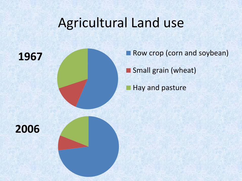
Agricultural Land use
1967 Row crop (corn and soybean)
Small grain (wheat)
Hay and pasture
2006
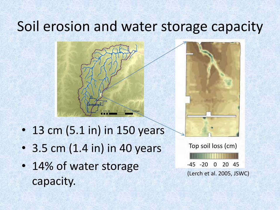
Soil erosion and water storage capacity
• 13 cm (5.1 in) in 150 years
• 3.5 cm (1.4 in) in 40 years
• 14% of water storage capacity.
Top soil loss (cm)
-45 -20 0 20 45
(Lerch et al. 2005, JSWC)

1967 2009
Tributary crossing in Centralia
Urbanization
• 11% more people• 71% more houses

Conservation Practices
0
2
4
6
8
10
12
14
16
18
0
50
100
150
200
250
% w
ate
rsh
ed
pro
tect
ed
Are
a p
rote
cte
d (
he
ctar
es)
Grassed waterway
Terraces
Seeding
Sod busting
Grazing system
Lagoon
Filter Strip
Diversion
CP33,CRP
Buffer
Cumulative % landprotected

• Before and after analysis.
• Trend analysis.
• Multiple regression analysis: requires good spatial and temporal knowledge of what is happening in the watershed.
• Multiple scale monitoring.
Other monitoring and analysis strategies
Multiple regression analysis
• Requires good spatial and temporal information of:– Weather
– Land use
– Crop distribution
– Land management, including• Cropland management and best management practices
• Sanitary sewage treatment
• Management of urban areas
• Management of pastures

Multiple regression
• No trend of nitrate loads over 92-06 in GCEW (O’Donnell, 2010).
• Decreasing trend over 1992-2010 (Lerch et al., 2015), possibly linked to decrease in wheat production.
• No BMP linked variable found significant.
• Not the right BMPs?• Not the right location?
Crop land
Pasture & grass
Impervious areas
Critical areas
Conservation practices

Time needed to detect change
• Mean Square Error of model was used to estimate the monitoring period needed to detect a future change
Predicted number of years needed to detect load reduction
Nitrate load reduction
Season 5% 10% 20% 25%
Year 92 24 7 4
Spring 185 49 13 9
O’Donnell, 2010

• Before and after analysis.
• Trend analysis.
• Multiple regression analysis: requires good spatial and temporal knowledge of what is happening in the watershed.
• Multiple scale monitoring.
Other monitoring and analysis strategies

Multiple scale monitoring
Stream Weir W1
Field
1993-2002Mulch tilled
corn-soybean
2004-2014Precision
Agricultural System (PAS)

Field 1
Pre-PAS 1993-2002 PAS 2004-2013South 40 acres North 52 acres
Odd year Corn (sorghum in 95)
N: pre-plant UAN,
incorporated
P: 1993, 1995, 2001
incorporated
Cultivation
Corn / Cover Crop
N: at planting + top
dress early summer
No-till
Wheat / Cover Crop
N: top dress in April
No-till
Even
year
Soybean
Cultivation
Soybean / Cover Crop
P: 2004, 2006, 2008
broadcast
No-till
Soybean / wheat
N: at wheat planting
P: 2004, 2006, 2008
broadcast
No-till
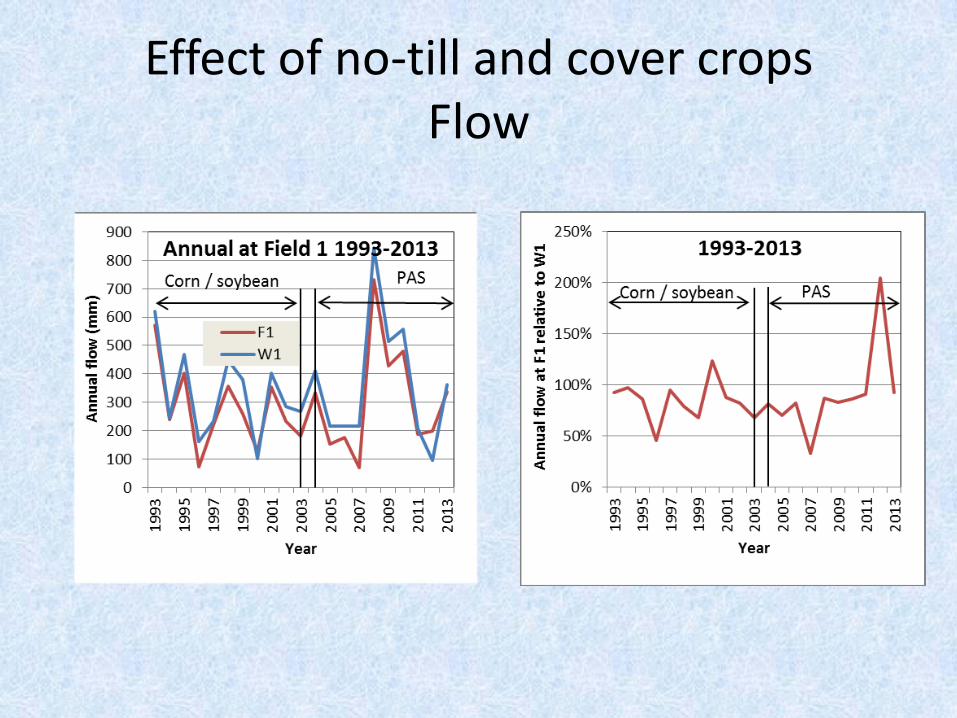
Effect of no-till and cover cropsFlow

Effect of no-till and cover cropDissolved P loss

Effect of no-till and cover cropNitrate-N loss

Effect of no-till and cover cropSediment

Annual Sediment losses

Summary• No-till and cover crops did: Reduce sediment
Did not change Nitrate-N transport
Did increase Dissolved P transport
• Agronomic practices, land use change, urbanization,
stream processes and climate all contribute to
modifying the runoff/sediment/nutrient yield regime of a watershed and make it difficult to:
detect a trend,
discern whether detected trends are due to any one factor.

Implications
To improve detection of water quality trends resulting from management changes, these changes should be:
• Implemented within a short time.
• Spatially targeted.• Of large magnitude.
• Addressing the processes that cause the problem
documented by the monitoring. Scale matters!

Data Management
• Equipment fails data gaps fill in the gaps
• Sediment loss measurements
• Inaccurate data
– Flow > Precipitation
– Issues with small events
• Meta data
AcknowledgementsCropping Systems and Water Quality Research Unit
Newell Kitchen, Ken Sudduth, Bob Lerch
Matt Volkmann, Kurt Holiman, Mark Olson, Aaron Beshears,
Teri Oster, Scott Drummond, Bettina Coggeshall.
ARS CEAP LTAR