Embed Size (px)
Citation preview
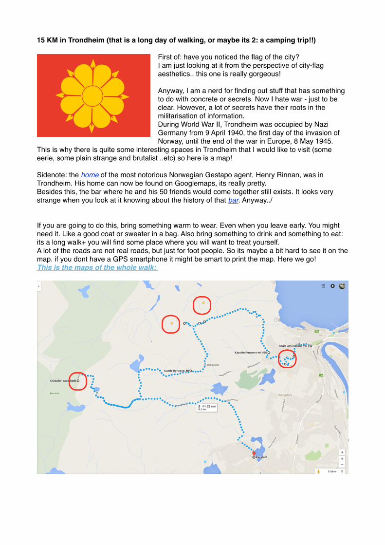
15 KM in Trondheim (that is a long day of walking, or maybe its 2: a camping trip!!)
First of: have you noticed the flag of the city?I am just looking at it from the perspective of city-flag aesthetics.. this one is really gorgeous!
Anyway, I am a nerd for finding out stuff that has something to do with concrete or secrets. Now I hate war - just to be clear. However, a lot of secrets have their roots in the militarisation of information. During World War II, Trondheim was occupied by Nazi Germany from 9 April 1940, the first day of the invasion of Norway, until the end of the war in Europe, 8 May 1945.
This is why there is quite some interesting spaces in Trondheim that I would like to visit (some eerie, some plain strange and brutalist ..etc) so here is a map!
Sidenote: the home of the most notorious Norwegian Gestapo agent, Henry Rinnan, was in Trondheim. His home can now be found on Googlemaps, its really pretty. Besides this, the bar where he and his 50 friends would come together still exists. It looks very strange when you look at it knowing about the history of that bar. Anyway../
If you are going to do this, bring something warm to wear. Even when you leave early. You might need it. Like a good coat or sweater in a bag. Also bring something to drink and something to eat: its a long walk+ you will find some place where you will want to treat yourself. A lot of the roads are not real roads, but just for foot people. So its maybe a bit hard to see it on the map. if you dont have a GPS smartphone it might be smart to print the map. Here we go! This is the maps of the whole walk:
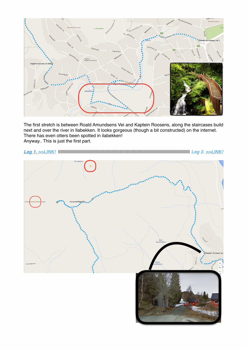
The first stretch is between Roald Amundsens Vei and Kaptein Roosens, along the staircases build next and over the river in Ilabekken. It looks gorgeous (though a bit constructed) on the internet.There has even otters been spotted in ilabekken!Anyway.. This is just the first part.
Leg 1. >>LINK! ||||||||||||||||||||||||||||||||||||||||||||||||||||||||||||||||||||||||||||||||||||||||||||||||||||||||||||||| Leg 2. >>LINK!
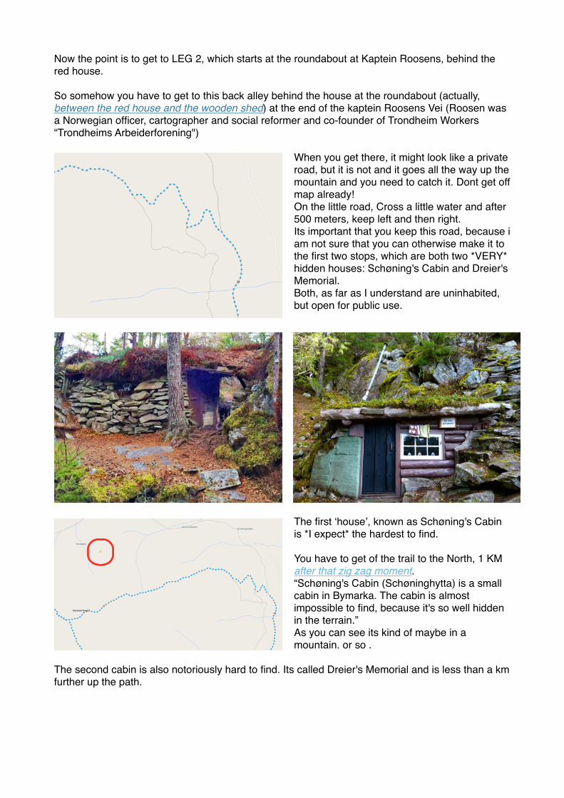
Now the point is to get to LEG 2, which starts at the roundabout at Kaptein Roosens, behind the red house.
So somehow you have to get to this back alley behind the house at the roundabout (actually, between the red house and the wooden shed) at the end of the kaptein Roosens Vei (Roosen was a Norwegian officer, cartographer and social reformer and co-founder of Trondheim Workers “Trondheims Arbeiderforening")
When you get there, it might look like a private road, but it is not and it goes all the way up the mountain and you need to catch it. Dont get off map already! On the little road, Cross a little water and after 500 meters, keep left and then right. Its important that you keep this road, because i am not sure that you can otherwise make it to the first two stops, which are both two *VERY* hidden houses: Schøning's Cabin and Dreier's Memorial.Both, as far as I understand are uninhabited, but open for public use.
The first ‘house’, known as Schøning's Cabin is *I expect* the hardest to find.
You have to get of the trail to the North, 1 KM after that zig zag moment. “Schøning's Cabin (Schøninghytta) is a small cabin in Bymarka. The cabin is almost impossible to find, because it's so well hidden in the terrain.”As you can see its kind of maybe in a mountain. or so .
The second cabin is also notoriously hard to find. Its called Dreier's Memorial and is less than a km further up the path.
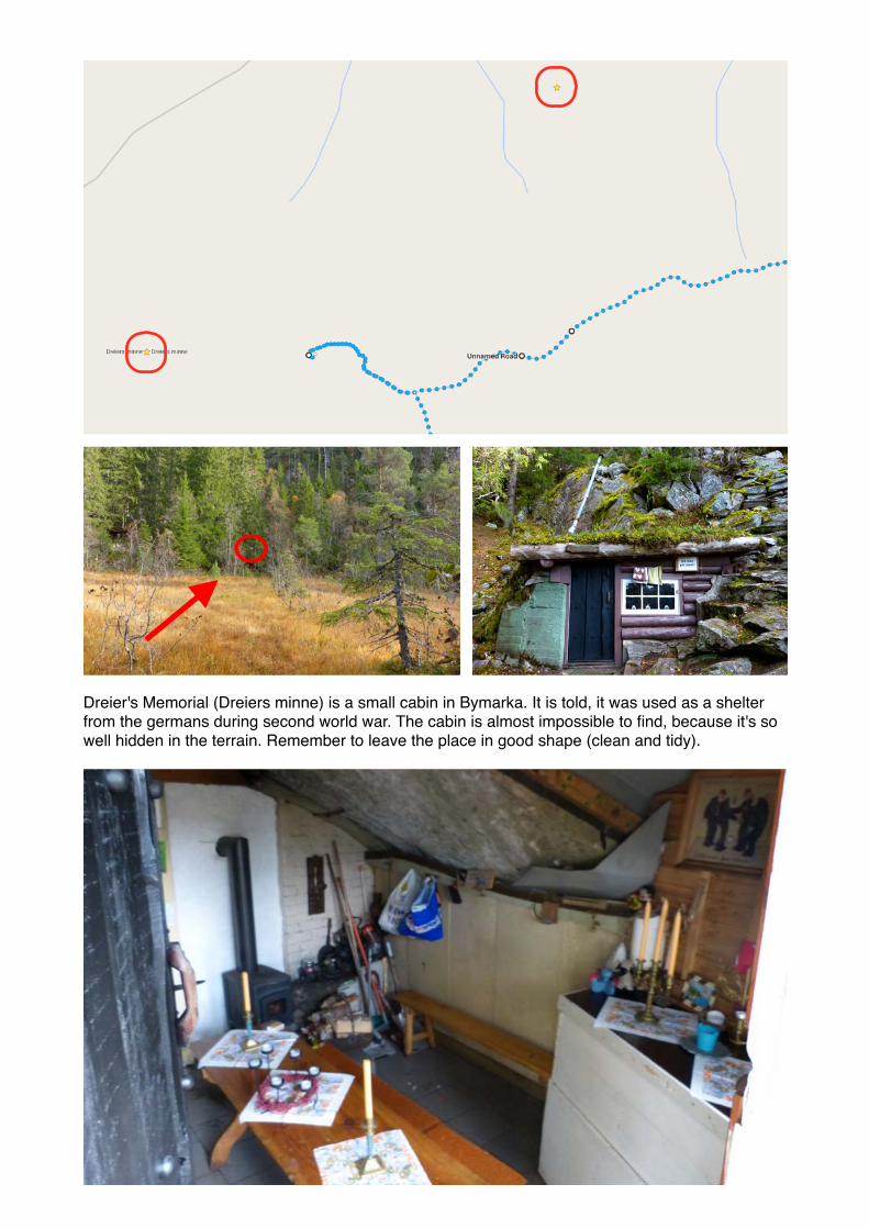
Dreier's Memorial (Dreiers minne) is a small cabin in Bymarka. It is told, it was used as a shelter from the germans during second world war. The cabin is almost impossible to find, because it's so well hidden in the terrain. Remember to leave the place in good shape (clean and tidy).

The next spot is the most exciting to me. I think it is also going to be kind of a hike. Google maps says it is 1,5 hrs (6 KM) but I think it is uphill and going to take much longer!Anyway, we are walking to Gråkallen radarhode! With a real buckyball dome! (this is so exciting!)
Gråkallen is Trondheim's second highest mountain top (552 meters height), and it's hemisphered shape is visible from a long distance. From Gråkallen you can see mountain tops from Sweden in east to Trollheimen in south. The top is just a short walk from Skistua. The ski sport facilities at Gråkallen (Vintervasskleiva) are to be removed.
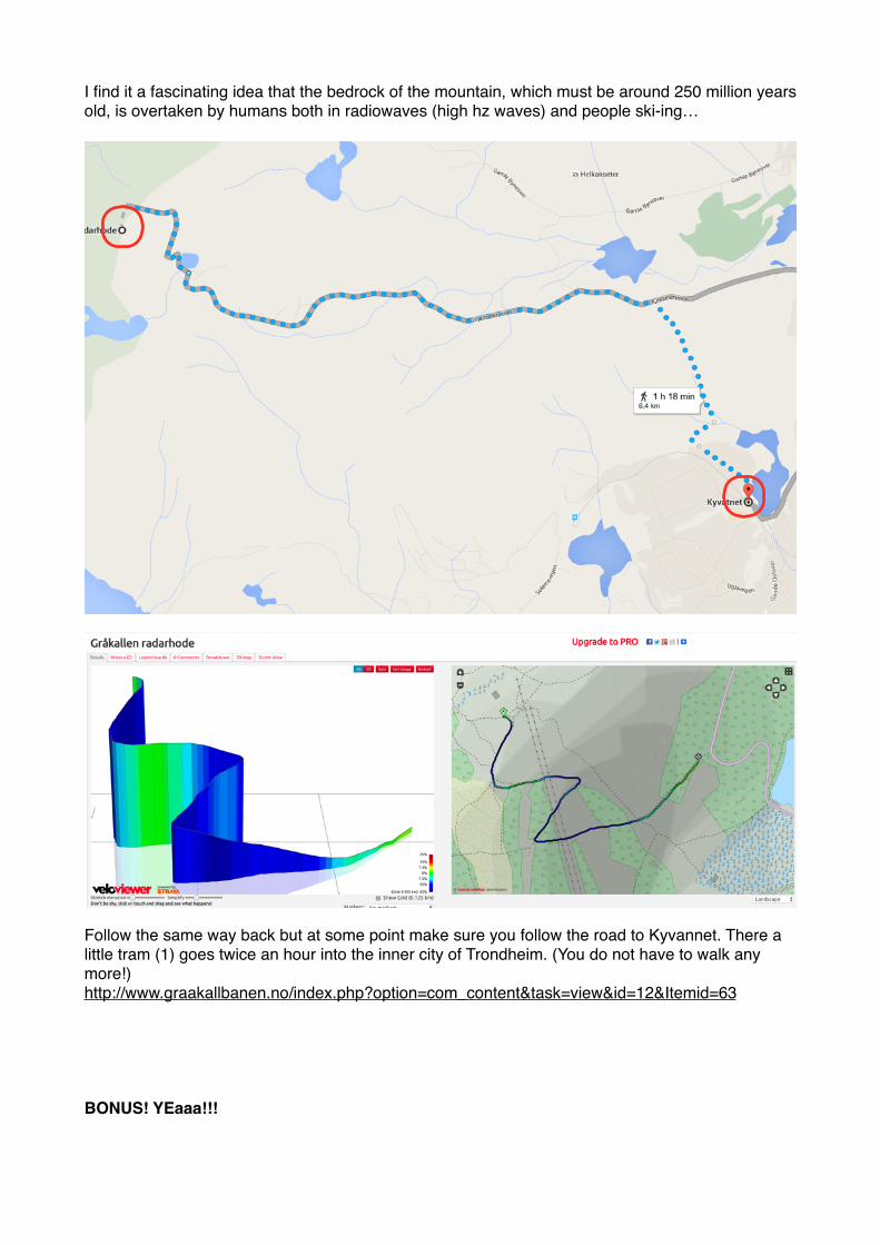
I find it a fascinating idea that the bedrock of the mountain, which must be around 250 million years old, is overtaken by humans both in radiowaves (high hz waves) and people ski-ing…
Follow the same way back but at some point make sure you follow the road to Kyvannet. There a little tram (1) goes twice an hour into the inner city of Trondheim. (You do not have to walk any more!)http://www.graakallbanen.no/index.php?option=com_content&task=view&id=12&Itemid=63
BONUS! YEaaa!!!

DORIA 1 and 2
Skippergata 14-16, 7042 Trondheim, Norway. Here you will find the Dora U-boat Bunkers. Trondheim was traditionally referred to as Drontheim in German. I dont speak German but hey,,, knowledge!
“This massive concrete submarine bunker with thick concrete walls was built by nazis during the occupation of Norway in World War II. There were two Doras I and II. Dora two was destroyed by a air bombing and was finally demolished. Dora I however represents a good example of what was a German submarine base. This base served submarines that had easy access to the Norway Sea and North Atlantic. The entrance of the fiord was protected by big cannonry.”Its listed to be destroyed but for now still visitable relic of the dark times.
Munkholmen!! I want to go here!! There is a boat from the harbour in the summer for 80NK. Bring your own snack etc.
Munkholmen (Norwegian: the monk's islet) is an islet north of TrondheimIn the years prior to the founding of the city of Trondheim in 997 by Viking King Olav Tryggvason, Munkholmen was used as an execution site by the Jarls of Lade. In the early 12th century, and possibly even earlier, Benedictine monks lived on the island in Nidarholm Abbey. Local stories claim the monastery was quite lively and that on several occasions requests came from the mainland to keep the noise down. By the time Lutheran Protestantism came to Trondheim, the monastery had fallen into decay.Construction of a fort on the island began in 1658. When it was completed in 1661, the fort was also used as a state prison for society's rejects. Count Peder Griffenfeld, Munkholmen's most famous prisoner, was transferred from the fortress of Copenhagen in 1671. Griffenfeld was kept at Munkholmen for 18 years, after which he was released, having contracted a terminal illness. The fort remained in operation until 1893.Nazi Germany invaded and occupied Norway in 1940. At this time, Munkholmen was fitted with anti-aircraft weaponry. A large portion of the fort was retrofitted to hold ammunition, and the flooring planks were nailed in with wooden nails to prevent explosions caused by soldiers' boots striking metal nails. The German occupying forces remained
in Norway until the end of the war in Europe in May 1945. Remnants of the installation still exist in the upper levels of the fort.Today, Munkholmen is a popular summertime tourist attraction and hangout for residents of Trondheim. From May to September, boats depart from Ravnkloa on a regular basis. Once on the island, visitors can take a guided tour (in English and Norwegian) or roam freely.
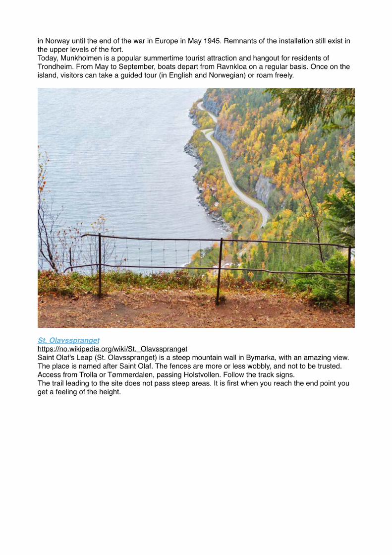
St. Olavssprangethttps://no.wikipedia.org/wiki/St._OlavssprangetSaint Olaf's Leap (St. Olavsspranget) is a steep mountain wall in Bymarka, with an amazing view. The place is named after Saint Olaf. The fences are more or less wobbly, and not to be trusted. Access from Trolla or Tømmerdalen, passing Holstvollen. Follow the track signs.The trail leading to the site does not pass steep areas. It is first when you reach the end point you get a feeling of the height.