Embed Size (px)
Citation preview

Alex 1016359 Claim Group John Bakus Event 5530214
____________________________________________________________________________________________
____________________________________________________________________________________________
February 3, 2015 Sookochoff Consultants Inc. page 1 of 26
JOHN BAKUS
(Owner & Operator)
GEOLOGICAL ASSESSMENT REPORT (Event 5530214)
on a
STRUCTURAL ANALYSIS
Work done on
Tenures 1016359, 1032161, 1032160
of three claim
Alex 1016359 Claim Group
Vancouver Mining Division
BCGS Map 092K.044/.054
Work done from
October 22, 2014 to October 25, 2014
Centre of Work
5,506,470N, 330,395E (NAD 83)
Author & Consultant
Laurence Sookochoff, PEng
Sookochoff Consultants Inc.
Alex 1016359 Claim Group John Bakus Event 5530214
____________________________________________________________________________________________
____________________________________________________________________________________________
February 3, 2015 Sookochoff Consultants Inc. page 2 of 26
TABLE OF CONTENTS page
Summary ------------------------------------------------------------------------------- 4.
Introduction ---------------------------------------------------------------------------- 5.
Property Location and Description ----------------------------------------------- 5.
Accessibility, Climate, Local Resources, Infrastructure and Physiography -- 7.
History: Property Area --------------------------------------------------------------- 7.
092K 023 – DORATHA MORTON -------------------------------------- 7.
092K 035 – DOUGLAS PINE --------------------------------------------- 8.
092K 151 – PHIL ------------------------------------------------------------ 8.
092L 158 – ISLAND COPPER -------------------------------------------- 9.
History: Property --------------------------------------------------------------------- 9.
092K 024 – ENID-JULIE --------------------------------------------------- 9.
092K 028 – ALEXANDRIA ----------------------------------------------- 10.
Geology: Regional -------------------------------------------------------------------- 11.
Geology: Property Area -------------------------------------------------------------- 12.
092K 023 – DORATHA MORTON -------------------------------------- 12.
092K 035 – DOUGLAS PINE --------------------------------------------- 12.
092K 151 – PHIL ------------------------------------------------------------ 12.
092L 158 – ISLAND COPPER -------------------------------------------- 13.
Geology: Property -------------------------------------------------------------------- 13.
092K 024 – ENID-JULIE --------------------------------------------------- 14.
092K 028 – ALEXANDRIA ----------------------------------------------- 14.
092K 054 – ALLS UP ------------------------------------------------------- 14.
Mineralization: Property Area ------------------------------------------------------ 16.
092K 023 – DORATHA MORTON -------------------------------------- 16.
092K 035 – DOUGLAS PINE --------------------------------------------- 16.
092K 151 – PHIL ------------------------------------------------------------ 16.
092L 158 – ISLAND COPPER -------------------------------------------- 16.
Mineralization: Property ------------------------------------------------------------- 17.
092K 024 – ENID-JULIE --------------------------------------------------- 17.
092K 028 – ALEXANDRIA ----------------------------------------------- 17.
092K 054 – ALLS UP ------------------------------------------------------- 18.
Structural Analysis ----------------------------------------------------------------------- 18.
Interpretation and Conclusions ------------------------------------------------------ 22.
Selected References --------------------------------------------------------------------- 24.
Statement of Costs ----------------------------------------------------------------------- 25.
Certificate ----------------------------------------------------------------------------------- 26.

Alex 1016359 Claim Group John Bakus Event 5530214
____________________________________________________________________________________________
____________________________________________________________________________________________
February 3, 2015 Sookochoff Consultants Inc. page 3 of 26
Table of Contents (cont’d)
ILLUSTRATIONS
Figure 1. Location Map ------------------------------------------------------ 5.
Figure 2. Property Location from Vancouver ----------------------------- 6.
Figure 3. Property Location from Campbell River ----------------------- 6.
Figure 4. Claim & Index Map ----------------------------------------------- 7.
Figure 5. Geology, Claims, & Minfile ------------------------------------- 15.
Figure 6. Indicated Structures on Tenure 1016359, 939069, & 1024653 18.
Figure 7. Rose Diagram from Lineaments of Figure 6 ------------------ 19.
Figure 8. Cross-Structure Locations and Minfiles on Google Earth --- 20.
Figure 9. Conceptual model showing potential for deep-seated
Gold bonanza zones and/or porphyry Cu-Au ---------------- 21.
TABLES
Table I. Alex 1016359 Claim Group Tenures ---------------------------- 5.
Table II. Approximate UTM locations of cross-structures and Minfiles 20.
Table III Alexandria and Enid-Julie Production and Inventory -------- 22.

Alex 1016359 Claim Group John Bakus Event 5530214
____________________________________________________________________________________________
____________________________________________________________________________________________
February 3, 2015 Sookochoff Consultants Inc. page 4 of 26
SUMMARY
The Alex 1016359 Claim Group (“Property”) covers an area of 123 hectares on the west coast of British Columbia
209 kilometres northwest of Vancouver and 52 kilometres north of Campbell River, the principal resource and
supply centre any initial exploration.
Geologically, the Property is underlain by a variety of Tertiary-Jurassic granite-granodioritic-diorite intrusives in
contact with Triassic metavolcanics and metasediments. The main contact zone is of a northwesterly band of
stratified rock with a prominent shear zone characterized by strong silicification and beaching and could be traced
for 6.5 kilometres from the Alexandria workings northwestward through the Enid-Julie. Other alteration includes
skarnification of calcareous sediments
At the Alexandria, in the southeast, the underground workings include five adits which explore a highly silicified
shear zone hosting quartz veins bearing pyrite and chalcopyrite with localized gold values of up to 192.5 grams per
tonne and silver values up to 647 grams per tonne. Production is reported as 1,694 tonnes with a recovery of 22,239
grams of gold and 40,590 grams of silver. A reported inventory of 25,600 drill indicated tonnes of 10 grams gold
remains at the mine.
At the Enid-Julie, located more than two kilometres to the northwest and on the same silicified shear zone,
underground workings are limited to a 4.6 metre shaft and an 18.3 metre crosscut adit exploring pyritic and rare
galena-bearing auriferous quartz veins. Production is reported as 62 grams of gold and 218 grams of silver from
two tonnes of ore. Reported values of 135.7 grams per tonne gold and 551.9 grams per tonne silver are comparable
to the gold and silver values at the Alexandria. This could indicate that the two kilometre shear zone may host the
consistent erratic gold and silver mineralization.
The prominent silicified shear zone with surficial erratic mineralization may indicate the peripheral silicified
alteration zone to a deep-seated structurally controlled epithermal system with a potential bonanza gold-silver zone
and/or a deeper seated copper-gold intrusive hosted porphyry system such as the Island Copper (Minfile 092L
158). The intrusive could be the mineral source and the generator for the epithermal mineralization and the erratic
leakage of mineralization of the Alexandria and the Enid-Julie workings (Figure 9).
Any depth related surficially exposed geological information would be enhanced at the three cross-
structural locations as determined by the structural analysis. These locations could provide a breccia pipe for
the less restricted means of hydrothermal fluid conveyance to the surface where the porphyritic geological
indicators would be etched. These indicators could be revealed as minerals and/or alteration and would be subject
to interpretation for advanced exploration.
Thus, the three cross structural locations labeled A, B, and C on Figures 6 and 8 should be the prime exploration
areas. The geological information gained from the cross-structural areas, would facilitate in the interpretation of
less obvious mineral indicators to a potential concealed mineral resource.

Alex 1016359 Claim Group John Bakus Event 5530214
____________________________________________________________________________________________
____________________________________________________________________________________________
February 3, 2015 Sookochoff Consultants Inc. page 5 of 26
INTRODUCTION
In October 2014, a structural analysis was completed on the three claim Alex 1016359 Claim Group (“Property”).
The purpose of the program was to delineate potential structures which may be integral in geological controls to
potentially economic mineral zones that may occur on of the Property.
Information for this report was obtained from sources as cited under Selected References and from the Structural
Analysis completed and reported on herein.
PROPERTY LOCATION & DESCRIPTION
Location
The Property is located on the west coast of British Columbia, 209 kilometres northwest of Vancouver and 52
kilometres north of Campbell River which is on the east coast of Vancouver Island. The Property is on the western
shore of the mouth of Philips Arm and within BCGS 092K.044/.054.
Figure 1. Location Map (from MapPlace)
Description
The Property is comprised of three contiguous mineral claims covering an area of 123.3378 hectares. Particulars are
as follows:
Table I. Alex 1016359 Claim Group Tenures
Tenure
Number
Type Claim Name Good Until* Area (ha)
1016359 Mineral ALEXANDRIA 250000 G AU DR 20250201 20.5584
1032160 Mineral Alexandria West 20190504 82.2263
1032161 Mineral ALEXANDRIA ENID 135 GT AU 20241111 20.5531
*Upon the approval of the assessment work filing, Event 5530214.

Alex 1016359 Claim Group John Bakus Event 5530214
____________________________________________________________________________________________
____________________________________________________________________________________________
February 3, 2015 Sookochoff Consultants Inc. page 6 of 26
Property Description and Location (cont’d)
Figure 2. Property Location from Vancouver
(from MapPlace & Google Earth)
Figure 3. Property Location from Campbell River
(from MapPlace & Google Earth)

Alex 1016359 Claim Group John Bakus Event 5530214
____________________________________________________________________________________________
____________________________________________________________________________________________
February 3, 2015 Sookochoff Consultants Inc. page 7 of 26
ACCESSIBILITY, CLIMATE, LOCAL RESOURCES, INFRASTRUCTURE AND
PHYSIOGRAPHY
Access
Access to the Property would by helicopter, float plane, or boat from Campbell River.
Logging roads provide access to the central portion of the Property.
Climate
The climate is classified as West-Coast Marine with rainfall exceeding 300 centimetres per year. Summers and
winters are mild, with snow seldom remaining on the ground at tide-water for more than a day. The uppermost
slopes may be snow covered for up to three months of the year.
Local Resources and Infrastructure
The closest commercial lodging and supply centre would be at Campbell River where most services required for
property exploration and development can be found.
Physiography
The west coast of British Columbia is well known for its rugged terrane and high relief. The Alex 1016359 Claim
Group extends southward from the shores of Phillips Arm to a 915 metre elevation along the northwesterly
boundary.
Figure 4. Claim & Index Map (Base map from MapPlace
HISTORY: PROPERTY AREA
MINFILE reports the history of showings and past producers peripheral to the Property (Figure 5) as follows.
DORATHA MORTON past producer (Au-quartz veins)
MINFILE 092K 023
Two kilometres northwest

Alex 1016359 Claim Group John Bakus Event 5530214
____________________________________________________________________________________________
____________________________________________________________________________________________
February 3, 2015 Sookochoff Consultants Inc. page 8 of 26
History: Property Area (cont’d)
Doratha Morton past producer
The property was first Crown granted to P.J. Chick and C. Moody in 1897 and by late 1898 was placed into
production. Ore taken from several adits at an elevation of 792 metres was conveyed down to a stamp mill and
Canada's first cyanide vat-leach plant, on a 2-kilometre tramline. Fairfield Exploration Syndicate, Limited,
operated the mine until October 1899. Additional claims, including the Eva (Lot 254), Banker (Lot 291),
Comox Fraction (Lot 297), Percy (Lot 299), Dorothy Morton Fr. (Lot 300), Chimnang (Lot 319) and Maggie
May (Lot 322) were Crown-granted to the company in 1899.
Glasair Mining Corporation, Limited acquired the property in 1924. The R. Crowe-Swords interests
incorporated Glasord Mining Corporation, Limited in 1925 to option the property. Work during the year
included driving a 15-metre adit some 120 metres east of the old workings. Glasair sold its interest in the
property to Morton Wolseley Consolidated Mining, Limited; the property was retained until the end of 1932.
The workings at that time included 5 adits totalling 640 metres.
Hercules Consolidated Mining, Smelting and Power Corporation, Limited held the property in 1933-34 and
opened 3 new adits totalling 76 metres. Santiago Mines, Limited carried out work under a lease agreement in
1935. Pembroke Mining Corporation, of Seattle, held the property in the late 1930's.
Black Pearl Petroleums Ltd. optioned a 60 per cent interest in the property from Stephen Green, of Burnaby, in
March 1983. The company name was changed August 1983 to Signet Resources Inc. Work in 1984 included
trenching and 610 metres of diamond drilling. This work indicated a probable 7710 tonnes at greater than 13.7
grams per tonne gold in the No. 1 adit east drift (George Cross Newsletter 12/09/84). Work in 1985-86
included trenching and 1088 metres of diamond drilling in 15 holes.
Work included a VLF electromagnetic survey in 1983, 596 metres of diamond drilling in 5 BQ holes on surface
in 1984, 387 metres of underground diamond drilling in 5 AQ holes in 1985 with no significant results, and 701
metres of diamond drilling in 10 surface holes in 1986. A geochemical soil survey in the Camp Area gave
values in 6 of 87 samples. Reserves were reported as 9070 tonnes at 14.4 grams per tonne gold (George Cross
Newsletter, 1987, No. 2).
The company name was changed in March 1987 to New Signet Resources Inc. In 1987 trenching and sampling
was carried out along strike on a number of gold-bearing parallel quartz veins within the shear zone.
The area was prospected in 1993 by Ripple Creek Resources. Total production between 1898 and 1934 was
9319 tonnes, yielding 333,923 grams of silver, 143,913 grams of gold and 1094 kilograms of copper.
The mine consists of numerous adits, levels and trenches, all located along the shear zone.
DOUGLAS PINE past producer (Au quartz veins)
MINFILE 092K 035
Four kilometres south-southeast
The Douglas Pine (L.271) is located on the northeast corner of East Thurlow Island approximately one
kilometre southeast of Shoal Bay.
PHIL showing (Breccia, Shear)
MINFILE 092K 151
Two kilometres west
Exploration and development in the area began before 1940 as various operators explored the limits of the
mineralization at the Doratha Morton (092K 023) and Alexandria (92K 028) gold mines. In the early 1980s the
Falconbridge gold program and several junior mining companies reopened old workings and conducted further
exploration. This work located gold veins in surface trenching and at least two adits during 1985 to 1987.

Alex 1016359 Claim Group John Bakus Event 5530214
____________________________________________________________________________________________
____________________________________________________________________________________________
February 3, 2015 Sookochoff Consultants Inc. page 9 of 26
History: Property Area (cont’d)
Phil showing
Falconbridge drilled seven holes and found anomalous gold in six of them (Assessment Report 25098). The best
assay from a drill section was 9.50 grams per tonne gold over 2.35 metres.
In 1997 Thurlow Resources conducted an exploration program on the area, renamed the DM property, on the
HY, LO, and FILL 2-19 claims. The program consisted of soil sampling, rock sampling, and mapping to try to
locate a possible extension of the molybdenite, chalcopyrite and pyrite mineralized zone beyond a rock quarry
where it was originally found. The survey concentrated on the westerly part of a north-westerly striking shear
zone that crosses the claim group. The soil geochemistry outlined a molybdenum anomaly for 150 metres along
the base line in a northerly direction from the rock quarry. No encouraging values were found south of the
quarry. Three of seven grab rock samples yielded highly anomalous values: Sample RS#4 assayed 0.5032 per
cent molybdenum; Sample #6-04-04 (grab sample from the quarry) assayed 0.2817 per cent molybdenum;
Sample #6-04-05 from an outcrop below the Falconbridge diamond drill sites assayed 0.556 gram per tonne
gold (Assessment Report 25098).
ISLAND COPPER past producer (Porphyry Cu +/- Mo +/- Au)
MINFILE 092L 158
Seventy kilometres north
During its operating life from 1971 to 1995 inclusive, the Mine produced about 1227 million kilograms of
copper, 35,268 kilograms of gold, 294,106 kilograms of silver (probably 360,800 kilograms of silver), 32
million kilograms of molybdenum and 236 kilograms of rhenium from 367 million tonnes of ore.
BHP Minerals Canada Ltd. ceased mining operations in July 1995 and finished milling of surface stockpiles by
the end of the year. The open pit was flooded in May 1996 and reclamation work continued for two years. A saw
mill and lumber kiln, utilizing mine buildings and facilities, are being established at the mine site.
In 1998, BHP received the 1997 British Columbia Mine Reclamation Award.
In November 1999, GTN Copper Technology Ltd. of Sydney Australia (with an office in Englewood, California)
announced their intention to develop an $80 million copper processing plant employing approximately 70
persons at the former Island Copper Mine site near Port Hardy. The facility will import copper concentrate
from mines in Western Canada, the U.S. and South America, with initial capacity to process 50,000 tons of
copper per year, with potential to increase production to over 200,000 tons.
HISTORY: PROPERTY
MINFILE reports the history of showings, prospects, and developed prospects on the Property (Figure 5) as
follows.
ENID-JULIE past producer (Au-quartz veins)
MINFILE 092K 024
Within Tenure 1032161
The property is located between elevations of 457 and 915 metres on the west side of Phillips Arm, 1.2
kilometres west of Bullveke Point, some 210 kilometres northwest of Vancouver. The Alexandra property (092K
028) adjoins to the southeast and the Doratha Morton (092K 023) to the northwest.
The Enid (Lot 280), Julie (Lot 233), Jennie B. (Lot 276), and Stella (Lot 281) claims were Crown-granted in
1898 to W.A. Bauer. In 1918 the above claims were re-Crown-granted, the Enid and Stella to W.R. Taylor, and
the Julie and Jennie B. to T.N. Phillips. The adjacent Empress claim (L 279) was Crown-granted to Alex Smith
in 1921. Glasair Mining Corporation, Limited, incorporated September 1924, acquired the Julie and Jennie B.
claims and the Doratha Morton property.

Alex 1016359 Claim Group John Bakus Event 5530214
____________________________________________________________________________________________
____________________________________________________________________________________________
February 3, 2015 Sookochoff Consultants Inc. page 10 of 26
History: Property (cont’d)
Enid-Julie past producer
During 1925 a 4.6-metre shaft was sunk and a 18.3-metre crosscut adit driven on the Julie claim, to trace
pyrite, and rare galena-bearing auriferous quartz veins. The veins are parallel to shear zone at the contact, and
in the metamorphosed rocks on the northeast side.
Glasord Mining Corporation, Limited was incorporated in July 1925 to continue the exploration work. The
Julie and Jennie B. claims were re-Crown-granted in 1925 to R. Crowe-Swords, President of the company.
Work was suspended in 1926. The Enid and Stella claims were re-Crown-granted in 1926 to W.A. Glasgow.
Morton Woolsey Consolidated Mines, Limited in 1928 purchased Clasair Mining for 2,500,000 shares.
Apparently no work other than prospecting was done on the Enid-Julie in subsequent years. Enid-Julie Mines,
Limited was incorporated in 1933 to continue the development work. In 1933, it is recorded that 62 grams of
gold and 218 grams of silver were produced from 2 tonnes of ore. It is unknown from which working or on
which claim the shipment was made. During 1934 the new 238-metre level crosscut adit was driven about 91
metres, some 150 to 215 metres short of its objective, which was to get under the shaft showing; work was
suspended in July 1934.
In 1996 and 1997 Norwood Resources conducted ground electromagnetic and magnetic surveys, soil
geochemical surveys, prospecting, trenching and road building on the Ben 1-6, Dy 1-6, Hop 1-4, and Jeff
claims, which are part of the adjacent Alexander property (092K 028). As of 1996 the Alexandria property
includes the Alexandria, Enid-Julie, Empress and All up.
Corpac Minerals Limited in July 1980 optioned the above claims from M.P. Warshawski and J.W. MacLeod. A
geochemical soil survey (105 samples) was carried out over the Enid, Empress and Comox claims.
ALEXANDRIA past producer (Au-quartz veins)
MINFILE 092K 028
Within Tenure 1016359
The Alexandra (Lot 225) occurrence is located on the western shore of Phillips Arm.
Seven claims, the Alexandra, Waterloo, Emperor Fr., Highland Laddie, Duke, Jubilee Fr., and Duchess (Lots
225-131 respectively) were Crown-granted in 1897-88 to H. Rhodes of Vancouver. Phillips Arm Gold Mines
Limited was Incorporated in January 1897 to acquire the property.
Development work in several adits continued into 1899. On the nearby All Up claim an adit had been driven
from the beach for about 33 metres following an irregular quartz vein about 60 centimetres wide. No further
activity was reported until 1919 when Mr. Rhodes, on behalf of the company, reopened, resurveyed, and
sampled the workings. In 1923 C.H. Dickie and Beaton and Hemsworth of Vancouver, acquired a lease and
bond on the property. Rehabilitation of the workings and raising from the lower adit was carried out.
Alexandria Mining Company, Limited was incorporated in British Columbia in September 1925 by Mr. Dickie,
H.M. Waters and Associates to acquire the property. Some development work was reported during 1925-26 but
apparently finances were limited. Alexandra Gold Mines, Limited was incorporated in Ontario in December
1927 by H.W. Waters and associates as a holding company to acquire a block of shares in Alexandria Mining
Company. Development work resumed in 1928 and continued until late in 1931. The workings at that time
included five adits between the beach and the 122 metre elevation, comprising about 580 metres of drifts and
crosscuts; the lower No. 1 adit was driven from the beach for 168 metres westerly, with three crosscuts each
about 90 metres long, and a 15 metre raise to No. 2 adit. At a point 91 metres from the portal of the lower adit
a shaft was sunk to 82 metres and levels driven at 30 metres and 60 metres; the 30-metre level was driven
westerly for 152 metres. The No. 5 adit, located at the 75-metre elevation between Nos. 2 and 3 adits, was
driven in 1929.

Alex 1016359 Claim Group John Bakus Event 5530214
____________________________________________________________________________________________
____________________________________________________________________________________________
February 3, 2015 Sookochoff Consultants Inc. page 11 of 26
History: Property (cont’d)
Alexandria past producer (cont’d)
Premier Gold Mining Company Limited optioned the property late in 1933. About 460 metres of drifting and
crosscutting was done in extending the 30 metre and 60 metre levels in the shaft and Nos. 1 and 2 adits. The
underground workings were sampled; zones of economic interest were identified in the lower adit, and on the
30-metre level from the shaft. About 13,600 tonnes of material at approximately 10.3 grams per tonne gold
were indicated in a shoot between the two levels (Report of Minister of Mines, British Columbia, 1934, p. F 8).
The company gave up its option in August 1934.
Lessee F.H. Fox shipped some ore from the property in 1939. Alex Limited, incorporated in April 1940, shipped
ore in 1940. Production totalled 1694 tonnes, mainly from a stope above the lower adit, from which 40,590
grams of silver, 22,239 grams of gold, and 1761 kilograms of copper were extracted.
In 1996 and 1997 Norwood Resources conducted ground electromagnetic and magnetic surveys, soil
geochemical surveys, prospecting, trenching and road building on the property. The soil survey on the adjacent
Ben claims on the Alexander property tests the area between the Dorotha Morton Mine (092K 023) and the
Enid-Julie workings (092K 024). The purpose was to determine if the Dorotha Morton gold trend continues
into the Alexandria property. Two areas of anomalous gold were located and trenched.
Envoy Resources Limited carried out a geochemical soil survey (152 samples) in 1976 under an option
agreement with the owners M.P. Warshawski and J.W. MacLeod. Corpac Minerals Limited in 1980 optioned
the Alexandra group from the above owners, and the adjacent Enid-Julie property. Indicated and inferred
reserves of 17,500 tonnes grading 10.49 grams per tonne gold were estimated, based on work by Premier in
1933-34 (G.A. Noel, Oct. 8, 1980 in Statement of Material Facts 57/81, Corpac Minerals Limited). Work by
Corpac in 1980 included a geochemical soil survey (105 samples).
Charlemagne Resources Ltd., in November 1982, optioned 17 reverted crown grants. Work in 1983 included
576 metres of underground development and 482 metres of underground diamond drilling in 5 holes.
Falconbridge Limited entered into an agreement with Charlemagne and in 1985-1986 carried out geochemical
surveys comprising 1687 soil and 440 rock samples, airborne magnetometer and electro-magnetic surveys over
300 kilometres, and a ground electromagnetic survey over 200 kilometres on the Alexandra and adjacent
ground. A geophysical anomaly was found some 5 kilometres to the northwest on the Commonwealth claims
(092K 025). In the Alexandra underground workings diamond drilling totalled 759 metres in 15 holes.
GEOLOGY: REGIONAL
The regional geology of the Phillips Arm gold camp is described by Roddick and Woodsworth of the Geological
Survey of Canada as follows.
… most of the area is underlain by plutonic rocks, ranging from gabbro to quartz monzonite. Granodiorite and
quartz diorite predominate and unlike most areas in the Coast. Mountains, granodiorite is slightly more
abundant. The granodiorite forms a broad central belt about 50 km wide, extending from Big Julie pluton in the
southeast to Knight Inlet, with a core area of quartz monzonite between Toba and Knight Inlets. The flanking
belts are underlain mainly by quartz diorite but, granodiorite and diorite are also well represented. Most of the
plutons, excepting the quartz monzonite, exhibit a pronounced northwesterly elongation. This pattern is
accentuated by long narrow belts of metasedimentary and metavolcanic rocks.
Steeply dipping metasedimentary and metavolcanic rocks form narrow bands engulfed in the main mass of the
Coast Plutonic Complex. Although interrupted here and there by large plutons they are remarkably persistent
along strike and are thought to represent fault slices or grabens along which ‘horsts’ of plutonic rock were
thrust, upward. The bounding shear zones in places still exist but synplutonic recrystallization has commonly
reduced them to mere foliations or obliterated them entirely. In many places these ‘screens’ are flanked on one
side by diorite and on the other by quartz diorite or, less commonly, by granodiorite.

Alex 1016359 Claim Group John Bakus Event 5530214
____________________________________________________________________________________________
____________________________________________________________________________________________
February 3, 2015 Sookochoff Consultants Inc. page 12 of 26
Geology: Regional (cont’d)
The dioritic rocks may represent remnants of a primitive granitoid basement upon which Karmutsen and later
rocks were deposited. Deep burial and subsequent deformation of the eugeosynclinal pile along with the
underlying basement was probably in response to compressive forces transmitted through the North America
Plate against oceanic crust, Relief came eventually with the onset of subduction, and plutonic masses, formed
before and during the compressive stage, began their movement upwards bounded by synplutonic faults. The
open structure of the Karmutsen volcanics on Vancouver Island is in marked contrast with the strongly
deformed remnants of these rocks within the Coast Plutonic Complex.
GEOLOGY: PROPERTY AREA
MINFILE reports the geology of showings and past producers peripheral to the Property (Figure 5) as follows.
DORATHA MORTON past producer (Au quartz veins)
MINFILE 092K 023
Two kilometres northwest
Most of the area is underlain by a persistent, over 12 kilometre long band of stratified rock. The band trends
northwest and separates Jurassic to Cretaceous Coast Plutonic Complex rock of two different compositions,
diorite and granodiorite. The stratified rock, metavolcanic rocks and metasediments are Paleozoic and/or
Triassic in age and are not presently correlated with a specific group and/or formation.
The Doratha Morton straddles the sheared contact between diorite to the southwest and metamorphosed rocks
to the northeast. The shear zone dips approximately 75 degrees to the southwest and locally truncates the
contact. It can be traced from the Alexandria (092K 028) through the Enid-Julie (092K 024) and Doratha
Morton, and on to the Commonwealth-Champion (092K 025), a distance of 6.5 kilometres.
Pyrite is the dominant sulphide mineral found on the property. It occurs in quartz as disseminated patches and
seams parallel to the foliation within the silicified zone and as fracture coatings within both granitic and
metamorphosed rocks. The pyrite concentration seldom rises above 5 per cent. Trace amounts of galena,
sphalerite and chalcopyrite often accompany pyrite especially in crosscutting stringers. Tellurium has been
detected on fractures in drill core. Gold values appear to have a positive correlation with concentrations of
pyrite within or adjacent to quartz veins. Free gold has seldom been observed.
DOUGLAS PINE past producer (Au quartz veins)
MINFILE 092K 035
Four kilometres south-southeast
The area is underlain by quartz diorite of the Cretaceous to Jurassic Coast Plutonic Complex, within which is
contained a roof pendant of uncorrelated Paleozoic and/or Triassic metavolcanics and metasediments. This
belt-like roof pendant is considered to be an extension of the belt at Fanny Bay (Geological Survey of Canada
Open File 480). The metamorphic rocks consist mainly of hornblende schist which grades in and out of
irregularly layered gneiss, schlieren gneiss and local agmatite.
The Douglas Pine is situated on a shear zone which roughly follows the irregular metamorphic-intrusive
contact. A quartz vein infills the strong northwest trending shear or fissure zone with northeast dips of 50 to 85
degrees. The vein ranges from a few centimetres to 2 metres wide and is locally mineralized with lenses and
disseminations of pyrite, pyrrhotite, arsenopyrite and minor chalcopyrite. The main oreshoot, 15 to 30 metres
long and 60 metres down dip has been almost completely stoped out.
PHIL showing (Breccia, Shear)
MINFILE 092K 151
Two kilometres west

Alex 1016359 Claim Group John Bakus Event 5530214
____________________________________________________________________________________________
____________________________________________________________________________________________
February 3, 2015 Sookochoff Consultants Inc. page 13 of 26
Geology: Property Area (cont’d)
Phil showing (cont’d)
A molybdenite showing occurs in a quarry in an area underlain by diorite of the Late Jurassic to Eocene Coast
Plutonic Complex (Geological Survey of Canada Open File 480). The showing is located to the west of the
entrance to Phillips Arm.
ISLAND COPPER past producer (Porphyry Cu +/- Mo +/- Au)
MINFILE 092L 158
Seventy kilometres north
The region is underlain by northwest trending belts of Upper Triassic volcanic rocks and sediments of the
Vancouver Group (Karmutsen and Quatsino formations) and Lower Jurassic Bonanza Group volcanic rocks
and sediments. These rocks have been intruded by stocks of the Early-Middle Jurassic Island Plutonic Suite.
The Island Copper deposit lies within moderately south dipping brecciated tuff, lapilli and tuff breccia of
andesitic and basaltic composition, which comprise the lower part of the Bonanza Group pyroclastic sequence.
These volcanic rocks are cut by a digitating quartz feldspar porphyry dyke trending 290 degrees and dipping 60
degrees north.
Breccias with volcanic and intrusive fragments cap the dyke and occur along its margins. Brecciation is less
intense a short distance outward from the porphyry and within about 60 metres the dislocated breccia gives way
to systems of intense fracturing (crackle breccia). On its northwest end the dyke is capped by pyrophyllite
breccia (110 metres wide and traceable for 1100 metres along strike); to the southeast the dyke plunges under
Bonanza rocks. Where it is least altered, the dyke exhibits a granodiorite composition.
The host rocks have been subjected to contact thermal metamorphism and hydrothermal alteration. The
metamorphic aureole can be subdivided into an inner zone 100 metres wide adjacent to the dyke and
characterized by biotite and magnetite; an intermediate transitional chlorite zone (180 metres wide); and an
outer epidote zone 350 metres wide. The ore is associated with the biotite zone and the inner part of the chlorite
zone.
The hydrothermal alteration affects small volumes of rock (fractures, quartz-carbonate veinlets) and is closely
related to fracturing and brecciation. This alteration resulted in assemblages termed the chlorite-sericite,
sericite, pyrophyllite (pyrophyllite, dumortierite, kaolin) and "Yellow Dog" (rusty orange dolomite) types.
In the volcanic rocks there is an inner pyrophyllite zone, a central sericite zone, and an outer chlorite-sericite
zone. In the quartz- feldspar porphyry, there is an inner sericite zone and an outer chlorite-sericite zone. The
pyrophyllite breccia has a mineral assemblage characteristic of the pyrophyllite-type alteration.
Marginal breccias have mineral assemblages of sericite and pyrophyllite types. "Yellow Dog" alteration is
confined to "Yellow Dog" breccias, characterized by rusty brown fracture-fillings of ferroan dolomite.
The orebody is divided into the hanging wall and footwall ore zones. The hanging wall zone is a roughly tabular
body 60 to 180 metre wide and approximately 1700 metres long, continuing to a depth of 300 metres below
surface (Cargill, 1976). This zone strikes 290 degrees and dips 60 degrees north. The footwall ore zone is not as
well defined as the hanging wall zone. A small amount of ore occurs within the dyke, however, most quartz
feldspar porphyry is unmineralized.
GEOLOGY: PROPERTY
Hicks (1985) reports that:
The property is dominated by a variety of granite-granodiorite-diorite intrusives. These range in age from
Eocene to Late Jurassic. Medium grained biotite-hornblende granodiorite makes up 70% of the property
mapped. Porphyritic to equigranular granodiorite-diorite +/- biotite +/- hornblende occur in lesser amounts.

Alex 1016359 Claim Group John Bakus Event 5530214
____________________________________________________________________________________________
____________________________________________________________________________________________
February 3, 2015 Sookochoff Consultants Inc. page 14 of 26
Geology: Property (cont’d)
Gradational contacts are common between intrusive units of different compositions. In areas of extreme
shearing and alteration, primary minerals have been completely removed, making their original composition
difficult to determine from field examination.
Medium to dark green fine-grained andesite-dacite tuffs and possible flows approximates 20% of mapped
lithologies. Exposures of this unit are found most abundantly near to, and northwest of the Alexandria workings.
Narrow ribbons or slivers of andesite-dacite parallel the regional northwest trend.
Argillaceous sediments are found in a narrow band extending northwest from Bullveke Creek to the Doratha
Morton workings. They are typically dark grey to black, fissile and commonly sheared unless calcareous.
Occasional disseminated pyrite up to 2% gives a rusty weathered appearance. Minor bull quartz veins (<5cm)
are possibly quartz segregations.
The Alexandria Mine is characterized by a northwest trending sheared zone at least 30 metres wide with narrow
discrete zones of silicification and quartz veins within the boundaries. The silicified wall rocks of the No. 1 adit
are marked by a strong platy quartz fabric. This phenomenon is thought to be related to shearing.
MINFILE reports the geology of showings, prospects, and developed prospects on the Property (Figure 5) as
follows.
ENID-JULIE past producer (Au-quartz veins)
MINFILE 092K 024
Within Tenure 1032161
Most of the area around Bullveke Point is underlain by a persistent band, over 12 kilometres long, of stratified
rock. The band trends northwest and separates Jurassic to Cretaceous Coast Plutonic rock of two different
compositions, diorite and granodiorite. The stratified rock, metavolcanic rock and metasediments are
Paleozoic and/or Triassic in age and are not presently correlated with a specific group and/or formation.
The Enid-Julie straddles the sheared contact between diorite to the southwest and metamorphosed rocks to the
northeast. The shear zone dips approximately 75 degrees to the southwest and locally truncates the contact. It
can be traced from the Alexandria (092K 028) through the Enid-Julie and Doratha Morton (092K 023), and on
to the Commonwealth-Champion (092K 025), a distance of 6.5 kilometres.
ALEXANDRIA past producer (Au-quartz veins)
MINFILE 092K 028
Within Tenure 1016359
Most of the area is underlain by a persistent band, over 12 kilometres long, of stratified rock. The band trends
northwest and separates Tertiary-Jurassic Coast Plutonic Complex diorite and granodiorite from stratified
metavolcanic rocks and metasediments of Paleozoic and/or Triassic age.
The mine straddles the sheared contact between diorite to the southwest and metamorphosed rocks to the
northeast. The shear zone dips approximately 75 degrees to the southwest and locally truncates the contact. It
can be traced from the Alexandria through the Enid-Julie (092K 024) and Doratha Morton (092K 023) and on
to the Commonwealth (092K 025) occurrences respectively, a distance of 6.5 kilometres. The area was
prospected in 1993 by Ripple Creek Resources.
ALLS UP showing (Au-quartz veins)
MINFILE 092K 054
Within Tenure 1016359

Alex 1016359 Claim Group John Bakus Event 5530214
____________________________________________________________________________________________
____________________________________________________________________________________________
February 3, 2015 Sookochoff Consultants Inc. page 15 of 26
Geology: Property (cont’d)
Alls Up showing (cont’d)
Most of the area is underlain by a persistent, over 12 kilometres long, band of stratified rock. The band trends
northwest and separates Jurassic to Cretaceous Coast Plutonic Complex rock of two different compositions,
diorite and granodiorite. The stratified metavolcanic and metasedimentary rocks are not presently correlated
with a specific group and/or formation.
Figure 5. Geology, Claims, & Minfile
(Base Map from MapPlace)
GEOLOGY MAP LEGEND
uTrKQ
Upper Triassic
Vancouver Group-
Vancouver and Quatsino Formations
basaltic volcanic rocks
LJKqm
Late Jurassic to Early Cretaceous
Quartz monzonitic intrusive rocks
LJKga
Lower Jurassic to Early Cretaceous
Unnamed
Granodioritic intrusive rocks
LJKqd
Lower Jurassic to Early Cretaceous
Unnamed
Quartz dioritic intrusive rocks

Alex 1016359 Claim Group John Bakus Event 5530214
__________________________________________________________________________________________
__________________________________________________________________________________________
February 3, 2015 Sookochoff Consultants Inc. page 16 of 26
MINERALIZATION: PROPERTY AREA
MINFILE reports the mineralization of showings and past producers peripheral to the Property (Figure 5) as
follows.
DORATHA MORTON past producer (Au quartz veins)
MINFILE 092K 023
Two kilometres northwest
Drill and drift indicated tonnage was calculated at 18,144 tonnes grading 11.998 grams per tonne gold in
1987 (George Cross Newsletter #68, 1987 and Open File 1992-1). Selected grab samples from dumps have
been recorded as assaying as high as 146.7 grams per tonne gold and 579.3 grams per tonne silver (New
Signet Resources, Statement of Material Facts, 1987).
Several samples taken from the former Doratha-Morton mine in 1993 yielded anomalous gold (Assessment
Report 22515). Sample JLP-92-56 yielded 1560 grams per tonne gold and 41 grams per tonne silver.
Sample JLP-92-64 yielded 11,290 grams per tonne gold, greater than 200 grams per tonne silver, 0.18 per
cent copper, 0.82 per cent lead and 0.75 per cent zinc. Sample JLP-92-58 yielded 2.25 grams per tonne gold
and 2.6 grams per tonne silver. Sample JLP-92-62 yielded 6.09 grams per tonne gold and 11.0 grams per
tonne silver.
DOUGLAS PINE past producer (Au quartz veins)
MINFILE 092K 035
Four kilometres south-southeast
An assay of 34.28 grams per tonne gold, 47.992 grams per tonne silver and 0.15 per cent copper is recorded
from a channel sample across 47.72 centimetres (Property File, O'Grady, B.T., 1936). This assay was
obtained from an adit at 285 metres elevation.
From 1938 to 1940, 310 tonnes of mined ore produced 6656 grams of gold, 10,389 grams of silver and 1569
kilograms of copper.
PHIL showing (Breccia, Shear)
MINFILE 092K 151
Two kilometres west
Falconbridge drilled seven holes and found anomalous gold in six of them (Assessment Report 25098). The
best assay from a drill section was 9.50 grams per tonne gold over 2.35 metres.
Three of seven grab rock samples yielded highly anomalous values: Sample RS#4 assayed 0.5032 per cent
molybdenum; Sample #6-04-04 (grab sample from the quarry) assayed 0.2817 per cent molybdenum;
Sample #6-04-05 from an outcrop below the Falconbridge diamond drill sites assayed 0.556 gram per tonne
gold (Assessment Report 25098).
ISLAND COPPER past producer (Porphyry Cu +/- Mo +/- Au)
MINFILE 092L 158
Seventy kilometres north
Although pyrite is the most abundant sulphide, chalcopyrite and molybdenite are the only sulphides
recovered. Sphalerite and galena occur erratically in carbonate veinlets within and peripheral to the ore
zone. Bornite has been observed in the ore zone in negligible quantities. Oxide minerals include magnetite,
hematite and leucoxene.
Chalcopyrite occurs in dry fractures on slip surfaces and locally as disseminations. It also occurs in minor
amounts in quartz veins with molybdenite, in carbonate veins with sphalerite, and in veins with pyrite. Gold
and silver are recovered from the chalcopyrite concentrate.

Alex 1016359 Claim Group John Bakus Event 5530214
__________________________________________________________________________________________
__________________________________________________________________________________________
February 3, 2015 Sookochoff Consultants Inc. page 17 of 26
Mineralization: Property Area (cont’d)
Island Copper past producer (cont’d)
Molybdenite occurs principally on slip surfaces and less abundantly in quartz veins and hairline fractures
with chalcopyrite. Molybdenum concentrates contain between 1800 and 2400 parts per million rhenium
(calculated to 100 per cent MoS2).
Based upon potassium-argon dating of the nearby Rupert Inlet stock and geological relationships between
the stock, the porphyry dyke and the Island Copper orebody, mineralization probably occurred about 154
million years ago (Geology, Exploration and Mining in British Columbia 1972, page 297).
Reserves estimated by the company at January 1, 1995 were 23.4 million tonnes grading 0.33 per cent
copper, 0.02 per cent molybdenum, 0.16 gram per tonne gold and 1.2 grams per tonnes silver.
MINERALIZATION: PROPERTY
Ostler (1998) reports that:
The Alexandria property is located on a roof pendant of metavolcanic and metasedimentary rocks within the
Coast Range plutonic complex. The roof pendant, hosts a series of sub-parallel, en echelon gold-bearing
structures that attain lengths of over 500 m (1640ft).
Gold occurs with sparsely disseminated pyrite, & tellurides and traces of other sulphides in ribboned quartz
veins and dilatant pods within these structures. Gold concentration in these quartz bodies can exceed 5.0
oz/ton (165.6 gm/mt) and commonly is in excess of 0.3 oz/ton (10gm/mt) across widths in excess of 1 m (3.28
ft). Composite widths of several adjacent quartz bodies can exceed 10 m (32.8 ft.).
MINFILE reports the mineralization of mineral showings and past producers as follows:
ENID-JULIE past producer (Au-quartz veins)
MINFILE 092K 024
Within Tenure 1032161
Values of 135.7 grams per tonne gold or better with corresponding high values of silver, 551.9 grams per
tonne, have been obtained from grab and/or float samples from in and around the old workings (Assessment
Reports 8287, 10399, 14466). A more representative sample from the Kristina adit produced values of 0.70
gram per tonne gold and 3.2 grams per tonne silver (Assessment Report 14466).
ALEXANDRIA past producer (Au-quartz veins)
MINFILE 092K 028
Within Tenure 1016359
The workings explore the highly silicified and quartz-veined shear zone. Pyrite and minor chalcopyrite
within the quartz veins are known to carry high gold and silver values. The best intersections from
underground drilling are 1.0 metre grading 11.0 grams per tonne, 1.15 metres grading 6.45 grams per tonne
and 0.82 metre grading 5.0 grams per tonne gold (Assessment Report 14466).
Sample 19-B, taken from the former Alexandria mine area in 1993, yielded 510.86 grams per tonne gold,
89.6 grams per tonne silver, 0.33 per cent copper, 0.12 per cent lead, 0.49 per cent zinc and 0.02 per cent
molybdenum (Assessment Report 22515).
Drill indicated reserves are 25,600 tonnes grading 10 grams per tonne gold (Exploration in British
Columbia 1986, page C274).

Alex 1016359 Claim Group John Bakus Event 5530214
__________________________________________________________________________________________
__________________________________________________________________________________________
February 3, 2015 Sookochoff Consultants Inc. page 18 of 26
Mineralization: Property (cont’d)
ALLS UP showing (Au-quartz veins)
MINFILE 092K 054
Within Tenure 1016359
The Alls Up adit exposes multiple 5 to 10 centimetre wide quartz veins with minor pyrite (less than 1.0 per
cent) within a granodiorite host. A sea level exposure of the quartz veins is 80 centimetres wide with coarse
pyrite on selvages. The best assay is recorded for a channel sample 0.3 metre long from within the adit. The
assay was 0.055 gram per tonne gold and 2.3 grams per tonne silver (Assessment Report 14466).
STRUCTURAL ANALYSIS
The structural analysis was performed on a DEM Hillside Shade map of the contiguous 850207, 973409 and
1016957 Tenures by viewing of the map and marking the lineaments, or indicated structures, thereon. A total of 62 lineaments were marked and compiled into a 10 degree class interval and plotted as a rose diagram as indicated on Figure 7.
The centre of work is at UTM 5,506,470N, 330,395E (NAD 83)
Figure 6. Indicated Structures on Tenures 1016359, 1032161, & 1032160 (Base Map from MapPlace)

Alex 1016359 Claim Group John Bakus Event 5530214
__________________________________________________________________________________________
__________________________________________________________________________________________
February 3, 2015 Sookochoff Consultants Inc. page 19 of 26
Structural Analysis (cont’d)
Figure 7. Rose Diagram from Lineaments of Figure 6
STATISTICS
(Tenure 594336)
Axial (non-polar) data
No. of Data = 62
Sector angle = 8°
Scale: tick interval = 3% [1.9 data]
Maximum = 14.5% [9 data]
Mean Resultant dir'n = 026-206
[Approx. 95% Confidence interval = ±22.3°]
(valid only for unimodal data)
_________________________
Mean Resultant dir'n = 025.6 - 205.6
Circ.Median = 025.5 - 205.5
Circ.Mean Dev.about median = 29.0°
Circ. Variance = 0.19
Circular Std.Dev. = 37.52°
Circ. Dispersion = 2.32
Circ.Std Error = 0.1933
Circ.Skewness = 1.89
Circ.Kurtosis = -10.24
kappa = 0.94
(von Mises concentration param. estimate)
Resultant length = 26.30
Mean Resultant length = 0.4243
'Mean' Moments: Cbar = 0.2657; Sbar = 0.3308
'Full' trig. sums: SumCos = 16.4713; Sbar =
20.5081
Mean resultant of doubled angles = 0.1662
Mean direction of doubled angles = 089
(Usage references: Mardia & Jupp,
'Directional Statistics', 1999, Wiley;
Fisher, 'Statistical Analysis of Circular Data',
1993, Cambridge University Press)
Note: The 95% confidence calculation uses
Fisher's (1993) 'large-sample method'

Alex 1016359 Claim Group John Bakus Event 5530214
__________________________________________________________________________________________
__________________________________________________________________________________________
February 3, 2015 Sookochoff Consultants Inc. page 20 of 26
Structural Analysis (cont’d)
Figure 8 Cross structural locations and Minfiles on Google Earth
Table 1I. Approximate UTM locations of cross-structures & Minfiles
(UTM-NAD 83)
Location UTM East UTM North Elevation
Cross-structures
A 330,456 5,597,280 561
B 330,238 5,597,178 750
C 330,825 5,596,370 446
Minfiles Alexandria 331,207 5,596,004 1 Enid-Julie 330,366 5,597,453 700

Alex 1016359 Claim Group John Bakus Event 5530214
__________________________________________________________________________________________
__________________________________________________________________________________________
February 3, 2015 Sookochoff Consultants Inc. page 21 of 26
Figure 9. Conceptual model showing potential for deep-seated gold bonanza zones
and/or porphyry Cu-Au. (Map from Bisson, 2014)
Alex 1016359 Claim Group John Bakus Event 5530214
__________________________________________________________________________________________
__________________________________________________________________________________________
February 3, 2015 Sookochoff Consultants Inc. page 22 of 26
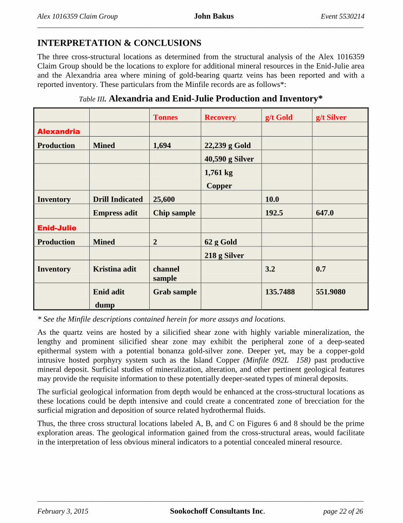
INTERPRETATION & CONCLUSIONS
The three cross-structural locations as determined from the structural analysis of the Alex 1016359
Claim Group should be the locations to explore for additional mineral resources in the Enid-Julie area
and the Alexandria area where mining of gold-bearing quartz veins has been reported and with a
reported inventory. These particulars from the Minfile records are as follows*:
Table III. Alexandria and Enid-Julie Production and Inventory*
Tonnes Recovery g/t Gold g/t Silver
Alexandria
Production Mined 1,694 22,239 g Gold
40,590 g Silver
1,761 kg
Copper
Inventory Drill Indicated 25,600 10.0
Empress adit Chip sample 192.5 647.0
Enid-Julie
Production Mined 2 62 g Gold
218 g Silver
Inventory Kristina adit channel
sample
3.2 0.7
Enid adit
dump
Grab sample 135.7488 551.9080
* See the Minfile descriptions contained herein for more assays and locations.
As the quartz veins are hosted by a silicified shear zone with highly variable mineralization, the
lengthy and prominent silicified shear zone may exhibit the peripheral zone of a deep-seated
epithermal system with a potential bonanza gold-silver zone. Deeper yet, may be a copper-gold
intrusive hosted porphyry system such as the Island Copper (Minfile 092L 158) past productive
mineral deposit. Surficial studies of mineralization, alteration, and other pertinent geological features
may provide the requisite information to these potentially deeper-seated types of mineral deposits.
The surficial geological information from depth would be enhanced at the cross-structural locations as
these locations could be depth intensive and could create a concentrated zone of brecciation for the
surficial migration and deposition of source related hydrothermal fluids.
Thus, the three cross structural locations labeled A, B, and C on Figures 6 and 8 should be the prime
exploration areas. The geological information gained from the cross-structural areas, would facilitate
in the interpretation of less obvious mineral indicators to a potential concealed mineral resource.

Alex 1016359 Claim Group John Bakus Event 5530214
__________________________________________________________________________________________
__________________________________________________________________________________________
February 3, 2015 Sookochoff Consultants Inc. page 23 of 26
Respectfully submitted
Sookochoff Consultants Inc.
Laurence Sookochoff, PEng

Alex 1016359 Claim Group John Bakus Event 5530214
__________________________________________________________________________________________
__________________________________________________________________________________________
February 3, 2015 Sookochoff Consultants Inc. page 24 of 26
SELECTED REFERENCES
Hicks, K. – Drilling, Geological and Geochemical Report on the Phillips Arm Project for
Falconbridge Limited. January 1986. AR 14 466 A
Jones, H.M. – Geological and Geochemical Report Alexandria Property for Corpac Minerals Ltd.
January 21, 1982. AR 10,399.
MapPlace – Map Data downloads
Marshak, S., Mitra, G. – Basic Methods of Structural Geology. pp 258-259, 264*.Prentice-Hall Inc.
1988
MtOnline - MINFILE downloads.
092K 023 – DORATHA MORTON
092K 035 – DOUGLAS PINE
092K 151 – PHIL
092L 158 – ISLAND COPPER
092K 024 – ENID-JULIE
092K 028 – ALEXANDRIA
092K 054 – ALLS UP
Ostler, J. – Geochemical, Geophysical and Road Surveys on the Alexandria Property for Norwood
Resources Limited. January 12, 1998. AR 25,231.
- Prospecting, Geochemical and Electromagnetic Surveys on the Alexandria Property for
Norwood Resources Limited. March 5, 1997. AR 24,890.
Roddick, J.A. – Notes on the Stratified rocks of Bute Inlet Map-area (excluding Vancouver and
Quadra Islands). Geological Survey of Canada, O.F. 480.

Alex 1016359 Claim Group John Bakus Event 5530214
__________________________________________________________________________________________
__________________________________________________________________________________________
February 3, 2015 Sookochoff Consultants Inc. page 25 of 26
STATEMENT OF COSTS
Work on the Alex 1016359 Claim Group was done from October 22, 2014 to October 25, 2014 to
the value as follows:
Structural Analysis
Laurence Sookochoff, PEng. 2.5 days @ $ 1,000.00/day -------- $ 2,500.00
Maps ----------------------------------------------------------------------- 1,000.00
Report --------------------------------------------------------------------- 3,500.00
$ 7,000.00
=======

Alex 1016359 Claim Group John Bakus Event 5530214
__________________________________________________________________________________________
__________________________________________________________________________________________
February 3, 2015 Sookochoff Consultants Inc. page 26 of 26
CERTIFICATE
I, Laurence Sookochoff, of the City of Vancouver, in the Province of British Columbia, do hereby
certify:
That I am a Consulting Geologist and principal of Sookochoff Consultants Inc. with an address at 120
125A-1030 Denman Street, Vancouver, BC V6G 2M6.
I, Laurence Sookochoff, further certify that:
1) I am a graduate of the University of British Columbia (1966) and hold a B.Sc. degree in Geology.
2) I have been practicing my profession for the past forty-eight years.
3) I am registered and in good standing with the Association of Professional Engineers and
Geoscientists of British Columbia.
4) The information for this report is based on information as itemized in the Selected Reference section
of this report and from periodic exploration work the author has performed within similar geological
areas as the area of the Alex 1016359 Claim Group
5) I have no interest in the Alex 1016359 Claim Group as described herein.
Laurence Sookochoff, P. Eng.