Embed Size (px)
Citation preview
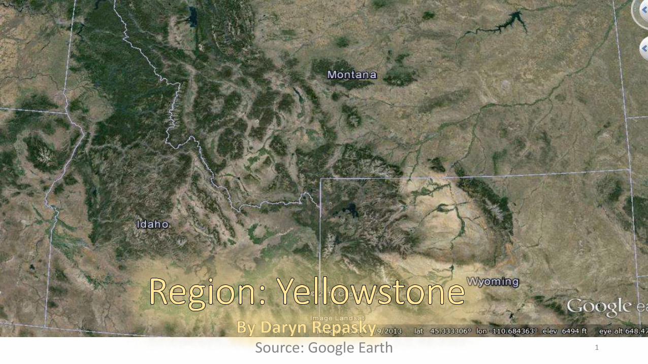
Source: Google Earth 1
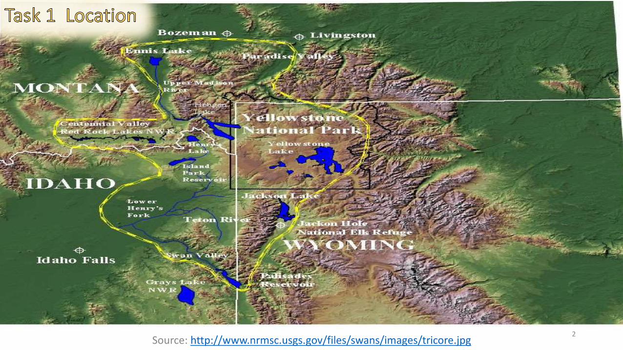
Source: http://www.nrmsc.usgs.gov/files/swans/images/tricore.jpg2
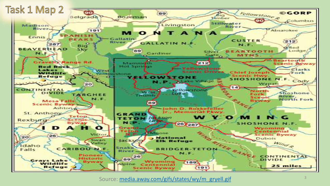
Source: media.away.com/gifs/states/wy/m_gryell.gif 3
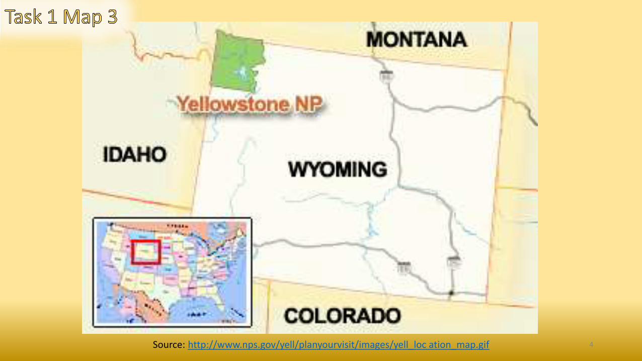
Source: http://www.nps.gov/yell/planyourvisit/images/yell_loc ation_map.gif 4
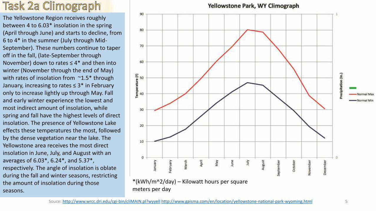
Souce: http://www.wrcc.dri.edu/cgi-bin/cliMAIN.pl?wyyell http://www.gaisma.com/en/location/yellowstone-national-park-wyoming.html 5
The Yellowstone Region receives roughly between 4 to 6.03* insolation in the spring (April through June) and starts to decline, from 6 to 4* in the summer (July through Mid-September). These numbers continue to taper off in the fall, (late-September through November) down to rates ≤ 4* and then into winter (November through the end of May) with rates of insolation from ~1.5* through January, increasing to rates ≤ 3* in February only to increase lightly up through May. Fall and early winter experience the lowest and most indirect amount of insolation, while spring and fall have the highest levels of direct insolation. The presence of Yellowstone Lake effects these temperatures the most, followed by the dense vegetation near the lake. The Yellowstone area receives the most direct insolation in June, July, and August with an averages of 6.03*, 6.24*, and 5.37*, respectively. The angle of insolation is oblate during the fall and winter seasons, restricting the amount of insolation during those seasons.
*(kWh/m^2/day) – Kilowatt hours per square meters per day
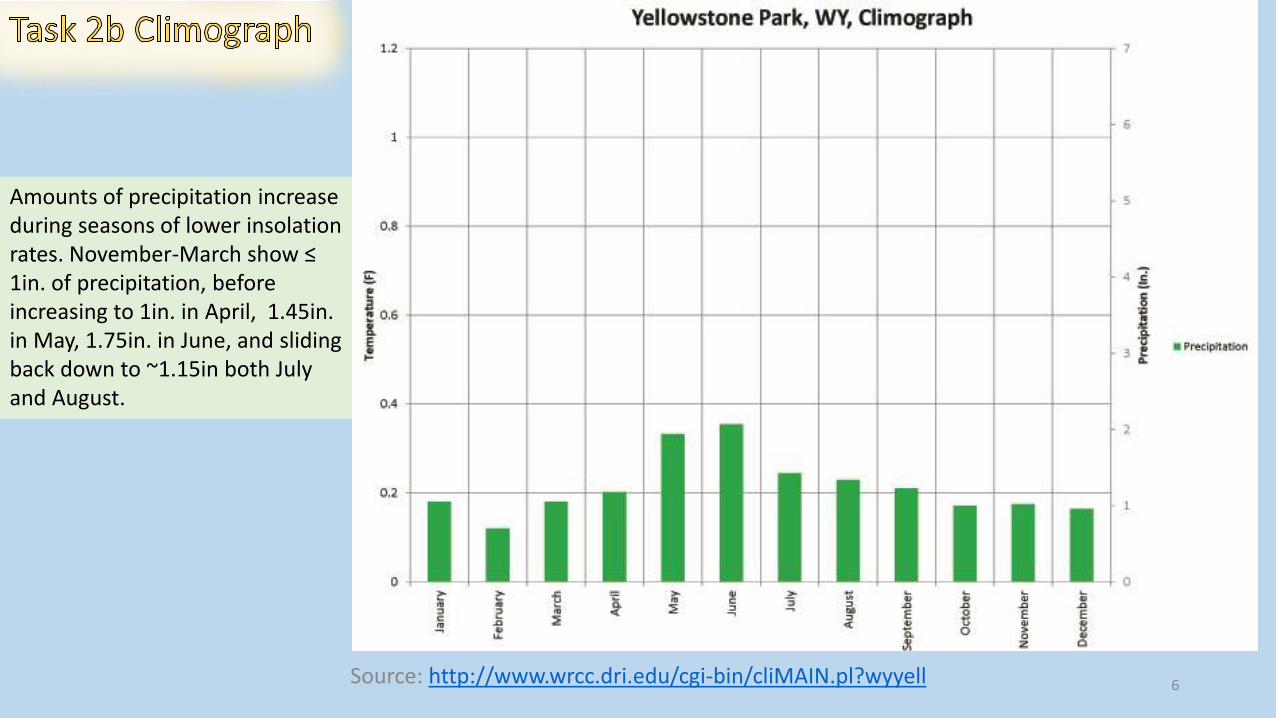
Source: http://www.wrcc.dri.edu/cgi-bin/cliMAIN.pl?wyyell 6
Amounts of precipitation increase during seasons of lower insolation rates. November-March show ≤ 1in. of precipitation, before increasing to 1in. in April, 1.45in. in May, 1.75in. in June, and sliding back down to ~1.15in both July and August.
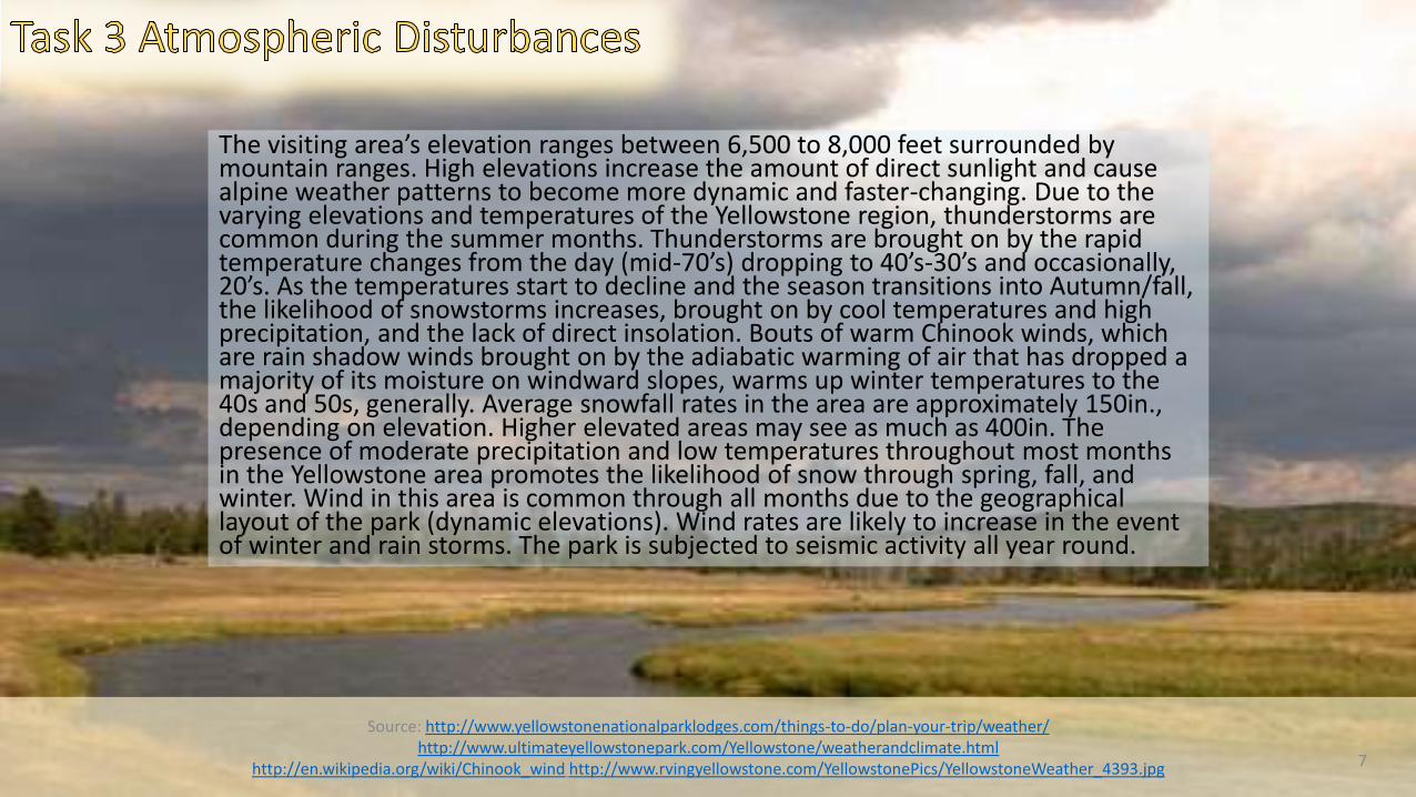
The visiting area’s elevation ranges between 6,500 to 8,000 feet surrounded by mountain ranges. High elevations increase the amount of direct sunlight and cause alpine weather patterns to become more dynamic and faster-changing. Due to the varying elevations and temperatures of the Yellowstone region, thunderstorms are common during the summer months. Thunderstorms are brought on by the rapid temperature changes from the day (mid-70’s) dropping to 40’s-30’s and occasionally, 20’s. As the temperatures start to decline and the season transitions into Autumn/fall, the likelihood of snowstorms increases, brought on by cool temperatures and high precipitation, and the lack of direct insolation. Bouts of warm Chinook winds, which are rain shadow winds brought on by the adiabatic warming of air that has dropped a majority of its moisture on windward slopes, warms up winter temperatures to the 40s and 50s, generally. Average snowfall rates in the area are approximately 150in., depending on elevation. Higher elevated areas may see as much as 400in. The presence of moderate precipitation and low temperatures throughout most months in the Yellowstone area promotes the likelihood of snow through spring, fall, and winter. Wind in this area is common through all months due to the geographical layout of the park (dynamic elevations). Wind rates are likely to increase in the event of winter and rain storms. The park is subjected to seismic activity all year round.
Source: http://www.yellowstonenationalparklodges.com/things-to-do/plan-your-trip/weather/http://www.ultimateyellowstonepark.com/Yellowstone/weatherandclimate.html
http://en.wikipedia.org/wiki/Chinook_wind http://www.rvingyellowstone.com/YellowstonePics/YellowstoneWeather_4393.jpg 7
Source: http://www.yellowstone.climatemps.com/http://www.nps.gov/features/yell/climateexplorer/index.html
8
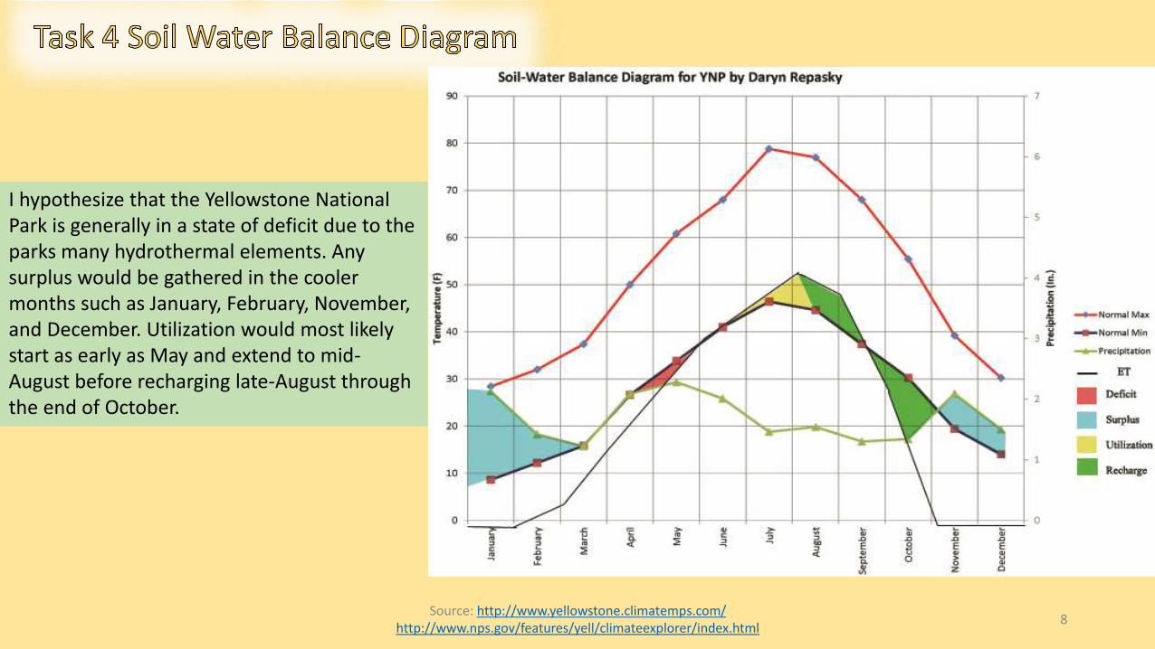
I hypothesize that the Yellowstone National Park is generally in a state of deficit due to the parks many hydrothermal elements. Any surplus would be gathered in the cooler months such as January, February, November, and December. Utilization would most likely start as early as May and extend to mid-August before recharging late-August through the end of October.
Source: http://www.yellowstone.climatemps.com/ https://weatherspark.com/averages/31209/Yellowstone-National-Park-Wyoming-United-States ELEMENTAL GEOSYSTEMS PG. 165
9
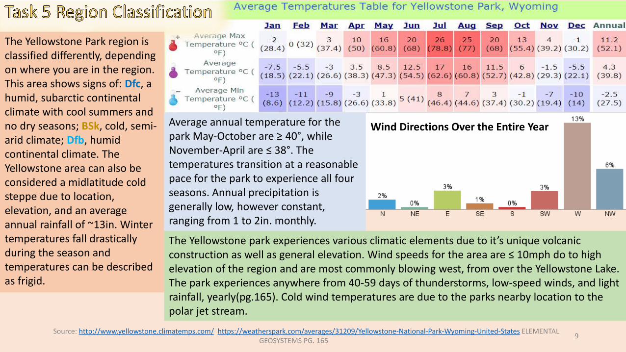
The Yellowstone Park region is classified differently, depending on where you are in the region. This area shows signs of: Dfc, a humid, subarctic continental climate with cool summers and no dry seasons; BSk, cold, semi-arid climate; Dfb, humid continental climate. The Yellowstone area can also be considered a midlatitude cold steppe due to location, elevation, and an average annual rainfall of ~13in. Winter temperatures fall drastically during the season and temperatures can be described as frigid.
Wind Directions Over the Entire YearAverage annual temperature for the park May-October are ≥ 40°, while November-April are ≤ 38°. The temperatures transition at a reasonable pace for the park to experience all four seasons. Annual precipitation is generally low, however constant, ranging from 1 to 2in. monthly.
The Yellowstone park experiences various climatic elements due to it’s unique volcanicconstruction as well as general elevation. Wind speeds for the area are ≤ 10mph do to high elevation of the region and are most commonly blowing west, from over the Yellowstone Lake. The park experiences anywhere from 40-59 days of thunderstorms, low-speed winds, and light rainfall, yearly(pg.165). Cold wind temperatures are due to the parks nearby location to the polar jet stream.
Source: http://www.geologycafe.com/images/vulcan3.jpg https://gsa.confex.com/gsa/2011RM/finalprogram/abstract_187754.htmhttp://serc.carleton.edu/research_education/yellowstone_reu/index.html “Metamorphism” http://www.cr.nps.gov/history/online_books/geology/publications/bul/1347/images/fig5.jpg
10
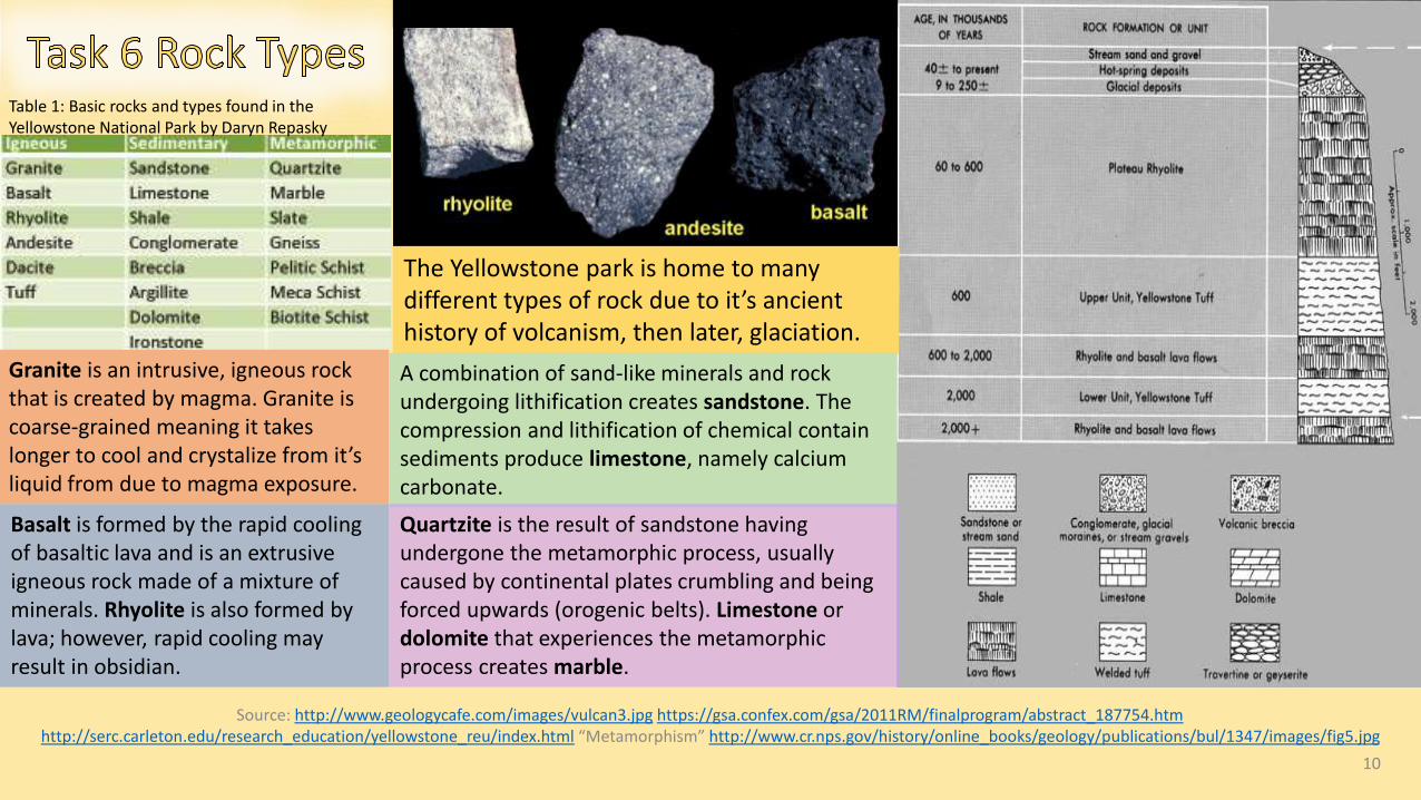
Table 1: Basic rocks and types found in the Yellowstone National Park by Daryn Repasky
Granite is an intrusive, igneous rock that is created by magma. Granite is coarse-grained meaning it takes longer to cool and crystalize from it’s liquid from due to magma exposure.
The Yellowstone park is home to many different types of rock due to it’s ancient history of volcanism, then later, glaciation.
Basalt is formed by the rapid cooling of basaltic lava and is an extrusive igneous rock made of a mixture of minerals. Rhyolite is also formed by lava; however, rapid cooling may result in obsidian.
A combination of sand-like minerals and rock undergoing lithification creates sandstone. The compression and lithification of chemical contain sediments produce limestone, namely calcium carbonate.
Quartzite is the result of sandstone having undergone the metamorphic process, usually caused by continental plates crumbling and being forced upwards (orogenic belts). Limestone or dolomite that experiences the metamorphic process creates marble.

Source: http://volcano.oregonstate.edu/hotspotparks http://www.geology.sdsu.edu/how_volcanoes_work/Thumblinks/yellowstone_page.html11
The Yellowstone Park itself was created by various tectonic, glacial and volcanic processes. I hypothesize that the Yellowstone region’s crust was formed from stable platforms of rocks. Due to the historic presence of the Yellowstone “super volcano” and the park location over a continental hot spot, it’s safe to say the region is largely volcanic. The park is situated on a high plateau supported by a thermally expanded, buoyant mantle, called a mantle plume. The mantle itself expands and contracts The deformed crustal formation would have been brought on by bouts of faulting, folding, and crustal movement caused by various volcanic eruptions over the course of millions of years. In the wake of these ancient eruptions, U-shaped valleys were formed, as well as a few calderas, some of which have been long since covered by basaltic lava flows and surficial elements.
Source: http://surveyofyellowstone.tumblr.com/ http://volcanoes.usgs.gov/vsc/images/image_mngr/0-99/img12_800w_500h.jpg http://geo1202.blogspot.com/2011/03/normal-0-false-false-false-en-us-x-none.html 12
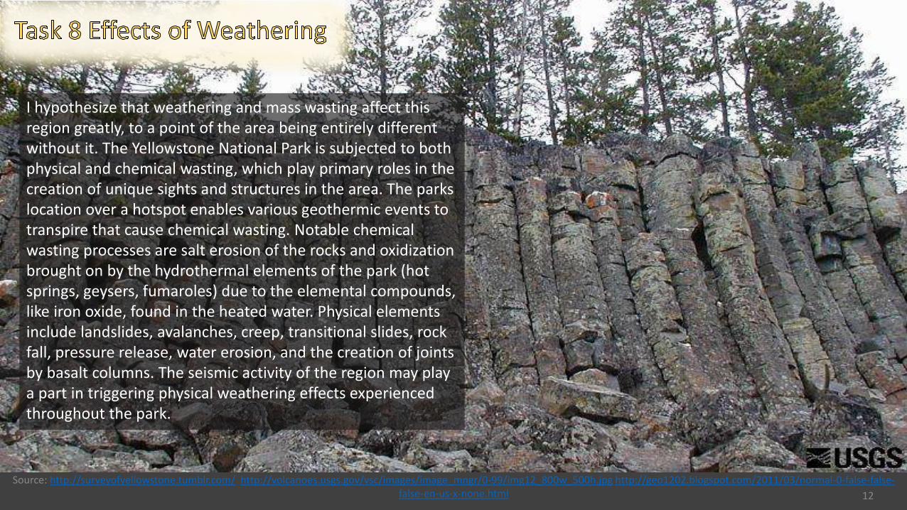
I hypothesize that weathering and mass wasting affect this region greatly, to a point of the area being entirely different without it. The Yellowstone National Park is subjected to both physical and chemical wasting, which play primary roles in the creation of unique sights and structures in the area. The parks location over a hotspot enables various geothermic events to transpire that cause chemical wasting. Notable chemical wasting processes are salt erosion of the rocks and oxidization brought on by the hydrothermal elements of the park (hot springs, geysers, fumaroles) due to the elemental compounds, like iron oxide, found in the heated water. Physical elements include landslides, avalanches, creep, transitional slides, rock fall, pressure release, water erosion, and the creation of joints by basalt columns. The seismic activity of the region may play a part in triggering physical weathering effects experienced throughout the park.
Source: http://www.secretyellowstone.com/wp-content/uploads/2010/01/yellowstonerivers.jpg http://www.secretyellowstone.com/historical-cultural-scientific/rivers-streams-lakeshttp://www.scienceclarified.com/landforms/Ocean-Basins-to-Volcanoes/Stream-and-River.html
13
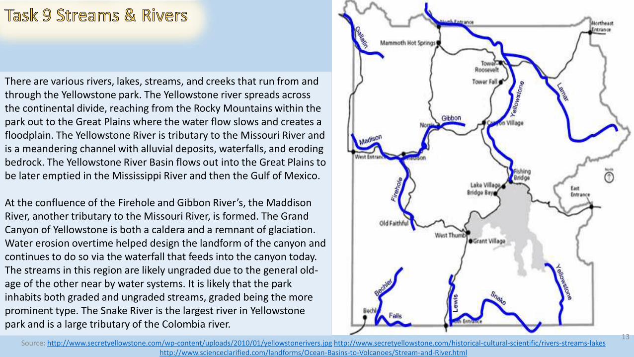
There are various rivers, lakes, streams, and creeks that run from and through the Yellowstone park. The Yellowstone river spreads across the continental divide, reaching from the Rocky Mountains within the park out to the Great Plains where the water flow slows and creates a floodplain. The Yellowstone River is tributary to the Missouri River and is a meandering channel with alluvial deposits, waterfalls, and eroding bedrock. The Yellowstone River Basin flows out into the Great Plains to be later emptied in the Mississippi River and then the Gulf of Mexico.
At the confluence of the Firehole and Gibbon River’s, the Maddison River, another tributary to the Missouri River, is formed. The Grand Canyon of Yellowstone is both a caldera and a remnant of glaciation. Water erosion overtime helped design the landform of the canyon and continues to do so via the waterfall that feeds into the canyon today. The streams in this region are likely ungraded due to the general old-age of the other near by water systems. It is likely that the park inhabits both graded and ungraded streams, graded being the more prominent type. The Snake River is the largest river in Yellowstone park and is a large tributary of the Colombia river.
Source: http://traveltips.usatoday.com/types-landforms-yellowstone-63188.html http://commons.wikimedia.org/wiki/File:Origin_of_volcanic_caldera_via_analogue_model.gifChristopherson, ELEMENTAL GEOSYSTEMS (G.15” Volcanoes”) http://3.bp.blogspot.com/-2XYaCslOQRo/T6W139QNu9I/AAAAAAAAANw/_E7lGhqwIA4/s1600/domes5.jpeg
14
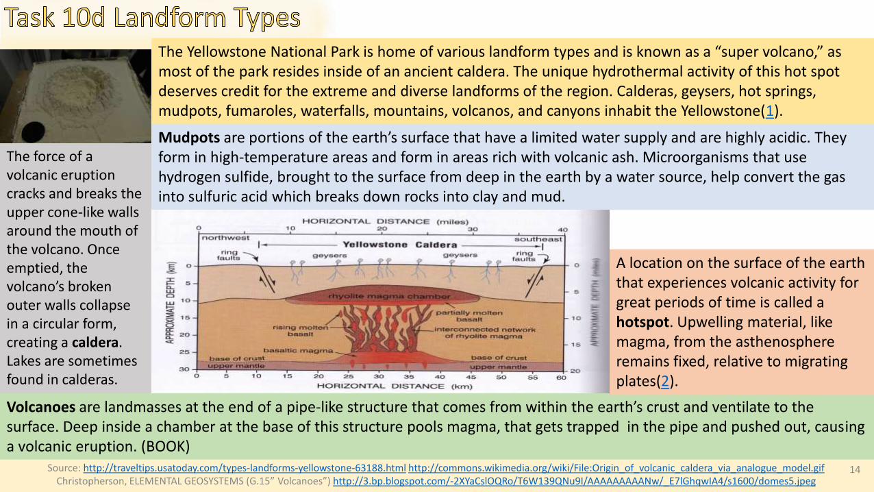
The Yellowstone National Park is home of various landform types and is known as a “super volcano,” as most of the park resides inside of an ancient caldera. The unique hydrothermal activity of this hot spot deserves credit for the extreme and diverse landforms of the region. Calderas, geysers, hot springs, mudpots, fumaroles, waterfalls, mountains, volcanos, and canyons inhabit the Yellowstone(1).
The force of a volcanic eruption cracks and breaks the upper cone-like walls around the mouth of the volcano. Once emptied, the volcano’s broken outer walls collapse in a circular form, creating a caldera. Lakes are sometimes found in calderas.
Volcanoes are landmasses at the end of a pipe-like structure that comes from within the earth’s crust and ventilate to the surface. Deep inside a chamber at the base of this structure pools magma, that gets trapped in the pipe and pushed out, causinga volcanic eruption. (BOOK)
A location on the surface of the earth that experiences volcanic activity for great periods of time is called a hotspot. Upwelling material, like magma, from the asthenosphere remains fixed, relative to migrating plates(2).
Mudpots are portions of the earth’s surface that have a limited water supply and are highly acidic. They form in high-temperature areas and form in areas rich with volcanic ash. Microorganisms that use hydrogen sulfide, brought to the surface from deep in the earth by a water source, help convert the gas into sulfuric acid which breaks down rocks into clay and mud.
Source: http://yellowpark.weebly.com/geysers.html http://www.britannica.com/EBchecked/topic/272775/hot-spring http://www.nps.gov/yell/photosmultimedia/norris-tour-black-growler.htmhttp://www.nps.gov/features/yell/slidefile/history/postcards/fjhaynes/Images/11516.jpg 15
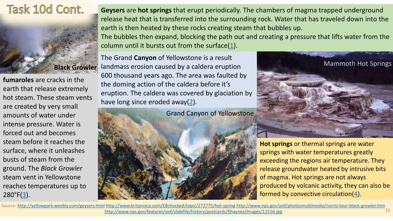
Geysers are hot springs that erupt periodically. The chambers of magma trapped underground release heat that is transferred into the surrounding rock. Water that has traveled down into the earth is then heated by these rocks creating steam that bubbles up. The bubbles then expand, blocking the path out and creating a pressure that lifts water from the column until it bursts out from the surface(1).
Hot springs or thermal springs are water springs with water temperatures greatly exceeding the regions air temperature. They release groundwater heated by intrusive bits of magma. Hot springs are not always produced by volcanic activity, they can also be formed by convective circulation(4).
fumaroles are cracks in the earth that release extremely hot steam. These steam vents are created by very small amounts of water under intense pressure. Water is forced out and becomes steam before it reaches the surface, where it unleashes busts of steam from the ground. The Black Growler steam vent in Yellowstone reaches temperatures up to 280°F(3).
Black Growler
The Grand Canyon of Yellowstone is a result landmass erosion caused by a caldera eruption 600 thousand years ago. The area was faulted by the doming action of the caldera before it’s eruption. The caldera was covered by glaciation by have long since eroded away(2).
Mammoth Hot Springs
Grand Canyon of Yellowstone
Source: http://www.montana.edu/business/images/absaroka-mountains.jpg http://www.wsgs.wyo.gov/research/stratigraphy/AbsarokaRange/Default.aspxhttp://www.pbs.org/program/yellowstone/ 16
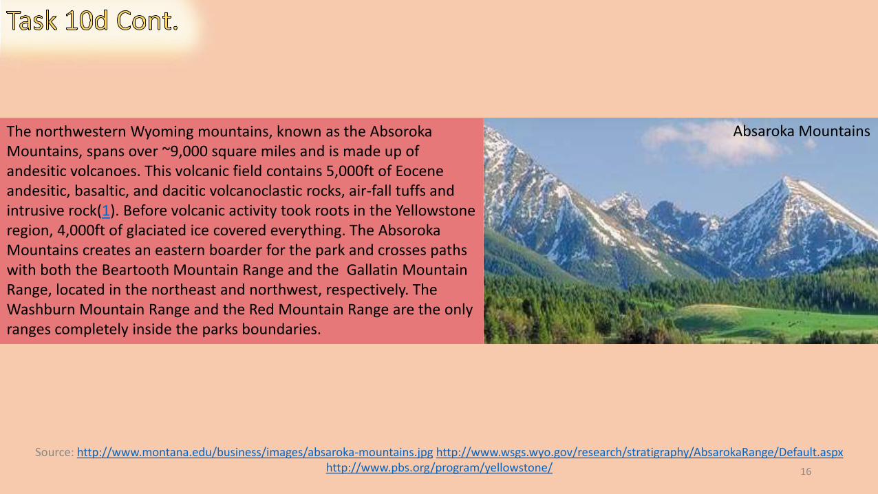
Absaroka MountainsThe northwestern Wyoming mountains, known as the Absoroka Mountains, spans over ~9,000 square miles and is made up of andesitic volcanoes. This volcanic field contains 5,000ft of Eocene andesitic, basaltic, and dacitic volcanoclastic rocks, air-fall tuffs and intrusive rock(1). Before volcanic activity took roots in the Yellowstone region, 4,000ft of glaciated ice covered everything. The Absoroka Mountains creates an eastern boarder for the park and crosses paths with both the Beartooth Mountain Range and the Gallatin Mountain Range, located in the northeast and northwest, respectively. The Washburn Mountain Range and the Red Mountain Range are the only ranges completely inside the parks boundaries.
Source: https://soilseries.sc.egov.usda.gov/OSD_Docs/Y/YELLOWSTONE.html http://www.wyomingextension.org/agpubs/pubs/b1069.pdfhttp://www.fs.fed.us/rm/pubs_other/rmrs_2013_sikkink_p001.pdf http://4.bp.blogspot.com/-ufG_jeBj3s4/T5TsjrmwiZI/AAAAAAAAALA/RHcEHbSTNo4/s1600/Bolg+2+soil+profile+of+K's.jpg
ELEMENTAL GEOSYSTEMS PG. 455 “Soil Taxonomy”
17
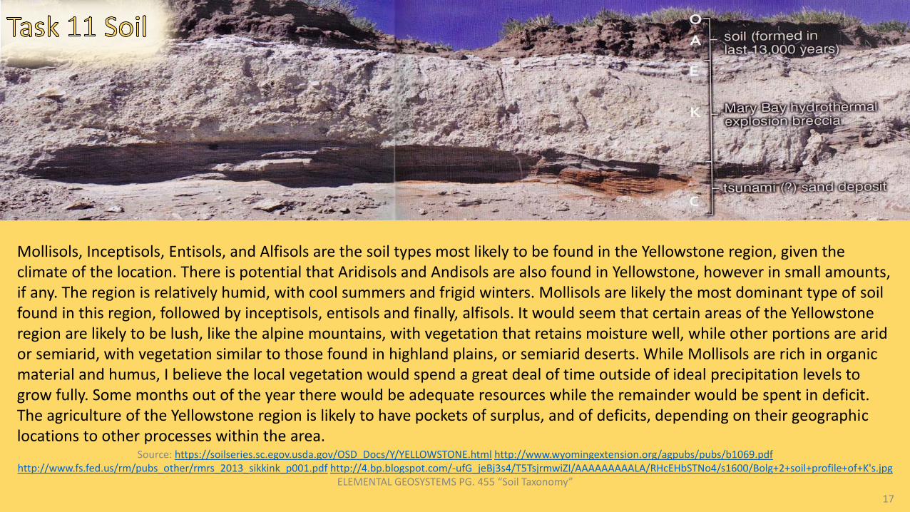
Mollisols, Inceptisols, Entisols, and Alfisols are the soil types most likely to be found in the Yellowstone region, given the climate of the location. There is potential that Aridisols and Andisols are also found in Yellowstone, however in small amounts,if any. The region is relatively humid, with cool summers and frigid winters. Mollisols are likely the most dominant type of soil found in this region, followed by inceptisols, entisols and finally, alfisols. It would seem that certain areas of the Yellowstone region are likely to be lush, like the alpine mountains, with vegetation that retains moisture well, while other portions are arid or semiarid, with vegetation similar to those found in highland plains, or semiarid deserts. While Mollisols are rich in organicmaterial and humus, I believe the local vegetation would spend a great deal of time outside of ideal precipitation levels to grow fully. Some months out of the year there would be adequate resources while the remainder would be spent in deficit. The agriculture of the Yellowstone region is likely to have pockets of surplus, and of deficits, depending on their geographic locations to other processes within the area.
Source: http://pubs.usgs.gov/wri/wri984269/fig10.gifhttp://www.britannica.com/EBchecked/topic/652774/Yellowstone-National-Park/306480/Plant-and-animal-life
http://www.yellowstone.co/wildflowers/wildflowerspage3.htm http://fedgycc.org/images/clip_image002_009.jpg 18
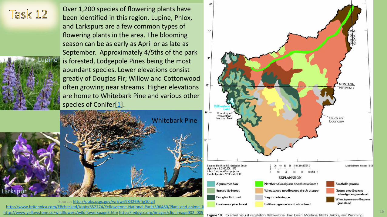
Over 1,200 species of flowering plants have been identified in this region. Lupine, Phlox, and Larkspurs are a few common types of flowering plants in the area. The blooming season can be as early as April or as late as September. Approximately 4/5ths of the park is forested, Lodgepole Pines being the most abundant species. Lower elevations consist greatly of Douglas Fir; Willow and Cottonwood often growing near streams. Higher elevations are home to Whitebark Pine and various other species of Conifer[1].
Whitebark Pine
Lupine
Larkspur
Source: http://www.yellowstone.co/animals.htm http://www.britannica.com/EBchecked/topic/652774/Yellowstone-National-Park/306480/Plant-and-animal-life 19
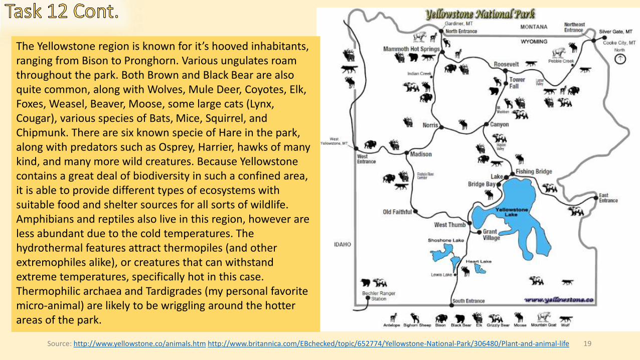
The Yellowstone region is known for it’s hooved inhabitants, ranging from Bison to Pronghorn. Various ungulates roam throughout the park. Both Brown and Black Bear are also quite common, along with Wolves, Mule Deer, Coyotes, Elk, Foxes, Weasel, Beaver, Moose, some large cats (Lynx, Cougar), various species of Bats, Mice, Squirrel, and Chipmunk. There are six known specie of Hare in the park, along with predators such as Osprey, Harrier, hawks of many kind, and many more wild creatures. Because Yellowstone contains a great deal of biodiversity in such a confined area, it is able to provide different types of ecosystems with suitable food and shelter sources for all sorts of wildlife. Amphibians and reptiles also live in this region, however are less abundant due to the cold temperatures. The hydrothermal features attract thermopiles (and other extremophiles alike), or creatures that can withstand extreme temperatures, specifically hot in this case. Thermophilic archaea and Tardigrades (my personal favorite micro-animal) are likely to be wriggling around the hotter areas of the park.

20
Task 10d: http://traveltips.usatoday.com/types-landforms-yellowstone-63188.htmlhttp://commons.wikimedia.org/wiki/File:Origin_of_volcanic_caldera_via_analogue_model.gifChristopherson, ELEMENTAL GEOSYSTEMS (G.15” Volcanoes”) http://3.bp.blogspot.com/-2XYaCslOQRo/T6W139QNu9I/AAAAAAAAANw/_E7lGhqwIA4/s1600/domes5.jpeg10 cont: http://yellowpark.weebly.com/geysers.htmlhttp://www.britannica.com/EBchecked/topic/272775/hot-springhttp://www.nps.gov/yell/photosmultimedia/norris-tour-black-growler.htmhttp://www.nps.gov/features/yell/slidefile/history/postcards/fjhaynes/Images/11516.jpg10 cont: http://www.montana.edu/business/images/absaroka-mountains.jpghttp://www.wsgs.wyo.gov/research/stratigraphy/AbsarokaRange/Default.aspxhttp://www.pbs.org/program/yellowstone/
Task 1: Google EarthLocation Map: http://www.nrmsc.usgs.gov/files/swans/images/tricore.jpgMap 2: media.away.com/gifs/states/wy/m_gryell.gifMap 3: http://www.nps.gov/yell/planyourvisit/images/yell_loc ation_map.gif
Task 2: http://www.wrcc.dri.edu/cgi-bin/cliMAIN.pl?wyyellhttp://www.gaisma.com/en/location/yellowstone-national-park-wyoming.html
Task 3: http://www.yellowstonenationalparklodges.com/things-to-do/plan-your-trip/weather/http://www.ultimateyellowstonepark.com/Yellowstone/weatherandclimate.htmlhttp://en.wikipedia.org/wiki/Chinook_windhttp://www.rvingyellowstone.com/YellowstonePics/YellowstoneWeather_4393.jpg
Task 4: Source: http://www.yellowstone.climatemps.com/http://www.nps.gov/features/yell/climateexplorer/index.html
Task 5: http://www.yellowstone.climatemps.com/https://weatherspark.com/averages/31209/Yellowstone-National-Park-Wyoming-United-StatesELEMENTAL GEOSYSTEMS PG. 165
Task 6: Source: http://www.geologycafe.com/images/vulcan3.jpghttps://gsa.confex.com/gsa/2011RM/finalprogram/abstract_187754.htmhttp://serc.carleton.edu/research_education/yellowstone_reu/index.html“Metamorphism”http://www.cr.nps.gov/history/online_books/geology/publications/bul/1347/images/fig5.jpg
Task 7: http://volcano.oregonstate.edu/hotspotparkshttp://www.geology.sdsu.edu/how_volcanoes_work/Thumblinks/yellowstone_page.html
Task 8: http://surveyofyellowstone.tumblr.com/http://volcanoes.usgs.gov/vsc/images/image_mngr/0-99/img12_800w_500h.jpghttp://geo1202.blogspot.com/2011/03/normal-0-false-false-false-en-us-x-none.html
Task 9: : http://www.secretyellowstone.com/wp-content/uploads/2010/01/yellowstonerivers.jpghttp://www.secretyellowstone.com/historical-cultural-scientific/rivers-streams-lakeshttp://www.scienceclarified.com/landforms/Ocean-Basins-to-Volcanoes/Stream-and-River.html
Task 11: https://soilseries.sc.egov.usda.gov/OSD_Docs/Y/YELLOWSTONE.htmlhttp://www.wyomingextension.org/agpubs/pubs/b1069.pdfhttp://www.fs.fed.us/rm/pubs_other/rmrs_2013_sikkink_p001.pdfhttp://4.bp.blogspot.com/-ufG_jeBj3s4/T5TsjrmwiZI/AAAAAAAAALA/RHcEHbSTNo4/s1600/Bolg+2+soil+profile+of+K's.jpgELEMENTAL GEOSYSTEMS PG. 455 “Soil Taxonomy”
Task 12: : http://pubs.usgs.gov/wri/wri984269/fig10.gifhttp://www.britannica.com/EBchecked/topic/652774/Yellowstone-National-Park/306480/Plant-and-animal-lifehttp://www.yellowstone.co/wildflowers/wildflowerspage3.htmhttp://fedgycc.org/images/clip_image002_009.jpg12 cont: http://www.yellowstone.co/animals.htmhttp://www.britannica.com/EBchecked/topic/652774/Yellowstone-National-Park/306480/Plant-and-animal-life