Embed Size (px)
Citation preview

Topographical map resource package Sec 4E/5N Geography Elective
Topographical map
Basic elements of a topographical map
Topographical map resource package Sec 4E/5N Geography Elective
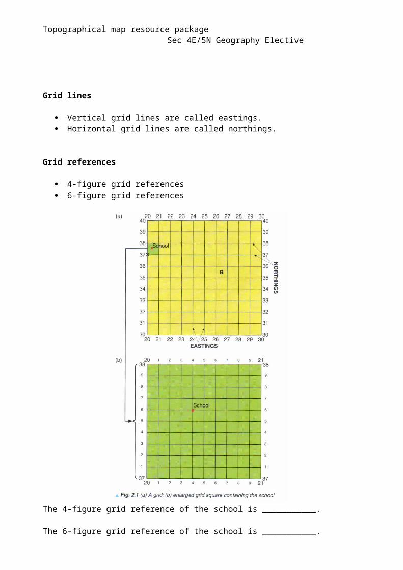
Grid lines
Vertical grid lines are called eastings. Horizontal grid lines are called northings.
Grid references
4-figure grid references 6-figure grid references
The 4-figure grid reference of the school is ___________.
The 6-figure grid reference of the school is ___________.
Topographical map resource package Sec 4E/5N Geography Elective
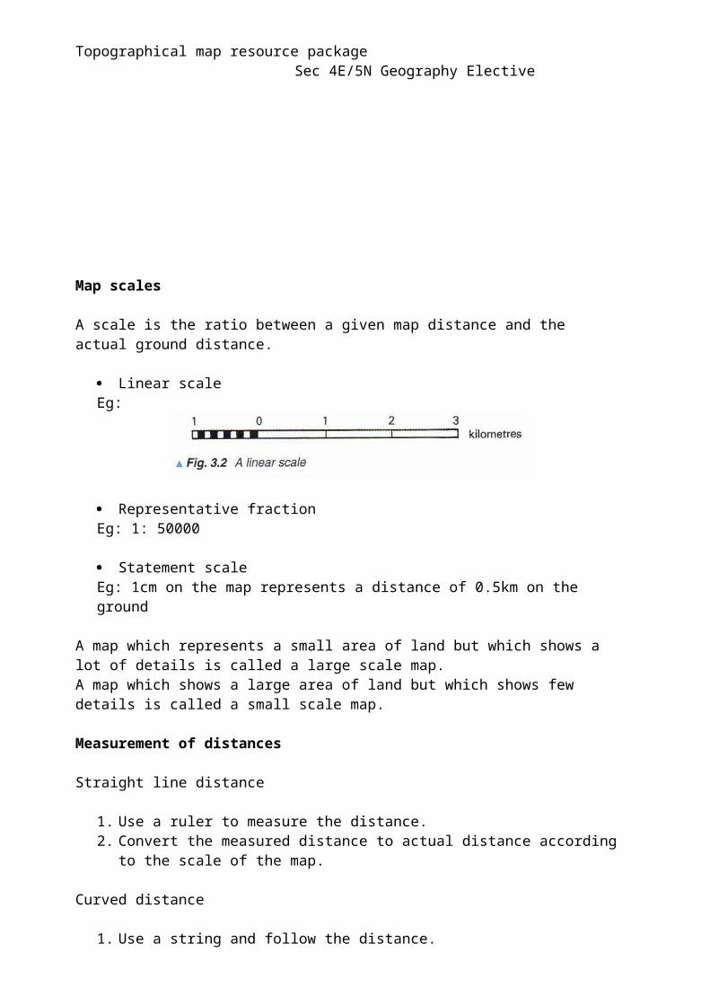
Map scales
A scale is the ratio between a given map distance and the actual ground distance.
Linear scaleEg:
Representative fractionEg: 1: 50000
Statement scaleEg: 1cm on the map represents a distance of 0.5km on the ground
A map which represents a small area of land but which shows a lot of details is called a large scale map.A map which shows a large area of land but which shows few details is called a small scale map.
Measurement of distances
Straight line distance
1. Use a ruler to measure the distance. 2. Convert the measured distance to actual distance according to the scale of the
map.
Curved distance
1. Use a string and follow the distance. 2. Place the string against the ruler to measure the distance.3. Convert the measured distance to actual distance according to the scale of the
map.
Topographical map resource package Sec 4E/5N Geography Elective
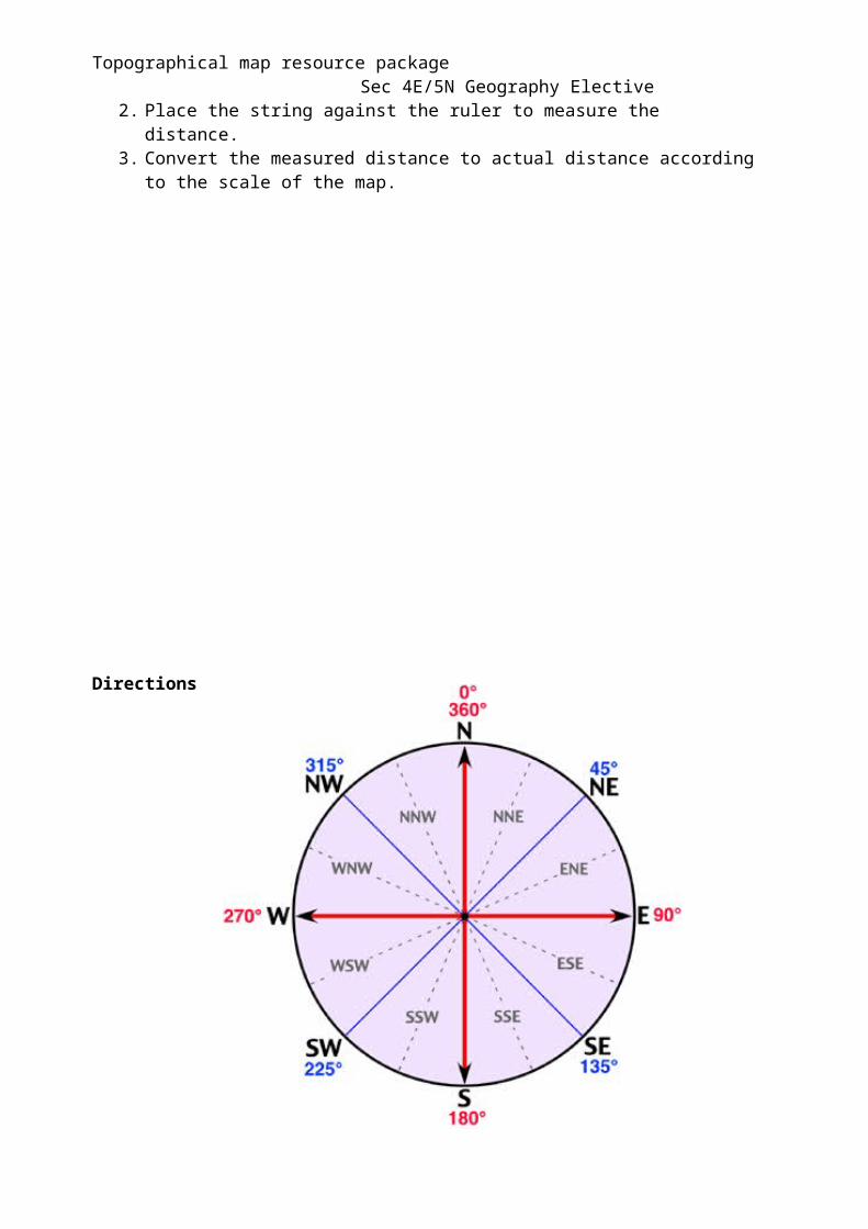
Directions
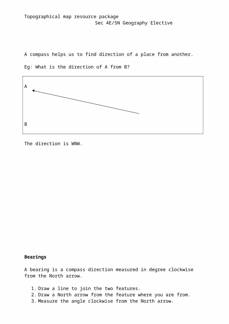
A compass helps us to find direction of a place from another.
Eg: What is the direction of A from B?
A
B
The direction is WNW.
Topographical map resource package Sec 4E/5N Geography Elective
Bearings
A bearing is a compass direction measured in degree clockwise from the North arrow.
1. Draw a line to join the two features.2. Draw a North arrow from the feature where you are from.3. Measure the angle clockwise from the North arrow.
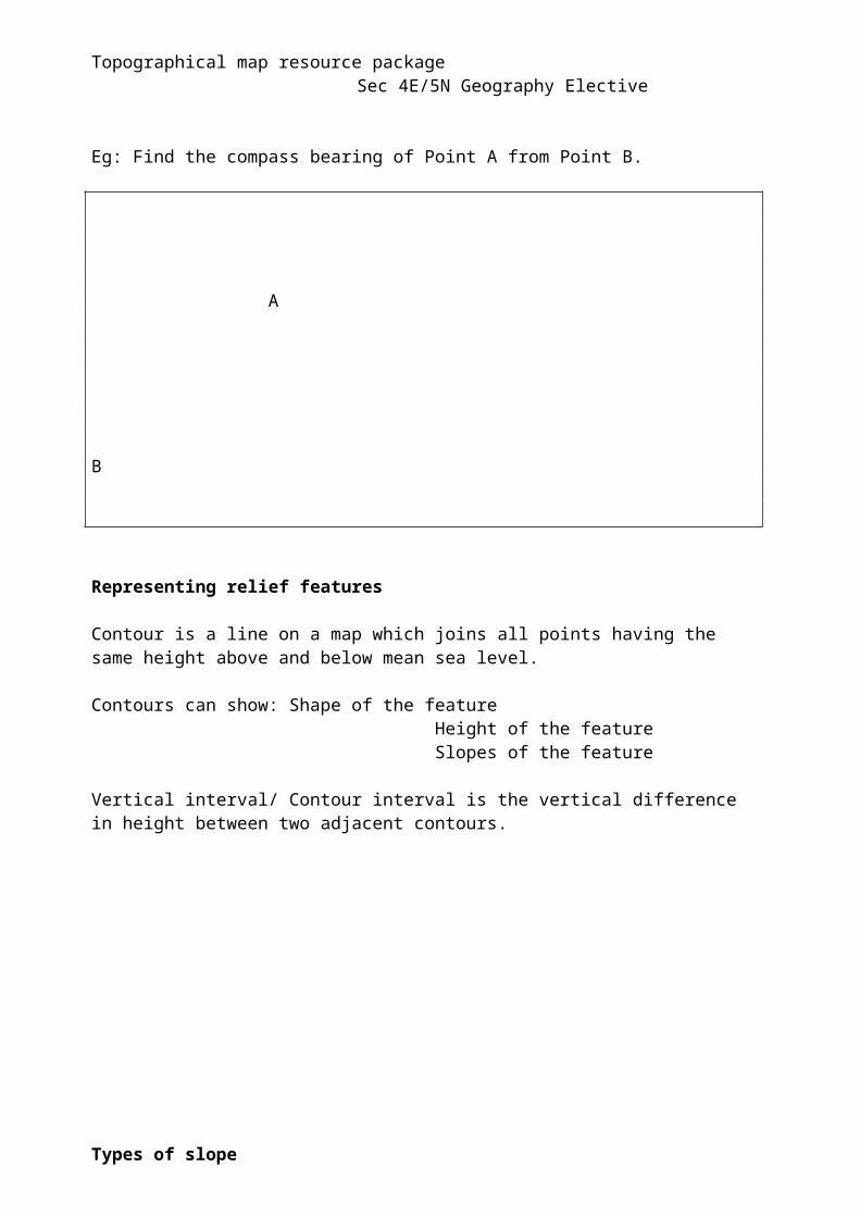
Eg: Find the compass bearing of Point A from Point B.
A
B
Representing relief features
Contour is a line on a map which joins all points having the same height above and below mean sea level.
Contours can show: Shape of the feature Height of the feature Slopes of the feature
Vertical interval/ Contour interval is the vertical difference in height between two adjacent contours.
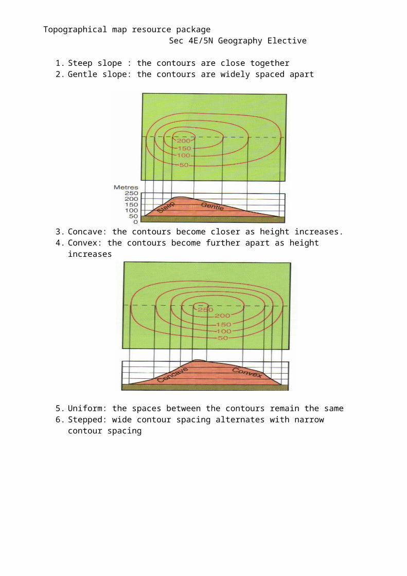
Topographical map resource package Sec 4E/5N Geography ElectiveTypes of slope
1. Steep slope : the contours are close together2. Gentle slope: the contours are widely spaced apart
3. Concave: the contours become closer as height increases.4. Convex: the contours become further apart as height increases
5. Uniform: the spaces between the contours remain the same6. Stepped: wide contour spacing alternates with narrow contour spacing
Topographical map resource package Sec 4E/5N Geography ElectiveGradient
Gradient refers to the steepness of a slope.A gradient can be written as a ratio between the vertical distance relative to the horizontal distance.
1. Measure the horizontal distance2. Convert the horizontal distance to metres according to the scale3. Calculate the vertical distance by looking at the contour lines4. Use the formula: Gradient = Vertical distance
Horizontal distance
Working:
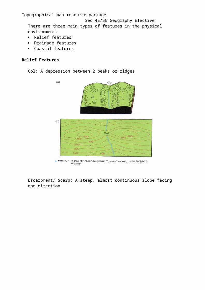
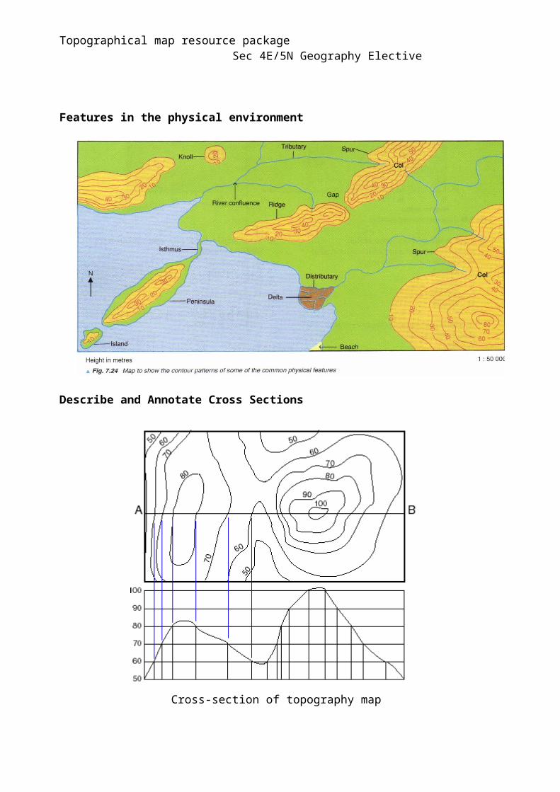
Features of the Physical Environment
There are three main types of features in the physical environment. Relief features Drainage features Coastal features
Relief Features
Col: A depression between 2 peaks or ridges

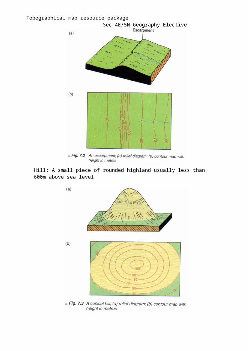
Topographical map resource package Sec 4E/5N Geography ElectiveEscarpment/ Scarp: A steep, almost continuous slope facing one direction
Hill: A small piece of rounded highland usually less than 600m above sea level
Topographical map resource package Sec 4E/5N Geography ElectiveMountain: A large steep-sided piece of highland which ends in a summit or peak usually higher than 600m above sea level
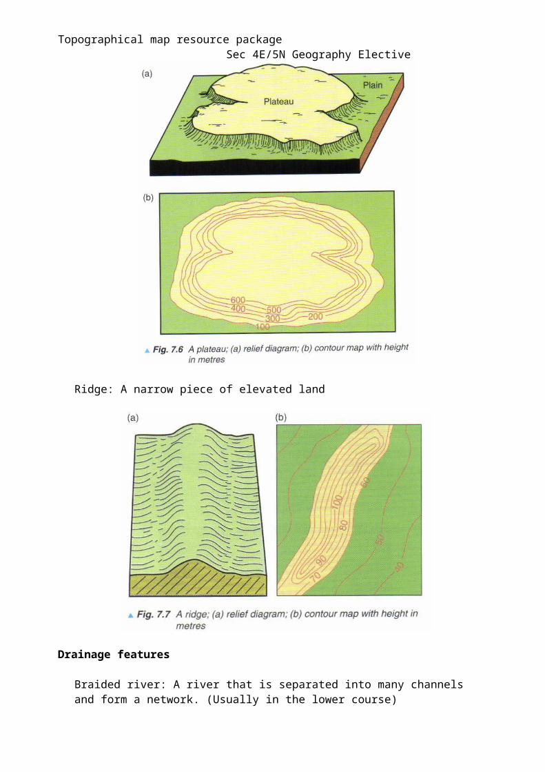
Plateau: A fairly flat piece of elevated land
Topographical map resource package Sec 4E/5N Geography ElectiveRidge: A narrow piece of elevated land
Drainage features
Braided river: A river that is separated into many channels and form a network. (Usually in the lower course)

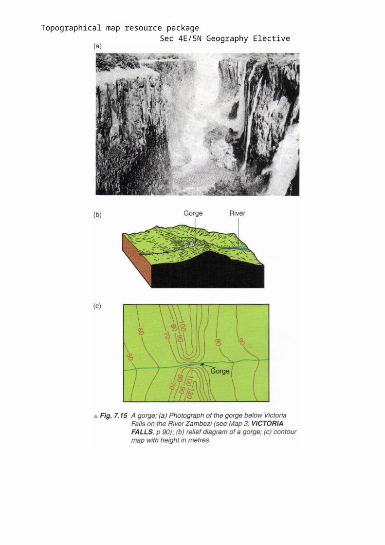
Topographical map resource package Sec 4E/5N Geography ElectiveGorge: A deep and narrow valley with side which are almost vertical.
Topographical map resource package Sec 4E/5N Geography ElectiveFloodplain: A lowland bordering a river.
V- shaped valley: A river cuts downwards into the riverbed and erodes it vertically.
Features in the physical environment

Topographical map resource package Sec 4E/5N Geography Elective
Describe and Annotate Cross Sections
Cross-section of topography map
Annotate the following on the cross-section of the topography map.
A: ValleyB: Steepest slopeC: Highest peak
Topographical map resource package Sec 4E/5N Geography ElectiveHuman environment
Components of human environment Agriculture Industry Settlements and communications
The function of a settlement refers to the main activity of the settlement. These can be inferred by looking at evidences from the map.
Examples of function
PortA port is a settlement on a coast, river which develops trading activities.Evidences to look out for: Ports, coasts
Industrial TownAn industrial town is a settlement which has industrial activities. These activities may develop because the settlement is near to a source of fuel energy, raw materials or near to a large population which acts as a market.Evidences to look out for: Fuel energy, Factories
Agricultural TownAn agricultural town is usually located in an area where crops are grown or livestock are reared, or where agricultural products are processed and marketed.Evidences to look out for: Cultivation, plantations
Residential TownA residential town appears on a map as an extensive area of houses plus associated buildings like schools, hospitals, religious buildings.Evidences to look out for: Facilities, housing
Settlement Patterns

Topographical map resource package Sec 4E/5N Geography Elective
Dispersed settlement pattern
Buildings are scattered giving an open appearance. This type of pattern is usually found in areas that have a sparse population. Eg: Rural areas
Linear settlement pattern
Buildings are located along a footpath, road, railway or a river. This is also fairly common in rural areas.
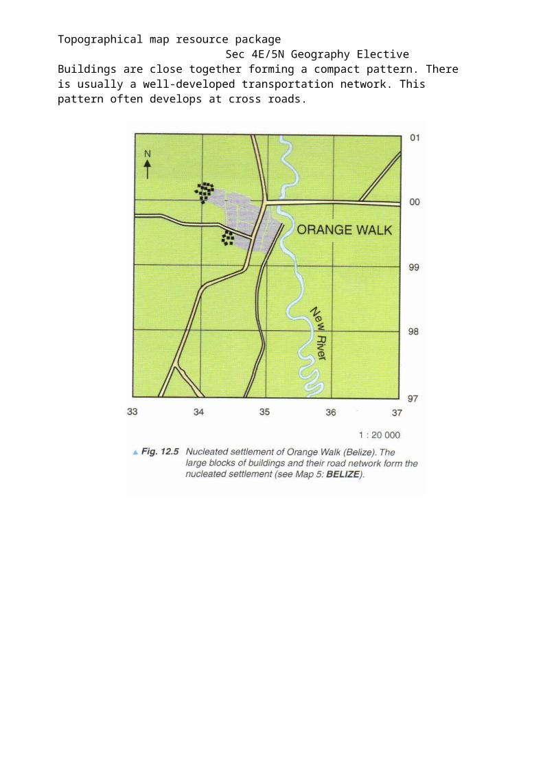
Nucleated settlement pattern
Topographical map resource package Sec 4E/5N Geography Elective
Buildings are close together forming a compact pattern. There is usually a well-developed transportation network. This pattern often develops at cross roads.
Topographical map resource package Sec 4E/5N Geography ElectiveGuidelines in answering map related questions
Description of relief
1. Give the range of height of the relief of the area.2. State the height of the highest point3. Describe the relief ( Mountainous, hilly)4. Point out any relief features that stand out in the area5. Describe the slope in the area (Concave, convex, uniform, stepped, steep,
gently sloping)
Description of river course
1. State the direction of river flow (From source to mouth)2. State the course of the river (Upper, middle, lower course)3. Describe the river course (Meandering, straight, braiding)4. Describe the river features found along the river5. Give map evidences in the form of grid squares or grid lines.
Description of coastal zone
1. Describe the shape of the coast2. Describe the gradient of the coast (Steep or gentle)3. Describe the features of the coast. 4. Highlight features such as cliffs, headlands, bays, beaches, swamps and corals.5. Give map evidences in the form of grid squares or grid lines
Description of human landscape
1. Describe the settlement pattern (dispersed, linear, nucleated)2. State whether the settlement is urban or rural3. Describe the location and distribution of settlement in relation to relief4. Describe the human activities taking place in the map. (Agriculture, industry,
commercial)5. Describe the pattern of communications in relation to relief and settlement.
Topographical map resource package Sec 4E/5N Geography ElectiveAfter completion of this map reading package, you should be able to
Skills Tick if you are confident with the skill
Giving 4-figure and 6-figure grid references
Giving directions and compass bearings
Measuring distances (Curved or straight)
Calculate Gradient
Identify the landforms from the contour
Briefly describe the relief of a map
Briefly describe the river course of a map
Briefly describe patterns and location of vegetation, land use and communication
Infer the human activities from map evidence

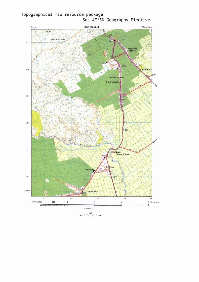
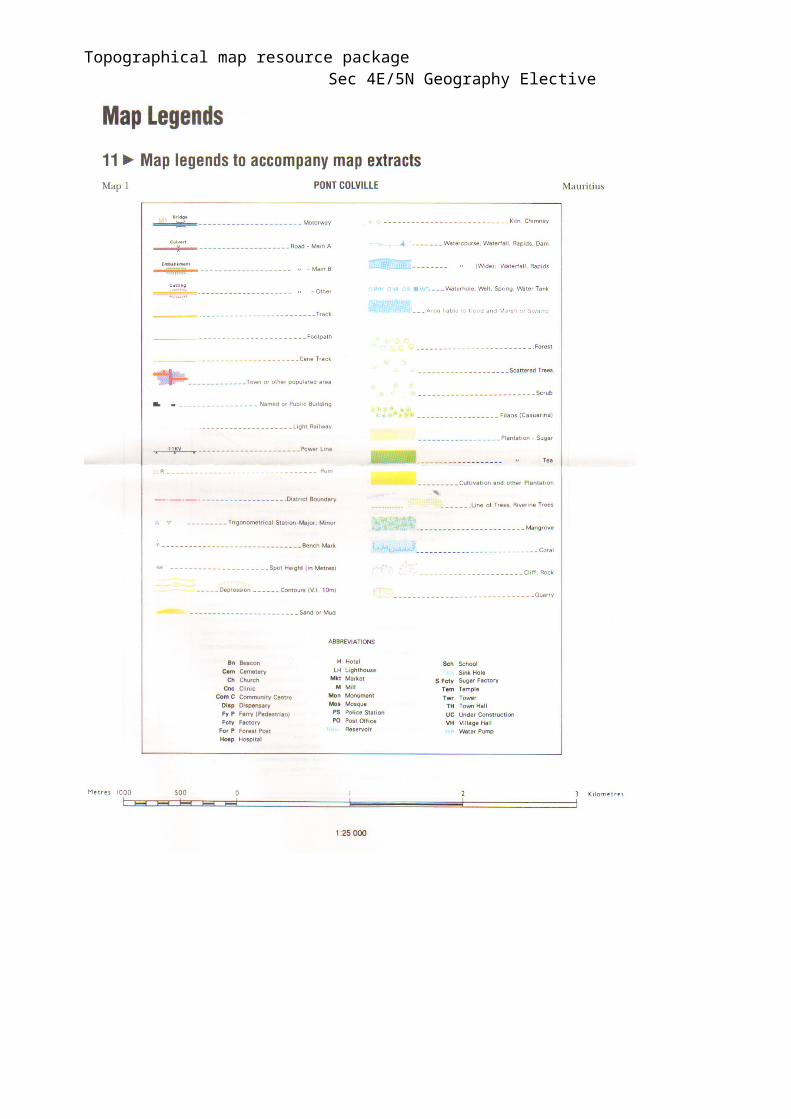
Topographical map resource package Sec 4E/5N Geography ElectivePont Colville
Topographical map resource package Sec 4E/5N Geography Elective
Topographical map resource package Sec 4E/5N Geography Elective
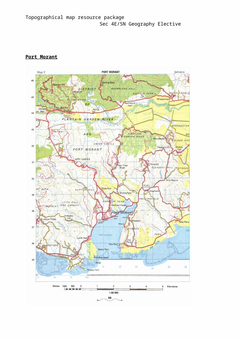
Port Morant

Topographical map resource package Sec 4E/5N Geography Elective
Topographical map resource package Sec 4E/5N Geography Elective
Practice 1
Refer to the map of Pont Colville, 1:25 000 and answer the following question
1) What is the six-figure grid reference of the water tank? [1m]
2) Describe the relief of the area between Northings 77 & 79. [4m]
3) Describe the river flow bounded between Northing 77 & 78. [2m]
4) Identify a possible development of an ox-bow lake in this river. Give the six figure grid reference of where the ox-bow lake will be. [1m]
5) Find the bearing of the water tank from the cemetery along Grand Bassin Road.[1m]
6) Using map evidence to support your answer, describe the main economic activity that people in Pont Colville is involved in. [3m]
Practice 2
Refer to the map of Port Morant, 1:50 000 and answer the following questions
1) Describe the coastal zone in Port Morant. [4m]
2) Calculate the gradient of the Clifton Hill between the spot height 248m in 176397 and the spot height 140m in 189393. [2m]
3) Describe the course of Plantain Garden River as shown in this section of the map. [3m]
45
43
20 26
Topographical map resource package Sec 4E/5N Geography Elective
Practice 3
Moshi, Tanzania
Refer to the map of Moshi, Tanzania, 1:50,000 and answer the following questions.
1) Describe the distribution of natural vegetation to the north of northing 33. [3m]
2) What is the compass direction of Weruweru School at grid reference 0633 from Kibsho School at grid reference 1236? [1m]
3) Describe the river flow in the area bounded by easting 10 and 14 and northing 31 and 36. [2m]
4) Calculate the gradient between the trigonometrical stations in grid squares 1130 and 1132. [2m]
Marsiling Secondary Prelims 2010
Topographical map resource package Sec 4E/5N Geography Elective
Practice 4
Victoria Falls
1 With reference to the map of Victoria Falls, describe the likely impacts of deforestation in the area shown in Fig. 2. [5m]
75 80
32 ___________________________32
26___________________________26
2Study the map of Victoria Falls. Using map evidence, describe the relief and drainage basin of the area surrounding the Masuwe River in the southern section of the map.
[4m]
Queenstown Secondary 2009
3a. (i) Refer to the topographical map, Victoria Falls(Zimbabwe). State the most distinctive physical feature found on this part of the map and describe how this feature may be formed. [5]
78 85 18 18
10 10 78 85
(ii) Describe the drainage pattern of the area bounded by eastings 69 to 72 and northings 22 to 25. [2]
Bendemeer Secondary 2009
Topographical map resource package Sec 4E/5N Geography Elective
Practice 5
Savanna-La-Mar (Jamaica)
Refer to the 1:50 000 map extract of Savanna-La-Mar (Jamaica).
(1) Name the coastal management strategy used in the part of the map indicated in the grid area below. Explain how it can protect the coast.
22 26
[2]
(2) Besides coastal protection, account for the other benefits of the coastal management strategy mentioned in 2(b)(i)
[4]
Crescent Girls’ School 2009
79
76

Topographical map resource package Sec 4E/5N Geography Elective
ANSWERS TO PRACTICES (Teacher’s Copy Only)
Practice 1
1) What is the six-figure grid reference of the water tank? [1m]Ans: 039778
2) Describe the relief of the area between Northings 77 & 79. [4m]Ans: The height of the area ranges from 330m (0477) to 520m (0078).The relief is steeper in the area west of easting 03 as can be seen by the contours close and gets gentler together from east of easting 04. Spacing between the contours is wider.
3) Describe the river flow bounded between Northing 77 & 78. [2m]Ans: The river is flowing from west to east but turns to south at 0376.The river meanders more in 0077 & 0177 but is flowing in a straight channel 0277 & 0377.
4) Identify a possible development of an ox-bow lake in this river. Give the six figure grid reference of where the ox-bow lake will be.Ans: 017774
5) Find the bearing of the water tank from the cemetery along Grand Bassin Road.[1m]
Ans: 35 degrees
6) Using map evidence to support your answer, describe the main economic activity that people in Pont Colville is involved in. [3m]Ans: The people in Pont Colville are cultivating tea as can be seen by the large areas of tea cultivation in the West of the Grand Bassin Road and North of Savanne Road. There are also 3 tea factories along the main roads.

Topographical map resource package Sec 4E/5N Geography Elective
Practice 2
1) Describe the coastal zone in Port Morant. [4m]Ans: The coast is low-lying with several small bays, (1934), (2335) and 1 large bay Port Morant. The gradient of the coast is gentle. Several coral reefs fringe the coast, (2135). There are some beaches formed by sand error or gravel in grid squares 2335 & 2536.
2) Calculate the gradient of the Clifton Hill between the spot height 248m in 176397 and the spot height 140m in 189393.
3) Describe the course of Plantain Garden River as shown in this section of the map. [3m]
Ans: Plantain Garden River flows from West and East and is joined by by the Indian Cony River in 2143. The river is flowing on a low-lying plain of 10-20m.
Practice 3
1 Describe the distribution of natural vegetation to the north of northing 33. [3]- There is the presence of only one type of natural vegetation, woodland
clustered in 2 main areas. [1]- The first area is bounded by easting 36 and northing 10 and the
vegetation is found above 1040m. [1]- The second area is bounded by easting 10 and 13 and northing 33 and
39 and the vegetation is found above 980m. [1]
3
2 What is the compass direction of Weruweru School at grid reference 0633 from Kibsho School at grid reference 1236? [1]- The direction is southwest. [1]
1
3 Describe the river flow in the area bounded by easting 10 and 14 and northing 31 and 36. [2]- The river is flowing in a southeast direction [1] from the highlands of
1060m in grid square 1035 to the lower lands of 940m in grid square 1131. [1]
- The drainage pattern is dendritic [1] as is evident in grid square 1232/1234.[1]
- Two tributaries, Umbwe and Oosw [1], join the main river Karanga at grid
2
45
43
20 26
Topographical map resource package Sec 4E/5N Geography Electivesquare 1232.[1]
(Any 1 point)
4 Calculate the gradient between the trigonometrical stations in grid squares 1130 and 1132. [2]- Gradient = Vertical Distance / Horizontal Distance = (1068 – 931m) / 3.6cm x 500m [1] = 137 / 1800 = 1:13 [1]
2
Practice 4
1 Deforestation affects the nutrient cycle greatly. Lesser leaf litter leads to less decomposed material and thus, fertility is replaced at a slower rate.
Vegetation provides a protective cover for the soil. The absence of vegetation will expose the soil to agents of erosion, especially running water.
Deforestation will lead to a higher rate of surface runoffs. This may lead to flooding. There might be flooding in Livingstone e.g. in GS 7726 and 7625, as the build-up is next to a river.
Increase in surface runoff also leads to excessive soil leaching, nutrients are being washed deeper into the soil and the nutrient cycle is greatly interrupted.
The water level in the two (e.g. GS 7531) lakes may decrease. Since there is less transpiration, the amount of water vapour in the air is also reduced. This will result in less precipitation.
There must be at least two inferences to the map details, failing to do so, max 3m.
2 Relief This area is rather gentle sloping as the contours are relatively far apart. It is on a highland and the height of the area is about 900m above sea level.
Any others.
River The river is fast flowing. There are several rapids such as those found in grid
square 7613. The river is flowing in a NE direction and then towards the east to join the main
river.
The river is meandering and likely to be fast flowing as it is at the upper course.
Any others.
2
2
3ai) Feature = a gorge. A river flows through an area of resistant rocks on its sides Erosion is more effective vertically than laterally Over time, vertical erosion deepens the channel A narrow, deep, steep sided valley is formed such as Songwe Gorge (grid
square 8013)/ Second Gorge/ Third Gorge (grid square 7817)/ Fourth Gorge (grid square 7816)/ Fifth Gorge (grid square 7815), Daoma Gorge (grid square 7812)
ii) Describe the drainage pattern of the area bounded by eastings 69 to 72 and northings 22 to 25. [2]
Dendritic Pattern

Topographical map resource package Sec 4E/5N Geography Elective It is flowing in Southeast direction towards the Zambezi river
Practice 5
Refer to the 1:50 000 map extract of Savanna-La-Mar (Jamaica).
1 Name the coastal management strategy used in the part of the map indicated in the grid area below. Explain how it can protect the coast.
22 26
1 mark for identification
Mangroves
1 mark for explanation of function as a coastal defense measure
The prop roots and kneed roots of mangrove trees anchor the trees firmly in the muddy soil, binding the loose soil and helping to trap sediments, thus reducing coastal erosion.
OR Mangroves also form a buffer or protection zone between the coastal
settlements and the sea such that storm surges and strong waves break against the mangroves, thus reducing the erosive impact of the waves.
[2]
79
76