Embed Size (px)
Citation preview
COME ON AN INCREDIBLE VISUAL JOURNEY from Earth’s molten core to the fi ery rivers of a lava-covered mountainside
WITNESS A VIOLENT ERUPTION as fantastic digital images show you a volcano as you’ve never seen it before
GET THE INSIDE STORYwith eyewitness accounts, earth-shattering facts, and
essential defi nitions throughout the book
Journey to the center of the
earth and witness what actually
happens during one of our planet’s
most violent events.
AN ASTONISHING STORYHow are volcanoes created? What happens
when they erupt? Volcano takes you on an
amazing virtual journey that unfolds step
by step, exploring and explaining
each stage in the terrifying
spectacle of an eruption.
INCREDIBLE IMAGESAmazing digital imagery
takes you where no
human has been before.
Stand in a white-hot
magma chamber or face
the frightening power of an
onrushing pyroclastic blast!
AMAZING FACTSEyewitness accounts, thrilling stories, and
fantastic fact boxes guarantee that this is
one learning experience you’ll never forget.
Get ready to fi nd out what it was like to
hear Krakatoa erupting or to fl ee the falling
ash in Pompeii.
Volcano is a story that will shake
your world!
$15.99 USA$19.99 CanadaISBN 0-7566-1409-0
Author
ANNE ROONEY taught at England’s
Cambridge and York Universities
before becoming a full-time writer.
She is the author of many books for
adults and children on history,
philosophy, and science and
technology, and was long-listed for the
Junior Prize of the Aventis Prizes for
Science Books in 2004. Anne lives in
Cambridge, England, with her two
daughters and Marcel, a blue lobster.
Consultant
DOUGLAS PALMER is a science
author who has written several books
on earth science and was a major
contributor to DK’s Earth. He spent
more than 20 years as a geology
lecturer at the University of Dublin,
and he still lectures for the University
of Cambridge Institute of Continuing
Education, in England.
Also available in the
DK Experience series:
Dinosaur
Flight
Pyramid
Background image: Getty/StoneIllustrations: Front & Back: Atlantic Digital, Candy Lab, Andrew Kerr
Discover more atwww.dk.com 9 780756 614096
51599ISBN 0-7566-1409-0
Printed in China
VOLCANOA
NN
E R
OO
NE
Y
A completely unique approach to illustrated reference, integrating groundbreaking
images with powerful narrative text, DK’s new Experience series uses panoramic
storyboard sequences to help you dive into the printed page in a whole new way.

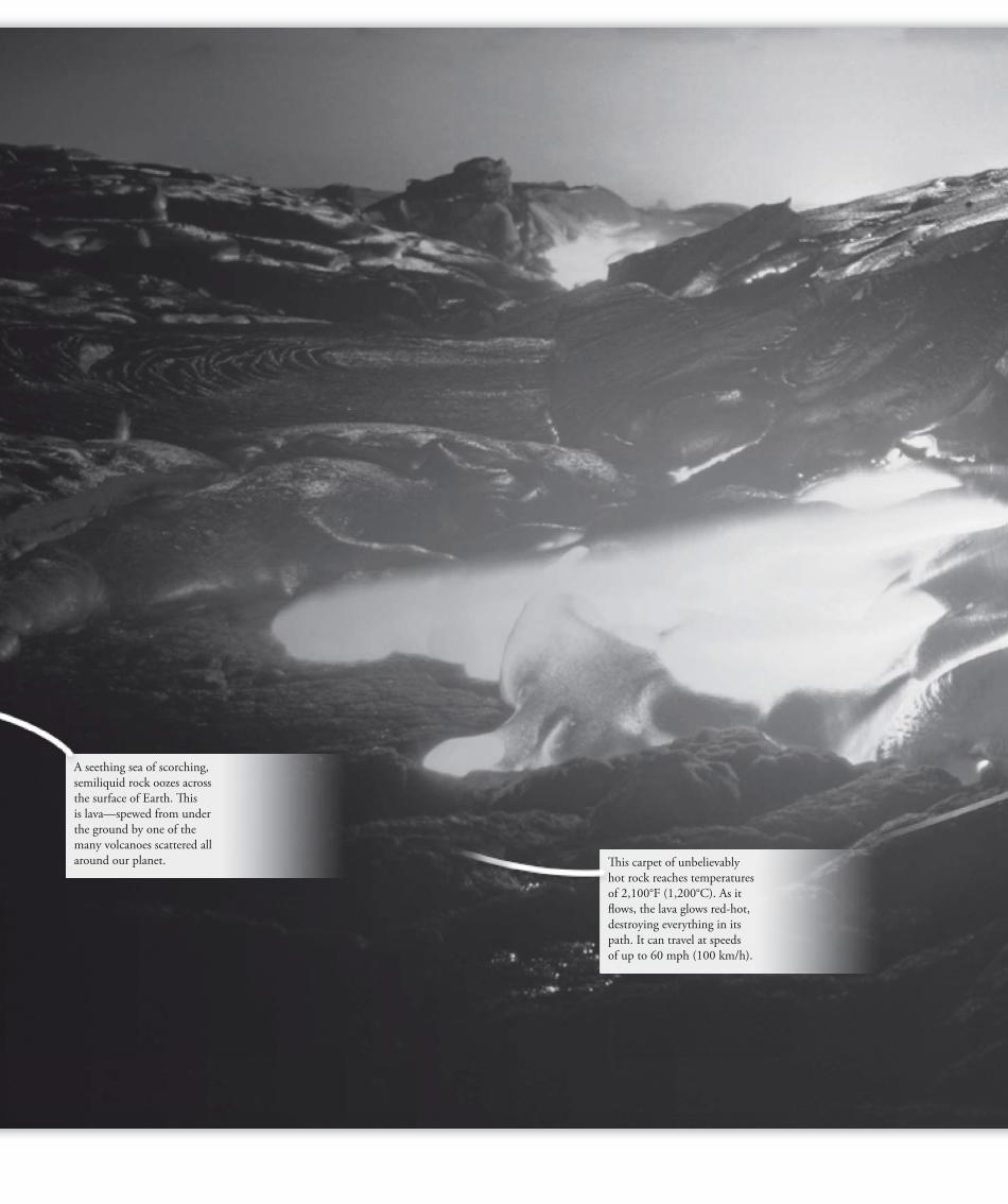
Th is carpet of unbelievably
hot rock reaches temperatures
of 2,100°F (1,200°C). As it
fl ows, the lava glows red-hot,
destroying everything in its
path. It can travel at speeds
of up to 60 mph (100 km/h).
A seething sea of scorching,
semiliquid rock oozes across
the surface of Earth. Th is
is lava—spewed from under
the ground by one of the
many volcanoes scattered all
around our planet.
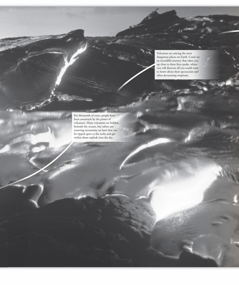
For thousands of years, people have
been awestruck by the power of
volcanoes. Many volcanoes are hidden
beneath the oceans, but others are
towering mountains on land that can
be ripped apart as the rocks and gas
within them explode into the sky.
Volcanoes are among the most
dangerous places on Earth. Come on
an incredible journey that takes you
up close to these fi ery peaks, where
you will discover all you could want
to know about their spectacular and
often devastating eruptions.
written by
ANNE ROONEY
VOLCANO
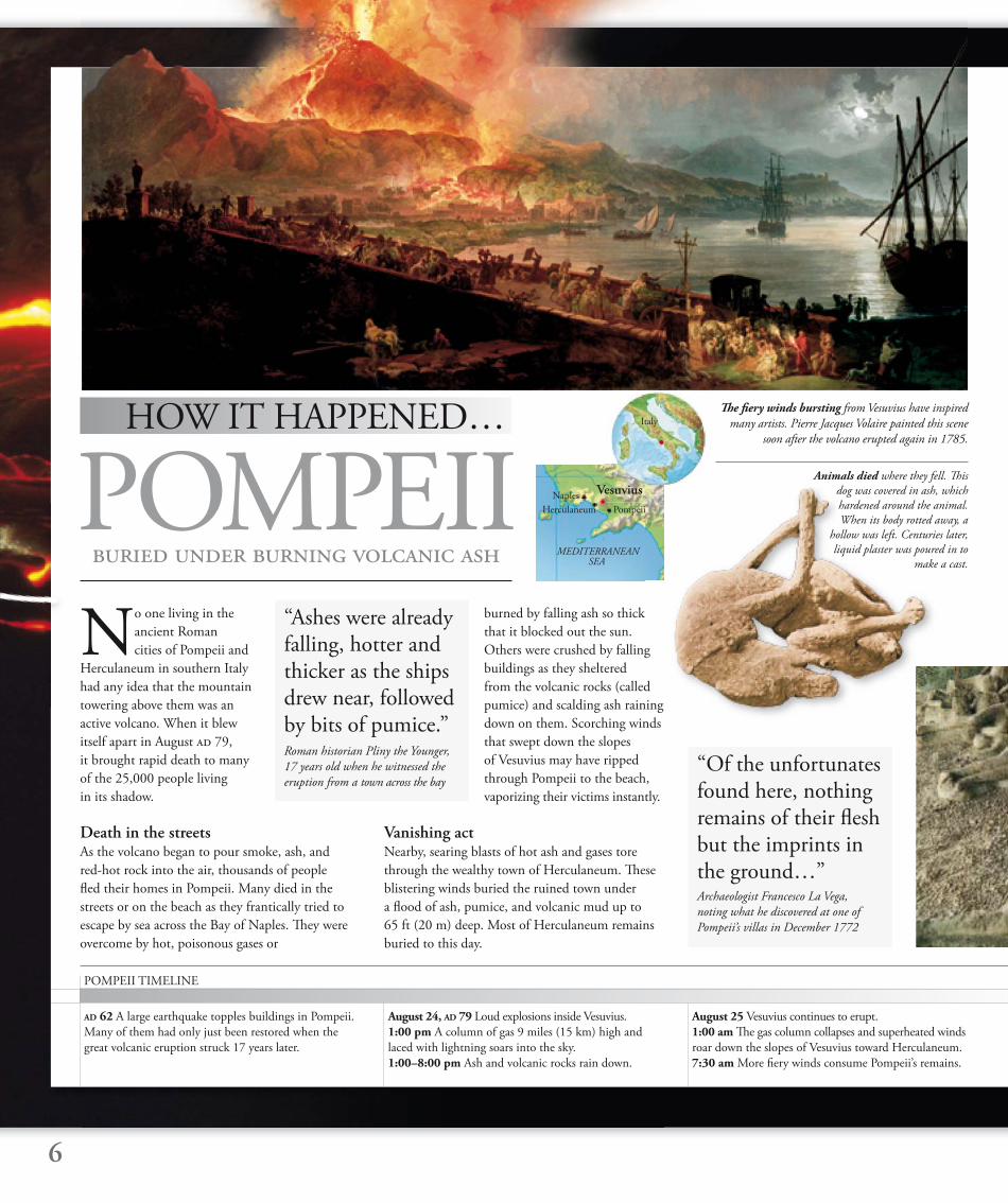
No one living in the
ancient Roman
cities of Pompeii and
Herculaneum in southern Italy
had any idea that the mountain
towering above them was an
active volcano. When it blew
itself apart in August ad 79,
it brought rapid death to many
of the 25,000 people living
in its shadow.
Death in the streetsAs the volcano began to pour smoke, ash, and
red-hot rock into the air, thousands of people
fl ed their homes in Pompeii. Many died in the
streets or on the beach as they frantically tried to
escape by sea across the Bay of Naples. Th ey were
overcome by hot, poisonous gases or
burned by falling ash so thick
that it blocked out the sun.
Others were crushed by falling
buildings as they sheltered
from the volcanic rocks (called
pumice) and scalding ash raining
down on them. Scorching winds
that swept down the slopes
of Vesuvius may have ripped
through Pompeii to the beach,
vaporizing their victims instantly.
Vanishing actNearby, searing blasts of hot ash and gases tore
through the wealthy town of Herculaneum. Th ese
blistering winds buried the ruined town under
a fl ood of ash, pumice, and volcanic mud up to
65 ft (20 m) deep. Most of Herculaneum remains
buried to this day.
POMPEII Animals died where they fell. Th is
dog was covered in ash, which
hardened around the animal.
When its body rotted away, a
hollow was left. Centuries later,
liquid plaster was poured in to
make a cast. buried under burning volcanic ash
6
HOW IT HAPPENED…
August 24, AD 79 Loud explosions inside Vesuvius.
1:00 pm A column of gas 9 miles (15 km) high and
laced with lightning soars into the sky.
1:00–8:00 pm Ash and volcanic rocks rain down.
August 25 Vesuvius continues to erupt.
1:00 am Th e gas column collapses and superheated winds
roar down the slopes of Vesuvius toward Herculaneum.
7:30 am More fi ery winds consume Pompeii’s remains.
AD 62 A large earthquake topples buildings in Pompeii.
Many of them had only just been restored when the
great volcanic eruption struck 17 years later.
“Ashes were already falling, hotter and thicker as the ships drew near, followed by bits of pumice.”Roman historian Pliny the Younger,
17 years old when he witnessed the
eruption from a town across the bay
POMPEII TIMELINE
“Of the unfortunates found here, nothing remains of their fl esh but the imprints in the ground…” Archaeologist Francesco La Vega,
noting what he discovered at one of
Pompeii’s villas in December 1772
Th e fi ery winds bursting from Vesuvius have inspired
many artists. Pierre Jacques Volaire painted this scene
soon after the volcano erupted again in 1785.
Vesuvius
Pompeii
MEDITERRANEAN SEA
Naples
Herculaneum
Italy
Many victims were discovered
huddled together. Scientists believe
that they died suddenly, engulfed by
a surge of burning gas.
Devastating factsThe eruption of Vesuvius tore the mountain apart and devastated the surrounding towns and villages. Many people fl ed their homes, but they had to face a horrendous onslaught from the volcano.
7
1592 Coins and marble fragments are found at Pompeii.
1689 A carved marble slab discovered underground
alerts people to the existence of the ruins of Pompeii.
1709 A workman digs up marble from Herculaneum.
1748 Large-scale excavations begin at Pompeii.
1765 Excavators start to map the buildings they uncover.
1860 Work shifts from treasure-hunting to detailed
scientifi c investigation.
A skeleton uncovered at Herculaneum still wears two
rings. Preserved artifacts and buildings found at the two cities
have given us a fascinating picture of ancient Roman life.
Big bang The eruption was the type known as Plinian. It released 100,000 times more energy than the atomic bomb that destroyed the Japanese city of Hiroshima at the end of World War II. Deadly cloud A column of gas, ash, and rock spurted 9 miles (15 km) straight up into the sky, spreading out in a shape like a giant umbrella. Tons of rock At the height of the eruption, Vesuvius shot 150,000 tons of rock into the air every second— a total of 0.6 cu miles (2.6 km³). Searing wind Six blasts of scalding wind carrying ash and poisonous gases rushed down the mountainside at up to 60 mph (100 km/h). Scorched The wind reached temperatures of up to 1,470°F (800°C)—hot enough to turn wood to carbon in an instant. Hail of stones For 18 hours, Pompeii was bombarded by pumice stones that piled up into a layer 8 ft (2.5 m) deep. Buried By the end of the eruption, Pompeii lay buried under 15–25 ft (4.5–7.5 m) of debris. To the west of the mountain, Herculaneum was left 65 ft (20 m) underground. Destroyed Half of Vesuvius disappeared when its summit collapsed, leaving a hole 1.8 miles (3 km) wide. Victims Most victims of the explosion died from terrible burns, were suffocated, or were crushed to death.
Deadly spectacleCurious observers stayed to watch, some even
risking their lives by going closer. No survivors
left fi rsthand accounts of how Pompeii and
Herculaneum were destroyed. But Pliny the
Younger wrote detailed observations of the
eruption from across the Bay of Naples. His
account gives a powerful insight into the
terrible events, and has been useful to modern
historians and scientists. His uncle, Pliny the
Elder, died on the beach watching the eruption.
Preserved under ash Th e city of Pompeii was buried by a layer of stone
and ash 15–25 ft (4.5–7.5 m) thick. Soon, new
grass and trees grew in the
fertile soil and covered the
site. It lay hidden for 1,500
years until builders uncovered
carved slabs of marble, but
it remained unexplored until
1748. Early digging was carried
out by slaves chained in pairs.
In March 1944, ash clouds billowed out of Vesuvius
again, in the worst eruption for 70 years. Lava fl ows
destroyed the nearby towns of Massa and San Sebastiano.
Many died when they broke
into pockets of poisonous gas
trapped under the surface.
Excavators found street after
street of buildings preserved
under the ash. Hollow spaces
in the hardened ash revealed
the shapes of bodies, long
gone, of the people who died
in the eruption. Casts have
been made by pouring plaster
or resin into these spaces
left by the victims’ bodies. As soon as news of
the excavations spread, Pompeii began to attract
visitors from around the world.
Eruptions continueToday, two-thirds of the city inside Pompeii’s
walls is still buried. Most of Herculaneum lies
under mud hardened to rock, and some of it is
far beneath the modern town of Resina, whose
residents live within lava-fl ow distance of Vesuvius.
Th e volcano continues to erupt—it has done so
more than 50 times since ad 79.
Hester Th rale, an English woman
who visited the ruins after another
great eruption shook the area in 1785
“How very horrible: the certainty that such a scene maybe acted all over again tomorrow.”
8
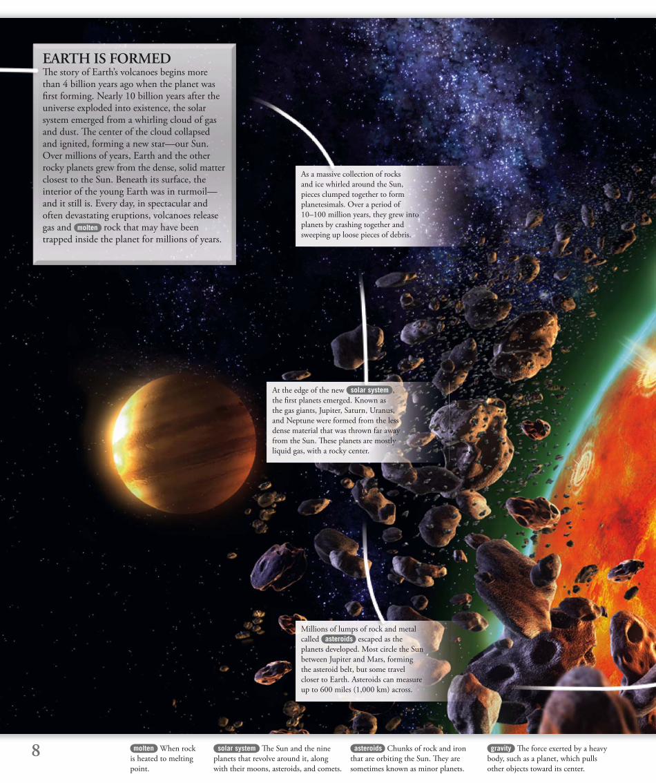
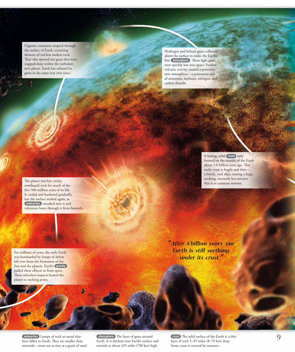
EARTH IS FORMEDTh e story of Earth’s volcanoes begins more than 4 billion years ago when the planet was fi rst forming. Nearly 10 billion years after the universe exploded into existence, the solar system emerged from a whirling cloud of gas and dust. Th e center of the cloud collapsed and ignited, forming a new star—our Sun. Over millions of years, Earth and the other rocky planets grew from the dense, solid matter closest to the Sun. Beneath its surface, the interior of the young Earth was in turmoil—and it still is. Every day, in spectacular and often devastating eruptions, volcanoes release gas and molten rock that may have been trapped inside the planet for millions of years.
gravity Th e force exerted by a heavy
body, such as a planet, which pulls
other objects toward its center.
asteroids Chunks of rock and iron
that are orbiting the Sun. Th ey are
sometimes known as minor planets.
solar system Th e Sun and the nine
planets that revolve around it, along
with their moons, asteroids, and comets.
As a massive collection of rocks
and ice whirled around the Sun,
pieces clumped together to form
planetesimals. Over a period of
10–100 million years, they grew into
planets by crashing together and
sweeping up loose pieces of debris.
At the edge of the new solar system ,
the fi rst planets emerged. Known as
the gas giants, Jupiter, Saturn, Uranus,
and Neptune were formed from the less
dense material that was thrown far away
from the Sun. Th ese planets are mostly
liquid gas, with a rocky center.
Millions of lumps of rock and metal
called asteroids escaped as the
planets developed. Most circle the Sun
between Jupiter and Mars, forming
the asteroid belt, but some travel
closer to Earth. Asteroids can measure
up to 600 miles (1,000 km) across.
molten When rock
is heated to melting
point.
9meteorites Lumps of rock or metal that
have fallen to Earth. Th ey are smaller than
asteroids—some are as tiny as a grain of sand.
crust Th e solid surface of the Earth is a thin
layer of rock 5–45 miles (8–70 km) deep.
Some crust is covered by seawater.
atmosphere Th e layer of gases around
Earth. It is thickest near Earth’s surface and
extends to about 435 miles (700 km) high.
“ After 4 billion years, our Earth is still seething
under its crust.”
Gigantic volcanoes erupted through
the surface of Earth, scattering
showers of red-hot molten rock.
Th ey also spewed out gases that were
trapped deep within the turbulent
new planet. Earth has released its
gases in the same way ever since.
Th e planet was hot, sticky,
semiliquid rock for much of the
fi rst 500 million years of its life.
It cooled and hardened gradually,
but the surface melted again, as meteorites smashed into it and
volcanoes burst through it from beneath.
For millions of years, the early Earth
was bombarded by lumps of debris
left over from the formation of the
Sun and the planets. Earth’s gravity
pulled these objects in from space.
Th ese relentless impacts heated the
planet to melting point.
A lasting, solid crust only
formed on the outside of the Earth
about 3.8 billion years ago. Th is
rocky crust is fragile and thin—
a brittle, cool skin, coating a huge,
seething, intensely hot interior
that is in constant motion.
Hydrogen and helium gases collected
above the surface to make the Earth’s
fi rst atmosphere . Th ese light gases
were quickly lost into space. Further
volcanic activity created a primitive
new atmosphere—a poisonous mix
of ammonia, methane, nitrogen, and
carbon dioxide.
10
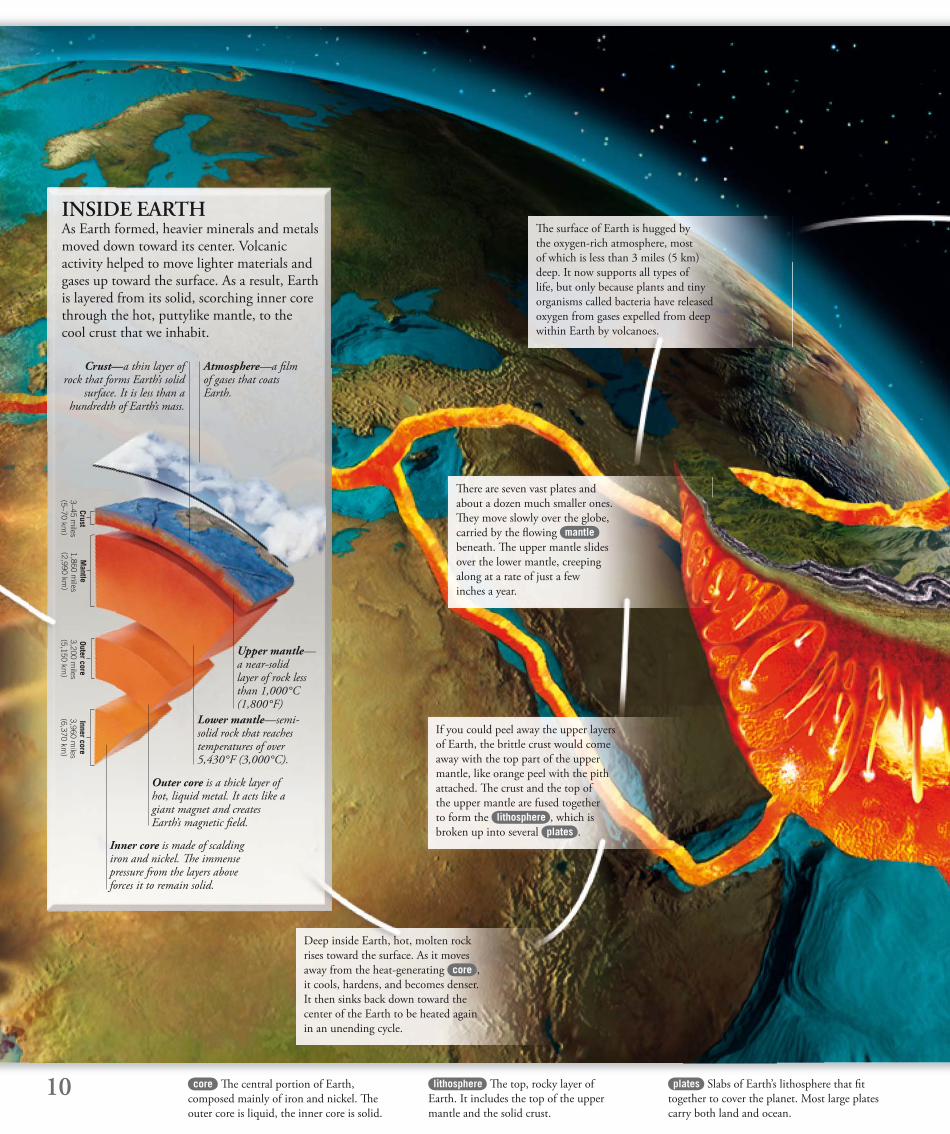
INSIDE EARTHAs Earth formed, heavier minerals and metals moved down toward its center. Volcanic activity helped to move lighter materials and gases up toward the surface. As a result, Earth is layered from its solid, scorching inner core through the hot, puttylike mantle, to the cool crust that we inhabit.
plates Slabs of Earth’s lithosphere that fi t
together to cover the planet. Most large plates
carry both land and ocean.
lithosphere Th e top, rocky layer of
Earth. It includes the top of the upper
mantle and the solid crust.
Outer core is a thick layer of hot, liquid metal. It acts like a giant magnet and creates Earth’s magnetic fi eld.
Inner core is made of scalding iron and nickel. Th e immense pressure from the layers above forces it to remain solid.
Atmosphere—a fi lm of gases that coats Earth.
Lower mantle—semi-solid rock that reaches temperatures of over 5,430°F (3,000°C).
Upper mantle—a near-solid layer of rock less than 1,000°C (1,800°F)
Crust—a thin layer of rock that forms Earth’s solid
surface. It is less than a hundredth of Earth’s mass.
Mantle
1,860 miles
(2,990 km)
Outer core 3,200 m
iles(5,150 km
)
Crust 3–45 m
iles(5–70 km
)
Inner core 3,960 m
iles(6,370 km
)
If you could peel away the upper layers
of Earth, the brittle crust would come
away with the top part of the upper
mantle, like orange peel with the pith
attached. Th e crust and the top of
the upper mantle are fused together
to form the lithosphere , which is
broken up into several plates .
Deep inside Earth, hot, molten rock
rises toward the surface. As it moves
away from the heat-generating core ,
it cools, hardens, and becomes denser.
It then sinks back down toward the
center of the Earth to be heated again
in an unending cycle.
Th ere are seven vast plates and
about a dozen much smaller ones.
Th ey move slowly over the globe,
carried by the fl owing mantle
beneath. Th e upper mantle slides
over the lower mantle, creeping
along at a rate of just a few
inches a year.
Th e surface of Earth is hugged by
the oxygen-rich atmosphere, most
of which is less than 3 miles (5 km)
deep. It now supports all types of
life, but only because plants and tiny
organisms called bacteria have released
oxygen from gases expelled from deep
within Earth by volcanoes.
core Th e central portion of Earth,
composed mainly of iron and nickel. Th e
outer core is liquid, the inner core is solid.
11mantle Th e thick layer of semisolid,
hot rock between Earth’s core and crust.
Th e upper mantle is fused to the crust.
asthenosphere Th e partially melted
layer of rock that lies beneath the lithosphere.
crystalline Formed from crystals, which
are solid minerals with a regular, often
symmetrical shape.
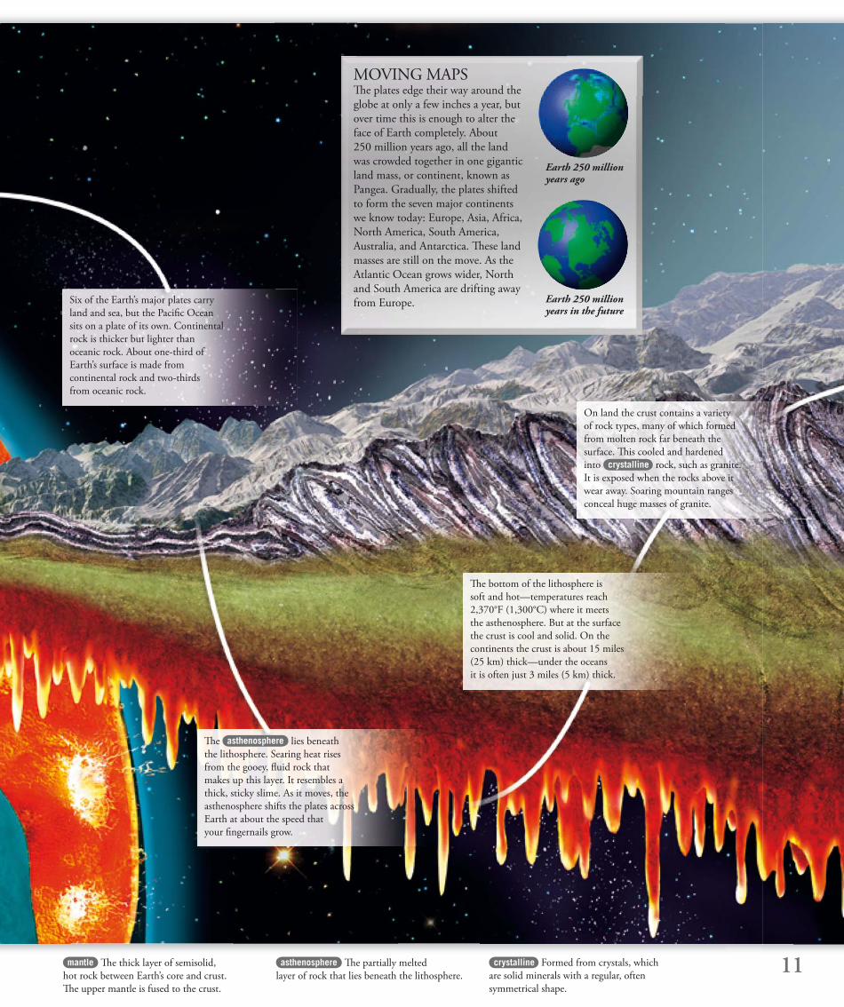
MOVING MAPSTh e plates edge their way around the
globe at only a few inches a year, but
over time this is enough to alter the
face of Earth completely. About
250 million years ago, all the land
was crowded together in one gigantic
land mass, or continent, known as
Pangea. Gradually, the plates shifted
to form the seven major continents
we know today: Europe, Asia, Africa,
North America, South America,
Australia, and Antarctica. Th ese land
masses are still on the move. As the
Atlantic Ocean grows wider, North
and South America are drifting away
from Europe.
Earth 250 million years ago
Earth 250 million years in the future
Six of the Earth’s major plates carry
land and sea, but the Pacifi c Ocean
sits on a plate of its own. Continental
rock is thicker but lighter than
oceanic rock. About one-third of
Earth’s surface is made from
continental rock and two-thirds
from oceanic rock.
Th e asthenosphere lies beneath
the lithosphere. Searing heat rises
from the gooey, fl uid rock that
makes up this layer. It resembles a
thick, sticky slime. As it moves, the
asthenosphere shifts the plates across
Earth at about the speed that
your fi ngernails grow.
Th e bottom of the lithosphere is
soft and hot—temperatures reach
2,370°F (1,300°C) where it meets
the asthenosphere. But at the surface
the crust is cool and solid. On the
continents the crust is about 15 miles
(25 km) thick—under the oceans
it is often just 3 miles (5 km) thick.
On land the crust contains a variety
of rock types, many of which formed
from molten rock far beneath the
surface. Th is cooled and hardened
into crystalline rock, such as granite.
It is exposed when the rocks above it
wear away. Soaring mountain ranges
conceal huge masses of granite.
12
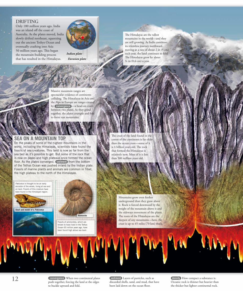
DRIFTINGOnly 180 million years ago, India
was an island off the coast of
Australia. As the plates moved, India
slowly drifted northeast, squeezing
out the ancient Tethys Ocean and
eventually crashing into Asia
50 million years ago. Th is began
the mountain-building process
that has resulted in the Himalayas.
sediment Layers of particles, such as
discarded shells, sand, and mud, that have
been laid down on the ocean fl oor.
density How compact a substance is.
Oceanic rock is thinner but heavier than
the thicker but lighter continental rock.
Eurasian plate
Indian plate
SEA ON A MOUNTAIN TOPOn the peaks of some of the highest mountains in the world, including the Himalayas, scientists have found the fossils of sea creatures. This land is now as far from the sea bed as it’s possible to get. But some of the rock that is now on peaks and high plateaus once formed the ocean fl oor. As the plates converged, sediment from the bottom of the Tethys Ocean was pushed inland by the Indian plate. Fossils of marine plants and animals are common in Tibet, the high plateau to the north of the Himalayas.
Pakicetus is thought to be an early ancestor of the whale, living at sea and on land. Fossils of this creature have been found in the Himalayan region.
Fossils of ammonites, which are known to have lived in the Tethys Ocean 65 million years ago, have been found high above sea level.
Ammonite
Skull and model of a Pakicetus
Massive mountain ranges are
spectacular evidence of continents
colliding. Th e Himalayas in Asia and
the Alps in Europe are ranges created
by convergence —a head-on crash
between two plates. As they grind
together, the plates crumple and fold
to form vast mountains.
Th e Himalayas are the tallest
mountains in the world—and they
are still growing. As India continues
its relentless journey northward,
moving at a rate of about 2 in (5 cm)
each year, the land continues to fold.
Th e Himalayas grow by about
¼ in (0.6 cm) a year.
Th e crust of the land found in the
centre of the continents is far older
than the ocean crust—some of it
is 4 billion years old. Th e rock
that formed the Himalayas is
relatively new. Most of it is less
than 500 million years old.
Mountains grow even farther
underground than they grow above
it. Rock is forced downward by the
weight of the mountain above it and
the sideways movement of the plates.
Th e roots of the Himalayas are the
deepest of any mountains—here, the
crust is up to 45 miles (70 km) thick.
convergence When two continental plates
push together, forcing the land at the edges
to buckle upward and fold.
13deforms Loses its normal
shape—fl at land becomes
squashed and folded.
eroded Eaten away over time
by the forces of weather or
moving ice.
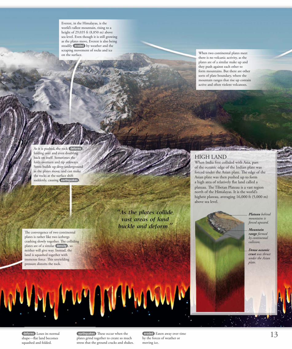
HIGH LAND When India fi rst collided with Asia, part
of the oceanic edge of the Indian plate was
forced under the Asian plate. Th e edge of the
Asian plate was then pushed up to form
a high area of relatively fl at land called a
plateau. Th e Tibetan Plateau is a vast region north of the Himalayas. It is the world’s
highest plateau, averaging 16,000 ft (5,000 m)
above sea level.
Mountain range formed by continental collision.
Plateau behind mountains is forced upward.
Dense oceanic crust was thrust under the Asian plate.
‘‘ As the plates collide, vast areas of land
buckle and deform.’’
earthquakes Th ese occur when the
plates grind together to create so much
stress that the ground cracks and shakes.
As it is pushed, the rock deforms ,
folding over and even doubling
back on itself. Sometimes the
folds overturn and tip sideways.
Stress builds up deep underground
as the plates move, and can make
the rocks at the surface shift
suddenly, causing earthquakes .
Everest, in the Himalayas, is the
world’s tallest mountain, rising to a
height of 29,035 ft (8,850 m) above
sea level. Even though it is still growing
as the plates move, Everest is also being
steadily eroded by weather and the
scraping movement of rocks and ice
on the surface.
Th e convergence of two continental
plates is rather like two icebergs
crashing slowly together. Th e colliding
plates are of a similar density , so
neither will give way. Instead, the
land is squashed together with
immense force. Th is unyielding
pressure distorts the rock.
When two continental plates meet
there is no volcanic activity, as the
plates are of a similar make up and
they push against each other to
form mountains. But there are other
sorts of plate boundary, where the
mountain ranges that rise up contain
active and often violent volcanoes.
14 magma Molten rock within Earth.
When magma reaches the surface, it is
called lava.
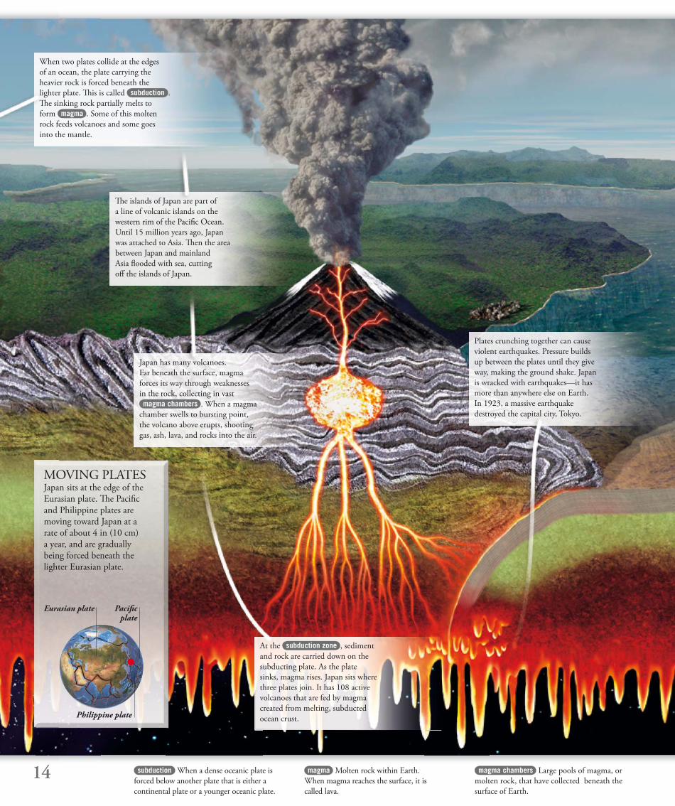
MOVING PLATES Japan sits at the edge of the
Eurasian plate. Th e Pacifi c
and Philippine plates are
moving toward Japan at a
rate of about 4 in (10 cm)
a year, and are gradually
being forced beneath the
lighter Eurasian plate.
Pacifi c plate
Eurasian plate
Philippine plate
When two plates collide at the edges
of an ocean, the plate carrying the
heavier rock is forced beneath the
lighter plate. Th is is called subduction .
Th e sinking rock partially melts to
form magma . Some of this molten
rock feeds volcanoes and some goes
into the mantle.
Th e islands of Japan are part of
a line of volcanic islands on the
western rim of the Pacifi c Ocean.
Until 15 million years ago, Japan
was attached to Asia. Th en the area
between Japan and mainland
Asia fl ooded with sea, cutting
off the islands of Japan.
Japan has many volcanoes.
Far beneath the surface, magma
forces its way through weaknesses
in the rock, collecting in vast
magma chambers . When a magma
chamber swells to bursting point,
the volcano above erupts, shooting
gas, ash, lava, and rocks into the air.
Plates crunching together can cause
violent earthquakes. Pressure builds
up between the plates until they give
way, making the ground shake. Japan
is wracked with earthquakes—it has
more than anywhere else on Earth.
In 1923, a massive earthquake
destroyed the capital city, Tokyo.
At the subduction zone , sediment
and rock are carried down on the
subducting plate. As the plate
sinks, magma rises. Japan sits where
three plates join. It has 108 active
volcanoes that are fed by magma
created from melting, subducted
ocean crust.
subduction When a dense oceanic plate is
forced below another plate that is either a
continental plate or a younger oceanic plate.
magma chambers Large pools of magma, or
molten rock, that have collected beneath the
surface of Earth.
15
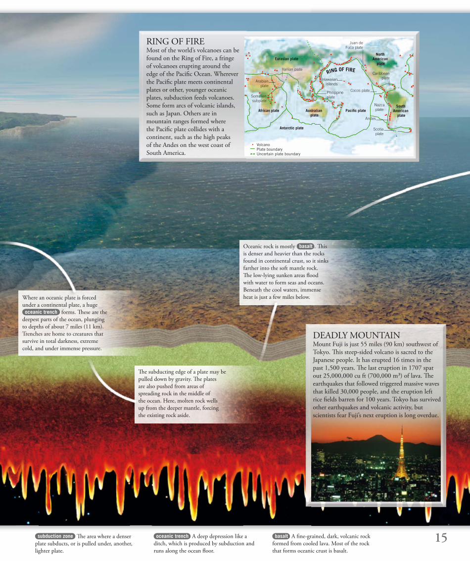
RING OF FIREMost of the world’s volcanoes can be
found on the Ring of Fire, a fringe
of volcanoes erupting around the
edge of the Pacifi c Ocean. Wherever
the Pacifi c plate meets continental
plates or other, younger oceanic
plates, subduction feeds volcanoes.
Some form arcs of volcanic islands,
such as Japan. Others are in
mountain ranges formed where
the Pacifi c plate collides with a
continent, such as the high peaks
of the Andes on the west coast of
South America.
DEADLY MOUNTAINMount Fuji is just 55 miles (90 km) southwest of
Tokyo. Th is steep-sided volcano is sacred to the
Japanese people. It has erupted 16 times in the
past 1,500 years. Th e last eruption in 1707 spat
out 25,000,000 cu ft (700,000 m³) of lava. Th e
earthquakes that followed triggered massive waves
that killed 30,000 people, and the eruption left
rice fi elds barren for 100 years. Tokyo has survived
other earthquakes and volcanic activity, but
scientists fear Fuji’s next eruption is long overdue.
subduction zone Th e area where a denser
plate subducts, or is pulled under, another,
lighter plate.
basalt A fi ne-grained, dark, volcanic rock
formed from cooled lava. Most of the rock
that forms oceanic crust is basalt.
oceanic trench A deep depression like a
ditch, which is produced by subduction and
runs along the ocean fl oor.
Eurasian plate
African plate
Antarctic plate
Australian plate
Pacifi c plateSouth
American plate
NorthAmerican
plate
Philippine plate
Juan de Fuca plate
Cocos plate
Nazca plate
Iranian plateCaribbean
plate
Scotia plate
VolcanoPlate boundaryUncertain plate boundary
Arabian plate
Somalian subplate
Th e subducting edge of a plate may be
pulled down by gravity. Th e plates
are also pushed from areas of
spreading rock in the middle of
the ocean. Here, molten rock wells
up from the deeper mantle, forcing
the existing rock aside.
Where an oceanic plate is forced
under a continental plate, a huge
oceanic trench forms. Th ese are the
deepest parts of the ocean, plunging
to depths of about 7 miles (11 km).
Trenches are home to creatures that
survive in total darkness, extreme
cold, and under immense pressure.
Oceanic rock is mostly basalt . Th is
is denser and heavier than the rocks
found in continental crust, so it sinks
farther into the soft mantle rock.
Th e low-lying sunken areas fl ood
with water to form seas and oceans.
Beneath the cool waters, immense
heat is just a few miles below.
RING OF FIRE
Andes
Hawaiian islands
16
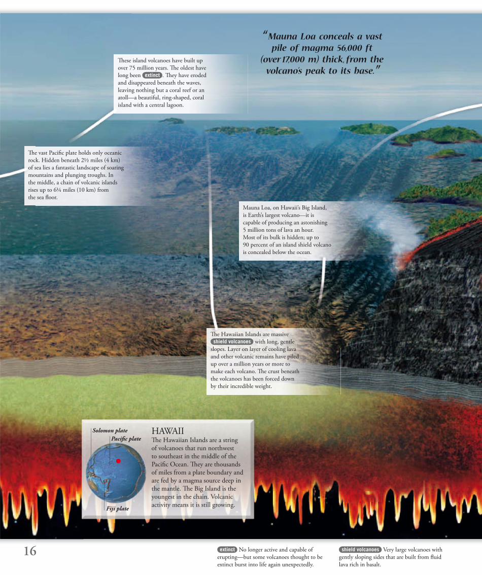
HAWAII Th e Hawaiian Islands are a string
of volcanoes that run northwest
to southeast in the middle of the
Pacifi c Ocean. Th ey are thousands
of miles from a plate boundary and
are fed by a magma source deep in
the mantle. Th e Big Island is the
youngest in the chain. Volcanic
activity means it is still growing.
shield volcanoes Very large volcanoes with
gently sloping sides that are built from fl uid
lava rich in basalt.
extinct No longer active and capable of
erupting—but some volcanoes thought to be
extinct burst into life again unexpectedly.
“ Mauna Loa conceals a vast pile of magma 56,000 ft
(over 17,000 m) thick, from the volcano’s peak to its base.”
Pacifi c plate
Solomon plate
Fiji plate
Th e vast Pacifi c plate holds only oceanic
rock. Hidden beneath 2½ miles (4 km)
of sea lies a fantastic landscape of soaring
mountains and plunging troughs. In
the middle, a chain of volcanic islands
rises up to 6¼ miles (10 km) from
the sea fl oor.
Th e Hawaiian Islands are massive
shield volcanoes with long, gentle
slopes. Layer on layer of cooling lava
and other volcanic remains have piled
up over a million years or more to
make each volcano. Th e crust beneath
the volcanoes has been forced down
by their incredible weight.
Mauna Loa, on Hawaii’s Big Island,
is Earth’s largest volcano—it is
capable of producing an astonishing
5 million tons of lava an hour.
Most of its bulk is hidden; up to
90 percent of an island shield volcano
is concealed below the ocean.
Th ese island volcanoes have built up
over 75 million years. Th e oldest have
long been extinct . Th ey have eroded
and disappeared beneath the waves,
leaving nothing but a coral reef or an
atoll—a beautiful, ring-shaped, coral
island with a central lagoon.
17
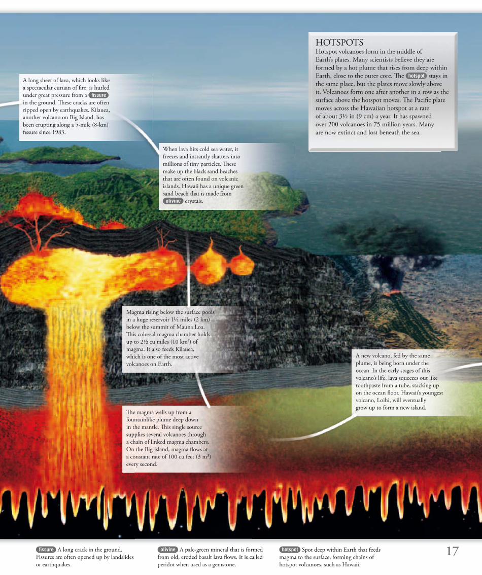
HOTSPOTSHotspot volcanoes form in the middle of
Earth’s plates. Many scientists believe they are
formed by a hot plume that rises from deep within
Earth, close to the outer core. Th e hotspot stays in
the same place, but the plates move slowly above
it. Volcanoes form one after another in a row as the
surface above the hotspot moves. Th e Pacifi c plate
moves across the Hawaiian hotspot at a rate
of about 3½ in (9 cm) a year. It has spawned
over 200 volcanoes in 75 million years. Many
are now extinct and lost beneath the sea.
fi ssure A long crack in the ground.
Fissures are often opened up by landslides
or earthquakes.
olivine A pale-green mineral that is formed
from old, eroded basalt lava fl ows. It is called
peridot when used as a gemstone.
hotspot Spot deep within Earth that feeds
magma to the surface, forming chains of
hotspot volcanoes, such as Hawaii.
A long sheet of lava, which looks like
a spectacular curtain of fi re, is hurled
under great pressure from a fi ssure
in the ground. Th ese cracks are often
ripped open by earthquakes. Kilauea,
another volcano on Big Island, has
been erupting along a 5-mile (8-km)
fi ssure since 1983.
When lava hits cold sea water, it
freezes and instantly shatters into
millions of tiny particles. Th ese
make up the black sand beaches
that are often found on volcanic
islands. Hawaii has a unique green
sand beach that is made from
olivine crystals.
Magma rising below the surface pools
in a huge reservoir 1½ miles (2 km)
below the summit of Mauna Loa.
Th is colossal magma chamber holds
up to 2½ cu miles (10 km3) of
magma. It also feeds Kilauea,
which is one of the most active
volcanoes on Earth.
Th e magma wells up from a
fountainlike plume deep down
in the mantle. Th is single source
supplies several volcanoes through
a chain of linked magma chambers.
On the Big Island, magma fl ows at
a constant rate of 100 cu feet (3 m³)
every second.
A new volcano, fed by the same
plume, is being born under the
ocean. In the early stages of this
volcano’s life, lava squeezes out like
toothpaste from a tube, stacking up
on the ocean fl oor. Hawaii’s youngest
volcano, Loihi, will eventually
grow up to form a new island.
18 mid-ocean ridges Connected chains
of mountains on the seabed. Th ey are
the largest feature of the ocean fl oor.
diverging Moving apart. When two plates
diverge, they form a constructive boundary,
which means that new crust is formed.
rift zone An area of Earth’s surface where
two plates are moving away from each other
and rising magma forms new crust.
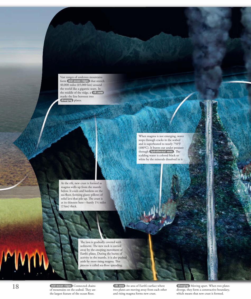
Vast ranges of undersea mountains
form mid-ocean ridges that stretch
40,000 miles (65,000 km) around
the world like a gigantic seam. In
the middle of the ridge, a rift zone
marks the line between two
diverging plates.
Th e lava is gradually covered with
sediment. Th e new rock is carried
away by the creeping movement of
Earth’s plates. During the bursts of
activity in the mantle, it is also pushed
aside by more rising magma. Th is
process is called sea-fl oor spreading.
At the rift, new crust is formed as
magma wells up from the mantle
below. It cools and hardens on the
sea fl oor, forming glassy pillows of
solid lava that pile up. Th e crust is
at its thinnest here—barely 1¼ miles
(2 km) thick.
When magma is not emerging, water
seeps through cracks in the seabed
and is superheated to nearly 750°F
(400°C). It bursts out under pressure
through hydrothermal vents . Th e
scalding water is colored black or
white by the minerals dissolved in it.
19sonar Using beams of sound and their
echoes to measure the depth of the ocean
and locate objects on the sea fl oor.
hydrothermal vents Cracks in the seabed
through which super-heated water spurts
under huge pressure.
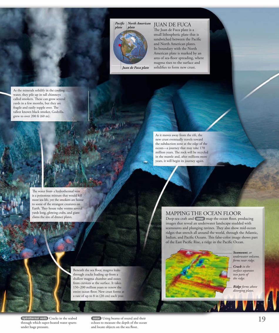
MAPPING THE OCEAN FLOORDeep-sea craft and sonar map the ocean fl oor, producing
images that reveal an underwater landscape studded with
seamounts and plunging ravines. Th ey also show mid-ocean
ridges that stretch all around the world, through the Atlantic,
Indian, and Pacifi c Oceans. Th is false-color image shows part
of the East Pacifi c Rise, a ridge in the Pacifi c Ocean.
As the minerals solidify in the cooling
water, they pile up in tall chimneys
called smokers. Th ese can grow several
yards in a few months, but they are
fragile and easily topple over. Th e
tallest known black smoker, Godzilla,
grew to over 200 ft (60 m).
Th e water from a hydrothermal vent
is a poisonous mixture that would kill
most sea life, yet the smokers are home
to some of the strangest creatures on
Earth. Th ey house tube worms several
yards long, glowing crabs, and giant
clams the size of dinner plates.
As it moves away from the rift, the
new crust eventually travels toward
the subduction zone at the edge of the
ocean—a journey that may take 170
million years. Th e rock will be recycled
in the mantle and, after millions more
years, it will begin its journey again.
Beneath the sea fl oor, magma leaks
through cracks leading up from a
shallow magma chamber and oozes
from crevices at the surface. It takes
150–200 million years to renew the
entire ocean fl oor. New crust forms at
a rate of up to 8 in (20 cm) each year.
North American plate
Juan de Fuca plate
JUAN DE FUCATh e Juan de Fuca plate is a
small lithospheric plate that is
sandwiched between the Pacifi c
and North American plates.
Its boundary with the North
American plate is marked by an
area of sea-fl oor spreading, where
magma rises to the surface and
solidifi es to form new crust.
Ridge forms above diverging plates.
Crack in the surface separates two parts of the ridge.
Seamount, or underwater volcano, forms near ridge.
Pacifi c plate
20 geological Relating to the minerals and
rocks that make up Earth and the processes
that have formed it.
fault A crack in Earth’s surface where
movement has occurred. Faults usually form
as a result of plate movement.
terranes Sections of one plate, containing
distinctive rock types, that have merged with
a plate of a diff erent makeup.
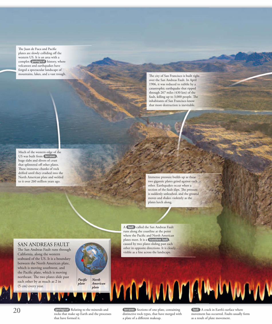
SAN ANDREAS FAULTTh e San Andreas Fault runs through
California, along the western
seaboard of the US. It is a boundary
between the North American plate,
which is moving southwest, and
the Pacifi c plate, which is moving
northeast. Th e two plates slide past
each other by as much as 2 in
(5 cm) every year.
Pacifi c plate
Th e Juan de Fuca and Pacifi c
plates are slowly colliding off the
western US. It is an area with a
complex geological history, where
volcanoes and earthquakes have
forged a spectacular landscape of
mountains, lakes, and a vast trough.Th e city of San Francisco is built right
over the San Andreas Fault. In April
1906, it was reduced to rubble by a
catastrophic earthquake that ripped
through 267 miles (430 km) of the
fault, killing up to 3,000 people. Th e
inhabitants of San Francisco know
that more destruction is inevitable.
Immense pressure builds up as these
two gigantic plates grind against each
other. Earthquakes occur when a
section of the fault slips. Th e pressure
is suddenly unleashed, and the ground
moves and shakes violently as the
plates lurch along.
A fault called the San Andreas Fault
runs along the coastline at the point
where the Pacifi c and North American
plates meet. It is a transform fault ,
caused by two plates sliding past each
other in opposite directions. It is clearly
visible as a line across the landscape.
Much of the western edge of the
US was built from terranes ,
huge slabs and slivers of crust
that splintered off other plates.
Th ese immense chunks of rock
drifted until they crashed into the
North American plate and welded
to it over 260 million years ago.
North American plate
21
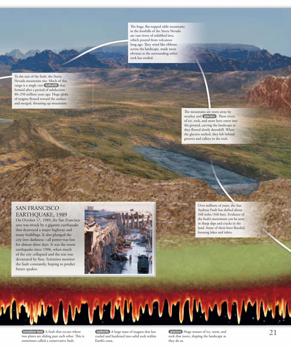
SAN FRANCISCO EARTHQUAKE, 1989On October 17, 1989, the San Francisco
area was struck by a gigantic earthquake
that destroyed a major highway and
many buildings. It also plunged the
city into darkness—all power was lost
for almost three days. It was the worst
earthquake since 1906, when much
of the city collapsed and the rest was
devastated by fi res. Scientists monitor
the fault constantly, hoping to predict
future quakes.
transform fault A fault that occurs where
two plates are sliding past each other. Th is is
sometimes called a conservative fault.
glaciers Huge masses of ice, snow, and
rock that move, shaping the landscape as
they do so.
batholith A large mass of magma that has
cooled and hardened into solid rock within
Earth’s crust.
To the east of the fault, the Sierra
Nevada mountains rise. Much of this
range is a single vast batholith that
formed after a period of subduction
80–250 million years ago. Huge globs
of magma fl oated toward the surface
and merged, thrusting up mountains.
Th e mountains are worn away by
weather and glaciers . Th ese rivers
of ice, rock, and snow have eaten into
the ground, carving the landscape as
they fl owed slowly downhill. When
the glaciers melted, they left behind
grooves and valleys in the rock.
Th e huge, fl at-topped table mountains
in the foothills of the Sierra Nevada
are vast rivers of solidifi ed lava,
which poured from volcanoes
long ago. Th ey wind like ribbons
across the landscape, made more
obvious as the surrounding softer
rock has eroded.
Over millions of years, the San
Andreas Fault has shifted about
348 miles (560 km). Evidence of
the fault’s movement can be seen
in sharp dips and cracks in the
land. Some of these have fl ooded,
forming lakes and inlets.
22
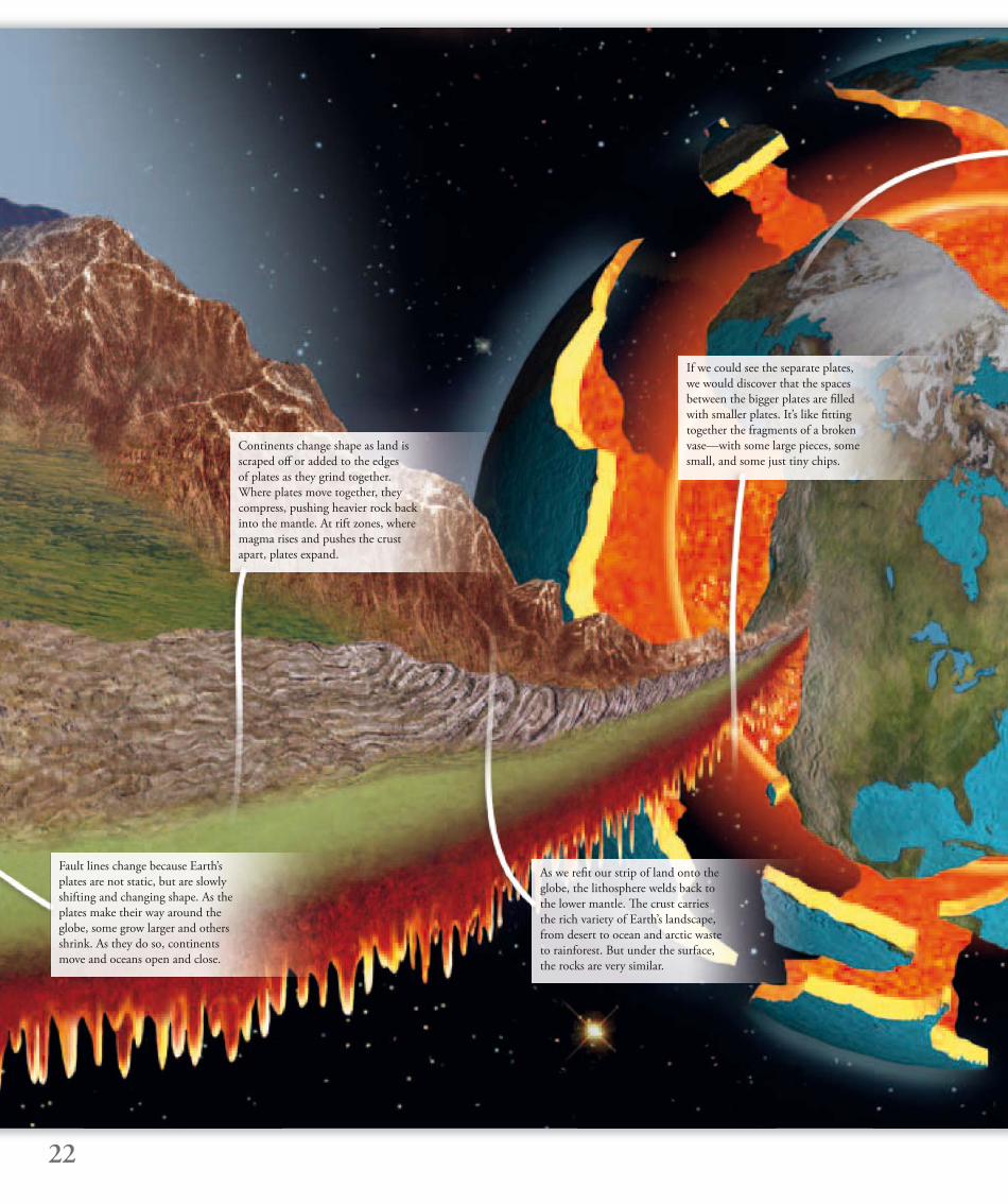
Continents change shape as land is
scraped off or added to the edges
of plates as they grind together.
Where plates move together, they
compress, pushing heavier rock back
into the mantle. At rift zones, where
magma rises and pushes the crust
apart, plates expand.
Fault lines change because Earth’s
plates are not static, but are slowly
shifting and changing shape. As the
plates make their way around the
globe, some grow larger and others
shrink. As they do so, continents
move and oceans open and close.
As we refi t our strip of land onto the
globe, the lithosphere welds back to
the lower mantle. Th e crust carries
the rich variety of Earth’s landscape,
from desert to ocean and arctic waste
to rainforest. But under the surface,
the rocks are very similar.
If we could see the separate plates,
we would discover that the spaces
between the bigger plates are fi lled
with smaller plates. It’s like fi tting
together the fragments of a broken
vase—with some large pieces, some
small, and some just tiny chips.
23
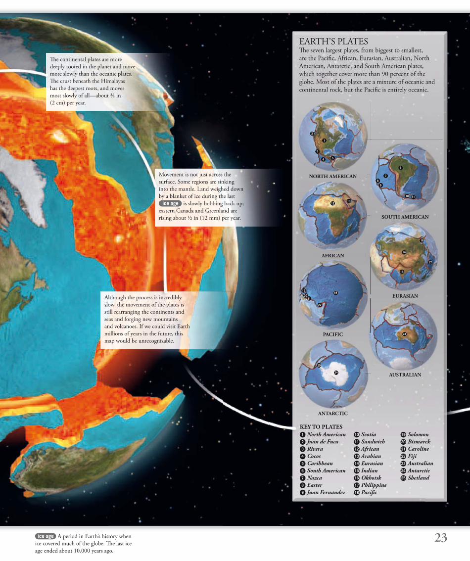
EARTH’S PLATESTh e seven largest plates, from biggest to smallest,
are the Pacifi c, African, Eurasian, Australian, North
American, Antarctic, and South American plates,
which together cover more than 90 percent of the
globe. Most of the plates are a mixture of oceanic and
continental rock, but the Pacifi c is entirely oceanic.
ice age A period in Earth’s history when
ice covered much of the globe. Th e last ice
age ended about 10,000 years ago.
Th e continental plates are more
deeply rooted in the planet and move
more slowly than the oceanic plates.
Th e crust beneath the Himalayas
has the deepest roots, and moves
most slowly of all—about ¾ in
(2 cm) per year.
Movement is not just across the
surface. Some regions are sinking
into the mantle. Land weighed down
by a blanket of ice during the last
ice age is slowly bobbing back up;
eastern Canada and Greenland are
rising about ½ in (12 mm) per year.
Although the process is incredibly
slow, the movement of the plates is
still rearranging the continents and
seas and forging new mountains
and volcanoes. If we could visit Earth
millions of years in the future, this
map would be unrecognizable.
2
1
3
4 5
6
7
8
9
10 11
1213
14
17
15
16
1819
2021
22
23
25
24
1 North American 2 Juan de Fuca 3 Rivera4 Cocos 5 Caribbean 6 South American 7 Nazca8 Easter 9 Juan Fernandez
NORTH AMERICAN
AFRICAN
SOUTH AMERICAN
EURASIAN
PACIFIC
AUSTRALIAN
ANTARCTIC
10 Scotia 11 Sandwich 12 African 13 Arabian 14 Eurasian 15 Indian16 Okhotsk 17 Philippine 18 Pacifi c
19 Solomon 20 Bismarck 21 Caroline 22 Fiji 23 Australian24 Antarctic 25 Shetland
KEY TO PLATES
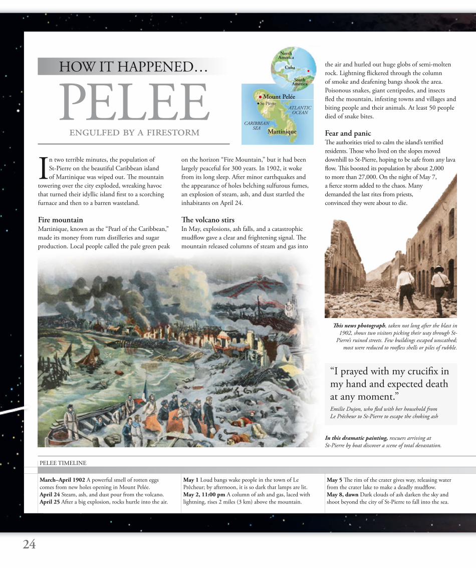
In two terrible minutes, the population of
St-Pierre on the beautiful Caribbean island
of Martinique was wiped out. Th e mountain
towering over the city exploded, wreaking havoc
that turned their idyllic island fi rst to a scorching
furnace and then to a barren wasteland.
Fire mountainMartinique, known as the “Pearl of the Caribbean,”
made its money from rum distilleries and sugar
production. Local people called the pale green peak
Th is news photograph, taken not long after the blast in
1902, shows two visitors picking their way through St-
Pierre’s ruined streets. Few buildings escaped unscathed;
most were reduced to roofl ess shells or piles of rubble.
In this dramatic painting, rescuers arriving at
St-Pierre by boat discover a scene of total devastation.
24
HOW IT HAPPENED…
May 1 Loud bangs wake people in the town of Le
Prêcheur; by afternoon, it is so dark that lamps are lit.
May 2, 11:00 pm A column of ash and gas, laced with
lightning, rises 2 miles (3 km) above the mountain.
May 5 Th e rim of the crater gives way, releasing water
from the crater lake to make a deadly mudfl ow.
May 8, dawn Dark clouds of ash darken the sky and
shoot beyond the city of St-Pierre to fall into the sea.
March–April 1902 A powerful smell of rotten eggs
comes from new holes opening in Mount Pelée.
April 24 Steam, ash, and dust pour from the volcano.
April 25 After a big explosion, rocks hurtle into the air.
PELEE TIMELINE
PELEEengulfed by a firestorm
Mount Pelée
ATLANTIC OCEAN
CARIBBEAN SEA
on the horizon “Fire Mountain,” but it had been
largely peaceful for 300 years. In 1902, it woke
from its long sleep. After minor earthquakes and
the appearance of holes belching sulfurous fumes,
an explosion of steam, ash, and dust startled the
inhabitants on April 24.
Th e volcano stirsIn May, explosions, ash falls, and a catastrophic
mudfl ow gave a clear and frightening signal. Th e
mountain released columns of steam and gas into
the air and hurled out huge globs of semi-molten
rock. Lightning fl ickered through the column
of smoke and deafening bangs shook the area.
Poisonous snakes, giant centipedes, and insects
fl ed the mountain, infesting towns and villages and
biting people and their animals. At least 50 people
died of snake bites.
Fear and panicTh e authorities tried to calm the island’s terrifi ed
residents. Th ose who lived on the slopes moved
downhill to St-Pierre, hoping to be safe from any lava
fl ow. Th is boosted its population by about 2,000
to more than 27,000. On the night of May 7,
a fi erce storm added to the chaos. Many
demanded the last rites from priests,
convinced they were about to die.
“I prayed with my crucifi x in my hand and expected death at any moment.”Emilie Dujon, who fl ed with her household from
Le Prêcheur to St-Pierre to escape the choking ash
Martinique
St-Pierre
North America
South America
Cuba
25
8:02 am A telegraph message is cut off after a few seconds,
indicating the exact time of St-Pierre’s destruction.
8:05 am Fast-moving cloud of hot gases incinerates
the city—virtually all its residents perish.
12:30 pm A steamship carries news of the disaster to
Martinique’s capital, Fort-de-France.
August 30 Second burning gas cloud kills 1,000 people.
September 1 Mount Pelée releases third deadly gas cloud.
Devastating factsThe Plinian-style eruption of Mount Peléewas the most destructive of the 20th century. In barely two minutes, 27,000 people losttheir lives in the fi rst recorded nuée ardente,or “glowing cloud.”
Glowing cloudTh e cataclysm came in the early morning of
May 8, but it took a form no one expected. Th e
volcano shuddered and seemed to tear apart, then
sent a fi ery cloud roaring down the mountainside,
engulfi ng St-Pierre within seconds. People died
where they stood, never knowing what happened.
It took only two or three minutes for the terrible
cloud to tear through the city. Immediately
following it, a fi restorm fueled by the wind and
casks of rum raged through the ruins of the city at
temperatures of up to 1,650°F (900°C), scorching
everything in its path. In the entire center of the
city, there were just two survivors. On the edges of
the area caught by the burning cloud, there were
a few more survivors, though many were horribly
injured by breathing in the scalding air.
It was the worst volcanic disaster since
the destruction of Pompeii in
ad 79, and had the same cause.
Scientists studying
the eruption of Mount Pelée named the
phenomenon a nuée ardente (glowing cloud).
AftermathWhen offi cials in nearby towns heard nothing
from St-Pierre all morning, they became
alarmed. Boats were sent to investigate, but
returned with awful stories of a demolished city,
the inhabitants all dead, the land still too hot for
anyone to land. People with friends and relatives
One of only two survivors was 25-year-old Louis-Auguste
Sylbaris, who later joined a circus. Posters advertising his
act boasted that he had survived the “silent city of death.”
Deafening roar People heard the eruption in Venezuela, South America, 2,910 miles (4,680 km) away. Terrible toll The eruption killed about 27,000 people and left another 25,000 homeless. Scorching wind The searing blast of the nuée ardente raced down the volcano at 310 mph (500 km/h) and at temperatures of 390–840°F (200–450ºC). Hot as a furnace A fi restorm started by the nuée ardente was fueled by St-Pierre’s massive stores of rum. During the storm, the air became even hotter than rocks leaving the volcano’s crater. And again On August 30, a powerful second nuée ardente covered twice the area of the fi rst. Lucky survivor Louis-Auguste Sylbaris, a prisoner in jail behind thick stone walls, was rescued from the wreckage of St-Pierre after three days. Strange structure After the eruption, a spectacular column of lava nicknamed “The Needle of Pelée” grew from the volcano’s crater. It was unlike anything seen before, but eventually toppled in March 1903 when 755 ft (230 m) high.
in St-Pierre crowded the docks, desperately hoping
for news of survivors. None came.
Second explosionTh e volcano was not fi nished. Another nuée ardente
swept through St-Pierre on August 30. Now, though,
there were only a few looters in the city – they met a
grisly fate. Th e mountain remained highly active for
months, and many more fi ery winds rolled down its
slopes until the middle of 1903. Two bodies
lie face down in
volcanic slurry,
having been trapped
by a terrifying mudfl ow.
“He had just fi nished his sentence when I heard a dreadful scream, then another much weaker groan, like a stifl ed death rattle. Th en silence.”A businessman who had been on the phone to a friend
in St-Pierre at 8:02 am on May 8
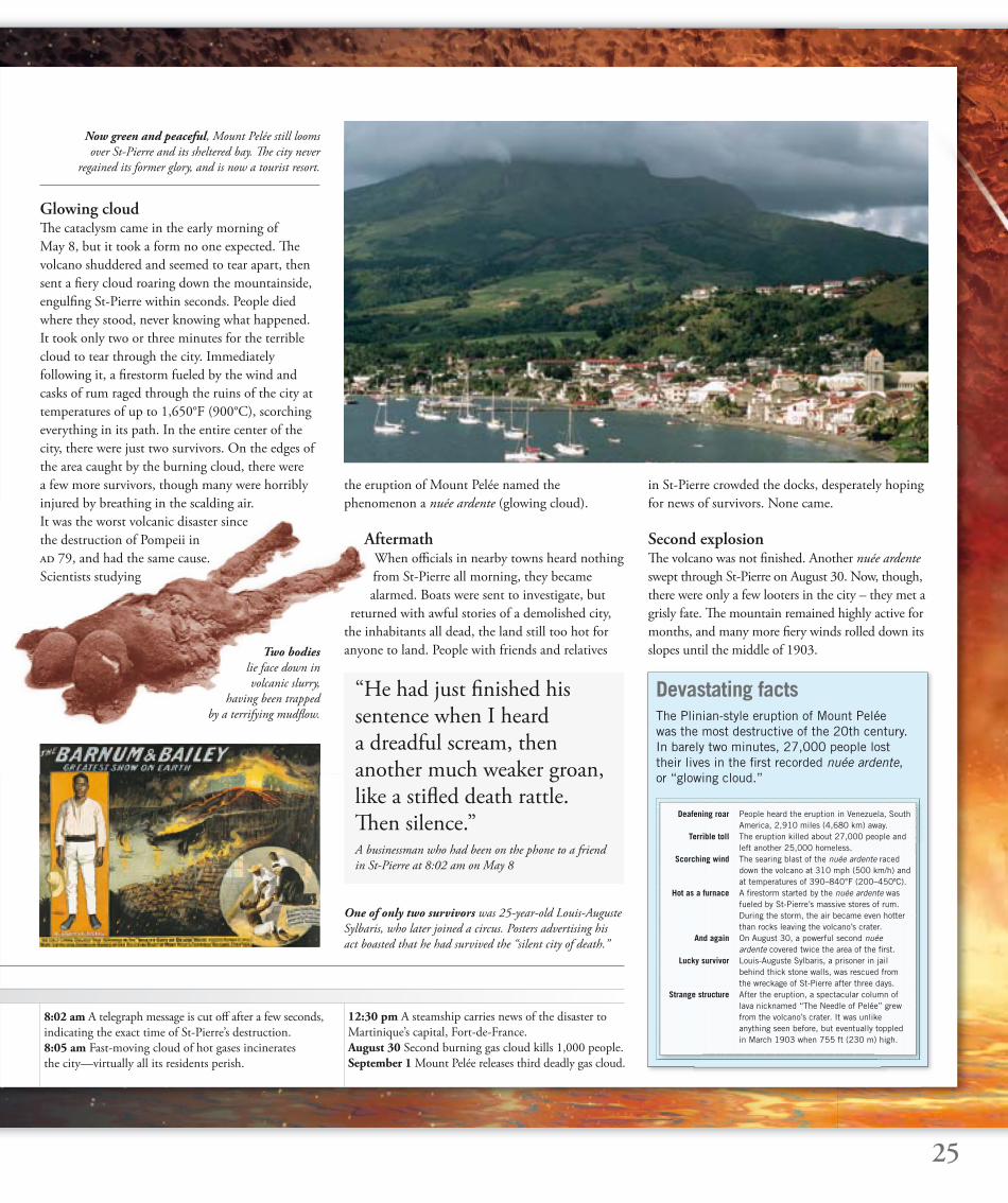
Now green and peaceful, Mount Pelée still looms
over St-Pierre and its sheltered bay. Th e city never
regained its former glory, and is now a tourist resort.
26
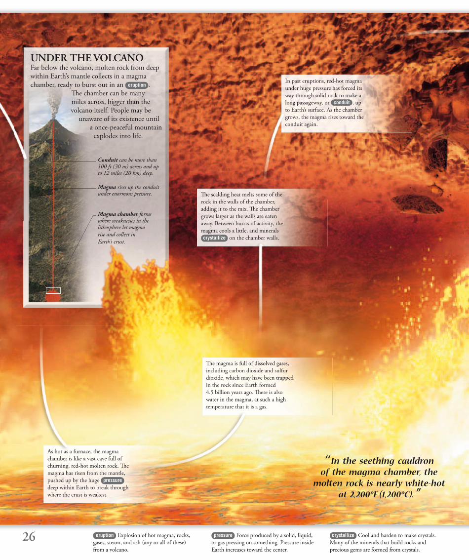
UNDER THE VOLCANO Far below the volcano, molten rock from deep within Earth’s mantle collects in a magma chamber, ready to burst out in an eruption .
Th e chamber can be many miles across, bigger than the volcano itself. People may be
unaware of its existence until a once-peaceful mountain
explodes into life.
pressure Force produced by a solid, liquid,
or gas pressing on something. Pressure inside
Earth increases toward the center.
crystallize Cool and harden to make crystals.
Many of the minerals that build rocks and
precious gems are formed from crystals.
Magma rises up the conduit under enormous pressure.
Magma chamber forms where weaknesses in the lithosphere let magma
rise and collect in
Earth’s crust.
Conduit can be more than 100 ft (30 m) across and up to 12 miles (20 km) deep.
‘‘ In the seething cauldron of the magma chamber, the
molten rock is nearly white-hot at 2,200ºF (1,200ºC). ”
As hot as a furnace, the magma
chamber is like a vast cave full of
churning, red-hot molten rock. Th e
magma has risen from the mantle,
pushed up by the huge pressure
deep within Earth to break through
where the crust is weakest.
Th e magma is full of dissolved gases,
including carbon dioxide and sulfur
dioxide, which may have been trapped
in the rock since Earth formed
4.5 billion years ago. Th ere is also
water in the magma, at such a high
temperature that it is a gas.
Th e scalding heat melts some of the
rock in the walls of the chamber,
adding it to the mix. Th e chamber
grows larger as the walls are eaten
away. Between bursts of activity, the
magma cools a little, and minerals
crystallize on the chamber walls.
In past eruptions, red-hot magma
under huge pressure has forced its
way through solid rock to make a
long passageway, or conduit , up
to Earth’s surface. As the chamber
grows, the magma rises toward the
conduit again.
eruption Explosion of hot magma, rocks,
gases, steam, and ash (any or all of these)
from a volcano.

27silica Silicon dioxide, the most common
mineral found in Earth’s crust.
viscous Th ick or runny. Th e less viscous
a liquid is, the more easily it fl ows.
conduit Passageway that links the
magma chamber with the mouth of
the volcano above.
As more and more magma rises
from deep inside Earth, the chamber
expands with the heat and the
enormous pressure. Above ground,
the mountain may swell or bulge.
Sometimes the chamber can even
explode, blowing the mountain apart.
Magma leaks into the surrounding
rock through cracks and weaknesses
in the chamber walls. Scorching
magma may seep through to the
surface as well as bursting from the
mouth of the volcano, or it may cool
and harden below the surface.
Magma can be as runny as honey or
more viscous than peanut butter.
Extra silica dissolving from the
walls of the chamber changes the
magma, making it even more sticky.
Viscous magma with a lot of gas
makes the most dangerous eruptions.
Although the magma is incredibly
hot, water and gas cannot escape from
the mixture because they are held in
by the huge pressure in the chamber.
It is like shaking a bottle of soda—
bubbles do not appear until the cap is
taken off , letting the pressure drop.
Th e magma closest to the top of the
chamber is lighter and contains most
gas. Th is will rush up the conduit
fi rst, giving the eruption an explosive
start. Th icker, less gassy magma will
follow later, and emerge more slowly
from the volcano.
Th e magma chamber is fi lled to
bursting point, as the pressure inside
it soars. Th e surrounding rock can no
longer hold the magma, which has
to escape. It bursts into the conduit
to start its upward journey of many
miles to Earth’s surface.
28 melt Mixture of molten rock with dissolved
gases, water, and chunks of solid rock, that
forms magma.
vent Opening where gases and magma can
escape into the air.
plug Blockage made of hardened magma,
rubble, and debris in the conduit.
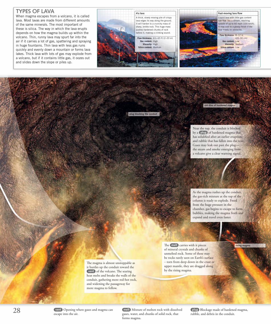
plug blocking the conduit
rising magma
old dike of hardened magma
Th e magma is almost unstoppable as
it hurtles up the conduit toward the vent of the volcano. Th e searing
heat melts and breaks the walls of the
conduit, gathering more red-hot rock,
and widening the passageway for
more magma to follow.
Th e melt carries with it pieces
of mineral crystals and chunks of
unmelted rock. Some of these may
be rocks rarely seen on Earth’s surface
– torn from deep down in the crust or
upper mantle, they are dragged along
by the rising magma.
Near the top, the conduit is blocked
by a plug of hardened magma that
has solidifi ed after an earlier eruption,
and rubble that has fallen into the vent.
Gases may leak out past the plug—
the steam and smoke emerging from
a volcano give a clear warning signal.
As the magma rushes up the conduit,
the gas-rich mixture at the top of the
column is ready to explode. Freed
from the huge pressure in the
chamber, gas begins to escape to form
bubbles, making the magma froth and
expand and travel even faster.
TYPES OF LAVAWhen magma escapes from a volcano, it is called lava. Most lavas are made from different amounts of the same minerals. The most important of these is silica. The way in which the lava erupts depends on how the magma builds up within the volcano. Thin, runny lava may spurt far into the air if it carries a lot of gas, spattering and spraying in huge fountains. Thin lava with less gas runs quickly and evenly down a mountain or forms lava lakes. Thick lava with lots of gas may explode from a volcano, but if it contains little gas, it oozes out and slides down the slope or piles up.
Liquid lava with little gas content can fl ow like a stream, reaching speeds of up to 60 mph (100 km/h). It may cool to a glassy fi nish if the fl ow meets no obstacles.
Fast-moving lava fl ow
Flow thickness: 8–12 in (20–30 cm) Gas content: Low Viscosity: Medium Silica content: Low
A thick, slowly moving pile of crispy lava edges its way along the ground. It will harden to a crunchy mass of sharp, brittle rock. This huge mass pushes hardened chunks of rock before it, making a clinking sound.
A’a lava
Flow thickness: 6½–65 ft (2–20 m) Gas content: High Viscosity: High Silica content: Medium
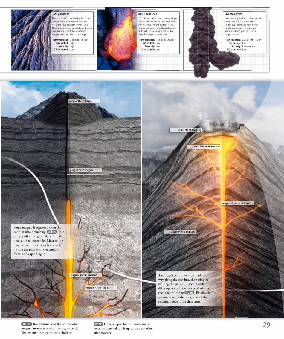
29cone Cone-shaped hill or mountain of
volcanic material, built up by one eruption
after another.
dikes Rock formations that occur when
magma invades a vertical fi ssure, or crack.
Th e magma then cools and solidifi es.
plug of solid magma
magma rises in conduit
magma fl ows into dikes
magma fl ows into dikes
layers of ash and rock
remnants of the plug
vent fi lls with magma
cone of the volcano
Some magma is squeezed from the
conduit into branching dikes that
carry it off underground, or into the
fl anks of the mountain. Most of the
magma continues to gush upward,
hitting the plug with tremendous
force, and exploding it.
Th e magma continues to smash its
way along the conduit, shattering or
melting the plug as it goes. Further
dikes open up in the layers of ash and
rock that form the cone . Finally, the
magma reaches the vent, and all that
remains above it is a thin crust.
This is a thick, slow-fl owing lava. Its surface cools and hardens rapidly, while the lava beneath it moves on. The surface folds and twists as it slows and solidifi es, and the lava forms shapes that look like coils of rope.
Rope pahoehoe
Flow thickness: 2–8 in (5–20 cm) Gas content: High Viscosity: High Silica content: Low
If thick lava drips down a steep slope, it can form saclike shapes that swell with hot lava. As the surface cools, new lumps push through weak spots and swell up, making a shape that resembles animal intestines.
Entrail pahoehoe
Flow thickness: 2–8 in (5–20 cm) Gas content: Low Viscosity: Low Silica content: Low
Lava dripping inside a tube-shaped cavity can pile up. Each drop hardening before the next arrives, building a tower. The separate solidifi ed drops give the lava a lumpy surface.
Lava stalagmite
Flow thickness: 31⁄3–6½ ft (1–2 m) Gas content: Low Viscosity: Low/medium Silica content: Low
30 compacted Pressed down and packed
together.
toxic Poisonous.
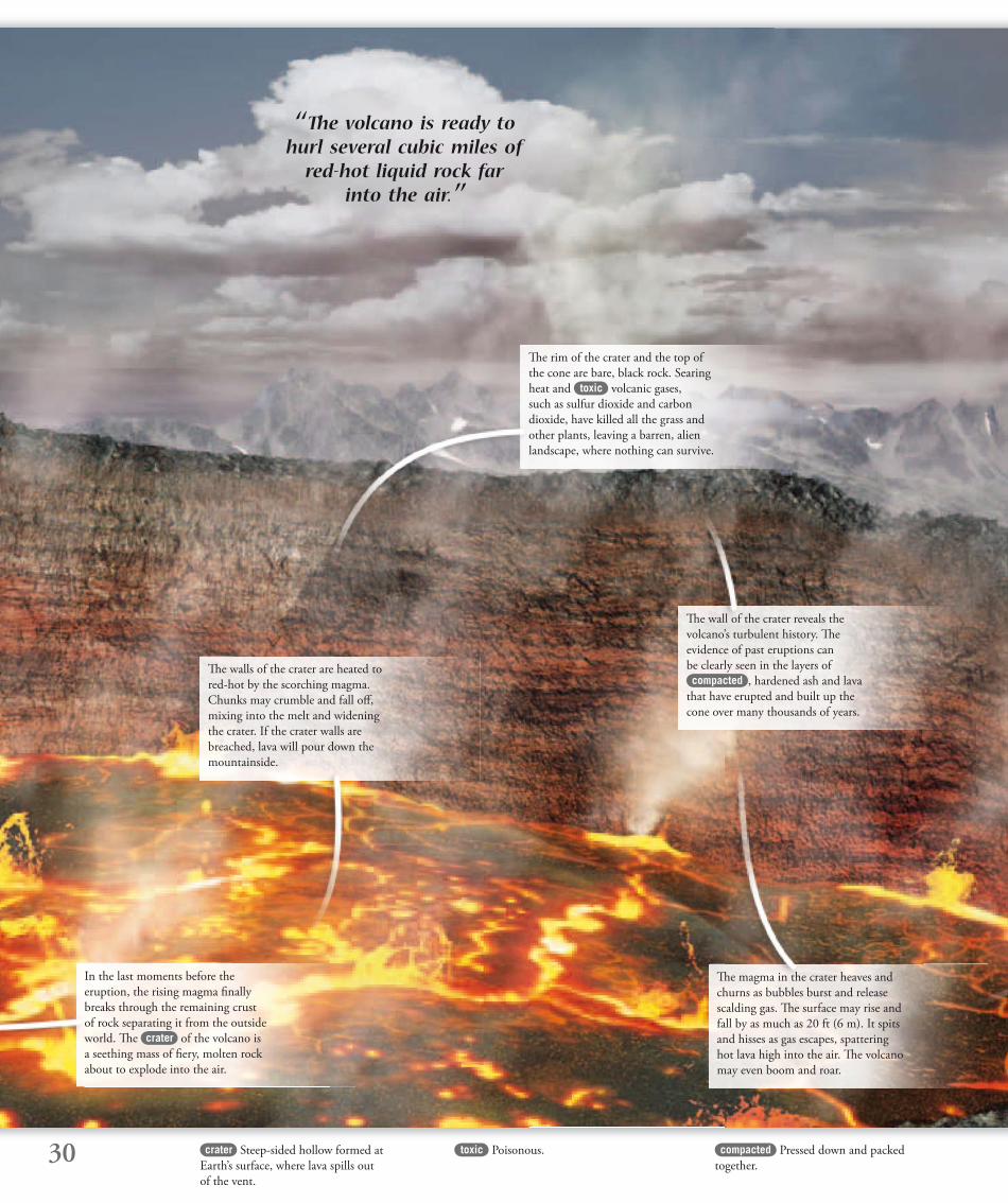
‘‘ The volcano is ready to hurl several cubic miles of
red-hot liquid rock far into the air. ’’
In the last moments before the
eruption, the rising magma fi nally
breaks through the remaining crust
of rock separating it from the outside
world. Th e crater of the volcano is
a seething mass of fi ery, molten rock
about to explode into the air.
Th e walls of the crater are heated to
red-hot by the scorching magma.
Chunks may crumble and fall off ,
mixing into the melt and widening
the crater. If the crater walls are
breached, lava will pour down the
mountainside.
Th e rim of the crater and the top of
the cone are bare, black rock. Searing
heat and toxic volcanic gases,
such as sulfur dioxide and carbon
dioxide, have killed all the grass and
other plants, leaving a barren, alien
landscape, where nothing can survive.
Th e wall of the crater reveals the
volcano’s turbulent history. Th e
evidence of past eruptions can
be clearly seen in the layers of compacted , hardened ash and lava
that have erupted and built up the
cone over many thousands of years.
Th e magma in the crater heaves and
churns as bubbles burst and release
scalding gas. Th e surface may rise and
fall by as much as 20 ft (6 m). It spits
and hisses as gas escapes, spattering
hot lava high into the air. Th e volcano
may even boom and roar.
crater Steep-sided hollow formed at
Earth’s surface, where lava spills out
of the vent.
31
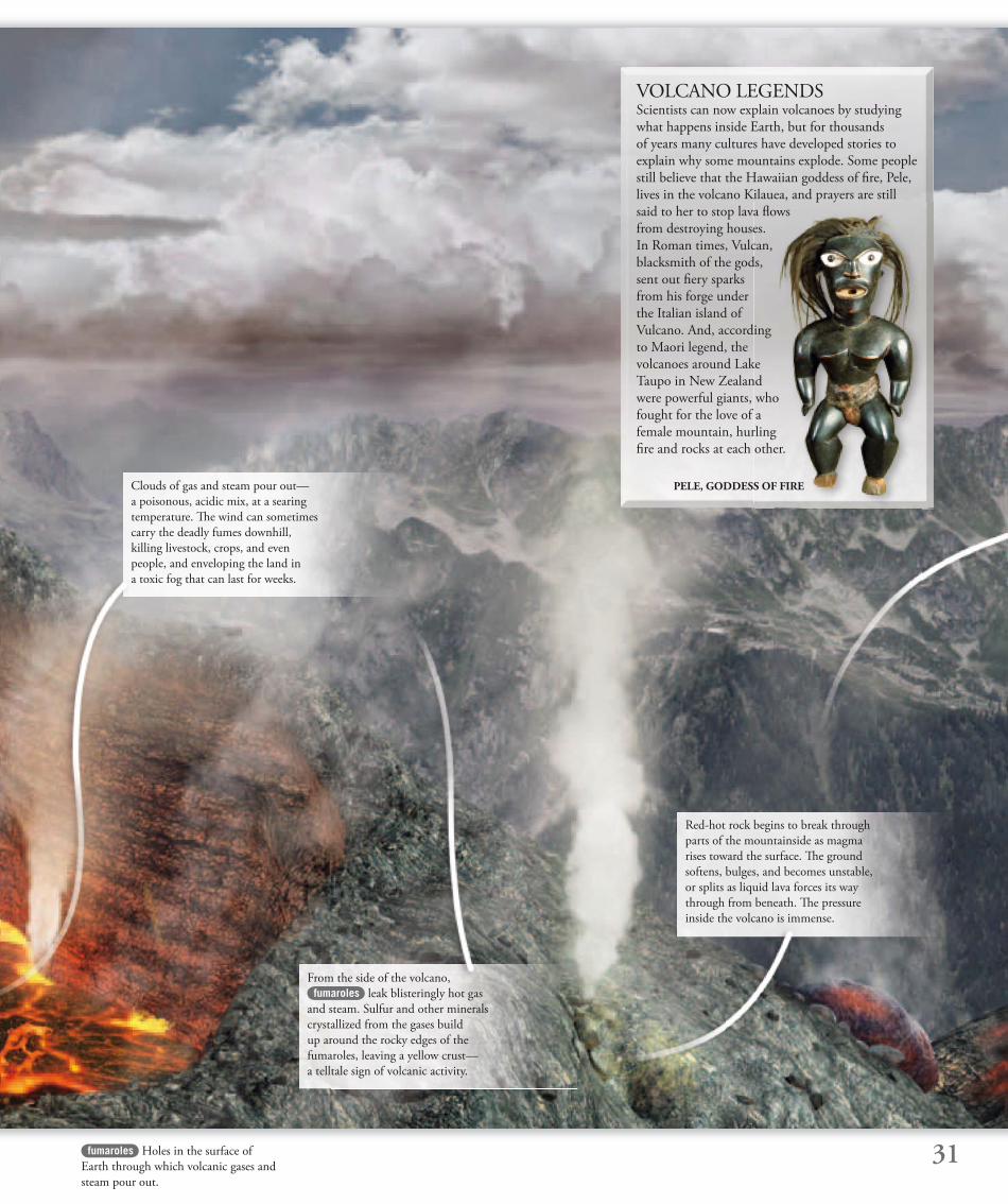
VOLCANO LEGENDSScientists can now explain volcanoes by studying
what happens inside Earth, but for thousands
of years many cultures have developed stories to
explain why some mountains explode. Some people
still believe that the Hawaiian goddess of fi re, Pele,
lives in the volcano Kilauea, and prayers are still
said to her to stop lava fl ows
from destroying houses.
In Roman times, Vulcan,
blacksmith of the gods,
sent out fi ery sparks
from his forge under
the Italian island of
Vulcano. And, according
to Maori legend, the
volcanoes around Lake
Taupo in New Zealand
were powerful giants, who
fought for the love of a
female mountain, hurling
fi re and rocks at each other.
fumaroles Holes in the surface of
Earth through which volcanic gases and
steam pour out.
PELE, GODDESS OF FIREClouds of gas and steam pour out—
a poisonous, acidic mix, at a searing
temperature. Th e wind can sometimes
carry the deadly fumes downhill,
killing livestock, crops, and even
people, and enveloping the land in
a toxic fog that can last for weeks.
From the side of the volcano,
fumaroles leak blisteringly hot gas
and steam. Sulfur and other minerals
crystallized from the gases build
up around the rocky edges of the
fumaroles, leaving a yellow crust—
a telltale sign of volcanic activity.
Red-hot rock begins to break through
parts of the mountainside as magma
rises toward the surface. Th e ground
softens, bulges, and becomes unstable,
or splits as liquid lava forces its way
through from beneath. Th e pressure
inside the volcano is immense.
32 plume A rising column of material, such as
volcanic ash and gas.
suspension Mixture of particles held in a
gas or liquid.
ash Very fi ne, hard particles of shattered
lava, measuring less than ¹⁄₁₀ in (2 mm).
It is gray or whitish in color.
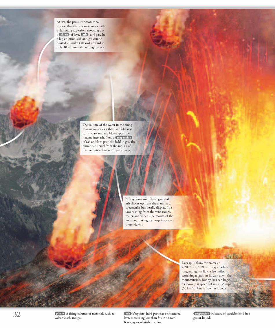
At last, the pressure becomes so
intense that the volcano erupts with
a deafening explosion, shooting out
a plume of lava, ash , and gas. In
a big eruption, ash and gas can be
blasted 20 miles (30 km) upward in
only 10 minutes, darkening the sky.
Th e volume of the water in the rising
magma increases a thousandfold as it
turns to steam, and blows apart the
magma into ash. Now a suspension
of ash and lava particles held in gas, the
plume can travel from the mouth of
the conduit as fast as a supersonic jet.
A fi ery fountain of lava, gas, and
ash shoots up from the crater in a
spectacular but deadly display. Th e
lava rushing from the vent scours,
melts, and widens the mouth of the
volcano, making the eruption even
more violent.
Lava spills from the crater at
2,200°F (1,200°C). It stays molten
long enough to fl ow a few miles,
scorching a path on its way down the
mountainside. Runny lava can begin
its journey at speeds of up to 35 mph
(60 km/h), but it slows as it cools.
33pyroclastic fl ow Fast-moving, scorching
wind carrying ash and lava particles.
lava bombs Chunks of solid or semisolid
rock, hurled out of a volcano.
incinerates Burns up completely, leaving
only ash.
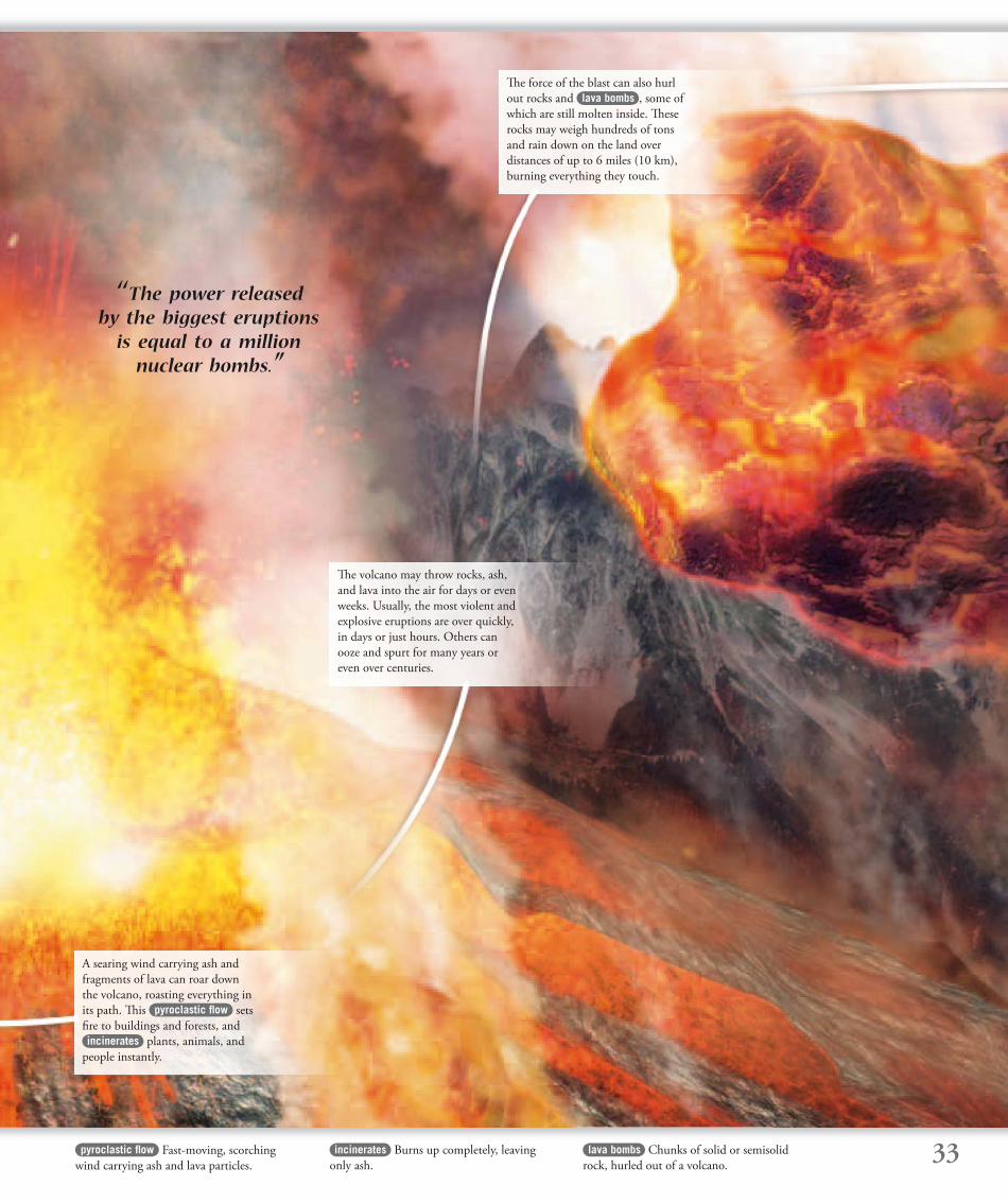
‘‘ The power released by the biggest eruptions
is equal to a million nuclear bombs.”
A searing wind carrying ash and
fragments of lava can roar down
the volcano, roasting everything in
its path. Th is pyroclastic fl ow sets
fi re to buildings and forests, and
incinerates plants, animals, and
people instantly.
Th e volcano may throw rocks, ash,
and lava into the air for days or even
weeks. Usually, the most violent and
explosive eruptions are over quickly,
in days or just hours. Others can
ooze and spurt for many years or
even over centuries.
Th e force of the blast can also hurl
out rocks and lava bombs , some of
which are still molten inside. Th ese
rocks may weigh hundreds of tons
and rain down on the land over
distances of up to 6 miles (10 km),
burning everything they touch.
34
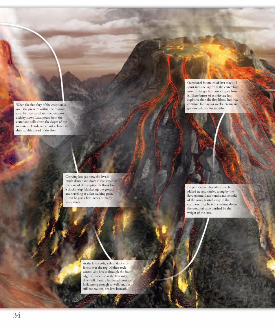
Occasional fountains of lava may still
spurt into the sky from the crater, but
most of the gas has now escaped from
it. Th ese bursts of activity are less
explosive than the fi rst blasts, but may
continue for days or weeks. Steam and
gas can leak out for months.
Carrying less gas now, the lava is
much denser and more viscous than at
the start of the eruption. It fl ows like
a thick syrup, blanketing the ground
and traveling at a fast walking pace.
It can be just a few inches or many
yards thick.
When the fi rst fury of the eruption is
over, the pressure within the magma
chamber has eased and the volcano’s
activity slows. Lava pours from the
crater and rolls down the slopes of the
mountain. Hardened chunks clatter as
they tumble ahead of the fl ow.
As the lava cools, a thin, dark crust
forms over the top. Molten rock
continually breaks through the front
edge of this crust as the lava rolls
downhill. Later, a hardened crust can
look strong enough to walk on, but
still conceal red-hot lava beneath.
Large rocks and boulders may be
picked up and carried along by the
fi ery stream. Lava bombs and chunks
of the cone, blasted away in the
eruption, may be sent crashing down
the mountainside, pushed by the
weight of the lava.
35methane Gas composed of hydrogen and
carbon that burns very easily.
shards Slivers or fragments of sharp rock
or glass. As shards break from newly cooled
lava, they may produce a tinkling sound.
vegetation Trees, grass, and all other types
of plants.
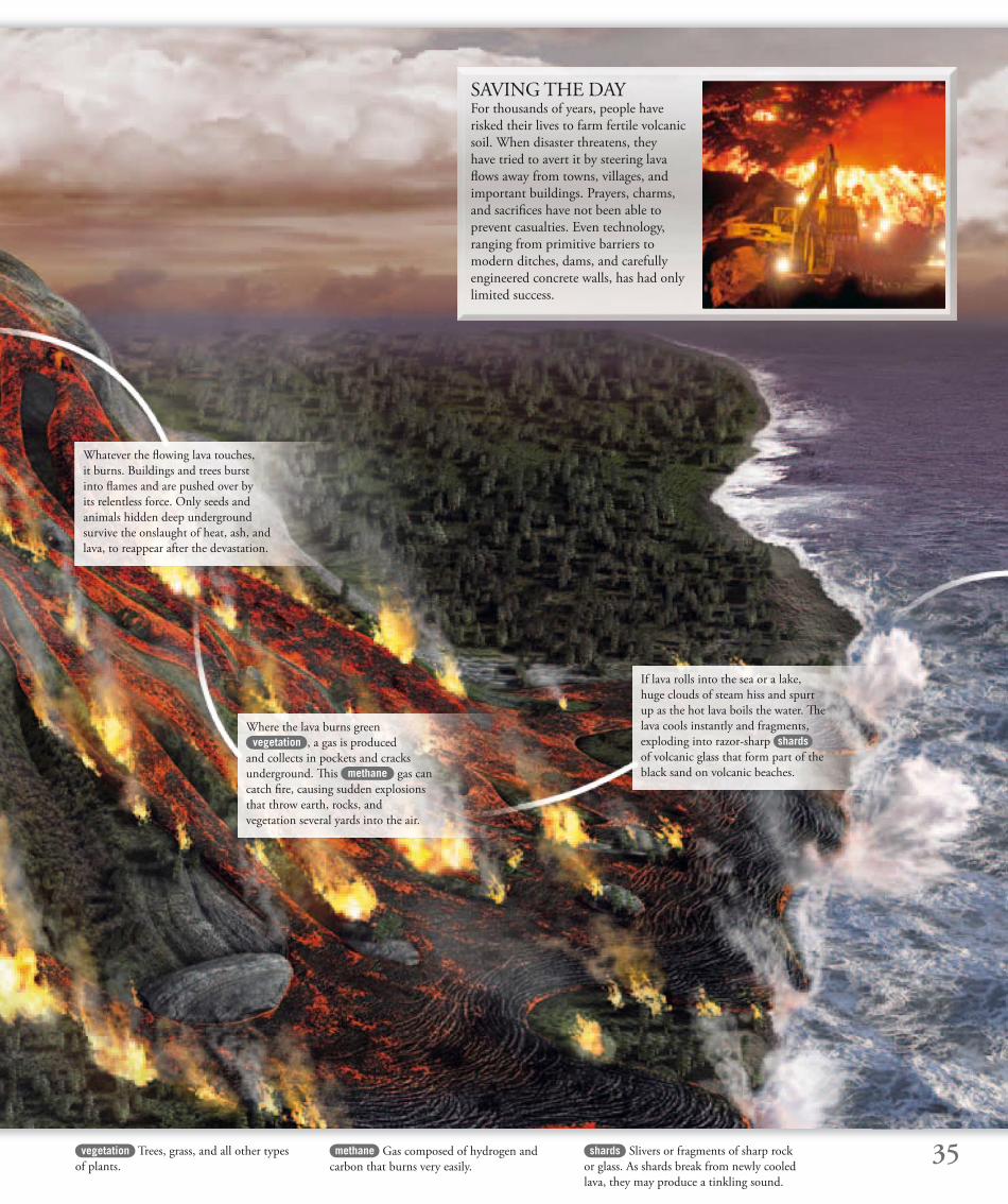
Whatever the fl owing lava touches,
it burns. Buildings and trees burst
into fl ames and are pushed over by
its relentless force. Only seeds and
animals hidden deep underground
survive the onslaught of heat, ash, and
lava, to reappear after the devastation.
Where the lava burns green
vegetation , a gas is produced
and collects in pockets and cracks
underground. Th is methane gas can
catch fi re, causing sudden explosions
that throw earth, rocks, and
vegetation several yards into the air.
If lava rolls into the sea or a lake,
huge clouds of steam hiss and spurt
up as the hot lava boils the water. Th e
lava cools instantly and fragments,
exploding into razor-sharp shards
of volcanic glass that form part of the
black sand on volcanic beaches.
SAVING THE DAYFor thousands of years, people have
risked their lives to farm fertile volcanic
soil. When disaster threatens, they
have tried to avert it by steering lava
fl ows away from towns, villages, and
important buildings. Prayers, charms,
and sacrifi ces have not been able to
prevent casualties. Even technology,
ranging from primitive barriers to
modern ditches, dams, and carefully
engineered concrete walls, has had only
limited success.
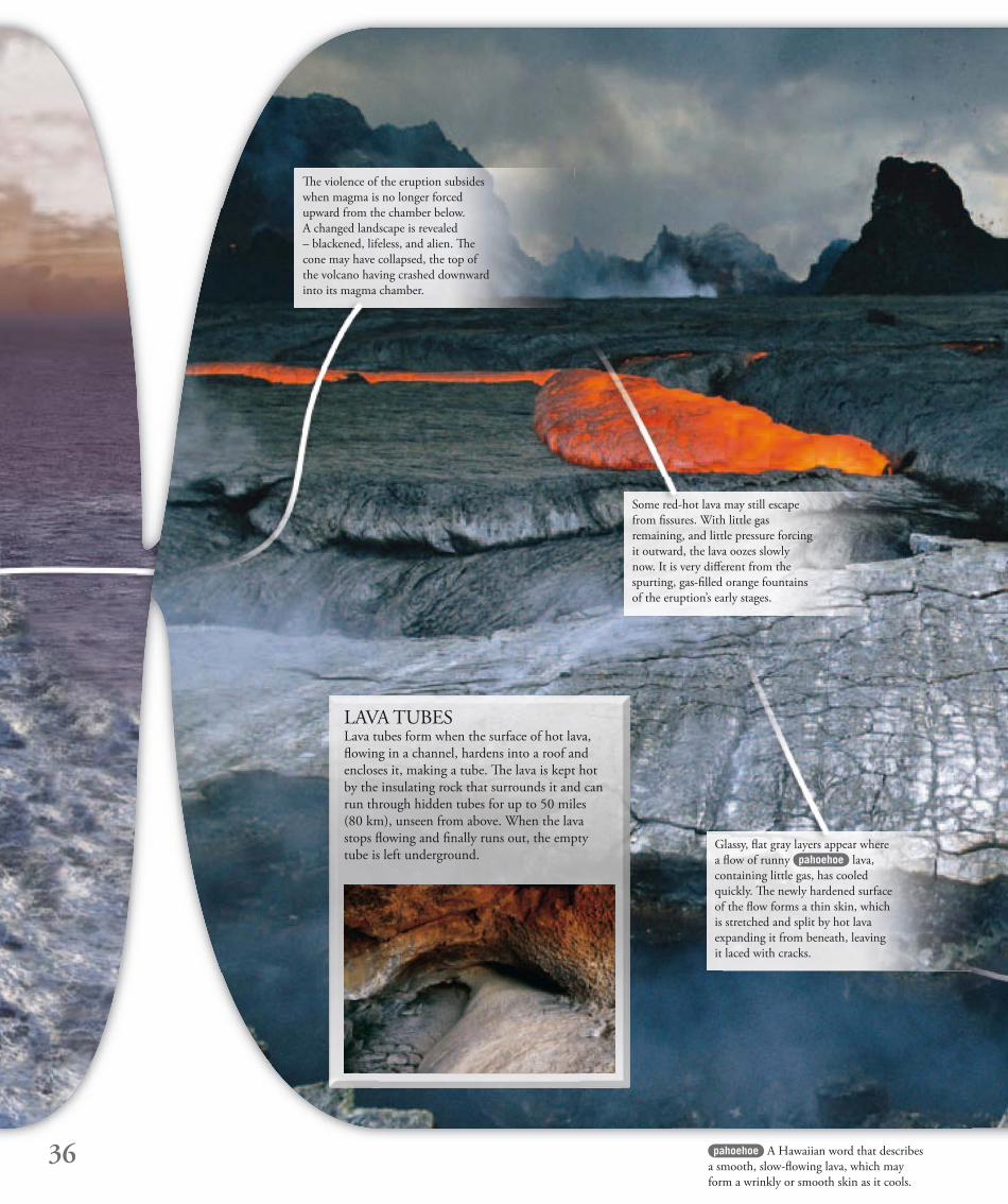
Some red-hot lava may still escape
from fi ssures. With little gas
remaining, and little pressure forcing
it outward, the lava oozes slowly
now. It is very diff erent from the
spurting, gas-fi lled orange fountains
of the eruption’s early stages.
Glassy, fl at gray layers appear where
a fl ow of runny pahoehoe lava,
containing little gas, has cooled
quickly. Th e newly hardened surface
of the fl ow forms a thin skin, which
is stretched and split by hot lava
expanding it from beneath, leaving
it laced with cracks.
Th e violence of the eruption subsides
when magma is no longer forced
upward from the chamber below.
A changed landscape is revealed
– blackened, lifeless, and alien. Th e
cone may have collapsed, the top of
the volcano having crashed downward
into its magma chamber.
36 pahoehoe A Hawaiian word that describes
a smooth, slow-fl owing lava, which may
form a wrinkly or smooth skin as it cools.
LAVA TUBESLava tubes form when the surface of hot lava,
fl owing in a channel, hardens into a roof and
encloses it, making a tube. Th e lava is kept hot
by the insulating rock that surrounds it and can
run through hidden tubes for up to 50 miles
(80 km), unseen from above. When the lava
stops fl owing and fi nally runs out, the empty
tube is left underground.
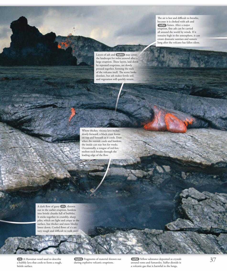
A dark fl ow of gassy a’a , thrown
out in the earlier eruption, hardens
into brittle chunks full of bubbles.
It sticks together in crumbly, sharp
piles, which are light and crispy at the
surface, but thicker and more blocky
lower down. Cooled fl ows of a’a are
very rough and diffi cult to walk over.
Th e air is hot and diffi cult to breathe,
because it is choked with ash and
sulfur fumes. After a major
eruption, fi ne ash can be carried
all around the world by winds. If it
remains high in the atmosphere, it can
create dramatic sunrises and sunsets
long after the volcano has fallen silent.
Layers of ash and tephra may cover
the landscape for miles around after a
large eruption. Th ese layers, laid down
by repeated eruptions, are slowly
pressed together, forming the rock
of the volcano itself. Th e scene looks
desolate, but ash makes fertile soil,
and vegetation will quickly return.
Where thicker, viscous lava inches
slowly forward, a black crust forms
on top and beneath as it cools. Even
when the outside cools and hardens,
the inside can stay hot for weeks.
Occasionally, a tongue of red-hot,
molten rock breaks through the
leading edge of the fl ow.
37a’a A Hawaiian word used to describe
a bubbly lava that cools to form a rough,
brittle surface.
tephra Fragments of material thrown out
during explosive volcanic eruptions.
sulfur Yellow substance deposited as crystals
around vents and fumaroles. Sulfur dioxide is
a volcanic gas that is harmful to the lungs.
38
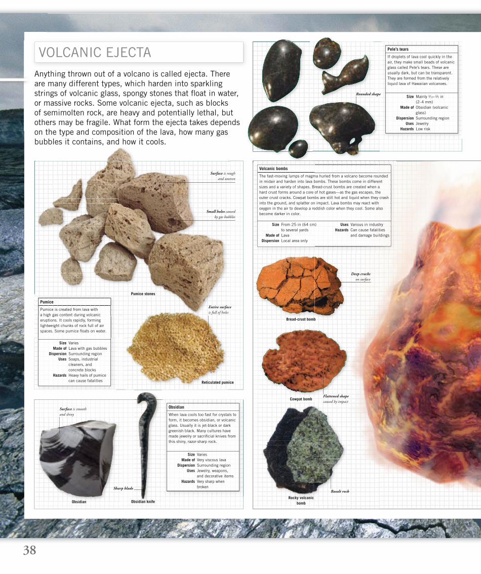
Anything thrown out of a volcano is called ejecta. There are many different types, which harden into sparkling strings of volcanic glass, spongy stones that fl oat in water, or massive rocks. Some volcanic ejecta, such as blocks of semimolten rock, are heavy and potentially lethal, but others may be fragile. What form the ejecta takes depends on the type and composition of the lava, how many gas bubbles it contains, and how it cools.
VOLCANIC EJECTA
Deep cracks
on surface
Small holes caused
by gas bubbles
Rounded shape
If droplets of lava cool quickly in the air, they make small beads of volcanic glass called Pele’s tears. These are usually dark, but can be transparent. They are formed from the relatively liquid lava of Hawaiian volcanoes.
Pele’s tears
Size Mainly ¹⁄10–¹⁄5 in (2–4 mm) Made of Obsidian (volcanic glass) Dispersion Surrounding region Uses Jewelry Hazards Low risk
The fast-moving lumps of magma hurled from a volcano become rounded in midair and harden into lava bombs. These bombs come in different sizes and a variety of shapes. Bread-crust bombs are created when a hard crust forms around a core of hot gases—as the gas escapes, the outer crust cracks. Cowpat bombs are still hot and liquid when they crash into the ground, and splatter on impact. Lava bombs may react with oxygen in the air to develop a reddish color when they cool. Some also become darker in color.
Volcanic bombs
Size From 25 in (64 cm) to several yards Made of Lava Dispersion Local area only
Uses Various in industry Hazards Can cause fatalities and damage buildings
When lava cools too fast for crystals to form, it becomes obsidian, or volcanic glass. Usually it is jet-black or dark greenish black. Many cultures have made jewelry or sacrifi cial knives from this shiny, razor-sharp rock.
Obsidian
Size Varies Made of Very viscous lava Dispersion Surrounding region Uses Jewelry, weapons, and decorative items Hazards Very sharp when broken
Pumice is created from lava with a high gas content during volcanic eruptions. It cools rapidly, forming lightweight chunks of rock full of air spaces. Some pumice fl oats on water.
Pumice
Size Varies Made of Lava with gas bubbles Dispersion Surrounding region Uses Soaps, industrial cleaners, and concrete blocks Hazards Heavy hails of pumice can cause fatalities
Sharp blade
Surface is smooth
and shiny
Flattened shape
caused by impact
Basalt rock
Rocky volcanic bomb
Pumice stones
Bread-crust bomb
Reticulated pumice
Cowpat bomb
Obsidian Obsidian knife
Entire surface
is full of holes
Surface is rough
and uneven
39
Jumble of rough,
irregularly shaped rocks
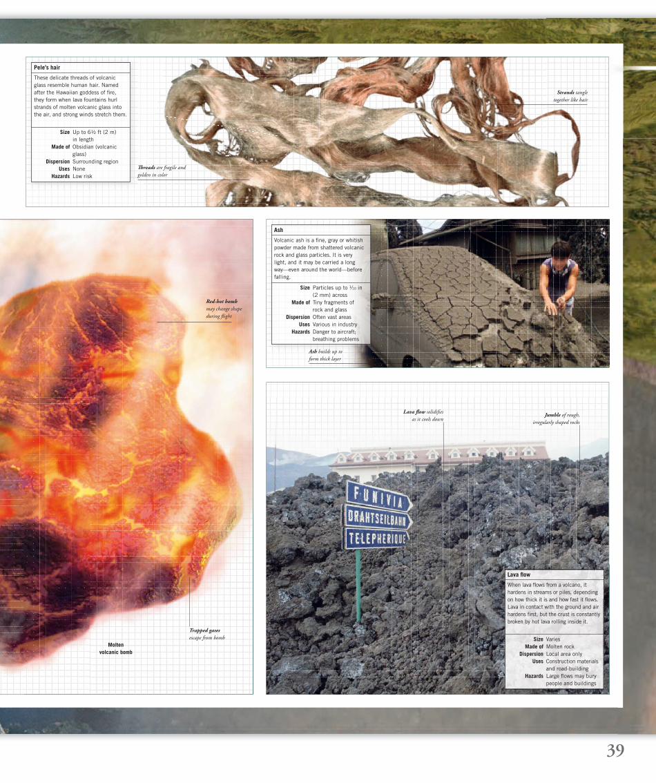
These delicate threads of volcanic glass resemble human hair. Named after the Hawaiian goddess of fi re, they form when lava fountains hurl strands of molten volcanic glass into the air, and strong winds stretch them.
Pele’s hair
Size Up to 6½ ft (2 m) in length Made of Obsidian (volcanic glass) Dispersion Surrounding region Uses None Hazards Low risk
Volcanic ash is a fi ne, gray or whitish powder made from shattered volcanic rock and glass particles. It is very light, and it may be carried a long way—even around the world—before falling.
Ash
Size Particles up to ¹⁄10 in (2 mm) across Made of Tiny fragments of rock and glass Dispersion Often vast areas Uses Various in industry Hazards Danger to aircraft; breathing problems
Th reads are fragile and
golden in color
Lava fl ow solidifi es
as it cools down
Ash builds up to
form thick layer
Strands tangle
together like hair
Trapped gases
escape from bomb
When lava fl ows from a volcano, it hardens in streams or piles, depending on how thick it is and how fast it fl ows. Lava in contact with the ground and air hardens fi rst, but the crust is constantly broken by hot lava rolling inside it.
Lava fl ow
Size Varies Made of Molten rock Dispersion Local area only Uses Construction materials and road-building Hazards Large fl ows may bury people and buildings
Red-hot bomb
may change shape
during fl ight
Moltenvolcanic bomb
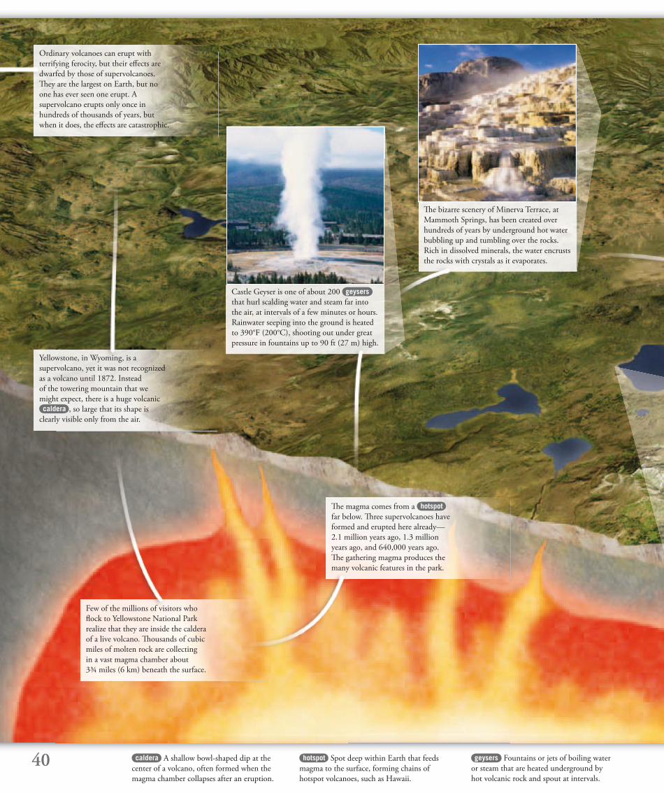
40 caldera A shallow bowl-shaped dip at the
center of a volcano, often formed when the
magma chamber collapses after an eruption.
geysers Fountains or jets of boiling water
or steam that are heated underground by
hot volcanic rock and spout at intervals.
hotspot Spot deep within Earth that feeds
magma to the surface, forming chains of
hotspot volcanoes, such as Hawaii.
Ordinary volcanoes can erupt with
terrifying ferocity, but their eff ects are
dwarfed by those of supervolcanoes.
Th ey are the largest on Earth, but no
one has ever seen one erupt. A
supervolcano erupts only once in
hundreds of thousands of years, but
when it does, the eff ects are catastrophic.
Yellowstone, in Wyoming, is a
supervolcano, yet it was not recognized
as a volcano until 1872. Instead
of the towering mountain that we
might expect, there is a huge volcanic caldera , so large that its shape is
clearly visible only from the air.
Few of the millions of visitors who
fl ock to Yellowstone National Park
realize that they are inside the caldera
of a live volcano. Th ousands of cubic
miles of molten rock are collecting
in a vast magma chamber about
3¾ miles (6 km) beneath the surface.
Th e magma comes from a hotspot
far below. Th ree supervolcanoes have
formed and erupted here already—
2.1 million years ago, 1.3 million
years ago, and 640,000 years ago.
Th e gathering magma produces the
many volcanic features in the park.
Castle Geyser is one of about 200 geysers
that hurl scalding water and steam far into
the air, at intervals of a few minutes or hours.
Rainwater seeping into the ground is heated
to 390°F (200°C), shooting out under great
pressure in fountains up to 90 ft (27 m) high.
Th e bizarre scenery of Minerva Terrace, at
Mammoth Springs, has been created over
hundreds of years by underground hot water
bubbling up and tumbling over the rocks.
Rich in dissolved minerals, the water encrusts
the rocks with crystals as it evaporates.
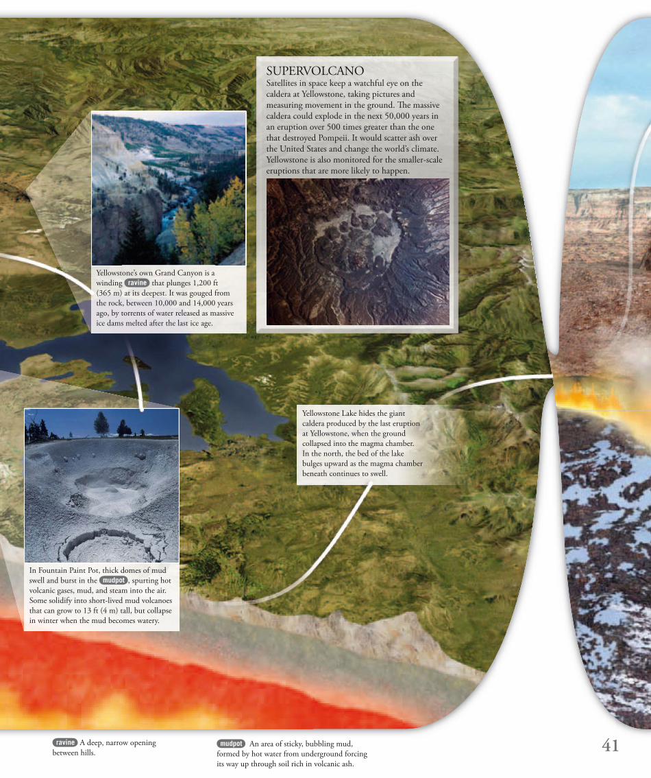
41mudpot An area of sticky, bubbling mud,
formed by hot water from underground forcing
its way up through soil rich in volcanic ash.
Yellowstone Lake hides the giant
caldera produced by the last eruption
at Yellowstone, when the ground
collapsed into the magma chamber.
In the north, the bed of the lake
bulges upward as the magma chamber
beneath continues to swell.
SUPERVOLCANOSatellites in space keep a watchful eye on the
caldera at Yellowstone, taking pictures and
measuring movement in the ground. Th e massive
caldera could explode in the next 50,000 years in
an eruption over 500 times greater than the one
that destroyed Pompeii. It would scatter ash over
the United States and change the world’s climate.
Yellowstone is also monitored for the smaller-scale
eruptions that are more likely to happen.
Yellowstone’s own Grand Canyon is a
winding ravine that plunges 1,200 ft
(365 m) at its deepest. It was gouged from
the rock, between 10,000 and 14,000 years
ago, by torrents of water released as massive
ice dams melted after the last ice age.
In Fountain Paint Pot, thick domes of mud
swell and burst in the mudpot , spurting hot
volcanic gases, mud, and steam into the air.
Some solidify into short-lived mud volcanoes
that can grow to 13 ft (4 m) tall, but collapse
in winter when the mud becomes watery.
ravine A deep, narrow opening
between hills.

42
In ancient eruptions, millions of years
ago, massive fl oods of liquid basalt
poured from countless fi ssures
to cover vast areas of land in a layer
several miles thick. Over thousands
of years, wind and water have carved
strange rocky towers from these deep
fl ows of basalt rock.
VOLCANIC LANDSCAPESVolcanoes have left their mark on the landscape in many ways. As well as mountains, they have created islands, lakes, and rock formations. Th is volcanic panorama might appear to belong to
the world of science fi ction, but it reveals many weird and wonderful features that exist on Earth today.
Hot, molten rock still pours from
fi ssures in the ground in Iceland.
It is the only place on Earth where
the spreading that takes place at
mid-ocean ridges can be seen on land.
Th e heat under the ground also drives
up geysers that spurt scalding steam.
basalt A fi ne-grained, dark volcanic rock
formed from cooled lava. Most of the rock
that forms the oceanic crust is basalt.
geothermal Using Earth’s internal heat.
Geothermal energy is extracted from the
ground in areas of volcanic activity.
fi ssures Long cracks in the ground.
Th ey are often opened up by landslides
or earthquakes.
Where the crust is thin, and magma
is close to the surface, geothermal
power stations are built to take heat
from the ground and convert it into
electricity. Steam and superheated
water are drawn up to drive turbines,
which then power generators.
Whole islands can be destroyed by the
powerful mix of volcanic activity and
water. Th e Greek island of Santorini,
or Th era, in the Aegean Sea, was once
a huge volcano. In about 1410 bc,
the island blew apart, leaving only a
remnant in the shape of a horseshoe.
New islands can also rise dramatically
from the sea. Surtur’s Island (Surtsey),
near Iceland, emerged in 1963. It was
created by lava from a fi ssure piling
up on the sea fl oor. As more and more
lava erupted, the mound grew large
enough to appear above the water.
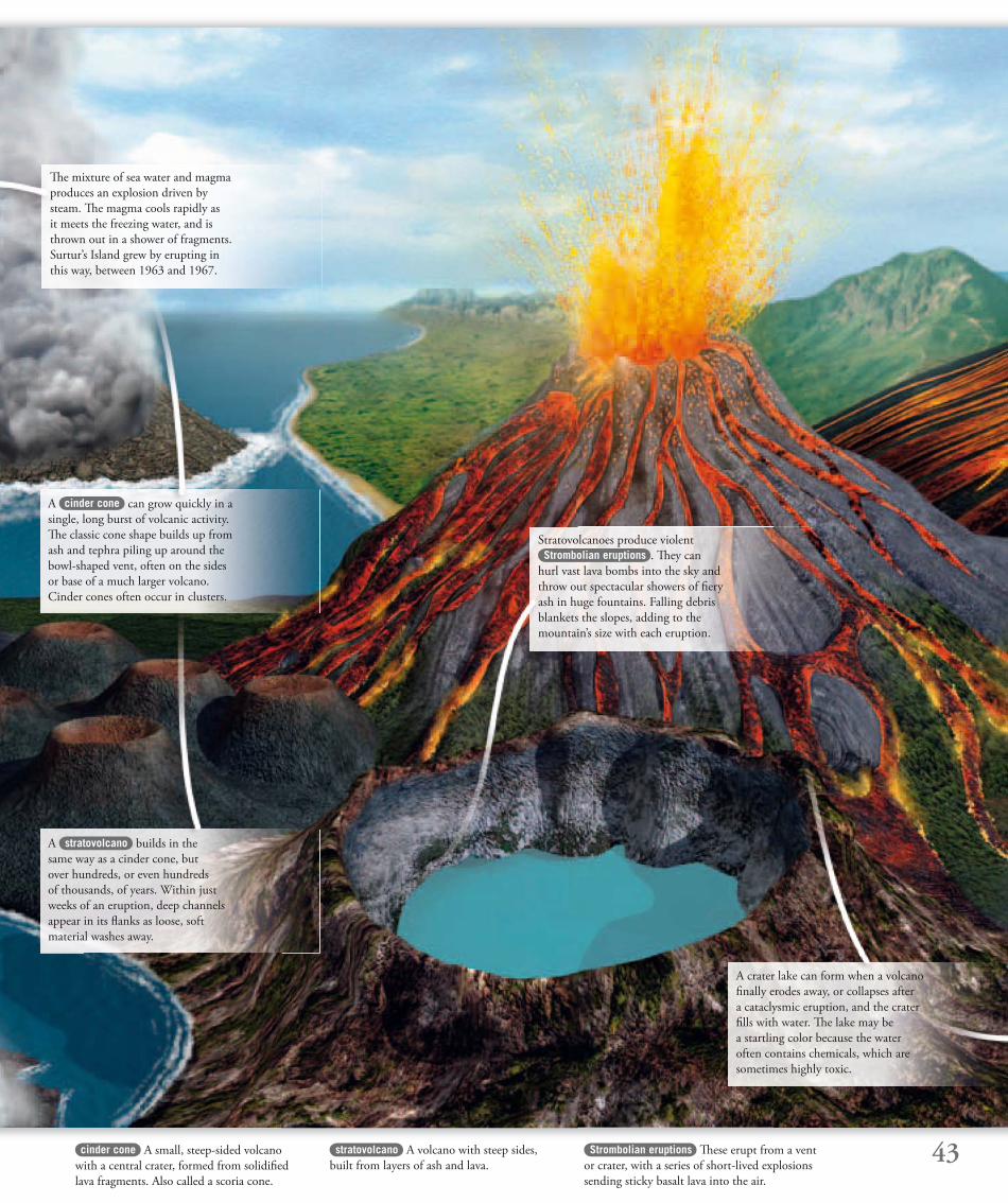
43cinder cone A small, steep-sided volcano
with a central crater, formed from solidifi ed
lava fragments. Also called a scoria cone.
Strombolian eruptions Th ese erupt from a vent
or crater, with a series of short-lived explosions
sending sticky basalt lava into the air.
stratovolcano A volcano with steep sides,
built from layers of ash and lava.
Th e mixture of sea water and magma
produces an explosion driven by
steam. Th e magma cools rapidly as
it meets the freezing water, and is
thrown out in a shower of fragments.
Surtur’s Island grew by erupting in
this way, between 1963 and 1967.
A cinder cone can grow quickly in a
single, long burst of volcanic activity.
Th e classic cone shape builds up from
ash and tephra piling up around the
bowl-shaped vent, often on the sides
or base of a much larger volcano.
Cinder cones often occur in clusters.
Stratovolcanoes produce violent
Strombolian eruptions . Th ey can
hurl vast lava bombs into the sky and
throw out spectacular showers of fi ery
ash in huge fountains. Falling debris
blankets the slopes, adding to the
mountain’s size with each eruption.
A stratovolcano builds in the
same way as a cinder cone, but
over hundreds, or even hundreds
of thousands, of years. Within just
weeks of an eruption, deep channels
appear in its fl anks as loose, soft
material washes away.
A crater lake can form when a volcano
fi nally erodes away, or collapses after
a cataclysmic eruption, and the crater
fi lls with water. Th e lake may be
a startling color because the water
often contains chemicals, which are
sometimes highly toxic.
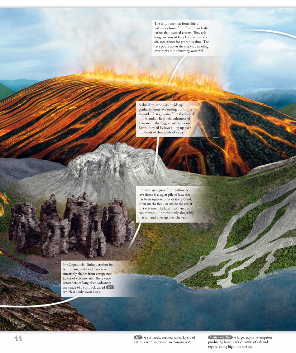
44 Plinian eruption A large, explosive eruption
producing huge, dark columns of ash and
tephra, rising high into the air.
Th e eruptions that form shield
volcanoes burst from fi ssures and rifts
rather than central craters. Th ey spit
long curtains of fi ery lava far into the
air, sometimes for years at a time. Th e
lava pours down the slopes, cascading
over rocks like a burning waterfall.
A shield volcano also builds up
gradually from lava oozing out of the
ground, often growing from the sea bed
into islands. Th e shield volcanoes of
Hawaii are the biggest volcanoes on
Earth, formed by lava piling up over
hundreds of thousands of years.
Other shapes grow from within. A
lava dome is a squat pile of lava that
has been squeezed out of the ground,
often on the fl ank or inside the crater
of a volcano. Th e lava is too viscous to
run downhill. It moves only sluggishly
if at all, and piles up over the vent.
In Cappadocia, Turkey, erosion by
wind, rain, and sand has carved
unearthly shapes from compacted
layers of volcanic ash. Th ese eerie
reminders of long-dead volcanoes
are made of a soft rock called tuff ,
which is easily worn away.
tuff A soft rock, formed when layers of
ash mix with water and are compressed.
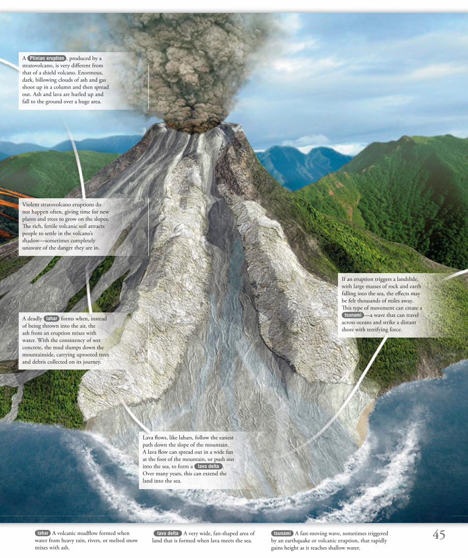
45
If an eruption triggers a landslide,
with large masses of rock and earth
falling into the sea, the eff ects may
be felt thousands of miles away.
Th is type of movement can create a
tsunami —a wave that can travel
across oceans and strike a distant
shore with terrifying force.
Lava fl ows, like lahars, follow the easiest
path down the slope of the mountain.
A lava fl ow can spread out in a wide fan
at the foot of the mountain, or push out
into the sea, to form a lava delta .
Over many years, this can extend the
land into the sea.
tsunami A fast-moving wave, sometimes triggered
by an earthquake or volcanic eruption, that rapidly
gains height as it reaches shallow water.
lahar A volcanic mudfl ow formed when
water from heavy rain, rivers, or melted snow
mixes with ash.
A deadly lahar forms when, instead
of being thrown into the air, the
ash from an eruption mixes with
water. With the consistency of wet
concrete, the mud slumps down the
mountainside, carrying uprooted trees
and debris collected on its journey.
Violent stratovolcano eruptions do
not happen often, giving time for new
plants and trees to grow on the slopes.
Th e rich, fertile volcanic soil attracts
people to settle in the volcano’s
shadow—sometimes completely
unaware of the danger they are in.
A Plinian eruption , produced by a
stratovolcano, is very diff erent from
that of a shield volcano. Enormous,
dark, billowing clouds of ash and gas
shoot up in a column and then spread
out. Ash and lava are hurled up and
fall to the ground over a huge area.
lava delta A very wide, fan-shaped area of
land that is formed when lava meets the sea.
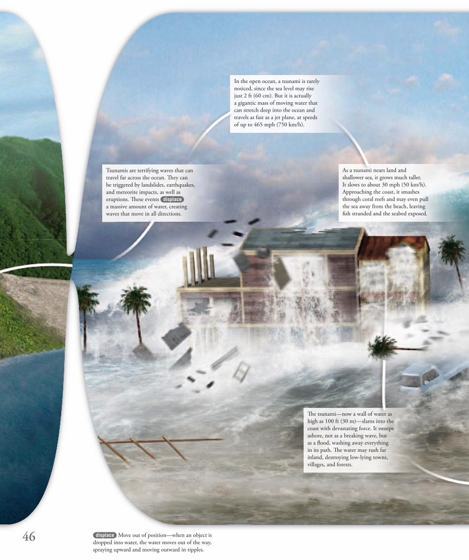
46
Th e tsunami—now a wall of water as
high as 100 ft (30 m)—slams into the
coast with devastating force. It sweeps
ashore, not as a breaking wave, but
as a fl ood, washing away everything
in its path. Th e water may rush far
inland, destroying low-lying towns,
villages, and forests.
Tsunamis are terrifying waves that can
travel far across the ocean. Th ey can
be triggered by landslides, earthquakes,
and meteorite impacts, as well as
eruptions. Th ese events displace
a massive amount of water, creating
waves that move in all directions.
displace Move out of position—when an object is
dropped into water, the water moves out of the way,
spraying upward and moving outward in ripples.
In the open ocean, a tsunami is rarely
noticed, since the sea level may rise
just 2 ft (60 cm). But it is actually
a gigantic mass of moving water that
can stretch deep into the ocean and
travels as fast as a jet plane, at speeds
of up to 465 mph (750 km/h).
As a tsunami nears land and
shallower sea, it grows much taller.
It slows to about 30 mph (50 km/h).
Approaching the coast, it smashes
through coral reefs and may even pull
the sea away from the beach, leaving
fi sh stranded and the seabed exposed.
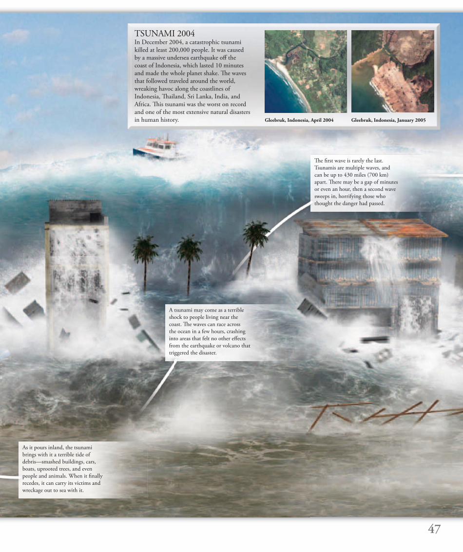
47
TSUNAMI 2004In December 2004, a catastrophic tsunami
killed at least 200,000 people. It was caused
by a massive undersea earthquake off the
coast of Indonesia, which lasted 10 minutes
and made the whole planet shake. Th e waves
that followed traveled around the world,
wreaking havoc along the coastlines of
Indonesia, Th ailand, Sri Lanka, India, and
Africa. Th is tsunami was the worst on record
and one of the most extensive natural disasters
in human history. Gleebruk, Indonesia, April 2004
As it pours inland, the tsunami
brings with it a terrible tide of
debris—smashed buildings, cars,
boats, uprooted trees, and even
people and animals. When it fi nally
recedes, it can carry its victims and
wreckage out to sea with it.
A tsunami may come as a terrible
shock to people living near the
coast. Th e waves can race across
the ocean in a few hours, crashing
into areas that felt no other eff ects
from the earthquake or volcano that
triggered the disaster.
Th e fi rst wave is rarely the last.
Tsunamis are multiple waves, and
can be up to 430 miles (700 km)
apart. Th ere may be a gap of minutes
or even an hour, then a second wave
sweeps in, horrifying those who
thought the danger had passed.
Gleebruk, Indonesia, January 2005
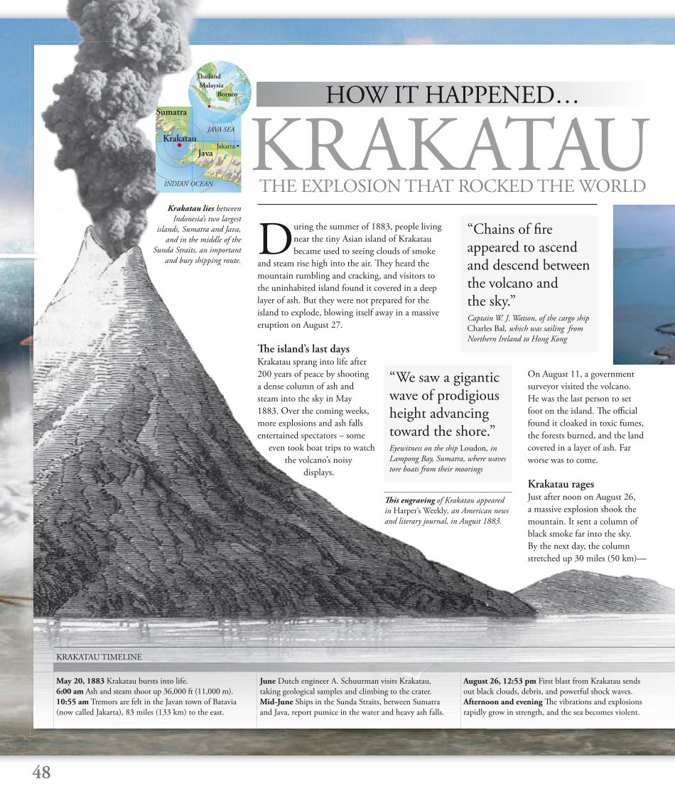
During the summer of 1883, people living
near the tiny Asian island of Krakatau
became used to seeing clouds of smoke
and steam rise high into the air. Th ey heard the
mountain rumbling and cracking, and visitors to
the uninhabited island found it covered in a deep
layer of ash. But they were not prepared for the
island to explode, blowing itself away in a massive
eruption on August 27.
Th e island’s last daysKrakatau sprang into life after
200 years of peace by shooting
a dense column of ash and
steam into the sky in May
1883. Over the coming weeks,
more explosions and ash falls
entertained spectators – some
even took boat trips to watch
the volcano’s noisy
displays.
On August 11, a government
surveyor visited the volcano.
He was the last person to set
foot on the island. Th e offi cial
found it cloaked in toxic fumes,
the forests burned, and the land
covered in a layer of ash. Far
worse was to come.
Krakatau ragesJust after noon on August 26,
a massive explosion shook the
mountain. It sent a column of
black smoke far into the sky.
By the next day, the column
stretched up 30 miles (50 km)—
KRAKATAUTHE EXPLOSION THAT ROCKED THE WORLD
48
HOW IT HAPPENED…
June Dutch engineer A. Schuurman visits Krakatau,
taking geological samples and climbing to the crater.
Mid-June Ships in the Sunda Straits, between Sumatra
and Java, report pumice in the water and heavy ash falls.
August 26, 12:53 pm First blast from Krakatau sends
out black clouds, debris, and powerful shock waves.
Afternoon and evening Th e vibrations and explosions
rapidly grow in strength, and the sea becomes violent.
May 20, 1883 Krakatau bursts into life.
6:00 am Ash and steam shoot up 36,000 ft (11,000 m).
10:55 am Tremors are felt in the Javan town of Batavia
(now called Jakarta), 83 miles (133 km) to the east.
KRAKATAU TIMELINE
“Chains of fi re appeared to ascend and descend between the volcano and the sky.”Captain W. J. Watson, of the cargo ship
Charles Bal, which was sailing from
Northern Ireland to Hong Kong
“We saw a gigantic wave of prodigious height advancing toward the shore.”Eyewitness on the ship Loudon, in
Lampong Bay, Sumatra, where waves
tore boats from their moorings
Th is engraving of Krakatau appeared
in Harper’s Weekly, an American news
and literary journal, in August 1883.
Sumatra
Java
JAVA SEA
KrakatauJakarta •
INDIAN OCEAN
Krakatau lies between
Indonesia’s two largest
islands, Sumatra and Java,
and in the middle of the
Sunda Straits, an important
and busy shipping route.
Th ailand
Malaysia
Borneo
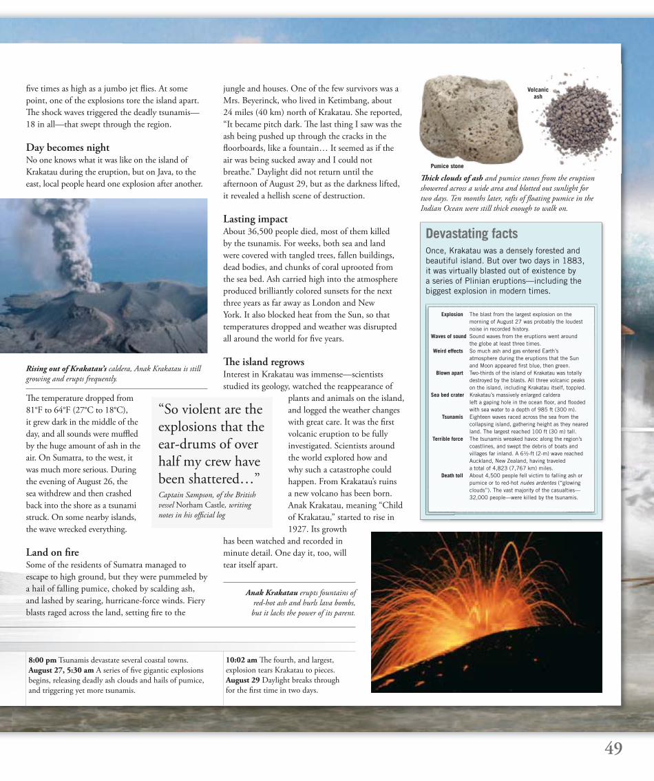
Th ick clouds of ash and pumice stones from the eruption
showered across a wide area and blotted out sunlight for
two days. Ten months later, rafts of fl oating pumice in the
Indian Ocean were still thick enough to walk on.
Devastating factsOnce, Krakatau was a densely forested and beautiful island. But over two days in 1883, it was virtually blasted out of existence by a series of Plinian eruptions—including the biggest explosion in modern times.
49
8:00 pm Tsunamis devastate several coastal towns.
August 27, 5:30 am A series of fi ve gigantic explosions
begins, releasing deadly ash clouds and hails of pumice,
and triggering yet more tsunamis.
10:02 am Th e fourth, and largest,
explosion tears Krakatau to pieces.
August 29 Daylight breaks through
for the fi rst time in two days.
Explosion The blast from the largest explosion on the morning of August 27 was probably the loudest noise in recorded history. Waves of sound Sound waves from the eruptions went around the globe at least three times. Weird effects So much ash and gas entered Earth’s atmosphere during the eruptions that the Sun and Moon appeared fi rst blue, then green. Blown apart Two-thirds of the island of Krakatau was totally destroyed by the blasts. All three volcanic peaks on the island, including Krakatau itself, toppled. Sea bed crater Krakatau’s massively enlarged caldera left a gaping hole in the ocean fl oor, and fl ooded with sea water to a depth of 985 ft (300 m). Tsunamis Eighteen waves raced across the sea from the collapsing island, gathering height as they neared land. The largest reached 100 ft (30 m) tall. Terrible force The tsunamis wreaked havoc along the region’s coastlines, and swept the debris of boats and villages far inland. A 6½-ft (2-m) wave reached Auckland, New Zealand, having traveled a total of 4,823 (7,767 km) miles. Death toll About 4,500 people fell victim to falling ash or pumice or to red-hot nuées ardentes (“glowing clouds”). The vast majority of the casualties— 32,000 people—were killed by the tsunamis.
Pumice stone
Volcanicash
Rising out of Krakatau’s caldera, Anak Krakatau is still
growing and erupts frequently.
fi ve times as high as a jumbo jet fl ies. At some
point, one of the explosions tore the island apart.
Th e shock waves triggered the deadly tsunamis—
18 in all—that swept through the region.
Day becomes nightNo one knows what it was like on the island of
Krakatau during the eruption, but on Java, to the
east, local people heard one explosion after another.
jungle and houses. One of the few survivors was a
Mrs. Beyerinck, who lived in Ketimbang, about
24 miles (40 km) north of Krakatau. She reported,
“It became pitch dark. Th e last thing I saw was the
ash being pushed up through the cracks in the
fl oorboards, like a fountain… It seemed as if the
air was being sucked away and I could not
breathe.” Daylight did not return until the
afternoon of August 29, but as the darkness lifted,
it revealed a hellish scene of destruction.
Lasting impactAbout 36,500 people died, most of them killed
by the tsunamis. For weeks, both sea and land
were covered with tangled trees, fallen buildings,
dead bodies, and chunks of coral uprooted from
the sea bed. Ash carried high into the atmosphere
produced brilliantly colored sunsets for the next
three years as far away as London and New
York. It also blocked heat from the Sun, so that
temperatures dropped and weather was disrupted
all around the world for fi ve years.
Th e island regrowsInterest in Krakatau was immense—scientists
studied its geology, watched the reappearance of
plants and animals on the island,
and logged the weather changes
with great care. It was the fi rst
volcanic eruption to be fully
investigated. Scientists around
the world explored how and
why such a catastrophe could
happen. From Krakatau’s ruins
a new volcano has been born.
Anak Krakatau, meaning “Child
of Krakatau,” started to rise in
1927. Its growth
has been watched and recorded in
minute detail. One day it, too, will
tear itself apart.
“So violent are the explosions that the ear-drums of over half my crew have been shattered…”Captain Sampson, of the British
vessel Norham Castle, writing
notes in his offi cial log
Th e temperature dropped from
81°F to 64°F (27°C to 18°C),
it grew dark in the middle of the
day, and all sounds were muffl ed
by the huge amount of ash in the
air. On Sumatra, to the west, it
was much more serious. During
the evening of August 26, the
sea withdrew and then crashed
back into the shore as a tsunami
struck. On some nearby islands,
the wave wrecked everything.
Land on fi reSome of the residents of Sumatra managed to
escape to high ground, but they were pummeled by
a hail of falling pumice, choked by scalding ash,
and lashed by searing, hurricane-force winds. Fiery
blasts raged across the land, setting fi re to the
Anak Krakatau erupts fountains of
red-hot ash and hurls lava bombs,
but it lacks the power of its parent.
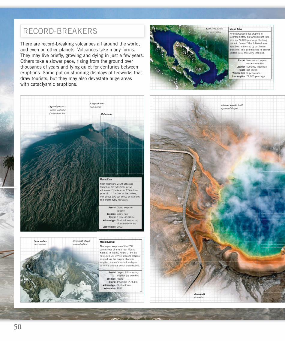
50
There are record-breaking volcanoes all around the world, and even on other planets. Volcanoes take many forms. They may live briefl y, growing and dying in just a few years. Others take a slower pace, rising from the ground over thousands of years and lying quiet for centuries between eruptions. Some put on stunning displays of fi reworks that draw tourists, but they may also devastate huge areaswith cataclysmic eruptions.
RECORD-BREAKERS
Boardwalk
for tourists
No supervolcano has erupted in recorded history, but when Mount Toba blew up 74,000 years ago, the long volcanic “winter” that followed may have been witnessed by our human ancestors. The lake that fi lls its extinct caldera is 56 miles (90 km) long.
Mount Toba
Record Most recent super- volcano eruption Location Sumatra, Indonesia Height Not known Volcano type Supervolcano Last eruption 74,000 years ago
The largest eruption of the 20th century was of a vent near Mount Katmai. In just 60 hours, 7–8½ cu miles (30–35 km³) of ash and magma erupted. As the magma chamber emptied, Katmai’s summit collapsed to form a caldera, which then fl ooded.
Mount Katmai
Record Largest 20th-century eruption (by quantity) Location Alaska Height 1¹/³ miles (2.25 km) Volcano type Stratovolcano Last eruption 1912
Near-neighbors Mount Etna and Stromboli are extremely active volcanoes. Etna is about 2.5 million years old. It has four active craters, with about 200 ash cones on its sides, and erupts every few years.
Mount Etna
Record Oldest eruptive volcano Location Sicily, Italy Height 2 miles (3.3 km) Volcano type Stratovolcano on top of a shield volcano Last eruption 2002
Main crater
Mineral deposits build
up around the pool
Lake Toba fi lls the
enormous caldera
Large ash cone
near summit
Snow and ice
cover summit
Steep walls of rock
surround caldera
Upper slopes are a
barren wasteland
of ash and old lava

51
Paricutín gave scientists a unique chance to watch a volcano from birth. It began to grow in a fi eld in Mexicoin 1943, rising 1,100 ft (336 m) in the fi rst year. It erupted continuously until 1952 and then fell silent.
Paricutín
Record Fastest-growing volcano on record Location Mexico Height 2,950 ft (900 m) Volcano type Scoria cone Last eruption 1943–1952
Steam rises
from the pool’s
superheated waters
Vesuvius towers over the city of Naples, Italy. Three million people live in its shadow—more than any other active volcano in Europe. Naples has an evacuation plan to move everyone to safety at one week’s notice.
Vesuvius
Record Most populated European volcano Location Campania, Italy Height 4,203 ft (1,281 m) Volcano type Stratovolcano Last eruption 1944
The solar system’s biggest volcano is on the planet Mars. Mars does not have moving tectonic plates, so the same area of its surface stays over a volcanic hotspot, enabling the volcano to grow to huge proportions.
Olympus Mons
Record Largest volcano in the solar system Location Mars Height 15 miles (24 km) Volcano type Shield volcano Last eruption None in recorded time
Small-scale eruptions
of runny lava
Giant caldera
at summit
The largest volcano on Earth that might still erupt is Yellowstone, an immense supervolcano. Its gigantic magma chamber, which is about 75 miles (120 km) in diameter, lies approximately 3¾ miles (6 km) beneath Yellowstone National Park. The volcano has no mountain of its own. The entire area is dotted with geysers and hydrothermal vents. This photograph shows Prismatic Pool, a hot spring that sits directly over the magma chamber. Its brilliant colors come from algae and other organisms that have adapted to thrive in the hot, mineral-rich water.
Yellowstone
Record Largest volcano that could erupt Location Wyoming
Height Lacks a cone Volcano type Supervolcano Last eruption 640,000 years ago
Church half-
buried by lava
The largest volcano on Earth, Mauna Loa is one of fi ve that make up Hawaii’s Big Island, in the Pacifi c Ocean. It is a massive shield volcano that has grown over at least 100,000 years of eruptions. The mountain towers 5¼ miles (8.5 km) above the sea fl oor, and the crust beneath is pushed down by a further 5 miles (8 km). Mauna Loa has erupted frequently over the last 100,000 years.
Mauna Loa
Record Largest active volcano Location Big Island, Hawaii
Height 13,681 ft (4,170 m) Volcano type Shield volcano Last eruption 1984
Lower slopes of
volcano are fertile
farmland
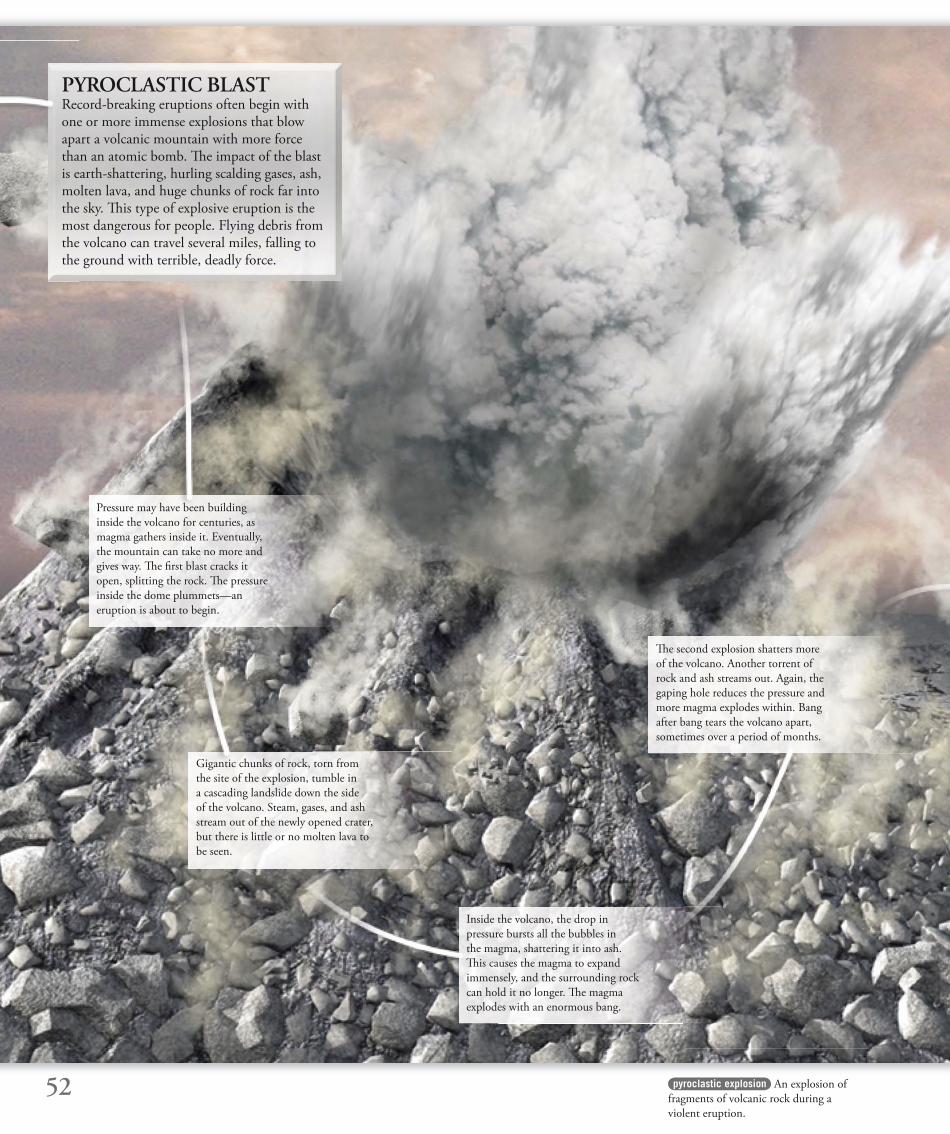
52
Pressure may have been building
inside the volcano for centuries, as
magma gathers inside it. Eventually,
the mountain can take no more and
gives way. Th e fi rst blast cracks it
open, splitting the rock. Th e pressure
inside the dome plummets—an
eruption is about to begin.
PYROCLASTIC BLASTRecord-breaking eruptions often begin with one or more immense explosions that blow apart a volcanic mountain with more force than an atomic bomb. Th e impact of the blast is earth-shattering, hurling scalding gases, ash, molten lava, and huge chunks of rock far into the sky. Th is type of explosive eruption is the most dangerous for people. Flying debris from the volcano can travel several miles, falling to the ground with terrible, deadly force.
Gigantic chunks of rock, torn from
the site of the explosion, tumble in
a cascading landslide down the side
of the volcano. Steam, gases, and ash
stream out of the newly opened crater,
but there is little or no molten lava to
be seen.
pyroclastic explosion An explosion of
fragments of volcanic rock during a
violent eruption.
Inside the volcano, the drop in
pressure bursts all the bubbles in
the magma, shattering it into ash.
Th is causes the magma to expand
immensely, and the surrounding rock
can hold it no longer. Th e magma
explodes with an enormous bang.
Th e second explosion shatters more
of the volcano. Another torrent of
rock and ash streams out. Again, the
gaping hole reduces the pressure and
more magma explodes within. Bang
after bang tears the volcano apart,
sometimes over a period of months.
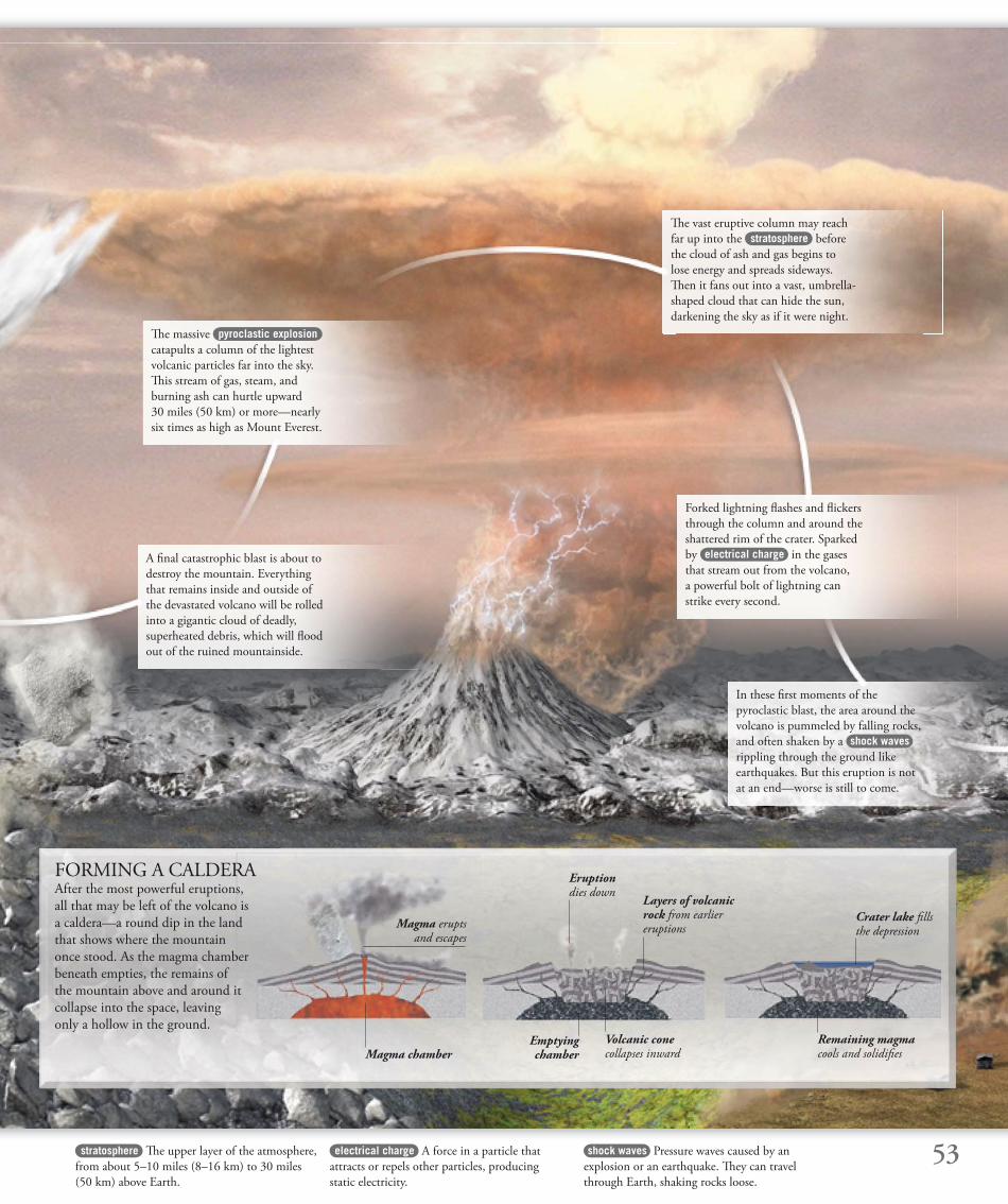
53stratosphere Th e upper layer of the atmosphere,
from about 5–10 miles (8–16 km) to 30 miles
(50 km) above Earth.
shock waves Pressure waves caused by an
explosion or an earthquake. Th ey can travel
through Earth, shaking rocks loose.
electrical charge A force in a particle that
attracts or repels other particles, producing
static electricity.
A fi nal catastrophic blast is about to
destroy the mountain. Everything
that remains inside and outside of
the devastated volcano will be rolled
into a gigantic cloud of deadly,
superheated debris, which will fl ood
out of the ruined mountainside.
Th e massive pyroclastic explosion
catapults a column of the lightest
volcanic particles far into the sky.
Th is stream of gas, steam, and
burning ash can hurtle upward
30 miles (50 km) or more—nearly
six times as high as Mount Everest.
Th e vast eruptive column may reach
far up into the stratosphere before
the cloud of ash and gas begins to
lose energy and spreads sideways.
Th en it fans out into a vast, umbrella-
shaped cloud that can hide the sun,
darkening the sky as if it were night.
Forked lightning fl ashes and fl ickers
through the column and around the
shattered rim of the crater. Sparked
by electrical charge in the gases
that stream out from the volcano,
a powerful bolt of lightning can
strike every second.
In these fi rst moments of the
pyroclastic blast, the area around the
volcano is pummeled by falling rocks,
and often shaken by a shock waves
rippling through the ground like
earthquakes. But this eruption is not
at an end—worse is still to come.
FORMING A CALDERA After the most powerful eruptions,
all that may be left of the volcano is
a caldera—a round dip in the land
that shows where the mountain
once stood. As the magma chamber
beneath empties, the remains of
the mountain above and around it
collapse into the space, leaving
only a hollow in the ground.
Magma chamber
Magma erupts and escapes
Volcanic cone collapses inward
Emptying chamber
Eruption dies down
Layers of volcanic rock from earlier eruptions
Remaining magma cools and solidifi es
Crater lake fi lls the depression

54
At the base of the cloud, a ground-
hugging avalanche of red-hot, glowing
ash and small fragments of lava races
down the slope, cascading over rocks
and streaming along gullies. Th is nuée
ardente (“glowing cloud”), drawn
downward by gravity, reaches speeds
of over 125 mph (200 km/h).
Th e eruptive column, which was
rising at 1,300 ft (400 m) per second,
can no longer support the weight
above it and collapses. Immediately,
a thick, dark cloud billows out from
the crater—a scorching mix of gas,
ash, and lava fragments.
aerosols Fine droplets of a liquid or dust
dispersed in air. Volcanic eruptions can release
tonnes of these particles into the atmosphere.
pyroclastic surge Highly destructive hot
blast that may travel swiftly ahead of a nuée
ardente, and over wider areas.
avalanche Th e sudden downward
movement of a mass of snow, ice,
volcanic ash, or debris.
Racing ahead of the fi ery avalanche ,
a superheated wave of pressure
blasts out in all directions. Th is pyroclastic surge is one of the
volcano’s most deadly hazards. Th e
heat is so intense that it can turn
trees to burning torches in an instant.
Th e fi nest ash from the column is
carried high into the atmosphere
and travels thousands of miles. It can
circle the globe many times, carried
by winds, and it poses a threat to
aircraft, since it can clog their engines.
Carried upward with the ash are fi ne aerosols of gases and vapor.
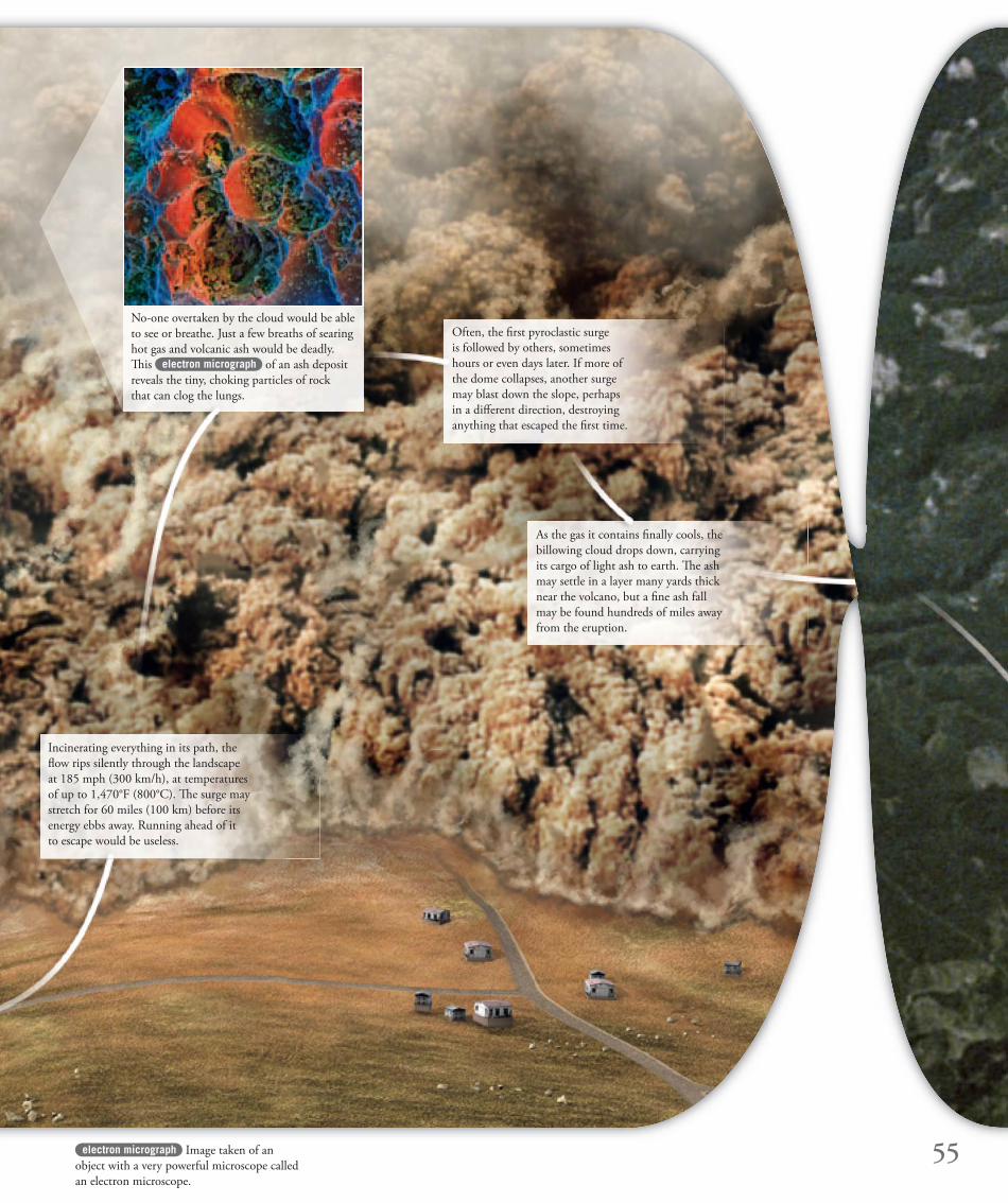
55electron micrograph Image taken of an
object with a very powerful microscope called
an electron microscope.
Incinerating everything in its path, the
fl ow rips silently through the landscape
at 185 mph (300 km/h), at temperatures
of up to 1,470°F (800°C). Th e surge may
stretch for 60 miles (100 km) before its
energy ebbs away. Running ahead of it
to escape would be useless.
Often, the fi rst pyroclastic surge
is followed by others, sometimes
hours or even days later. If more of
the dome collapses, another surge
may blast down the slope, perhaps
in a diff erent direction, destroying
anything that escaped the fi rst time.
As the gas it contains fi nally cools, the
billowing cloud drops down, carrying
its cargo of light ash to earth. Th e ash
may settle in a layer many yards thick
near the volcano, but a fi ne ash fall
may be found hundreds of miles away
from the eruption.
No-one overtaken by the cloud would be able
to see or breathe. Just a few breaths of searing
hot gas and volcanic ash would be deadly.
Th is electron micrograph of an ash deposit
reveals the tiny, choking particles of rock
that can clog the lungs.
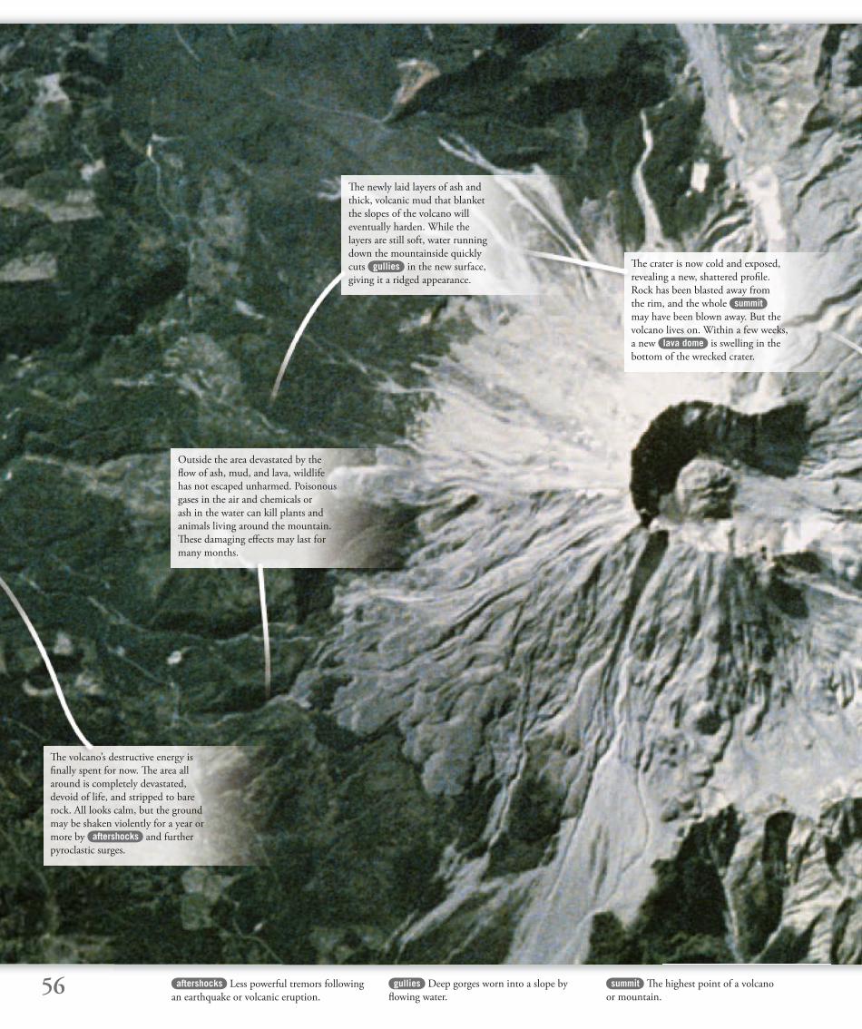
56 aftershocks Less powerful tremors following
an earthquake or volcanic eruption.
summit Th e highest point of a volcano
or mountain.
gullies Deep gorges worn into a slope by
fl owing water.
Th e volcano’s destructive energy is
fi nally spent for now. Th e area all
around is completely devastated,
devoid of life, and stripped to bare
rock. All looks calm, but the ground
may be shaken violently for a year or
more by aftershocks and further
pyroclastic surges.
Th e newly laid layers of ash and
thick, volcanic mud that blanket
the slopes of the volcano will
eventually harden. While the
layers are still soft, water running
down the mountainside quickly
cuts gullies in the new surface,
giving it a ridged appearance.
Th e crater is now cold and exposed,
revealing a new, shattered profi le.
Rock has been blasted away from
the rim, and the whole summit
may have been blown away. But the
volcano lives on. Within a few weeks,
a new lava dome is swelling in the
bottom of the wrecked crater.
Outside the area devastated by the
fl ow of ash, mud, and lava, wildlife
has not escaped unharmed. Poisonous
gases in the air and chemicals or
ash in the water can kill plants and
animals living around the mountain.
Th ese damaging eff ects may last for
many months.
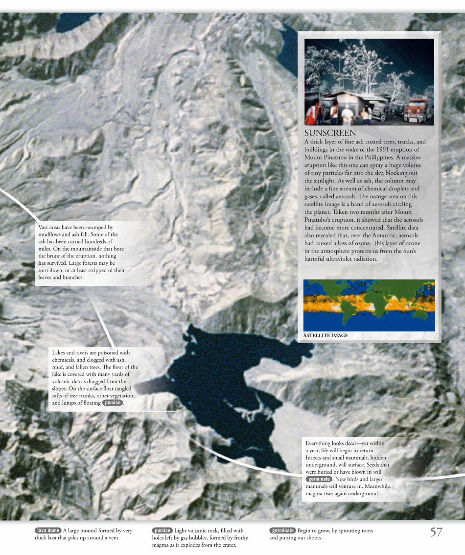
57lava dome A large mound formed by very
thick lava that piles up around a vent.
germinate Begin to grow, by sprouting roots
and putting out shoots.
pumice Light volcanic rock, fi lled with
holes left by gas bubbles, formed by frothy
magma as it explodes from the crater.
Vast areas have been swamped by
mudfl ows and ash fall. Some of the
ash has been carried hundreds of
miles. On the mountainside that bore
the brunt of the eruption, nothing
has survived. Large forests may be
torn down, or at least stripped of their
leaves and branches.
Lakes and rivers are poisoned with
chemicals, and clogged with ash,
mud, and fallen trees. Th e fl oor of the
lake is covered with many yards of
volcanic debris dragged from the
slopes. On the surface fl oat tangled
rafts of tree trunks, other vegetation,
and lumps of fl oating pumice .
Everything looks dead—yet within
a year, life will begin to return.
Insects and small mammals, hidden
underground, will surface. Seeds that
were buried or have blown in will
germinate . New birds and larger
mammals will venture in. Meanwhile,
magma rises again underground…
SUNSCREENA thick layer of fi ne ash coated trees, trucks, and
buildings in the wake of the 1991 eruption of
Mount Pinatubo in the Philippines. A massive
eruption like this one can spray a huge volume
of tiny particles far into the sky, blocking out
the sunlight. As well as ash, the column may
include a fi ne stream of chemical droplets and
gases, called aerosols. Th e orange area on this
satellite image is a band of aerosols circling
the planet. Taken two months after Mount
Pinatubo’s eruption, it showed that the aerosols
had become more concentrated. Satellite data
also revealed that, over the Antarctic, aerosols
had caused a loss of ozone. Th is layer of ozone
in the atmosphere protects us from the Sun’s
harmful ultraviolet radiation.
SATELLITE IMAGE

It took just 30 seconds for Mount St. Helens
to tear itself apart in its largest eruption for
4,000 years. In the space of two minutes, a
huge pyroclastic surge devastated immense tracts
of the surrounding land in Washington State and
killed 57 people.
Tales of long agoSince pioneers and settlers arrived
in the Cascade Mountains region,
Mount St. Helens had been fairly
quiet, with only minor eruptions.
But American Indians in the area
had legends about a more violent
past when the “fi re mountain”
hurled out rocks, shaking the
Earth and darkening the Sun.
By 1980, volcanologists had been
watching Mount St. Helens for years. Th ey knew
that the next major eruption was due and predicted
it would occur before the end of the 20th century.
First rumblingsIn March 1980, earth tremors and more powerful
shocks began to rock the volcano. On March 27,
a small explosive eruption threw black
ash 1.8 miles (3 km) into the air.
A swelling on the northern
fl ank of the mountain was a sure sign that magma
was collecting underground. Nearby residents
were evacuated and minor eruptions continued,
attracting geologists and tourists to the mountain.
At the end of April, the volcano went quiet again,
but the bulge was still growing
by over 3⅓ ft (1 m) a day. By
May 7, it was already 1½ miles
(2.5 km) wide. Small eruptions
restarted, but local people were
fed up and wanted to go home.
Sudden catastropheWith no further warning, on
the morning of May 18, an
earthquake shook rocks from
the top of the northern side of
MOUNTST. HELENS
the mountain that blew apart
58
HOW IT HAPPENED…
April 22–May 7 Eruptions stop, but a bulge on the
north fl ank of the mountain continues to grow.
May 7 Tremors and renewed eruptions of steam and ash.
May 12 Small avalanche of rocks caused by earthquake.
May 18, 8:32 am An earthquake causes a huge
avalanche on the volcano’s north side, immediately
followed by an eruption with the force of 55 atomic
bombs. Th e blast is heard 200 miles (320 km) away.
March 20, 1980 A moderate earthquake just beneath the
volcano is followed by continuing tremors and shocks.
March 27 A small crater forms and an ash plume rises.
April 3 Th e authorities declare a state of emergency.
At 8:32 am on May 17, 1980, the fi rst blast throws out
a plume of ash, gas, and chunks of rock.
MOUNT ST. HELENS TIMELINE
Ten seconds later, as more of the unstable north side of
the mountain slides away, a massive eruption starts.
Fifteen seconds after that, the bulging mountainside
explodes. Th e pyroclastic fl ow that followed reached speeds of
up to 600 mph (1,000 km/h).
• Seattle
MountSt. Helens
• Portland
Canada
United States
North America
Jack Hyde, geologist at Tacoma
Community College, May 5
“I have a gut feeling… that, as the bulge continues to grow, something dramatic is goingto happen soon.”
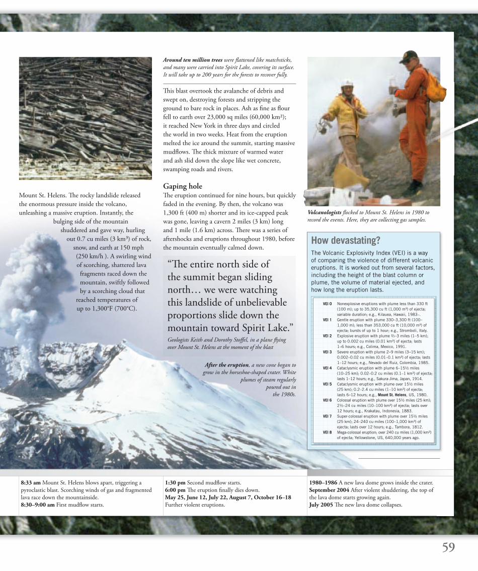
After the eruption, a new cone began to
grow in the horseshoe-shaped crater. White
plumes of steam regularly
poured out in
the 1980s.
59
8:33 am Mount St. Helens blows apart, triggering a
pyroclastic blast. Scorching winds of gas and fragmented
lava race down the mountainside.
8:30–9:00 am First mudfl ow starts.
1:30 pm Second mudfl ow starts.
6:00 pm Th e eruption fi nally dies down.
May 25, June 12, July 22, August 7, October 16–18
Further violent eruptions.
1980–1986 A new lava dome grows inside the crater.
September 2004 After violent shuddering, the top of
the lava dome starts growing again.
July 2005 Th e new lava dome collapses.
“Th e entire north side of the summit began sliding north… we were watching this landslide of unbelievable proportions slide down the mountain toward Spirit Lake.”Geologists Keith and Dorothy Stoff el, in a plane fl ying
over Mount St. Helens at the moment of the blast
How devastating?The Volcanic Explosivity Index (VEI) is a way of comparing the violence of different volcanic eruptions. It is worked out from several factors, including the height of the blast column or plume, the volume of material ejected, andhow long the eruption lasts.
VEI 0 Nonexplosive eruptions with plume less than 330 ft (100 m); up to 35,300 cu ft (1,000 m³) of ejecta; variable duration; e.g., Kilauea, Hawaii, 1983–. VEI 1 Gentle eruption with plume 330–3,300 ft (100– 1,000 m); less than 353,000 cu ft (10,000 m³) of ejecta; bursts of up to 1 hour; e.g., Stromboli, Italy. VEI 2 Explosive eruption with plume ²⁄3–3 miles (1–5 km); up to 0.002 cu miles (0.01 km³) of ejecta; lasts 1–6 hours; e.g., Colima, Mexico, 1991. VEI 3 Severe eruption with plume 2–9 miles (3–15 km); 0.002–0.02 cu miles (0.01–0.1 km³) of ejecta; lasts 1–12 hours; e.g., Nevado del Ruiz, Colombia, 1985. VEI 4 Cataclysmic eruption with plume 6–15½ miles (10–25 km); 0.02–0.2 cu miles (0.1–1 km³) of ejecta; lasts 1–12 hours; e.g., Sakura-Jima, Japan, 1914. VEI 5 Cataclysmic eruption with plume over 15½ miles (25 km); 0.2–2.4 cu miles (1–10 km³) of ejecta; lasts 6–12 hours; e.g., Mount St. Helens, US, 1980. VEI 6 Colossal eruption with plume over 15½ miles (25 km); 2½–24 cu miles (10–100 km³) of ejecta; lasts over 12 hours; e.g., Krakatau, Indonesia, 1883. VEI 7 Super-colossal eruption with plume over 15½ miles (25 km); 24–240 cu miles (100–1,000 km³) of ejecta; lasts over 12 hours; e.g., Tambora, 1812. VEI 8 Mega-colossal eruption; over 240 cu miles (1,000 km³) of ejecta; Yellowstone, US, 640,000 years ago.
Around ten million trees were fl attened like matchsticks,
and many were carried into Spirit Lake, covering its surface.
It will take up to 200 years for the forests to recover fully.
Volcanologists fl ocked to Mount St. Helens in 1980 to
record the events. Here, they are collecting gas samples.
Mount St. Helens. Th e rocky landslide released
the enormous pressure inside the volcano,
unleashing a massive eruption. Instantly, the
bulging side of the mountain
shuddered and gave way, hurling
out 0.7 cu miles (3 km³) of rock,
snow, and earth at 150 mph
(250 km/h ). A swirling wind
of scorching, shattered lava
fragments raced down the
mountain, swiftly followed
by a scorching cloud that
reached temperatures of
up to 1,300°F (700°C).
Th is blast overtook the avalanche of debris and
swept on, destroying forests and stripping the
ground to bare rock in places. Ash as fi ne as fl our
fell to earth over 23,000 sq miles (60,000 km);
it reached New York in three days and circled
the world in two weeks. Heat from the eruption
melted the ice around the summit, starting massive
mudfl ows. Th e thick mixture of warmed water
and ash slid down the slope like wet concrete,
swamping roads and rivers.
Gaping holeTh e eruption continued for nine hours, but quickly
faded in the evening. By then, the volcano was
1,300 ft (400 m) shorter and its ice-capped peak
was gone, leaving a cavern 2 miles (3 km) long
and 1 mile (1.6 km) across. Th ere was a series of
aftershocks and eruptions throughout 1980, before
the mountain eventually calmed down.
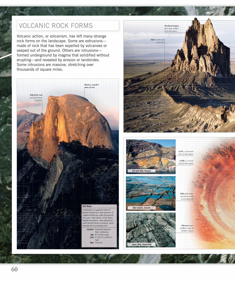
60
Volcanic action, or volcanism, has left many strange rock forms on the landscape. Some are extrusions—made of rock that has been expelled by volcanoes or seeped out of the ground. Others are intrusions—formed underground by magma that solidifi ed without erupting—and revealed by erosion or landslides. Some intrusions are massive, stretching over thousands of square miles.
VOLCANIC ROCK FORMS Hardened magma
from main conduit
of an old volcano
Massive, rounded
dome of rock
Half of the rock
was ground away
by glaciers
A sill is a horizontal
sheet of solid magma
Dikes follow lines
of weakness in the
surrounding rock
Alternate layers
of diff erent types of
solidifi ed magma
A dike is a vertical
band of solid magma
Sill and dike, Greece
Dike swarm, Canada
Layer dike, Greenland
A batholith is a gigantic lump of granite formed by a vast reservoir of magma hardening under the ground. This one—Half Dome, in the Sierra Nevada mountains—was exposed by uplift and the forces of erosion, which removed the surrounding rock.
Half Dome
Location Yosemite National Park, California Age 87 million years Size 4,735 ft (1,440 m) high Type Intrusion
Dike stretches away
across desert
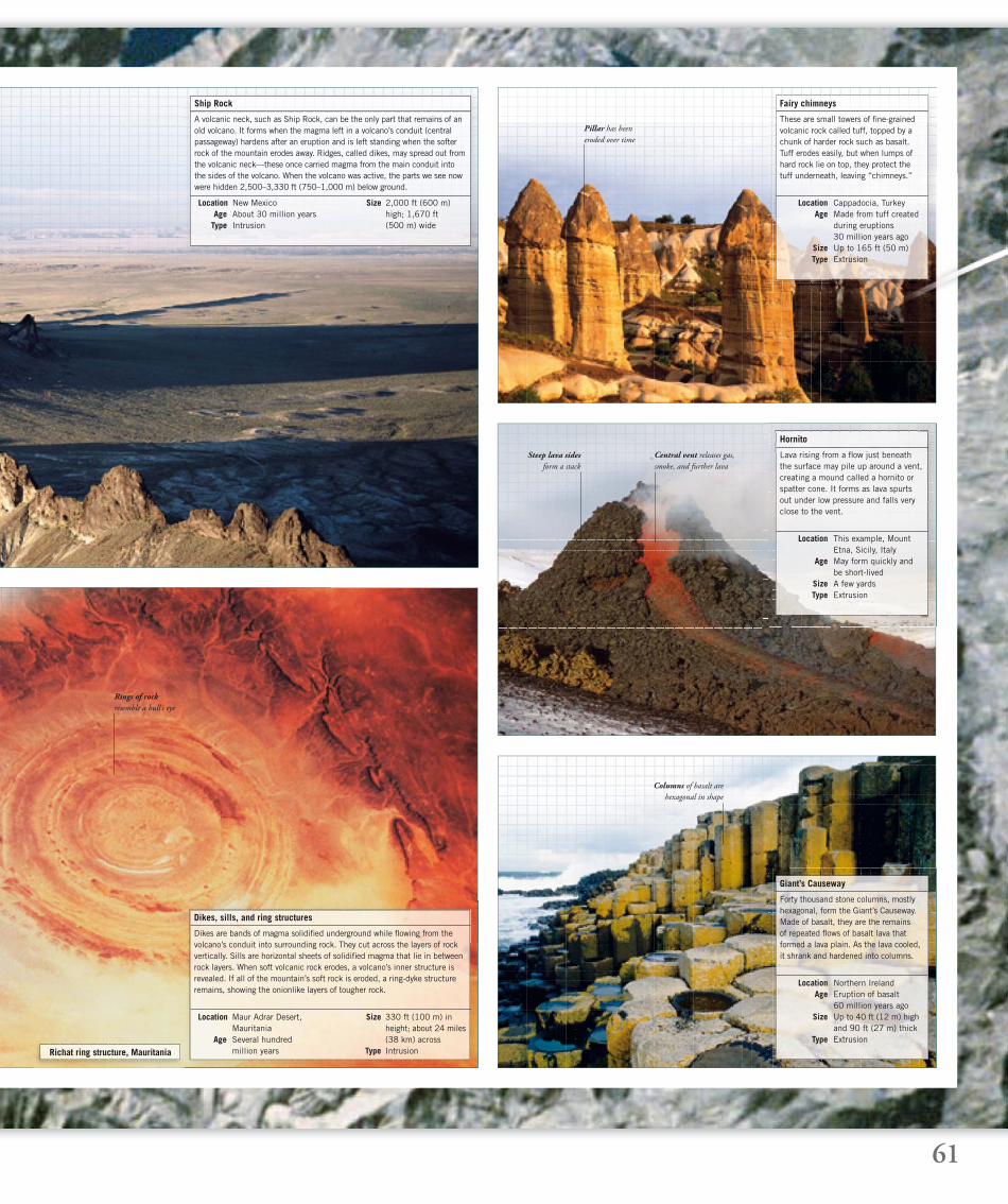
61
Rings of rock
resemble a bull’s eye
Pillar has been
eroded over time
Columns of basalt are
hexagonal in shape
Steep lava sides
form a stack
Richat ring structure, Mauritania
A volcanic neck, such as Ship Rock, can be the only part that remains of an old volcano. It forms when the magma left in a volcano’s conduit (central passageway) hardens after an eruption and is left standing when the softer rock of the mountain erodes away. Ridges, called dikes, may spread out from the volcanic neck—these once carried magma from the main conduit into the sides of the volcano. When the volcano was active, the parts we see now were hidden 2,500–3,330 ft (750–1,000 m) below ground.
Ship Rock
Location New Mexico Age About 30 million years Type Intrusion
Size 2,000 ft (600 m) high; 1,670 ft (500 m) wide
These are small towers of fi ne-grained volcanic rock called tuff, topped by a chunk of harder rock such as basalt. Tuff erodes easily, but when lumps of hard rock lie on top, they protect the tuff underneath, leaving “chimneys.”
Fairy chimneys
Location Cappadocia, Turkey Age Made from tuff created during eruptions 30 million years ago Size Up to 165 ft (50 m) Type Extrusion
Hornito
Lava rising from a fl ow just beneath the surface may pile up around a vent, creating a mound called a hornito or spatter cone. It forms as lava spurts out under low pressure and falls very close to the vent.
Location This example, Mount Etna, Sicily, Italy Age May form quickly and be short-lived Size A few yards Type Extrusion
Forty thousand stone columns, mostly hexagonal, form the Giant’s Causeway. Made of basalt, they are the remains of repeated fl ows of basalt lava that formed a lava plain. As the lava cooled, it shrank and hardened into columns.
Giant’s Causeway
Location Northern Ireland Age Eruption of basalt 60 million years ago Size Up to 40 ft (12 m) high and 90 ft (27 m) thick Type Extrusion
Dikes are bands of magma solidifi ed underground while fl owing from the volcano’s conduit into surrounding rock. They cut across the layers of rock vertically. Sills are horizontal sheets of solidifi ed magma that lie in between rock layers. When soft volcanic rock erodes, a volcano’s inner structure is revealed. If all of the mountain’s soft rock is eroded, a ring-dyke structure remains, showing the onionlike layers of tougher rock.
Dikes, sills, and ring structures
Location Maur Adrar Desert, Mauritania Age Several hundred million years
Size 330 ft (100 m) inheight; about 24 miles (38 km) across
Type Intrusion
Central vent releases gas,
smoke, and further lava
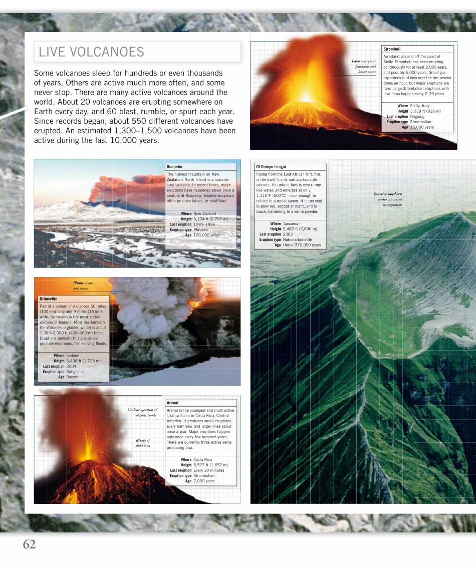
62
Some volcanoes sleep for hundreds or even thousands of years. Others are active much more often, and some never stop. There are many active volcanoes around the world. About 20 volcanoes are erupting somewhere on Earth every day, and 60 blast, rumble, or spurt each year. Since records began, about 550 different volcanoes have erupted. An estimated 1,300–1,500 volcanoes have been active during the last 10,000 years.
LIVE VOLCANOES
The highest mountain on New Zealand’s North Island is a massive stratovolcano. In recent times, major eruptions have happened about once a century at Ruapehu. Smaller eruptions often produce lahars, or mudfl ows.
Ruapehu
Where New Zealand Height 9,174 ft (2,797 m) Last eruption 1995–1996 Eruption type Phreatic Age 120,000 years
Part of a system of volcanoes 60 miles (100 km) long and 9 miles (15 km) wide, Grímsvötn is the most active volcano in Iceland. Most lies beneath the Vatnajökull glacier, which is about 1,300–2,000 ft (400–600 m) thick. Eruptions beneath this glacier can produce enormous, fast-moving fl oods.
Grímsvötn
Where Iceland Height 5,436 ft (1,725 m) Last eruption 2004 Eruption type Subglacial Age Recent
Plume of ash
and steam
Lava emerges as
fountains and
broad rivers
Violent ejection of
volcanic bombs
Inactive southern
crater is covered
in vegetation
Rivers of
fl uid lava
Arenal is the youngest and most active stratovolcano in Costa Rica, Central America. It produces small eruptions every half hour and larger ones about once a year. Major eruptions happen only once every few hundred years. There are currently three active vents producing lava.
Arenal
Where Costa Rica Height 5,523 ft (1,657 m) Last eruption Every 30 minutes Eruption type Strombolian Age 7,000 years
An island volcano off the coast of Sicily, Stromboli has been erupting continuously for at least 2,000 years, and possibly 5,000 years. Small gas explosions hurl lava over the rim several times an hour, but major eruptions are rare. Large Strombolian eruptions with lava fl ows happen every 2–20 years.
Stromboli
Where Sicily, Italy Height 3,038 ft (926 m) Last eruption Ongoing Eruption type Strombolian Age 15,000 years
Rising from the East African Rift, this is the Earth’s only natrocarbonatite volcano. Its unique lava is very runny, like water, and emerges at only 1,110°F (600°C)—cool enough to collect in a metal spoon. It is too cool to glow red, except at night, and is black, hardening to a white powder.
Ol Doinyo Lengai
Where Tanzania Height 9,482 ft (2,890 m) Last eruption 2003 Eruption type Natrocarbonatite Age Under 370,000 years
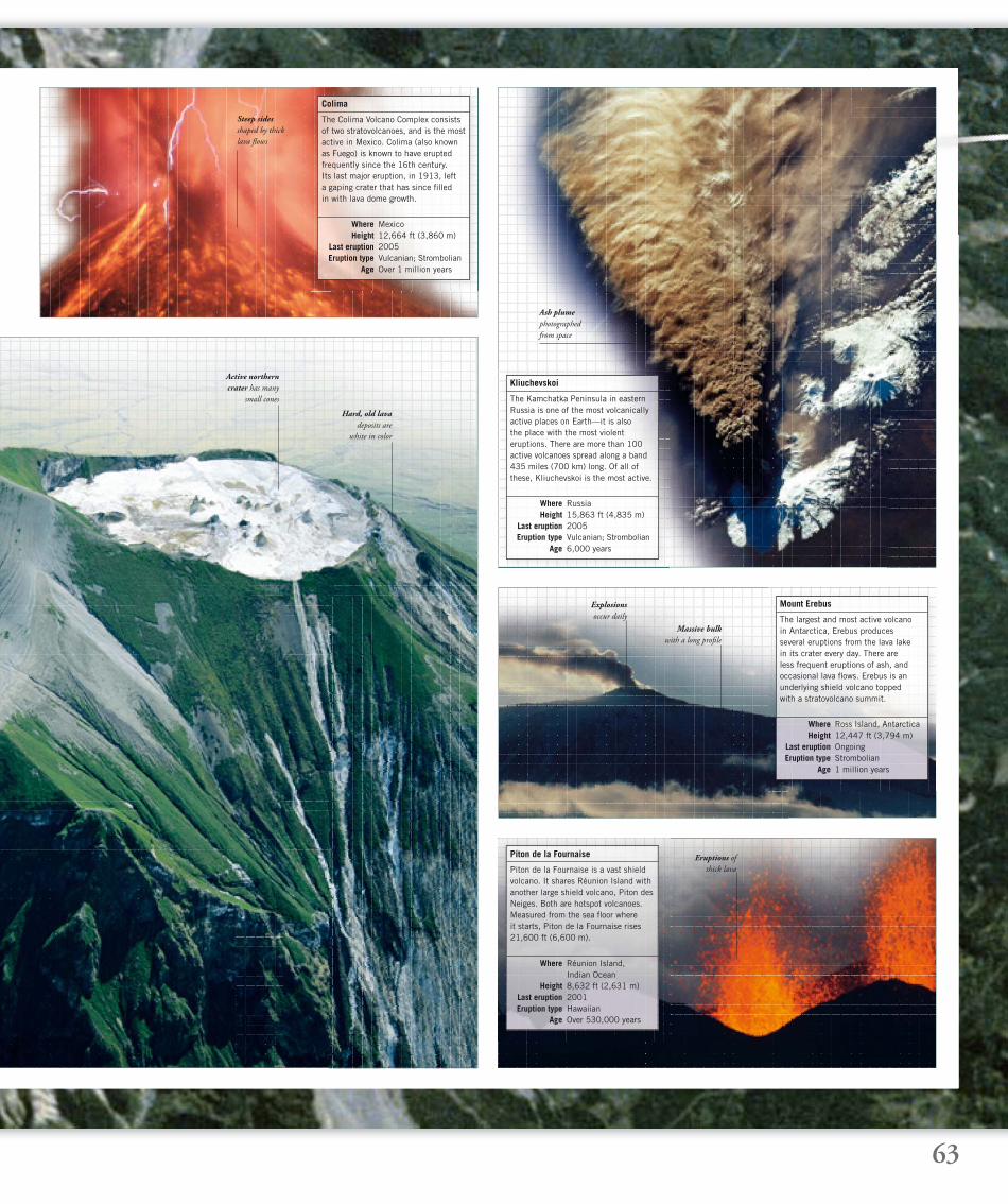
63
Ash plume
photographed
from space
Eruptions of
thick lava
Active northern
crater has many
small cones
Hard, old lava
deposits are
white in color
Massive bulk
with a long profi le
Explosions
occur daily
Steep sides
shaped by thick
lava fl ows
The Colima Volcano Complex consists of two stratovolcanoes, and is the most active in Mexico. Colima (also known as Fuego) is known to have erupted frequently since the 16th century. Its last major eruption, in 1913, left a gaping crater that has since fi lled in with lava dome growth.
Colima
Where Mexico Height 12,664 ft (3,860 m) Last eruption 2005 Eruption type Vulcanian; Strombolian Age Over 1 million years
The Kamchatka Peninsula in eastern Russia is one of the most volcanically active places on Earth—it is alsothe place with the most violent eruptions. There are more than 100 active volcanoes spread along a band435 miles (700 km) long. Of all of these, Kliuchevskoi is the most active.
Kliuchevskoi
Where Russia Height 15,863 ft (4,835 m) Last eruption 2005 Eruption type Vulcanian; Strombolian Age 6,000 years
Piton de la Fournaise is a vast shield volcano. It shares Réunion Island with another large shield volcano, Piton des Neiges. Both are hotspot volcanoes. Measured from the sea fl oor where it starts, Piton de la Fournaise rises 21,600 ft (6,600 m).
Piton de la Fournaise
Where Réunion Island, Indian Ocean Height 8,632 ft (2,631 m) Last eruption 2001 Eruption type Hawaiian Age Over 530,000 years
The largest and most active volcano in Antarctica, Erebus produces several eruptions from the lava lake in its crater every day. There are less frequent eruptions of ash, and occasional lava fl ows. Erebus is an underlying shield volcano topped with a stratovolcano summit.
Mount Erebus
Where Ross Island, Antarctica Height 12,447 ft (3,794 m) Last eruption Ongoing Eruption type Strombolian Age 1 million years
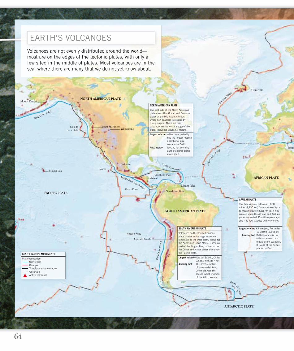
64
Volcanoes are not evenly distributed around the world—most are on the edges of the tectonic plates, with only a few sited in the middle of plates. Most volcanoes are in the sea, where there are many that we do not yet know about.
EARTH’S VOLCANOES
NORTH AMERICAN PLATE
PACIFIC PLATE
Volcanoes on the South American plate cluster in the huge mountain ranges along the west coast, including the Andes and Sierra Madre. These are part of the Ring of Fire, pushed up as the Cocos and Nazca plates dive under the Pacifi c plate.
SOUTH AMERICAN PLATE
Largest volcano Ojos del Salado, Chile: 22,589 ft (6,887 m).Amazing fact The 1985 eruption of Nevado del Ruiz, Colombia, was the second-worst eruption of the 20th century.
The East African Rift runs 3,000 miles (4,830 km) from northern Syria to Mozambique in East Africa. It was created when the African and Arabian plates separated 35 million years ago and it is now studded with volcanoes.
AFRICAN PLATE
Largest volcano Kilimanjaro, Tanzania: 19,340 ft (5,895 m) Amazing fact Dallol volcano is the only volcano on land that is below sea level. It is one of the hottest places on Earth.
AFRICAN PLATE
ANTARCTIC PLATE
Plate boundaries: Convergent Divergent Transform or conservative Uncertain Active volcanoes
KEY TO EARTH’S MOVEMENTS
SOUTH AMERICAN PLATE
Middle American Trench
Puerto Rico Trench
Per
u-Chi
le T
renc
h
Trench
South Sandwich
Re
ykjan
es R
idge
Mid
-Atla
ntic
Ridge
The east side of the North American plate meets the African and Eurasian plates at the Mid-Atlantic Ridge, where new sea fl oor is created by rising magma. There are many volcanoes on the western edge of the plate, including Mount St. Helens.
NORTH AMERICAN PLATE
Largest volcano Yellowstone probably has the largest magma chamber of any volcano on Earth.Amazing fact Iceland is stretching as the tectonic plates move apart.
Mauna Loa
RING OF FIRE
Mount St. HelensYellowstone
Caribbean Plate
Cocos Plate
Nazcou Plate
Juan de Fuca Plate
Arenal
Colima
Nevado del Ruiz
Ojos del Salado
Grimsvötn
Strom
Mount Pelée
Mount Katmai
Paricutín
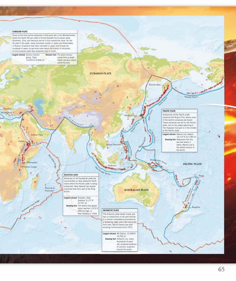
65
Some of the most active volcanoes in the world are in the Mediterranean, where the North African plate is forced beneath the Eurasian plate. Stromboli, Etna, and Vesuvius are all in this subduction zone. On the far east of the plate, many volcanoes cluster in Japan and Kamchatka, in Russia. Eruptions have been recorded in Japan and Europe for hundreds of years, so we know more about the history of volcanoes on the Eurasian plate than anywhere else on Earth.
EURASIAN PLATE
Largest volcano Kunlun volcano group, Tibet: 19,055 ft (5,808 m)
Volcanic fact The word volcano comes from a small Italian volcanic island called Vulcano.
EURASIAN PLATE
AUSTRALIAN PLATE
PACIFIC PLATE
Volcanoes on the Australian plate are concentrated on New Zealand’s North Island where the Pacifi c plate is being subducted. New Zealand has several volcanoes that form part of the Ring of Fire.
Australian plate
Largest volcano Ruapehu, New Zealand: 9,177 ft (2,797 m) Amazing fact The tallest ever geyser spout reached 1,475 ft (450 m) high, in New Zealand in 1904.
Subduction of the Pacifi c plate produces the Ring of Fire, where most of the world’s volcanoes are found. These volcanoes are not on the Pacifi c plate, but on the plates adjoining it. The Hawaiian hot spot is in the middle of the Pacifi c plate.
PACIFIC PLATE
Largest volcano Mauna Loa, Hawaii: 13,710 ft (4,1790 m) Amazing fact Measured from the sea bed where it starts, Mauna Loa is the tallest volcano in the world.
The Antarctic plate barely moves and has no subduction or hot spot activity. It is almost completely surrounded by a spreading ridge, and a few volcanoes form here. Mount Erebus has been erupting continuously since 1972.
ANTARCTIC PLATE
Largest volcano Mt Erebus: 12,448 ft (3,794 m) Amazing fact Antarctic ice, many thousands of years old, preserves evidence of volcanic eruptions around the world.
Java (Sunda) Trench
Bougainville Trench
Ker
mad
ec T
renc
h
Tong
o Tr
ench
Philippine Trench
Marian
a Tr
ench
Ryuky
u Tr
ench
Izu Bonin Trench
Japa
n Tr
ench
Kurile
Trenc
h
Aleutian Trench
Southwest
Indian
Ridge
Mid-Indian R
idge
Arabian Plate
Vesuvius
Mount Etna
mboli
Dallol
Ol Doinyo Lengai
Kilimanjaro
Piton de la Fournaise
Kliuchevskoi
Ruapehu
Gr e
at
Ri f
t V
al l
ey
H
i ma l a y a s
Mount Fuji
Krakatau
Mount Pinatubo
66
INDEXA page number in bold refers to the main
entry for that subject
Aa’a lava 28, 37
active volcanoes 62–63
aerosols 54, 57
African plate 23, 64
aftershocks 56
Antarctic plate 23, 63, 65
Arenal 62
ash, volcanic 6, 7, 24, 32, 37, 39,
43, 44, 45, 48, 49, 54,
55, 57, 59
asteroids 8
asthenosphere 11
atmosphere 9, 10
Australian plate 23, 65
Bbasalt 15, 42, 61
batholiths 21, 60
bombs, volcanic 38–39
Ccalderas 40, 41, 53
California 20–21
cinder cones 43
Colima 59, 63
compacted ash 30, 31
conduits 26, 27, 28, 29
cones 29, 36
convergence 12
core, Earth’s 10
craters 30, 43, 56, 59
crust, Earth’s 9, 11, 12, 22
crystalline rocks 11, 26
Ddebris 52, 53
deformation, rock 13
density, rock 12, 13
dikes 29, 60, 61
diverging plates 18
EEarth: formation of 8–9
inside Earth 10–11
earthquakes 13, 14, 17, 20, 21, 45,
46, 58–59
ejecta 38–39
electrical charges 53
Erebus, Mount 63
erosion 13, 21, 44, 60, 61
eruptions 26, 32–37
Krakatau 48–49
Mount Pelée 24–25
Mount St. Helens 58–59
Plinian eruptions 45, 49
pyroclastic blasts 52–57
Strombolian eruptions 43
Vesuvius 6–7
Etna, Mount 50
Eurasian plate 23
extinct volcanoes 16
extrusions 60
Ffairy chimneys 61
faults 20, 22
fi restorms 25
fi ssures 17, 42, 44
folds 12, 13
fossils 12
Fuji, Mount 15
fumaroles 31
Ggases 9, 6, 26, 30, 31, 32, 34, 45, 54
geothermal energy 42
geysers 40, 41, 42, 51
Giants’ Causeway 61
glaciers 21
glass, volcanic 38, 39
granite 11, 60
gravity 8, 9, 15
Grímsvötn 62, 64
gullies 56
HHawaiian Islands 16–17, 31, 44, 51, 59
Herculaneum 6–7
Himalayas 12–13
hornito 61
hot spots 17, 40, 51, 63
hydrothermal vents 18, 19, 51
Iice age 23
Iceland 42, 62
India 12, 13
Indonesia 47, 48–49, 59
intrusions 60
islands, volcanic 15, 16–17, 42–43
Italy 6, 50, 51, 62
JJapan 14, 15, 59
Java 48, 49
Juan de Fuca plate 19, 20, 64
KKamchatka 63, 65
Katmai, Mount 50
Kilauea 17, 31, 59
Kilimanjaro, Mount 64
Kliuchevskoi 63
Krakatau 48–49, 59
Llahar 45
lakes, crater 43
landscapes 42–45
landslides 45, 46, 58–59, 60
lava 14, 21, 28–29
eruptions 30, 31, 32–33, 34–35
lava bombs 33, 34, 43
lava domes 44, 56, 59
lava fl ows 36–37, 39, 45
lava tubes 36
shield volcanoes 16
legends 31
lightning 53
lithosphere 10, 11, 22
Mmagma 14, 19, 22, 26–31,
52, 60–61
magma chambers 14, 17, 19,
26–27, 53
mantle 10, 11
Mars 8, 51
Martinique 24–25
Mauna Loa 16–17, 51, 57
melt 28
meteorites 9, 46
methane 35
Mexico 51, 59, 63
mid-ocean ridges 18, 19, 42
molten rock 8, 11
Mount St. Helens 41, 58–59, 64
mountain ranges 12–13, 15, 22
mudfl ows 24, 45, 57, 59
mudpots 41
NNew Zealand 62, 65
North American plate 23, 64
nuée ardente (glowing cloud) 25, 54
Oobsidian 38
oceans: fl oor 18–19
oceanic plates 15, 16
trenches 15
tsunamis 45, 46–47, 49
Ol Doinyo Lengai 62–63, 65
olivine 17
Olympus Mons 51
oxygen 10
PPacifi c Ocean 11, 14, 15, 16–17
Pacifi c plate 23, 65
pahoehoe lava 29, 36
Pangea 11
Paricutín 51
Pelée, Mount 24–25
Pele’s hair 39
Pele’s tears 38
Pinatubo, Mount 57
Piton de la Fournaise 63
planets, formation of 8–9
plates 10, 11, 12–15, 22–23, 64–65
Plinian eruptions 7, 25, 45, 49
Pliny the Younger 7
plug, volcanic 28
plumes 32
Pompeii 6–7, 25
pressure 26
pumice 6, 7, 38, 49, 57
pyroclastic blasts 52–57
pyroclastic fl ow 33
pyroclastic surges 54–56, 58, 59
Rrecord-breakers 50–51
Richat ring structure 61
rift zones 18, 19, 22
Ring of Fire 15, 64–65
rock 8, 11, 12, 13, 26
rock forms 60–61
Romans 6–7
Ruapehu 62
67
SSt-Pierre 24–25
San Andreas fault 20–21
San Francisco 20–21
Santorini 42
sea-fl oor spreading 18–19
seamounts 19
sediment 12, 18
shards, rock 35
shield volcanoes 16, 44, 51, 63
Ship Rock 61
shock waves 53
Sierra Nevada 21
silica 27, 28
sills 60
smokers 19
solar system 8–9, 51
South American plate 23, 64
spatter cones 61
stalagmites, lava 29
steam 31, 32, 34, 35, 42, 43
stratosphere 53
stratovolcanoes 43, 45, 62
Stromboli 50, 59, 62
Strombolian eruptions 43
subduction zone 14, 15, 19
sulfur 31, 37
Sumatra 48, 49
summits 56, 57
supervolcanoes 40–41, 50–51
Surtur’s Island (Surtsey) 42–43
Ttephra 37, 43, 45
terranes 20
Tibetan Plateau 13
Toba, Mount 50
Tokyo 14, 15
transform faults 20, 21
tsunamis 45, 46–47, 49
tuff 44, 61
Vvegetation 35, 37
vents 28
Vesuvius, Mount 6–7, 51
Volcanic Explosivity Index (VEI) 59
W Ywaves, tsunamis 45, 46–47, 49
Yellowstone 40–41, 50–51, 59, 64
ACKNOWLEDGMENTS
For Cliff Knight, with thanks
Dorling Kindersley would like to thank Polly Boyd for
proofreading; Hilary Bird for the index; Christine Heilman for
text Americanization; Dr. Andrew Coburn, Vice President of
Catastrophe Research, Risk Management Solutions Inc., and
Ron Rooney, Fellow of the Royal Institue of Chemistry, for
additional help and advice.
Picture Credits
Th e publishers would like to thank the following for their kind
permission to reproduce their photographs:
(Abbreviations key: r=right; l=left; a=above; b=below;
c=center; bckgrd=background.)
2 Getty Images: Richard A. Cooke c. 4 Getty Images: Richard
A. Cooke c. 6 Corbis: North Carolina Museum of Art t; Sean
Sexton Collection cr. 6 Getty Images: Richard A. Cooke
bckgrd. 7 Corbis: Bettmann bl, br; Jonathan Blair t.
11 Illustrator’s reference: www.historyoftheuniverse.com: tr.
12 © Th e Natural History Museum, London: bla. 12 DK
Images: Philip Eales, Planetary Visions tl. 14 DK Images:
Philip Eales, Planetary Visions bl. 15 Zefa Visual Media
UK Ltd: J.F. Raga br. 16 DK Images: Philip Eales, Planetary
Visions bl. 19 Science Photo Library: Dr Ken Macdonald
br. 19 DK Images: Philip Eales, Planetary Visions tc. 20 DK
Images: Philip Eales, Planetary Visions bl. 21 Corbis: Dave
Bartruff b. 23 DK Images: Philip Eales, Planetary Visions
r (locator globes). 24 Corbis: cr. 24 Mary Evans Picture
Library: bl. 25 Circus World Museum: Image courtesy of
Circus World Museum, Wisconsin/permission from Ringling
Bros. & Barnum and Bailey bl. 25 Corbis: cl; Philip Gould
tr. 28 Getty Images: AFP tc; G. Brad Lewis tr. 29 Corbis:
Paul A. Souders tc. 29 Science Photo Library: G. Brad
Lewis tl. 31 © Michael Holford: tr. 35 Empics Ltd: PA
Photos tr. 36 Corbis: David Muench b. 37 Frans Lanting
Photography: www.lanting.com c. 38 DK Images: Instituto
Nacional de Antropologia e Historia/Michel Zabe bcl. 38
Glendale Community College, Arizona, U.S.A: Courtesy of
Stan Celestian tr, cl, c, cb. 38 Frans Lanting Photography:
www.lanting.com bckgrd. 39 Corbis: tr, Vittoriano Rastelli
br. 39 Empics Ltd: PA Photos cr. 40 Corbis: Gunter Marx
Photography tr. 41 National Geographic Image Collection:
Raymond Gehman bl. 41 NASA: Courtesy of Image Analysis
Lab, NASA Johnson Space Center/http://eol.jsc.nasa.
gov/STS040-614-63 tr. 47 Courtesy of www.digitalglobe.
com: tr. 48 Corbis: Bettmann c. 48 OSF/photolibrary.com:
Mary Plage tl. 49 Alamy Images: Eric Chahi br. 49 Images
de Volcans/Maurice and Katia Kraff t: tl. 50 Corbis: Yann
Arthus-Bertrand cr; Jonathan Blair cl. 50 NASA: Landsat image
courtesy of Smithsonian Institute tr. 50 National Geographic
Image Collection: Wilbur Garrett bl. 51 Corbis: Jonathan
Blair cr; Danny Lehman tl; NASA/Roger Ressmeyer br.
51 OSF/photolibrary.com: Carini Joe tr. 55 Science Photo
Library: David Scharf t. 56 Getty Images: Astromujoff c.
57 Rex Features: tr. 57 Science Photo Library: NOAA/
Robert M. Carey cr. 58 Getty Images: Astromujoff bckgrd.
58 U.S. Geological Survey: br; Gary Rosenquist l.
59 U.S. Geological Survey: tl, tr. 60 Corbis: br; Peter Guttman
bc; Danny Lehman tr. 60 Geological Survey of Canada: Dr
Robert H. Rainbird cb. 60 Getty Images: Astromujoff bckgrd.
60 National Geographic Image Collection: Randy Olson l.
60 Tom Pfeiff er: www.decadevolcano.net c. 61 Corbis: Ric
Ergenbright br. 61 Getty Images: Robert Frerck tr. 61 Images
de Volcans/Maurice and Katia Kraff t: cr. 62 Corbis: Sygma/
Alfi o Scigliano tr. 62 Getty Images: Astromujoff bckgrd.
62 N.H.P.A.: Kevin Schafer bl. 62 Rex Features: tl.
62 Mats Wibe Lund: cl. 63 Corbis: Sygma/JIR br.
63 OSF/photolibrary.com: Doug Allan cr; NASA tr.
63 Reuters: Eduardo Quiros tl. 63 Science Photo Library:
Bernhard Edmaier bl. 64 Getty Images: Astromujoff bckgrd.
65 Getty Images: Richard A. Cooke bckgrd. 66 Getty Images:
Richard A. Cooke c. 68 Getty Images: Richard A. Cooke c.
70 Getty Images: Richard A. Cooke c.
Text Credits
Th e publishers would like to thank the following for their kind
permission to reproduce their extracts:
6, l Penguin Books Ltd: from Th e Letters of Th e Younger Pliny
p167, translated with an introduction by Betty Radice (Penguin
Classics 1963, Reprinted 1969). Copyright © Betty Radice,
1963, 1969. Reproduced by permission of Penguin Books Ltd.
24, 25, 58, 59 Yale University Press: from Vulcan’s Fury pp164,
172, 216, 218, by Alwyn Scarth (Yale University Press, 1999).
Copyright © 1999 by Alwyn Scarth.
Every eff ort has been made to trace all copyright holders. Th e
publishers will be pleased to hear from any copyright holders
not here acknowledged.

68
Consultant Douglas Palmer
Senior Editor Jayne MillerSenior Art Editor Smiljka Surla
Editors Sarah Larter, Jackie Fortey, Ben Hoare Designers Johnny Pau, Rebecca Wright
Managing Editor Camilla HallinanManaging Art Editor Sophia M. Tampakopoulos Turner
DTP Coordinator Siu Yin Chan, Natasha Lu
Publishing Managers Caroline Buckingham, Andrew MacintyreCategory Publisher Laura Buller, Jonathan Metcalf
Picture Research Bridget TilyProduction Erica Rosen
Jacket Design Neal Cobourne
Illustrators Atlantic Digital, Candy Lab, Andrew Kerr
First American Edition, 2006Published in the United States by
DK Publishing, Inc., 375 Hudson Street,New York, New York 10014
06 07 08 09 10 10 9 8 7 6 5 4 3 2 1
Copyright © 2006 Dorling Kindersley Limited
All rights reserved under International and Pan-American Copyright Conventions. No part of this publication may be reproduced, stored in a retrieval system,
or transmitted in any form or by any means, electronic, mechanical, photocopying, recording or otherwise, without the prior written permission of the copyright owner.
Published in Great Britain by Dorling Kindersley Limited.
A Cataloging-in-Publication record for this book is available from the Library of Congress.
ISBN-13: 978-0-7566-1409-6ISBN-10: 0-7566-1409-0
Color reproduction by Colourscan, SingaporePrinted and bound in China by Hung Hing
Discover more at www.dk.com
London, New York, Melbourne,Munich, and Delhi

69
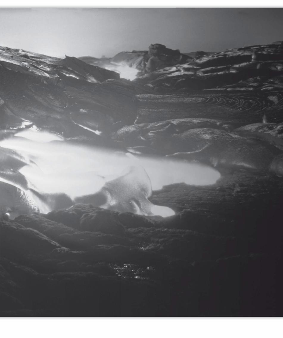

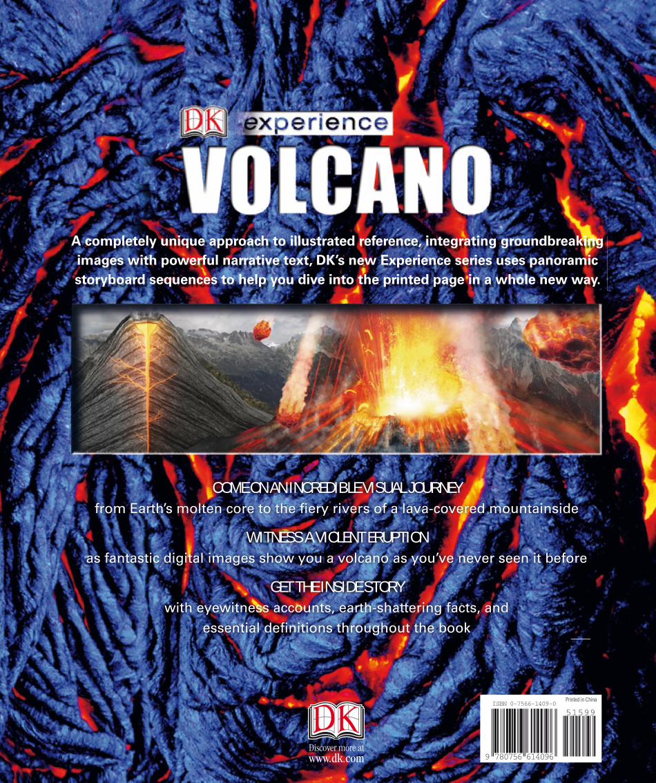
COME ON AN INCREDIBLE VISUAL JOURNEY from Earth’s molten core to the fi ery rivers of a lava-covered mountainside
WITNESS A VIOLENT ERUPTION as fantastic digital images show you a volcano as you’ve never seen it before
GET THE INSIDE STORYwith eyewitness accounts, earth-shattering facts, and
essential defi nitions throughout the book
Journey to the center of the
earth and witness what actually
happens during one of our planet’s
most violent events.
AN ASTONISHING STORYHow are volcanoes created? What happens
when they erupt? Volcano takes you on an
amazing virtual journey that unfolds step
by step, exploring and explaining
each stage in the terrifying
spectacle of an eruption.
INCREDIBLE IMAGESAmazing digital imagery
takes you where no
human has been before.
Stand in a white-hot
magma chamber or face
the frightening power of an
onrushing pyroclastic blast!
AMAZING FACTSEyewitness accounts, thrilling stories, and
fantastic fact boxes guarantee that this is
one learning experience you’ll never forget.
Get ready to fi nd out what it was like to
hear Krakatoa erupting or to fl ee the falling
ash in Pompeii.
Volcano is a story that will shake
your world!
$15.99 USA$19.99 CanadaISBN 0-7566-1409-0
Author
ANNE ROONEY taught at England’s
Cambridge and York Universities
before becoming a full-time writer.
She is the author of many books for
adults and children on history,
philosophy, and science and
technology, and was long-listed for the
Junior Prize of the Aventis Prizes for
Science Books in 2004. Anne lives in
Cambridge, England, with her two
daughters and Marcel, a blue lobster.
Consultant
DOUGLAS PALMER is a science
author who has written several books
on earth science and was a major
contributor to DK’s Earth. He spent
more than 20 years as a geology
lecturer at the University of Dublin,
and he still lectures for the University
of Cambridge Institute of Continuing
Education, in England.
Also available in the
DK Experience series:
Dinosaur
Flight
Pyramid
Background image: Getty/StoneIllustrations: Front & Back: Atlantic Digital, Candy Lab, Andrew Kerr
Discover more atwww.dk.com 9 780756 614096
51599ISBN 0-7566-1409-0
Printed in China
VOLCANOA
NN
E R
OO
NE
Y
A completely unique approach to illustrated reference, integrating groundbreaking
images with powerful narrative text, DK’s new Experience series uses panoramic
storyboard sequences to help you dive into the printed page in a whole new way.