Embed Size (px)
Citation preview
OLD
RO
AD
, NEW
DIR
ECTI
ON
S: A
PLA
N F
OR
AD
ELIN
EU
C B
erke
ley
• Sp
rin
g 2
010
CP
218
Tran
spo
rtat
ion
Pla
nn
ing
Stu
dio Introduction
NO
RTH
AD
ELIN
E
SOU
TH A
DEL
INE
BerkeleyBowl
Market
PostOffice
FleaMarket
å
å
å
Ed RobertsCampusSTATION
AREA
ASHBY AVE
ASHBY AVE
SHA
TTU
CK
AV
E
ALCATRAZ AVE
MA
RTIN
LUTH
ER K
ING
JR W
AY
CITY OF BERKELEY
CITY OF OAKLAND
0 400 800200Feet
CITY OFBERKELEY
EMERYVILLEOAKLAND
PIEDMONT
ALBANY
EL CERRITORICHMOND
I-80/I-580
I-80
I-580
I-80
I-880
Bay Bridge to
San Francisco
CONTRA COSTACOUNTY
ALAMEDACOUNTY LINE
I-580
I-980
HWY 24
HWY 13
BART to
Walnut Creek
BA
RT to
Rich
mo
nd
[
0 5,000 10,0002,500Feet
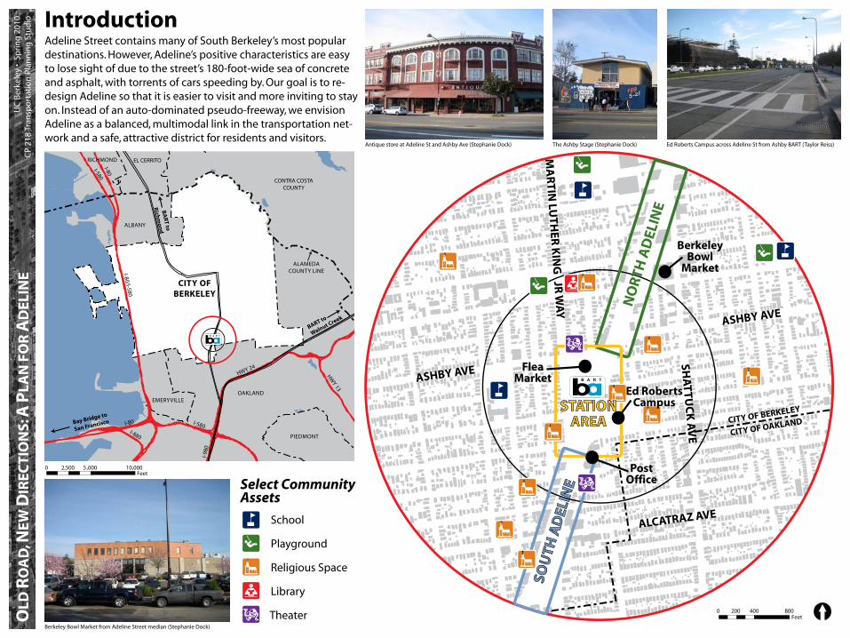
Adeline Street contains many of South Berkeley’s most popular destinations. However, Adeline’s positive characteristics are easy to lose sight of due to the street’s 180-foot-wide sea of concrete and asphalt, with torrents of cars speeding by. Our goal is to re-design Adeline so that it is easier to visit and more inviting to stay on. Instead of an auto-dominated pseudo-freeway, we envision Adeline as a balanced, multimodal link in the transportation net-work and a safe, attractive district for residents and visitors.
Select Community Assets
SchoolåPlayground
Religious Space
Library
TheaterBerkeley Bowl Market from Adeline Street median (Stephanie Dock)
Ed Roberts Campus across Adeline St from Ashby BART (Taylor Reiss)Antique store at Adeline St and Ashby Ave (Stephanie Dock) The Ashby Stage (Stephanie Dock)

OLD
RO
AD
, NEW
DIR
ECTI
ON
S: A
PLA
N F
OR
AD
ELIN
EU
C B
erke
ley
• Sp
rin
g 2
010
CP
218
Tran
spo
rtat
ion
Pla
nn
ing
Stu
dio Transportation Context
[
Local Roads Transit Bicycle Network
1/1R
72
51B
12
49
52
J
18
88
49
E
F
FS
ASHBY AVEALCATRAZ AVE
DWIGHT WAY
BANCROFT WAY
UNIVERSITY AVE
MA
RTIN LU
THER KIN
G JR W
AY
SHATTU
CK AV
E
SAC
RAM
ENTO
ST
TELEGR
AP
H A
VE
AD
ELINE ST
COLLEG
E AVE
SAN
PABLO
AVE
STANFORD A
VE
POWELL ST
MA
RKET ST
BART to
Walnut Creek
BART to
SF/Fremont
BART to
Richmond
ASHBY AVE
ALCATRAZ AVE
DWIGHT WAY
BANCROFT WAY
UNIVERSITY AVE
MA
RTIN LU
THER KIN
G JR W
AY
SHATTU
CK AVE
SAC
RAM
ENTO
ST
TELEGR
AP
H A
VE
AD
ELINE ST
CO
LLEGE AV
E
SAN
PABLO
AVE STANFORD A
VE
POWELL ST
MA
RKET ST
HWY 24
ASHBY AVE
WOOLSEY ST
CHANNING WAY
HEARST AVE
MILV
IA ST
COLBY ST
CA
LIFORN
IA ST
TELEGR
AP
H A
VE
AD
ELINE ST
HILLEG
ASS AVE
MA
RKET ST
RUSSELL ST
KING
ST
GEN
OA
ST
OX
FORD
ST
DA
NA
ST
Adeline St at BART Station
Shattuck Ave in Downtown
San Pablo Ave at University Ave
Telegraph Ave at Ashby Ave
Woolsey St at MLK Jr Way
Relative Right-of-Way Widths
City LimitMajor Street
Local Street
Bus Line (Color Coded)B
BART Line
Separated Path Striped Lane
Route0 2,0001,000Feet
Four AC Transit bus lines run within the study area for daytime service.
Service to Oakland and Piedmont every 20 to 30 minutes during the day and evening.
12
18
49
F
Service to Albany and Oakland every 15 to 20 minutes during the day and evening.
Service within Berkeley every 30 minutes during the day and evening.
Service to San Francisco every 30 minutes during the day and evening.
The following bicycle enhancements have been installed within the study area:
Bicycle boulevards on Russell and MilviaStreets prioritize bicycle right-of-way and include devices to calm or divert traffic.
A bicycle loop detector on Oregon Streetallows bicycles to actuate the traffic signal.
A bicycle lane on Adeline Street providesspace clear of fast-moving auto traffic.
A bicycle route on Woolsey Street provideseast-west connectivity.

OLD
RO
AD
, NEW
DIR
ECTI
ON
S: A
PLA
N F
OR
AD
ELIN
EU
C B
erke
ley
• Sp
rin
g 2
010
CP
218
Tran
spo
rtat
ion
Pla
nn
ing
Stu
dio
10,000 aadt
20,000 aadt
30,000 aadt
Refuge
Signal
Fatality
10 ped/hr
50 ped/hr
150 ped/hr
Total intersectioncrossings
100 vph
500 vph
1,500 vph
Estimated dailytraffi c volume
15,300
10,600
10,900
34,70035,000
27,800
11,0
00
15,10016,300
17,700
18,300
16,900Ashby
Ashby
Ad
eline
Ad
eline
Ad
eline
Ad
eline
MLK
MLK
Alcatraz
Alcatraz
MLK
Stan
ford
Vehicles per hourPM peak (4:45-5:45)
250 500 7500 1000 ft 62.5 125 187.50 250 ft
680
170
63
06626
180
66
98
61
84
57
57
0
580
1
Ashby
Ad
elin
e
CLEAR
KEEPCLEAR
KEEP
CLE
KECLEAR
KEEP
LEAR
KEEP
1,100
27
660
870 740
1,5001
,50
0
140
310088
52
35088
11
0
10
0
0160
99
2
3
MLK A
delin
eFairview
Woolsey
Alcatraz
Ad
elin
e
RUSSELL ST
KING
S T
SHATTU
CK AVE
MILVIA ST
WARD ST
WOOLSEY ST
ALCATRAZ AVE
MARTIN
LUTHER KING JR W
AY
STAN
FOR
D A
VE
ASHBY AVE
133
72
240
89
262
106
165
33
191
151
170
24
280
Alcatraz
Fairview
Harmon
Ashby
Oregon
MLK
Shattuck
Russell
StuartM
LK
Stanfo
rd
Maximum hourlyped crossings
Pedestrian safety
250 500 7500 1000 ft
RUSSELL ST
KING
S T
SHATTU
CK AVE
MILVIA ST
WARD ST
WOOLSEY ST
ALCATRAZ AVE
MARTIN
LUTHER KING JR W
AY
STAN
FOR
D A
VE
ASHBY AVE
41
37
108
104
76
36
66
50
38
69
40
41
38
Maximum hourlybike volume
±
250 500 7500 1000 ft
TO HWY 24
TO DOWNTOWN
5 bikes/hr
25 bikes/hr
75 bikes/hr
Total intersectionvolume
20 - 50 ft
50 - 75 ft
75 - 100 ft
100 - 150 ft
Legend Crossing distance
85th Percentile Speed
34mph
33mph
36mph
32mph
32mph
31mph
1
3
2
262 104

OLD
RO
AD
, NEW
DIR
ECTI
ON
S: A
PLA
N F
OR
AD
ELIN
EU
C B
erke
ley
• Sp
rin
g 2
010
CP
218
Tran
spo
rtat
ion
Pla
nn
ing
Stu
dio How Adeline residents get around
Where study area residents work, and how they get thereAdeline residents travel regionally to work and increasingly choose to BART or bicycle to get there
ve
College Ave
Dwight Way
Cedar St
Clar
emon
t Ave
evA hpargeleT
6th St
Alcatraz Ave
7th St
Ashby Ave
University Ave
tS eniledA
Market St
Sacramento St
k Ave
Tunnel Rd
yawdaorB
51st St
ng Jr Way
Broadway Ter
Powell St
Stanford Ave
Bancroft Way
Chabot Rd
Patton St
Sacramento St
Ashby Ave
Shattuck Ave
Martin Luther King Jr W
ay
NORTH BERKELEY
DOWNTOWN BERKELEYDOWNTOWN BERKELEY
ASHBY
24
ROCKRIDGE
24
80
240 0.5 1
Miles
LEGEND
Origins by Mode to Station
Walked all the way
Bicycle
Bus, train or other transit
Drove alone / carpooled
Dropped off
BART Line and Station
One mile Station Buffer
Half-mile Station Buffer
Capitol Corridor (Amtrak)
Amtrak (other)
Home origins for Ashby riders, 2008
2008 BART-wide 2008 Ashby-specifi c
On average, of the 4,797weekday riders who begin their journey at Ashby
78% come from home
22% come from work
Over time, more residents are choosing to BART or bike to work and fewer residents are drivingCities where residents in the
study area work, 2008
BART Bike Bus
50%
43%
17%
7%9%
7%
13%9%
Carpool Walk Other
6%6% 5%5%
10%12%
Drove Alone
Means of transportation to work for study area residents, 1990-2000
1990 2000
Where Ashby BART riders live, and how they get to the stationAshby riders live very close to the station and most do not use a car to access the station
Berkeley, 26%
Oakland, 18%
San Francisco, 18%
Emeryville, 2.5%
Richmond, 2.2%
Sources: ESRI, 2008 BART Station Profi le Study (weekday only; data are weighted from survey sample to represent average weekeday ridership)
Source: US Census 2000, SF3 Table P30
Vehicle Ownership, 2000
0.79 vehicles/household in study area
0.96 vehicles/household in Berkeley
Source: US Census 2000, SF3 Table H46
Source: US Census 2008, Local Employment Household Dyanmics
Top 5 Work Destinations, 2008(by census tract)
1. Downtown San Francisco
2. UC Berkeley campus
3. West Berkeley
4. Downtown Berkeley
5. Emeryville
Source: US Census 2008, Local Employment Household Dyanmics21%18% 18%
27%
18%15%
26%
13%
30%
MacArthur Ashby N. Berkeley
SF Oakland Berkeley
Source: US Census 2008, Local Employment Household Dyanmics
Less than 30 min commute
30-45 min commute
45+ min commute
Commute time for residents traveling to work via public transit, 2000
Study Area Berkeley
22% 20%
33%38% 40%
47%
Source: US Census 2000, SF3 Table P32 Sources: 2008 BART Station Profi le Study (weekday only; data are weighted from survey sample to represent average weekeday ridership)
Many of residents’ work destinations are accessible by transit, shuttle, or bicycle.
Compared to the study area, a similarpercentage of residents around the MacArthur and North Berkeley BARTstations travel to San Franciso to getto work.
Cities where residents living within 1/2 mile of BART stations work, 2008
Residents in the study area spendless time commuting to work viapublic transit compared to residents in the city of Berkeley
12% of riders access Ashby BART by bike, the highest of any station in the BART system
20%
34%31%
12%15%
1%4%5%5%
10%
5%
Drove Alone
DropOff
Bike BusCarpool Walk
57%
How riders coming from home get to BART, 2008
70% of Ashby riders arriving to the station from home don’t step into a car to get there

ASHBY AVE
SHBY AVE
AD
ELIN
E ST
MA
RTIN LU
THER KIN
G JR. W
AY
SHATTU
CK AVE
WOO
ALCATRAZ AVEFAIRVIEW ST
KING
ST
RUSSELL ST
OREGON ST
STUART ST
HARMON ST
MLK W
AY
EMERSON ST
ESSEX ST
MILVIA
ST
63RD ST
[ 0 200 400 800Feet
ASHBY AVE
SHBY AVE
AD
ELIN
E ST
MA
RTIN LU
THER KIN
G JR. W
AY
SHATTU
CK AVE
WOO
ALCATRAZ AVEFAIRVIEW ST
KING
ST
RUSSELL ST
OREGON ST
STUART ST
HARMON ST
MLK W
AY
EMERSON ST
ESSEX ST
MILVIA
ST
63RD ST
[ 0 200 400 800Feet
4
3
4
5
5
5
7
7
10
13
28
Other
Toys
Services
Art
Soaps/Scents
Electronics
Audio/Video
Second Hand
Food
Jewelery
Clothing/Acc.
African Clothes, JeweleryAfrican Sculptures, MasksAsian Jewelery, Scarves, ArtAssorted Second HandBeaded Jewelery, NecklacesBootleg CDs/DVDsCell Phone AccessoriesHot DogsMassageMerlino Wool SocksPlastic ToysUsed BooksUsed Records/VHS/TapesReggae WearScarvesShoesSoap/ScentsSocks, UnderwearStereos/Computer MonitorsSunglassesTacos and Burritos T-Shirts, Embroidered Pants
Survey Conducted Sat Feb 27
425 People and 84 Booths counted at 2pm
Small proportion of goods are mass-produced and new
Most are used or limited-runOLD
RO
AD
, NEW
DIR
ECTI
ON
S: A
PLA
N F
OR
AD
ELIN
EU
C B
erke
ley
• Sp
rin
g 2
010
CP
218
Tran
spo
rtat
ion
Pla
nn
ing
Stu
dio
Land UseExisting Conditions Inventory
Building Condition
Land Use Legend
Commercial
Office
Mixed Use
Single-family Residential
Multi-family Residential
Arts
Institutional
Vacant
Building Condition LegendExcellent
Good
Fair
Poor
Flea Market
Schools/ChildcareArts
Medical Services
Other
Restaurant/Bar
Office
Retail-16 salons-11 furnishings
Corridor Business Mix (118 total)
28
55
4 68
8
9
Ed Roberts Campus
Building Condition Photos by Stephanie Dock
Photo by Emily Ehlers
Photo by Brian Gould

OLD
RO
AD
, NEW
DIR
ECTI
ON
S: A
PLA
N F
OR
AD
ELIN
EU
C Be
rkel
ey •
Spr
ing
2010
CP
218
Tra
nspo
rtat
ion
Plan
ning
Stu
dio
11 PM: Eyes on the street?
Ad
elin
e
MLK
Alcatraz
Ward
Shattuck
Russell
Ashby
Woolsey
62nd
MLK
Stan
ford
Adeline at Night
Ad
elin
e
MLK
Alcatraz
Ward
Shattuck
Russell
Ashby
Woolsey
ML
People present, comfortable
Very few peopleNo people presentOpen business
Intersections
Adeline/Ashby
Adeline/MLK
Tree
Landscaping
Surface parking lot
A Stroll Down Adeline
Adeline SouthLorin District: walkable but not lively
Around BARTBarren with bright spots
Surface Parking
Extensive landscaping
Large lots and set-backs
Void along BART parking lot
Pedestrian-scale parcels and street wall
Enormous landscaped medians
Adeline is a barrier
Some historic buildings
Adeline NorthQuiet and park-like
And unusual ones
Phot
o cr
edits
: Erin
Mac
hell

Ad
elin
e
MLK
Alcatraz
Ward
Shattuck
Russell
Ashby
Woolsey
62nd
MLK
Stan
ford
OLD
RO
AD
, NEW
DIR
ECTI
ON
S: A
PLA
N F
OR
AD
ELIN
EU
C Be
rkel
ey •
Spr
ing
2010
CP
218
Tra
nspo
rtat
ion
Plan
ning
Stu
dio
Historic buildings, well-designed sidewalks and artwork intermingle with stretches of disrepair and neglect
Assets and Problem AreasArtwork
Artwork enlivens the corridor.Building on historic registry Artwork
(+) Assets ( - ) Problem areas
(+) Landscaped sidewalk & historic buildings work
together
(+) Maintained building on historic registry
(+) Historic character beautifully maintained
(-) Barren sidewalk, poor maintenance
(-) Unfriendly building
(+/-) Historic character poorly maintained
(+) Appealing architecture & sidewalk
(+/-) Poorly maintained historic registry building
(+) Landscaped with street furniture
(-) Plain building, bare sidewalk
(-) Bare sidewalk, no street frontage
(-) Narrow sidewalk and fence by BART tracks
Phot
o cr
edits
: Erin
Mac
hell
3
2
1
4
5
1
4
5
3
2

OLD
RO
AD
, NEW
DIR
ECTI
ON
S: A
PLA
N F
OR
AD
ELIN
EU
C B
erke
ley
• Sp
rin
g 2
010
CP
218
Tran
spo
rtat
ion
Pla
nn
ing
Stu
dio
ASHBY AVE
ASHBY AVE
AD
ELIN
E ST
MA
RTIN LU
THER KIN
G JR. W
AY
SHATTU
CK AVE
WOOLSEY ST
ALCATRAZ AVEFAIRVIEW ST
KING
ST
RUSSELL ST
OREGON ST
STUART ST
HARMON ST
MLK W
AY
EMERSON ST
ESSEX ST
MILVIA
ST
63RD ST
[
0 200 400 800Feet
Issues Opportunities
ConnectivityThe Ashby BART station attracts a high share of cyclists and pedestrians.
Adeline’s right-of-way is wide enough to accommodate all users with little impact to auto level of service.
The study area is well served by east-west bicycle routes.
Adeline’s wide sidewalks can accommodate a large amount of pedestrians.
SafetyReducing long traffi c signal cycles could reduce vehicle speeds while making crossings easier.
There is room to introduce traffi c calming measures that promote pedestrian and cyclist safety.
ActivityThe study area features major attractors that draw large number of non-motorized trips to Adeline.
The area is part of the Ashby/Adeline Arts District.
The BART parking lot is a good site for compact, mixed-use development.
Other OpportunitiesHistoric buildings and similar streetscape design can be used to create a common sense of place.
Parking at and adjacent to the Ashby BART station can be priced to manage demand and generate funds for neighborhood improvements.
ConnectivityHigh traffi c volumes, high vehicle speeds, and a wide right-of-way hinder connectivity.
The west Ashby BART parking lot blocks pedestrian and cyclist movement.
Gaps in the bicycle network create potential confl ict points between drivers and cyclists.
SafetyPedestrian and cyclist safety is a concern throughout the Adeline corridor.
Unsafe intersections discourage pedestrians and BART riders from visiting local businesses.
ActivityPublic and sidewalk spaces are underused.
An adjacent shopping district along Shattuck competes with Adeline for pedestrian traffi c.
Some neighborhood residents and fl ea market patrons fear gentrifi cation and displacement due to redevelopment.
Other ConcernsBART’s parking replacement policy drives up the cost of station area development.
The study area contains several antique and furnishing stores that require good automobile access.
1
3 4
8CW 3 4
2 5 7
1
9
6
A
B C
A D H
A
E F J
A
Legend1
A
CW
Issue
Opportunity
Corridor-wide issue/opportunity
CW
CW
CW
CW
CW
CW
CW
CW
CW
CW
CW
1
3
6
2
45
7
8
9
A
B
C
D
F
H
J
E
G
I
I
G

OLD
RO
AD
, NEW
DIR
ECTI
ON
S: A
PLA
N F
OR
AD
ELIN
EU
C B
erke
ley
• Sp
rin
g 2
010
CP
218
Tran
spo
rtat
ion
Pla
nn
ing
Stu
dio Vision
Adeline Street will be a balanced, multimodal link in the transportation network and a safe, attractive district for residents and visitors with new housing well served by transit.
Goal 3: Encourage designs and uses that support active,walkable neighborhoods
Encourage the development of focused, pedestrian-friendly commercial uses
Create public spaces that are inviting and well-used
Cultivate compact residential development at the Ashby BART station
Goal 2: Create a safer pedestrian and cyclist environment
Reduce conflicts between pedestrians, cyclists, and motorists
Reduce vehicle speeds along the corridor
Improve intersection designs, traffic controls, and shorten crossings
Goal 1: Enhance corridor connectivity for all users
Facilitate intermodal connections that will enhance access to the corridor’s destinations
Improve movement though and across the corridor
Improve pedestrian and bicycle network continuity and infrastructure

OLD
RO
AD
, NEW
DIR
ECTI
ON
S: A
PLA
N F
OR
AD
ELIN
EU
C B
erke
ley
• Sp
rin
g 2
010
CP
218
Tran
spo
rtat
ion
Pla
nn
ing
Stu
dio
[
ASHBY AVE
ASHBY AVE
AD
ELIN
E ST
MA
RTIN LU
THER KIN
G JR. W
AY
SHATTU
CK AVE
WOOLSEY ST
ALCATRAZ AVEFAIRVIEW ST
KING
ST
RUSSELL ST
OREGON ST
STUART ST
HARMON ST
EMERSON ST
ESSEX ST
MILVIA
ST
63RD ST
[
P
P
P
P
P
ASHBY AVE
ASHBY AVE
AD
ELIN
E ST
MA
RTIN LU
THER KIN
G JR. W
AY
SHATTU
CK AVE
WOOLSEY ST
ALCATRAZ AVEFAIRVIEW ST
KING
ST
RUSSELL ST
OREGON ST
STUART ST
HARMON ST
EMERSON ST
ESSEX ST
MILVIA
ST
63RD ST
[
ASHBY AVE
ASHBY AVE
AD
ELIN
E ST
MA
RTIN LU
THER KIN
G JR. W
AY
SHATTU
CK AVE
WOOLSEY ST
ALCATRAZ AVEFAIRVIEW ST
KING
ST
RUSSELL ST
OREGON ST
STUART ST
HARMON ST
EMERSON ST
ESSEX ST
MILVIA
ST
63RD ST
[
ASHBY AVE
ASHBY AVE
AD
ELIN
E ST
MA
RTIN LU
THER KIN
G JR. W
AY
SHATTU
CK AVE
WOOLSEY ST
ALCATRAZ AVEFAIRVIEW ST
KING
ST
RUSSELL ST
OREGON ST
STUART ST
HARMON ST
EMERSON ST
ESSEX ST
MILVIA
ST
63RD ST
Reducing excess space for cars to calm traffic and improve the pedestrian environment
Taming the Traffic: Road Dieting
Framework PlansPavement-to-Parks and Plazas
Lane RemovedRealigned Intersection
Existing Signal
New Signal
New or Expanded Public Open SpaceStriped Bike Lane
Bicycle Route
New Signal
Transit Stops
Safe, Multimodal Access Development for Enlivenment
Land for DevelopmentRearranged ParkingP
Road Diets: fewer, narrower
lanes
Intersections realigned to shorten crossings
Coordinated traffic signals
Transit plaza for easy
connections
Bicycle route changesto avoid conflilcts
New signals for safer
crossings
Creating public open spaces that will attract pedestrians and complement nearby land uses
Encouraging neighborhood-scale residential development and local-serving commercial uses
Improving neighborhood accessibility and connectivity by foot, bicycle, and transit
Continuous streetscape to eliminate station area
voidRedwood Park
Preserving a mature stand of trees and softening a busy
intersection
Parking reorganized
to save space
Transit-orienteddevelopment at
Ashby BART
Realigned intersection allows for development
spaceGateway Park
Entrance to Berkeley, the Adeline Corridor, and the Lorin District
Park blocks with promenade
A greenway leading to
Downtown Berkeley
Continuous bicycle lanes for full length of Adeline St.
Sidewalk plazas and public market
spaces

BUS STOP
BUS STOPBUS STOP
BUS STOP
Russell St.
Ashby Ave
Oregon St
Ward St
Emerson St
Es
Shattuck AveBerkeley BowlMarket
Existing
1”=20’
20’sidewalk and planted area
8’parking
lane
6’bikelane
11’travellane
90’linear park
8’parking
lane
6’bikelane
11’travellane
180’public right-of-way
16’sidewalk and planted area
3’3’20’
sidewalk and planted area
8’parking
lane
8’bikelane
14’travellane
14’travellane
56’planted median
8’parking
lane
8’bikelane
14’travellane
14’travellane
180’public right-of-way
16’sidewalk and planted area
B
A B Proposed
A
To Downtown Berkeley
Proposed Design
Existing Configuration
0 100 20050Feet[
North Adeline
BUS STOP
BUS STOP
BUS STOP
BUS STOP
BUS STOP
Ashby Ave
Emerson St
Essex St
Woolsey St
Fairview St
Harm
on St
MLK Way
Prince St
Woolsey St
Ed Roberts CampusPost Office
1”=20’
13’ sidewalk/
transit shelter
6’bikelane
11’travellane
10’travellane
16’grassy median
12’transit /k&r
bay
6’bikelane
10’travellane
11’travellane
124’public right-of-way
17’sidewalk
12’transit /k&r
bay
BART entrance
transit transfer
area
Future Ed
Roberts Campus
Ashby BART
Station
Future Ashby BART Dev.
10’ sidewalk
8’parking
lane
6’bikelane
14’travellane
14’travellane
16’grassy median
8’parking
lane
6’bikelane
14’travellane
14’travellane
124’public right-of-way
14’sidewalk
future Ed Roberts
Campus
Ashby BART
Station
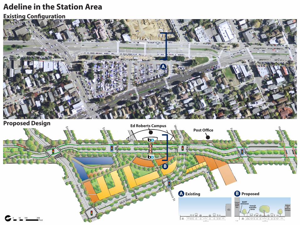
ExistingA B Proposed
Proposed Design
Existing Configuration
B
A
Adeline in the Station Area
0 100 20050Feet[

BUS STOP
BUS STOP
BUS STOP
BUS STOP
BUS STOP
BUS STOP
WAIT-HEREWAIT-HERE
Woolsey St
Fairview St
Harm
on St
Alcatraz Ave
63rd St
62nd St
Prince St
Woolsey St
ts CampusPost Office
Proposed Design
Existing Configuration
South Adeline
1”=20’
12’sidewalk
30’bay with diagonal parking
5’planted median
30’grassy median
11’travellane
180’public right-of-way
12’sidewalk
10’travellane
30’bay with diagonal parking
6’bikelane
11’travellane
10’travellane
6’bikelane
5’planted median
12’sidewalk
30’bay with diagonal parking
5’planted median
14’travellane
12’travellane
10’grassy
median
12’travellane
14’travellane
180’public right-of-way
12’sidewalk
12’travellane
12’travellane
30’bay with diagonal parking
5’planted median
A
B
ExistingA B Proposed
To Downtown Oakland & SR 24
0 100 20050Feet[

Adeline corridor perspectivesLooking north at Oregon St Looking north at Harmon StLooking north at Ashby BART
Summary of corridor changesProposedExisting
Maximum width of vehicle lanes (feet)Number of on-street parking spacesPercent of right-of-way devoted to carsNew public space created (square feet)New developable space created (square feet)Bicycle lane completion along Adeline (percent)Crossing distances at key intersections on Adeline (feet):Adeline/OregonAdeline/Ashby (northern crosswalk)Adeline/Ashby (southern crosswalk)Ed Roberts Campus crosswalkAdeline/MLK62nd/Adeline (northern crosswalk)62nd/Adeline (southern crosswalk)Alcatraz/Adeline
14327
59%--
62%
88117126105130
8590
120
11332
45%227,660104,570
100%
3070707070757580
Traffic analysisOur proposal calms traffic on Adeline while still accommodating vehicle throughput. We used SimTraffic 5 software to model peak-hour vehicle flow through the corridor, including new trips induced by our proposed station area development, and found that our design maintains a motor vehicle level-of-service (LOS) of C or above at all intersections.
Existing
Proposed
Existing
Proposed
Existing
Proposed
Worst Movement LOSIntersection
Adeline/OregonAdeline/AshbyAdeline/EssexAdeline/MLKAdeline/FairviewAdeline/AlcatrazAdeline/Standford/MLKMLK/AshbyMLK/Prince
BBBCACBBA
CDBCCDCCA
Overall LOS
OLD
RO
AD
, NEW
DIR
ECTI
ON
S: A
PLA
N F
OR
AD
ELIN
EU
C B
erke
ley
• Sp
rin
g 2
010
CP
218
Tran
spo
rtat
ion
Pla
nn
ing
Stu
dio North Adeline
ASHBY AVE
RUSSELL ST
KING
S T
SHATTU
CK AV
E
MILV
IA ST
WOOLSEY STAD
ELIN
E ST
MA
RTIN
LUTH
ER
KIN
G JR
WAY
LOR
INA ST
WARD ST
WOOLSEY ST
ADEL
INE
ST
ALCATRAZ AVE
¯0 250 500 750 1,000
Feet
AVE
ELELAD
ED
EEININ
E STTT
EE
Adeline/Ashby Intersection RedesignCorridor Improvements
Improved crossing angle Shorter pedestrian crosssings
Continuous bicycle lanes
Existing
Lane removal: From two car lanes to oneNarrowed auto lanes: 14 feet to 11 feetShortened pedestrian crossingsSidewalk curb extensionsContinuous dedicated bike lanes Increased usable park space Maintained curbside parking Opportunity for community park design
••••••••
Commonwealth Ave, Boston, MA
Possible park uses and treatments
Patricia’s Green, Octavia BlvdSan Francisco, CAImage Source: SanFranciscoSidewalks.wordpress.com
Image Source: City of St. Petersburg website Image Source: New York Bounty website
Image Source: melbourneartcritic.wordpress.org
Image Source: Flickr, xnmeme
Buston Reserve, Melbourne, Australia
dog park, St. Petersburg, FLTaqwa Community GardensThe Bronx, New York, NY
Docklands, Melbourne, AustraliaImage Source: Flickr, Christopher_JB
Redesign Centerpiece: Roadway to Park
Jacob Javits Plaza, New York, NYImage Source: Flickr, Wallyg
Involve the community in the park design
Image Source: Taylor Reiss, April 18, 2010
Ashby AveAdeline St
Reclaimed pedestrian space
Adeline at Russell Street
Image Source: Flickr, }{enry
skate spot design St. Croix, WI
Ipanema Beach, Rio de Janeiro
Waterfront Park, Charleston, SC
Highline Park, New York, NY
Image Source: Flickr, spohnranchskateparks
Image Source: Flickr, spohnranchskateparks
Image Source: panaramio.com, Andrew Holden
Roadway
Pedestrian Space
Crossings
Proposed
Existing
Proposed
Existing
Proposed
Existing
Proposed
Existing Vision
¯ ¯
Designed for all modes
¯ ¯
37°
63°
117’
70’ 70’
70’73’
126’148’
73’
¯

OLD
RO
AD
, NEW
DIR
ECTI
ON
S: A
PLA
N F
OR
AD
ELIN
EU
C B
erke
ley
• Sp
rin
g 2
010
CP
218
Tran
spo
rtat
ion
Pla
nn
ing
Stu
dio
Phase 1
Adeline in the Station Area
Signal Phasing-Adeline/MLK
Phase 4Phase 3
Phase 2
12
ASHBY AVE
RUSSELL ST
KIN
G S T
SHATTU
CK AV
E
MILV
IA ST
WOOLSEY ST
ADEL
INE
ST
MA
RTIN
LUTH
ER
KIN
G JR
WAY
LOR
INA ST
WARD ST
WOOLSEY ST
ADEL
INE
ST
ALCATRAZ AVE
¯0 400 800200 Feet
ASHBY AVEAVE
Existing:Woolsey bicycle route ends at BART station. Bicyclists either enter traffic and turn along the corner of BART station or illegally cut through BART station.
Proposed:Woolsey bicyclists turn before Adeline to access BART station through new Essex signal OR turn onto Fairview with new signal to continue east onto new desingated bicycle path. New treatment for Prince St bicyclists entering BART and new bike station.
85’
65’25’
70’
76’
70’
25 ’
67’
51’
Crossing Distances
Old Adeline/ Woolsey
New Adeline/ MLK
Old Adeline/ MLK
Bicycle Facilties
Legend Illegal bike movement
Class 2 Bike Path Class 3 Bike Route
Bicycle crossing
Existing
Proposed
- Compact parking along smaller Adeline segment- Safer design forces drivers to directly
view bicycles while `parking
Diagonal Back-in Parking
Narrow lanes to a width appropriate for a 20 mph
Reconfigure existing on-street parallel parking to diagonal
Install a new signal at Adeline and Essex and a raised crosswalk across from the Ed Roberts Campus
Expand sidewalks, bus stops, and kiss-and-ride bays
Realign the Adeline/MLK intersection
Create new space for development from excess right-of-way
Reroute bicycles to enhance accessiblity of station area and cross connectivity
Objectives
Legend Pedestrians Permitted Vehicles
Goal: Multimodal Access to Ashby BART
Photo Credit: Mike Izzo
Photo Credit: Stephanie Dock
Photo Credit: Taylor Reiss
Photo Credit: Mike Izzo
4
54
3
7
6
1
2
5
4
3
7
6
7
5
5
2 Development Plan
Adeline
ExistingBuilding
Utilize existing vacant parcel
Mixed Use
Townhomes
Park
ExistingBuildings
ExistingRedwoods
Cafe Seating
6Current: Parallel Parking Along Station
Face new access lane

OLD
RO
AD
, NEW
DIR
ECTI
ON
S: A
PLA
N F
OR
AD
ELIN
EU
C B
erke
ley
• Sp
rin
g 2
010
CP
218
Tran
spo
rtat
ion
Pla
nn
ing
Stu
dio
Gateway Park
Realign Adeline Street50,000 sq ft public space reclaimedConsolidate space for new parkPublic art, trees and landscaping
••••
South Adeline Road diet & pedestrian improvements
Expand bike network
Narrow and reduce number of lanesWiden median and create pedestrian refugesNew signal at Adeline/FairviewReconfigure Adeline/Stanford intersection
••••
New bicycle lane in each directionInstall bike boxSeparate bikes from cars where possible
•••
Pho
to c
red
it: J
ay O
. Law
ren
ce
pedestrian circulationExisting
pedestrian circulationbicycle circulation
Proposed
Pho
to c
red
it: B
rian
Go
ebel
Pho
to c
red
it: R
ich
ard
Drd
ul
A
Pho
to c
red
it: J
oh
n B
Kel
ly
Textured crosswalk
90’
98’ 85’
75’
75’52’
Pho
to c
red
it: G
ary
Hal
vors
on
, O
reg
on
Sta
te A
rch
ives
WA
IT HERE
WA
IT HERE
Exis
tin
gP
rop
ose
d
ASHBY AVE
RUSSELL ST
KIN
G S T
SH
ATTUC
K AVE
MILV
IA ST
WOOLSEY ST
ADEL
INE
ST
MAR
TIN LU
THE
R K
ING
JR W
AY
LOR
INA ST
WARD ST
WOOLSEY ST
ADEL
INE
ST
ALCATRAZ AVE
¯0 400 800200 Feet
ADEL
ADEL
ADEL
DINININ
E STSS
E ST
E ST
A Pedestrian refugeB Reduced crossing distancesC
B
Soft-hit postsG
Bike boxH
Bike box protects bicyclists from turning vehicles
Expansive public parkD
D
Lively public spaces support local retailF
B A R T
B A R T
Gateway
Park
78% of right-of-way dedicated to cars
69% of right-of-way dedicated to cars
¯¯
Parking bays reorganizedE
E
Inefficient parking bays are reorganized to take up less space but provide 14 extra spaces than presently exist.
164 existing spaces >>> 178 proposed spaces
C
F
GH
Pedestrian Space
Crossings
Roadway
¯
1
2
3
Sweet Adeline
View from MLK & Stanford looking north up Adeline
OLD
RO
AD
, NEW
DIR
ECTI
ON
S: A
PLA
N F
OR
AD
ELIN
EU
C B
erke
ley
• Sp
rin
g 2
010
CP
218
Tran
spo
rtat
ion
Pla
nn
ing
Stu
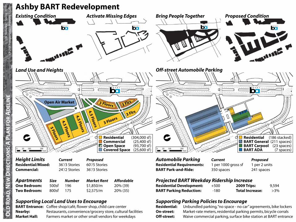
dio Ashby BART Redevelopment
Land Use and Heights Off-street Automobile Parking
Height Limits Current ProposedResidential/Mixed: 36’/3 Stories 60’/5 Stories Commercial: 24’/2 Stories 36’/3 Stories
Apartments Size Number Market Rent AffordableOne Bedroom: 500sf 196 $1,850/m 20% (39)Two Bedroom: 800sf 175 $2,575/m 20% (35)
Supporting Local Land Uses to EncourageBART Entrance: Coffee shop/café, flower shop, child care centerNearby: Restaurants, convenience/grocery store, cultural facilitiesMarket Hall: Farmers market or other small vendors for weekdays
Automobile Parking Current ProposedResidential Requirements: 1 per 1000 gross sf 1 per 2 unitsBART Park-and-Ride: 350 spaces 241 spaces
Projected BART Weekday Ridership IncreaseResidential Development: +500 2009 Trips: 9,594BART Parking Reduction: -180 Total Increase: >3%
Supporting Parking Policies to EncourageResidential: Unbundled parking, “no space - no car” agreements, bike lockersOn-street: Market-rate meters, residential parking permits, bicycle corralsOff-street: Waive commercial parking, surface bike station at BART entrance
Open Air Market
3 Floors
3 Flrs3 Floors
5 Floors
4.5 Floors
CommercialOpen SpaceCovered Space
(304,000 sf )(25,400 sf )(93,700 sf )(25,600 sf )
ResidentialBART GeneralBART CarpoolBART ADA
(186 stacked)(211 spaces)
(23 spaces)(7 spaces)
4.5 Floors
4.5 Floors
3 Flrs
Existing Condition Activate Missing Edges Bring People Together Proposed Condition
Residential
0 50 100 200Feet
[
0 50 100 200Feet
[
OLD
RO
AD
, NEW
DIR
ECTI
ON
S: A
PLA
N F
OR
AD
ELIN
EU
C B
erke
ley
• Sp
rin
g 2
010
CP
218
Tran
spo
rtat
ion
Pla
nn
ing
Stu
dio
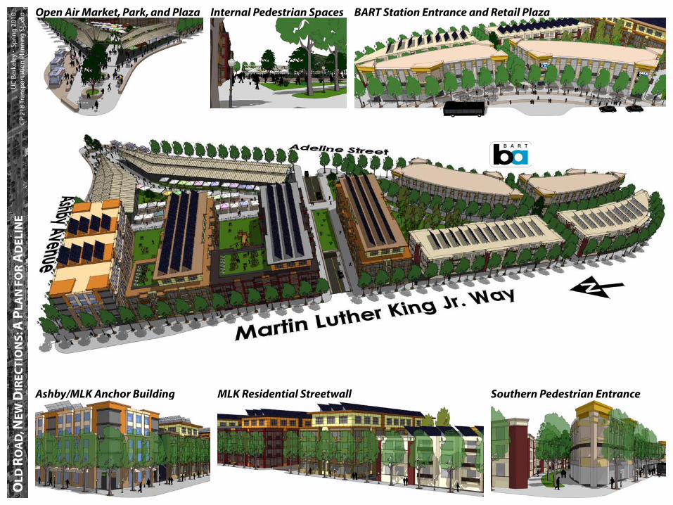
Ashby/MLK Anchor Building MLK Residential Streetwall Southern Pedestrian Entrance
BART Station Entrance and Retail PlazaInternal Pedestrian SpacesOpen Air Market, Park, and Plaza

Vision: Target pedestrian-friendly land uses that will transform Adeline into a vibrant and dynamic corridorLand Uses and Opportunity Areas
Commercial
Office
Mixed Use
Residential
Arts
Institutional
Vacant (lot or building)
Open Space
ParkingOLD
ROA
D,N
EWD
IREC
TIONS:APL
AN
FOR A
DEL
INE
UC Be
rrin
g 20
10
CP 2
18 Transpo
rtation Plan
ning
Studio Land Use Vision and Policy
Ashby Ave
.
Alcatraz Ave
.
MLK Jr. W
ay
Oregon
St.
Adeline Street
62nd St.
Woolsey Ave
.
Target Commercial Uses (Convenience Stores, Restaurants, Offices)
Target Residential or Retail
1
2
3
4
5
6
1
2
34
5
6
Target Commercial or Residential
Adeline Median
Ed Roberts CampusAshby BART Station Parking Lot
bookstores, restaurants)
Target Residential or Office
Targeted Land Uses
OLD
RO
AD
, NEW
DIR
ECTI
ON
S: A
PLA
N F
OR
AD
ELIN
EU
C B
erke
ley
• Sp
rin
g 2
010
CP
218
Tran
spo
rtat
ion
Pla
nn
ing
Stu
dio
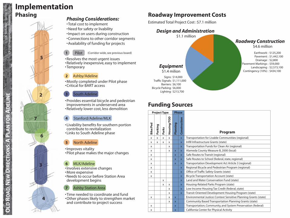
Roadway Improvement CostsEstimated Total Project Cost : $7.1 million
Implementation
Funding Sources
Roadway Construction$4.6 million
Equipment$1.4 milion
Design and Administration$1.1 million
$14,000 $1,111,000 $6,100 $6,000 $213,700
Signs:Traffic Signals:
Barriers:Bicycle Parking:
Lighting:
$125,200 $1,442,100 $2,800 $59,000 $2,573,100 $434,100
Earthwork :Pavement :Drainage :
Pavement Markings :Landscaping :
Contingency (10%) :
Phasing Considerations:Total cost to implementNeed for safety or livabilityImpact on users during constructionConnections to other corridor segmentsAvailability of funding for projects
•••••
Phasing
Resolves the most urgent issuesRelatively inexpensive, easy to implementTemporary
•••
Improves vitalityPilot phase makes the major changes
••
Time needed to coordinate and fundOther phases likely to strengthen market and contribute to project success
••
Ashby Station Area7
Involves extensive changesMore expensiveNeeds to occur before Station Area development begins
•••
MLK/Adeline6
North Adeline5
Livability benefits for southern portion contribute to revitalizationLinks to South Adeline phase
•
•
Stanford/Adeline/MLK4
Provides essential bicycle and pedestrian improvements in underserved areaRelatively lower cost, less demolition
•
•
South Adeline3
Mostly completed under Pilot phaseCritical for BART access
••
Ashby/Adeline2
Pilot1
2
7
3
4
5
6
Project Type Phase
Program
Bik
e/P
ed
Par
kin
g
Par
ks
Ho
usi
ng
/TO
D
Pla
nn
ing
Co
nst
ruct
ion
x x x x x Transportation for Livable Communities (regional)
x x x x x Infill Infrastructure Grants (state)
x x x Transportation Funds for Clean Air (regional)
x x x x Alameda County Measure B, 2000 (local)
x x x Safe Routes to Transit (regional)
x x x Safe Routes to School (federal, state, regional)
x x x Transportation Development Act Article 3 (regional)
x x Regional Bicycle and Pedestrian Program (regional)
x x Office of Traffic Safety Grants (state)
x x Bicycle Transportation Account (state)
x x Land and Water Conservation Fund (state)
x x x Housing-Related Parks Program (state)
x x Low Income Housing Tax Credit (federal, state)
x x Transit-Oriented Development Housing Program (state)
x x x Environmental Justice: Context Sensitive Planning Grants (state)
x x Community Based Transportation Planning Grants (state)
x x Transportation, Community, and System Preservation (federal)
x x California Center for Physical Activity
(Corridor-wide, see previous board)

OLD
RO
AD
, NEW
DIR
ECTI
ON
S: A
PLA
N F
OR
AD
ELIN
EU
C B
erke
ley
• Sp
rin
g 2
010
CP
218
Tran
spo
rtat
ion
Pla
nn
ing
Stu
dio
North Adeline
Safe-hit posts and re-striping re-align corridor and narrow lanes down
Phase I Improvements - North and South Adeline
South Adeline
Planters mark pedestrian cross-ings and corners of safe-hit post lines
Legend
Safe-hit postsBollardsPlantersEdge of raised parklet with plantersEdge of raised bus platformRaised crosswalk
Wider medians allow for addi-tional automobile storage when making turns
Road diet along South Adeline and North Adeline reduces auto-mobile speeds and breaks down pedestrian crossings
Reduce automobile speeds Increase pedestrian and bicycle safety
••
Examples
Safe-hit posts used to delineate bicycle lane in Washington, DC
Safe-hit posts used to delineate right-turn only lane in San Fran-cisco, CA (Market Street Trial)
Temporary planters used to mark perimeter of pedestrian plaza in San Francisco, CA (Castro Plaza Trial)
Safe-hit bollards and temporary planters used to separate pedes-trians, bicycles, and automobiles in New York City, NY
Raised deck and planters to cre-ate usable space in San Francis-co, CA (Divisadero Parklet)
Raised deck and planters create mini-park
(Not to Scale) (Not to Scale)
New bicycle lanes improve con-tinuity of bicycle network
Pho
to C
red
it: s
fcit
izen
.co
mPh
oto
Cre
dit
: rea
dys
etd
c.co
mPh
oto
Cre
dit
: Jam
iso
n W
iese
rPh
oto
Cre
dit
: far
m3.
stat
ic.fl
ickr
.co
mPh
oto
Cre
dit
: sfp
avem
entt
op
arks
.sfp
lan
nin
g.o
rg
Improve bicycle circulation Test proposed concepts of the re-design on a temporary trial basis
••
Short term goals:
To Adeline in the Station Area
To Adeline in the Station Area
[[

OLD
RO
AD
, NEW
DIR
ECTI
ON
S: A
PLA
N F
OR
AD
ELIN
EU
C B
erke
ley
• Sp
rin
g 2
010
CP
218
Tran
spo
rtat
ion
Pla
nn
ing
Stu
dio Phase I Improvements - Adeline in the Station Area
Ashby BART Station Area
BART parking lot exit converted to bicycle entry/exit only improves bi-cycle circulation and access to sta-tion
Openings in existing medians im-prove bicycle circulation and bollards create refuges for bicycles while pre-venting use by automobiles
Slip lane closed to automobiles and open to two-way bicycle movements improves bicycle circulation
Reconfigured Adeline/Ashby intersec-tion shortens pedestrian crossings and adds continuity of bicycle lane
Reclaimed paved space allows for new uses
Raised crosswalks reduce automo-bile speeds and improve pedestrian safety
Safe-hit posts and re-striping re-align corridor and narrow lanes down
Planters mark pedestrian crossings and corners of safe-hit post lines
Raised deck extends bus stop to new alignment
Bicycle and Pedestrian CirculationTo Adeline North
To Adeline South
(Not to Scale)(Not to Scale)
Legend
BicyclesPedestrians
[
[