Embed Size (px)
Citation preview

NG LEK YUEN | 0324010 | FNBE JULY 2015LECTURERS : MS DELLIYA – MS HASMANIRA – MISS IFFAFINAL PROJECT | PART A | ENBE
BANDAR TUN RAZAK

CONTENT
INTRODUCTION TO CITYPAST, PRESENT & FUTURE CITY
TOWN PLANNING PRINCIPLES - NEIGHBOURHOOD UNITTHE BETTER FUTURE TOWN GUIDELINES
THE CITY THAT I LIVE IN - BANDAR TUN RAZAKPROPOSAL FOR THE BETTER FUTURE CITY
APPENDIX
01021013153133
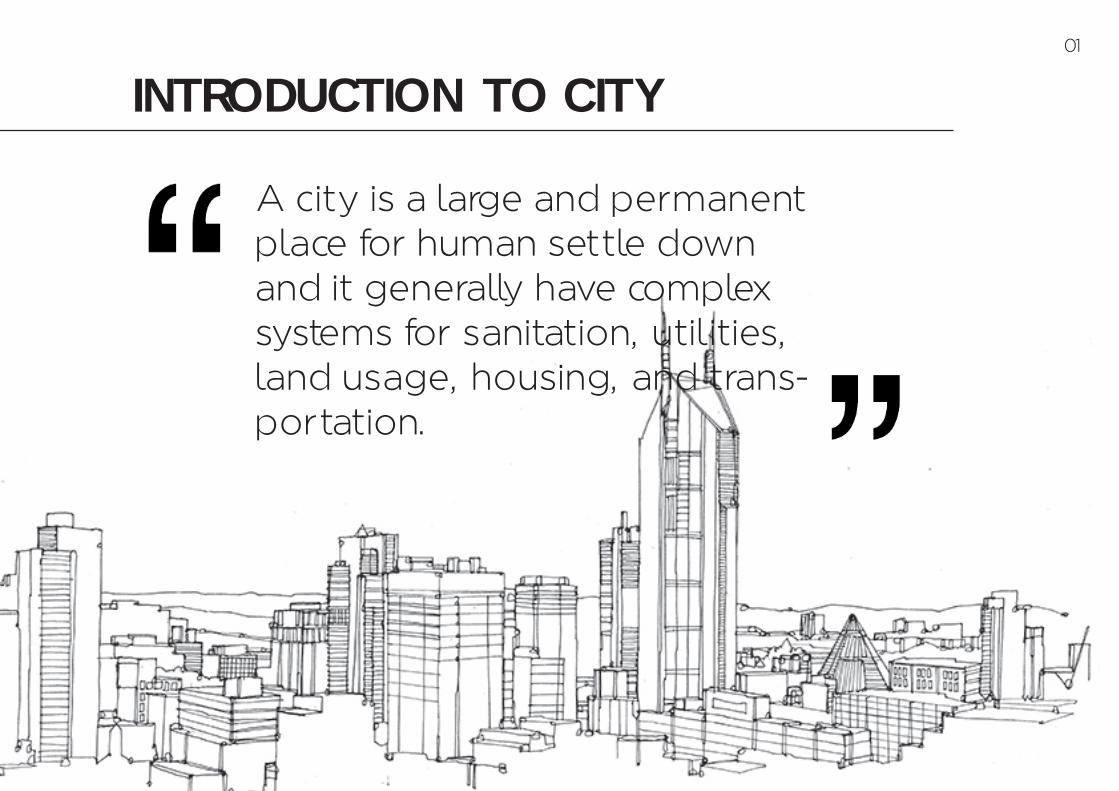
INTRODUCTION TO CITY
A city is a large and permanent place for human settle down and it generally have complex systems for sanitation, utilities, land usage, housing, and trans-portation.
01
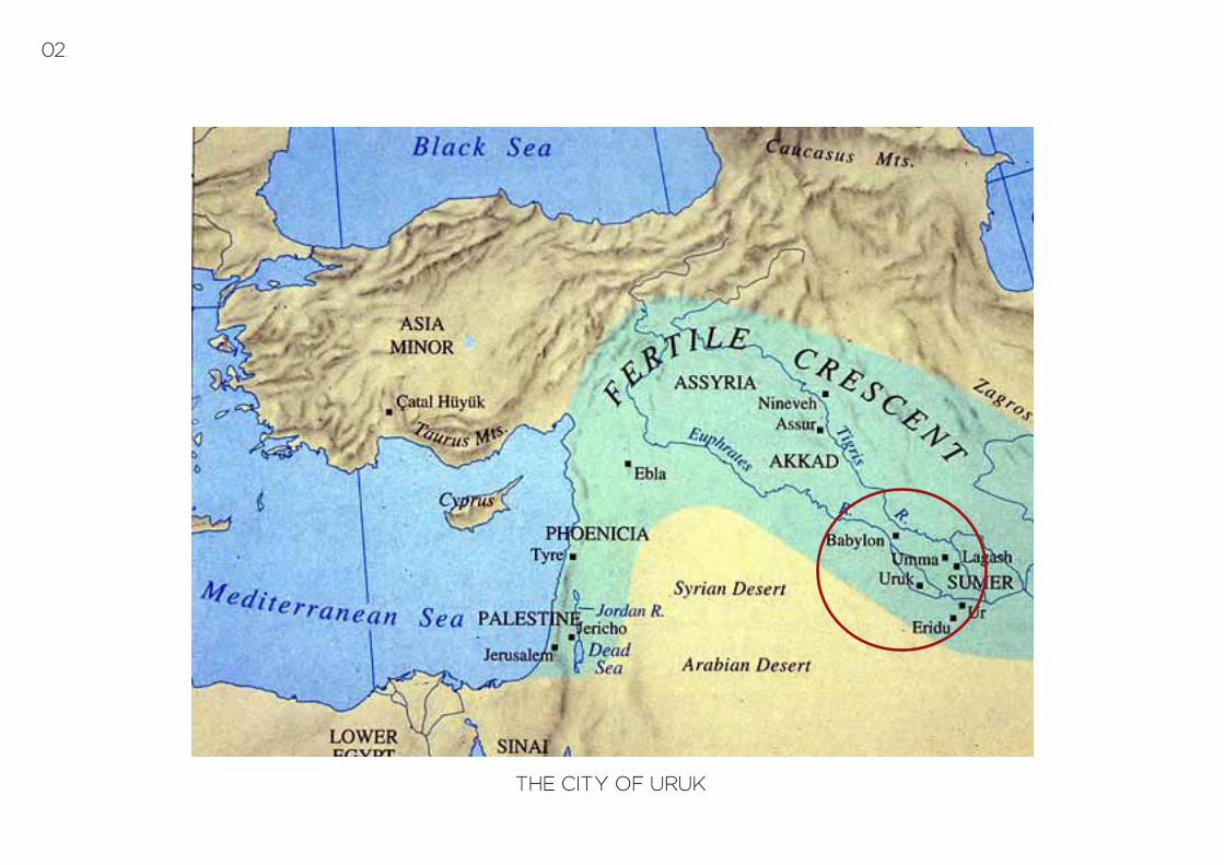
THE CITY OF URUK
02

the city of uruk past cityIn the ancient world, a city is an urban center which have:- dense population- certain pattern of buildings spreading out from a cen-tral religious complex such as a temple- laws and rules
They are also defined as large communities of people who have decided to live together.
Location: East of the present bed of the Euphrates riv-er, on the ancient dry former channel of the Euphra-tes River (some 30 km east of modern As-Samawah, Al-Muthanna, Iraq.)
Feature: [1] Considered the first true and also oldest city in the world, was first set-tled in c. 4500 BCE and walled cities, for defence, were common by 2900 BCE throughout the region.[2] An ancient city of Sumer and later Babylonia, At its height c 2900 BC, Uruk probably had 50,000-80,000 residents living in 6 km sq. of walled area.[3] The origin of writing[4] Proper waste management and sanitation[5] Defense structure[6] The first city to develop the cylinder seal which the ancient Mesopo-tamians used to designate personal property or as a signature on docu-ments.
The stone temple, base of the Ziggurat at the archaeological site of Uruk in Warka
The structures follow the two main typologies of Sumerian architecture, Tripartite with 3 parallel halls and T-Shaped also with three halls, but the central one extends into two perpendicular bays at one end
03

Part of the facade of the temple of Inanna at Uruk. There are standing male and female deities in alter-nate niches
Round Pillar Hall in UrukTemple N, Cone-Mosaic Courtyard, and Round Pillar Hall are often referred to as a single structure; the Cone-Mosaic Temple.
The origins of writing in the form of cuneiform script representing
the Sumerian language
The city of Uruk had two major public complexes in the Uruk period. One of these was the Anu ziggurat and White Temple, both dedicated to the Mesopotamian sky-god Anu. Several architectural features of the building complex had appeared first in the Ubaid period, show-ing the continuity between the two phases.
04

TORONTO, CANADA
05
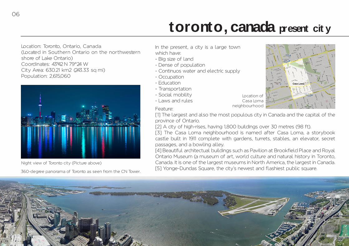
toronto, canada present city
Location: Toronto, Ontario, Canada(Located in Southern Ontario on the northwestern shore of Lake Ontario)Coordinates: 43°42 –N 79°24 –WCity Area: 630.21 km2 (243.33 sq mi)Population: 2,615,060
Feature: [1] The largest and also the most populous city in Canada and the capital of the province of Ontario.[2] A city of high-rises, having 1,800 buildings over 30 metres (98 ft).[3] The Casa Loma neighbourhood is named after Casa Loma, a storybook castle built in 1911 complete with gardens, turrets, stables, an elevator, secret passages, and a bowling alley.[4] Beautiful architectual buildings such as Pavilion at Brookfield Place and Royal Ontario Museum (a museum of art, world culture and natural history in Toronto, Canada. It is one of the largest museums in North America, the largest in Canada.[5] Yonge-Dundas Square, the city's newest and flashiest public square.
In the present, a city is a large town which have:- Big size of land- Dense of population- Continuos water and electric supply- Occupation- Education- Transportation- Social mobility- Laws and rules
360-degree panorama of Toronto as seen from the CN Tower.
Night view of Toronto city (Picture above)
Location of Casa Loma
neighbourhood
06
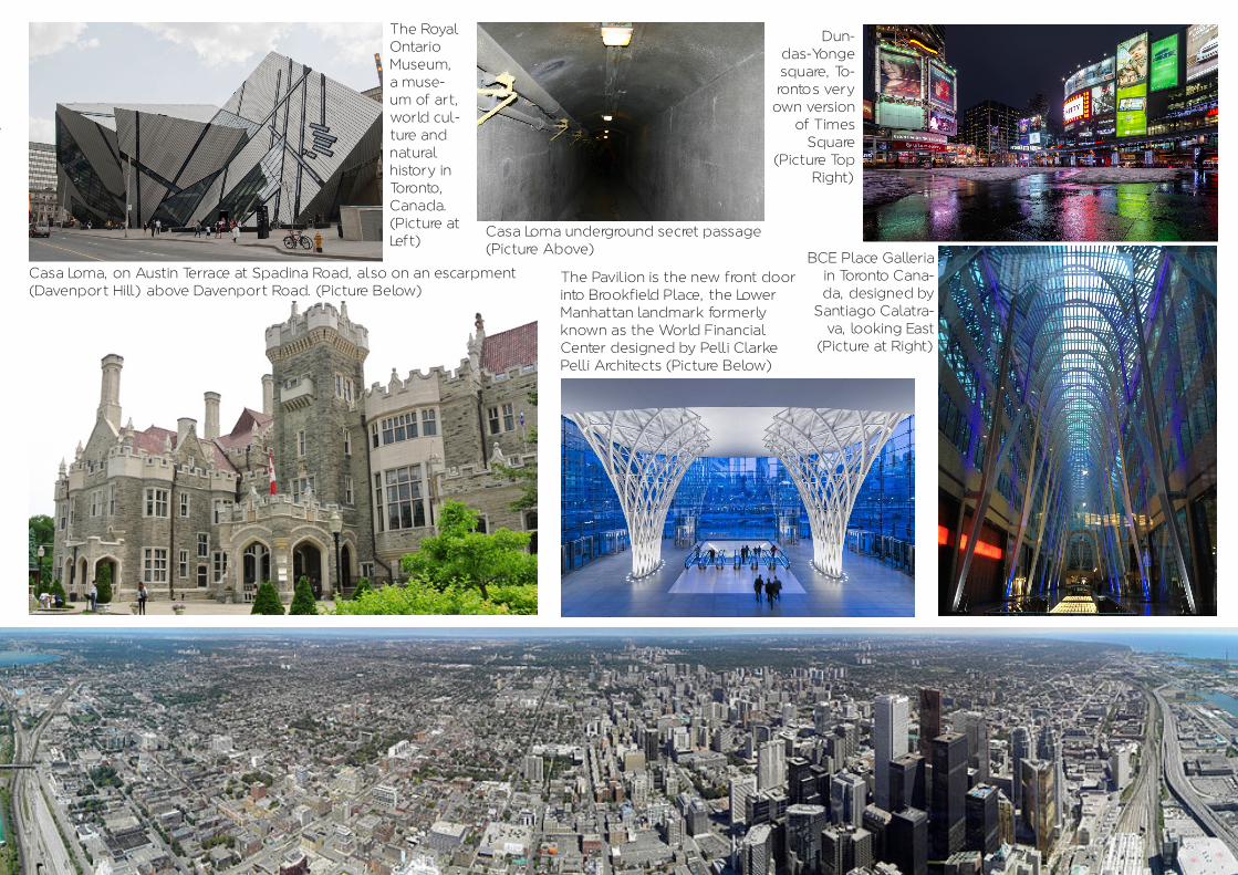
Casa Loma, on Austin Terrace at Spadina Road, also on an escarpment (Davenport Hill) above Davenport Road. (Picture Below)
The Pavilion is the new front door into Brookfield Place, the Lower Manhattan landmark formerly known as the World Financial Center designed by Pelli Clarke Pelli Architects (Picture Below)
Dun-das-Yonge square, To-ronto–s very
own version of Times
Square (Picture Top
Right)
BCE Place Galleria in Toronto Cana-da, designed by
Santiago Calatra-va, looking East
(Picture at Right)
Casa Loma underground secret passage(Picture Above)
The Royal Ontario Museum, a muse-um of art, world cul-ture and natural history in Toronto, Canada.(Picture at Left)
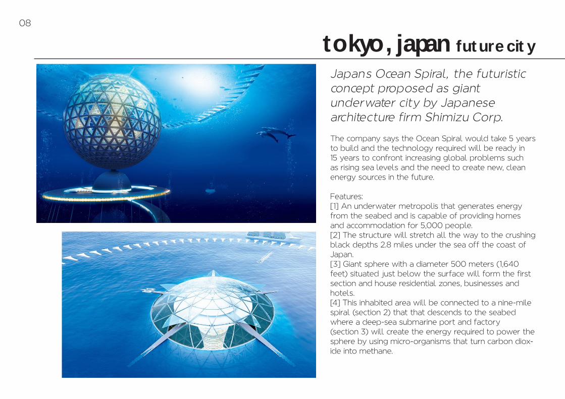
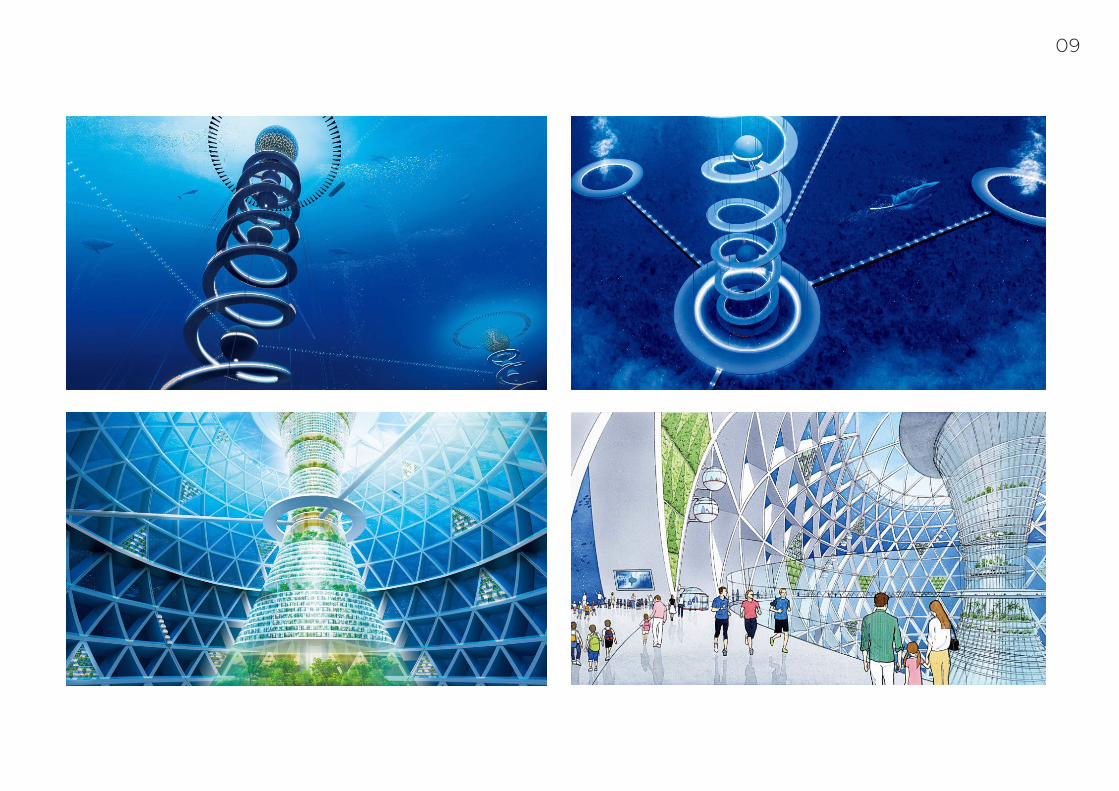
tokyo, japan future city
Japan–s Ocean Spiral, the futuristic concept proposed as giantunderwater city by Japanesearchitecture firm Shimizu Corp.
The company says the Ocean Spiral would take 5 years to build and the technology required will be ready in 15 years to confront increasing global problems such as rising sea levels and the need to create new, clean energy sources in the future.
Features:[1] An underwater metropolis that generates energy from the seabed and is capable of providing homes and accommodation for 5,000 people.[2] The structure will stretch all the way to the crushing black depths 2.8 miles under the sea off the coast of Japan.[3] Giant sphere with a diameter 500 meters (1,640 feet) situated just below the surface will form the first section and house residential zones, businesses and hotels.[4] This inhabited area will be connected to a nine-mile spiral (section 2) that that descends to the seabed where a deep-sea submarine port and factory(section 3) will create the energy required to power the sphere by using micro-organisms that turn carbon diox-ide into methane.
08
09

neighbourhood unit town planning principles
Clarence Arthur Perry (1872-1944) was an American planner. He formulated his early ide-as about the neighborhood unit and commu-nity life which is 5-minute walk to define walk-ing distances from residential to non-residential components. Perry was very concerned about the walkability to and from schools. His ide-as were realized in neighborhoods like Rad-burn through the work of Clarence Stein.
Perry's 6 basic principles of neighbourhood theory:
[1] Traffic routes should not pass through residential neighbourhoods.[2] Interior street pattern should be de-signed and constructed through use of cul-de-sacs, curve layout and light duty surfacing[3] The population of the neighbourhood should be that which is necessary to sup-port its elementary school.[4] The neighbourhood focal point should be the elementary school centrally lo-cated on a common or green along with other institutions that have services area coincident with the neighbourhood bound-aries.[5] The radius of the neighbourhood should be a maximum of 1/4 mile[6] Shopping dictricts should be sited at the edge of the neighbourhood.
Sir Clarence Arthur Perry, one of the famous people in plan-ning during the 5th century B.C. (Picture Above)
The neighbourhood unit plan in 1929 which in-cluded traffic routes, safe interior street patterns, estimated population, schools, green spaces and service area.(Picture at bottom left)
The traditional neighbor-hood includes a high level
of connectivity allowing actual walk distances to nearly meet the 1/4 mile
radius.(Picture at bottom right)
10

The conventional suburban model of development provides very little connec-tivity from the residences to the places of business making it very auto-dependent.(Picture at above)
The Neighbourhood Idea
A sound area for living with:
[1] Adequate school and parks within a half mile walk[2] Major streets around rather than through the neigh-bourhood[3] Seperate reidential and non residential districts[4] Population large enough to support an elementary school. Usually 5000 to 10000 people[5] Some neighbourhood stores and services
Reproduced from Comprehensive Planning for The Whittier Neighbourhood, courtesy of Minneapolis City Planning Commision Perry's original concept.(Picture at Below)
The neighbourhood unit was conceived of as a comprehensive physical planning tool, to be utilised for designing self-contained residential neighbourhoods which promot-ed a community centric lifestyle, away from the noise and air pollution.
Examples of well neighbourhood planning.Pictures at Left and Above.
11

Chicago's Southside, shows a clearly definable neigh-bourhood subdistrict planning.
[A] Physical feature - the large open park to the north.
[B] Major Street - Stony Island Avenue, with its heavy traffic and major bus route, to the west.
[C] Ethnic grouping - an almost 100 per cent Negro population and an almost 100 per cent white pop-ulation are seperated, at least temporarily, by Stony Island Avenue.
[D] Focal points - the retail shopping area along both sides of Stony Island Avenue is a local center of pedestrian attraction.
[E] Residential building type - the six residential blocks in the subdistrict are comprised exclusively of three story apartment house. There is an abrupt shift to prestige type single family residences to the east and to a mixture of one and two family dwellings to the south.
[F] Neighbourhood associations - attempts are un-derway to organize a local citizens groupto improve the area within the neighbourhood subgroup bound-aries.
[G] Community facility service areas - all public school elementary pupils in the subdistrict attend the Parkside Elementary School.
12
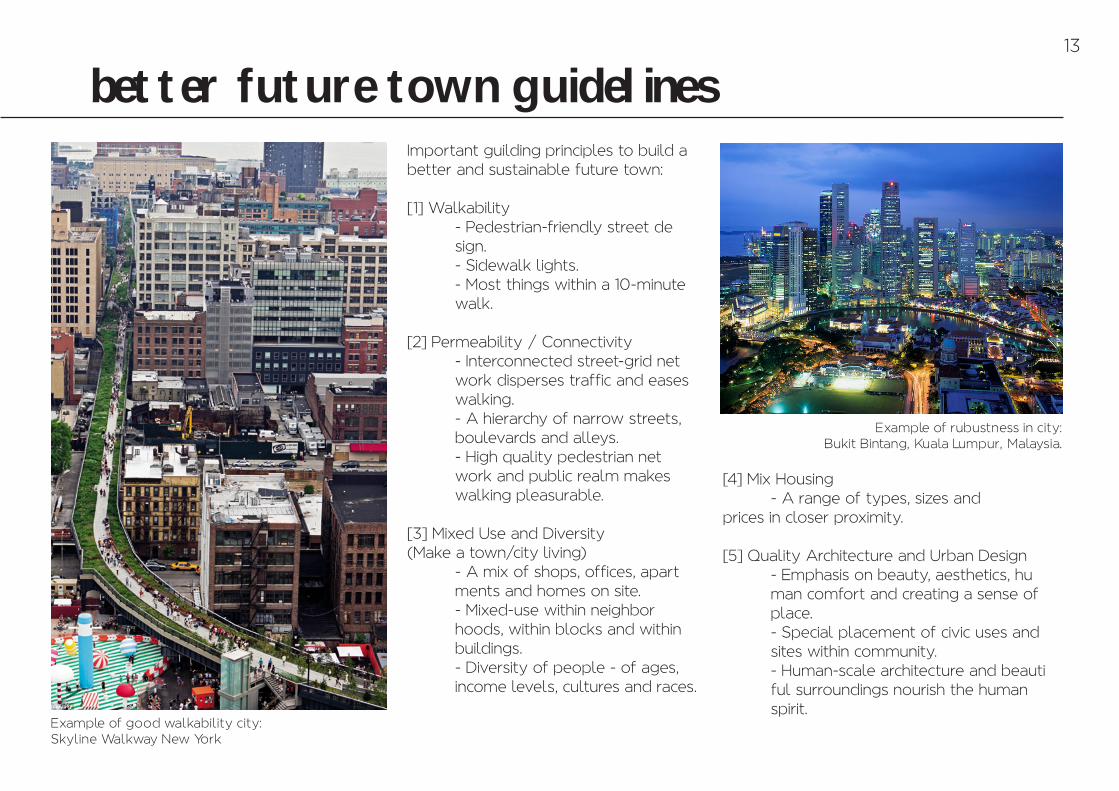
better future town guidelinesImportant guilding principles to build a better and sustainable future town:
[1] Walkability - Pedestrian-friendly street de sign. - Sidewalk lights. - Most things within a 10-minute walk.
[2] Permeability / Connectivity - Interconnected street-grid net work disperses traffic and eases walking. - A hierarchy of narrow streets, boulevards and alleys. - High quality pedestrian net work and public realm makes walking pleasurable.
[3] Mixed Use and Diversity(Make a town/city living) - A mix of shops, offices, apart ments and homes on site. - Mixed-use within neighbor hoods, within blocks and within buildings. - Diversity of people - of ages, income levels, cultures and races.
[4] Mix Housing - A range of types, sizes and prices in closer proximity.
[5] Quality Architecture and Urban Design - Emphasis on beauty, aesthetics, hu man comfort and creating a sense of place. - Special placement of civic uses and sites within community. - Human-scale architecture and beauti ful surroundings nourish the human spirit.
Example of rubustness in city: Bukit Bintang, Kuala Lumpur, Malaysia.
Example of good walkability city: Skyline Walkway New York
13
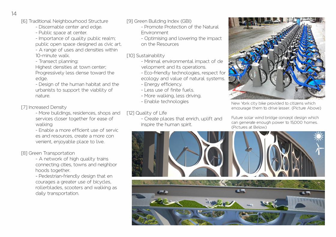
[6] Traditional Neighbourhood Structure - Discernable center and edge. - Public space at center. - Importance of quality public realm; public open space designed as civic art. - A range of uses and densities within 10-minute walk. - Transect planning: Highest densities at town center; Progressively less dense toward the edge. - Design of the human habitat and the urbanists to support the viability of nature.
[7] Increased Density - More buildings, residences, shops and services closer together for ease of walking - Enable a more efficient use of servic es and resources, create a more con venient, enjoyable place to live.
[8] Green Transportation - A network of high quality trains connecting cities, towns and neighbor hoods together. - Pedestrian-friendly design that en courages a greater use of bicycles, rollerblades, scooters and walking as daily transportation.
[9] Green Building Index (GBI) - Promote Protection of the Natural Environment - Optimising and lowering the impact on the Resources
[10] Sustainability - Minimal environmental impact of de velopment and its operations. - Eco-friendly technologies, respect for ecology and value of natural systems. - Energy efficiency. - Less use of finite fuels. - More walking, less driving. - Enable technologies
[12] Quality of Life - Create places that enrich, uplift and inspire the human spirit.
New York city bike provided to citizens which encourage them to drive lesser. (Picture Above)
Future solar wind bridge concept design which can generate enough power to 15,000 homes. (Pictures at Below)
14
bandar tun razak the city that i live in
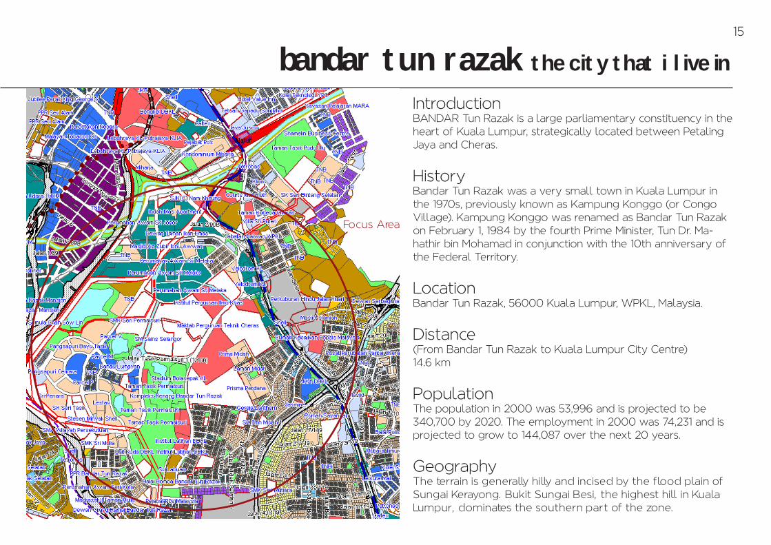
IntroductionBANDAR Tun Razak is a large parliamentary constituency in the heart of Kuala Lumpur, strategically located between Petaling Jaya and Cheras.
HistoryBandar Tun Razak was a very small town in Kuala Lumpur in the 1970s, previously known as Kampung Konggo (or Congo Village). Kampung Konggo was renamed as Bandar Tun Razak on February 1, 1984 by the fourth Prime Minister, Tun Dr. Ma-hathir bin Mohamad in conjunction with the 10th anniversary of the Federal Territory.
LocationBandar Tun Razak, 56000 Kuala Lumpur, WPKL, Malaysia.
Distance(From Bandar Tun Razak to Kuala Lumpur City Centre)14.6 km
PopulationThe population in 2000 was 53,996 and is projected to be 340,700 by 2020. The employment in 2000 was 74,231 and is projected to grow to 144,087 over the next 20 years.
GeographyThe terrain is generally hilly and incised by the flood plain of Sungai Kerayong. Bukit Sungai Besi, the highest hill in Kuala Lumpur, dominates the southern part of the zone.
Focus Area
15
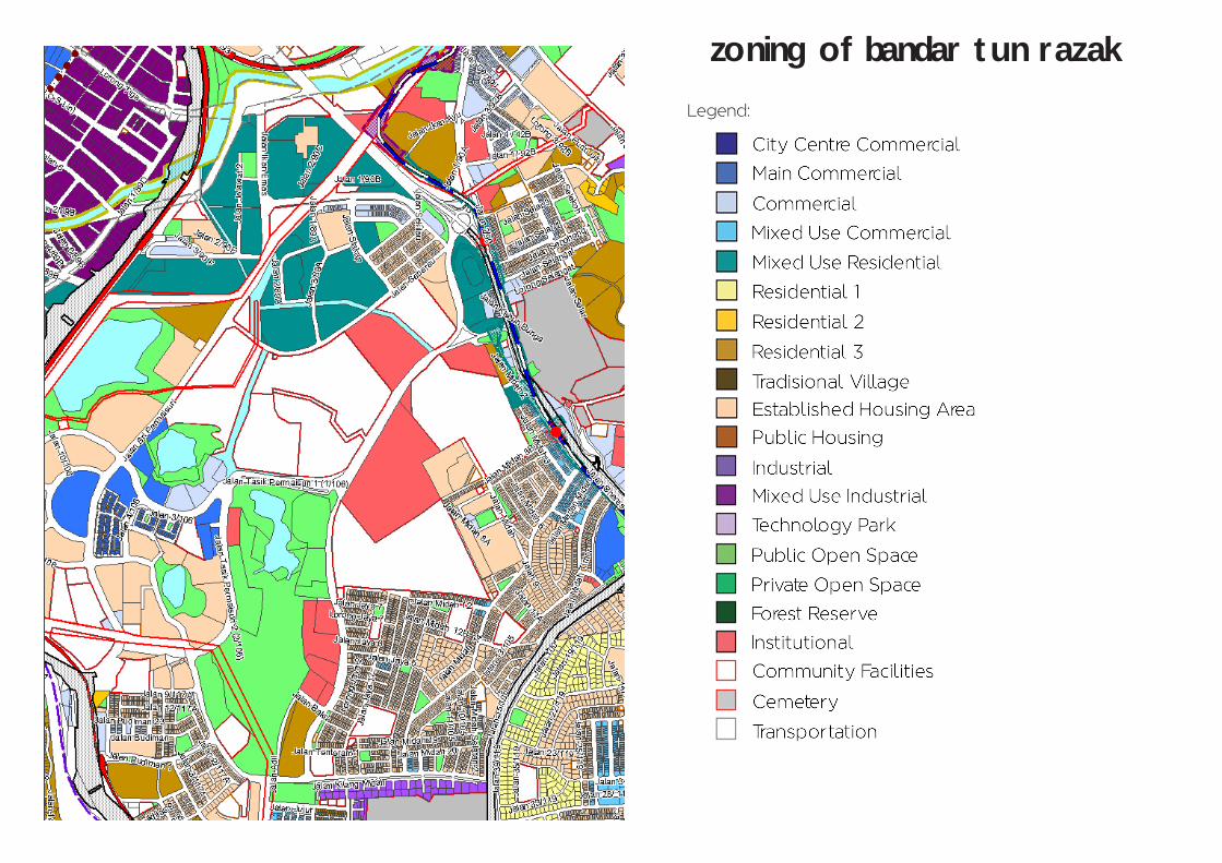
zoning of bandar tun razak
Legend:

residential area around bandar tun razakLegend:
11 Mixed Use Residential Area
Pangsapuri Cheras 4e- Mostly are flats which is lower costing- For low income citizens to live here.- All buildings look old and in bad conditions and bad maintenance- Living condition is not safe
2
3
4
5
17
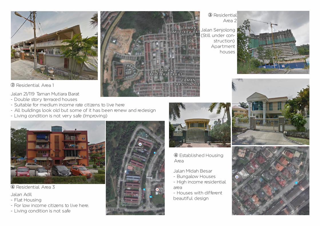
2 Residential Area 1
Jalan 21/119 Taman Mutiara Barat- Double story terraced houses- Suitable for medium income rate citizens to live here- All buildings look old but some of it has been renew and redesign- Living condition is not very safe (Improving)
3 ResidentialArea 2
Jalan Senjolong (Still under con-
struction)Apartment
houses
4 Residential Area 3
Jalan Adil- Flat Housing- For low income citizens to live here.- Living condition is not safe
4 Established Housing Area
Jalan Midah Besar- Bungalow Houses- High income residential area- Houses with different beautiful design
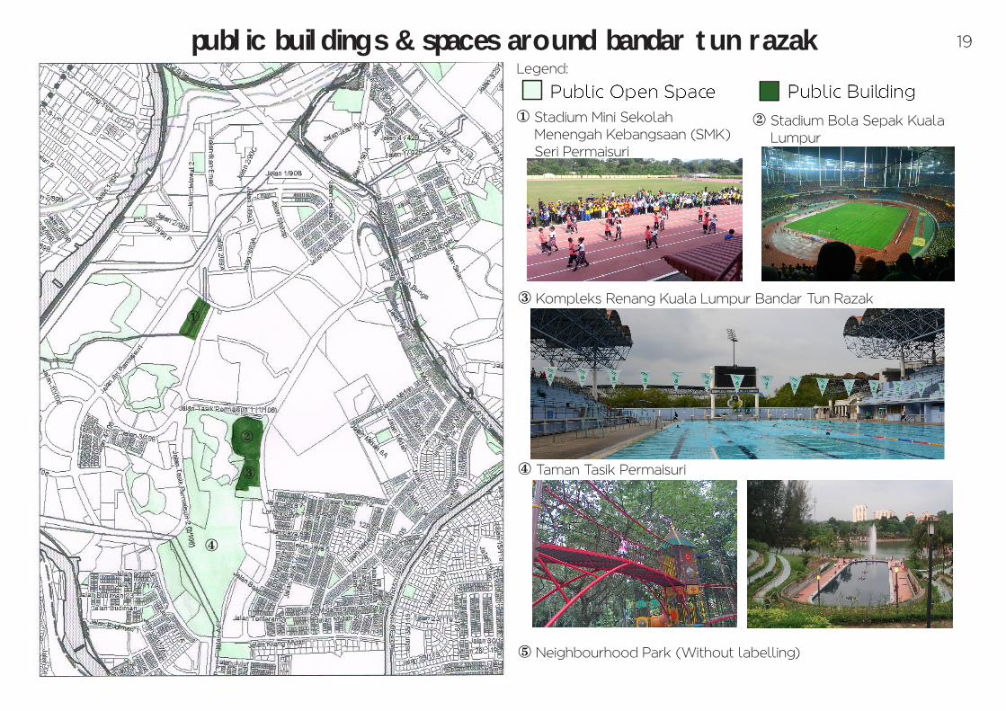
public buildings & spaces around bandar tun razak
1
2
3
4
1 Stadium Mini Sekolah Menengah Kebangsaan (SMK) Seri Permaisuri
2 Stadium Bola Sepak Kuala Lumpur
3 Kompleks Renang Kuala Lumpur Bandar Tun Razak
4 Taman Tasik Permaisuri
5 Neighbourhood Park (Without labelling)
Legend:
19
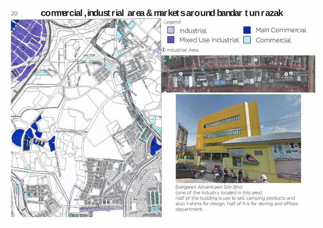
commercial, industrial area & markets around bandar tun razakLegend:
1
1 Industrial Area
Evergreen Adventuren Sdn Bhd(one of the industry located in this area)Half of the building is use to sell camping products and also t-shirts for design, half of it is for storing and offices department.
2
3
4
20

2 Mixed Use Industrial Area 3 Main Commercial Area 4 Commercial Area
Akhbar Harian China Press Berhad(one of the industry located in this area)The industry produce Chinese DailyNewspaper, ”中国报" (Zh–ngguó bào) inchinese.
Tesco Extra Cheras(one of the well-known commercial building located in this area)Commercial building which have poslaju of-fice, restaurants and others. A place for citi-zens to do groceries shopping.
Restoran Dhurbar & Budget Hotel(one of the indian restaurant and budgethotel located in this commercial area)Can be easy seen once you turn into the junction of Taman Midah road from Jalan Cheras highway.W
21
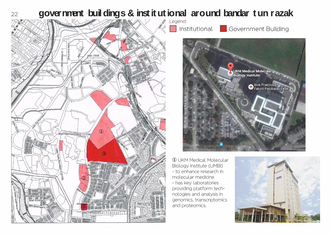
government buildings & institutional around bandar tun razakLegend:
3
5
2
14
1 UKM Medical Molecular Biology Institute (UMBI)- to enhance research in molecular medicine- has key laboratories providing platform tech-nologies and analysis in genomics, transcriptomics and proteomics.
22
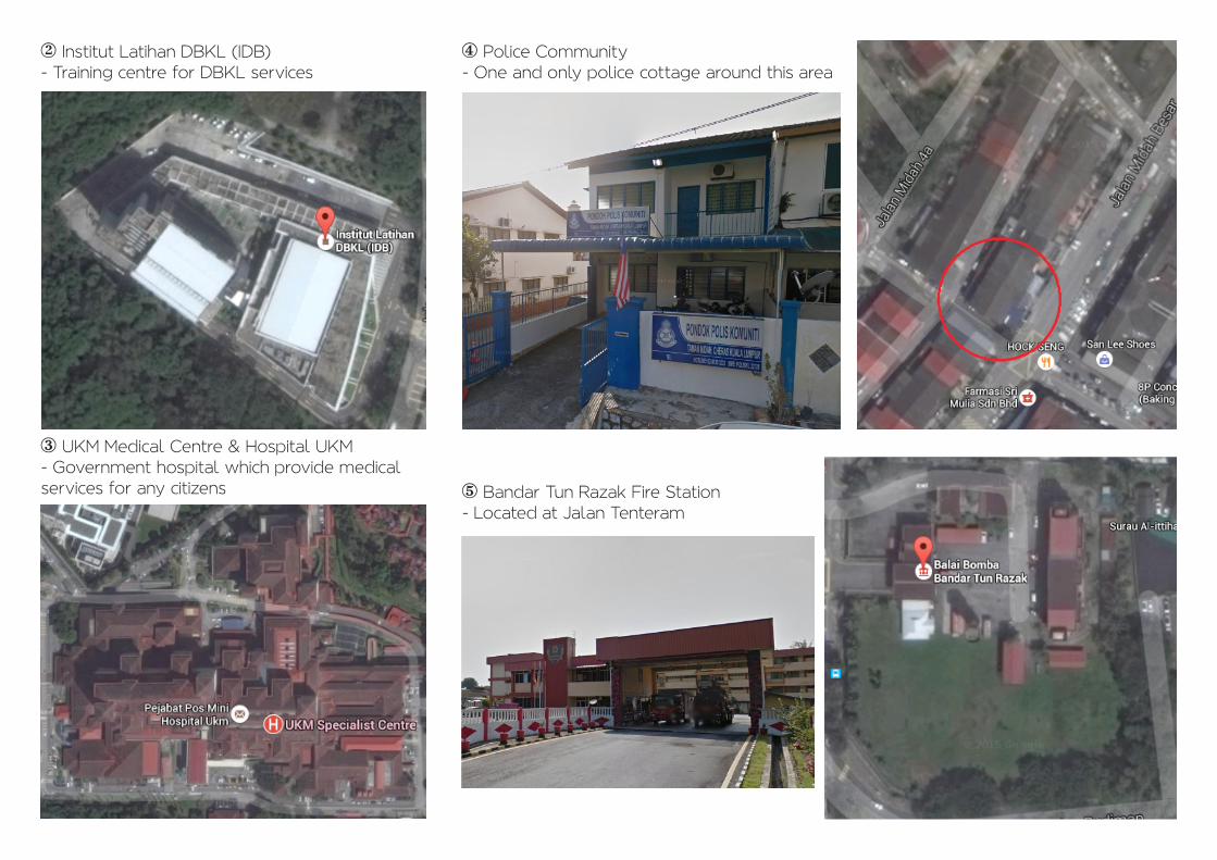
2 Institut Latihan DBKL (IDB)- Training centre for DBKL services
3 UKM Medical Centre & Hospital UKM- Government hospital which provide medical services for any citizens
4 Police Community- One and only police cottage around this area
5 Bandar Tun Razak Fire Station- Located at Jalan Tenteram
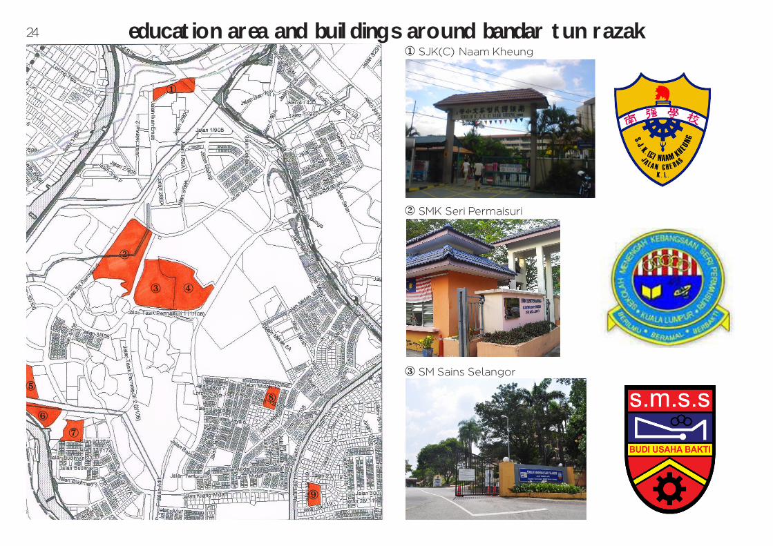
education area and buildings around bandar tun razak
1
2
3 4
5
6
7
8
1 SJK(C) Naam Kheung
2 SMK Seri Permaisuri
3 SM Sains Selangor
9
24

4 SM Sains Alam Shah
5 SK Seri Tasik
6 SMA Wilayah Persekutuan
7 SMK Seri Mulia
8 SK Taman Midah 1
9 SMK Seri Mutiara
25

transportation system around bandar tun razak1 Bandar Tun Razak LRT station (Mulia LRT station)Ampang Line(Sentul Timur-Sri Petaling route)- Carrying over 130,000 to 150,000 per day- Took around 1 hour 20 minutes to KL City Centre1
23
4
5
26
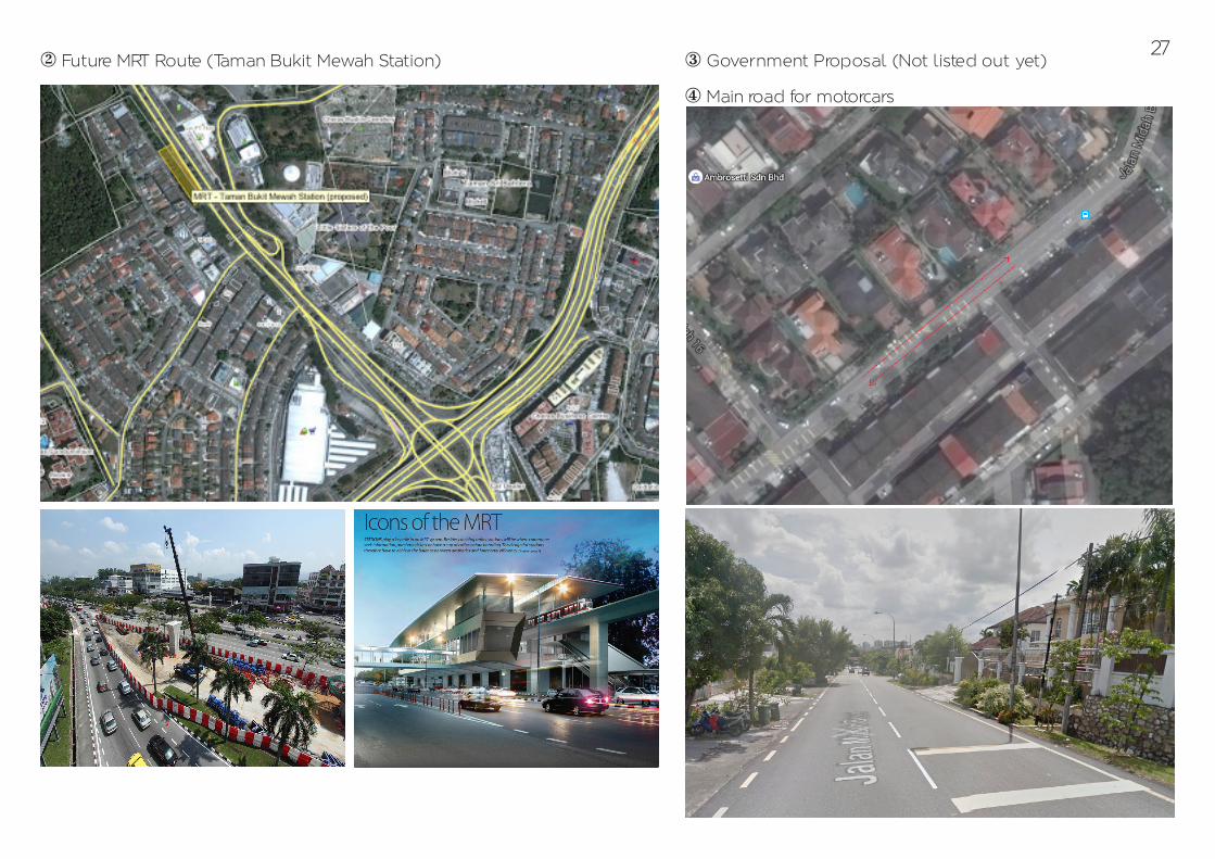
2 Future MRT Route (Taman Bukit Mewah Station) 3 Government Proposal (Not listed out yet)
4 Main road for motorcars
27

5 Myrapid KL Bus Route
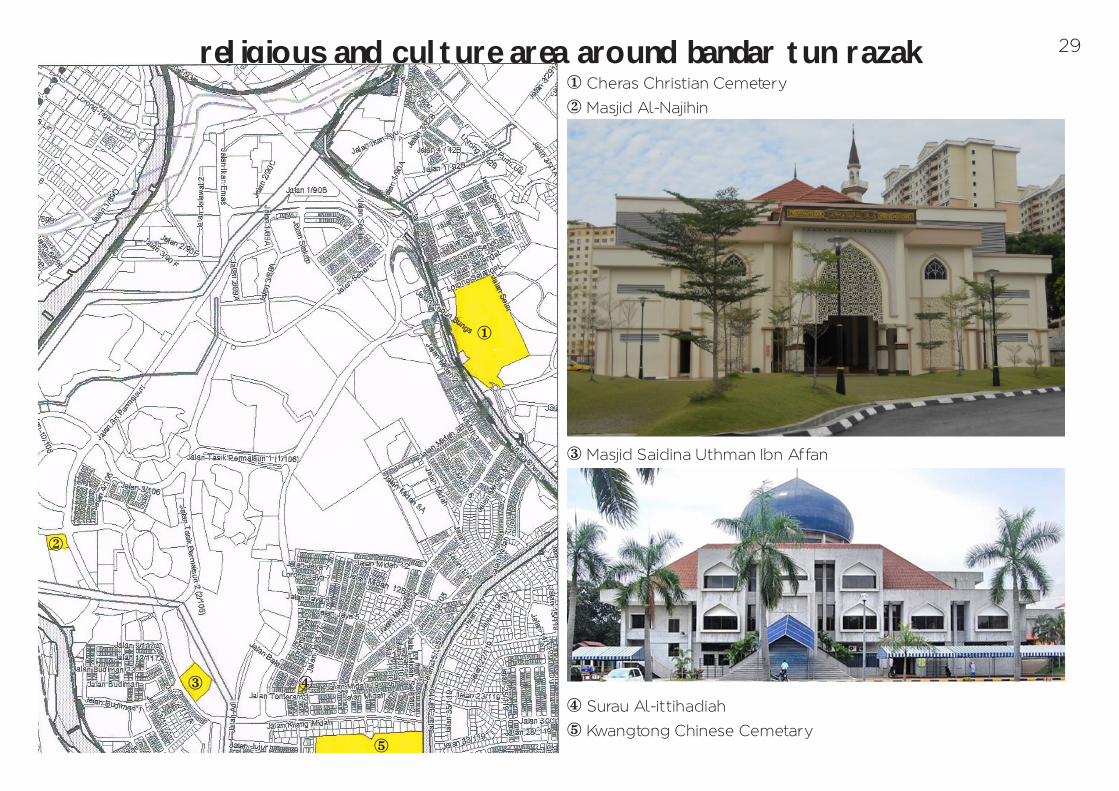
religious and culture area around bandar tun razak
1
2
3 4
5
1 Cheras Christian Cemetery
2 Masjid Al-Najihin
3 Masjid Saidina Uthman Ibn Affan
4 Surau Al-ittihadiah
5 Kwangtong Chinese Cemetary
29
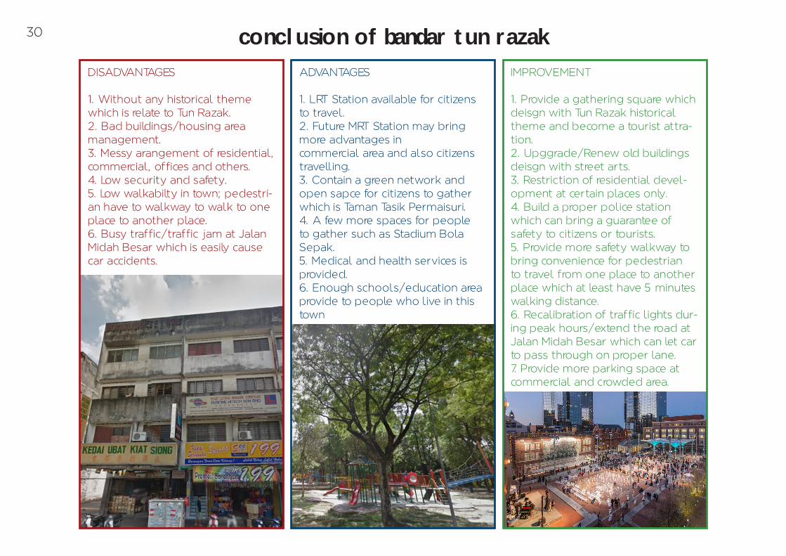
conclusion of bandar tun razakDISADVANTAGES
1. Without any historical theme which is relate to Tun Razak.2. Bad buildings/housing area management.3. Messy arangement of residential, commercial, offices and others.4. Low security and safety.5. Low walkabilty in town; pedestri-an have to walkway to walk to one place to another place.6. Busy traffic/traffic jam at Jalan Midah Besar which is easily cause car accidents.
ADVANTAGES
1. LRT Station available for citizens to travel.2. Future MRT Station may bring more advantages incommercial area and also citizens travelling.3. Contain a green network and open sapce for citizens to gather which is Taman Tasik Permaisuri.4. A few more spaces for people to gather such as Stadium Bola Sepak.5. Medical and health services is provided.6. Enough schools/education area provide to people who live in this town
IMPROVEMENT
1. Provide a gathering square which deisgn with Tun Razak historical theme and become a tourist attra-tion.2. Upggrade/Renew old buildings deisgn with street arts.3. Restriction of residential devel-opment at certain places only.4. Build a proper police station which can bring a guarantee of safety to citizens or tourists.5. Provide more safety walkway to bring convenience for pedestrian to travel from one place to another place which at least have 5 minutes walking distance.6. Recalibration of traffic lights dur-ing peak hours/extend the road at Jalan Midah Besar which can let car to pass through on proper lane.7. Provide more parking space at commercial and crowded area.
30
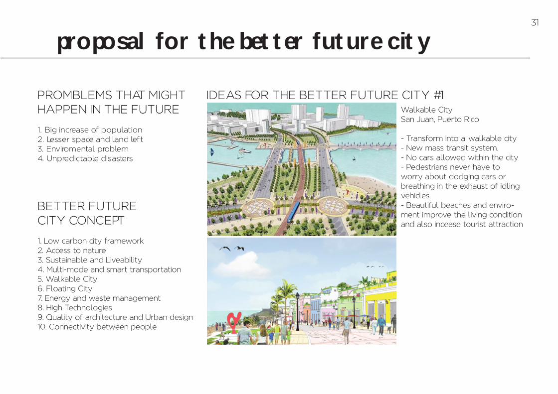
proposal for the better future city
PROMBLEMS THAT MIGHT HAPPEN IN THE FUTURE
1. Big increase of population2. Lesser space and land left3. Enviromental problem4. Unpredictable disasters
BETTER FUTURE CITY CONCEPT
1. Low carbon city framework2. Access to nature3. Sustainable and Liveability4. Multi-mode and smart transportation5. Walkable City6. Floating City7. Energy and waste management8. High Technologies9. Quality of architecture and Urban design10. Connectivity between people
IDEAS FOR THE BETTER FUTURE CITY #1Walkable City San Juan, Puerto Rico
- Transform into a –walkable city- New mass transit system.- No cars allowed within the city- Pedestrians never have to worry about dodging cars or breathing in the exhaust of idling vehicles- Beautiful beaches and enviro-ment improve the living condition and also incease tourist attraction
31

IDEAS FOR THE BETTER FUTURE CITY #2
A Sustainable CityMasdar City, Dubai - Best practices in environmental building technologies- Strong focus on community connections and social interaction in green spaces- Produce 50 percent of its own energy through solar power and offset its carbon footprint via mass transit.- The design consists of 550 residential villas, organic farms, educational facilities and 600,000 square feet of solar panels.
appendix1. City-journal.org,. –Tradition And The Modern City By Robert Adam, City Journal Autumn 1995–. N.p., 1995. Web. 6 Nov. 2015.2. CNN,. –Insane Ocean Spiral Proposed As Giant Underwater City - CNN.Com–. N.p., 2015. Web. 6 Nov. 2015.3. Crystalinks.com,. –Uruk - Ur - The Great Ziggurat - Crystalinks–. N.p., 2015. Web. 6 Nov. 2015.4. Dalevilletowncenter.com,. –Daleville Town Center - Traditional Neighborhood Development–. N.p., 2015. Web. 6 Nov. 2015.5. Dbkl.gov.my,. –Kuala Lumpur Structure Plan 2020 : Strategic Zone–. N.p., 2015. Web. 6 Nov. 2015.6. Dictionary.com,. –The Definition Of City–. N.p., 2015. Web. 6 Nov. 2015.7. Futurecity.glasgow.gov.uk,. –Future City Glasgow | Glasgow City Council–. N.p., 2015. Web. 6 Nov. 2015.8. Google Maps,. –Google Maps–. N.p., 2015. Web. 6 Nov. 2015.9. GraphicRiver,. –Minimal Interior Design Brochure–. N.p., 2015. Web. 6 Nov. 2015.10. Jp.myrapid.com.my,. –Myrapid Routes–. N.p., 2015. Web. 6 Nov. 2015.11. Lloyd Lawhon, L. –The Neighborhood Unit: Physical Design Or Physical Determinism?–. Journal of Planning History 8.2 (2009): 111-132. Web. 6 Nov. 2015.12. Mark, Joshua. –Uruk–. Ancient History Encyclopedia. N.p., 2015. Web. 6 Nov. 2015.13. Mymrt.com.my,. –MYMRT | MRT Corp - Official Webpage For The Klang Valley My Rapid Transit.–. N.p., 2015. Web. 6 Nov. 2015.14. Myrapid.com.my,. N.p., 2015. Web. 6 Nov. 2015.15. Pinterest.com,. N.p., 2015. Web. 6 Nov. 2015.16. Popular Science,. –Attractive Italian Viaduct Has Wind Turbines Built In–. N.p., 2015. Web. 6 Nov. 2015.17. Team, Maplandia.com. –Cheras Map | Malaysia Google Satellite Maps–. Maplandia.com. N.p., 2015. Web. 6 Nov. 2015.18. Teams, Malaxi. –Rapid KL - Ampang Line, Putra Line (Peta Perjalanan LRT)–. Malaxi.com. N.p., 2015. Web. 6 Nov. 2015.19. WebUrbanist,. –Walkability & Hyperdensity: 14 Concepts For Future Cities–. N.p., 2014. Web. 6 Nov. 2015.20. Wikipedia,. –Bandar Tun Razak–. N.p., 2015. Web. 6 Nov. 2015.21. Wikipedia,. –Bandar Tun Razak LRT Station–. N.p., 2015. Web. 6 Nov. 2015.22. Wikipedia,. –City–. N.p., 2015. Web. 6 Nov. 2015.23. Wikipedia,. –Masdar City–. N.p., 2015. Web. 6 Nov. 2015.24. Wikipedia,. –Neighbourhood Unit–. N.p., 2015. Web. 6 Nov. 2015.25. Wikipedia,. –Toronto–. N.p., 2015. Web. 6 Nov. 2015.26. Wikipedia,. –Uruk–. N.p., 2015. Web. 6 Nov. 2015.27. Www1.toronto.ca,. N.p., 2015. Web. 6 Nov. 2015.
33
NG LEK YUEN0324010
FNBE JULY 2015LECTURERS :MS DELLIYA – MS HASMANIRA – MISS IFFAFINAL PROJECT | PART A | ENBE