Embed Size (px)
Citation preview
DIT Spatial Information Strategy 2012
Page 1
Masters in Spatial Information
Management
Department of Spatial Information Science
DT113 (2011 – 2013)
Geographic Information Management 2
SSPL 9050
GI Management Organisational Strategy in DIT
Submitted by
Catherine Kavanagh
Andrea Acinelli
James O Byrne
Submission Date: 09th
November 2012
For the attention of: Mr. Paddy Prendergast
DIT Spatial Information Strategy 2012
Page 2
Contents
1. Introduction ....................................................................................................... 4
1.1 Project Brief ................................................................................................. 4
1.2 Background .................................................................................................. 4
1.3 Proposed Methodology ............................................................................... 4
1.4 Face to Face Interviews ................................................................................ 6
1.6 Project Scope ............................................................................................... 6
1.7 Deliverables ................................................................................................. 7
1.8 Constraints .................................................................................................. 7
2. Overview of Current Spatial Data System ........................................................... 8
2.1 Organisational Overview .............................................................................. 8
2.2 Stakeholders ................................................................................................ 8
2.3 Previous Audits and Reports ........................................................................ 9
2.4 Stakeholder Interviews ................................................................................ 9
2.5 Overview of Interview Results ..................................................................... 9
3 Assessment of organizational needs ...................................................................... 11
3.1 Methodology overview .................................................................................. 11
3.2 Identification of organizational issues ............................................................ 11
3.3 Identification of organizational needs ............................................................ 15
3.4 Prioritize needs .............................................................................................. 16
3.5 Conclusions .................................................................................................... 17
4 SWOT analysis of current system .......................................................................... 18
4.1 Introduction ................................................................................................... 18
4.2 Methodology .................................................................................................. 18
4.3 SWOT chart .................................................................................................... 18
4.4 Filter tests ...................................................................................................... 19
4.5 Filtered SWOT chart ....................................................................................... 20
4.6 SWOT alignment ............................................................................................ 21
5. Business Case Analysis ..................................................................................... 23
5.1 Cost benefit analysis .................................................................................. 23
5.2 Recommendations ..................................................................................... 24
6. Strategy Proposal ............................................................................................. 26
6.1 Key roles and responsibilities ..................................................................... 26
6.2 Data Acquisition ......................................................................................... 28
6.3 Data management ..................................................................................... 28
6.4 Implementation ......................................................................................... 31
6.5 Monitoring ................................................................................................. 33
References ............................................................................................................... 34
DIT Spatial Information Strategy 2012
Page 3
List of Tables
Table 1 - Report Deliverables ..................................................................................... 5
Table 2 - List of Interviewees ...................................................................................... 6
Table 3- Project Stakeholders ..................................................................................... 8
Table 4 - Issues identified ......................................................................................... 14
Table 5 - Legend for Issues Identified ....................................................................... 15
Table 6 - Identified needs ......................................................................................... 16
Table 7 - Key of Identified Needs .............................................................................. 16
Table 8 - Priority of Requirements ............................................................................ 17
Table 9 - Key of Priority of requirements .................................................................. 17
Table 10 - SWOT factors ........................................................................................... 19
Table 11 - Filtering tests for strengths and weaknesses ............................................ 19
Table 12 - Filtering tests for opportunities and threats ............................................. 20
Table 13 - Filtered SWOT .......................................................................................... 21
Table 14- Cost/Benefit Analysis ................................................................................ 24
Table 15 - Strategy Development Milestones ........................................................... 26
Table 16 - Roles and Responsibilities ........................................................................ 27
List of Figures
Figure 1 - DIT Organisation Overview (areas investigated as part of this report shown in
yellow) ....................................................................................................................... 8
Figure 2 - Project Organisation Chart ....................................................................... 26
Figure 3 - Data management procedure ................................................................... 28
Figure 4 - Sample folder structure ............................................................................ 30
DIT Spatial Information Strategy 2012
Page 4
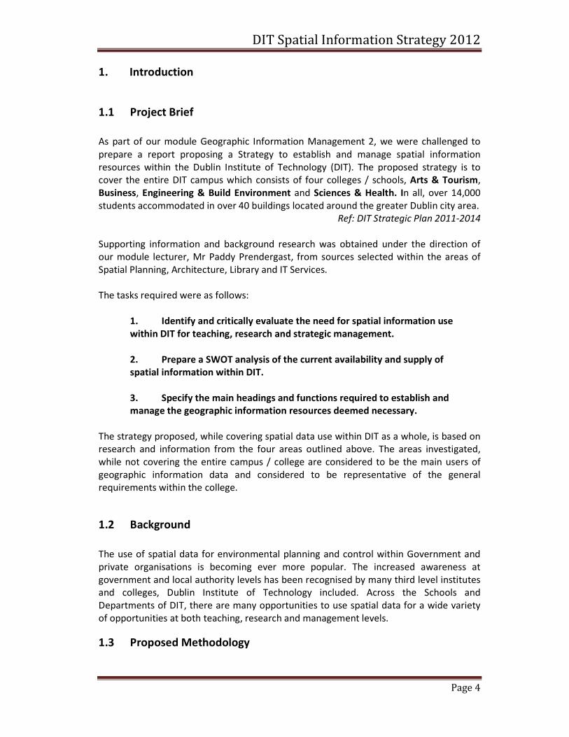
1. Introduction
1.1 Project Brief
As part of our module Geographic Information Management 2, we were challenged to
prepare a report proposing a Strategy to establish and manage spatial information
resources within the Dublin Institute of Technology (DIT). The proposed strategy is to
cover the entire DIT campus which consists of four colleges / schools, Arts & Tourism,
Business, Engineering & Build Environment and Sciences & Health. In all, over 14,000
students accommodated in over 40 buildings located around the greater Dublin city area.
Ref: DIT Strategic Plan 2011-2014
Supporting information and background research was obtained under the direction of
our module lecturer, Mr Paddy Prendergast, from sources selected within the areas of
Spatial Planning, Architecture, Library and IT Services.
The tasks required were as follows:
1. Identify and critically evaluate the need for spatial information use
within DIT for teaching, research and strategic management.
2. Prepare a SWOT analysis of the current availability and supply of
spatial information within DIT.
3. Specify the main headings and functions required to establish and
manage the geographic information resources deemed necessary.
The strategy proposed, while covering spatial data use within DIT as a whole, is based on
research and information from the four areas outlined above. The areas investigated,
while not covering the entire campus / college are considered to be the main users of
geographic information data and considered to be representative of the general
requirements within the college.
1.2 Background
The use of spatial data for environmental planning and control within Government and
private organisations is becoming ever more popular. The increased awareness at
government and local authority levels has been recognised by many third level institutes
and colleges, Dublin Institute of Technology included. Across the Schools and
Departments of DIT, there are many opportunities to use spatial data for a wide variety
of opportunities at both teaching, research and management levels.
1.3 Proposed Methodology
DIT Spatial Information Strategy 2012
Page 5
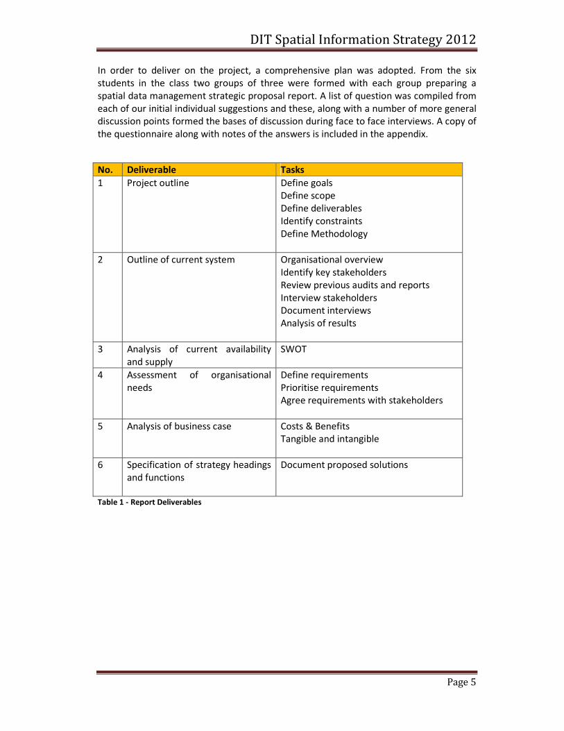
In order to deliver on the project, a comprehensive plan was adopted. From the six
students in the class two groups of three were formed with each group preparing a
spatial data management strategic proposal report. A list of question was compiled from
each of our initial individual suggestions and these, along with a number of more general
discussion points formed the bases of discussion during face to face interviews. A copy of
the questionnaire along with notes of the answers is included in the appendix.
No. Deliverable Tasks
1 Project outline Define goals
Define scope
Define deliverables
Identify constraints
Define Methodology
2 Outline of current system Organisational overview
Identify key stakeholders
Review previous audits and reports
Interview stakeholders
Document interviews
Analysis of results
3 Analysis of current availability
and supply
SWOT
4 Assessment of organisational
needs
Define requirements
Prioritise requirements
Agree requirements with stakeholders
5 Analysis of business case Costs & Benefits
Tangible and intangible
6 Specification of strategy headings
and functions
Document proposed solutions
Table 1 - Report Deliverables
DIT Spatial Information Strategy 2012
Page 6
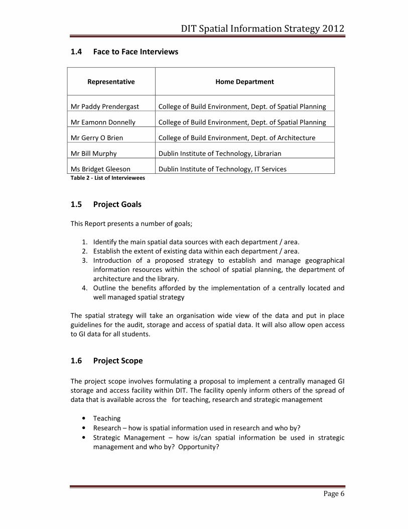
1.4 Face to Face Interviews
Representative
Home Department
Mr Paddy Prendergast
College of Build Environment, Dept. of Spatial Planning
Mr Eamonn Donnelly
College of Build Environment, Dept. of Spatial Planning
Mr Gerry O Brien
College of Build Environment, Dept. of Architecture
Mr Bill Murphy
Dublin Institute of Technology, Librarian
Ms Bridget Gleeson
Dublin Institute of Technology, IT Services Table 2 - List of Interviewees
1.5 Project Goals
This Report presents a number of goals;
1. Identify the main spatial data sources with each department / area.
2. Establish the extent of existing data within each department / area.
3. Introduction of a proposed strategy to establish and manage geographical
information resources within the school of spatial planning, the department of
architecture and the library.
4. Outline the benefits afforded by the implementation of a centrally located and
well managed spatial strategy
The spatial strategy will take an organisation wide view of the data and put in place
guidelines for the audit, storage and access of spatial data. It will also allow open access
to GI data for all students.
1.6 Project Scope
The project scope involves formulating a proposal to implement a centrally managed GI
storage and access facility within DIT. The facility openly inform others of the spread of
data that is available across the for teaching, research and strategic management
• Teaching
• Research – how is spatial information used in research and who by?
• Strategic Management – how is/can spatial information be used in strategic
management and who by? Opportunity?
DIT Spatial Information Strategy 2012
Page 7
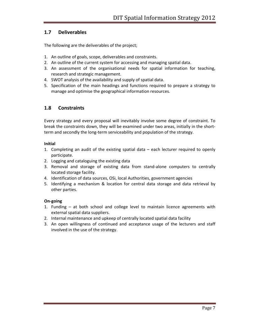
1.7 Deliverables
The following are the deliverables of the project;
1. An outline of goals, scope, deliverables and constraints.
2. An outline of the current system for accessing and managing spatial data.
3. An assessment of the organisational needs for spatial information for teaching,
research and strategic management.
4. SWOT analysis of the availability and supply of spatial data.
5. Specification of the main headings and functions required to prepare a strategy to
manage and optimise the geographical information resources.
1.8 Constraints
Every strategy and every proposal will inevitably involve some degree of constraint. To
break the constraints down, they will be examined under two areas, initially in the short-
term and secondly the long-term serviceability and population of the strategy.
Initial
1. Completing an audit of the existing spatial data – each lecturer required to openly
participate.
2. Logging and cataloguing the existing data
3. Removal and storage of existing data from stand-alone computers to centrally
located storage facility.
4. Identification of data sources, OSi, local Authorities, government agencies
5. Identifying a mechanism & location for central data storage and data retrieval by
other parties.
On-going
1. Funding – at both school and college level to maintain licence agreements with
external spatial data suppliers.
2. Internal maintenance and upkeep of centrally located spatial data facility
3. An open willingness of continued and acceptance usage of the lecturers and staff
involved in the use of the strategy.
DIT Spatial Information Strategy 2012
Page 8
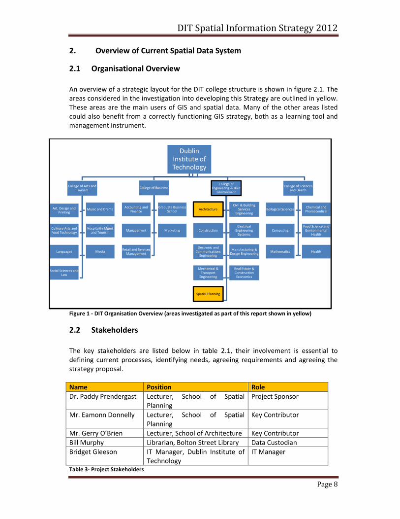
2. Overview of Current Spatial Data System
2.1 Organisational Overview
An overview of a strategic layout for the DIT college structure is shown in figure 2.1. The
areas considered in the investigation into developing this Strategy are outlined in yellow.
These areas are the main users of GIS and spatial data. Many of the other areas listed
could also benefit from a correctly functioning GIS strategy, both as a learning tool and
management instrument.
Figure 1 - DIT Organisation Overview (areas investigated as part of this report shown in yellow)
2.2 Stakeholders
The key stakeholders are listed below in table 2.1, their involvement is essential to
defining current processes, identifying needs, agreeing requirements and agreeing the
strategy proposal.
Name Position Role
Dr. Paddy Prendergast Lecturer, School of Spatial
Planning
Project Sponsor
Mr. Eamonn Donnelly Lecturer, School of Spatial
Planning
Key Contributor
Mr. Gerry O’Brien Lecturer, School of Architecture Key Contributor
Bill Murphy Librarian, Bolton Street Library Data Custodian
Bridget Gleeson IT Manager, Dublin Institute of
Technology
IT Manager
Table 3- Project Stakeholders
Dublin Institute of Technology
College of Arts and Tourism
Art, Design and Printing
Music and Drame
Culinary Arts and Food Technology
Hospitality Mgmt and Tourism
Languages Media
Social Sciences and Law
College of Business
Accounting and Finance
Graduate Business School
Management Marketing
Retail and Services Management
College of Engineering & Built
Environment
ArchitectureCivil & Building
Services Engineering
ConstructionElectrical
Engineering Systems
Electronic and Communications
Engineering
Manufacturing & Design Engineering
Mechanical & Transport
Engineering
Real Estate & Construction Economics
Spatial Planning
College of Sciences and Health
Boilogical SciencesChemical and
Pharaaceutical
ComputingFood Science and
Environmental Health
Mathematics Health
DIT Spatial Information Strategy 2012
Page 9
2.3 Previous Audits and Reports
• Towards the implementation of spatial data management best practice with the
department of spatial information science, Dublin Institute of Technology – Ciara
Sherwin, BSc Geomatics 2008.
• GI Management (SSPL9050) Module Assignment 2009, Dublin Institute of
Technology, Masters in Spatial information Management (GIM2) class 2008-10.
2.4 Stakeholder Interviews
Interviews were held with each of the stakeholders in order to
• identify current operational procedures and deficiencies for data collection,
access and management
• identify essential requirements and secondary requirements
• clarify their willingness to participate in the strategy and their role in the future
development of the strategy
• identify constraints to the implementation of the strategy
• take on board any suggestions or preferences
The interviews took approximately one hour and took the form of a series of questions
and an informal discussion on some of the issues.
The questions and results of the interviews are outlined in the following section. Each of
the questions has been assigned a priority based on the answers received.
2.5 Overview of Interview Results
A list of the questions and notes of the answers from each interviewee are contained in
the appendices. An outline of the main issues raised during interviews are listed below;
1. There is currently no driver for change - however it is generally agreed that a
comprehensive review and cataloguing of all existing spatial data would be
welcomed – the benefits far out-weigh the effort involved.
2. Best practice would necessitate having in place a general strategy on spatial data
– storage and sourcing.
3. Based on individual research and published work, there is a general awareness of
where to seek specific spatial data from, however there is a Lack of awareness of
spatial data assets within the college and there is duplication of data acquisition
in many cases.
DIT Spatial Information Strategy 2012
Page 10
4. Data is commonly sources by individuals with licence agreements being inn place
with the OSi.
5. The requirement for up to date and accurate data varies within departments.
6. A DIT funded and centrally driven management strategy would be the obvious
way forward – the library should be the data custodian.
7. A more formal DIT college procedure should be adopted to inform users of spatial
data 9students & staff) about licences and usage agreements on the use of spatial
data.
8. There is a lack of awareness and understanding of the metadata associated with
much of the existing spatial data.
9. Sharing and access to data held by colleagues is often not explored – new data is
simply ordered from sources outside the college.
DIT Spatial Information Strategy 2012
Page 11
3 Assessment of organizational needs
The following need analysis was carried out to evaluate the primary and secondary
requirements necessary for the successful implementation of the proposed strategy
which aims to establish and manage the GI (Geographic Information) resources in DIT.
3.1 Methodology overview
The needs for spatial information use in DIT were analysed under three main
organizational areas: teaching, research and strategic management.
All the issues raised during the interview process with the stakeholders were identified
and categorized under ten topics representing critical data management aspects. The
relevance of each issue was then assessed by looking at the number of key areas directly
affected and the results shown in Table 1 clearly indicate a group of issues (dark blue)
that have an impact on all three study areas.
It is particularly important that these groups of issues are addressed on the proposed
strategy because of the broader benefits that they can bring to DIT as an organization as
opposed to focusing on a problem that only affects the area of research for example.
After an accurate examination of all the main issues, organizational needs were identified
as shown in Table 2. In addition, each need was ranked based on two parameters: level of
importance (Priority) and how difficult it would be to be implemented (Achievable) due
to various constraints.
Finally, in Table 3 a needs assessment matrix was used to highlight and prioritize the
requirements (primary and secondary) that would form the basis to formulate an
effective and successful strategy for the management of spatial information in DIT.
It is important to note that due to the nature and restriction imposed on the preparation
of this document, and the extensive use of tables/graphics to present the result, it has
not been possible to extensively evaluate all the issues and needs that are required for a
full evaluation.
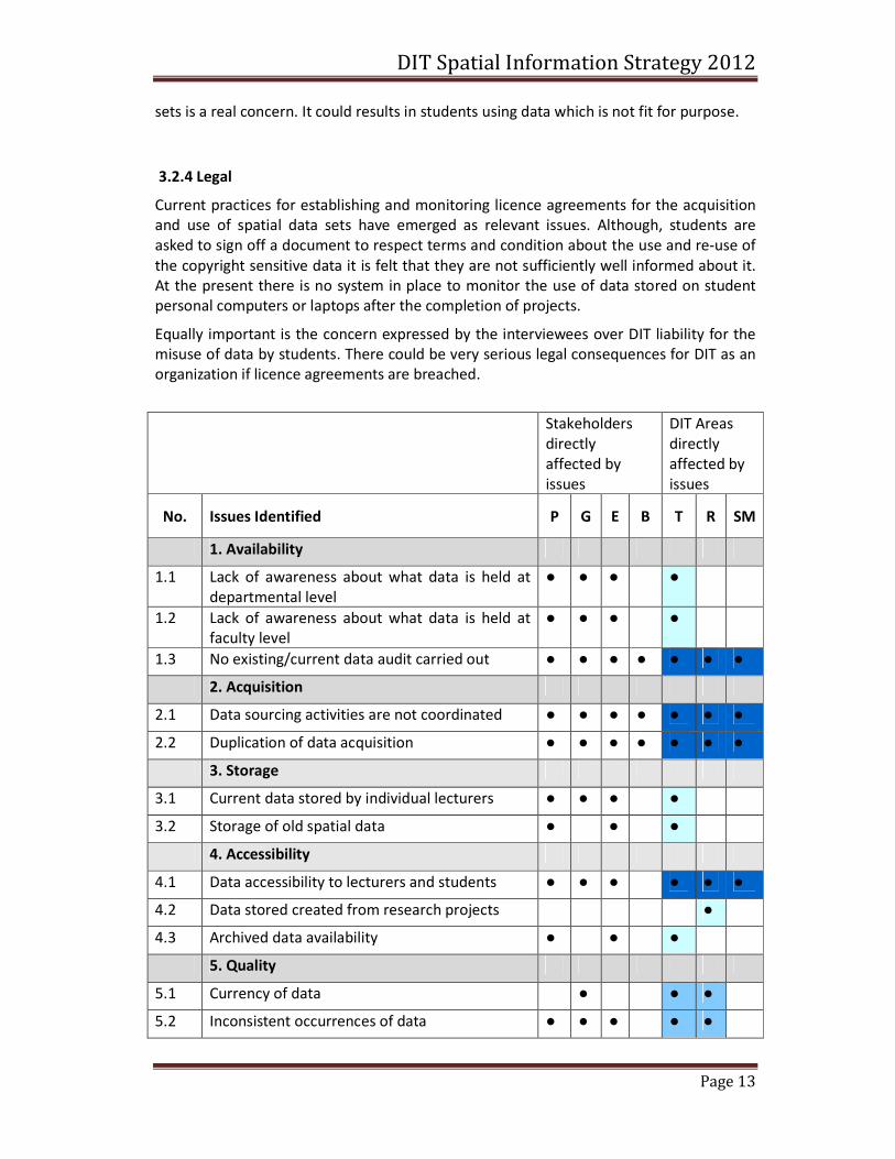
3.2 Identification of organizational issues
The review of the interview results has highlighted a large number of current
organizational issues in the management of GI resources in DIT. These issues affect, to
various degrees, different business processes and existing IT systems which are vital to
the daily activities of students, lecturers and administration staff.
For the purpose of this report a critical evaluation of the issues identified will be
presented in the following four paragraphs where they were grouped into four broader
topics. See Table 1 below for a tabular representation of each issue and the key study
areas directly affected.
DIT Spatial Information Strategy 2012
Page 12
3.2.1 Data Management
It has emerged that spatial data is generally managed differently on an individual basis
without a coordinated and collective effort at school or departmental level.
Consequently, duplication of data management activities are inevitable causing a
considerable amount of resources and time to be used inefficiently and at additional
costs.
The absence of a central data management system also highlight the issues associated
with data backups and security in terms of possible data loss due to hardware failures or
to inappropriate access restrictions set on the individual PC.
However, there is a strong awareness of the level of current inefficiencies among the
stakeholders interviewed showing that the problem is well recognized and acknowledged.
3.2.2 Data use and availability
The results of the survey indicated that data sourcing activities are not coordinated and it
also showed a lack of awareness about what type of spatial data is held available at both
departmental and faculty level although each individual lecturer knows to a small extent
what data is available from other colleagues within the same School.
The present situation is widely recognized as being one of the major causes for the
duplication of spatial data. However, there is evidence of a strong desire to complete an
extensive spatial data audit to solve part of the issue.
Two previous isolated attempts in preparing data catalogues were made but partially
failed due to a lack of time and financial support.
With regards to data storage, it has also emerged that a considerable amount of data sets
acquired in the past are now permanently stored on various personal computers and
other data sets obtained for specific projects/studies are being deleted at the end of each
academic year for obvious legal restrictions.
Moreover, a personal computer is available in the library that allows students to access
Ordnance Survey (OSi) data through requests submitted to the library staff.
Generally it can be stated that data is distributed to students either directly by the
lecturer (e.g. USB) or via the existing network infrastructure (personal network drives).
3.2.3 Data Quality
Requirements for data quality vary within departments and significant data quality issues
were raised with great concern with regards to certain characteristic. In fact, the high
level of currency, accuracy and reliability of some data sets is critical in particular to
researchers and architects (who need to represent reality) while the format and
consistent occurrences of data sets are more important for other teaching areas such as
in the School of Spatial Planning.
It has become apparent that failing to meet teaching and research requirements in
particular, can lead to poor quality researches and even threaten the reputation of the
faculty among academics and future students.
The questionnaire also revealed that the quality of metadata associated with spatial data
DIT Spatial Information Strategy 2012
Page 13
sets is a real concern. It could results in students using data which is not fit for purpose.
3.2.4 Legal
Current practices for establishing and monitoring licence agreements for the acquisition
and use of spatial data sets have emerged as relevant issues. Although, students are
asked to sign off a document to respect terms and condition about the use and re-use of
the copyright sensitive data it is felt that they are not sufficiently well informed about it.
At the present there is no system in place to monitor the use of data stored on student
personal computers or laptops after the completion of projects.
Equally important is the concern expressed by the interviewees over DIT liability for the
misuse of data by students. There could be very serious legal consequences for DIT as an
organization if licence agreements are breached.
Stakeholders
directly
affected by
issues
DIT Areas
directly
affected by
issues
No. Issues Identified P G E B T R SM
1. Availability
1.1 Lack of awareness about what data is held at
departmental level
● ● ● ●
1.2 Lack of awareness about what data is held at
faculty level
● ● ● ●
1.3 No existing/current data audit carried out ● ● ● ● ● ● ●
2. Acquisition
2.1 Data sourcing activities are not coordinated ● ● ● ● ● ● ●
2.2 Duplication of data acquisition ● ● ● ● ● ● ●
3. Storage
3.1 Current data stored by individual lecturers ● ● ● ●
3.2 Storage of old spatial data ● ● ●
4. Accessibility
4.1 Data accessibility to lecturers and students ● ● ● ● ● ●
4.2 Data stored created from research projects ●
4.3 Archived data availability ● ● ●
5. Quality
5.1 Currency of data ● ● ●
5.2 Inconsistent occurrences of data ● ● ● ● ●
DIT Spatial Information Strategy 2012
Page 14
Stakeholders
directly
affected by
issues
DIT Areas
directly
affected by
issues
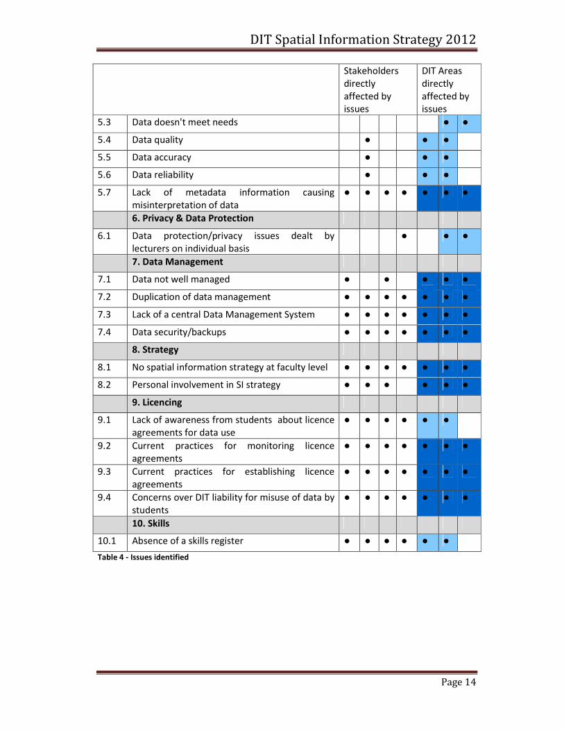
5.3 Data doesn't meet needs ● ●
5.4 Data quality ● ● ●
5.5 Data accuracy ● ● ●
5.6 Data reliability ● ● ●
5.7 Lack of metadata information causing
misinterpretation of data
● ● ● ● ● ● ●
6. Privacy & Data Protection
6.1 Data protection/privacy issues dealt by
lecturers on individual basis
● ● ●
7. Data Management
7.1 Data not well managed ● ● ● ● ●
7.2 Duplication of data management ● ● ● ● ● ● ●
7.3 Lack of a central Data Management System ● ● ● ● ● ● ●
7.4 Data security/backups ● ● ● ● ● ● ●
8. Strategy
8.1 No spatial information strategy at faculty level ● ● ● ● ● ● ●
8.2 Personal involvement in SI strategy ● ● ● ● ● ●
9. Licencing
9.1 Lack of awareness from students about licence
agreements for data use
● ● ● ● ● ●
9.2 Current practices for monitoring licence
agreements
● ● ● ● ● ● ●
9.3 Current practices for establishing licence
agreements
● ● ● ● ● ● ●
9.4 Concerns over DIT liability for misuse of data by
students
● ● ● ● ● ● ●
10. Skills
10.1 Absence of a skills register ● ● ● ● ● ●
Table 4 - Issues identified
DIT Spatial Information Strategy 2012
Page 15
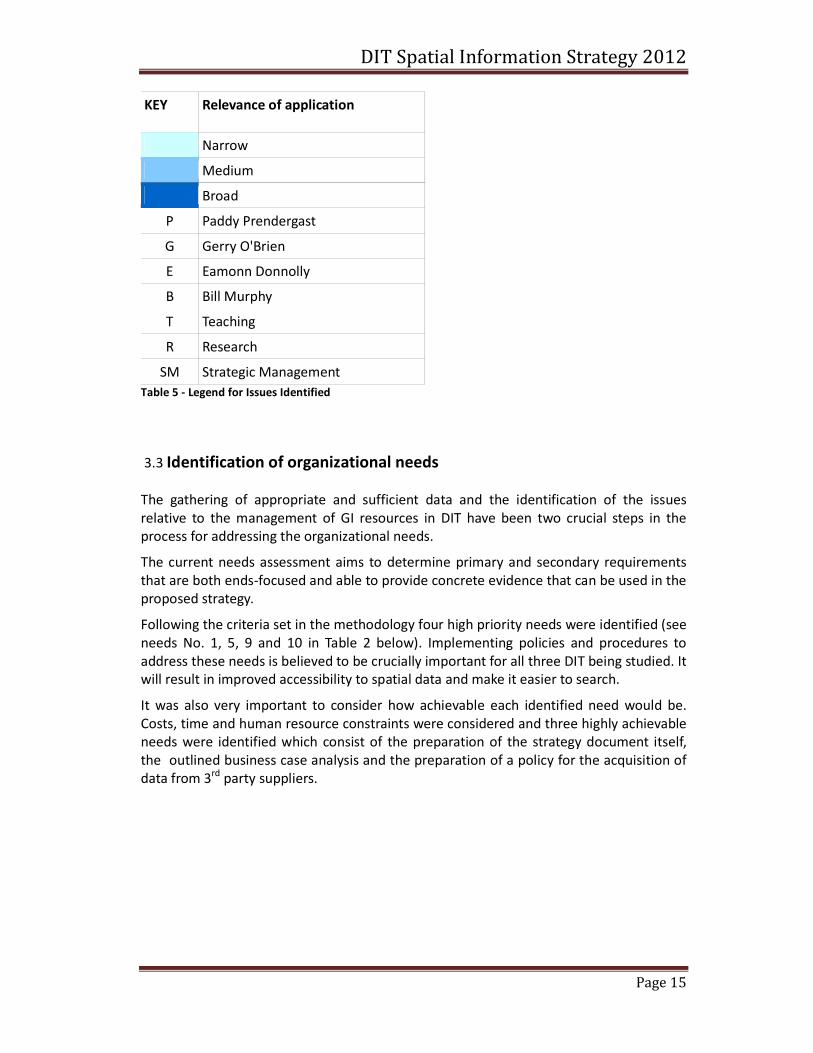
KEY Relevance of application
Narrow
Medium
Broad
P Paddy Prendergast
G Gerry O'Brien
E Eamonn Donnolly
B Bill Murphy
T Teaching
R Research
SM Strategic Management
Table 5 - Legend for Issues Identified
3.3 Identification of organizational needs
The gathering of appropriate and sufficient data and the identification of the issues
relative to the management of GI resources in DIT have been two crucial steps in the
process for addressing the organizational needs.
The current needs assessment aims to determine primary and secondary requirements
that are both ends-focused and able to provide concrete evidence that can be used in the
proposed strategy.
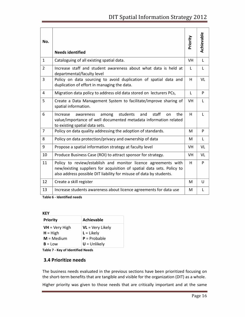
Following the criteria set in the methodology four high priority needs were identified (see
needs No. 1, 5, 9 and 10 in Table 2 below). Implementing policies and procedures to
address these needs is believed to be crucially important for all three DIT being studied. It
will result in improved accessibility to spatial data and make it easier to search.
It was also very important to consider how achievable each identified need would be.
Costs, time and human resource constraints were considered and three highly achievable
needs were identified which consist of the preparation of the strategy document itself,
the outlined business case analysis and the preparation of a policy for the acquisition of
data from 3rd
party suppliers.
DIT Spatial Information Strategy 2012
Page 16
No.
Needs identified
Pri
ori
ty
Ach
iev
ab
le
1 Cataloguing of all existing spatial data. VH L
2 Increase staff and student awareness about what data is held at
departmental/faculty level
L L
3 Policy on data sourcing to avoid duplication of spatial data and
duplication of effort in managing the data.
H VL
4 Migration data policy to address old data stored on lecturers PCs, L P
5 Create a Data Management System to facilitate/improve sharing of
spatial information.
VH L
6 Increase awareness among students and staff on the
value/importance of well documented metadata information related
to existing spatial data sets.
H L
7 Policy on data quality addressing the adoption of standards. M P
8 Policy on data protection/privacy and ownership of data M L
9 Propose a spatial information strategy at faculty level VH VL
10 Produce Business Case (ROI) to attract sponsor for strategy. VH VL
11 Policy to review/establish and monitor licence agreements with
new/existing suppliers for acquisition of spatial data sets. Policy to
also address possible DIT liability for misuse of data by students.
H P
12 Create a skill register M U
13 Increase students awareness about licence agreements for data use M L
Table 6 - Identified needs
KEY
Priority Achievable
VH = Very High
H = High
M = Medium
B = Low
VL = Very Likely
L = Likely
P = Probable
U = Unlikely
Table 7 - Key of Identified Needs
3.4 Prioritize needs
The business needs evaluated in the previous sections have been prioritized focusing on
the short-term benefits that are tangible and visible for the organization (DIT) as a whole.
Higher priority was given to those needs that are critically important and at the same
DIT Spatial Information Strategy 2012
Page 17
time are very likely to be implemented. The findings are not based exclusively on a
technology-driven approach but also on the benefits that can be brought to multiple
processes and multiple users.
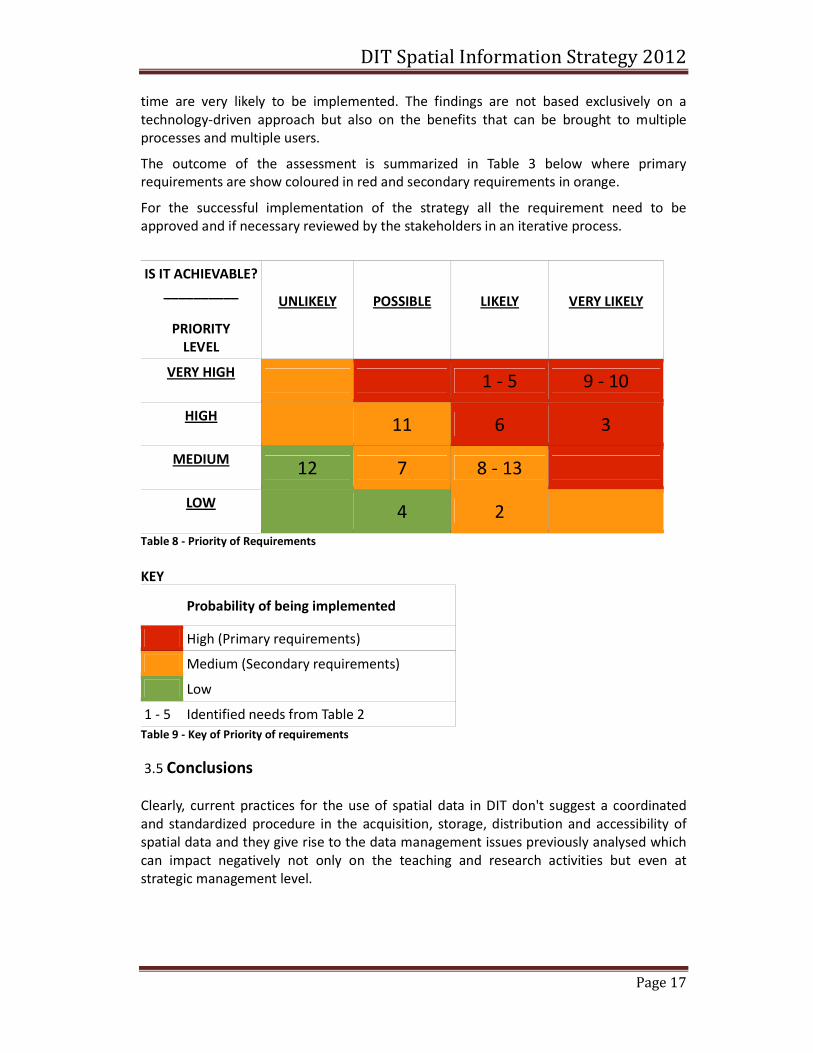
The outcome of the assessment is summarized in Table 3 below where primary
requirements are show coloured in red and secondary requirements in orange.
For the successful implementation of the strategy all the requirement need to be
approved and if necessary reviewed by the stakeholders in an iterative process.
IS IT ACHIEVABLE?
__________
PRIORITY
LEVEL
UNLIKELY
POSSIBLE
LIKELY
VERY LIKELY
VERY HIGH
1 - 5 9 - 10
HIGH
11 6 3
MEDIUM
12 7 8 - 13
LOW
4 2
Table 8 - Priority of Requirements
KEY
Probability of being implemented
High (Primary requirements)
Medium (Secondary requirements)
Low
1 - 5 Identified needs from Table 2
Table 9 - Key of Priority of requirements
3.5 Conclusions
Clearly, current practices for the use of spatial data in DIT don't suggest a coordinated
and standardized procedure in the acquisition, storage, distribution and accessibility of
spatial data and they give rise to the data management issues previously analysed which
can impact negatively not only on the teaching and research activities but even at
strategic management level.
DIT Spatial Information Strategy 2012
Page 18
4 SWOT analysis of current system
4.1 Introduction
In this chapter a SWOT analysis of the current practices involving spatial data is carried
out and it represent the fourth deliverable of this report. The results will be reflected in
the proposed strategy and it is therefore critical to the overall process.
4.2 Methodology
SWOT analysis is one of the most used techniques in the proposal of any type of
strategies. It involves the consideration of strengths, weaknesses, opportunities and
threats that can have an impact on the strategy either in a positive or negative way.
Internal (within the organization) and external (outside the organization) factors are
taken into consideration, evaluated (filtered) and aligned and presented in a tabular
format.
The evaluation or filtering step is an adapted version of the methodology used by (Smith,
2006)
4.3 SWOT chart
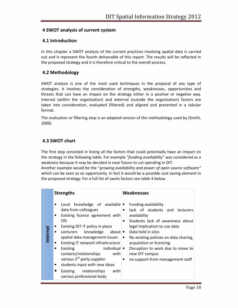
The first step consisted in listing all the factors that could potentially have an impact on
the strategy in the following table. For example “funding availability” was considered as a
weakness because it may be decided in near future to cut spending in DIT.
Another example would be the “growing availability and power of open source software”
which can be seen as an opportunity. In fact it would be a possible cost saving element in
the proposed strategy. For a full list of swots factors see table 4 below.
Inte
rna
l
Strengths
• Local knowledge of available
data from colleagues
• Existing licence agreement with
OSi
• Existing DIT IT policy in place
• Lecturers knowledge about
spatial data management issues
• Existing IT network infrastructure
• Existing individual
contacts/relationships with
various 3rd
party supplier
• students input with new ideas
• Existing relationships with
various professional body
Weaknesses
• Funding availability
• lack of students and lecturers
availability
• Students lack of awareness about
legal implication to use data
• Data held in silos
• No existing policies on data sharing,
acquisition or licencing
• Disruption to work due to move to
new DIT campus
• no support from management staff
DIT Spatial Information Strategy 2012
Page 19
Ex
tern
al
Opportunities
• Increasing awareness by
government of the importance of
spatial data
• growing availability and power of
open source software
• growing availability of public and
private open data
• IIS, SCSI collective knowledge of
working practices and use of
spatial data.
• Availability of MapGenie web-
service
• Future merging of OSi, LR and VO
• Improvement of technologies
Threats
• More restrictive licence agreement
and copyrights.
• Further worsening of the economy
• Increase costs of data
Table 10 - SWOT factors
4.4 Filter tests
Filtering each factor is a very import part of the swot analysis. Each factor has to pass four
different tests before it can be considered a “real” factor. This process allows eliminating
those internal and external factors that were included in the chart after an initial
brainstorm session. The full list of criteria is illustrated in Table 5 and 6 below. Please note
that some of the parameter has been slightly modified to better represent the current
analysis.
A strength is only a strength if it is
VRIO
A weakness is only a weakness if it is
MUDU
Valuable: It can create value for the
organization or the client
Meaningful: It makes a significant
difference to the organization
Rare: It is not shared with competitors
(N/A)
Uncommon: It is not shared with
competitors (N/A)
Inimitable: It is difficult or costly to
copy or implement
Difficult: It is not easy or inexpensive to fix,
replace, remove or improve
Organizational aligned: the
organization is able to use the strength
Uncompensated: It is not counterbalanced
by some other factor
Table 11 - Filtering tests for strengths and weaknesses

DIT Spatial Information Strategy 2012
Page 20
A opportunities is only a opportunities
if it is
VRIO
A threats is only a threats if it is
MUDU
Complementary: It does not prevent
taking advantage of another, better,
opportunity
Unmitigated: It is not removed or
significantly reduced by some other
Large: It is big enough to justify the
costs to absorb benefits
Significant: It is a large enough threat to
make a significant impact on the
organization
Accessible: It can be taken advantage
of by the firm
Undefended: It is not removed or
significantly reduced by some action the
organization is already undertaking
Lasting: It last long enough to be taken
advantage of
Lasting: It last long enough to have a
significant impact on the organization
Table 12 - Filtering tests for opportunities and threats
4.5 Filtered SWOT chart
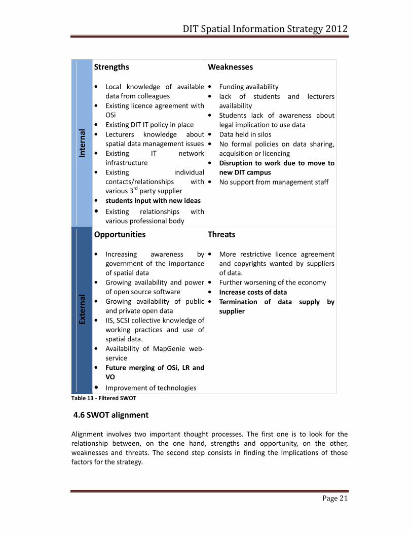
The new SWOT chart as shown in Table 7 has been cut down by the filtering process
applied to the internal and external factors. The strength “students input with new ideas”
factor had to be remove from the SWOT as it is not an Inimitable factor and therefore it
failed to pass the test.
Equally, the weakness ''Disruption to work due to move to new DIT campus” didn't pass
the test because it is counterbalanced by the existence of another factor, the “existing IT
network infrastructure”, which will manage the move with a well-studied project plan
aimed at minimizing any disruption to on-going work.
In contrast, the strength “Existing DIT IT policy in place”, met all the criteria and passed
the filter test. Therefore it can be considered a “real” strength.
Unfortunately, due to the limitations imposed to this report, it was not possible to
present the analysis of all the other internal and external factors in such detail.
DIT Spatial Information Strategy 2012
Page 21
Inte
rna
l
Strengths
• Local knowledge of available
data from colleagues
• Existing licence agreement with
OSi
• Existing DIT IT policy in place
• Lecturers knowledge about
spatial data management issues
• Existing IT network
infrastructure
• Existing individual
contacts/relationships with
various 3rd
party supplier
• students input with new ideas
• Existing relationships with
various professional body
Weaknesses
• Funding availability
• lack of students and lecturers
availability
• Students lack of awareness about
legal implication to use data
• Data held in silos
• No formal policies on data sharing,
acquisition or licencing
• Disruption to work due to move to
new DIT campus
• No support from management staff
Ex
tern
al
Opportunities
• Increasing awareness by
government of the importance
of spatial data
• Growing availability and power
of open source software
• Growing availability of public
and private open data
• IIS, SCSI collective knowledge of
working practices and use of
spatial data.
• Availability of MapGenie web-
service
• Future merging of OSi, LR and
VO
• Improvement of technologies
Threats
• More restrictive licence agreement
and copyrights wanted by suppliers
of data.
• Further worsening of the economy
• Increase costs of data
• Termination of data supply by
supplier
Table 13 - Filtered SWOT
4.6 SWOT alignment
Alignment involves two important thought processes. The first one is to look for the
relationship between, on the one hand, strengths and opportunity, on the other,
weaknesses and threats. The second step consists in finding the implications of those
factors for the strategy.
DIT Spatial Information Strategy 2012
Page 22
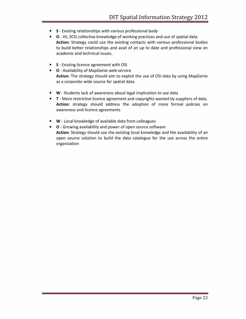
• S - Existing relationships with various professional body
• O - IIS, SCSI collective knowledge of working practices and use of spatial data.
Action: Strategy could use the existing contacts with various professional bodies
to build better relationships and avail of an up to date and professional view on
academic and technical issues.
• S - Existing licence agreement with OSi
• O - Availability of MapGenie web-service
Action: The strategy should aim to exploit the use of OSi data by using MapGenie
as a corporate wide source for spatial data.
• W - Students lack of awareness about legal implication to use data
• T - More restrictive licence agreement and copyrights wanted by suppliers of data.
Action: strategy should address the adoption of more formal policies on
awareness and licence agreements
• W - Local knowledge of available data from colleagues
• O - Growing availability and power of open source software
Action: Strategy should use the existing local knowledge and the availability of an
open source solution to build the data catalogue for the use across the entire
organization
DIT Spatial Information Strategy 2012
Page 23
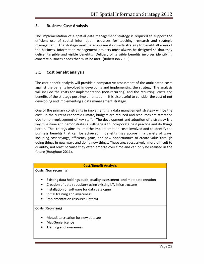
5. Business Case Analysis
The implementation of a spatial data management strategy is required to support the
efficient use of spatial information resources for teaching, research and strategic
management. The strategy must be an organisation wide strategy to benefit all areas of
the business. Information management projects must always be designed so that they
deliver tangible and visible benefits. Delivery of tangible benefits involves identifying
concrete business needs that must be met. (Robertson 2005)
5.1 Cost benefit analysis
The cost benefit analysis will provide a comparative assessment of the anticipated costs
against the benefits involved in developing and implementing the strategy. The analysis
will include the costs for implementation (non-recurring) and the recurring costs and
benefits of the strategy post-implementation. It is also useful to consider the cost of not
developing and implementing a data management strategy.
One of the primary constraints in implementing a data management strategy will be the
cost. In the current economic climate, budgets are reduced and resources are stretched
due to non-replacement of key staff. The development and adoption of a strategy is a
key milestone and demonstrates a willingness to incorporate best practice and do things
better. The strategy aims to limit the implementation costs involved and to identify the
business benefits that can be achieved. Benefits may accrue in a variety of ways,
including cost savings, efficiency gains, and new opportunities to create value through
doing things in new ways and doing new things. These are, successively, more difficult to
quantify, not least because they often emerge over time and can only be realised in the
future (Houghton 2011).
Cost/Benefit Analysis
Costs (Non recurring)
• Existing data holdings audit, quality assessment and metadata creation
• Creation of data repository using existing I.T. infrastructure
• Installation of software for data catalogue
• Initial training and awareness
• Implementation resource (intern)
Costs (Recurring)
• Metadata creation for new datasets
• MapGenie licence
• Training and awareness
DIT Spatial Information Strategy 2012
Page 24
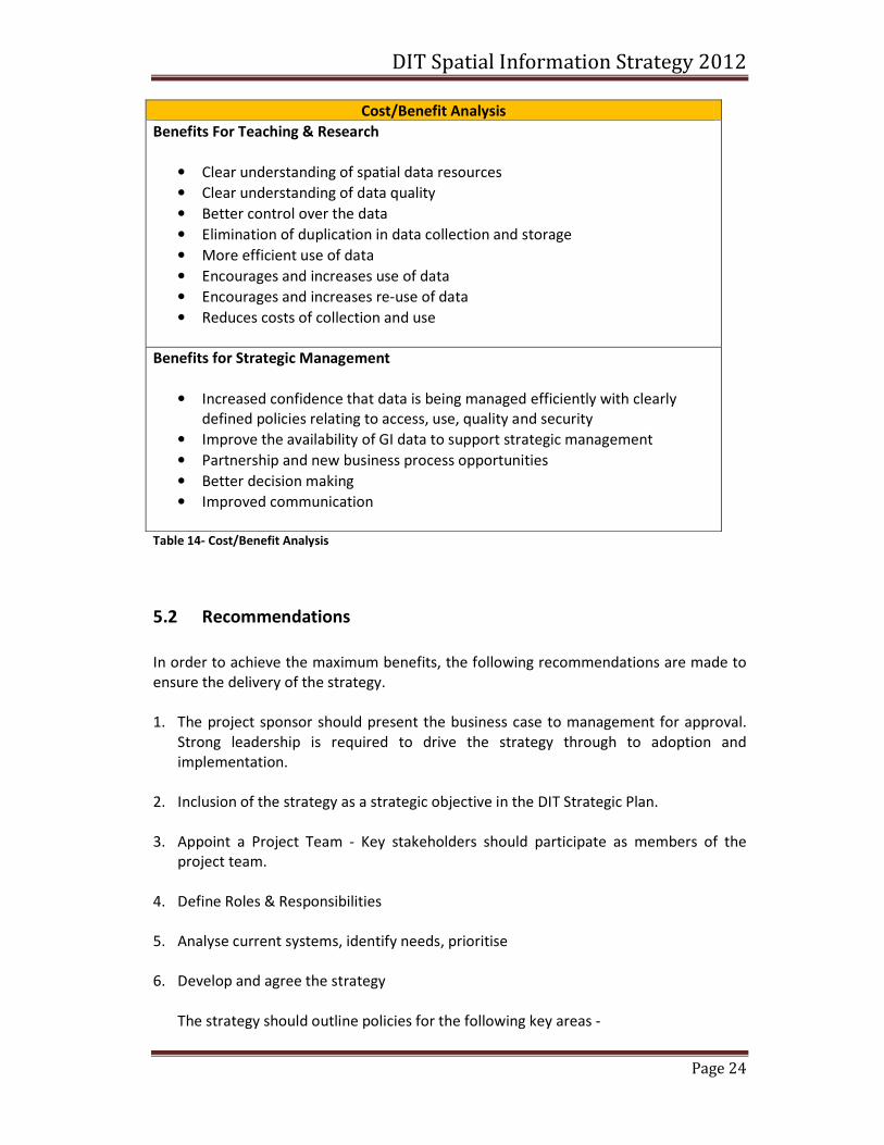
Cost/Benefit Analysis
Benefits For Teaching & Research
• Clear understanding of spatial data resources
• Clear understanding of data quality
• Better control over the data
• Elimination of duplication in data collection and storage
• More efficient use of data
• Encourages and increases use of data
• Encourages and increases re-use of data
• Reduces costs of collection and use
Benefits for Strategic Management
• Increased confidence that data is being managed efficiently with clearly
defined policies relating to access, use, quality and security
• Improve the availability of GI data to support strategic management
• Partnership and new business process opportunities
• Better decision making
• Improved communication
Table 14- Cost/Benefit Analysis
5.2 Recommendations
In order to achieve the maximum benefits, the following recommendations are made to
ensure the delivery of the strategy.
1. The project sponsor should present the business case to management for approval.
Strong leadership is required to drive the strategy through to adoption and
implementation.
2. Inclusion of the strategy as a strategic objective in the DIT Strategic Plan.
3. Appoint a Project Team - Key stakeholders should participate as members of the
project team.
4. Define Roles & Responsibilities
5. Analyse current systems, identify needs, prioritise
6. Develop and agree the strategy
The strategy should outline policies for the following key areas -
DIT Spatial Information Strategy 2012
Page 25
• Data acquisition
• Data management
• Data use and exchange
• Security
• Monitoring
• Review
The views of the stakeholders should be incorporated into the strategy. This will
ensure that stakeholders will be supportive and in agreement with the strategy and
its subsequent implementation. Once the strategy is adopted, it should be publicised
throughout the organisation to ensure that it is adopted by the staff in all colleges
and schools in DIT.
7. Implement the strategy
DIT Spatial Information Strategy 2012
Page 26
6. Strategy Proposal
Data management is a corporate service which helps with the provision of information
services by controlling or co-ordinating the definitions and usage of reliable and relevant
data (Gordon 2007).
The strategy aims to provide the policies and procedures to support the consistent
management and access to spatial data for DIT. There benefits have been outlined as
part of the cost/benefit analysis.
The table below outlines the key milestones required to develop and implement the data
management strategy.
No. Milestone
6.1 Assign the key roles and responsibilities
6.2 Define the data acquisition policies and procedures
6.3 Define the data management policies and procedures
6.4 Define the policies and procedures for data use and exchange
6.5 Define the security procedures
6.6 Implement the strategy
6.7 Monitor the application of the strategy Table 15 - Strategy Development Milestones
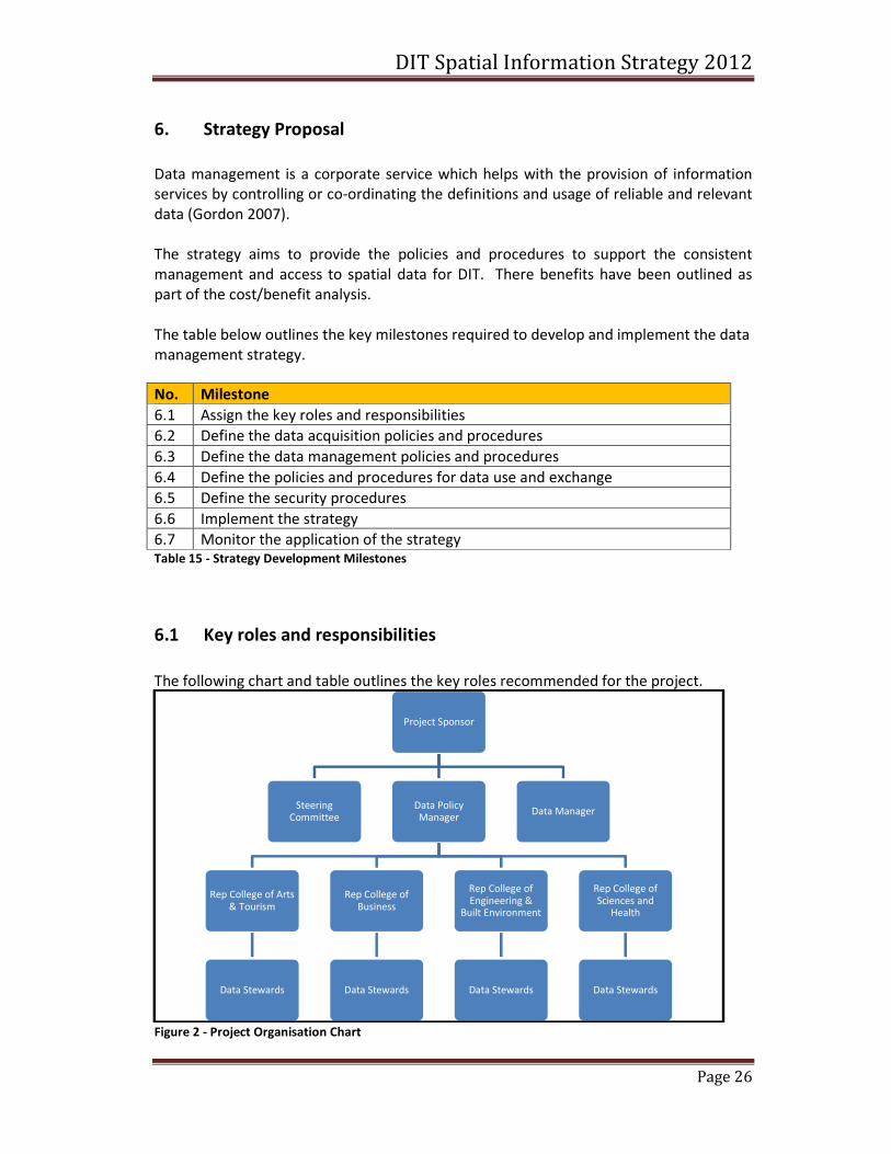
6.1 Key roles and responsibilities
The following chart and table outlines the key roles recommended for the project.
Figure 2 - Project Organisation Chart
Project Sponsor
Steering Committee
Data Policy Manager
Rep College of Arts & Tourism
Data Stewards
Rep College of Business
Data Stewards
Rep College of Engineering &
Built Environment
Data Stewards
Rep College of Sciences and
Health
Data Stewards
Data Manager
DIT Spatial Information Strategy 2012
Page 27
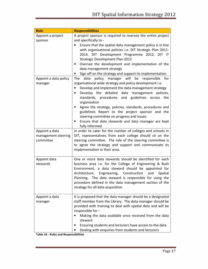
Role Responsibilities
Appoint a project
sponsor
A project sponsor is required to oversee the entire project
and specifically to -
• Ensure that the spatial data management policy is in line
with organisational policies i.e. DIT Strategic Plan 2011-
2014, DIT Development Programme 2012, DIT IT
Strategic Development Plan 2012
• Oversee the development and implementation of the
data management strategy
• Sign off on the strategy and support its implementation
Appoint a data policy
manager
The data policy manager will be responsible for
organisational wide strategy and policy development i.e.
• Develop and implement the data management strategy
• Develop the detailed data management policies,
standards, procedures and guidelines across the
organisation
• Agree the strategy, policies, standards, procedures and
guidelines Report to the project sponsor and the
steering committee on progress and issues
• Ensure that data stewards and data manager are kept
fully informed
Appoint a data
management steering
committee
In order to cater for the number of colleges and schools in
DIT, representatives from each college should sit on the
steering committee. The role of the steering committee is
to agree the strategy and support and communicate its
implementation in their area.
Appoint data
stewards
One or more data stewards should be identified for each
business area i.e. for the College of Engineering & Built
Environment, a data steward should be appointed for
Architecture, Engineering, Construction and Spatial
Planning. The data steward is responsible for using the
procedure defined in the data management section of the
strategy for all data acquisition.
Appoint a data
manager
It is proposed that the data manager should be a designated
staff member from the Library. The data manager should be
provided with training to deal with spatial data and will be
responsible for –
• Making the data available once received from the data
steward
• Ensuring students and lecturers have access to the data
• Dealing with enquiries from students and lecturers Table 16 - Roles and Responsibilities
DIT Spatial Information Strategy 2012
Page 28
6.2 Data Acquisition
This section outlines the data acquisition policy and procedure for spatial data.
OSI data – Data is regularly sourced from the OSI and it is proposed to define the
business case for the purchase of a MapGenie licence as part of the data acquisition
policy. The purchase of the MapGenie licence will remove the need for many of the
requests to OSI for current data. It will also ensure that all students and lecturers have
access to OSI data.
Other Suppliers - DIT obtain data from a limited number of suppliers. The remaining
suppliers should be listed as part of the policy. The list should include contact details,
terms of supply and any copyright and IPR issues that may be associated with data from
the supplier.
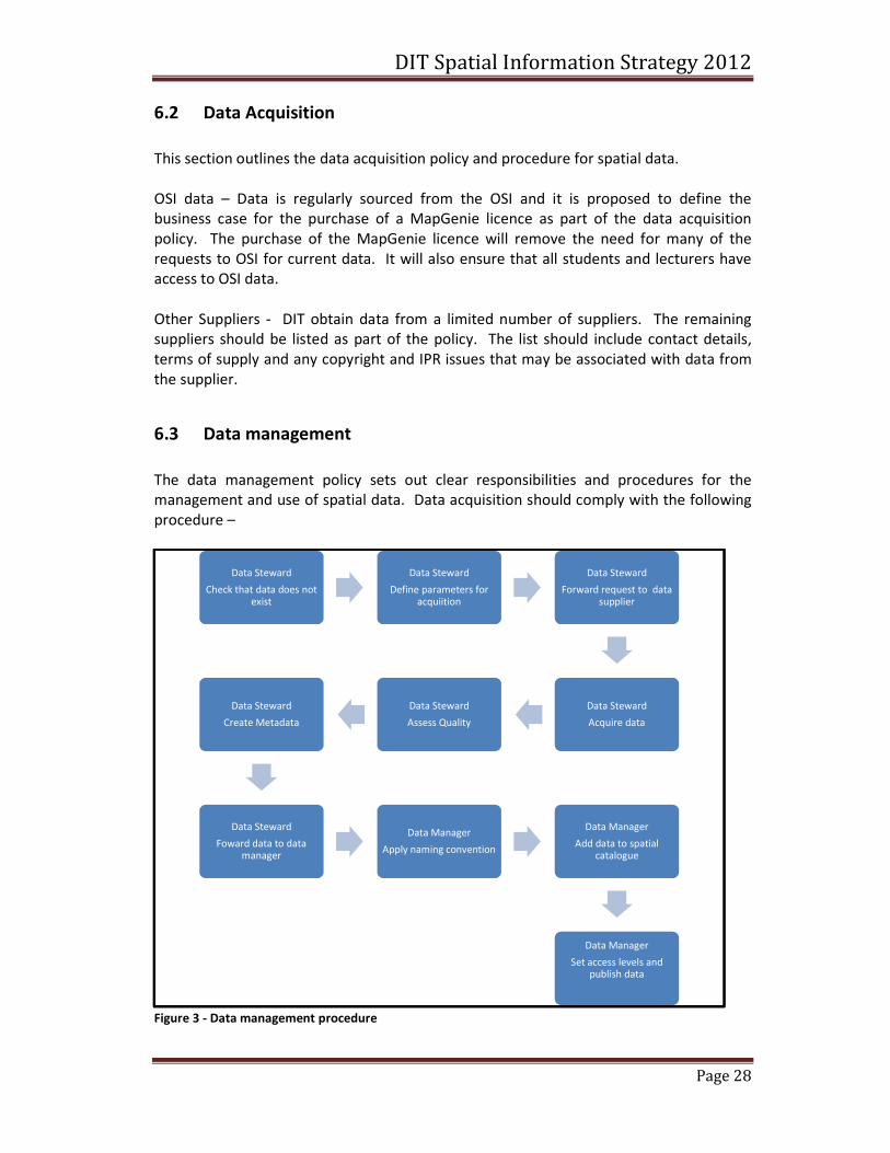
6.3 Data management
The data management policy sets out clear responsibilities and procedures for the
management and use of spatial data. Data acquisition should comply with the following
procedure –
Figure 3 - Data management procedure
Data Steward
Check that data does not exist
Data Steward
Define parameters for acquiition
Data Steward
Forward request to data supplier
Data Steward
Acquire data
Data Steward
Assess Quality
Data Steward
Create Metadata
Data Steward
Foward data to data manager
Data Manager
Apply naming convention
Data Manager
Add data to spatial catalogue
Data Manager
Set access levels and publish data
DIT Spatial Information Strategy 2012
Page 29
6.3.1 Define parameters for acquisition
The parameters for acquisition should be defined using the spatial data acquisition form.
The parameters to be defined include
• Supplier contact details
• Description of the data required
• Spatial extent of the data
• Format required
• Cost, if any
• Proposed use
• Expected benefit
• Access level for the data
• Data request made
6.3.2 Assess Quality
Quality assessment should be carried out by the data steward in line with the quality
assessment policy.
The purpose of describing the quality of spatial data is to enable data users to select the
spatial data or dataset best suited to their needs. It allows data producers/custodians to
validate how well a dataset meets the criteria set out in the product
description/specification, and assists a data user in determining any specific product’s
ability to satisfy the requirements for their particular application. (Victorian Spatial
Council 2009)
It is proposed that data quality should be assessed in accordance with ISO 19113. Non
quantitative elements such as purpose, usage and lineage should be documented.
Quantitative elements should as completeness, logical consistency, positional accuracy,
temporal accuracy and thematic accuracy should also be assessed.
6.3.3 Create Metadata
Proper identification of the spatial data set is essential to exploit the value of the data
and to facilitate data discovery, retrieval and re-use. The data steward should create the
metadata in accordance with internal standards adopted. While the standard identified
in the requirements analysis is INSPIRE, the metadata policy will outline a minimum
number of mandatory fields that must be entered in order to meet user requirements for
discovery and provide information on suitability and fitness for purpose. Additional
metadata fields may also be required depending on the type of data. The policy will
ensure that metadata creation is not too onerous for the data steward as this may
prohibit metadata creation. Training in metadata creation should be provided for all
data stewards.
6.3.4 Apply naming convention & standard folder structure
DIT Spatial Information Strategy 2012
Page 30
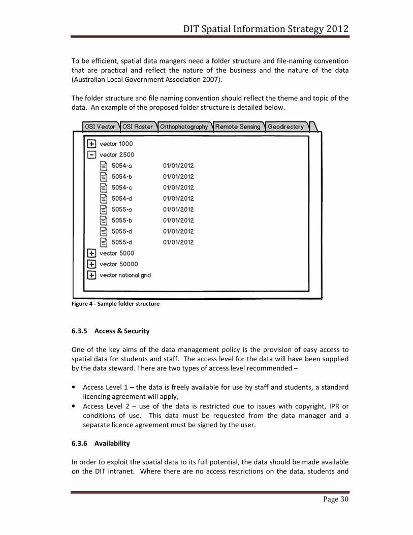
To be efficient, spatial data mangers need a folder structure and file-naming convention
that are practical and reflect the nature of the business and the nature of the data
(Australian Local Government Association 2007).
The folder structure and file naming convention should reflect the theme and topic of the
data. An example of the proposed folder structure is detailed below.
Figure 4 - Sample folder structure
6.3.5 Access & Security
One of the key aims of the data management policy is the provision of easy access to
spatial data for students and staff. The access level for the data will have been supplied
by the data steward. There are two types of access level recommended –
• Access Level 1 – the data is freely available for use by staff and students, a standard
licencing agreement will apply,
• Access Level 2 – use of the data is restricted due to issues with copyright, IPR or
conditions of use. This data must be requested from the data manager and a
separate licence agreement must be signed by the user.
6.3.6 Availability
In order to exploit the spatial data to its full potential, the data should be made available
on the DIT intranet. Where there are no access restrictions on the data, students and
DIT Spatial Information Strategy 2012
Page 31
lecturers in all colleges can then search for, view and download the data required.
Datasets with restricted access must be requested from the data manager.
6.3.7 Ownership
Each dataset supplied should clearly identify the owner of the data, copyright, and
Intellectual Property Rights and the copyright. The conditions of use should be clearly
stated and available to the user.
6.3.8 Security, Backups & Disaster Recovery
All spatial data will be stored on the DIT network. This will ensure that the data is secure
and restricted from unauthorised access. It will be backed up on a nightly basis.
Disaster recovery will be in accordance with existing IT procedures.
6.4 Implementation
The implementation plan should use existing personnel, Open Source software and
knowledge resources. In order to implement the data management strategy the
following key tasks need to be completed -
6.4.1 Infrastructure
Metadata Catalogue - Use Geonetworks Open source for the metadata catalogue.
Geonetworks is an approved project of the Open Source Geospatial Foundation (OSGeo)
and has been deployed in many organisations. Thus, there are strong and reliable
partners and a diverse and vibrant developer community behind the GeoNetwork project
to ensure the continuity and quality of the development (Nuske 2012). It supports
ISO19139, Dublin Core and Federal Geographic Data Committee. The metadata fields can
be adjusted as needed to meet DIT requirements.
Hardware – use existing DIT hardware to host the metadata catalogue and data
repository.
Personnel – Initial implementation will require a dedicated resource to complete the
data audit, populate the metadata catalogue and data repository, carry out training and
awareness of the strategy. It is recommended that a qualified intern is sourced to carry
out these tasks under the supervision of the Data Policy Manager and the Data Manager.
Once completed, the processing of all new metadata and data should be carried out by
the Data Stewards.
DIT Spatial Information Strategy 2012
Page 32
6.4.2 Data Audit and Migration
A data audit of existing datasets should be completed. The audit should build on the
work carried out in previous projects. The audit should prioritise the datasets and ensure
that priority datasets are made available initially. Remaining datasets should then be
made available.
6.4.3 Management and Governance
The implementation plan should be agreed with the Project Sponsor, Data Policy
Manager, Data Manager and the members of the steering committee. Full support and
resources should be made available to the intern in order to complete the
implementation as efficiently as possible.
It is recommended that the Data Management Strategy should be rolled out on phased
basis. Initial implementation should be carried out in the College of Engineering and Built
Environment and focus on the schools of Spatial Planning and Architecture. This will be a
key implementation phase and will test the policies and procedures in the strategy.
Phase two of the implementation should include the remaining schools in the college.
The demand for access to spatial information in the remaining colleges should be
assessed and the rollout to the remaining colleges prioritised on this basis.
6.4.4 Training and Awareness
Training is required for the Data Stewards to raise awareness of the policies and
procedures in the Spatial Data Management Strategy. They will also require training in
the metadata standards and Geonetworks metadata catalogue.
All students need to be made aware of the new policies and procedures for accessing
spatial data. Training should include awareness of licencing agreements and conditions
of use.
MapGenie awareness and training will also be required for students and lecturers and
should be carried out to ensure that the organisation benefits as quickly as possible from
the cost of the licence. The solution should be widely promoted using DITs existing
student resource centre.
Use of the MapGenie licence must be monitored and agreement reached with OSI on the
release of MapGenie access keys. The expected terms of the licence agreement with OSI
will include an expiry data of the MapGenie licence that will coincide with the end of the
academic year. New access keys should be provided to students at the start of each
academic year to ensure that unauthorised access is not permitted.
Management should also be included in the training and awareness programme. While
the provision of spatial information resources across the organisation will demonstrate
significant benefits for teaching and research, the use of spatial information for strategic
management needs to be investigated in conjunction with management.
DIT Spatial Information Strategy 2012
Page 33
6.4.5 Budget
There is limited funding available to implement the strategy. However, the
implementation is focused on using existing resources and infrastructure. The hiring of
an intern to carry out the project implementation is a minimal cost. The major cost is the
purchase of the MapGenie licence which is approximately €10,000 per annum. It is felt
that the initial cost could be justified in the business case and monitoring should be
carried out to support the business case for future years.
6.5 Monitoring
Statistics can be obtained from Geonetworks to monitor the access to the datasets.
Reports should be obtained regularly to assess what datasets are being accessed and
how frequently. Use of MapGenie should also be monitored to support the on-going
business need. Reports on usage should be submitted to the Project Sponsor and
steering committee.
DIT Spatial Information Strategy 2012
Page 34
References
Australian Local Government Association. 2007. Local Government Spatial Information
Management Toolkit, Version 2.0. Module 3 - Data management Principles.
Gordon, K. 2007. Principles of Data Management. The British Computer Society.
Houghton, J. 2011. Costs and Benefits of Data Provision, Report to the Australian
National Data Service.
Intra-governmental Group on Geographic Information. (2005) The Principles of Good
Data Management.
Nuske, R. T., Jan. (2012) GeoNetwork OpenSource: From Index Cards to Spatial Data
Infrastructures.
Robertson, J. (2005) 10 Principles of Effective Information Management.
Victorian Spatial Council. 2009. Spatial Information Data Quality Guidelines.
Smith, Brian, (2006) Hidden Strengths – The proper use and great strengths of the SWOT
analysis.
Sherwin, Ciara, BSc Geomatics DIT (2008), Towards the implementation of spatial data
management best practice with the department of spatial information science, Dublin
Institute of Technology
MSc, GIM Class Report, (2009), DIT, Proposed Strategy for the Management of Spatial
Information Assets in the School of Spatial Planning in Dublin Institute of Technology
(DIT)