Embed Size (px)
Citation preview
ASGEOGRAPHYREVISIONHYDROLOGYANDFLUVIALGEOMORPHOLOGY
1.4 THEHUMANIMPACT

KEYTERMSANDDEFINITIONSAbstraction is the amount taken out, e.g. water abstraction.Bankfull stage is a condition in which a river’s channel fills completely, so that any further increase in discharge results in water overflowing the banks.Channel is the passageway in which a river flows.Channelisation refers to modifications to river channels, consisting of some combination of straightening, deepening, widening, clearing or lining of the natural channel.Discharge is the quantity of water that passes a given point on the bank of a river within a given interval of time.Drainage basin is the total area that contributes water to a river.
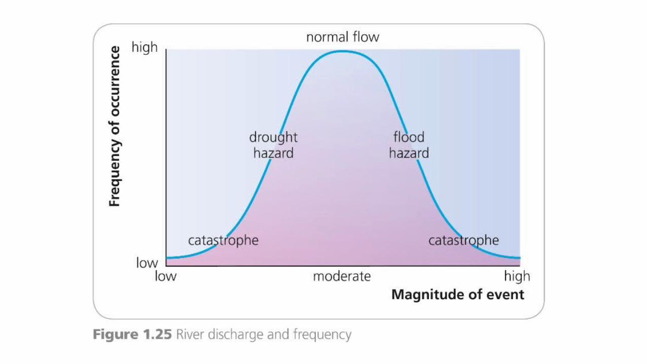
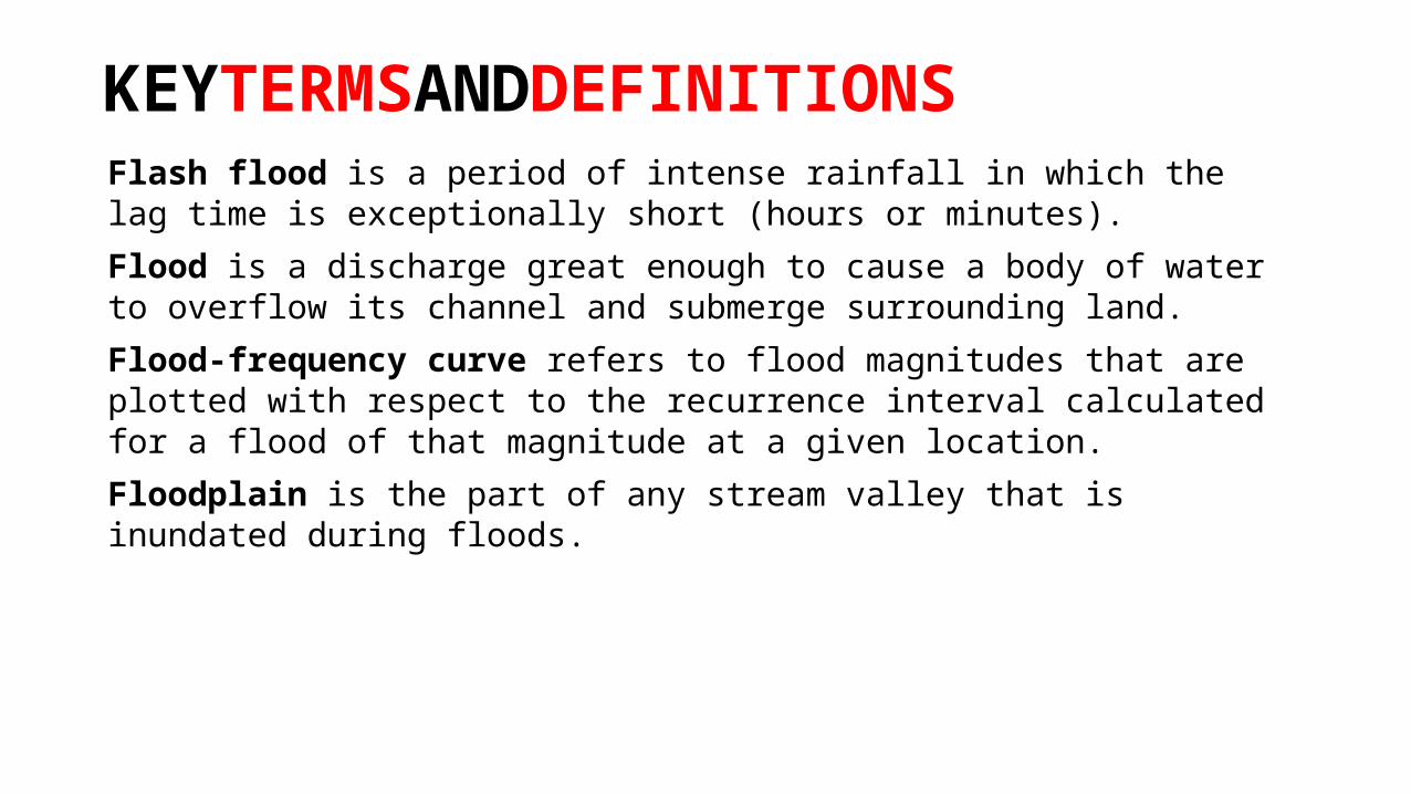
KEYTERMSANDDEFINITIONSFlash flood is a period of intense rainfall in which the lag time is exceptionally short (hours or minutes).Flood is a discharge great enough to cause a body of water to overflow its channel and submerge surrounding land.Flood-frequency curve refers to flood magnitudes that are plotted with respect to the recurrence interval calculated for a flood of that magnitude at a given location.Floodplain is the part of any stream valley that is inundated during floods.


KEYTERMSANDDEFINITIONSHazard assessment is the process of determining when and where hazards have occurred in the past; the severity of the physical effects of past events of a given magnitude; the frequency of events that are strong enough to generate physical effects; and what a particular event would be like if it were to occur now; and portraying all this information in a form that can be used by planners and decision-makers.Levees are raised banks of sediment along a river rising above the level of the flood plain and created by fluvial deposition. In many cases these natural levees are enhanced by artificial levees built to prevent flooding.

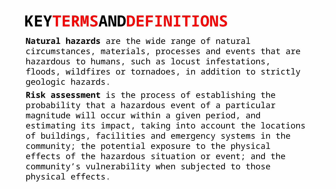
KEYTERMSANDDEFINITIONSNatural hazards are the wide range of natural circumstances, materials, processes and events that are hazardous to humans, such as locust infestations, floods, wildfires or tornadoes, in addition to strictly geologic hazards.Risk assessment is the process of establishing the probability that a hazardous event of a particular magnitude will occur within a given period, and estimating its impact, taking into account the locations of buildings, facilities and emergency systems in the community; the potential exposure to the physical effects of the hazardous situation or event; and the community’s vulnerability when subjected to those physical effects.

TOPICSUMMARYThere are a number of ways in which human activity affects precipitation.Cloud seeding has probably been one of the more successful.The human impact on evaporation and evapotranspiration is relatively small in relation to the rest of the hydrological cycle, but is nevertheless important.Human activity also affects interception.Deforestation can lead to changes in evapotranspiration, surface run off, surface storage and time lag.Human activity has a great impact on infiltration and soil water; for example, urbanisation creates an impermeable surface with compacted soil, which reduces infiltration and increases overland runoff and flood peaks.

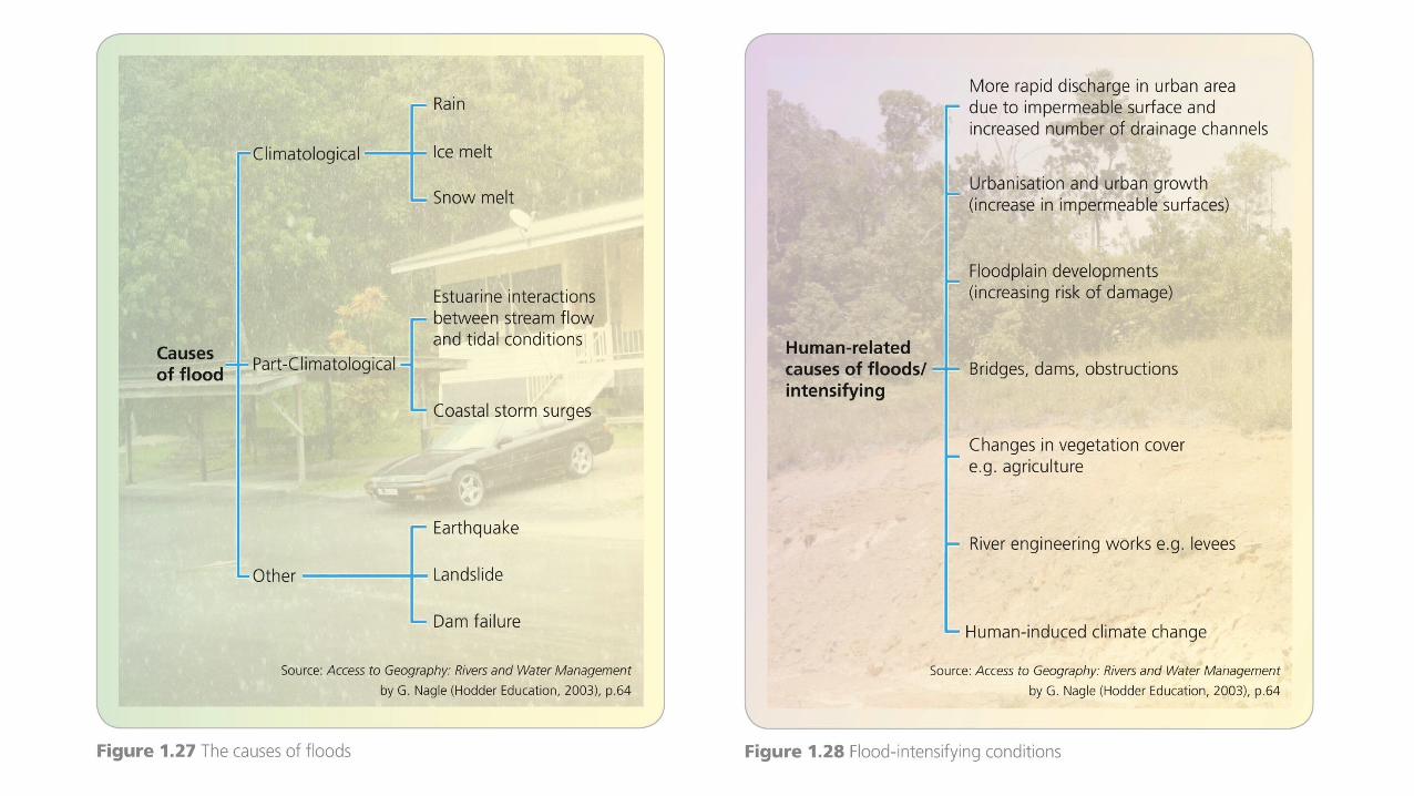
TOPICSUMMARYHuman activity also affects groundwater stores.The building of large dams seriously affects the hydrological cycle.Floods are one of the most common of all environmental hazards. The nature and scale of flooding varies greatly.The main cause of floods is climatic forces, whereas the flood intensifying conditions tend to be drainage basin specific.Flood protection can take many forms, such as loss-sharing and event-modification adjustments.Loss-sharing adjustments include disaster aid and insurance.Event-modification adjustments include environmental control and hazard-resistant design.
TOPICSUMMARYFlood diversion measures, by contrast, include the construction of levees and reservoirs and the modification of river channels.Flood proofing includes any adjustments to buildings and their contents that help reduce losses.A large proportion of the world’s surface experiences dry conditions. Semi-arid areas are commonly defined as having a rainfall of less than 500 mm per annum, while arid areas have less than 250 mm.Drought is an extended period of dry weather leading to conditions of extreme dryness.Farmers in LEDCs have many strategies to cope with drought.
ADDITIONALWORK1. To what extent can the causes and consequences of floods be managed?2. Describe and explain the hydrological effects of urbanisation.3. Comment on the changes to the hydrological cycle caused by the building of large dams.4. To what extent can people adapt to drought conditions?
SUGGESTEDWEBSITESwww.internationalrivers.org/ for the International Rivers Network.www.internationalrivers.org/node/1610 for a PowerPoint on people, water and life.www.apfm.info/pdf/case_studies/cs_usa_mississippi.pdf for flood management on the Mississippi.www.wwf.org.au/publications/pipedreamsibtsfinaljune21 for WWF Australia’s report on inter-basin transfers and water shortages.www.unu.edu/unupress/unupbooks/80858e/80858E06.htm#2.5 for a detailed account of problem management on the Jordan River.www.mrcmekong.org/about_mrc.htm for the homepage of the Mekong River Commission.www.guardian.co.uk/world/video/2009/may/19/chinaeco-refugees to see a video on water shortage and desertification in Gansu province.