Embed Size (px)
DESCRIPTION
The site was excavated under licence no. 04E0712. It was divided into ten areas of excavation: Areas 1-6, Area 6W, Area 7, Area 10 and Area 12.The earliest evidence for human activity was an Early Neolithic radiocarbon date obtained from the fill of a ditch in Area 6. However, there is no evidence for associated Early Neolithic activity. Most of the archaeological features excavated at Ballynattin were Bronze Age. Bronze Age pits were found in Area 6W, there was a spread of Bronze Age material in Area 3 and three partial Bronze Age structures were found in Areas 6 and 7. These were truncated and approximately only one third of each structure survived for excavation. A furnace excavated in Area 2 may also be Bronze Age in date; it has no associated radiocarbon dates but a saddle quern and flints were found within the furnace fill. The remaining features excavated at the site were primarily post-medieval, including a hearth excavated in Area 4, drains and ditches (Areas 1, 4 and 5) and a 19th century cobbled surface (Area 5).
Citation preview
Issue 14 [ISSN 2009-2237]
Archaeological Excavation Report
04E0712 & 03E1692IDA Arklow Business & Technology Park, Ballynattin, Co. Wicklow
Bronze Age pits, structures and a furnace
Eachtra Journal
The Forge, Innishannon, Co. CorkTel: 021 470 16 16Fax: 021 470 16 28E-mail: [email protected] Site: www.eachtra.ie
Contact details:
March 2007
Written by:
Client:
Archaeological Excavation Report,IDA Arklow Business & Technology Park,Ballynattin,Co. Wicklow
IDA Ireland,Property Division,Wilton Park House,Wilton Place,Dublin 2
03/8546
04E0712 & 03E1692
John Tierney
Bernice KellyBernadette DohertyPenny JohnstonAntonia Doolan
Planning Register No.:
Licence No.:
Licensee:
iii
Table of Contents
1 Summary ..........................................................................................................................1
2 Acknowledgements ...........................................................................................................1
3 Introduction .....................................................................................................................1
4 Background to the Development Area ..............................................................................2
5 Site Location, Topography and Soils ................................................................................2
6 Archaeological and Historical Background .......................................................................3
7 Results of Excavation 04E0712 .........................................................................................4
7.1 Area 1 ........................................................................................................................4
7.2 Area 2 ........................................................................................................................4
7.3 Area 3 ........................................................................................................................5
7.4 Area 4 ........................................................................................................................5
7.5 Area 5 ........................................................................................................................6
7.6 Area 6 ........................................................................................................................7
7.7 Area 6W ....................................................................................................................10
7.8 Area 7 .......................................................................................................................12
7.9 Area 10 ......................................................................................................................16
7.10 Area 12 .....................................................................................................................16
8 Specialist Results .............................................................................................................18
8.1 Radiocarbon Dates ....................................................................................................18
8.2 Plant remains ...........................................................................................................18
8.3 Pottery .....................................................................................................................18
8.4 Lithics .......................................................................................................................18
9 Summary and Discussion of Excavation Results ..............................................................19
10 Conclusions .....................................................................................................................20
11 Bibliography ....................................................................................................................21
11.1 Websites ....................................................................................................................21
12 Figures .............................................................................................................................22
13 Plates ...............................................................................................................................42
14 Appendices ......................................................................................................................51
14.1 Appendix 1: Context Register ....................................................................................52
14.2 Appendix 2: Stratigraphic Matrix ..............................................................................88
14.3 Appendix 3: Finds Register .......................................................................................89
iv
List of FiguresFigure 1: Site location map ....................................................................................................................22
Figure 2: RMP version of 6-inch Ordnance Survey map with development location indicated (OS Map Sheet WI045) ........................................................................................................................................23
Figure 3: Development site with area locations .................................................................................... 24
Figure 4: Area 1 post-excavation plan ..................................................................................................25
Figure 5: Section through boundary ditch C.6 in Area 1 ......................................................................26
Figure 6: Post-excavation plan of Area 2 ..............................................................................................27
Figure 7: Post-excavation plan of Area 3 ...............................................................................................28
Figure 8: Post-excavation plan of Area 4 ...............................................................................................29
Figure 9: Section through C.34, C.76, C.88 and C.89 in Area 5 ..........................................................30
Figure 10: Post-excavation plan of Area 6 ..............................................................................................31
Figure 11: Post-excavation plan of contexts in Area 6 excavated under licence no. 03E1692 ..................32
Figure 12: Post-excavation plan of Area 6W ..........................................................................................33
Figure 13: Western part of Area 6W (post-excavation) ..........................................................................34
Figure 14: Eastern part of Area 6W (post-excavation) ...........................................................................35
Figure 15: Post-excavation plan of contexts in Area 6W excavated under licence no. 03E1692 ..............36
Figure 16: Post-excavation plan of Area 7 ..............................................................................................37
Figure 17: Post-excavation plan of Structure B in Area 7 .......................................................................38
Figure 18: Post-excavation plan of Structure C in Area 7 ......................................................................39
Figure 19: Post-excavation plan of contexts found to the north of Structure C in Area 7 ..................... 40
Figure 20: Post-excavation plan of contexts in Area 12 excavated under licence no. 03E1692 ...............41
List of PlatesPlate 1: Post-excavation shot of Area 2 ................................................................................................. 42
Plate 2: Pre-excavation shot of Area 2 ................................................................................................... 42
Plate 3: Section through the spread excavated in Area 3 ........................................................................43
Plate 4: Post-excavation shot of Area 4 ..................................................................................................43
Plate 5: Section through the ditch in Area 5......................................................................................... 44
Plate 6: Pre-excavation shot of Area 5 ................................................................................................... 44
Plate 7: General post-excavation shot of Area 6 .....................................................................................45
14.4 Appendix 4: Plant remains from Ballynattin, Co. Wicklow 04E0712 ........................92
14.5 Appendix 5: Pottery Report .......................................................................................97
14.6 Lithics Finds Report for 03E1692 and 04E0712 Ballynattin, Co. Wicklow .............. 101
Table of contents cont.
v
Copyright Notice: Please note that all original information contained within this report, including all original drawings, photographs, text and all other printed matter deemed to be the writer’s, remains the property of the writer and Eachtra Archaeological Projects and so may not be reproduced or used in any form without the written consent of the writer or Eachtra Archaeological Projects.
Plate 8: Post-excavation shot of Structure A Area 6 ...............................................................................45
Plate 9: Post-excavation of pit C.74 in Area 6W ................................................................................... 46
Plate 10: Post-excavation of pit C.72 in Area 6W ................................................................................. 46
Plate 11: Pre-excavation of pit C.64 in Area 6W ...................................................................................47
Plate 12: Footing trenches in Structure B Area 7 ...................................................................................47
Plate 13: Post-excavation shot of Structure B Area 7 .............................................................................48
Plate 14: Pre-excavation shot of Structure C Area 7 ..............................................................................48
Plate 15: Footing trenches in Structure C Area 7...................................................................................49
Plate 16: Post-excavation shot of Structure C Area 7 .............................................................................49
Plate 17: Pottery from the footing trench of Structure C Area 7 ............................................................50
Plate 18: Post-excavation shot of pits C.363 and C.335 Area 7 ..............................................................50
List of plates contents cont.
1
IDA Arklow Business & Technology Park 04E0712-03E1692ISSUE 14: Eachtra Journal - ISSN 2009-2237
http://eachtra.ie/index.php/journal/04e0712-03e1692-ida-arklow-business-technology-park-ballynattin-co-wicklow/
1 Summary
Townland BallynattinCivil Parish ArklowBarony ArklowCounty WicklowLicence no. 04E0712 and 03E1692OS Map Sheet WI045Nation Grid Ref. 323320 171140Elevation 32 m to 59 m ODSite type(s) Three prehistoric round houses, a furnace, isolated
hearth with stake-holes, post-medieval ditches
2 AcknowledgementsThe licence holder was John Tierney and the fieldwork crew included Áine Richardson, Antonia Doo-lan, Dawn Gooney, Tina Murphy, Bernadette Doherty, Bernice Kelly, Fiacc Murphy, Frank Fitzger-ald, Áine Mawe, Kevin Stronach, Mairt Hanley, Carles Plana, Seamas, Ruadhan and Carol Power. Specialists included Mary Dillon, Farina Sternke, Helen Roche, Eoin Grogan and the 14 Chrono Centre at Queen’s University Belfast. Report writing by Bernadette Doherty, Bernice Kelly, Antonia Doolan and Penny Johnston.
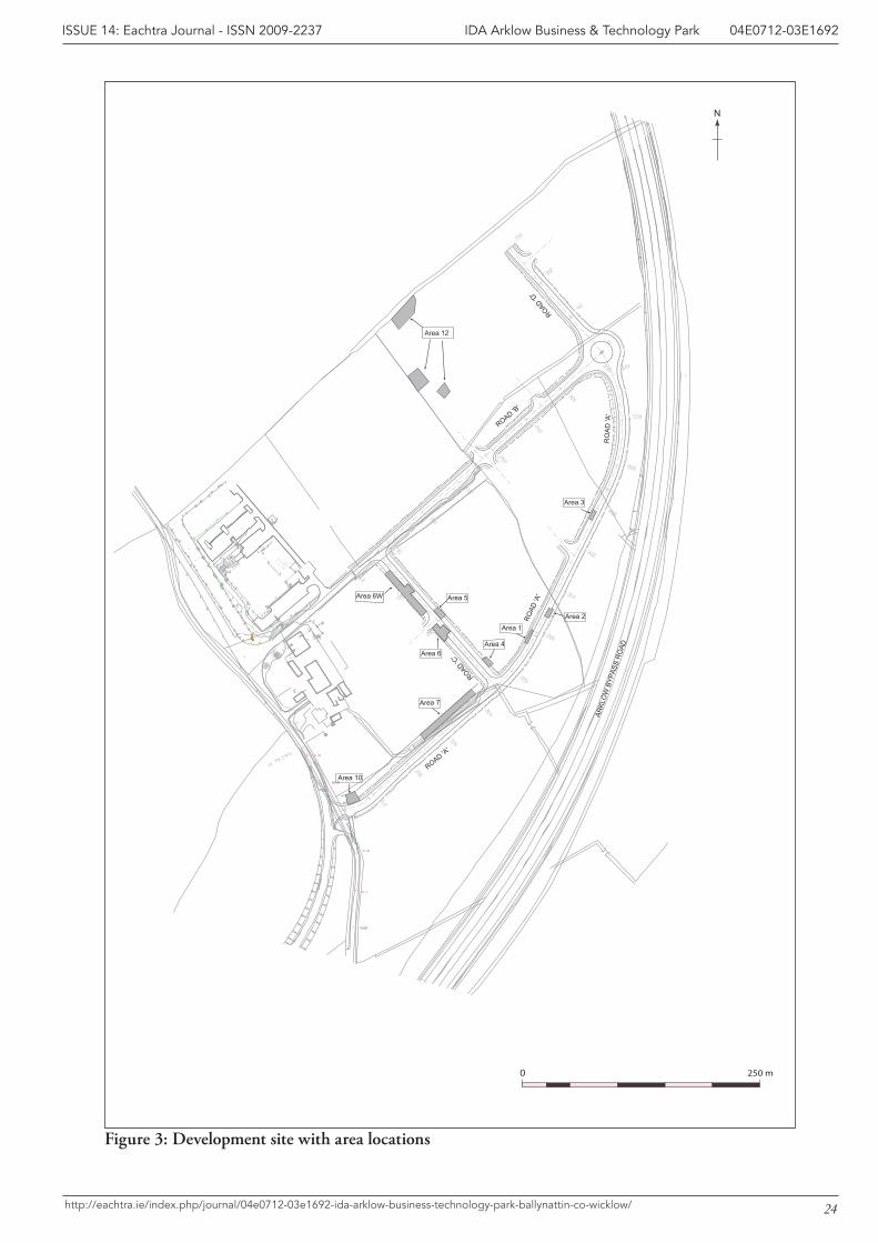
3 IntroductionThis report details the results of archaeological excavation at Ballynattin, Arklow, Co. Wicklow. The site, within a 21.83 hectare Industrial Development Agency (IDA) Business and Technology Park, was located at National Grid Reference 323320 171140 at an elevation of between 32 m OD and 59 m OD in an area covered by OS 6” map Sheet WI045 (Figures 1-3). Excavation was carried out in advance of development which included the construction of roadways, services infrastructure and landscaping covering at the Business & Technology Park. Archaeological testing, followed by small scale excava-tion, was carried out at the site in November 2003 under licence number 03E1692 (licence holder was John Tierney). Subsequent excavations were conducted over a seven week period which commenced on the 4 May 2004. These excavations were also directed by John Tierney under licence number 04E0712. This report pertains to the results from both licences.
2
IDA Arklow Business & Technology Park 04E0712-03E1692ISSUE 14: Eachtra Journal - ISSN 2009-2237
http://eachtra.ie/index.php/journal/04e0712-03e1692-ida-arklow-business-technology-park-ballynattin-co-wicklow/
4 Background to the Development AreaFour earlier phases of archaeological investigation occurred at the site; Geophysical (magnetometer) Survey: this was carried out by ArchaeoPhysica, under licence number
03R0140. Archaeological Test Excavation: pre-development archaeological test excavations were executed
by John Tierney of Eachtra Archaeological Projects, in November 2003 under licence number 03E1692. The results of this testing yielded a total of five areas which subsequently required excavation (Tierney and Doolan 2004a).
Archaeological Excavation: phase 3 of archaeological works involved the excavation of a fulacht fiadh and associated features licence 03E1692 A report on these findings was submitted to the Planning and Licensing section of the Department of the Environment, Heritage and Local Government (DoEHLG) in January 2004. The excavation report advised, as a mitigating meas-ure, that ‘all future groundworks for this development should be monitored by a qualified ar-chaeologist’ (Tierney and Doolan 2004b).
Archaeological Monitoring: archaeological monitoring took place over the course of seven days in April 2004. Potential prehistoric archaeological activity was identified at eight locations within Areas 1-7 and Area 10 (Kelly and Tierney 2004).
Archaeological excavation began as a consequence of discoveries made during archaeological monitor-ing. This was carried out under licence 04E0712 and works commenced on the 4th of May 2004. In the course of these works, Eachtra Archaeological Projects were required to monitor topsoil removal at two further locations within the site. At one location, Area 11, potential archaeological sediments were acknowledged and the area was cordoned off until further investigations could be carried out. Archaeological features were encountered to the west of Area 6, and this location was identified as Area 6 West. A total of ten archaeological zones were investigated within the bounds of the development over a 7-week period. Interim results were presented in Kelly and Doherty (2004). This final report integrates the results from archaeological works carried out under excavation licences 03E1692 and 04E0712.
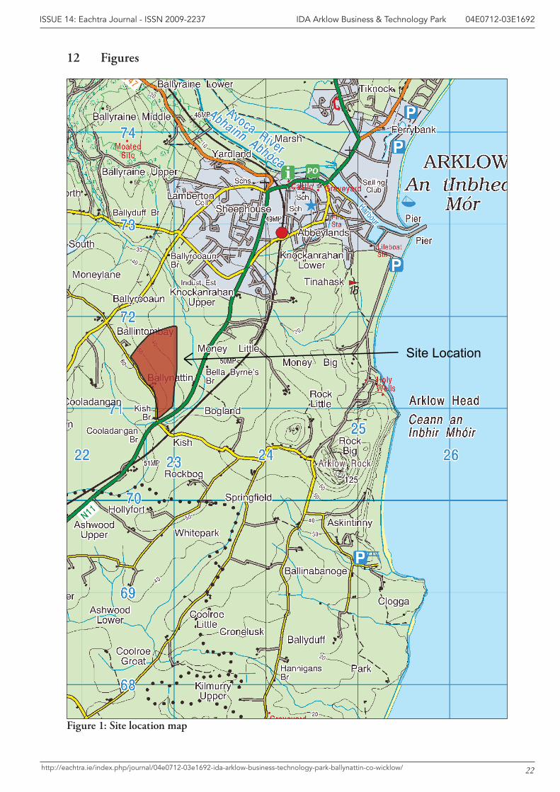
5 Site Location, Topography and Soils The site is situated in the townland of Ballynattin, west of the N11 and to the south-east of Arklow town, a coastal town situated at the mouth of the River Avoca in south Co. Wicklow. Ballynattin is located in the Barony of Arklow and within Arklow Civil Parish. Ballynattin House, an eighteenth/nineteenth century farmhouse that is now used as offices, is located along the south-western boundary of the site. The Arklow Bypass curves around the eastern and north-eastern extremities of the site. The Arklow Business Park lies to the west of this new Business and Technology Park development.
The surrounding landscape consists of low-lying, gently undulating ground. The site elevation slopes from south-west to north-east, from 59 m OD to 32 m OD. The area is drained by an extensive network of small streams. A culvert occurs within the area of the development; it serves to transport
3
IDA Arklow Business & Technology Park 04E0712-03E1692ISSUE 14: Eachtra Journal - ISSN 2009-2237
http://eachtra.ie/index.php/journal/04e0712-03e1692-ida-arklow-business-technology-park-ballynattin-co-wicklow/
storm-water under the adjacent N11 Arklow bypass, eventually emptying into the Ballyduff stream to the north-west. In turn, Ballyduff stream joins the Avoca River at Glenart.
The soils in the development area consist of a mixture of greys (90%) and grey brown podzolics (10%) which are derived from dense, calcareous, marine muds which were removed from the Irish sea and deposited inland by ice. These soils have a limited range and are best used in grass production. Prior to development, the site comprised agricultural (pasture) fields. The field boundaries were composed of hedgerows and/or timber post-and-wire fencing.
6 Archaeological and Historical BackgroundSeveral archaeological sites have been found in the townland of Ballynattin and in the surrounding area. Topsoil removal along the route of the Arklow bypass, located to the east of the IDA Business Park, was monitored under excavation licence 97E0083 by Breandán Ó Riordáin for Valerie J. Keeley Ltd. (www.excavations.ie). Three sites were found. Site 1 consisted of a small area of dark, charcoal-like material. Site 2 was a deposit of charcoal associated with a scatter of cremated bone. Site 3, a flat cemetery, consisted of three pits and a linear spread. In excess of fifty sherds of Beaker and food vessel pottery and over thirty flakes of flint, half of which were worked, were found within these pits. Other sites excavated along the route of the road included a possible Bronze Age enclosure in Johnstown South (96E0196) by Martin Fitzpatrick (www.excavations.ie). Pottery from the enclosure was similar to sherds retrieved at Ballynattin (Appendix 5) and the site was located 5.4 km to the north-west of the IDA Business Park. Within the townland of Ballynattin a burnt mound was discovered approximately 100 m to the east of the IDA Business Park (National Grid co-ordinate 3231151 1716131). The site was excavated by Anne Connolly under licence number 97E0128 (www.excavations.ie) and it comprised a number of small burnt spreads of heat-affected stone and charcoal and an associated wooden surface. Dendrochronological analysis of some of the wood from the surface indicated a felling date in late 856 or early 855 BC.
Sarah McCutcheon monitored ground-works for construction of a short roadway (130 m in length) which provided access to Euroconex Technologies. Monitoring was carried out under licence 98E0257 issued by the DoEHLG (formerly Dúchas) and the archaeological contexts found were subsequently excavated by Eamonn Cotter under the same licence (Cotter 2000, 220). The largest site was a rectan-gular enclosure measuring 14 m X 8 m with a 1.35 m wide entrance on its southern side. The enclosure was interpreted as a livestock corral, or some similar non-domestic compound. A report on these find-ings was submitted to the DoEHLG (formerly Dúchas) and Wicklow County Council in July 1998. Radiocarbon dates for this feature confirmed it to have been a medieval structure dating to between 1430 AD and 1530 AD (Eamonn Cotter pers. comm.).
Excavation undertaken by Eachtra in December 2003 at the proposed development produced evidence for ephemeral occupation sites along the route of the Haul Road. These features comprised rubbish
4
IDA Arklow Business & Technology Park 04E0712-03E1692ISSUE 14: Eachtra Journal - ISSN 2009-2237
http://eachtra.ie/index.php/journal/04e0712-03e1692-ida-arklow-business-technology-park-ballynattin-co-wicklow/
pits, some of which contained fire waste, and posts and stakes, which may have comprised fences or a wind-break structure. Based on morphology, artefact typology and radiocarbon dating the majority of the sites are prehistoric. Spreads of heat-shattered stones were discovered within the environs of the proposed new Vitra Tiles factory, which was located to the west of the development site and a fulacht fiadh trough was recorded along the western boundary of the development. The report on these find-ings was submitted to the Planning and Licensing section of the Department of Environment, Herit-age and Local Government (DoEHLG) in January 2004 (Tierney et al. 2004).
7 Results of Excavation 04E0712The site was excavated under licence no. 04E0712. It was divided into ten areas of excavation: Areas 1-6, Area 6W, Area 7, Area 10 and Area 12.The earliest evidence for human activity was an Early Neo-lithic radiocarbon date obtained from the fill of a ditch in Area 6. However, there is no evidence for associated Early Neolithic activity. Most of the archaeological features excavated at Ballynattin were Bronze Age. Bronze Age pits were found in Area 6W, there was a spread of Bronze Age material in Area 3 and three partial Bronze Age structures were found in Areas 6 and 7. These were truncated and approximately only one third of each structure survived for excavation. A furnace excavated in Area 2 may also be Bronze Age in date; it has no associated radiocarbon dates but a saddle quern and flints were found within the furnace fill. The remaining features excavated at the site were primarily post-medieval, including a hearth excavated in Area 4, drains and ditches (Areas 1, 4 and 5) and a 19th cen-tury cobbled surface (Area 5). Details of the excavated contexts are found in the stratigraphic matrix (Appendix 1) and the context register (Appendix 2) while all the artefacts retrieved during excavation are catalogued in the finds register (Appendix 3).
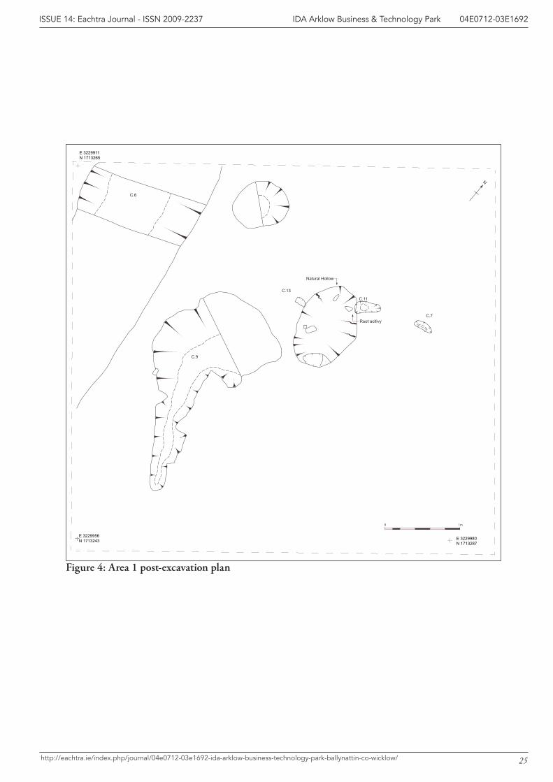
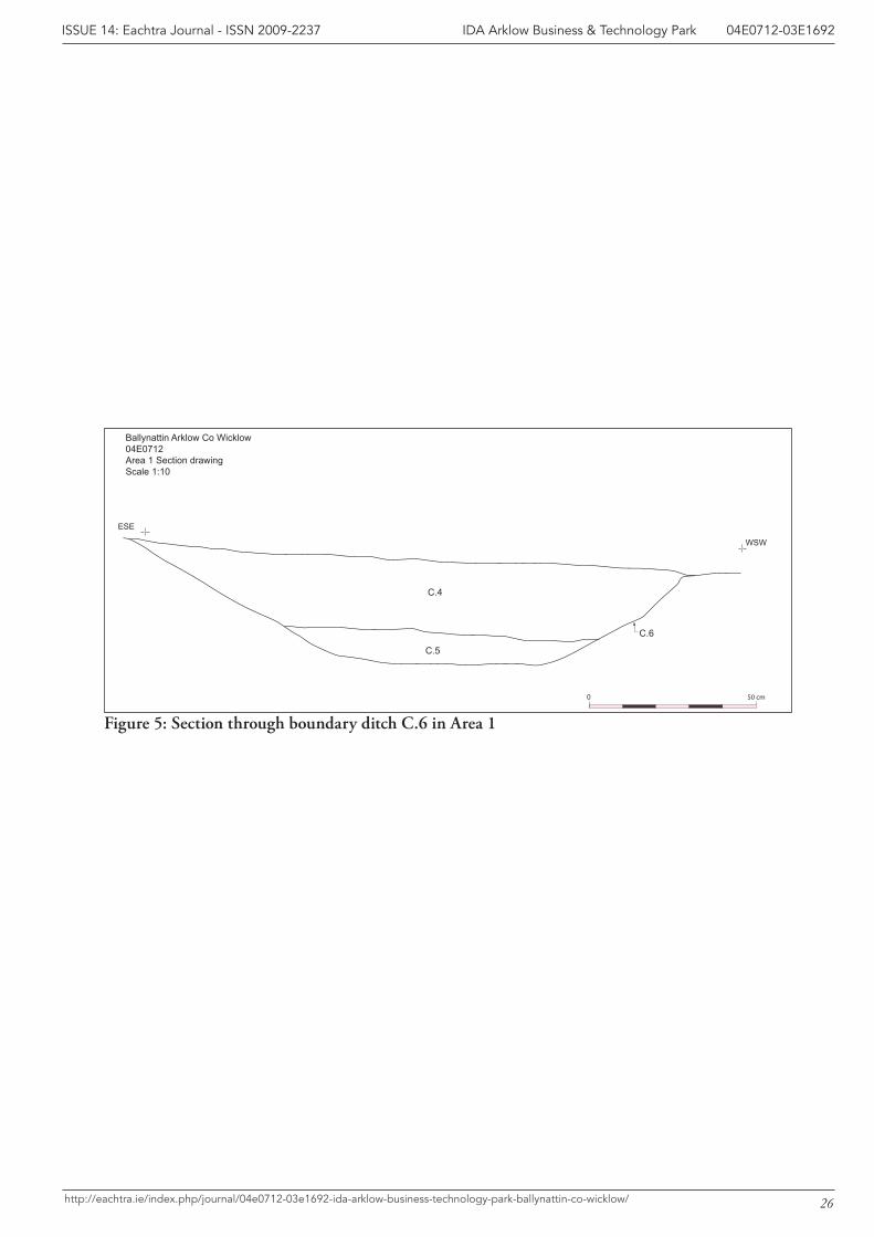
7.1 Area 1Area 1 was located at the southern extents of the Spur Road, at National Grid Co-ordinate (NGC) 3229911 1713265 (see Figure 3). A number of potential archaeological features were identified within an area of excavation which measured 5 m X 5 m. Excavation indicated that the majority of the poten-tial features were not archaeological in nature, but were the result of root action and rabbit burrowing. The only archaeological remains consisted of a post-medieval ditch, C.6, (Figure 4) which was filled by two deposits of light grey brown silts, C.4 and C.5. The ditch was aligned north to south (Figures 4 and 5) and it may originally have been constructed to assist drainage in the area, or as part of a field boundary.
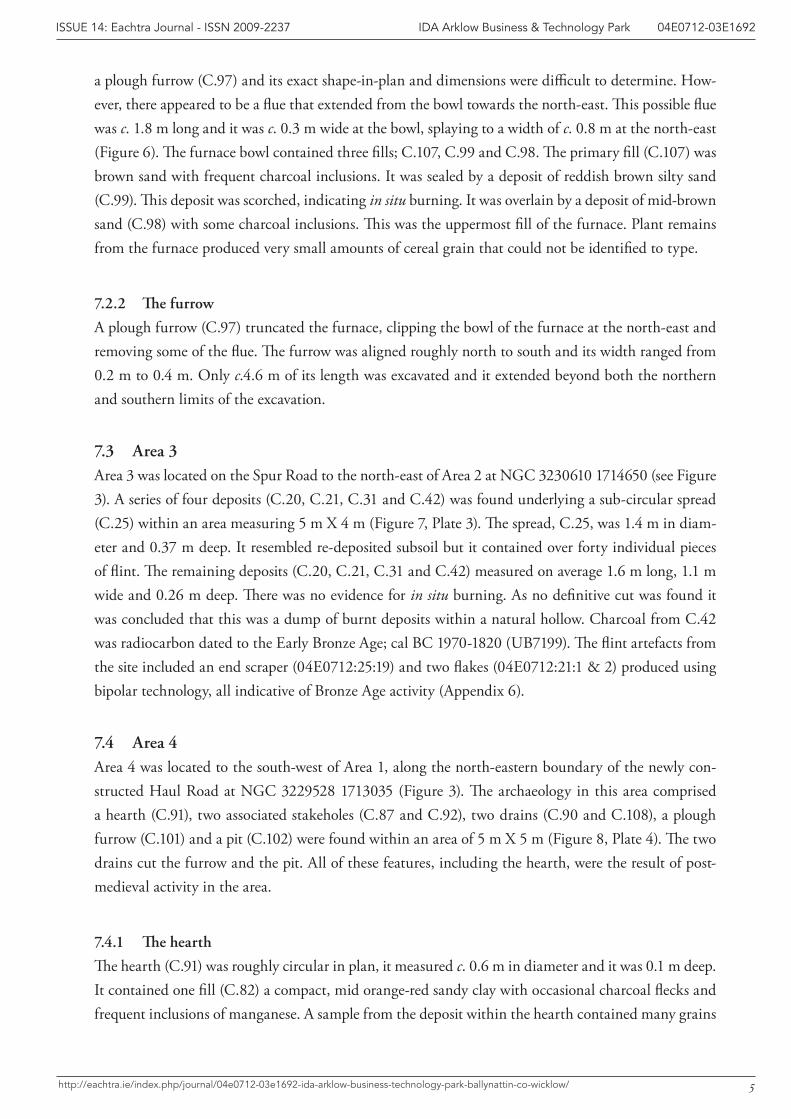
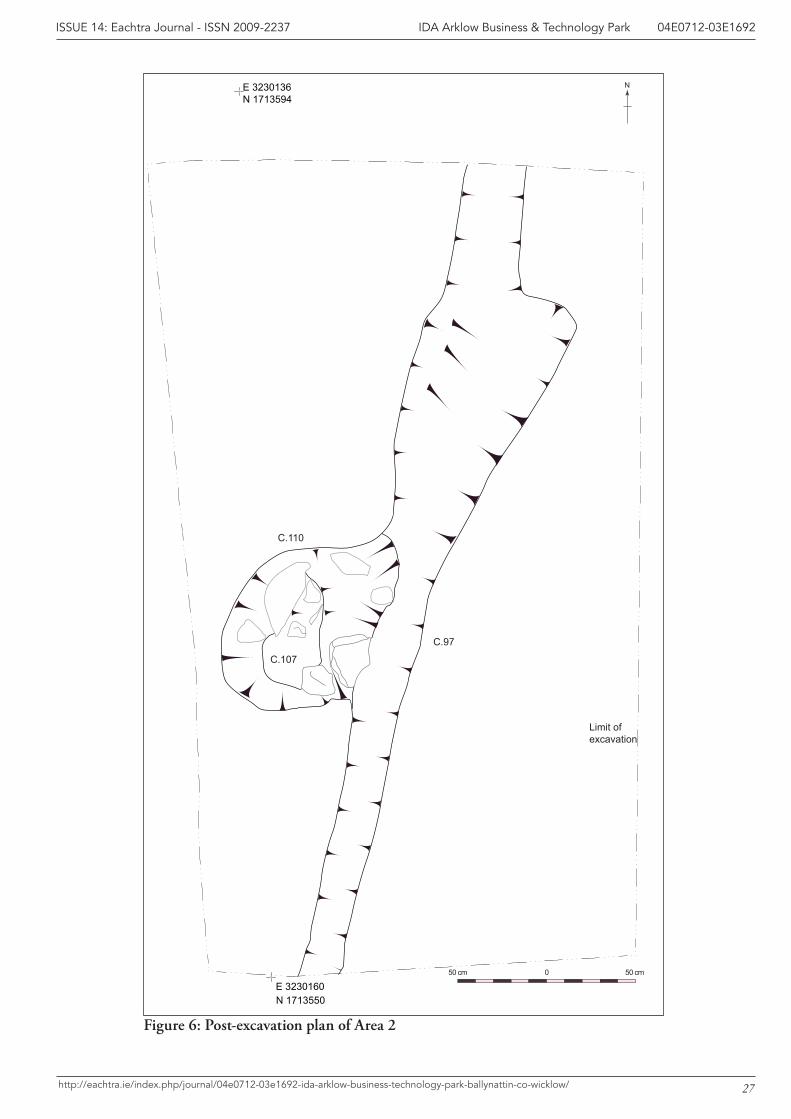
7.2 Area 2This area was situated along the eastern boundary of the Spur Road, to the north-east of Area 1 at NGC 3230160 1713550 (Figure 3). Two features were excavated within a 5 m X 4 m grid; a furnace, (C.110) and a furrow (C.97) (Figure 6, Plates 1 and 2).
7.2.1 The furnace
The furnace bowl was sub-circular in plan and approximately 0.9 m in diameter. It was truncated by
5
IDA Arklow Business & Technology Park 04E0712-03E1692ISSUE 14: Eachtra Journal - ISSN 2009-2237
http://eachtra.ie/index.php/journal/04e0712-03e1692-ida-arklow-business-technology-park-ballynattin-co-wicklow/
a plough furrow (C.97) and its exact shape-in-plan and dimensions were difficult to determine. How-ever, there appeared to be a flue that extended from the bowl towards the north-east. This possible flue was c. 1.8 m long and it was c. 0.3 m wide at the bowl, splaying to a width of c. 0.8 m at the north-east (Figure 6). The furnace bowl contained three fills; C.107, C.99 and C.98. The primary fill (C.107) was brown sand with frequent charcoal inclusions. It was sealed by a deposit of reddish brown silty sand (C.99). This deposit was scorched, indicating in situ burning. It was overlain by a deposit of mid-brown sand (C.98) with some charcoal inclusions. This was the uppermost fill of the furnace. Plant remains from the furnace produced very small amounts of cereal grain that could not be identified to type.
7.2.2 The furrow
A plough furrow (C.97) truncated the furnace, clipping the bowl of the furnace at the north-east and removing some of the flue. The furrow was aligned roughly north to south and its width ranged from 0.2 m to 0.4 m. Only c.4.6 m of its length was excavated and it extended beyond both the northern and southern limits of the excavation.
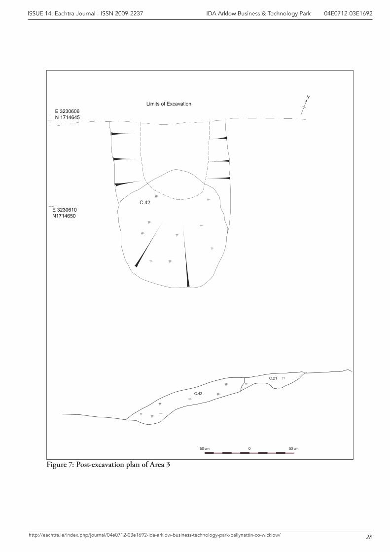
7.3 Area 3Area 3 was located on the Spur Road to the north-east of Area 2 at NGC 3230610 1714650 (see Figure 3). A series of four deposits (C.20, C.21, C.31 and C.42) was found underlying a sub-circular spread (C.25) within an area measuring 5 m X 4 m (Figure 7, Plate 3). The spread, C.25, was 1.4 m in diam-eter and 0.37 m deep. It resembled re-deposited subsoil but it contained over forty individual pieces of flint. The remaining deposits (C.20, C.21, C.31 and C.42) measured on average 1.6 m long, 1.1 m wide and 0.26 m deep. There was no evidence for in situ burning. As no definitive cut was found it was concluded that this was a dump of burnt deposits within a natural hollow. Charcoal from C.42 was radiocarbon dated to the Early Bronze Age; cal BC 1970-1820 (UB7199). The flint artefacts from the site included an end scraper (04E0712:25:19) and two flakes (04E0712:21:1 & 2) produced using bipolar technology, all indicative of Bronze Age activity (Appendix 6).
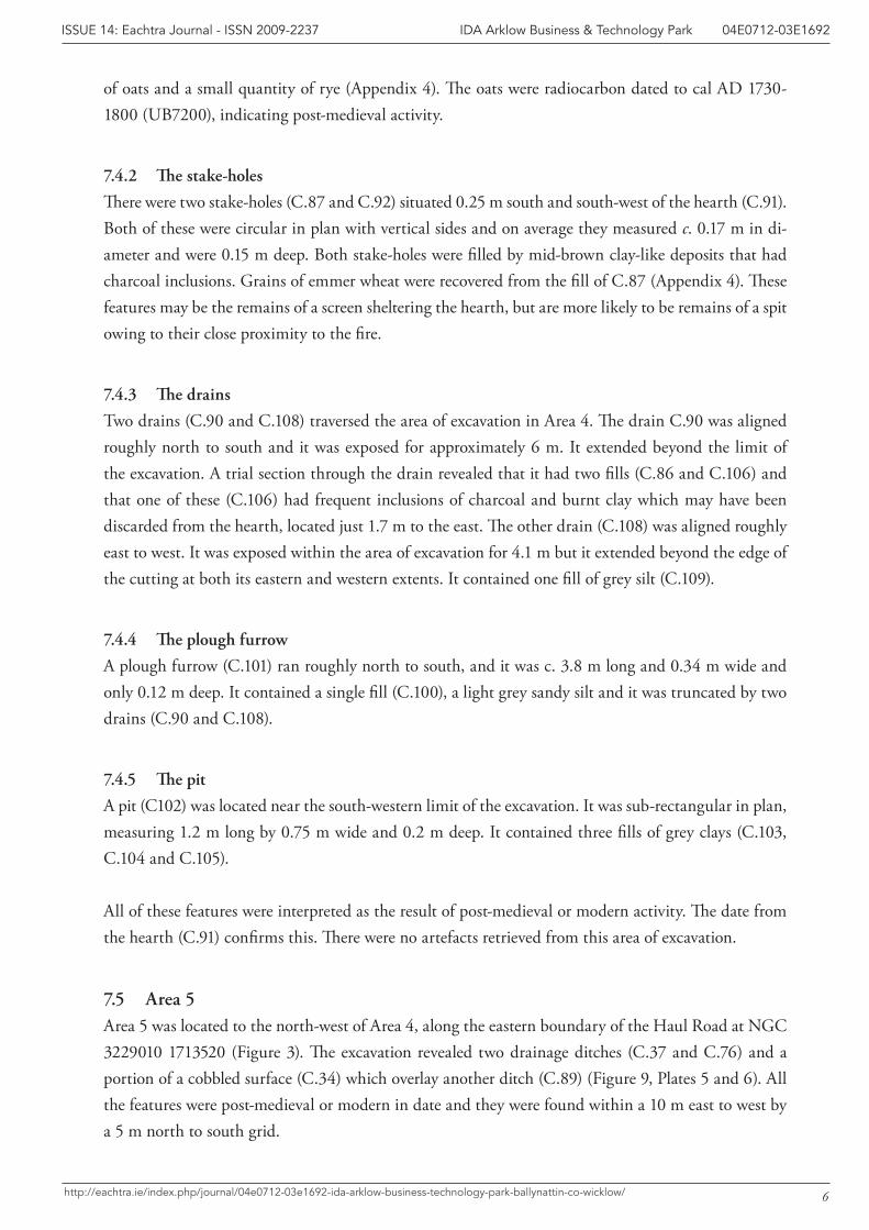
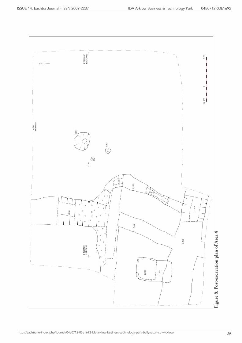
7.4 Area 4Area 4 was located to the south-west of Area 1, along the north-eastern boundary of the newly con-structed Haul Road at NGC 3229528 1713035 (Figure 3). The archaeology in this area comprised a hearth (C.91), two associated stakeholes (C.87 and C.92), two drains (C.90 and C.108), a plough furrow (C.101) and a pit (C.102) were found within an area of 5 m X 5 m (Figure 8, Plate 4). The two drains cut the furrow and the pit. All of these features, including the hearth, were the result of post-medieval activity in the area.
7.4.1 The hearth
The hearth (C.91) was roughly circular in plan, it measured c. 0.6 m in diameter and it was 0.1 m deep. It contained one fill (C.82) a compact, mid orange-red sandy clay with occasional charcoal flecks and frequent inclusions of manganese. A sample from the deposit within the hearth contained many grains
6
IDA Arklow Business & Technology Park 04E0712-03E1692ISSUE 14: Eachtra Journal - ISSN 2009-2237
http://eachtra.ie/index.php/journal/04e0712-03e1692-ida-arklow-business-technology-park-ballynattin-co-wicklow/
of oats and a small quantity of rye (Appendix 4). The oats were radiocarbon dated to cal AD 1730-1800 (UB7200), indicating post-medieval activity.
7.4.2 The stake-holes
There were two stake-holes (C.87 and C.92) situated 0.25 m south and south-west of the hearth (C.91). Both of these were circular in plan with vertical sides and on average they measured c. 0.17 m in di-ameter and were 0.15 m deep. Both stake-holes were filled by mid-brown clay-like deposits that had charcoal inclusions. Grains of emmer wheat were recovered from the fill of C.87 (Appendix 4). These features may be the remains of a screen sheltering the hearth, but are more likely to be remains of a spit owing to their close proximity to the fire.
7.4.3 The drains
Two drains (C.90 and C.108) traversed the area of excavation in Area 4. The drain C.90 was aligned roughly north to south and it was exposed for approximately 6 m. It extended beyond the limit of the excavation. A trial section through the drain revealed that it had two fills (C.86 and C.106) and that one of these (C.106) had frequent inclusions of charcoal and burnt clay which may have been discarded from the hearth, located just 1.7 m to the east. The other drain (C.108) was aligned roughly east to west. It was exposed within the area of excavation for 4.1 m but it extended beyond the edge of the cutting at both its eastern and western extents. It contained one fill of grey silt (C.109).
7.4.4 The plough furrow
A plough furrow (C.101) ran roughly north to south, and it was c. 3.8 m long and 0.34 m wide and only 0.12 m deep. It contained a single fill (C.100), a light grey sandy silt and it was truncated by two drains (C.90 and C.108).
7.4.5 The pit
A pit (C102) was located near the south-western limit of the excavation. It was sub-rectangular in plan, measuring 1.2 m long by 0.75 m wide and 0.2 m deep. It contained three fills of grey clays (C.103, C.104 and C.105).
All of these features were interpreted as the result of post-medieval or modern activity. The date from the hearth (C.91) confirms this. There were no artefacts retrieved from this area of excavation.
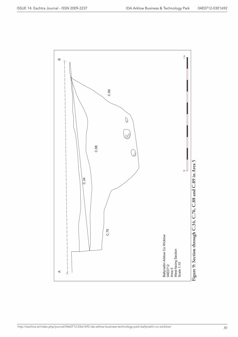
7.5 Area 5Area 5 was located to the north-west of Area 4, along the eastern boundary of the Haul Road at NGC 3229010 1713520 (Figure 3). The excavation revealed two drainage ditches (C.37 and C.76) and a portion of a cobbled surface (C.34) which overlay another ditch (C.89) (Figure 9, Plates 5 and 6). All the features were post-medieval or modern in date and they were found within a 10 m east to west by a 5 m north to south grid.
7
IDA Arklow Business & Technology Park 04E0712-03E1692ISSUE 14: Eachtra Journal - ISSN 2009-2237
http://eachtra.ie/index.php/journal/04e0712-03e1692-ida-arklow-business-technology-park-ballynattin-co-wicklow/
7.5.1 The cobbled surface
A portion of a cobbled surface (C.34), measuring 7.9 m east to west by 3.35 m north to south, was revealed along the south-western extents of the excavation cutting, terminating abruptly at the eastern edge of excavation. The cobbling directly overlay a ditch (C.89) and extended marginally beyond the ditch edge to the north. Red earthenware pottery was found directly underneath the cobbled surface and therefore indicated that the cobbling was laid in the 19th century.
7.5.2 The ditches
A ditch (C.89) underlay the area of cobbling near the southern edge of the excavation. It was exposed for a length of 5.2 m but it extended beyond the limit of excavation. The ditch was c. 1.5 m wide and 0.5 m deep. It contained one fill (C.88), a brown clay which contained no artefacts. The remaining features within this area included a series of post-medieval or modern ditches associated with the drainage of the terrain. These included parallel ditches (C.37 and C.76) which were aligned north to south. The ditch C.37 was exposed for a length of 6 m and it was 2.8 m wide and 0.37 m deep. It contained one fill (C.36) which resembled topsoil but contained a Bronze Age retouched flint scraper (04E0712:36:1). As this flint came from topsoil that was used to fill the ditch it was probably re-deposited after disturbance of Bronze Age activity (excavations at Areas 2, 3, 6, 6W and 7 all pro-duced evidence of Bronze Age archaeology).
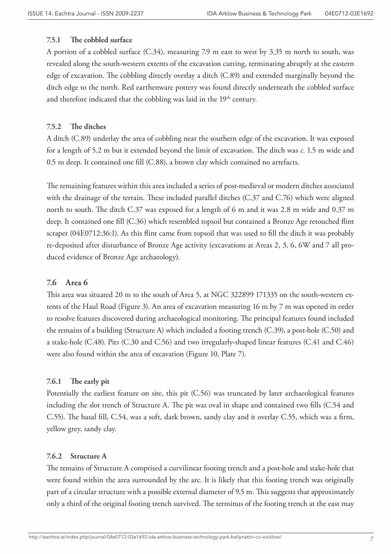
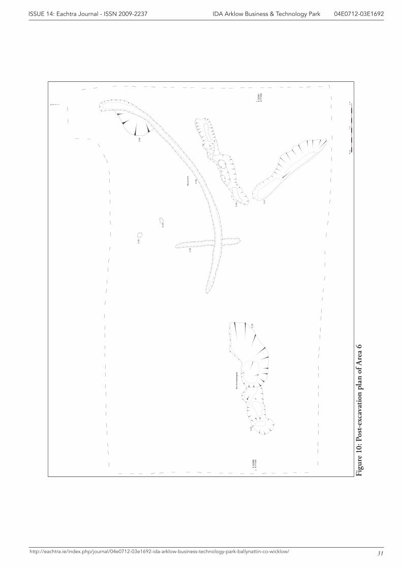
7.6 Area 6This area was situated 20 m to the south of Area 5, at NGC 322899 171335 on the south-western ex-tents of the Haul Road (Figure 3). An area of excavation measuring 16 m by 7 m was opened in order to resolve features discovered during archaeological monitoring. The principal features found included the remains of a building (Structure A) which included a footing trench (C.39), a post-hole (C.50) and a stake-hole (C.48). Pits (C.30 and C.56) and two irregularly-shaped linear features (C.41 and C.46) were also found within the area of excavation (Figure 10, Plate 7).
7.6.1 The early pit
Potentially the earliest feature on site, this pit (C.56) was truncated by later archaeological features including the slot trench of Structure A. The pit was oval in shape and contained two fills (C.54 and C.55). The basal fill, C.54, was a soft, dark brown, sandy clay and it overlay C.55, which was a firm, yellow grey, sandy clay.
7.6.2 Structure A
The remains of Structure A comprised a curvilinear footing trench and a post-hole and stake-hole that were found within the area surrounded by the arc. It is likely that this footing trench was originally part of a circular structure with a possible external diameter of 9.5 m. This suggests that approximately only a third of the original footing trench survived. The terminus of the footing trench at the east may
8
IDA Arklow Business & Technology Park 04E0712-03E1692ISSUE 14: Eachtra Journal - ISSN 2009-2237
http://eachtra.ie/index.php/journal/04e0712-03e1692-ida-arklow-business-technology-park-ballynattin-co-wicklow/
represent the entrance to the structure. No post-holes or stake-holes were recorded within the footing trench cut, suggesting the building was of split-timber construction. The internal post-hole and stake-hole may represent internal sub-division of the building.
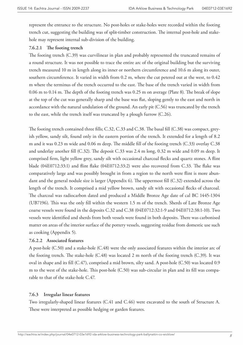
7.6.2.1 The footing trench
The footing trench (C.39) was curvilinear in plan and probably represented the truncated remains of a round structure. It was not possible to trace the entire arc of the original building but the surviving trench measured 10 m in length along its inner or northern circumference and 10.6 m along its outer, southern circumference. It varied in width from 0.2 m, where the cut petered out at the west, to 0.42 m where the terminus of the trench occurred to the east. The base of the trench varied in width from 0.06 m to 0.14 m. The depth of the footing trench was 0.25 m on average (Plate 8). The break of slope at the top of the cut was generally sharp and the base was flat, sloping gently to the east and north in accordance with the natural undulation of the ground. An early pit (C.56) was truncated by the trench to the east, while the trench itself was truncated by a plough furrow (C.26).
The footing trench contained three fills; C.32, C.33 and C.38. The basal fill (C.38) was compact, grey-ish yellow, sandy silt, found only in the eastern portion of the trench. It extended for a length of 8.2 m and it was 0.23 m wide and 0.06 m deep. The middle fill of the footing trench (C.33) overlay C.38 and underlay another fill (C.32). The deposit C.33 was 2.4 m long, 0.32 m wide and 0.09 m deep. It comprised firm, light yellow grey, sandy silt with occasional charcoal flecks and quartz stones. A flint blade (04E0712:33:1) and flint flake (04E0712:33:2) were also recovered from C.33. The flake was comparatively large and was possibly brought in from a region to the north were flint is more abun-dant and the general nodule size is larger (Appendix 6). The uppermost fill (C.32) extended across the length of the trench. It comprised a mid yellow brown, sandy silt with occasional flecks of charcoal. The charcoal was radiocarbon dated and produced a Middle Bronze Age date of cal BC 1445-1304 (UB7196). This was the only fill within the western 1.5 m of the trench. Sherds of Late Bronze Age coarse vessels were found in the deposits C.32 and C.38 (04E0712:32:1-9 and 04E0712:38:1-10). Two vessels were identified and sherds from both vessels were found in both deposits. There was carbonised matter on areas of the interior surface of the pottery vessels, suggesting residue from domestic use such as cooking (Appendix 5).
7.6.2.2 Associated features
A post-hole (C.50) and a stake-hole (C.48) were the only associated features within the interior arc of the footing trench. The stake-hole (C.48) was located 2 m north of the footing trench (C.39). It was oval in shape and its fill (C.47), comprised a mid brown, silty sand. A post-hole (C.50) was located 0.9 m to the west of the stake-hole. This post-hole (C.50) was sub-circular in plan and its fill was compa-rable to that of the stake-hole C.47.
7.6.3 Irregular linear features
Two irregularly-shaped linear features (C.41 and C.46) were excavated to the south of Structure A. These were interpreted as possible hedging or garden features.
9
IDA Arklow Business & Technology Park 04E0712-03E1692ISSUE 14: Eachtra Journal - ISSN 2009-2237
http://eachtra.ie/index.php/journal/04e0712-03e1692-ida-arklow-business-technology-park-ballynattin-co-wicklow/
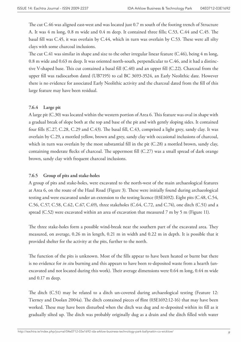
The cut C.46 was aligned east-west and was located just 0.7 m south of the footing trench of Structure A. It was 4 m long, 0.8 m wide and 0.4 m deep. It contained three fills; C.53, C.44 and C.45. The basal fill was C.45, it was overlain by C.44, which in turn was overlain by C.53. These were all silty clays with some charcoal inclusions.The cut C.41 was similar in shape and size to the other irregular linear feature (C.46), being 4 m long, 0.8 m wide and 0.63 m deep. It was oriented north-south, perpendicular to C.46, and it had a distinc-tive V-shaped base. This cut contained a basal fill (C.40) and an upper fill (C.22). Charcoal from the upper fill was radiocarbon dated (UB7195) to cal BC 3693-3524, an Early Neolithic date. However there is no evidence for associated Early Neolithic activity and the charcoal dated from the fill of this large feature may have been residual.
7.6.4 Large pit
A large pit (C.30) was located within the western portion of Area 6. This feature was oval in shape with a gradual break of slope both at the top and base of the pit and with gently sloping sides. It contained four fills (C.27, C.28, C.29 and C.43). The basal fill, C.43, comprised a light grey, sandy clay. It was overlain by C.29, a mottled yellow, brown and grey, sandy clay with occasional inclusions of charcoal, which in turn was overlain by the most substantial fill in the pit (C.28) a mottled brown, sandy clay, containing moderate flecks of charcoal. The uppermost fill (C.27) was a small spread of dark orange brown, sandy clay with frequent charcoal inclusions.
7.6.5 Group of pits and stake-holes
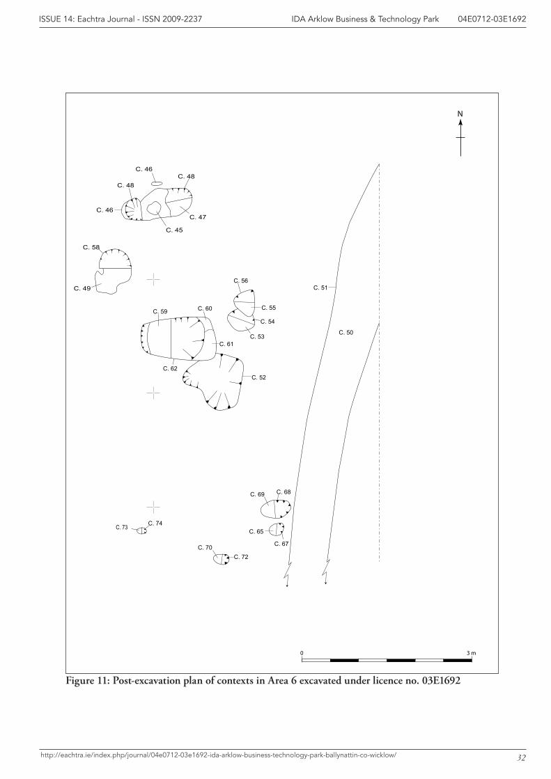
A group of pits and stake-holes, were excavated to the north-west of the main archaeological features at Area 6, on the route of the Haul Road (Figure 3). These were initially found during archaeological testing and were excavated under an extension to the testing licence (03E1692). Eight pits (C.48, C.54, C.56, C.57, C.58, C.62, C.67, C.69), three stakeholes (C.64, C.72, and C.74), one ditch (C.51) and a spread (C.52) were excavated within an area of excavation that measured 7 m by 5 m (Figure 11).
The three stake-holes form a possible wind-break near the southern part of the excavated area. They measured, on average, 0.26 m in length, 0.21 m in width and 0.22 m in depth. It is possible that it provided shelter for the activity at the pits, further to the north.
The function of the pits is unknown. Most of the fills appear to have been heated or burnt but there is no evidence for in situ burning and this appears to have been re-deposited waste from a hearth (un-excavated and not located during this work). Their average dimensions were 0.64 m long, 0.44 m wide and 0.17 m deep.
The ditch (C.51) may be related to a ditch un-covered during archaeological testing (Feature 12: Tierney and Doolan 2004a). The ditch contained pieces of flint (03E1692:12-16) that may have been worked. These may have been disturbed when the ditch was dug and re-deposited within its fill as it gradually silted up. The ditch was probably originally dug as a drain and the ditch filled with water
10
IDA Arklow Business & Technology Park 04E0712-03E1692ISSUE 14: Eachtra Journal - ISSN 2009-2237
http://eachtra.ie/index.php/journal/04e0712-03e1692-ida-arklow-business-technology-park-ballynattin-co-wicklow/
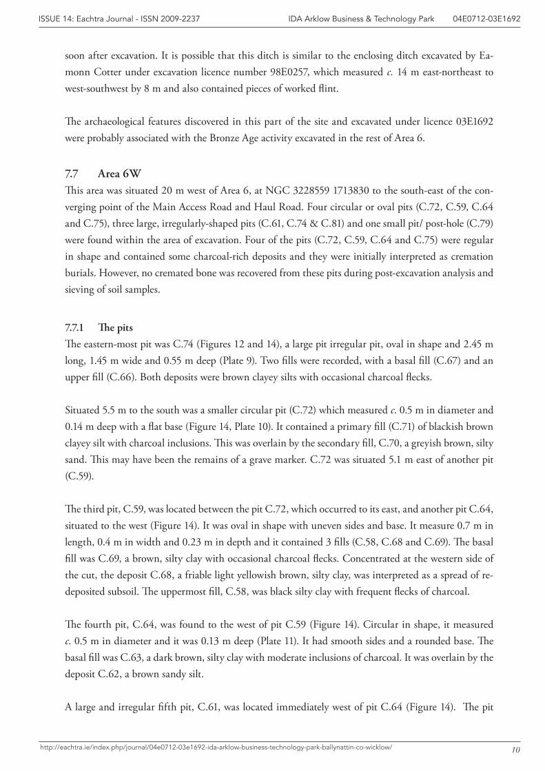
soon after excavation. It is possible that this ditch is similar to the enclosing ditch excavated by Ea-monn Cotter under excavation licence number 98E0257, which measured c. 14 m east-northeast to west-southwest by 8 m and also contained pieces of worked flint.
The archaeological features discovered in this part of the site and excavated under licence 03E1692 were probably associated with the Bronze Age activity excavated in the rest of Area 6.
7.7 Area 6WThis area was situated 20 m west of Area 6, at NGC 3228559 1713830 to the south-east of the con-verging point of the Main Access Road and Haul Road. Four circular or oval pits (C.72, C.59, C.64 and C.75), three large, irregularly-shaped pits (C.61, C.74 & C.81) and one small pit/ post-hole (C.79) were found within the area of excavation. Four of the pits (C.72, C.59, C.64 and C.75) were regular in shape and contained some charcoal-rich deposits and they were initially interpreted as cremation burials. However, no cremated bone was recovered from these pits during post-excavation analysis and sieving of soil samples.
7.7.1 The pits
The eastern-most pit was C.74 (Figures 12 and 14), a large pit irregular pit, oval in shape and 2.45 m long, 1.45 m wide and 0.55 m deep (Plate 9). Two fills were recorded, with a basal fill (C.67) and an upper fill (C.66). Both deposits were brown clayey silts with occasional charcoal flecks.
Situated 5.5 m to the south was a smaller circular pit (C.72) which measured c. 0.5 m in diameter and 0.14 m deep with a flat base (Figure 14, Plate 10). It contained a primary fill (C.71) of blackish brown clayey silt with charcoal inclusions. This was overlain by the secondary fill, C.70, a greyish brown, silty sand. This may have been the remains of a grave marker. C.72 was situated 5.1 m east of another pit (C.59).
The third pit, C.59, was located between the pit C.72, which occurred to its east, and another pit C.64, situated to the west (Figure 14). It was oval in shape with uneven sides and base. It measure 0.7 m in length, 0.4 m in width and 0.23 m in depth and it contained 3 fills (C.58, C.68 and C.69). The basal fill was C.69, a brown, silty clay with occasional charcoal flecks. Concentrated at the western side of the cut, the deposit C.68, a friable light yellowish brown, silty clay, was interpreted as a spread of re-deposited subsoil. The uppermost fill, C.58, was black silty clay with frequent flecks of charcoal.
The fourth pit, C.64, was found to the west of pit C.59 (Figure 14). Circular in shape, it measured c. 0.5 m in diameter and it was 0.13 m deep (Plate 11). It had smooth sides and a rounded base. The basal fill was C.63, a dark brown, silty clay with moderate inclusions of charcoal. It was overlain by the deposit C.62, a brown sandy silt.
A large and irregular fifth pit, C.61, was located immediately west of pit C.64 (Figure 14). The pit
11
IDA Arklow Business & Technology Park 04E0712-03E1692ISSUE 14: Eachtra Journal - ISSN 2009-2237
http://eachtra.ie/index.php/journal/04e0712-03e1692-ida-arklow-business-technology-park-ballynattin-co-wicklow/
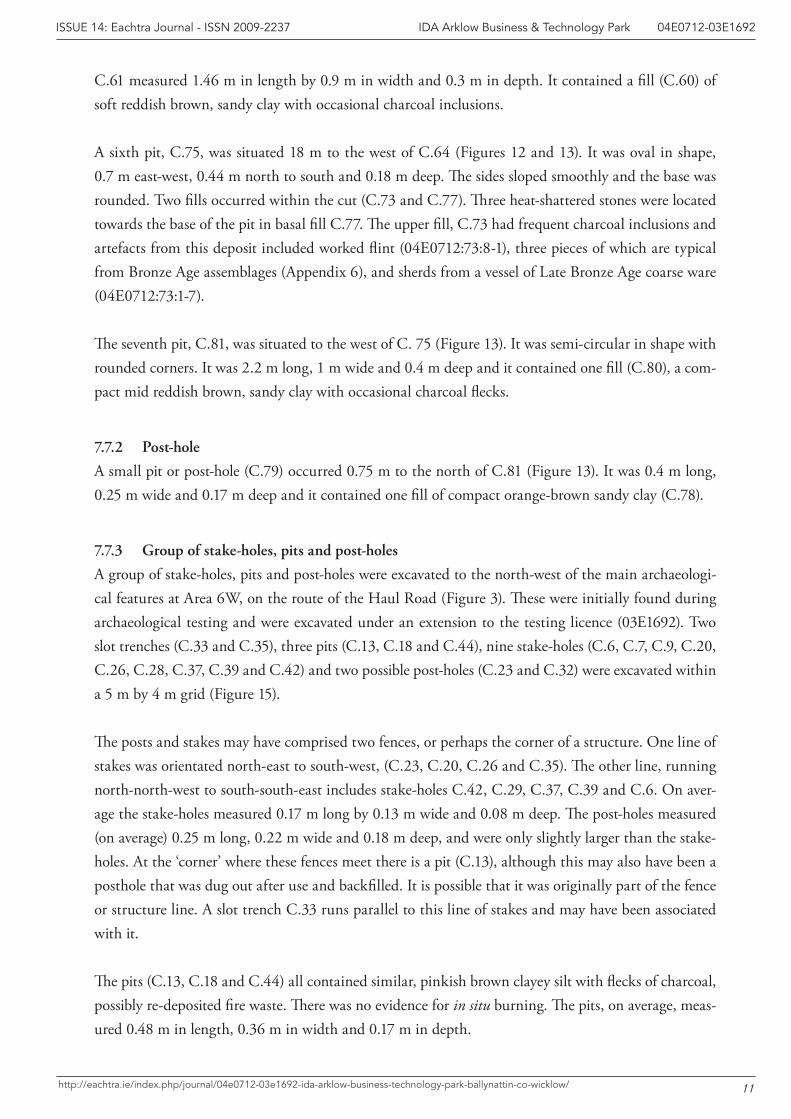
C.61 measured 1.46 m in length by 0.9 m in width and 0.3 m in depth. It contained a fill (C.60) of soft reddish brown, sandy clay with occasional charcoal inclusions.
A sixth pit, C.75, was situated 18 m to the west of C.64 (Figures 12 and 13). It was oval in shape, 0.7 m east-west, 0.44 m north to south and 0.18 m deep. The sides sloped smoothly and the base was rounded. Two fills occurred within the cut (C.73 and C.77). Three heat-shattered stones were located towards the base of the pit in basal fill C.77. The upper fill, C.73 had frequent charcoal inclusions and artefacts from this deposit included worked flint (04E0712:73:8-1), three pieces of which are typical from Bronze Age assemblages (Appendix 6), and sherds from a vessel of Late Bronze Age coarse ware (04E0712:73:1-7).
The seventh pit, C.81, was situated to the west of C. 75 (Figure 13). It was semi-circular in shape with rounded corners. It was 2.2 m long, 1 m wide and 0.4 m deep and it contained one fill (C.80), a com-pact mid reddish brown, sandy clay with occasional charcoal flecks.
7.7.2 Post-hole
A small pit or post-hole (C.79) occurred 0.75 m to the north of C.81 (Figure 13). It was 0.4 m long, 0.25 m wide and 0.17 m deep and it contained one fill of compact orange-brown sandy clay (C.78).
7.7.3 Group of stake-holes, pits and post-holes
A group of stake-holes, pits and post-holes were excavated to the north-west of the main archaeologi-cal features at Area 6W, on the route of the Haul Road (Figure 3). These were initially found during archaeological testing and were excavated under an extension to the testing licence (03E1692). Two slot trenches (C.33 and C.35), three pits (C.13, C.18 and C.44), nine stake-holes (C.6, C.7, C.9, C.20, C.26, C.28, C.37, C.39 and C.42) and two possible post-holes (C.23 and C.32) were excavated within a 5 m by 4 m grid (Figure 15).
The posts and stakes may have comprised two fences, or perhaps the corner of a structure. One line of stakes was orientated north-east to south-west, (C.23, C.20, C.26 and C.35). The other line, running north-north-west to south-south-east includes stake-holes C.42, C.29, C.37, C.39 and C.6. On aver-age the stake-holes measured 0.17 m long by 0.13 m wide and 0.08 m deep. The post-holes measured (on average) 0.25 m long, 0.22 m wide and 0.18 m deep, and were only slightly larger than the stake-holes. At the ‘corner’ where these fences meet there is a pit (C.13), although this may also have been a posthole that was dug out after use and backfilled. It is possible that it was originally part of the fence or structure line. A slot trench C.33 runs parallel to this line of stakes and may have been associated with it.
The pits (C.13, C.18 and C.44) all contained similar, pinkish brown clayey silt with flecks of charcoal, possibly re-deposited fire waste. There was no evidence for in situ burning. The pits, on average, meas-ured 0.48 m in length, 0.36 m in width and 0.17 m in depth.
12
IDA Arklow Business & Technology Park 04E0712-03E1692ISSUE 14: Eachtra Journal - ISSN 2009-2237
http://eachtra.ie/index.php/journal/04e0712-03e1692-ida-arklow-business-technology-park-ballynattin-co-wicklow/
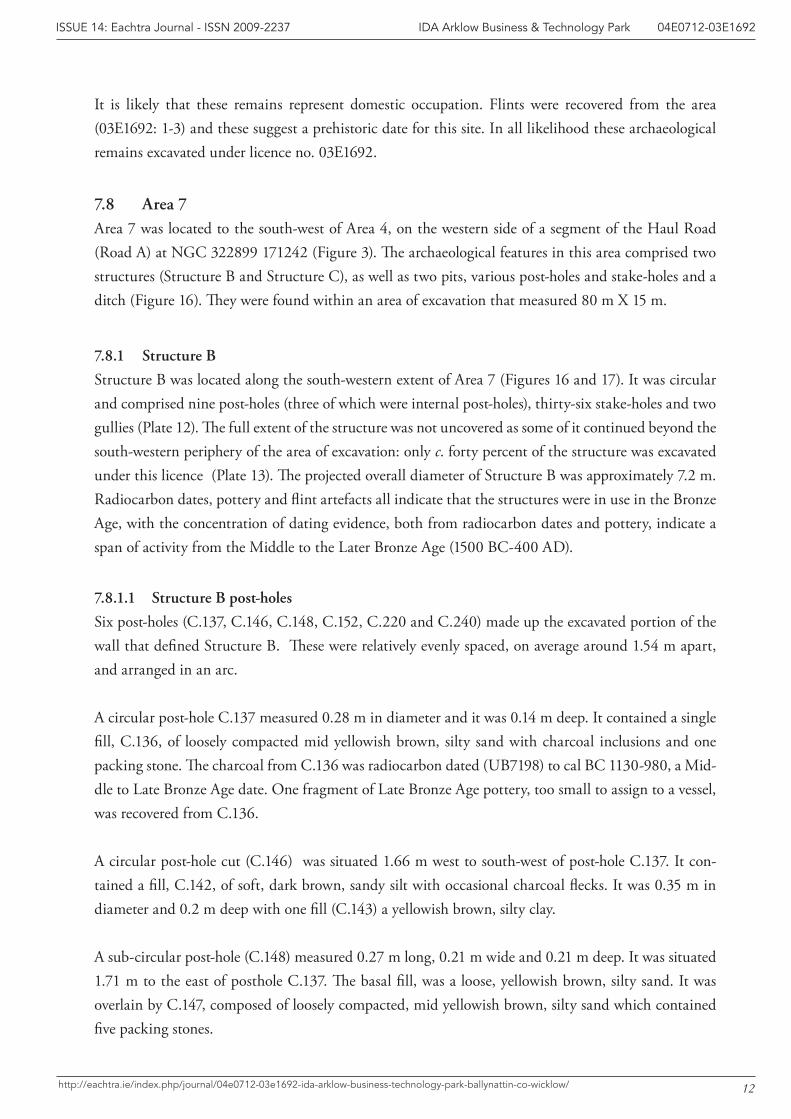
It is likely that these remains represent domestic occupation. Flints were recovered from the area (03E1692: 1-3) and these suggest a prehistoric date for this site. In all likelihood these archaeological remains excavated under licence no. 03E1692.
7.8 Area 7Area 7 was located to the south-west of Area 4, on the western side of a segment of the Haul Road (Road A) at NGC 322899 171242 (Figure 3). The archaeological features in this area comprised two structures (Structure B and Structure C), as well as two pits, various post-holes and stake-holes and a ditch (Figure 16). They were found within an area of excavation that measured 80 m X 15 m.
7.8.1 Structure B
Structure B was located along the south-western extent of Area 7 (Figures 16 and 17). It was circular and comprised nine post-holes (three of which were internal post-holes), thirty-six stake-holes and two gullies (Plate 12). The full extent of the structure was not uncovered as some of it continued beyond the south-western periphery of the area of excavation: only c. forty percent of the structure was excavated under this licence (Plate 13). The projected overall diameter of Structure B was approximately 7.2 m. Radiocarbon dates, pottery and flint artefacts all indicate that the structures were in use in the Bronze Age, with the concentration of dating evidence, both from radiocarbon dates and pottery, indicate a span of activity from the Middle to the Later Bronze Age (1500 BC-400 AD).
7.8.1.1 Structure B post-holes
Six post-holes (C.137, C.146, C.148, C.152, C.220 and C.240) made up the excavated portion of the wall that defined Structure B. These were relatively evenly spaced, on average around 1.54 m apart, and arranged in an arc.
A circular post-hole C.137 measured 0.28 m in diameter and it was 0.14 m deep. It contained a single fill, C.136, of loosely compacted mid yellowish brown, silty sand with charcoal inclusions and one packing stone. The charcoal from C.136 was radiocarbon dated (UB7198) to cal BC 1130-980, a Mid-dle to Late Bronze Age date. One fragment of Late Bronze Age pottery, too small to assign to a vessel, was recovered from C.136.
A circular post-hole cut (C.146) was situated 1.66 m west to south-west of post-hole C.137. It con-tained a fill, C.142, of soft, dark brown, sandy silt with occasional charcoal flecks. It was 0.35 m in diameter and 0.2 m deep with one fill (C.143) a yellowish brown, silty clay.
A sub-circular post-hole (C.148) measured 0.27 m long, 0.21 m wide and 0.21 m deep. It was situated 1.71 m to the east of posthole C.137. The basal fill, was a loose, yellowish brown, silty sand. It was overlain by C.147, composed of loosely compacted, mid yellowish brown, silty sand which contained five packing stones.
13
IDA Arklow Business & Technology Park 04E0712-03E1692ISSUE 14: Eachtra Journal - ISSN 2009-2237
http://eachtra.ie/index.php/journal/04e0712-03e1692-ida-arklow-business-technology-park-ballynattin-co-wicklow/
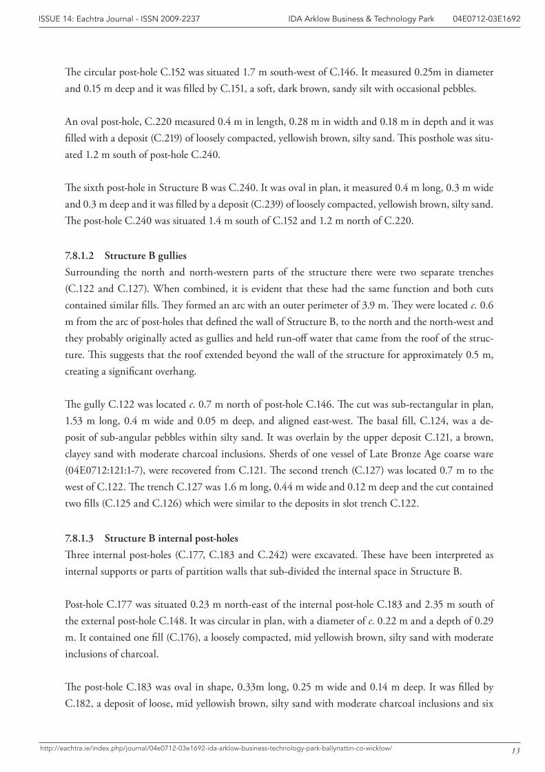
The circular post-hole C.152 was situated 1.7 m south-west of C.146. It measured 0.25m in diameter and 0.15 m deep and it was filled by C.151, a soft, dark brown, sandy silt with occasional pebbles.
An oval post-hole, C.220 measured 0.4 m in length, 0.28 m in width and 0.18 m in depth and it was filled with a deposit (C.219) of loosely compacted, yellowish brown, silty sand. This posthole was situ-ated 1.2 m south of post-hole C.240.
The sixth post-hole in Structure B was C.240. It was oval in plan, it measured 0.4 m long, 0.3 m wide and 0.3 m deep and it was filled by a deposit (C.239) of loosely compacted, yellowish brown, silty sand. The post-hole C.240 was situated 1.4 m south of C.152 and 1.2 m north of C.220.
7.8.1.2 Structure B gullies
Surrounding the north and north-western parts of the structure there were two separate trenches (C.122 and C.127). When combined, it is evident that these had the same function and both cuts contained similar fills. They formed an arc with an outer perimeter of 3.9 m. They were located c. 0.6 m from the arc of post-holes that defined the wall of Structure B, to the north and the north-west and they probably originally acted as gullies and held run-off water that came from the roof of the struc-ture. This suggests that the roof extended beyond the wall of the structure for approximately 0.5 m, creating a significant overhang. The gully C.122 was located c. 0.7 m north of post-hole C.146. The cut was sub-rectangular in plan, 1.53 m long, 0.4 m wide and 0.05 m deep, and aligned east-west. The basal fill, C.124, was a de-posit of sub-angular pebbles within silty sand. It was overlain by the upper deposit C.121, a brown, clayey sand with moderate charcoal inclusions. Sherds of one vessel of Late Bronze Age coarse ware (04E0712:121:1-7), were recovered from C.121. The second trench (C.127) was located 0.7 m to the west of C.122. The trench C.127 was 1.6 m long, 0.44 m wide and 0.12 m deep and the cut contained two fills (C.125 and C.126) which were similar to the deposits in slot trench C.122.
7.8.1.3 Structure B internal post-holes
Three internal post-holes (C.177, C.183 and C.242) were excavated. These have been interpreted as internal supports or parts of partition walls that sub-divided the internal space in Structure B.
Post-hole C.177 was situated 0.23 m north-east of the internal post-hole C.183 and 2.35 m south of the external post-hole C.148. It was circular in plan, with a diameter of c. 0.22 m and a depth of 0.29 m. It contained one fill (C.176), a loosely compacted, mid yellowish brown, silty sand with moderate inclusions of charcoal.
The post-hole C.183 was oval in shape, 0.33m long, 0.25 m wide and 0.14 m deep. It was filled by C.182, a deposit of loose, mid yellowish brown, silty sand with moderate charcoal inclusions and six
14
IDA Arklow Business & Technology Park 04E0712-03E1692ISSUE 14: Eachtra Journal - ISSN 2009-2237
http://eachtra.ie/index.php/journal/04e0712-03e1692-ida-arklow-business-technology-park-ballynattin-co-wicklow/
packing stones. A fragment of Late Bronze Age coarse pottery was also recovered from this deposit. It was from the same vessel as a body-sherd that was found in a deposit within the slot trench of Struc-ture C (C.145, see below). This indicates that occupation at both structures was contemporary. The posthole (C.183) was truncated by the boundary ditch, C.118, to the west. It was situated 0.23 m to the west-south-west of internal post-hole C.177.
The final post-hole associated with Structure B was C.242, a sub-circular post-hole situated 1.8 m south of external post-hole C.146 and 0.9 m east-south-east of external post-hole C.152. It was filled by C.241 which comprised loose, mixed brown and grey, sandy silt with moderately occurring inclu-sions of fine pebbles.
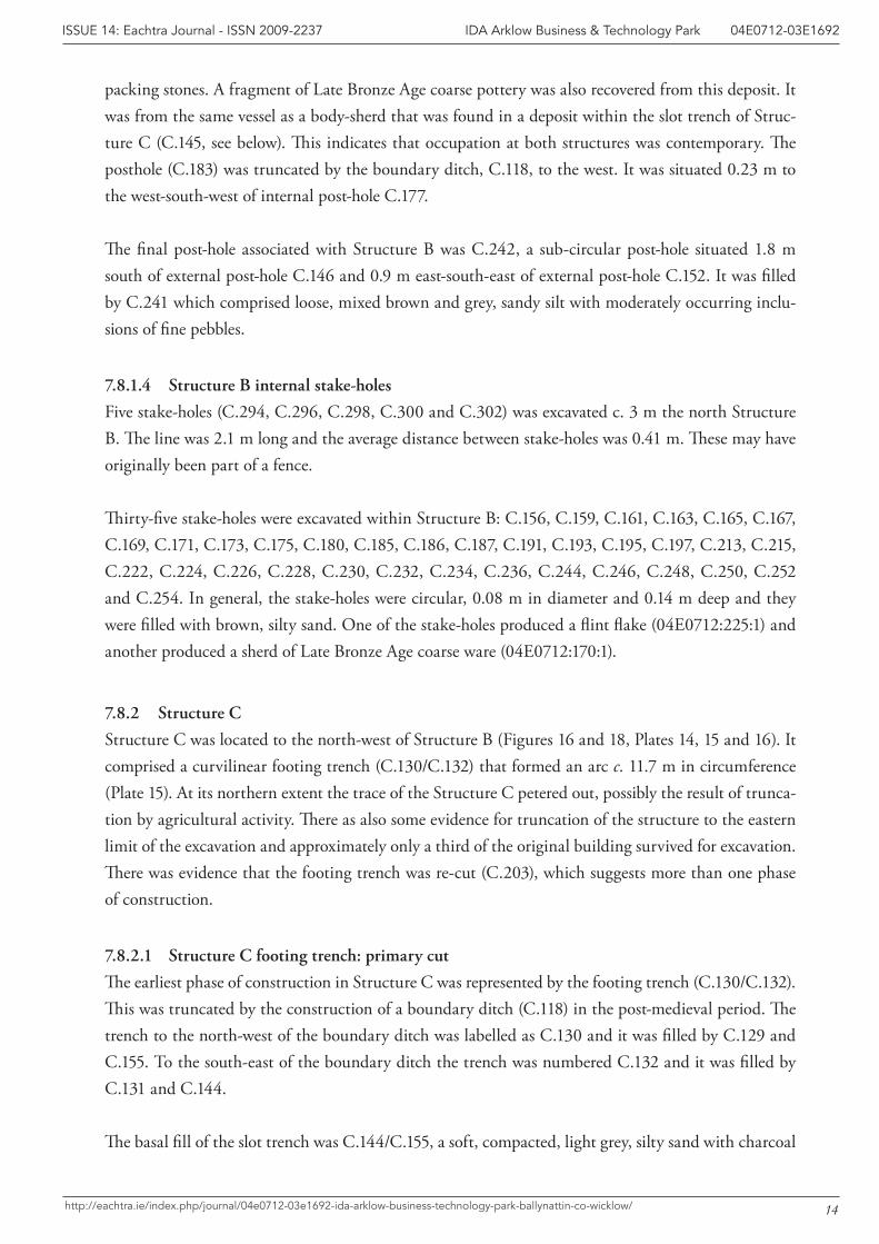
7.8.1.4 Structure B internal stake-holes
Five stake-holes (C.294, C.296, C.298, C.300 and C.302) was excavated c. 3 m the north Structure B. The line was 2.1 m long and the average distance between stake-holes was 0.41 m. These may have originally been part of a fence.
Thirty-five stake-holes were excavated within Structure B: C.156, C.159, C.161, C.163, C.165, C.167, C.169, C.171, C.173, C.175, C.180, C.185, C.186, C.187, C.191, C.193, C.195, C.197, C.213, C.215, C.222, C.224, C.226, C.228, C.230, C.232, C.234, C.236, C.244, C.246, C.248, C.250, C.252 and C.254. In general, the stake-holes were circular, 0.08 m in diameter and 0.14 m deep and they were filled with brown, silty sand. One of the stake-holes produced a flint flake (04E0712:225:1) and another produced a sherd of Late Bronze Age coarse ware (04E0712:170:1).
7.8.2 Structure C
Structure C was located to the north-west of Structure B (Figures 16 and 18, Plates 14, 15 and 16). It comprised a curvilinear footing trench (C.130/C.132) that formed an arc c. 11.7 m in circumference (Plate 15). At its northern extent the trace of the Structure C petered out, possibly the result of trunca-tion by agricultural activity. There as also some evidence for truncation of the structure to the eastern limit of the excavation and approximately only a third of the original building survived for excavation. There was evidence that the footing trench was re-cut (C.203), which suggests more than one phase of construction.
7.8.2.1 Structure C footing trench: primary cut
The earliest phase of construction in Structure C was represented by the footing trench (C.130/C.132). This was truncated by the construction of a boundary ditch (C.118) in the post-medieval period. The trench to the north-west of the boundary ditch was labelled as C.130 and it was filled by C.129 and C.155. To the south-east of the boundary ditch the trench was numbered C.132 and it was filled by C.131 and C.144.
The basal fill of the slot trench was C.144/C.155, a soft, compacted, light grey, silty sand with charcoal
15
IDA Arklow Business & Technology Park 04E0712-03E1692ISSUE 14: Eachtra Journal - ISSN 2009-2237
http://eachtra.ie/index.php/journal/04e0712-03e1692-ida-arklow-business-technology-park-ballynattin-co-wicklow/
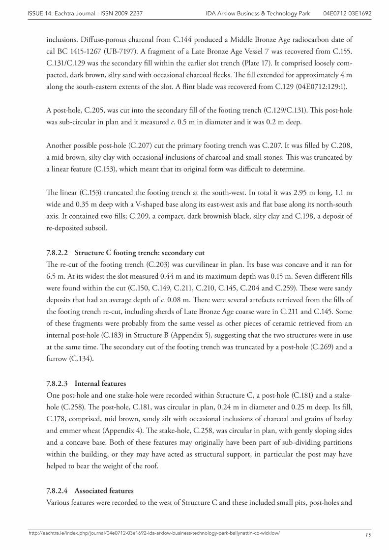
inclusions. Diffuse-porous charcoal from C.144 produced a Middle Bronze Age radiocarbon date of cal BC 1415-1267 (UB-7197). A fragment of a Late Bronze Age Vessel 7 was recovered from C.155. C.131/C.129 was the secondary fill within the earlier slot trench (Plate 17). It comprised loosely com-pacted, dark brown, silty sand with occasional charcoal flecks. The fill extended for approximately 4 m along the south-eastern extents of the slot. A flint blade was recovered from C.129 (04E0712:129:1).
A post-hole, C.205, was cut into the secondary fill of the footing trench (C.129/C.131). This post-hole was sub-circular in plan and it measured c. 0.5 m in diameter and it was 0.2 m deep.
Another possible post-hole (C.207) cut the primary footing trench was C.207. It was filled by C.208, a mid brown, silty clay with occasional inclusions of charcoal and small stones. This was truncated by a linear feature (C.153), which meant that its original form was difficult to determine.
The linear (C.153) truncated the footing trench at the south-west. In total it was 2.95 m long, 1.1 m wide and 0.35 m deep with a V-shaped base along its east-west axis and flat base along its north-south axis. It contained two fills; C.209, a compact, dark brownish black, silty clay and C.198, a deposit of re-deposited subsoil.
7.8.2.2 Structure C footing trench: secondary cut
The re-cut of the footing trench (C.203) was curvilinear in plan. Its base was concave and it ran for 6.5 m. At its widest the slot measured 0.44 m and its maximum depth was 0.15 m. Seven different fills were found within the cut (C.150, C.149, C.211, C.210, C.145, C.204 and C.259). These were sandy deposits that had an average depth of c. 0.08 m. There were several artefacts retrieved from the fills of the footing trench re-cut, including sherds of Late Bronze Age coarse ware in C.211 and C.145. Some of these fragments were probably from the same vessel as other pieces of ceramic retrieved from an internal post-hole (C.183) in Structure B (Appendix 5), suggesting that the two structures were in use at the same time. The secondary cut of the footing trench was truncated by a post-hole (C.269) and a furrow (C.134).
7.8.2.3 Internal features
One post-hole and one stake-hole were recorded within Structure C, a post-hole (C.181) and a stake-hole (C.258). The post-hole, C.181, was circular in plan, 0.24 m in diameter and 0.25 m deep. Its fill, C.178, comprised, mid brown, sandy silt with occasional inclusions of charcoal and grains of barley and emmer wheat (Appendix 4). The stake-hole, C.258, was circular in plan, with gently sloping sides and a concave base. Both of these features may originally have been part of sub-dividing partitions within the building, or they may have acted as structural support, in particular the post may have helped to bear the weight of the roof.
7.8.2.4 Associated features
Various features were recorded to the west of Structure C and these included small pits, post-holes and
16
IDA Arklow Business & Technology Park 04E0712-03E1692ISSUE 14: Eachtra Journal - ISSN 2009-2237
http://eachtra.ie/index.php/journal/04e0712-03e1692-ida-arklow-business-technology-park-ballynattin-co-wicklow/
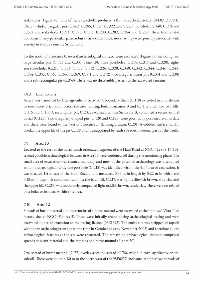
stake-holes (Figure 18). One of these stakeholes produced a flint retouched artefact (04E0712:290:1). These included irregular pits (C.262, C.285, C.287, C. 322 and C.330), post-holes C.140, C.274 and C.362 and stake-holes C.271, C.276, C.278, C.280, C.282, C.284 and C.289. These features did not occur in any particular pattern but their location indicates that they were possibly associated with activity in the area outside Structure C.
To the north of Structure C several archaeological contexts were excavated (Figure 19) including two large circular pits (C.363 and C.335; Plate 18), three post-holes (C.314, C.316 and C.320), eight-een stake-holes (C.210, C.304, C.308, C.312, C.326, C.328, C.340, C.342, C.344, C.346, C.348, C.354, C.352, C.365, C.366, C.369, C.371 and C.372), two irregular linear pits (C.331 and C.338) and a sub-rectangular pit (C.359). There was no discernible pattern to the excavated remains.
7.8.3 Later activity
Area 7 was truncated by later agricultural activity. A boundary ditch (C.118) extended in a north-east to south-west orientation across the area, cutting both Structures B and C. The ditch had two fills, C.116 and C.117. A rectangular pit, C.202, excavated within Structure B, contained a recent animal burial (C.123). Two irregularly-shaped pits (C.120 and C.128) were potentially post-medieval in date and these were found to the west of Structure B, flanking a drain, C.201. A cobbled surface, C.115, overlay the upper fill of the pit C.128 and it disappeared beneath the south-western part of the baulk.
7.9 Area 10Located to the east of the north-south orientated segment of the Haul Road at NGC 322808 171154, several possible archaeological features in Area 10 were cordoned-off during the monitoring phase. The small area of excavation was cleaned manually and most of the potential archaeology was discounted as non-archaeological. Only one post-hole (C.218) was identified within the 4m2 area of excavation. It was situated 1.4 m east of the Haul Road and it measured 0.33 m in length by 0.22 m in width and 0.18 m in depth. It contained two fills; the basal fill, C.217, was light yellowish brown, silty clay and the upper fill, C.216, was moderately compacted light reddish brown, sandy clay. There were no related post-holes or features within this area.
7.10 Area 12Spreads of burnt material and the remains of a burnt mound were excavated at the proposed Vitra Tiles factory site, at NGC (Figures 3). These were initially found during archaeological testing and were excavated under an extension to the testing licence (03E1692). The entire site was stripped of topsoil without an archaeologist on site (some time in October or early November 2003) and therefore all the archaeological features at the site were truncated. The remaining archaeological deposits comprised spreads of burnt material and the remains of a burnt mound (Figure 20).
One spread of burnt material (C.77) overlay a second spread (C.78), which in turn lay directly on the subsoil. These were found c. 80 m to the north-west of the 98E0257 enclosure. Another two spreads of

17
IDA Arklow Business & Technology Park 04E0712-03E1692ISSUE 14: Eachtra Journal - ISSN 2009-2237
http://eachtra.ie/index.php/journal/04e0712-03e1692-ida-arklow-business-technology-park-ballynattin-co-wicklow/
burnt material, C.79 and C.81, were located 20 m to the north-west. C.79 filled a shallow pit (C.80) and C.81 was a shallow spread. There was no trough associated with these spreads and the deposits were probably associated with the prehistoric enclosure excavated under licence 98E257 (Cotter, 2000).
The remains of a burnt mound (C.82, C.83 and C.84) were discovered in the north-west corner of the field, along the north-west baulk and extending beyond the limit of excavation. These deposits were truncated by topsoil stripping and the mound was largely destroyed. A trough (C.85) was associated with the burnt deposits. It measured 2.5 m north-west to south-east, by c. 2.5 m in width and 0.2 m in depth. There was no indication of any trough lining. Burnt mounds are Bronze Age in date and this feature may be broadly contemporary with the enclosure excavated under excavation licence number 98E0257, which is 150 m to the south-east.
18
IDA Arklow Business & Technology Park 04E0712-03E1692ISSUE 14: Eachtra Journal - ISSN 2009-2237
http://eachtra.ie/index.php/journal/04e0712-03e1692-ida-arklow-business-technology-park-ballynattin-co-wicklow/
8 Specialist Results
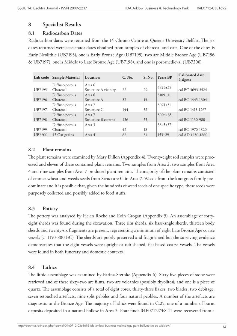
8.1 Radiocarbon DatesRadiocarbon dates were returned from the 14 Chrono Centre at Queens University Belfast. The six dates returned were accelerator dates obtained from samples of charcoal and oats. One of the dates is Early Neolithic (UB7195), one is Early Bronze Age (UB7199), two are Middle Bronze Age (UB7196 & UB7197), one is Middle to Late Bronze Age (UB7198), and one is post-medieval (UB7200).
Lab code Sample Material Location C. No. S. No. Years BP Calibrated date2 sigma
UB7195Diffuse-porousCharcoal
Area 6Structure A vicinity 22 29 4825±35 cal BC 3693-3524
UB7196Diffuse-porousCharcoal
Area 6Structure A 32 15
3109±31cal BC 1445-1304
UB7197Diffuse-porousCharcoal
Area 7Structure C 144 52
3074±31cal BC 1415-1267
UB7198Diffuse-porousCharcoal
Area 7Structure B external 136 53
3004±35cal BC 1130-980
UB7199Diffuse-porousCharcoal
Area 342 18
3845±37cal BC 1970-1820
UB7200 43 Oat grains Area 4 82 31 153±29 cal AD 1730-1860
8.2 Plant remains The plant remains were examined by Mary Dillon (Appendix 4). Twenty-eight soil samples were proc-essed and eleven of these contained plant remains. Two samples from Area 2, two samples from Area 4 and nine samples from Area 7 produced plant remains. The majority of the plant remains consisted of emmer wheat and weeds seeds from Structure C in Area 7. Weeds from the knotgrass family pre-dominate and it is possible that, given the hundreds of weed seeds of one specific type, these seeds were purposely collected and possibly added to food stuffs.
8.3 Pottery The pottery was analysed by Helen Roche and Eoin Grogan (Appendix 5). An assemblage of forty-eight sherds was found during the excavation. Three rim sherds, six base-angle sherds, thirteen body sherds and twenty-six fragments are present, representing a minimum of eight Late Bronze Age coarse vessels (c. 1150-800 BC). The sherds are poorly preserved and fragmented but the surviving evidence demonstrates that the eight vessels were upright or tub-shaped, flat-based coarse vessels. The vessels were found in both funerary and domestic contexts.
8.4 LithicsThe lithic assemblage was examined by Farina Sternke (Appendix 6). Sixty-five pieces of stone were retrieved and of these sixty-two are flints, two are volcanics (possibly rhyolites), and one is a piece of quartz. The assemblage consists of a total of eight cores, thirty-three flakes, two blades, two debitage, seven retouched artefacts, nine split pebbles and four natural pebbles. A number of the artefacts are diagnostic to the Bronze Age. The majority of lithics were found in C.25, one of a number of burnt deposits deposited in a natural hollow in Area 3. Four finds 04E0712:73:8-11 were recovered from a
19
IDA Arklow Business & Technology Park 04E0712-03E1692ISSUE 14: Eachtra Journal - ISSN 2009-2237
http://eachtra.ie/index.php/journal/04e0712-03e1692-ida-arklow-business-technology-park-ballynattin-co-wicklow/
pit in Area 6W, while 04E0712:107:2 was associated with the fill of a furnace in Area 2.
9 Summary and Discussion of Excavation ResultsThe range of archaeological material excavated at Ballynattin, Co. Wicklow under licence no. 04E0712 included Middle-Late Bronze Age buildings, a furnace, a post-medieval hearth, agricultural and boundary features.
Three Middle-Late Bronze Age buildings (Structures A, B and C) were excavated at Ballynattin. Structures B and C were only 10 m apart, both were found within Area 7. They were c. 100 m from Structure A, located in Area 6. Although each structure was disturbed by agricultural activity and/or recent ground-works associated with the construction of the Haul Road, c. one third of each structure survived for excavation. The structures were all round or oval timber-built houses. This is typical: in Doody’s (2000) survey of Irish Bronze Age houses, forty-nine excavated timber-built houses were listed and only eleven of these were rectangular. However, despite a common shape-in-plan, there is certainly diversity in construction methods: some houses have footing trenches while other do not, some have only one ring of posts while others have more, and some houses have evidence of internal divisions, although the majority do not (Doody 2000, 137). This diversity is evident in the results from Bal-lynattin and each of the three structures found were different. Structure A had a footing trench but there was no evidence for post or stake support and it was surmised that the structure was plank-built. Structure B was post-built, and comprised a circle of evenly spaced post-holes with evidence for stake and post-built internal partitions and a drainage gully that surrounded the circle of posts. Structure C was characterised by a curvilinear foundation trench which contained evidence for post-built sup-ports. All of the buildings at Ballynattin were quite large and their projected diameters were in the 7-9 m range. Their size and the substantial nature of the structural remains suggest significant buildings, houses that formed part of a permanent settlement. To emphasise the permanency of the settlement, there was evidence in one house (Structure C) that the wall had been repaired or replaced. Despite this, no hearths (internal or external) were excavated in association with any of the Bronze Age houses at Ballynattin. However, there was evidence that cooking and domestic occupation had been carried out; six of the eight pottery vessels retrieved from the site had carbonised matter and fire-blackening on the both surfaces. This was interpreted as evidence for domestic use (Appendix 5).
This settlement evidence occurred alongside many areas of Bronze Age archaeology where the activi-ties at the site were not as easy to classify. In Area 6W seven pits were excavated and, although initially thought of as cremation pits, their function is unknown. Pits, post-holes and stake-holes were also found outside Structure C in Area 7, following no obvious pattern and of uncertain function.
The furnace excavated at Area 2 was truncated and its morphology was not clearly defined. However, it appeared to have a small chamber, circular in plan and possibly a long flue that extended to the north-east. It was not radiocarbon dated and therefore it is difficult to be certain about when it was in use. The function of the furnace is also obscure, slag was absent and therefore the site was presumably not
20
IDA Arklow Business & Technology Park 04E0712-03E1692ISSUE 14: Eachtra Journal - ISSN 2009-2237
http://eachtra.ie/index.php/journal/04e0712-03e1692-ida-arklow-business-technology-park-ballynattin-co-wicklow/
used for metal-working. There were very few seeds recovered from the fill of the furnace, indicating that it was not used for drying grain.
Post-medieval features excavated at Ballynattin were generally associated with agriculture. These were generally furrows, drains and boundary ditches. One post-medieval hearth was also excavated (Area ). As there was a large quantity of cereal grains retrieved from the fill of the hearth it is possible that this, too, had an agricultural purpose.
10 ConclusionsTen areas of archaeological potential were investigated along the course of new road and services in-frastructure at the IDA Business and Technology Park in Ballynattin. These areas were fully excavated under State licence 04E0712, revealing the remains of three Bronze Age structures, Bronze Age pits and spreads of Bronze Age material, a furnace (possibly also Bronze Age), a post-medieval hearth and post-medieval agricultural activity. In association with earlier archaeological work in the area, such as the medieval enclosure also found in Ballynattin townland (Cotter 2000, 220), these sites indicate a long span of human activity in the area.
21
IDA Arklow Business & Technology Park 04E0712-03E1692ISSUE 14: Eachtra Journal - ISSN 2009-2237
http://eachtra.ie/index.php/journal/04e0712-03e1692-ida-arklow-business-technology-park-ballynattin-co-wicklow/
11 BibliographyCotter, E. 2000. ‘Ballynattin Prehistoric Enclosure 32332 17114 98E0257, Co. Wicklow’ In I. Bennett
(ed.) Excavations 1998. Bray, Wordwell.
Doody, M. 2000. ‘Bronze Age houses in Ireland’ pp.135-160 in A. Desmond, G. Johnson, M. McCarthy, J. Sheehan and E. Shee Twohig (eds.) New Agendas in Irish Prehistory. Bray, Wordwell.
IDA 2003. Arklow Business and Technology Park IDA, Briefing Document- Archaeological Testing. IDA briefing document.
Doherty, B, and Kelly, B. 2004. Ballynattin, Arklow, Co. Wicklow – Archaeological Excavation Interim Report (04E0712). Unpublished Eachtra Archaeological Projects report submitted to the Department of the Environment, Heritage and Local Government.
Kelly, B. & Tierney J. 2004. Ballynattin, Arklow, Co. Wicklow - Archaeological Monitoring Report. Unpublished Eachtra Archaeological Projects report submitted to the Department of the Environment, Heritage and Local Government.
Tierney, J. & Doolan A. 2004a. Ballynattin, Arklow, Co. Wicklow. Archaeological Testing Report. Unpublished Eachtra Archaeological Projects report submitted to the Department of the Environment, Heritage and Local Government.
Tierney, J. & Doolan A. 2004b. Ballynattin, Arklow, Co. Wicklow. Archaeological Excavation Interim Report (03E1692). Unpublished Eachtra Archaeological Projects report submitted to the Department of the Environment, Heritage and Local Government.
11.1 Websiteswww.excavations.ie
N
Site Location
22
IDA Arklow Business & Technology Park 04E0712-03E1692ISSUE 14: Eachtra Journal - ISSN 2009-2237
http://eachtra.ie/index.php/journal/04e0712-03e1692-ida-arklow-business-technology-park-ballynattin-co-wicklow/
12 Figures
Figure 1: Site location map
N
0 20 m10 m
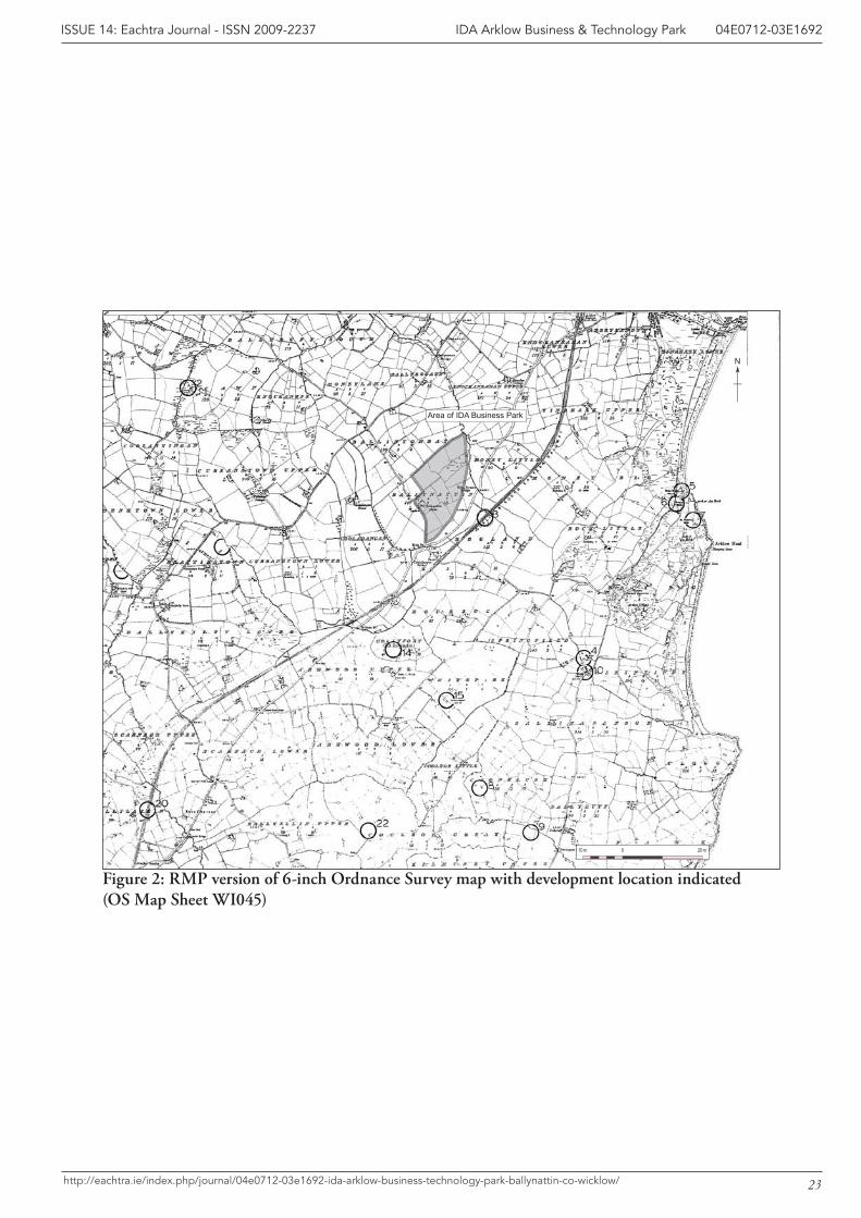
Area of IDA Business Park
23
IDA Arklow Business & Technology Park 04E0712-03E1692ISSUE 14: Eachtra Journal - ISSN 2009-2237
http://eachtra.ie/index.php/journal/04e0712-03e1692-ida-arklow-business-technology-park-ballynattin-co-wicklow/
Figure 2: RMP version of 6-inch Ordnance Survey map with development location indicated (OS Map Sheet WI045)
ARKL
OW
BYP
ASS
RO
AD
ROAD 'A'
ROAD
'A'
RO
AD 'A
'
ROAD 'B'
ROAD 'C'
ROAD 'D'
Area 7
Area 6W Area 5
Area 6Area 4
Area 1
Area 2
Area 3
N
0 250 m
Area 10
Area 12
24
IDA Arklow Business & Technology Park 04E0712-03E1692ISSUE 14: Eachtra Journal - ISSN 2009-2237
http://eachtra.ie/index.php/journal/04e0712-03e1692-ida-arklow-business-technology-park-ballynattin-co-wicklow/
Figure 3: Development site with area locations
C.13
C.11
C.7
N
C.9
C.6
0 1m
E 3229956N 1713243
E 3229911N 1713265
E 3229980N 1713287
Root acitivy
Natural Hollow
25
IDA Arklow Business & Technology Park 04E0712-03E1692ISSUE 14: Eachtra Journal - ISSN 2009-2237
http://eachtra.ie/index.php/journal/04e0712-03e1692-ida-arklow-business-technology-park-ballynattin-co-wicklow/
Figure 4: Area 1 post-excavation plan
C.4
C.5
ESE
WSW
C.6
0 50 cm
Ballynattin Arklow Co Wicklow04E0712Area 1 Section drawingScale 1:10
26
IDA Arklow Business & Technology Park 04E0712-03E1692ISSUE 14: Eachtra Journal - ISSN 2009-2237
http://eachtra.ie/index.php/journal/04e0712-03e1692-ida-arklow-business-technology-park-ballynattin-co-wicklow/
Figure 5: Section through boundary ditch C.6 in Area 1
N
C.107
C.97
Limit of excavation
C.110
0 50 cm50 cm
E 3230160N 1713550
E 3230136N 1713594
27
IDA Arklow Business & Technology Park 04E0712-03E1692ISSUE 14: Eachtra Journal - ISSN 2009-2237
http://eachtra.ie/index.php/journal/04e0712-03e1692-ida-arklow-business-technology-park-ballynattin-co-wicklow/
Figure 6: Post-excavation plan of Area 2
C.42
Limits of ExcavationN
C.21
C.42
mc 05050 cm
E 3230610N1714650
E 3230606N 1714645
28
IDA Arklow Business & Technology Park 04E0712-03E1692ISSUE 14: Eachtra Journal - ISSN 2009-2237
http://eachtra.ie/index.php/journal/04e0712-03e1692-ida-arklow-business-technology-park-ballynattin-co-wicklow/
Figure 7: Post-excavation plan of Area 3
C.1
02
C.1
05
C.8
6
C.1
09
C.1
08
C.101
C.1
00
C.1
01
C.9
2
C.8
7
C.9
1
C.1
06C.9
0
N
01
m5
0 c
m
Lim
it of
exca
vatio
n
E 3
2295
28 N
171
3035
E 3
2295
37N
171
3035
29
IDA Arklow Business & Technology Park 04E0712-03E1692ISSUE 14: Eachtra Journal - ISSN 2009-2237
http://eachtra.ie/index.php/journal/04e0712-03e1692-ida-arklow-business-technology-park-ballynattin-co-wicklow/
Figu
re 8
: Pos
t-ex
cava
tion
pla
n of
Are
a 4
01
m
C.8
8
C.8
9
C.3
4
C.7
6
Bal
lyna
ttin
Ark
low
Co
Wic
klow
04E
0712
Are
a 5
Wes
t-fac
ing
Sec
tion
Sca
le 1
:10
AB
30
IDA Arklow Business & Technology Park 04E0712-03E1692ISSUE 14: Eachtra Journal - ISSN 2009-2237
http://eachtra.ie/index.php/journal/04e0712-03e1692-ida-arklow-business-technology-park-ballynattin-co-wicklow/
Figu
re 9
: Sec
tion
thr
ough
C.3
4, C
.76,
C.8
8 an
d C
.89
in A
rea
5
C.5
0
C.4
8
Stru
ctur
e A
Non
-Arc
haeo
logi
cal
E 3
2289
9N
171
335
E 3
2290
1N
171
335
C.5
6
C.2
6
C.3
9
C.4
6 C.4
1
C.3
0C
.52
1 m
2 m
0 c
m
N
31
IDA Arklow Business & Technology Park 04E0712-03E1692ISSUE 14: Eachtra Journal - ISSN 2009-2237
http://eachtra.ie/index.php/journal/04e0712-03e1692-ida-arklow-business-technology-park-ballynattin-co-wicklow/
Figu
re 1
0: P
ost-
exca
vati
on p
lan
of A
rea
6
N
0 3 m
C. 49
C. 58
C. 48
C. 46
C. 45
C. 47
C. 48C. 46
C. 56
C. 55
C. 54
C. 53
C. 52
C. 60
C. 61
C. 59
C. 62
C. 74C. 73
C. 70C. 72
C. 68C. 69
C. 67
C. 65
C. 50
C. 51
32
IDA Arklow Business & Technology Park 04E0712-03E1692ISSUE 14: Eachtra Journal - ISSN 2009-2237
http://eachtra.ie/index.php/journal/04e0712-03e1692-ida-arklow-business-technology-park-ballynattin-co-wicklow/
Figure 11: Post-excavation plan of contexts in Area 6 excavated under licence no. 03E1692
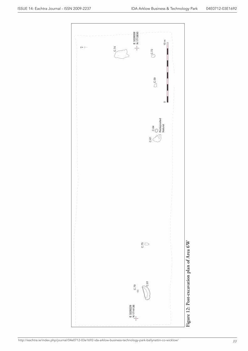
C.7
5
C.6
4
N
C.5
9
C.6
1
Red
epos
ited
Nat
ural
C.8
1
C.7
9
C.7
4
10 m
0
C.7
2
E 3
2285
59N
171
3830
E 3
2282
29N
171
4136
33
IDA Arklow Business & Technology Park 04E0712-03E1692ISSUE 14: Eachtra Journal - ISSN 2009-2237
http://eachtra.ie/index.php/journal/04e0712-03e1692-ida-arklow-business-technology-park-ballynattin-co-wicklow/
Figu
re 1
2: P
ost-
exca
vati
on p
lan
of A
rea
6W
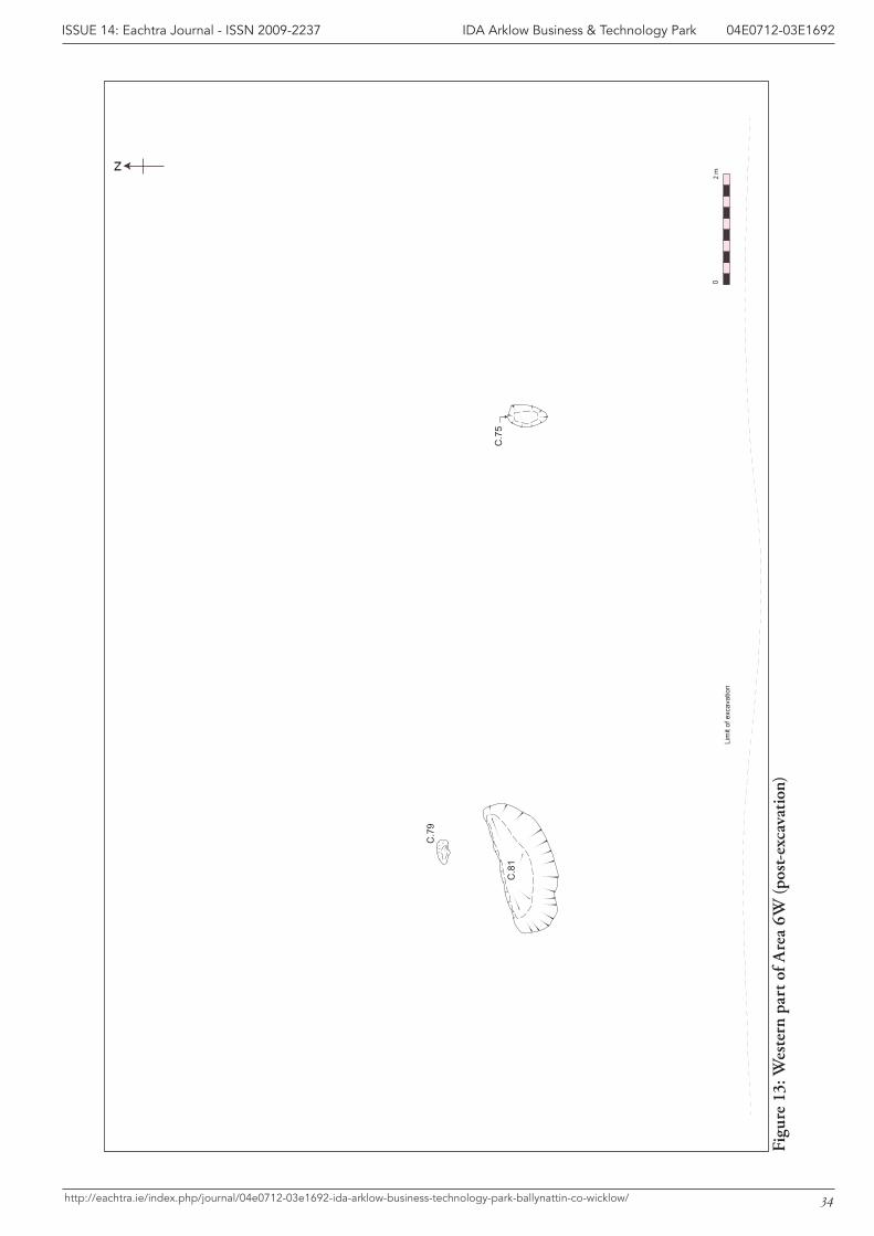
2
m0
C.7
5
N
C.8
1
C.7
9
Lim
it of
exc
avat
ion
34
IDA Arklow Business & Technology Park 04E0712-03E1692ISSUE 14: Eachtra Journal - ISSN 2009-2237
http://eachtra.ie/index.php/journal/04e0712-03e1692-ida-arklow-business-technology-park-ballynattin-co-wicklow/
Figu
re 1
3: W
este
rn p
art o
f Are
a 6W
(pos
t-ex
cava
tion
)
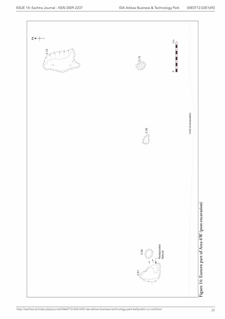
2
m0
C.6
4
N
C.5
9
C.6
1
Red
epos
ited
Nat
ural
C.7
4
C.7
2
Lim
it of
exc
avat
ion
35
IDA Arklow Business & Technology Park 04E0712-03E1692ISSUE 14: Eachtra Journal - ISSN 2009-2237
http://eachtra.ie/index.php/journal/04e0712-03e1692-ida-arklow-business-technology-park-ballynattin-co-wicklow/
Figu
re 1
4: E
aste
rn p
art o
f Are
a 6W
(pos
t-ex
cava
tion
)
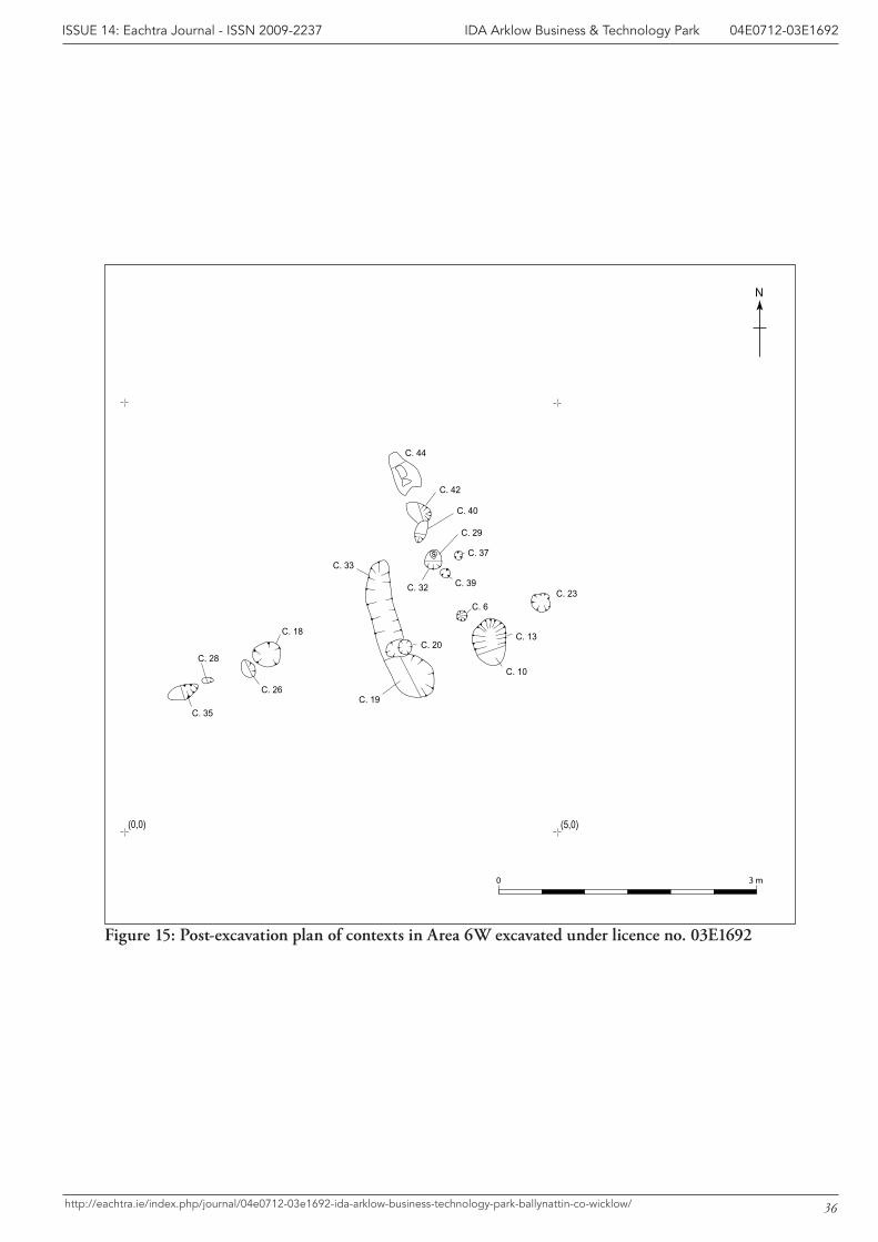
(0,0) (5,0)
0 3 m
N
C. 44
C. 42
C. 40
C. 37
C. 39
s
C. 32
C. 29
C. 23
C. 10
C. 13
C. 6
C. 33
C. 19
C. 20C. 18
C. 26
C. 28
C. 35
36
IDA Arklow Business & Technology Park 04E0712-03E1692ISSUE 14: Eachtra Journal - ISSN 2009-2237
http://eachtra.ie/index.php/journal/04e0712-03e1692-ida-arklow-business-technology-park-ballynattin-co-wicklow/
Figure 15: Post-excavation plan of contexts in Area 6W excavated under licence no. 03E1692
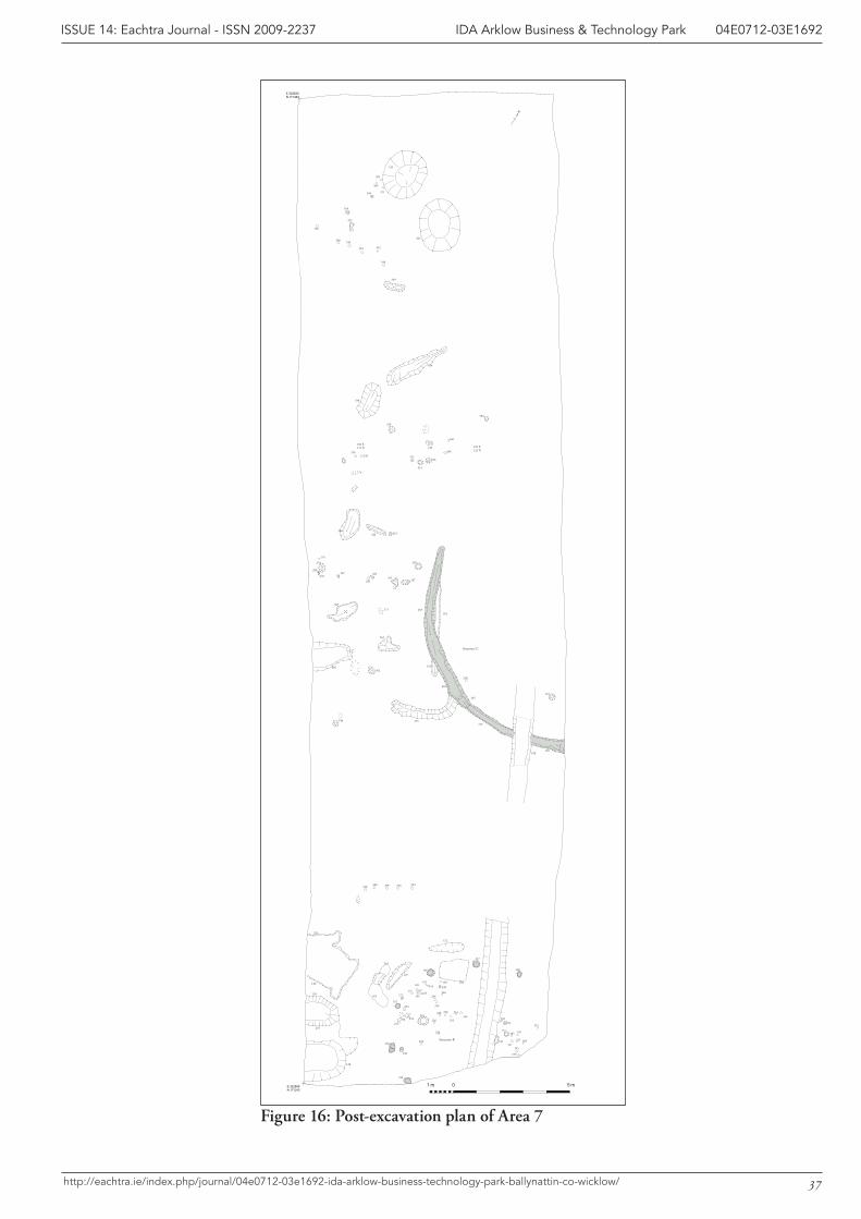
Structure C
Structure B
0 5 m1 mE 322899N 171242
E 322830N 171484
N
189213
183
185 187
197
191 189
195
193
215
137
148
254
152
173
254
244246
248
150159
161
163165
167
169
146
202
122
127
263
263
120
128
120
201
128
240
238
220
222
224
226
243252250
175
228 230
232
234236
171
177
292
285302
335
363
312
339
372
352
354
366
369
365
371
350
340
342344
346348
359
338
320
304
210
316
308
306
314
326328
265
267
284
282
324322330
278287
280
274
276
258
203
134
203134
271
287
262
205181
130168
132153140
105 E125 N
100 E125 N
294296298300318
37
IDA Arklow Business & Technology Park 04E0712-03E1692ISSUE 14: Eachtra Journal - ISSN 2009-2237
http://eachtra.ie/index.php/journal/04e0712-03e1692-ida-arklow-business-technology-park-ballynattin-co-wicklow/
Figure 16: Post-excavation plan of Area 7
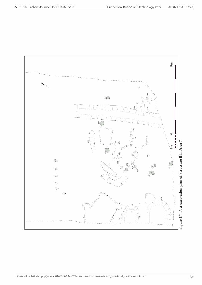
Stru
ctur
e B
05
m1
m
N
189
213
183
185
187
197
191
189
195
193
215
137
148
254
152
173
254
244
246
248
150
159
161
163
16516
7
169
146
202
122
127
263
263
120
128120 20
1
128
240
238
220
222
224
226
243
252
250
175
228
230
23223
423
6
171
177
294
296
298
300
318
38
IDA Arklow Business & Technology Park 04E0712-03E1692ISSUE 14: Eachtra Journal - ISSN 2009-2237
http://eachtra.ie/index.php/journal/04e0712-03e1692-ida-arklow-business-technology-park-ballynattin-co-wicklow/
Figu
re 1
7: P
ost-
exca
vati
on p
lan
of S
truc
ture
B in
Are
a 7
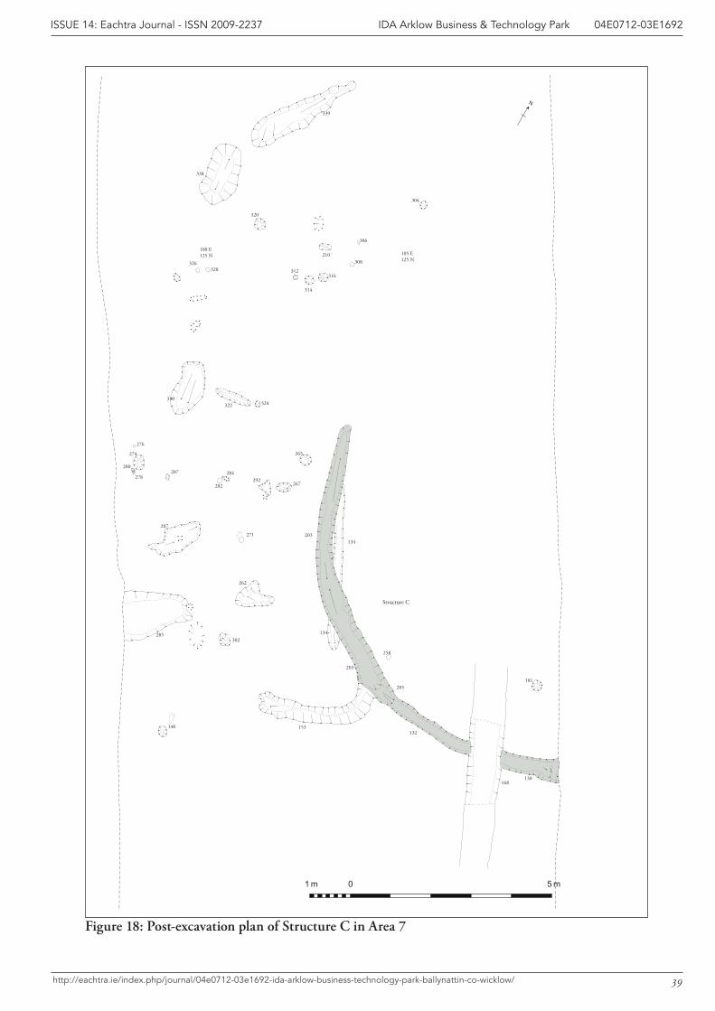
Structure C
0 5 m1 m
N
292
285302
312
339
338
320
304
210
316
308
306
314
326328
265
267
284
282
324322330
278287
280
274
276
258
203
134
203134
271
287
262
205181
130168
132153140
105 E125 N
100 E125 N
39
IDA Arklow Business & Technology Park 04E0712-03E1692ISSUE 14: Eachtra Journal - ISSN 2009-2237
http://eachtra.ie/index.php/journal/04e0712-03e1692-ida-arklow-business-technology-park-ballynattin-co-wicklow/
Figure 18: Post-excavation plan of Structure C in Area 7
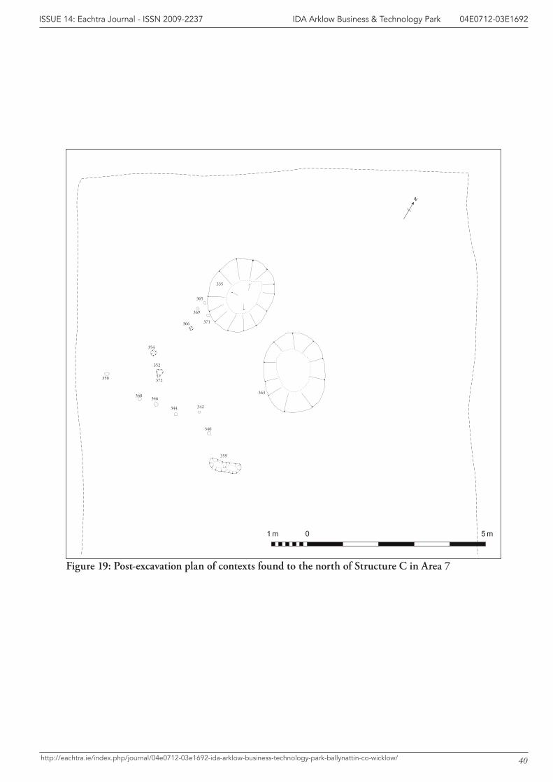
0 5 m1 m
N
335
363
372
352
354
366
369
365
371
350
340
342344
346348
359
40
IDA Arklow Business & Technology Park 04E0712-03E1692ISSUE 14: Eachtra Journal - ISSN 2009-2237
http://eachtra.ie/index.php/journal/04e0712-03e1692-ida-arklow-business-technology-park-ballynattin-co-wicklow/
Figure 19: Post-excavation plan of contexts found to the north of Structure C in Area 7
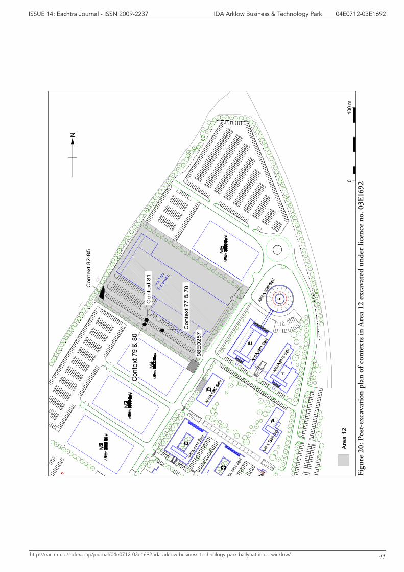
010
0 m
Con
text
82-
85
Con
text
79
& 80
Con
text
81
Con
text
77
& 7
8
98E
0257
Are
a 12
N
41
IDA Arklow Business & Technology Park 04E0712-03E1692ISSUE 14: Eachtra Journal - ISSN 2009-2237
http://eachtra.ie/index.php/journal/04e0712-03e1692-ida-arklow-business-technology-park-ballynattin-co-wicklow/
Figu
re 2
0: P
ost-
exca
vati
on p
lan
of c
onte
xts
in A
rea
12 e
xcav
ated
und
er li
cenc
e no
. 03E
1692
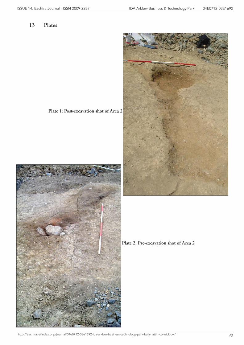
42
IDA Arklow Business & Technology Park 04E0712-03E1692ISSUE 14: Eachtra Journal - ISSN 2009-2237
http://eachtra.ie/index.php/journal/04e0712-03e1692-ida-arklow-business-technology-park-ballynattin-co-wicklow/
13 Plates
Plate 1: Post-excavation shot of Area 2
Plate 2: Pre-excavation shot of Area 2
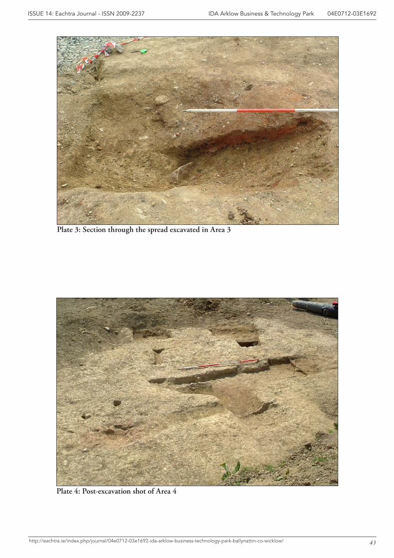
43
IDA Arklow Business & Technology Park 04E0712-03E1692ISSUE 14: Eachtra Journal - ISSN 2009-2237
http://eachtra.ie/index.php/journal/04e0712-03e1692-ida-arklow-business-technology-park-ballynattin-co-wicklow/
Plate 3: Section through the spread excavated in Area 3
Plate 4: Post-excavation shot of Area 4
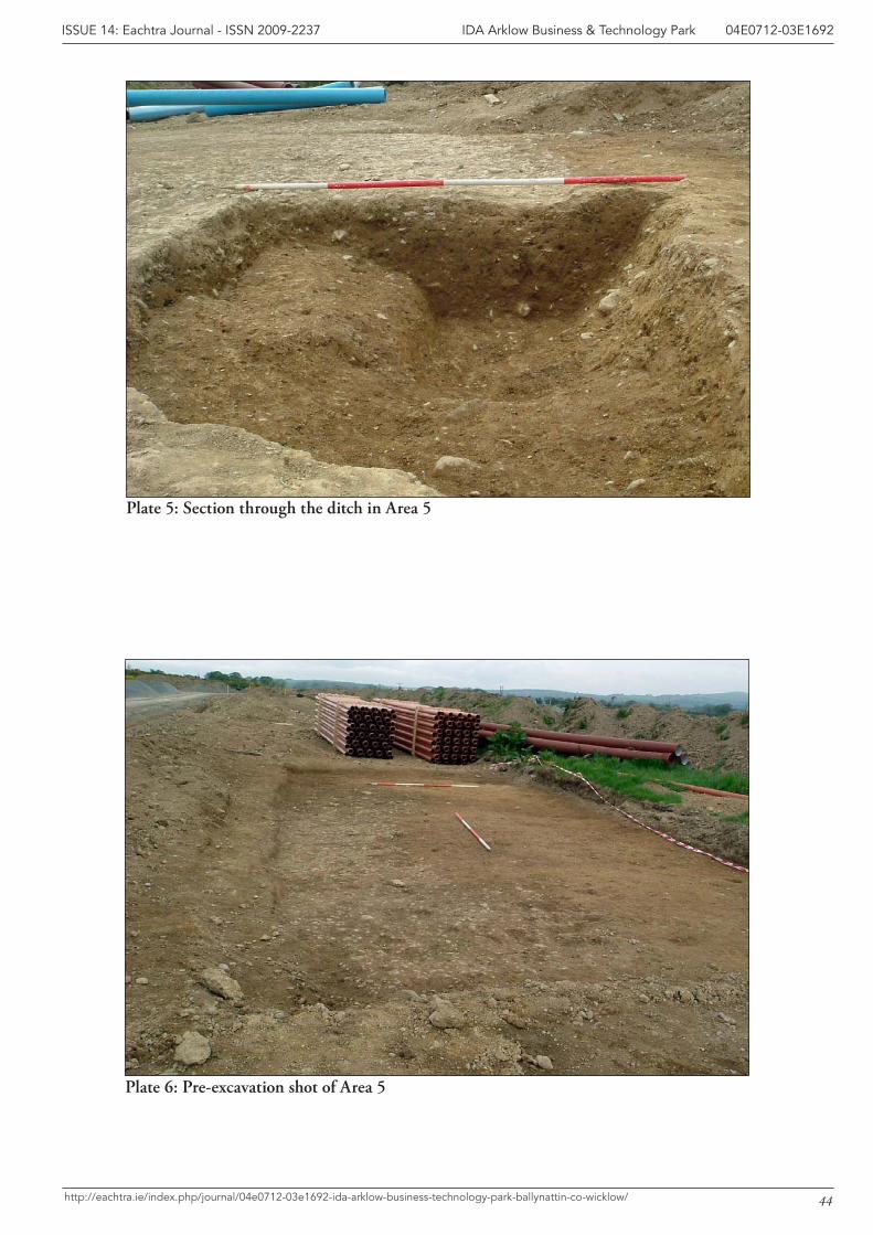
44
IDA Arklow Business & Technology Park 04E0712-03E1692ISSUE 14: Eachtra Journal - ISSN 2009-2237
http://eachtra.ie/index.php/journal/04e0712-03e1692-ida-arklow-business-technology-park-ballynattin-co-wicklow/
Plate 5: Section through the ditch in Area 5
Plate 6: Pre-excavation shot of Area 5
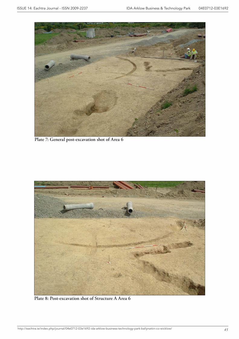
45
IDA Arklow Business & Technology Park 04E0712-03E1692ISSUE 14: Eachtra Journal - ISSN 2009-2237
http://eachtra.ie/index.php/journal/04e0712-03e1692-ida-arklow-business-technology-park-ballynattin-co-wicklow/
Plate 7: General post-excavation shot of Area 6
Plate 8: Post-excavation shot of Structure A Area 6
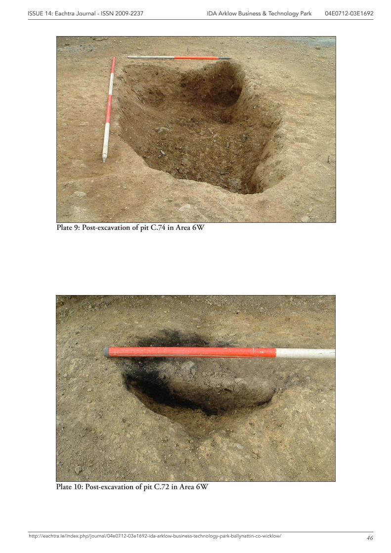
46
IDA Arklow Business & Technology Park 04E0712-03E1692ISSUE 14: Eachtra Journal - ISSN 2009-2237
http://eachtra.ie/index.php/journal/04e0712-03e1692-ida-arklow-business-technology-park-ballynattin-co-wicklow/
Plate 9: Post-excavation of pit C.74 in Area 6W
Plate 10: Post-excavation of pit C.72 in Area 6W
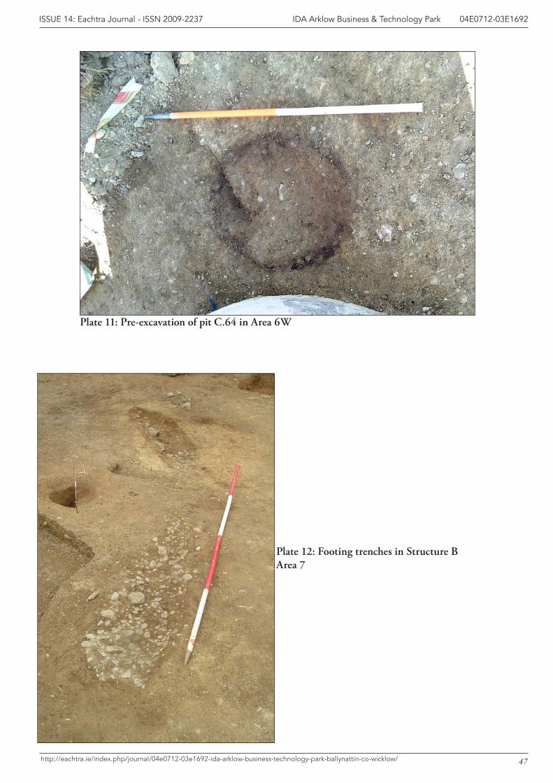
47
IDA Arklow Business & Technology Park 04E0712-03E1692ISSUE 14: Eachtra Journal - ISSN 2009-2237
http://eachtra.ie/index.php/journal/04e0712-03e1692-ida-arklow-business-technology-park-ballynattin-co-wicklow/
Plate 11: Pre-excavation of pit C.64 in Area 6W
Plate 12: Footing trenches in Structure B Area 7
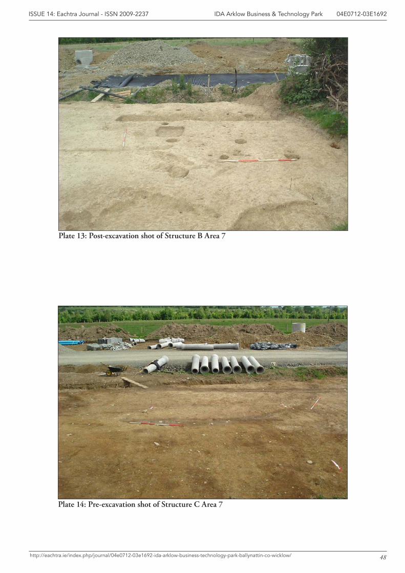
48
IDA Arklow Business & Technology Park 04E0712-03E1692ISSUE 14: Eachtra Journal - ISSN 2009-2237
http://eachtra.ie/index.php/journal/04e0712-03e1692-ida-arklow-business-technology-park-ballynattin-co-wicklow/
Plate 13: Post-excavation shot of Structure B Area 7
Plate 14: Pre-excavation shot of Structure C Area 7
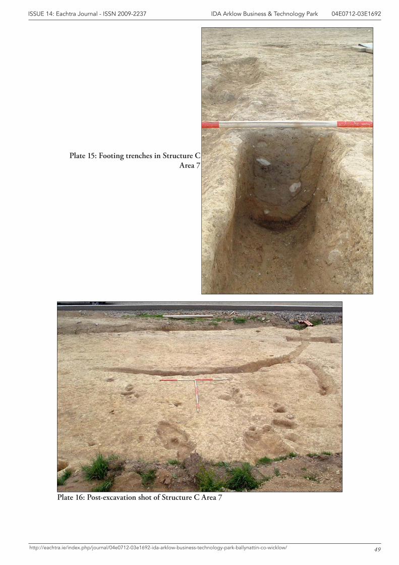
49
IDA Arklow Business & Technology Park 04E0712-03E1692ISSUE 14: Eachtra Journal - ISSN 2009-2237
http://eachtra.ie/index.php/journal/04e0712-03e1692-ida-arklow-business-technology-park-ballynattin-co-wicklow/
Plate 15: Footing trenches in Structure C Area 7
Plate 16: Post-excavation shot of Structure C Area 7
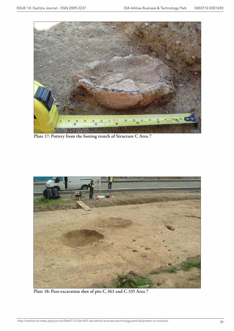
50
IDA Arklow Business & Technology Park 04E0712-03E1692ISSUE 14: Eachtra Journal - ISSN 2009-2237
http://eachtra.ie/index.php/journal/04e0712-03e1692-ida-arklow-business-technology-park-ballynattin-co-wicklow/
Plate 17: Pottery from the footing trench of Structure C Area 7
Plate 18: Post-excavation shot of pits C.363 and C.335 Area 7

51
IDA Arklow Business & Technology Park 04E0712-03E1692ISSUE 14: Eachtra Journal - ISSN 2009-2237
http://eachtra.ie/index.php/journal/04e0712-03e1692-ida-arklow-business-technology-park-ballynattin-co-wicklow/
14 Appendices
Appendix 1: Context RegisterAppendix 2: Stratigraphic MatrixAppendix 3: Find RegisterAppendix 4: Plant Remains Report by Mary DillonAppendix 5: Pottery Report by Helen Roche & Eoin GroganAppendix 6: Lithic Report by Farina SternkeAppendix 7: Site Archive (Basis) SummaryAppendix 8: Dissemination StrategyAppendix 9: Programme Schedule
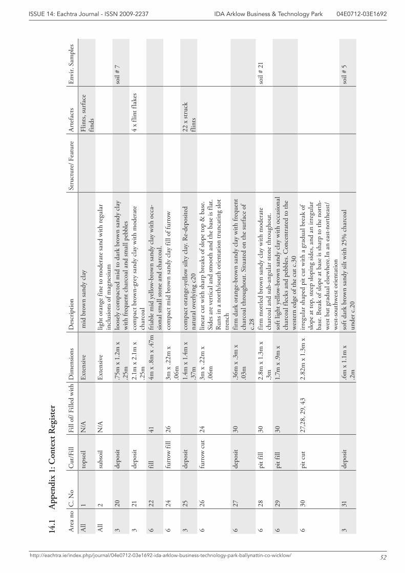
52
IDA Arklow Business & Technology Park 04E0712-03E1692ISSUE 14: Eachtra Journal - ISSN 2009-2237
http://eachtra.ie/index.php/journal/04e0712-03e1692-ida-arklow-business-technology-park-ballynattin-co-wicklow/
Are
a no
C. N
oC
ut/F
illFi
ll of
/ Fill
ed w
ithD
imen
sions
Des
crip
tion
Stru
ctur
e/ F
eatu
reA
rtef
acts
Envi
r. Sa
mpl
es
All
1to
psoi
lN
/AEx
tens
ive
mid
bro
wn
sand
y cl
ayFl
ints
, sur
face
fin
dsA
ll2
subs
oil
N/A
Exte
nsiv
elig
ht o
rang
e fin
e to
mod
erat
e sa
nd w
ith re
gula
r in
clus
ions
of m
agne
sium
320
depo
sit.7
5m x
1.2
m x
.2
5mlo
osel
y co
mpa
cted
mid
to d
ark
brow
n sa
ndy
clay
w
ith fr
eque
nt c
harc
oal a
nd sm
all p
ebbl
esso
il #
7
321
depo
sit2.
1m x
2.1
m x
.2
5mco
mpa
ct b
row
n-gr
ey sa
ndy
clay
with
mod
erat
e ch
arco
al4
x fli
nt fl
akes
622
fill
414m
x .8
m x
.47m
fria
ble
mid
yel
low
-bro
wn
sand
y cl
ay w
ith o
cca-
siona
l sm
all s
tone
and
cha
rcoa
l.6
24fu
rrow
fill
263m
x .2
2m x
.0
6mco
mpa
ct m
id b
row
n sa
ndy
clay
fill
of fu
rrow
325
depo
sit1.
4m x
1.4
m x
.3
7mco
mpa
ct o
rang
e-ye
llow
silty
cla
y. R
e-de
posit
ed
natu
ral o
verly
ing
c20
22 x
stru
ck
flint
s6
26fu
rrow
cut
243m
x .2
2m x
.0
6mlin
ear c
ut w
ith sh
arp
brea
ks o
f slo
pe to
p &
bas
e.
Side
s are
ver
tical
and
smoo
th a
nd th
e ba
se is
flat
. R
uns i
n a
nort
h/so
uth
orie
ntat
ion
trun
catin
g slo
t tr
ench
627
depo
sit30
.36m
x .3
m x
.0
3mfir
m d
ark
oran
ge-b
row
n sa
ndy
clay
with
freq
uent
ch
arco
al th
roug
hout
. Situ
ated
on
the
surf
ace
of
c.28
628
pit f
ill30
2.8m
x 1
.3m
x
.3m
firm
mot
tled
brow
n sa
ndy
clay
with
mod
erat
e ch
arco
al a
nd su
b-an
gula
r sto
ne th
roug
hout
. so
il #
21
629
pit f
ill30
1.7m
x .9
m x
so
ft lig
ht y
ello
w-b
row
n sa
ndy
clay
with
occ
asio
nal
char
coal
flec
ks a
nd p
ebbl
es. C
once
ntra
ted
to th
e w
este
rn e
dge
of th
e cu
t c.3
06
30pi
t cut
27,2
8, 2
9, 4
32.
82m
x 1
.3m
x
irreg
ular
shap
ed p
it cu
t with
a g
radu
al b
reak
of
slope
at t
op, s
teep
slop
ing
sides
, and
an
irreg
ular
ba
se. B
reak
of s
lope
at b
ase
is sh
arp
to th
e no
rth-
wes
t but
gra
dual
else
whe
re.In
an
east-
nort
heas
t/
wes
t-sou
thw
est o
rient
atio
n3
31de
posit
.6m
x 1
.1m
x
.2m
soft
dark
bro
wn
sand
y sil
t with
25%
cha
rcoa
l un
der c
.20
soil
# 5
14.1
A
ppen
dix
1: C
onte
xt R
egis
ter
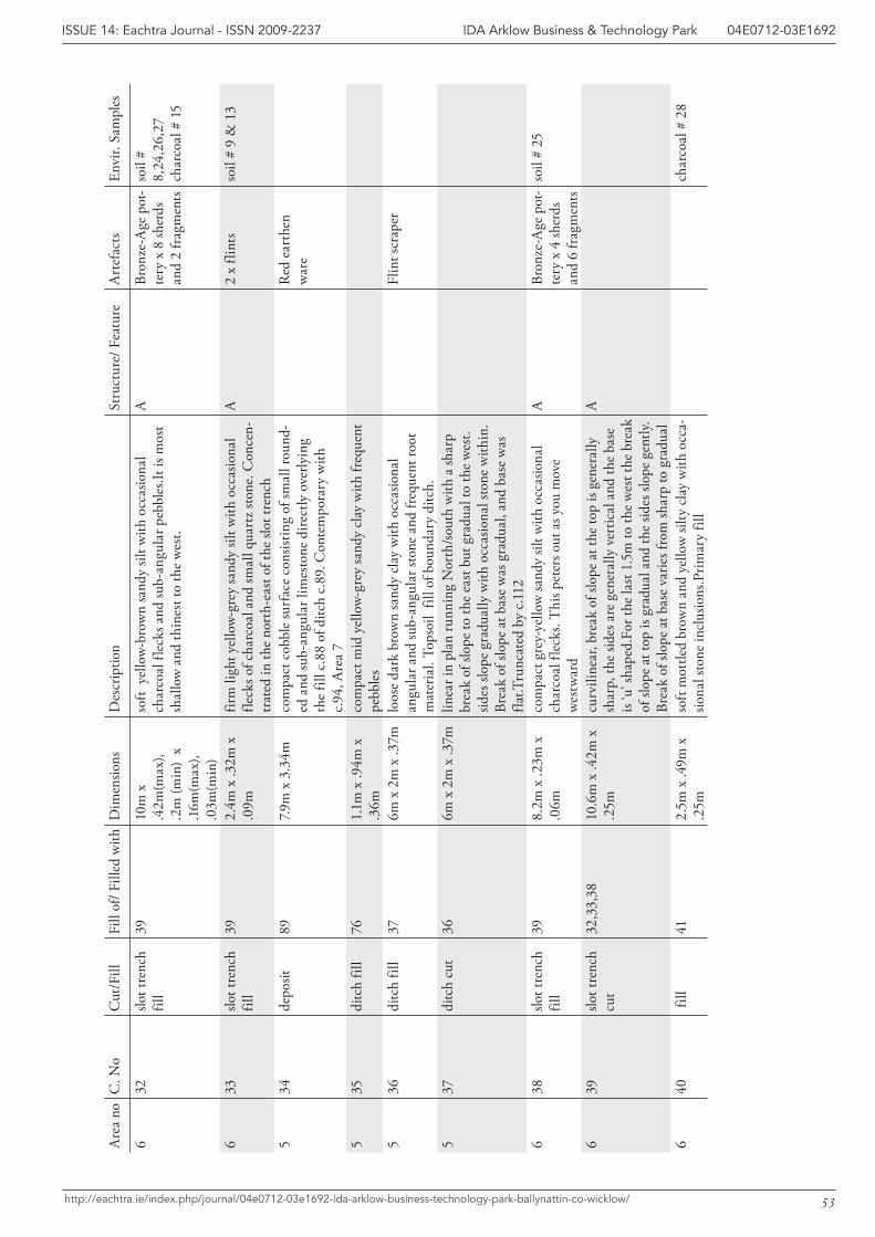
53
IDA Arklow Business & Technology Park 04E0712-03E1692ISSUE 14: Eachtra Journal - ISSN 2009-2237
http://eachtra.ie/index.php/journal/04e0712-03e1692-ida-arklow-business-technology-park-ballynattin-co-wicklow/
Are
a no
C. N
oC
ut/F
illFi
ll of
/ Fill
ed w
ithD
imen
sions
Des
crip
tion
Stru
ctur
e/ F
eatu
reA
rtef
acts
Envi
r. Sa
mpl
es
632
slot t
renc
h fil
l39
10m
x
.42m
(max
), .2
m (m
in)
x .1
6m(m
ax),
.03m
(min
)
soft
yel
low
-bro
wn
sand
y sil
t with
occ
asio
nal
char
coal
flec
ks a
nd su
b-an
gula
r peb
bles
.It is
mos
t sh
allo
w a
nd th
ines
t to
the
wes
t.
ABr
onze
-Age
pot
-te
ry x
8 sh
erds
an
d 2
frag
men
ts
soil
# 8,
24,2
6,27
ch
arco
al #
15
633
slot t
renc
h fil
l39
2.4m
x .3
2m x
.0
9mfir
m li
ght y
ello
w-g
rey
sand
y sil
t with
occ
asio
nal
fleck
s of c
harc
oal a
nd sm
all q
uart
z sto
ne. C
once
n-tr
ated
in th
e no
rth-
east
of t
he sl
ot tr
ench
A2
x fli
nts
soil
# 9
& 1
3
534
depo
sit89
7.9m
x 3
.34m
com
pact
cob
ble
surf
ace
cons
istin
g of
smal
l rou
nd-
ed a
nd su
b-an
gula
r lim
esto
ne d
irect
ly o
verly
ing
the
fill c
.88
of d
itch
c.89
. Con
tem
pora
ry w
ith
c.94,
Are
a 7
Red
ear
then
w
are
535
ditc
h fil
l76
1.1m
x .9
4m x
.3
6mco
mpa
ct m
id y
ello
w-g
rey
sand
y cl
ay w
ith fr
eque
nt
pebb
les
536
ditc
h fil
l37
6m x
2m
x .3
7mlo
ose
dark
bro
wn
sand
y cl
ay w
ith o
ccas
iona
l an
gula
r and
sub-
angu
lar s
tone
and
freq
uent
root
m
ater
ial.
Tops
oil
fill o
f bou
ndar
y di
tch.
Flin
t scr
aper
537
ditc
h cu
t36
6m x
2m
x .3
7mlin
ear i
n pl
an ru
nnin
g N
orth
/sout
h w
ith a
shar
p br
eak
of sl
ope
to th
e ea
st b
ut g
radu
al to
the
wes
t.sid
es sl
ope
grad
ually
with
occ
asio
nal s
tone
with
in.
Brea
k of
slop
e at
bas
e w
as g
radu
al, a
nd b
ase
was
fla
t.Tru
ncat
ed b
y c.1
12
638
slot t
renc
h fil
l39
8.2m
x .2
3m x
.0
6mco
mpa
ct g
rey-
yello
w sa
ndy
silt w
ith o
ccas
iona
l ch
arco
al fl
ecks
. Thi
s pet
ers o
ut a
s you
mov
e w
estw
ard
ABr
onze
-Age
pot
-te
ry x
4 sh
erds
an
d 6
frag
men
ts
soil
# 25
639
slot t
renc
h cu
t32
,33,
3810
.6m
x .4
2m x
.2
5mcu
rvili
near
, bre
ak o
f slo
pe a
t the
top
is ge
nera
lly
shar
p, th
e sid
es a
re g
ener
ally
ver
tical
and
the
base
is
‘u’ s
hape
d.Fo
r the
last
1.5
m to
the
wes
t the
bre
ak
of sl
ope
at to
p is
grad
ual a
nd th
e sid
es sl
ope
gent
ly.
Brea
k of
slop
e at
bas
e va
ries f
rom
shar
p to
gra
dual
A
640
fill
412.
5m x
.49m
x
.25m
soft
mot
tled
brow
n an
d ye
llow
silty
cla
y w
ith o
cca-
siona
l sto
ne in
clus
ions
.Prim
ary
fill
char
coal
# 2
8
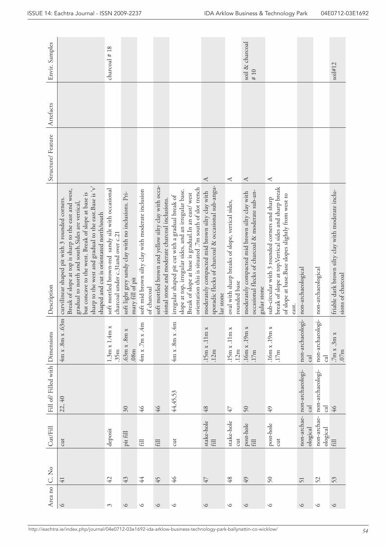
54
IDA Arklow Business & Technology Park 04E0712-03E1692ISSUE 14: Eachtra Journal - ISSN 2009-2237
http://eachtra.ie/index.php/journal/04e0712-03e1692-ida-arklow-business-technology-park-ballynattin-co-wicklow/
Are
a no
C. N
oC
ut/F
illFi
ll of
/ Fill
ed w
ithD
imen
sions
Des
crip
tion
Stru
ctur
e/ F
eatu
reA
rtef
acts
Envi
r. Sa
mpl
es
641
cut
22, 4
04m
x .8
m x
.63m
curv
iline
ar sh
aped
pit
with
3 ro
unde
d co
rner
s. Br
eak
of sl
ope
at to
p is
shar
p to
the
east
and
wes
t, gr
adua
l to
nort
h an
d so
uth.
Side
s are
ver
tical
, bu
t con
cave
to th
e w
est.
Brea
k of
slop
e at
bas
e is
shar
p to
the
wes
t and
gra
dual
to th
e ea
st.B
ase
is ‘v
’ sh
aped
and
cut
is o
rient
ated
nor
th/so
uth
342
depo
sit1.
3m x
1.4
m x
.3
5mso
ft m
ottle
d br
own-
red
sand
y sil
t with
occ
asio
nal
char
coal
und
er c
.31a
nd o
ver c
.21
char
coal
# 1
8
643
pit f
ill30
.63m
x .8
m x
.0
8mso
ft lig
ht g
rey
sand
y cl
ay w
ith n
o in
clus
ions
. Pri-
mar
y fil
l of p
it6
44fil
l46
4m x
.7m
x .4
mso
ft m
id b
row
n sil
ty c
lay
with
mod
erat
e in
clus
ion
of c
harc
oal
645
fill
46so
ft m
ottle
d br
own
and
yello
w si
lty c
lay
with
occ
a-sio
nal s
tone
and
mod
erat
e ch
arco
al in
clus
ions
.6
46cu
t44
,45,
534m
x .8
m x
.4m
irreg
ular
shap
ed p
it cu
t with
a g
radu
al b
reak
of
slope
at t
op, i
rreg
ular
side
s, an
d an
irre
gula
r bas
e.
Brea
k of
slop
e at
bas
e is
grad
ual.I
n an
eas
t/ w
est
orie
ntat
ion
this
is sit
uate
d .7
m so
uth
of sl
ot tr
ench
647
stak
e-ho
le
fill
48.15
m x
.11m
x
.12m
mod
erat
ely
com
pact
ed m
id b
row
n sil
ty c
lay
with
sp
orad
ic fl
ecks
of c
harc
oal &
occ
asio
nal s
ub-a
ngu-
lar s
tone
A
648
stak
e-ho
le
cut
47.15
m x
.11m
x
.12m
oval
with
shar
p br
eaks
of s
lope
, ver
tical
side
s, ro
unde
d ba
seA
649
post-
hole
fil
l 50
.16m
x .1
9m x
.1
7mm
oder
atel
y co
mpa
cted
mid
bro
wn
silty
cla
y w
ith
occa
siona
l fle
cks o
f cha
rcoa
l & m
oder
ate
sub-
an-
gula
r sto
ne
Aso
il &
cha
rcoa
l #
10
650
post-
hole
cu
t 49
.16m
x .1
9m x
.1
7msu
b-ci
rcul
ar w
ith 3
roun
ded
corn
ers a
nd sh
arp
brea
k of
slop
e at
top.
Vert
ical
side
s and
shar
p br
eak
of sl
ope
at b
ase.
Base
slop
es sl
ight
ly fr
om w
est t
o ea
st.
A
651
non-
arch
ae-
olog
ical
non-
arch
aeol
ogi-
cal
non-
arch
aeol
ogi-
cal
non-
arch
aeol
ogic
al
652
non-
arch
ae-
olog
ical
non-
arch
aeol
ogi-
cal
non-
arch
aeol
ogi-
cal
non-
arch
aeol
ogic
al
653
fill
46.7
m x
.3m
x
.07m
fria
ble
dark
bro
wn
silty
cla
y w
ith m
oder
ate
incl
u-sio
ns o
f cha
rcoa
lso
il#12
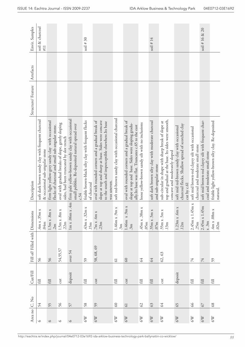
55
IDA Arklow Business & Technology Park 04E0712-03E1692ISSUE 14: Eachtra Journal - ISSN 2009-2237
http://eachtra.ie/index.php/journal/04e0712-03e1692-ida-arklow-business-technology-park-ballynattin-co-wicklow/
Are
a no
C. N
oC
ut/F
illFi
ll of
/ Fill
ed w
ithD
imen
sions
Des
crip
tion
Stru
ctur
e/ F
eatu
reA
rtef
acts
Envi
r. Sa
mpl
es
654
fill
56.4
m x
.35m
x
.04m
soft
dark
bro
wn
sand
y cl
ay w
ith fr
eque
nt c
harc
oal
& o
ccas
iona
l sub
-ang
ular
ston
eso
il &
cha
rcoa
l #1
16
55fil
l56
1.5m
x .8
m x
.2
mfir
m li
ght y
ello
w-g
rey
sand
y cl
ay w
ith o
ccas
iona
l fle
cks o
f cha
rcoa
l and
smal
l sub
-ang
ular
ston
e.
656
cut
54,5
5,57
1.5m
x .8
m x
.2
2mov
al w
ith g
radu
al b
reak
s of s
lope
, gen
tly sl
opin
g sid
es, h
ad b
een
trun
cate
d by
slot
tren
ch6
57de
posit
over
54
1m x
.06m
x .4
mfir
m p
ale
yello
w-b
row
n sa
ndy
clay
with
occ
asio
nal
smal
l peb
bles
. Re-
depo
sited
nat
ural
spre
ad o
ver
c.54
6W58
fill
59.4
3m x
.32m
x
.15m
fria
ble
brow
n-bl
ack
silty
cla
y w
ith fr
eque
nt fl
ecks
of
cha
rcoa
lso
il #
30
6W59
cut
58, 6
8, 6
9.7
m x
.4m
x
.23m
oval
with
roun
ded
corn
ers a
nd a
gra
dual
bre
ak o
f slo
pe a
t top
and
shar
p at
bas
e. S
ides
wer
e co
ncav
e to
the
sout
h an
d im
perc
eptib
le e
lsew
here
.Its b
ase
was
une
ven.
6W60
fill
611.
46m
x .9
m x
.3
mso
ft re
d-br
own
sand
y cl
ay w
ith o
ccas
iona
l cha
rcoa
l
6W61
cut
601.
46m
x .9
m x
.3
mov
al w
ith ro
unde
d co
rner
s and
a g
radu
al b
reak
of
slope
at t
op a
nd b
ase.
Sid
es w
ere
slopi
ng g
radu
-al
ly.It
s bas
e w
as fl
at. T
runc
ates
c.6
5 to
the
east
6W62
fill
64.4
5m x
.38m
x
.05m
loos
e ye
llow
-bro
wn
sand
y sil
t with
no
incl
usio
ns
6W63
fill
64.5
5m x
.5m
x
.07m
soft
dark
bro
wn
silty
cla
y w
ith m
oder
ate
char
coal
an
d su
b-an
gula
r sto
neso
il #
14
6W64
cut
62, 6
3.5
5m x
.5m
x
.13m
sub-
circ
ular
in sh
ape
with
shar
p br
eak
of sl
ope
at
top
and
grad
ual a
t the
bas
e. It
s sid
es w
ere
smoo
th,
conc
ave
and
mod
erat
ely
slope
d6W
65de
posit
1.23
m x
.6m
x
.12m
soft
mid
red-
brow
n sa
ndy
clay
with
occ
asio
nal
char
coal
flec
ks. S
hallo
w sp
read
of s
corc
hed
clay
cu
t by
c.61
6W66
fill
742.
45m
x 1
.45m
x
.25m
soft
mid
bro
wn-
red
clay
ey si
lt w
ith o
ccas
iona
l ch
arco
al a
nd m
oder
ate
smal
l sto
ne6W
67fil
l74
2.45
m x
1.4
5m
x .3
mso
ft m
id b
row
n-re
d cl
ayey
silt
with
freq
uent
cha
r-co
al a
nd m
oder
ate
smal
l sto
neso
il #
16 &
20
6W68
fill
59.4
m x
.08m
x
.02m
fria
ble
light
yel
low
-bro
wn
silty
cla
y. R
e-de
posit
ed
natu
ral.
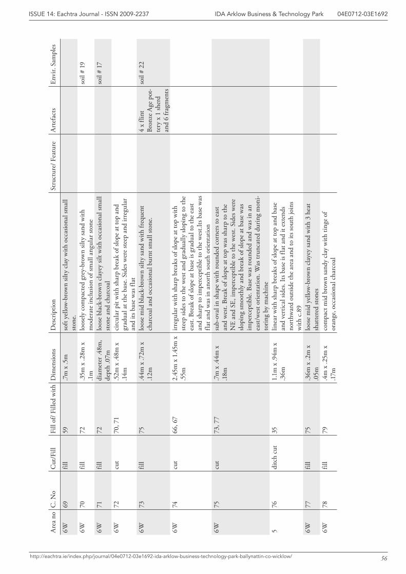
56
IDA Arklow Business & Technology Park 04E0712-03E1692ISSUE 14: Eachtra Journal - ISSN 2009-2237
http://eachtra.ie/index.php/journal/04e0712-03e1692-ida-arklow-business-technology-park-ballynattin-co-wicklow/
Are
a no
C. N
oC
ut/F
illFi
ll of
/ Fill
ed w
ithD
imen
sions
Des
crip
tion
Stru
ctur
e/ F
eatu
reA
rtef
acts
Envi
r. Sa
mpl
es
6W69
fill
59.7
m x
.5m
so
ft ye
llow
-bro
wn
silty
cla
y w
ith o
ccas
iona
l sm
all
stone
.6W
70fil
l72
.35m
x .2
8m x
.1
mlo
osel
y co
mpa
cted
gre
y-br
own
silty
sand
with
m
oder
ate
incl
usio
n of
smal
l ang
ular
ston
eso
il #
19
6W71
fill
72di
amet
er .4
8m,
dept
h .0
7mlo
ose
blac
k-br
own
clay
ey si
lt w
ith o
ccas
iona
l sm
all
stone
and
cha
rcoa
lso
il #
17
6W72
cut
70, 7
1.5
2m x
.48m
x
.14m
circ
ular
pit
with
shar
p br
eak
of sl
ope
at to
p an
d gr
adua
l at t
he b
ase.
Sid
es w
ere
stee
p an
d irr
egul
ar
and
its b
ase
was
flat
6W73
fill
75.4
4m x
.72m
x
.12m
loos
e m
id b
lack
-bro
wn
silty
sand
with
freq
uent
ch
arco
al a
nd o
ccas
iona
l bur
nt sm
all s
tone
.4
x fli
nt
Br
onze
Age
pot
-te
ry x
1 sh
erd
and
6 fr
agm
ents
soil
# 22
6W74
cut
66, 6
72.
45m
x 1
.45m
x
.55m
irreg
ular
with
shar
p br
eaks
of s
lope
at t
op w
ith
stee
p sid
es to
the
wes
t and
gra
dual
ly sl
opin
g to
the
east
. Bre
ak o
f slo
pe a
t bas
e is
grad
ual t
o th
e ea
st
and
shar
p to
impe
rcep
tible
to th
e w
est.I
ts b
ase
was
fla
t and
was
in a
nort
h so
uth
orie
ntat
ion
6W75
cut
73, 7
7.7
m x
.44m
x
.18m
sub-
oval
in sh
ape
with
roun
ded
corn
ers t
o ea
st
and
wes
t. Br
eak
of sl
ope
at to
p w
as sh
arp
to th
e N
E an
d SE
, im
perc
eptib
le to
the
wes
t. Si
des w
ere
slopi
ng sm
ooth
ly a
nd b
reak
of s
lope
at b
ase
was
im
perc
eptib
le. B
ase
was
roun
ded
and
was
in a
n ea
st/w
est o
rient
atio
n. W
as tr
unca
ted
durin
g m
oni-
torin
g by
mac
hine
576
ditc
h cu
t35
1.1m
x .9
4m x
.3
6mlin
ear w
ith sh
arp
brea
ks o
f slo
pe a
t top
and
bas
e an
d ve
rtic
al si
des.
Its b
ase
is fla
t and
it e
xten
ds
nort
hwar
d ou
tsid
e th
e ar
ea a
nd to
its s
outh
join
s w
ith c
.89
6W77
fill
75.3
6m x
.2m
x
.05m
loos
e m
id y
ello
w-b
row
n cl
ayey
sand
with
3 h
eat
shat
tere
d sto
nes
6W78
fill
79.4
m x
.25m
x
.17m
com
pact
mid
bro
wn
sand
y cl
ay w
ith ti
nge
of
oran
ge, o
ccas
iona
l cha
rcoa
l
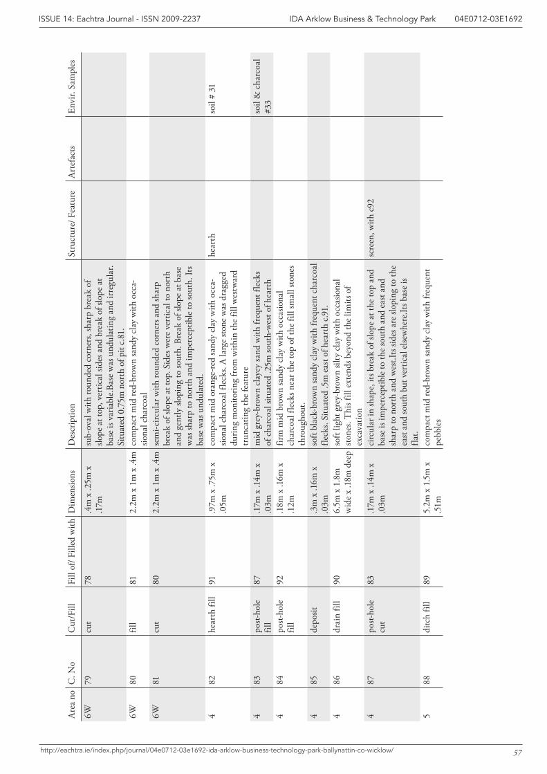
57
IDA Arklow Business & Technology Park 04E0712-03E1692ISSUE 14: Eachtra Journal - ISSN 2009-2237
http://eachtra.ie/index.php/journal/04e0712-03e1692-ida-arklow-business-technology-park-ballynattin-co-wicklow/
Are
a no
C. N
oC
ut/F
illFi
ll of
/ Fill
ed w
ithD
imen
sions
Des
crip
tion
Stru
ctur
e/ F
eatu
reA
rtef
acts
Envi
r. Sa
mpl
es
6W79
cut
78.4
m x
.25m
x
.17m
sub-
oval
with
roun
ded
corn
ers,
shar
p br
eak
of
slope
at t
op, v
ertic
al si
des a
nd b
reak
of s
lope
at
base
is v
aria
ble.
Base
was
und
ulat
ing
and
irreg
ular
. Si
tuat
ed 0
.75m
nor
th o
f pit
c.81
.6W
80fil
l81
2.2m
x 1
m x
.4m
com
pact
mid
red-
brow
n sa
ndy
clay
with
occ
a-sio
nal c
harc
oal
6W81
cut
802.
2m x
1m
x .4
mse
mi-c
ircul
ar w
ith ro
unde
d co
rner
s and
shar
p br
eak
of sl
ope
at to
p. S
ides
wer
e ve
rtic
al to
nor
th
and
gent
ly sl
opin
g to
sout
h. B
reak
of s
lope
at b
ase
was
shar
p to
nor
th a
nd im
perc
eptib
le to
sout
h. It
s ba
se w
as u
ndul
ated
.4
82he
arth
fill
91.9
7m x
.75m
x
.05m
com
pact
mid
ora
nge-
red
sand
y cl
ay w
ith o
cca-
siona
l cha
rcoa
l fle
cks.
A la
rge
stone
was
dra
gged
du
ring
mon
itorin
g fr
om w
ithin
the
fill w
estw
ard
trun
catin
g th
e fe
atur
e
hear
thso
il #
31
483
post-
hole
fil
l87
.17m
x .1
4m x
.0
3mm
id g
rey-
brow
n cl
ayey
sand
with
freq
uent
flec
ks
of c
harc
oal s
ituat
ed .2
5m so
uth-
wes
t of h
eart
hso
il &
cha
rcoa
l #3
34
84po
st-ho
le
fill
92.1
8m x
.16m
x
.12m
firm
mid
bro
wn
sand
y cl
ay w
ith o
ccas
iona
l ch
arco
al fl
ecks
nea
r the
top
of th
e fil
l sm
all s
tone
s th
roug
hout
.4
85de
posit
.3m
x .1
6m x
.0
3mso
ft bl
ack-
brow
n sa
ndy
clay
with
freq
uent
cha
rcoa
l fle
cks.
Situ
ated
.5m
eas
t of h
eart
h c.9
1.4
86dr
ain
fill
906.
5m x
1.8
m
wid
e x
.18m
dee
pso
ft lig
ht g
rey-
brow
n sil
ty c
lay
with
occ
asio
nal
stone
s. T
his f
ill e
xten
ds b
eyon
d th
e lim
its o
f ex
cava
tion
487
post-
hole
cu
t83
.17m
x .1
4m x
.0
3mci
rcul
ar in
shap
e, it
s bre
ak o
f slo
pe a
t the
top
and
base
is im
perc
eptib
le to
the
sout
h an
d ea
st a
nd
shar
p to
nor
th a
nd w
est.I
ts si
des a
re sl
opin
g to
the
east
and
sout
h bu
t ver
tical
else
whe
re.It
s bas
e is
flat.
scre
en, w
ith c
92
588
ditc
h fil
l89
5.2m
x 1
.5m
x
.51m
com
pact
mid
red-
brow
n sa
ndy
clay
with
freq
uent
pe
bble
s
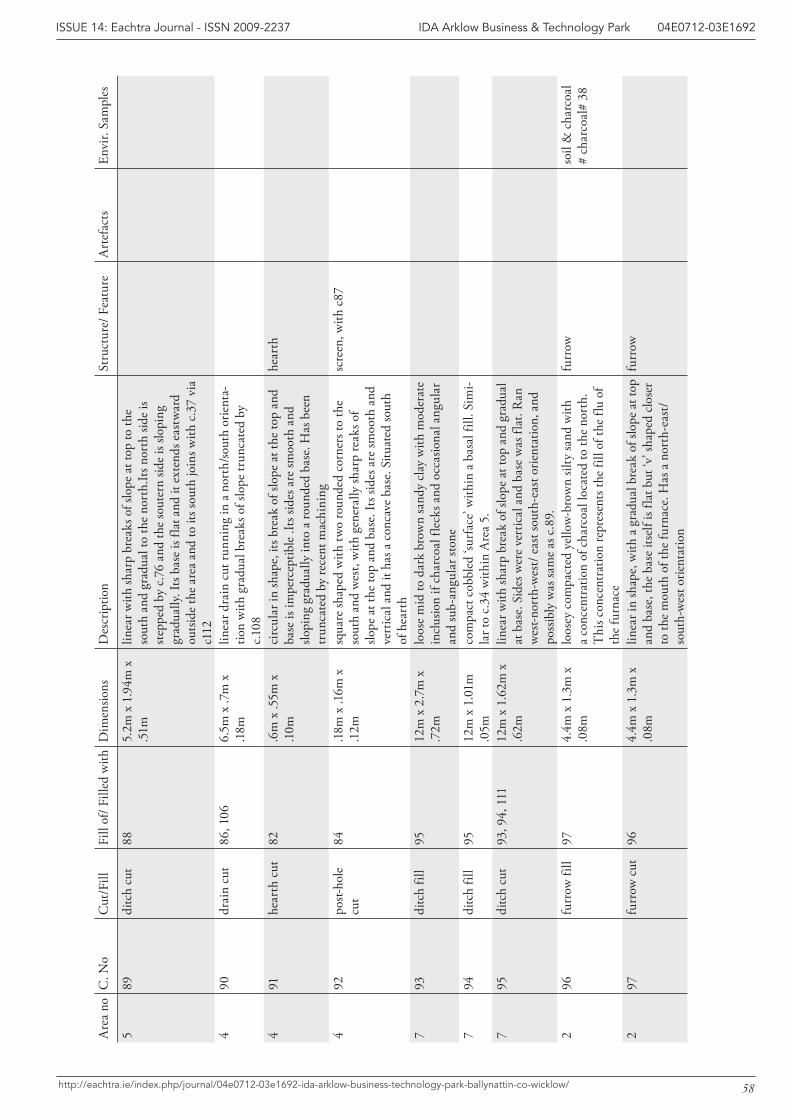
58
IDA Arklow Business & Technology Park 04E0712-03E1692ISSUE 14: Eachtra Journal - ISSN 2009-2237
http://eachtra.ie/index.php/journal/04e0712-03e1692-ida-arklow-business-technology-park-ballynattin-co-wicklow/
Are
a no
C. N
oC
ut/F
illFi
ll of
/ Fill
ed w
ithD
imen
sions
Des
crip
tion
Stru
ctur
e/ F
eatu
reA
rtef
acts
Envi
r. Sa
mpl
es
589
ditc
h cu
t88
5.2m
x 1
.94m
x
.51m
linea
r with
shar
p br
eaks
of s
lope
at t
op to
the
sout
h an
d gr
adua
l to
the
nort
h.It
s nor
th si
de is
st
eppe
d by
c.7
6 an
d th
e so
uter
n sid
e is
slopi
ng
grad
ually
. Its
bas
e is
flat a
nd it
ext
ends
eas
twar
d ou
tsid
e th
e ar
ea a
nd to
its s
outh
join
s with
c.3
7 vi
a c1
124
90dr
ain
cut
86, 1
066.
5m x
.7m
x
.18m
linea
r dra
in c
ut ru
nnin
g in
a n
orth
/sout
h or
ient
a-tio
n w
ith g
radu
al b
reak
s of s
lope
trun
cate
d by
c.1
08
491
hear
th c
ut82
.6m
x .5
5m x
.1
0mci
rcul
ar in
shap
e, it
s bre
ak o
f slo
pe a
t the
top
and
base
is im
perc
eptib
le .I
ts si
des a
re sm
ooth
and
slo
ping
gra
dual
ly in
to a
roun
ded
base
. Has
bee
n tr
unca
ted
by re
cent
mac
hini
ng
hear
th
492
post-
hole
cu
t84
.18m
x .1
6m x
.1
2msq
uare
shap
ed w
ith tw
o ro
unde
d co
rner
s to
the
sout
h an
d w
est,
with
gen
eral
ly sh
arp
reak
s of
slope
at t
he to
p an
d ba
se. I
ts si
des a
re sm
ooth
and
ve
rtic
al a
nd it
has
a c
onca
ve b
ase.
Situ
ated
sout
h of
hea
rth
scre
en, w
ith c
87
793
ditc
h fil
l95
12m
x 2
.7m
x
.72m
loos
e m
id to
dar
k br
own
sand
y cl
ay w
ith m
oder
ate
incl
usio
n if
char
coal
flec
ks a
nd o
ccas
iona
l ang
ular
an
d su
b-an
gula
r sto
ne7
94di
tch
fill
9512
m x
1.0
1m
.05m
com
pact
cob
bled
‘sur
face
’ with
in a
bas
al fi
ll. S
imi-
lar t
o c.
34 w
ithin
Are
a 5.
795
ditc
h cu
t93
, 94,
111
12m
x 1
.62m
x
.62m
linea
r with
shar
p br
eak
of sl
ope
at to
p an
d gr
adua
l at
bas
e. S
ides
wer
e ve
rtic
al a
nd b
ase
was
flat
. Ran
w
est-n
orth
-wes
t/ e
ast s
outh
-eas
t orie
ntat
ion,
and
po
ssib
ly w
as sa
me
as c
.89.
2
96fu
rrow
fill
974.
4m x
1.3
m x
.0
8mlo
osey
com
pact
ed y
ello
w-b
row
n sil
ty sa
nd w
ith
a co
ncen
trat
ion
of c
harc
oal l
ocat
ed to
the
nort
h.
Thi
s con
cent
ratio
n re
pres
ents
the
fill o
f the
flu
of
the
furn
ace
furr
owso
il &
cha
rcoa
l #
char
coal
# 38
297
furr
ow c
ut96
4.4m
x 1
.3m
x
.08m
linea
r in
shap
e, w
ith a
gra
dual
bre
ak o
f slo
pe a
t top
an
d ba
se, t
he b
ase
itsel
f is f
lat b
ut ‘v
’ sha
ped
clos
er
to th
e m
outh
of t
he fu
rnac
e. H
as a
nor
th-e
ast/
sout
h-w
est o
rient
atio
n
furr
ow
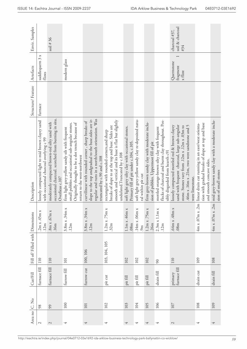
59
IDA Arklow Business & Technology Park 04E0712-03E1692ISSUE 14: Eachtra Journal - ISSN 2009-2237
http://eachtra.ie/index.php/journal/04e0712-03e1692-ida-arklow-business-technology-park-ballynattin-co-wicklow/
Are
a no
C. N
oC
ut/F
illFi
ll of
/ Fill
ed w
ithD
imen
sions
Des
crip
tion
Stru
ctur
e/ F
eatu
reA
rtef
acts
Envi
r. Sa
mpl
es
298
furn
ace
fill
110
.2m
x .4
5m x
.1
2mlo
osel
y co
mpa
cted
ligh
t to
mid
bro
wn
clay
ey sa
nd
with
occ
asio
nal c
harc
oal o
verly
ing
c 99
furn
ace
sadd
lequ
ern
3 x
flint
s2
99fu
rnac
e fil
l11
0.8
m x
.67m
x
.16m
mod
erat
ely
com
pact
ed b
row
n-re
d sil
ty sa
nd w
ith
occa
siona
l cha
rcoa
l. sc
orch
ed fr
om b
urni
ng in
situ
.O
verli
eas c
.107
soil
# 36
410
0fu
rrow
fill
101
3.8m
x .3
4m x
.1
2mfir
m li
ght g
rey-
yello
w sa
ndy
silt w
ith fr
eque
nt
smal
l peb
bles
and
occ
asio
nal s
ub-a
ngul
ar st
ones
. O
rigin
ally
thou
ght t
o be
a sl
ot tr
ench
bec
ause
of
retu
rn to
the
wes
t-nor
thw
est
mod
ern
glas
s
410
1fu
rrow
cut
100,
106
3.8m
x .3
4m x
.1
2mcu
rvili
near
with
roun
ded
corn
er ,
shar
p br
eaks
of
slope
to th
e to
p an
dgra
dual
to th
e ba
se.si
des a
re ir
-re
gula
r and
runs
in a
nor
th/so
uth
orie
ntat
ion.
Was
tr
unca
ted
by c
.90
and
c.108
410
2pi
t cut
103,
104
, 105
1.2m
x .7
5m x
.3
2mre
ctan
gula
r with
roun
ded
corn
ers,a
nd sh
arp
brea
ks o
f slo
pe to
at t
he to
p an
d ba
se. S
ides
are
sm
ooth
and
ver
tical
and
its b
ase
is fla
t but
slig
htly
un
dula
ted.
Trun
cate
d by
c.1
084
103
pit f
ill10
21.
1m x
.46m
x
.08m
soft
light
gre
y sil
ty c
lay
with
occ
asio
nal s
tone
s. Pr
imar
y fil
l of p
it un
der c
.104
, c.1
05.
410
4pi
t fill
102
.14m
x .0
6m x
.9
mso
ft lig
ht g
rey-
yello
w sa
ndy
clay
re-d
epos
ited
natu
-ra
l with
in p
it cu
t4
105
pit f
ill10
21.
2m x
.75m
x
.26m
firm
gre
y-br
own
sand
y cl
ay w
ith m
oder
ate
incl
u-sio
n of
peb
bles
. Upp
erm
ost f
ill o
f pit
410
6dr
ain
fill
902.
3m x
1.1
m x
.1
2mm
ottle
d or
ange
-bro
wn
silty
cla
y w
ith fr
eque
nt
fleck
s of c
harc
oal a
nd b
urnt
cla
y th
roug
hout
. Pos
-sib
ly d
isgar
ded
from
hea
rth
c91
210
7pr
imar
y fu
rnac
e fil
l11
0.6
4m x
.48m
x
.08m
loos
ely
com
pact
ed m
ottle
d re
d &
bro
wn
clay
ey
sand
with
freq
uent
cha
rcoa
l, la
rge
sub-
angu
lar
stone
. Sto
nes v
ary
from
.12m
x .1
2m x
.03m
to
.46m
x .1
6m x
.21m
, tw
o w
ere
sand
stone
and
5
wer
e lim
esto
ne.
Que
rnsto
ne
frag
men
t
1
x fli
nt
char
coal
#37
, so
il &
cha
rcoa
l #3
4
410
8dr
ain
cut
109
4m x
.07m
x .2
mlin
ear d
rain
cut
runn
ing
in a
n ea
st/w
est o
rient
a-tio
n w
ith g
radu
al b
reak
s of s
lope
at t
op a
nd b
ase
and
smoo
th c
onca
ve si
des.
410
9dr
ain
fill
108
4m x
.07m
x .2
mm
id g
rey-
brow
n sa
ndy
clay
with
a m
oder
ate
incl
u-sio
n of
smal
l sto
nes
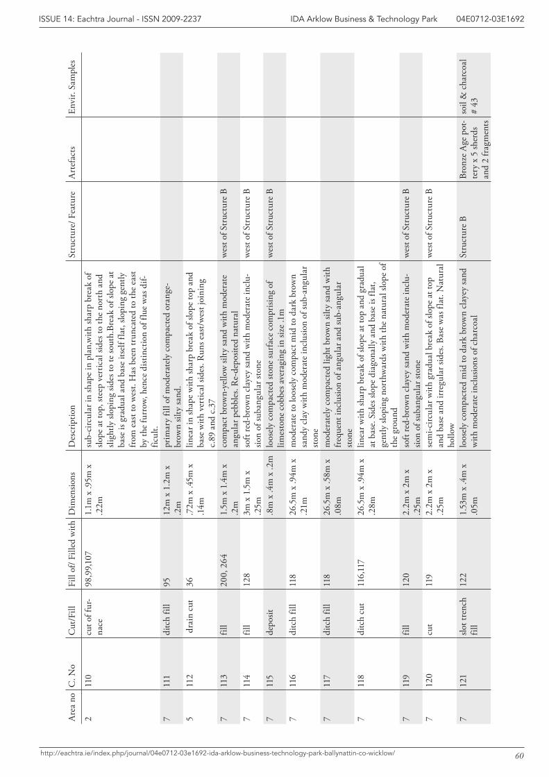
60
IDA Arklow Business & Technology Park 04E0712-03E1692ISSUE 14: Eachtra Journal - ISSN 2009-2237
http://eachtra.ie/index.php/journal/04e0712-03e1692-ida-arklow-business-technology-park-ballynattin-co-wicklow/
Are
a no
C. N
oC
ut/F
illFi
ll of
/ Fill
ed w
ithD
imen
sions
Des
crip
tion
Stru
ctur
e/ F
eatu
reA
rtef
acts
Envi
r. Sa
mpl
es
211
0cu
t of f
ur-
nace
98,9
9,10
71.
1m x
.95m
x
.22m
sub-
circ
ular
in sh
ape
in p
lan,
with
shar
p br
eak
of
slope
at t
op, s
teep
ver
tical
side
s to
the
nort
h an
d sli
ghtly
slop
ing
sides
to te
sout
h.Br
eak
of sl
ope
at
base
is g
radu
al a
nd b
ase
itsel
f fla
t, slo
ping
gen
tly
from
eas
t to
wes
t. H
as b
een
trun
cate
d to
the
east
by
the
furr
ow, h
ence
dist
inct
ion
of fl
ue w
as d
if-fic
ult.
711
1di
tch
fill
9512
m x
1.2
m x
.2
mpr
imar
y fil
l of m
oder
atel
y co
mpa
cted
ora
nge-
brow
n sil
ty sa
nd.
511
2 d
rain
cut
36.7
2m x
.45m
x
.14m
linea
r in
shap
e w
ith sh
arp
brea
k of
slop
e to
p an
d ba
se w
ith v
ertic
al si
des.
Run
s eas
t/w
est j
oini
ng
c.89
and
c.3
77
113
fill
200,
264
1.5m
x 1
.4m
x
.2m
com
pact
bro
wn-
yello
w si
lty sa
nd w
ith m
oder
ate
angu
lar p
ebbl
es. R
e-de
posit
ed n
atur
alw
est o
f Str
uctu
re B
711
4fil
l12
83m
x 1
.5m
x
.25m
soft
red-
brow
n cl
ayey
sand
with
mod
erat
e in
clu-
sion
of su
bang
ular
ston
ew
est o
f Str
uctu
re B
711
5de
posit
.8m
x .4
m x
.2m
loos
ely
com
pact
ed st
one
surf
ace
com
prisi
ng o
f lim
esto
ne c
obbe
s ave
ragi
ng in
size
.1m
wes
t of S
truc
ture
B
711
6di
tch
fill
118
26.5
m x
.94m
x
.21m
mod
erat
e to
loos
ely
com
pact
mid
to d
ark
brow
n sa
ndy
clay
with
mod
erat
e in
clus
ion
of su
b-an
gula
r sto
ne7
117
ditc
h fil
l11
826
.5m
x .5
8m x
.0
8mm
oder
atel
y co
mpa
cted
ligh
t bro
wn
silty
sand
with
fr
eque
nt in
clus
ion
of a
ngul
ar a
nd su
b-an
gula
r sto
ne7
118
ditc
h cu
t11
6,11
726
.5m
x .9
4m x
.2
8mlin
ear w
ith sh
arp
brea
k of
slop
e at
top
and
grad
ual
at b
ase.
Sid
es sl
ope
diag
onal
ly a
nd b
ase
is fla
t, ge
ntly
slop
ing
nort
hwar
ds w
ith th
e na
tura
l slo
pe o
f th
e gr
ound
711
9fil
l12
02.
2m x
2m
x
.25m
soft
red-
brow
n cl
ayey
sand
with
mod
erat
e in
clu-
sion
of su
bang
ular
ston
ew
est o
f Str
uctu
re B
712
0cu
t11
92.
2m x
2m
x
.25m
sem
i-circ
ular
with
gra
dual
bre
ak o
f slo
pe a
t top
an
d ba
se a
nd ir
regu
lar s
ides
. Bas
e w
as fl
at. N
atur
al
hollo
w
wes
t of S
truc
ture
B
712
1slo
t tre
nch
fill
122
1.53
m x
.4m
x
.05m
loos
ely
com
pact
ed m
id to
dar
k br
own
clay
ey sa
nd
with
mod
erat
e in
clus
ions
of c
harc
oal
Stru
ctur
e B
Bron
ze A
ge p
ot-
tery
x 5
sher
ds
and
2 fr
agm
ents
soil
& c
harc
oal
# 43
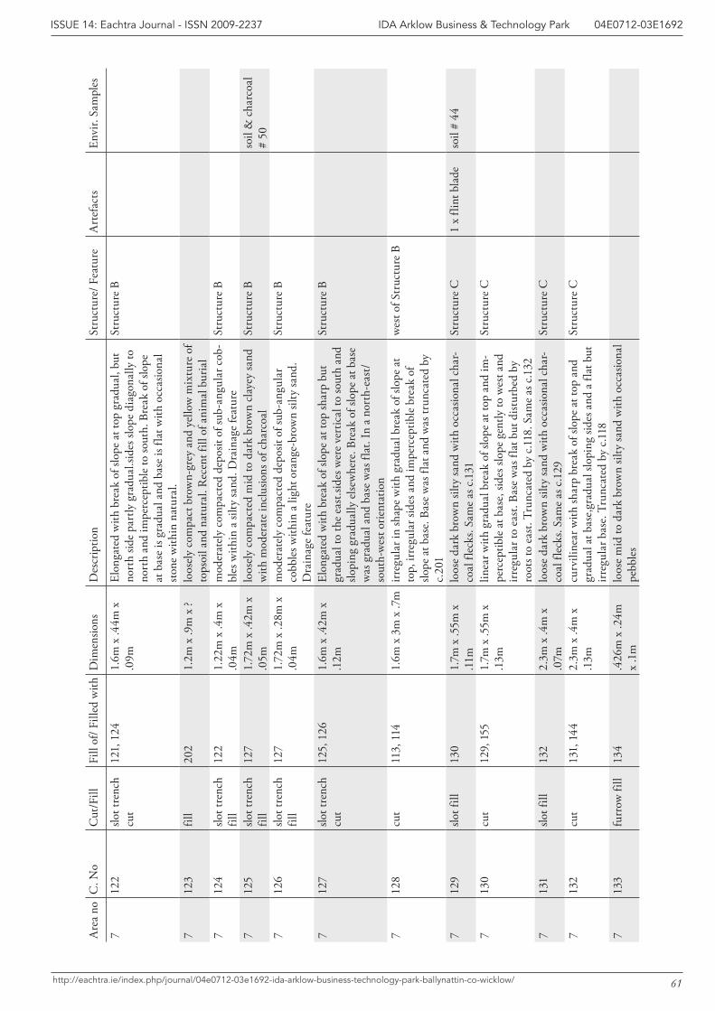
61
IDA Arklow Business & Technology Park 04E0712-03E1692ISSUE 14: Eachtra Journal - ISSN 2009-2237
http://eachtra.ie/index.php/journal/04e0712-03e1692-ida-arklow-business-technology-park-ballynattin-co-wicklow/
Are
a no
C. N
oC
ut/F
illFi
ll of
/ Fill
ed w
ithD
imen
sions
Des
crip
tion
Stru
ctur
e/ F
eatu
reA
rtef
acts
Envi
r. Sa
mpl
es
712
2slo
t tre
nch
cut
121,
124
1.6m
x .4
4m x
.0
9mEl
onga
ted
with
bre
ak o
f slo
pe a
t top
gra
dual
, but
no
rth
side
part
ly g
radu
al.si
des s
lope
dia
gona
lly to
no
rth
and
impe
rcep
tible
to so
uth.
Bre
ak o
f slo
pe
at b
ase
is gr
adua
l and
bas
e is
flat w
ith o
ccas
iona
l sto
ne w
ithin
nat
ural
.
Stru
ctur
e B
712
3fil
l20
21.
2m x
.9m
x ?
loos
ely
com
pact
bro
wn-
grey
and
yel
low
mix
ture
of
tops
oil a
nd n
atur
al. R
ecen
t fill
of a
nim
al b
uria
l7
124
slot t
renc
h fil
l12
21.
22m
x .4
m x
.0
4mm
oder
atel
y co
mpa
cted
dep
osit
of su
b-an
gula
r cob
-bl
es w
ithin
a si
lty sa
nd. D
rain
age
feat
ure
Stru
ctur
e B
712
5slo
t tre
nch
fill
127
1.72
m x
.42m
x
.05m
loos
ely
com
pact
ed m
id to
dar
k br
own
clay
ey sa
nd
with
mod
erat
e in
clus
ions
of c
harc
oal
Stru
ctur
e B
soil
& c
harc
oal
# 50
712
6slo
t tre
nch
fill
127
1.72
m x
.28m
x
.04m
mod
erat
ely
com
pact
ed d
epos
it of
sub-
angu
lar
cobb
les w
ithin
a li
ght o
rang
e-br
own
silty
sand
. D
rain
age
feat
ure
Stru
ctur
e B
712
7slo
t tre
nch
cut
125,
126
1.6m
x .4
2m x
.1
2mEl
onga
ted
with
bre
ak o
f slo
pe a
t top
shar
p bu
t gr
adua
l to
the
east
.side
s wer
e ve
rtic
al to
sout
h an
d slo
ping
gra
dual
ly e
lsew
here
. Bre
ak o
f slo
pe a
t bas
e w
as g
radu
al a
nd b
ase
was
flat
. In
a no
rth-
east
/so
uth-
wes
t orie
ntat
ion
Stru
ctur
e B
712
8cu
t11
3, 1
141.
6m x
3m
x .7
mirr
egul
ar in
shap
e w
ith g
radu
al b
reak
of s
lope
at
top,
irre
gula
r sid
es a
nd im
perc
eptib
le b
reak
of
slope
at b
ase.
Bas
e w
as fl
at a
nd w
as tr
unca
ted
by
c.20
1
wes
t of S
truc
ture
B
712
9slo
t fill
130
1.7m
x .5
5m x
.1
1mlo
ose
dark
bro
wn
silty
sand
with
occ
asio
nal c
har-
coal
flec
ks. S
ame
as c
.131
Stru
ctur
e C
1 x
flint
bla
deso
il #
44
713
0cu
t12
9, 1
551.
7m x
.55m
x
.13m
linea
r with
gra
dual
bre
ak o
f slo
pe a
t top
and
im-
perc
eptib
le a
t bas
e, si
des s
lope
gen
tly to
wes
t and
irr
egul
ar to
eas
t. Ba
se w
as fl
at b
ut d
istur
bed
by
root
s to
east
. Tru
ncat
ed b
y c.1
18. S
ame
as c
.132
Stru
ctur
e C
713
1slo
t fill
132
2.3m
x .4
m x
.0
7mlo
ose
dark
bro
wn
silty
sand
with
occ
asio
nal c
har-
coal
flec
ks. S
ame
as c
.129
Stru
ctur
e C
713
2cu
t13
1, 1
442.
3m x
.4m
x
.13m
curv
iline
ar w
ith sh
arp
brea
k of
slop
e at
top
and
grad
ual a
t bas
e,gr
adua
l slo
ping
side
s and
a fl
at b
ut
irreg
ular
bas
e. T
runc
ated
by
c.118
Stru
ctur
e C
713
3fu
rrow
fill
134
.426
m x
.24m
x
.1m
loos
e m
id to
dar
k br
own
silty
sand
with
occ
asio
nal
pebb
les
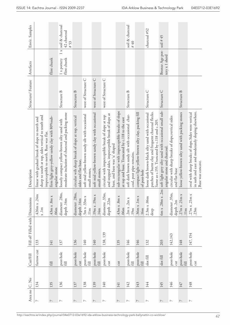
62
IDA Arklow Business & Technology Park 04E0712-03E1692ISSUE 14: Eachtra Journal - ISSN 2009-2237
http://eachtra.ie/index.php/journal/04e0712-03e1692-ida-arklow-business-technology-park-ballynattin-co-wicklow/
Are
a no
C. N
oC
ut/F
illFi
ll of
/ Fill
ed w
ithD
imen
sions
Des
crip
tion
Stru
ctur
e/ F
eatu
reA
rtef
acts
Envi
r. Sa
mpl
es
713
4fu
rrow
cut
133
.426
m x
.24m
x
.1m
linea
r with
gra
dual
bre
ak o
f slo
pe to
nor
th a
nd
shar
p to
sout
h at
top,
side
s ver
tical
to so
uth
and
impe
rcep
tible
to n
orth
. Bas
e w
as fl
at.
713
5fil
l14
1.4
3m x
.8m
x
.06m
firm
ligh
t gre
y-ye
llow
sand
y cl
ay w
ith 8
0%su
b-an
gula
r sto
ne
flint
chu
nk
713
6po
st-ho
le
fill
137
diam
eter
.28m
, de
pth
.14m
loos
ely
com
pact
yel
low
-bro
wn
silty
sand
with
m
oder
ate
incl
usio
n of
cha
rcoa
l and
pac
king
ston
eSt
ruct
ure
B1
x po
tter
y
1 x
flint
chu
nkso
il &
cha
rcoa
l 42
cha
rcoa
l #
537
137
post-
hole
cu
t13
6di
amet
er .2
8m,
dept
h .1
4mci
rcul
ar w
ih sh
arp
brea
k of
slop
e at
top,
ver
tical
sid
es a
nd fl
at b
ase,
Stru
ctur
e B
713
8po
st-ho
le
fill
140
.5m
x .3
3m x
.1
1mso
ft m
id y
ello
w-b
row
n sa
ndy
silt w
ith o
ccas
iona
l sm
all s
tone
s, w
est o
f Str
uctu
re C
713
9po
st-ho
le
fill
140
.19m
x .1
9m x
.1
4mso
ft m
id y
ello
w-b
row
n sa
ndy
clay
with
occ
asio
nal
smal
l sto
nes,
wes
t of S
truc
ture
C
714
0po
st-ho
le
cut
138,
139
diam
etre
.33m
, de
pth
.22m
circ
ular
with
impe
rcep
tible
bre
ak o
f slo
pe a
t top
an
d st
eppe
d sid
es, i
mpe
rcep
tible
bre
ak o
f slo
pe a
t ba
se, a
nd b
ase
was
‘u’ s
hape
d
wes
t of S
truc
ture
C
714
1cu
t13
5.4
3m x
.8m
x
.06m
sub-
rect
angu
lar w
ith im
perc
eptib
le b
reak
s of s
lope
at
top
and
base
. Tru
ncat
ed b
y c.1
18 to
the
east
714
2po
st-ho
le
fill
146
.2m
x .2
m x
.1
9mso
ft da
rk b
row
n sa
ndy
silt w
ith o
ccas
iona
l ch
ar-
coal
, pos
t pip
e re
mai
ns.
Stru
ctur
e B
soil
& c
harc
oal
# 40
714
3po
st-ho
le
fill
146
.36m
x .1
m x
.1
6mco
mpa
ct li
ght y
ello
w-b
row
n sil
ty c
lay,
pack
ing
fill
of p
ost-h
ole
714
4slo
t fill
132
2.3m
x .0
6m
deep
loos
e da
rk b
row
n-bl
ack
silty
sand
with
occ
asio
nal
patc
hes o
f bur
nt c
lay
and
freq
uent
cha
rcoa
l fle
cks.
Sam
e as
c.15
5. T
runc
ated
by
c.118
and
c.2
05.
Stru
ctur
e C
char
coal
#52
714
5slo
t fill
203
6m x
.28m
x .2
mso
ft lig
ht g
rey
silty
sand
with
occ
asio
nal s
mal
l sub
-an
gula
r sto
ne a
nd c
harc
oal.
Stru
ctur
e C
Bron
ze A
ge p
ot-
tery
x 1
sher
dso
il #
45
714
6po
st-ho
le
cut
142,
143
diam
eter
.35m
, de
pth
.2m
circ
ular
with
shar
p br
eaks
of s
lope
,vert
ical
side
s an
d fla
t bas
e 7
147
post-
hole
fil
l14
8.2
7m x
.21m
x
.11m
loos
e ye
llow
-bro
wn
silty
sand
with
pac
king
ston
esSt
ruct
ure
B
714
8po
st-ho
le
cut
147,
154
.27m
x .2
1m x
.2
3mov
al w
ith sh
arp
brea
ks o
f slo
pe.S
ides
wer
e ve
rtic
al
in su
th a
nd e
ast a
nd m
oder
atel
y slo
ping
else
whe
re.
Base
was
con
cave
.
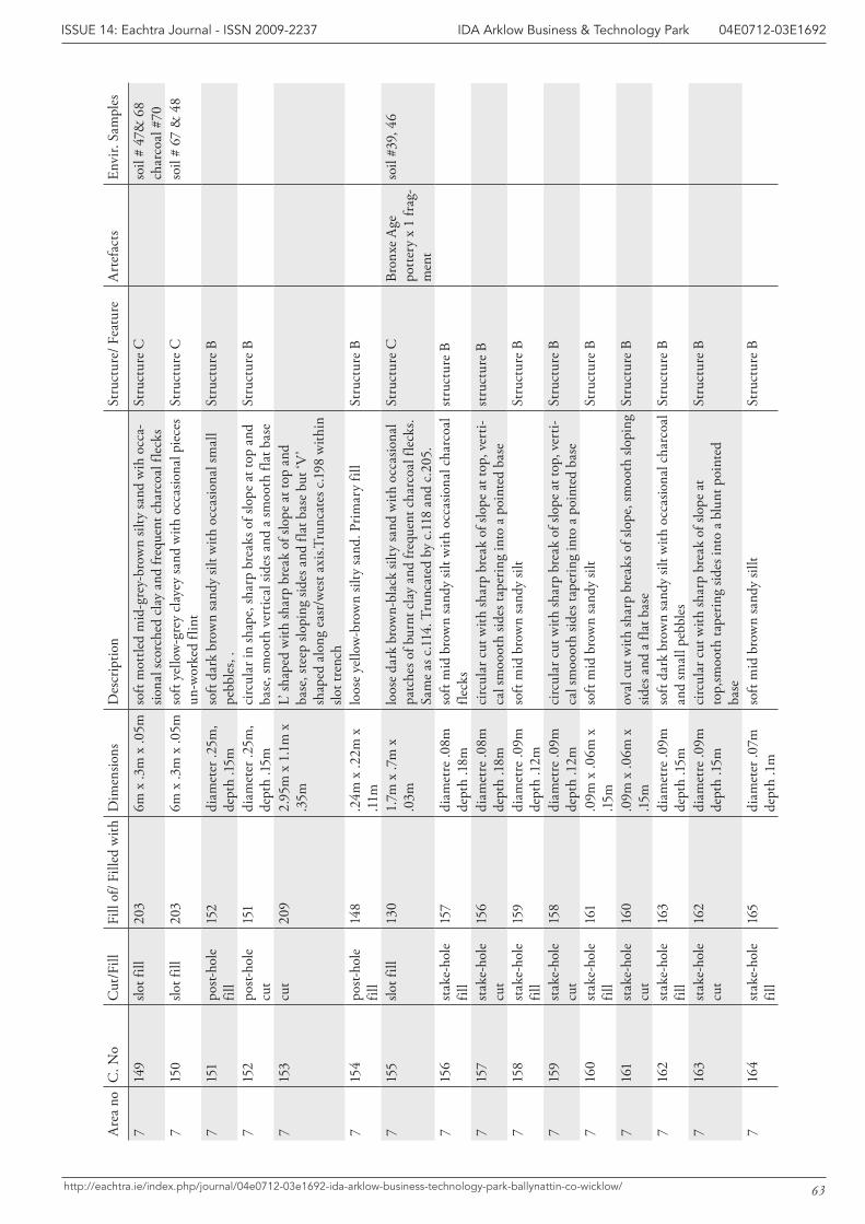
63
IDA Arklow Business & Technology Park 04E0712-03E1692ISSUE 14: Eachtra Journal - ISSN 2009-2237
http://eachtra.ie/index.php/journal/04e0712-03e1692-ida-arklow-business-technology-park-ballynattin-co-wicklow/
Are
a no
C. N
oC
ut/F
illFi
ll of
/ Fill
ed w
ithD
imen
sions
Des
crip
tion
Stru
ctur
e/ F
eatu
reA
rtef
acts
Envi
r. Sa
mpl
es
714
9slo
t fill
203
6m x
.3m
x .0
5mso
ft m
ottle
d m
id-g
rey-
brow
n sil
ty sa
nd w
ih o
cca-
siona
l sco
rche
d cl
ay a
nd fr
eque
nt c
harc
oal f
leck
sSt
ruct
ure
Cso
il #
47&
68
char
coal
#70
715
0slo
t fill
203
6m x
.3m
x .0
5mso
ft ye
llow
-gre
y cl
ayey
sand
with
occ
asio
nal p
iece
s un
-wor
ked
flint
Stru
ctur
e C
soil
# 67
& 4
8
715
1po
st-ho
le
fill
152
diam
eter
.25m
, de
pth
.15m
soft
dark
bro
wn
sand
y sil
t with
occ
asio
nal s
mal
l pe
bble
s, .
Stru
ctur
e B
715
2po
st-ho
le
cut
151
diam
eter
.25m
, de
pth
.15m
circ
ular
in sh
ape,
shar
p br
eaks
of s
lope
at t
op a
nd
base
, sm
ooth
ver
tical
side
s and
a sm
ooth
flat
bas
eSt
ruct
ure
B
715
3cu
t20
92.
95m
x 1
.1m
x
.35m
L’ sh
aped
with
shar
p br
eak
of sl
ope
at to
p an
d ba
se, s
teep
slop
ing
sides
and
flat
bas
e bu
t ‘V
’ sh
aped
alo
ng e
asr/
wes
t axi
s.Tru
ncat
es c
.198
with
in
slot t
renc
h7
154
post-
hole
fil
l14
8.2
4m x
.22m
x
.11m
loos
e ye
llow
-bro
wn
silty
sand
. Prim
ary
fill
Stru
ctur
e B
715
5slo
t fill
130
1.7m
x .7
m x
.0
3mlo
ose
dark
bro
wn-
blac
k sil
ty sa
nd w
ith o
ccas
iona
l pa
tche
s of b
urnt
cla
y an
d fr
eque
nt c
harc
oal f
leck
s. Sa
me
as c
.114
. Tru
ncat
ed b
y c.1
18 a
nd c
.205
.
Stru
ctur
e C
Bron
xe A
ge
pott
ery
x 1
frag
-m
ent
soil
#39,
46
715
6st
ake-
hole
fil
l 15
7di
amet
re .0
8m
dept
h .1
8mso
ft m
id b
row
n sa
ndy
silt w
ith o
ccas
iona
l cha
rcoa
l fle
cks
stru
ctur
e B
715
7st
ake-
hole
cu
t15
6di
amet
re .0
8m
dept
h .1
8mci
rcul
ar c
ut w
ith sh
arp
brea
k of
slop
e at
top,
ver
ti-ca
l sm
ooot
h sid
es ta
perin
g in
to a
poi
nted
bas
est
ruct
ure
B
715
8st
ake-
hole
fil
l15
9di
amet
re .0
9m
dept
h .1
2mso
ft m
id b
row
n sa
ndy
silt
Stru
ctur
e B
715
9st
ake-
hole
cu
t15
8di
amet
re .0
9m
dept
h .1
2mci
rcul
ar c
ut w
ith sh
arp
brea
k of
slop
e at
top,
ver
ti-ca
l sm
ooot
h sid
es ta
perin
g in
to a
poi
nted
bas
eSt
ruct
ure
B
716
0st
ake-
hole
fil
l16
1.0
9m x
.06m
x
.15m
soft
mid
bro
wn
sand
y sil
t St
ruct
ure
B
716
1st
ake-
hole
cu
t16
0.0
9m x
.06m
x
.15m
oval
cut
with
shar
p br
eaks
of s
lope
, sm
ooth
slop
ing
sides
and
a fl
at b
ase
Stru
ctur
e B
716
2st
ake-
hole
fil
l16
3di
amet
re .0
9m
dept
h .15
mso
ft da
rk b
row
n sa
ndy
silt w
ith o
ccas
iona
l cha
rcoa
l an
d sm
all p
ebbl
es
Stru
ctur
e B
716
3st
ake-
hole
cu
t16
2di
amet
re .0
9m
dept
h .15
mci
rcul
ar c
ut w
ith sh
arp
brea
k of
slop
e at
to
p,sm
ooth
tape
ring
sides
into
a b
lunt
poi
nted
ba
se
Stru
ctur
e B
716
4st
ake-
hole
fil
l16
5di
amet
er .0
7m
dept
h .1
mso
ft m
id b
row
n sa
ndy
sillt
Stru
ctur
e B
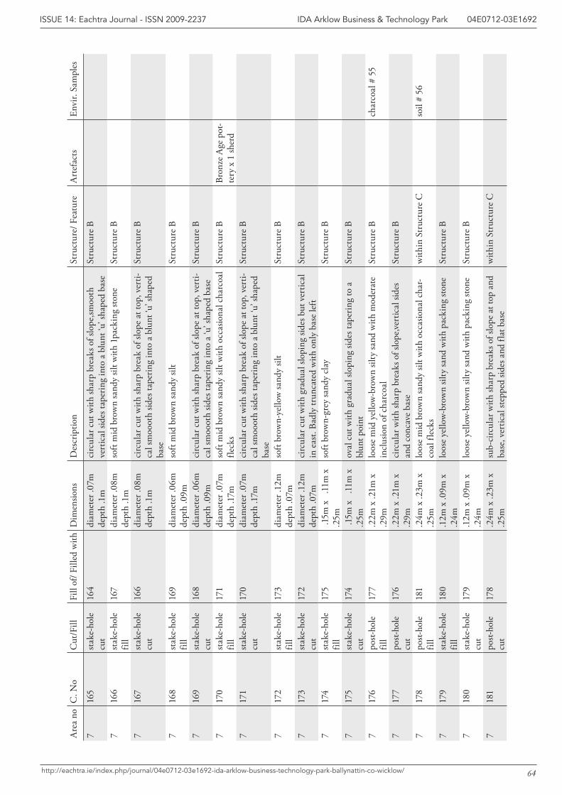
64
IDA Arklow Business & Technology Park 04E0712-03E1692ISSUE 14: Eachtra Journal - ISSN 2009-2237
http://eachtra.ie/index.php/journal/04e0712-03e1692-ida-arklow-business-technology-park-ballynattin-co-wicklow/
Are
a no
C. N
oC
ut/F
illFi
ll of
/ Fill
ed w
ithD
imen
sions
Des
crip
tion
Stru
ctur
e/ F
eatu
reA
rtef
acts
Envi
r. Sa
mpl
es
716
5st
ake-
hole
cu
t16
4di
amet
er .0
7m
dept
h .1
mci
rcul
ar c
ut w
ith sh
arp
brea
ks o
f slo
pe,sm
ooth
ve
rtic
al si
des t
aper
ing
into
a b
lunt
‘u’ s
hape
d ba
seSt
ruct
ure
B
716
6st
ake-
hole
fil
l16
7di
amet
er .0
8m
dept
h .1
mso
ft m
id b
row
n sa
ndy
silt w
ith 1
pack
ing
stone
St
ruct
ure
B
716
7st
ake-
hole
cu
t16
6di
amet
er .0
8m
dept
h .1
mci
rcul
ar c
ut w
ith sh
arp
brea
k of
slop
e at
top,
ver
ti-ca
l sm
ooot
h sid
es ta
perin
g in
to a
blu
nt ‘u
’ sha
ped
base
Stru
ctur
e B
716
8st
ake-
hole
fil
l16
9di
amet
er .0
6m
dept
h .0
9mso
ft m
id b
row
n sa
ndy
silt
Stru
ctur
e B
716
9st
ake-
hole
cu
t16
8di
amet
er .0
6m
dept
h .0
9mci
rcul
ar c
ut w
ith sh
arp
brea
k of
slop
e at
top,
ver
ti-ca
l sm
ooot
h sid
es ta
perin
g in
to a
‘u’ s
hape
d ba
seSt
ruct
ure
B
717
0st
ake-
hole
fil
l17
1di
amet
er .0
7m
dept
h .1
7mso
ft m
id b
row
n sa
ndy
silt w
ith o
ccas
iona
l cha
rcoa
l fle
cks
Stru
ctur
e B
Bron
ze A
ge p
ot-
tery
x 1
sher
d7
171
stak
e-ho
le
cut
170
diam
eter
.07m
de
pth
.17m
circ
ular
cut
with
shar
p br
eak
of sl
ope
at to
p, v
erti-
cal s
moo
oth
sides
tape
ring
into
a b
lunt
‘u’ s
hape
d ba
se
Stru
ctur
e B
717
2st
ake-
hole
fil
l17
3di
amet
er .1
2m
dept
h .0
7mso
ft br
own-
yello
w sa
ndy
silt
Stru
ctur
e B
717
3st
ake-
hole
cu
t17
2di
amet
er .1
2m
dept
h .0
7mci
rcul
ar c
ut w
ith g
radu
al sl
opin
g sid
es b
ut v
ertic
al
in e
ast.
Badl
y tr
unca
ted
with
onl
y ba
se le
ftSt
ruct
ure
B
717
4st
ake-
hole
fil
l17
5 .1
5m x
.1
1m x
.2
5mso
ft br
own-
grey
sand
y cl
ay
Stru
ctur
e B
717
5st
ake-
hole
cu
t17
4 .1
5m x
.1
1m x
.2
5mov
al c
ut w
ith g
radu
al sl
opin
g sid
es ta
perin
g to
a
blun
t poi
ntSt
ruct
ure
B
717
6po
st-ho
le
fill
177
.22m
x .2
1m x
.2
9mlo
ose
mid
yel
low
-bro
wn
silty
sand
with
mod
erat
e in
clus
ion
of c
harc
oal
Stru
ctur
e B
char
coal
# 5
5
717
7po
st-ho
le
cut
176
.22m
x .2
1m x
.2
9mci
rcul
ar w
ith sh
arp
brea
ks o
f slo
pe,ve
rtic
al si
des
and
conc
ave
base
St
ruct
ure
B
717
8po
st-ho
le
fill
181
.24m
x .2
3m x
.2
5mlo
ose
mid
bro
wn
sand
y sil
t with
occ
asio
nal c
har-
coal
flec
ksw
ithin
Str
uctu
re C
soil
# 56
717
9st
ake-
hole
fil
l18
0.1
2m x
.09m
x
.24m
loos
e ye
llow
-bro
wn
silty
sand
with
pac
king
ston
e St
ruct
ure
B
718
0st
ake-
hole
cu
t17
9.1
2m x
.09m
x
.24m
loos
e ye
llow
-bro
wn
silty
sand
with
pac
king
ston
e St
ruct
ure
B
718
1po
st-ho
le
cut
178
.24m
x .2
3m x
.2
5msu
b-ci
rcul
ar w
ith sh
arp
brea
ks o
f slo
pe a
t top
and
ba
se, v
ertic
al st
eppe
d sid
es a
nd fl
at b
ase
with
in S
truc
ture
C
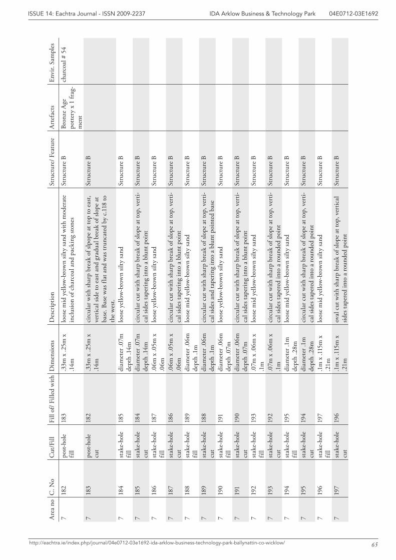
65
IDA Arklow Business & Technology Park 04E0712-03E1692ISSUE 14: Eachtra Journal - ISSN 2009-2237
http://eachtra.ie/index.php/journal/04e0712-03e1692-ida-arklow-business-technology-park-ballynattin-co-wicklow/
Are
a no
C. N
oC
ut/F
illFi
ll of
/ Fill
ed w
ithD
imen
sions
Des
crip
tion
Stru
ctur
e/ F
eatu
reA
rtef
acts
Envi
r. Sa
mpl
es
718
2po
st-ho
le
fill
183
.33m
x .2
5m x
.1
4mlo
ose
mid
yel
low
-bro
wn
silty
sand
with
mod
erat
e in
clus
ion
of c
harc
oal a
nd p
acki
ng st
ones
Stru
ctur
e B
Bron
ze A
ge
pott
ery
x 1
frag
-m
ent
char
coal
# 5
4
718
3po
st-ho
le
cut
182
.33m
x .2
5m x
.1
4mci
rcul
ar w
ith sh
arp
brea
k of
slpo
pe a
t top
to e
ast,
vert
ical
side
to e
ast a
nd g
radu
al b
reak
of s
lope
at
base
. Bas
e w
as fl
at a
nd w
as tr
unca
ted
by c
.118
to
the
wes
t.
Stru
ctur
e B
718
4st
ake-
hole
fil
l18
5di
amet
er .0
7m
dept
h .1
4mlo
ose
yello
w-b
row
n sil
ty sa
nd
Stru
ctur
e B
718
5st
ake-
hole
cu
t18
4di
amet
er .0
7m
dept
h .1
4mci
rcul
ar c
ut w
ith sh
arp
brea
k of
slop
e at
top,
ver
ti-ca
l sid
es ta
perin
g in
to a
blu
nt p
oint
Stru
ctur
e B
718
6st
ake-
hole
fil
l18
7.0
6m x
.05m
x
.06m
loos
e ye
llow
-bro
wn
silty
sand
St
ruct
ure
B
718
7st
ake-
hole
cu
t18
6.0
6m x
.05m
x
.06m
circ
ular
cut
with
shar
p br
eak
of sl
ope
at to
p, v
erti-
cal s
ides
tape
ring
into
a b
lunt
poi
ntSt
ruct
ure
B
718
8st
ake-
hole
fil
l18
9di
amet
er .0
6m
dept
h .1
mlo
ose
mid
yel
low
-bro
wn
silty
sand
St
ruct
ure
B
718
9st
ake-
hole
cu
t18
8di
amet
er .0
6m
dept
h .1
mci
rcul
ar c
ut w
ith sh
arp
brea
k of
slop
e at
top,
ver
ti-ca
l sid
es a
nd ta
perin
g in
to a
blu
nt p
oint
ed b
ase
Stru
ctur
e B
719
0st
ake-
hole
fil
l19
1di
amet
er .0
6m
dept
h .0
7mlo
ose
yello
w-b
row
n sil
ty sa
nd
Stru
ctur
e B
719
1st
ake-
hole
cu
t19
0di
amet
er .0
6m
dept
h .0
7mci
rcul
ar c
ut w
ith sh
arp
brea
k of
slop
e at
top,
ver
ti-ca
l sid
es ta
perin
g in
to a
blu
nt p
oint
Stru
ctur
e B
719
2st
ake-
hole
fil
l19
3.0
7m x
.06m
x
.1m
loos
e m
id y
ello
w-b
row
n sil
ty sa
nd
Stru
ctur
e B
719
3st
ake-
hole
cu
t19
2.0
7m x
.06m
x
.1m
circ
ular
cut
with
shar
p br
eak
of sl
ope
at to
p, v
erti-
cal s
ides
tape
red
into
a ro
unde
d po
int
Stru
ctur
e B
719
4st
ake-
hole
fil
l19
5di
amet
er .1
m
dept
h .2
8mlo
ose
mid
yel
low
-bro
wn
silty
sand
St
ruct
ure
B
719
5st
ake-
hole
cu
t19
4di
amet
er .1
m
dept
h .2
8mci
rcul
ar c
ut w
ith sh
arp
brea
k of
slop
e at
top,
ver
ti-ca
l sid
es ta
pere
d in
to a
roun
ded
poin
tSt
ruct
ure
B
719
6st
ake-
hole
fil
l19
7.1
m x
.115
m x
.2
1mlo
ose
mid
yel
low
-bro
wn
silty
sand
St
ruct
ure
B
719
7st
ake-
hole
cu
t19
6.1
m x
.115
m x
.2
1mov
al c
ut w
ith sh
arp
brea
k of
slop
e at
top,
ver
tical
sid
es ta
pere
d in
to a
roun
ded
poin
tSt
ruct
ure
B
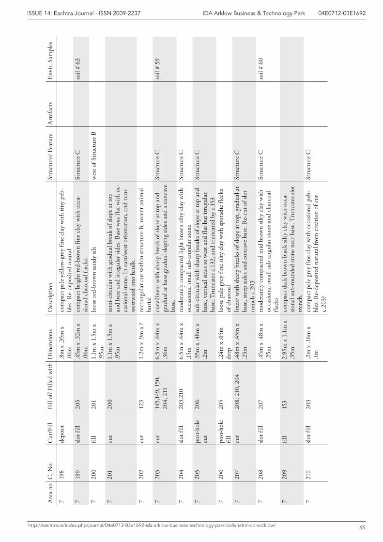
66
IDA Arklow Business & Technology Park 04E0712-03E1692ISSUE 14: Eachtra Journal - ISSN 2009-2237
http://eachtra.ie/index.php/journal/04e0712-03e1692-ida-arklow-business-technology-park-ballynattin-co-wicklow/
Are
a no
C. N
oC
ut/F
illFi
ll of
/ Fill
ed w
ithD
imen
sions
Des
crip
tion
Stru
ctur
e/ F
eatu
reA
rtef
acts
Envi
r. Sa
mpl
es
719
8de
posit
.8m
x .3
5m x
.0
6mco
mpa
ct p
ale
yello
w-g
rey
fine
clay
with
tiny
peb
-bl
es. R
e-de
posit
ed n
aura
l7
199
slot f
ill20
5.4
5m x
.32m
x
.06m
com
pact
brig
ht re
d-br
own
fine
clay
with
occ
a-sio
nal c
harc
oal f
leck
s.St
ruct
ure
Cso
il #
63
720
0fil
l20
11.
1m x
1.5
m x
.9
5mlo
ose
red-
brow
n sa
ndy
silt
wes
t of S
truc
ture
B
720
1cu
t20
01.
1m x
1.5
m x
.9
5mse
mi-c
ircul
ar w
ith g
radu
al b
reak
of s
lope
at t
op
and
base
and
irre
gula
r sid
es. B
ase
was
flat
with
oc-
casio
nal s
tone
. In
east
/wes
t orie
ntat
ion,
and
runs
w
estw
ard
into
bau
lk.
720
2cu
t12
31.
2m x
.9m
x ?
rect
angu
lar c
ut w
ithin
stru
ctur
e B,
rece
nt a
nim
al
buria
l7
203
cut
145,
149,
150
, 20
4, 2
116.
5m x
.44m
x
.36m
curv
iline
ar w
ith sh
arp
brea
k of
slop
e at
top
and
grad
ual a
t bas
e,gr
adua
l slo
ping
side
s and
a c
onca
ve
base
.
Stru
ctur
e C
soil
# 59
720
4slo
t fill
203,
210
6.5m
x .4
4m x
.15
mm
oder
atel
y co
mpa
cted
ligh
t bro
wn
silty
cla
y w
ith
occa
siona
l sm
all s
ub-a
ngul
ar st
one
Stru
ctur
e C
720
5po
st-ho
le
cut
206
.55m
x .4
8m x
.2
msu
b-ci
rcul
ar w
ith sh
arp
brea
ks o
f slo
pe a
t top
and
ba
se, v
ertic
al si
des t
o w
est a
nd fl
at b
ut ir
regu
lar
base
. Tru
ncat
es c
.132
, and
trun
cate
d by
c.15
3
Stru
ctur
e C
720
6po
st-ho
le
fill
205
.24m
x .0
5m
deep
loos
e pa
le g
rey
fine
silty
cla
y w
ith sp
orad
ic fl
ecks
of
cha
rcoa
l7
207
cut
208,
210
, 204
.48m
x .4
5m x
.2
5mlin
ear w
ith sh
arp
brea
ks o
f slo
pe a
t top
, gra
dual
at
base
, ste
ep si
des a
nd c
onca
ve b
ase.
Re-
cut o
f slo
t tr
ench
c.2
03
Stru
ctur
e C
720
8slo
t fill
207
.45m
x .4
8m x
.2
5mm
oder
atel
y co
mpa
cted
mid
bro
wn
silty
cla
y w
ith
occa
siona
l sm
all s
ub-a
ngul
ar st
one
and
char
coal
fle
cks
Stru
ctur
e C
soil
# 60
720
9fil
l15
32.
95m
x 1
.1m
x
.35m
com
pact
dar
k br
own-
blac
k sil
ty c
lay
with
occ
a-sio
nal s
ub-r
ound
ed st
one
near
bas
e. T
runc
ates
slot
tr
ench
.7
210
slot f
ill20
3.2
m x
.16m
x
.1m
com
pact
pal
e gr
ey fi
ne c
lay
with
occ
asio
nal p
eb-
bles
. Re-
depo
sited
nat
ural
from
cre
atio
n of
cut
c.
203?
Stru
ctur
e C
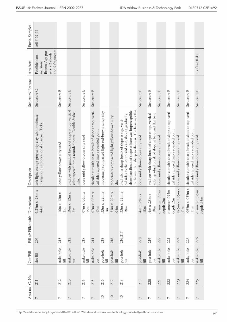
67
IDA Arklow Business & Technology Park 04E0712-03E1692ISSUE 14: Eachtra Journal - ISSN 2009-2237
http://eachtra.ie/index.php/journal/04e0712-03e1692-ida-arklow-business-technology-park-ballynattin-co-wicklow/
Are
a no
C. N
oC
ut/F
illFi
ll of
/ Fill
ed w
ithD
imen
sions
Des
crip
tion
Stru
ctur
e/ F
eatu
reA
rtef
acts
Envi
r. Sa
mpl
es
721
1slo
t fill
203
4.25
m x
.28m
x
.44m
soft
light
ora
nge-
grey
sand
y cl
ay w
ith m
oder
ate
man
gane
se a
nd o
ccas
iona
l cha
rcoa
l fle
cks.
Stru
ctur
e C
Poss
ible
ham
-m
ersto
ne
Bron
ze A
ge p
ot-
tery
x 2
sher
ds
and
9 fr
agm
ents
soil
# 62
,69
721
2st
ake-
hole
fil
l21
3.1
6m x
,12m
x
.2m
loos
e ye
llow
-bro
wn
silty
sand
St
ruct
ure
B
721
3st
ake-
hole
cu
t21
2.1
6m x
,12m
x
.2m
oval
cut
with
gra
dual
bre
ak o
f slo
pe a
t top
, ver
tical
sid
es ta
pere
d in
to a
roun
ded
poin
t. D
oubl
e St
ake-
hole
.
Stru
ctur
e B
721
4st
ake-
hole
fil
l21
5.0
7m x
.06m
x
.15m
loos
e m
id y
ello
w-b
row
n sil
ty sa
nd
Stru
ctur
e B
721
5st
ake-
hole
cu
t21
4.0
7m x
.06m
x
.15m
circ
ular
cut
with
shar
p br
eak
of sl
ope
at to
p, v
erti-
cal s
ides
tape
red
into
a ro
unde
d po
int
Stru
ctur
e B
1021
6po
st-ho
le
fill
218
.33m
x .2
2m x
.1
mm
oder
atel
y co
mpa
cted
ligh
t red
-bro
wn
sand
y cl
ay
1021
7po
st-ho
le
fill
218
.33m
x .2
2m x
.0
8mm
oder
atel
y co
mpa
cted
ligh
t yel
low
-bro
wn
silty
cl
ay10
218
post-
hole
cu
t21
6,21
7.3
3m x
.22m
x
.18m
oval
with
a sh
arp
brea
k of
slop
e at
top,
ver
ti-ca
l sid
es to
the
sout
h an
d ea
st, s
lopi
ng g
radu
ally
el
sew
here
.Bre
ak o
f slo
pe a
t bas
e w
as im
perc
eptib
le
to th
e w
est b
ut sh
arp
to th
e ea
st. T
he b
ase
was
flat
.7
219
post-
hole
fil
l 22
0.4
m x
.28m
x
.18m
loos
e m
id y
ello
w-b
row
n sil
ty sa
nd
Stru
ctur
e B
722
0po
st-ho
le
cut
219
.4m
x .2
8m x
.1
8mov
al c
ut w
ith sh
arp
brea
k of
slop
e at
top,
ver
tical
sid
es, g
radu
al b
reak
of s
lope
at b
ase
and
flat b
ase
St
ruct
ure
B
722
1st
ake-
hole
fil
l22
2di
amet
er .0
95m
de
pth
.2m
loos
e m
id y
ello
w-b
row
n sil
ty sa
nd
Stru
ctur
e B
722
2st
ake-
hole
cu
t22
1di
amet
er .0
95m
de
pth
.2m
circ
ular
cut
with
shar
p br
eak
of sl
ope
at to
p, v
erti-
cal s
ides
tape
red
into
a ro
unde
d po
int
Stru
ctur
e B
722
3st
ake-
hole
fil
l22
4.0
65m
x .0
55m
x
.11m
loos
e m
id y
ello
w-b
row
n sil
ty sa
nd
Stru
ctur
e B
722
4st
ake-
hole
cu
t22
3.0
65m
x .0
55m
x
.11m
circ
ular
cut
with
shar
p br
eak
of sl
ope
at to
p, v
erti-
cal s
ides
tape
red
into
a ro
unde
d po
int
Stru
ctur
e B
722
5st
ake-
hole
fil
l22
6di
amet
er .0
75m
de
pth
.15m
loos
e m
id y
ello
w-b
row
n sil
ty sa
ndSt
ruct
ure
B1
x fli
nt fl
ake
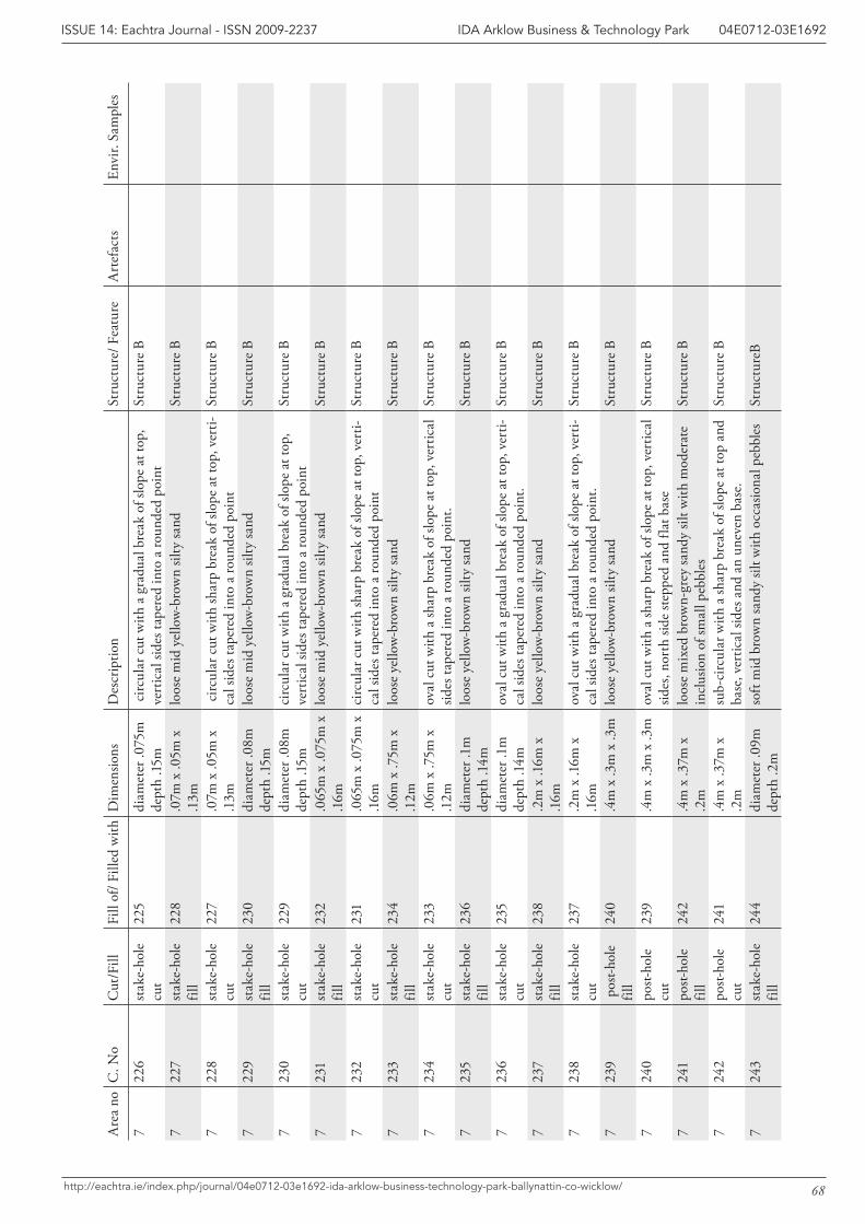
68
IDA Arklow Business & Technology Park 04E0712-03E1692ISSUE 14: Eachtra Journal - ISSN 2009-2237
http://eachtra.ie/index.php/journal/04e0712-03e1692-ida-arklow-business-technology-park-ballynattin-co-wicklow/
Are
a no
C. N
oC
ut/F
illFi
ll of
/ Fill
ed w
ithD
imen
sions
Des
crip
tion
Stru
ctur
e/ F
eatu
reA
rtef
acts
Envi
r. Sa
mpl
es
722
6st
ake-
hole
cu
t22
5di
amet
er .0
75m
de
pth
.15m
circ
ular
cut
with
a g
radu
al b
reak
of s
lope
at t
op,
vert
ical
side
s tap
ered
into
a ro
unde
d po
int
Stru
ctur
e B
722
7st
ake-
hole
fil
l22
8.0
7m x
.05m
x
.13m
loos
e m
id y
ello
w-b
row
n sil
ty sa
ndSt
ruct
ure
B
722
8st
ake-
hole
cu
t22
7.0
7m x
.05m
x
.13m
circ
ular
cut
with
shar
p br
eak
of sl
ope
at to
p, v
erti-
cal s
ides
tape
red
into
a ro
unde
d po
int
Stru
ctur
e B
722
9st
ake-
hole
fil
l23
0di
amet
er .0
8m
dept
h .15
mlo
ose
mid
yel
low
-bro
wn
silty
sand
St
ruct
ure
B
723
0st
ake-
hole
cu
t22
9di
amet
er .0
8m
dept
h .15
mci
rcul
ar c
ut w
ith a
gra
dual
bre
ak o
f slo
pe a
t top
, ve
rtic
al si
des t
aper
ed in
to a
roun
ded
poin
tSt
ruct
ure
B
723
1st
ake-
hole
fil
l23
2.0
65m
x .0
75m
x
.16m
loos
e m
id y
ello
w-b
row
n sil
ty sa
nd
Stru
ctur
e B
723
2st
ake-
hole
cu
t23
1.0
65m
x .0
75m
x
.16m
circ
ular
cut
with
shar
p br
eak
of sl
ope
at to
p, v
erti-
cal s
ides
tape
red
into
a ro
unde
d po
int
Stru
ctur
e B
723
3st
ake-
hole
fil
l23
4.0
6m x
.75m
x
.12m
loos
e ye
llow
-bro
wn
silty
sand
St
ruct
ure
B
723
4st
ake-
hole
cu
t23
3.0
6m x
.75m
x
.12m
oval
cut
with
a sh
arp
brea
k of
slop
e at
top,
ver
tical
sid
es ta
pere
d in
to a
roun
ded
poin
t.St
ruct
ure
B
723
5st
ake-
hole
fil
l23
6di
amet
er .1
m
dept
h .1
4mlo
ose
yello
w-b
row
n sil
ty sa
nd
Stru
ctur
e B
723
6st
ake-
hole
cu
t23
5di
amet
er .1
m
dept
h .1
4mov
al c
ut w
ith a
gra
dual
bre
ak o
f slo
pe a
t top
, ver
ti-ca
l sid
es ta
pere
d in
to a
roun
ded
poin
t.St
ruct
ure
B
723
7st
ake-
hole
fil
l23
8.2
m x
.16m
x
.16m
loos
e ye
llow
-bro
wn
silty
sand
St
ruct
ure
B
723
8st
ake-
hole
cu
t23
7.2
m x
.16m
x
.16m
oval
cut
with
a g
radu
al b
reak
of s
lope
at t
op, v
erti-
cal s
ides
tape
red
into
a ro
unde
d po
int.
Stru
ctur
e B
723
9 p
ost-h
ole
fill
240
.4m
x .3
m x
.3m
loos
e ye
llow
-bro
wn
silty
sand
St
ruct
ure
B
724
0po
st-ho
le
cut
239
.4m
x .3
m x
.3m
oval
cut
with
a sh
arp
brea
k of
slop
e at
top,
ver
tical
sid
es, n
orth
side
step
ped
and
flat b
ase
Stru
ctur
e B
724
1po
st-ho
le
fill
242
.4m
x .3
7m x
.2
mlo
ose
mix
ed b
row
n-gr
ey sa
ndy
silt w
ith m
oder
ate
incl
usio
n of
smal
l peb
bles
St
ruct
ure
B
724
2po
st-ho
le
cut
241
.4m
x .3
7m x
.2
msu
b-ci
rcul
ar w
ith a
shar
p br
eak
of sl
ope
at to
p an
d ba
se, v
ertic
al si
des a
nd a
n un
even
bas
e.St
ruct
ure
B
724
3st
ake-
hole
fil
l24
4di
amet
er .0
9m
dept
h .2
mso
ft m
id b
row
n sa
ndy
silt w
ith o
ccas
iona
l peb
bles
St
ruct
ureB
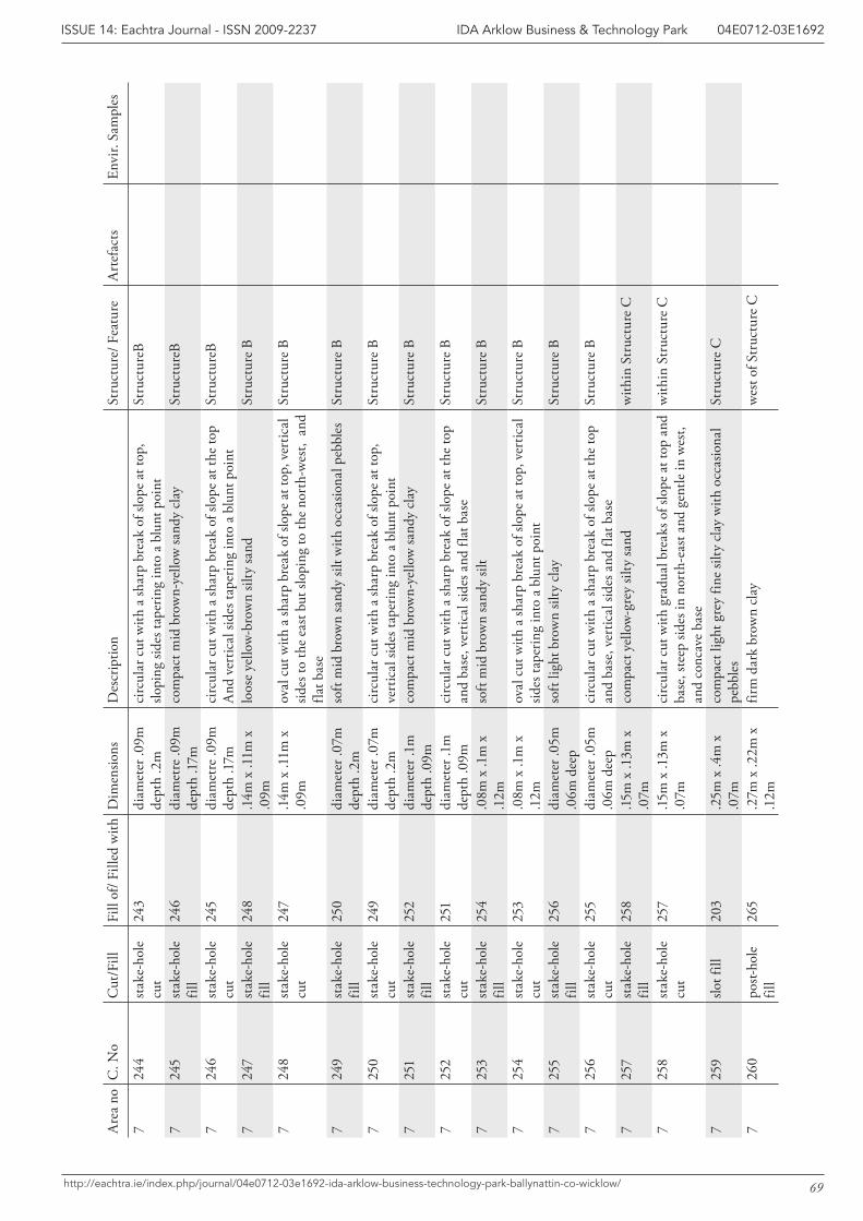
69
IDA Arklow Business & Technology Park 04E0712-03E1692ISSUE 14: Eachtra Journal - ISSN 2009-2237
http://eachtra.ie/index.php/journal/04e0712-03e1692-ida-arklow-business-technology-park-ballynattin-co-wicklow/
Are
a no
C. N
oC
ut/F
illFi
ll of
/ Fill
ed w
ithD
imen
sions
Des
crip
tion
Stru
ctur
e/ F
eatu
reA
rtef
acts
Envi
r. Sa
mpl
es
724
4st
ake-
hole
cu
t24
3di
amet
er .0
9m
dept
h .2
mci
rcul
ar c
ut w
ith a
shar
p br
eak
of sl
ope
at to
p,
slopi
ng si
des t
aper
ing
into
a b
lunt
poi
ntSt
ruct
ureB
724
5st
ake-
hole
fil
l24
6di
amet
re .0
9m
dept
h .1
7mco
mpa
ct m
id b
row
n-ye
llow
sand
y cl
ay
Stru
ctur
eB
724
6st
ake-
hole
cu
t24
5di
amet
re .0
9m
dept
h .1
7mci
rcul
ar c
ut w
ith a
shar
p br
eak
of sl
ope
at th
e to
p A
nd v
ertic
al si
des t
aper
ing
into
a b
lunt
poi
ntSt
ruct
ureB
724
7st
ake-
hole
fil
l24
8.1
4m x
.11m
x
.09m
loos
e ye
llow
-bro
wn
silty
sand
St
ruct
ure
B
724
8st
ake-
hole
cu
t24
7.1
4m x
.11m
x
.09m
oval
cut
with
a sh
arp
brea
k of
slop
e at
top,
ver
tical
sid
es to
the
east
but
slop
ing
to th
e no
rth-
wes
t, a
nd
flat b
ase
Stru
ctur
e B
724
9st
ake-
hole
fil
l25
0di
amet
er .0
7m
dept
h .2
mso
ft m
id b
row
n sa
ndy
silt w
ith o
ccas
iona
l peb
bles
St
ruct
ure
B
725
0st
ake-
hole
cu
t24
9di
amet
er .0
7m
dept
h .2
mci
rcul
ar c
ut w
ith a
shar
p br
eak
of sl
ope
at to
p,
vert
ical
side
s tap
erin
g in
to a
blu
nt p
oint
Stru
ctur
e B
725
1st
ake-
hole
fil
l25
2di
amet
er .1
m
dept
h .0
9mco
mpa
ct m
id b
row
n-ye
llow
sand
y cl
ay
Stru
ctur
e B
725
2st
ake-
hole
cu
t25
1di
amet
er .1
m
dept
h .0
9mci
rcul
ar c
ut w
ith a
shar
p br
eak
of sl
ope
at th
e to
p an
d ba
se, v
ertic
al si
des a
nd fl
at b
ase
Stru
ctur
e B
725
3st
ake-
hole
fil
l25
4.0
8m x
.1m
x
.12m
soft
mid
bro
wn
sand
y sil
t St
ruct
ure
B
725
4st
ake-
hole
cu
t25
3.0
8m x
.1m
x
.12m
oval
cut
with
a sh
arp
brea
k of
slop
e at
top,
ver
tical
sid
es ta
perin
g in
to a
blu
nt p
oint
Stru
ctur
e B
725
5st
ake-
hole
fil
l25
6di
amet
er .0
5m
.06m
dee
pso
ft lig
ht b
row
n sil
ty c
lay
Stru
ctur
e B
725
6st
ake-
hole
cu
t25
5di
amet
er .0
5m
.06m
dee
pci
rcul
ar c
ut w
ith a
shar
p br
eak
of sl
ope
at th
e to
p an
d ba
se, v
ertic
al si
des a
nd fl
at b
ase
Stru
ctur
e B
725
7st
ake-
hole
fil
l25
8.15
m x
.13m
x
.07m
co
mpa
ct y
ello
w-g
rey
silty
sand
w
ithin
Str
uctu
re C
725
8st
ake-
hole
cu
t25
7.15
m x
.13m
x
.07m
ci
rcul
ar c
ut w
ith g
radu
al b
reak
s of s
lope
at t
op a
nd
base
, ste
ep si
des i
n no
rth-
east
and
gen
tle in
wes
t, an
d co
ncav
e ba
se
with
in S
truc
ture
C
725
9slo
t fill
203
.25m
x .4
m x
.0
7mco
mpa
ct li
ght g
rey
fine
silty
cla
y w
ith o
ccas
iona
l pe
bble
s St
ruct
ure
C
726
0po
st-ho
le
fill
265
.27m
x .2
2m x
.1
2mfir
m d
ark
brow
n cl
ayw
est o
f Str
uctu
re C
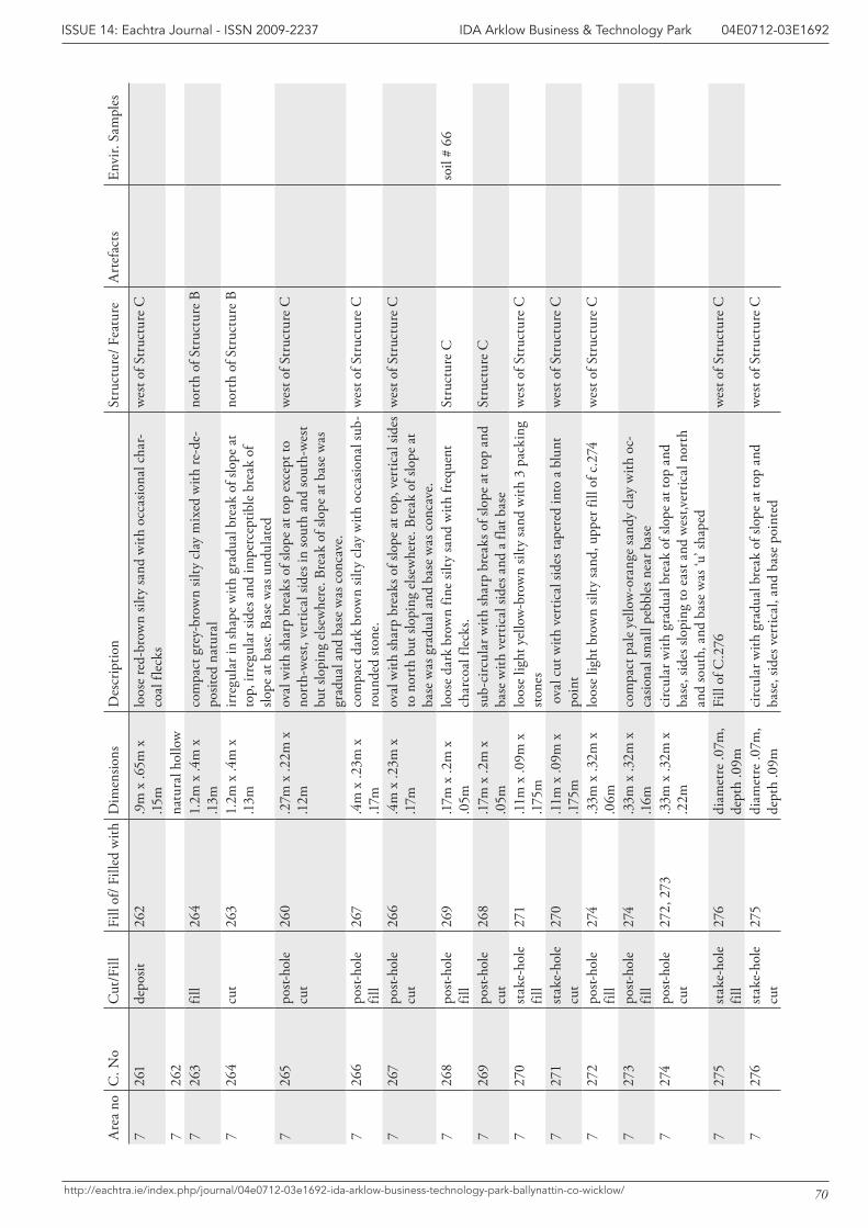
70
IDA Arklow Business & Technology Park 04E0712-03E1692ISSUE 14: Eachtra Journal - ISSN 2009-2237
http://eachtra.ie/index.php/journal/04e0712-03e1692-ida-arklow-business-technology-park-ballynattin-co-wicklow/
Are
a no
C. N
oC
ut/F
illFi
ll of
/ Fill
ed w
ithD
imen
sions
Des
crip
tion
Stru
ctur
e/ F
eatu
reA
rtef
acts
Envi
r. Sa
mpl
es
726
1de
posit
262
.9m
x .6
5m x
.15
mlo
ose
red-
brow
n sil
ty sa
nd w
ith o
ccas
iona
l cha
r-co
al fl
ecks
wes
t of S
truc
ture
C
726
2na
tura
l hol
low
726
3fil
l26
41.
2m x
.4m
x
.13m
com
pact
gre
y-br
own
silty
cla
y m
ixed
with
re-d
e-po
sited
nat
ural
nort
h of
Str
uctu
re B
726
4cu
t26
31.
2m x
.4m
x
.13m
irreg
ular
in sh
ape
with
gra
dual
bre
ak o
f slo
pe a
t to
p, ir
regu
lar s
ides
and
impe
rcep
tible
bre
ak o
f slo
pe a
t bas
e. B
ase
was
und
ulat
ed
nort
h of
Str
uctu
re B
726
5po
st-ho
le
cut
260
.27m
x .2
2m x
.1
2mov
al w
ith sh
arp
brea
ks o
f slo
pe a
t top
exc
ept t
o no
rth-
wes
t, ve
rtic
al si
des i
n so
uth
and
sout
h-w
est
but s
lopi
ng e
lsew
here
. Bre
ak o
f slo
pe a
t bas
e w
as
grad
ual a
nd b
ase
was
con
cave
.
wes
t of S
truc
ture
C
726
6po
st-ho
le
fill
267
.4m
x .2
3m x
.1
7mco
mpa
ct d
ark
brow
n sil
ty c
lay
with
occ
asio
nal s
ub-
roun
ded
stone
.w
est o
f Str
uctu
re C
726
7po
st-ho
le
cut
266
.4m
x .2
3m x
.1
7mov
al w
ith sh
arp
brea
ks o
f slo
pe a
t top
, ver
tical
side
s to
nor
th b
ut sl
opin
g el
sew
here
. Bre
ak o
f slo
pe a
t ba
se w
as g
radu
al a
nd b
ase
was
con
cave
.
wes
t of S
truc
ture
C
726
8po
st-ho
le
fill
269
.17m
x .2
m x
.0
5mlo
ose
dark
bro
wn
fine
silty
sand
with
freq
uent
ch
arco
al fl
ecks
. St
ruct
ure
Cso
il #
66
726
9po
st-ho
le
cut
268
.17m
x .2
m x
.0
5msu
b-ci
rcul
ar w
ith sh
arp
brea
ks o
f slo
pe a
t top
and
ba
se w
ith v
ertic
al si
des a
nd a
flat
bas
eSt
ruct
ure
C
727
0st
ake-
hole
fil
l27
1.1
1m x
.09m
x
.175
mlo
ose
light
yel
low
-bro
wn
silty
sand
with
3 p
acki
ng
stone
sw
est o
f Str
uctu
re C
727
1st
ake-
hole
cu
t27
0.1
1m x
.09m
x
.175
m o
val c
ut w
ith v
ertic
al si
des t
aper
ed in
to a
blu
nt
poin
tw
est o
f Str
uctu
re C
727
2po
st-ho
le
fill
274
.33m
x .3
2m x
.0
6mlo
ose
light
bro
wn
silty
sand
, upp
er fi
ll of
c.2
74w
est o
f Str
uctu
re C
727
3po
st-ho
le
fill
274
.33m
x .3
2m x
.1
6mco
mpa
ct p
ale
yello
w-o
rang
e sa
ndy
clay
with
oc-
casio
nal s
mal
l peb
bles
nea
r bas
e7
274
post-
hole
cu
t27
2, 2
73.3
3m x
.32m
x
.22m
circ
ular
with
gra
dual
bre
ak o
f slo
pe a
t top
and
ba
se, s
ides
slop
ing
to e
ast a
nd w
est,v
ertic
al n
orth
an
d so
uth,
and
bas
e w
as ‘u
’ sha
ped
727
5st
ake-
hole
fil
l27
6di
amet
re .0
7m,
dept
h .0
9mFi
ll of
C.2
76w
est o
f Str
uctu
re C
727
6st
ake-
hole
cu
t27
5di
amet
re .0
7m,
dept
h .0
9mci
rcul
ar w
ith g
radu
al b
reak
of s
lope
at t
op a
nd
base
, sid
es v
ertic
al, a
nd b
ase
poin
ted
wes
t of S
truc
ture
C
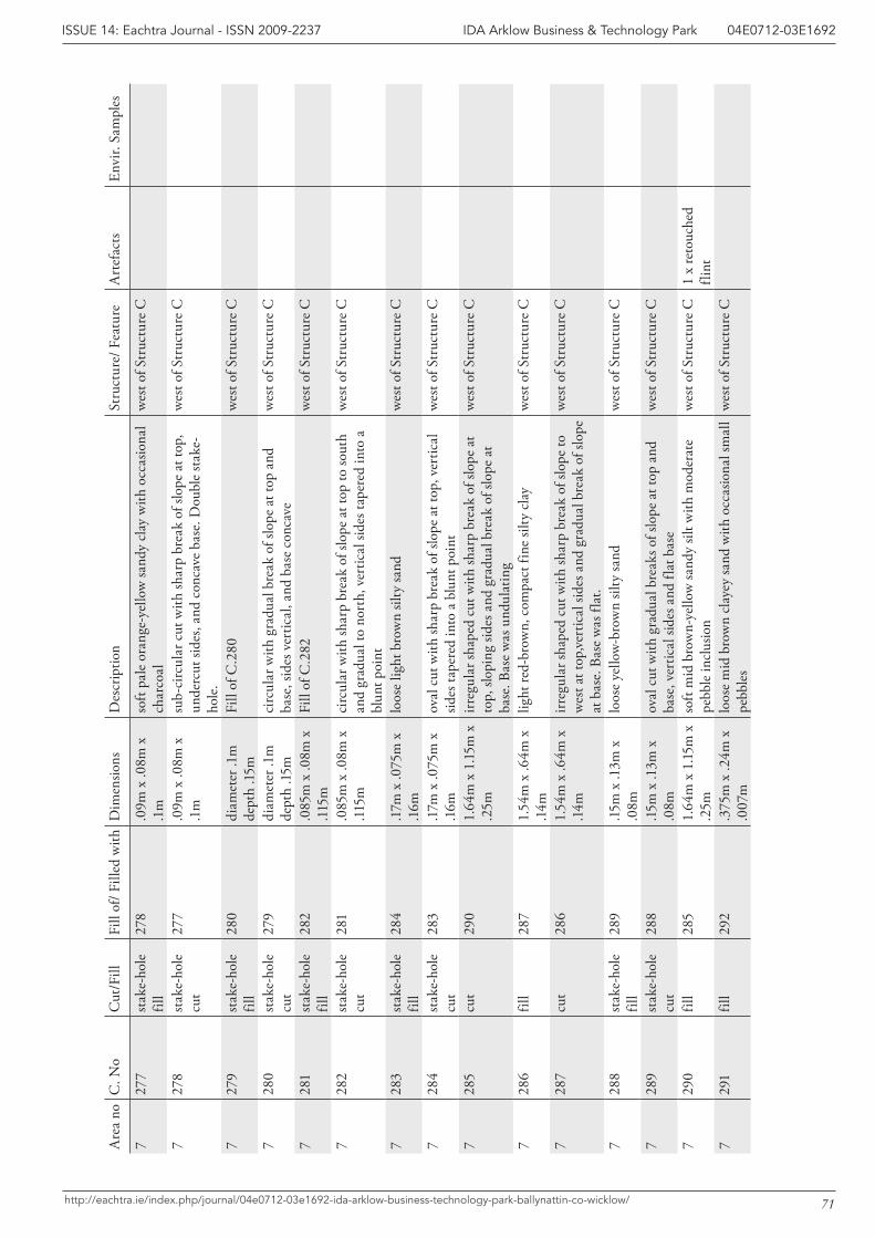
71
IDA Arklow Business & Technology Park 04E0712-03E1692ISSUE 14: Eachtra Journal - ISSN 2009-2237
http://eachtra.ie/index.php/journal/04e0712-03e1692-ida-arklow-business-technology-park-ballynattin-co-wicklow/
Are
a no
C. N
oC
ut/F
illFi
ll of
/ Fill
ed w
ithD
imen
sions
Des
crip
tion
Stru
ctur
e/ F
eatu
reA
rtef
acts
Envi
r. Sa
mpl
es
727
7st
ake-
hole
fil
l27
8.0
9m x
.08m
x
.1m
soft
pale
ora
nge-
yello
w sa
ndy
clay
with
occ
asio
nal
char
coal
w
est o
f Str
uctu
re C
727
8st
ake-
hole
cu
t27
7.0
9m x
.08m
x
.1m
sub-
circ
ular
cut
with
shar
p br
eak
of sl
ope
at to
p,
unde
rcut
side
s, an
d co
ncav
e ba
se. D
oubl
e st
ake-
hole
.
wes
t of S
truc
ture
C
727
9st
ake-
hole
fil
l28
0di
amet
er .1
m
dept
h .15
mFi
ll of
C.2
80w
est o
f Str
uctu
re C
728
0st
ake-
hole
cu
t27
9di
amet
er .1
m
dept
h .15
mci
rcul
ar w
ith g
radu
al b
reak
of s
lope
at t
op a
nd
base
, sid
es v
ertic
al, a
nd b
ase
conc
ave
wes
t of S
truc
ture
C
728
1st
ake-
hole
fil
l28
2.0
85m
x .0
8m x
.1
15m
Fill
of C
.282
wes
t of S
truc
ture
C
728
2st
ake-
hole
cu
t28
1.0
85m
x .0
8m x
.1
15m
circ
ular
with
shar
p br
eak
of sl
ope
at to
p to
sout
h an
d gr
adua
l to
nort
h, v
ertic
al si
des t
aper
ed in
to a
bl
unt p
oint
wes
t of S
truc
ture
C
728
3st
ake-
hole
fil
l28
4.1
7m x
.075
m x
.1
6mlo
ose
light
bro
wn
silty
sand
w
est o
f Str
uctu
re C
728
4st
ake-
hole
cu
t28
3.1
7m x
.075
m x
.1
6mov
al c
ut w
ith sh
arp
brea
k of
slop
e at
top,
ver
tical
sid
es ta
pere
d in
to a
blu
nt p
oint
wes
t of S
truc
ture
C
728
5cu
t29
01.
64m
x 1
.15m
x
.25m
irreg
ular
shap
ed c
ut w
ith sh
arp
brea
k of
slop
e at
to
p, sl
opin
g sid
es a
nd g
radu
al b
reak
of s
lope
at
base
. Bas
e w
as u
ndul
atin
g
wes
t of S
truc
ture
C
728
6fil
l28
71.
54m
x .6
4m x
.1
4mlig
ht re
d-br
own,
com
pact
fine
silty
cla
yw
est o
f Str
uctu
re C
728
7cu
t28
61.
54m
x .6
4m x
.1
4mirr
egul
ar sh
aped
cut
with
shar
p br
eak
of sl
ope
to
wes
t at t
op,ve
rtic
al si
des a
nd g
radu
al b
reak
of s
lope
at
bas
e. B
ase
was
flat
.
wes
t of S
truc
ture
C
728
8st
ake-
hole
fil
l28
9.15
m x
.13m
x
.08m
lo
ose
yello
w-b
row
n sil
ty sa
nd
wes
t of S
truc
ture
C
728
9st
ake-
hole
cu
t28
8.15
m x
.13m
x
.08m
ov
al c
ut w
ith g
radu
al b
reak
s of s
lope
at t
op a
nd
base
, ver
tical
side
s and
flat
bas
ew
est o
f Str
uctu
re C
729
0fil
l28
51.
64m
x 1
.15m
x
.25m
soft
mid
bro
wn-
yello
w sa
ndy
silt w
ith m
oder
ate
pebb
le in
clus
ion
wes
t of S
truc
ture
C1
x re
touc
hed
flint
729
1fil
l29
2.3
75m
x .2
4m x
.0
07m
loos
e m
id b
row
n cl
ayey
sand
with
occ
asio
nal s
mal
l pe
bble
sw
est o
f Str
uctu
re C
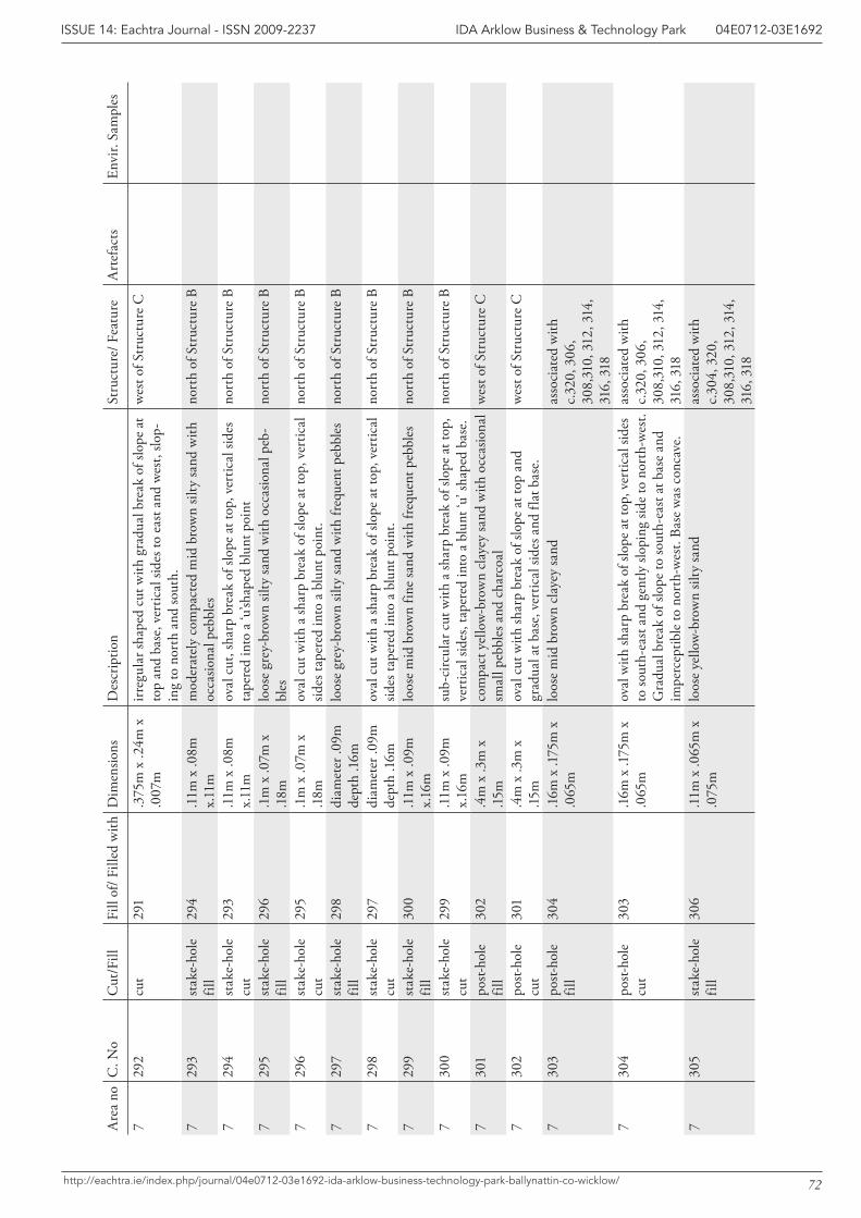
72
IDA Arklow Business & Technology Park 04E0712-03E1692ISSUE 14: Eachtra Journal - ISSN 2009-2237
http://eachtra.ie/index.php/journal/04e0712-03e1692-ida-arklow-business-technology-park-ballynattin-co-wicklow/
Are
a no
C. N
oC
ut/F
illFi
ll of
/ Fill
ed w
ithD
imen
sions
Des
crip
tion
Stru
ctur
e/ F
eatu
reA
rtef
acts
Envi
r. Sa
mpl
es
729
2cu
t29
1.3
75m
x .2
4m x
.0
07m
irreg
ular
shap
ed c
ut w
ith g
radu
al b
reak
of s
lope
at
top
and
base
, ver
tical
side
s to
east
and
wes
t, slo
p-in
g to
nor
th a
nd so
uth.
wes
t of S
truc
ture
C
729
3st
ake-
hole
fil
l29
4.1
1m x
.08m
x.
11m
mod
erat
ely
com
pact
ed m
id b
row
n sil
ty sa
nd w
ith
occa
siona
l peb
bles
no
rth
of S
truc
ture
B
729
4st
ake-
hole
cu
t29
3.1
1m x
.08m
x.
11m
oval
cut
, sha
rp b
reak
of s
lope
at t
op, v
ertic
al si
des
tape
red
into
a ‘u
’shap
ed b
lunt
poi
ntno
rth
of S
truc
ture
B
729
5st
ake-
hole
fil
l29
6.1
m x
.07m
x
.18m
loos
e gr
ey-b
row
n sil
ty sa
nd w
ith o
ccas
iona
l peb
-bl
es
nort
h of
Str
uctu
re B
729
6st
ake-
hole
cu
t29
5.1
m x
.07m
x
.18m
oval
cut
with
a sh
arp
brea
k of
slop
e at
top,
ver
tical
sid
es ta
pere
d in
to a
blu
nt p
oint
. no
rth
of S
truc
ture
B
729
7st
ake-
hole
fil
l29
8di
amet
er .0
9m
dept
h .1
6mlo
ose
grey
-bro
wn
silty
sand
with
freq
uent
peb
bles
no
rth
of S
truc
ture
B
729
8st
ake-
hole
cu
t29
7di
amet
er .0
9m
dept
h .1
6mov
al c
ut w
ith a
shar
p br
eak
of sl
ope
at to
p, v
ertic
al
sides
tape
red
into
a b
lunt
poi
nt.
nort
h of
Str
uctu
re B
729
9st
ake-
hole
fil
l30
0.1
1m x
.09m
x.
16m
loos
e m
id b
row
n fin
e sa
nd w
ith fr
eque
nt p
ebbl
es
nort
h of
Str
uctu
re B
730
0st
ake-
hole
cu
t29
9.1
1m x
.09m
x.
16m
sub-
circ
ular
cut
with
a sh
arp
brea
k of
slop
e at
top,
ve
rtic
al si
des,
tape
red
into
a b
lunt
‘u’ s
hape
d ba
se.
nort
h of
Str
uctu
re B
730
1po
st-ho
le
fill
302
.4m
x .3
m x
.15
mco
mpa
ct y
ello
w-b
row
n cl
ayey
sand
with
occ
asio
nal
smal
l peb
bles
and
cha
rcoa
lw
est o
f Str
uctu
re C
730
2po
st-ho
le
cut
301
.4m
x .3
m x
.15
mov
al c
ut w
ith sh
arp
brea
k of
slop
e at
top
and
grad
ual a
t bas
e, v
ertic
al si
des a
nd fl
at b
ase.
wes
t of S
truc
ture
C
730
3po
st-ho
le
fill
304
.16m
x .1
75m
x
.065
mlo
ose
mid
bro
wn
clay
ey sa
nd
asso
ciat
ed w
ith
c.32
0, 3
06,
308,
310,
312
, 314
, 31
6, 3
187
304
post-
hole
cu
t30
3.1
6m x
.175
m x
.0
65m
oval
with
shar
p br
eak
of sl
ope
at to
p, v
ertic
al si
des
to so
uth-
east
and
gen
tly sl
opin
g sid
e to
nor
th-w
est.
Gra
dual
bre
ak o
f slo
pe to
sout
h-ea
st a
t bas
e an
d im
perc
eptib
le to
nor
th-w
est.
Base
was
con
cave
.
asso
ciat
ed w
ith
c.32
0, 3
06,
308,
310,
312
, 314
, 31
6, 3
187
305
stak
e-ho
le
fill
306
.11m
x .0
65m
x
.075
mlo
ose
yello
w-b
row
n sil
ty sa
nd
asso
ciat
ed w
ith
c.30
4, 3
20,
308,
310,
312
, 314
, 31
6, 3
18
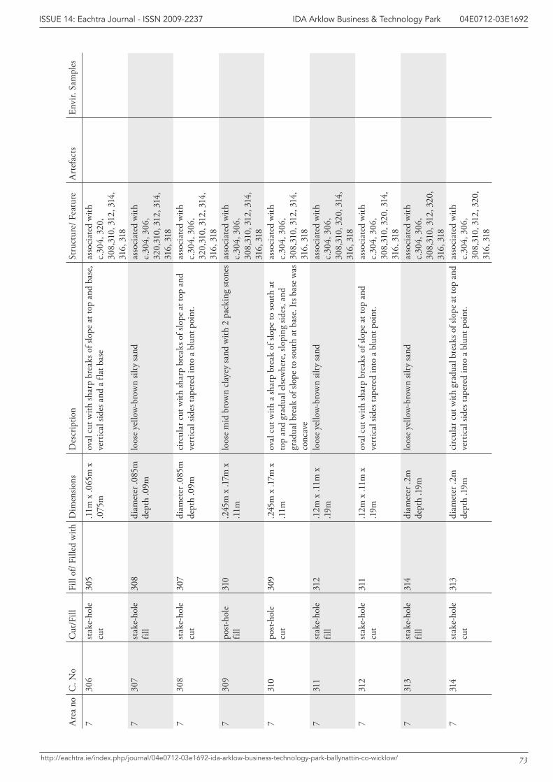
73
IDA Arklow Business & Technology Park 04E0712-03E1692ISSUE 14: Eachtra Journal - ISSN 2009-2237
http://eachtra.ie/index.php/journal/04e0712-03e1692-ida-arklow-business-technology-park-ballynattin-co-wicklow/
Are
a no
C. N
oC
ut/F
illFi
ll of
/ Fill
ed w
ithD
imen
sions
Des
crip
tion
Stru
ctur
e/ F
eatu
reA
rtef
acts
Envi
r. Sa
mpl
es
730
6st
ake-
hole
cu
t30
5.1
1m x
.065
m x
.0
75m
oval
cut
with
shar
p br
eaks
of s
lope
at t
op a
nd b
ase,
ve
rtic
al si
des a
nd a
flat
bas
eas
soci
ated
with
c.
304,
320
, 30
8,31
0, 3
12, 3
14,
316,
318
730
7st
ake-
hole
fil
l30
8di
amet
er .0
85m
de
pth
.09m
loos
e ye
llow
-bro
wn
silty
sand
as
soci
ated
with
c.
304,
306
, 32
0,31
0, 3
12, 3
14,
316,
318
730
8st
ake-
hole
cu
t30
7di
amet
er .0
85m
de
pth
.09m
circ
ular
cut
with
shar
p br
eaks
of s
lope
at t
op a
nd
vert
ical
side
s tap
ered
into
a b
lunt
poi
nt.
asso
ciat
ed w
ith
c.30
4, 3
06,
320,
310,
312
, 314
, 31
6, 3
187
309
post-
hole
fil
l31
0.2
45m
x .1
7m x
.1
1mlo
ose
mid
bro
wn
clay
ey sa
nd w
ith 2
pac
king
ston
es a
ssoc
iate
d w
ith
c.30
4, 3
06,
308,
310,
312
, 314
, 31
6, 3
187
310
post-
hole
cu
t30
9.2
45m
x .1
7m x
.1
1mov
al c
ut w
ith a
shar
p br
eak
of sl
ope
to so
uth
at
top
and
grad
ual e
lsew
here
, slo
ping
side
s, an
d gr
adua
l bre
ak o
f slo
pe to
sout
h at
bas
e. It
s bas
e w
as
conc
ave
asso
ciat
ed w
ith
c.30
4, 3
06,
308,
310,
312
, 314
, 31
6, 3
187
311
stak
e-ho
le
fill
312
.12m
x .1
1m x
.1
9mlo
ose
yello
w-b
row
n sil
ty sa
nd
asso
ciat
ed w
ith
c.30
4, 3
06,
308,
310,
320
, 314
, 31
6, 3
187
312
stak
e-ho
le
cut
311
.12m
x .1
1m x
.1
9mov
al c
ut w
ith sh
arp
brea
ks o
f slo
pe a
t top
and
ve
rtic
al si
des t
aper
ed in
to a
blu
nt p
oint
.as
soci
ated
with
c.
304,
306
, 30
8,31
0, 3
20, 3
14,
316,
318
731
3st
ake-
hole
fil
l31
4di
amet
er .2
m
dept
h .1
9mlo
ose
yello
w-b
row
n sil
ty sa
nd
asso
ciat
ed w
ith
c.30
4, 3
06,
308,
310,
312
, 320
, 31
6, 3
187
314
stak
e-ho
le
cut
313
diam
eter
.2m
de
pth
.19m
circ
ular
cut
with
gra
dual
bre
aks o
f slo
pe a
t top
and
ve
rtic
al si
des t
aper
ed in
to a
blu
nt p
oint
.as
soci
ated
with
c.
304,
306
, 30
8,31
0, 3
12, 3
20,
316,
318
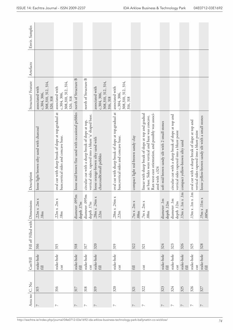
74
IDA Arklow Business & Technology Park 04E0712-03E1692ISSUE 14: Eachtra Journal - ISSN 2009-2237
http://eachtra.ie/index.php/journal/04e0712-03e1692-ida-arklow-business-technology-park-ballynattin-co-wicklow/
Are
a no
C. N
oC
ut/F
illFi
ll of
/ Fill
ed w
ithD
imen
sions
Des
crip
tion
Stru
ctur
e/ F
eatu
reA
rtef
acts
Envi
r. Sa
mpl
es
731
5st
ake-
hole
fil
l31
6.2
2m x
.2m
x
.18m
loos
e lig
ht b
row
n sil
ty sa
nd w
ith c
harc
oal
asso
ciat
ed w
ith
c.30
4, 3
06,
308,
310,
312
, 314
, 32
0, 3
187
316
stak
e-ho
le
cut
315
.22m
x .2
m x
.1
8mov
al c
ut w
ith sh
arp
brea
k of
slop
e at
top,
grad
ual a
t ba
se,ve
rtic
al si
des a
nd c
onca
ve b
ase.
asso
ciat
ed w
ith
c.30
4, 3
06,
308,
310,
312
, 314
, 32
0, 3
187
317
stak
e-ho
le
fill
318
diam
eter
.095
m
dept
h .1
7mlo
ose
mid
bro
wn
fine
sand
with
occ
asio
nal p
ebbl
es
nort
h of
Str
uctu
re B
731
8st
ake-
hole
cu
t31
7di
amet
er .0
95m
de
pth
.17m
circ
ular
cut
with
a sh
arp
brea
k of
slop
e at
top,
ve
rtic
al si
des,
tape
red
into
a b
lunt
‘u’ s
hape
d ba
se.
nort
h of
Str
uctu
re B
731
9st
ake-
hole
fil
l32
0.2
8m x
.24m
x
.22m
loos
e or
ange
-bro
wn
silty
sand
with
ch
arco
al&
smal
l peb
bles
as
soci
ated
with
c.
304,
306
, 30
8,31
0, 3
12, 3
14,
316,
318
732
0st
ake-
hole
cu
t31
9.2
8m x
.24m
x
.22m
oval
cut
with
shar
p br
eak
of sl
ope
at to
p,gr
adua
l at
base
,vert
ical
side
s and
con
cave
bas
e.as
soci
ated
with
c.
304,
306
, 30
8,31
0, 3
12, 3
14,
316,
318
732
1fil
l32
2.7
m x
.2m
x
.08m
com
pact
ligh
t red
-bro
wn
sand
y cl
ay
732
2cu
t32
1.7
m x
.2m
x
.08m
linea
r with
shar
p br
eak
of sl
ope
at to
p an
d gr
adua
l at
bas
e. S
ides
wer
e ve
rtic
al a
nd b
ase
was
con
cave
. R
an w
est-e
ast o
rient
atio
n, a
nd p
ossib
ly w
as a
ssoc
i-at
ed w
ith c
324
732
3st
ake-
hole
fil
l32
4di
amet
er .1
m
dept
h .1
2mso
ft m
id b
row
n sa
ndy
silt w
ith 2
smal
l sto
nes
732
4st
ake-
hole
cu
t32
3di
amet
er .1
m
dept
h .1
2mci
rcul
ar c
ut w
ith a
shar
p br
eak
of sl
ope
at to
p an
d ve
rtic
al si
des t
aper
ed in
to a
blu
nt p
oint
732
5st
ake-
hole
fil
l32
6.1
3m x
.1m
x .1
mco
mpa
ct y
ello
w-b
row
n sil
ty sa
nd
732
6st
ake-
hole
cu
t32
5.1
3m x
.1m
x .1
mov
al c
ut w
ith a
shar
p br
eak
of sl
ope
at to
p an
d ve
rtic
al si
des t
aper
ed in
to a
blu
nt p
oint
732
7st
ake-
hole
fil
l32
8.15
m x
.11m
x
.085
mlo
ose
yello
w-b
row
n sa
ndy
silt w
ith a
smal
l sto
nes
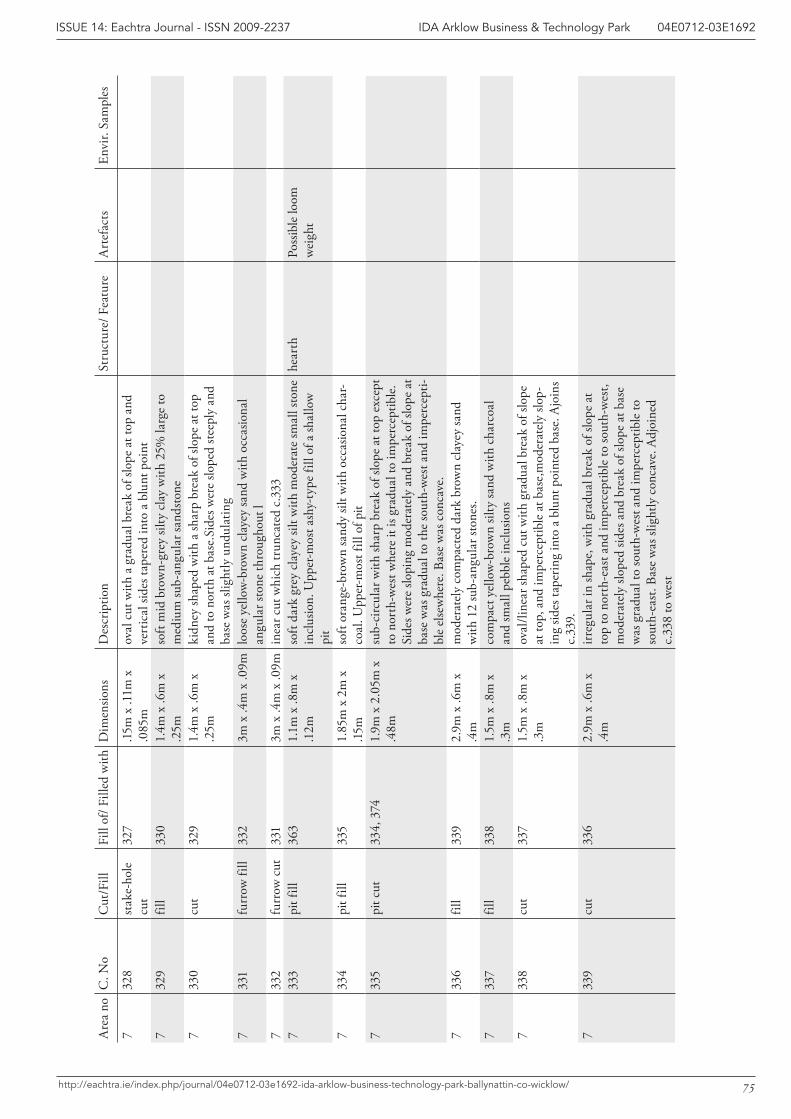
75
IDA Arklow Business & Technology Park 04E0712-03E1692ISSUE 14: Eachtra Journal - ISSN 2009-2237
http://eachtra.ie/index.php/journal/04e0712-03e1692-ida-arklow-business-technology-park-ballynattin-co-wicklow/
Are
a no
C. N
oC
ut/F
illFi
ll of
/ Fill
ed w
ithD
imen
sions
Des
crip
tion
Stru
ctur
e/ F
eatu
reA
rtef
acts
Envi
r. Sa
mpl
es
732
8st
ake-
hole
cu
t32
7.15
m x
.11m
x
.085
mov
al c
ut w
ith a
gra
dual
bre
ak o
f slo
pe a
t top
and
ve
rtic
al si
des t
aper
ed in
to a
blu
nt p
oint
732
9fil
l33
01.
4m x
.6m
x
.25m
soft
mid
bro
wn-
grey
silty
cla
y w
ith 2
5% la
rge
to
med
ium
sub-
angu
lar s
ands
tone
733
0cu
t32
91.
4m x
.6m
x
.25m
kidn
ey sh
aped
with
a sh
arp
brea
k of
slop
e at
top
and
to n
orth
at b
ase.
Side
s wer
e slo
ped
stee
ply
and
base
was
slig
htly
und
ulat
ing
733
1fu
rrow
fill
332
3m x
.4m
x .0
9mlo
ose
yello
w-b
row
n cl
ayey
sand
with
occ
asio
nal
angu
lar s
tone
thro
ugho
ut l
733
2fu
rrow
cut
331
3m x
.4m
x .0
9min
ear c
ut w
hich
trun
cate
d c.
333
733
3pi
t fill
363
1.1m
x .8
m x
.1
2mso
ft da
rk g
rey
clay
ey si
lt w
ith m
oder
ate
smal
l sto
ne
incl
usio
n. U
pper
-mos
t ash
y-ty
pe fi
ll of
a sh
allo
w
pit
hear
thPo
ssib
le lo
om
wei
ght
733
4pi
t fill
335
1.85
m x
2m
x
.15m
soft
oran
ge-b
row
n sa
ndy
silt w
ith o
ccas
iona
l cha
r-co
al. U
pper
-mos
t fill
of p
it7
335
pit c
ut33
4, 3
741.
9m x
2.0
5m x
.4
8msu
b-ci
rcul
ar w
ith sh
arp
brea
k of
slop
e at
top
exce
pt
to n
orth
-wes
t whe
re it
is g
radu
al to
impe
rcep
tible
. Si
des w
ere
slopi
ng m
oder
atel
y an
d br
eak
of sl
ope
at
base
was
gra
dual
to th
e so
uth-
wes
t and
impe
rcep
ti-bl
e el
sew
here
. Bas
e w
as c
onca
ve.
733
6fil
l33
92.
9m x
.6m
x
.4m
mod
erat
ely
com
pact
ed d
ark
brow
n cl
ayey
sand
w
ith 1
2 su
b-an
gula
r sto
nes.
733
7fil
l33
81.
5m x
.8m
x
.3m
com
pact
yel
low
-bro
wn
silty
sand
with
cha
rcoa
l an
d sm
all p
ebbl
e in
clus
ions
733
8cu
t33
71.
5m x
.8m
x
.3m
oval
/line
ar sh
aped
cut
with
gra
dual
bre
ak o
f slo
pe
at to
p, a
nd im
perc
eptib
le a
t bas
e,m
oder
atel
y slo
p-in
g sid
es ta
perin
g in
to a
blu
nt p
oint
ed b
ase.
Ajo
ins
c.33
9.7
339
cut
336
2.9m
x .6
m x
.4
mirr
egul
ar in
shap
e, w
ith g
radu
al b
reak
of s
lope
at
top
to n
orth
-eas
t and
impe
rcep
tible
to so
uth-
wes
t, m
oder
atel
y slo
ped
sides
and
bre
ak o
f slo
pe a
t bas
e w
as g
radu
al to
sout
h-w
est a
nd im
perc
eptib
le to
so
uth-
east
. Bas
e w
as sl
ight
ly c
onca
ve. A
djoi
ned
c.33
8 to
wes
t
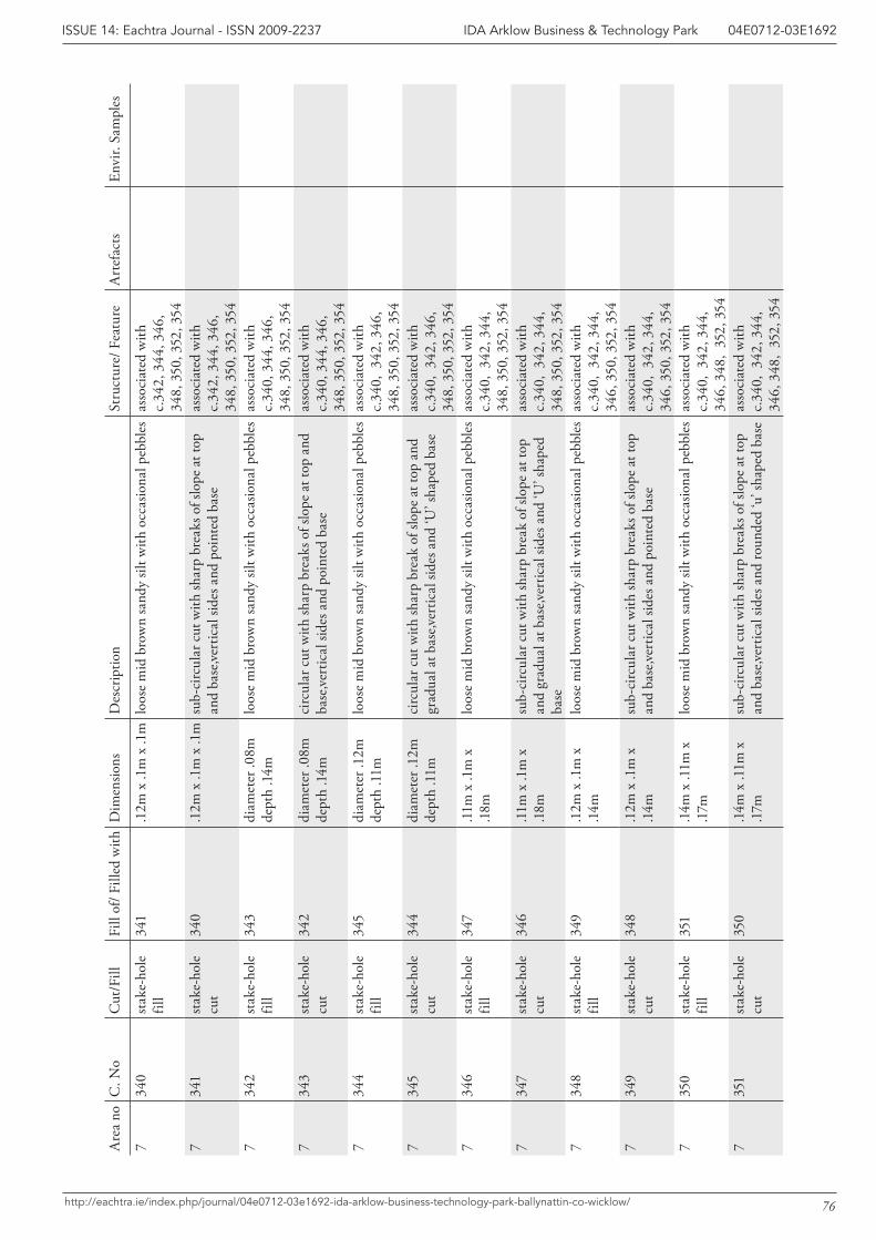
76
IDA Arklow Business & Technology Park 04E0712-03E1692ISSUE 14: Eachtra Journal - ISSN 2009-2237
http://eachtra.ie/index.php/journal/04e0712-03e1692-ida-arklow-business-technology-park-ballynattin-co-wicklow/
Are
a no
C. N
oC
ut/F
illFi
ll of
/ Fill
ed w
ithD
imen
sions
Des
crip
tion
Stru
ctur
e/ F
eatu
reA
rtef
acts
Envi
r. Sa
mpl
es
734
0st
ake-
hole
fil
l34
1.1
2m x
.1m
x .1
mlo
ose
mid
bro
wn
sand
y sil
t with
occ
asio
nal p
ebbl
es
asso
ciat
ed w
ith
c.34
2, 3
44, 3
46,
348,
350
, 352
, 354
734
1st
ake-
hole
cu
t34
0.1
2m x
.1m
x .1
msu
b-ci
rcul
ar c
ut w
ith sh
arp
brea
ks o
f slo
pe a
t top
an
d ba
se,ve
rtic
al si
des a
nd p
oint
ed b
ase
asso
ciat
ed w
ith
c.34
2, 3
44, 3
46,
348,
350
, 352
, 354
734
2st
ake-
hole
fil
l34
3di
amet
er .0
8m
dept
h .1
4mlo
ose
mid
bro
wn
sand
y sil
t with
occ
asio
nal p
ebbl
es
asso
ciat
ed w
ith
c.34
0, 3
44, 3
46,
348,
350
, 352
, 354
734
3st
ake-
hole
cu
t34
2di
amet
er .0
8m
dept
h .1
4mci
rcul
ar c
ut w
ith sh
arp
brea
ks o
f slo
pe a
t top
and
ba
se,ve
rtic
al si
des a
nd p
oint
ed b
ase
asso
ciat
ed w
ith
c.34
0, 3
44, 3
46,
348,
350
, 352
, 354
734
4st
ake-
hole
fil
l34
5di
amet
er .1
2m
dept
h .1
1mlo
ose
mid
bro
wn
sand
y sil
t with
occ
asio
nal p
ebbl
es
asso
ciat
ed w
ith
c.34
0, 3
42, 3
46,
348,
350
, 352
, 354
734
5st
ake-
hole
cu
t34
4di
amet
er .1
2m
dept
h .1
1mci
rcul
ar c
ut w
ith sh
arp
brea
k of
slop
e at
top
and
grad
ual a
t bas
e,ver
tical
side
s and
‘U’ s
hape
d ba
seas
soci
ated
with
c.
340,
342
, 346
, 34
8, 3
50, 3
52, 3
547
346
stak
e-ho
le
fill
347
.11m
x .1
m x
.1
8mlo
ose
mid
bro
wn
sand
y sil
t with
occ
asio
nal p
ebbl
es
asso
ciat
ed w
ith
c.34
0, 3
42, 3
44,
348,
350
, 352
, 354
734
7st
ake-
hole
cu
t34
6.1
1m x
.1m
x
.18m
sub-
circ
ular
cut
with
shar
p br
eak
of sl
ope
at to
p an
d gr
adua
l at b
ase,v
ertic
al si
des a
nd ‘U
’ sha
ped
base
asso
ciat
ed w
ith
c.34
0, 3
42, 3
44,
348,
350
, 352
, 354
734
8st
ake-
hole
fil
l34
9.1
2m x
.1m
x
.14m
loos
e m
id b
row
n sa
ndy
silt w
ith o
ccas
iona
l peb
bles
as
soci
ated
with
c.
340,
342
, 344
, 34
6, 3
50, 3
52, 3
547
349
stak
e-ho
le
cut
348
.12m
x .1
m x
.1
4msu
b-ci
rcul
ar c
ut w
ith sh
arp
brea
ks o
f slo
pe a
t top
an
d ba
se,ve
rtic
al si
des a
nd p
oint
ed b
ase
asso
ciat
ed w
ith
c.34
0, 3
42, 3
44,
346,
350
, 352
, 354
735
0st
ake-
hole
fil
l35
1.1
4m x
.11m
x
.17m
loos
e m
id b
row
n sa
ndy
silt w
ith o
ccas
iona
l peb
bles
as
soci
ated
with
c.
340,
342
, 344
, 34
6, 3
48,
352,
354
735
1st
ake-
hole
cu
t35
0.1
4m x
.11m
x
.17m
sub-
circ
ular
cut
with
shar
p br
eaks
of s
lope
at t
op
and
base
,vert
ical
side
s and
roun
ded
‘u’ s
hape
d ba
seas
soci
ated
with
c.
340,
342
, 344
, 34
6, 3
48,
352,
354
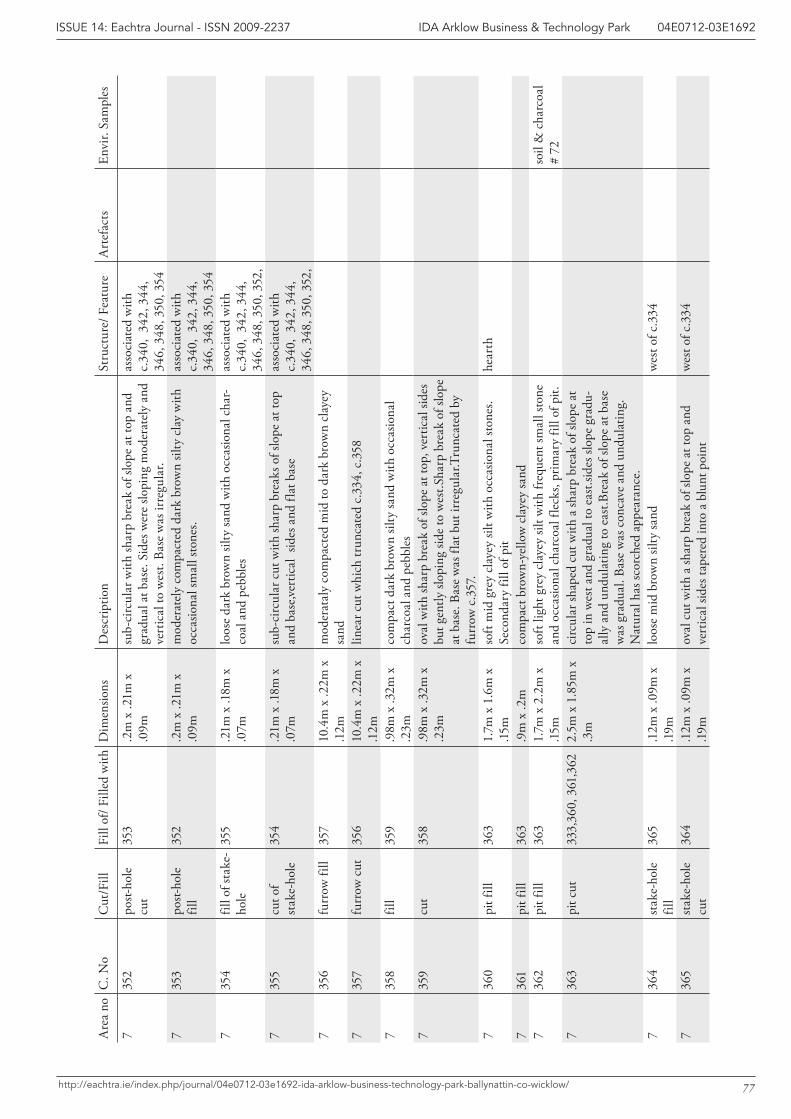
77
IDA Arklow Business & Technology Park 04E0712-03E1692ISSUE 14: Eachtra Journal - ISSN 2009-2237
http://eachtra.ie/index.php/journal/04e0712-03e1692-ida-arklow-business-technology-park-ballynattin-co-wicklow/
Are
a no
C. N
oC
ut/F
illFi
ll of
/ Fill
ed w
ithD
imen
sions
Des
crip
tion
Stru
ctur
e/ F
eatu
reA
rtef
acts
Envi
r. Sa
mpl
es
735
2po
st-ho
le
cut
353
.2m
x .2
1m x
.0
9msu
b-ci
rcul
ar w
ith sh
arp
brea
k of
slop
e at
top
and
grad
ual a
t bas
e. S
ides
wer
e slo
ping
mod
erat
ely
and
vert
ical
to w
est.
Base
was
irre
gula
r.
asso
ciat
ed w
ith
c.34
0, 3
42, 3
44,
346,
348
, 350
, 354
735
3po
st-ho
le
fill
352
.2m
x .2
1m x
.0
9mm
oder
atel
y co
mpa
cted
dar
k br
own
silty
cla
y w
ith
occa
siona
l sm
all s
tone
s.as
soci
ated
with
c.
340,
342
, 344
, 34
6, 3
48, 3
50, 3
547
354
fill o
f sta
ke-
hole
355
.21m
x .1
8m x
.0
7mlo
ose
dark
bro
wn
silty
sand
with
occ
asio
nal c
har-
coal
and
peb
bles
as
soci
ated
with
c.
340,
342
, 344
, 34
6, 3
48, 3
50, 3
52,
735
5cu
t of
stak
e-ho
le35
4.2
1m x
.18m
x
.07m
sub-
circ
ular
cut
with
shar
p br
eaks
of s
lope
at t
op
and
base
,vert
ical
sid
es a
nd fl
at b
ase
asso
ciat
ed w
ith
c.34
0, 3
42, 3
44,
346,
348
, 350
, 352
, 7
356
furr
ow fi
ll35
710
.4m
x .2
2m x
.1
2m
mod
erat
aly
com
pact
ed m
id to
dar
k br
own
clay
ey
sand
7
357
furr
ow c
ut35
610
.4m
x .2
2m x
.1
2m
linea
r cut
whi
ch tr
unca
ted
c.33
4, c
.358
735
8fil
l35
9.9
8m x
.32m
x
.23m
com
pact
dar
k br
own
silty
sand
with
occ
asio
nal
char
coal
and
peb
bles
735
9cu
t35
8.9
8m x
.32m
x
.23m
oval
with
shar
p br
eak
of sl
ope
at to
p, v
ertic
al si
des
but g
ently
slop
ing
side
to w
est.S
harp
bre
ak o
f slo
pe
at b
ase.
Bas
e w
as fl
at b
ut ir
regu
lar.T
runc
ated
by
furr
ow c
.357
.7
360
pit f
ill36
31.
7m x
1.6
m x
.15
mso
ft m
id g
rey
clay
ey si
lt w
ith o
ccas
iona
l sto
nes.
Seco
ndar
y fil
l of p
it he
arth
736
1pi
t fill
363
.9m
x .2
mco
mpa
ct b
row
n-ye
llow
cla
yey
sand
736
2pi
t fill
363
1.7m
x 2
.2m
x
.15m
soft
light
gre
y cl
ayey
silt
with
freq
uent
smal
l sto
ne
and
occa
siona
l cha
rcoa
l fle
cks,
prim
ary
fill o
f pit.
soil
& c
harc
oal
# 72
736
3pi
t cut
333,
360,
361
,362
2.5m
x 1
.85m
x
.3m
circ
ular
shap
ed c
ut w
ith a
shar
p br
eak
of sl
ope
at
top
in w
est a
nd g
radu
al to
eas
t.sid
es sl
ope
grad
u-al
ly a
nd u
ndul
atin
g to
eas
t.Bre
ak o
f slo
pe a
t bas
e w
as g
radu
al. B
ase
was
con
cave
and
und
ulat
ing.
N
atur
al h
as sc
orch
ed a
ppea
ranc
e.7
364
stak
e-ho
le
fill
365
.12m
x .0
9m x
.1
9mlo
ose
mid
bro
wn
silty
sand
w
est o
f c.3
34
736
5st
ake-
hole
cu
t36
4.1
2m x
.09m
x
.19m
oval
cut
with
a sh
arp
brea
k of
slop
e at
top
and
vert
ical
side
s tap
ered
into
a b
lunt
poi
ntw
est o
f c.3
34
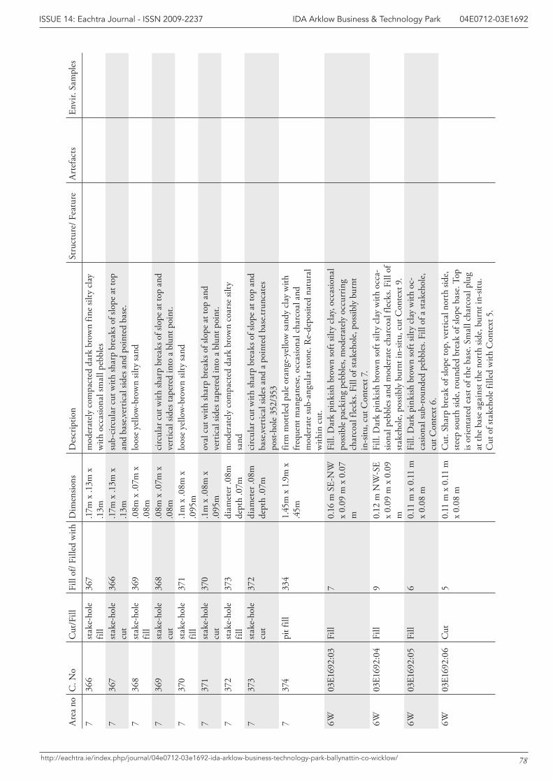
78
IDA Arklow Business & Technology Park 04E0712-03E1692ISSUE 14: Eachtra Journal - ISSN 2009-2237
http://eachtra.ie/index.php/journal/04e0712-03e1692-ida-arklow-business-technology-park-ballynattin-co-wicklow/
Are
a no
C. N
oC
ut/F
illFi
ll of
/ Fill
ed w
ithD
imen
sions
Des
crip
tion
Stru
ctur
e/ F
eatu
reA
rtef
acts
Envi
r. Sa
mpl
es
736
6st
ake-
hole
fil
l 36
7.1
7m x
.13m
x
.13m
mod
erat
ely
com
pact
ed d
ark
brow
n fin
e sil
ty c
lay
with
occ
asio
nal s
mal
l peb
bles
7
367
stak
e-ho
le
cut
366
.17m
x .1
3m x
.1
3msu
b-ci
rcul
ar c
ut w
ith sh
arp
brea
ks o
f slo
pe a
t top
an
d ba
se,ve
rtic
al si
des a
nd p
oint
ed b
ase.
736
8st
ake-
hole
fil
l 36
9.0
8m x
.07m
x
.08m
loos
e ye
llow
-bro
wn
silty
sand
736
9st
ake-
hole
cu
t36
8.0
8m x
.07m
x
.08m
circ
ular
cut
with
shar
p br
eaks
of s
lope
at t
op a
nd
vert
ical
side
s tap
ered
into
a b
lunt
poi
nt.
737
0st
ake-
hole
fil
l 37
1.1
m x
.08m
x
.095
mlo
ose
yello
w-b
row
n sil
ty sa
nd
737
1st
ake-
hole
cu
t37
0.1
m x
.08m
x
.095
mov
al c
ut w
ith sh
arp
brea
ks o
f slo
pe a
t top
and
ve
rtic
al si
des t
aper
ed in
to a
blu
nt p
oint
.7
372
stak
e-ho
le
fill
373
diam
eter
.08m
de
pth
.07m
mod
erat
ely
com
pact
ed d
ark
brow
n co
arse
silty
sa
nd
737
3st
ake-
hole
cu
t37
2di
amet
er .0
8m
dept
h .0
7mci
rcul
ar c
ut w
ith sh
arp
brea
ks o
f slo
pe a
t top
and
ba
se,ve
rtic
al si
des a
nd a
poi
nted
bas
e.tru
ncat
es
post-
hole
352
/353
737
4pi
t fill
334
1.45
m x
1.9
m x
.4
5mfir
m m
ottle
d pa
le o
rang
e-ye
llow
sand
y cl
ay w
ith
freq
uent
man
gane
se, o
ccas
iona
l cha
rcoa
l and
m
oder
ate
sub-
angu
lar s
tone
. Re-
depo
sited
nat
ural
w
ithin
cut
.6W
03E1
692:
03Fi
ll7
0.16
m S
E-N
W
x 0.
09 m
x 0
.07
m
Fill.
Dar
k pi
nkish
bro
wn
soft
silty
cla
y, oc
casio
nal
poss
ible
pac
king
peb
bles
, mod
erat
ely
occu
rrin
g ch
arco
al fl
ecks
. Fill
of s
take
hole
, pos
sibly
bur
nt
in-s
itu, c
ut C
onte
xt 7
.6W
03E1
692:
04Fi
ll9
0.12
m N
W-S
E x
0.09
m x
0.0
9 m
Fill.
Dar
k pi
nkish
bro
wn
soft
silty
cla
y w
ith o
cca-
siona
l peb
bles
and
mod
erat
e ch
arco
al fl
ecks
. Fill
of
stak
ehol
e, p
ossib
ly b
urnt
in-s
itu, c
ut C
onte
xt 9
.6W
03E1
692:
05Fi
ll6
0.11
m x
0.1
1 m
x
0.08
mFi
ll. D
ark
pink
ish b
row
n so
ft sil
ty c
lay
with
oc-
casio
nal s
ub-r
ound
ed p
ebbl
es. F
ill o
f a st
akeh
ole,
cu
t Con
text
6.
6W03
E169
2:06
Cut
50.
11 m
x 0
.11
m
x 0.
08 m
Cut
. Sha
rp b
reak
of s
lope
top,
ver
tical
nor
th si
de,
stee
p so
uth
side,
roun
ded
brea
k of
slop
e ba
se. T
op
is or
ient
ated
eas
t of t
he b
ase.
Sm
all c
harc
oal p
lug
at th
e ba
se a
gain
st th
e no
rth
side,
bur
nt in
-situ
. C
ut o
f sta
keho
le fi
lled
with
Con
text
5.
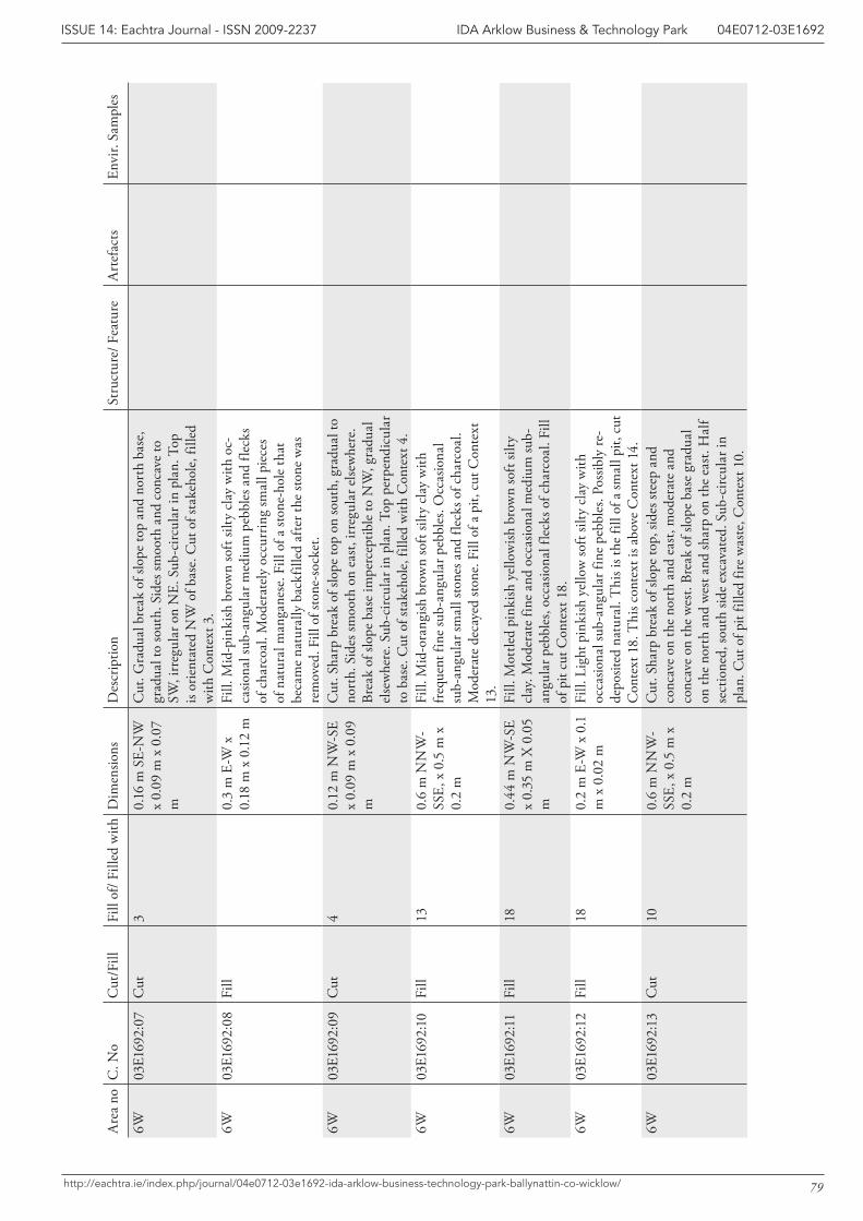
79
IDA Arklow Business & Technology Park 04E0712-03E1692ISSUE 14: Eachtra Journal - ISSN 2009-2237
http://eachtra.ie/index.php/journal/04e0712-03e1692-ida-arklow-business-technology-park-ballynattin-co-wicklow/
Are
a no
C. N
oC
ut/F
illFi
ll of
/ Fill
ed w
ithD
imen
sions
Des
crip
tion
Stru
ctur
e/ F
eatu
reA
rtef
acts
Envi
r. Sa
mpl
es
6W03
E169
2:07
Cut
30.
16 m
SE-
NW
x
0.09
m x
0.0
7 m
Cut
. Gra
dual
bre
ak o
f slo
pe to
p an
d no
rth
base
, gr
adua
l to
sout
h. S
ides
smoo
th a
nd c
onca
ve to
SW
, irr
egul
ar o
n N
E. S
ub-c
ircul
ar in
pla
n. T
op
is or
ient
ated
NW
of b
ase.
Cut
of s
take
hole
, fill
ed
with
Con
text
3.
6W03
E169
2:08
Fill
0.3
m E
-W x
0.
18 m
x 0
.12
mFi
ll. M
id-p
inki
sh b
row
n so
ft sil
ty c
lay
with
oc-
casio
nal s
ub-a
ngul
ar m
ediu
m p
ebbl
es a
nd fl
ecks
of
cha
rcoa
l. M
oder
atel
y oc
curr
ing
smal
l pie
ces
of n
atur
al m
anga
nese
. Fill
of a
ston
e-ho
le th
at
beca
me
natu
rally
bac
kfill
ed a
fter t
he st
one
was
re
mov
ed. F
ill o
f sto
ne-s
ocke
t.6W
03E1
692:
09C
ut4
0.12
m N
W-S
E x
0.09
m x
0.0
9 m
Cut
. Sha
rp b
reak
of s
lope
top
on so
uth,
gra
dual
to
nort
h. S
ides
smoo
th o
n ea
st, i
rreg
ular
else
whe
re.
Brea
k of
slop
e ba
se im
perc
eptib
le to
NW
, gra
dual
el
sew
here
. Sub
-circ
ular
in p
lan.
Top
per
pend
icul
ar
to b
ase.
Cut
of s
take
hole
, fill
ed w
ith C
onte
xt 4
.6W
03E1
692:
10Fi
ll13
0.6
m N
NW
-SS
E, x
0.5
m x
0.
2 m
Fill.
Mid
-ora
ngish
bro
wn
soft
silty
cla
y w
ith
freq
uent
fine
sub-
angu
lar p
ebbl
es. O
ccas
iona
l su
b-an
gula
r sm
all s
tone
s and
flec
ks o
f cha
rcoa
l. M
oder
ate
deca
yed
stone
. Fill
of a
pit,
cut
Con
text
13
.6W
03E1
692:
11Fi
ll18
0.44
m N
W-S
E x
0.35
m X
0.0
5 m
Fill.
Mot
tled
pink
ish y
ello
wish
bro
wn
soft
silty
cl
ay. M
oder
ate
fine
and
occa
siona
l med
ium
sub-
angu
lar p
ebbl
es, o
ccas
iona
l fle
cks o
f cha
rcoa
l. Fi
ll of
pit
cut C
onte
xt 1
8.
6W03
E169
2:12
Fill
180.
2 m
E-W
x 0
.1
m x
0.0
2 m
Fill.
Lig
ht p
inki
sh y
ello
w so
ft sil
ty c
lay
with
oc
casio
nal s
ub-a
ngul
ar fi
ne p
ebbl
es. P
ossib
ly re
-de
posit
ed n
atur
al. T
his i
s the
fill
of a
smal
l pit,
cut
C
onte
xt 1
8. T
his c
onte
xt is
abo
ve C
onte
xt 1
4.6W
03E1
692:
13C
ut10
0.6
m N
NW
-SS
E, x
0.5
m x
0.
2 m
Cut
. Sha
rp b
reak
of s
lope
top,
side
s ste
ep a
nd
conc
ave
on th
e no
rth
and
east
, mod
erat
e an
d co
ncav
e on
the
wes
t. Br
eak
of sl
ope
base
gra
dual
on
the
nort
h an
d w
est a
nd sh
arp
on th
e ea
st. H
alf
sect
ione
d, so
uth
side
exca
vate
d. S
ub-c
ircul
ar in
pl
an. C
ut o
f pit
fille
d fir
e w
aste
, Con
text
10.
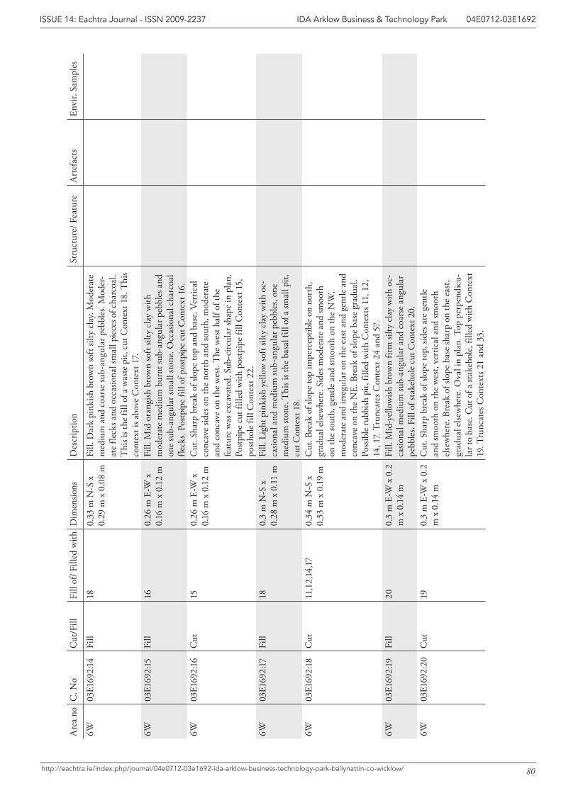
80
IDA Arklow Business & Technology Park 04E0712-03E1692ISSUE 14: Eachtra Journal - ISSN 2009-2237
http://eachtra.ie/index.php/journal/04e0712-03e1692-ida-arklow-business-technology-park-ballynattin-co-wicklow/
Are
a no
C. N
oC
ut/F
illFi
ll of
/ Fill
ed w
ithD
imen
sions
Des
crip
tion
Stru
ctur
e/ F
eatu
reA
rtef
acts
Envi
r. Sa
mpl
es
6W03
E169
2:14
Fill
180.
33 m
N-S
x
0.29
m x
0.0
8 m
Fill.
Dar
k pi
nkish
bro
wn
soft
silty
cla
y. M
oder
ate
med
ium
and
coa
rse
sub-
angu
lar p
ebbl
es. M
oder
-at
e fle
cks a
nd o
ccas
iona
l sm
all p
iece
s of c
harc
oal.
Thi
s is t
he fi
ll of
a w
aste
pit,
cut
Con
text
18.
Thi
s co
ntex
t is a
bove
Con
text
17.
6W
03E1
692:
15Fi
ll16
0.26
m E
-W x
0.
16 m
x 0
.12
mFi
ll. M
id o
rang
ish b
row
n so
ft sil
ty c
lay
with
m
oder
ate
med
ium
bur
nt su
b-an
gula
r peb
bles
and
on
e su
b-an
gula
r sm
all s
tone
. Occ
asio
nal c
harc
oal
fleck
s. Po
stpi
pe fi
ll of
pos
tpip
e cu
t Con
text
16.
6W
03E1
692:
16C
ut15
0.26
m E
-W x
0.
16 m
x 0
.12
mC
ut. S
harp
bre
ak o
f slo
pe to
p an
d ba
se. V
ertic
al
conc
ave
sides
on
the
nort
h an
d so
uth,
mod
erat
e an
d co
ncav
e on
the
wes
t. T
he w
est h
alf o
f the
fe
atur
e w
as e
xcav
ated
. Sub
-circ
ular
shap
e in
pla
n.
Post
pipe
cut
fille
d w
ith p
ostp
ipe
fill C
onte
xt 1
5,
post
hole
fill
Con
text
22.
6W03
E169
2:17
Fill
180.
3 m
N-S
x
0.28
m x
0.1
1 m
Fill.
Lig
ht p
inki
sh y
ello
w so
ft sil
ty c
lay
with
oc-
casio
nal a
nd m
ediu
m su
b-an
gula
r peb
bles
, one
m
ediu
m st
one.
Thi
s is t
he b
asal
fill
of a
smal
l pit,
cu
t Con
text
18.
6W03
E169
2:18
Cut
11,1
2,14
,17
0.34
m N
-S x
0.
33 m
x 0
.19
mC
ut. B
reak
of s
lope
top
impe
rcep
tible
on
nort
h,
grad
ual e
lsew
here
. Sid
es m
oder
ate
and
smoo
th
on th
e so
uth,
gen
tle a
nd sm
ooth
on
the
NW
, m
oder
ate
and
irreg
ular
on
the
east
and
gen
tle a
nd
conc
ave
on th
e N
E. B
reak
of s
lope
bas
e gr
adua
l.
Poss
ible
rubb
ish p
it, fi
lled
with
Con
text
s 11,
12,
14
, 17.
Tru
ncat
es C
onte
xt 2
4 an
d 57
.6W
03E1
692:
19Fi
ll20
0.3
m E
-W x
0.2
m
x 0
.14
mFi
ll. M
id-y
ello
wish
bro
wn
firm
silty
cla
y w
ith o
c-ca
siona
l med
ium
sub-
angu
lar a
nd c
oars
e an
gula
r pe
bble
s. Fi
ll of
stak
ehol
e cu
t Con
text
20.
6W03
E169
2:20
Cut
190.
3 m
E-W
x 0
.2
m x
0.1
4 m
Cut
. Sha
rp b
reak
of s
lope
top,
side
s are
gen
tle
and
smoo
th o
n th
e w
est,
vert
ical
and
smoo
th
else
whe
re. B
reak
of s
lope
bas
e sh
arp
on th
e ea
st,
grad
ual e
lsew
here
. Ova
l in
plan
. Top
per
pend
icu-
lar t
o ba
se. C
ut o
f a st
akeh
ole,
fille
d w
ith C
onte
xt
19. T
runc
ates
Con
text
s 21
and
33.
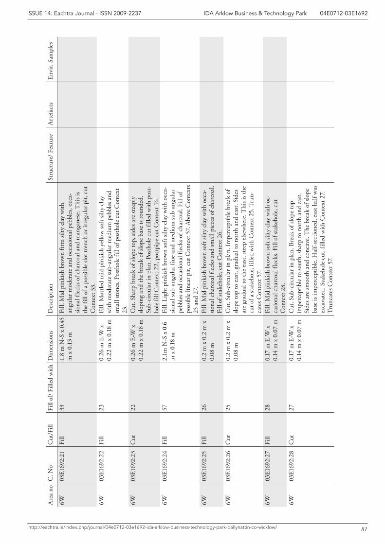
81
IDA Arklow Business & Technology Park 04E0712-03E1692ISSUE 14: Eachtra Journal - ISSN 2009-2237
http://eachtra.ie/index.php/journal/04e0712-03e1692-ida-arklow-business-technology-park-ballynattin-co-wicklow/
Are
a no
C. N
oC
ut/F
illFi
ll of
/ Fill
ed w
ithD
imen
sions
Des
crip
tion
Stru
ctur
e/ F
eatu
reA
rtef
acts
Envi
r. Sa
mpl
es
6W03
E169
2:21
Fill
331.
8 m
N-S
x 0
.45
m x
0.1
3 m
Fill.
Mid
pin
kish
bro
wn
firm
silty
cla
y w
ith
angu
lar m
oder
ate
and
occa
siona
l peb
bles
, occ
a-sio
nal f
leck
s of c
harc
oal a
nd m
anga
nese
. Thi
s is
the
fill o
f a p
ossib
le sl
ot tr
ench
or i
rreg
ular
pit,
cut
C
onte
xt 3
3.6W
03E1
692:
22Fi
ll23
0.26
m E
-W x
0.
22 m
x 0
.18
mFi
ll. M
ottle
d m
id-p
inki
sh y
ello
w so
ft sil
ty c
lay
with
mod
erat
e su
b-an
gula
r med
ium
peb
bles
and
sm
all s
tone
s. Po
stho
le fi
ll of
pos
thol
e cu
t Con
text
23
.6W
03E1
692:
23C
ut22
0.26
m E
-W x
0.
22 m
x 0
.18
mC
ut. S
harp
bre
ak o
f slo
pe to
p, si
des a
re st
eepl
y slo
ping
and
the
brea
k of
slop
e ba
se is
roun
ded.
Su
b-ci
rcul
ar in
pla
n. P
osth
ole
cut f
illed
with
pos
t-ho
le fi
ll C
onte
xt 2
2, p
ostp
ipe
cut C
onte
xt 1
6.6W
03E1
692:
24Fi
ll57
2.1m
N-S
x 0
.6
m x
0.1
8 m
Fill.
Lig
ht p
inki
sh b
row
n so
ft sil
ty c
lay
with
occ
a-sio
nal s
ub-a
ngul
ar fi
ne a
nd m
ediu
m su
b-an
gula
r pe
bble
s and
occ
asio
nal f
leck
s of c
harc
oal.
Fill
of
poss
ible
line
ar p
it, c
ut C
onte
xt 5
7. A
bove
Con
text
s 25
and
27.
6W03
E169
2:25
Fill
260.
2 m
x 0
.2 m
x
0.08
mFi
ll. M
id p
inki
sh b
row
n so
ft sil
ty c
lay
with
occ
a-sio
nal c
harc
oal f
leck
s and
smal
l pie
ces o
f cha
rcoa
l. Fi
ll of
stak
ehol
e, c
ut C
onte
xt 2
6.6W
03E1
692:
26C
ut25
0.2
m x
0.2
m x
0.
08 m
Cut
. Sub
-circ
ular
in p
lan.
Impe
rcep
tible
bre
ak o
f slo
pe to
p to
eas
t, gr
adua
l to
nort
h an
d ea
st. S
ides
ar
e gr
adua
l to
the
east
, ste
ep e
lsew
here
. Thi
s is t
he
cut o
f a st
akeh
ole,
fille
d w
ith C
onte
xt 2
5. T
run-
cate
s Con
text
57.
6W03
E169
2:27
Fill
280.
17 m
E-W
x
0.14
m x
0.0
7 m
Fill.
Mid
pin
kish
bro
wn
soft
silty
cla
y w
ith o
c-ca
siona
l cha
rcoa
l fle
cks.
Fill
of st
akeh
ole,
cut
C
onte
xt 2
8.6W
03E1
692:
28C
ut27
0.17
m E
-W x
0.
14 m
x 0
.07
mC
ut. S
ub-c
ircul
ar in
pla
n. B
reak
of s
lope
top
impe
rcep
tible
to so
uth,
shar
p to
nor
th a
nd e
ast.
Side
s are
smoo
th a
nd c
onca
ve. T
he b
reak
of s
lope
ba
se is
impe
rcep
tible
. Hal
f-sec
tione
d, e
ast h
alf w
as
exca
vate
d. S
take
hole
cut
, fill
ed w
ith C
onte
xt 2
7.
Trun
cate
s Con
text
57.
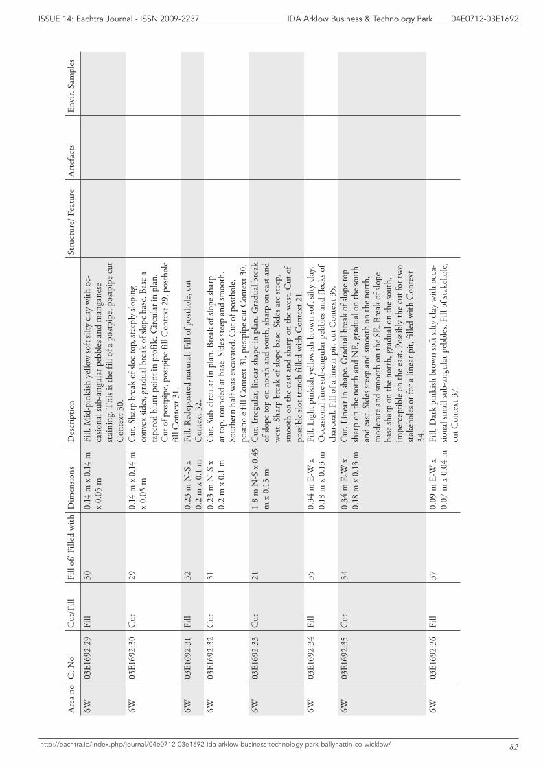
82
IDA Arklow Business & Technology Park 04E0712-03E1692ISSUE 14: Eachtra Journal - ISSN 2009-2237
http://eachtra.ie/index.php/journal/04e0712-03e1692-ida-arklow-business-technology-park-ballynattin-co-wicklow/
Are
a no
C. N
oC
ut/F
illFi
ll of
/ Fill
ed w
ithD
imen
sions
Des
crip
tion
Stru
ctur
e/ F
eatu
reA
rtef
acts
Envi
r. Sa
mpl
es
6W03
E169
2:29
Fill
300.
14 m
x 0
.14
m
x 0.
05 m
Fill.
Mid
-pin
kish
yel
low
soft
silty
cla
y w
ith o
c-ca
siona
l sub
-ang
ular
peb
bles
and
man
gane
se
stai
ning
. Thi
s is t
he fi
ll of
a p
ostp
ipe,
pos
tpip
e cu
t C
onte
xt 3
0.
6W03
E169
2:30
Cut
290.
14 m
x 0
.14
m
x 0.
05 m
Cut
. Sha
rp b
reak
of s
loe
top,
stee
ply
slopi
ng
conv
ex si
des,
grad
ual b
reak
of s
lope
bas
e. B
ase
a ta
pere
d bl
unt p
oint
in p
rofil
e. C
ircul
ar in
pla
n.
Cut
of p
ostp
ipe,
pos
tpip
e fil
l Con
text
29,
pos
thol
e fil
l Con
text
31.
6W03
E169
2:31
Fill
320.
23 m
N-S
x
0.2
m x
0.1
mFi
ll. R
edep
osite
d na
tura
l. Fi
ll of
pos
thol
e, c
ut
Con
text
32.
6W03
E169
2:32
Cut
310.
23 m
N-S
x
0.2
m x
0.1
mC
ut. S
ub-c
ircul
ar in
pla
n. B
reak
of s
lope
shar
p at
top,
roun
ded
at b
ase.
Sid
es st
eep
and
smoo
th.
Sout
hern
hal
f was
exc
avat
ed. C
ut o
f pos
thol
e,
post
hole
fill
Con
text
31,
pos
tpip
e cu
t Con
text
30.
6W03
E169
2:33
Cut
211.
8 m
N-S
x 0
.45
m x
0.1
3 m
Cut
. Irr
egul
ar, l
inea
r sha
pe in
pla
n. G
radu
al b
reak
of
slop
e to
p on
nor
th a
nd so
uth,
shar
p on
eas
t and
w
est.
Shar
p br
eak
of sl
ope
base
. Sid
es a
re st
eep,
sm
ooth
on
the
east
and
shar
p on
the
wes
t. C
ut o
f po
ssib
le sl
ot tr
ench
fille
d w
ith C
onte
xt 2
1.
6W03
E169
2:34
Fill
350.
34 m
E-W
x
0.18
m x
0.1
3 m
Fill.
Lig
ht p
inki
sh y
ello
wish
bro
wn
soft
silty
cla
y. O
ccas
iona
l fin
e su
b-an
gula
r peb
bles
and
flec
ks o
f ch
arco
al. F
ill o
f a li
near
pit,
cut
Con
text
35.
6W03
E169
2:35
Cut
340.
34 m
E-W
x
0.18
m x
0.1
3 m
Cut
. Lin
ear i
n sh
ape.
Gra
dual
bre
ak o
f slo
pe to
p sh
arp
on th
e no
rth
and
NE,
gra
dual
on
the
sout
h an
d ea
st. S
ides
stee
p an
d sm
ooth
on
the
nort
h,
mod
erat
e an
d sm
ooth
on
the
SE. B
reak
of s
lope
ba
se sh
arp
on th
e no
rth,
gra
dual
on
the
sout
h,
impe
rcep
tible
on
the
east
. Pos
sibly
the
cut f
or tw
o st
akeh
oles
or f
or a
line
ar p
it, fi
lled
with
Con
text
34
.6W
03E1
692:
36Fi
ll37
0.09
m E
-W x
0.
07 m
x 0
.04
mFi
ll. D
ark
pink
ish b
row
n so
ft sil
ty c
lay
with
occ
a-sio
nal s
mal
l sub
-ang
ular
peb
bles
. Fill
of s
take
hole
, cu
t Con
text
37.
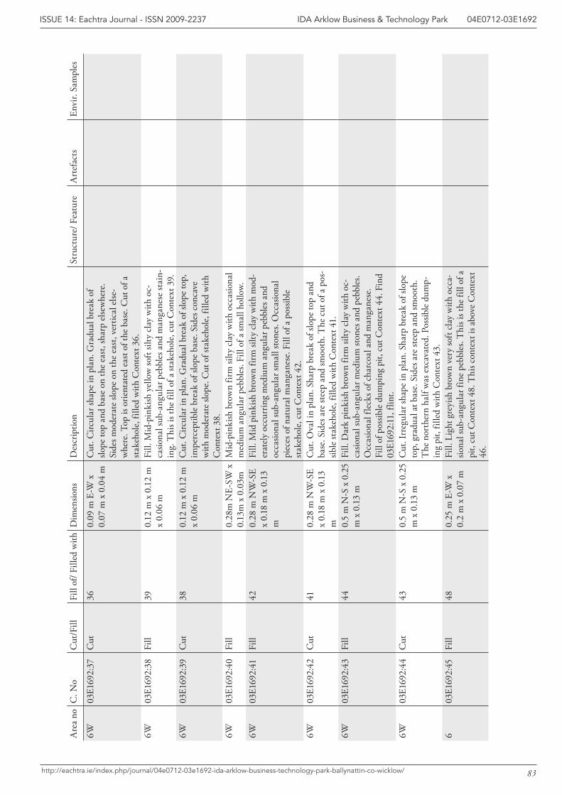
83
IDA Arklow Business & Technology Park 04E0712-03E1692ISSUE 14: Eachtra Journal - ISSN 2009-2237
http://eachtra.ie/index.php/journal/04e0712-03e1692-ida-arklow-business-technology-park-ballynattin-co-wicklow/
Are
a no
C. N
oC
ut/F
illFi
ll of
/ Fill
ed w
ithD
imen
sions
Des
crip
tion
Stru
ctur
e/ F
eatu
reA
rtef
acts
Envi
r. Sa
mpl
es
6W03
E169
2:37
Cut
360.
09 m
E-W
x
0.07
m x
0.0
4 m
Cut
. Circ
ular
shap
e in
pla
n. G
radu
al b
reak
of
slope
top
and
base
on
the
east
, sha
rp e
lsew
here
. Si
des m
oder
ate
slope
on
the
east
, ver
tical
else
-w
here
. Top
is o
rient
ated
eas
t of t
he b
ase.
Cut
of a
st
akeh
ole,
fille
d w
ith C
onte
xt 3
6.
6W03
E169
2:38
Fill
390.
12 m
x 0
.12
m
x 0.
06 m
Fill.
Mid
-pin
kish
yel
low
soft
silty
cla
y w
ith o
c-ca
siona
l sub
-ang
ular
peb
bles
and
man
gane
se st
ain-
ing.
Thi
s is t
he fi
ll of
a st
akeh
ole,
cut
Con
text
39.
6W
03E1
692:
39C
ut38
0.12
m x
0.1
2 m
x
0.06
mC
ut. C
ircul
ar in
pla
n. G
radu
al b
reak
of s
lope
top,
im
perc
eptib
le b
reak
of s
lope
bas
e. S
ides
con
cave
w
ith m
oder
ate
slope
. Cut
of s
take
hole
, fill
ed w
ith
Con
text
38.
6W03
E169
2:40
Fill
0.28
m N
E-SW
x
0.13
m x
0.0
3mM
id-p
inki
sh b
row
n fir
m si
lty c
lay
with
occ
asio
nal
med
ium
ang
ular
peb
bles
. Fill
of a
smal
l hol
low.
6W03
E169
2:41
Fill
420.
28 m
NW
-SE
x 0.
18 m
x 0
.13
m
Fill.
Mid
pin
kish
bro
wn
firm
silty
cla
y w
ith m
od-
erat
ely
occu
rrin
g m
ediu
m a
ngul
ar p
ebbl
es a
nd
occa
siona
l sub
-ang
ular
smal
l sto
nes.
Occ
asio
nal
piec
es o
f nat
ural
man
gane
se. F
ill o
f a p
ossib
le
stak
ehol
e, c
ut C
onte
xt 4
2.6W
03E1
692:
42C
ut41
0.28
m N
W-S
E x
0.18
m x
0.1
3 m
Cut
. Ova
l in
plan
. Sha
rp b
reak
of s
lope
top
and
base
. Sid
es a
re st
eep
and
smoo
th. T
he c
ut o
f a p
os-
sible
stak
ehol
e, fi
lled
with
Con
text
41.
6W03
E169
2:43
Fill
440.
5 m
N-S
x 0
.25
m x
0.1
3 m
Fill.
Dar
k pi
nkish
bro
wn
firm
silty
cla
y w
ith o
c-ca
siona
l sub
-ang
ular
med
ium
ston
es a
nd p
ebbl
es.
Occ
asio
nal f
leck
s of c
harc
oal a
nd m
anga
nese
. Fi
ll of
pos
sible
dum
ping
pit,
cut
Con
text
44.
Fin
d 03
E169
2:11
, flin
t.6W
03E1
692:
44C
ut43
0.5
m N
-S x
0.2
5 m
x 0
.13
mC
ut. I
rreg
ular
shap
e in
pla
n. S
harp
bre
ak o
f slo
pe
top,
gra
dual
at b
ase.
Sid
es a
re st
eep
and
smoo
th.
The
nor
ther
n ha
lf w
as e
xcav
ated
. Pos
sible
dum
p-in
g pi
t, fil
led
with
Con
text
43.
603
E169
2:45
Fill
480.
25 m
E-W
x
0.2
m x
0.0
7 m
Fill.
Lig
ht g
reyi
sh b
row
n ve
ry so
ft cl
ay w
ith o
cca-
siona
l sub
-ang
ular
fine
peb
bles
. Thi
s is t
he fi
ll of
a
pit,
cut C
onte
xt 4
8. T
his c
onte
xt is
abo
ve C
onte
xt
46.
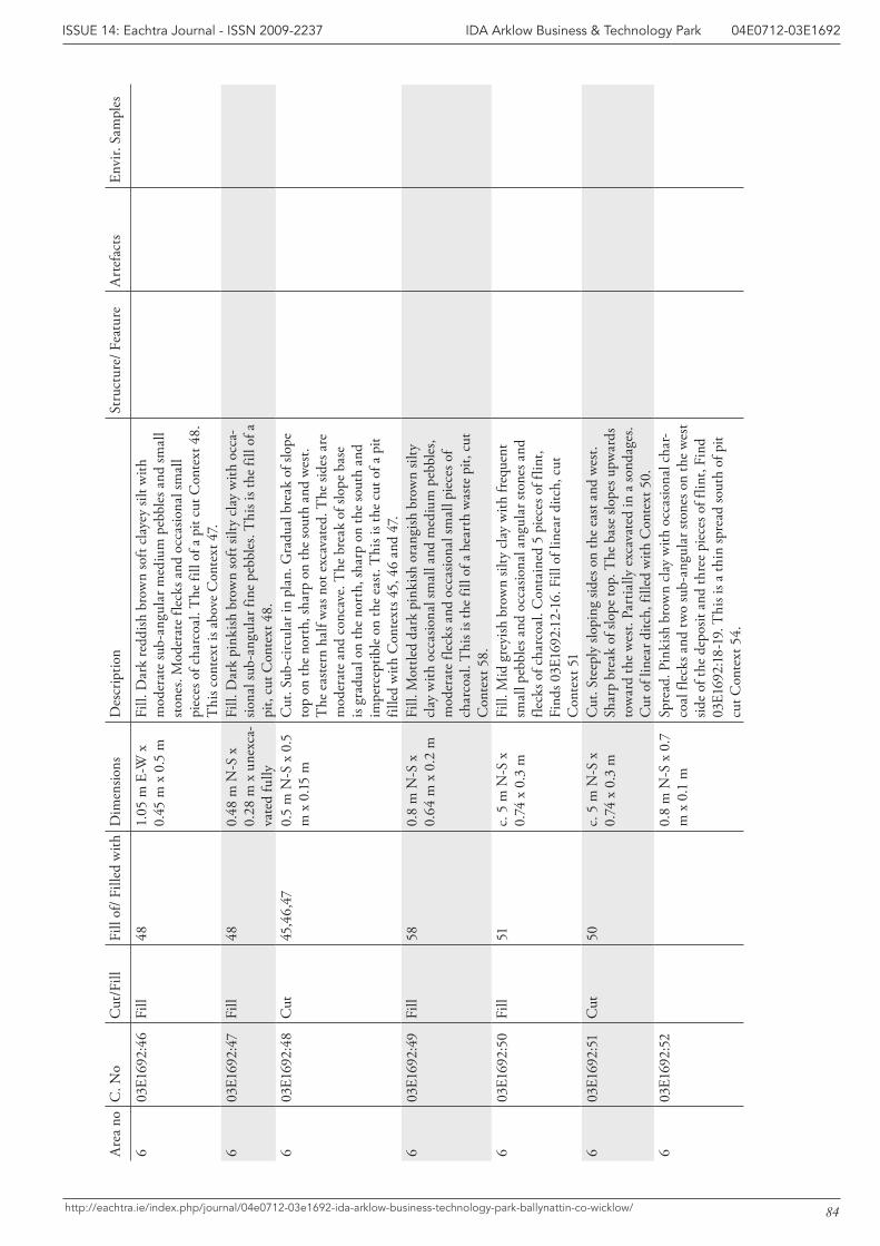
84
IDA Arklow Business & Technology Park 04E0712-03E1692ISSUE 14: Eachtra Journal - ISSN 2009-2237
http://eachtra.ie/index.php/journal/04e0712-03e1692-ida-arklow-business-technology-park-ballynattin-co-wicklow/
Are
a no
C. N
oC
ut/F
illFi
ll of
/ Fill
ed w
ithD
imen
sions
Des
crip
tion
Stru
ctur
e/ F
eatu
reA
rtef
acts
Envi
r. Sa
mpl
es
603
E169
2:46
Fill
481.
05 m
E-W
x
0.45
m x
0.5
mFi
ll. D
ark
redd
ish b
row
n so
ft cl
ayey
silt
with
m
oder
ate
sub-
angu
lar m
ediu
m p
ebbl
es a
nd sm
all
stone
s. M
oder
ate
fleck
s and
occ
asio
nal s
mal
l pi
eces
of c
harc
oal.
The
fill
of a
pit
cut C
onte
xt 4
8.
Thi
s con
text
is a
bove
Con
text
47.
603
E169
2:47
Fill
480.
48 m
N-S
x
0.28
m x
une
xca-
vate
d fu
lly
Fill.
Dar
k pi
nkish
bro
wn
soft
silty
cla
y w
ith o
cca-
siona
l sub
-ang
ular
fine
peb
bles
. Thi
s is t
he fi
ll of
a
pit,
cut C
onte
xt 4
8.6
03E1
692:
48C
ut45
,46,
470.
5 m
N-S
x 0
.5
m x
0.15
mC
ut. S
ub-c
ircul
ar in
pla
n. G
radu
al b
reak
of s
lope
to
p on
the
nort
h, sh
arp
on th
e so
uth
and
wes
t. T
he e
aste
rn h
alf w
as n
ot e
xcav
ated
. The
side
s are
m
oder
ate
and
conc
ave.
The
bre
ak o
f slo
pe b
ase
is gr
adua
l on
the
nort
h, sh
arp
on th
e so
uth
and
impe
rcep
tible
on
the
east
. Thi
s is t
he c
ut o
f a p
it fil
led
with
Con
text
s 45,
46
and
47.
603
E169
2:49
Fill
580.
8 m
N-S
x
0.64
m x
0.2
mFi
ll. M
ottle
d da
rk p
inki
sh o
rang
ish b
row
n sil
ty
clay
with
occ
asio
nal s
mal
l and
med
ium
peb
bles
, m
oder
ate
fleck
s and
occ
asio
nal s
mal
l pie
ces o
f ch
arco
al. T
his i
s the
fill
of a
hea
rth
was
te p
it, c
ut
Con
text
58.
603
E169
2:50
Fill
51c.
5 m
N-S
x
0.74
x 0
.3 m
Fill.
Mid
gre
yish
bro
wn
silty
cla
y w
ith fr
eque
nt
smal
l peb
bles
and
occ
asio
nal a
ngul
ar st
ones
and
fle
cks o
f cha
rcoa
l. C
onta
ined
5 p
iece
s of f
lint,
Find
s 03E
1692
:12-
16. F
ill o
f lin
ear d
itch,
cut
C
onte
xt 5
16
03E1
692:
51C
ut50
c. 5
m N
-S x
0.
74 x
0.3
mC
ut. S
teep
ly sl
opin
g sid
es o
n th
e ea
st a
nd w
est.
Shar
p br
eak
of sl
ope
top.
The
bas
e slo
pes u
pwar
ds
tow
ard
the
wes
t. Pa
rtia
lly e
xcav
ated
in a
sond
ages
. C
ut o
f lin
ear d
itch,
fille
d w
ith C
onte
xt 5
0.6
03E1
692:
52
0.8
m N
-S x
0.7
m
x 0
.1 m
Spre
ad. P
inki
sh b
row
n cl
ay w
ith o
ccas
iona
l cha
r-co
al fl
ecks
and
two
sub-
angu
lar s
tone
s on
the
wes
t sid
e of
the
depo
sit a
nd th
ree
piec
es o
f flin
t, Fi
nd
03E1
692:
18-1
9. T
his i
s a th
in sp
read
sout
h of
pit
cut C
onte
xt 5
4.
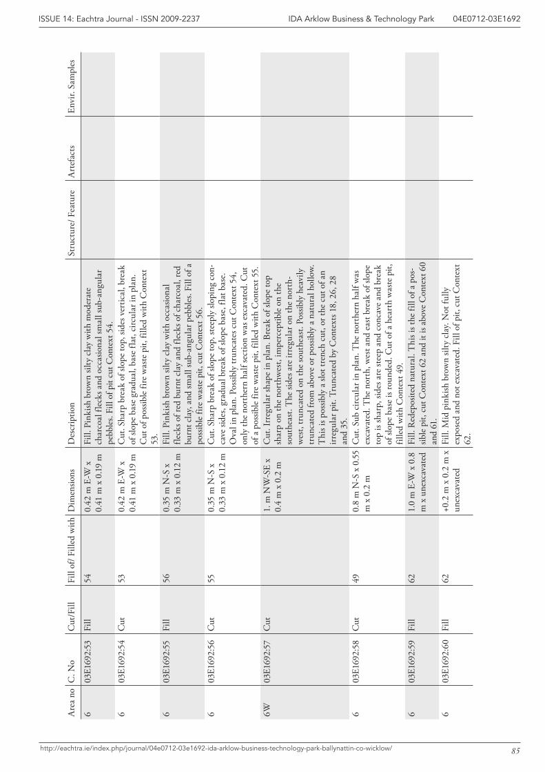
85
IDA Arklow Business & Technology Park 04E0712-03E1692ISSUE 14: Eachtra Journal - ISSN 2009-2237
http://eachtra.ie/index.php/journal/04e0712-03e1692-ida-arklow-business-technology-park-ballynattin-co-wicklow/
Are
a no
C. N
oC
ut/F
illFi
ll of
/ Fill
ed w
ithD
imen
sions
Des
crip
tion
Stru
ctur
e/ F
eatu
reA
rtef
acts
Envi
r. Sa
mpl
es
603
E169
2:53
Fill
540.
42 m
E-W
x
0.41
m x
0.1
9 m
Fill.
Pin
kish
bro
wn
silty
cla
y w
ith m
oder
ate
char
coal
flec
ks a
nd o
ccas
iona
l sm
all s
ub-a
ngul
ar
pebb
les.
Fill
of p
it cu
t Con
text
54.
603
E169
2:54
Cut
530.
42 m
E-W
x
0.41
m x
0.1
9 m
Cut
. Sha
rp b
reak
of s
lope
top,
side
s ver
tical
, bre
ak
of sl
ope
base
gra
dual
, bas
e fla
t, ci
rcul
ar in
pla
n.
Cut
of p
ossib
le fi
re w
aste
pit,
fille
d w
ith C
onte
xt
53.
603
E169
2:55
Fill
560.
35 m
N-S
x
0.33
m x
0.1
2 m
Fill.
Pin
kish
bro
wn
silty
cla
y w
ith o
ccas
iona
l fle
cks o
f red
bur
nt c
lay
and
fleck
s of c
harc
oal,
red
burn
t cla
y, an
d sm
all s
ub-a
ngul
ar p
ebbl
es. F
ill o
f a
poss
ible
fire
was
te p
it, c
ut C
onte
xt 5
6.
603
E169
2:56
Cut
550.
35 m
N-S
x
0.33
m x
0.1
2 m
Cut
. Sha
rp b
reak
of s
lope
top,
stee
ply
slopi
ng c
on-
cave
side
s, gr
adua
l bre
ak o
f slo
pe b
ase,
flat
bas
e.
Ova
l in
plan
. Pos
sibly
trun
cate
s cut
Con
text
54,
on
ly th
e no
rthe
rn h
alf s
ectio
n w
as e
xcav
ated
. Cut
of
a p
ossib
le fi
re w
aste
pit,
fille
d w
ith C
onte
xt 5
5.6W
03E1
692:
57C
ut1.
m N
W-S
E x
0.4
m x
0.2
mC
ut. I
rreg
ular
shap
e in
pla
n. B
reak
of s
lope
top
shar
p on
the
nort
hwes
t, im
perc
eptib
le o
n th
e so
uthe
ast.
The
side
s are
irre
gula
r on
the
nort
h-w
est,
trun
cate
d on
the
sout
heas
t. Po
ssib
ly h
eavi
ly
trun
cate
d fr
om a
bove
or p
ossib
ly a
nat
ural
hol
low.
T
his i
s pos
sibly
a sl
ot tr
ench
cut
, or t
he c
ut o
f an
irreg
ular
pit.
Tru
ncat
ed b
y C
onte
xts 1
8, 2
6, 2
8 an
d 35
.6
03E1
692:
58C
ut49
0.8
m N
-S x
0.5
5 m
x 0
.2 m
Cut
. Sub
circ
ular
in p
lan.
The
nor
ther
n ha
lf w
as
exca
vate
d. T
he n
orth
, wes
t and
eas
t bre
ak o
f slo
pe
top
is sh
arp,
side
s are
stee
p an
d co
ncav
e an
d br
eak
of sl
ope
base
is ro
unde
d. C
ut o
f a h
eart
h w
aste
pit,
fil
led
with
Con
text
49.
603
E169
2:59
Fill
621.
0 m
E-W
x 0
.8
m x
une
xcav
ated
Fill.
Red
epos
ited
natu
ral.
Thi
s is t
he fi
ll of
a p
os-
sible
pit,
cut
Con
text
62
and
it is
abov
e C
onte
xt 6
0 an
d 61
.6
03E1
692:
60Fi
ll62
+0.2
m x
0.2
m x
un
exca
vate
dFi
ll. M
id p
inki
sh b
row
n sil
ty c
lay.
Not
fully
ex
pose
d an
d no
t exc
avat
ed. F
ill o
f pit,
cut
Con
text
62
.
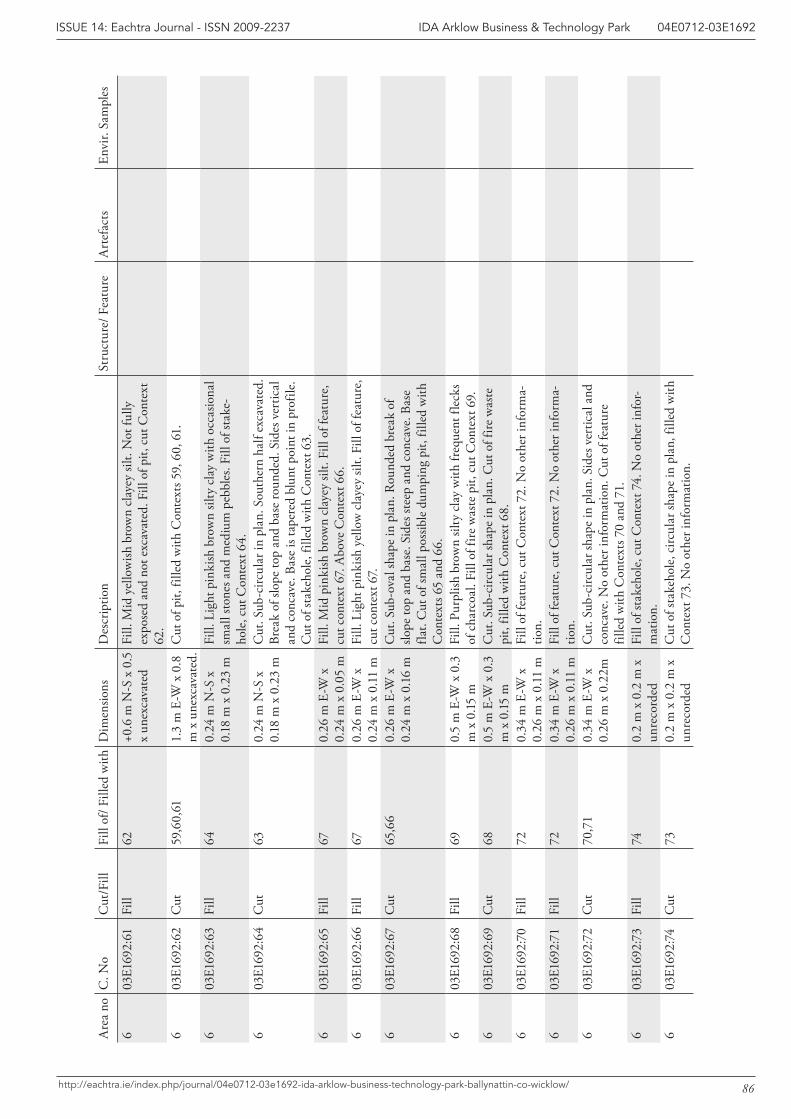
86
IDA Arklow Business & Technology Park 04E0712-03E1692ISSUE 14: Eachtra Journal - ISSN 2009-2237
http://eachtra.ie/index.php/journal/04e0712-03e1692-ida-arklow-business-technology-park-ballynattin-co-wicklow/
Are
a no
C. N
oC
ut/F
illFi
ll of
/ Fill
ed w
ithD
imen
sions
Des
crip
tion
Stru
ctur
e/ F
eatu
reA
rtef
acts
Envi
r. Sa
mpl
es
603
E169
2:61
Fill
62+0
.6 m
N-S
x 0
.5
x un
exca
vate
dFi
ll. M
id y
ello
wish
bro
wn
clay
ey si
lt. N
ot fu
lly
expo
sed
and
not e
xcav
ated
. Fill
of p
it, c
ut C
onte
xt
62.
603
E169
2:62
Cut
59,6
0,61
1.3
m E
-W x
0.8
m
x u
nexc
avat
ed.
Cut
of p
it, fi
lled
with
Con
text
s 59,
60,
61.
603
E169
2:63
Fill
640.
24 m
N-S
x
0.18
m x
0.2
3 m
Fill.
Lig
ht p
inki
sh b
row
n sil
ty c
lay
with
occ
asio
nal
smal
l sto
nes a
nd m
ediu
m p
ebbl
es. F
ill o
f sta
ke-
hole
, cut
Con
text
64.
603
E169
2:64
Cut
630.
24 m
N-S
x
0.18
m x
0.2
3 m
Cut
. Sub
-circ
ular
in p
lan.
Sou
ther
n ha
lf ex
cava
ted.
Br
eak
of sl
ope
top
and
base
roun
ded.
Sid
es v
ertic
al
and
conc
ave.
Bas
e is
tape
red
blun
t poi
nt in
pro
file.
C
ut o
f sta
keho
le, f
illed
with
Con
text
63.
603
E169
2:65
Fill
670.
26 m
E-W
x
0.24
m x
0.0
5 m
Fill.
Mid
pin
kish
bro
wn
clay
ey si
lt. F
ill o
f fea
ture
, cu
t con
text
67.
Abo
ve C
onte
xt 6
6.6
03E1
692:
66Fi
ll67
0.26
m E
-W x
0.
24 m
x 0
.11
mFi
ll. L
ight
pin
kish
yel
low
cla
yey
silt.
Fill
of fe
atur
e,
cut c
onte
xt 6
7.6
03E1
692:
67C
ut65
,66
0.26
m E
-W x
0.
24 m
x 0
.16
mC
ut. S
ub-o
val s
hape
in p
lan.
Rou
nded
bre
ak o
f slo
pe to
p an
d ba
se. S
ides
stee
p an
d co
ncav
e. B
ase
flat.
Cut
of s
mal
l pos
sible
dum
ping
pit,
fille
d w
ith
Con
text
s 65
and
66.
603
E169
2:68
Fill
690.
5 m
E-W
x 0
.3
m x
0.15
mFi
ll. P
urpl
ish b
row
n sil
ty c
lay
with
freq
uent
flec
ks
of c
harc
oal.
Fill
of fi
re w
aste
pit,
cut
Con
text
69.
603
E169
2:69
Cut
680.
5 m
E-W
x 0
.3
m x
0.15
mC
ut. S
ub-c
ircul
ar sh
ape
in p
lan.
Cut
of f
ire w
aste
pi
t, fil
led
with
Con
text
68.
6
03E1
692:
70Fi
ll72
0.34
m E
-W x
0.
26 m
x 0
.11
mFi
ll of
feat
ure,
cut
Con
text
72.
No
othe
r inf
orm
a-tio
n.6
03E1
692:
71Fi
ll72
0.34
m E
-W x
0.
26 m
x 0
.11
mFi
ll of
feat
ure,
cut
Con
text
72.
No
othe
r inf
orm
a-tio
n.6
03E1
692:
72C
ut70
,71
0.34
m E
-W x
0.
26 m
x 0
.22m
Cut
. Sub
-circ
ular
shap
e in
pla
n. S
ides
ver
tical
and
co
ncav
e. N
o ot
her i
nfor
mat
ion.
Cut
of f
eatu
re
fille
d w
ith C
onte
xts 7
0 an
d 71
.6
03E1
692:
73Fi
ll74
0.2
m x
0.2
m x
un
reco
rded
Fill
of st
akeh
ole,
cut
Con
text
74.
No
othe
r inf
or-
mat
ion.
603
E169
2:74
Cut
730.
2 m
x 0
.2 m
x
unre
cord
edC
ut o
f sta
keho
le, c
ircul
ar sh
ape
in p
lan,
fille
d w
ith
Con
text
73.
No
othe
r inf
orm
atio
n.
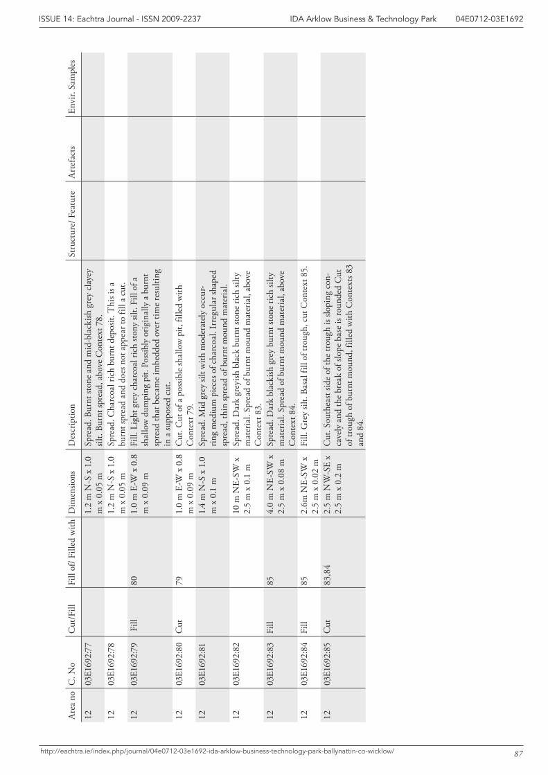
87
IDA Arklow Business & Technology Park 04E0712-03E1692ISSUE 14: Eachtra Journal - ISSN 2009-2237
http://eachtra.ie/index.php/journal/04e0712-03e1692-ida-arklow-business-technology-park-ballynattin-co-wicklow/
Are
a no
C. N
oC
ut/F
illFi
ll of
/ Fill
ed w
ithD
imen
sions
Des
crip
tion
Stru
ctur
e/ F
eatu
reA
rtef
acts
Envi
r. Sa
mpl
es
1203
E169
2:77
1.2
m N
-S x
1.0
m
x 0
.05
mSp
read
. Bur
nt st
one
and
mid
-bla
ckish
gre
y cl
ayey
sil
t. Bu
rnt s
prea
d, a
bove
Con
text
78.
1203
E169
2:78
1.2
m N
-S x
1.0
m
x 0
.05
mSp
read
. Cha
rcoa
l ric
h bu
rnt d
epos
it. T
his i
s a
burn
t spr
ead
and
does
not
app
ear t
o fil
l a c
ut.
1203
E169
2:79
Fill
801.
0 m
E-W
x 0
.8
m x
0.0
9 m
Fill.
Lig
ht g
rey
char
coal
rich
ston
y sil
t. Fi
ll of
a
shal
low
dum
ping
pit.
Pos
sibly
orig
inal
ly a
bur
nt
spre
ad th
at b
ecam
e im
bedd
ed o
ver t
ime
resu
lting
in
a su
ppos
ed c
ut.
1203
E169
2:80
Cut
791.
0 m
E-W
x 0
.8
m x
0.0
9 m
Cut
. Cut
of a
pos
sible
shal
low
pit,
fille
d w
ith
Con
text
79.
1203
E169
2:81
1.4
m N
-S x
1.0
m
x 0
.1 m
Spre
ad. M
id g
rey
silt w
ith m
oder
atel
y oc
cur-
ring
med
ium
pie
ces o
f cha
rcoa
l. Ir
regu
lar s
hape
d sp
read
, thi
n sp
read
of b
urnt
mou
nd m
ater
ial.
1203
E169
2:82
10 m
NE-
SW x
2.
5 m
x 0
.1 m
Spre
ad. D
ark
grey
ish b
lack
bur
nt st
one
rich
silty
m
ater
ial.
Spre
ad o
f bur
nt m
ound
mat
eria
l, ab
ove
Con
text
83.
12
03E1
692:
83Fi
ll85
4.0
m N
E-SW
x
2.5
m x
0.0
8 m
Spre
ad. D
ark
blac
kish
gre
y bu
rnt s
tone
rich
silty
m
ater
ial.
Spre
ad o
f bur
nt m
ound
mat
eria
l, ab
ove
Con
text
84.
1203
E169
2:84
Fill
852.
6m N
E-SW
x
2.5
m x
0.0
2 m
Fill.
Gre
y sil
t. Ba
sal f
ill o
f tro
ugh,
cut
Con
text
85.
1203
E169
2:85
Cut
83,8
42.
5 m
NW
-SE
x 2.
5 m
x 0
.2 m
Cut
. Sou
thea
st si
de o
f the
trou
gh is
slop
ing
con-
cave
ly a
nd th
e br
eak
of sl
ope
base
is ro
unde
d C
ut
of tr
ough
of b
urnt
mou
nd, f
illed
with
Con
text
s 83
and
84.

88
IDA Arklow Business & Technology Park 04E0712-03E1692ISSUE 14: Eachtra Journal - ISSN 2009-2237
http://eachtra.ie/index.php/journal/04e0712-03e1692-ida-arklow-business-technology-park-ballynattin-co-wicklow/
14.2 Appendix 2: Stratigraphic Matrix
Please see attached CD for matrix
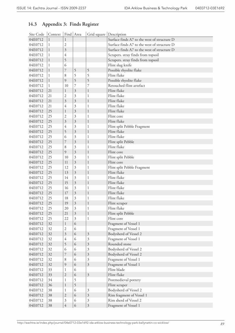
89
IDA Arklow Business & Technology Park 04E0712-03E1692ISSUE 14: Eachtra Journal - ISSN 2009-2237
http://eachtra.ie/index.php/journal/04e0712-03e1692-ida-arklow-business-technology-park-ballynattin-co-wicklow/
14.3 Appendix 3: Finds Register
Site Code Context Find Area Grid square Description04E0712 1 1 Surface finds A7 to the west of structure D04E0712 1 2 Surface finds A7 to the west of structure D04E0712 1 3 Surface finds A7 to the west of structure D04E0712 1 4 Scrapers. stray finds from topsoil04E0712 1 5 Scrapers. stray finds from topsoil04E0712 1 6 Flint slug knife04E0712 1 7 5 5 Possible rhyolite flake04E0712 1 8 5 5 Flint flake04E0712 1 9 5 5 Possible rhyolite flake04E0712 1 10 7 7 Retouched flint artefact04E0712 21 1 3 1 Flint flake04E0712 21 2 3 1 Flint flake04E0712 21 3 3 1 Flint flake04E0712 21 4 3 1 Flint flake04E0712 25 1 3 1 Flint flake04E0712 25 2 3 1 Flint core04E0712 25 3 3 1 Flint flake04E0712 25 4 3 1 Flint split Pebble Fragment04E0712 25 5 3 1 Flint flake04E0712 25 6 3 1 Flint flake04E0712 25 7 3 1 Flint split Pebble04E0712 25 8 3 1 Flint flake04E0712 25 9 3 1 Flint core04E0712 25 10 3 1 Flint split Pebble04E0712 25 11 3 1 Flint core04E0712 25 12 3 1 Flint split Pebble Fragment04E0712 25 13 3 1 Flint flake04E0712 25 14 3 1 Flint flake04E0712 25 15 3 1 Flint flake04E0712 25 16 3 1 Flint flake04E0712 25 17 3 1 Flint flake04E0712 25 18 3 1 Flint flake04E0712 25 19 3 1 Flint scraper04E0712 25 20 3 1 Flint flake04E0712 25 21 3 1 Flint split Pebble04E0712 25 22 3 1 Flint core04E0712 32 1 6 Fragment of Vessel 104E0712 32 2 6 Fragment of Vessel 104E0712 32 3 6 3 Bodysherd of Vessel 204E0712 32 4 6 3 Fragment of Vessel 104E0712 32 5 6 3 Rounded stone04E0712 32 6 6 3 Bodysherd of Vessel 204E0712 32 7 6 3 Bodysherd of Vessel 204E0712 32 8 6 3 Fragment of Vessel 104E0712 32 9 6 3 Fragment of Vessel 104E0712 33 1 6 Flint blade04E0712 33 2 6 3 Flint flake04E0712 34 1 5 Postmedieval pottery04E0712 36 1 5 Flint scraper04E0712 38 1 6 3 Bodysherd of Vessel 204E0712 38 2 6 3 Rim fragment of Vessel 104E0712 38 3 6 3 Rim sherd of Vessel 204E0712 38 4 6 3 Fragment of Vessel 1
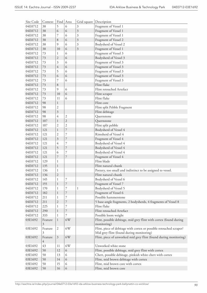
90
IDA Arklow Business & Technology Park 04E0712-03E1692ISSUE 14: Eachtra Journal - ISSN 2009-2237
http://eachtra.ie/index.php/journal/04e0712-03e1692-ida-arklow-business-technology-park-ballynattin-co-wicklow/
Site Code Context Find Area Grid square Description04E0712 38 5 6 3 Fragment of Vessel 104E0712 38 6 6 3 Fragment of Vessel 104E0712 38 7 6 3 Fragment of Vessel 104E0712 38 8 6 3 Fragment of Vessel 204E0712 38 9 6 3 Bodysherd of Vessel 204E0712 38 10 6 3 Fragment of Vessel 104E0712 73 1 6 Fragment of Vessel 304E0712 73 2 6 Bodysherd of Vessel 304E0712 73 3 6 Fragment of Vessel 304E0712 73 4 6 Fragment of Vessel 304E0712 73 5 6 Fragment of Vessel 304E0712 73 6 6 Fragment of Vessel 304E0712 73 7 6 Fragment of Vessel 304E0712 73 8 Flint flake04E0712 73 9 6 Flint retouched Artefact04E0712 73 10 6 Flint scraper04E0712 73 11 6 Flint flake04E0712 98 1 Flint core04E0712 98 2 Flint split Pebble Fragment04E0712 98 3 Flint debitage04E0712 98 4 2 Quernstone04E0712 107 1 2 Quernstone04E0712 107 2 2 Flint split pebble04E0712 121 1 7 Bodysherd of Vessel 404E0712 121 2 7 Rimsherd of Vessel 404E0712 121 3 7 Fragment of Vessel 404E0712 121 4 7 Bodysherd of Vessel 404E0712 121 5 7 Bodysherd of Vessel 404E0712 121 6 7 Bodysherd of Vessel 404E0712 121 7 7 Fragment of Vessel 404E0712 129 1 Flint blade04E0712 135 1 Flint natural chunk04E0712 136 1 Pottery, too small and indistinct to be assigned to vessel.04E0712 136 2 Flint natural chunk04E0712 145 1 7 Bodysherd of Vessel 604E0712 155 1 7 Fragment of Vessel 704E0712 170 1 7 1 Bodysherd of Vessel 504E0712 182 1 7 Fragment of Vessel 604E0712 211 1 7 Possible hammerstone04E0712 211 2 7 5 base-angle fragments, 2 bodysherds, 4 fragments of Vessel 804E0712 225 1 7 Flint flake04E0712 290 1 7 Flint retouched Artefact04E0712 333 1 7 Possible loom weight03E1692 Feature
31 6W Flint, possible debitage, mid grey flint with cortex (found during
monitoring)03E1692 Feature
32 6W Flint, piece of debitage with cortex or possible retouched scraper?
Mid grey flint (found during monitoring)03E1692 Feature
43 6W Flint, piece of unworked mid grey flint (found during monitoring)
03E1692 43 11 6W Unworked white stone03E1692 50 12 6 Flint, possible debitage, mid grey flint with cortex03E1692 50 13 6 Chert, possible debitage, pinkish white chert with cortex03E1692 50 14 6 Flint, mid brown debitage with cortex03E1692 50 15 6 Flint, mid brown core with cortex03E1692 50 16 6 Flint, mid brown core

91
IDA Arklow Business & Technology Park 04E0712-03E1692ISSUE 14: Eachtra Journal - ISSN 2009-2237
http://eachtra.ie/index.php/journal/04e0712-03e1692-ida-arklow-business-technology-park-ballynattin-co-wicklow/
Site Code Context Find Area Grid square Description03E1692 50 17 6 Flint, unworked flint cortex03E1692 52 18 6 Flint, unworked flint cortex03E1692 52 19 6 Flint, pebble, unworked
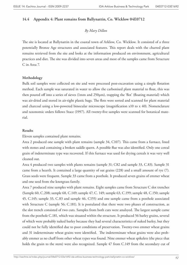
92
IDA Arklow Business & Technology Park 04E0712-03E1692ISSUE 14: Eachtra Journal - ISSN 2009-2237
http://eachtra.ie/index.php/journal/04e0712-03e1692-ida-arklow-business-technology-park-ballynattin-co-wicklow/
14.4 Appendix 4: Plant remains from Ballynattin, Co. Wicklow 04E0712
By Mary Dillon
The site is located at Ballynattin in the coastal town of Arklow, Co. Wicklow. It consisted of a three potentially Bronze Age structures and associated features. This report deals with the charred plant remains retrieved from the site and looks at the information produced on environment, agricultural practices and diet. The site was divided into seven areas and most of the samples came from Structure C in Area 7.
Methodology
Bulk soil samples were collected on site and were processed post-excavation using a simple flotation method. Each sample was saturated in water to allow the carbonised plant material to float, this was then poured off into a series of sieves (1mm and 250µm), trapping the ‘flot’ (floating material) which was air-dried and stored in air-tight plastic bags. The flots were sorted and scanned for plant material and charcoal using a low-powered binocular microscope (magnification x10 to x 40). Nomenclature and taxonomic orders follows Stace (1997). All twenty-five samples were scanned for botanical mate-rial.
Results
Eleven samples contained plant remains. Area 2 produced one sample with plant remains (sample 34, C107). This came from a furnace, lined with stones and containing a broken saddle quern. A possible flue was also identified. Only one cereal grain of indeterminate type was recovered. If this furnace was used for drying cereals it was very well cleaned out.Area 4 produced two samples with plants remains (sample 31; C82 and sample 33, C.83). Sample 31 came from a hearth. It contained a large quantity of oat grains (228) and a small amount of rye (7). Grass seeds were frequent. Sample 33 came from a posthole. It produced seven grains of emmer wheat and one seed from the knotgrass family.Area 7 produced nine samples with plant remains. Eight samples came from Structure C slot trenches (Sample 60, C.208; sample 68, C.149; sample 47; C. 149; sample 63, C.199; sample 48, C.150; sample 45, C.145; sample 33, C.83 and sample 46, C155) and one sample came from a posthole associated with Structure C (sample 56; C.181). It is postulated that there were two phases of construction, as the slot trench consisted of two cuts. Samples from both cuts were analsyed. The largest sample came from the posthole C.181, which was situated within the structure. It produced 56 barley grains, several of which were probably naked barley because they had several characteristics of naked barley, but they could not be fully identified due to poor conditions of preservation. Twenty-two emmer wheat grains and 31 indeterminate wheat grains were identified. The indeterminate wheat grains were also prob-ably emmer as no chaff from other wheat types was found. Nine emmer wheat spikelets (the piece that holds the grain to the stem) were also recognized. Sample 47 from C.149 from the secondary cut of
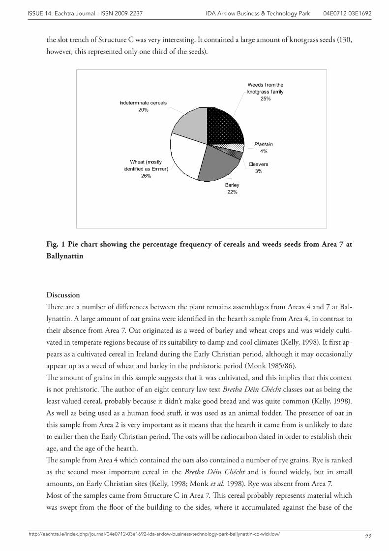
93
IDA Arklow Business & Technology Park 04E0712-03E1692ISSUE 14: Eachtra Journal - ISSN 2009-2237
http://eachtra.ie/index.php/journal/04e0712-03e1692-ida-arklow-business-technology-park-ballynattin-co-wicklow/
the slot trench of Structure C was very interesting. It contained a large amount of knotgrass seeds (130, however, this represented only one third of the seeds).
Fig. 1 Pie chart showing the percentage frequency of cereals and weeds seeds from Area 7 at Ballynattin
Discussion
There are a number of differences between the plant remains assemblages from Areas 4 and 7 at Bal-lynattin. A large amount of oat grains were identified in the hearth sample from Area 4, in contrast to their absence from Area 7. Oat originated as a weed of barley and wheat crops and was widely culti-vated in temperate regions because of its suitability to damp and cool climates (Kelly, 1998). It first ap-pears as a cultivated cereal in Ireland during the Early Christian period, although it may occasionally appear up as a weed of wheat and barley in the prehistoric period (Monk 1985/86).The amount of grains in this sample suggests that it was cultivated, and this implies that this context is not prehistoric. The author of an eight century law text Bretha Déin Chécht classes oat as being the least valued cereal, probably because it didn’t make good bread and was quite common (Kelly, 1998). As well as being used as a human food stuff, it was used as an animal fodder. The presence of oat in this sample from Area 2 is very important as it means that the hearth it came from is unlikely to date to earlier then the Early Christian period. The oats will be radiocarbon dated in order to establish their age, and the age of the hearth. The sample from Area 4 which contained the oats also contained a number of rye grains. Rye is ranked as the second most important cereal in the Bretha Déin Chécht and is found widely, but in small amounts, on Early Christian sites (Kelly, 1998; Monk et al. 1998). Rye was absent from Area 7.Most of the samples came from Structure C in Area 7. This cereal probably represents material which was swept from the floor of the building to the sides, where it accumulated against the base of the
Weeds from the knotgrass family
25%Indeterminate cereals
20%
Plantain4%
Cleavers3%
Barley 22%
Wheat (mostly identif ied as Emmer)
26%
94
IDA Arklow Business & Technology Park 04E0712-03E1692ISSUE 14: Eachtra Journal - ISSN 2009-2237
http://eachtra.ie/index.php/journal/04e0712-03e1692-ida-arklow-business-technology-park-ballynattin-co-wicklow/
walls and eventually in the slot trenches. It could also represent material that was used to pack the slot trenches, therefore preceding the use of the structure. The largest sample from Structure C comes from a posthole that was located within the structure.Emmer wheat is the most dominant cereal grain in the samples from Structure C Emmer wheat is not rated highly in the Bretha Déin Chécht, possibly for the reason that it is unsuitable for bread mak-ing (Kelly, 1998, 225). It has been found at Neolithic sites across Ireland, such as at settlement site at Tankardstown, Co. Limerick (Monk 1988), a Neolithic habitation layer at Townley Hall, Co. Meath (Monk 1987, 41) and for the most part has been the most common cereal found on such sites (Monk 1988). Emmer wheat was the main wheat species cultivated in Ireland until the Early Christian Period (Monk 1987, 41). Three of the samples from Structure C had emmer wheat spikelets present, thus confirming the identification of the grains.Although both wheat and barley were grown in the Bronze Age, excavations, including those at Fota Island, Co. Cork (Rutter and O’Connell 1992), Ballyveelish, Co. Tipperary (Monk 1987) and Doon-moon and Elton, both in Co. Limerick (Monk 1988, 191), have indicated that barley was the dominant crop. Barley, which originated as a wild grass in the Near East, was probably introduced to Ireland in the Neolithic (Monk 1986, 1), but became widespread during the Bronze Age period. Barley was likely an important food source as well as possible animal fodder and, significantly, can be harvested regardless of bad weather (Tierney and Hannon 2003, 155). It was well represented in the samples from Structure C. It possible that the barley here is naked barley, although the degraded nature of the surface of the grains makes definitive identification impossible. A large amount of weed seeds were identified in the assemblage. From sample 31 from Area 4, there was a significant amount of grass seeds, probably growing and harvested alongside the oats. From Area 7, weeds from the knotgrass family predominate (Fig. 1). Sample 47 produced vast quantities of such seeds, which are tiny, barely visible to the naked eye. These weeds normally are associated with dis-turbed and arable ground, but it has also been suggested that they were purposely collected and used to supplement the diet. Helbaek thought that knotgrass family weeds were eaten in Prehistoric Denmark (Helbaek, 1954) and faecal material from an 11th century house in Dublin City revealed many weed seeds, both from the knotgrass and goosefoot families (Mitchell, 1987). It is possible that, given the hundreds of weed seeds of one specific type, these seeds were purposely collected and possibly added to food stuffs.
Summary
The plant remains assemblage from Ballynattin provides information on agriculture and diet in the Bronze Age. The identification of oats from Area 4 is very useful as it highlights that at least some of the features here are later than Bronze Age in date. The large amount of emmer wheat identified from Structure C contrasts with the evidence from other Bronze Age sites in Ireland, where barley was the main cereal cultivated.
95
IDA Arklow Business & Technology Park 04E0712-03E1692ISSUE 14: Eachtra Journal - ISSN 2009-2237
http://eachtra.ie/index.php/journal/04e0712-03e1692-ida-arklow-business-technology-park-ballynattin-co-wicklow/
References
Helbaek, H. 1954 Prehistoric food plants and weeds in Denmark. A survey of archaeological botanical research. Danmarks Geoligishe. Unders, 11, no. 80, 250-261. Copenhagen.
Jones, G. 1998 Wheat grain identification – why bother? Environmental Archaeology, Vol. 2, pp. 29-34.
Kelly, F. 1998 Early Irish Farming. Dublin, Dublin Institute for Advanced Studies.
Mitchell, G F 1951 ‘Studies in Irish Quaternary deposits’. Proceedings of the Royal Irish Academy, 53B, 111-206
Mitchell, G. F. 1987 Archaeology and Environment in Early Dublin (with contributions from C.A. Dickson and J.H. Dickson). Dublin. National Museum of Ireland/Royal Irish Academy.
Monk, M. 1985/86. ‘Evidence from macroscopic plant remains for crop
husbandry in prehistoric and early historic Ireland: A review’, Journal of
Irish Archaeology 3.
Monk, M.A. 1987 The charred plant remains from Ballyveelish. In: Cleary, R.M., Hurley, M.F and Twohig, E.A Archaeological excavations on the Cork – Dublin Gas Pipeline (1981-82), Department of Archaeology, University College Cork, Cork pp. 30-31.
Monk, M.A. 1988 Archaeobotanical study of samples from pipeline sites. In: Gowen , M. Three Irish Gas Pipelines: New archaeological evidence in Munster, Wordwell, Dublin, pp. 185-191.
Monk, M., Tierney, J. and Hannon M. 1998 Archaeobotanical studies. In: Monk, M. and Sheehan, J. (eds.) Early Medieval Munster. Archaeology, History and Society, Cork University Press, Cork. pp. 65-75.
Rutter, E. and O’Connell, P. 1992 Fota, Co. Cork. In Digging up Cork: archaeological excavations Cork, 1992, Cork Public Museum, Cork, pp. 11-13.
Stace, C.A. 1997 New Flora in the British Isles (2nd edition), Cambridge, Cambridge University Press.
Tierney, J. and Hannon, M. 2003 Charred plant remains. In: Cleary, R.M. Enclosed Late Bronze Age habitation site and boundary wall at Lough Gur, Co. Limerick, Royal Irish Academy, Vol. 103C, No. 4, pp. 152-157.
97
IDA Arklow Business & Technology Park 04E0712-03E1692ISSUE 14: Eachtra Journal - ISSN 2009-2237
http://eachtra.ie/index.php/journal/04e0712-03e1692-ida-arklow-business-technology-park-ballynattin-co-wicklow/
14.5 Appendix 5: Pottery Report
Helen Roche and Eoin Grogan
The Assemblage
An assemblage of forty eight sherds was found during the excavation. Three rimsherds, six base-angle sherds, thirteen bodysherds and twenty six fragments are present, representing a minimum of eight Late Bronze Age coarse vessels (c. 1150-800 BC). Sherds representing vessels 1 and 2 were found in the slot trenches of Structure A (Contexts 32 and 38) and vessel 3 was found in a cremation pit (Context 73) in Area 6W. Sherds representing vessels 4 and 5 were associated with Structure B, coming from the fill of a slot trench (Context 121) and a stakehole (Context 170). Vessels 7 and 8 were found in primary and secondary cuts associated with Structure C (Contexts 155 and 211). The two sherds rep-resenting vessel 6 came from different areas with one sherd associated with Structure B (Context 182:external posthole) and the other associated with Structure C (Context 145:secondary cut). However, the similarity in fabric suggests that they are either part of the same vessel or represent sherds from two very similar vessels. A fragment too small to be assigned to a particular vessel was found in a posthole associated with Structure B (Context 136)
The sherds are poorly preserved and fragmented but the surviving evidence demonstrates that the eight vessels were upright or tub-shaped, flat-based coarse vessels, an identification based on the featured sherds and fabric consistency. The fabric is medium to thick-walled, ranging from 7.9mm to 17.1mm in thickness with a medium to high content of inclusions. Vessels 1-6 display clear evidence in the form of carbonised matter and fire-blackening on the both surfaces, for domestic use.
While varying in thickness, vessels 1, 3-5, 7 and 8 show similarities in fabric and in preservation. All examples the crumbly slightly sandy-textured fabric has a moderate to high content of inclusions and the exterior surfaces are either weathered or completely missing. The sherds representing vessels 2 and 6, although also showing evidence for weathering appear to have been more skilfully fired, with the fabric having a harder consistency and showing evidence that the exterior surfaces had been smoothed with a slurry was before firing.
Few featured sherds survive with the exception of three rimsherds from vessels 1, 2 and 4 and por-tion of the base from vessel 8. Rimsherd 38:21 (vessel 1) is rounded with a slight constriction on the exterior surface. The sherd, while small, shows that the vessel was more straight-sided than curved in profile, coming from a rather small vessel probably only about 18cm in height and 16-17cm in rim diameter. The simple rounded rim 38:3 (vessel 2) is from a larger vessel measuring up to 23cm in height and 19cm in rim diameter. The curvature of the sherd shows that the vessel was tub-shaped. Rimsherd 121:2 (vessel 4) appears to represent a similarly shaped and sized vessel to the previous
1 Theexcavationnumber04E0712isomittedthroughout;onlythefeaturenumberfollowedbythefindnumberisincluded.Where the pottery is listed the feature numbers are in bold: e.g. Rimsherd 38:2.
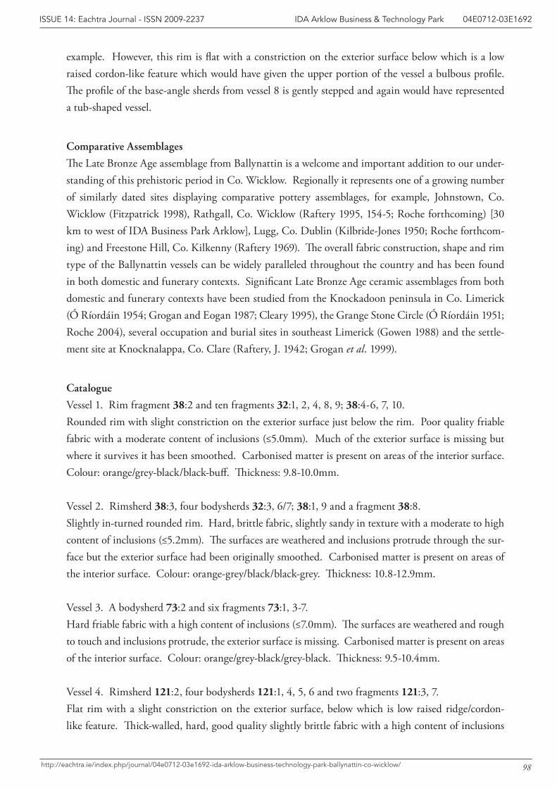
98
IDA Arklow Business & Technology Park 04E0712-03E1692ISSUE 14: Eachtra Journal - ISSN 2009-2237
http://eachtra.ie/index.php/journal/04e0712-03e1692-ida-arklow-business-technology-park-ballynattin-co-wicklow/
example. However, this rim is flat with a constriction on the exterior surface below which is a low raised cordon-like feature which would have given the upper portion of the vessel a bulbous profile. The profile of the base-angle sherds from vessel 8 is gently stepped and again would have represented a tub-shaped vessel.
Comparative Assemblages
The Late Bronze Age assemblage from Ballynattin is a welcome and important addition to our under-standing of this prehistoric period in Co. Wicklow. Regionally it represents one of a growing number of similarly dated sites displaying comparative pottery assemblages, for example, Johnstown, Co. Wicklow (Fitzpatrick 1998), Rathgall, Co. Wicklow (Raftery 1995, 154-5; Roche forthcoming) [30 km to west of IDA Business Park Arklow], Lugg, Co. Dublin (Kilbride-Jones 1950; Roche forthcom-ing) and Freestone Hill, Co. Kilkenny (Raftery 1969). The overall fabric construction, shape and rim type of the Ballynattin vessels can be widely paralleled throughout the country and has been found in both domestic and funerary contexts. Significant Late Bronze Age ceramic assemblages from both domestic and funerary contexts have been studied from the Knockadoon peninsula in Co. Limerick (Ó Ríordáin 1954; Grogan and Eogan 1987; Cleary 1995), the Grange Stone Circle (Ó Ríordáin 1951; Roche 2004), several occupation and burial sites in southeast Limerick (Gowen 1988) and the settle-ment site at Knocknalappa, Co. Clare (Raftery, J. 1942; Grogan et al. 1999).
Catalogue
Vessel 1. Rim fragment 38:2 and ten fragments 32:1, 2, 4, 8, 9; 38:4-6, 7, 10.Rounded rim with slight constriction on the exterior surface just below the rim. Poor quality friable fabric with a moderate content of inclusions (≤5.0mm). Much of the exterior surface is missing but where it survives it has been smoothed. Carbonised matter is present on areas of the interior surface. Colour: orange/grey-black/black-buff. Thickness: 9.8-10.0mm.
Vessel 2. Rimsherd 38:3, four bodysherds 32:3, 6/7; 38:1, 9 and a fragment 38:8. Slightly in-turned rounded rim. Hard, brittle fabric, slightly sandy in texture with a moderate to high content of inclusions (≤5.2mm). The surfaces are weathered and inclusions protrude through the sur-face but the exterior surface had been originally smoothed. Carbonised matter is present on areas of the interior surface. Colour: orange-grey/black/black-grey. Thickness: 10.8-12.9mm.
Vessel 3. A bodysherd 73:2 and six fragments 73:1, 3-7. Hard friable fabric with a high content of inclusions (≤7.0mm). The surfaces are weathered and rough to touch and inclusions protrude, the exterior surface is missing. Carbonised matter is present on areas of the interior surface. Colour: orange/grey-black/grey-black. Thickness: 9.5-10.4mm.
Vessel 4. Rimsherd 121:2, four bodysherds 121:1, 4, 5, 6 and two fragments 121:3, 7. Flat rim with a slight constriction on the exterior surface, below which is low raised ridge/cordon-like feature. Thick-walled, hard, good quality slightly brittle fabric with a high content of inclusions
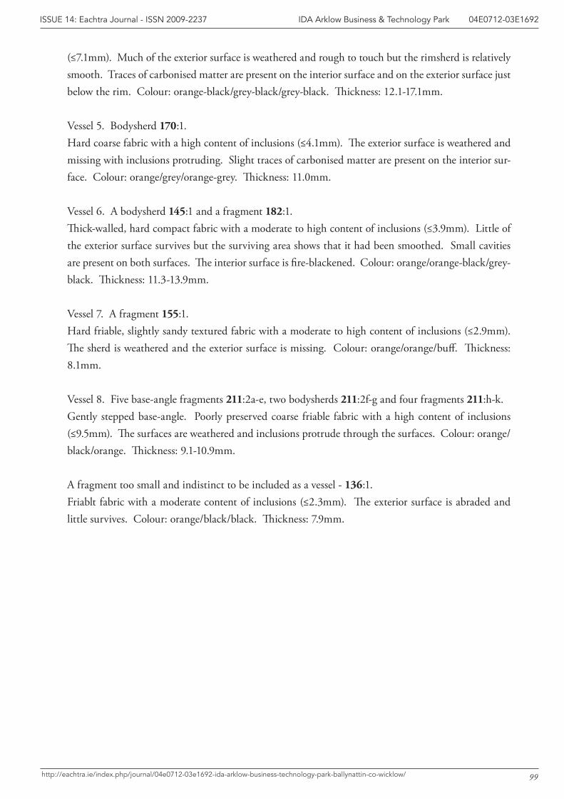
99
IDA Arklow Business & Technology Park 04E0712-03E1692ISSUE 14: Eachtra Journal - ISSN 2009-2237
http://eachtra.ie/index.php/journal/04e0712-03e1692-ida-arklow-business-technology-park-ballynattin-co-wicklow/
(≤7.1mm). Much of the exterior surface is weathered and rough to touch but the rimsherd is relatively smooth. Traces of carbonised matter are present on the interior surface and on the exterior surface just below the rim. Colour: orange-black/grey-black/grey-black. Thickness: 12.1-17.1mm.
Vessel 5. Bodysherd 170:1. Hard coarse fabric with a high content of inclusions (≤4.1mm). The exterior surface is weathered and missing with inclusions protruding. Slight traces of carbonised matter are present on the interior sur-face. Colour: orange/grey/orange-grey. Thickness: 11.0mm.
Vessel 6. A bodysherd 145:1 and a fragment 182:1. Thick-walled, hard compact fabric with a moderate to high content of inclusions (≤3.9mm). Little of the exterior surface survives but the surviving area shows that it had been smoothed. Small cavities are present on both surfaces. The interior surface is fire-blackened. Colour: orange/orange-black/grey-black. Thickness: 11.3-13.9mm.
Vessel 7. A fragment 155:1. Hard friable, slightly sandy textured fabric with a moderate to high content of inclusions (≤2.9mm). The sherd is weathered and the exterior surface is missing. Colour: orange/orange/buff. Thickness: 8.1mm.
Vessel 8. Five base-angle fragments 211:2a-e, two bodysherds 211:2f-g and four fragments 211:h-k.Gently stepped base-angle. Poorly preserved coarse friable fabric with a high content of inclusions (≤9.5mm). The surfaces are weathered and inclusions protrude through the surfaces. Colour: orange/black/orange. Thickness: 9.1-10.9mm.
A fragment too small and indistinct to be included as a vessel - 136:1. Friablt fabric with a moderate content of inclusions (≤2.3mm). The exterior surface is abraded and little survives. Colour: orange/black/black. Thickness: 7.9mm.
100
IDA Arklow Business & Technology Park 04E0712-03E1692ISSUE 14: Eachtra Journal - ISSN 2009-2237
http://eachtra.ie/index.php/journal/04e0712-03e1692-ida-arklow-business-technology-park-ballynattin-co-wicklow/
References
Cleary, R. 1995 Later Bronze Age Settlement and Prehistoric Burials, Lough Gur, Co. Limerick, Proceedings of the Royal Irish Academy 95C, 1-92.
Fitzpatrick, M. 1998 Johnstown South enclosure, Co. Wicklow, in I. Bennett (ed.) Excavations 1997, 199-200, Wordwell, Dublin.
Gowen, M. 1988 Three Irish Gas Pipelines: New Archaeological Evidence in Munster. Wordwell, Dublin.
Grogan, E. and Eogan, G. 1987 Lough Gur excavations by Seán P. Ó Ríordáin: further Neolithic and Beaker habitations on Knockadoon, Proceedings of the Royal Irish Academy 87C, 299-506.
Grogan, E., O’Sullivan, A., O’Carroll F. and Hagen, I. 1999 Knocknalappa, Co. Clare: a reappraisal, Discovery Programme Reports 6, 111-123, The Discovery Programme/Royal Irish Academy, Dublin.
Kilbride-Jones, H. 1950 The excavation of a composite Early Iron Age monument with “Henge” features at Lugg, Co. Dublin, Proceedings of the Royal Irish Academy 53C, 311-32.
Ó Ríordáin, S.P. 1951 Lough Gur excavations: The Great Stone Circle (B) in Grange townland, Proceedings of the Royal Irish Academy 54C, 37-74.
Ó Ríordáin, S.P. 1954 Lough Gur Excavations: Neolithic and Bronze Age Houses on Knockadoon, Proceedings of the Royal Irish Academy 56C, 297-459.
Raftery, J. 1942 Knocknalappa crannóg, Co. Clare. North Munster Antiquarian Journal 3, 53-72.
Raftery, B. 1969 Freestone Hill, Co. Kilkenny: an Iron Age hillfort and Bronze Age cairn. Proceedings of the Royal Irish Academy 68C, 1-108.
Raftery, B. 1995 The Conundrum of Irish Iron Age Pottery, 149-156. In B. Raftery (ed.) Sites and Sights of the Iron Age. Oxbow Monograph 56, Oxford.
Roche, H. 2004 The Dating of the Embanked Stone Circle at Grange, Co. Limerick. In H. Roche, E. Grogan, J. Bradley, J. Coles and B. Raftery (eds) From Megaliths to Metals, 109-116. Oxbow Books. Oxford.
Roche, H. forthcoming The Prehistoric Pottery Assemblage from Rathgall, Co. Wicklow. In B. Raftery Excavations at Rathgall, Co. Wicklow.
Roche, H. forthcoming The Late Bronze Age Pottery Assemblage from Lugg, Co. Dublin.
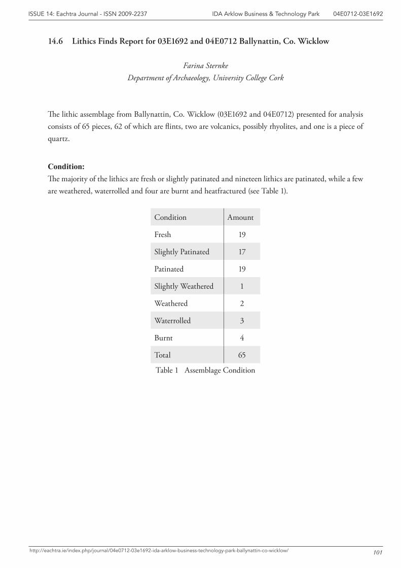
101
IDA Arklow Business & Technology Park 04E0712-03E1692ISSUE 14: Eachtra Journal - ISSN 2009-2237
http://eachtra.ie/index.php/journal/04e0712-03e1692-ida-arklow-business-technology-park-ballynattin-co-wicklow/
14.6 Lithics Finds Report for 03E1692 and 04E0712 Ballynattin, Co. Wicklow
Farina SternkeDepartment of Archaeology, University College Cork
The lithic assemblage from Ballynattin, Co. Wicklow (03E1692 and 04E0712) presented for analysis consists of 65 pieces, 62 of which are flints, two are volcanics, possibly rhyolites, and one is a piece of quartz.
Condition:The majority of the lithics are fresh or slightly patinated and nineteen lithics are patinated, while a few are weathered, waterrolled and four are burnt and heatfractured (see Table 1).
Condition Amount
Fresh 19
Slightly Patinated 17
Patinated 19
Slightly Weathered 1
Weathered 2
Waterrolled 3
Burnt 4
Total 65
Table 1 Assemblage Condition
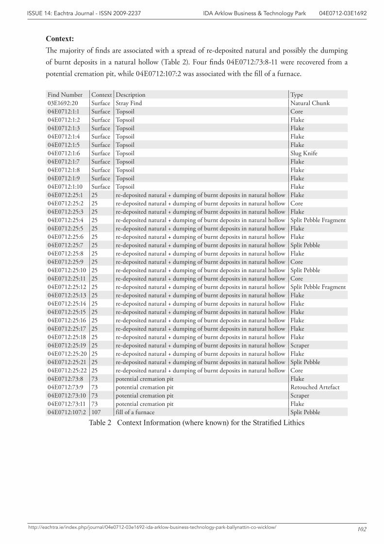
102
IDA Arklow Business & Technology Park 04E0712-03E1692ISSUE 14: Eachtra Journal - ISSN 2009-2237
http://eachtra.ie/index.php/journal/04e0712-03e1692-ida-arklow-business-technology-park-ballynattin-co-wicklow/
Context:The majority of finds are associated with a spread of re-deposited natural and possibly the dumping of burnt deposits in a natural hollow (Table 2). Four finds 04E0712:73:8-11 were recovered from a potential cremation pit, while 04E0712:107:2 was associated with the fill of a furnace.
Find Number Context Description Type03E1692:20 Surface Stray Find Natural Chunk04E0712:1:1 Surface Topsoil Core04E0712:1:2 Surface Topsoil Flake04E0712:1:3 Surface Topsoil Flake04E0712:1:4 Surface Topsoil Flake04E0712:1:5 Surface Topsoil Flake04E0712:1:6 Surface Topsoil Slug Knife04E0712:1:7 Surface Topsoil Flake04E0712:1:8 Surface Topsoil Flake04E0712:1:9 Surface Topsoil Flake04E0712:1:10 Surface Topsoil Flake04E0712:25:1 25 re-deposited natural + dumping of burnt deposits in natural hollow Flake04E0712:25:2 25 re-deposited natural + dumping of burnt deposits in natural hollow Core04E0712:25:3 25 re-deposited natural + dumping of burnt deposits in natural hollow Flake04E0712:25:4 25 re-deposited natural + dumping of burnt deposits in natural hollow Split Pebble Fragment04E0712:25:5 25 re-deposited natural + dumping of burnt deposits in natural hollow Flake04E0712:25:6 25 re-deposited natural + dumping of burnt deposits in natural hollow Flake04E0712:25:7 25 re-deposited natural + dumping of burnt deposits in natural hollow Split Pebble04E0712:25:8 25 re-deposited natural + dumping of burnt deposits in natural hollow Flake04E0712:25:9 25 re-deposited natural + dumping of burnt deposits in natural hollow Core04E0712:25:10 25 re-deposited natural + dumping of burnt deposits in natural hollow Split Pebble04E0712:25:11 25 re-deposited natural + dumping of burnt deposits in natural hollow Core04E0712:25:12 25 re-deposited natural + dumping of burnt deposits in natural hollow Split Pebble Fragment04E0712:25:13 25 re-deposited natural + dumping of burnt deposits in natural hollow Flake04E0712:25:14 25 re-deposited natural + dumping of burnt deposits in natural hollow Flake04E0712:25:15 25 re-deposited natural + dumping of burnt deposits in natural hollow Flake04E0712:25:16 25 re-deposited natural + dumping of burnt deposits in natural hollow Flake04E0712:25:17 25 re-deposited natural + dumping of burnt deposits in natural hollow Flake04E0712:25:18 25 re-deposited natural + dumping of burnt deposits in natural hollow Flake04E0712:25:19 25 re-deposited natural + dumping of burnt deposits in natural hollow Scraper04E0712:25:20 25 re-deposited natural + dumping of burnt deposits in natural hollow Flake04E0712:25:21 25 re-deposited natural + dumping of burnt deposits in natural hollow Split Pebble04E0712:25:22 25 re-deposited natural + dumping of burnt deposits in natural hollow Core04E0712:73:8 73 potential cremation pit Flake04E0712:73:9 73 potential cremation pit Retouched Artefact04E0712:73:10 73 potential cremation pit Scraper04E0712:73:11 73 potential cremation pit Flake04E0712:107:2 107 fill of a furnace Split Pebble
Table2ContextInformation(whereknown)fortheStratifiedLithics
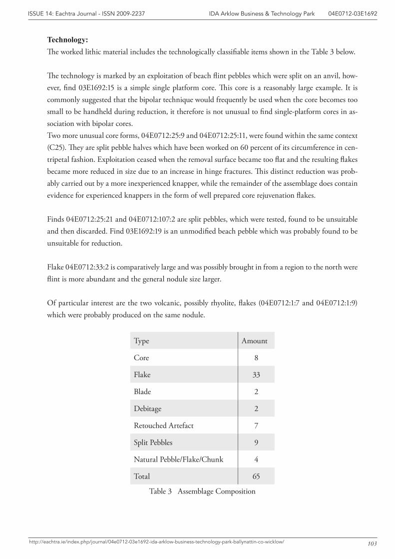
103
IDA Arklow Business & Technology Park 04E0712-03E1692ISSUE 14: Eachtra Journal - ISSN 2009-2237
http://eachtra.ie/index.php/journal/04e0712-03e1692-ida-arklow-business-technology-park-ballynattin-co-wicklow/
Technology: The worked lithic material includes the technologically classifiable items shown in the Table 3 below.
The technology is marked by an exploitation of beach flint pebbles which were split on an anvil, how-ever, find 03E1692:15 is a simple single platform core. This core is a reasonably large example. It is commonly suggested that the bipolar technique would frequently be used when the core becomes too small to be handheld during reduction, it therefore is not unusual to find single-platform cores in as-sociation with bipolar cores. Two more unusual core forms, 04E0712:25:9 and 04E0712:25:11, were found within the same context (C25). They are split pebble halves which have been worked on 60 percent of its circumference in cen-tripetal fashion. Exploitation ceased when the removal surface became too flat and the resulting flakes became more reduced in size due to an increase in hinge fractures. This distinct reduction was prob-ably carried out by a more inexperienced knapper, while the remainder of the assemblage does contain evidence for experienced knappers in the form of well prepared core rejuvenation flakes.
Finds 04E0712:25:21 and 04E0712:107:2 are split pebbles, which were tested, found to be unsuitable and then discarded. Find 03E1692:19 is an unmodified beach pebble which was probably found to be unsuitable for reduction.
Flake 04E0712:33:2 is comparatively large and was possibly brought in from a region to the north were flint is more abundant and the general nodule size larger.
Of particular interest are the two volcanic, possibly rhyolite, flakes (04E0712:1:7 and 04E0712:1:9) which were probably produced on the same nodule.
Type Amount
Core 8
Flake 33
Blade 2
Debitage 2
Retouched Artefact 7
Split Pebbles 9
Natural Pebble/Flake/Chunk 4
Total 65
Table 3 Assemblage Composition
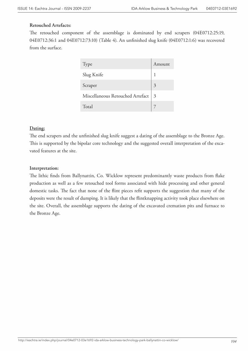
104
IDA Arklow Business & Technology Park 04E0712-03E1692ISSUE 14: Eachtra Journal - ISSN 2009-2237
http://eachtra.ie/index.php/journal/04e0712-03e1692-ida-arklow-business-technology-park-ballynattin-co-wicklow/
Retouched Artefacts:
The retouched component of the assemblage is dominated by end scrapers (04E0712:25:19, 04E0712:36:1 and 04E0712:73:10) (Table 4). An unfinished slug knife (04E0712:1:6) was recovered from the surface.
Type Amount
Slug Knife 1
Scraper 3
Miscellaneous Retouched Artefact 3
Total 7
Dating:
The end scrapers and the unfinished slug knife suggest a dating of the assemblage to the Bronze Age. This is supported by the bipolar core technology and the suggested overall interpretation of the exca-vated features at the site.
Interpretation:
The lithic finds from Ballynattin, Co. Wicklow represent predominantly waste products from flake production as well as a few retouched tool forms associated with hide processing and other general domestic tasks. The fact that none of the flint pieces refit supports the suggestion that many of the deposits were the result of dumping. It is likely that the flintknapping activity took place elsewhere on the site. Overall, the assemblage supports the dating of the excavated cremation pits and furnace to the Bronze Age.