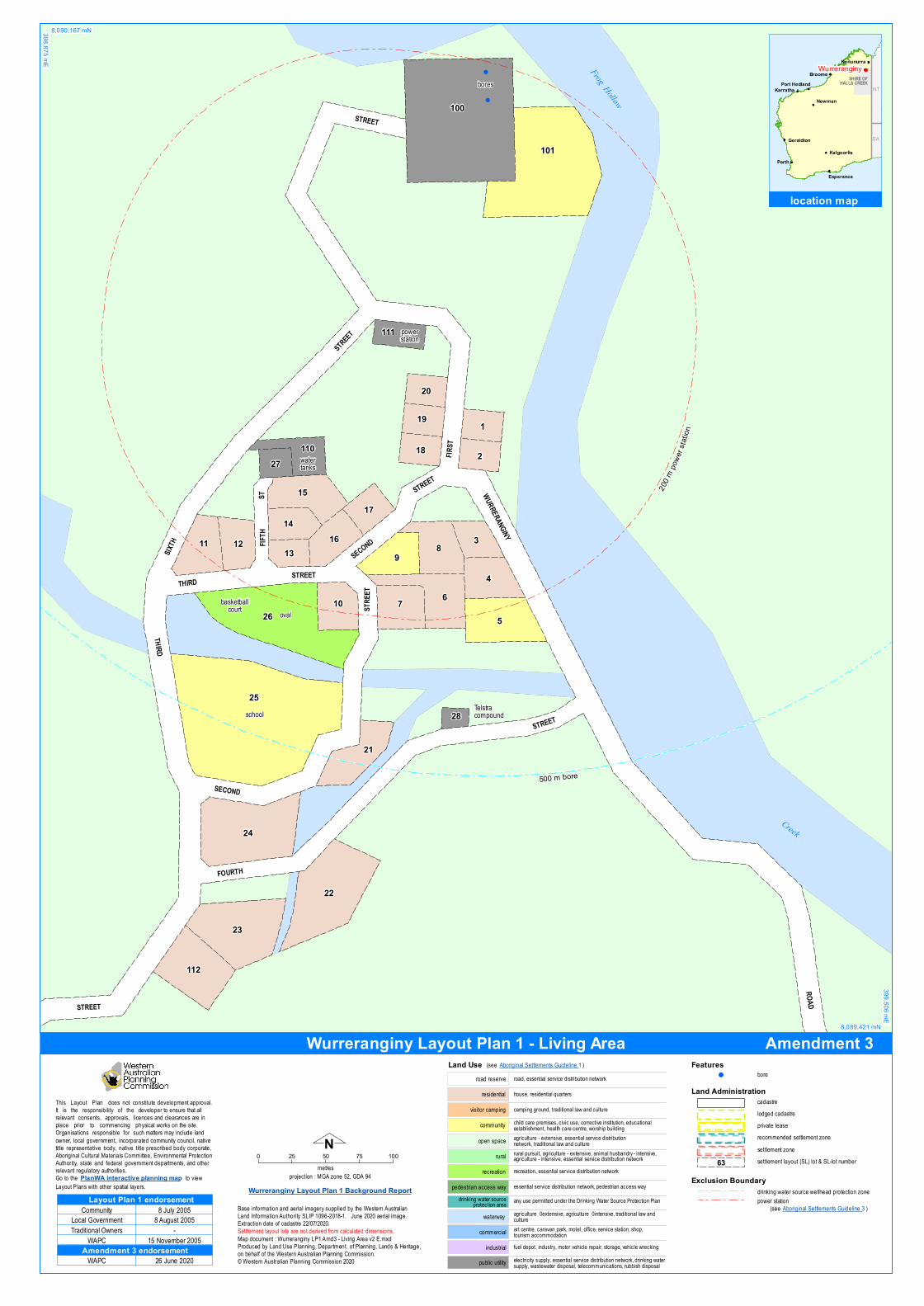
elec tric ity su pply, essential service d istribu tion network, d rinking watersu pply, wastewater d isposal, telecom m u nic ations, ru bbish d isposalpu blic u tility
fu el depot, ind u stry, m otor veh ic le repair, storag e, veh ic le wrec kingind u strial
art centre, c aravan park, m otel, office, service station, sh op,tou rism ac c om m od ationcom m erc ial
essential service d istribu tion network, pedestrian ac cess waypedestrian ac cess way
recreation, essential service d istribu tion networkrec reation
ru ral pu rsu it, ag ric u ltu re - extensive, anim al h u sband ry - intensive,ag ric u ltu re - intensive, essential service d istribu tion networkru ral
c h ild care prem ises, c ivic u se, corrective institu tion, ed u c ationalestablish m ent, health c are centre, worsh ip bu ild ingcom m u nityag ric u ltu re - extensive, essential service d istribu tionnetwork, trad itional law and c u ltu reopen space
cam ping g rou nd, trad itional law and c u ltu revisitor c am ping
h ou se, residential qu artersresidential
road, essential service d istribu tion networkroad reserve
any u se perm itted u nder the Drinking Water Sou rce Protec tion Pland rinking water sou rceprotec tion area
Land Use (see Aborig inal Settlements Gu id eline 1)
ag ric u ltu re – extensive, ag ric u ltu re – intensive, trad itional law andc u ltu rewaterway
Nprojec tion : MGA zone 52, GDA 94
0 25 50 75 100m etres
Settlem ent layou t lots are not d erived from c alc u lated d im ensions.Map d oc u m ent : Wu rrerang iny LP1 Am d 3 - Living Area v2 E.mxdProd u ced by Land Use Planning , Departm ent. of Planning , Land s & Heritag e,on behalf of the Western Au stralian Planning Com m ission.© Western Au stralian Planning Com m ission 2020
Wurreranginy Layout Plan 1 Background Report
Land Administrationcad astrelod g ed c ad astreprivate leaserec om m end ed settlement zonesettlem ent zonesettlem ent layou t (SL) lot & SL-lot nu m ber63
Th is Layou t Plan d oes not constitu te developm ent approval.It is the responsibility of th e developer to ensu re th at allrelevant c onsents, approvals, licences and c learances are inplace prior to c om m enc ing ph ysic al works on the site.O rg anisations responsible for su c h m atters m ay inc lu d e landowner, local g overnm ent, inc orporated c om m u nity c ou nc il, nativetitle representative bod y, native title presc ribed bod y c orporate,Aborig inal Cu ltu ral Materials Com m ittee, Environm ental Protec tionAu th ority, state and federal g overnm ent departm ents, and otherrelevant reg u latory au th orities.Go to the PlanWA interactive planning map to viewLayou t Plans with oth er spatial layers.
Base inform ation and aerial im ag ery su pplied by the Western Au stralianLand Inform ation Au th ority SLIP 1096-2018-1. Ju ne 2020 aerial im ag e.Extrac tion d ate of cad astre 22/07/2020.
(see Aborig inal Settlements Gu id eline 3)
Exclusion Boundaryd rinking water sou rce wellhead protec tion zonepower station
Featuresbore!
WAPCAmendment 3 endorsement
26 Ju ne 2020
Com m u nity
Trad itional O wnersWAPC
Local Governm ent
Layout Plan 1 endorsement8 Ju ly 20058 Au g u st 2005
-15 November 2005
!
!
25
100
26
101
24
22
5
6
23
8
4
7
9
112
15
21
311
1
2
10
161214
17
18
19
20
110
13
111
27
28
200 m
powe
r stat
io n
500 m bore
oval
bores
sc h ool
basketballcou rt
watertanks
powerstation
Telstracom pou nd
Creek
Frog Hollow
ROAD
FIRST
SIXTH
FOURTH
STREET
WURRERANGINY
FIFTH
ST
SECOND
THIRD
STRE
ET
THIRD
STREET
STREET
STREET
STREET
STREET
SECOND
8,090,167 mN398,875 mE
399,506 mE
8,089,421 mN
location map
NT
SA
Perth
Broome
Karratha
Geraldton
Port Hedland
Kalgoorlie
Kununurra
NewmanAli ce
Sp rings
Esperance
NT
SA
SHIRE OFHALLS CREEK
Wurreranginy
Amendment 3Wurreranginy Layout Plan 1 - Living Area
Nprojec tion : MGA zone 52, GDA 94
0 50 100 150 200 250m etres
Settlem ent layou t lots are not d erived from c alc u lated d im ensions.Map d oc u m ent : Wu rrerang iny LP1 Am d 3 - Context v2 E.mxdProd u ced by Land Use Planning , Departm ent. of Planning , Land s & Heritag e,on behalf of the Western Au stralian Planning Com m ission.© Western Au stralian Planning Com m ission 2020
Land Administrationcad astrelod g ed c ad astreprivate leaserec om m end ed settlement zonesettlem ent zonesettlem ent layou t (SL) lot & SL-lot nu m ber63
Th is Layou t Plan d oes not constitu te developm ent approval.It is the responsibility of th e developer to ensu re th at allrelevant c onsents, approvals, licences and c learances are inplace prior to c om m enc ing ph ysic al works on the site.O rg anisations responsible for su c h m atters m ay inc lu d e landowner, local g overnm ent, inc orporated c om m u nity c ou nc il, nativetitle representative bod y, native title presc ribed bod y c orporate,Aborig inal Cu ltu ral Materials Com m ittee, Environm ental Protec tionAu th ority, state and federal g overnm ent departm ents, and otherrelevant reg u latory au th orities.Go to the PlanWA interactive planning map to viewLayou t Plans with oth er spatial layers.
Base inform ation and aerial im ag ery su pplied by the Western Au stralianLand Inform ation Au th ority SLIP 1096-2018-1. Ju ne 2020 aerial im ag e.Extrac tion d ate of cad astre 22/07/2020.
elec tric ity su pply, essential service d istribu tion network, d rinking watersu pply, wastewater d isposal, telecom m u nic ations, ru bbish d isposalpu blic u tility
fu el depot, ind u stry, m otor veh ic le repair, storag e, veh ic le wrec kingind u strial
art centre, c aravan park, m otel, office, service station, sh op,tou rism ac c om m od ationcom m erc ial
essential service d istribu tion network, pedestrian ac cess waypedestrian ac cess way
recreation, essential service d istribu tion networkrec reation
ru ral pu rsu it, ag ric u ltu re - extensive, anim al h u sband ry - intensive,ag ric u ltu re - intensive, essential service d istribu tion networkru ral
c h ild care prem ises, c ivic u se, corrective institu tion, ed u c ationalestablish m ent, health c are centre, worsh ip bu ild ingcom m u nityag ric u ltu re - extensive, essential service d istribu tionnetwork, trad itional law and c u ltu reopen space
cam ping g rou nd, trad itional law and c u ltu revisitor c am ping
h ou se, residential qu artersresidential
road, essential service d istribu tion networkroad reserve
any u se perm itted u nder the Drinking Water Sou rce Protec tion Pland rinking water sou rceprotec tion areaag ric u ltu re – extensive, ag ric u ltu re – intensive, trad itional law andc u ltu rewaterway
Land Use
Exclusion Boundaryd rinking water sou rce wellhead protec tion zone
Featuresbore!
WAPCAmendment 3 endorsement
26 Ju ne 2020
Com m u nity
Trad itional O wnersWAPC
Local Governm ent
Layout Plan 1 endorsement8 Ju ly 20058 Au g u st 2005
-15 November 2005
!
!
500 mbor e
42
100101
41
bores
cem etery
ru bbishtip
Creek
Frog Hollow
HIGHWAY
ROAD
GREAT N
ORTHERN
THIRD
FIRST
SIXTH
STREET
FOURTH
WURRERANGINYSTREET
STREET
STRE
ET
THIRD
ST
8,090,362 mN398,403 mE
399,938 mE
8,088,545 mN
location map
NT
SA
Perth
Broome
Karratha
Geraldton
Port Hedland
Kalgoorlie
Kununurra
NewmanAli ce
Sp rings
Esperance
NT
SA
SHIRE OFHALLS CREEK
Wurreranginy
Amendment 3Wurreranginy Layout Plan 1 - Context
Nprojection : MGA zone 52, GDA 94
0 0.5 1 1.5kilometres
Settlement layout lots are not derived from calculated dimensions.Base information supplied by the Western Australian Land Information AuthoritySLIP 1096-2018-1. Extraction date of cadastre 22/07/2020.
Map document : Wurreranginy LP1 Amd3 - Land Tenure v2 E.mxdProduced by Land Use Planning, Department. of Planning, Lands & Heritage,on behalf of the Western Australian Planning Commission.© Western Australian Planning Commission 2020
This Layout Plan does not constitute development approval.It is the responsibility of the developer to ensure that allrelevant consents, approvals, licences and clearances are inplace prior to commencing physical works on the site.Organisations responsible for such matters may include landowner, local government, incorporated community council, nativetitle representative body, native title prescribed body corporate,Aboriginal Cultural Materials Committee, Environmental ProtectionAuthority, state and federal government departments, and otherrelevant regulatory authorities.Go to the PlanWA interactive planning map to viewLayout Plans with other spatial layers.
bench mark & namestandard survey mark & name
Geodetic Survey Marks
.
&—
Land Administrationcadastrelodged cadastreprivate leaserecommended settlement zonesettlement zonesettlement layout (SL) lot
Land Tenurecrown reservecrown reserve - Aboriginal Lands TrustDepartment of Biodiversity, Conservation & Attractions managedfreeholdleaseholdotherpastoral lease
unallocated crown landwater reserve
pastoral lease - Aboriginal Lands Trust
WAPCAmendment 3 endorsement
26 June 2020
Community
Traditional OwnersWAPC
Local Government
Layout Plan 1 endorsement8 July 2005
8 August 2005-
15 November 2005
_
.
.
.
.
.
.
.
.
.
.
.
.
.
.
.
SSM R 21
SSM DG 21
SSM DIXON RANGE 29
SSM DIXON RANGE 112
SSM DIXON RANGE 111
SSM DIXON RANGE 110
SSM DIXON RANGE 109
SSM DIXON RANGE 108
SSM DIXON RANGE 106
SSM DIXON RANGE 105
SSM DIXON RANGE 104
SSM DIXON RANGE 103
SSM DIXON RANGE 102
SSM DIXON RANGE 107
BM 10(DIX)
lot 44Crown reserve 13944
lot 44Crown reserve 13944
lot 60Pastoral lease PL N050285Texas Downs Mabel Downs
lot 60Pastoral lease PL N050285Texas Downs Mabel Downs
8,095,167 mN395,056 mE
403,965 mE
8,084,625 mN
Wurreranginy AboriginalCorporation lease
Baulu-Wah AboriginalCorporation lease
Wurreranginy
location map
NT
SA
Perth
Broome
Karratha
Geraldton
Port Hedland
Kalgoorlie
Kununurra
NewmanAli ce
Sp rings
Esperance
NT
SA
SHIRE OFHALLS CREEK
Wurreranginy
Amendment 3Wurreranginy Layout Plan 1 - Land Tenure
Recommended