Watershed Management Ordinance
Effective
May 1, 2014
As amended
May 16, 2019

[This page is intentionally blank.]

METROPOLITAN WATER RECLAMATION DISTRICT OF GREATER CHICAGO 100 EAST ERIE STREET
CHICAGO, ILLINOIS 60611 (312) 751-5600
BOARD OF COMMISSIONERS Hon. Kari K. Steele, President
Hon. Barbara J. McGowan, Vice President Hon. Frank Avila, Chairman of Finance
Hon. Cameron Davis Hon. Kimberly Du Buclet Hon. Marcelino Garcia
Hon. Josina Morita Hon. Debra Shore
Hon. Mariyana T. Spyropoulos
OFFICERS Brian A. Perkovich, Executive Director
Mary Ann Boyle, Treasurer Darlene A. LoCascio, Director of Procurement and Materials Management
Susan T. Morakalis, General Counsel John P. Murray, Director of Maintenance and Operations
Catherine O’Connor, Ph.D., Director of Engineering Edward Podczerwinski, Director of Monitoring and Research
Beverly K. Sanders, Director of Human Resources John Sudduth, Director of Information Technology
Jacqueline Torres, Clerk/Director of Finance
Board of Commissioners and Officers listed as of the date of amendment – May 16, 2019
AN ORDINANCE
AN ORDINANCE HEREINAFTER KNOWN AS THE “WATERSHED MANAGEMENT ORDINANCE,” ADOPTED
BY THE BOARD OF COMMISSIONERS, METROPOLITAN WATER RECLAMATION DISTRICT OF GREATER
CHICAGO, ON OCTOBER 3, 2013 AND AS AMENDED TO, AND INCLUDING, APRIL 17, 2014, MAY 1, 2014,
JULY 10, 2014, FEBRUARY 15, 2018, APRIL 4, 2019, AND MAY 16, 2019.

[This page is intentionally blank.]

Table of Contents
ARTICLE 1. AUTHORITY AND PURPOSE ............................................................................................. 1-1
§ 100. Statutory Authority ........................................................................................................................ 1-1
§ 101. Cook County Stormwater Management Plan ................................................................................ 1-1
§ 102. Considerations................................................................................................................................ 1-1
§ 103. Purposes of this Ordinance ............................................................................................................ 1-2
§ 104. Relationship to the Sewer Permit Ordinance and Manual of Procedures ..................................... 1-4
ARTICLE 2. APPLICABILITY AND GENERAL PROVISIONS ..................................................................... 2-1
§ 200. Scope of Regulation ....................................................................................................................... 2-1
§ 201. Applicability .................................................................................................................................... 2-2
§ 202. Interpretation ................................................................................................................................. 2-5
§ 203. Disclaimer of Liability ..................................................................................................................... 2-5
§ 204. Severability ..................................................................................................................................... 2-5
§ 205. Right of Access ............................................................................................................................... 2-6
§ 206. National Flood Insurance Program Eligibility ................................................................................. 2-6
§ 207. Multi-County Municipalities ........................................................................................................... 2-6
§ 208. Study of Current Provisions of and Potential Amendments to this Ordinance ............................. 2-7
§ 209. Amendments .................................................................................................................................. 2-8
§ 210. Effective Date ................................................................................................................................. 2-8
ARTICLE 3. WATERSHED MANAGEMENT PERMIT REQUIREMENTS AND SUBMITTALS ........................ 3-1
§ 300. General Requirements and Limitation ........................................................................................... 3-1
§ 301. Permit Fees ..................................................................................................................................... 3-2
§ 302. Watershed Management Permit Application Submittal ................................................................ 3-3
§ 303. Plan Set and Exhibits Submittal ...................................................................................................... 3-7
§ 304. Terms of Permit/Denial - Appeal ................................................................................................. 3-10
§ 305. Construction Timeline Requirements and Approval of Plan Revisions ........................................ 3-10
§ 306. Record Drawings .......................................................................................................................... 3-11
§ 307. Recordation and Obligations of a Watershed Management Permit ........................................... 3-11
ARTICLE 4. REQUIREMENTS FOR EROSION AND SEDIMENT CONTROL ............................................... 4-1
§ 400. Erosion and Sediment Control General Requirements .................................................................. 4-1

§ 401. Temporary Erosion and Sediment Control Requirements ............................................................. 4-1
§ 402. Permanent Erosion Control Requirements .................................................................................... 4-4
ARTICLE 5. REQUIREMENTS FOR STORMWATER MANAGEMENT ...................................................... 5-1
§ 500. General Site Development and Stormwater Management Information ....................................... 5-1
§ 501. General Site Development and Stormwater Management Requirements.................................... 5-1
§ 502. Runoff Requirements ..................................................................................................................... 5-2
§ 503. Volume Control Requirements....................................................................................................... 5-5
§ 504. Detention Requirements ................................................................................................................ 5-8
§ 505. Development and Redevelopment Tributary to Existing Detention Facilities ............................. 5-13
ARTICLE 6. REQUIREMENTS FOR FLOOD PROTECTION AREAS ........................................................... 6-1
§ 600. Flood Protection Areas ................................................................................................................... 6-1
§ 601. Requirements for Floodplain, Floodway, and Flood Protection Elevation Determination ............ 6-1
§ 602. Requirements for Development within the Floodplain ................................................................. 6-3
§ 603. Requirements for Wetland Boundary, Quality, and Buffer Width Determination ........................ 6-7
§ 604. Requirements for Development Affecting the Function of Wetlands and Wetland Buffers ....... 6-10
§ 605. Wetland Banking .......................................................................................................................... 6-15
§ 606. Riparian Environments Requirements ......................................................................................... 6-15
§ 607. Requirements for Development Affecting the Function of Riparian Environments .................... 6-17
ARTICLE 7. REQUIREMENTS FOR SEWER CONSTRUCTION ................................................................. 7-1
§ 700. General Sewer Construction Requirements ................................................................................... 7-1
§ 701. Qualified Sewer Construction ........................................................................................................ 7-2
§ 702. Qualified Sewer Construction Requirements ................................................................................. 7-3
ARTICLE 8. INFILTRATION / INFLOW CONTROL PROGRAM ................................................................ 8-1
§ 800. Introduction ................................................................................................................................... 8-1
§ 801. Scope and Goals ............................................................................................................................. 8-1
§ 802. Applicability .................................................................................................................................... 8-2
§ 803. General Requirements ................................................................................................................... 8-2
§ 804. Short Term Requirements .............................................................................................................. 8-2
§ 805. Long Term O&M Program .............................................................................................................. 8-4
§ 806. Annual Reporting ........................................................................................................................... 8-5

§ 807. Non-Compliance ............................................................................................................................. 8-6
§ 808. Administrative Proceedings: Notice of Non-Compliance ............................................................... 8-7
§ 809. Administrative Proceedings: Show Cause before the Board of Commissioners ............................ 8-8
§ 810. Notice of Show Cause..................................................................................................................... 8-8
§ 811. Show Cause Hearing and Imposition of Penalties by the Board of Commissioners ...................... 8-8
§ 812. Legal and Equitable Relief .............................................................................................................. 8-9
§ 813. Injunctive Relief ............................................................................................................................ 8-10
§ 814. Judicial Review ............................................................................................................................. 8-10
ARTICLE 9. MAINTENANCE .............................................................................................................. 9-1
§ 900. General Maintenance Requirements ............................................................................................. 9-1
§ 901. Permitted Facility Operation and Maintenance............................................................................. 9-1
§ 902. Maintenance Requirements for Stormwater Projects with No Permittee .................................... 9-2
ARTICLE 10. INSPECTIONS .............................................................................................................. 10-1
§ 1000. General ....................................................................................................................................... 10-1
§ 1001. Inspection Requirements to be met by Development ............................................................... 10-1
§ 1002. Special Requirements for Qualified Sewer Construction ........................................................... 10-2
§ 1003. Request for Final Inspection ...................................................................................................... 10-3
ARTICLE 11. VARIANCES ................................................................................................................ 11-1
§ 1100. Authority .................................................................................................................................... 11-1
§ 1101. Petition for Variance .................................................................................................................. 11-1
§ 1102. Notice of Petition ....................................................................................................................... 11-2
§ 1103. Standards ................................................................................................................................... 11-3
§ 1104. Submission of Written Comments ............................................................................................. 11-4
§ 1105. Determination by the District .................................................................................................... 11-5
§ 1106. Conditions .................................................................................................................................. 11-6
ARTICLE 12. PROHIBITED ACTS, ENFORCEMENT, AND PENALTIES .................................................... 12-1
§ 1200. Prohibited Acts ........................................................................................................................... 12-1
§ 1201. Administrative Proceedings: Notice of Violation ....................................................................... 12-1
§ 1202. Administrative Proceedings: Show Cause Before the Board of Commissioners ....................... 12-3
§ 1203. Notice of Show Cause ................................................................................................................ 12-4

§ 1204. Show Cause Hearing and Imposition of Civil Penalties by the Board of Commissioners........... 12-4
§ 1205. Revocation of Watershed Management Permits....................................................................... 12-6
§ 1206. Stop-Work Order ........................................................................................................................ 12-6
§ 1207. Additional Remedies for Flood Protection Areas ....................................................................... 12-7
§ 1208. Legal and Equitable Relief .......................................................................................................... 12-7
§ 1209. Injunctive Relief .......................................................................................................................... 12-8
ARTICLE 13. APPEALS .................................................................................................................... 13-1
§ 1300. Right to Appeal ........................................................................................................................... 13-1
§ 1301. Appeals to the Director of Engineering ...................................................................................... 13-1
§ 1302. Appeals to the Board of Commissioners .................................................................................... 13-2
ARTICLE 14. ADMINISTRATION ...................................................................................................... 14-1
§ 1400. Responsibility for Administration ............................................................................................... 14-1
§ 1401. Role of the District ..................................................................................................................... 14-1
§ 1402. Role of an Authorized Municipality ............................................................................................ 14-2
§ 1403. Procedure for Authorization ...................................................................................................... 14-4
§ 1404. District Oversight of Authorized Municipalities ......................................................................... 14-5
§ 1405. Representative Capacity ............................................................................................................ 14-6
Signature Page
Appendix A Definitions
Appendix B Watershed Specific Release Rates
Appendix C Legacy Sewer Permit Ordinance and Manual of Procedures for the Administration of
the Sewer Permit Ordinance
Appendix D U.S. Army Corps of Engineers Watershed Services Areas
Appendix E Watershed Planning Areas
Appendix F Permit Fees
Appendix G Existing Intergovernmental Agreements

______________________________________________________________________________
ARTICLE 1. AUTHORITY AND PURPOSE
Page 1-1
ARTICLE 1. AUTHORITY AND PURPOSE
§ 100. Statutory Authority
1. This Ordinance shall be known and may be cited as the Watershed Management
Ordinance (Ordinance).
2. The Metropolitan Water Reclamation District of Greater Chicago (District) promulgates
this Ordinance pursuant to its authority to adopt ordinances regulating sewers tributary
to the District’s water reclamation facilities, regulating floodplain and stormwater
management, and governing the location, width, course, and release rate of all
stormwater runoff channels, streams, and basins in Cook County, over which the District
has jurisdiction, in accordance with the adopted Cook County Stormwater Management
Plan (CCSMP). The statutory authority for this Ordinance is contained in
55 ILCS 5/5-1062.1, 70 ILCS 2605/1 et seq., and particularly 70 ILCS 2605/7f, 70 ILCS 2605/7h,
70 ILCS 2605/12, as well as other applicable authority, all as amended from time to time.
3. An authorized municipality, as defined in Article 14 of this Ordinance, may adopt this
Ordinance pursuant to its authority to adopt ordinances regulating floodplain and
stormwater management and governing the location, width, course, and release rate of all
stormwater runoff channels, streams, and basins in the authorized municipality, over
which the authorized municipality has jurisdiction. The statutory authority for an
authorized municipality to adopt this Ordinance is contained in the Illinois Municipal Code,
65 ILCS 5/1 et seq., as well as other applicable authority, all as amended from time to time.
§ 101. Cook County Stormwater Management Plan
The District’s Board of Commissioners adopted the CCSMP on February 15, 2007. This Ordinance
is a component of the countywide stormwater management program presented in the CCSMP.
Other components of the countywide stormwater management program include the Detailed
Watershed Plans (DWPs) for the major watersheds of Cook County. The CCSMP and DWPs are
available on the District’s website, www.mwrd.org.
§ 102. Considerations
The District considered numerous factors in the creation of this Ordinance, including, but not limited to:
1. Inappropriate floodplain uses and development have increased flood risk, flood damage,
and environmental degradation;
2. It is necessary to consider stormwater management on a watershed basis;
3. Cook County lands drain poorly due to generally flat topography and soils of low permeability;

______________________________________________________________________________
ARTICLE 1. AUTHORITY AND PURPOSE
Page 1-2
4. Many land development practices alter the natural hydrologic balance of Cook County streams;
5. Wetlands play an essential role in flood storage, floodplain management, sediment
control, and water quality enhancement;
6. Riparian environments may be effective in reducing flow rates and volumes in addition
to providing stream bank erosion protection and water quality enhancements;
7. Many stormwater facilities are not adequately maintained;
8. While the District has required stormwater detention in separate sewer areas since 1972 via
the Sewer Permit Ordinance, flooding continues to be a concern in Cook County due to the
increased volume and rate of stormwater runoff resulting from continued development;
9. Stormwater detention requirements for new developments alone do not address the
impacts of transportation and other improvements; and
10. Infiltration and inflow contributes to basement backups, sanitary sewer overflows, and
excessive flows to the District’s water reclamation facilities.
§ 103. Purposes of this Ordinance
The purpose of this Ordinance is to effectuate the purposes and intent of the Metropolitan Water
Reclamation District Act (70 ILCS 2605/1 et seq.) by:
1. Protecting the public health, safety, and welfare, and reducing the potential for loss of
property due to flood damage;
2. Managing and mitigating the effects of urbanization on stormwater drainage throughout
Cook County;
3. Protecting existing and new development by minimizing the increase of stormwater
runoff volume beyond that experienced under existing conditions and by reducing peak
stormwater flows;
4. Promoting responsible land use practices in Cook County, particularly within floodplains
and floodways;
5. Protecting existing water resources, including lakes, streams, floodplains, wetlands, and
groundwater from detrimental and unnecessary modification in order to maintain their
beneficial functions;
6. Reducing or mitigating the environmentally detrimental effects of existing and future
runoff in order to improve and maintain water quality;

______________________________________________________________________________
ARTICLE 1. AUTHORITY AND PURPOSE
Page 1-3
7. Preserving and enhancing existing riparian environments;
8. Controlling erosion and the discharge of sediment from all sources including, but not
limited to, stormwater facilities, waterways, developments, and construction sites;
9. Requiring appropriate and adequate provisions for site runoff control;
10. Requiring consistency in stormwater management activities within and among the units
of government having stormwater management jurisdiction;
11. Ensuring future development in the floodplain does not adversely affect floodplain
environments or increase the potential for flood damage;
12. Requiring regular, planned maintenance of stormwater management facilities;
13. Encouraging control of stormwater quantity and quality at the most site-specific or local level;
14. Establishing uniform and minimum countywide stormwater management regulations
while recognizing and coordinating with stormwater programs effectively operating
within Cook County;
15. Requiring strict compliance with and enforcement of this Ordinance;
16. Meeting the floodway permitting requirements of the Illinois Department of Natural Resources,
Office of Water Resources, delineated in the Rivers, Lakes, and Streams Act (615 ILCS 5/18g);
17. Meeting or exceeding the rules and regulations of the National Flood Insurance Program
(NFIP) for development;
18. Protecting the ability of the District’s sewerage systems, intercepting sewers, TARP
structures, sewage disposal and treatment plants, works and facilities to perform the
functions for which they were designed;
19. Controlling the nature, volume, and manner of discharge into the District’s sewerage
systems, intercepting sewers, TARP structures, sewage disposal and treatment plants,
works, and facilities;
20. Maintaining stable operation of the District’s sewerage systems, intercepting sewers,
TARP structures, sewage disposal and treatment plants, works, and facilities;
21. Reducing infiltration and inflow into the District’s sewerage systems, intercepting sewers,
TARP structures, sewage disposal and treatment plants, works, and facilities; and
22. Protecting waters within Cook County so as to preserve the public health.

______________________________________________________________________________
ARTICLE 1. AUTHORITY AND PURPOSE
Page 1-4
§ 104. Relationship to the Sewer Permit Ordinance and Manual of Procedures
1. Permittees and co-permittees that have Sewerage System Permits issued shall retain all
rights, obligations and liabilities under the Sewer Permit Ordinance and the Manual of
Procedures for the Administration of the Sewer Permit Ordinance (Manual of
Procedures) as they existed prior to their repeal.
2. The Sewer Permit Ordinance and its companion ordinance, the Manual of Procedures,
were repealed effective May 1, 2014. (See District Ordinance repealing the Sewer Permit
Ordinance and the Manual of Procedures for the Administration of the Sewer Permit
Ordinance, April 17, 2014).
3. The requirements related to the regulation, permitting, and enforcement of qualified
sewer construction are now contained in Article 7 of this Ordinance.

______________________________________________________________________________
ARTICLE 2. APPLICABILITY AND GENERAL PROVISIONS
Page 2-1
ARTICLE 2. APPLICABILITY AND GENERAL PROVISIONS
§ 200. Scope of Regulation
1. This Ordinance applies to all development within the boundaries of Cook County, Illinois
and qualified sewer construction within the District’s corporate boundaries or service
agreement areas, over which the District has jurisdiction as described in §100.2 of this
Ordinance, including those projects under the control of any governmental entity,
agency, or authority.
2. Any person proposing a project that falls under any of the categories set forth in §201 of
this Ordinance shall obtain a Watershed Management Permit prior to the start of the
project.
3. The requirements for sewer construction contained within Article 7 of this Ordinance
supersede the requirements of the repealed Sewer Permit Ordinance and the Manual of
Procedures, which make up Appendix C of this Ordinance. Any person proposing to
install qualified sewer within the District’s corporate limits or service agreement areas,
as detailed under Article 7 of this Ordinance, shall obtain a Watershed Management
Permit prior to commencing sewer work.
4. The provisions of this Ordinance shall not apply to any of the following:
A. Agriculture and gardening activities that do not involve filling, grading, or
construction of levees;
B. Structures and land uses existing as of the effective date of this Ordinance, except
when redevelopment occurs;
C. Projects solely within Lake Michigan, certified by a Professional Geologist or
Structural or Professional Engineer, licensed in the State of Illinois, that has
obtained approval from the Corps and IDNR-OWR and does not include qualified
sewer;
D. Projects within the corporate boundaries of the City of Chicago, Illinois except for
any of the following:
(1) New or reconstructed outfalls to waterways or Lake Michigan; and
(2) Direct connections to District interceptors, TARP structures, facilities, or
District property;

______________________________________________________________________________
ARTICLE 2. APPLICABILITY AND GENERAL PROVISIONS
Page 2-2
E. Projects listed in §201.1, §201.2.E, and §201.2.F of this Ordinance that are within
the corporate boundaries of a multi-county municipality, which has adopted and
currently enforces the stormwater ordinance of a contiguously adjacent Illinois
county subject to the requirements of §207 of this Ordinance;
F. Projects listed solely in §201.1 of this Ordinance that are undertaken by state or
federal agencies (e.g. IDOT, Illinois Tollway Authority, or the Corps);
G. Projects listed solely in §201.1 of this Ordinance that are undertaken as a flood
control project; or
H. Projects undertaken by the District.
5. Existing structures that do not conform to the requirements of this Ordinance shall not
be substantially improved, replaced, or enlarged in any manner unless such
improvements, replacements, or enlargements conform to the requirements of this
Ordinance.
§ 201. Applicability
1. A Watershed Management Permit from either the District or an authorized municipality
shall be required for any of the following projects:
A. Development within a Flood Protection Area;
B. Development with an indirect wetland impact;
C. Development of residential buildings within 100-feet of the regulatory
floodplain; and
D. Development greater than 0.5 acre, unless the development solely involves one
or more of the following:
(1) Single-family home development located outside of flood protection areas;
(2) Installation, renovation, or replacement of a septic system, potable water
service line, or other utility to serve an existing structure, provided that
the area is restored to existing grade and vegetative cover is restored;
(3) Excavation in public rights-of-way or public utility easements for the
purpose of installing or maintaining utilities other than qualified sewer,
provided that the area is restored to existing grade and vegetative cover is
restored. Utility excavation not requiring a Watershed Management
Permit must install and maintain adequate sediment and erosion control;

______________________________________________________________________________
ARTICLE 2. APPLICABILITY AND GENERAL PROVISIONS
Page 2-3
(4) Maintenance activities, repair, or at-grade in-kind replacement of existing
lawn areas not otherwise requiring a Watershed Management Permit,
provided that the area is restored to existing grade and vegetative cover is
restored; or
(5) Maintenance activities, repair, or in-kind replacement of existing
impervious areas including, but not limited to, roadways or parking lots
not otherwise requiring a Watershed Management Permit.
2. A Watershed Management Permit from the District shall be required for any of the
following projects:
A. Qualified sewer within a combined sewer area tributary to either a combined
sewer or a waterway;
B. Qualified sewer within the District corporate limits or service agreements areas;
C. Direct connections to District interceptors, reservoirs, facilities, or TARP
structures;
D. New or reconstructed outfalls to the waterways or Lake Michigan, within Cook
County;
E. Reconfiguration of existing major or minor stormwater systems that alters the
service area of a District permitted detention facility; and
F. Modifications to the control structure or storage volume of a District permitted
detention facility.

______________________________________________________________________________
ARTICLE 2. APPLICABILITY AND GENERAL PROVISIONS
Page 2-4
Table 1. Applicability Summary
Project Regulated Area Permitting
Authority Section
De
ve
lop
me
nt
Act
ivit
ies Development greater than 0.5 acre*
Cook County
Except City of Chicago
District or
Authorized
Municipality
§ 201.1.D
Reconfiguration of existing major or minor stormwater
systems that alters the service area of a District
permitted detention facility
Cook County
Except City of Chicago District § 201.2.E
Modifications to a District permitted detention facility Cook County
Except City of Chicago District § 201.2.F
Flo
od
Pro
tect
ion
Are
as Development within a flood protection area
Cook County
Except City of Chicago
District or
Authorized
Municipality
§ 201.1.A
Indirect impacts to a wetland Cook County
Except City of Chicago
District or
Authorized
Municipality
§ 201.1.B
Development of residential buildings within 100-feet of
the regulatory floodplain
Cook County
Except City of Chicago
District or
Authorized
Municipality
§ 201.1.C
Qu
ali
fie
d S
ew
er Qualified sewer within a combined sewer area
tributary to either a combined sewer or a waterway
District Corporate Limits
or Service Areas
Except City of Chicago
District § 201.2.A
Qualified sewer construction including lift stations
District Corporate Limits
or Service Areas
Except City of Chicago
District § 201.2.B
Dis
tric
t Im
pa
cts Direct connections to District interceptors, reservoirs,
facilities, or TARP Structures
Entire Cook County
Including City of Chicago+ District § 201.2.C
New or reconstructed outfalls to waterways or
Lake Michigan
Cook County
Including City of Chicago+ District § 201.2.D
* Unless the development solely involves one or more provision listed in §201.1.D.
+ Facility connection authorization shall be obtained.

______________________________________________________________________________
ARTICLE 2. APPLICABILITY AND GENERAL PROVISIONS
Page 2-5
§ 202. Interpretation
1. This Ordinance shall be liberally construed to protect the health, welfare, safety, and
environment of the residents of Cook County and to effectuate the purposes of this
Ordinance and enabling legislation.
2. Nothing contained in this Ordinance shall be understood to imply consent, licensing, or
permission to locate, construct, or maintain any structure, site, or facility, nor to carry on
any trade, industry, occupation, operation, or activity.
3. When provisions of this Ordinance differ or conflict with any other applicable statute,
law, ordinance, regulation, or rule, the more stringent provisions shall apply.
4. The provisions of this Ordinance are cumulative and shall be considered additional
limitations on all other laws and ordinances previously approved, or that may hereafter
be approved, and that concern any subject matter included in this Ordinance.
§ 203. Disclaimer of Liability
1. The degree of flood protection provided by this Ordinance is considered reasonable for
regulatory purposes and is based on engineering experience and scientific methods of study.
2. This Ordinance does not warrant that areas outside the delineated floodplain or permitted
projects within the delineated floodplain will be free from flooding and associated damages.
3. This Ordinance shall not be construed or applied in any manner to create liability on the
part of, or a cause of action against, the District, any municipality, or any elected official,
officer, agent, or employee thereof, for any damage or injury to person or property
resulting from reliance on the provisions of this Ordinance or from reading or interpreting
any map that is part of this Ordinance.
4. The design and supplementary design requirements contained herein do not replace nor
substitute sound engineering practice.
§ 204. Severability
1. The provisions of this Ordinance shall be severable in accordance with the following:
A. If any court of competent jurisdiction shall adjudge any provision of this Ordinance
invalid, such judgment shall not affect any other provisions of this Ordinance; and

______________________________________________________________________________
ARTICLE 2. APPLICABILITY AND GENERAL PROVISIONS
Page 2-6
B. If any court of competent jurisdiction shall adjudge invalid the application of any
provision of this Ordinance to a particular parcel of land, a particular structure, or
a particular project, such judgment shall not affect the application of said
provisions to any other parcel of land, structure, or project.
2. All such unaffected provisions of this Ordinance shall remain in full force and effect.
§ 205. Right of Access
1. Representatives of the District may, at all reasonable times during regular business hours
or upon notice, enter upon any project subject to this Ordinance for the purpose of
conducting periodic inspections to ensure compliance with this Ordinance or with a
Watershed Management Permit issued thereunder. The scope of the inspection,
including reviewing and copying of records, is limited to determining whether the project
is in compliance with all requirements and conditions of this Ordinance and/or
Watershed Management Permit.
2. The District may periodically inspect any mitigation measure at reasonable times and such
inspection shall be limited to determining whether the project is in compliance with all
requirements and conditions of this Ordinance and/or a Watershed Management Permit.
3. An inspection may also be conducted in accordance with Article 10 or Section 1201.5 of
this Ordinance.
§ 206. National Flood Insurance Program Eligibility
1. This Ordinance does not repeal any county/municipal ordinance or resolution passed in
order to establish eligibility for the National Flood Insurance Program (NFIP).
2. This Ordinance is not intended to supplement, replace, or remove any responsibility that
either Cook County or a municipality may have to maintain eligibility and good standing
in the NFIP. Proper administration and enforcement of the NFIP within participating
municipalities and counties is a requirement of the NFIP.
3. Floodplain requirements included in Article 6 of this Ordinance meet or exceed the NFIP
requirements as set forth under the Code of Federal Regulations (44 C.F.R.§ 59-60) for
development., This Ordinance does not encompass all NFIP requirements for a
municipality to maintain a compliant NFIP ordinance.
§ 207. Multi-County Municipalities
1. A multi-county municipality may adopt and enforce one of the following ordinances of
an adjacent county if the municipality has corporate area within that county:

______________________________________________________________________________
ARTICLE 2. APPLICABILITY AND GENERAL PROVISIONS
Page 2-7
A. The DuPage County Countywide Stormwater and Flood Plain Ordinance, as
amended from time to time by the DuPage County Board;
B. The Kane County Stormwater Ordinance, as amended from time to time by the
Kane County Board;
C. The Lake County Watershed Development Ordinance, as amended from time to
time by the Lake County Board;
D. The McHenry County Stormwater Management Ordinance, as amended from time
to time by the McHenry County Board; or
E. The Will County Stormwater Management Ordinance, as amended from time to
time by the Will County Board.
2. A Watershed Management Permit shall not be required from the District for any
development activity specified in §201.1, §201.2.E, and §201.2.F of this Ordinance within
a multi-county municipality, in which the multi-county municipality elects to adopt an
adjacent county’s ordinance as specified in §207.1 of this Ordinance and satisfies all of
the following requirements:
A. Has the authority to adopt an adjacent county’s ordinance;
B. Retains qualified staff per the adopted ordinance;
C. Enters into an intergovernmental agreement with the District; and
D. Administers and enforces the adopted ordinance per the requirements of the
adopted ordinance.
3. A multi-county municipality that has satisfied §207.2 and entered into an
intergovernmental agreement with the District is still required to obtain a Watershed
Management Permit from the District for all projects specified in §201.2.A-D of this
Ordinance.
4. A Watershed Management Permit shall be required from the District for all projects
specified in §201.1 and §201.2 of this Ordinance within a multi-county municipality that
has not entered into an intergovernmental agreement with the District.
§ 208. Study of Current Provisions of and Potential Amendments to this Ordinance
The District shall initiate a study of certain current provisions of and potential
amendments to this Ordinance. This study will be initiated by the end of 2019 with a
targeted completion date of May 2022. The study shall include the following areas:

______________________________________________________________________________
ARTICLE 2. APPLICABILITY AND GENERAL PROVISIONS
Page 2-8
1. A pilot study of a regional stormwater detention and volume control credit trading
program;
2. Impacts of watershed specific release rates on disproportionately impacted communities;
3. Impacts of release rates under existing and future development scenarios in collar
counties on watersheds in the District;
4. Impact of volume control and watershed specific release rates on stream erosion and
related water quality effects such as turbidity and sedimentation; and
5. Board of Commissioners shall consider the study in May 2022.
§ 209. Amendments
Amendments to this Ordinance shall become effective when adopted by the District’s
Board of Commissioners.
§ 210. Effective Date
This Ordinance shall be effective on May 1, 2014.

______________________________________________________________________________
ARTICLE 3. WATERSHED MANAGEMENT PERMIT REQUIREMENTS AND SUBMITTALS
Page 3-1
ARTICLE 3. WATERSHED MANAGEMENT PERMIT REQUIREMENTS AND
SUBMITTALS
§ 300. General Requirements and Limitation
1. The issuance of a Watershed Management Permit does not:
A. Convey any property rights or any exclusive privilege;
B. Authorize any injury to private property or invasion of private rights; or
C. Release the applicant from liability for damage to persons or property resulting
from the work covered by the permit.
2. The Watershed Management Permit application and plan set submittals shall be certified
by a Professional Engineer, indicating that the technical submittal meets the criteria
required by this Ordinance.
3. The Watershed Management Permit application shall include the name(s), legal
address(es), and original signature(s) of the applicants attesting to the understanding of
the requirements and intent to comply with this Ordinance, according to the following;
A. For projects located within a municipality’s corporate limits, both the permittee
and co-permittee(s) must sign the Watershed Management Permit application;
B. For projects located in unincorporated areas, the co-permittee(s) must sign the
permit application and the permittee (Cook County) is requested to sign the permit
application. The co-permittee must comply with the following requirements;
(1) For projects which include qualified sanitary sewer work without a
permittee, the Watershed Management Permit may be issued under a
sole permittee status, and must demonstrate all of the following:
(a) The area to be served is outside the jurisdiction of any local sanitary
district, township, or public utility company which is certified for
such service;
(b) The facilities to be served are for the sole and exclusive use of the
property owner, and no sewer extension is contemplated for other
private users;
(c) Evidence of responsibility, as determined by the District’s Board of
Commissioners;

______________________________________________________________________________
ARTICLE 3. WATERSHED MANAGEMENT PERMIT REQUIREMENTS AND SUBMITTALS
Page 3-2
(d) Compliance with the administrative requirements in the TGM; and
(e) The permit must be recorded with the Cook County Recorder of
Deeds according to §307 of this Ordinance.
(2) For projects that involve development, the co-permittee must adhere to
the additional maintenance requirements in §902 of this Ordinance. The
permit must be recorded with the Cook County Recorder of Deeds
according to §307 of this Ordinance.
4. Prior to commencing construction, the applicant shall secure all appropriate approvals
from local, state, regional, and federal authorities or their designee, including, but not
limited to, OWR, the Corps, IEPA, and FEMA.
5. Applicants proposing runoff at a location on or adjacent to holdings or property of Forest
Preserve District of Cook County (FPD) shall contact FPD for review of the proposed work
to determine stormwater impacts to FPD property and methods to reduce or eliminate
any adverse impacts. Refer to the TGM for further details.
6. Either the District or relevant authorized municipality shall make the final determination
that all pertinent information is submitted by the applicant to allow for Watershed
Management Permit review and/or issuance. Additional information or calculations may
be requested from the applicant by either the District or authorized municipality to
ensure compliance with this Ordinance.
7. Any error or omission in the approved Watershed Management Permit documents shall
not relieve the applicant from any requirement of this Ordinance.
§ 301. Permit Fees
1. The District shall establish a schedule of permit fees in accordance with the provisions of
this Ordinance, which may be amended from time to time. The Schedule of permit fees
is included in Appendix F of this Ordinance.
2. An authorized municipality may establish a schedule of permit fees in accordance with
the provisions of this Ordinance, which may be amended from time to time.
3. Fees shall be based upon the costs either the District or authorized municipality incurs
for all aspects of the permitting process, including, but not limited to, review of permit
applications and inspections.

______________________________________________________________________________
ARTICLE 3. WATERSHED MANAGEMENT PERMIT REQUIREMENTS AND SUBMITTALS
Page 3-3
4. The applicant shall pay all relevant permit fees at the time of application for a Watershed
Management Permit. Permit fees shall be refunded if the permit application is cancelled
subject to the conditions of §1401.3 of this Ordinance. Base fees, and other completed
review fees, are considered non-refundable.
§ 302. Watershed Management Permit Application Submittal
The Watershed Management Permit submittal shall include the permit application and all of
the following when applicable:
1. A general narrative description of the proposed project that shall include:
A. The common address and legal description of the property holdings where the
project will take place;
B. Project type, which includes Single-Family Homes, Residential Subdivisions,
Multi-Family Residential, Non-Residential, Right-of-Way, and Open Space;
C. Size of the property holdings where the project will take place;
D. Size of the proposed project;
E. A statement from either a Professional Engineer or Wetland Specialist when
flood protection areas are not present within:
(1) The project area;
(2) The property holdings; or
(3) 100 feet beyond the project area, including areas not located within the
property holdings.
2. The following submittals, as detailed in Article 3 of the TGM:
A. The Erosion and Sediment Control Submittal, including:
(1) Schedule P signed by the co-permittee; and
(2) A narrative of the erosion and sediment control plan that describes all
measures appropriate for the project such that all the requirements of
Article 4 of this Ordinance are met.
B. The Stormwater Management Submittal, including:

______________________________________________________________________________
ARTICLE 3. WATERSHED MANAGEMENT PERMIT REQUIREMENTS AND SUBMITTALS
Page 3-4
(1) The applicable Schedule D or Schedule D-Legacy with applicable
supporting calculations, signed and sealed by a Professional Engineer;
(2) The runoff plan for the development that describes all measures
appropriate to meet the requirements of §502 of this Ordinance;
(3) A volume control plan that describes all measures appropriate for the
development in accordance with §503 of this Ordinance;
(4) A detention facility plan that describes all measures appropriate for the
development in accordance with §504 or §505 of this Ordinance;
(5) Schedule K (Disclosure of Property Interests), signed and notarized by the
applicant and Notary Public, respectively, if the aggregate total area of
property and all other lands contiguous to said property in which the
applicant has property interest is less than the stormwater detention
threshold stipulated under Table 2 in §501 of this Ordinance; and
(6) Schedule L (Notice of Requirements for Stormwater Detention), signed
and notarized by the applicant and Notary Public, respectively, for
property holdings requiring detention in which there are previously
undeveloped property holdings areas not included in the detention
calculations.
C. The Floodplain Submittal for development associated with a floodplain and/or
floodway designated in §601 of this Ordinance, including:
(1) Schedule H and applicable supporting calculations, signed and sealed by a
Professional Engineer;
(2) A narrative description of the proposed project within the limits of the
floodplain and floodway, and details of floodproofing measures including
material specifications, construction methods, and calculations;
(3) A determination of the BFE and FPE, including the source of the
determination, in accordance with §601.4 and §601.9 of this Ordinance;
(4) A copy of the Cook County FIS Floodway Data Table, if available;
(5) Revisions to FIRM(s) including all hydrologic and hydraulic calculations,
modeling, and all CLOMR/LOMR applications;
(6) Floodplain fill and compensatory storage calculations in accordance with
§602.5, §602.6, and §602.7 of this Ordinance; and

______________________________________________________________________________
ARTICLE 3. WATERSHED MANAGEMENT PERMIT REQUIREMENTS AND SUBMITTALS
Page 3-5
(7) Calculations or analyses that demonstrate compliance with §602.22 of this
Ordinance for development in the floodway.
D. The Wetland Submittal for any development associated with a wetland
designated in §603 of this Ordinance, including:
(1) Schedule W, signed by a Wetland Specialist;
(2) Copies of the following forms of correspondence from the Corps:
(a) A Corps Jurisdictional Determination indicating that the impacted
wetland is not under the jurisdiction of the Corps; or
(b) If required by the Corps, a Section 404 permit application, all
associated correspondence, and a copy of the completed joint
application form (NCR Form 426, “Protecting Illinois Waters”)
signed by the applicant;
(3) The isolated wetland submittal for a standard isolated wetland that is less
than one-tenth of an acre (0.10 acre) in aggregate;
(4) The isolated wetland submittal for a high quality isolated wetland or a
standard isolated wetland greater than or equal to one-tenth of an acre
(0.10 acre) in aggregate;
(5) An isolated wetland delineation report consistent with the requirements
for wetland delineation provided in §603 of this Ordinance, including all
Corps “Routine Wetland Determination Data Form(s);” and
(6) If wetland mitigation is required, a wetland mitigation document shall be
developed in accordance with §604 of this Ordinance.
E. The Riparian Environment Submittal for any development associated with a
riparian environment designated in §606 of this Ordinance, including;
(1) Either Schedule H or Schedule W, signed by a Professional Engineer or
Wetland Specialist, respectively;
(2) A delineation of the riparian environments in accordance with §606.2 of
this Ordinance;
(3) If mitigation is required, a riparian environment mitigation document
must be developed in accordance with §607 and a plan in accordance with
§303.2.N of this Ordinance;

______________________________________________________________________________
ARTICLE 3. WATERSHED MANAGEMENT PERMIT REQUIREMENTS AND SUBMITTALS
Page 3-6
(4) For impacts to a Jurisdictional Waters of the U.S., provide a copy of one
of the following forms of correspondence from the Corps:
(a) A Letter of No Objection stating that no permit is necessary; or
(b) A Section 404 permit application from the Corps, all associated
correspondence and a copy of the completed joint application form
(NCR Form 426, “Protecting Illinois Waters”) signed by the
applicant or agent.
(5) For channel relocation, include documentation indicating that the length
of the mitigated channel is greater than or equal to the length of the
disturbed channel.
F. The Qualified Sewer Submittal for any qualified sewer construction, as
designated in Article 7 of this Ordinance, including:
(1) Schedules A, B, and C;
(2) Schedule E and applicable supporting calculations for new, reconstructed,
or modified public lift stations and/or forcemains;
(3) Schedules F and G and applicable supporting documentation for onsite
treatment or pre-treatment of industrial wastes;
(4) Schedule J, signed and notarized by the applicant and Notary Public,
respectively, for projects located in a municipality that has not adopted
ordinances requiring overhead plumbing and prohibiting footing drain
discharge into the sanitary sewer system. Said ordinances shall be filed
with the District.
(5) Schedule O for either of the following:
(a) Direct connections to District infrastructure; or
(b) New or reconstructed outfalls to waterways or Lake Michigan;
(6) All District required general notes, approved materials, applicable
standard details (or equivalent), technical requirements, and design
guidelines for qualified sewer construction available from the TGM;
(7) Population Equivalency (PE) calculations for expected sewer flows based
on new, existing, and/or expanded service area;

______________________________________________________________________________
ARTICLE 3. WATERSHED MANAGEMENT PERMIT REQUIREMENTS AND SUBMITTALS
Page 3-7
(8) Service area and future service area exhibits along with supporting
population calculations;
(9) A narrative description of any live sewer connection or live sewer bypass
protocol;
(10) A recorded maintenance agreement between all sewer system owners
when a new connection to a privately-owned sewer is proposed; and
(11) Other calculations necessary to demonstrate compliance with this
Ordinance.
G. The Maintenance and Monitoring Plan Submittal, including:
(1) Schedule R, signed and notarized by the applicant and Notary Public,
respectively;
(2) A schedule of implementation of the erosion and sediment control plan;
(3) A scheduled perpetual maintenance program for the following:
(a) Stormwater management facilities, including major stormwater
systems, volume control practices, stormwater detention facilities,
native planting conservation areas, and other stormwater facilities;
(b) Compensatory storage facilities;
(c) Wetlands;
(d) Riparian environments; and
(e) Qualified sewer.
3. All applicable exhibits and plan sheets specified in §303 of this Ordinance.
§ 303. Plan Set and Exhibits Submittal
Depending on the complexity of the proposed project, combining plan sheets is desirable if
information provided on all plan sheets is clear, specific, and legible. The Plan Set and Exhibits
Submittal shall include the following when applicable:
1. All required topographic information shall be tied to the North American Vertical Datum
of 1988 (NAVD88);

______________________________________________________________________________
ARTICLE 3. WATERSHED MANAGEMENT PERMIT REQUIREMENTS AND SUBMITTALS
Page 3-8
2. The plan set being submitted under the Watershed Management Permit shall be
comprised of the following plan sheets and exhibits, as applicable:
A. Cover or Title Sheet, including the following:
(1) A location map made to scale displaying the following:
(a) The project location, and named streets, highways, railroads and
waterways;
(b) Delineation of the conveyance route and indication of the sewer
system owner of the stormwater drainage from the project to the
receiving waterway or combined sewer; and
(c) Delineation of the conveyance route and indication of the sewer
system owner of sanitary, storm, and/or combined sewers from
the project through the local sewer system(s) to the receiving
District interceptor or facility;
(2) The index of plan sheets that are included as part of the plan set; and
(3) Original seal and signature of the Professional Engineer of record.
B. MWRD General Notes plan sheet;
C. Existing Conditions Plan;
D. Demolition Plan;
E. Dimensional or Geometry Plan;
F. Paving Plan;
G. Grading Plan;
H. Utility Plan;
I. Erosion and Sediment Control Plan;
J. Construction Details;
K. Stormwater Management Exhibit including:
(1) Development Area Exhibit; and
(2) Tributary Area Exhibit.

______________________________________________________________________________
ARTICLE 3. WATERSHED MANAGEMENT PERMIT REQUIREMENTS AND SUBMITTALS
Page 3-9
L. Floodplain plan sheet(s) including:
(1) Location of the existing and proposed BFE and floodway; and
(2) Cross section profiles of floodplain fill and compensatory storage with a
tabular summary of cut and fill volumes below the 10-year flood elevation
and between the 10-year and 100-year flood elevations.
M. Wetland plan sheet(s), including:
(1) The location of wetland and wetland buffer on or within 100 feet of the
project, based upon a survey of the wetland delineation in accordance
with §603 of this Ordinance;
(2) Area of proposed impact to wetland or wetland buffer; and
(3) A proposed wetland mitigation plan that meets the requirements of §604
of this Ordinance, if impacts to the wetland or wetland buffer are
proposed.
N. Riparian Environment plan sheet(s), including:
(1) Location of riparian environments located within the project, based upon
a survey of the Ordinary High Water Mark (OHWM) of the channel or
stream and associated riparian environment;
(2) Area of proposed impact to riparian environments as defined in §607.3 of
this Ordinance; and
(3) Proposed riparian environment mitigation plan that meets the
requirements of §607 of this Ordinance, if impacts to the riparian
environment are proposed.
3. The Plat of Survey, Exhibit A, meeting the requirements of Section 1270.54 of Title 68 of
the Illinois Administrative Code. When Exhibit A is submitted with Schedule L, it shall also
meet the requirements of the Cook County Recorder of Deeds;
4. The recording plan sheet(s), Exhibit R, meeting the requirements of the Cook County
Recorder of Deeds, shall include the following:
A. The common address, legal description, and property index number (PIN);
B. The location of all existing and proposed systems indicated in §302.2.G(3) of this
Ordinance; and

______________________________________________________________________________
ARTICLE 3. WATERSHED MANAGEMENT PERMIT REQUIREMENTS AND SUBMITTALS
Page 3-10
C. The type and schedule of maintenance activities to be performed on the existing
and proposed systems as required under §302.2.G of this Ordinance.
§ 304. Terms of Permit/Denial - Appeal
1. Upon receipt of a complete Watershed Management Permit application, either the
District or an authorized municipality may:
A. Request clarifications or revisions from the co-permittee;
B. Issue a Watershed Management Permit;
C. Issue a Watershed Management Permit with special conditions in accordance
with this Ordinance; or
D. Deny the application for a Watershed Management Permit.
2. Any applicant aggrieved by the special conditions or denial of a Watershed Management
Permit may appeal said denial or special conditions as specified in Article 13 of this
Ordinance.
§ 305. Construction Timeline Requirements and Approval of Plan Revisions
1. Construction activities authorized under a Watershed Management Permit must be
initiated within one year following the date of permit issuance. If construction activity has
not started within one year following the date of permit issuance and the applicant
intends to pursue the permitted activity, then the applicant shall submit a written request
for an extension. Upon receipt of such request, either the District or an authorized
municipality may grant an extension to start the construction activities under the
Watershed Management Permit. Failure to commence construction activities within one
year following the date of permit issuance or by the granted extension date renders the
issued Watershed Management Permit null and void.
2. Construction activities authorized under a Watershed Management Permit must be
completed within three years following the date of permit issuance. If construction
activity has been started but is not completed within three years of the date of issuance
of a Watershed Management Permit and the applicant intends to continue the permitted
activity, then the applicant shall submit a written request for an extension. Upon receipt
of such request, either the District or an authorized municipality may grant an extension
for construction activities under a Watershed Management Permit.

______________________________________________________________________________
ARTICLE 3. WATERSHED MANAGEMENT PERMIT REQUIREMENTS AND SUBMITTALS
Page 3-11
3. After issuance of a Watershed Management Permit, all material revisions to the plans
require the approval of either the District or an authorized municipality. The applicant
shall submit a written request for approval, the appropriate fee, and the revised plans. If
either the District or authorized municipality determines that the revised plans are in
compliance with the then current requirements of this Ordinance, an approval of the
revised plans will be issued.
§ 306. Record Drawings
1. Upon completion of the project, record drawings of all plan sheet(s) shall be submitted to
the District.
2. All record drawings shall contain benchmark information and reference a vertical datum.
3. Record drawing calculations shall be submitted to the District for the following:
A. As-built volume of constructed volume control practices, detention facilities, and
compensatory storage; and
B. Acreage of constructed native planting conservation areas, wetland mitigation
areas, and riparian environment mitigation areas.
4. If the constructed grades, geometries, inverts, acreage, or volumes of constructed
stormwater facilities, volume control practices, detention facilities, compensatory
storage, native planting conservation areas, wetland mitigation areas, or riparian
environment mitigation areas are not in conformance with the approved plans, the
applicant shall be responsible for any modifications required for compliance with this
Ordinance.
5. Record drawings shall be prepared, signed, and sealed by a Professional Engineer or a
Professional Land Surveyor. The record calculations shall be prepared, signed, and sealed
by a Professional Engineer.
§ 307. Recordation and Obligations of a Watershed Management Permit
1. The applicant is responsible for ensuring Schedule R, specified under §302.2.G of this
Ordinance, together with Exhibit R specified under §303.4 of this Ordinance, is recorded
with the Cook County Recorder of Deeds.
2. At the expense of the applicant, the District may record Schedule R, specified under
§302.2.G of this Ordinance, together with Exhibit R, specified under §303.4 of this
Ordinance with the Cook County Recorder of Deeds.

______________________________________________________________________________
ARTICLE 3. WATERSHED MANAGEMENT PERMIT REQUIREMENTS AND SUBMITTALS
Page 3-12
3. The Director of Engineering may record the Watershed Management Permit and any
amendments thereto with the Cook County Recorder of Deeds.
4. Obligations imposed under a recorded Watershed Management Permit shall continue
into perpetuity or until the property holding is redeveloped under a new Watershed
Management Permit.

______________________________________________________________________________
ARTICLE 4. REQUIREMENTS FOR EROSION AND SEDIMENT CONTROL
Page 4-1
ARTICLE 4. REQUIREMENTS FOR EROSION AND SEDIMENT CONTROL
§ 400. Erosion and Sediment Control General Requirements
1. All projects shall incorporate erosion and sediment control practices. The erosion and
sediment control practices of any project requiring a Watershed Management Permit as
specified in §201 of this Ordinance shall comply with the requirements of Article 4 of this
Ordinance.
2. All applicants shall submit the documents specified in Article 3 of this Ordinance to verify
compliance with the requirements in Article 4 of this Ordinance.
3. For all projects that discharge directly to Jurisdictional Waters of the U.S., the hydraulic
and hydrologic design of the erosion and sediment control plan shall be designed for a
storm event equal to or greater than a 25-year, 24-hour storm event.
4. All projects that are subject to National Pollutant Discharge Elimination System (NPDES)
Permit ILR10 shall meet the submittal and approval requirements of ILR10.
5. Design criteria and specifications for erosion and sediment control practices shall be
taken from the Illinois Urban Manual, as amended.
6. Where criteria and specifications are not provided in the Illinois Urban Manual, the
design criteria and specifications shall be taken from the TGM.
7. Other erosion and sediment control practices that are equally effective as those in the
Illinois Urban Manual may be used if either the District or an authorized municipality
provides prior written approval.
8. Erosion and sediment control practices shall be functional before disturbances are made.
§ 401. Temporary Erosion and Sediment Control Requirements
1. All waste generated as a result of projects including, but not limited to, any building
waste, concrete or mortar washout, chemicals, litter, sanitary waste, or any other waste
shall be legally disposed of and shall be prevented from being transported offsite by either
wind or water.
2. Flood protection areas shall be protected with a minimum of a double-row silt fence or
equivalent measure.
3. Soil stockpiles or other construction materials shall not be located within flood protection
areas or their buffers.

______________________________________________________________________________
ARTICLE 4. REQUIREMENTS FOR EROSION AND SEDIMENT CONTROL
Page 4-2
4. Temporary stream crossings used during construction shall be designed to convey a 2-
year, 24-hour flood event without overtopping unless either the District or an authorized
municipality approves a more frequent design event. In addition, the following conditions
shall be met:
A. Temporary stream crossings shall not reduce the carrying capacity of the channel;
B. The entire crossing shall be designed to withstand hydrodynamic, hydrostatic, and
erosive forces up to the base flood event without washing out;
C. Upon completion of construction, the temporary stream crossings shall be entirely
removed and the stream bed and banks restored to a stable non-erosive condition
that incorporates native vegetation where appropriate; and
D. Erosion and sediment control practices shall be implemented and maintained
during installation, maintenance, and removal of temporary stream crossings.
5. Temporary erosion control practices shall meet the following:
A. Existing vegetation shall be preserved where practicable to minimize the area of
soil disturbance.
B. Selection of appropriate temporary erosion control practices shall consider:
(1) Seasonal, topographic, and maintenance limitations;
(2) The susceptibility of soils to erosion; and
(3) Proximity to flood protection areas.
C. Appropriate erosion control practices shall be incorporated in the portions of the
property holding not under current development where the existing ground
cover does not consist of appropriate stabilizing vegetation so as to protect
against discharges from upstream areas, or discharges to downstream areas.
D. Temporary erosion control practices shall be maintained on a year-round basis
during construction and any periods of construction shutdown until permanent
stabilization is achieved.
E. For projects involving phased construction, the portions of the project area where
construction activities have temporarily or permanently ceased must have
stabilization practices completed within seven (7) days, except:
(1) Where precluded by snow cover, erosion control practices shall be
completed as soon as practicable; or

______________________________________________________________________________
ARTICLE 4. REQUIREMENTS FOR EROSION AND SEDIMENT CONTROL
Page 4-3
(2) Where construction activity resumes on that portion of the project within
fourteen (14) days from when activities ceased.
F. If a soil stockpile is to remain dormant or undisturbed:
(1) For time periods between thirty (30) days and twelve (12) months,
temporary stabilization shall be completed within seven days of the
formation of the stockpile; or
(2) For time periods of more than twelve (12) months, permanent stabilization
of the stockpile shall be completed within seven days of the formation of
the stockpile.
G. Velocity dissipation measures shall be placed at discharge locations and along the
length of any outfall channel, as necessary, to provide a non-erosive velocity flow
so that the natural, physical, and biological characteristics and functions of the
channel are maintained and protected.
H. Earthen embankment side slopes shall not exceed 3:1 (horizontal to vertical) and
shall be stabilized with an erosion control blanket.
6. Temporary sediment control practices shall meet the following:
A. Selection of appropriate sediment control practices shall consider:
(1) Seasonal, topographic, and maintenance limitations;
(2) Amount of tributary area; and
(3) Proximity to flood protection areas.
B. Sediment control practices shall be continuously maintained during construction
and any periods of construction shutdown until permanent stabilization is
achieved.
C. Sediment control practices shall intercept all runoff from projects before runoff
leaves the site under the following conditions:
(1) Projects draining less than one acre shall be protected by silt fence or
equivalent; or
(2) Projects draining one or more acre shall be protected by a silt fence and a
sediment basin or equivalent, which shall be:

______________________________________________________________________________
ARTICLE 4. REQUIREMENTS FOR EROSION AND SEDIMENT CONTROL
Page 4-4
(a) Sized to intercept the 2-year, 24-hour runoff volume from the
tributary area; and
(b) Located at the lowest point of the disturbance.
D. All stormwater facilities draining the project area shall be protected with an
appropriate sediment control practice.
E. A stabilized construction entrance/exit shall be provided. Any soil reaching a
public or private roadway shall be removed immediately and transported to a
controlled sediment disposal area.
F. Perimeter sediment controls are required for any stockpiles created for the
project.
G. Construction dewatering operations shall be designed and operated so that water
discharged from a project will meet the requirements set forth by the State of
Illinois.
§ 402. Permanent Erosion Control Requirements
1. Permanent erosion control practices shall be initiated within seven days following the
completion of soil disturbing activities.
2. All temporary erosion and sediment control practices shall be maintained until
permanent stabilization practices are achieved by at least one of the following:
A. The establishment of a uniform (e.g., evenly distributed, without large bare areas)
perennial vegetative cover with a density of 70 percent on all unpaved areas and
areas not covered by permanent structures; and
B. Installation of riprap, gabions, or other non-vegetative practices.
3. All temporary erosion and sediment control practices shall be removed within thirty (30)
days after permanent stabilization is achieved.

______________________________________________________________________________
ARTICLE 5. REQUIREMENTS FOR STORMWATER MANAGEMENT
Page 5-1
ARTICLE 5. REQUIREMENTS FOR STORMWATER MANAGEMENT
§ 500. General Development and Stormwater Management Information
1. All development shall meet the requirements specified in Article 4 and Article 5 of this
Ordinance, and shall also meet any applicable requirements of Article 6 and Article 7 of
this Ordinance.
2. All applicants shall submit the documents specified in Article 3 to verify compliance with
the requirements in Article 5 of this Ordinance.
3. Stormwater facilities constructed under the provisions of this Ordinance shall be
maintained according to the criteria and guidelines established in Article 9 of this Ordinance.
4. Stormwater facilities shall meet the analysis, design, and performance standard
requirements specified in Article 5 of this Ordinance and the TGM.
5. Stormwater facilities shall be designed to comply with Illinois drainage law in addition to
the requirements of this Ordinance.
6. For any development subject to an intergovernmental agreement listed in Appendix G of
this Ordinance, the terms of the intergovernmental agreement shall prevail over any
conflicting requirements of Article 5 of this Ordinance.
§ 501. General Development and Stormwater Management Requirements
1. Development shall not:
A. Increase flood elevations or decrease flood conveyance capacity upstream or
downstream of the property holding;
B. Pose any increase in flood velocity or impairment of the hydrologic and hydraulic
functions of streams and floodplains unless a water resource benefit is realized;
C. Unreasonably or unnecessarily degrade surface or groundwater quality;
D. Result in any new or additional expense to any person other than the applicant as
a result of stormwater discharge; and
E. Violate any provision of this Ordinance either during or after construction.
2. Development shall meet the stormwater management requirements of Article 5 as
summarized in Table 2 of this Ordinance.

______________________________________________________________________________
ARTICLE 5. REQUIREMENTS FOR STORMWATER MANAGEMENT
Page 5-2
3. Development that incorporates in-kind replacement with green infrastructure may be
considered non-qualified development.
4. A Watershed Management Permit may be issued without the applicant providing
detention for the undeveloped area within property holding, and the Watershed
Management Permit will require Schedule L per §302.2.B(6) of this Ordinance.
Table 2.
Summary of Stormwater Management Requirements1,2
Development Type (See Appendix A for definitions)
§502 §503 §504
Runoff
Requirements
Volume Control
Requirements
Detention
Requirements
Single-Family Home Exempt Exempt Exempt
Residential Subdivision on property holdings
≥ 1 acre ≥ 1 acre ≥ 5 acres
Multi-Family Residential on property holdings
≥ 0.5 acre ≥ 0.5 acre ≥ 3 acres‡
Non-Residential on property holdings
≥ 0.5 acre ≥ 0.5 acre ≥ 3 acres‡
Open Space on property holdings
≥ 0.5 acre Not Applicable Not Applicable
Right-of-Way when new impervious area
≥ 1 acre ≥ 1 acre† ≥ 1 acre†
1 Stormwater management requirements do not apply to demolition or maintenance activities.
2 Requirements are applicable when a Watershed Management Permit is required under §201 of this Ordinance.
† Where practicable.
‡ Starting the effective date of this Ordinance, any new development within the property holdings that totals either
individually or in the aggregate to greater than or equal to one-half (0.5) of an acre.
§ 502. Runoff Requirements
1. The requirements of this section shall apply to any of the following when a Watershed
Management Permit is required under §201 of this Ordinance:
A. Residential subdivision development on property holdings greater than or equal
to one (1) acre;

______________________________________________________________________________
ARTICLE 5. REQUIREMENTS FOR STORMWATER MANAGEMENT
Page 5-3
B. Multi-family residential development on property holdings greater than or equal
to one-half of an acre (0.5 acre);
C. Non-residential development on property holdings greater than or equal to
one-half of an acre (0.5 acre);
D. Open space development on property holdings greater than or equal to one-half
of an acre (0.5 acre); and
E. Right-of-way development with new impervious area greater than or equal to
one (1) acre.
2. Transfers of waters between watersheds shall be prohibited except when such transfers
do not violate any of the provisions of §501.1 of this Ordinance.
3. Concentrated discharges from stormwater facilities must enter conveyance systems that are:
A. Contained within a right-of-way or a public easement; or
B. Capable of conveying the design runoff rate without increasing flood or erosion
damages downstream or on adjacent property for the 2-year, 10-year, and 100-year
storm events using the methodology provided in §502.9 of this Ordinance.
4. Minor stormwater systems shall be sized to convey runoff from the tributary area under
fully developed conditions consistent with the design requirements of the local
jurisdiction or existing stormwater facility.
5. Major stormwater systems shall be sized to convey the design runoff rate of the 100-year
storm event using the methodology specified in §502.9 of this Ordinance. The design
runoff rate for any major stormwater system shall include the runoff from all tributary
areas upstream of the point of design without increasing flood or erosion damages
downstream or on adjacent properties.
6. Major stormwater systems shall be located within a right-of-way or a public easement
explicitly providing public access for maintenance.
7. Upstream tributary flows shall be safely routed around or through the project in the
following manner depending on whether detention is required per §504.1 of this Ordinance:
A. When detention is not required, the applicant shall demonstrate that the
development will not increase velocities or flows downstream or on adjacent
properties for the 2-year, 10-year, and 100-year storm events, at a minimum,
using the methodology specified in §502.9 of this Ordinance; and
B. When detention is required, the requirements of §504.11 of this Ordinance apply.

______________________________________________________________________________
ARTICLE 5. REQUIREMENTS FOR STORMWATER MANAGEMENT
Page 5-4
8. The runoff and flood water storage function of depressional storage shall be preserved.
When depressional storage is altered, the depressional storage shall be compensated in the
following manner depending on whether detention is required per §504.1 of this Ordinance:
A. When detention is not required, the applicant shall demonstrate that the
development does not increase velocities, flows, or flood elevations downstream
nor on adjacent properties for the 2-year, 10-year, and 100-year storm events of
a 24-hour duration. The analysis shall use the methodology specified in §502.9 of
this Ordinance and shall include the upstream tributary flow to the existing
depressional storage area; and
B. When detention is required, the requirements of §504.6 of this Ordinance apply.
9. The design runoff rate shall be calculated by using an event hydrograph method with a
critical duration analysis. The event hydrograph method shall be HEC-1, HEC-HMS or
TR-20 using NRCS curve number methodology, or a method approved by the District. The
event hydrograph method shall incorporate the following assumptions:
A. Antecedent Runoff Condition II;
B. Bulletin 70 (1989) northeast-sectional frequency distributions of rainfall for
Watershed Management Permit applications accepted by the District prior to
January 1, 2020; or
C. Bulletin 70 (2019) northeast-sectional frequency distributions of rainfall for
Watershed Management Permit applications accepted by the District on or after
January 1, 2020; and
D. Appropriate time distributions of rainfall.
10. Drain tile that is found during design or construction of the development shall be
removed or replaced and the conveyed flow shall be incorporated into the development’s
drainage system in a manner that shall not cause damage to upstream and downstream
structures, land uses, or existing stormwater facilities.
11. The maximum stormwater runoff inundation depths on roads and parking lots for all
development shall not exceed twelve (12) inches.
12. The lowest floor in new buildings, or foundation expansions to existing buildings, shall
be elevated, floodproofed, or otherwise protected to at least one (1) foot above the
following elevations to prevent the entry of surface stormwater:
A. The design elevation associated with the design runoff rate of an adjacent major
stormwater system as sized in §502.5 of this Ordinance;

______________________________________________________________________________
ARTICLE 5. REQUIREMENTS FOR STORMWATER MANAGEMENT
Page 5-5
B. The design elevation associated with the 100-year high water elevation of an
adjacent detention facility as designed per §504.13 of this Ordinance;
C. The design elevation associated with the overflow path of an adjacent detention
facility as designed per §504.13.D of this Ordinance; and
D. The BFE or any other tailwater conditions shall be incorporated into the design
elevations of §502.12.A-C of this Ordinance.
13. When stormwater discharge is proposed into a private stormwater facility, the applicant
shall obtain written permission from the facility owner.
14. When construction is proposed on private property and outside the property holdings,
the applicant shall obtain written permission from the property owner and obtain any
required easements.
15. To the extent practicable, all runoff from rooftops and parking lots that does not
discharge into a detention facility shall be directed onto pervious surfaces.
16. A separate sanitary sewer and a separate storm sewer shall be provided within the
property holding.
17. When located within the combined sewer area, stormwater shall be collected, routed,
and discharged into either a waterway or a stormwater facility tributary to a waterway
when:
A. Any boundary of the project is within one-eighth (1/8) of a mile of either a
waterway or storm sewer; or
B. Any boundary of the project is within one-fourth (1/4) of a mile of either a
waterway or storm sewer if practicable.
18. The applicant shall procure any required federal, state, or local permits for stormwater
discharges to a waterway.
§ 503. Volume Control Requirements
1. The requirements of this section shall apply to any of the following when a Watershed
Management Permit is required under §201 of this Ordinance:
A. Residential subdivision development on property holdings greater than or equal
to one (1) acre or more;

______________________________________________________________________________
ARTICLE 5. REQUIREMENTS FOR STORMWATER MANAGEMENT
Page 5-6
B. Multi-family residential development on property holdings greater than or equal
to one-half of an acre (0.5 acre) or more;
C. Non-residential development on property holdings greater than or equal to
one-half of an acre (0.5 acre) or more; and
D. Right-of-way development with new impervious area greater than or equal to
one (1) acre or more, where practicable.
2. The first inch of runoff from the impervious area shall be the volume control storage.
3. Volume control practices are required to capture the volume control storage for all
development with impervious area greater than or equal to 0.10 acre. Development with
impervious area less than 0.10 acre shall provide volume control practices where practicable.
4. Volume control practices shall provide treatment of the volume control storage. Volume
control practices shall be provided according to the following hierarchy:
A. Retention-based practices with quantifiable storage capacity shall be provided
onsite and shall:
(1) Be sized to retain and infiltrate or reuse the volume control storage;
(2) Provide pretreatment measures to protect the functionality of
retention-based practices where necessary. Flow-through practices may
be used to meet the pretreatment requirement where appropriate;
(3) Be designed to incorporate a backflow prevention device when discharging
into a combined sewer system or a storm sewer system that is tributary
to District water reclamation facilities; and
(4) Be located outside of the floodway.
B. If all means of providing retention-based practices onsite are technically
infeasible and documented, offsite retention-based practices may be utilized if all
of the following conditions are met:
(1) The applicant demonstrates that site constraints prevent the
development from providing retention-based practices onsite to retain
the full volume control storage;
(2) When the development utilizing offsite retention-based practices is
tributary to a waterway, including when located within the combined
sewer area, onsite flow-through practices shall be provided and sized to
treat the volume control storage as it passes through the practice; and

______________________________________________________________________________
ARTICLE 5. REQUIREMENTS FOR STORMWATER MANAGEMENT
Page 5-7
(3) The offsite retention-based practice utilized shall be located within the
same watershed planning area as the development and meet all of the
following conditions:
(a) Be approved under a Watershed Management Permit meeting all
of the requirements of Article 5 of this Ordinance;
(b) Provide sufficient storage for the development, above and beyond
any storage required by the offsite retention-based practice’s
permit and any of the offsite retention-based practice’s storage
that was utilized by any other developments;
(c) Capture equivalent impervious stormwater runoff from a parcel
that is not tributary to an existing retention-based practice;
(d) Be functional before the applicant requests final inspection of the
associated development;
(e) Provide a trade agreement for perpetual maintenance of the
offsite volume control practice between all parties that have an
interest in the offsite volume control practice and obligates the
parties’ successors and assigns to perpetually maintain the offsite
volume control practice; and
(f) Record the recording submittal specified in §307 of this Ordinance
with Cook County to ensure perpetual existence, function, trade
agreement, and maintenance.
C. If all means of providing onsite and offsite retention-based practices are
technically infeasible and documented, and the applicant demonstrates that site
constraints prevent the use of onsite retention-based practices to retain the full
volume control storage, the following compliance alternatives shall be applicable:
(1) The volume control storage may be reduced by five percent (5%) for every
one percent (1%) of existing impervious area reduced;
(2) When tributary to a combined sewer system or a storm sewer system that is
tributary to District water reclamation facilities, detention volume equivalent
to the volume control storage shall be provided in the following manner
depending on whether detention is required per §504.1 of this Ordinance:
(a) When detention is not required, a detention facility shall be
provided for the volume control storage.

______________________________________________________________________________
ARTICLE 5. REQUIREMENTS FOR STORMWATER MANAGEMENT
Page 5-8
(b) When detention is required, detention volume equivalent to the
volume control storage shall be provided in addition to the
required detention volume;
(3) When tributary to a waterway, including when located within the
combined sewer area, flow-through practices shall be provided and sized
to pretreat the volume control storage as it passes through the practice.
5. Excess volume control practices may be installed to capture the volume control storage
from anticipated impervious area of a future development. A concept plan must be
provided to appropriate the storage toward the anticipated impervious area, and is
subject to the following:
A. Future development will be subject to the volume control requirements in effect
as of the date the future complete Watershed Management Permit application is
accepted by the District; and
B. If the excess volume control practices do not sufficiently meet the then existing
requirements for the complete future development, then additional volume
control practices will be required for the difference of the volume control storage
under the future permit.
§ 504. Detention Requirements
1. The requirements of this section shall apply to any of the following when a Watershed
Management Permit is required under §201 of this Ordinance:
A. Residential subdivision development on property holdings greater than or equal
to five (5) acres;
B. Multi-family residential development on property holdings greater than or equal to
three (3) acres with new development either individually or in aggregate greater than
or equal to one-half of an acre (0.5 acre) after the effective date of this Ordinance;
C. Non-residential development on property holdings greater than or equal to three
(3) acres with new development either individually or in aggregate is greater than or
equal to one-half of an acre (0.5 acre) after the effective date of this Ordinance; and
D. Right-of-way development totaling one (1) acre or more of new impervious area,
where practicable.
2. The area of development shall be used to calculate the gross allowable release rate.

______________________________________________________________________________
ARTICLE 5. REQUIREMENTS FOR STORMWATER MANAGEMENT
Page 5-9
3. The gross allowable release rate shall be determined at the time a complete Watershed
Management Permit application is accepted by the District and shall be:
A. Based on the watershed specific release rate as specified in Appendix B of this
Ordinance; and
B. In compliance with §504.6 of this Ordinance.
4. The net allowable release rate shall be calculated by deducting the unrestricted flow
from the gross allowable release rate.
5. Development with unrestricted flow shall:
A. Demonstrate the unrestricted flow does not cause offsite damage; and
B. Mitigate the unrestricted flow by one of the following methods:
(1) Calculate the unrestricted flow rate using the methodology specified in
§504.10 of this Ordinance;
(2) Plant the unrestricted flow area with native deep-rooted vegetation
approved by the District, and the area shall be placed in an easement and
maintained as a native planting conservation area in perpetuity. The gross
allowable release rate for the development shall be based on subtracting
the native planting conservation area from the development area; or
(3) Divert an equivalent area, within the property holding, where detention is
not provided to the detention facility.
6. Where depressional storage exists and where the existing runoff rate for the
development is less than the gross allowable release rate provided in §504.3 of this
Ordinance, then the net allowable release rate shall be based on the existing runoff rate
minus any unrestricted flow. The existing runoff rate shall be calculated using the
methodology specified in §504.10 of this Ordinance.
7. The actual release rate from the detention facility shall not exceed the net allowable
release rate.
8. The required detention volume shall be calculated using the actual release rate of the
detention facility with either the methodology specified in §504.10 of this Ordinance or
the nomograph method presented in the TGM. The nomograph method shall not be used
in any of the following scenarios:
A. The gross allowable release rate is affected by depressional storage as described
in §504.6 of this Ordinance;

______________________________________________________________________________
ARTICLE 5. REQUIREMENTS FOR STORMWATER MANAGEMENT
Page 5-10
B. The gross allowable release rate is affected by unrestricted flow as described in
§504.5.B(1) or §504.5.B(2) of this Ordinance;
C. When there are upstream tributary flows to the detention facility described in
§504.11 of this Ordinance; or
D. When the BFE or any other tailwater conditions affect the control structure for
the detention facility.
9. The required detention volume calculated in §504.8 of this Ordinance can be reduced by:
A. The volume of the retention-based practices provided in §503.4.A of this Ordinance
that is located within the same property holdings as the detention facility; and
B. The volume of any retention-based practice in excess of the volume control
storage if all of the following conditions are met:
(1) The storage volume of the retention-based practice is accessed during the
100-year storm event; and
(2) The development complies with the actual release rate specified in §504.7
of this Ordinance.
10. The event hydrograph method shall be HEC-1, HEC-HMS or TR-20 using NRCS curve
number methodology and an outlet control routing option, or a method approved by the
District. The event hydrograph method shall incorporate the following assumptions:
A. Antecedent Runoff Condition II;
B. Bulletin 70 (1989) northeast-sectional frequency distribution of rainfall for the
100-year storm event with a 24-hour duration for Watershed Management
Permit applications accepted by the District prior to January 1, 2020; or
C. Bulletin 70 (2019) northeast-sectional frequency distribution of rainfall for the
100-year storm event with a 24-hour duration for Watershed Management
Permit applications accepted by the District on or after January 1, 2020; and
D. Appropriate time distributions of rainfall.
11. Upstream tributary flow shall be addressed by one of the following measures:
A. Provide the required detention volume for the development at the
development’s actual release rate while bypassing the upstream tributary flow
described in §502.7 of this Ordinance;

______________________________________________________________________________
ARTICLE 5. REQUIREMENTS FOR STORMWATER MANAGEMENT
Page 5-11
B. Provide the required detention volume for the development and the upstream
tributary flow at the development’s actual release rate; or
C. Provide sufficient detention facility volume for the development and the
upstream tributary flow at an actual release rate that ensures no adverse offsite
impacts will occur for the 2-year, 10-year, and 100-year storm events, at a
minimum, using a critical duration analysis and the methodology specified in
§504.10 of this Ordinance. The minimum required detention volume shall be
based on the development’s actual release rate as determined in §504.6, §504.7,
and §504.12 of this Ordinance.
12. Detention facilities affected by the BFE or any other tailwater conditions shall calculate:
A. The actual release rate assuming no tailwater effect (free-flow release) due to the
nearby effective BFE, by elevation, not delineation, which shall not exceed the net
allowable release rate; and
B. The required detention volume at the actual release rate assuming a zero release
rate below the tailwater effect (submerged release) due to the nearby effective
BFE, by elevation, not delineation.
13. The detention facility shall be designed and constructed to:
A. Be accessible and maintainable;
B. Function with a gravity outlet wherever possible;
C. Function without human intervention and under tailwater conditions;
D. Provide an overflow structure and overflow path that can safely convey the design
runoff rate using the methodology specified in §502.9 of this Ordinance and no
less than 1.0 cfs/acre of tributary area;
E. Maximum detention depths on new parking lots shall not exceed twelve (12)
inches, and the inundation hazard below the 100-year high water elevation shall
be clearly posted;
F. Provide side slope stabilization; and
G. Provide earth stabilization and armoring with riprap, concrete, or other durable
material when high erosive forces could lead to soil erosion or washout. Examples
of where armoring may be required include:
(1) Storm sewer flared end sections; and

______________________________________________________________________________
ARTICLE 5. REQUIREMENTS FOR STORMWATER MANAGEMENT
Page 5-12
(2) Emergency overflows.
14. The control structure for the detention facility shall be:
A. Located within the property boundary when possible;
B. Durable and permanent;
C. Visible and accessible for maintenance;
D. Located on the outlet side of a manhole structure;
E. Designed to be self-cleaning; and
F. Designed to incorporate a backflow prevention device when connecting to the
combined sewer system or a storm sewer system tributary to District water
reclamation facilities.
15. The required detention volume shall be provided onsite. If all means of providing the
required detention volume onsite is technically infeasible and documented, an offsite
detention facility may be utilized in accordance with the following hierarchy:
A. Offsite in a detention facility where the development conveys the 100-year storm
event to the detention facility;
B. Partially onsite in a detention facility with supplemental storage in an offsite
detention facility per §504.15.C and §504.15.D of this Ordinance;
C. In an offsite detention facility in a location that is upstream or hydrologically
equivalent to the development in the same watershed planning area; or
D. In an offsite detention facility within the same watershed planning area;
16. Detention volume provided by an offsite detention facility may be utilized to meet the
detention requirements for the development if all of the following conditions are met:
A. The applicant demonstrates that site limitations prevent the development from
providing the full volume of the detention facility onsite;
B. The development complies with the runoff requirements in §502 and the volume
control storage requirements in §503 of this Ordinance;
C. The offsite detention facility shall meet all of the following conditions:

______________________________________________________________________________
ARTICLE 5. REQUIREMENTS FOR STORMWATER MANAGEMENT
Page 5-13
(1) Be approved under a Watershed Management Permit meeting all of the
requirements of Article 5 of this Ordinance;
(2) Provide one hundred percent (100%) of the deficient onsite volume for the
associated development;
(3) Capture stormwater runoff from a property holding that is not tributary
to an existing stormwater detention facility;
(4) Be functional before the applicant requests final inspection of the
associated traded development;
(5) Provide a trade agreement for perpetual maintenance of the offsite
detention facility between all parties that have an interest in the offsite
detention facility and obligates the parties’ successors and assigns to
perpetually maintain the offsite detention facility.
(6) Record the recording submittal specified in §307 of this Ordinance with
the Cook County Recorder of Deeds to ensure perpetual existence,
function, trade agreement, and maintenance.
17. The detention facility shall be constructed prior to or concurrently with other
construction on the project and shall be completed and functional prior to occupancy or
sanitary sewers being placed in service, and prior to the Request for Final Inspection (RFI).
18. A development is not required to comply with the detention requirements per §504.1 of
this Ordinance if all of the following conditions are met:
A. The development discharges stormwater to a stormwater facility that is tributary
to Lake Michigan;
B. The downstream receiving stormwater facility has adequate capacity as
determined by the governing municipality;
C. The development complies with the volume control requirements of §503 of this
Ordinance; and
D. The development intercepts and treats all onsite stormwater runoff to improve
water quality prior to discharge.
§ 505. Development and Redevelopment Tributary to Existing Detention Facilities
1. Incidental disturbance to an existing detention facility to provide the new required
additional detention volume may be considered non-qualified development.

______________________________________________________________________________
ARTICLE 5. REQUIREMENTS FOR STORMWATER MANAGEMENT
Page 5-14
2. Redevelopment may utilize an existing detention facility to provide the required
detention volume if all of the following conditions are met:
A. The existing control structure is verified (or is further modified as part of the current
work) to meet the release rate requirements in effect at the time the control
structure was constructed under either this Ordinance or the Sewer Permit
Ordinance, based on a recent survey, signed and sealed by a Professional Engineer;
B. Actual detention volume is verified (or is further modified as part of the current
work) to meet or exceed the required detention volume in effect at the time the
existing detention facility was constructed under either this Ordinance or the
Sewer Permit Ordinance, based on a recent survey, signed and sealed by either a
Professional Engineer or Professional Land Surveyor;
C. Adequate capacity is provided to convey stormwater runoff from the
redevelopment to the existing detention facility for all storms up to and including
the 100-year storm event;
D. Volume control practices are provided to treat the volume control storage as
required in §503 of this Ordinance.
3. Watershed Management Permit applications accepted by the District prior to January 1,
2020 with redevelopment tributary to an existing detention facility may be granted the
following allowances:
A. If the redevelopment is tributary to an existing detention facility approved under
a Watershed Management Permit or constructed on or after the effective date of
this Ordinance, it shall comply with the requirements of §504 of this Ordinance;
B. If the redevelopment’s composite runoff coefficient does not exceed the design
composite runoff coefficient of the existing detention facility as designed and
intended under the Sewerage System Permit, additional stormwater detention
volume is not required;
C. If the redevelopment’s composite runoff coefficient exceeds the design
composite runoff coefficient of the existing detention facility as designed and
intended under the Sewerage System Permit, additional stormwater detention
volume shall be provided for the redevelopment. In such situations, the modified
rational method using Bulletin 70 (1989) rainfall data may be used to calculate the
additional required storage volume. The gross allowable release rate for the
redevelopment will be based as follows:

______________________________________________________________________________
ARTICLE 5. REQUIREMENTS FOR STORMWATER MANAGEMENT
Page 5-15
(1) For redevelopment of areas within a permitted property holding intended
to be tributary to an existing detention facility, the existing approved
actual release rate and restrictor may be retained;
(2) For redevelopment of areas within a permitted property holding that was
never intended to be tributary to an existing detention facility, but will
become tributary to such detention facility upon redevelopment, the
gross allowable release rate for the basin will be recalculated based on a
pro-rated area amount. The total new required detention volume will be
updated based on the new actual release rate. For redevelopment of a
property holding never planned to be tributary or that does not contain
an existing detention facility permitted under a sewerage system permit,
the redevelopment shall be subject to the standard stormwater
management requirements described in §500 through §504 of this
Ordinance.
D. If the redevelopment is tributary to an existing detention facility that was
constructed prior to the effective date of this Ordinance and never permitted
under a Sewerage System Permit, the following allowances may be granted:
(1) If the redevelopment meets all of the following conditions:
(a) Actual detention volume is verified (or is further modified as part
of the current work) to meet or exceed the required detention
volume calculated according to the standards set under the Sewer
Permit Ordinance, and signed and sealed by either a Professional
Engineer or Professional Land Surveyor;
(b) Actual release rate from the existing control structure is verified
(or is further modified as part of the current work) to be less than
the requirements set under the Sewer Permit Ordinance, and the
calculations are signed and sealed by a Professional Engineer;
(c) The redevelopment provides treatment of the volume control
storage as required in §503 of this Ordinance; and
(d) The redevelopment provides adequate capacity to convey
stormwater runoff to the detention facility for all storms up to and
including the 100-year storm event.
(2) Then, the following redevelopment allowances may be granted:

______________________________________________________________________________
ARTICLE 5. REQUIREMENTS FOR STORMWATER MANAGEMENT
Page 5-16
(a) If the redevelopment’s proposed impervious area does not exceed
the existing or anticipated impervious area, additional stormwater
detention volume is not required;
(b) If the redevelopment’s proposed impervious area exceeds the
existing or anticipated impervious area, additional stormwater
detention volume shall be provided for the redevelopment. In such
situations, the modified rational method using Bulletin 70 (1989)
rainfall data may be used to calculate the additional required
storage volume. The release rate for the redevelopment will be
based on a pro-rata share of redevelopment's portion of the actual
release rate of the control structure.
4. Watershed Management Permit applications accepted by the District on or after January 1,
2020 with redevelopment tributary to an existing detention facility shall comply with the
following requirements:
A. Redevelopment tributary to an existing detention facility shall provide detention
volume based on the lesser of the watershed specific release rate specified in
Appendix B of this Ordinance or the actual release rate of the existing detention
facility. The required detention volume for the redevelopment shall be calculated
as follows:
(1) The modified rational method using Bulletin 70 (2019) rainfall data, or a
method approved by the District, shall be used when:
(a) The redevelopment is tributary to an existing detention facility
approved under a Sewerage System Permit; or
(b) The redevelopment is tributary to an existing detention facility
that was constructed prior to the effective date of this Ordinance
and was never approved under a Sewerage System Permit.
(2) The methodology specified in §504.8 of this Ordinance shall be used when:
(a) The redevelopment is tributary to an existing detention facility
approved under a Watershed Management Permit; or
(b) The redevelopment is tributary to an existing detention facility
that was constructed on or after the effective date of this
Ordinance and was never approved under a Watershed
Management Permit.

______________________________________________________________________________
ARTICLE 5. REQUIREMENTS FOR STORMWATER MANAGEMENT
Page 5-17
B. The redevelopment shall modify the control structure of the existing detention
facility to meet the new composite net allowable release rate specified in
§505.4.C of this Ordinance when any redevelopment:
(1) Is greater than or equal to twenty-five percent (25%) of the detention
service area;
(2) Results in the aggregate development of the detention service area to
exceed the following milestones:
(a) Forty percent (40%);
(b) Results in the aggregate development of the detention service
area to exceed eighty percent (80%); or
(c) Results in the aggregate development of the detention service
area to equal one-hundred percent (100%).
C. When the existing control structure is modified, as required in §505.4.B of this
Ordinance, the new composite net allowable release rate shall be recalculated
based on the redevelopment’s watershed specific release rate specified in
Appendix B of this Ordinance and the pro-rated share of the existing release rate
for the remaining non-redeveloped area.

[This page is intentionally blank.]

______________________________________________________________________________
ARTICLE 6. REQUIREMENTS FOR FLOOD PROTECTION AREAS
Page 6-1
ARTICLE 6. REQUIREMENTS FOR FLOOD PROTECTION AREAS
§ 600. Flood Protection Areas
1. Development within a flood protection area shall comply with the requirements of
Article 6 of this Ordinance, and shall also meet any applicable requirements of Article 5,
Article 7, and Article 9 of this Ordinance.
2. All projects within a flood protection area shall comply with the requirements Article 4
of this Ordinance.
3. All applicants shall submit the documents specified in Article 3 to verify compliance with
the requirements in Article 6 of this Ordinance.
4. Compliance with Article 6 of this Ordinance shall not preclude the applicant from meeting
all applicable federal, state, and local requirements including, but not limited to, the local
NFIP regulations.
5. Any human-induced change in improved or unimproved real estate within the floodplain
not considered to be development under this Ordinance, including substantial
improvements, shall meet the requirements of the local jurisdiction’s NFIP or other
stormwater ordinance. Compliance with §601 and §602 of this Ordinance does not
excuse the applicant from meeting all local requirements for participation in the NFIP.
§ 601. Requirements for Floodplain, Floodway, and Flood Protection Elevation
Determination
1. For purposes of §601 and §602, the floodplain shall be the area determined in §601.3 and
§601.4 and any inundation areas resulting from the 100-year flood elevation determined
in §601.5 of this Ordinance.
2. Development within floodplains shall not:
A. Result in any new or additional expense to any person other than the applicant
for flood protection or for lost environmental stream uses and functions; and
B. Violate §501.1 of this Ordinance.
3. Determination shall be made of the BFE, the boundary of the floodplain, and the limits of
the floodway as shown on the effective FIS for Cook County and the regulatory floodplain
shown on the FIRM, including any LOMC or LOMA that has been issued by FEMA.
4. Determination of the BFE in a floodplain shown on the FIRM associated with the effective
FIS shall be determined for:

______________________________________________________________________________
ARTICLE 6. REQUIREMENTS FOR FLOOD PROTECTION AREAS
Page 6-2
A. AE Zones by using the 100-year profile;
B. AH Zones by using the elevation noted on the applicable FIRM;
C. AO Zones by using the highest adjacent grade plus the depth number shown on
the applicable FIRM, or two feet above the highest adjacent grade if no depth
number is provided; and
D. For areas shown as A Zones on the effective FIRM, a BFE shall be determined by a
project-specific floodplain study acceptable to either the District or an authorized
municipality. This study shall be approved by OWR in cases where both:
(1) The drainage area is one (1) square mile or greater; and
(2) The development is associated with a permit that will be issued by OWR.
5. When a known flood hazard is not identified as a Special Flood Hazard Area on the FIRM,
the District or an authorized municipality may require the applicant to perform a
project-specific study to determine the project-specific 100-year flood elevation. If the
study determines the presence of floodplain or floodway areas, it shall be approved by
OWR in cases where both:
A. The drainage area is one square mile or greater; and
B. The development is associated with a permit that will be issued by OWR.
6. Project-specific floodplain studies shall be performed by a Professional Engineer using
the appropriate models when applicable:
A. TR-20, HEC-1, or HEC-HMS hydrologic model;
B. HEC-2 or HEC-RAS hydraulic model; or
C. A model or technique approved by the District and OWR.
7. The applicant shall observe the regulatory floodway as designated by OWR, which is
delineated on the effective FIRM. If a floodway is not designated on the FIRM then the
following shall apply:
A. When the drainage area is greater than one square mile, then the regulatory
floodway shall be deemed to be the limits of the regulatory floodplain and subject
to all floodway requirements of this Ordinance; or
B. When the drainage area is less than one (1) square mile, then a floodway
designation is not required.

______________________________________________________________________________
ARTICLE 6. REQUIREMENTS FOR FLOOD PROTECTION AREAS
Page 6-3
8. The regulatory floodway may be re-designated by the applicant. For floodways where
the drainage area is greater than one square mile, approval of the re-designation shall be
required by FEMA, through a Conditional Letter of Map Revision (CLOMR) and/or Letter
of Map Revision (LOMR). OWR concurrence is also required by FEMA where a regulatory
floodway is re-designated.
9. The applicant shall determine the FPE, which shall be two feet above the highest 100-
year flood elevation as determined by:
A. The BFE associated with the effective Cook County FIS, including any LOMC that
has been issued by FEMA; or
B. Project-specific 100-year flood elevation developed in §601.5 of this Ordinance.
§ 602. Requirements for Development within the Floodplain
1. For a new building or a foundation expansion of an existing building that increases the
building footprint by the lesser of either twenty percent (20%) or 2,500 square feet, in
aggregate, the proposed lowest floor shall be elevated to at least the FPE in accordance
with the requirements specified in §602.8, §602.9, §602.10, and the local municipality’s
NFIP ordinance. A non-residential new building or a foundation expansion to an existing
building that increases the building footprint by the lesser of either twenty percent (20%)
or 2,500 square feet may be floodproofed in accordance with the municipality’s NFIP
ordinance.
2. New building or foundation expansions to existing buildings that increases the building
footprint by the lesser of either twenty percent (20%) or 2,500 square feet, in aggregate,
with the lowest floor below the BFE, shall comply with the following:
A. The lowest entry elevation, shall be at or above the FPE;
B. Provide compensatory storage per §602.5 and §602.6 of this Ordinance;
C. Demonstrate that a building, and foundation below the BFE are reasonably safe
from flooding per design standards requirements in Technical Bulletin 10-01
issued by FEMA; and
D. Obtain a Letter of Map Revision Based on Fill (LOMR-F) if the building is in the
regulatory floodplain.
3. New accessory structures in the floodplain shall be regulated by the relevant
municipality under its NFIP ordinance.

______________________________________________________________________________
ARTICLE 6. REQUIREMENTS FOR FLOOD PROTECTION AREAS
Page 6-4
4. New parking lots built below the 100-year flood elevation shall clearly post the potential
flood hazard.
5. Compensatory storage shall be required for any fill, structure, or other material above
grade in the floodplain that temporarily or permanently displaces floodplain storage
volume. In addition, compensatory storage shall:
A. Equal at least 1.1 times the volume of flood storage lost below the BFE;
B. Be operational prior to placement of fill, structures, or other materials temporarily
or permanently placed in the floodplain;
C. Be provided in the immediate vicinity of the flood storage lost, where practicable;
D. Be provided in addition to the required detention volume; and
E. Drain freely and openly to the waterway.
6. Compensatory storage shall be provided incrementally as follows:
A. All floodplain storage lost between the normal water level and the existing
regulatory 10-year flood elevation shall be replaced below the proposed
regulatory 10-year flood elevation and above the normal water level;
B. All floodplain storage lost between the existing regulatory 10-year flood elevation
and the regulatory 100-year flood elevation shall be replaced below the proposed
regulatory 100-year flood elevation and above the regulatory 10-year flood
elevation; and
C. The additional compensatory storage required beyond a one to one (1:1) ratio
may be placed above or below the proposed regulatory 10-year flood elevation.
7. Compensatory storage is not required for the floodproofing of existing buildings for the
floodplain volume displaced by the building.
8. New structures that are elevated, existing structures that are floodproofed, or
foundation expansions shall:
A. Be anchored to prevent flotation, collapse, or lateral movement;
B. Use flood resistant materials below the FPE;
C. Use construction methods and practices that do not increase the potential for
increases in flood damage;

______________________________________________________________________________
ARTICLE 6. REQUIREMENTS FOR FLOOD PROTECTION AREAS
Page 6-5
D. Elevate electrical, heating, ventilation, plumbing, air conditioning equipment, and
other service facilities to the FPE or higher;
E. Provide adequate access and drainage; and
F. Provide a backup power source that will activate without human intervention if
electricity is required.
9. Any fill required to elevate a building must:
A. Extend ten feet beyond the foundation before the grade slopes below the
100-year flood elevation for buildings, unless it is demonstrated that the building
is reasonably safe from flooding per design standard requirements in Technical
Bulletin 10-01 issued by FEMA;
B. Be placed in layers no greater than six inches deep before compaction; and
C. Provide compensatory storage per §602.5 and §602.6 of this Ordinance.
10. When a structure is elevated by means other than filling:
A. The lowest floor of any building and all electrical, heating, ventilating, plumbing, and
air conditioning equipment of any structure shall be located at or above the FPE;
B. Walls, stilts, piles, and other foundations below the lowest floor that are subject
to flooding shall be designed so that hydrostatic forces on exterior walls are
automatically equalized. A drainage system must be installed to remove
floodwaters from the area interior to the structure foundation by non-mechanical
means within a reasonable period of time after the floodwaters recede; and
C. Compensatory storage for elevation of structures allowed in §602.10 of this
Ordinance shall not be required.
11. All CLOMR, LOMR, and LOMR-F applications require the approval of the governing
municipality and shall be submitted to either the District or an authorized municipality
concurrently with the application to FEMA.
12. No filling, grading, dredging, excavating, or other proposed development within the
floodplain that results in an increase to the FIS effective BFE or a modification to the
regulatory floodway boundary shall take place until a CLOMR is issued by FEMA and a
floodway construction permit is issued by OWR.
13. If a LOMR is required by FEMA, the RFI will not be issued until the approved LOMR is
issued by FEMA.

______________________________________________________________________________
ARTICLE 6. REQUIREMENTS FOR FLOOD PROTECTION AREAS
Page 6-6
14. Stormwater facilities within the floodplain, such as culverts, bridges, and impoundments
that have an associated backwater shall not be removed, replaced, or modified unless all
of the following apply:
A. All structures and their associated lowest entry elevations within the backwater
of the existing stormwater facility are identified;
B. Hydraulically equivalent compensatory storage is provided to mitigate any
potential increases in flow or flood elevations upstream or downstream of the
stormwater facility; and
C. A water resource benefit is provided.
15. All proposed sanitary structures shall have above ground openings located above the FPE
or be constructed with bolted watertight structure lids.
16. New and replacement water supply systems and wells shall either have all above ground
openings above the FPE or be watertight.
17. New waste disposal systems on the property holding shall not be constructed within the
floodplain.
18. Construction of District required volume control practices and detention facilities within
the regulatory floodway is strictly prohibited.
19. Detention facilities located outside of the floodway but within the floodplain shall:
A. Store the required runoff under all stream flow and backwater conditions up to
the 100-year flood elevation, assuming a zero release rate below the 100-year
flood elevation; and
B. Not allow design release rates to be exceeded under any stream elevation less
than the 100-year flood elevation.
20. New or modified storm sewer outfalls shall meet the requirements of §702.3.F of this
Ordinance and shall comply with Illinois Department of Transportation’s (IDOT) minimum
standards. Relevant IEPA and NPDES permits shall be required for all new outfalls to
waterways and Lake Michigan. Copies of all such permit applications for outfalls located
within the City of Chicago should be provided concurrently to the District.
21. Temporary or permanent storage of items susceptible to flood damage is prohibited
unless elevated or floodproofed to the FPE.

______________________________________________________________________________
ARTICLE 6. REQUIREMENTS FOR FLOOD PROTECTION AREAS
Page 6-7
22. Development shall preserve effective floodway conveyance such that there will be no
increases in flood elevations, flow rates, or floodway velocity, unless these increases are
contained in a public flood easement, a water resource benefit is provided, and a CLOMR
is issued by FEMA prior to any work in the regulatory floodway.
23. For any proposed development within the floodway the co-permittee shall provide
either the District or an authorized municipality with an evaluation of the hydrologic and
hydraulic impacts of the development:
A. Using the regulatory floodplain model, if available, or a study as directed by the
District using the methodology provided in §601.6 of this Ordinance;
B. For the 2-year, 10-year, and 100-year storm events for the 24-hour event, at a
minimum; and
C. For existing and any future planned watershed conditions as directed by either
the District or an authorized municipality.
24. Within the floodway, any proposed development shall meet the requirements of Parts
3700 or 3708 of Title 17 of the Illinois Administrative Code and §602 of this Ordinance.
Appropriate uses or specific construction approved by IDNR-OWR shall be considered for
permits;
25. Transition sections are required for the calculation of effective regulatory floodway
conveyance due to the modification or replacement of existing bridge and culvert structures
or to compensate for lost conveyance for other appropriate uses approved by IDNR-OWR.
§ 603. Requirements for Wetland Boundary, Quality, and Buffer Width
Determination
1. Wetlands provide any or all of the following functions:
A. Facilitate hydrologic functions, including infiltration, evaporation, and
evapotranspiration;
B. Reduce flood flow rates, velocities, and volumes;
C. Provide flood control by storing stormwater;
D. Prevent erosion and promote bank stability of streams, lakes, and ponds;
E. Control sediment from upland areas reducing the impact of urbanization on
stream habitat and water quality by filtering and assimilating nutrients discharged
from surrounding uplands;

______________________________________________________________________________
ARTICLE 6. REQUIREMENTS FOR FLOOD PROTECTION AREAS
Page 6-8
F. Serve as important areas for de-nitrification, which reduces growth of algal
blooms and subsequent depressed levels of dissolved oxygen in-stream; and
G. Provide an effective mechanism for treatment of contaminated surface runoff.
2. Any applicant proposing development shall investigate the property holding for the
presence of wetlands. The applicant shall use the following sources and methods to
determine if wetland areas may exist:
A. Onsite wetland investigation;
B. National Wetland Inventory (NWI) Maps from the United States Fish and Wildlife
Service (USFWS);
C. National Resource Conservation Service (NRCS) wetland inventory maps; and
D. Wetlands identified in current and historical aerial photographs, United States
Geological Survey (USGS) hydrological atlas, soil survey of Cook County, and USGS
topographic maps.
3. The applicant shall identify the boundaries, extent, function, and quality of all wetland
areas on the property holding. The presence and extent of wetland areas shall be
determined as the result of an onsite wetland delineation according to the following:
A. All onsite wetland delineations are required to use procedures in accordance with
the current Corps Wetland Delineation Manual; or
B. Farmed wetlands located in agricultural areas which are in production and which
are not determined to be wetlands through the federal wetland methodology shall
be delineated through the current National Food Security Act Manual methodology;
C. Agricultural areas that have been abandoned for five (5) consecutive years shall
be delineated in accordance with the Corps Wetland Delineation Manual.
4. The applicant shall request a Corps jurisdictional determination of any identified
wetland areas within the project area or within 100-feet of the project.
5. The approximate location, extent, and quality of offsite wetlands within 100 feet of the
project shall be identified. Offsite wetlands shall be delineated using the Corps Wetland
Delineation Manual, or if delineation is unavailable or cannot be performed, the
approximate limits of wetlands shall be identified using one or more of the following
resources:
A. NWI Maps from the United States Fish and Wildlife Service (USFWS);

______________________________________________________________________________
ARTICLE 6. REQUIREMENTS FOR FLOOD PROTECTION AREAS
Page 6-9
B. NRCS wetland inventory maps; and
C. Wetlands identified in current and historical aerial photographs, USGS
hydrological atlas, soil survey of Cook County, and USGS topographic maps.
6. Any offsite wetland that cannot be accessed in the field by a wetland specialist shall be
considered a high quality isolated wetland and shall be subject to the wetland buffers of
§603.10.C of this Ordinance.
7. The following isolated wetland areas are exempt from the wetland requirements of this
Ordinance:
A. Wetlands in roadside ditches created by excavation in upland areas;
B. Wetlands created by excavation or by other unfinished development activities in
upland areas;
C. Wetlands created by artificial hydrology including, but not limited to, irrigation or
detention facility outlets which would revert to upland areas if irrigation was to cease;
D. Wetlands created by the construction of stormwater facilities in upland areas,
provided that the facility was not created for the purpose of wetland mitigation; and
E. Wetlands created by the construction of ponds in upland areas.
8. Either the District or an authorized municipality shall verify all onsite isolated wetland
determinations and delineations.
9. The applicant shall provide an assessment of any identified isolated wetland and classify
it as either a high quality isolated wetland or a standard isolated wetland using the
criteria described below. Either the District or an authorized municipality will make the
final determination of wetland status. A high quality isolated wetland satisfies any one
of the criteria listed below. An isolated wetland that does not meet any of the following
criteria can be classified as a standard isolated wetland. The criteria to receive a high
quality isolated wetland status are as follows:
A. It has a Swink and Wilhelm Floristic Quality Index (FQI) value greater than or
equal to 20 during a single season assessment or a native mean C-value of 3.5 or
higher as calculated by the Swink and Wilhelm methodology; or
B. It is known to possess a federal- or state-listed threatened or endangered species
based upon consultation with the Illinois Department of Natural Resources (IDNR)
and the United States Fish and Wildlife Service (USFWS).

______________________________________________________________________________
ARTICLE 6. REQUIREMENTS FOR FLOOD PROTECTION AREAS
Page 6-10
10. Wetland buffers for isolated wetlands shall be determined according to the classification
of the wetland as determined in §603.9 of this Ordinance. Minimum isolated wetland
buffer widths shall be as follows and as summarized in Table 3 of this Ordinance:
A. Thirty feet from the boundary of standard isolated wetlands greater than or equal to
one-tenth of an acre (0.10 acre) and less than one-half of an acre (0.5 acre) in area;
B. Fifty feet from the boundary of standard isolated wetlands greater than or equal
to one-half of an acre (0.5 acre) in area; or
C. One-hundred feet from the boundary of high quality isolated wetlands.
Table 3. Wetland Buffer Determination for Isolated Wetlands
Wetland Quality Acreage §603.10.A §603.10.B §603.10.C
Standard
Isolated Wetland
≥ 0.10 acre
and
< 0.50 acre
30 ft
≥ 0.50 acre 50 ft
High Quality
Isolated Wetland No minimum 100 ft
11. The Wetland Buffer width for isolated wetlands may be varied to a minimum of the
greater of one-half the required buffer width or thirty (30) feet, upon approval of either
the District or an authorized municipality.
§ 604. Requirements for Development Affecting the Function of Wetlands and
Wetland Buffers
1. Requirements for development affecting the function of wetlands are summarized in
Table 4 of this Ordinance.
2. Development that impacts onsite Corps jurisdictional wetlands shall be prohibited unless
a permit for all regulated activities is obtained from the appropriate federal and state
authorities.
3. Development that impacts onsite high quality isolated wetlands shall be prohibited
unless documentation is submitted that demonstrates:

______________________________________________________________________________
ARTICLE 6. REQUIREMENTS FOR FLOOD PROTECTION AREAS
Page 6-11
A. That the presence of high quality isolated wetlands precludes all economic use of
the site and that no practicable alternative to wetland modification exists; or
B. That avoidance of high quality isolated wetlands would create a hazardous road
condition and that no practicable alternative to isolated wetland modification exists.
Based upon a review of the submitted documentation and any other available resources,
either the District or an authorized municipality will make the final determination as to
whether the proposed high quality isolated wetland modification represents the least
amount of wetland impact required to allow economic use of the property or to mitigate
the road hazard, and a determination as to whether a permit should be granted.
Table 4. Wetland Impact Matrix
Wetland Type Wetland Area §604.2 §604.3 §604.4 §604.5
Corps
Jurisdictional Wetland Any X
Standard
Isolated Wetland
<0.10 acre X
≥0.10 acre X
High Quality
Isolated Wetland Any X
4. Development that impacts onsite standard isolated wetlands that are equal to or greater
than one-tenth of an acre (0.10 acre) in aggregate shall be prohibited unless
documentation is submitted which demonstrates that no practicable alternative to
wetland modification exists. Based upon a review of the submitted documentation and
other available resources, either the District or an authorized municipality will make a
determination as to whether the proposed wetland modifications will be permitted.
5. Development that impacts onsite standard isolated wetlands with a total acreage less
than one-tenth of an acre (0.10 acre) in aggregate, including contiguous isolated Waters
less than one-tenth of an acre (0.10 acre), does not require documentation showing that
no practicable alternatives to wetland modification exist.

______________________________________________________________________________
ARTICLE 6. REQUIREMENTS FOR FLOOD PROTECTION AREAS
Page 6-12
6. Development will be permitted only when the indirect environmental impacts to onsite
and offsite wetlands can be sufficiently evaluated, minimized, and mitigated as specified
in §604 and §605 of this Ordinance. The designed hydrology should be maintained as
close to 100 percent of the existing hydrology as possible. An indirect wetland impact
shall be assumed if the development activity causes the wetland hydrology to fall below
80 percent, or to exceed 150 percent, of the existing condition storm event runoff volume
to the wetland for the 2-year, 24-hour storm event.
7. Detention facilities are permissible in standard isolated wetlands. Detention facilities
are not permissible in high quality isolated wetlands. Detention facilities are not
permissible in Corps Jurisdictional Wetlands when prohibited by the Corps. When
detention is provided in a standard isolated wetland:
A. The wetland hydrology should be maintained as close to 100 percent of the
existing hydrology as possible;
B. The wetland hydrology shall not fall below 80 percent, nor exceed 150 percent, of
the existing condition storm event runoff volume to the wetland up through the
2-year, 24-hour storm event; and
C. The isolated wetlands shall not be inundated with more than twelve inches of water
above the isolated wetland's normal water elevation for longer than twenty four
hours during storm events up to and including the 100-year, 24-hour storm event.
8. Stormwater outlets discharging into an isolated wetland will only be allowed provided
that appropriate volume control practices and erosion control practices are proposed
and the outlets discharge through proper energy dissipation and scour protection, such
as a level spreader or vegetated swale.
9. Mitigation for developments that impact an isolated wetland shall provide for the
replacement of the lost wetland environment in accordance with Table 5 of this
Ordinance:
A. Impacts to standard isolated wetlands less than one-tenth of an acre (0.10 acre)
in aggregate do not require mitigation;
B. Impacts to standard isolated wetlands more than or equal to one-tenth of an acre
(0.10 acre) in aggregate shall be mitigated at a minimum ratio of one-and-one-half
acre of creation for each acre impacted (1.5:1);
C. High quality isolated wetlands impacts shall be mitigated at a minimum ratio of
three acres of creation for each acre impacted (3:1);

______________________________________________________________________________
ARTICLE 6. REQUIREMENTS FOR FLOOD PROTECTION AREAS
Page 6-13
D. Isolated wetland impacts initiated after the effective date of this Ordinance and
prior to issuance of a Watershed Management Permit, or other unauthorized
impact shall be mitigated at a minimum ratio of three acres of creation for each
acre impacted (3:1); and
E. The District, federal, state, and local authorities may require a greater
compensation ratio where unique wetland functions are threatened.
Table 5. Isolated Wetland Mitigation Requirement Ratios
Wetland Quality Area §604.9.A §604.9.B §604.9.C §604.9.D
Standard
Isolated Wetland
<0.10 acre None
≥0.10 acre
1.5:1
High Quality
Isolated Wetland
Any
3:1
Impacts Prior to Issuance of Permit 3:1
10. When development impacts an isolated wetland, mitigation of said impacts shall be
accomplished through one or more of the following options:
A. Payment into a Corps approved wetland mitigation bank in accordance with §605.1;
B. Onsite wetland mitigation that meets one of the following:
(1) Enhancement of an existing onsite isolated wetland from a standard
isolated wetland to a high quality isolated wetland, subject to §604 of
this Ordinance;
(2) Expansion of an existing onsite isolated wetland;
(3) Creation of a new wetland that meets the requirements of §604.13.
C. Offsite wetland mitigation within the same Watershed Planning Area as the impact.
11. Wetland mitigation for impacts to Corps jurisdictional wetlands shall not be credited
toward wetland mitigation for impacts to isolated wetlands.
12. Mitigated isolated wetlands shall be designed to duplicate or improve the hydrologic and
biologic features of the original isolated wetland.

______________________________________________________________________________
ARTICLE 6. REQUIREMENTS FOR FLOOD PROTECTION AREAS
Page 6-14
13. Creation of wetlands for the mitigation of development impacts, within or affecting a
wetland, may take place only within areas that are not currently wetlands and where
there is reasonable expectation that wetland mitigation will succeed.
14. Either the District or an authorized municipality may allow an existing isolated wetland
that is contiguous to a proposed isolated wetland mitigation area to be enhanced in
quality from a standard isolated wetland to a high quality isolated wetland in exchange
for a partial reduction in the mitigation area required. In no case shall there be a loss of
wetland function. Either the District or an authorized municipality may reduce the total
wetland mitigation area required by 0.75 acre for every one acre of such wetland
enhancement; however, the area of creation of new wetlands to compensate for
unavoidable wetland loss shall not be allowed to fall below a ratio of one acre of creation
for each acre impacted (1:1).
15. An isolated wetland mitigation plan shall be developed by the applicant. This plan shall
include design, construction, monitoring, and maintenance of the mitigation measures
and shall meet the requirements of Article 9 of this Ordinance. Cumulative impacts with
a total acreage less than one-tenth of an acre (0.10 acre) to all onsite standard isolated
wetlands do not require a mitigation plan.
16. Development in or affecting an isolated wetland shall be initiated only after the
mitigation plan has been approved by either the District or an authorized municipality.
17. The design, analysis, and construction of all wetland mitigation shall comply with all
applicable federal, state, and local regulations.
18. Either the District or an authorized municipality will require that the applicant provide
annual monitoring reports on the status of the constructed mitigation measures for five
years, or until such time that the performance criteria have been met. Either the District
or an authorized municipality may also require the co-permittee to undertake remedial
action to bring the area into compliance with the mitigation plan.
19. Development within an isolated wetland buffer shall not, without mitigation:
A. Adversely change the quantity, quality, or temporal and areal distribution of flows
entering any adjacent wetlands or waters;
B. Adversely affect any groundwater infiltration functions; or
C. Destroy or damage vegetation that stabilizes wetland fringe areas or provides
overland flow filtration to wetlands. The removal of invasive vegetation is not
considered to be destruction or damage of vegetation.

______________________________________________________________________________
ARTICLE 6. REQUIREMENTS FOR FLOOD PROTECTION AREAS
Page 6-15
20. Impacts to wetland buffer areas shall be mitigated through the replacement or
enhancement of impacted functions.
§ 605. Wetland Banking
1. Isolated wetland mitigation provided through a wetland mitigation bank shall abide by
the following hierarchy unless the method is not available, or unless the next method is
justified through avoidance and minimization sequencing:
A. Payment into a Corps approved wetland mitigation bank in the same watershed
planning area; or
B. Payment into a Corps approved wetland mitigation bank that is closest to the
development within the same Corps Watershed Service Area as the impact as
shown in Appendix D of this Ordinance.
2. The payment amount made into a wetland mitigation bank will be determined by
multiplying the acres of required mitigation by the appropriate banking cost.
3. Wetland mitigation bank credits applied toward impacts to Corps jurisdictional wetlands
may not be applied simultaneously to mitigate impacts to isolated wetlands.
4. Wetland mitigation banks shall be approved by the Corps.
§ 606. Riparian Environments Requirements
1. Riparian environments provide any or all of the following functions:
A. Reduce flood flow rates, velocities, and volumes;
B. Prevent erosion and promote bank stability of streams, lakes, ponds, or wetland
shorelines;
C. Control sediment from upland areas, reducing the impact of urbanization on
stream habitat and water quality by filtering and assimilating nutrients discharged
from surrounding uplands;
D. Insulate and moderate daily and seasonal stream temperature fluctuations by
maintaining cooler in-stream temperatures for areas with overhanging
vegetation;
E. Serve as important areas for de-nitrification which reduces growth of algal blooms
and subsequent depressed levels of dissolved oxygen in-stream; and

______________________________________________________________________________
ARTICLE 6. REQUIREMENTS FOR FLOOD PROTECTION AREAS
Page 6-16
F. Provide an effective mechanism for treatment of contaminated surface runoff.
2. Any development involving riparian environments shall identify the boundaries of those
riparian environments within the buffer area by using the following documents or
procedures at the time of the development and which are summarized in Table 6 of this
Ordinance:
A. For any Jurisdictional Waters of the U.S. that does not qualify as a wetland, the
riparian environment shall be 50 feet from the OHWM.
B. For any Isolated Waters that does not qualify as a wetland, the riparian
environment shall be 30 feet from the OHWM.
C. For any Jurisdictional Waters of the U.S. or for any Isolated Waters that do not
qualify as a wetland, and which have a BSC of “A” or “B”, the riparian
environment shall be 100 feet from the OHWM.
D. For any Jurisdictional Waters of the U.S. or Isolated Waters that do not qualify as
a wetland identified as a BSS, the riparian environment shall be 100 feet from the
OHWM.
Table 6. Riparian Environment Determination Buffer
Biological Stream
Characterization Waters Classification §606.2.A §606.2.B
§606.2.C or
§606.2.D
All Other Streams
Jurisdictional Water of
the U.S.
50 feet from
the OHWM
Isolated Waters 30 feet from
the OHWM
BSC of “A” or “B” or
BSS Streams
Jurisdictional Water of
the U.S.
100 feet from
the OHWM
Isolated Waters 100 feet from
the OHWM
3. The following are not considered to be riparian environments and shall be exempt from
the riparian environment requirements of this Ordinance:
A. Roadside ditches created by excavation for the purposes of stormwater conveyance;
B. Channels or bodies of water created by unfinished development activities; or
C. Channels or bodies of water created by the construction of stormwater facilities
for the purposes of stormwater management.

______________________________________________________________________________
ARTICLE 6. REQUIREMENTS FOR FLOOD PROTECTION AREAS
Page 6-17
§ 607. Requirements for Development Affecting the Function of Riparian
Environments
1. Development that impacts Jurisdictional Waters of the U.S. or Corps Jurisdictional
Wetlands shall be prohibited unless a permit for the regulated activities is obtained from
the appropriate federal and state authorities.
2. To the extent practicable, the existing functions of a riparian environment as defined by
§606.1 of this Ordinance shall be protected.
3. Adverse impacts to riparian environment functions shall be defined as:
A. Modification or relocation of streams and channels;
B. Significant changes to quantity, quality, or distribution of flows draining to any
adjacent wetlands or waters; or
C. Damage to vegetation that overhangs, stabilizes, and provides overland flow
filtration, or shades stream channels, wetlands, or impoundments that normally
contain water. The removal of invasive vegetation is not considered to be
destruction or damage of vegetation. The removal of vegetation and downed
trees impeding drainage is not considered to be damage to vegetation when
included as part of a District recognized program or project for stream
maintenance, or stabilization, restoration, or enhancement.
4. Adverse impacts to the existing functions of a riparian environment shall be mitigated
and a mitigation plan shall be prepared.
5. The following requirements pertain to channel relocation and stabilization practices:
A. When practicable, impacts to natural streams and channels should be avoided;
B. If a channel is completely or partially relocated, the newly created portion shall be
constructed in a manner which will allow naturalizing to occur including, but not
limited to, meandering, pools, or riffles;
C. New or relocated channels shall be built under dry conditions through the
diversion of the normal flow within the channel. All items of construction
(including establishment of vegetation) shall be completed prior to diversion of
water into the new channel;

______________________________________________________________________________
ARTICLE 6. REQUIREMENTS FOR FLOOD PROTECTION AREAS
Page 6-18
D. If a channel is modified, an approved and effective erosion and sediment control
practice to minimize and control suspended sediment and degradation of
downstream water quality must be installed before excavation begins. The
installed means must be maintained throughout the construction period and
conform to the requirements of Article 4 of this Ordinance;
E. The length of any new or relocated channel shall be greater than or equal to the
length of the disturbed channel;
F. Any channel modifications shall meet all other requirements in the Ordinance,
including the floodplain and floodway requirements described in §601 and §602
of this Ordinance;
G. The co-permittee shall provide a plan and profile of the existing and proposed
channel and supporting calculations for the channel width, depth, sinuosity, and
riffle locations. Impacts on flood flows and flood elevations shall be evaluated
using appropriate hydrologic and hydraulic methods;
H. Streams and channels shall be expected to withstand all events up to the base
flood without increased erosion. Hard armoring of banks with concrete,
bulkheads, riprap, and other man-made materials shall be avoided where
practicable. Hard armoring shall be used only where erosion cannot be prevented
by use of bioengineering techniques or gradual slopes. Such armoring shall not
have any adverse impact on other properties, nor shall it have an adverse impact
upon the existing land use; and
I. All project areas must be replanted for stability with native vegetation where
appropriate. The TGM provides examples of native vegetation that is appropriate
in riparian environments.
6. Re-vegetation within riparian environments shall take place as soon as possible. In
accordance with §402.1 of this Ordinance, stabilization practices shall be initiated as soon
as practicable where construction activities have temporarily or permanently ceased.
7. Stormwater outlets discharging into a channel will only be allowed provided that
appropriate volume control practices are implemented and that they discharge through
proper energy dissipation, such as a level spreader or vegetated swale.
8. A riparian mitigation plan in accordance with §302.2.E(2) and §303.2.N of this Ordinance
shall be developed. Mitigation of riparian environment impacts shall include design,
construction, and continued monitoring and maintenance of the mitigation measures and
shall meet the requirements of Article 9 of this Ordinance.

______________________________________________________________________________
ARTICLE 6. REQUIREMENTS FOR FLOOD PROTECTION AREAS
Page 6-19
9. The design, analysis, and construction of all riparian environment mitigation measures
shall comply with all applicable federal, state, and local regulations.
10. Development in or affecting a riparian environment shall be initiated only after a
mitigation plan has been approved by either the District or an authorized municipality.
11. Either the District or an authorized municipality will require that the co-permittee
provide annual reports monitoring the status of the constructed mitigation measures for
five years, or until such time that the performance criteria has been met. Either the
District or an authorized municipality may also require the co-permittee undertake
remedial action to bring the area into compliance with the mitigation plan.

[This page is intentionally blank.]

______________________________________________________________________________
ARTICLE 7. REQUIREMENTS FOR SEWER CONSTRUCTION
Page 7-1
ARTICLE 7. REQUIREMENTS FOR SEWER CONSTRUCTION
§ 700. General Sewer Construction Requirements
1. A Watershed Management Permit is required for qualified sewer construction as defined
in §701 of this Ordinance.
2. A Watershed Management Permit is not required for non-qualified sewer construction,
as defined in §701.2 and §701.3 of this Ordinance.
3. All applicants shall submit the documents specified in Article 3 to verify compliance with
the requirements in Article 7 of this Ordinance.
4. Qualified sewer shall meet the requirements specified in Article 7 of this Ordinance and
the analysis, design, and performance standards specified in the TGM.
5. Qualified sewer that is planned in conjunction with development shall also meet the
requirements specified in Article 4 and Article 5 of this Ordinance, and any applicable
requirements of Article 6 of this Ordinance.
6. Qualified sewer installed under the provisions of this Ordinance shall be maintained
according to the criteria and guidelines established in Article 9 of this Ordinance.
7. The District may enter into service agreements, the area of which is subject to the
requirements specified in Article 7 of this Ordinance, for the following areas:
A. Cook County municipalities that are contiguous to the District corporate limits; or
B. Multi-county municipalities.
8. Connection impact fees, as indicated in Appendix F of this Ordinance, are required for
the following areas annexing into the District corporate limits:
A. Any applicant that has not previously paid a connection impact fee for any permit
project area that annexed into the District on or after July 9, 1998, shall pay a
connection impact fee to the District when said area or a portion thereof is the
subject of a Watershed Management Permit.
B. Connection impact fees are not required for:
(1) Publicly owned facilities performing a local governmental function that
discharge only domestic sewage into District water reclamation facilities; or

______________________________________________________________________________
ARTICLE 7. REQUIREMENTS FOR SEWER CONSTRUCTION
Page 7-2
(2) Real estate tax-exempt facilities that discharge only domestic sewage into
the District water reclamation facilities.
§ 701. Qualified Sewer Construction
1. Qualified sewer is all new and replacement service sewer, sanitary sewer, combined
sewer, and storm sewer when located within the combined sewer area or when tributary
to District water reclamation facilities, including any of the following:
A. Structures and appurtenances;
B. Pump station and force main, including modification and pump replacement;
C. Cured-In-Place-Pipe (CIPP) rehabilitation;
D. Alteration to the conveyance capacity of a sewer system;
E. Reinstatement of an existing unpermitted sewer;
F. Sewer connections at the building foundation, or within the right-of-way or public
easement;
(1) Direct connection to a District facility; and
(2) Outfall to a waterway or Lake Michigan.
G. Treatment and pretreatment facilities, including, but not limited to, treatment
processes, private treatment plants, oxidation ponds, and similar facilities.
2. Non-qualified sewer includes any of the following:
A. Service sewer or storm sewer for a single-family home, including when located
within a residential subdivision, provided the service sewer:
(1) Does not run parallel within the right-of-way or public easement;
(2) Does not require an extension of the receiving system within the
right-of-way or public easement to provide service; and
(3) Conveys domestic sewage only and complies with §702.2.C of this Ordinance.
B. Plumbing internal to any building;
C. Storm sewer tributary to a waterway when located within the separate sewer area;

______________________________________________________________________________
ARTICLE 7. REQUIREMENTS FOR SEWER CONSTRUCTION
Page 7-3
D. Septic systems and associated sewers that do not discharge effluent to District
water reclamation facilities;
E. Sewers and sewer connections constructed outside of the District corporate limits
or service agreement areas, at the time of permit application;
F. Sewers and sewer connections for private grey water, reclamation, or water
harvesting systems when located within the separate sewer area and not
tributary to District water reclamation facilities;
G. Footing drains to protect a building or structure foundation; and
H. Underdrains solely associated with green infrastructure when located within the
combined sewer area that meets the following conditions:
(1) Discharge is tributary to a waterway; or
(2) The groundwater separation design guidelines contained in the TGM.
3. Maintenance and inspections of sewers and associated structures and appurtenances are
considered non-qualified sewer and includes any of the following:
A. Cured-In-Place-Pipe (CIPP) rehabilitation of a service sewer described in §701.2.A
of this Ordinance or previously permitted private sewers;
B. Grouting; and
C. Jetting, cleaning, and root-treating.
§ 702. Qualified Sewer Construction Requirements
1. Qualified sewer construction shall not:
A. Pollute public potable water supply systems, water mains, or water service lines;
B. Pollute waterways, water bodies, or groundwater;
C. Discharge sewage without treatment:
(1) Onto the ground;
(2) Into a stormwater facility tributary to a waterway; or
(3) Into a receiving waterway.

______________________________________________________________________________
ARTICLE 7. REQUIREMENTS FOR SEWER CONSTRUCTION
Page 7-4
D. Discharge industrial waste without pre-treatment when required;
E. Violate §501.1 of this Ordinance when stormwater is conveyed;
F. Allow stormwater to enter a sanitary sewer;
G. Allow infiltration in excess of one-hundred (100) gallons per twenty-four (24)
hours per mile per inch-diameter of the sewer for any section of the system and
at any time during its service life that is tributary to District water reclamation
facilities;
H. Increase basement backups, sanitary sewer overflows, or combined sewer
overflows; and
I. Violate any provision of this Ordinance either during or after construction.
2. Qualified sewer shall:
A. Be designed and constructed to comply with all Federal, State and local laws, and
engineering standards pertaining to sewer construction, including, but not limited to:
(1) The District’s Sewage and Waste Control Ordinance;
(2) Title 35 of the Illinois Administrative Code, including Part 370,
Illinois Recommended Standards for Sewage Works;
(3) IPCB Technical Releases and other applicable rules and regulations issued;
(4) Standard Specifications for Water & Sewer Construction in Illinois,
published by the Illinois Society of Professional Engineers; and
(5) Recommended Standards for Wastewater Facilities, published by the
Great Lakes-Upper Mississippi River Board of State and Provincial Public
Health and Environmental Managers.
B. Be constructed with watertight material, joints, and connections to sewers,
structures, or appurtenances. When a structure or appurtenance is subject to
surface water inundation, a bolt-down watertight frame and cover shall be
provided unless the structure is:
(1) Elevated to at least the FPE when located within or adjacent to a
floodplain; or
(2) Elevated to at least one (1) foot above the 100-year high water elevation
associated with a stormwater detention facility.

______________________________________________________________________________
ARTICLE 7. REQUIREMENTS FOR SEWER CONSTRUCTION
Page 7-5
C. Be designed to provide a separate sanitary sewer and a separate storm sewer
within the property holdings and all of the following shall apply:
(1) Floor drains located within the building shall connect to the sanitary sewer
system;
(2) The following shall discharge onto the ground, or connect to the
storm sewer system or stormwater facility, and shall not connect to the
sanitary sewer system:
(a) Downspouts, roof drains, or window well drains;
(b) Footing drains used to protect a building or structure foundation; and
(c) Sump pumps or any drains used to collect and discharge
groundwater or stormwater.
(3) Underdrains shall discharge onto the ground, or connect to the
storm sewer system or stormwater facility, and shall not connect to the
sanitary sewer system. Underdrains shall not connect to the
combined sewer system or a storm sewer system that is tributary to
District water reclamation facilities, unless:
(a) Separation is provided upstream of the receiving combined sewer
system or storm sewer system; or
(b) The underdrain is used in conjunction with green infrastructure or
volume control practices, and conforms to the groundwater
separation design guidelines contained in the TGM and a backflow
prevention device is provided.
D. Collect, route, and discharge stormwater to a waterway when located within the
combined sewer area as required in §502.17 of this Ordinance.
E. Discharge into a receiving system that drains by gravity or by permanent pump,
and shall not connect to a system that promotes septic conditions or deposition
of solids.
F. A sewer bypass system shall be provided during construction, as necessary, and shall:
(1) Be capable of maintaining the full capacity of the sewer system such that
service for all facilities connected to the affected sections of the sewer
system is not disrupted and maintained at all times; and

______________________________________________________________________________
ARTICLE 7. REQUIREMENTS FOR SEWER CONSTRUCTION
Page 7-6
(2) Not be installed within or discharge into any waterway, creek, canal,
channel, ditch, river, pond, storm sewer, stormwater facility, floodplain,
riparian environment, wetland, or any other system used to drain and
convey groundwater or stormwater from land.
3. Qualified sewer construction shall incorporate the following items:
A. An inspection manhole shall be constructed on all non-residential sanitary
service sewers, and on multi-family residential sanitary service sewers when
applicable, within the property holding and prior to discharging into the sewer
main. The inspection manhole shall not convey any stormwater or groundwater.
B. When the use of a building is such that it will produce non-domestic or
industrial waste, the following shall be provided within the property holding and
prior to discharging into the sewer main:
(1) Grease separator, or similar separation appurtenance, when fat, oil, or
grease is produced (e.g. restaurant);
(2) Triple basin, or similar settling appurtenance, when objectionable waste
or heavy-loaded discharges are produced (e.g. auto service, carwash); or
(3) Treatment or pretreatment facility when industrial waste is produced (e.g.
chemical plating, industrial food processing).
C. Public pump stations and force mains, shall comply with the following:
(1) Gravity sewers shall be used whenever practicable. Pump stations and
force mains shall only be used after all other alternatives have been
exhausted;
(2) The pump station and force main shall be designed and incorporate the
following:
(a) Pumping capacity shall be designed and justified on the basis of dry
weather flow at the time of permit application. The design flow
shall be calculated from the population equivalent of the service
area with an appropriate peaking factor or derived from actual
water use data;
(b) Multiple pumps shall be provided and have capacity such that, with
any pump out of service, the remaining pumps will have capacity
for the calculated design flow. When only two (2) pumps are
provided, they shall be the same size;

______________________________________________________________________________
ARTICLE 7. REQUIREMENTS FOR SEWER CONSTRUCTION
Page 7-7
(c) Automatically alternate the pumps in use;
(d) Pumping in excess of the calculated design flow is prohibited; and
(e) Emergency pumping capability shall be provided and shall be
accomplished by connection of the pump station to at least two (2)
independent power sources, by portable or in-place electric
generation equipment, or by portable pumping equipment with
sufficient capacity to maintain the capacity of the pump station.
(3) Flood protection provisions shall be provided for pump stations, including
mechanical and electrical equipment, based on the following type of work:
(a) New pump stations shall be located outside the limits of the
regulatory floodplain, elevated to at least the FPE, or floodproofed
to protect against the base flood. New pump stations shall also be
designed and located such that it is accessible to provide
maintenance at all times during the base flood.
(b) Existing pump stations to be repaired or rehabilitated shall have all
aboveground equipment elevated to at least the FPE, or
floodproofed to protect against the base flood. Where possible,
ground openings shall be adjusted to at least the FPE, or be
floodproofed to protect against the base flood and constructed with
watertight bolt-down covers/lids to protect against the base flood.
D. Stream crossings shall comply with the following:
(1) The top of all sewers entering or crossing the stream shall be at a sufficient
depth below the natural bottom of the stream bed to protect the sewer.
The following cover requirements shall be provided:
(a) One foot of cover when the sewer is located in rock;
(b) Three feet of cover when the sewer is located in other material; or
(c) In a paved channel, the top of the sewer shall be located below the
bottom of the channel pavement.
(2) Less cover may be approved only if the proposed sewer crossing will not
interfere with future modifications to the stream channel and additional
provisions are provided to protect the sewer; and

______________________________________________________________________________
ARTICLE 7. REQUIREMENTS FOR SEWER CONSTRUCTION
Page 7-8
(3) Sewers entering or crossing a stream shall be constructed of ductile iron
pipe with mechanical joints, or other material capable of absorbing pipe
movement and joint deflection while remaining intact and watertight.
E. When a direct connection to a District facility is proposed, the applicant shall:
(1) Contact the District to obtain record drawings of the District facility, and
(2) Obtain written approval from the District prior to entering any District facility.
F. New or reconstructed outfalls to a waterway or Lake Michigan shall comply with
the following:
(1) All outfalls shall provide an appropriate energy dissipation device;
(2) All outfalls to Lake Michigan shall provide a water quality device to provide
pre-treatment of all discharge into the lake;
(3) All outfalls constructed within a riparian environment are subject to the
requirements of §607 of this Ordinance; and
(4) Neither erosion nor downstream flooding shall result from the discharge
of the outfall.
G. The removal or abandonment of a septic system shall comply with the following:
(1) The existing septic system shall be abandoned. Abandoned septic tanks
shall be removed or filled with granular material;
(2) Connections to the new sanitary service sewer system shall be watertight
and made upstream of the septic tank; and
(3) The applicant shall conduct an internal and external inspection of the
buildings and premises to be connected to the new sanitary service sewer
to identify infiltration and inflow (I/I) sources due to faulty, illegal, and
improper connections. The sanitary service sewer shall not be put in
service until all I/I sources are eliminated.
H. When a private-to-private sewer connection within private property is proposed,
the applicant shall submit written permission from the private owner and a
recorded maintenance agreement to the District.

______________________________________________________________________________
ARTICLE 8. INFILTRATION / INFLOW CONTROL PROGRAM
PAGE 8-1
ARTICLE 8. INFILTRATION / INFLOW CONTROL PROGRAM
§ 800. Introduction
The separate sanitary sewers within the District’s service area are designed and intended
to receive and convey only domestic and industrial wastewaters together with a limited
amount of groundwater infiltration. Stormwater runoff and excessive groundwater
infiltration, however, have in many cases been entering and overloading sanitary sewers
through deficiencies in the sewer systems such as open pipe joints, cracked or broken
pipes, leaking manholes, and illegal connections (i.e., direct or indirect
stormwater/groundwater connections to separate sanitary sewers). Sewer overloading
arising from such deficiencies may cause health hazards, financial losses, and
inconvenience to area residents. These detrimental conditions occur as a consequence of
water pollution from treatment plant bypasses and sewage overflows into streams, and
also as a result of backups of sewage into buildings and onto streets and yards. Excessive
extraneous clear water flows also result in additional sewage treatment costs to the
public. Since the enactment of the 1985 Sewer Summit Agreement (SSA), many
communities have invested in rehabilitation efforts yet the sewer systems still have
excessive stormwater inflow and groundwater infiltration (I/I) requiring further
reduction. Many communities still need to establish on-going maintenance programs and
budgets that continually renew local systems. The Illinois Environmental Protection
Agency (IEPA) has imposed a special condition as part of the District’s National Pollutant
Discharge Elimination System (NPDES) Permits that requires the owners and/or operators
of separate sanitary sewer systems (satellite entities) that discharge directly and/or
indirectly into District facilities to implement measures in addition to those required
under the SSA if excessive I/I causes or contributes to sanitary sewer overflows (SSOs)
and/or basement backups. In order to address the requirements set forth in the NPDES
Permits and other federal, state and local regulations, it is the intent of this Article to set
forth a regionally applied Infiltration/Inflow Control Program (Program) for the
rehabilitation and correction of sanitary sewer system deficiencies, and for the
continuation of adequate long-term sanitary sewer management and maintenance
programs by the satellite entities that are tributary to the District’s facilities.
§ 801. Scope and Goals
1. The purpose of this Program is to provide a framework for asset management of separate
sanitary sewer systems to meet the following goals:
A. Maintain infrastructure to prevent SSOs and basement backups due to sewer
surcharging and other adverse sewer system conditions;

______________________________________________________________________________
ARTICLE 8. INFILTRATION / INFLOW CONTROL PROGRAM
PAGE 8-2
B. Comply with the District’s NPDES Permits and all other applicable federal, state,
and local laws and regulations; and
C. Minimize extraneous flows transported to the District’s facilities due to defective
system components or illegal connections.
§ 802. Applicability
1. This Article applies to all satellite entities that own and/or operate a sanitary sewer
system that discharges directly and/or indirectly to the District’s facilities.
§ 803. General Requirements
1. All satellite entities shall implement and complete all Short Term Requirements as described
in §804 of this Ordinance within five (5) years of July 10, 2014, the effective date of this
Article or, for satellite entities that connect to the District’s sewer system after the effective
date of this Article, five (5) years from the date of connection. Satellite entities that have
been notified by the District as being in compliance with the Short Term Requirements
described in §804 of this Ordinance will be subject only to the requirement of the Long Term
O&M Program described in §805 of this Ordinance.
2. All satellite entities shall implement a Long Term O&M Program as described in §805 of
this Ordinance.
3. All satellite entities shall submit annual reports of their progress and plans relative to
their Short Term Requirements and Long Term O&M Program to the District as described
in §806 of this Ordinance.
4. All satellite entities shall comply with the SSA and applicable federal, state, and local laws
and regulations.
5. All satellite entities shall prioritize corrective action with the goal of preventing SSOs,
basement backups and system failures.
6. All satellite entities shall develop an adequate funding mechanism that will ensure
program sustainability.
§ 804. Short Term Requirements
1. Each satellite entity shall complete the following Short Term Requirements:
A. Conduct a Sewer System Condition Assessment:

______________________________________________________________________________
ARTICLE 8. INFILTRATION / INFLOW CONTROL PROGRAM
PAGE 8-3
(1) Conduct a prioritized condition assessment of high risk public sanitary
sewer system infrastructure through various inspection and testing
methods. The assessment shall prioritize: (a) areas with SSOs and/or
basement backups; (b) areas upstream of SSOs and basement backups;
(c) sub-basins known to surcharge; (d) areas with excessive wet weather
flows and/or excessive lift station pumpage; and (e) areas with system
deficiencies that could result in system failure.
(2) Recent documented condition assessment(s) can be used as credit toward
this assessment.
(3) Utilize inspections to catalog illegal connections in high wet weather areas
for disconnection in Private Sector Program.
B. Conduct Sewer System Rehabilitation:
(1) Utilize assessment data to identify rehabilitation needs and begin development
of a Capital Improvement Program (CIP) based on severity of condition.
(2) Begin addressing high priority deficiencies according to CIP plan within
three (3) years.
(3) Disconnect direct and indirect cross connections identified during
inspections within one year of identification.
(4) Repair uncovered or broken service lateral cleanout caps within one year
of identification.
C. Develop and submit to the District for approval a Private Sector Program (PSP)
that addresses disconnection of illegal private inflow sources and removal of
infiltration due to private laterals.
D. Develop and submit to the District for approval a Long Term O&M Program
conforming to §805.3 of this Ordinance.
2. The District will support satellite entities’ efforts by providing the following:
A. The District will complete an interceptor capacity allocation analysis to inform
communities of built capacity and set maximum allowable flow rates.

______________________________________________________________________________
ARTICLE 8. INFILTRATION / INFLOW CONTROL PROGRAM
PAGE 8-4
B. The District will work with the Council of Government organizations to encourage
consolidation of Information Technology platform with secure access to provide
satellite entities access to Geographic Information System (GIS), Computerized
Maintenance and Management System (CMMS) platforms and a customer support
system software that tracks reports from the satellite entities regarding sewer service.
C. The District will work with the Council of Government organizations to encourage
cross-community cleaning, inspection and repair contracts that offer an economy
of scale to satellite entities.
D. The District will seek unit pricing for flow monitoring and look into providing
software tracking of flow information to interested communities.
E. The District will continue meeting with the Advisory Technical Panel (ATP) to
provide templates and guidance documents for this program.
§ 805. Long Term O&M Program
1. Under this Program the satellite entities will develop a comprehensive operation and
maintenance program to prevent SSOs and basement backups by removing I/I sources,
addressing deficiencies of their sanitary sewer system, maintaining and restoring system
capacity, and preventing system failures. This plan will include an adequate funding
mechanism for the program.
2. Each satellite entity shall implement the Long Term O&M Program and PSP developed
and approved under §804 of this Ordinance.
3. The Long Term O&M Program must include the following elements:
A. Sewer System Management: Adequate and trained/qualified staff will be provided
to implement all aspects of the Long Term O&M Program. Staff will be periodically
trained for safety, sewer inspection, maintenance and rehabilitation work.
Records of all work completed under the Long Term O&M Program will be
maintained.
B. Sewer System Map: The sewer system map will be maintained and updated on an
annual basis.
C. Sewer System Inspection: A continuous inspection program will be implemented
to assess the condition of the system, identify I/I sources, and keep the system
map current. Results of the inspections will be utilized to prioritize system
maintenance and rehabilitation work.

______________________________________________________________________________
ARTICLE 8. INFILTRATION / INFLOW CONTROL PROGRAM
PAGE 8-5
D. Sewer System Maintenance: A continuous maintenance program will include
sewer cleaning and other preventive maintenance work required as a result of the
inspection program. The maintenance work performed will maintain system
capacity.
E. Sewer System Rehabilitation: A continuous rehabilitation program will correct
system defects and deficiencies found as a result of the inspection program. The
rehabilitation work performed will address the removal of I/I sources, ensure
system integrity, and restore system capacity.
F. Sewer System Capacity Evaluation: Periodic evaluations will be made to determine
if adequate capacity exists within the system and identify areas of inadequate
capacity.
G. Material and Equipment: Adequate and proper material and equipment will be
provided to implement all aspects of the Long Term O&M Program. The materials
will be periodically inspected to assure that an adequate supply is available and in
a working condition.
H. A CIP will be developed and updated as additional deficiencies are identified under
the inspection program. The CIP will detail a plan and schedule to address all long
term corrective work.
I. The PSP, which addresses disconnection of illegal private inflow sources and
removal of infiltration due to private laterals.
J. A plan for funding all aspects of the Long Term O&M Program and the PSP will be
provided.
4. Each satellite entity shall consult the Technical Guidance Manual for additional details
regarding the Long Term O&M Program requirements.
§ 806. Annual Reporting
1. All satellite entities shall submit to the District Annual Reports of their progress and plans
relative to their Short Term Requirements and Long Term O&M Program. Annual Reports
must be submitted regardless of the degree of progress made during the reporting period.
Among other uses, the District will utilize the Annual Reports to prepare and distribute
an annual status report regarding progress made by the satellite entities on their I/I
identification and removal efforts.

______________________________________________________________________________
ARTICLE 8. INFILTRATION / INFLOW CONTROL PROGRAM
PAGE 8-6
2. During the first five (5) years after the effective date of this Article, or during the first five
(5) years after the date of connection for satellite entities that connect to the District’s
sewer system after the effective date of this Article, satellite entities must demonstrate
the following:
A. Completion of their Short Term Requirements described in §804.1.A and §804.1.B
of this Ordinance.
B. Development of their PSP described in §804.1.C of this Ordinance.
C. Development of their Long Term O&M Program described in §804.1.D of this
Ordinance.
3. Satellite Entities shall demonstrate that they are implementing their PSP and Long Term
O&M Program by summarizing the following items on Annual Report forms provided by
the District. :
A. Public and private sector SSOs and basement backups.
B. Sanitary sewer system inspection, maintenance and rehabilitation activities.
C. All completed rehabilitation projects.
D. All completed CIP work.
§ 807. Non-Compliance
1. Any satellite entity may be found to be in non-compliance with this Article for the
following reasons:
A. Failure to demonstrate adequate annual progress toward implementing and
completing the Short Term Requirements described in §804 of this Ordinance
within five (5) years of the effective date of this Article or, for satellite entities
that connect to the District’s sewer system after the effective date of this Article,
within five (5) years from the date of connection.
B. Failure to demonstrate adequate implementation of the approved Long Term
O&M Program as described in §805 of this Ordinance.
C. Failure to demonstrate adequate implementation of the approved PSP described
in §804.1.C of this Ordinance.
D. Failure to submit an Annual Report or submission of an Annual Report that does
not meet the requirements of §806 of this Ordinance.

______________________________________________________________________________
ARTICLE 8. INFILTRATION / INFLOW CONTROL PROGRAM
PAGE 8-7
E. Failure to otherwise comply with any provision of this Article.
§ 808. Administrative Proceedings: Notice of Non-Compliance
1. Whenever it shall appear to the Director of Engineering that non-compliance with a
provision of this Article exists, the Director of Engineering shall, as soon as practical, issue
a written Notice of Non-Compliance (NONC) to the satellite entity responsible for the
apparent non-compliance. The NONC shall advise the satellite entity of the nature of the
non-compliance and shall require the satellite entity to investigate the alleged non-
compliance, determine remediation measures, and develop a schedule to correct the
non-compliance. The NONC may be sent via Certified Mail, Return Receipt Requested, or
may be served personally by a representative of the District to the satellite entity, or its
representative.
2. The Director of Engineering may request a conciliation meeting concurrent with the
issuance of a NONC for the purpose of investigating the NONC and for establishing a
compliance schedule. In the event a conciliation meeting is not requested by the Director
of Engineering, the satellite entity may request a conciliation meeting within seven (7)
calendar days of receipt of a NONC. The Director of Engineering shall use his or her best
efforts to convene the conciliation meeting within forty-five (45) calendar days of issuance
of the NONC. During conciliation proceedings, the satellite entity may be required to
furnish the District with such information as is reasonably necessary to demonstrate
compliance with this Article. The Director of Engineering may continue the conciliation
meeting from time to time as deemed necessary to further compliance with this Article.
3. A satellite entity engaging in conciliation proceedings with respect to a NONC shall submit
a compliance report and schedule to the Director of Engineering within sixty (60)
calendar days after the conciliation meeting, or upon such further date as determined
appropriate by the Director of Engineering. In the event that no conciliation meeting is
held, the satellite entity shall submit the compliance report and schedule within sixty
(60) calendar days after the receipt of the NONC.
4. The compliance report and schedule shall establish a final compliance date, representing
a date certain upon which all conditions contained in the NONC are remedied. The
compliance report and schedule shall be executed by the satellite entity or its authorized
representative and shall be certified as to accuracy and completeness.
5. Within twenty-one (21) calendar days after receipt of the compliance report and
schedule, the Director of Engineering shall accept the compliance report and schedule
as filed or shall request such further amendments to the compliance report and schedule
as deemed necessary to insure compliance with the requirements of this Article.

______________________________________________________________________________
ARTICLE 8. INFILTRATION / INFLOW CONTROL PROGRAM
PAGE 8-8
6. No later than twenty-one (21) calendar days after the final compliance date, the Director
of Engineering shall review the compliance status of the satellite entity and shall advise
the satellite entity in writing whether the satellite entity has adequately remedied the
condition(s) contained in the NONC.
7. If it appears to the Director of Engineering that the satellite entity subject to a NONC has
failed to respond within sixty (60) calendar days after service, or has failed to submit a
compliance report and schedule acceptable to the Director of Engineering, or has failed
to achieve compliance on or before the final compliance date, the Director of Engineering
may at his or her discretion either issue an amendment to the NONC or make a
Recommendation for Show Cause to the Executive Director. The issuance of a
Recommendation for Show Cause may trigger a loss of eligibility for the satellite entity to
receive District-sponsored funding assistance.
§ 809. Administrative Proceedings: Show Cause before the Board of Commissioners
1. Upon recommendation of the Director of Engineering as set forth in §808.7 of this
Ordinance, the Executive Director may order the satellite entity to appear before the
Board of Commissioners or its duly designated representative and show cause why the
satellite entity should not be found in non-compliance of this Article.
2. The Board of Commissioners shall promulgate procedural rules governing administrative
proceedings pursuant to this Article.
§ 810. Notice of Show Cause
1. Notice to the satellite entity shall specify the date, time and location of a hearing to be
held by the Board of Commissioners or its designee. The notice of the hearing shall be
served personally or by registered or certified mail at least ten (10) working days before
said hearing.
§ 811. Show Cause Hearing and Imposition of Penalties by the Board of
Commissioners
1. The Board of Commissioners or its designee may conduct a Show Cause hearing.
2. The Board of Commissioners shall establish a panel of independent hearing officers, from
which a designee must be selected, to conduct all hearings not presided over by the Board
of Commissioners. All hearing officers shall be attorneys licensed to practice law in the
State of Illinois.

______________________________________________________________________________
ARTICLE 8. INFILTRATION / INFLOW CONTROL PROGRAM
PAGE 8-9
3. All hearings shall be on the record and any testimony taken at a hearing shall be under
oath and recorded stenographically. The transcripts so recorded must be made available
to any member of the public or to the satellite entity or party to such hearing upon
payment of the usual charges for transcripts. At the hearing, the hearing officer may issue
in the name of the Board of Commissioners notices of hearing requesting the attendance
and testimony of witnesses and the production of evidence relevant to any matter
involved in the hearing.
4. The Board of Commissioners, or the hearing officer, shall conduct a full and impartial
hearing on the record, with an opportunity for the presentation of evidence and cross-
examination of the witnesses.
5. For hearings conducted by a hearing officer, after all evidence has been presented, the
hearing officer shall issue a report based upon the preponderance of the evidence in the
record, which includes findings of fact, conclusions of law, an order, and, if non-compliance
is proved, recommended penalties as detailed under §811.8 of this Ordinance. The Report
shall be transmitted to the Board of Commissioners, along with a complete record of the
hearing if so requested by the hearing officer or the Board of Commissioners.
6. The Board of Commissioners shall either approve or reject the report. If the report is
rejected, the Board of Commissioners shall remand the matter to the hearing officer for
further proceedings. If the report is accepted by the Board of Commissioners, it shall
constitute the final order of the Board of Commissioners.
7. The final determination regarding the imposition of penalties rests within the sole
discretion of the Board of Commissioners.
8. Penalties may be assessed as follows:
A. Loss of eligibility for the satellite entity to receive District-sponsored funding
assistance;
B. Loss of status as an Authorized Municipality as described in this Ordinance;
C. Reporting of the satellite entity’s non-compliance to the IEPA and/or USEPA; and
D. The denial of a watershed management permit for qualified sewer construction
as described in Article 7 of this Ordinance.
§ 812. Legal and Equitable Relief
1. The General Counsel of the District shall take such action deemed necessary to compel
compliance with the provisions of this Article.

______________________________________________________________________________
ARTICLE 8. INFILTRATION / INFLOW CONTROL PROGRAM
PAGE 8-10
2. In the enforcement of this Article, the District shall have the authority to institute, or
cause to be instituted, any and all actions, legal or equitable, including appeals, which are
required for the enforcement of this Article without first exhausting the administrative
remedies set forth herein.
§ 813. Injunctive Relief
1. In addition to the penalties provided in Article 8 of this Ordinance, whenever a satellite
entity violates any provision of this Article or fails to comply with any order of the Board
of Commissioners, the District, acting through the Executive Director, may apply to the
Circuit Court of Cook County, or other Court having jurisdiction, for the issuance of an
injunction restraining the satellite entity from violating or further violating this Article or
failing to comply with a Board Order.
§ 814. Judicial Review
1. The Administrative Review Act of the State of Illinois and the rules adopted under such
act, shall govern all proceedings for judicial review of final orders of the Board of
Commissioners issued under this section.

______________________________________________________________________________
ARTICLE 9. MAINTENANCE
Page 9-1
ARTICLE 9. MAINTENANCE
§ 900. General Maintenance Requirements
1. A maintenance plan shall be required under a Watershed Management Permit to provide
for the perpetual maintenance of all of the following systems as required by §302.2.G of
this Ordinance:
A. Erosion and sediment control practices;
B. Stormwater detention facilities;
C. Stormwater collection facilities including both major and minor stormwater
systems;
D. Volume control practices;
E. Native planting conservation areas;
F. Qualified sewer including service on grease basins, triple basins, and private
pre-treatment facilities;
G. Wetland mitigation; and
H. Riparian environment mitigation.
2. The maintenance plan provisions shall describe inspection, maintenance, and monitoring
activities that occur after the construction phase and continue into perpetuity.
3. Guidance on inspection, maintenance, and monitoring is provided in the TGM.
4. Maintenance is the responsibility of the co-permittee and permittee of the Watershed
Management Permit. The applicant may delegate maintenance responsibility to an
entity acceptable to the permittee; however, ultimate responsibility for maintenance of
the facilities listed under §900.1 of this Ordinance, lies with the permittee.
5. Any amendment to the maintenance plan shall be submitted to and approved by the
District’s Director of Engineering.
§ 901. Permitted Facility Operation and Maintenance
1. Constructed facilities must be permanently operated and maintained by the applicant in
accordance with the issued Watershed Management Permit and special conditions.

______________________________________________________________________________
ARTICLE 9. MAINTENANCE
Page 9-2
2. Permitted facilities shall not be modified, extended, replaced, eliminated or abandoned
without written permission from the District’s Director of Engineering.
3. It shall be the duty and responsibility of every applicant to whom a Watershed
Management Permit has been issued for the construction and operation of any facility or
sewer connection under this Ordinance to keep said facility or sewer connection in a proper
state of repair and maintenance after same has been completed and placed in operation.
§ 902. Maintenance Requirements for Stormwater Projects With No Permittee
1. For stormwater projects located within unincorporated areas, which do not have an
assigned permittee, as outlined in §300.3.B(2) of this Ordinance, constructed stormwater
facilities (volume control practices and detention facilities) must be permanently
operated and maintained by the co-permittee in accordance with the issued Watershed
Management Permit and special conditions.
2. Stormwater facilities shall not be modified, extended, replaced, eliminated or abandoned
without written permission from the District’s Director of Engineering.
3. The co-permittee shall ensure inspections occur on a regular basis, and adequate funding
is allocated for proper operation and maintenance responsibilities. An estimate of O&M
costs shall be submitted with the maintenance plan, and the co-permittee shall
demonstrate an adequate funding mechanism is in place to cover future expenditures, as
adjusted for inflation over time. The above documents shall be recorded with Cook County.

______________________________________________________________________________
ARTICLE 10. INSPECTIONS
Page 10-1
ARTICLE 10. INSPECTIONS
§ 1000. General
1. The District may periodically inspect any project under the District’s scope of regulation
as outlined in §200 of this Ordinance.
2. The District may periodically inspect any project requiring a Watershed Management
Permit as outlined in §201 of this Ordinance.
3. An authorized municipality shall periodically inspect any development in its jurisdiction
requiring a Watershed Management Permit as outlined in §201.1 of this Ordinance.
4. Inspections shall verify compliance with this Ordinance and issued Watershed
Management Permits. Typical inspections may occur on the following milestones:
A. After mobilization and installation of initial erosion and sediment control
practices, prior to any soil disturbance;
B. During installation of qualified sewer, major stormwater systems and
stormwater facilities;
C. Completion of the development or qualified sewer.
5. The District may enter upon any project subject to this Ordinance to conduct inspections
as outlined in §205.1 of this Ordinance.
§ 1001. Inspection Requirements to be Met by Development
1. Prior to commencement of construction under a Watershed Management Permit, the
co-permittee shall give, or cause to be given, to the District or relevant authorized
municipality, an advance notice of at least two (2) working days of the milestones
described in §1000.4 of this Ordinance.
2. All construction shall be in accordance with the plans and specifications made part of a
Watershed Management Permit. The Watershed Management Permit together with a
set of the plans and specifications for the project shall be kept on the job site at all times
during construction, until final inspection and approval by the District or relevant
authorized municipality.
3. All construction shall be inspected and approved by a Professional Engineer acting on
behalf of the permittee or the owner of the project, or by the duly authorized
representative of the Professional Engineer.

______________________________________________________________________________
ARTICLE 10. INSPECTIONS
Page 10-2
4. No trenches related to qualified sewer or major stormwater systems shall be backfilled
except as authorized by the inspection engineer and the District Inspector after having
inspected and approved the sewer installation.
5. No underground stormwater facilities shall be backfilled except as authorized by the
inspection engineer and the District Inspector after having inspected and approved the
installation.
6. Construction records may be inspected at any time during the project to demonstrate
ongoing compliance with this Ordinance and any issued Watershed Management
Permits. Such records may include, but are not limited to:
A. The stormwater pollution prevention plan with associated inspection reports;
B. A copy of the latest revised construction drawings;
C. The project construction schedule;
D. Project construction photography; and
E. Copies of other federal, state, and local permits.
7. Where construction is performed without advance notice to the District or relevant
authorized municipality, as required in §1001.1 of this Ordinance, the District or relevant
authorized municipality will assume that the construction does not comply with the
applicable Ordinance requirements. Any portion of the construction performed without
the requisite advance notice shall be exposed by the owner, at his expense, in at least
one location between every two manholes, two terminal points or as directed by the
District for visual inspection by the District to insure compliance with applicable
requirements as to materials and workmanship.
§ 1002. Special Requirements for Qualified Sewer Construction
1. In addition to the inspection requirements of §1001 of this Ordinance, the requirements
of this section shall apply to qualified sewer construction.
2. Testing: All sewers constructed under the Watershed Management Permit issued by the
District shall be subject to inspection, testing and approval by the District to insure
compliance with the Ordinance. All testing shall be made, or caused to be made, by the
permittee or co-permittee at no cost to the District and in the presence of the District
inspector or representative.
3. Backfilling: No sewer trenches shall be backfilled except as authorized by the District
inspector after having inspected and approved the sewer installation.

______________________________________________________________________________
ARTICLE 10. INSPECTIONS
Page 10-3
§ 1003. Request for Final Inspection
1. Upon substantial completion of construction, the applicant shall submit to the District a
properly executed Request for Final Inspection (RFI) and approval on the form prescribed
by the District.
2. Upon receipt of the RFI, the District shall schedule the final inspection with the applicant.
3. No qualified sewer shall be put in service until it has been approved by the District, and
until all facilities (excluding landscaping) required as conditions of the Watershed
Management Permit are satisfactorily constructed and completed.
4. The applicant shall furnish or cause to be furnished to the District a set of record
drawings, as described in §306 of this Ordinance, which shall be approved by the District
prior to final inspection and approval.
5. Prior to final inspection and approval, the applicant shall provide a copy of the recorded
documents, per requirements described in §307 of this Ordinance.

[This page is intentionally blank.]

______________________________________________________________________________
ARTICLE 11. VARIANCES
Page 11-1
ARTICLE 11. VARIANCES
§ 1100. Authority
1. Only the District may grant variances from the requirements of this Ordinance and the
District shall do so only in compliance with this Article; an authorized municipality shall
not grant variances from the requirements of this Ordinance.
2. The variance procedure is intended to provide a narrowly circumscribed means by which
relief may be granted from the requirements of this Ordinance.
§ 1101. Petition for Variance
1. A request for a variance shall be filed as a petition by the applicant and shall be filed with
the Clerk of the District, at 100 East Erie Street, Chicago, Illinois 60611.
2. At the time of filing the petition, the applicant shall pay a variance filing fee, as indicated
in Appendix F of this Ordinance.
3. A variance petition shall, at a minimum, contain the following:
A. The applicant’s notarized signature on the petition;
B. A letter of no objection to the variance request from the permittee or, if the
project is located in an unincorporated area, from the appropriate unit of local
government, which shall, at a minimum, contain the following:
(1) Certification from the local NFIP administrator that the project complies
with the local NFIP ordinance or has obtained a variance from the local
ordinance;
(2) Certification that the local NFIP administrator has advised the applicant
regarding any impact the proposed variance may have on NFIP insurance
premiums or eligibility; and
(3) Certification that the permittee has no objection to the variance request.
C. The names and addresses of all professional consultants advising the owner
regarding the project;
D. The address(es), plat of survey, and legal description of the site upon which the
project is or will be located;

______________________________________________________________________________
ARTICLE 11. VARIANCES
Page 11-2
E. The names and address(es) of all owners of record of any property holding within
two-hundred fifty (250) feet of the site where the project is or will be located;
F. A detailed statement of the specific feature(s) or characteristic(s) of the project or
proposed project that requires a variance and prevent it from complying with this
Ordinance;
G. The specific provision(s) of this Ordinance from which a variance is being
requested, the precise variation being sought, and a detailed statement of any
alternative or less extensive variance, if any, that would also allow the project to
be permitted and completed; and
H. A detailed statement describing how the requested variance satisfies each of the
criterion provided in §1103.1 of this Ordinance.
§ 1102. Notice of Petition
1. Within seven (7) calendar days after the petition for variance is filed with the Clerk of the
District, the applicant shall publish at least one notice of the petition in a newspaper that
is published in Cook County with a general circulation in the vicinity of the site of the
proposed project for which a variance is requested.
2. Within seven (7) calendar days after the petition for variance is filed with the Clerk of the
District, the applicant shall mail notice via certified mail, return receipt requested, of such
petition to all owners of record of any property holding located within two-hundred fifty
(250) feet of the site of the proposed project for which a variance is requested, and to
any other persons in the vicinity of the proposed development that the applicant has
knowledge of or believes may potentially be affected by the requested variance.
3. All notices required by this section shall include the following:
A. The street address of the project, or if there is no street address, then the legal
description and the location with reference to any well-known landmarks,
highway, road or intersection;
B. A description of the requested variance;
C. A statement that any person may submit written comments regarding the petition
for variance to the Clerk of the District within twenty-one (21) calendar days after
the publication and mailing of notice; the notice shall include mailing information
for said comments as follows:
Metropolitan Water Reclamation District of Greater Chicago,
Clerk of the District, 100 East Erie Street, Chicago, Illinois 60611;

______________________________________________________________________________
ARTICLE 11. VARIANCES
Page 11-3
D. A statement that copies of the petition for variance are available upon request
from the applicant;
E. A statement that any and all documents that concern the petition for variance,
which are subject to public disclosure, will be made available for inspection by the
applicant at a readily accessible location; the notice will include the address where
said inspection of documents will take place together with the name and
telephone number of the person responsible for making the records available for
inspection;
F. A statement that rules governing the variance hearing process are available on
the District’s website; and
G. Any additional information considered necessary or proper.
4. Within fourteen (14) calendar days after the petition for variance is filed, the applicant
shall file with the Clerk of the District a certification of publication and shall attach a copy
of the published notice.
5. Within fourteen (14) calendar days after the petition for variance is filed, the applicant
shall file with the Clerk of the District a sworn affidavit listing the addresses to which
notices were mailed and certifying to the completeness of the list to the best of the
applicant’s knowledge and belief.
6. No later than seven (7) calendar days after the last of the filings required in paragraphs 4
and 5 above are filed with the Clerk of the District, the District shall publish the petition
for variance and all notices filed on its website. The website shall advise all persons of the
opportunity to submit written comments regarding the petition, as described in §1104 of
this Ordinance.
7. The District may deny any petition for variance based solely on an applicant’s failure to
file any item(s) required by this section.
§ 1103. Standards
1. The District may grant a variance when it is consistent with the general purpose and
intent of this Ordinance and when the project meets the requirements as specified in
§501.1.A-C of this Ordinance and the petition demonstrates all of the following
conditions:
A. Granting the variance neither alters the essential character of the area involved
nor alters existing stream uses;
______________________________________________________________________________
ARTICLE 11. VARIANCES
Page 11-4
B. Failure to grant the variance would create an unreasonable hardship on the
applicant; economic hardship alone shall not constitute unreasonable hardship;
C. The variance to be granted is the minimum necessary and there are no other
means by which the alleged hardship can be avoided or remedied to a degree
sufficient to permit the reasonable continuation of the project;
D. The applicant’s circumstances are unique, not self-imposed, and do not represent
a general condition or problem;
E. The project is unique when compared to other projects that have met the
provisions of this Ordinance;
F. A development proposed within a flood protection area is unable to be
constructed outside the flood protection area; and
G. Granting the variance shall not result in any of the following:
(1) Increase in the regulatory floodplain elevation, unless a CLOMR is issued
by FEMA;
(2) Additional threats to public safety;
(3) Extraordinary public expense;
(4) Nuisances, fraud, or victimization of the public; or
(5) Conflict with existing laws or ordinances.
2. The District shall not grant variances for any project that is within a regulatory floodway,
Corps Jurisdictional Wetland, or Jurisdictional Waters of the U.S. unless such variance
meets or exceeds federal and/or state required minimum standards for development in
such areas. The applicant shall be responsible for obtaining all applicable federal and/or
state permits before any such variance is granted.
3. The District shall not grant variances that would violate the minimum standards for
floodplain management established by the OWR and the requirements of FEMA for
participation in the NFIP.
§ 1104. Submission of Written Comments
1. The Clerk of the District will accept written comments on a petition for variance
submitted by any person up to twenty-one (21) calendar days after the date the District
published notice of the petition for variance on its website.

______________________________________________________________________________
ARTICLE 11. VARIANCES
Page 11-5
2. Written comments should be mailed to: Metropolitan Water Reclamation District of
Greater Chicago, Clerk of the District, 100 E. Erie Street, Chicago, Illinois 60611.
3. The District shall provide all written comments received regarding a petition for variance
to the applicant within seven (7) calendar days of the end of the written comment period
as described in §1104.1 of this Ordinance.
4. The District shall take into consideration all written comments received regarding a
petition for variance.
§ 1105. Determination by the District
1. The Board of Commissioners or its designee may conduct a hearing on a petition for
variance.
2. The Board of Commissioners shall promulgate procedural rules that will govern hearings
pursuant to this Article. All hearings conducted pursuant to this Article will also follow the
requirements for show cause hearings as set forth in §1204.2 through §1204.5 of this
Ordinance.
3. After closure of the written comment period specified in §1104 of this Ordinance, the
Clerk of the District shall forward to the Director of Engineering:
A. The petition for variance;
B. Copies of all filings submitted by the applicant; and
C. Copies of all written comments received.
4. The Director of Engineering shall review the petition for variance and prepare a report
recommending one of the following actions:
A. Granting the petition for variance; or
B. Granting the petition for variance with conditions; or
C. Denying the petition for variance.
The report shall include the items listed under §1105.3 of this Ordinance, and the Director
of Engineering must forward the report to the Board of Commissioners or its designee
for consideration.
5. All variance hearings shall be concluded as soon as practicable.

______________________________________________________________________________
ARTICLE 11. VARIANCES
Page 11-6
6. When a variance hearing is conducted by the designee of the Board of Commissioners,
the designated hearing officer shall submit the following at the conclusion of the hearing:
A. A written report to the Board of Commissioners containing the designated
hearing officer’s findings with respect to the petition for variance, and the basis
for those findings; and
B. A complete record of the variance hearing if requested by either the Board of
Commissioners or the applicant. If the applicant requests the complete record,
the applicant must pay the cost for the preparation of the record.
7. The Board of Commissioners shall either approve or reject the report of the designated
hearing officer. If the report is rejected, the Board of Commissioners shall remand the
matter to the designated hearing officer for further proceedings. If the report is accepted
by the Board of Commissioners, it shall constitute the final order of the Board of
Commissioners.
8. The final determination regarding the petition for variance rests within the sole discretion
of the Board of Commissioners, subject to the provisions of this Article.
9. The Clerk of the District shall notify the applicant of the final order of the Board of
Commissioners by certified mail, return receipt requested within thirty (30) calendar days
of the Board of Commissioners’ final order. The final order shall specify the basis of the
order, including any requirements and conditions of this Ordinance that are involved.
10. The Clerk of the District shall notify all persons who submitted written comments of the
final order of the Board of Commissioners by certified mail, return receipt requested
within thirty (30) calendar days of the Board of Commissioners’ determination.
11. The Administrative Review Law of the State of Illinois, and the rules adopted under such
law, shall govern all proceedings for judicial review of final orders of the Board of
Commissioners issued under this section.
§ 1106. Conditions
1. The District may grant a variance that differs from the relief requested when supported
by the record.
2. The District may impose specific conditions and limitations on the project receiving a
variance as the District deems necessary to meet the intent of this Ordinance.
3. Whenever a variance is authorized with conditions and limitations, the applicant and
co-permittee, if any, shall both file a sworn affidavit with the District, indicating
acceptance of the conditions and limitations and their agreement to comply therewith.

______________________________________________________________________________
ARTICLE 12. PROHIBITED ACTS, ENFORCEMENT, AND PENALTIES
Page 12-1
ARTICLE 12. PROHIBITED ACTS, ENFORCEMENT, AND PENALTIES
§ 1200. Prohibited Acts
1. It shall be unlawful for any person to undertake any project within Cook County that
requires a Watershed Management Permit under this Ordinance without first securing a
Watershed Management Permit.
2. It shall be unlawful for any person to install qualified sewer within the District’s corporate
limits or service agreement areas that requires a Watershed Management Permit under
this Ordinance without first securing a Watershed Management Permit.
3. It shall be unlawful for any person to fail to maintain systems, in whole or in part, as
required:
A. Within a Watershed Management Permit; and
B. Within the maintenance plan of the Watershed Management Permit as required
in Article 3 and Article 9 of this Ordinance.
4. It shall be unlawful for any person to violate, disobey, omit, fail to maintain, or refuse to
comply with or to resist enforcement of any provision of this Ordinance or any condition
of a Watershed Management Permit required by this Ordinance.
§ 1201. Administrative Proceedings: Notice of Violation
1. Whenever it shall appear to the Director of Engineering that a violation of a provision of
this Ordinance exists, the Director of Engineering shall, as soon as practical, issue a
written Notice of Violation (NOV) to the person(s) responsible for the apparent violation
(respondent). The NOV shall advise the respondent of the nature of the noncompliance
and shall require the respondent to investigate the alleged violation, determine
remediation measures, and develop a schedule to correct the noncompliance. The NOV
may be sent via Certified Mail, Return Receipt Requested, or may be served personally by
a representative of the District at the site, on the respondent or its representative.
2. Upon receipt of an NOV, the respondent shall cease all actions that are related to or in
furtherance of the alleged noncompliant activity until such time as the NOV is finally
resolved.

______________________________________________________________________________
ARTICLE 12. PROHIBITED ACTS, ENFORCEMENT, AND PENALTIES
Page 12-2
3. The Director of Engineering may request a conciliation meeting concurrent with the
issuance of a NOV for the purpose of investigating the NOV and for establishing a
compliance schedule. In the event a conciliation meeting is not requested by the Director
of Engineering, the respondent may request a conciliation meeting within seven (7)
calendar days of receipt of a NOV. The Director of Engineering shall use his/her best
efforts to convene the conciliation meeting within forty-five (45) calendar days of
issuance of the NOV. During conciliation proceedings, the respondent may be required
to furnish the District with such information as is reasonably necessary to demonstrate
compliance with the Ordinance or with a Watershed Management Permit issued
thereunder. The Director of Engineering may continue the conciliation meeting from
time to time as deemed necessary to further compliance with this Ordinance.
4. A respondent engaging in conciliation proceedings with respect to a NOV shall submit a
compliance report and schedule to the Director of Engineering within 30 calendar days
after the conciliation meeting, or upon such further date as determined appropriate by
the Director of Engineering. In the event no conciliation meeting is held, the respondent
shall submit the compliance report and schedule within forty-five (45) calendar days after
the receipt of the NOV. The compliance report and schedule shall be executed by the
respondent or its authorized representative and shall be certified as to accuracy and
completeness by a Professional Engineer. The compliance report and schedule shall
include a schedule that establishes a final compliance date, representing a date certain
upon which all violations and conditions contained in the NOV are remedied. Within
twenty-one (21) calendar days after receipt of the compliance report and schedule, the
Director of Engineering shall accept the compliance report and schedule as filed or shall
request such further amendments to the compliance report and schedule as deemed
necessary to insure compliance with the requirements of the Ordinance or Watershed
Management Permit.
5. Representatives of the District may, during reasonable hours, enter upon any project
subject to a NOV for purposes of inspecting the project that is the subject of the NOV
and/or for verifying compliance with a compliance report and schedule submitted
pursuant to §1201.4 of this Ordinance. Inspections shall be conducted in accordance with
the provisions of this Ordinance concerning Right of Access as set forth in §205 of this
Ordinance. Each onsite inspection made by the District pursuant to this section is subject
to the inspection fee indicated in Appendix F of this Ordinance.
6. No later than twenty-one (21) calendar days after the final compliance date, the Director
of Engineering shall review the compliance status of the respondent and shall advise the
respondent in writing whether respondent has adequately remedied the violation(s)
contained in the NOV.

______________________________________________________________________________
ARTICLE 12. PROHIBITED ACTS, ENFORCEMENT, AND PENALTIES
Page 12-3
7. If it appears to the Director of Engineering that the respondent subject to a NOV has
failed to respond within forty-five (45) calendar days after service, or has failed to submit
a compliance report and schedule acceptable to the Director of Engineering, or has failed
to achieve compliance on or before the final compliance date, the Director of Engineering
may at his discretion either issue an amendment to the NOV or make a Recommendation
for Show Cause to the Executive Director.
Table 7 Notice of Violation (NOV)
Section Action By When
1201.1 Issuance of NOV Director of
Engineering
Apparent violation of Ordinance or Watershed
Management Permit.
1201.3 Submission of compliance
report and schedule Respondent Within 45 calendar days after issuance of NOV.
1201.5 Review of compliance
report and schedule
Director of
Engineering
Within 21 calendar days after receipt of compliance
report and schedule.
1201.6 Issuance of amendment to
NOV
Director of
Engineering
Respondent:
1) Does not respond 45 calendar days after service,
2) Fails to submit an acceptable compliance report
and schedule, or
3) Fails to achieve compliance on or before the final
compliance date.
1201.6
Recommendation for
Show Cause to Executive
Director
Director of
Engineering
Respondent:
1) Does not respond 45 calendar days after service,
2) Fails to submit an acceptable compliance report
and schedule, or
3) Fails to achieve compliance on or before the final
compliance date.
§ 1202. Administrative Proceedings: Show Cause Before the Board of Commissioners
1. Upon recommendation of the Director of Engineering as set forth in §1201.7 of this
Ordinance, the Executive Director may order the respondent to appear before the Board
of Commissioners or its designee and show cause why the respondent should not be
found in violation of this Ordinance.
2. The Board of Commissioners shall promulgate procedural rules governing administrative
proceedings pursuant to this Article.

______________________________________________________________________________
ARTICLE 12. PROHIBITED ACTS, ENFORCEMENT, AND PENALTIES
Page 12-4
§ 1203. Notice of Show Cause
1. Notice to the respondent shall specify the date, time and location of a hearing to be held
by the Board of Commissioners or its designee. The notice of the hearing shall be served
personally or by registered or certified mail at least ten (10) working days before said
hearing. In the case of a municipality or a corporation, said service shall be upon an
officer or agent thereof.
§ 1204. Show Cause Hearing and Imposition of Civil Penalties by the Board of
Commissioners
1. The Board of Commissioners or its designee may conduct a Show Cause hearing.
2. The Board of Commissioners shall establish a panel of independent hearing officers, from
which a designee must be selected, to conduct all hearings not presided over by the Board
of Commissioners. All hearing officers shall be attorneys licensed to practice law in the
State of Illinois who are in good standing.
3. All hearings shall be on the record and any testimony taken at a hearing shall be under
oath and recorded stenographically. The transcripts so recorded must be made available
to any member of the public or to the respondent or party to such hearing upon payment
of the usual charges for transcripts. At the hearing, the hearing officer may issue in the
name of the Board of Commissioners notices of hearing requesting the attendance and
testimony of witnesses and the production of evidence relevant to any matter involved
in the hearing.
4. The Board of Commissioners or its designee shall conduct a full and impartial hearing on
the record, with an opportunity for the presentation of evidence and cross-examination
of the witnesses.
5. For hearings conducted by a hearing officer, after all evidence has been presented, the
hearing officer shall issue a report based upon the preponderance of the evidence in the
record, which includes findings of fact, conclusions of law, an order, and, if violations are
proved, recommended penalties as detailed under §1204.8 of this Ordinance. The Report
shall be transmitted to the Board of Commissioners, along with a complete record of the
hearing if so requested by the hearing officer or the Board of Commissioners.
6. The Board of Commissioners shall either approve or reject the report. If the report is
rejected, the Board of Commissioners shall remand the matter to the hearing officer for
further proceedings. If the report is accepted by the Board of Commissioners, it shall
constitute the final order of the Board of Commissioners.
7. The final determination regarding the imposition of penalties, and the amount thereof,
rests within the sole discretion of the Board of Commissioners.

______________________________________________________________________________
ARTICLE 12. PROHIBITED ACTS, ENFORCEMENT, AND PENALTIES
Page 12-5
8. Penalties and costs shall be assessed as follows:
A. Civil penalties shall be assessed at not less than $100.00 nor more than $1,000.00
per day for each violation; each day’s continuation of such violation or failure to
abide by the terms of this Ordinance is a separate and distinct offense;
B. An inspection fee, as listed in Appendix F of this Ordinance, shall be assessed by
the District for each onsite inspection made by the District to ascertain or confirm
compliance by a respondent hereunder with the construction, operation, and
maintenance provisions of this Ordinance or with a permit issued pursuant to this
Ordinance; such inspection(s) shall be made when requested by the respondent,
when required by the compliance schedule agreed upon in conciliation
proceedings, or if no such request(s) is(are) made, then upon the compliance date
established by an order of the Board of Commissioners and thereafter as
circumstances may reasonably require; and
C. After a hearing on an alleged violation the hearing officer or Board of
Commissioners may, in addition to any other penalties imposed, order any person
found to have committed a violation to reimburse the District for the costs of the
hearing, including any expenses incurred for the inspection, sampling, analysis,
document preparation, administrative costs, court reporter, and attorney fees.
9. All penalties specified by the District shall be paid within thirty (30) days after the party
on whom it is imposed receives a written copy of the order of the Board of
Commissioners, unless the person to whom the order is issued seeks judicial review of
the order, and obtains a stay of the decision from the Circuit Court of Cook County or
other court having jurisdiction in accordance with the Administrative Review Law of the
State of Illinois.
10. All unpaid penalties shall be considered in arrears thirty (30) days after the date of the
order.
11. The Administrative Review Law of the State of Illinois, and the rules adopted under such
law, shall govern all proceedings for judicial review of final orders of the Board of
Commissioners issued under this section.

______________________________________________________________________________
ARTICLE 12. PROHIBITED ACTS, ENFORCEMENT, AND PENALTIES
Page 12-6
§ 1205. Revocation of Watershed Management Permits
1. In addition to the provisions for administrative and legal proceedings contained in this
Article 12 of this Ordinance, whenever the Executive Director determines that a person
to whom a Watershed Management Permit has been issued has failed to remedy the
violations stated in a NOV issued pursuant to this Ordinance; or whenever a person has
failed to comply with an order of the Board of Commissioners issued pursuant to this
Ordinance; or has failed to comply with a substantive order of a court entered in litigation
initiated by the District, the Office of the State’s Attorney or the United States Attorney,
against such person for noncompliance with this Ordinance; or has failed to promptly pay
all civil penalties, inspection fees, or other costs assessed against such person in any
action taken by the District, the Executive Director may order such person to show cause
before the Board of Commissioners why the Watershed Management Permit should not
be revoked, except in circumstances where a properly filed appeal is pending.
§ 1206. Stop-Work Order
1. The District, upon the Director of Engineering’s determination, as set forth herein, is
authorized to issue an order requiring the suspension of a project that is subject to this
Ordinance.
2. A stop-work order shall:
A. Be in writing;
B. Indicate the reason for its issuance; and
C. Order the action, if any, necessary to resolve the circumstances requiring the stop-
work order.
3. One copy of the stop-work order shall be posted on the property in a conspicuous location
and one copy shall be delivered by Registered Mail, Return Receipt Requested, or
personal delivery to the respondent, and/or to the property owner or his/her agent.
4. The stop-work order shall state the conditions under which the construction of the
subject project may be resumed.
5. The District shall issue a stop-work order if the Director of Engineering determines that:
A. The project is proceeding in a manner which creates imminent hazard of severe
harm to persons, property, or the environment on or off the site;

______________________________________________________________________________
ARTICLE 12. PROHIBITED ACTS, ENFORCEMENT, AND PENALTIES
Page 12-7
B. The project is occurring in violation of a requirement of this Ordinance, or of a
Watershed Management Permit, and the District has determined it is necessary
to halt ongoing activity to avoid continuing or additional violations and where
significant costs and effort would be incurred should the offending activity be
allowed to continue; or
C. The project for which a Watershed Management Permit is required is proceeding
without issuance of a Watershed Management Permit. In such an instance, the
stop-work order shall state that the order terminates when the required
Watershed Management Permit is properly obtained.
6. Any applicant aggrieved by the issuance of a stop-work order may appeal the stop-work
order as outlined in Article 13 of this Ordinance.
§ 1207. Additional Remedies for Flood Protection Areas
1. Upon the unauthorized excavation, filling, or modification of a flood protection area by
any person, the District may petition the circuit court for an order to restore the site to
its prior condition in order to lessen or avoid the imminent threat to public health, safety,
or welfare, or damage to property or the environment resulting from the accumulation
of runoff of stormwater or floodwater, or loss of beneficial function.
2. When, after a diligent search, the identity or whereabouts of the owner(s) of any such
sites, including lien holders of record, are not ascertainable, notice mailed to the person
in whose name the real estate was last assessed for taxes, constitutes sufficient notice.
3. The reasonable costs of restoration of the flood protection area that are incurred by the
District shall be recoverable from the owner of such site in a civil action, together with
court costs and other expenses of litigation.
§ 1208. Legal and Equitable Relief
1. The District shall take such action deemed necessary to enforce collection and payment
of all costs and penalties, to restrain violations of, and to compel compliance with the
provisions of this Ordinance and with the conditions of any Watershed Management
Permit issued hereunder.
2. In the enforcement of this Ordinance, the District shall have the authority to institute, or
cause to be instituted, any and all actions, legal or equitable, including appeals, which are
required for the enforcement of this Ordinance without first exhausting the
administrative remedies set forth herein.

______________________________________________________________________________
ARTICLE 12. PROHIBITED ACTS, ENFORCEMENT, AND PENALTIES
Page 12-8
§ 1209. Injunctive Relief
1. In addition to the penalties provided in this Article 12 of this Ordinance, whenever a
person violates any provision of this Ordinance or fails to comply with any order of the
Board of Commissioners, the District, acting through the Executive Director, may apply
to the Circuit Court of Cook County, or other court having jurisdiction, for the issuance of
an injunction restraining the person from violating this Ordinance or failing to comply
with the Board of Commissioners’ order from making further violations.
2. Notwithstanding any remedies that the District may have by statute, common law, or this
Ordinance, when, in the determination of the Executive Director, the construction,
operation, maintenance, ownership or control of any project subject to this Ordinance
presents an imminent danger to the public health, welfare or safety, presents or may
present an endangerment to the environment, is in violation of this Ordinance, or
threatens to interfere with the operation of the sewerage system of a water reclamation
facility under the jurisdiction of the District, the District, acting through the Executive
Director, may apply to the Circuit Court of Cook County, or other court having jurisdiction,
for injunctive relief to cease and desist such activities without first exhausting
administrative remedies set forth herein.

______________________________________________________________________________
ARTICLE 13. APPEALS
Page 13-1
ARTICLE 13. APPEALS
§ 1300. Right to Appeal
1. Any person subject to this Ordinance, or his/her authorized representative, shall have a
right to appeal the following to the Director of Engineering:
A. The denial of a Watershed Management Permit;
B. The conditions imposed in a Watershed Management Permit; and
C. The issuance of a stop-work order.
2. Any person contesting any final decision, order, requirement, or determination of the
Director of Engineering made pursuant to §1300.1 of this Ordinance shall have the right
to appeal to the Board of Commissioners.
§ 1301. Appeals to the Director of Engineering
1. All appeals to the Director of Engineering shall be made in writing and shall specify the
reasons for the appeal. For appeals regarding permit denials or permit conditions, the
appeal must be served upon the Director of Engineering within 60 calendar days from
the date of denial or conditional issuance of a Watershed Management Permit. An
appeal of the issuance of a stop-work order must be served upon the Director of
Engineering within 14 calendar days from the date of posting of the stop-work order.
2. The Director of Engineering will use his/her best efforts to respond in writing to a request
for an appeal within 30 calendar days of the receipt of a request from the appellant and
shall schedule an appeal meeting in the letter responding to the request. In the case of
an appeal of the issuance of a stop-work order, the Director of Engineering shall use
his/her best effort to schedule and conduct an appeal meeting within 30 calendar days of
receipt of the request for appeal.
3. When a meeting is scheduled by the Director of Engineering, the appellant must submit
all information pertinent to the appeal. Unless otherwise agreed to by the Director of
Engineering and the appellant, information must be submitted to the Director of
Engineering at least 14 calendar days prior to the scheduled appeal meeting. In the case
of an appeal of the issuance of a stop-work order, the appellant must submit all
information pertinent to the appeal contemporaneously with the request for appeal.

______________________________________________________________________________
ARTICLE 13. APPEALS
Page 13-2
4. The Director of Engineering will conduct an appeal meeting and attempt to resolve any
bona fide claims, disputes, or inquiries the appellant may have. All determinations made
by the Director of Engineering shall be in writing and a copy thereof transmitted to the
appellant. The Director of Engineering will use his/her best efforts to transmit these
determinations to the appellant within 60 calendar days of the appeal meeting.
Determinations regarding the appeal of the issuance of a stop-work order shall be
transmitted to the appellant within 14 days of the appeal meeting.
5. Should the appellant fail to appear at the scheduled appeal meeting, another appeal
meeting will not be scheduled unless the appellant requests such a meeting, in writing to
the Director of Engineering, not later than 30 calendar days after the date of the initially
scheduled appeal meeting. A second appeal meeting may be granted at the discretion of
the Director of Engineering upon a finding of good cause as to why the initial appeal
meeting was missed. If a properly filed request for a second appeal meeting under this
section is denied by the Director of Engineering, the appellant may file an appeal to the
Board of Commissioners for the sole purpose of determining the propriety of the Director
of Engineering’s denial. If the Board of Commissioners grant the appellant’s request,
then the matter shall be remanded for an appeal by the Director of Engineering under
the provisions of this section.
6. Any person who has been issued a Watershed Management Permit, and who appeals a
condition contained in that permit, may commence construction of the subject project
prior to a resolution of the appeal. However, any commencement of construction must
comply with all of the terms and conditions of the Watershed Management Permit as
issued to said person, and not otherwise in violation of this Ordinance.
7. Any person whose request for a Watershed Management Permit was denied by the
District or by an authorized municipality is prohibited from commencing construction of
the subject project during the pendency of an appeal. Under no circumstances can
construction commence prior to the issuance of a Watershed Management Permit.
8. Any person who requests an appeal of the issuance of a stop-work order must suspend
construction of the subject project while the appeal is pending.
§ 1302. Appeals to the Board of Commissioners
1. In the event that the appellant does not concur with the determination of the Director of
Engineering, the appellant may petition the Board of Commissioners for a hearing. Any
petition requesting a hearing by the Board of Commissioners shall be made by the
appellant within 30 calendar days after receipt of the determination by the Director of
Engineering pursuant to §1301 of this Ordinance.

______________________________________________________________________________
ARTICLE 13. APPEALS
Page 13-3
2. An appellant’s petition to the Board of Commissioners for a hearing must be in writing
and filed with the Clerk of the District, at 100 East Erie Street, Chicago, Illinois 60611, with
copies to the Director of Engineering and the President of the Board of Commissioners.
3. The Board of Commissioners or its designee may conduct a hearing on an appellant’s
petition to the Board of Commissioners.
4. The Board of Commissioners shall establish a panel of independent hearing officers, from
which a designee must be selected, to conduct all hearings not presided over by the Board
of Commissioners. All hearing officers shall be attorneys licensed to practice law in the
State of Illinois who are in good standing.
5. The Board of Commissioners shall not grant an appeal if the appellant failed to timely file
an appeal with the Director of Engineering.
6. Within 60 calendar days after receipt of a petition, the District shall advise the appellant
in writing regarding the date, time, and location at which the Board of Commissioners or
its designee will consider the petition made by the appellant.
7. When an appeal hearing is conducted by the designee of the Board of Commissioners,
the designated hearing officer shall submit a written report of his or her findings to the
Board of Commissioners with respect to such appeal. The hearing officer must also
submit a complete record of the appeal hearing if requested by the Board of
Commissioners, the Director of Engineering or by the appellant. If only the appellant
requests the complete record, the appellant must pay the cost for the preparation of the
record.
8. The Board of Commissioners shall either approve or reject the report of the designated
hearing officer. If the report is rejected, the Board of Commissioners shall remand the
matter to the hearing officer for further proceedings. If the report is accepted by the
Board of Commissioners, it shall constitute the final order of the Board of
Commissioners.
9. The scope of any hearing conducted under this section shall be limited to the issues raised
by the appellant in the Director of Engineering’s appeal meeting. Technical information
that was not submitted by the appellant to the Director of Engineering under §1301 of
this Ordinance shall not be utilized in a hearing before the Board of Commissioners or its
designee.
10. All appeal hearings before the Board of Commissioners or the designated hearing officer
shall be concluded as soon as practicable.

______________________________________________________________________________
ARTICLE 13. APPEALS
Page 13-4
11. Determinations by the Board of Commissioners or its designee shall be effective
immediately. The District shall provide the final decision and order of the Board of
Commissioners in writing to the appellant within 30 calendar days of entry.
12. Final decisions of the Board of Commissioners under this Article are subject to the
Administrative Review Law of the State of Illinois, and that law and the rules adopted
under such law, shall govern all proceedings for judicial review of any such orders.
13. Any person who requests an appeal to the Board of Commissioners under this section
must maintain the status quo during the pendency of the appeal and shall not take any
action in contravention of the determination of the Director of Engineering.
14. The Board of Commissioners shall promulgate procedural rules governing administrative
proceedings pursuant to this Article.

______________________________________________________________________________
ARTICLE 14. ARTICLE 14. ADMINISTRATION
Page 14-1
ARTICLE 14. ADMINISTRATION
§ 1400. Responsibility for Administration
1. The District has the authority and responsibility for the administration of this Ordinance.
§ 1401. Role of the District
1. The role of the District in the administration of this Ordinance shall include all of the
following:
A. Supervise the execution of this Ordinance;
B. Review and issue Watershed Management Permits;
C. Develop and maintain the TGM, which will serve as a companion reference to this
Ordinance;
D. Notify Cook County governmental agencies, municipalities, authorized
municipalities, FEMA, OWR, Corps, and IEPA of any amendments to this
Ordinance;
E. Provide inspections to ensure proper compliance with this Ordinance;
F. Investigate complaints of violations of this Ordinance;
G. Enforce this Ordinance;
H. Hear variance petitions;
I. Hear appeals;
J. Advise, consult with, and cooperate with other governmental entities to promote
the purposes of this Ordinance; and
K. Supervise authorized municipalities.
2. The District shall timely review Watershed Management Permit applications and
respond within:
A. Fifteen (15) working days of an initial submittal for projects not involving flood
protection areas;
B. Thirty (30) working days of an initial submittal for projects involving flood
protection areas; and

______________________________________________________________________________
ARTICLE 14. ARTICLE 14. ADMINISTRATION
Page 14-2
C. Ten (10) working days of a resubmittal.
3. The District reserves the right to cancel Watershed Management Permit applications in
such a case as:
A. The applicant gives notice that the project has been cancelled; or
B. A resubmittal has not been received by the District within ninety (90) days of the
District’s issuance of its review comments. Such permit applications will be considered
non-responsive and will be subject to cancellation upon notice by the District.
4. Watershed Management Permit applications that are cancelled by the District shall have
permit fees refunded as described in §301.4 of this Ordinance.
§ 1402. Role of an Authorized Municipality
1. The role of an authorized municipality in the administration of this Ordinance shall
include the following:
A. Issue Watershed Management Permits for development listed in §201.1 of this
Ordinance and within its corporate boundaries in conformance with this Ordinance;
B. Provide inspections to ensure proper compliance with this Ordinance;
C. Investigate complaints of violations of the Ordinance;
D. Advise, consult with, and cooperate with other governmental entities to promote
the purposes of this Ordinance; and
E. Follow its own policies regarding permit cancellation and fee refunds.
2. An authorized municipality must:
A. Have legal authority to:
(1) Perform all requirements of an authorized municipality under this
Ordinance; and
(2) Adopt this Ordinance by reference;
B. Adopt this Ordinance, including all amendments, by reference;
C. Participate in the regular phase of the NFIP;

______________________________________________________________________________
ARTICLE 14. ARTICLE 14. ADMINISTRATION
Page 14-3
D. Have the ability to review and issue Watershed Management Permits for
development in separate sewer areas listed in §201.1 of this Ordinance and
within its corporate boundaries in conformance with this Ordinance;
E. Employ or retain by contract, adequate staff for all of the following positions:
(1) An enforcement officer;
(2) Professional Engineer(s); and
(3) Wetland specialist(s);
F. Timely review Watershed Management Permit applications and respond within:
(1) Fifteen (15) working days of an initial submittal for projects not involving
flood protection areas;
(2) Thirty (30) working days of an initial submittal for projects involving flood
protection areas; and
(3) Ten (10) working days of a resubmittal;
G. Maintain all of the following records;
(1) Watershed Management Permits;
(2) Record drawings;
(3) Structure improvement data;
(4) Elevation certificates for the BFE and lowest floor, published by FEMA;
(5) Base flood data and base flood maps; and
(6) LOMC, LOMR.
H. Transmit all records specified in §1402.2.G of this Ordinance to the District upon
request;
I. Issue Watershed Management Permits for development activities listed in §201.1 of
this Ordinance within its corporate boundaries in conformance with this Ordinance;
J. Inspect the construction of all projects which require a Watershed Management
Permit from the authorized municipality;

______________________________________________________________________________
ARTICLE 14. ARTICLE 14. ADMINISTRATION
Page 14-4
K. Ensure inspection of all constructed volume control practices occurs on an annual
basis;
L. Notify the District promptly for any violation within the authorized municipality;
M. Issue local stop work orders for all violations, when appropriate; and
N. Establish Watershed Management Permit fees for Watershed Management
Permits reviewed and issued by the authorized municipality.
3. An authorized municipality shall not:
A. Issue Watershed Management Permits inconsistent with the provisions of this
Ordinance;
B. Issue Watershed Management Permits for development activities listed in §201.2
of this Ordinance without first receiving approval from the District;
C. Issue Watershed Management Permits for projects within combined sewer areas
or separate sewer areas that are tributary to combined sewers;
D. Issue Watershed Management Permits for projects in which a conflict of interest
exists between the Professional Engineer employed by the municipality, per
§1402.2.E, and the Professional Engineer that designed the project;
E. Issue variances; or
F. Hear appeals.
§ 1403. Procedure for Authorization
1. A municipality seeking to become an authorized municipality shall formally petition the
District through a letter of intent. The letter of intent shall contain all of the following:
A. A statement of intent to adopt this Ordinance by reference;
B. A legal opinion indicating the authorized municipality has legal authority to
perform all obligations required by this Ordinance including:
(1) The regulation of erosion and sediment control, stormwater
management, floodplains, isolated wetlands, and riparian environments;
(2) The ability to conduct inspections;
(3) The issuance of Watershed Management Permits;

______________________________________________________________________________
ARTICLE 14. ARTICLE 14. ADMINISTRATION
Page 14-5
(4) The enforcement of this Ordinance; and
(5) The ability to enter into an intergovernmental agreement with the District;
C. A verified statement of financial capability to perform and adequately fund the
obligations of the authorized municipality;
D. Designation of an enforcement officer;
E. An implementation plan; and
F. Proposed staffing.
2. An intergovernmental agreement between a municipality and the District shall
effectuate the status of a municipality as an authorized municipality. The
intergovernmental agreement shall remain effective unless terminated.
§ 1404. District Oversight of Authorized Municipalities
1. The District may inspect any project within an authorized municipality.
2. The District may audit an authorized municipality periodically. During an audit, the
District may:
A. Inspect and copy pertinent records kept by an authorized municipality;
B. Inspect Watershed Management Permits issued by an authorized municipality;
C. Meet with staff of an authorized municipality;
D. Conduct field inspections of projects permitted by an authorized municipality;
E. Request and copy financial records of the authorized municipality;
F. Verify that an authorized municipality complies with all requirements listed in
§1402.2 of this Ordinance; and
G. Verify that an authorized municipality does not violate any provision listed in
§1402.3 of this Ordinance.
3. The Director of Engineering shall promptly notify an authorized municipality of any of
the following deficiencies:
A. Failure to comply with any provision of §1402.2 of this Ordinance;

______________________________________________________________________________
ARTICLE 14. ARTICLE 14. ADMINISTRATION
Page 14-6
B. Violation of any provision of §1402.3 of this Ordinance; or
C. Breach of the intergovernmental agreement;
4. An authorized municipality shall remedy any deficiency listed in §1404.3 of this Ordinance
within thirty (30) calendar days of notice of the deficiency. In cases where a deficiency
cannot be remedied within thirty days, the Director of Engineering may grant an extension.
5. The Director of Engineering may either suspend or terminate a municipality’s status as
an authorized municipality if the municipality fails to remedy a violation in accordance
with §100.4 of this Ordinance. If a municipality’s status as an authorized municipality is
either suspended or terminated, the municipality may petition the Director of
Engineering for reauthorization after all deficiencies are remedied.
§ 1405. Representative Capacity
1. Any action to enforce any provision of this Ordinance by an elected official, officer, agent,
or employee of the District shall be taken in the name of and on behalf of the District and
said elected official, officer, agent, or employee shall not be rendered personally liable.
2. Any action to enforce any provision of this Ordinance by an elected official, officer, agent,
or employee of an authorized municipality shall be taken in the name of and on behalf
of the authorized municipality and said elected official, officer, agent, or employee shall
not be rendered personally liable.
3. Any action to enforce any provision of this Ordinance by an authorized municipality shall
be taken in the name of and on behalf of the authorized municipality and not in the name
of and on behalf of the District.

.~ _ ..
This ~~dinan~e as amended shall be in full fore and effect May 16, ZQ19.
Adopted:
Ka ri IC. 5tee le
President of the Board of Commissioners of theMetrop~fitan 1Nater Reclamation Di~tr~ct ~f
greater Chicago
Appr~~~d as to form and legality:
Ellen Avery
Head Assistant Attorney
Susan T. Morakal'rs
~enera~ counsel
SCGNATURE PAGE

[This page is intentionally blank.]

______________________________________________________________________________
APPENDIX A. DEFINITIONS
Page A-1
APPENDIX A. DEFINITIONS
Interpretation of Terms and Words
The terms and words used in this Ordinance shall be interpreted as follows:
1. Verbs and phrases in the present tense shall be presumed to include the future tense;
2. Parts of speech used in the singular shall be presumed to include the plural, and those used in
plural shall be presumed to include the singular;
3. The words "shall," "will," and "must" are understood as mandatory, not permissive;
4. All distances shall be measured horizontally unless otherwise stated; and
5. A masculine, feminine or neuter pronoun shall not exclude the other genders.
Definitions
Words and terms not defined herein shall be understood by their common dictionary definition.
Within the context of this Ordinance, the following words and terms shall be defined as follows (except
where otherwise specifically indicated):
100-Year Flood Elevation
The highest elevation of the BFE or a project-specific 100-year flood elevation.
Accessory Structure
A detached, non-habitable building without sanitary facilities that is less than 750 square feet in
area. Accessory structures include, but are not limited to, garages and sheds.
Actual Release Rate
The release rate from the control structure of a detention facility at the 100-year high water
elevation.
Appellant
An applicant, permittee, or co-permittee who appeals the District’s denial and/or imposition of
conditions of a Watershed Management Permit or of a variance request.
Applicant
The permittee, co-permittee, sole permittee, or their designated Professional Engineer, who
submits a Watershed Management Permit application.
Authorized Municipality
A Cook County municipality authorized by the District to issue Watershed Management Permits
within its corporate boundaries.

______________________________________________________________________________
APPENDIX A. DEFINITIONS
Page A-2
Base Flood
The flood having a one percent probability of being equaled or exceeded in a given year. The base
flood is also known as the “100-year flood.”
Basement
Any area of a building having its floor below grade.
Basement Backup
Discharge of sewage into the lower level of a building caused by either a blockage or collapse on the
service lateral from the building to the public sewer system or by surcharging of the public sector
sewer system.
BFE
Base Flood Elevation. The height of the base flood in relation to the North American Vertical Datum
of 1988 that is associated with the Special Flood Hazard Area on the effective FIRM. The BFE shall
be determined by the effective Flood Insurance Study (FIS) for a project at the time of application as
determined by the criteria provided in §601.3 and §601.4 of this Ordinance.
Board of Commissioners
The nine-member Metropolitan Water Reclamation District of Greater Chicago’s Board of
Commissioners who are elected by the public.
BSC
Biological Stream Characterization. A program developed by the Illinois Environmental Protection
Agency (IEPA) in conjunction with biologists from the Illinois Department of Natural Resources
(IDNR) to aid in the classification of streams throughout the watersheds of Illinois. The BSC utilizes
the Alternative Index of Biotic Integrity (AIBI) to classify streams as A, B, C, D, or E. The ratings use
fish, macroinvertebrates, crayfish, mussels, and threatened and endangered species information to
generate an overall score of biological diversity and integrity in streams.
BSS
Biologically Significant Stream. Streams with a Biological Diversity or Integrity of “A”, “B”, or “C”
according to the latest edition of the “Illinois Department of Natural Resources Office of Resource
Conservation: Biological Stream Ratings for Diversity, Integrity, and Significance”.
Building
A structure that is enclosed by walls and a roof. This term does not include accessory structures.
Bulletin 70 (1989)
Huff, F.A., and J.R. Angel, 1989. “Rainfall Distributions and Hydroclimatic Characteristics of Heavy
Rainstorms in Illinois” (Bulletin 70), Illinois State Water Survey.
Bulletin 70 (2019)
Angel, J.R., and M. Markus, 2019. “Frequency Distributions of Heavy Precipitation in Illinois:
Updated Bulletin 70” (Updated Bulletin 70), Illinois State Water Survey.

______________________________________________________________________________
APPENDIX A. DEFINITIONS
Page A-3
CLOMA
Conditional Letter of Map Amendment. A FEMA comment letter on a development proposed to be
located in, and affecting only that portion of, the area of floodplain outside the regulatory floodway
and having no impact on the existing regulatory floodway or BFEs.
CLOMR
Conditional Letter of Map Revision. A letter that indicates that FEMA will revise BFEs, flood
insurance rate zones, flood boundaries, or floodways as shown on an effective FIRM after the
record drawings are submitted and approved.
Co-Permittee
A person applying for a Watershed Management Permit, who must be the owner of the land
specified in the application, the owner’s representative, or a developer with the owner’s
authorization. When the record title holder of the land specified in the application is a land trust,
the person with power of direction must be the co-permittee. [Compare co-permittee with
permittee and sole permittee].
Combined Sewer
A sewer intended to convey the combined flow of stormwater runoff and sewage. [Compare
combined sewer with sanitary sewer and storm sewer].
Combined Sewer Area
Areas within the District’s corporate limits that have combined sewers intended to convey the
combined flow of stormwater runoff and sewage to a District facility. The expansion of existing or
establishment of a new combined sewer area is prohibited. . This area does not represent the actual
effective boundaries between the combined sewer area and separate sewer area. Consult the local
sewer system atlas information for that level of detail. [Compare combined sewer area with
separate sewer area].
Compensatory Storage
An excavated volume of storage used to offset the loss of existing flood storage capacity when fill or
structures are placed within the floodplain.
Compliance Report and Schedule
A report that specifies a schedule and final compliance date for which all violations and conditions
contained in a NONC are remedied.
Connection Impact Fee
Fee for annexing into the District corporate limits on or after July 9, 1998.
Contiguous or Continguously
Adjacent to and touching at one point or more; if the lands are separated by an easement or a
dedicated right-of-way, it shall be considered contiguous.
Control Structure
The structure (i.e., restrictor) that controls the flow rate out of the detention facility such that the
required detention volume is provided.

______________________________________________________________________________
APPENDIX A. DEFINITIONS
Page A-4
Cook County
The land area within the boundaries of Cook County, Illinois.
Corps
United States Army Corps of Engineers.
Corps Jurisdictional Determination
Procedure by which the Corps determines whether it has jurisdiction over a subject water as a
waters of the United States. For the purposes of this Ordinance, a wetland not under the
jurisdiction of the Corps shall be considered an isolated wetland.
Corps Jurisdictional Wetland
Any wetland that is under the jurisdiction of the Corps.
Corps Wetland Delineation Manual
The current Corps Wetland Delineation Manual, including any relevant regional supplements, or
superseded and as authorized under Section 404 of the Clean Water Act.
Critical Duration Analysis
A study that determines which storm event duration (1-, 2-, 3-, 6-, 12-, 24-, or 48-hour) results in the
greatest peak runoff rate.
Demolition
Removal of structures, impervious area, or utilities that return land to a natural or vacant state.
Demolition activities that change the use of the land, involves berms, landscaping, or grading for
future development, or requires any fill within a flood protection area are considered
development. [Compare demolition with maintenance, maintenance activity, and development.]
Depressional Storage
The volume contained within an above-ground area without a traditional outlet that drains by
evaporation and/or infiltration, or when the water surface exceeds the highest closed-contour
elevation on a one-foot contour topographic map.
Design Runoff Rate
The runoff rate, or flow rate, used to design a major stormwater system and to determine offsite
flow rates. Design runoff rates are calculated by using an event hydrograph method and a critical
duration analysis.
Detention Facility
A proposed structure providing temporary storage of stormwater runoff to meet the requirements
of this Ordinance. The detention facility includes the stormwater storage facility, control structure
(i.e., restrictor), and the emergency overflow.
Detention Service Area
All areas accounted for when calculating the gross allowable release rate. This term shall include
tributary areas and unrestricted areas considered in the design of a detention facility.

______________________________________________________________________________
APPENDIX A. DEFINITIONS
Page A-5
Development
Any human-induced activity or change to real estate (including, but not limited to, grading, paving,
excavation, fill, or mining; alteration, subdivision, change in land use or practice; building; or storage
of equipment or materials) undertaken by private or public entities that affects the volume, flow
rate, drainage pattern or composition of stormwater. The term development shall include
redevelopment and shall be understood to not include maintenance, maintenance activities, or
demolition. [Compare development with maintenance, maintenance activity, and demolition.]
Director of Engineering
The Director of Engineering of the Metropolitan Water Reclamation District of Greater Chicago, or
his or her designee.
District
Metropolitan Water Reclamation District of Greater Chicago
DWP
Detailed Watershed Plans. A study and evaluation by the District to assess the specific conditions
and needs for each of the following watersheds: Calumet-Sag Channel, the Little Calumet River, the
Lower Des Plaines River, the North Branch Chicago River, Poplar Creek, and the Upper Salt Creek.
Enforcement Officer
A municipal official having actual authority from an authorized municipality to administer this
Ordinance and issue Watershed Management Permits.
Erosion
The process of soil particle detachment from the land surface by the forces of wind, water, or
gravity.
Erosion Control Practice
A temporary or permanent measure that stabilizes soil by covering and/or binding soil particles in
order to prevent erosion.
Executive Director
The Executive Director of the Metropolitan Water Reclamation District of Greater Chicago.
Existing Detention Facility
A detention facility previously permitted under a Watershed Management Permit or a
Sewerage System Permit, or a locally-required facility that has been constructed prior to submitting
a new Watershed Management Permit application.
Facility Connection Authorization
Within the City of Chicago, an authorization for a connection to a District owned, operated, and
maintained facility, and for impacts to District owned or leased property. Formerly known as a
Sewer Connection Authorization under the Sewer Permit Ordinance.

______________________________________________________________________________
APPENDIX A. DEFINITIONS
Page A-6
Farmed Wetland
A wetland that is currently farmed or has been farmed within five (5) years prior to submitting a
new Watershed Management Permit application.
FEMA
Federal Emergency Management Agency. The federal agency whose primary mission is to reduce
the loss of life and property and protect the nation from all hazards (including natural disasters, acts
of terrorism, and other man-made disasters) by leading and supporting the nation in a risk-based,
comprehensive emergency management system of preparedness, protection, response, recovery,
and mitigation.
FIRM
Flood Insurance Rate Map. The current version of a map issued by FEMA that is an official
community map on which FEMA has delineated both the special hazard areas and the risk premium
zones applicable to a community together with any amendments, additions, revisions, or
substitutions issued by FEMA at any time.
FIS
Flood Insurance Study. The current version of a study of flood discharges and flood profiles for a
community adopted and published by FEMA, together with any amendments, additions, revisions or
substitutions issued by FEMA at any time. The FIS also includes its associated FIRMs.
Flood or Flooding
A general and temporary condition of partial or complete inundation of normally dry land areas
from the unusual and rapid accumulation or runoff of surface waters from any source.
Flood Control Project
A development undertaken by either the District or a municipality to reduce the frequency and
magnitude of flood events, including, but not limited to, reservoirs, floodwalls, levees, and channel
conveyance improvements and excluding detention facilities; or a development undertaken by a
public utility, as defined in the Illinois Public Utilities Act, that the District determines is necessary to
protect critical utility infrastructure from flood events and that the District determines is consistent
with the purposes of this Ordinance, as set forth in §103.
Flood Protection Area
Regulatory floodplain, regulatory floodway, riparian environment, wetland, and wetland buffer.
Floodplain
The area adjacent to and including a body of water where ground surface elevations are at or below
a specified flood elevation. Floodplains include regulatory floodplains.
Floodproof or Floodproofing
Additions, changes, or adjustments to structures or land that prevent the entry of flood water in
order to protect property from flood damage.

______________________________________________________________________________
APPENDIX A. DEFINITIONS
Page A-7
Floodway
The channel and portion of the floodplain adjacent to a stream or watercourse that is needed to
store and convey the base flood without cumulatively increasing the water surface elevation more
than a tenth of a foot. Floodways include regulatory floodways.
Floodway Conveyance
The flow carrying capacity of the floodway section and is defined using Manning's equation as:
� =�.���
�
�� Where: "n" is Manning’s roughness factor;
"A" is the effective area of the floodway cross-section; and
"R" is ratio of the wetted area to the wetted perimeter.
Flow-Through Practice
Permanent volume control practice designed to treat stormwater runoff from the impervious area
of a development after permanent stabilization is achieved. Flow-through practices include, but are
not limited to, vegetated filter strips, bio-swales, constructed wetlands, catch basin inserts, and oil
and grit separators.
FPE
Flood Protection Elevation. The highest 100-year flood elevation plus two foot of freeboard, as
determined in §601.9 of this Ordinance.
General Counsel
The General Counsel of the Metropolitan Water Reclamation District of Greater Chicago.
Green Infrastructure
A practice designed to mimic functions of the hydrologic cycle, including infiltration, interception,
evapotranspiration, and evaporation. [Compare green infrastructure with volume control practice.)
Gross Allowable Release Rate
The maximum allowable release rate from a detention facility without adjustments due to existing
depressional storage and/or unrestricted flow.
Groundwater
Subsurface water occupying the saturation zone below the normal water table.
High Quality Isolated Wetland
Isolated wetlands that are of the highest value due to their uniqueness, scarcity, function, and/or
value as determined by §603.9 of this Ordinance.
Highest Adjacent Grade
The highest natural elevation of the ground surface next to the proposed walls of a building prior to
construction.
IDOT
Illinois Department of Transportation.

______________________________________________________________________________
APPENDIX A. DEFINITIONS
Page A-8
IEPA
Illinois Environmental Protection Agency.
IPCB
Illinois Pollution Control Board.
Illinois Urban Manual
The manual containing design guidance performance standards for erosion and sediment control to
meet the requirements of this Ordinance. The Illinois Urban Manual is published by the Association
of Illinois Soil and Water Conservation Districts.
Impervious Area
A surface that does not readily allow for the infiltration of stormwater runoff into the ground.
Impervious areas include, but are not limited to, rooftops, asphalt or concrete pavement,
compacted graveled, and ponded water at its normal water level. Volume control practices, green
infrastructure, or other areas which include, but are not limited to, non-compacted gravel,
porous/permeable pavement, and bio-retention (rain gardens and bio-swales, composed of an
engineered soil mix) that are designed to promote infiltration of stormwater runoff into the ground
shall not be considered an impervious area.
Indirect Wetland Impact
A development activity that causes the wetland hydrology to fall below eighty percent (80%), or
exceed one-hundred fifty percent (150%), of the existing condition storm event runoff volume to
the wetland for the 2-year, 24-hour storm event.
Industrial Waste
Solid, liquid, or gaseous waste resulting from any commercial, industrial, manufacturing,
agricultural, trade or business operation or process or from the recovery or processing of natural
resources.
Isolated Waters
All waters including lakes, ponds, streams, intermittent streams, and ephemeral pools that are not
under the Corps jurisdiction. The limits of the Isolated Waters in Cook County extend to the
OHWM.
Isolated Wetland
All wetlands that are not under the jurisdiction of the Corps.
Jurisdictional Waters of the U.S.
All waters including lakes, ponds, streams, intermittent streams, and ephemeral pools that are
under the jurisdiction of the Corps.
LOMA
Letter of Map Amendment. The official determination by FEMA that a specific structure or parcel of
land is not in a regulatory floodplain. A LOMA amends the effective FIRM.

______________________________________________________________________________
APPENDIX A. DEFINITIONS
Page A-9
LOMC
Letter of Map Change. A letter from FEMA which reflects an official revision to an effective NFIP
map. LOMCs are issued in place of the physical revision and republication of the effective map.
LOMR
Letter of Map Revision. A letter from FEMA that revises BFEs, flood insurance rate zones, flood
boundaries, or the regulatory floodway as shown on an effective FIRM.
LOMR-F
Letter of Map Revision Based on Fill. A letter from FEMA which officially revises an effective NFIP
map. A LOMR-F provides FEMA's determination concerning whether a structure or parcel has been
elevated by fill above the BFE and excluded from the Special Flood Hazard Area.
Long Term O&M Program
Long Term Operation and Maintenance Program. An ongoing program that a satellite entity
develops and implements to reduce SSOs and basement backups including, but not limited to,
removing I/I sources, addressing deficiencies in their sewer system, maintaining system capacity,
and preventing catastrophic system failures.
Lowest Entry Elevation
The elevation at which water can enter a building through any non-water tight opening such as a
doorway threshold, windowsill, or basement window well.
Lowest Floor
The floor of the lowest enclosed area, including the basement. An unfinished or flood resistant
enclosure, used solely for parking of vehicles, building access, or storage in an area other than a
basement area is not considered the lowest floor of a building, provided the enclosure is not built
to render the structure in violation of the applicable non-elevation design requirement of the Code
of Federal Regulations (44 CFR 60.3).
Maintenance
The action required to preserve the original function and prevent failure of systems, which include,
but are not limited to, sewer systems, volume control practices, detention facilities, compensatory
storage facilities, constructed wetlands, riparian environments, or other stormwater facilities.
[Compare maintenance with maintenance activity, development, and demolition.]
Maintenance Activity
In-kind replacement, restoration, or repair of existing infrastructure, pavement, or facilities
including, but not limited to, roadways and parking lots, provided they will perform the same
function for which they were originally designed and constructed. [Compare maintenance activity
with maintenance, development, and demolition.]
Major Stormwater System
The stormwater system designed to store and/or convey flows for the 100-year critical duration
storm event.

______________________________________________________________________________
APPENDIX A. DEFINITIONS
Page A-10
Manual of Procedures
The District’s Manual of Procedures for the Administration of the Sewer Permit Ordinance as
amended November 5, 1988.
Material Revision
Any deviation from the approved Watershed Management Permit including, but not limited to,
plans, calculations, specifications, or the applicant.
Minor Stormwater System
Infrastructure including curb, gutter, culverts, roadside ditches and swales, storm sewers, tiles,
subsurface drainage systems, and other practices intended to capture and convey stormwater
runoff from storm events less than the 100-year storm event.
Multi-County Municipality
A municipality containing corporate area within both Cook County and an Illinois county located
contiguously adjacent to Cook County.
Multi-Family Residential
Residential project where any building contains three (3) or more dwelling units within the property
holding. [Compare multi-family residential with residential subdivision.]
Municipality
A local government, including a city, village, town, or Cook County. The term shall not include a
township, school district, park district, or sanitary district.
Native Planting Conservation Area
Area planted with deep-rooted vegetation, as approved by the District, and maintained in
perpetuity.
Net Allowable Release Rate
The maximum allowable release rate from a detention facility that is adjusted due to depressional
storage and/or unrestricted flow.
NFIP
National Flood Insurance Program. The requirements of the NFIP are codified in Title 44 of the Code
of Federal Regulations.
NONC
Notice of Non-Compliance. Notice issued to a satellite entity by the District for an apparent
infraction of the Infiltration/Inflow Control Program described in Article 8 of this Ordinance.
Non-Residential
Land uses other than residential subdivisions, multi-family residential, right-of-way, or open space.
Non-residential land uses include, but are not limited to, commercial land use and industrial land
use.

______________________________________________________________________________
APPENDIX A. DEFINITIONS
Page A-11
Non-Qualified Development
Development that incorporates in-kind replacement with green infrastructure, naturalized
compensatory storage areas, native planting conservation areas, or incidental disturbances to an
existing detention facility to restore or provide additional detention volume. Non-qualified
development may be excluded from the gross allowable release rate calculation specified in §504.3
and detention facility volume calculation specified in §504.8 and §505.2 of this Ordinance.
NOV
Notice of Violation. Notice given to a permittee, co-permittee, and/or any other person responsible
for an apparent violation of this Ordinance.
NPDES
National Pollutant Discharge Elimination System.
NRCS
The United States Department of Agriculture Natural Resources Conservation Service.
NWI
National Wetland Inventory. The wetland mapping program created by the U.S. Fish and Wildlife
Service to provide information on the characteristics, extent, and status of the nation's wetlands,
deepwater habitats, and other wildlife habitats.
Offsite Detention Facility
A manmade structure providing temporary storage of stormwater runoff intended to mitigate
hydrologic impacts of development that is not directly tributary to the facility and located
elsewhere in the watershed planning area.
Offsite Retention-Based Practice
A permanent practice designed to capture, retain, and infiltrate stormwater runoff from an
impervious area located elsewhere in the watershed planning area.
OHWM
Ordinary High Water Mark. The point on a bank or shore at which the presence and movement of
surface waters is continuous, leaving a distinctive mark. The mark may be caused by erosion,
destruction or prevention of terrestrial vegetation, a predominance of hydrophytic vegetation, or
other recognized factors.
Open Space
Pervious land to be retained as pervious land which is not part of a larger development. Open
space may also include sidewalk, bike path, nature or walking trail development less than or equal
to fourteen feet in width. [Compare open space with right-of-way.]
Ordinance
This Watershed Management Ordinance (WMO).

______________________________________________________________________________
APPENDIX A. DEFINITIONS
Page A-12
Outfall
The end point of any storm, sanitary, or combined sewer, providing a point source discharge into a
defined waterway, or Lake Michigan. Outfalls do not include culverts or open conveyances systems
connecting two segments of a waterway, or private single-family home drains.
Owner
The record title holder or a beneficiary of a land trust which is the record title holder. When the
owner is other than an individual, the term includes beneficiaries, agents, shareholders, officers,
and directors.
OWR
Illinois Department of Natural Resources Office of Water Resources.
Permittee
Any municipality, municipal corporation, sanitary district, utility company, township government, or
any other governmental body required to jointly sign a Watershed Management Permit application.
The permittee is the municipality where the development is located and/or the receiving sewer
system owner(s) that conveys flow from the qualified sewer to the District water reclamation
facility. [Compare permittee with co-permittee and sole permittee].
Person
Any individual, partnership, firm, school, district, company, corporation, municipal corporation,
association, joint stock company, trust, estate, unit of local government, sanitary district, special
taxing district, school district, public utility, political subdivision, county agency, state agency, federal
agency, or any other legal entity, or owner, or any legal representative, agent, or assign thereof.
Professional Engineer
A person licensed under the laws of the State of Illinois to practice professional engineering.
Professional Land Surveyor
A person licensed under the laws of the State of Illinois to practice land surveying.
Project
Any human-induced activity, including development, redevelopment, demolition, maintenance
activities, and qualified sewer construction.
Property Holding
Contiguous land in which the applicant has a property interest.
Property Interest
The ownership or other beneficial interest in a property regardless of whether that interest is partial
or full, or whether the interest is direct or indirect. Property interest includes but is not limited to
contractual, legal, or equitable interests and options to buy. In the case of a shareholder interest,
the shareholder shall be deemed to have a property interest if he owns or controls 5% or more of
the shares.

______________________________________________________________________________
APPENDIX A. DEFINITIONS
Page A-13
PSP
Private Sector Program. An ongoing program that a satellite entity develops and implements to
identify and remove I/I from privately owned sources.
Public Flood Easement
An easement acceptable to the appropriate jurisdictional body that meets the regulation of the
OWR, the District, and the municipality, that provides legal assurances that all areas subject to
flooding in the created backwater of the development will remain open to allow flooding.
Qualified Sewer
All new and replacement public and private sewers and sewer connections, exterior to a building
foundation. See §701 of this Ordinance for a complete list.
Record Drawings
Drawings prepared, signed, and sealed by a professional engineer or professional land surveyor
representing the final "as-built" record of the actual in-place elevations, location of structures, and
topography.
Redevelopment
Any human-induced activity or change to an existing developed property (including but not limited
to, grading, paving, excavation, dredging, fill, or mining; alteration, subdivision, change in land use or
practice; building; or storage of equipment or materials) undertaken by private or public entities
that affects the volume, flow rate, drainage pattern, or composition of stormwater runoff on the
previously developed land. The term shall not be understood to include maintenance.
Regulatory Floodplain
The floodplain as determined by the BFE used as the basis for regulation in this Ordinance.
Regulatory Floodway
Floodway under the jurisdiction of the Illinois Department of Natural Resources (17 Ill. Adm. Code
1700.30 Parts 3700 and 3708), which consists of portions of the floodplain depicted as floodway on
maps recognized by OWR.
Required Detention Volume
The volume required to be provided within a detention facility to store the 100-year storm event
with a 24-hour duration at the actual release rate.
Residential Subdivision
Residential property that is planned to be subdivided for development, and where each sub-parcel
contains a building with less than three (3) dwelling units. [Compare residential subdivision with
multi-family residential and single-family home].
Respondent
Permittee, co-permittee, and/or any other person responsible for an apparent violation of this
Ordinance.

______________________________________________________________________________
APPENDIX A. DEFINITIONS
Page A-14
Retention-Based Practice
Permanent volume control practice designed to capture, retain, infiltrate, and treat or reuse
stormwater runoff from the impervious area of a development after permanent stabilization is
achieved. Retention-based practices include, but are not limited to: infiltration trenches, infiltration
basins, porous pavement, bio-retention systems, dry wells, open channel practices fitted with check
dams, retention storage below the outlet of a detention facility, and constructed wetlands that
have quantifiable storage.
Right-of-Way
Land that is dedicated for public access as of the effective date of this Ordinance including roads
and sidewalks. [Compare right-of-way with open space.]
Riparian Environment
The vegetated area between aquatic and upland ecosystems adjacent to a waterway or body of
water that provides flood management, habitat, and water quality enhancement or other amenities
dependent upon the proximity to water.
Runoff
The water from rainfall and/or snowmelt that exceeds the infiltration capacity of the land.
Sanitary Sewer
Sewers intended to convey sewage. [Compare sanitary sewer with storm sewer and combined
sewer].
Satellite Entity
Any municipality, municipal corporation, township government or other governmental body,
sanitary district, or utility company that owns and/or operates a public sanitary sewer system,
including any successors or assigns of those entities, that discharges directly and/or indirectly into
District water reclamation facilities.
Sediment
The suspended soil particles that are transported after erosion has occurred.
Sedimentation
The process when the velocity of wind or water is slowed sufficiently to allow suspended soil
particles to settle.
Sediment Control Practice
A system or method that is designed to intercept sediment that is transported by runoff.
Separate Sewer Area
An area where stormwater runoff is intended to be collected and conveyed in a separate storm
sewer, pipe, and/or ditch system discharges into a receiving natural or man-made waterway or
other stormwater facility. This area does not represent the actual effective boundaries between
the combined sewer area and separate sewer area. Consult local sewer system atlas information
for that level of detail. [Compare separate sewer area with combined sewer area].

______________________________________________________________________________
APPENDIX A. DEFINITIONS
Page A-15
Service Sewer
A sewer constructed on private property, except for street crossing, that receives flow from a single
building and connects to a sewer main or lateral.
Sewage
The water-carried human wastes or a combination of water-carried waters from residences,
business buildings, institutions and industrial establishments, together with such ground, surface,
storm or other wastes as may be present.
Sewer Permit Ordinance
The District’s Sewer Permit Ordinance as amended in July of 1999.
Sewer System Owner
The municipality, township, or sanitary district that owns and/or is responsible for the maintenance
and operation of a sewer system. The sewer system owner is a permittee for a Watershed
Management Permit that includes qualified sewer.
Sewerage System Permit
A permit under the District’s Sewer Permit Ordinance.
Single-Family Home
Residential property containing less than three (3) dwelling units. Single-family home parcels
subdivided after the effective date of this Ordinance are considered as residential subdivision.
[Compare single family home with residential subdivision and multi-family residential].
Site Constraint
Condition of a site that limits the use of retention-based practices, such as contaminated soils, high
groundwater, wetlands, riparian environments, or floodway. New development that is considered
a site constraint includes, but is not limited to, gas stations, chemical storage facilities, and
conservation areas. Poor soils and proposed utility conflicts are not considered site constraints.
Sole Permittee
An applicant applying for a Watershed Management Permit without a permittee. A sole permittee
is solely and completely responsible for the perpetual operation and maintenance of all site
infrastructure, including the sanitary sewer system, as approved under the Watershed
Management Permit. See §300.3.B of this Ordinance for a complete list requirements. [Compare
sole permittee with permittee and co-permittee].
Special Flood Hazard Area
An area having special flood, mudslide, mudflow, or flood-related erosion hazards and which is
identified on a FIRM as Zone A, AO, A1-30, AE, A99, AH, VO, V1-30, VE, V, M, or E.

______________________________________________________________________________
APPENDIX A. DEFINITIONS
Page A-16
SSA
Sewer Summit Agreement provides guidelines for achieving final compliance with sewer
rehabilitation requirements acceptable to IEPA, USEPA, municipal conferences and the District. The
goals of the SSA are to prevent water pollution and eliminate basement backups and adverse
surcharging conditions that cause health hazards and financial losses.
SSO
Sanitary Sewer Overflow. Any release or diversion of untreated sewage from the sanitary sewer
system to a surface water, storm sewer, storm ditch, or the ground.
Standard Isolated Wetland
All isolated wetlands other than high quality isolated wetlands.
Storm Event
The frequency rainfall event as published in Bulletin 70.
Storm Sewer
A sewer intended to convey stormwater runoff. [Compare storm sewer with combined sewer and
sanitary sewer].
Stormwater
Precipitation that falls to the ground that does not naturally infiltrate into the subsurface soil.
Stormwater Facility
Structures and measures both natural and artificial which serve as a means of draining surface and
subsurface water from land including, but not limited to, ditches, channels, conduits, bridges,
culverts, levees, ponds, natural and man-made impoundments, wetlands, wetland buffers, riparian
environment, tile, swales, storm sewers, and waterways.
Structure
A structure is anything that is erected or constructed on or below ground including, but not limited
to, buildings, manufactured homes, accessory structures, fences, sheds, tanks, dams, sewers,
manholes, drop shafts, constructed channels, outfalls, parking lots, driveways, roads, sidewalks, and
concrete patios.
Subwatershed
The division of a major watershed planning area as identified in the District’s DWPs and depicted in
Appendix E of this Ordinance.
Swink and Wilhelm Mean Coefficient of Conservatism (ĉ)
The mean coefficient of conservatism (ĉ) in an inventory group calculated by the sum of all
coefficients in an inventory unit divided by the number of species (N).
Swink and Wilhelm Floristic Quality Index (FQI)
The index derived from floristic inventory data. The index is the arithmetic product of the average
coefficient of conservatism (ĉ) and the square-root of species richness (√N) of an inventory unit.

______________________________________________________________________________
APPENDIX A. DEFINITIONS
Page A-17
TARP
The District’s Tunnel And Reservoir Plan including all associated structures and appurtenances.
TGM
Technical Guidance Manual. A manual prepared in conjunction with this Ordinance that provides
technical information and guidance on how to comply with the provisions of this Ordinance, and as
amended from time to time.
Tributary Area
All land drained by or contributing water to the same stream, lake, or stormwater facility, or which
drains to a common point.
Underdrain
A below grade pipe containing openings that allow the drainage of stormwater from overlying soils,
gravel, sand, aggregate, and other similar media. Underdrains include, but are not limited to, field
tiles, drain tiles, and open jointed pipes. This term does not include footing drains.
Unrestricted Flow
Stormwater runoff from a development that is not tributary to a detention facility Unrestricted
flow must be included in Net Allowable Release Rate calculations. Non-qualified development
does not contribute to unrestricted flow.
Upland
Terrain lying above the level where water flows or where flooding occurs.
Upstream Tributary Flow
Stormwater runoff or groundwater flow from an area upstream of a project. Upstream tributary
flows can be bypass flows.
USEPA
United States Environmental Protection Agency
Variance
A limited grant of relief by the District from the term(s) or condition(s) of this Ordinance.
Volume Control Practice
Permanent practice designed to capture, retain, and infiltrate stormwater runoff from impervious
areas of a development after permanent stabilization is achieved. [Compare volume control
practice with green infrastructure.]
Volume Control Storage
The first inch of runoff from the impervious area.
Watershed
Tributary areas discharging to a common point.

______________________________________________________________________________
APPENDIX A. DEFINITIONS
Page A-18
Watershed Management Permit
A permit issued by the District or an authorized municipality for a project that is in compliance with
this Ordinance.
Watershed Planning Area
The area considered in a specific DWP and depicted in Appendix E of this Ordinance.
Water Reclamation Facility
Facility designed to treat sewage.
Water Resource Benefit
A decrease in flood elevations, a reduction in flood damages to structures upstream or downstream
of the project, a reduction in peak flow rates, and/or enhancement of existing water-related
environmental resources created by the project which is greater than the minimum Ordinance
requirements.
Waterway
Navigable body of water such as a stream, creek, canal, channel, or river.
Wetland
Areas which are inundated or saturated by surface or groundwater (hydrology) at a frequency and
duration sufficient to support, under normal circumstances, a prevalence of vegetation
(hydrophytes) typically adapted for life in saturated soil conditions (hydric soils). Wetlands
generally include swamps, marshes, bogs, and similar areas.
Wetland Buffer
The vegetated area adjacent to wetlands left open for the purpose of eliminating or minimizing
adverse impacts to such areas.
Wetland Impact
Wetlands that are directly or indirectly disturbed or otherwise adversely affected, whether
temporarily or permanently, by filling, excavation, flooding, or drainage which results from
implementation of a development activity.
Wetland Mitigation
The process of offsetting wetland impacts through the restoration, creation, enhancement, and
preservation of wetlands.
Wetland Mitigation Bank
A repository of wetlands that are restored, established, enhanced, and/or preserved for the
purpose of providing compensatory mitigation for authorized impacts. In general, a mitigation bank
sells compensatory mitigation credits (acres) to the applicant(s), whose obligation to provide
compensatory mitigation is then transferred to the mitigation bank sponsor.
Wetland Specialist
A person having skill in the art and science of identifying, delineating, and assessing wetlands.

______________________________________________________________________________
APPENDIX B. WATERSHED SPECIFIC RELEASE RATES
Page B-1
APPENDIX B
Watershed Specific Release Rates
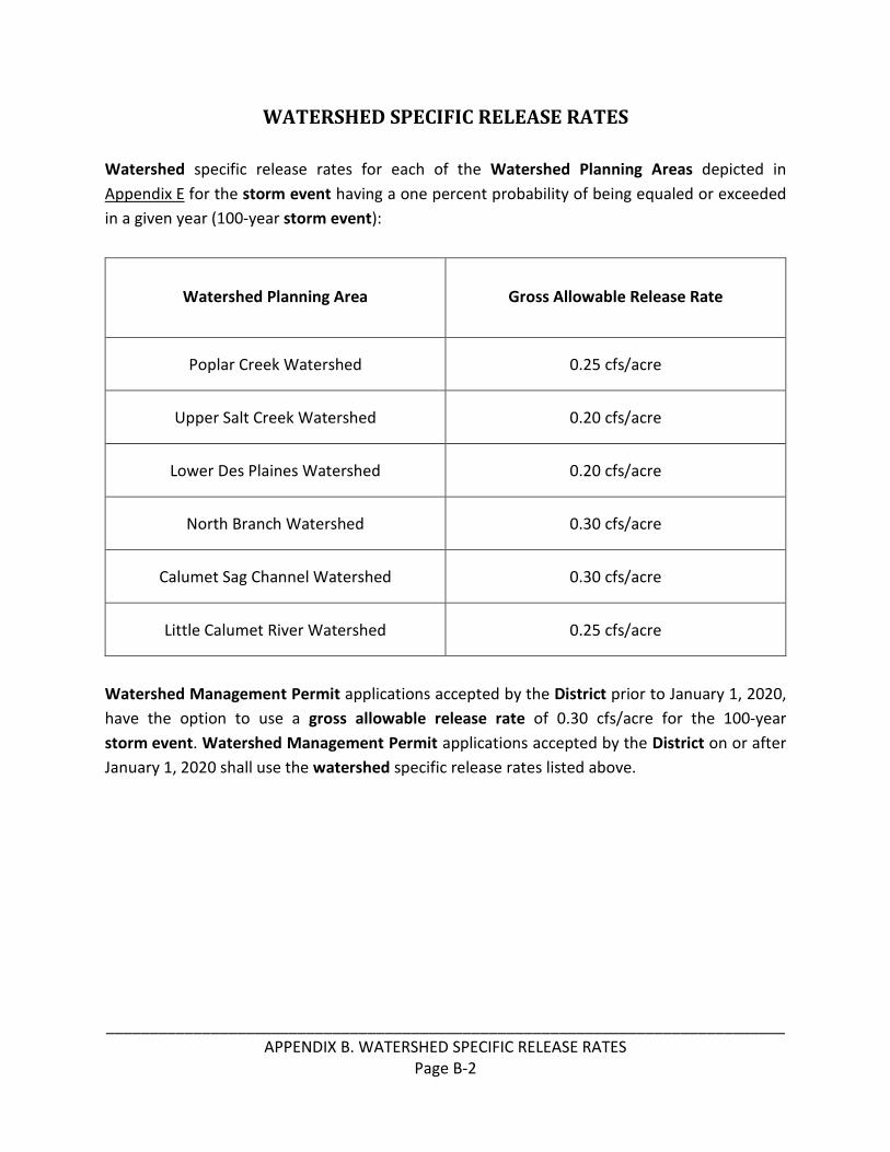
______________________________________________________________________________
APPENDIX B. WATERSHED SPECIFIC RELEASE RATES
Page B-2
WATERSHED SPECIFIC RELEASE RATES
Watershed specific release rates for each of the Watershed Planning Areas depicted in
Appendix E for the storm event having a one percent probability of being equaled or exceeded
in a given year (100-year storm event):
Watershed Planning Area Gross Allowable Release Rate
Poplar Creek Watershed 0.25 cfs/acre
Upper Salt Creek Watershed 0.20 cfs/acre
Lower Des Plaines Watershed 0.20 cfs/acre
North Branch Watershed 0.30 cfs/acre
Calumet Sag Channel Watershed 0.30 cfs/acre
Little Calumet River Watershed 0.25 cfs/acre
Watershed Management Permit applications accepted by the District prior to January 1, 2020,
have the option to use a gross allowable release rate of 0.30 cfs/acre for the 100-year
storm event. Watershed Management Permit applications accepted by the District on or after
January 1, 2020 shall use the watershed specific release rates listed above.

______________________________________________________________________________
APPENDIX C. LEGACY SEWER PERMIT ORDINANCE AND MANUAL OF PROCEDURES FOR THE
ADMINISTRATION OF THE SEWER PERMIT ORDINANCE
Page C-1
APPENDIX C
Legacy Sewer Permit Ordinance and
Manual of Procedures for the Administration of the Sewer Permit Ordinance

______________________________________________________________________________
APPENDIX C. LEGACY SEWER PERMIT ORDINANCE AND MANUAL OF PROCEDURES FOR THE
ADMINISTRATION OF THE SEWER PERMIT ORDINANCE
Page C-2

______________________________________________________________________________
APPENDIX C. LEGACY SEWER PERMIT ORDINANCE AND MANUAL OF PROCEDURES FOR THE
ADMINISTRATION OF THE SEWER PERMIT ORDINANCE
Page C-3

______________________________________________________________________________
APPENDIX C. LEGACY SEWER PERMIT ORDINANCE AND MANUAL OF PROCEDURES FOR THE
ADMINISTRATION OF THE SEWER PERMIT ORDINANCE
Page C-4

______________________________________________________________________________
APPENDIX C. LEGACY SEWER PERMIT ORDINANCE AND MANUAL OF PROCEDURES FOR THE
ADMINISTRATION OF THE SEWER PERMIT ORDINANCE
Page C-5

______________________________________________________________________________
APPENDIX C. LEGACY SEWER PERMIT ORDINANCE AND MANUAL OF PROCEDURES FOR THE
ADMINISTRATION OF THE SEWER PERMIT ORDINANCE
Page C-6

______________________________________________________________________________
APPENDIX C. LEGACY SEWER PERMIT ORDINANCE AND MANUAL OF PROCEDURES FOR THE
ADMINISTRATION OF THE SEWER PERMIT ORDINANCE
Page C-7

______________________________________________________________________________
APPENDIX C. LEGACY SEWER PERMIT ORDINANCE AND MANUAL OF PROCEDURES FOR THE
ADMINISTRATION OF THE SEWER PERMIT ORDINANCE
Page C-8

______________________________________________________________________________
APPENDIX C. LEGACY SEWER PERMIT ORDINANCE AND MANUAL OF PROCEDURES FOR THE
ADMINISTRATION OF THE SEWER PERMIT ORDINANCE
Page C-9

______________________________________________________________________________
APPENDIX C. LEGACY SEWER PERMIT ORDINANCE AND MANUAL OF PROCEDURES FOR THE
ADMINISTRATION OF THE SEWER PERMIT ORDINANCE
Page C-10

______________________________________________________________________________
APPENDIX C. LEGACY SEWER PERMIT ORDINANCE AND MANUAL OF PROCEDURES FOR THE
ADMINISTRATION OF THE SEWER PERMIT ORDINANCE
Page C-11

______________________________________________________________________________
APPENDIX C. LEGACY SEWER PERMIT ORDINANCE AND MANUAL OF PROCEDURES FOR THE
ADMINISTRATION OF THE SEWER PERMIT ORDINANCE
Page C-12

______________________________________________________________________________
APPENDIX C. LEGACY SEWER PERMIT ORDINANCE AND MANUAL OF PROCEDURES FOR THE
ADMINISTRATION OF THE SEWER PERMIT ORDINANCE
Page C-13

______________________________________________________________________________
APPENDIX C. LEGACY SEWER PERMIT ORDINANCE AND MANUAL OF PROCEDURES FOR THE
ADMINISTRATION OF THE SEWER PERMIT ORDINANCE
Page C-14

______________________________________________________________________________
APPENDIX C. LEGACY SEWER PERMIT ORDINANCE AND MANUAL OF PROCEDURES FOR THE
ADMINISTRATION OF THE SEWER PERMIT ORDINANCE
Page C-15

______________________________________________________________________________
APPENDIX C. LEGACY SEWER PERMIT ORDINANCE AND MANUAL OF PROCEDURES FOR THE
ADMINISTRATION OF THE SEWER PERMIT ORDINANCE
Page C-16

______________________________________________________________________________
APPENDIX C. LEGACY SEWER PERMIT ORDINANCE AND MANUAL OF PROCEDURES FOR THE
ADMINISTRATION OF THE SEWER PERMIT ORDINANCE
Page C-17

______________________________________________________________________________
APPENDIX C. LEGACY SEWER PERMIT ORDINANCE AND MANUAL OF PROCEDURES FOR THE
ADMINISTRATION OF THE SEWER PERMIT ORDINANCE
Page C-18

______________________________________________________________________________
APPENDIX C. LEGACY SEWER PERMIT ORDINANCE AND MANUAL OF PROCEDURES FOR THE
ADMINISTRATION OF THE SEWER PERMIT ORDINANCE
Page C-19

______________________________________________________________________________
APPENDIX C. LEGACY SEWER PERMIT ORDINANCE AND MANUAL OF PROCEDURES FOR THE
ADMINISTRATION OF THE SEWER PERMIT ORDINANCE
Page C-20

______________________________________________________________________________
APPENDIX C. LEGACY SEWER PERMIT ORDINANCE AND MANUAL OF PROCEDURES FOR THE
ADMINISTRATION OF THE SEWER PERMIT ORDINANCE
Page C-21

______________________________________________________________________________
APPENDIX C. LEGACY SEWER PERMIT ORDINANCE AND MANUAL OF PROCEDURES FOR THE
ADMINISTRATION OF THE SEWER PERMIT ORDINANCE
Page C-22

______________________________________________________________________________
APPENDIX C. LEGACY SEWER PERMIT ORDINANCE AND MANUAL OF PROCEDURES FOR THE
ADMINISTRATION OF THE SEWER PERMIT ORDINANCE
Page C-23

______________________________________________________________________________
APPENDIX C. LEGACY SEWER PERMIT ORDINANCE AND MANUAL OF PROCEDURES FOR THE
ADMINISTRATION OF THE SEWER PERMIT ORDINANCE
Page C-24

______________________________________________________________________________
APPENDIX C. LEGACY SEWER PERMIT ORDINANCE AND MANUAL OF PROCEDURES FOR THE
ADMINISTRATION OF THE SEWER PERMIT ORDINANCE
Page C-25

______________________________________________________________________________
APPENDIX C. LEGACY SEWER PERMIT ORDINANCE AND MANUAL OF PROCEDURES FOR THE
ADMINISTRATION OF THE SEWER PERMIT ORDINANCE
Page C-26

______________________________________________________________________________
APPENDIX C. LEGACY SEWER PERMIT ORDINANCE AND MANUAL OF PROCEDURES FOR THE
ADMINISTRATION OF THE SEWER PERMIT ORDINANCE
Page C-27

______________________________________________________________________________
APPENDIX C. LEGACY SEWER PERMIT ORDINANCE AND MANUAL OF PROCEDURES FOR THE
ADMINISTRATION OF THE SEWER PERMIT ORDINANCE
Page C-28

______________________________________________________________________________
APPENDIX C. LEGACY SEWER PERMIT ORDINANCE AND MANUAL OF PROCEDURES FOR THE
ADMINISTRATION OF THE SEWER PERMIT ORDINANCE
Page C-29

______________________________________________________________________________
APPENDIX C. LEGACY SEWER PERMIT ORDINANCE AND MANUAL OF PROCEDURES FOR THE
ADMINISTRATION OF THE SEWER PERMIT ORDINANCE
Page C-30

______________________________________________________________________________
APPENDIX C. LEGACY SEWER PERMIT ORDINANCE AND MANUAL OF PROCEDURES FOR THE
ADMINISTRATION OF THE SEWER PERMIT ORDINANCE
Page C-31

______________________________________________________________________________
APPENDIX C. LEGACY SEWER PERMIT ORDINANCE AND MANUAL OF PROCEDURES FOR THE
ADMINISTRATION OF THE SEWER PERMIT ORDINANCE
Page C-32

______________________________________________________________________________
APPENDIX C. LEGACY SEWER PERMIT ORDINANCE AND MANUAL OF PROCEDURES FOR THE
ADMINISTRATION OF THE SEWER PERMIT ORDINANCE
Page C-33

______________________________________________________________________________
APPENDIX C. LEGACY SEWER PERMIT ORDINANCE AND MANUAL OF PROCEDURES FOR THE
ADMINISTRATION OF THE SEWER PERMIT ORDINANCE
Page C-34

______________________________________________________________________________
APPENDIX C. LEGACY SEWER PERMIT ORDINANCE AND MANUAL OF PROCEDURES FOR THE
ADMINISTRATION OF THE SEWER PERMIT ORDINANCE
Page C-35

______________________________________________________________________________
APPENDIX C. LEGACY SEWER PERMIT ORDINANCE AND MANUAL OF PROCEDURES FOR THE
ADMINISTRATION OF THE SEWER PERMIT ORDINANCE
Page C-36

______________________________________________________________________________
APPENDIX C. LEGACY SEWER PERMIT ORDINANCE AND MANUAL OF PROCEDURES FOR THE
ADMINISTRATION OF THE SEWER PERMIT ORDINANCE
Page C-37

______________________________________________________________________________
APPENDIX C. LEGACY SEWER PERMIT ORDINANCE AND MANUAL OF PROCEDURES FOR THE
ADMINISTRATION OF THE SEWER PERMIT ORDINANCE
Page C-38

______________________________________________________________________________
APPENDIX C. LEGACY SEWER PERMIT ORDINANCE AND MANUAL OF PROCEDURES FOR THE
ADMINISTRATION OF THE SEWER PERMIT ORDINANCE
Page C-39

______________________________________________________________________________
APPENDIX C. LEGACY SEWER PERMIT ORDINANCE AND MANUAL OF PROCEDURES FOR THE
ADMINISTRATION OF THE SEWER PERMIT ORDINANCE
Page C-40

______________________________________________________________________________
APPENDIX C. LEGACY SEWER PERMIT ORDINANCE AND MANUAL OF PROCEDURES FOR THE
ADMINISTRATION OF THE SEWER PERMIT ORDINANCE
Page C-41

______________________________________________________________________________
APPENDIX C. LEGACY SEWER PERMIT ORDINANCE AND MANUAL OF PROCEDURES FOR THE
ADMINISTRATION OF THE SEWER PERMIT ORDINANCE
Page C-42

______________________________________________________________________________
APPENDIX D. WATERSHED SERVICE AREAS
Page D-1
APPENDIX D
U.S. Army Corps of Engineers
Watershed Service Areas

______________________________________________________________________________
APPENDIX D. WATERSHED SERVICE AREAS
Page D-2

______________________________________________________________________________
APPENDIX E. WATERSHED PLANNING AREAS
Page E-1
APPENDIX E
Watershed Planning Areas

______________________________________________________________________________
APPENDIX E. WATERSHED PLANNING AREAS
Page E-2

______________________________________________________________________________
APPENDIX F. PERMIT FEES
Page F-1
APPENDIX F
Permit Fees

______________________________________________________________________________
APPENDIX F. PERMIT FEES
Page F-2
PERMIT FEES
WATERSHED MANAGEMENT PERMIT FEE SCHEDULE (Authorized Municipality permits are subject to the fees instituted by the municipality.
Only Section IV. Qualified Sewer fees apply)
Total Fee
SECTION I. NON-REFUNDABLE BASE PERMIT FEES (Does not include Section II, III, IV, and V of this form)
(A) Regular WMO Permit $1,100
(B) Notification and Request For Inspection (NRI) $250
(C) Earthwork/Foundation Limited Permit $2,100
(D) Facility Connection Authorization (within City of Chicago) $1,000
(E) Permit Revision $500
(F) Single-Family Home Special Flood Hazard Area (SFHA) $0
(G) Resubmittals $0
SECTION II. STORMWATER MANAGEMENT
(A) Runoff, volume control, or D-Legacy with no additional detention volume required $0
(B) Nomograph or D-Legacy with additional detention volume required $500
(C) Model - Small Detention Service Area (≤10 acres) $1,500
(D) Model - Large Detention Service Area (>10 acres) $3,000
SECTION III. ISOLATED WETLANDS/RIPARIAN ENVIRONMENTS
(A) Verification of Isolated Wetland Boundary, Classification and Buffer $250
(B) Isolated Wetland Impact < 0.10 Acre or Riparian Environment without Mitigation $500
(C) Isolated Wetland Impact ≥ 0.10 Acre or Riparian Environment with Mitigation Plan $2,500
SECTION IV. QUALIFIED SEWER
(A) Sewer Inspection Fee $5/LF of Sewer*
(B) Pump Station and/or Forcemain (Schedule E) $250
(C) Outfalls/Direct Connections to District Facilities/Impacts to District Property (Schedule O) $250
(D) Connection Impact Fee
(1) Low Density and/or Medium Density Residential (20 Units/Acre or Less) $3,750/Acre
(2) High Density Residential (21 Units/Acre or More) $6,000/Acre
(3) Commercial or Industrial $7,500/Acre
SECTION V. OTHER FEES
(A) Recordation Deposit (Schedule R/Exhibit R) – Required for most projects $500
(B) Hazard Areas (Floodplain/Floodway/Riparian Environment - Schedule H) $250
(C) Notice of Requirements of Stormwater Detention (Schedule L/Exhibit A) $250
(D) Inspections for Violations $250/Inspection
(E) Variances (Filing and Review Fee) $2,000
* Sewers tributary to a waterway are exempt from inspection fees. Use the longest dimension length for underground vaults.

______________________________________________________________________________
APPENDIX G. EXISTING INTERGOVERNMENTAL AGREEMENTS
Page G-1
APPENDIX G
Existing Intergovernmental Agreements

______________________________________________________________________________
APPENDIX G. EXISTING INTERGOVERNMENTAL AGREEMENTS
Page G-2
EXISTING INTERGOVERNMENTAL AGREEMENTS
The intergovernmental agreements referenced in §500.6 of this Ordinance include, but are not
limited to, all of the following:
1. Agreement by and between the Metropolitan Sanitary District of Greater Chicago and
the Villages of Westchester and Hillside, dated February 10, 1972 and commonly
known as the Westchester and Hillside Agreement;
2. Agreement by and between the Society of the Divine Word, Missionary Sisters Servants
of the Holy Spirit, and Metropolitan Sanitary District of Greater Chicago, dated August
17, 1975 and commonly known as the Techny Agreement; and
3. Intergovernmental Agreement for Acquisition, Design, Construction, Use, Operation
and Maintenance of Stormwater and Recreational Improvements at Heritage Park,
dated April 1, 2010 and commonly known as the Heritage Park Flood Control Facility
Agreement.
4. Intergovernmental Agreement by and between the Village of Flossmoor, Homewood
Flossmoor High School District 233, and the Metropolitan Water Reclamation District
of Greater Chicago for Construction and Perpetual Maintenance of the Cherry Creek
East Branch Flood Control Project in Flossmoor, Illinois.
Recommended