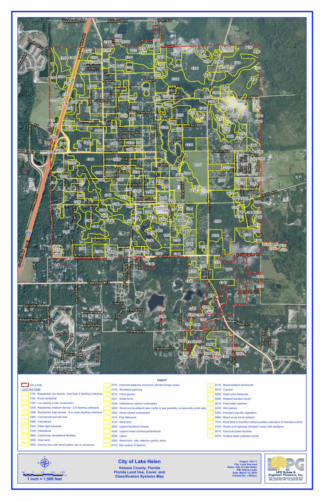
1100
1200
1180
1180
4200
2110
1180
3300
6300
4110
4340
4110
13001200
1190 2130
1180
4340
2110
6300
1100
5200
6300
1100
1200
11801180
1100
1200
4340
4340
1920
2431
5200
1400
2210
1700
1100
1180
1100
1180
3100
1180
6300
5200
1100
4110 4340
1550
1100
1180
4340
6460
1100
4340
2110
1100
1860
3100 4340
2130
2210
2110
1480
1100
1200
2110
1180
2130
1700
1100
2210
1400
4340
2431
1200
4200
1200
1100
3100
2210
1100
1180
4340
3300
24316250
2210
22104340
2210
14001900
8140
6300
1180
1180
6460
4110
4340
6300
5200
1180
4340
1100
4110
2210
4340
4200
7410
4340
6300
3300
6460
5200
4340
6300
4110
6440
2110
5200
4340
6440
1100
6430
2210
1180
6410
2110
1180
6410
6250
6110
1100
5200
1200
4340
6440
6250
5300
6210
1100
5200
2210
5300
1100
1100
2210
1400
4340
1200
1180
4340
1200
1200
2210
1700
4110
1100
1700
1700
6440
2130
6210
6410
1100
1100
6440
6300
1180
6460
6410
1180
1180
3300
6210
6410
3200
6460
6440
6430
6410
4340
4110
8370
6460
6460
41101100
6410
6430
3100
6410
6410
6410
5200
6460
5300
1100
1200
2110
6460
6440
6300
6410
6460
6210
6410
8370
6430
6460
4340
6460
6410
6410
5200
5200
6410
6440
6460
5300
6410
6410
5200
6410
6410
6170
6410
6300
6250
4340
5200
6410
21306430
43402130
6410
6440
1100
1180
8310
2110
3100
5200
3100
6410 3300
6300
4340 4130
Project: 1611-1File: Land Use.mxd
Name: City of Lake HelenPM: Sherie Lindh
Date: March 14, 2016Created By: J.Wilson
LegendCity Limits
Land Use Code1100: Residential, low density - less than 2 dwelling units/acre1180: Rural residential1190: Low density under construction1200: Residential, medium density - 2-5 dwelling units/acre1300: Residential, high density - 6 or more dwelling units/acre1400: Commercial and services1480: Cemeteries1550: Other light industrial1700: Institutional1860: Community recreational facilities1900: Open land1920: Inactive land with street pattern but no structures
2110: Improved pastures (monocult, planted forage crops)2130: Woodland pastures2210: Citrus groves2431: shade ferns3100: Herbaceous upland nonforested3200: Shrub and brushland (wax myrtle or saw palmetto, occasionally scrub oak)3300: Mixed upland nonforested4110: Pine flatwoods4130: Sand pine4200: Upland hardwood forests4340: Upland mixed coniferous/hardwood5200: Lakes5300: Reservoirs - pits, retention ponds, dams6110: Bay swamp (if distinct)
6170: Mixed wetland hardwoods6210: Cypress6250: Hydric pine flatwoods6300: Wetland forested mixed6410: Freshwater marshes6430: Wet prairies6440: Emergent aquatic vegetation6460: Mixed scrub-shrub wetland7410: Rural land in transition without positive indicators of intended activity8140: Roads and highways (divided 4-lanes with medians)8310: Electrical power facilities8370: Surface water collection ponds
µ500 0 500 1,000 1,500
Feet1 inch = 1,500 feet
City of Lake HelenVolusia County, Florida
Florida Land Use, Cover, andClassification Systems Map
Recommended


![SERIES 1180 SERIES 1180Delivery package Proximity switch, 2 fixing nuts, instructions. [mm] s [mm] a 700 600 500 400 300 200 100 80 40 0 80 40 s a LTK-1180-301-LTS-1180-301-LTK-1180-303-LTS-1180-303-G,](https://img.pdfslide.us/doc/110x75/5fd8adb449e21042a454e611/series-1180-series-delivery-package-proximity-switch-2-fixing-nuts-instructions.jpg)