Using CF-NetCDF for OGC access to Atmospheric Data
Using CF-NetCDF for OGC access to Atmospheric Data
M. Plieger1, J. van de Vegte1, R. Sluiter1, W. Som de Cerff1, E. de Vreede1, H. Manders1, R. M. van Hees2, S. de Witte2 , R. de Jeu3 , N. de Reus3
M. Plieger1, J. van de Vegte1, R. Sluiter1, W. Som de Cerff1, E. de Vreede1, H. Manders1, R. M. van Hees2, S. de Witte2 , R. de Jeu3 , N. de Reus3
http://adaguc.knmi.nl
1)Royal Netherlands Meteorological Institute2)Netherlands Institute for Space Research
3)Vrije Universiteit Amsterdam, Faculty of Earth and Life Sciences
http://adaguc.knmi.nl
Global Organization for Earth System Science Portals
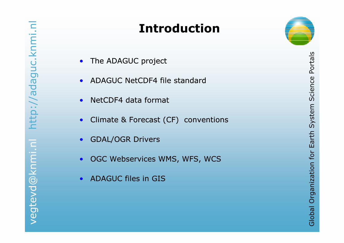
IntroductionIntroduction
• The ADAGUC project
• ADAGUC NetCDF4 file standard
• NetCDF4 data format
• Climate & Forecast (CF) conventions
• GDAL/OGR Drivers
• OGC Webservices WMS, WFS, WCS
• ADAGUC files in GIS
• The ADAGUC project
• ADAGUC NetCDF4 file standard
• NetCDF4 data format
• Climate & Forecast (CF) conventions
• GDAL/OGR Drivers
• OGC Webservices WMS, WFS, WCS
• ADAGUC files in GIS

http://adaguc.knmi.nl
Global Organization for Earth System Science Portals
ADAGUCADAGUC
Atmospheric Data Access for the Geospatial User Community
• Bridging different sciences
• Atmospheric Datasets in GIS systems
• Standard data format for all data
• Open Standards � OGC
• Connect with GIS clients through OGC standards
Atmospheric Data Access for the Geospatial User Community
• Bridging different sciences
• Atmospheric Datasets in GIS systems
• Standard data format for all data
• Open Standards � OGC
• Connect with GIS clients through OGC standards

http://adaguc.knmi.nl
Global Organization for Earth System Science Portals
From bytes to servicesFrom bytes to services
DATA PRODUCTS SERVICES
BinaryBinaryBinary
BinaryBinary
BinaryBinaryOther
WMS
WCS
WFS
ADAGUCContainerFormat
SCIAMACHYSCIAMACHY
ECMWFECMWF
RADAR
GOMEGOME
OMIOMI
MSGMSG
GDAL/OGRADAGUCContainerFormat
ADAGUCContainerFormat
ASCII
ArcGIS
ADAGUC Portal
uDIG
gvSIG
GoogleEarth
…
& many others
Web browser

http://adaguc.knmi.nl
Global Organization for Earth System Science Portals
DatasetsDatasets
• Instruments:
• Sciamachy
• GOME
• OMI
• AMSR
• Precipitation radar
• Instruments:
• Sciamachy
• GOME
• OMI
• AMSR
• Precipitation radar
Goal: Store data in a generic format and provide access to the data by using standard OGC Services
Goal: Store data in a generic format and provide access to the data by using standard OGC Services
• Datasets:• Soil Moisture• FRESCO (clouds)• NO2
• CH4
• CO• O3
• Precipitation
• Datasets:• Soil Moisture• FRESCO (clouds)• NO2
• CH4
• CO• O3
• Precipitation
• Current data types:• Raster• Vector
• Current data types:• Raster• Vector
RasterRaster VectorVector

http://adaguc.knmi.nl
Global Organization for Earth System Science Portals
ADAGUC Data formatADAGUC Data format
• NetCDF 4 data format
• Metadata conventions:• INSPIRE compliant: ISO-19115
• Climate and Forecast metadata convention 1.4
• NL kernset Metadata Standard
• Data and metadata reside in the same file • Self describing!
• NetCDF 4 data format
• Metadata conventions:• INSPIRE compliant: ISO-19115
• Climate and Forecast metadata convention 1.4
• NL kernset Metadata Standard
• Data and metadata reside in the same file • Self describing!
ISO core setISO core set
EU core set (CEN TC 287)EU core set (CEN TC 287)
NL core setNL core set
Vector/RasterVector/Raster
datadata
CF ConventionsCF Conventions
ADAGUC ADAGUC
filefile
http://adaguc.knmi.nl
Global Organization for Earth System Science Portals
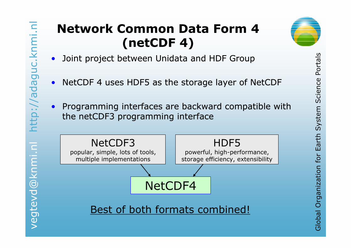
Network Common Data Form 4 (netCDF 4)
Network Common Data Form 4 (netCDF 4)
• Joint project between Unidata and HDF Group
• NetCDF 4 uses HDF5 as the storage layer of NetCDF
• Programming interfaces are backward compatible with the netCDF3 programming interface
• Joint project between Unidata and HDF Group
• NetCDF 4 uses HDF5 as the storage layer of NetCDF
• Programming interfaces are backward compatible with the netCDF3 programming interface
NetCDF3popular, simple, lots of tools, multiple implementations
HDF5powerful, high-performance, storage efficiency, extensibility
NetCDF4
Best of both formats combined!

http://adaguc.knmi.nl
Global Organization for Earth System Science Portals
Climate & forecast (CF) conventions
Climate & forecast (CF) conventions
• Locate data in space–time and as a function of other independent variables
• Coordinate variables:
• Locate data in space–time and as a function of other independent variables
• Coordinate variables:
http://adaguc.knmi.nl
Global Organization for Earth System Science Portals
Climate & forecast (CF) conventions
Climate & forecast (CF) conventions
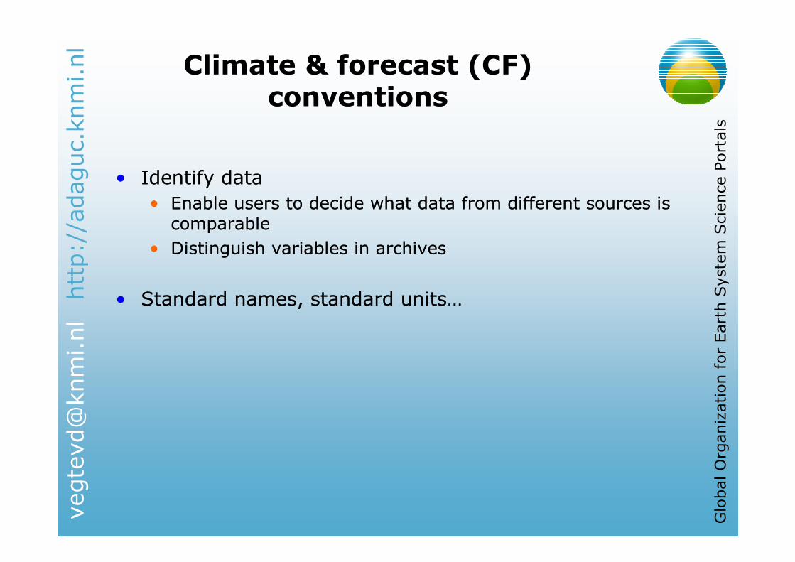
• Identify data
• Enable users to decide what data from different sources is comparable
• Distinguish variables in archives
• Standard names, standard units…
• Identify data
• Enable users to decide what data from different sources is comparable
• Distinguish variables in archives
• Standard names, standard units…
http://adaguc.knmi.nl
Global Organization for Earth System Science Portals
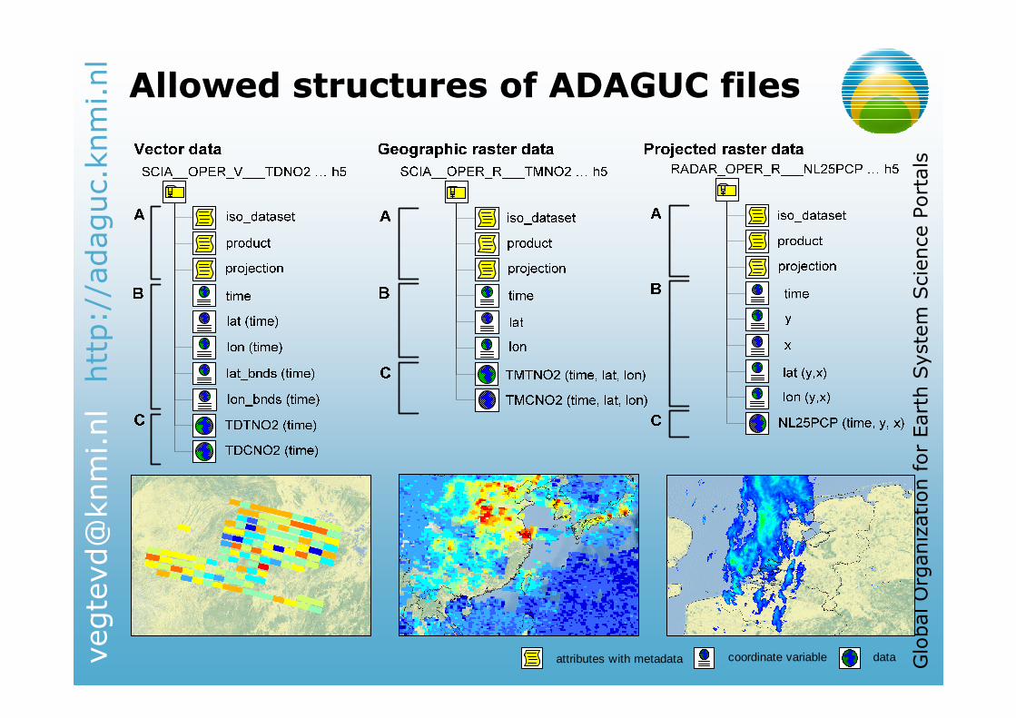
Allowed structures of ADAGUC filesAllowed structures of ADAGUC files
attributes with metadata coordinate variable data

http://adaguc.knmi.nl
Global Organization for Earth System Science Portals
Unique identifiers (UID)Unique identifiers (UID)
• Unique identifiers to make data unique
• Google on UID provides the description of the data!
• Unique identifiers to make data unique
• Google on UID provides the description of the data!

http://adaguc.knmi.nl
Global Organization for Earth System Science Portals
GDAL/OGR driversGDAL/OGR drivers
• GDAL / OGR
• Open source translator library for raster geospatial data formats
• Used in many software products
• UMN MapServer, GeoServer, Quantum GIS, ArcGIS, GRASS, OpenEV etc..
• GDAL - Geospatial Data Abstraction Library
• Access raster data
• OGR - Simple Feature Library
• Access vector data
• GDAL/OGR extensions available with support for the ADAGUC data standard
http://trac.osgeo.org/gdal/wiki/ADAGUChttp://trac.osgeo.org/gdal/wiki/ADAGUC
http://adaguc.knmi.nl
Global Organization for Earth System Science Portals
OGC WebservicesOGC Webservices
• Enabled by UMN MapServer
• GDAL � UMN MapServer
• Custom made WMS/WCS
• Dealing with real time data (updating without service restarting)
• Will become public available next year
• Web Mapping Service (WMS) for visualization
• Web Feature Service (WFS) for feature data access
• Web Coverage Service (WCS) for raster data access
• Why OpenGIS services?
• Data discovery
• Multiple output formats
• Resampling/ interpolation
• Spatial/temporal selections
• Easy connection to GIS programs
http://adaguc.knmi.nl
Global Organization for Earth System Science Portals
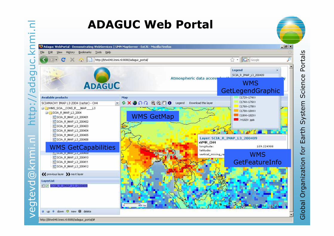
ADAGUC Web PortalADAGUC Web Portal
WMS GetCapabilities
WMS GetMap
WMS GetFeatureInfo
WMS GetLegendGraphic

http://adaguc.knmi.nl
Global Organization for Earth System Science Portals
Download data from the PortalDownload data from the Portal
• Download the original file,
or convert to your favorite GIS format using OpenGIS
• Download the original file
• Raster files are downloaded using WCS
• Vector files are downloaded using WFS
• Depending on the datatype the proper service is automatically selected
• Download the original file,
or convert to your favorite GIS format using OpenGIS
• Download the original file
• Raster files are downloaded using WCS
• Vector files are downloaded using WFS
• Depending on the datatype the proper service is automatically selected
WCS DescribeCoverage
WFS MetadataURL
WFS or WCS?

http://adaguc.knmi.nl
Global Organization for Earth System Science Portals
ADAGUC in GIS programsADAGUC in GIS programs
ArcGIS ExplorerArcGIS Explorer Google EarthGoogle Earth Quantum GISQuantum GIS
gvSIGgvSIG ArcGIS DesktopArcGIS Desktop UDIGUDIG
IDVIDV HDF ExplorerHDF Explorer NASANASA’’S PanoplyS Panoply
http://adaguc.knmi.nl
Global Organization for Earth System Science Portals
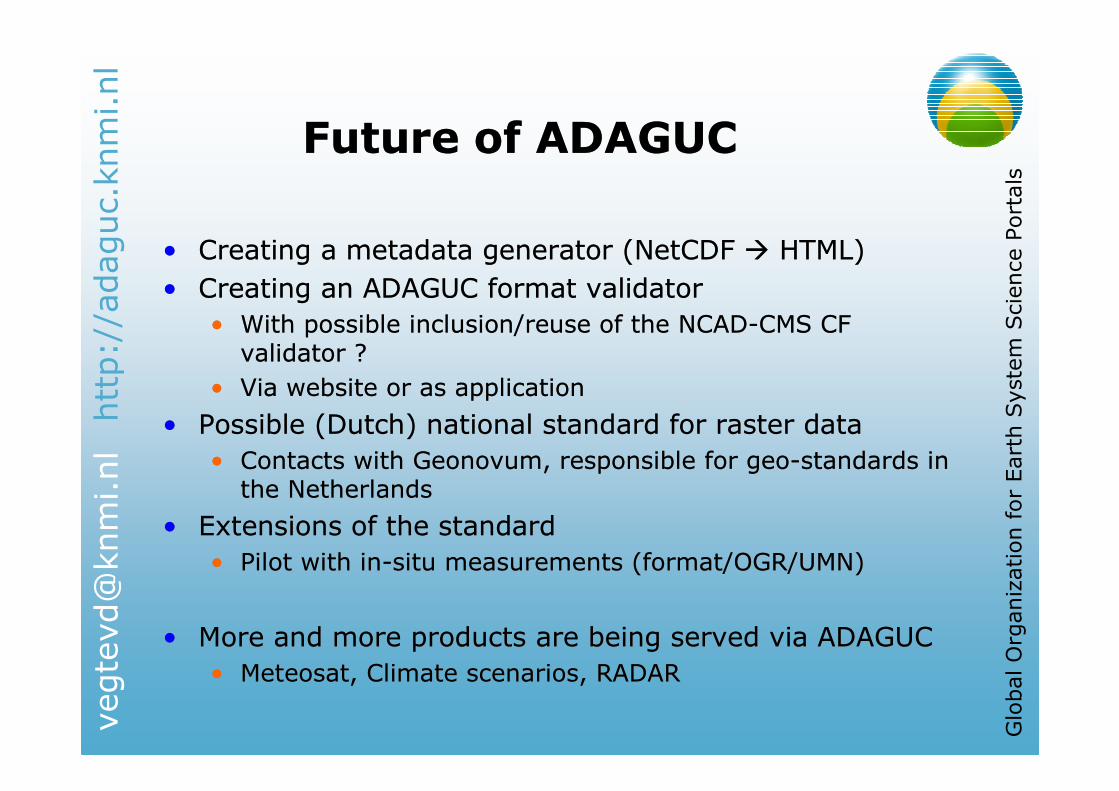
Future of ADAGUCFuture of ADAGUC
• Creating a metadata generator (NetCDF � HTML)
• Creating an ADAGUC format validator
• With possible inclusion/reuse of the NCAD-CMS CF validator ?
• Via website or as application
• Possible (Dutch) national standard for raster data
• Contacts with Geonovum, responsible for geo-standards in the Netherlands
• Extensions of the standard
• Pilot with in-situ measurements (format/OGR/UMN)
• More and more products are being served via ADAGUC
• Meteosat, Climate scenarios, RADAR

http://adaguc.knmi.nl
Global Organization for Earth System Science Portals
Questions?Questions?
http://adaguc.knmi.nlhttp://adaguc.knmi.nl
Recommended


![NetCDF-4 Performance Report - The HDF Group · NetCDF-4 Performance Report Choonghwan Lee ... Introduction NetCDF-4 [1] ... netcdf4 large netcdf3 large netcdf4 small](https://img.pdfslide.us/doc/110x75/5b509b227f8b9a5a6f8ed256/netcdf-4-performance-report-the-hdf-group-netcdf-4-performance-report-choonghwan.jpg)