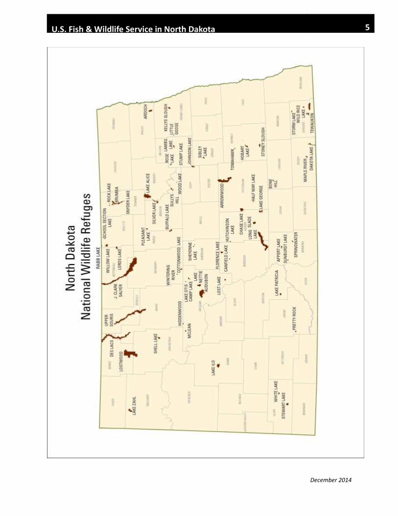
U.S. Fish & Wildlife Service in North Dakota
The mission of the U.S. Fish and Wildlife Service is
working with others to conserve, protect, and
enhance fish, wildlife, plants, and their habitats for
the continuing benefit of the American people.
December 2014
January 2015

December 2014
U.S. Fish & Wildlife Service in North Dakota 1
Contents
Abbreviations…………..…....………………………………….………………………………. 2
U.S. Fish and Wildlife Service Presence in North Dakota…………………………………… 3
Map of National Wildlife Refuges………..…………………………………………..……….. 5
National Wildlife Refuge Acreage Table……………………….…………………………….. 6
Map of Wetland Management Districts………………………………………………………. 8
Wetland Management District Acreage Table……………………...………………………... 9
National Wildlife Refuges (NWR), Wetland Management Districts (WMD),
and National Game Preserve (NGP)
Arrowwood NWR and WMD…………………………………………………………… 10
Audubon NWR and WMD………………………….…………………………………… 11
Chase Lake NWR and WMD…………………………….……………………………… 13
Crosby WMD………………………………………………………………………….… 14
Des Lacs NWR……………………………………………………………………….….. 15
Devils Lake WMD………………………………………………………………………. 16
J. Clark Salyer NWR and WMD………………………………………………………… 17
Kulm WMD……………………………………………………………………………… 18
Lake Ilo NWR…………………………………………………………………………… 19
Long Lake NWR and WMD……………………………………….…………………….. 20
Lostwood NWR and WMD……………………………………………………………… 22
Sullys Hill NGP………………………………………………………………………….. 23
Tewaukon NWR and WMD……………………………………………………………... 24
Upper Souris NWR……………………………………….……………………………… 25
Valley City WMD………………………………………….…………………………….. 26
National Fish Hatcheries (NFH)
Garrison Dam NFH……………………………………………………………………… 27
Valley City NFH………………………………………………………………………… 29
Ecological Services (ES) ……………………………………………………………………….. 30
Fire Management……………………………………………………………………………….. 31
Habitat and Population Evaluation Team (HAPET)………………………………………… 32
Law Enforcement………………………………………………………………………………. 33
Missouri River Fish and Wildlife Conservation……………………………………………… 34
Partners for Fish and Wildlife…………………………………………………………………. 35
Wetland Acquisition……………………………………………………………………………. 36
Glossary……………………………………………………………………………………………………… 37

December 2014
U.S. Fish & Wildlife Service in North Dakota 2
Abbreviations
_____________________________________________
FmHA Farmers Home Administration
HAPET Habitat and Population Evaluation Team
LCC Landscape Conservation Cooperative
NAWCA North American Wetlands Conservation Act
NGP National Game Preserve
NWR National Wildlife Refuge
NWRS National Wildlife Refuge System
SWAP Small Wetlands Acquisition Program
USFWS United States Fish and Wildlife Service (Service)
WMD Wetland Management District
WPA Waterfowl Production Area

December 2014
U.S. Fish & Wildlife Service in North Dakota 3
U.S. Fish and Wildlife Service
Presence in North Dakota
National Wildlife Refuges
North Dakota has 63 National
Wildlife Refuges (NWR) that
encompass 289,777 acres.
Wetland Management
Districts There are 11 Wetland
Management Districts (WMD)
with 1,288 Waterfowl
Production Areas (WPA)
totaling 289,372 acres. More
than 1.3 million acres are under
perpetual wetland and grassland
easements.
Visitors to NWRs and WMDs
may participate in a variety of
wildlife-dependent recreational
activities on lands that have
been opened to the public.
These activities include wildlife
observation, photography,
environmental education,
interpretation, hunting, and
fishing. Special regulations are
in place to protect natural
resources and to help ensure
safe and enjoyable visits.
Small Wetlands Acquisition
Program
The Small Wetlands Acquisition
Program was created by
Congress in 1958. The 1934
Migratory Bird Hunting and
Conservation Stamp Act
(commonly referred to as the
Duck Stamp Act) was amended
to allow proceeds from the sale
of Federal Duck Stamps to be
used to protect waterfowl
habitat. The habitat protected
through this program consists of
small wetlands surrounded by
grassland habitat, primarily in
the U.S. portion of the Prairie
Pothole Region. These areas,
protected in perpetuity through
fee-title acquisition or easement,
are called WPAs, and are part of
the National Wildlife Refuge
System.
Wetland Easements
A wetland easement is a legal
agreement between the U.S.
Fish and Wildlife Service
(Service) and a private
landowner. The landowner
receives a one-time payment to
permanently protect wetlands.
Wetlands covered by an
easement cannot be drained,
filled, leveled, or burned. When
these wetlands dry up naturally,
they can be farmed, grazed, or
hayed.
Grassland Easements
A grassland easement is a legal
agreement between the Service
and a private landowner. The
landowner receives a one-time
payment to permanently keep
the land in grass. Land covered
by a grassland easement may
not be cultivated. Mowing,
haying, and grass seed
harvesting are delayed until
after July 15 in order to help
grassland nesting birds complete
their nesting before the grass is
disturbed. Livestock grazing is
not restricted in any way.
Limited-interest National
Wildlife Refuges
The North Dakota Limited-
interest Refuge Program began
in the 1930’s, in response to the
many crises of the “Dust Bowl
Era.” Working with states and
private landowners, President
Roosevelt established this
program for the purpose of
“drought relief, water
conservation, and for migratory
bird and wildlife conservation.”
Hundreds of landowners agreed
to place their lands under this
program, most perpetual, for
these conservation purposes.
Today, these lands encompass
58,484 acres in North Dakota.
Partners for Fish and Wildlife
With over 90% of North Dakota
lands in private ownership, the
Partners for Fish and Wildlife
Program (Partners) is an
important program for restoring
and maintaining habitat for
migratory bird populations in
the Central Flyway.
The Partners program utilizes
proven habitat practices that
benefit wildlife and can be
incorporated into an established
agricultural operation. The most
common types of projects
include: restoration of drained
wetlands, creation of new
wetlands, restoration of native
vegetation on cropland, and the
establishment of rotational
grazing systems on degraded
native prairie.

December 2014
U.S. Fish & Wildlife Service in North Dakota 4
Fisheries and Aquatic
Conservation
The Garrison Dam, Baldhill,
and Valley City National Fish
Hatcheries are the three federal
fish hatcheries in North Dakota.
Two of the three facilities are
mitigation hatcheries–built to
provide fish that offset, or
mitigate, the impacts to the fish
community resulting from the
construction of dams. Valley
City National Fish Hatchery
pre-dated reservoir construction
and played a role in the
establishment of recreational
and farm pond fishing in the
1940’s and 1950’s when fish
were transported by railroad
cars in Fearnow pails and cream
cans. Today, in addition to
mitigation, the hatcheries
supplement natural reproduction
by stocking a variety of fish
species in lakes throughout
North Dakota and Wyoming.
Critical to recovery and
restoration efforts, the
hatcheries also participate in
propagation and stocking efforts
to help in the recovery efforts of
threatened and endangered
species such as the pallid and
lake sturgeons.
The Missouri River Fish &
Wildlife Conservation Office
serves as the aquatic species
conservation experts for the
Service with capability to
conduct assessments that
monitor species and aquatic
habitats. Most work is focused
on monitoring and recovery
efforts for pallid sturgeon and
other native species that are in
decline. Work is also conducted
with conservation partners in a
collaborative approach to
restore habitats where there are
opportunities to improve the
function of the landscape and
the aquatic resources.
Refuge Revenue Sharing
Lands acquired by the Service
are removed from the tax rolls,
but the Refuge Revenue Sharing
Act, as amended, allows us to
off-set the tax losses. Annual
payments are made to the
county or other local unit of
government.
The Revenue Sharing Act
requires that the revenue sharing
payments to counties for our
purchased land will be based on
the greatest of: 1) ¾ of 1 percent
of the market value; 2) 25
percent of the net receipts; or 3)
75 cents per acre.
Ecological Services
The Ecological Services Field
Office (ES) coordinates with
Federal, State, private, and non-
governmental organizations and
agencies within North Dakota,
surrounding states, and
Canadian provinces. ES
frequently functions as planners,
negotiators, coordinators, and
conservation advocates in an
effort to fulfill natural resource
mandates.
Primary activities include the
oversight and evaluation of
federally funded projects to
insure compliance with, or to
provide comments and
recommendations relative to the
Endangered Species Act, Fish
and Wildlife Coordination Act,
National Environmental Policy
Act, and Section 404 permit
evaluations as defined by the
Clean Water Act. Additionally,
expertise is provided on a wide
array of environmental
contaminant issues affecting
fish and wildlife resources.
Landscape Conservation
Cooperatives
A Landscape Conservation
Cooperative (LCC) serves as a
forum for science-based
partnerships including Federal,
State, Tribal, local government,
and non-governmental partners.
The LCCs are aligned around
geographically similar
landscapes and they are true
cooperatives formed to identify
best practices, fill information
gaps, and to avoid duplicative
efforts through partnership
based conservation planning and
design.
December 2014
U.S. Fish & Wildlife Service in North Dakota 5
December 2014
U.S. Fish & Wildlife Service in North Dakota 6
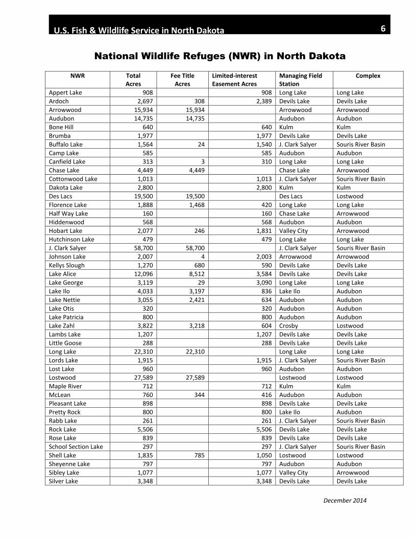
National Wildlife Refuges (NWR) in North Dakota
NWR Total Acres
Fee Title Acres
Limited-interest Easement Acres
Managing Field Station
Complex
Appert Lake 908 908 Long Lake Long Lake
Ardoch 2,697 308 2,389 Devils Lake Devils Lake
Arrowwood 15,934 15,934 Arrowwood Arrowwood
Audubon 14,735 14,735 Audubon Audubon
Bone Hill 640 640 Kulm Kulm
Brumba 1,977 1,977 Devils Lake Devils Lake
Buffalo Lake 1,564 24 1,540 J. Clark Salyer Souris River Basin
Camp Lake 585 585 Audubon Audubon
Canfield Lake 313 3 310 Long Lake Long Lake
Chase Lake 4,449 4,449 Chase Lake Arrowwood
Cottonwood Lake 1,013 1,013 J. Clark Salyer Souris River Basin
Dakota Lake 2,800 2,800 Kulm Kulm
Des Lacs 19,500 19,500 Des Lacs Lostwood
Florence Lake 1,888 1,468 420 Long Lake Long Lake
Half Way Lake 160 160 Chase Lake Arrowwood
Hiddenwood 568 568 Audubon Audubon
Hobart Lake 2,077 246 1,831 Valley City Arrowwood
Hutchinson Lake 479 479 Long Lake Long Lake
J. Clark Salyer 58,700 58,700 J. Clark Salyer Souris River Basin
Johnson Lake 2,007 4 2,003 Arrowwood Arrowwood
Kellys Slough 1,270 680 590 Devils Lake Devils Lake
Lake Alice 12,096 8,512 3,584 Devils Lake Devils Lake
Lake George 3,119 29 3,090 Long Lake Long Lake
Lake Ilo 4,033 3,197 836 Lake Ilo Audubon
Lake Nettie 3,055 2,421 634 Audubon Audubon
Lake Otis 320 320 Audubon Audubon
Lake Patricia 800 800 Audubon Audubon
Lake Zahl 3,822 3,218 604 Crosby Lostwood
Lambs Lake 1,207 1,207 Devils Lake Devils Lake
Little Goose 288 288 Devils Lake Devils Lake
Long Lake 22,310 22,310 Long Lake Long Lake
Lords Lake 1,915 1,915 J. Clark Salyer Souris River Basin
Lost Lake 960 960 Audubon Audubon
Lostwood 27,589 27,589 Lostwood Lostwood
Maple River 712 712 Kulm Kulm
McLean 760 344 416 Audubon Audubon
Pleasant Lake 898 898 Devils Lake Devils Lake
Pretty Rock 800 800 Lake Ilo Audubon
Rabb Lake 261 261 J. Clark Salyer Souris River Basin
Rock Lake 5,506 5,506 Devils Lake Devils Lake
Rose Lake 839 839 Devils Lake Devils Lake
School Section Lake 297 297 J. Clark Salyer Souris River Basin
Shell Lake 1,835 785 1,050 Lostwood Lostwood
Sheyenne Lake 797 797 Audubon Audubon
Sibley Lake 1,077 1,077 Valley City Arrowwood
Silver Lake 3,348 3,348 Devils Lake Devils Lake
December 2014
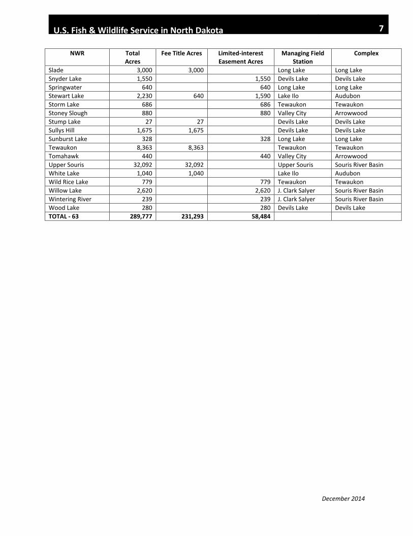
U.S. Fish & Wildlife Service in North Dakota 7
NWR Total Acres
Fee Title Acres Limited-interest Easement Acres
Managing Field Station
Complex
Slade 3,000 3,000 Long Lake Long Lake
Snyder Lake 1,550 1,550 Devils Lake Devils Lake
Springwater 640 640 Long Lake Long Lake
Stewart Lake 2,230 640 1,590 Lake Ilo Audubon
Storm Lake 686 686 Tewaukon Tewaukon
Stoney Slough 880 880 Valley City Arrowwood
Stump Lake 27 27 Devils Lake Devils Lake
Sullys Hill 1,675 1,675 Devils Lake Devils Lake
Sunburst Lake 328 328 Long Lake Long Lake
Tewaukon 8,363 8,363 Tewaukon Tewaukon
Tomahawk 440 440 Valley City Arrowwood
Upper Souris 32,092 32,092 Upper Souris Souris River Basin
White Lake 1,040 1,040 Lake Ilo Audubon
Wild Rice Lake 779 779 Tewaukon Tewaukon
Willow Lake 2,620 2,620 J. Clark Salyer Souris River Basin
Wintering River 239 239 J. Clark Salyer Souris River Basin
Wood Lake 280 280 Devils Lake Devils Lake
TOTAL - 63 289,777 231,293 58,484
In

December 2014
U.S. Fish & Wildlife Service in North Dakota 8

December 2014
U.S. Fish & Wildlife Service in North Dakota 9
Wetland Management Districts (WMD) in North Dakota
Arrowwood
28 6,144 18,757 0 416
Audubon 120 31,433 102,054
76,572 7,768
Chase Lake 136 43,344
123,000 48,000 3,325
Crosby
99 18,760 71,533 42,559 720
Devils Lake
257 48,885 150,182 4,264 4,606
J. Clark Salyer
127 27,339 140,276 42,201 6,973
Kulm
232 45,379 126,000 67,000 4,130
Long Lake
88 23,723 107,384 98,806 3,713
Lostwood
56 12,506 35,000 39,052 605
Tewaukon
63 14,378 27,000 11,000 2,000
Valley City 82 17,481 45,918 282 8,320
fg
TOTAL 1,288 289,372 947,104 429,736 42,576
WETLAND MANAGEMENT DISTRICT
WATERFOWL PRODUCTION AREAS (NUMBER)
WATERFOWL PRODUCTION AREAS (ACRES)
WETLAND EASEMENT (ACRES)
GRASSLAND EASEMENT (ACRES)
FARMERS HOME ADMINISTRATION (FmHA) (ACRES)

December 2014
U.S. Fish & Wildlife Service in North Dakota 10
Arrowwood
National Wildlife Refuge and Wetland
Management District
Contact: Project Leader
WMD Manager
Address: 7780 10th St. SE
Pingree, ND 58476
Phone: 701 / 285 3341
Email: [email protected]
Website: www.fws.gov/refuge/arrowwood
Complex Facts
Arrowwood National Wildlife
Refuge (NWR) and Wetland
Management District (WMD)
are all managed as part of the
Arrowwood NWR Complex.
Arrowwood NWR
• Established in 1935
• 15,934 acres
• Foster and Stutsman Counties
Refuge Purpose
Arrowwood NWR was
established for the following:
• a refuge and breeding ground
for migratory birds and other
wildlife
• use by migratory birds, with
emphasis on waterfowl and
other waterbirds
• the conservation of fish and
wildlife resources
• use as an inviolate sanctuary,
or for any other management
purpose, for migratory birds
Arrowwood WMD
• Established in 1961
• Foster and Eddy Counties
• 28 Waterfowl Production
Areas (WPA): 6,144 acres
• Wetland easements: 18,757
acres
• Grassland easements: 0 acres
• Farmers Home Administration
(FmHA) easements: 416 acres
• Limited-interest NWR
- Johnson Lake (2,007 acres)
WMD Purpose
The WMD provides oversight
for all of the U.S. Fish and
Wildlife Service’s small land
tracts in a multi-county area.
Objectives include:
• Wetland preservation
• Waterfowl and wildlife
production
• Maintenance of nesting habitat
for migratory birds
• Provide a staging area and
habitat for migration
• Work with private landowners
to restore and enhance wetland
and grassland habitats for
migratory birds
Visitor Opportunities
Visitors may enjoy wildlife
observation, photography,
environmental education,
interpretation, hunting, and
fishing opportunities on areas
that have been opened for these
uses. Special regulations apply.
Visitor Facilities
• Visitor center
• Auto tour route
• Wildlife observation deck
• Sharp-tailed grouse viewing
blind
• Warbler Woodland Watchable
Wildlife Area
• Primitive boat launches
Highlights
The refuge includes 14 miles of
the James River Valley.
Thirteen species of waterfowl
breed and raise young here.
Exposed mudflats provide
feeding areas for thousands of
migrating shorebirds, including
dowitchers, sandpipers, godwits,
yellowlegs, and plovers.
Sharp-tailed grouse congregate
on their dancing grounds each
year for courtship and breeding
rituals.

December 2014
U.S. Fish & Wildlife Service in North Dakota 11
Audubon
National Wildlife Refuge and Wetland
Management District Contact: Project Leader
WMD Manager
Address: 3275 11th Street NW
Coleharbor, ND 58531
Phone: 701 / 442 5474
Email: [email protected] Website: www.fws.gov/refuge/audubon
Complex Facts
Audubon, Lake Nettie and
McLean National Wildlife
Refuges (NWR) and the
Audubon Wetland Management
District (WMD) are managed as
part of the Audubon NWR
Complex.
Audubon NWR
• Established in 1956
• 14,735 acres
• McLean County
Lake Nettie NWR
• Established in 1935
• 3,055 acres
• McLean County
McLean NWR
• Established in 1939
• 760 acres
• McLean County
Refuge Purpose
Audubon NWR was established
for the following:
• Mitigate for habitat that was
inundated with water when
Garrison Dam flooded Missouri
River bottomlands
• Provide habitat for threatened
and endangered species
• Provide waterfowl production
and migration habitat
•manage habitat for migratory
non-game birds
•Protect and enhance natural
ecological communities
•Provide opportunities for
quality wildlife-dependent
recreation
•Protect cultural resources
Audubon WMD
• Established in 1962
• McLean, Sheridan, and Ward
Counties
• 120 Waterfowl Production
Areas (WPA): 31,433 acres
• Wetland easements: 102,054
acres
• Grassland easements: 76,572
acres
• Farmers Home Administration
(FmHA) easements: 7,768 acres
• 6 Limited-interest NWRs
-Camp Lake (585 acres)
-Hiddenwood (568 acres)
-Lake Otis (320 acres)
-Lake Patricia (800 acres)
-Lost Lake (960 acres)
-Sheyenne Lake (797 acres)
WMD Purpose
The WMD provides oversight
for all of the U.S. Fish and
Wildlife Service’s small land
tracts in a multi-county area.
Objectives include:
• Wetland preservation
• Waterfowl and wildlife
production
• Maintenance of nesting habitat
for migratory birds
• Provide a staging area and
habitat for migration
• Work with private landowners
to restore and enhance wetland
and grassland habitats for
migratory birds
Visitor Opportunities
Visitors may enjoy wildlife
observation, photography,
environmental education,
interpretation, hunting, and
fishing opportunities on areas
that have been opened for these
uses. Special regulations apply.
Visitor Facilities
• Visitor center
• South Shore auto tour route –
8 ½ miles
• Prairie nature trail – 1 mile
• Wildlife observation blind
Highlights
The piping plover, a small
shorebird listed as threatened on
the Endangered Species List,
nests on shorelines of Lake
Audubon and alkaline wetlands
in the WMD.

December 2014
U.S. Fish & Wildlife Service in North Dakota 12
More than 100 islands provide
nesting habitat on Lake
Audubon.
Audubon NWR is owned by
U.S. Army Corps of Engineers,
and managed by the U.S. Fish
and Wildlife Service. Lake
Audubon water levels are
managed by U.S. Bureau of
Reclamation.

December 2014
U.S. Fish & Wildlife Service in North Dakota 13
Chase Lake
National Wildlife Refuge and Wetland
Management District Contact: Refuge Manager
WMD Manager
Address: 5924 19th Street SE
Woodworth, ND 58496
Phone: 701 / 752 4218
Email: [email protected] Website: www.fws.gov/refuge/chase_lake
Complex Facts
Chase Lake National Wildlife
Refuge (NWR) and Chase Lake
Wetland Management District
(WMD) are managed as part of
the Arrowwood National
Wildlife Refuge Complex.
Chase Lake NWR
• Established in 1908
• 4,449 acres
• Stutsman County
Refuge Purpose
Chase Lake NWR was
established as a reserve and
breeding area for native birds.
Chase Lake WMD
• Established in 1992
• Stutsman and Wells Counties
• 136 Waterfowl Production
Areas (WPA): 43,344 acres
• 930 Wetland easements:
123,000 acres
• 173 Grassland easements:
48,000 acres
• 13 Farmers Home
Administration (FmHA)
easements: 3,325 acres
• Limited-interest NWR
-Half Way Lake (160 acres)
WMD Purpose
The WMD provides oversight
for all of the U.S. Fish and
Wildlife Service’s small land
tracts in a multi-county area.
Objectives include:
• Wetland preservation
• Waterfowl and wildlife
production
• Maintenance of nesting habitat
for migratory birds
• Provide a staging area and
habitat for migration
• Work with private landowners
to restore and enhance wetland
and grassland habitats for
migratory birds
Visitor Opportunities
Visitors may enjoy wildlife
observation, photography,
environmental education,
interpretation, hunting, and
fishing opportunities on areas
that have been opened for these
uses. Special regulations apply.
• Access to Chase Lake NWR
is limited to walking
• Special use permits are
required prior to entering the
refuge from April through
September
Visitor Facilities
• Chase Lake NWR has
interpretive panels and a scope
for wildlife viewing
• Visitor center is located at
Chase Lake headquarters office
• Auto-tour route with
interpretive panels and scopes is
located near the Chase Lake
headquarters
Highlights
Chase Lake NWR was the
second refuge established in
North Dakota.
Chase Lake NWR contains a
4,155-acre National Wilderness
Area.
The refuge and surrounding area
provide breeding and resting
habitat for more than 293 bird
species, including the largest
breeding colony of white
pelicans in North America.
The American Bird
Conservancy has designated the
refuge as one of America’s top
100 globally important bird
areas.
The Chase Lake Prairie Project
is a national flagship project of
the Prairie Pothole Joint
Venture of the North American
Waterfowl Management Plan,
encompassing 5.5 million acres
in 11 counties.
The Chase Lake headquarters
hosts the National Ecological
Observatory Network’s
(NEON) Northern Plains Core
Site.
December 2014
U.S. Fish & Wildlife Service in North Dakota 14
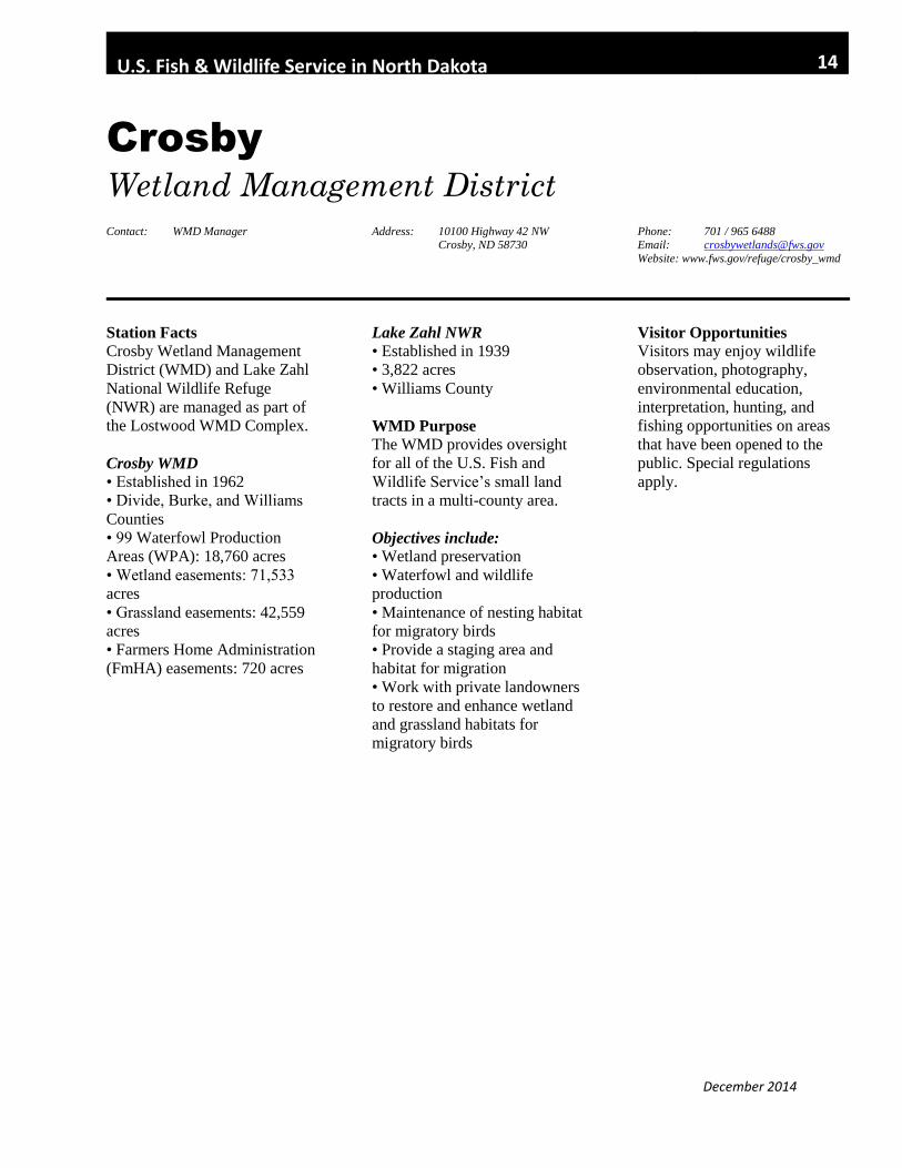
Crosby
Wetland Management District Contact: WMD Manager Address: 10100 Highway 42 NW
Crosby, ND 58730 Phone: 701 / 965 6488 Email: [email protected]
Website: www.fws.gov/refuge/crosby_wmd
Station Facts
Crosby Wetland Management
District (WMD) and Lake Zahl
National Wildlife Refuge
(NWR) are managed as part of
the Lostwood WMD Complex.
Crosby WMD
• Established in 1962
• Divide, Burke, and Williams
Counties
• 99 Waterfowl Production
Areas (WPA): 18,760 acres
• Wetland easements: 71,533
acres
• Grassland easements: 42,559
acres
• Farmers Home Administration
(FmHA) easements: 720 acres
Lake Zahl NWR
• Established in 1939
• 3,822 acres
• Williams County
WMD Purpose
The WMD provides oversight
for all of the U.S. Fish and
Wildlife Service’s small land
tracts in a multi-county area.
Objectives include:
• Wetland preservation
• Waterfowl and wildlife
production
• Maintenance of nesting habitat
for migratory birds
• Provide a staging area and
habitat for migration
• Work with private landowners
to restore and enhance wetland
and grassland habitats for
migratory birds
Visitor Opportunities
Visitors may enjoy wildlife
observation, photography,
environmental education,
interpretation, hunting, and
fishing opportunities on areas
that have been opened to the
public. Special regulations
apply.

December 2014
U.S. Fish & Wildlife Service in North Dakota 15
Des Lacs
National Wildlife Refuge Contact: Refuge Manager Address: 42000 520th Street NW
Kenmare, ND 58746Phone: 701 / 385 4046 Email: [email protected]
Website: www.fws.gov/refuge/des_lacs
Complex Facts
Des Lacs National Wildlife
Refuge (NWR) is managed as
part of the Lostwood WMD
Complex.
Des Lacs NWR
• Established in 1935
• 19,500 acres
• Burke and Ward Counties
Refuge Purpose
Des Lacs NWR was established
as a refuge and breeding ground
for migratory birds and other
wildlife.
Objectives include:
• Preserve, restore, and enhance
threatened and endangered
species and their habitats
• Provide habitat for waterfowl
and other migratory birds
• Promote diversity and
abundance of native flora and
fauna
• Protect, preserve, and interpret
cultural resources
Visitor Opportunities
Hunting
• deer, turkey, pheasant, gray
partridge, sharp-tailed grouse,
cottontail, snowshoe hare, and
fox
Wildlife Observation and
Photography
• From April through
November, the Des Lacs auto
tour route offers 14 miles of
scenic views along Upper,
Middle, and Lower Des Lacs
Lakes. Thirteen interpretive
panels are located along the auto
tour route and overlooks are
available at Middle Des Lacs
and Lower Des Lacs Lakes.
• Canada Goose Nature Trail –
7.5 mile nature trail is open to
hiking, bicycling, cross-country
skiing, snowshoeing, and one-
way vehicle traffic for 17 days
in mid-September
• Munch’s Coulee Hiking Trail
– 1 mile nature trail loop is open
to hiking and snowshoeing
• Tasker’s Coulee - has mowed
nature trails
• Tasker’s Coulee day use area
has a unique wooded area
consisting of mowed grass
nature trails and opportunities
for wildlife observation, hiking,
or group events. A historic
Civilian Conservation Corps
shelter with tables is located
near the parking area. A
restroom is available at the site.
• The boat dock day use area
has a boat ramp, tables, and
vault toilets. Non-motorized
boats are allowed.
Visitor Facilities
• Visitor center
• Observation deck
• Auto tour route
• Nature trails
• Tasker’s Coulee Day Use Area
Highlights
The Refuge extends south from
the Canadian border along 28
miles of the Des Lacs River.
Attracts up to 500,000 snow
geese each fall.
The National Audubon Society
recognizes the refuge as a
Globally Important Bird Area.
The Des Lacs auto tour route is
designated as an official ND
scenic backway in North
Dakota.
December 2014
U.S. Fish & Wildlife Service in North Dakota 16
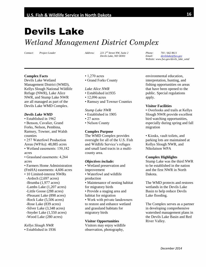
Devils Lake
Wetland Management District Complex Contact: Project Leader Address: 221 2nd Street NW, Suite 2
Devils Lake, ND 58301 Phone: 701 / 662 8611 Email: [email protected]
Website: www.fws.gov/devils_lake_wmd
Complex Facts Devils Lake Wetland
Management District (WMD),
Kellys Slough National Wildlife
Refuge (NWR), Lake Alice
NWR, and Stump Lake NWR
are all managed as part of the
Devils Lake WMD Complex.
Devils Lake WMD
• Established in 1962
• Benson, Cavalier, Grand
Forks, Nelson, Pembina,
Ramsey, Towner, and Walsh
counties
• 257 Waterfowl Production
Areas (WPAs): 48,885 acres
• Wetland easements: 150,182
acres
• Grassland easements: 4,264
acres
• Farmers Home Administration
(FmHA) easements: 4,606 acres
• 10 Limited-interest NWRs
-Ardoch (2,697 acres)
-Brumba (1,977 acres)
-Lambs Lake (1,207 acres)
-Little Goose (288 acres)
-Pleasant Lake (898 acres)
-Rock Lake (5,506 acres)
-Rose Lake (839 acres)
-Silver Lake (3,348 acres)
-Snyder Lake (1,550 acres)
-Wood Lake (280 acres)
Kellys Slough NWR
• Established in 1936
• 1,270 acres
• Grand Forks County
Lake Alice NWR
• Established in1935
• 12,096 acres
• Ramsey and Towner Counties
Stump Lake NWR
• Established in 1905
• 27 acres
• Nelson County
Complex Purpose
The WMD Complex provides
oversight for all of the U.S. Fish
and Wildlife Service’s refuges
and small land tracts in a multi-
county area.
Objectives include:
• Wetland preservation and
improvement
• Waterfowl and wildlife
production
• Maintenance of nesting habitat
for migratory birds
• Provide a staging area and
habitat for migration
• Work with private landowners
to restore and enhance wetland
and grassland habitats for
migratory birds
Visitor Opportunities
Visitors may enjoy wildlife
observation, photography,
environmental education,
interpretation, hunting, and
fishing opportunities on areas
that have been opened to the
public. Special regulations
apply.
Visitor Facilities
• Overlooks and trails at Kellys
Slough NWR provide excellent
bird watching opportunities,
especially during spring and fall
migration
• Kiosks, vault toilets, and
parking lots are maintained at
Kellys Slough NWR, and
Nikolaison WPA
Complex Highlights
Stump Lake was the third NWR
to be established in the nation
and the first NWR in North
Dakota.
The WMD protects and restores
wetlands in the Devils Lake
Basin to help reduce Devils
Lake flooding.
The Complex serves as a partner
in developing comprehensive
watershed management plans in
the Devils Lake Basin and Red
River Valley.
December 2014
U.S. Fish & Wildlife Service in North Dakota 17
J. Clark Salyer
National Wildlife Refuge and Wetland
Management District Contact: Project Leader
WMD Manager
Address: 681 Salyer Road
Upham, ND 58789
Phone: 701 / 768 2548
Email: [email protected] Website: www.fws.gov/refuge/j_clark_salyer
Complex Facts
J. Clark Salyer National
Wildlife Refuge (NWR) and
Wetland Management District
(WMD) are managed as part of
the Souris River Basin NWR
Complex.
J. Clark Salyer NWR
• Established in 1935
• 58,700 acres
• Bottineau and McHenry
Counties
J. Clark Salyer WMD
• Established in 1959
• Bottineau, McHenry, Pierce,
Renville, and Rolette Counties
• 127 Waterfowl Production
Areas (WPA): 27,339 acres
• Wetland easements: 140,276
acres
• Grassland easements: 42,201
acres
• Farmers Home Administration
(FmHA) easements: 6,973 acres
• 7 Limited-interest NWRs
-Buffalo Lake (1,564 acres)
-Cottonwood Lake (1,013
acres)
-Lords Lake (1,915 acres)
-Rabb Lake (261 acres)
-School Section Lake (297
acres)
-Willow Lake (2,620 acres)
-Wintering River (239 acres)
Refuge Purpose
J. Clark Salyer NWR was
established to provide habitat
for waterfowl, migratory birds,
and other wildlife.
WMD Purpose
The WMD provides oversight
for all of the U.S. Fish and
Wildlife Service’s small land
tracts in a multi-county area.
Objectives include:
• Wetland preservation
• Waterfowl and wildlife
production
• Maintenance of nesting habitat
for migratory birds
• Provide a staging area and
habitat for migration
• Work with private landowners
to restore and enhance wetland
and grassland habitats for
migratory birds
Visitor Opportunities and
Facilities
Visitors may enjoy wildlife
observation, photography,
environmental education,
interpretation, hunting, and
fishing opportunities on areas
that have been opened to the
public. Special regulations
apply.
• Two auto tour routes
• Two hiking trails
• Two canoe trails
Complex Highlights
J. Clark Salyer is the largest
NWR in North Dakota,
extending south from the
Canadian border for 45 miles.
Five main dikes with water
control structures impound over
23,000 acres of wetlands.
The refuge is designated as a
Globally Important Bird Area
and is part of the Western
Hemisphere Shorebird Reserve
Network.
The ND Natural Heritage
Inventory lists the refuge as one
of only two intact ecological
landscapes remaining in ND.

December 2014
U.S. Fish & Wildlife Service in North Dakota 18
Kulm
Wetland Management District Contact: Project Leader Address: PO Box E
1 First Street SW
Kulm, ND 58456
Phone: 701 / 647 2866 Email: [email protected]
Website: www.fws.gov/refuge/kulm_wmd
Station Facts
• Established in 1971
• Dickey, LaMoure, Logan, and
McIntosh Counties
• 232 Waterfowl Production
Areas (WPA): 45,379 acres
• Wetland easements: 126,000
acres
• Grassland easements: 67,000
acres
• Farmers Home Administration
(FmHA) easements: 4,130 acres
• 3 Limited-interest NWRs
-Bone Hill (640 acres)
-Dakota Lake (2,800 acres)
-Maple River (712 acres)
WMD Purpose
The WMD provides oversight
for all of the U.S. Fish and
Wildlife Service’s small land
tracts in a multi-county area.
Objectives include:
-Wetland and grassland
preservation
-Waterfowl and wildlife
production
-Maintenance of nesting habitat
for migratory birds
-Provide a staging area and
habitat for migration
-Work with private landowners
to restore and enhance wetland
and grassland habitats for
migratory birds
Visitor Opportunities Visitors may enjoy wildlife
observation, photography,
environmental education,
interpretation, hunting, and
fishing opportunities. Special
regulations apply.
Visitor Facilities
• Boat ramp and fishing pier on
Mundt Lake WPA in Logan
County
• Boat Ramp on Olson WPA
(Diamond Lake) in LaMoure
County
Highlights
The James River runs
southward through LaMoure
and eastern Dickey counties. It
joins the Missouri River System
near Yankton, SD, forming a
valuable migration route for
migratory birds.

December 2014
U.S. Fish & Wildlife Service in North Dakota 19
Lake Ilo
National Wildlife Refuge Contact: Refuge Manager Address: 489 102nd Avenue SW
Dunn Center, ND 58626
Phone: 701 / 548 8110 Email: [email protected]
Website: www.fws.gov/refuge/lake_ilo
Complex Facts
Lake Ilo National Wildlife
Refuge (NWR) is managed as
part of the Audubon NWR
Complex.
The Lake Ilo office oversees
lands located west of the
Missouri River, including 3
NWRs, one Limited-interest
NWR, and one Waterfowl
Production Area (WPA).
Lake Ilo NWR
• Established in 1939
• 4,033 acres
• Dunn County
Stewart Lake NWR
• Established in 1941
• 2,230 acres
• Slope County
White Lake NWR
• Established in 1941
• 1,040 acres
• Slope County
Pretty Rock NWR
• Limited-interest NWR
• Established in 1941
• 800 acres
• Grant County
Hillview WPA
• 1,214 acres
• Hettinger County
Refuge Purpose
Lake Ilo NWR was established
for the following purposes:
• As a breeding ground for
migratory birds and other
wildlife
• Fish and wildlife-oriented
recreation
• Conservation of endangered
species
• Protection of cultural and
natural resources
Visitor Opportunities
Visitors may enjoy wildlife
observation, photography,
environmental education,
interpretation, and fishing
opportunities on areas that have
been opened to the public.
Special regulations apply.
Visitor Facilities
• Lake Ilo Park (Day Use Area)
• North Shore Nature trail – 1
mile
• Wildlife Observation Point
Highlights
The Lake Ilo dam was built as a
water conservation project by
the Works Progress
Administration during the dry
Depression years.
Archeological sites studied on
the refuge revealed sites from
some of the earliest pre-historic
visitors - Folsom period Paleo-
Indians 10,500 years ago.
Cultural resources indicate
11,000 years of continuous
occupation.

December 2014
U.S. Fish & Wildlife Service in North Dakota 20
Long Lake
National Wildlife Refuge and Wetland
Management District Contact: Project Leader
WMD Manager
Address: 12000 353rd Street SE
Moffit, ND 58560
Phone: 701 / 387 4397
Email: [email protected]
Website: ww.fws.gov/refuge/long_lake
Complex Facts
Long Lake, Florence Lake, and
Slade National Wildlife Refuges
(NWR) and Long Lake Wetland
Management District (WMD)
are managed as part of the Long
Lake NWR Complex.
Long Lake NWR
• Established in 1932
• 22,310 acres
• Burleigh and Kidder Counties
Florence Lake NWR
• Established in 1939
• 1,888 acres
• Burleigh County
Slade NWR
• Established in 1940
• 3,000 acres
• Kidder County
Long Lake WMD
• Established in 1961
• Burleigh, Emmons, and
Kidder Counties
• 88 Waterfowl Production
Areas (WPA): 23,723 acres
• Wetland easements: 107,384
acres
• Grassland easements: 98,806
acres
• Farmers Home Administration
(FmHA) easements: 3,713 acres
• 6 Limited-interest NWRs
-Appert Lake (908 acres)
-Canfield Lake (313 acres)
-Lake George (3,119 acres)
-Hutchinson Lake (479 acres)
-Springwater (640 acres)
-Sunburst Lake (328 acres)
Refuge Purpose
Long Lake NWR was
established as a refuge and
breeding ground for migratory
birds and other wildlife.
Use as an inviolate sanctuary, or
for any other management
purpose, for migratory birds.
Preserve, restore, and enhance
federally listed threatened and
endangered species and their
habitats.
Provide the life requirements of
waterfowl, other migratory
birds, and resident wildlife
species.
Provide opportunities for high
quality wildlife-dependent
recreation.
Protect and preserve cultural
resources.
WMD Purpose
The WMD provides oversight
for all of the U.S. Fish and
Wildlife Service’s small land
tracts in a multi-county area.
Objectives include:
• Wetland preservation
• Waterfowl and wildlife
production
• Maintenance of nesting habitat
for migratory birds
• Provide a staging area and
habitat for migration
• Work with private landowners
to restore and enhance wetland
and grassland habitats for
migratory birds
Visitor Opportunities
Visitors may enjoy wildlife
observation, photography,
environmental education,
interpretation, hunting, and
fishing opportunities on areas
that have been opened to the
public. Special regulations
apply.
Visitor Facilities
• The Butte Viewing Area
• Public Fishing Area
• Sharp-tailed grouse viewing
blind

December 2014
U.S. Fish & Wildlife Service in North Dakota 21
Highlights An important staging area for
migrating sandhill cranes,
Canada geese, and other
waterfowl and shorebirds.
Endangered whooping cranes
often use refuge marshes during
spring and fall migration
periods.
Colonial birds, shorebirds, and
other water birds use Long Lake
NWR as a breeding and nesting
ground. Species include: black-
crowned night herons, cattle
egrets, common and black terns,
western and eared grebes,
Franklin’s gulls, double-crested
cormorants, and Federally
threatened piping plovers.
Long Lake NWR was
designated as a Globally
Important Bird Area and a
Western Hemisphere Shorebird
Reserve Network site due to its
importance as both a breeding
and migratory stop-over site for
more than 20,000 shorebirds
annually.
December 2014
U.S. Fish & Wildlife Service in North Dakota 22
Lostwood
National Wildlife Refuge and Wetland
Management District Contact: Project Leader
WMD Manager
Address: 8315 Highway 8
Kenmare, ND 58746
Phone: 701 / 848 2722
Email: [email protected] Website: www.fws.gov/refuge/lostwood
Complex Facts
Lostwood and Shell Lake
National Wildlife Refuges
(NWR) and Lostwood Wetland
Management District (WMD)
are managed as part of the
Lostwood WMD Complex.
Lostwood NWR
• Established in 1935
• 27,589 acres
• Burke and Mountrail County
Shell Lake NWR
• Established in 1939
• 1,835 acres
• Mountrail County
Refuge Purpose
Lostwood NWR was established
to serve as a refuge and
breeding ground for migratory
birds and other wildlife.
Objectives Include:
-Preservation of native
grasslands
-Conservation of wildlife and
habitat for people today and for
generations to come
-Manage wilderness with equal
consideration in management
decisions
Lostwood WMD
• Established in 1962
• Mountrail and a portion of
Ward County
• 56 Waterfowl Production
Areas (WPA): 12,506 acres.
• Wetland easements: 35,000
acres
• Grassland easements: 39,052
acres
• Farmers Home Administration
(FmHA) easements: 605 acres
WMD Purpose
The WMD provides oversight
for all of the U.S. Fish and
Wildlife Service’s small land
tracts in a multi-county area.
Objectives include:
• Wetland preservation
• Waterfowl and wildlife
production
• Maintenance of nesting habitat
for migratory birds
• Provide a staging area and
habitat for migration
• Work with private landowners
to restore and enhance wetland
and grassland habitats for
migratory birds
Visitor Opportunities
Visitors may enjoy wildlife
observation, photography,
environmental education,
interpretation, hunting, and
fishing opportunities in areas
that have been opened to the
public. The Lostwood
Wilderness Area is open for
birding, hiking, and
photography. Special
regulations apply.
Visitor Facilities
• Visitor Center
• Auto tour route
• Hiking Trail
• Viewing Tower
Complex Highlights
The 5,577 acre Lostwood
Wilderness Area was
established in 1975.
Lostwood NWR is a ‘Globally
Important Bird Area’ designated
by the American Bird
Conservancy. Lostwood Complex provides
breeding habitat for the
federally threatened piping
plover as well as many
declining grassland bird species
such as Baird’s sparrow and
Sprague’s pipit.
December 2014
U.S. Fish & Wildlife Service in North Dakota 23
Sullys Hill
National Game Preserve Contact: Visitor Services Manager Address: 2107 Park Drive
Fort Totten, ND 58335 Phone: 701 / 766-4272 Email: [email protected]
Website:
www.fws.gov/refuge/sullys_hill_national_ game_preserve/
Station Facts
Sullys Hill National Game
Preserve (NGP) is managed as
part of the Devils Lake Wetland
Management District Complex.
Sullys Hill NGP
• Established in 1921
• 1,675 acres
• Benson County
Station Purpose
Sullys Hill NGP was established
for the following:
• As a big game preserve,
refuge, and breeding ground for
wild animals and birds. The
NGP is to be made available to
the public for recreational
purposes that are consistent with
the use of this area as a game
preserve.
Visitor Opportunities
Visitors may enjoy wildlife
observation, photography,
environmental education, and
interpretation. Special
regulations apply.
Visitor Facilities
• Visitor center
• Auto tour route – 4 miles
• Nature trail – 1 ½ miles
• Accessible nature trail – ¼
mile
• 4 Observation decks
Highlights
• One of four U.S. Fish and
Wildlife Service preserves that
were established for national
bison conservation.
• Sullys Hill was first
established as a National Park in
1904. In 1921, the unit was
transferred to the U.S. Fish and
Wildlife Service to be managed
as a NGP.
• Supports a unique community
of habitats including an oak,
ash, basswood, and aspen
woodland and mixed grass
prairie interspersed with natural
and created wetlands.
• Provides habitat for over 250
species of migratory birds,
plains bison, Rocky Mountain
elk, white-tailed deer, and
prairie dogs.
• Serves as a regional
conservation learning center,
promoting the conservation role
of the National Wildlife Refuge
System while educating visitors
about the functions and benefits
of the NGP and the surrounding
prairie wetlands and grasslands.

December 2014
U.S. Fish & Wildlife Service in North Dakota 24
Tewaukon
National Wildlife Refuge and Wetland
Management District Contact: Project Leader
WMD Manager
Address: 9754 143-½ Avenue SE
Cayuga, ND 58013
Phone: 701 / 724 3598
Email: [email protected] Website: www.fws.gov/refuge/tewaukon
Complex Facts
Tewaukon National Wildlife
Refuge (NWR) and Wetland
Management District (WMD)
are managed as part of the
Tewaukon NWR Complex.
Tewaukon NWR
• Established in 1934
• 8,363 acres
• Sargent County
Tewaukon WMD
• Ransom, Richland, and
Sargent Counties
• 63 Waterfowl Production
Areas (WPA): 14,378 acres
• Wetland easements: 27,000
acres
• Grassland easements: 11,000
acres
• Farmers Home Administration
(FmHA) easements: 2,000 acres
• Limited-interest NWRs:
-Storm Lake (686 acres)
-Wild Rice Lake (779 acres)
Refuge Purpose
Tewaukon NWR was
established for the following:
• As a refuge and breeding
ground for migratory birds and
other wildlife
• For use as an inviolate
sanctuary, or for any other
management purpose for
migratory birds
WMD Purpose
The WMD provides oversight
for all of the U.S. Fish and
Wildlife Service’s small land
tracts in a multi-county area.
Objectives include • Wetland preservation
• Waterfowl and wildlife
production
• Maintenance of nesting habitat
for migratory birds
• Provide a staging area and
habitat for migration
• Work with private landowners
to restore and enhance wetland
and grassland habitats for
migratory birds
Visitor Opportunities
Visitors may enjoy wildlife
observation, photography,
environmental education,
interpretation, hunting, and
fishing opportunities on areas
that have been opened to the
public. Special regulations
apply.
Visitor Facilities
• Visitor center
• Auto tour route
• Nature trail
• Day use area
• Fishing dock
• Boat ramp
Highlights
Tewaukon NWR is located
along the Wild Rice River and
is managed as a part of the
tallgrass prairie ecosystem.
The Refuge and WMD are
implementing a prairie
restoration program where
former croplands are seeded to
native prairie grasses and forbs.
Lake Tewaukon supports tens of
thousands of migrating snow
geese and other waterfowl
species each spring.

December 2014
U.S. Fish & Wildlife Service in North Dakota 25
Upper Souris
National Wildlife Refuge Contact: Refuge Manager
Address: 17705 212th Avenue NW Foxholm, ND 58718
Phone: 701 / 468 5467 Email: [email protected]
Website: www.fws.gov/refuge/upper_souris
Complex Facts
Upper Souris National Wildlife
Refuge (NWR) is managed as
part of the Souris River Basin
NWR Complex.
Station Facts
• Established in 1935
• 32,092 acres
• Ward and Renville County
Refuge Purpose
Upper Souris NWR was
established for the following:
• As a refuge and breeding
ground for migratory birds and
other wildlife
• To protect, restore, and
manage habitat for migratory
birds and threatened and
endangered species
• Protect and manage Souris
River water to benefit fish and
wildlife on Upper Souris and J.
Clark Salyer NWRs
• Provide opportunities for
quality wildlife-dependent
recreation
Visitor Opportunities
Visitors may enjoy wildlife
observation, photography,
environmental education,
interpretation, hunting, and
fishing opportunities on areas
that have been opened to the
public. Special regulations
apply.
Visitor Facilities
• Visitor center
• Auto tour route
• Nature trail
• Canoe trail
• Day use area
• Fishing dock
• Boat ramps
Highlights
Lake Darling, a 9,600 acre lake,
is the largest of several water
impoundments on the refuge.
The lake’s primary purpose is to
furnish a regulated water supply
to smaller marshes downstream
and especially to the larger
marshes on the J. Clark Salyer
NWR, 110 miles downstream.
In 1998, the dam became an
integral part of the Souris River
Flood Control Project that
assists in providing 100-year
flood protection for the city of
Minot.
The refuge has been designated
as a Globally Important Bird
Area by the American Bird
Conservancy, and Lake Darling
is listed as a critical habitat for
the threatened piping plover.

December 2014
U.S. Fish & Wildlife Service in North Dakota 26
Valley City
Wetland Management District Contact: WMD Manager Address: 11515 River Road
Valley City, ND 58072 Phone: 701 / 845 3466 Email: [email protected]
Website:
www.fws.gov/refuge/valley_city_wmd
Complex Facts
Valley City Wetland
Management District (WMD) is
managed as part of the
Arrowwood National Wildlife
Refuge (NWR) Complex.
Valley City WMD
• Established in 1971
• Griggs, Steele, Traill, Barnes,
and Cass Counties
• 82 Waterfowl Production
Areas (WPA): 17,481 acres
• Wetland easements: 45,918
acres
• Grassland easements: 282
acres
• Farmers Home Administration
(FmHA) easements: 8,320 acres
• 4 Limited-interest NWRs
include:
-Hobart Lake (2,077 acres)
-Sibley Lake (1,077 acres)
-Stoney Slough (880 acres)
-Tomahawk (440 acres)
Purpose
The WMD provides oversight
for all of the U.S. Fish and
Wildlife Service’s small land
tracts in a multi-county area.
Objectives include:
• Wetland preservation
• Waterfowl and wildlife
production
• Maintenance of nesting habitat
for migratory birds
• Provide a staging area and
habitat for migration
• Work with private landowners
to restore and enhance wetland
and grassland habitats for
migratory birds
Visitor Opportunities Visitors may enjoy wildlife
observation, photography,
environmental education,
interpretation, hunting, and
fishing opportunities. Special
regulations apply.
Visitor Facilities
• Visitor Center
Highlights
Valley City WMD headquarters
is co-located with the National
Fish Hatchery.
The eastern one-third of the
WMD is located in the Red
River Valley, characterized by
flat, intensively farmed lands,
which were once the lake bed of
Glacial Lake Agassiz.
The eastern two-thirds of the
District is part of the glaciated
prairie pothole region known as
the drift prairie.
The Sheyenne River meanders
southward through the drift
prairie, creating an important
migration pathway and riparian
zone.

December 2014
U.S. Fish & Wildlife Service in North Dakota 27
Garrison Dam
National Fish Hatchery Contact: Project Leader Address: Box 530
Riverdale, ND 58565 Phone: 701 / 654 7451 Email: [email protected]
Website: www.fws.gov/garrisondam
Station Facts
The Garrison Dam National
Fish Hatchery (NFH) was
established in 1957 to provide
mitigation for the Upper
Missouri River Development
(Pick Sloan) Plan. The hatchery
is located downstream of
Garrison Dam on 209 acres of
land acquired in fee title for the
Garrison Project by the U.S.
Army Corps of Engineers.
Construction of the hatchery
was complete by the fall of
1962 and fish production began
in 1963.
The authorizing legislation for
Garrison Dam NFH is found in
the Fish and Wildlife
Coordination Act of 1934 (48
Stat. 401). An amendment to
the Act in 1946 established
provisions to assess fishery
resource impacts due to
impoundments and authorized
other Federal agencies to
transfer funds to the Fish and
Wildlife Service for the
propagation of fish to mitigate
damages. Hatchery funding was
established by Congress in 1957
under Public Law 85-77
(71Stat.264).
The hatchery has evolved over
the years to its current capacity
in response to changing
fisheries needs. The original
hatchery was comprised of
twelve raceways and twenty-
four 1 ½ acre ponds totaling
37.5 acres. The North Dakota
Game and Fish Department
invested in a two million dollar
facility located on the station in
1988. With the growing fishery
needs across the state another
2.5 million dollars was
committed the following year
toward a 40 pond expansion
project bringing the total acres
of production ponds to 97.5
acres. Garrison Dam NFH is the
largest Fish and Wildlife
Service’s pond production
hatchery. Its annual distribution
of 25-35 tons of trout and
salmon positions this facility in
the top ten rainbow trout
stations nationwide.
The hatchery produces walleye,
sauger, northern pike, chinook
salmon, rainbow trout, brown
trout, cutthroat trout, burbot
shovelnose sturgeon, pallid
sturgeon and paddlefish.
The Garrison Dam NFH
Complex is operated by the U.S.
Fish and Wildlife Service with
cooperative funding through the
North Dakota Game and Fish
Department and U.S. Army
Corps of Engineers.
Station Objectives
• Propagate native fish and
salmonids to maintain quality
recreational fisheries in North
Dakota and Wyoming
• Provide mitigation stocking in
Corps of Engineer’s reservoirs
• Assist in the recovery of the
pallid sturgeon, an endangered
species
• Assists with restoration of
shovelnose sturgeon in the
Bighorn River of Wyoming
• Assists with restoration of
sauger on the Wind River of
Wyoming
• Development of spawning and
propagation techniques for
burbot and other native
imperiled species
Visitor Opportunities
Visitors may observe fish in the
large visitor center aquariums
and hatchery tanks, hiking on
the hatchery’s trails, biking,
cross country skiing,
photography, viewing of
returning spawning salmon in
the hatchery creek,
environmental education,
guided tours and interpretation.
Visitor Facilities
• Visitor center with aquariums,
slideshow, and an interactive
touch screen computer
• Hatchery tours

December 2014
U.S. Fish & Wildlife Service in North Dakota 28
• Wildlife observation trails
with viewing blind
• Fishing pond
• Groomed cross country ski
trails
Activity Highlights
Annually stocks more than 10
million fish for restoration and
recovery of native fish and helps
sustain sport fishing in more
than 200 lakes and rivers in
North Dakota and Wyoming.
Annually produces more than
25 tons of trout and salmon for
stocking in North Dakota
waters.
Is the largest producer of the
endangered pallid sturgeon,
contributing significantly to the
recovery of this species.
The hatchery is operated in
cooperation with the North
Dakota Game and Fish
Department with funding
provided by the Department and
U.S. Army Corps of Engineers
for recreational and mitigation
fish stockings.
Annual fishing derbies held for
children with disabilities and
long term care residents.

December 2014
U.S. Fish & Wildlife Service in North Dakota 29
Valley City
National Fish Hatchery
Contact: Assistant Project Leader Address: 11515 River Road Valley City, ND 58072
Phone: 701 / 845 3464 Email: [email protected]
Website: www.fws.gov/valleycity
Station Facts
Valley City National Fish
Hatchery (NFH) is located in
south-eastern North Dakota
three miles northwest of Valley
City. The hatchery site
encompasses 71.5 acres on the
banks of the Sheyenne River.
The hatchery is comprised of 14
rearing ponds totaling 25.8 acres
and an intensive fish culture
facility.
Construction of Valley City
NFH was authorized by
Congress in 1930 under the
White Act (46 Stat. 372) for the
United States Bureau of Sport
Fisheries. The Act specified the
establishment of a fish-cultural
substation in North Dakota.
Construction began in 1938 and
was complete in 1940 with labor
provided by the Work Projects
Administration.
Baldhill Dam NFH is located in
south-eastern North Dakota
twelve miles north of Valley
City. The hatchery site
encompasses 38.5 acres and is
located directly below Lake
Ashtabula. The hatchery is
comprised of 20 fish rearing
ponds totaling 15.2 acres and an
intensive culture facility. A
cooperative agreement was
drafted with the U.S. Army
Corps of Engineers June 7, 1950
for use of the land and
installation of the water supply
line. Construction of the
hatchery began in 1949 and was
completed in 1951.
Baldhill Dam NFH, a substation
of the Valley City NFH was
authorized by Congress under
Public Law #350 on October 12,
1949 (63 Stat. 795). The Law
authorized funding for operation
of fish-cultural stations for the
propagation and distribution of
food fishes. The facility was
completed in 1951.
Valley City NFH and Baldhill
Dam NFH are substations of the
Garrison Dam Complex and the
only Fish and Wildlife Service
hatcheries in the Hudson Bay
Drainage. These hatcheries are
critical for continued and future
work on aquatic species in this
watershed.
The hatcheries produce walleye,
northern pike, crappie, tiger
muskellunge, bluegill,
largemouth bass, yellow perch,
and lake sturgeon.
Station Objectives
• Propagate native fish to
maintain quality recreational
fisheries in North Dakota and
Wyoming
• Assists with restoration of lake
sturgeon to the Red River
• Provide mitigation stocking in
Corps of Engineer’s reservoirs
• Develop mussel propagation
capabilities to assist in
restoration activities on the
Sheyenne and other Red River
tributaries
Visitor Opportunities and
Facilities • Visitor center
• Hiking
• Wildlife observation
• Photography
• Environmental education
• Canoeing
Highlights
• Propagation of native mussels
and fish for recreational fishing,
restoration of threatened species
and research
• Pollinator gardens, kids
fishing pond, and interpretive
day use area
• Outreach education for the
Valley City public school
system and state university

December 2014
U.S. Fish & Wildlife Service in North Dakota 30
Ecological Services
Field Office
Contact: Field Supervisor Address: 3425 Miriam Avenue
Bismarck, ND 58501
Phone: 701 / 250 4481
Email: [email protected]
Website: www.fws.gov/northdakotafieldoffice/
Station Facts
The North Dakota Ecological
Services (ES) Field Office
manages U.S. Fish and Wildlife
Service (Service) programs for
the conservation, protection, and
enhancement of fish, wildlife,
plants, and their habitats within
North Dakota.
This Field Office was
established in 1972 and is one
of 78 ES field stations across
the United States.
Primary activities include
coordination on Federal
projects, the Endangered
Species Act, environmental
contaminants, permits, and
licenses.
Station Objectives
• Provide oversight of
Endangered Species Act
compliance, particularly on
federal actions
• Conduct activities necessary to
meet the Fish and Wildlife
coordination Act responsibilities
• Participate in the
environmental review of
federally funded projects that
may affect fish and wildlife
• Address potential contaminant
impacts on natural resources
• Contribute to wetlands
conservation through review of
proposed work plans
Highlights
Provide Service lead on the
Corps of Engineers' Missouri
River Master Manual and
associated operational activities.
Develop and implement
replacement mitigation
measures for the Garrison
Diversion Unit.
Lead recovery activities for the
western prairie-fringed orchid in
southeastern North Dakota.
Coordinate fish and wildlife
issues relative to use of
agricultural chemicals.
Implement recovery of the least
tern and piping plover on the
Missouri River and Prairie
Coteau wetlands.
Promote public awareness of
endangered species,
environmental contaminants,
and prairie issues.
Conserve wetlands through
coordination, project review,
and alternative development.

December 2014
U.S. Fish & Wildlife Service in North Dakota 31
Fire Management
Contact: Fire Management Officer
Arrowwood NWR Complex
Address: 7780 10th St SE Pingree, ND 58476
Phone: 701/285-3341
Contact: ND Interagency Dispatch
Center, Lead Dispatcher
Dakota Prairie Grasslands Office Address: 1200 Missouri Avenue
Bismarck, ND 58504
Phone: 701/333-0262
Fire Management Facts
The U.S. Fish and Wildlife
Service has been using and
managing fire safely and cost-
effectively since the 1930’s,
leading to lands being in
healthier ecological condition
overall, with lower risk of
damaging fire. This long-term,
balanced approach to fire
management benefits both
people and wildlife.
In order to use fire to achieve
resource management
objectives, certain
environmental factors including
fuel, moisture, wind, relative
humidity, and managerial
constraints such as adequate
staffing and contingency
planning must be met. These
conditions are known as a
"prescription."
Activity Highlights
Prescribed fire is used to
manage habitat for migratory
birds, endangered plants and
animals, and resident wildlife.
Fire is also used to manage and
control noxious weeds or other
undesirable plant species.
Fire management and refuge
officials work with federal,
state, and local fire managers to
control wildland fires and
accomplish other common
objectives.
North Dakota Interagency
Dispatch Center
The Center dispatches resources
from Federal, State, and local
agencies to wildland fire
incidents, prescribed fires, and
all-hazard incidents within
North Dakota and across the
country.
The Center serves all agencies
within the North Dakota Zone:
U.S. Department of Agriculture
(USDA) – Forest Service, U.S.
Department of Interior – Bureau
of Land Management, Fish and
Wildlife Service, National Park
Service, Bureau of Indian
Affairs, as well as State
agencies – North Dakota Forest
Service, Game and Fish
Department, Parks and
Recreation, as well as County
and Local Fire Departments.
Partners
North Dakota Forest Service
North Dakota Game and Fish
Department
Various Tribes in North and
South Dakota
Bureau of Indian Affairs
USDA Forest Service
National Park Service

December 2014
U.S. Fish & Wildlife Service in North Dakota 32
Habitat and Population
Evaluation Team
Division of Refuges and Wildlife Contact: Project Leader Address: 3425 Miriam Avenue
Bismarck, ND 58501 Phone: 701 / 250 4413
Station Facts
The Habitat and Population
Evaluation Team (HAPET) was
established in 1989. HAPET’s
primary mission is to coordinate
the four square mile breeding
waterfowl survey and develop
landscape-scale models to
inform waterfowl and other
migratory bird conservation
efforts in the Prairie Pothole
Region.
HAPET supports the
conservation mission of the U.S.
Fish and Wildlife Service by
integrating scientific data and
landscape-scale conservation
planning with a focus on
migratory birds.
HAPET serves multi-agency
partners of the Prairie Pothole
Joint Venture, North American
Waterfowl Management Plan.
Three HAPET branch offices
are located in Great Falls,
Montana, Hartford, Kansas, and
Fergus Falls, Minnesota.
Station Objectives
• Prioritize areas for
conservation efforts to benefit
wildlife populations
• Support the development and
application of models to identify
and prioritize areas for
conservation efforts
• Guide strategic habitat
conservation by monitoring
migratory bird populations
• Provide science support for
Service programs as well as
other governmental and non-
governmental partners
• Enhance the efficiency and
effectiveness of land and
wildlife conservation by
developing computer
applications to be used by the
National Wildlife Refuge
System
• Evaluate effects of stressors
such as wind energy
development, oil and gas
extraction, habitat conversion,
and climate change on
migratory bird populations
Activity Highlights
Developed first wetland maps
displaying 3.3 million wetlands
in the U.S. Prairie Pothole
Region.
Developed duck breeding pair
distribution maps for the U.S.
Prairie Pothole Region.
Developed density and
distribution maps for a variety
of grassland birds, shorebirds,
and waterbirds across much of
the U.S. Prairie Pothole Region.
Demonstrated the benefits of the
U.S. Department of Agriculture
Conservation Reserve Program
for waterfowl and grassland
birds.
Annual waterfowl surveys use
state-of-the-art, remotely-
gathered aerial photography and
field study to monitor water
conditions in the Prairie Pothole
Region of ND, SD, MT, MN,
and Iowa.
Developed and maintain digital
files of Service lands in the
Mountain-Prairie Region.
December 2014
U.S. Fish & Wildlife Service in North Dakota 33
Law Enforcement
Contact: Resident Agent in Charge Address: 3425 Miriam Avenue
Bismarck, ND 58501
Phone: 701 / 255 0593
Contact: Special Agent Address: 3425 Miriam Avenue
Bismarck, ND 58501
Phone: 701 / 255 0593
Contact: Wildlife Inspector Address: U.S. Hwy 281 @ Canadian
Border – RR 1 Box 115
Dunseith, ND 58329 Phone: 701 / 263 4462
Contact: Wildlife Inspector Address: 10980 I-29 N., Suite 1
Pembina, ND 58271
Phone: 701/825-6366
Law Enforcement Facts
Special Agents are criminal
investigators who enforce the
treaties, statutes, and regulations
administered by the U.S. Fish
and Wildlife Service.
Special Agents conduct both
overt and covert investigations
using a variety of techniques
including interviewing,
gathering of evidence,
conducting surveillance, using
forensics techniques, executing
search and arrest warrants,
training other law enforcement
agencies in wildlife law
enforcement, and teaching in
educational facilities about
wildlife conservation.
Activity Highlights
Protect endangered species and
their habitats.
Investigate illegal take and
commercialization of wildlife.
Ensure compliance with
migratory bird hunting
regulations.
Protect bald and golden eagles.
Ensure compliance with wildlife
import/export regulations and
the Convention on International
Trade in Endangered Species of
Wild Flora and Fauna (CITES).
Assist in furthering the mission
of the Service's wetland
easement program.
Assist tribes in wildlife
management.
Partners
North Dakota Game and Fish
Department
Various tribes in North Dakota
Various international agencies
and other federal, state, and
local law enforcement agencies
in North Dakota and throughout
the United States.
December 2014
U.S. Fish & Wildlife Service in North Dakota 34
Missouri River Fish and
Wildlife Conservation Office
Contact: Project Leader Address: 3425 Miriam Avenue
Bismarck, ND 58501
Phone: 701 / 250 4419
Website: www.fws.gov/moriver
Station Facts
The Missouri River Fish and
Wildlife Conservation Office
was established in 1990.
Headquarters is in Bismarck,
North Dakota, and most work is
conducted in North Dakota and
eastern Montana.
Station Objectives
Conserve, manage, restore, and
enhance imperiled native
aquatic resources of the
Missouri River and its major
tributaries, focusing primarily
on the endangered pallid
sturgeon and other priority
species to preclude listing under
the Endangered Species Act.
Implement pallid sturgeon
recovery effort in North Dakota
through spawning,
augmentation, monitoring,
conducting research on life
history and habitat
requirements, protection, and
close coordination with
numerous state, federal, and
private organizations.
Work collaboratively with our
partners to develop strategies
that protect, restore, and
enhance aquatic habitats
utilizing the National Fish
Passage Program and the
National Fish Habitat
Partnership.
Provide expertise for
management of aquatic
resources on National Wildlife
Refuges including Tewaukon,
Upper Souris, and Lake Ilo.
Provide technical assistance to
the Native American Tribes and
Air Force Bases of North
Dakota for their natural
resources.
Implement measures that
minimize the risk of spreading
aquatic invasive species.
Increase awareness and promote
conservation of imperiled native
fish stocks.
Promote recreational fishing and
other public uses that increase
the enjoyment and education of
aquatic resources by engaging
the public and our partners.
Highlights
Work with the endangered
pallid sturgeon recovery effort
in North Dakota and throughout
the species' range from Montana
to Louisiana through planning,
research on life history, species
response, habitat requirements,
protection, and close
collaboration with numerous
state, federal, and private
organizations.
December 2014
U.S. Fish & Wildlife Service in North Dakota 35
Partners for Fish and Wildlife
Contact: State Coordinator Address: 3425 Miriam Avenue
Bismarck, ND 58501
Phone: 701 / 250 4403
Website:
www.fws.gov/mountain-prairie/pfw/nd
Program Facts
The Partners for Fish and
Wildlife Program (Partners) was
established in 1987, and works
to achieve voluntary habitat
restoration on private lands.
The Partners program provides
financial and technical
assistance to private landowners
to restore, enhance, and
establish habitat that benefits
migratory birds, threatened and
endangered species, and other
declining species.
Staff provides coordination and
oversight for the U.S. Fish and
Wildlife Service role and
responsibility at the State and
local levels as identified in the
Farm Bill and associated U.S.
Department of Agriculture’s
policies and programs.
Program Objectives
• Increase wetland habitat
through restoration of drained
wetlands, creation of new
wetlands, and enhancement of
existing wetlands.
• Restore and enhance
grasslands through grassland
restoration and rotational
grazing systems that increase
livestock production and
provide habitat for migratory
birds and other wildlife.
• Restore and enhance riparian
habitat through improved
livestock management.
Activity Highlights
North American Wetland
Conservation Act grants have
been written and administered
through the Partners Program.
These grants provide valuable
funding for the Partners
program, as well as the wetland
and grassland easement
programs.

December 2014
U.S. Fish & Wildlife Service in North Dakota 36
Wetland Acquisition Office
Bismarck and Minot Contact: Supervisory Realty Specialist Address: 3425 Miriam Avenue
Bismarck, ND 58501
Phone: 701 / 250 4415 Website: www.fws.gov/refuges/realty
Contact: Senior Realty Specialist Address: 2001 6th Street, SE, Suite #5
Minot, ND 58701
Phone: 701 / 852 0318
Station Facts
Established in 1961 to manage
the Small Wetland Acquisition
Program with offices in Minot
and Bismarck.
Acquisition Program
The Service acquires wildlife
habitat using fee title acquisition
and conservation easements.
Conservation easements include
wetland easements and
grassland easements.
Easements protect the habitat,
and surface ownership and
property taxes remain the
responsibility of the landowner.
Waterfowl Production Areas are
acquired in fee title. They
provide essential nesting cover
for waterfowl and are open to
hunting, fishing, and trapping.
Most acquisitions are made
under the authority of the
Migratory Bird Hunting and
Conservation Stamp Act of
1934. Waterfowl production is
the primary purpose and benefit
of the acquisition.
Fund Source for Habitat
Acquisition
The Migratory Bird
Conservation Fund provides
funding for acquisition.
Revenues from "Duck Stamps,"
import fees on firearms and
ammunition, and some National
Wildlife Refuge entrance fees
contribute to this fund.
Over $170 million has been
spent on habitat acquisition and
protection since this program
began in 1961.
Refuge Revenue Sharing
Payment
For fee properties owned by the
Service, annual refuge revenue
sharing payments are made to
the counties to offset loss of
property taxes.
Payments are based upon 3/4 of
1 percent of the market value of
the property owned in fee title.
North Dakota State law requires
counties to use refuge revenue
sharing funds for roads and
schools.

December 2014
U.S. Fish & Wildlife Service in North Dakota 37
Glossary
Farmers Home Administration Conservation Easement (FmHA) – easements developed by the U.S. Congress
under the Consolidated Farm and Rural Development Act of 1985 to establish easements for conservation,
recreation, and wildlife purposes on properties that were foreclosed on by the Federal government.
Fee Title – acquisition of most or all of the rights to a tract of land.
Grassland Easement – perpetual agreement entered into by a landowner and the U.S. Fish and Wildlife Service
(Service) by which a landowner gives up or sells one or more of the rights on their property for conservation
purposes, with terms set by the Service. In return for a single lump-sum payment, the landowner agrees not to
cultivate the grassland. Mowing, haying, and grass seed harvesting are delayed until after July 15 each year.
Habitat – suite of existing environmental conditions required by an organism for survival and reproduction; the
place where an organism typically lives and grows.
Habitat Conservation – protection of animal or plant habitat to ensure that the use of that habitat by the animal
or plant is not altered or reduced.
Limited-interest Easement Refuge – the U.S. Fish and Wildlife Service has limited capabilities on these
refuges. Most agreements include the right to manage water uses, hunting, and trapping on the refuges.
Migration – regular, extensive, seasonal movements of birds between their breeding regions and their wintering
regions.
Migratory Bird – bird species that follow a seasonal movement from their breeding grounds to their wintering
grounds. Waterfowl, shorebirds, raptors, and songbirds are all migratory birds.
National Wildlife Refuge System (NWRS) – designated area of land, water, or an interest in land or water
within the National Wildlife Refuge System.
North American Waterfowl Management Plan (NAWMP) – signed in 1986, and recognizes that the recovery
and perpetuation of waterfowl populations depends on restoring wetlands and associated ecosystems throughout
the United States and Canada. It established cooperative international efforts and joint ventures comprised of
individuals; corporations; conservation organizations; and local, state, provincial, and federal agencies drawn
together by common conservation objectives.
Prescribed Fire – skillful application of fire to natural fuels under conditions such as weather, fuel moisture, and
soil moisture that allow confinement of the fire to a pre-determined area and produces the intensity of heat and
rate of spread to accomplish planned benefits to one or more objectives of habitat management, wildlife
management, or hazard reduction.
Private Land – land that is owned by a private individual, a group of individuals, or a non-governmental
organization.

December 2014
U.S. Fish & Wildlife Service in North Dakota 38
Refuge Purpose – purpose specified in or derived from the law, proclamation, executive order, agreement, public
land order, donation document, or administrative memorandum establishing authorization or expanding a refuge
or district sub-unit.
Refuge Revenue Sharing – annual payment made to the county or other local unit of government to off-set the
tax losses on lands acquired by the U.S. Fish and Wildlife Service.
Region 6 – Mountain-Prairie Region of the U.S. Fish and Wildlife Service (Service), which administers Service
programs in Colorado, Kansas, Montana, Nebraska, North Dakota, South Dakota, Wyoming, and Utah.
U.S. Fish and Wildlife Service (USFWS, Service) – principal federal agency responsible for conserving,
protecting, and enhancing fish and wildlife and their habitats for the continuing benefit of the American people.
The Service manages the National Wildlife Refuge System which is comprised of national wildlife refuges and
waterfowl production areas. It also operates national fish hatcheries and ecological service field stations, the
agency enforces federal wildlife laws, manages migratory bird populations, restores national significant fisheries,
conserves and restores wildlife habitat such as wetlands, administers the Endangered Species Act, and helps
foreign governments with their conservation efforts. It also oversees the federal aid program that distributes
millions of dollars in excise taxes on fishing and hunting equipment to state wildlife agencies.
Waterfowl – category of birds that includes ducks, geese, and swans.
Waterfowl Production Area (WPA) – public lands purchased by the Federal government for increasing the
production of migratory birds, especially waterfowl. The purchase of land is also known as “ownership in fee
title” where the Federal government holds ownership of land on behalf of the American public. Money to buy
WPA lands generally comes from the public purchase of a Federal Duck Stamp. This program is important to
ensure the long-term protection of waterfowl and other migratory bird breeding habitat that is located primarily in
the Prairie Pothole Region of the northern Great Plains. All WPAs are within Wetland Management Districts
managed by Service staff. WPAs are open to the public for hunting, fishing, trapping, and other wildlife
dependent recreational opportunities.
Wetland – land transition between terrestrial and aquatic systems where the water table is usually at or near the
surface or the land is covered by shallow water.
Wetland Easement – perpetual agreement entered into by a landowner and the U.S. Fish and Wildlife Service
(Service) by which a landowner gives up or sells one or more of the rights on their property for conservation
purposes, with terms set by the Service. In return for a single lump-sum payment, the landowner agrees not to
drain, burn, level, or fill wetlands covered by the easement. When wetlands dry up naturally, they can be farmed,
grazed, or hayed.
Wetland Management District (WMD) – administrative unit that provides oversight for all of the U.S. Fish and
Wildlife Service’s small land tracts in a multi-county area. Eleven WMDs in North Dakota manage waterfowl
production areas, wetland easements, grassland easements, and Farmers Home Administration conservation
easements. These WMD lands are part of the National Wildlife Refuge System, a network of lands set aside to
conserve fish and wildlife and their habitat.
Recommended