UNIVERSITI PUTRA MALAYSIA
JWAN M. MOHAMMED AL-DOSKI
FK 2013 134
USE OF HYBRID CLASSIFICATION ALGORITHM FOR LAND USE AND LAND COVER ANALYSIS IN DATA SCARCE ENVIRONMENT

© COPYRIG
HT UPM
USE OF HYBRID CLASSIFICATION ALGORITHM FOR LAND USE AND
LAND COVER ANALYSIS IN DATA SCARCE ENVIRONMENT
By
JWAN M. MOHAMMED AL-DOSKI
Thesis Submitted to the School Graduate Studies, Universiti Putra Malaysia, in
Fulfillments of the Requirements for the Degree of Master of Science.
September 2013

© COPYRIG
HT UPM
COPYRIGHT
All material contained within the thesis, including without limitation text, logos,
icons, photographs and all other artwork, is copyright material of Universiti Putra
Malaysia unless otherwise stated. Use may be made of any material contained within
the thesis for non-commercial purposes from the copyright holder. Commercial use
of material may only be made with the express, prior, written permission of
Universiti Putra Malaysia.
Copyright © Universiti Putra Malaysia

© COPYRIG
HT UPM
ii
DEDICATION
To who survived the Anfal killing grounds and to all those who did not
To all victims of Iraq’s chemical warfare in Halabja
To those who are fighting against tyranny and oppression
For those who love knowledge and are pursuing it for a better world
To my ever-loving parents
To my dearest siblings
To my lovely sister, Jivan Al-doski

© COPYRIG
HT UPM
iii
Abstract of thesis presented to the Senate of Universiti Putra Malaysia in fulfillment
of the requirement for the degree of Master of Science
USE OF HYBRID CLASSIFICATION ALGORITHM FOR LAND USE AND
LAND COVER ANALYSIS IN DATA SCARCE ENVIRONMENT
By
JWAN M MOHAMMED AL-DOSKI
September 2013
Chairman: Shattri B Mansor, PhD
Faculty: Engineering
ABSTRACT
The technique of remote sensing satellite imaging has played a significant role in
facilitating the study of land use/land cover changes (LULC). This is because the
information that can be extracted from images constitutes a fundamental key in many
diverse applications such as Environment, Planning and Monitoring programs and
others. LULC changes are mainly the result of human intervention and natural
phenomena such as population growth, urbanization, wars and other factors. During
the 1980-1988 Iraq-Iran war, many cities and villages in the north of Iraq were
shelled several times with chemical weapons that caused many changes in land
covers. Among the cities seriously affected by these chemical weapons is Halabja
City (the study area for this research), which was shelled on 16 March 1988, leaving
approximately 5,000 people dead and 7,000 injured with long-term damage to their
health. In this study, vegetation indices, tasseled cap transformation, hybrid

© COPYRIG
HT UPM
iv
classification as a combination of k-means and support vector machine algorithms,
and post-classification comparison were respectively implemented to detect and
assess LULC in Halabja. Two Landsat 5 (Thematic Mapper - TM) images obtained
in 1986, 1990 with one Landsat 7 (Enhanced Thematic Mapper Plus - ETM+) image
acquired in 2000 were used. All images were geometrically corrected and projected
to UTM, Datum WGS_84 and Zone 38N using automatic image to image registration
with polynomial transformation equations and a nearest neighbor re-sampling
algorithm. The root mean square (RMS) error was less than 0.5 pixels. Subsequently,
all images were atmospherically corrected by applying dark object subtraction and
sub-setted to (1400) samples, (999) lines. The hybrid classifier with the aid of visual
interpretation tools, knowledge-based assignment and other supplementary data like
Google earth images and vegetation indices were run on subsets to classify images
into five thematic classes based on the NLCD 92 classification system scheme
(Water Bodies; Shrub Land; Cultivated/Planted Area; Low-Intensity Urban Area;
and Bare Land). To assess classification accuracy, the classified images were
randomly sampled to produce confusion matrix which provided LULCC maps with
an average overall accuracy of 95% and 0.94 Kappa statistic that tendered them deal
for further qualitative and quantitative analysis of land cover changes through a post-
classification. Based on the overall accuracy and kappa statistics, hybrid classifier
was found to be more preferred classification approach than k-means and SVM.
A multi-date post-classification comparison algorithm was used to determine LULC
changes in two intervals, 1986-1990, and 1990-2000. Change analysis during 1986 to
1990 revealed that all classes decreased and showed few changes except the bare
land which showed an increase of about 30%. The Low intensity urban changed area

© COPYRIG
HT UPM
v
was determined and overlaid with chemical weapons bombing location GPS points;
roads with the aid of the NDBI index to locate low intensity urban areas changes. It
was noticed that bombed places are the same places where the urban area changed.
During the 1990 to 2000 period, there were significant increases in low intensity
residential and cultivated / plant areas. The low intensity residential area increased by
12 km2 (61%). This increment comes from conversion of 2% cultivated/planted area,
2% of bare land and 8% of water bodies while cultivated / plant areas increased by
83%. Most of the increments of this class come from the conversion of 36 % water
bodies, 24 % of shrub land, 14 % of bare land, and 6% of low intensity residential
areas. On the contrary, there was a significant decrease in water bodies by 55%
overall and other class designations. In conclusion, hybrid classification as a
combination of k-means and support vector machine algorithms and post-
classification comparison change detection technique can be used to monitor land
cover changes in Halabja city, Iraq.

© COPYRIG
HT UPM
vi
Abstrak tesis yang dikemukakan kepada Senat Universiti Putra Malaysia sebagai
memenuhi keperluan untuk ijazah Master Sains
PENGGUNAAN ALGORITMA PENGELASAN HIBRID BAGI ANALISIS
PENGGUNAAN DAN LITUPAN TANAH DALAM DATA PERSEKITARAN
ALAM BERKURANGAN
Oleh
JWAN M MOHAMMED AL-DOSKI
September 2013
Pengerusi: Shattri B Mansor, PhD
Fakulti: Kejuruteraan
ABSTRAK
Teknik pengindera jauh pengimejan satelit telah memainkan peranan yang sangat
penting dalam menjalankan kajian berkenaan dengan penggunaan tanah/perubahan
litupan tanah (LULC). Ini adalah kerana maklumat yang diperolehi daripada imej-
imej menampilkan pentunjuk penting dalam pelbagai aplikasi seperti Alam Sekitar,
Program-program Perancangan dan Pemantauan dan sebagainya. Perubahan LULC
sebahagian besarnya adalah hasil daripada campur tangan manusia dan fenomena
semulajadi seperti peningkatan populasi, urbanisasi, peperangan dan faktor-faktor
lain. .Semasa peperangan Iraq-Iran pada 1980-1988, banyak bandar dan kampung-
kampung di Utara Iraq telah dihujani beberapa kali dengan senjata kimia yang
menyebabkan banyak perubahan ke atas litupan tanah. Antara bandar yang terkesan
secara serius dengan senjata kimia ini adalah Bandar Halabja (kawasan penyelidikan

© COPYRIG
HT UPM
vii
bagi kajian ini), yang mana telah dibom pada 16 Mac 1988, menyebablcan lebih
kurang 5,000 orang meninggal dunia dan 7,000 cedera dengan kesan jangka panjang
kepada kesihatan mereka. Dalam kajian ini, indeks tumbuhan, Transformasi
Tasseled Cap klasifikasi hyibrid seperti kombinasi min-k dan algoritma mesin vector
sokongan dan perbandingan pasca-klasifikasi masing-masing telah
diimplementasikan untuk mengesan dan menilai LULC di Halabja. Imej-imej
daripada dua Landsat 5 (Pemeta Tematik - TM) diperolehi pada 1986, 1990 dengan
imej daripada satu Langsat 7(Pemeta Tematik Tertonjol Tambahan - ETM+)
diperolehi dalam tahun 2000 telah digunakan. Kesemua imej telah diperbetulkan
secara geometric dan dipancarkan kepada UTM, Datum WGS_84 dan Zone 38N
menggunakan imej automatik kepada pendaftaran imej dengan persamaan
transformasi polinomial dan algoritma persampelan semula terdekat. Ralat punca
min kuasa dua (RMS) adalah kurang daripada 0.5 piksel. Kemudian, kesemua imej
telah diperbetulkan secara atmosfera dengan mengenakan pengurangan objek legam
dan sub-setkan kepada sampel (1400) garisan (999). Pengelas hibrid dengan bantuan
daripada peralatan interpretasi visual, tugasan berdasarkan maklumat dan data
tambahan lain seperti imej Google Earth dan indeks vegetasi telah dijalankan keatas
subset untuk mengelaskan imej kepada lima kelas tematik berdasarkan kepada sistem
skema klasifikasi NLCD 92 (Kandungan Air; Tanah Renek; Kawasan Tanaman;
Kawasan Bandar Keamatan Rendah; dan Tanah Kosong). Untuk menilai ketepatan
pengelasan, imej terkelas telah disampelkan secara rawak untuk menghasilkan matrik
kekalutan yang menyediakan peta LULCC dengan purata keseluruhan ketepatan
adalah 95% dan statistik 0.94 Kappa yang menggantikan mereka untuk analisis
kualitatif dan kuantitatif lebih lanjut ke atas perubahan litupan tanah menerusi pasca
pengelasan. Berdasarkan kepada ketepatan keseluruhan dan statistik kappa, pengelas
© COPYRIG
HT UPM
viii
hybrid telah dijumpai sebagai pendekatan pengelasan yang lebih diminati berbanding
min k dan SVM.
Algoritma perbandingan pasca pengelasan pelbagai tarikh telah digunakan untuk
menentukan perubhan LULC dalam dua selang masa 1986-1990, dan 1990-2000.
Analisis perubahan semasa 1986 sehingga 1990 menunjukkan bahawa kesemua
kelas berkurangan dan menunjukkan beberapa perubahan kecuali tanah kosong yang
mana telah menunjukkan peningkatan sebanyak 30%. Kawasan perubahan bandar
berkeamatan rendah telah dikenalpasti dan dilipat tindih dengan lokasi poin GPS
pengeboman senjata kimia; jalanraya dengan bantuan indeks NDBI untuk
menentukan perubahan kepada kawasan Bandar yang berkepadatan rendah. Ianya
didapati bahawa tempat yang dibomkan adalah sama dimana kawasan perubahan di
bandar. Semasa jangkamasa 1990 hingga ke 2000, terdapat penambahan yang
signifikan dalam kawasan berkepadatan rendah dan kawasan tanaman/tumbuhan.
Kawasan perumahan berkepadatan rendah.telah meningkat sebanyak 12 km2 (61%).
Peningkatan ini datangnya daripada penukaran bagi 2% kawasan tanaman/tumbuhan,
2% tanah lapang dan 8% bagi kandungan air sementara kawasan tanaman/tumbuhan
telah meningkat sebanyak 83%. Kebanyakan daripada penambahan bagi kelas ini
datangnya daripada penukaran bagi 36 % kandungan air, 24 % bagi kawasan
tanaman reneh, 14 % bagi tanah lapang, dan 6% bagi kawasan perumahan kepadatan
rendah. Sebaliknya terdapat pengurangan yang signifikan bagi kandungan air bagi
keseluruhan 55% dan designasi kelas yang lain. Sebagai kesimpulannya, pengelasan
hybrid adalah satu kombinasi bagi min K dan algoritma vector mesin sokongan dan
teknik perbandingan pasca pengelasan pengesanan perubahan boleh digunakan
untuk memantau perubahan bagi litupan tanah di Bandar Halabja, Iraq.
© COPYRIG
HT UPM
ix
ACKNOWLEDGEMENTS
My deepest gratitude goes to the Most Merciful Allah S.W.T. Who granted me the
opportunity to pursue my second degree study in Malaysia?
The completion of this thesis would not have been possible without the support of
many people. I am so grateful to have enjoyed the support, encouragement, help and
patience of so many people around me. My special thanks are due to my supervisor,
Prof. Dr. Shattri. B Mansor for all his words of encouragement, support and guidance
through this long process. I would also like to thank Assoc. Prof. Dr. Helmi Zulhaidi
Bin Mohd Shafri for sharing with me, his expertise in remote sensing. Your feedback
was truly valuable to me. I would also like to extend a thank you to the staff at the
Institute of Advanced Technology for all the positive feedback and for inspiring me
to complete this study. Special thanks are also due to staff at the Spatial and
Numerical Modeling Laboratory (SNML) for all the technical support. Also, many
thanks go to all my classmates. There are too many to name, but we have supported
each other over many years at Universiti Putra Malaysia. To my family and all my
friends, thank you for your kind words and support. Finally, I would like to extend a
special thank you to my parents. I would not be where I am today if it weren’t for
your love and support. Thank you for always believing in me. I would like to
dedicate this thesis to my Mom and Dad, Noria Aziz and Myaser M Al-Doski.

© COPYRIG
HT UPM
x
APPROVAL
I certify that an Examination Committee met on September 20, 2013 to conduct the
final examination of Jwan M Mohammed Al-doski on her thesis entitled “USE OF
HYBRID CLASSIFICATION ALGORITHM FOR LAND USE AND LAND
COVER ANALYSIS IN A DATA SCARCE ENVIRONMENT” in accordance with
the Universities and University Colleges Act 1971 and the Constitution of the
Universiti Putra Malaysia [P.U. (A) 106] 15 March 1998. The Committee
recommends that the student be awarded the Master of Science.
Members of the Examination (supervisory) Committee were as follows:
Abdul Rashid Bin Mohamed Sharif, PhD
Associate Professor
Department of Biological and Agricultural Engineering
Faculty of Engineering
Universiti Putra Malaysia
(Chairman)
Biswajeet Pradhan, PhD
Associate Professor
Department of Civil Engineering
Faculty of Engineering
Universiti Putra Malaysia
(Internal Examiner)
Khairunniza Binti Bejo, PhD
Associate Professor
Department of Biological and Agricultural Engineering
Faculty of Engineering
Universiti Putra Malaysia
(Internal Examiner)
Maged Mahmoud Marghany , PhD
Associate Professor
Department of Remote Sensing
Faculty of Geoinformation Science and Engineering
Universiti Teknologi Malaysia
(External Examiner)
_____________________________
BUJANG BIN KIM HUAT, PhD
Assoc. Professor and Dean School of Graduate Studies University Putra Malaysia
Date, / / 2013

© COPYRIG
HT UPM
xi
This thesis was submitted to the Senate of Universiti Putra Malaysia and has been
accepted as fulfillment of the requirement for the degree of Master of Science. The
members of the Supervisory Committee were as follows:
Shattri B Mansor, PhD
Professor
Faculty of Engineering
Universiti Putra Malaysia
(Chairman)
Helmi Zulhaidi Bin Mohd Shafri, PhD
Associate Professor
Faculty of Engineering
Universiti Putra Malaysia
(Member)
______________________________ BUJANG BIN KIM HUAT, PhD
Professor and Dean School of Graduate Studies Universiti Putra Malaysia
Date:

© COPYRIG
HT UPM
xii
DECLARATION
Declaration by graduate student
I hereby confirm that:
this thesis is my original work;
quotations, illustrations and citations have been duly referenced;
this thesis has not been submitted previously or concurrently for any other
degree at any other institutions;
intellectual property from the thesis and copyright of thesis are fully-owned
by Universiti Putra Malaysia, as according to the Universiti Putra Malaysia
(Research) Rules 2012;
written permission must be obtained from supervisor and the office of Deputy
Vice-Chancellor (Research and Innovation) before thesis is published (in the
form of written, printed or in electronic form) including books, journals,
modules, proceedings, popular writings, seminar papers, manuscripts, posters,
reports, lecture notes, learning modules or any other materials as stated in the
Universiti Putra Malaysia (Research) Rules 2012;
there is no plagiarism or data falsification/fabrication in the thesis, and
scholarly integrity is upheld as according to the Universiti Putra Malaysia
(Graduate Studies) Rules 2003 (Revision 2012-2013) and the Universiti Putra
Malaysia (Research) Rules 2012. The thesis has undergone plagiarism
detection software.
Signature: Date: 20 September, 2013
Name and Matric No: Jwan M Mohammed Al-doski , GS28466

© COPYRIG
HT UPM
xiii
Declaration by Members of Supervisory Committee
This is to confirm that:
The research conducted and the writing of this thesis was under our supervision;
Supervision responsibilities as stated in the university Putra Malaysia (Graduate Studies) Rules 2003 (Revision 2012-2012) are adhered to.
Signature Signature
Name of Shattri B Mansor, PhD Name of Helmi Zulhaidi Bin
Chairman of Member of Mohd Shafri, PhD
Supervisory Supervisory
Committee: Committee:

© COPYRIG
HT UPM
xiv
TABLE OF CONTENTS
Page
ABSTRACT ........................................................................................................... iii
ABSTRAK ...............................................................................................................vi ACKNOWLEDGEMENTS ....................................................................................ix
APPROVAL ............................................................................................................. x DECLARATION .................................................................................................. xii
LIST OF TABLES ................................................................................................ xvi LIST OF FIGURES ........................................................................................... xviii
LIST OF ABBREVIATIONS ..............................................................................xxii
CHAPTER
1 INTRODUCTION ........ 1
1.1 Introduction .................................................................................. 1 1.2 Problem Statement and Motivation ............................................... 7
1.3 Research Objectives ...................................................................... 8 1.4 Research Questions ....................................................................... 9
1.5 Scope and Limitations of Research................................................ 9 1.6 Thesis Outline ............................................................................. 10
2 LITERATURE REVIEW ..... 11
2.1 Land Use/Land Cover Changes .................................................................. 12 2.2 Remote Sensing Technology ....................................................................... 13
2.3 Studying Conflicts and Remote Sensing ................................................. 17 2.4 Background Information ............................................................................... 22
2.4.1 General Information about Iraq and the Kurdistan region ...................................................................... 22
2.4.2 Chemical Warfare and Halabja City.................................. 26 2.5 Remote Sensing for Iraq War Impact Studies ................................. 34 2.6 Image Pre-processing Methods ................................................................... 36
2.6.1 Vegetation Indices (VI) .......................................................... 36
2.6.2 Tasseled Cap Transformation.............................................. 40 2.7 Change Detection for LULC ..... 42 2.8 Factor Effecting Change Detection Techniques and
Considerations ................................................................................................... 47 2.9 Image Classification ........................................................................................ 49
2.10 Overview of Hybrid Classification Approach ....................................... 53
3 DATA AND METHODOLOGY ....... 56
3.1 Description of the Study Area ..................................................................... 56
3.2 Data Considerations for Land Cover Changes ...................................... 59
3.2.1 Landsat 5 (TM) and Landsat 7 (ETM+) Data ................................................................................................ 60
3.2.2 Data Use and Source ................................................................. 62
3.2.3 Supplementary Data Sets ....................................................... 64 3.3 Methodology ... 67

© COPYRIG
HT UPM
xv
3.3.1 Pre-processing ............................................................................ 68
3.3.2 Preliminary Analysis and Preparation of Ancillary Data ............................................................................ 76
3.3.3 Hybrid Classification Procedure......................................... 80
3.3.4 Description of Classification Algorithm Used ................................................................................................ 82
3.3.5 Classification scheme design................................................ 88
3.3.6 Unsupervised Procedure ....................................................... 89
3.3.7 Supervised Procedure ............................................................. 93
3.3.8 Hybrid Classification Implementation ............................ 98
3.3.9 Post -classification Processing ............................................ 99
3.3.10 Accuracy Assessment ........................................................... 100
3.3.11 Post-classification Comparison Change Detection Algorithm ............................................................ 104
4 RESULTS AND DISCUSSION .................... 105
4.1 Examination of Image Classification and Accuracy
Assessment ................................................................................................... 105 4.2 Land Cover Change Statistics and Results ........................................... 112
4.3 Qualitative Changes Analysis ................................................................... 114 4.4 Analysis of Land Use Land Cover Change Pattern .................... 121
4.4.1 Land Use and Land Cover Changes between 1986 and 1990 ....................................... 125
4.4.2 Land use and land cover changes between 1990 and 2000 ....................................... 131
4.5 Comparing Hybrid Classification with K-Means and SVM ....... 137
5 CONCLUSION AND RECOMMENDATIONS 142
5.1 Conclusion ................................................................................ 142
5.2 Recommendations ..................................................................... 145
REFERENCES ............................................................................................... 149 APPENDICES ............................................................................................... 168
BIODATA OF STUDENT ............................................................................ 181 LIST OF PUBLICATIONS .......................................................................... 182

© COPYRIG
HT UPM
xvi
LIST OF TABLES
Table Page
2.1 Use of Chemical Weapons in the 20th Century .................................................28
2.2 Well-documented Cases of Iraq’s Use of Chemical Weapons during the
Iraq- Iran War ..................................................................................................29
2.3 Summary of Remote Sensing Classification Techniques...................................51
3.1 Characteristics of Landsat 5, 7 Sensors and Sensitivities of Bands ....................62
3.2 Satellite Data Used ...........................................................................................64
3.3 Root Mean-Squared (RMS) of the Geo-Referenced Images ..............................74
3.4 Descriptions of the Land Use/ Land Cover Classification System .....................89
4.1 Class Name and Assigned Class Colors .......................................................... 105
4.2 Confusion Matrix of the 1986, 1990 and 2000 LULC Maps Produced
from Landsat TM, ETM+ Data Using Hybid Classification ........................... 107
4.3 Summary of Hybrid Classification Accuracies (%) for 1986, 1990 and
2000 .............................................................................................................. 110
4.4 Description of Overall Land Cover Changes from1986 to 1990 ...................... 117
4.5 Description of Overall Land Cover Changes from 1990 to 2000 ..................... 120
4.6 Matrices of Land Cover Area Changes in (Km2) and Percentage from
1986 to 1990 .................................................................................................. 123
4.7 Matrices of Land Cover Area Changes in (Km2) and Percentage from
1990 to 2000 .................................................................................................. 124

© COPYRIG
HT UPM
xvii
4.8 Summary of the LULC Area Coverage and Area Changes by km2 and
Percentage Estimation in Halabja City during 1986 to 1990 ........................... 125
4.9 Summary of the LULC Area Coverage and Area Changes by km2 and
Percentage Estimation in Halabja City during 1990 to 2000 ........................... 132
4.10 Land Cover and Land Use Classification Accuracy (%) And KAPP for
K-means, SVM and Hybrid Classification Algorithms ................................... 141
B.1 Vegetation Indices ........................................................................................ 175
B.2 Summary of Different Pre-Classification Change Detection Methods ........... 177
B.3 Confusion Matrix of the 1986, 1990 and 2000 LULC Maps Produced
from Landsat TM, ETM+ Data Using K- means ............................................ 179
B.4 Confusion Matrix of the 1986, 1990 and 2000 LULC Maps Produced
from Landsat TM, ETM+ Data Using SVM ................................................... 180
© COPYRIG
HT UPM
xviii
LIST OF FIGURES
Figure ..............................................................................................................Page
1.1 Dead Bodies of Halabja Residents Unloaded for Mass Burial ............................ 3
1.2 Oil Field Fire during the Gulf War .................................................................... 4
1.3 Gases Rising over Halabja City, 1988 ............................................................... 6
2.1 Map of Iraq Showing the Kurdistan Region and Location of Halabja City ........24
2.2 Types of Chemical Weapons ............................................................................27
2.3 Illustration of Chemical Weapons Attack Sites in Iraq ......................................30
2.4 Areas of Chemical Attacks in the Northern Part of Iraq ....................................31
2.5 Civilians Killed by Gas Attack. ........................................................................32
2.6 Photographs of People Killed by the Chemical Attacks in Halabja City ............33
2.7 Major Change Detection Procedure Steps .........................................................42
2.8 Diagram of Post-classification Comparison Change Detection .........................45
3.1 Full Scene of Landsat TM Image-1986 (Band 4, 3, 2) of Study Area –
Halabja City, Iraq, with Area of Interest (marked red) .......................................57
3.2 Average Monthly Temperature and Precipitation in Halabja, Sulaimanya
City, Iraq ...........................................................................................................58
3.3 Iraq Crops Calendar .........................................................................................59
3.4 A) 2000 Landsat 7 ETM+ Image at 30m Resolution Displayed False Color
Composite (FCC) 4, 3, 2 Bands, B) The 2003 Ortho-imagery Image from
Google (15m) C) Halabja City..........................................................................65

© COPYRIG
HT UPM
xix
3.5 Study Area Shown on Full Scene Landsat TM 5 Captured in June 3, 1985 at
30m Resolution Displayed in FCC 4, 3, 2 Bands ...............................................66
3.6 Spatial Data and Bombed Location of Study Area - Halabja City, Iraq .............67
3.7 Workflow Diagram of Main Research Methodology Steps for LULCC in
Halabja City ......................................................................................................68
3.8 Example of Image before and after Radiometric Correction and Parameters .....71
3.9 Collecting of Ground Control Points in the Study Area for Geometric
Correction .........................................................................................................74
3.10 Hybrid Classification General Procedure ........................................................80
3.11 Applying Hybrid Classification Flow Chart ....................................................81
3.12 Example of a Non-Linearly Separable Case by SVM......................................85
3.13 Unsupervised K-Means Clustering Procedure .................................................91
3.14 Classified Image (1986) Using k-Means ........................................................92
3.15 Supervised Classification Procedure Steps......................................................93
3.16 Land Cover Class Map ...................................................................................94
3.17 Signatures Collecting Workflow .....................................................................95
3.18 Parameter of Support Vector Machine ............................................................97
3.19 Classified Image (1990) Using Support Vector Machine Classifier .................98
4.1 Land Use /Land Cover Classification Maps of the 1986, 1990 and 2000 for
Halabja City Using Hybrid classification ......................................................... 106

© COPYRIG
HT UPM
xx
4.2 Example of Water Classification Mask during 1990 to 2000 .......................... 113
4.3 Land Cover Change Detection Map between 1986 and 1990 .......................... 115
4.4 Land Cover Change Detection Map between 1990 and 2000 .......................... 116
4.5 Examples of Changes in Cultivated / Planted Area from 1986 to 1990 ........... 118
4.6 Examples of Changes in Low Intensity Urban Area from 1986 to 1990 .......... 119
4.7 Example of Change in Water Area from 1990 to 2000.................................... 120
4.8 Example of Change in Cultivated / Planted Area from 1990 to 2000 .............. 121
4.9 A- Charts Explaining the Area by Percentage of Each Land Cover Class in
1986 and 1990, B- Land Cover Area Change (Km2) in Halabja 1986 - 1990 ... 126
4.10 Examples of Changes in Water Area from 1986 to 1990 ............................... 127
4.11 Examples of Changes in Cultivated Area from 1986 to 1990 ........................ 128
4.12 Examples of the Spectral Similarity between Low Intensity Urban Area
and Bare Land ................................................................................................. 130
4.13 A- Chart Explaining the Area by Percentage of each Land Cover Class in
1990 and 2000, B- Land Cover Area Change (Km2) in Halabja 1990 - 2000 ... 133
4.14 Example of Bare Land Conversion to Low Intensity Urban Area .................. 135
4.15 Example of the Spectral Similarity between Bare Land and Low Intensity
Urban Area ..................................................................................................... 135
A.1 False Color Composite (FCC) of the Input Images 1986, 1990 and 2000
belonging to Halabja City, Iraq and Bands of Landsat TM and ETM+ used
include –Band 5 MIR:1.55 - 1.75 µm, Band 4 VNIR: 0.76 - 0.90 µm, Band
3 Red: 0.61 - 0.69 µm, Band 2 Green: 0.51 - 0.60 µm). ................................... 168

© COPYRIG
HT UPM
xxi
A.2 Gray Scale and Color Table of Normalized Difference Vegetation Index of
Halabja City in 1986, 1990 and 2000............................................................... 169
A.3 Gray Scale and Color Table of Normalized Difference Built-up Index of
Halabja City in 1986, 1990 and 2000............................................................... 170
A.4 Example of the Landsat TM 5 Tasseled Cap Transforms for 1986 Image
Display in Gray Scale and Combination .......................................................... 171
A.5 Land Use /Land Cover Classification Maps of the 1986, 1990 and 2000 for
Halabja City Using K-means Classification ..................................................... 172
A.6 Land Use /Land Cover Classification Maps of the 1986, 1990 and 2000 for
Halabja City Using SVM Classification .......................................................... 173
A.7 Bombed Locations Overlay on Urban Area Change Mask during 1986-
1990 ............................................................................ ……………… … 1736

© COPYRIG
HT UPM
xxii
LIST OF ABBREVIATIONS
RS Remote Sensing
NASA National Aeronautics and Space Administration
ETM+ Enhanced Thematic Mapper Plus
LULC Land Use / Land Cover
FCC False Color Composite
GCP Ground Control Point
TM Thematic Mapper
UTM Universal Transverse Mercator
VNIR Visible and Near Infra-Red
WGS 84 World Geodetic System 1984
VI Vegetation Index
NDVI Normalized Difference Vegetation Index
NDBI Normalized Difference Built Index
RMSE Root Mean Square Error
SWIR Short Wave Infrared

© COPYRIG
HT UPM
1
CHAPTER 1
1 INTRODUCTION .
1.1 Introduction
During the period 1946 to 2001, there were 225 armed conflicts globally and 34 of
them were active in all of or part of 2001 (Gleditsch et al., 2002), accounting for
approximately 20 million human casualties (Fearon & Laitin, 2003). In 2010 alone,
there were 30 active armed conflicts in 25 locations around the world (Themner &
Wallensteen, 2011). While the number of conflicts increased significantly during the
second half of the 20th century, their primary causes remain largely unchanged; that
is, differential access to critical resources and disagreements about ideology and/or
the nature of collective identity (Pedersen, 2002). On the other hand, the prevailing
type of war in modern times tends to occur within states, rather than between states
(Fearon & Laitin, 2003; Pedersen, 2002).
During the last thirty years of the 20th
century, Iraq in particular has been deeply and
disproportionately affected by several conflicts, including the Iran-Iraq War; to the
Gulf War and the initial campaign of Operation Iraqi Freedom (OIF); to economic
warfare in the form of comprehensive United Nations (UN) sanctions; to the long-
term occupation and reconstruction of OIF, post invasion (Gibson & Campbell,
2011). Although these conflicts were almost continuous, with little time separating
episodes which sometimes merged with one another, the styles of warfare were
distinct. These wars mainly break out from the high levels of poverty, heavy
economic dependence on resource-based primary exports, control of the natural
resources in Iraq such as oil and failed political institutions.

© COPYRIG
HT UPM
2
The drastic and widespread damage that prolonged warfare has brought about and
affected society, the economy, private and public property, and the infrastructure can
be seen and felt everywhere in Iraq. No one has been spared by the conflict and
everyone has suffered, in one way or another. These wars are considered
devastating, partly as a result of the associated high levels of civilians killed,
refugees and displaced people, which continued the cycle of poverty and has
disastrous implications on human health (Maguen, 2010; Marmar, 2009; Sidel &
Levy 2008; Farhood, 1993).
By the end of the wars, there were about 1.6 to 2 million people who were counted as
refugees or internally displaced people both permanently and temporarily, within the
Iraq or abroad as a result of war or internal crisis. However, there are no conclusive
figures for the number of people killed but the United States occupation in 2003 in an
estimated survey has claimed that during the Iran-Iraq War from September 1980 to
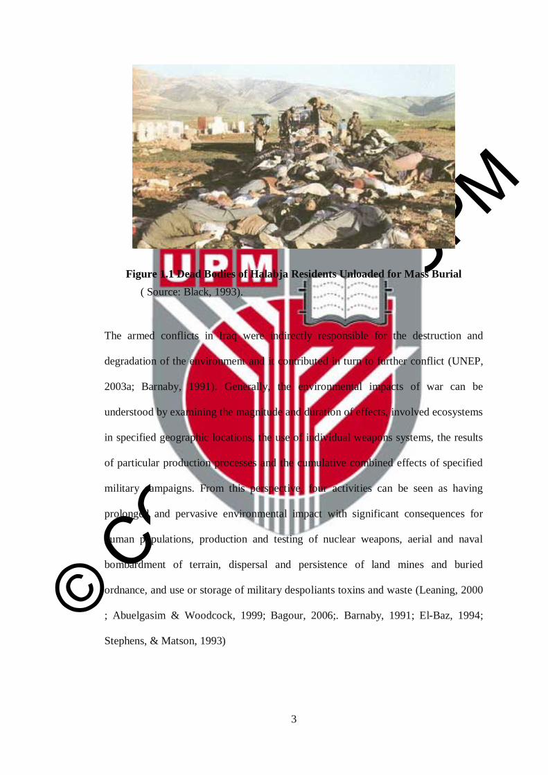
August 1988, between 150,000 and 340,000 were killed (see figure 1.1) and about
250,000 wounded, while more than 50,000 were being held as prisoners of war in
Iran whereas, during the Gulf War, the total combined figure for Iraqis and dissidents
killed could be as high as 300,000 and approximately 500,000 children died because
of international trade sanctions (Bruce Harris, 2008 ;BBC., 1988a; BBC., 1988b;
Steven Johns.,2006). During the most recent war, the long-term occupation and
reconstruction of Operation Iraqi Freedom (OIF), from March 2003 to December
2011, there are no estimates on the number of lives lost (Human Rights, 1993).
© COPYRIG
HT UPM
3
Figure 1.1 Dead Bodies of Halabja Residents Unloaded for Mass Burial
( Source: Black, 1993).
The armed conflicts in Iraq were indirectly responsible for the destruction and
degradation of the environment and it contributed in turn to further conflict (UNEP,
2003a; Barnaby, 1991). Generally, the environmental impacts of war can be
understood by examining the magnitude and duration of effects, involved ecosystems
in specified geographic locations, the use of individual weapons systems, the results
of particular production processes and the cumulative combined effects of specified
military campaigns. From this perspective, four activities can be seen as having
prolonged and pervasive environmental impact with significant consequences for
human populations, production and testing of nuclear weapons, aerial and naval
bombardment of terrain, dispersal and persistence of land mines and buried
ordnance, and use or storage of military despoliants toxins and waste (Leaning, 2000
; Abuelgasim & Woodcock, 1999; Bagour, 2006;. Barnaby, 1991; El-Baz, 1994;
Stephens, & Matson, 1993)

© COPYRIG
HT UPM
4
There was a great damage to an estimated 4,000 cities, villages and towns and their
surrounding environments and economic losses in financial terms have been
estimated to be billions of dollars (Baker, 2007). The sequence of aerial
bombardment, destruction of homes and urban and rural infrastructure, forests,
farms, transport systems and irrigation networks and progressive waves of dislocated
or homeless people, can be seen in all parts of Iraq. For example, in the 30 years of
the war in Iraq, an era marked by sieges of cities, attacks on safe havens and the
pulverization of towns to effect ethnic cleansing, millions of people have been forced
to flee within or across national borders. These wars crippled the urban support
systems of major cities and led to water pollution, decline of safe drinking water and
the significant spread disease, especially bacterial disease such as typhoid fever that
have increased tenfold since 1991. Additionally, the bombardment of sulfur plants
and oil fields that burned for a whole month in July 1991 were a vivid image of a
major part of the environmental damage caused by the war that has been contributing
to air pollution( see figure 1.2).
Figure 1.2 Oil Field Fire during the Gulf War
Source: http://www.geotimes.org/may03/geophen.html

© COPYRIG
HT UPM
5
Recently, sandstorms and the sand drift were some of the war effects noted during
and after the first Gulf war in Iraq which resulted from movements of military
vehicles across the landscape that caused several environmental and health problems.
In recent years, scholars have begun paying closer attention to the negative impacts
of armed on the environment. Recently, Reuveny et al. (2010) examined the impact
of war on several environmental indicators such as CO2 and NO emissions,
deforestation and a composite environmental stress indicator with mixed results,
including the finding that warfare increases deforestation in a country when fought at
home, and promotes forest growth when fought abroad, particularly among Least
Developed Countries (LDCs). Hanson et al. (2009) similarly looked at the
occurrence of war and its relationship to areas of high biodiversity globally and
found that over 90% of the major armed conflicts between 1950 and 2000 occurred
within countries containing biodiversity hotspots and more than 80% actually
occurred within a hotspot.
However, the devastation of the Iraqi wars is usually assessed based on the number
of people who have been killed, missing people and short term problems. Very few
studies have used satellite products to gain insight into the causes and consequences
of armed conflict in Iraq. The research conducted as part of this dissertation seeks to
examine the impacts of conflict on land cover and land use in Halabja city in
northern Iraq using satellite remote sensing data (See figure 1.3) was specifically
chosen as the area of study for this research because of its high biodiversity and
unique geographical position, where the cessation of hostilities in 1992 has made it
possible to examine the effects of war on the landscape.

© COPYRIG
HT UPM
6
Figure 1.3 Gases Rising over Halabja City, 1988
( Source: Salih, 1995).

© COPYRIG
HT UPM
7
1.2 Problem Statement and Motivation
In addition to the massive numbers of dead and missing people during the three
decades of wars and conflicts, international sanctions have affected several domains
in the north of Iraq (Kurdistan Region), among them: the agricultural production,
government policies, marketing and industry. As a result there is a substantial change
in the land cover especially since 1992 when the Kurdish Regional Government
(KRG) started rebuilding cities and improving living conditions to better standards.
So the KRG established many governmental bodies and agencies, and used urban
planners and decision makers. Among these were the environmentalists who
expressed much concern about the detection and the quantification of surface
changes that occurred during the war and reconstruction stages. They called for the
clarification of changes and understanding the relationship between war and natural
phenomenon as well as better management and usage of the resources. Among the
different cities of Iraq, which were greatly affected by the war is Halabja city; it took
the heaviest hit because it was attacked both physically and environmentally (by the
chemical weapons that were used). Lately, the KRG has put great effort and attention
to rebuild the city. According to some reports, the Kurdistan Region has shown
changes: there are 35 new villages that have been provided with electricity and 700
other villages have been repaired, around 1000 km of new roads/highways have been
built, 600 km repaired and resurfaced, 15 new bridges constructed with around 26%
of Kurdistan’s budget spent on construction and reconstruction (Kurdistan &
Hayastan, 2007).
So far, to the knowledge of the researcher, no study has been done on Iraq using
remote sensing technology to investigate the land use / land cover changes of
chemical weapons in Kurdistan region, Iraq.

© COPYRIG
HT UPM
8
1.3 Research Objectives
The main goal of this research is to detect land use / land cover changes as a result of
war's impact in the short-term 4 years (pro and after shelling with chemical weapons)
as well as a longer term of 10 years in Halabja city, Iraq. To achieve this, the
following sub-objectives can be adding as follows:
1. Identification of land use/land cover changes using vegetation indices and
hybrid classification change detection algorithms.
2. Produce land use/land cover classification maps accurately on a regional
scale of Halabja city.
3. Produce land use land cover changes maps for the study area within the
periods of 1986 to 1990 and 1990 to 2000.
4. Examine both qualitative and quantitative changes using advance post-
classification comparison technique.

© COPYRIG
HT UPM
9
1.4 Research Questions
In order to fulfill the above-mentioned objectives, the following research questions
are asked:
1. Can the land use/land cover changes in the study area identify the chemical
weapons effects using optical satellite data such as Landsat?
2. How effective is the hybrid classification technique for image classification in
the context of the study area?
3. What are the land use/land cover changes in the study area in two the time
periods due to chemical weapons effects?
4. How can post-classification be used to strengthen the justification of accuracy
for the hybrid classification?
1.5 Scope and Limitations of Research
The present research has limitations and difficulties. First of all, considering the
technical aspects, the satellite images used are restricted to certain spatial, temporal,
and spectral resolution. Furthermore, the resolution has a great impact on the
effectiveness of the change detection techniques. Secondly, the date of chemical
bombardment has a significant effect on the availability of satellite imagery as well
as the type of satellite sensor. Moreover, data types have effects on the number of
methodologies employed in this study. Thirdly, lack of high quality reference and
ground truth data affects the evaluation of classification and accuracy assessment.
© COPYRIG
HT UPM
10
1.6 Thesis Outline
Chapter One of this thesis deals with the general introduction, which includes the
background of the Iraq War and attack on Halabja, the problem statement and
motivation, objective and limitations of the study. Chapter Two is the overview of
the study which gives a brief introduction about the role of remote sensing in land
use/land cover, change detection with general types and applications of change
detection techniques with brief background information about Iraq and Halabja city
attack and chemical weapons, and a brief literature review on change detection
techniques together with a discussion of the considerations before implementing
change detection and related works. Chapter Three deals briefly with the description
about study area, and data resolution consideration for land cover changes with a
description of the data used and their sources as well as, deals extensively with the
methodology employed: pre-processing, hybrid classification and description about
classification algorithms used and post-classification of change detection techniques
on data. Chapter Four focuses on the results and analysis. Finally, Chapter Five
concludes with a summary and recommendations for further study.
© COPYRIG
HT UPM
149
6 REFERENCES
Abuelgasim, A., Ross, W., Gopal, S., & Woodcock, C. (1999). Change detection
using adaptive fuzzy neural networks: Environmental damage assessment
after the gulf war. Remote Sensing of Environment, 70(2), 208-223.
Achard, F., & Estreguil, C. (1995). Forest classification of Southeast Asia using
NOAA AVHRR data. Remote Sensing of Environment, 54(3), 198-208.
Adeniyi, P. O. (1980). Land-use change analysis using sequential aerial
photography and computer techniques. Photogrammetric Engineering and
Remote Sensing, 46, 1447-1464.
Ahmad, F. (2012). A review of remote sensing data change detection: Comparison
of Faisalabad and Multan districts, Punjab province, Pakistan. Journal of
Geography and Regional Planning, 5(9), 236-251.
Ahmad, M., (2002). Agricultural policy issues and challenges in Iraq: Short and
medium term options, Iraq's Economic Predicament(K. Mahdi, editor),
Exeter Arab and Islamic Studies Series, Ithaca Press, Reading, UK, pp. 169–
200.
Ala’Aldeen, D. A. A. (2005). Long term hazards of chemical weapons agents:
Analysis of soil samples from Kurdistan years after exposure to sulphur
mustard and nerve agents. Zanín: Journal of Kurdish Scientific and Medical
Association, 1, 1–10.
Al-Khudhairy, D., Caravaggi, I., & Glada, S. (2005). Structural damage
assessments from Ikonos data using change detection, object-oriented
segmentation, and classification techniques. Photogrammetric Engineering
and Remote Sensing, 71(7), 825.
Anderson, K., Watch, M. E., & Physicians for Human Rights. (1993). The Anfal
campaign in Iraqi Kurdistan: The destruction of koreme Human Rights
Watch.
Aplin, P., & Atkinson, P. M. (2004). Predicting missing field boundaries to increase
per-field classification accuracy. Photogrammetric Engineering and Remote
Sensing, 70(1), 141-149.
Aykps, C. (1998). Change detection study of Kuwait city and environs using multi-
temporal landsat thematic Mapper data. International Journal of Remote
Sensing, 19(9), 1651-1662.
Azzali, S., & Menenti, M. (2000). Mapping vegetation-soil-climate complexes in
southern Africa using temporal fourier analysis of NOAA-AVHRR NDVI
data. International Journal of Remote Sensing, 21(5), 973-996.

© COPYRIG
HT UPM
150
Bagour, M. H. (2006). Environmental impact assessment of 1991 gulf war military
activities using landsat tm imageries. Journal of Applied Sciences Research,
2(12), 1228-1234.
Baker, D. (2007). The economic impact of the Iraq war and higher military
spending. Center for Economic and Policy Research, may,
Bakr, N., Weindorf, D., Bahnassy, M., Marei, S., & El-Badawi, M. (2010).
Monitoring land cover changes in a newly reclaimed area of Egypt using
multi-temporal landsat data. Applied Geography, 30(4), 592-605.
Bally, P., Bequignon, J., Arino, O., & Briggs, S. (2005). Remote sensing and
humanitarian aid- A life-saving combination. E.S.A.Bulletin, (122), 36-41.
Bannari, A., Morin, D., Bonn, F., & Huete, A. (1995). A review of vegetation
indices. Remote Sensing Reviews, 13(1), 95-120.
Barnaby, F. (1991). The environmental impact of the gulf war. Ecologist, 21(4),
166-172.
Barnsley, M. J., Moller-Jensen, L., & Barr, S. L. (2001). Inferring urban land use
by spatial and structural pattern recognition. Remote Sensing and Urban
Analysis, , 115-144.
BBC. (1988a). 1988: Thousands die in Halabja gas attack BBC News,
BBC. (1988b). BBC news | saddam's Iraq: Key events Retrieved 6/20/2012, 2012,
from
http://news.bbc.co.uk/2/shared/spl/hi/middle_east/02/iraq_events/html/chemi
cal_warfare.stm
Biging, G., Chrisman, N., Colby, D., Congalton, R., Dobson, J., Ferguson, R., et al.
(1999). Accuracy assessment of remote sensing-detected change detection.
S.Khorram, American Society for Photogrammetry and Remote Sensing
(ASPRS), MD, USA,
Binh, T. N. K. D., Vromant, N., Hung, N. T., Hens, L., & Boon, E. (2005). Land
cover changes between 1968 and 2003 in cai nuoc, ca mau peninsula,
Vietnam. Environment, Development and Sustainability, 7(4), 519-536.
Biswas, A. K., & Tortajadaquiroz, H. C. (1996). Environmental impacts of the
Rwandan refugees on Zaire. Ambio, 25(6), 403-408.
Bjorgo, E. (2000a). Using very high spatial resolution multispectral satellite sensor
imagery to monitor refugee camps. International Journal of Remote Sensing,
21(3), 611-616.
Bjorgo, E. (2000b). Refugee camp mapping using very high spatial resolution
satellite sensor images. Geocarto International, 15(2), 79-88.
© COPYRIG
HT UPM
151
Black, G. (1993). Genocide in Iraq: The Anfal campaign against the Kurds Human
Rights Watch.
Brady, L. M. (2008). Life in the DMZ: Turning a diplomatic failure into an
environmental success. Diplomatic History, 32(4), 585-611.
Brown, I. A. (2010). Assessing eco-scarcity as a cause of the outbreak of conflict in
Darfur: A remote sensing approach. International Journal of Remote Sensing,
31(10), 2513-2520.
Bruce Harris. (2008). Saddam Hussein killer file Retrieved 6/7/2012, 2012, from
http://www.moreorless.au.com/killers/hussein.html
Bruce, C. M., & Hilbert, D. W. (2004). Pre-processing methodology for application
to landsat TM/ETM imagery of the wet tropics. Cooperative Research Centre
for Tropical Rainforest Ecology and Management. Rainforest CRC, Cairns,
Australia,
Camps-Valls, G., Gómez-Chova, L., Calpe-Maravilla, J., Martín-Guerrero, J. D.,
Soria-Olivas, E., Alonso-Chordá, L., et al. (2004). Robust support vector
method for hyperspectral data classification and knowledge discovery.
Geoscience and Remote Sensing, IEEE Transactions on, 42(7), 1530-1542.
Cardille, J. A., & Foley, J. A. (2003). Agricultural land-use change in Brazilian
Amazonia between 1980 and 1995: Evidence from integrated satellite and
census data. Remote Sensing of Environment, 87(4), 551-562.
Castellana, L., d’Addabbo, A., & Pasquariello, G. (2007). A composed
supervised/unsupervised approach to improve change detection from remote
sensing. Pattern Recognition Letters, 28(4), 405-413.
Černá, L., & Chytrý, M. (2005). Supervised classification of plant communities
with artificial neural networks. Journal of Vegetation Science, 16(4), 407-
414.
Chander, G., Markham, B. L., & Helder, D. L. (2009). Summary of current
radiometric calibration coefficients for landsat MSS, TM, ETM, and EO-1
ALI sensors. Remote Sensing of Environment, 113(5), 893-903.
Chavez Jr., P. S. (1996). Image-based atmospheric corrections - revisited and
improved. Photogrammetric Engineering and Remote Sensing, 62(9), 1025-
1036.
Chavez, P. S., & MacKinnon, D. J. (1994). Automatic detection of vegetation
changes in the southwestern United States using remotely sensed images.
Photogrammetric Engineering and Remote Sensing, 60(5), 571-583.
Chen, J., Gong, P., He, C., Pu, R., & Shi, P. (2003). Land-use/land-cover change
detection using improved change-vector analysis. Photogrammetric
Engineering and Remote Sensing, 69(4), 369-380.
© COPYRIG
HT UPM
152
Cheng, Y., Nie, J., Li, G., Zhang, C., & Wang, W. (2008). Study on land use and
land cover change with the integration of RS, GIS and GPS technologies-the
case of Baotou city in the Ecotone of agriculture-animal husbandry, china.
Geoscience and Remote Sensing Symposium, 2008. IGARSS 2008. IEEE
International, , 4. pp. IV-691-IV-694.
Cohen, N., & Arieli, T. (2011). Field research in conflict environments:
Methodological challenges and snowball sampling. Journal of Peace
Research, 48(4), 423-435.
Cohen, W. B. (1994). GIS applications perspective: Current research on remote
sensing of forest structure. Remote Sensing and GIS in Ecosystem
Management, , 91-107.
Cohen, W. B., & Spies, T. A. (1992). Estimating structural attributes of douglas-
fir/western hemlock forest stands from landsat and SPOT imagery. Remote
Sensing of Environment, 41(1), 1-17.
Cohen, W. B., Spies, T. A., & Fiorella, M. (1995). Estimating the age and structure
of forests in a multi-ownership landscape of western Oregon, USA. Remote
Sensing, 16(4), 721-746.
Congalton, R. G. (1991). A review of assessing the accuracy of classifications of
remotely sensed data. Remote Sensing of Environment, 37(1), 35-46.
Congalton, R. G. (1996). Accuracy assessment: A critical component of land cover
mapping. Gap Analysis: A Landscape Approach to Biodiversity Planning, ,
119-131.
Congalton, R. G. (2004). Putting the map back in map accuracy assessment.
Remote Sensing and GIS Accuracy Assessment, 1-11.
Congalton, R. G., & Green, K. (2008). Assessing the accuracy of remotely sensed
data: Principles and practices CRC.
Congalton, R. G. (1991). A review of assessing the accuracy of classifications of
remotely sensed data. Remote Sensing of Environment, 37(1), 35-46.
Congalton, R. G., & Green, K. (1999). Assessing the Accuracy of Remotely Sensed
Data: Principles and Practices,
Congalton, R. G., Oderwald, R. G., & Mead, R. A. (1983). Assessing landsat
classification accuracy using discrete multivariate analysis statistical
techniques. Photogrammetric Engineering & Remote Sensing, 49(12), 1671-
1678.
Coppin, P. R., & Bauer, M. E. (1996). Digital change detection in forest ecosystems
with remote sensing imagery. Remote Sensing Reviews, 13(3-4), 207-234.

© COPYRIG
HT UPM
153
Corresponding, P. C., Jonckheere, I., Nackaerts, K., Muys, B., & Lambin, E.
(2004). Review Article Digital change detection methods in ecosystem
monitoring: A review. International Journal of Remote Sensing, 25(9), 1565-
1596.
Corson, M. W., & Palka, E. J. (2004). Geotechnology, the US military, and war.
Geography and Technology, , 401-427.
Crist, E., & Kauth, R. (1986). The tasseled cap de-mystified ((transformations of
MSS and TM data)). Photogrammetric Engineering and Remote Sensing, 52,
81-86.
Crist, E. P. (1985). A TM tasseled cap equivalent transformation for reflectance
factor data. Remote Sensing of Environment, 17(3), 301-306.
Crist, E. P., Laurin, R., & Cicone, R. C. (1986). Vegetation and soils information
contained in transformed thematic mapper data. Proceedings of IGARSS'86
Symposium, pp. 1465-1470.
Crist, E. P., & Cicone, R. C. (1984). Physically-based transformation of thematic
mapper data - the tm tasseled cap. IEEE Transactions on Geoscience and
Remote Sensing, GE-22(3), 256-263.
Cristianini, N., & Shawe-Taylor, J. (2000). An introduction to support vector
machines and other kernel-based learning methods Cambridge university
press.
Dahlgren, E., & Carmona, M. D. (1988). Report of the mission dispatched by the
secretary-general to investigate allegations of the use of chemical weapons in
the conflict between the Islamic Repurlic of Iran and Iraq.
Dai, X., & Khorram, S. (1998). The effects of image misregistration on the
accuracy of remotely sensed change detection. Geoscience and Remote
Sensing, IEEE Transactions on, 36(5), 1566-1577.
De Beurs, K., & Henebry, G. (2008). War, drought, and phenology: Changes in the
land surface phenology of Afghanistan since 1982. Journal of Land use
Science, 3(2-3), 95-111.
De Sherbinin, A., Balk, D., Yager, K., Jaiteh, M., Pozzi, F., Giri, C., et al. (2002). A
CIESIN thematic guide to social science applications of remote sensing.
CIESIN Thematic Guides,
De Vos, H., Jongerden, J., & Van Etten, J. (2008). Images of war: Using satellite
images for human rights monitoring in Turkish Kurdistan1. Disasters, 32(3),
449-466.
Deer, P. (1995a). Digital change detection techniques in remote sensing.

© COPYRIG
HT UPM
154
Deer, P. (1995b). Digital change detection techniques: Civilian and military
applications. International Symposium on Spectral Sensing Research, , 95.
Dewidar, K. H. M. (2004). Detection of land use/land cover changes for the
northern part of the Nile delta (Burullus region), Egypt. International Journal
of Remote Sensing, 25(20), 4079-4089.
Diallo, Y., Hu, G., & Wen, X. (2009). Applications of remote sensing in land
use/land cover change detection in Puer and Simao counties, Yunnan
province. Journal of American Science, 5, 157-166.
Duda, T., & Canty, M. (2002). Unsupervised classification of satellite imagery:
Choosing a good algorithm. International Journal of Remote Sensing, 23(11),
2193-2212.
Dudley, J. P., Ginsberg, J. R., Plumptre, A. J., Hart, J. A., & Campos, L. C. (2002).
Effects of war and civil strife on wildlife and wildlife habitats. Conservation
Biology, 16(2), 319-329.
Dudley, J. P., & Woodford, M. H. (2002). Bioweapons, biodiversity, and ecocide:
Potential effects of biological weapons on biological diversity. Bioscience,
52(7), 583-592.
Dugdale-Pointon. (2002). Iran-iraq war 1980-1988 Retrieved 6/7/2012, 2012, from
http://www.historyofwar.org/articles/wars_iraniraq.html
Dworkin, J., Prescott, M., Jamal, R., Hardawan, S. A., Abdullah, A., & Galea, S.
(2008). The long-term psychosocial impact of a surprise chemical weapons
attack on civilians in halabja, iraqi kurdistan. The Journal of Nervous and
Mental Disease, 196(10), 772.
Dymond, C. C., Mladenoff, D. J., & Radeloff, V. C. (2002). Phenological
differences in tasseled cap indices improve deciduous forest classification.
Remote Sensing of Environment, 80(3), 460-472.
El-Baz, F. (1994). Gulf war and the environment Routledge.
El‐Gamily, H. I. (2007). Utilization of multi‐dates LANDSAT_TM data to
detect and quantify the environmental damages in the southeastern region of
kuwait from 1990 to 1991. International Journal of Remote Sensing, 28(8),
1773-1788.
ENVI User's Guide, 2008. ENVI On-Line Software User's Manual, ITT Visual
Information Solutions.
Evison, D., Hinsley, D., & Rice, P. (2002). Regular review: Chemical weapons.
BMJ: British Medical Journal, 324(7333), 332.
© COPYRIG
HT UPM
155
Fadhil, A. M. (2009). Land degradation detection using geo-information technology
for some sites in iraq. Journal of Al-Nahrain University-Science (JNUS),
12(3), 94-108.
Fao stat Retrieved 3/31/2013, 2013, from
http://faostat.fao.org/site/567/DesktopDefault.aspx?PageID=567#ancor
Farhood, L., Zurayk, H., Chaya, M., Saadeh, F., Meshefedjian, G., & Sidani, T.
(1993). The impact of war on the physical and mental health of the family:
The lebanese experience. Social Science & Medicine, 36(12), 1555-1567.
Fatehi, A., & Jalali, N. (2000). Effects of polluted rainfall related to burning
kuwaiti oil wells on vegetation in south of iran. International Archives of
Photogrammetry and Remote Sensing, 33(B7/1; PART 7), 427-432.
Fauvel, M., Chanussot, J., & Benediktsson, J. A. (2006). Evaluation of kernels for
multiclass classification of hyperspectral remote sensing data. Acoustics,
Speech and Signal Processing, 2006. ICASSP 2006 Proceedings. 2006 IEEE
International Conference on, , 2. pp. II-II.
Fearon, J. D., & Laitin, D. D. (2003). Ethnicity, insurgency, and civil war.
American Political Science Review, 97(1), 75-90.
Fiorella, M., & Ripple, W. J. (1993). Analysis of conifer forest regeneration using
landsat thematic mapper data. Photogrammetric Engineering and Remote
Sensing, 59(9), 1383-1388.
Fleischmann, C. G., & Walsh, S. J. (1991). Multi‐temporal AVHRR digital data:
An approach for landcover mapping of heterogeneous landscapes. Geocarto
International, 6(4), 5-20.
Foody, G. M. (1992). On the compensation for chance agreement in image
classification accuracy assessment. Photogrammetric Engineering and
Remote Sensing, 58(10), 1459-1460.
Foody, G. M. (2002). Status of land cover classification accuracy assessment.
Remote Sensing of Environment, 80(1), 185-201.
Foody, G. M., & Mathur, A. (2004). A relative evaluation of multiclass image
classification by support vector machines. Geoscience and Remote Sensing,
IEEE Transactions on, 42(6), 1335-1343.
Forkuor, G., & Cofie, O. (2011). Dynamics of land-use and land-cover change in
freetown, sierra leone and its effects on urban and peri-urban agriculture–a
remote sensing approach. International Journal of Remote Sensing, 32(4),
1017-1037.
Franklin, S. E., Lavigne, M. B., Wulder, M. A., & McCaffrey, T. M. (2002). Large-
area forest structure change detection: An example. Canadian Journal of
Remote Sensing, 28(4), 588-592.
© COPYRIG
HT UPM
156
Gallego, F. J. (2004). Remote sensing and land cover area estimation. International
Journal of Remote Sensing, 25(15), 3019-3047.
Giada, S., De Groeve, T., Ehrlich, D., & Soille, P. (2003). Information extraction
from very high resolution satellite imagery over lukole refugee camp,
tanzania. International Journal of Remote Sensing, 24(22), 4251-4266.
Gibson, G. and J.B. Campbell, 2011. War and agriculture: Three decades of
cropland land cover change in central Iraq, Proceedings of the 18th Pecora
Symposium: Forty Years of Earth Observations…Understanding a Changing
World, 14–17 November, Herndon, Virginia (American Society for
Photogrammetry and Remote Sensing, Bethesda, Maryland), unpaginated.
Gibson, G. R. (2012). Three decades of agricultural land use and land cover change
in iraq. War and Agriculture: Three Decades of Agricultural Land use and
Land Cover Change in Iraq,
Gleditsch, N. P., Wallensteen, P., Eriksson, M., Sollenberg, M., & Strand, H.
(2002). Armed conflict 1946-2001: A new dataset. Journal of Peace
Research, 39(5), 615-637.
Gorsevski, V., Kasischke, E., Dempewolf, J., Loboda, T., & Grossmann, F. (2012).
Analysis of the impacts of armed conflict on the eastern afromontane forest
region on the south Sudan—Uganda border using multitemporal landsat
imagery. Remote Sensing of Environment, 118, 10-20.
Groeneveld RA, Kruseman G, van Ierland EC (2003) Global warming and the
economics ofland-use and land-cover change. In Dolman AJ, Verhagen A,
Rovers CA (eds)Global Environ-mental Change and Land Use, 53–69.
Kluwer, Dordrecht
Gualtieri, J. A., & Cromp, R. F. (1999). Support vector machines for hyperspectral
remote sensing classification. The 27th AIPR Workshop: Advances in
Computer-Assisted Recognition, pp. 221-232.
Hanson, T., Brooks, T. M., Da Fonseca, G. A., Hoffmann, M., Lamoreux, J. F.,
Machlis, G., et al. (2009). Warfare in biodiversity hotspots. Conservation
Biology, 23(3), 578-587.
He, F., & Yin, J. (2009). Research on CA differencing for remote sensing change
detection. Image and Signal Processing, 2009. CISP'09. 2nd International
Congress on, pp. 1-4.
Hermes, L., Frieauff, D., Puzicha, J., & Buhmann, J. M. (1999). Support vector
machines for land usage classification in landsat TM imagery. Geoscience
and Remote Sensing Symposium, 1999. IGARSS'99 Proceedings. IEEE 1999
International, , 1. pp. 348-350.
Hirst, D. (1988). The kurdish victims caught unawares by cyanide
© COPYRIG
HT UPM
157
Huang, C., Davis, L., & Townshend, J. (2002). An assessment of support vector
machines for land cover classification. International Journal of Remote
Sensing, 23(4), 725-749.
Huang, J. Z., Ng, M. K., Rong, H., & Li, Z. (2005). Automated variable weighting
in k-means type clustering. Pattern Analysis and Machine Intelligence, IEEE
Transactions on, 27(5), 657-668.
Human Rights. Ba'athis and kurds. Retrieved 6/7/2012, 2012, from
http://www.hrw.org/reports/1993/iraqanfal/ANFAL1.htm
Husain, T. (1994). Kuwaiti oil fires—Source estimates and plume characterization.
Atmospheric Environment, 28(13), 2149-2158.
Irish, R. (2008). Landsat 7 science data users handbook. Landsat Project Science
Office, 2008(21 October 2008)
Jackson, R. D., & Huete, A. R. (1991). Interpreting vegetation indices. Preventive
Veterinary Medicine, 11(3), 185-200.
Jaiswal, R. K., Saxena, R., & Mukherjee, S. (1999). Application of remote sensing
technology for land use/land cover change analysis. Journal of the Indian
Society of Remote Sensing, 27(2), 123-128.
Jalali, N., Noroozi, A., & Abkar, A. (1998). Tracking of oil spills and smoke
plumes of Kuwait’s oil well fires to the coast and territory of IR of iran as a
result of the 1991 arabian gulf war. Isbn, 90(6164), 1489.
Jasinski, M. F. (1990). Functional relation among subpixel canopy cover, ground
shadow, and illuminated ground at large sampling scales. Remote Sensing of
the Biosphere,
Jensen, J. R. (1996). Introductory digital image processing prentice-hall.
Englewood Cliffs, NJ,
Jensen, J. R. (2009). Remote sensing of the environment Pearson Education India.
Jensen, J. (2005). Introductory digital image processing, 3rd.
Jensen, J. R. (1986). Introductory digital image processing. A Remote Sensing
Perspective, , 379.
Jensen, J. R. (1996). Introductory Digital Image Processing,
Jensen, J. R., Rutchey, K., Koch, M. S., & Narumalani, S. (1995). Inland wetland
change detection in the everglades water conservation area 2A using a time
series of normalized remotely sensed data. Photogrammetric Engineering and
Remote Sensing, 61(2), 199-209.

© COPYRIG
HT UPM
158
Jianya, G., Haigang, S., Guorui, M., & Qiming, Z. (2008). A review of multi-
temporal remote sensing data change detection algorithms. The International
Archives of the Photogrammetry, Remote Sensing and Spatial Information
Sciences, 37(B7), 757-762.
Jieli, C., Manchun, L., Yongxue, L., Chenglei, S., & Wei, H. (2010). Extract
residential areas automatically by new built-up index. Geoinformatics, 2010
18th International Conference on, pp. 1-5.
Joachims, T. (1998). Text categorization with support vector machines: Learning
with many relevant features Springer.
John, P. Chemical weapons programs - iraq special weapons facilities Retrieved
8/29/2012, 2012, from http://www.fas.org/nuke/guide/iraq/cw/program.htm
Johnson, R. D., & Kasischke, E. (1998). Change vector analysis: A technique for
the multispectral monitoring of land cover and condition. International
Journal of Remote Sensing, 19(3), 411-426.
Joost R. Hiltermann. (2008).The 1988 anfal campaign in iraqi kurdistan - online
encyclopedia of mass violence. Retrieved 6/7/2012, 2012, from
http://www.massviolence.org/The-1988-Anfal-Campaign-in-Iraqi-Kurdistan?cs-
Kaishan Song, Zongming Wang, Qqingfeng Liu, Dongmei Lu, Guang Yang,
Lihong Zeng, et al. (2009). Land use/land cover (LULC) characterizaitoin
with MODIS time series data in the amu river basin. Geoscience and Remote
Sensing Symposium,2009 IEEE International,IGARSS 2009, , 4. pp. IV-310-
IV-313.
Kamavisdar, P., Saluja, S., & Agrawal, S. A survey on image classification
approaches and techniques. International Journal of Advanced Research in
Computer and Communication Engineering Vol. 2, Issue 1, January 2013
Kanungo, T., Mount, D. M., Netanyahu, N. S., Piatko, C. D., Silverman, R., & Wu,
A. Y. (2002). An efficient k-means clustering algorithm: Analysis and
implementation. Pattern Analysis and Machine Intelligence, IEEE
Transactions on, 24(7), 881-892.
Kavzoglu, T., & Colkesen, I. (2009). A kernel functions analysis for support vector
machines for land cover classification. International Journal of Applied Earth
Observation and Geoinformation, 11(5), 352-359.
Kauth, R., Lambeck, P., Richardson, W., Thomas, G., & Pentland, A. (1979).
Feature extraction applied to agricultural crops as seen by landsat. NASA.
Johnson Space Center Proc. of Tech. Sessions, , 1.

© COPYRIG
HT UPM
159
Kennedy, R. E., Townsend, P. A., Gross, J. E., Cohen, W. B., Bolstad, P., Wang,
Y., et al. (2009). Remote sensing change detection tools for natural resource
managers: Understanding concepts and tradeoffs in the design of landscape
monitoring projects. Remote Sensing of Environment, 113(7), 1382-1396.
Kerdiles, H., & Díaz, R. (1996). Mapping of the volcanic ashes from the 1991
hudson eruption using NOAA-AVHRR data. International Journal of Remote
Sensing, 17(11), 1981-1995.
Keuchel, J., Naumann, S., Heiler, M., & Siegmund, A. (2003). Automatic land
cover analysis for tenerife by supervised classification using remotely sensed
data. Remote Sensing of Environment, 86(4), 530-541.
Khorram, S. (1999). Accuracy assessment of remote sensing-derived change
detection Asprs Pubns.
Kim, K. C. (1997). Preserving biodiversity in korea's demilitarized zone. Science,
278(5336), 242-243.
Knorn, J., Rabe, A., Radeloff, V. C., Kuemmerle, T., Kozak, J., & Hostert, P.
(2009). Land cover mapping of large areas using chain classification of
neighboring landsat satellite images. Remote Sensing of Environment,
113(5), 957-964.
Koch, M., & El-Baz, F. (1998). Identifying the effects of the gulf war on the
geomorphic features of kuwait by remote sensing and GIS. Photogrammetric
Engineering and Remote Sensing, 64(7), 739-746.
Kononenko, I., & Bratko, I. (1991). Information-based evaluation criterion for
classifier's performance. Machine Learning, 6(1), 67-80.
Krishnaswamy, J., Bawa, K. S., Ganeshaiah, K., & Kiran, M. (2009). Quantifying
and mapping biodiversity and ecosystem services: Utility of a multi-season
NDVI based mahalanobis distance surrogate. Remote Sensing of
Environment, 113(4), 857-867.
Kurdistan and Hayastan. Kurdistan and hayastan - hand in hand: Rebuilding
kurdistan. Retrieved 6/17/2012, 2012, from
http://kurdisharmenian.blogspot.com/2007/08/rebuilding-kurdistan.html
Kwarteng, A., & Chavez Jr, P. (1998). Change detection study of kuwait city and
environs using multi-temporal landsat thematic mapper data. International
Journal of Remote Sensing, 19(9), 1651-1662.
Landis, J. R., & Koch, G. G. (1977). The measurement of observer agreement for
categorical data. Biometrics, , 159-174.

© COPYRIG
HT UPM
160
Lempinen, E. (2006). Pioneering AAAS project finds strong evidence of zimbabwe
repression. American Association for the Advancement of Science
(AAAS).Available Online at:
Http://www.Aaas.org/news/releases/2006/0530zim.Shtml (Accessed 5 March
2008),
Lewiński, S., & Zaremski, K. (2004). Examples of object-oriented classification
performed on high-resolution satellite images. Warszawa, 11, 349-358.
Lillesand, T. M., Kiefer, R. W., & Chipman, J. W. (2004). Remote sensing and
image interpretation. John Wiley & Sons Ltd.
Lillesand, T. M., & Keifer, R. W. (1994). Remote Sensing and Image
Interpretation,
Lo, C., & Shipman, R. L. (1990). A GIS approach to land-use change dynamics
detection. Photogrammetric Engineering and Remote Sensing, 56(11), 1483-
1491.
Lodhi, M. A., Echavarria, F. R., & Keithley, C. (1998). Using remote sensing data
to monitor land cover changes near afghan refugee camps in northern
pakistan. Geocarto International, 13(1), 33-39.
Lu, D., Batistella, M., & Moran, E. (2008). Integration of landsat TM and SPOT
HRG images for vegetation change detection in the brazilian amazon.
Photogrammetric Engineering and Remote Sensing, 74(4), 421.
Lu, D., Mausel, P., Batistella, M., & Moran, E. (2005). Land‐cover binary change
detection methods for use in the moist tropical region of the amazon: A
comparative study. International Journal of Remote Sensing, 26(1), 101-114.
Lu, D., Mausel, P., Brondizio, E., & Moran, E. (2002). Assessment of atmospheric
correction methods for landsat TM data applicable to amazon basin LBA
research. International Journal of Remote Sensing, 23(13), 2651-2671.
Lu, D., Moran, E., Hetrick, S., & Li, G. (2010). Land-use and land-cover change
detection. Advances in Environmental Remote Sensing: Sensors, Algorithms,
and Applications, 7, 273.
Lu, D., & Weng, Q. (2007). A survey of image classification methods and
techniques for improving classification performance. International Journal of
Remote Sensing, 28(5), 823-870.
Lu, D., Weng, Q., Moran, E., Li, G., & Hetrick, S. (2010). Remote sensing image
classification. Advances in Environmental Remote Sensing: Sensors,
Algorithms, and Applications, 7, 219.
Lu, D., Mausel, P., Brondízio, E., & Moran, E. (2004). Change detection
techniques. International Journal of Remote Sensing, 25(12), 2365-2407.

© COPYRIG
HT UPM
161
Lunetta, R. S., & Lyon, J. G. (2004). Remote sensing and GIS accuracy assessment
CRC.
Lyon, J. G., Yuan, D., Lunetta, R. S., & Elvidge, C. D. (1998). A change detection
experiment using vegetation indices. Photogrammetric Engineering and
Remote Sensing, 64(2), 143-150.
Maathuis, B. (2003). Remote sensing based detection of minefields. Geocarto
International, 18(1), 51-60.
Machlis, G. E., & Hanson, T. (2011). Warfare ecology. Warfare Ecology, , 33-40.
Maguen, S., Lucenko, B. A., Reger, M. A., Gahm, G. A., Litz, B. T., Seal, K. H., et
al. (2010). The impact of reported direct and indirect killing on mental health
symptoms in iraq war veterans. Journal of Traumatic Stress, 23(1), 86-90.
Malpica, J., & Alonso, M. A method for change detection with multi-temporal
satellite images using the RX algorithm. Intemational Archives of
Photogrammetry, Remote Sensing and Spatial Information Science, Beijing,
China, 37, 1631-1635.
Markham, B. L., Storey, J. C., Williams, D. L., & Irons, J. R. (2004). Landsat
sensor performance: History and current status. Geoscience and Remote
Sensing, IEEE Transactions on, 42(12), 2691-2694.
Marmar, C. R. (2009). Mental health impact of afghanistan and iraq deployment:
Meeting the challenge of a new generation of veterans. Depression and
Anxiety, 26(6), 493-497.
Martin, P. S., & Szuter, C. R. (2001). War zones and game sinks in lewis and
Clark’s west. Conservation Biology, 13(1), 36-45.
Mas, J. F. (1999). Monitoring land-cover changes: A comparison of change
detection techniques. International Journal of Remote Sensing, 20(1), 139-
152.
Masek, J. G., Honzak, M., Goward, S. N., Liu, P., & Pak, E. (2001). Landsat-7
ETM as an observatory for land cover: Initial radiometric and geometric
comparisons with landsat-5 thematic mapper. Remote Sensing of
Environment, 78(1), 118-130.
Mather, P. M. (2004). Computer processing of remotely-sensed images Wiley
Online Library.
Mather, P. M. (1999). Computer Processing of Remotely-Sensed Images,
Melgani, F., & Bruzzone, L. (2004). Classification of hyperspectral remote sensing
images with support vector machines. Geoscience and Remote Sensing, IEEE
Transactions on, 42(8), 1778-1790.

© COPYRIG
HT UPM
162
Meyer, W. B., & Turner, B. L. (1992). Human population growth and global land-
use/cover change. Annual Review of Ecology and Systematics, , 39-61.
Mountrakis, G., Im, J., & Ogole, C. (2011). Support vector machines in remote
sensing: A review. ISPRS Journal of Photogrammetry and Remote Sensing,
66(3), 247-259.
National Aeronautics and Space Administration Land Processes Distributed Active
Archive Center (NASA LP DAAC), 2010. Moderate Resolution Imagine
Spectroradiometer MOD12Q1 Yearly L3 Global 500 m SIN GridLand Cover
Product for years 2001 to 2009, URL: http://daac.ornl.gov (last date accessed:
31 March 2013).
Nordberg, M., & Evertson, J. (2003). Monitoring change in mountainous dry-heath
vegetation at a regional ScaleUsing multitemporal landsat TM data. AMBIO:
A Journal of the Human Environment, 32(8), 502-509.
O’Leary, C. A. (2002). The kurds of iraq: Recent history, future prospects. Middle
East Review of International Affairs, 6(4), 17-19.
O’Loughlin, J., & Witmer, F. D. (2011). The localized geographies of violence in
the north caucasus of russia, 1999–2007. Annals of the Association of
American Geographers, 101(1), 178-201.
Pal, M., & Mather, P. M. (2003). An assessment of the effectiveness of decision
tree methods for land cover classification. Remote Sensing of Environment,
86(4), 554-565.
Pal, M., & Mather, P. M. (2008). Support vector classifiers for land cover
classification. ArXiv Preprint arXiv:0802.2138
Paradzayi, C., Annegarn, H., Matsika, R., & Erasmus, B. (2008). Field surveys for
biomass assessment in african savanna woodlands. Geoscience and Remote
Sensing Symposium, 2008. IGARSS 2008. IEEE International, , 3. pp. III-
632-III-635.
Pedersen, D. (2002). Political violence, ethnic conflict, and contemporary wars:
Broad implications for health and social well-being. Social Science &
Medicine, 55(2), 175-190.
Pilászy, I. (2005). Text categorization and support vector machines. The
Proceedings of the 6th International Symposium of Hungarian Researchers on
Computational Intelligence
Plumptre, A. J., Masozera, M., & Vedder, A. (2001). The impact of civil war on the
conservation of protected areas in rwanda Biodiversity Support Program,
World Wildlife Fund.
Politics | AKNEWS.com Retrieved 8/25/2012, 2012, from
http://www.aknews.com/en/aknews/4/120001/

© COPYRIG
HT UPM
163
Pradhan, R., Ghose, M., & Jeyaram, A. (2010). Land cover classification of
remotely sensed satellite data using bayesian and hybrid classifier.
International Journal of Computer Applications IJCA, 7(11), 1-4.
Ratanopad, S., & Kainz, W. (2006). Land cover classification and monitoring in
northeast thailand using landsat5 TM data. ISPRS Technical Commission II
Symposium, Vienna, , 7.
Resool, S. M. (2003). Anfal ̈a the kurds and the iraqi state.
Reuveny, R., Mihalache-O'Keef, A. S., & Li, Q. (2010). The effect of warfare on
the environment. Journal of Peace Research, 47(6), 749-761.
Richards, J. A., & Jia, X. (2006). Remote sensing digital image analysis: An
introduction Springer Verlag.
Rogan, J., & Chen, D. M. (2004). Remote sensing technology for mapping and
monitoring land-cover and land-use change. Progress in Planning, 61(4), 301-
326.
Rogers, A., & Kearney, M. (2004). Reducing signature variability in unmixing
coastal marsh thematic mapper scenes using spectral indices. International
Journal of Remote Sensing, 25(12), 2317-2335.
Rose, S., & Baravi, A. (1988). The meaning of halabja: Chemical warfare in
kurdistan. Race & Class, 30(1), 74.
Ruelland, D., Dezetter, A., Puech, C., & Ardoin‐Bardin, S. (2008). Long‐term
monitoring of land cover changes based on landsat imagery to improve
hydrological modelling in west africa. International Journal of Remote
Sensing, 29(12), 3533-3551.
Sader, S., & Winne, J. (1992). RGB-NDVI colour composites for visualizing forest
change dynamics. International Journal of Remote Sensing, 13(16), 3055-
3067.
Salih, K. (1995). Anfal: The kurdish genocide in iraq. Digest of Middle East
Studies, 4(2), 24-39.
Sastry, P. (2003). An introduction to support vector machines. Computing and
Information Sciences: Recent Trends, , 53-85.
Schnepf, R., 2003. Iraq's Agriculture: Background and Status, Congressional
Research Service Report for Congress, Library of Congress, Washington,
D.C., 6 p.
Schnepf, R.,, 2004. Iraq Agriculture and Food Supply: Background and Issues,
Congressional Research Service Report for Congress, Library of Congress,
Washington, D.C., 57 p.

© COPYRIG
HT UPM
164
Schowengerdt, R. A. (2007). Remote sensing: Models and methods for image
processing Academic Pr.
Schroeder, T. A., Cohen, W. B., Song, C., Canty, M. J., & Yang, Z. (2006).
Radiometric correction of multi-temporal landsat data for characterization of
early successional forest patterns in western oregon. Remote Sensing of
Environment, 103(1), 16-26.
Selim, S. Z., & Ismail, M. A. (1984). K-means-type algorithms: A generalized
convergence theorem and characterization of local optimality. Pattern
Analysis and Machine Intelligence, IEEE Transactions on, (1), 81-87.
Sidel, V. W., & Levy, B. S. (2008). The health impact of war†. International
Journal of Injury Control and Safety Promotion, 15(4), 189-195.
Singh, A. (1989). Digital change detection techniques using remotely-sensed data.
International Journal of Remote Sensing, 10(6), 989-1003.
Skakun, R. S., Wulder, M. A., & Franklin, S. E. (2003). Sensitivity of the thematic
mapper enhanced wetness difference index to detect mountain pine beetle
red-attack damage. Remote Sensing of Environment, 86(4), 433-443.
Slater, M., Sloggett, D., Rees, W., & Steel, A. (1999). Potential operational multi-
satellite sensor mapping of snow cover in maritime sub-polar regions.
International Journal of Remote Sensing, 20(15-16), 3019-3030.
Son, T. P. H., & Thu, P. M. (2005). Some pre-analysis techniques of remote
sensing images for land-use in Mekong delta. International Journal of
Geoinformatics, 1(1), 147-155.
Song, C., Woodcock, C. E., Seto, K. C., Lenney, M. P., & Macomber, S. A.
(2001b). Classification and change detection using landsat TM data: When
and how to correct atmospheric effects? Remote Sensing of Environment,
75(2), 230-244.
Spencer, W.J., 2007. The Middle East, McGraw Hill, Dubuque, Indiana, 274 p.
Spotts, P. 2010. "George Clooney-Backed Satellite Project to Monitor Volatile
Sudan." Christian Science Monitor, 29 December 2010.
Stehman, S. (1996). Estimating the kappa coefficient and its variance under
stratified random sampling. Photogrammetric Engineering and Remote
Sensing, 62(4), 401-407.
Stephens, G., & Matson, M. (1993). Monitoring the persian gulf war with NOAA
AVHRR data. International Journal of Remote Sensing, 14(7), 1423-1429.
Steven Johns. (2006). 1988: The halabja massacre | libcom.org Retrieved 6/4/2012,
2012, from http://libcom.org/history/1988-the-halabja-massacre

© COPYRIG
HT UPM
165
Stevens, K., Campbell, L., Urquhart, G., Kramer, D., & Qi, J. (2011). Examining
complexities of forest cover change during armed conflict on Nicaragua’s
atlantic coast. Biodiversity and Conservation, 20(12), 2597-2613.
Stoney, W. (2006). Guide to land imaging satellites. American Society for
Photogrammetry and Remote Sensing.Updated February, 2, 2006.
Story, M., & Congalton, R. G. (1986). Accuracy assessment-A user\'s perspective.
Photogrammetric Engineering and Remote Sensing, 52(3), 397-399.
Stuckens, J., Coppin, P., & Bauer, M. (2000). Integrating contextual information
with per-pixel classification for improved land cover classification. Remote
Sensing of Environment, 71(3), 282-296.
Sulik, J. J., & Edwards, S. (2010). Feature extraction for Darfur: Geospatial
applications in the documentation of human rights abuses. International
Journal of Remote Sensing, 31(10), 2521-2533.
Sunar, F. (1998). An analysis of changes in a multi-date data set: A case study in
the ikitelli area, Istanbul, Turkey. International Journal of Remote Sensing,
19(2), 225-235.
Susan F. Kinsley. (1991).Whatever happened to the Iraqi Kurds? (human rights
watch report, march 11, 1991) Retrieved 6/4/2012, 2012, from
http://www.hrw.org/reports/1991/IRAQ913.htm
Suthakar, K., & Bui, E. N. (2008). Land use/cover changes in the war‐ravaged
jaffna peninsula, sri lanka, 1984–early 2004. Singapore Journal of Tropical
Geography, 29(2), 205-220.
Teillet, P., Barker, J., Markham, B., Irish, R., Fedosejevs, G., & Storey, J. (2001).
Radiometric cross-calibration of the landsat-7 ETM and landsat-5 TM sensors
based on tandem data sets. Remote Sensing of Environment, 78(1), 39-54.
Thapa, R. B., & Murayama, Y. (2009). Examining spatiotemporal urbanization
patterns in Kathmandu valley, Nepal: Remote sensing and spatial metrics
approaches. Remote Sensing, 1(3), 534-556.
Themnér, L., & Wallensteen, P. (2011). Armed conflict, 1946–2010. Journal of
Peace Research, 48(4), 525-536.
Thu, P. M., & Populus, J. (2007). Status and changes of mangrove forest in
Mekong delta: Case study in tra vinh, Vietnam. Estuarine, Coastal and Shelf
Science, 71(1), 98-109.
Tou, J. T., & Gonzalez, R. C. (1974). Pattern recognition principles. Image
Rochester NY, 7
Treitz, P. (2004). Remote sensing for mapping and monitoring land-cover and land-
use change—an introduction. Progress in Planning, 61(4), 269-279.

© COPYRIG
HT UPM
166
Tso, B., & Olsen, R. C. (2005). Combining spectral and spatial information into
hidden markov models for unsupervised image classification. International
Journal of Remote Sensing, 26(10), 2113-2133.
Tzotsos, A., & Argialas, D. (2008). Support vector machine classification for
object-based image analysis. Object-Based Image Analysis, , 663-677.
UNEP, 2003, "Desk Study on the Environment in Iraq." Switzerland: United
Nations Environment Programme.
U.S Department of State. (2012). Background note: Iraq. Retrieved 6/7/2012, 2012,
from http://www.state.gov/r/pa/ei/bgn/6804.htm
United States Agency for International Development (USAID), 2004. Irrigation
water management assessment and priorities for Iraq, Agriculture
Reconstruction and Development Program for Iraq, URL:
http://www.usaid.gov/Iraq (last date accessed: 31 March 2013).
USGS/EROS find Data/Products and data Available/TM Retrieved 8/24/2012,
2012, from
http://eros.usgs.gov/#/Find_Data/Products_and_Data_Available/TM
USHMM, 2009, "Mapping Initiatives: Crisis in Darfur," United States Holocaust
Memorial Museum [http://www.ushmm.org/maps/projects/darfur/], accessed
8 February 2011
United Nations Food and Agricultural Organization (UN FAO), 2012a. Agricultural
Trade Statistics for Iraq. URL: http://faostat.fao.org (last date accessed: 31
March 2013).
Ustin, S. L., & Costick, L. A. (2000). Multispectral remote sensing over semi-arid
landscapes for resource management. Spatial Information for Land use
Management, , 97-111.
Vapnik, V. (2000). The nature of statistical learning theory springer.
Vanderzee, D., & Ehrlich, D. (1995). Sensitivity of ISODATA to changes in
sampling procedures and processing parameters when applied to AVHRR
time-series NDV1 data. Remote Sensing, 16(4), 673-686.
Verburg, P. H., Van De Steeg, J., Veldkamp, A., & Willemen, L. (2009). From land
cover change to land function dynamics: A major challenge to improve land
characterization. Journal of Environmental Management, 90(3), 1327-1335.
Verburg, P., De Groot, W., & Veldkamp, A. (2003). Methodology for multi-scale
land-use change modelling: Concepts and challenges. Global environmental
change and land use (pp. 17-51) Springer.

© COPYRIG
HT UPM
167
Vogelmann, J. E., Helder, D., Morfitt, R., Choate, M. J., Merchant, J. W., & Bulley,
H. (2001). Effects of Landsat 5 thematic Mapper and Landsat 7 enhanced
thematic Mapper plus radiometric and geometric calibrations and corrections
on landscape characterization. Remote Sensing of Environment, 78(1), 55-70.
Walter, V. (2004). Object-based classification of remote sensing data for change
detection. ISPRS Journal of Photogrammetry and Remote Sensing, 58(3),
225-238.
Wang, H., & Ellis, E. C. (2005). Image misregistration error in change
measurements. Photogrammetric Engineering and Remote Sensing, 71(9),
1037.
Wen, X., & Yang, X. (2009). Change detection from remote sensing imageries
using spectral change vector analysis. Information Processing, 2009. APCIP
2009. Asia-Pacific Conference on, , 2. pp. 189-192.
Williams, D. L., Goward, S., & Arvidson, T. (2006). Landsat: Yesterday, today,
and tomorrow. Photogrammetric Engineering and Remote Sensing, 72(10),
1171.
Williams, R. S., Heckman, J., & Schneeberger, J. (1991). Environmental
consequences of the persian gulf war, 1990-1991: Remote-sensing datasets of
kuwait and environs National Geographic Society.
Wilson, S. A., & Wilson, C. O. (2012). Modelling the impacts of civil war on land
use and land cover change within Kono district, Sierra Leone: A socio-
geospatial approach.
Witmer, F. D. W. (2008). Detecting war‐induced abandoned agricultural land in
northeast Bosnia using multispectral, multitemporal landsat TM imagery.
International Journal of Remote Sensing, 29(13), 3805-3831.
Xian, D., Sun, A., & Zheng, X. (2006). Analyzing the dust storm in iraq using
meteorological satellite data during the Iraq war. Proceedings of SPIE, , 6200.
pp. 62000U.
Yuan, F., Sawaya, K. E., Loeffelholz, B. C., & Bauer, M. E. (2005). Land cover
classification and change analysis of the twin cities (Minnesota) metropolitan
area by multitemporal Landsat remote sensing. Remote Sensing of
Environment, 98(2), 317-328.
Zha, Y., Gao, J., & Ni, S. (2003). Use of normalized difference built-up index in
automatically mapping urban areas from TM imagery. International Journal
of Remote Sensing, 24(3), 583-594.
Recommended