30
26
26
20
20
203
413
237
245
245
201
201
201
86
7
7
84
84
NorthPowder
Vale
Halfway
Nyssa
BakerCity
Granite
Greenhorn
Ontario
Haines
RichlandSumpter
Huntington
Unity
Austin Jct
Beulah
Bonita
Bridgeport
Brogan
Cairo
Drewsey
Durkee
Harper
Hereford
Homestead
Ironside
Jamieson
Keating
Lime
MedicalSprings
PayetteJunction
Pine
PleasantValley
Sparta
Telocaset
Weatherby
Westfall
Willowcreek
NewBridge
WALLOWA- WHITMAN
NATIONAL
FOREST
WALLOWA-WHITMAN
NATIONAL FOREST
MALHEUR
NATIONAL
FOREST
VALE BLM DISTRICT
PRINEVILLE BLM
DISTRICT
PACIF
IC T
IME Z
ONE
MOUNTA
IN T
IME Z
ONE
IDA
HO
OR
EGO
N
10:24am2m 9sec
10:25am2m 10sec
Oasis
KeenyPass
Spring
Burnt River
Canyon Area
Denny FlatArea(dispersed camping area)
NHOTICNational HistoricOregon TrailInterpretive Center
Virtue Flat(dispersed camping area)
Birch CreekInterpretive Site
Lime Exit
LookoutMountain
Road
CartersLanding
SwedesLanding
Bob Creek
Airstrip
Westfall
U.S. Department of the InteriorBureau of Land Management
TOTAL
8.21.17E SO
LAR LIPSE
Coos Bay
Florence
Newport
PortlandThe
Dalles
Albany
Bend
Salem
Tillamook
Eugene
Madras
Roseburg
Medford Lakeview
Burns
Vale
Pendleton
BakerCity
KlamathFalls
GrantsPass
Astoria
JohnDay
PrinevilleM a pA r e a
5 5 100
MILES
S
E
N
W
Airstrip
Birch Creek Interpretive Site (viewing)
Bob Creek
Burnt River Canyon (viewing)
Carters Landing
Denny Flats/Unity Lakes
Keeney Pass
Lime Exit (viewing)
Lookout Mountain Road
Mormon Basin Back County By-Way Loop (viewing only)
NHOTIC (viewing only)
Oasis Campground
Spring
Swede's Landing/Moonlight Mine
Virtue Flat
Westfall
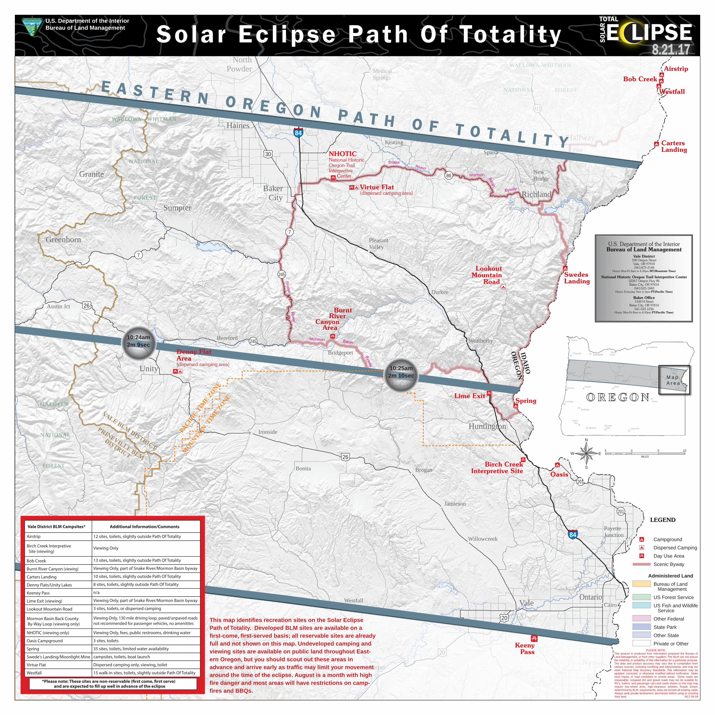
12 sites, toilets, slightly outside Path Of Totality
Viewing Only
13 sites, toilets, slightly outside Path Of Totality
Viewing Only, part of Snake River/Mormon Basin byway
10 sites, toilets, slightly outside Path Of Totality
8 sites, toilets, slightly outside Path Of Totality
n/a
Viewing Only, part of Snake River/Mormon Basin byway
3 sites, toilets, or dispersed camping
Viewing Only, 130 mile driving loop, paved/unpaved roadsnot recommended for passenger vehicles, no amenitites
Vale District BLM Campsites* Additional Information/Comments
*Please note: These sites are non-reservable (�rst come, �rst serve) and are expected to �ll up well in advance of the eclipse
Viewing Only, fees, public restrooms, drinking water
3 sites, toilets
35 sites, toilets, limited water availability
campsites, toilets, boat launch
Dispersed camping only, viewing, toilet
15 walk-in sites, toilets, slightly outside Path Of Totality
E A S T E R N O R E G O N P A T H O F T O T A L I T Y
Solar Ecl ipse Path Of Total ity
U.S. Department of the InteriorBureau of Land Management
Vale District100 Oregon StreetVale, OR 97918(541)473-3144
Hours: Mon-Fri 8am to 4:30pm MT(Mountain Time)
National Historic Oregon Trail Interpretive Center22267 Oregon Hwy 86Baker City, OR 97814
(541)523-1843Hours: Everyday 9am to 6pm PT(Pacific Time)
Baker Office3100 H Street
Baker City, OR 97814541-523-1256
Hours: Mon-Fri 8am to 4:30pm PT(Pacific Time)
PLEASE NOTE:This product is produced from information prepared the Bureau of Land Management, or from other suppliers. The BLM can not assure the reliability or suitability of this information for a particular purpose. The data and product accuracy may vary due to compilation from various sources, including modeling and interpretation, and may not meet National Map Accuracy Standards. This information may be updated, corrected, or otherwise modified without notification. Make local inquiry of road conditions in remote areas. Some roads are impassable. Unpaved dirt and gravel roads may not be suitable for RV's, trailers, and passenger cars and roads shown on the map may require four-wheel drive, high-clearance vehicles. Roads shown, determined by BLM requirements, does not include all existing roads. Always seek private landowners' permission before using or crossing their land. M17-04-04
LEGEND
Campground
Dispersed Camping
Day Use Area
Scenic Byway
Administered Land
Bureau of Land Management
US Forest Service
US Fish and Wildlife Service
Other Federal
State Park
Other State
Private or Other
Snake River/ Mormon Basin Byway
Snake R
iver/ Mormon Basin Byw
ay
This map identifies recreation sites on the Solar Eclipse Path of Totality. Developed BLM sites are available on a first-come, first-served basis; all reservable sites are already full and not shown on this map. Undeveloped camping and viewing sites are available on public land throughout East-ern Oregon, but you should scout out these areas in advance and arrive early as traffic may limit your movement around the time of the eclipse. August is a month with high fire danger and most areas will have restrictions on camp-fires and BBQs.
Recommended