This content is prepared from various sources and has used the study material from various books, internet articles etc. The teacher doesn’t claim any right over the content, it’s originality and any copyright. It is given only to the students of PG course in Geology to study as a part of their curriculum.

Precambrian Geology of India


Generalized tectonic map of
Indian subcontinent:
Precambrian Cratons, Mobile
Belts and Lineaments. AFB =
Aravalli Fold Belt, DFB =
Delhi Fold Belt, EGMB =
Eastern
Ghats Mobile Belt, SMB =
Satpura Mobile Belt, NSL =
Narmada-Son Lineament, CIS
= Central Indian Suture and
BPMP = Bhavani–Palghat
Mobile Belt.
Proterozoic Rifts and Basins
include IB = Indravati Basin,
ChB = Chhattisgarh Basin, GB
= Godavari Basin; MR =
Mahandi Rift; CuB =
Cuddapah Basin, VB =
Vindhyan Basin. CG =
Closepet Granite
(modified from Rao and
Reddy, 2002).

Each craton has undergone progressive stabilization of the block, suffered post-stabilization intrusive events like mafic dyke swarms and development of Proterozoic sedimentary basins within the cratons. Mafic dyke swarms are indicators of crustal extension and can represent supercontinent assembly and/or dispersal, subduction, large igneous province emplacement, and crust/mantle interaction.
Typically a craton begins with a few hundred million years of accumulation of gneisses and greenstone belts and then becomes stable within a few tens of millions of years. Stabilization is demonstrated by the closure of whole-rock isotopic systems, intrusion of undeformed plutons, and deposition of platform sediments on the newly created basement. After formation, cratons move about the earth but are not subjected to pervasive compressional deformation.

Dharwar Craton
•The Dharwar Craton is split into Eastern and Western Cratons, with major differences in lithology and ages
of rock units.
•The western boundary of the Eastern Dharwar Craton (EDC) is poorly defined and closely approximates
with the Closepet Granite.
•The EDC is bounded to the north by the Deccan Traps and the Bastar Craton, to the east by the Eastern
Ghats Mobile Belt, and to the south by the Southern Granulite Terrane.
•The craton is composed of the Dharwar Batholith (dominantly granitic), greenstone belts, intrusive
volcanics, and middle Proterozoic to more recent sedimentary basins.
•The Western Dharwar Craton (WDC) is located in southwest India , where it is bounded to the east by the
Eastern Dharwar Craton, to the west by the Arabian Sea, and to the south by Southern Granulite Terrane.
•The remaining boundary to the north is buried under younger sediments and the Cretaceous Deccan Traps.
•The division between the Western and Eastern Dharwar Cratons is based on the nature and abundance of
greenstones, as well as the age of surrounding basement and degree of regional metamorphism.
•The Archaean Tonalitic–Trondhjemitic–Granodioritic (TTG) Gneisses are found throughout the Western
Dharwar Craton, dated at 3.3 to 3.4 Ga .
•Three generations of volcanic-sedimentary greenstone granite sequences are present in the WDC: the 3.1–
3.3 Ga Sargur Group, the 2.6–2.9 Ga Dharwar Supergroup and 2.5–2.6 Ga calc-alkaline to high potassic
granitoids, the largest of which is the Closepet Granite.
•The Dharwar supracrustal rocks uncomformably overlie widespread gneiss-migmatite of the Peninsular
Gneissic Complex (3.0–3.3 Ga) that encloses the Sargur schist belts .
•The WDC shows an increase in regional metamorphic grade from greenschist to amphibolite facies in the
north and granulite facies in the south.
•The metamorphic grade increase corresponds to a paleopressure increase from 3 to 4 kbar in the amphibolite
facies to as much as 9–10 kbar (35 km paleodepth) in the highest grade granulite-transition zone along the
southern margin of the craton .

Six main lithotectonic units are
recognizable in the Dharwar
Craton:
Gorur Gneiss (3300-3400 My),
Sargur Group,
Peninsular Gneiss (3000 My),
Dharwar Supergroup,
Greenstone Belt,
Dharwar Batholith.
Geology of the Dharwar Craton and adjoining
terranes


Eastern Dharwar Craton
Archaean assemblages associated
with cratonization .
Sa = Sandur, KKJH = Kolar–Kadiri =
Jonnagiri–Hutti, RPSH = Ramagiri–
(Penakacherla–Sirigeri)–Hungund,
and VPG = Veligallu–Raichur–
Gadwal superbelt. Dyke intrusions
into
the EDC are HandB = Harohalli and
Bangalore swarm; A = Anantapur
swarm; M = Mahbubnagar swarm; H
= Hyderabad swarm.
EASTERN DHARWAR CRATON

Greenstone Belts
-concentrated in the western half of the craton and are
stretched into linear arrays.
-belts continue to the east where they are covered by
the Proterozoic Cuddapah Basin.
- general trend of the belts is N–S.
-metamorphism of the belts is limited to greenschist to
amphibolite facies.
-Pb/Pb dates the age of the Kolar Schist Belt between
2900 and 2600 Ma.
-SHRIMP U–Pb zircon methods ages of 2725–2550
Ma in the Kolar Belt.
-Age trends in the belts generally infer a younging
trend from west to east.
-These schist belts are all intruded by syn- and post-
tectonic felsic rocks.
-Some important greenstone schist belts and
supergroups are: the Sandur schist belt, the Kolar
Schist Belt
-The Sandur schist belt is characterized by dominant
green schist facies metamorphism with higher,
amphibolite grade rocks occurring at the margins.
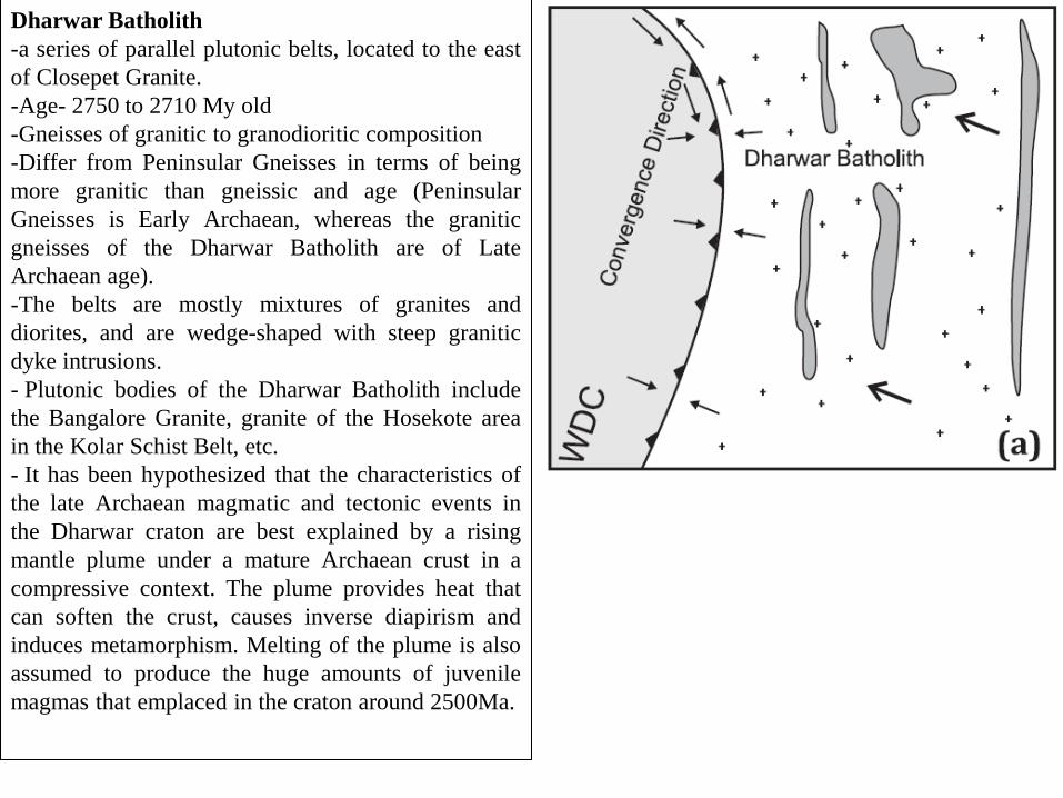
Dharwar Batholith
-a series of parallel plutonic belts, located to the east
of Closepet Granite.
-Age- 2750 to 2710 My old
-Gneisses of granitic to granodioritic composition
-Differ from Peninsular Gneisses in terms of being
more granitic than gneissic and age (Peninsular
Gneisses is Early Archaean, whereas the granitic
gneisses of the Dharwar Batholith are of Late
Archaean age).
-The belts are mostly mixtures of granites and
diorites, and are wedge-shaped with steep granitic
dyke intrusions.
- Plutonic bodies of the Dharwar Batholith include
the Bangalore Granite, granite of the Hosekote area
in the Kolar Schist Belt, etc.
- It has been hypothesized that the characteristics of
the late Archaean magmatic and tectonic events in
the Dharwar craton are best explained by a rising
mantle plume under a mature Archaean crust in a
compressive context. The plume provides heat that
can soften the crust, causes inverse diapirism and
induces metamorphism. Melting of the plume is also
assumed to produce the huge amounts of juvenile
magmas that emplaced in the craton around 2500Ma.

The plume model. The centre of the
plume is an enriched mantle hot spot that
lies below the Closepet batholith.
Melting of the enriched mantle hot spot
produces high temperature magmas that
penetrate overlying crust and strongly
interact with the surrounding crust and
induce partial melting. These magmas
cool very slowly, as the hot spot
maintains high temperatures for long
time. Towards the east, in Bangalore,
Hoskote–Kolar, and the western margin
of the Kolar Schist Belt, the plume
induces melting of less-enriched or
chondritic mantle. Melting of such
mantle produces colder magmas that
cool more rapidly and show less or no
interactions with the surrounding crust.

Closepet Granite
-located on the western margin of the EDC, a 400 km
long and approximately 20-30 km wide linear hill
range trending N–S and shows no substantial effects
of deformation and there are no signs of
metamorphism.
-The similar convexity of adjacent schist belts and
granitic plutons may indicate that the Closepet Granite
is a ‘stitching pluton’ formed during the suturing of
the Eastern and Western Dharwar Cratons.
-The exposed rock is divided into northern and
southern components by a part of the Sandur Schist
Belt.
-The Closepet Granite is a composite body of
predominant potash-rich adamellite, quart-monzonite
and granite.
-The occurrence of ductile mylonites and augen
gneisses along the margins of the granite plutons and
loaclly well in side the main body indicates shearing
during the emplacement of the granite.
- SHRIMP U/Pb dating gives age of 2513 ± 5 Ma and
appears to be part of a widespread Neo-Archaean
phase of plutonism in both the Eastern and Western
Dharwar Cratons.
- Probably Closepet Granite was emplaced towards
close of Archean and the beginning of Proterozoic
Era, thus marking transition between two eras.

WESTERN DHARWAR CRATON
Western Dharwar Craton showing major
lithologic boundaries
It is bounded to the east by the
Eastern Dharwar Craton, to the west
by the Arabian Sea, to the south by a
transition into the Southern Granulite
Terrane and the northern boundary is
buried under younger sediments and
the Cretaceous Deccan Traps. The
division between the Western and
Eastern Dharwar Cratons is based on
the nature and abundance of
greenstones, as well as the age of
surrounding basement and degree of
regional metamorphism
The Archaean Tonalitic–
Trondhjemitic–Granodioritic (TTG)
Gneisses are found throughout the
Western Dharwar Craton.
Age: whole rock Rb-Sr and Pb-Pb:
3.3 to 3.4 Ga
U–Pb zircon ages ranging from 3.5
to 3.6 Ga

Three generations of volcanic-sedimentary greenstone granite sequences are present in the WDC: the 3.1–3.3
Ga Sargur Group, the 2.6–2.9 Ga Dharwar Supergroup and 2.5–2.6 Ga calc-alkaline to high potassic
granitoids, the largest of which is the Closepet Granite.
The Dharwar supracrustal rocks uncomformably overlie widespread gneiss-migmatite of the Peninsular
Gneissic Complex (3.0–3.3 Ga) that encloses the Sargur schist belts. The WDC shows an increase in regional
metamorphic grade from greenschist to amphibolite facies in the north and granulite facies in the south. The
metamorphic grade increase corresponds to a paleopressure increase from 3 to 4 kbar in the amphibolite
facies to as much as 9–10 kbar (35 km paleodepth) in the highest grade granulite-transition zone along the
southern margin of the craton.

Sargur Group
-Identified as independent and oldest lithostratigraphic unit of the Dharwar Craton
-Represented by minor linear belts and enclaves of basic-ultrabasic magmatic rocks and pelitic-siliceous-
carbonate-rich carbonaceous metasediments.
-Spread mainly over the southern parts of Karnataka.
-Principal igneous components are peridotites, pyroxenites and komatiitic amphibolite, with localized
occurrence of anorthosite, gabbro and norite interlayered with spinifex-textures komatiite pillow lavas.
-The Sargur Group greenstone belts display well-preserved volcano-sedimentary sequences.
-Rocks of Sargur complex have undergone upper amphibolite-grade metamorphism at 700±30oC and 8.6±0.8
kBar and its basic –ultrabasic components converted to a schistose assemblage comprising antigorite±
chlorite± magnetite± siderite.
-The associated volcano-sedimentary rocks were metamorphosed to an assemblage of kyanite-staurolite-
quartz-plagioclase± fuchsite± graphite± corundum± sillimanite.
-SHRIMP U/Pb dating of detrital zircon has given age 3309±5 Ma.

Peninsular Gneiss
-West of the Chitradurga Boundary Fault, the larger part of the WDC is made up of gneisses of TTG
composition.
-It is the largest lithological unit of southern Indian Shield.
-The diversity of composition and degree of deformation suggest that the complex assemblage of granitic
rocks possibly formed as a result of more than one process- intrusion, migmatization and granitization.
- SHRIMP U/Pb dating of zircon from Peninsular Gneiss dates to 2963±4 Ma.
-Characterized by elongate belts and island-like enclaves of schistose rocks.
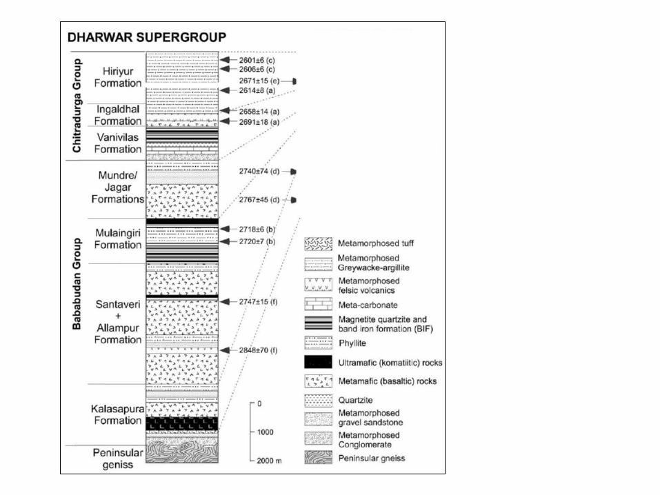
Dharwar Supergroup
The Dharwar Supergroup is exposed in two large schist belts that have been divided into two sub-sections,
the Bababudan Group and the Chitradurga Group.
Bababudan Group
spread over a 300 km long and 100–150 km wide area, and is made up of the Babadudan schist belt,
Western Ghats Belt, and the Shimoga schist belt.
The Bababudan schist belt covers an area of approximately 2500 km2. The base of this unit is represented by
the Kartikere conglomerate that discontinuously extends along the southern margin of the belt for 40 km.
This unit grades into a quartzite. The overlying formations typically consist of metabasalts with intercalated
meta-sedimentary units, with occasional gabbroic sills, minor BIF, and phyllites. These are thought to
represent a variety of terrestrial environments, ranging from braided fluvial systems to sub-aerial lava flows.
The Western Ghats Belt is a large schist belt about 2200 km2 in extent, and about 150 km by 15 km in
dimension. The stratigraphy closely resembles the Babaudan belt; however, a major group of basalts, felsic
volcanics, and pyroclastic units is also seen in the upper levels.
The Shimoga schist belt is a large (25,000 km2) NW trending belt separated from the previous two by
outcropping TTG basement gneiss. The contact between these basement gneisses and the schist belt is
observed as a zone of high-grade metamorphism, often with kyanite and garnet phases present. Granitioid
intrusions are also present in the north of the belt.
Sm-Nd wholerock isochron age ranges from 2911±49 Ma to 2848±70 Ma, with average age of 2700 Ma.

Chitradurga Group
-Made up of more than 1000 m thick succession of polymictic conglomerate at the base; limestones and
dolomites and BIF with Mn-ore formation in the middle; and greywackes carbonaceous phyllite and rhythmic
alteration of chert and ferrugenous silica in the upper part of the sequence.
-Later stage of Chitradurga sedimentation suffered subsidence of the basin floor and debris-flow deposits
resulted.
-Associated with predominant volcanics with some ultrabasics, Chitradurga succession represents deposits of
a deep-water basin unlike the Bababudan , where the clastics represent shallow-water platform deposits.
- Sm-Nd age of Chitradurga volcanics is 2748±15 Ma.
Recommended