This booklet includes: The Restless Earth
Challenges of Weather and Climate Rivers on the Land
How to use this Revision Guide...
WEEKS LEADING UP TO THE EXAM 1. READ through every section in the revision guide 2. LOOK at the exam tips and my predictions at the end of every section 3. HAVE A GO at answering some of the exam questions at the back of the guide 4. REMEMBER that CASE STUDIES in Geography are very important and will need a
lot of revising! (The information in this booklet is only the basics, use your exercise books to revise the specifics)
5. DON’T PANIC Remember you have gone through all this information already, although you may think you have forgotten some, once you look over it a few times it will come back to you :)
6. TAKE TIME revise over a period of time which is suitable, although we all might think we work best at the last minute this is not always the case)
7. PRACTICE your time management, see if you can answer 9 mark exam questions in 10minutes!
IN THE EXAM 1. READ THE QUESTION!!! (So many times I have seen people answer questions with
the EFFECTS of an event when the question is asking for the RESPONSES) 2. TAKE YOUR TIME do not rush through, make sure you have included enough detail
to achieve the best possible mark 3. DRINK water (Not too much you need a wee!) 4. DON’T LOOK at other people, everyone works at their own pace (plus, it wastes
time) 5. RUNNING OUT OF TIME? On a big question? Bullet Point the rest of your answer
NIGHT BEFORE/JUST BEFORE THE EXAM 1. Look over things once in the morning before the exam and once at night 2. Familiarise yourself with all your key facts 3. Enjoy a break and an early night 4. Any last minute problems, Miss Russell is in Hum3 for Form Time (come see me!)

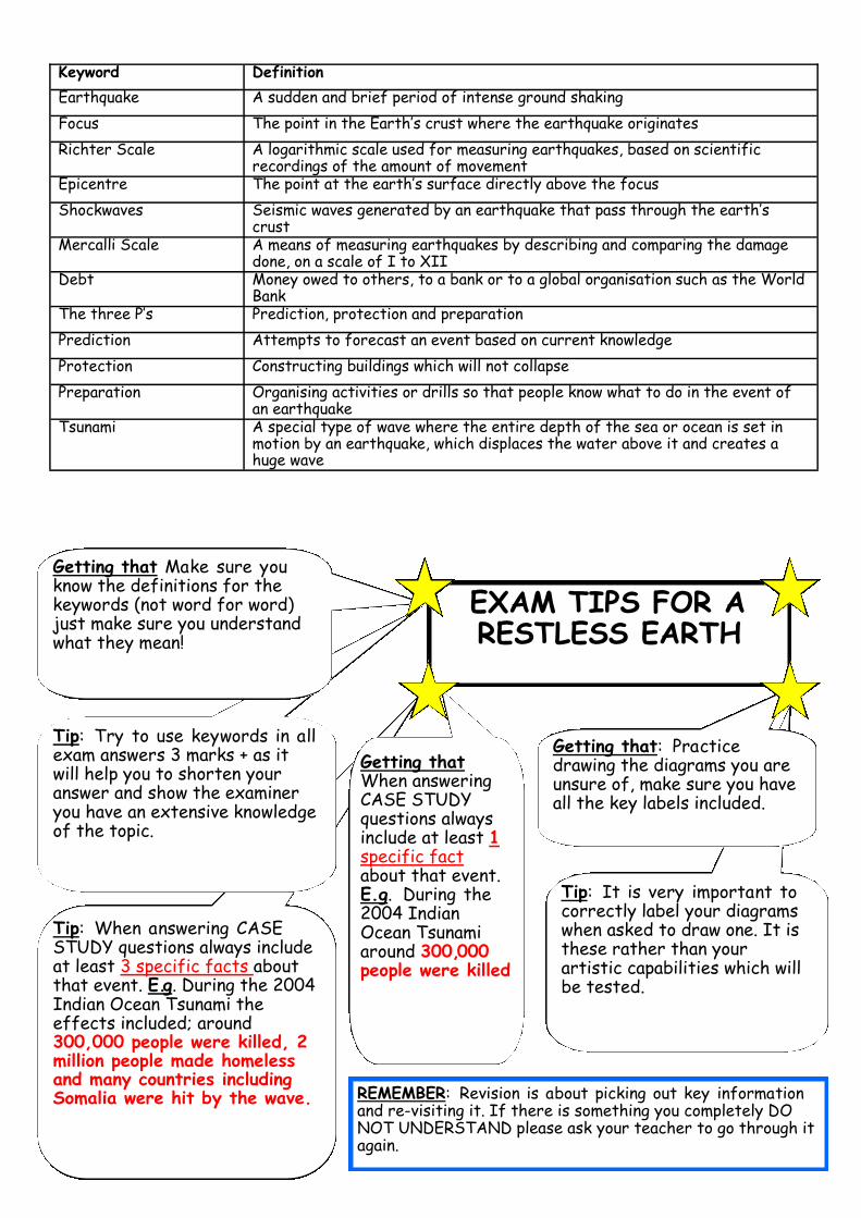
Keyword Definition
Crust The Outer Layer of the Earth
Plate A Section of the Earth’s crust
Plate Margin The boundary where two plates meet
Mantle The dense, mostly solid layer between the outer core and the crust
Convection Currents The circular currents of heat in the mantle
Subduction The sinking of oceanic crust at a destructive margin
Collision The meeting of two plates of continental crust. They are forced together and buckle under the pressure.
Fold Mountains Large mountain ranges where rock layers have been crumpled as they have been forced together
Ocean Trenches Deep sections of the ocean, usually where an oceanic plate is sinking below a continental plate
Composite Volcano A steep-sided volcano that is made up of a variety of materials, such as lava and ash.
Shield Volcano A broad volcano that is mostly made up of lava
Subsistence farming Farming to provide food for the farmers own family
Terraces Steps cut into hillside to create an area of flatland
Irrigation Artificial watering of the land
Hydroelectric Power The use of flowing water to turn turbines to generate electricity
Natural Hazard An Occurrence over which people have little control, which poses a threat to people’s lives and possessions. This is different from a natural event as volcanoes can erupt in unpopulated areas without being a hazard.
Primary Effects The immediate effects of the eruption, caused directly by it.
Secondary Effects The after-effects that occur as an indirect effect of the eruption on a longer timetable
Aid Money, food, training and technology given by richer countries to poorer countries.
Earthquake A sudden and often violent shift in the rocks forming the earth’s crust, which is felt at the surface.
Immediate responses
How people react as the disaster happens and the immediate aftermath
Long-Term Responses
Later reactions that occur in the weeks, months and years after the event.
Vent The opening- usually central and single- in a volcano, from which magma is emitted.
Lahar These secondary effects of a volcanic eruption are mudflows resulting from ash mixing with melting ice or water.
Supervolcano A mega colossal volcano that erupts at least 1,000km3 of material
Caldera The depression of the Supervolcano marking the collapsed magma chamber
Fissures Extended openings along a line of weakness that allows magma to escape
Geothermal Water that is heated beneath the ground, which water erupts into the air under pressure.
Geyser A geothermal feature in which water erupts into the air under pressure
Hotspot A section of the earth’s crust where plumes of magma rise, weakening the crust. These are away from plate boundaries.
Tip: When answering CASE STUDY questions always include at least 3 specific facts about that event. E.g. During the 2004 Indian Ocean Tsunami the effects included; around 300,000 people were killed, 2 million people made homeless and many countries including Somalia were hit by the wave.
Keyword Definition
Earthquake A sudden and brief period of intense ground shaking
Focus The point in the Earth’s crust where the earthquake originates
Richter Scale A logarithmic scale used for measuring earthquakes, based on scientific recordings of the amount of movement
Epicentre The point at the earth’s surface directly above the focus
Shockwaves Seismic waves generated by an earthquake that pass through the earth’s crust
Mercalli Scale A means of measuring earthquakes by describing and comparing the damage done, on a scale of I to XII
Debt Money owed to others, to a bank or to a global organisation such as the World Bank
The three P’s Prediction, protection and preparation
Prediction Attempts to forecast an event based on current knowledge
Protection Constructing buildings which will not collapse
Preparation Organising activities or drills so that people know what to do in the event of an earthquake
Tsunami A special type of wave where the entire depth of the sea or ocean is set in motion by an earthquake, which displaces the water above it and creates a huge wave
Tip: Try to use keywords in all exam answers 3 marks + as it will help you to shorten your answer and show the examiner you have an extensive knowledge of the topic.
EXAM TIPS FOR A RESTLESS EARTH
Getting that Make sure you know the definitions for the keywords (not word for word) just make sure you understand what they mean!
Tip: It is very important to correctly label your diagrams when asked to draw one. It is these rather than your artistic capabilities which will be tested.
Getting that: Practice drawing the diagrams you are unsure of, make sure you have all the key labels included.
Getting that When answering CASE STUDY questions always include at least 1 specific fact about that event. E.g. During the 2004 Indian Ocean Tsunami around 300,000 people were killed
REMEMBER: Revision is about picking out key information and re-visiting it. If there is something you completely DO NOT UNDERSTAND please ask your teacher to go through it again.
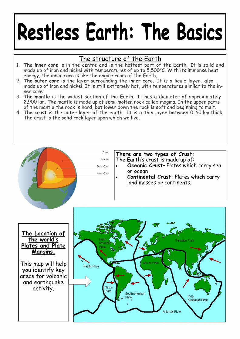
The structure of the Earth 1. The inner core is in the centre and is the hottest part of the Earth. It is solid and
made up of iron and nickel with temperatures of up to 5,500°C. With its immense heat energy, the inner core is like the engine room of the Earth.
2. The outer core is the layer surrounding the inner core. It is a liquid layer, also made up of iron and nickel. It is still extremely hot, with temperatures similar to the in-ner core.
3. The mantle is the widest section of the Earth. It has a diameter of approximately 2,900 km. The mantle is made up of semi-molten rock called magma. In the upper parts of the mantle the rock is hard, but lower down the rock is soft and beginning to melt.
4. The crust is the outer layer of the earth. It is a thin layer between 0-60 km thick. The crust is the solid rock layer upon which we live.
There are two types of Crust: The Earth’s crust is made up of: Oceanic Crust– Plates which carry sea
or ocean Continental Crust– Plates which carry
land masses or continents.
The Location of
the world’s Plates and Plate
Margins. This map will help you identify key
areas for volcanic and earthquake
activity.

1 DESTRUCTIVE At Destructive Plates:
Two Plates meet (An Oceanic and a Continental) The Oceanic plate is heavier and sinks below the
Continental Plate. This is called SUBDUCTION The Oceanic Plate then melts and the magma
formed rises through the continental crust to form a volcano.
The Andes is formed along a destructive margin
2 CONSERVATIVE At Conservative Plates:
Two Plates move past each other FRICTION between the plates causes
earthquakes The San Andreas Fault is a famous example
of a conservative plate boundary
3 CONSTRUCTIVE At Constructive Plates:
Two Plates move apart from each other (Both Oceanic Plates)
Magma rises through the centre Creates a gentle sloped SHIELD VOLCANO The Mid-Atlantic ridge is an example of a
constructive plate boundary
KEY VOCABULARY
Destructive Plate Boundary Constructive Plate Boundary Conservative Plate Boundary
Inner core Outer Core
Mantle Crust
Subduction

Fold Mountains and Ocean Trenches
Fold mountains are mountains formed mainly by the effects of folding on layers within the upper part of the Earth's crust
Fold mountains are formed when two tectonic plates move together (a compressional plate margin). This can be where two continental plates move towards each other or a continental and an oceanic plate. The movement of the two plates forces sedimentary rocks upwards into a series of folds
Ocean trenches are the deepest part of the sea floor and are formed at the Subduction zone
1. FOLD MOUNTAINS
2. OCEAN TRENCHES
Composite Volcano Shield Volcano
1 2
Magma Chamber
Magma Chamber
Eruptions from this volcano are infrequent but often violent
Eruptions from this volcano are frequent and non-violent
3. VOLCANOES

Hydroelectric Power (HEP)The deep valley and rivers of the Andes give it huge potential as a region to produce hydroelectric power. The narrow valleys are ideal to dam as it cuts costs, and the steep relief increases water velocities allowing electricity generation. Snow melt fuels most of the water provision, but this means that HEP production can be reduced to small amounts in winter.
The Yuncan dam project dams the Puacartambo and Huachon rivers in northeast Peru, while the el Platinalproject will begin construction in 2009
Positive Impacts:Provides energy for many of the local areasNegative Impacts:Eyesore and area it is built requires to be flooded every year
Mining
The Andes mountains contains a rich mix of minable materials that are both very valuable and very useful to man. When the Spanish conquered South America their prime objective was to prospect for gold. Potosi in Bolivia was one of Spain's principle mines and produced lots of silver. There exist large deposits of Coal, oil and natural gas, iron ore, gold, silver, tin, copper, phosphates and nitrates and Bauxite (for aluminium) within the Andes mountains. The Yanacocha gold mine in Peru is the largest gold mine in the world. It is an open cast mine and the rocks containing the gold are blasted with dynamite. The rock is then sprayed with toxic cyanide and the gold extracted from the resulting solution. This can contaminate water supplies. The nearby town of Cajamarca has grown from 30,000 when the mine started to 240,000 people in 2005.
Positive Impacts:Provides jobs for the local people and money for the Peruvian economyNegative Impacts:Eyesore and adds to traffic into the area with the large lorries needed for transporting material
3. HYDROELECTRIC POWER
4. MINING
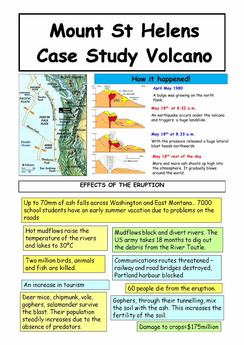
April May 1980
A bulge was growing on the north flank.
May 18th at 8.32 a.m.
An earthquake occurs under the volcano and triggers a huge landslide.
May 18th at 8.33 a.m.
With the pressure released a huge lateral blast heads northwards
May 18th rest of the day
More and more ash shoots up high into the atmosphere. It gradually blows around the world.
How it happened!
EFFECTS OF THE ERUPTION

http://www.bbc.co.uk/schools/gcsebitesize/geography/natural_hazards/managing_hazards_video.shtml
PredictionTime lapse cameras in the crater allow geologists to make safe observations
Seismograms indicate what to look out for. They measure vibrations in the earths crust and measure the magnitude of earthquakes.
Tiltmeters detect a change in slope caused by shifting magma beneath the surface
GPS use satellites to detect minute movements over a larger area.
A detailed plan is needed for dealing with a possible eruption. Everyone who could be affected needs to know the plan and what they should do if it needs to be put into action. Planning for a volcanic eruption includes:• creating an exclusion zone around the volcano• being ready and able to evacuate residents• having an emergency supply of basic provisions, such as food• funds need to be available to deal with the emergency and a good communication system needs to be in place
Preparing for an Eruption
A Successful NHS poster showing the dangers of swine flu…
TASK: Produce an equally catchy slogan/mini poster (half a page in exercise book) to warn people of the signs of volcanic activity, and what to do if an eruption was to occur!
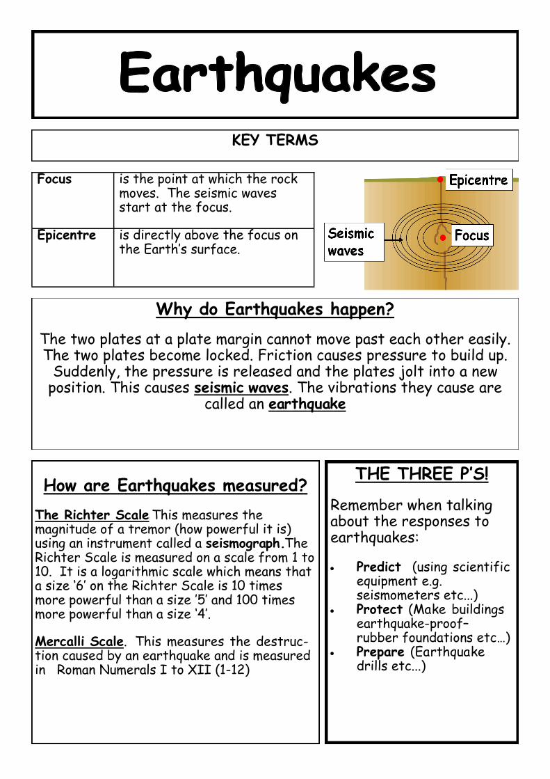
Why do Earthquakes happen?
The two plates at a plate margin cannot move past each other easily. The two plates become locked. Friction causes pressure to build up.
Suddenly, the pressure is released and the plates jolt into a new position. This causes seismic waves. The vibrations they cause are
called an earthquake
Focus is the point at which the rock moves. The seismic waves start at the focus.
Epicentre is directly above the focus on the Earth’s surface.
KEY TERMS
How are Earthquakes measured?
The Richter Scale: This measures the magnitude of a tremor (how powerful it is) using an instrument called a seismograph. The Richter Scale is measured on a scale from 1 to 10. It is a logarithmic scale which means that a size ‘6’ on the Richter Scale is 10 times more powerful than a size ’5’ and 100 times more powerful than a size ‘4’.
Mercalli Scale. This measures the destruc-tion caused by an earthquake and is measured in Roman Numerals I to XII (1-12)
THE THREE P’S! Remember when talking about the responses to earthquakes: Predict (using scientific
equipment e.g. seismometers etc...)
Protect (Make buildings earthquake-proof– rubber foundations etc…)
Prepare (Earthquake drills etc...)
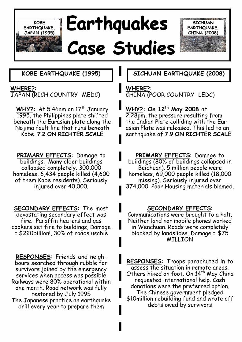
KOBE EARTHQUAKE (1995) SICHUAN EARTHQUAKE (2008)
WHERE?: JAPAN (RICH COUNTRY- MEDC)
WHERE?: CHINA (POOR COUNTRY- LEDC)
WHY?: At 5.46am on 17th January 1995, the Philippines plate shifted
beneath the Eurasian plate along the Nojima fault line that runs beneath
Kobe. 7.2 ON RICHTER SCALE
PRIMARY EFFECTS: Damage to buildings. Many older buildings collapsed completely. 300,000
homeless, 6,434 people killed (4,600 of them Kobe residents). Seriously
injured over 40,000.
SECONDARY EFFECTS: The most devastating secondary effect was
fire. Paraffin heaters and gas cookers set fire to buildings, Damage = $220billion!, 30% of roads usable
RESPONSES: Friends and neigh-bours searched through rubble for survivors joined by the emergency services when access was possible
Railways were 80% operational within one month. Road network was fully
restored by July 1995 The Japanese practice an earthquake
drill every year to prepare them
WHY?: On 12th May 2008 at 2.28pm, the pressure resulting from the Indian Plate colliding with the Eur-asian Plate was released. This led to an earthquake of 7.9 ON RICHTER SCALE
PRIMARY EFFECTS: Damage to buildings (80% of buildings collapsed in
Beichuan). 5 million people were homeless, 69,000 people killed (18,000
missing). Seriously injured over 374,000. Poor Housing materials blamed.
SECONDARY EFFECTS: Communications were brought to a halt. Neither land nor mobile phones worked in Wenchuan. Roads were completely blocked by landslides. Damage = $75
MILLION
RESPONSES: Troops parachuted in to assess the situation in remote areas.
Others hiked on foot. On 14th May China requested international help. Cash
donations were the preferred option. The Chinese government pledged
$10million rebuilding fund and wrote off debts owed by survivors
KOBE EARTHQUAKE, JAPAN (1995)
SICHUAN EARTHQUAKE, CHINA (2008)

What causes a tsunami? When an earthquake, volcano or landslide happens on the ocean floor, water
is displaced. This water forms the start of the tsunami. When the waves reach shallower water: their height can increase by several metres the shallow water slows the wave the waves get closer together
Tsunami A special type of wave where the entire depth of the ocean is set in motion by an event, often an earthquake, which displaces the water above it and creates a huge wave
KEY TERMS
CASE STUDY: INDIAN OCEAN TSUNAMI (BOXING DAY 2004)
Two tectonic plates, the Australian and Eurasian plates, meet just off Sumatra's south-west coast, grinding together and sending periodic seismic tremors through the region. At 0059 GMT a violent rupture occurred on the sea floor along a fault about 1,000km long. EFFECTS: 230, 21 0 - 310,000 deaths, Two million people
were made homeless. People were swept away in the waters, which arrived rapidly and with little warning. Thirteen countries were affected, the worst being In-donesia. Indonesia was hit by the tsunami first. Forty-five minutes later the tsunami reached Thailand. Islands reliant on tourism and fishing, such as the Maldives, had to rebuild their industries
RESPONSES: Short-term aid, such as water purification tablets, temporary housing and medical supplies were given from international countries.
An early warning system between countries surrounding the Indian Ocean has been set up.

Hurricane A powerful tropical storm with sustained winds of over 75mph.
Eye The centre of the hurricane where sinking air creates clear conditions
Eye Wall A high bank of cloud either side of the eye where the wind speeds are high and heavy rain falls
Track The path/course of a hurricane
KEY TERMS
Hurricanes need a lot of heat to form and a sea surface temperature of at least 26°C, which is why they usually occur over tropical seas. They also need to be between 5 and 20° north or south of the equator. It works like this:
1. When this warm and wet air rises, it condenses to form towering clouds, heavy rainfall. 2. Rising warm air causes the pressure to decrease at higher altitudes. Warm air is under a higher
pressure than cold air, so moves towards the ‘space’ occupied by the colder, lower pressure, air. So the low pressure ‘sucks in’ air from the warm surroundings, which then also rises.
3. Air that surrounds the low pressure zone at the centre flows in a spiral at very high speeds - anti-clockwise in the northern hemisphere - at speeds of around 120 km/h (75 mph).
4. Air is ejected at the top of the storm – which can be 15km high – and falls to the outside of the storm, out and over the top, away from the eye of the storm. As this happens, it reduces the mass of air over the ‘eye of the storm’ - causing the wind speed to increase further.
5. The faster the winds blow, the lower the air pressure in the centre, and so the cycle continues. The hurricane grows stronger and stronger.
6. The cloud brings heavy rain, thunder and lightning. 7. In the centre is the eye of the hurricane, about 45 km across (30 miles) across. Often there will
be no clouds in the eye. 8. In the northern hemisphere, the prevailing easterly tropical winds tend to steer hurricanes
toward land - although their course is unpredictable. As hurricanes move inshore, their power gradually reduces because their energy comes from sucking up moist sea air.
Diagram of a Hurricane.

HURRICANE KATRINA (2005) CYCLONE NARGIS (2008)
WHERE? North America– New Orleans 6th most powerful hurricane EFFECTS? 1,836 dead Hundreds of thousands homeless 3 million left without electricity $89billion—COST Help arrived in a few hours RESPONSES: SHORT-TERM: Rescuing people from floodwater, treating injured LONG-TERM: Rebuilding New Orleans WARNINGS: Katrina had been monitored and predicted accurately 80% people evacuated
WHERE? MyanMar (Burma) Developed in Bay of Bengal EFFECTS? At least 140,000 dead 2-3 million homeless UN estimate 1.5 million affected $10billion– COST Government refused foreign aid RESPONSES: SHORT-TERM: Identification and burial of the dead, Treating the injured LONG-TERM: Rebuilding homes, Reclaiming Farmland WARNINGS: Most people had no idea the cyclone was approaching

Processes of Erosion
Corrosion (Solution) Material dissolved by the river
Abrasion (Corrasion) Load wears away river channel
Hydraulic Action Force of current dislodges loose material
Attrition Load collides
Processes of Transportation
Traction Rolling of large load
Saltation Bouncing of smaller load
Suspension Fine material held within the water
Solution Rocks dissolved within the water
RIVERS KEYWORDS GLOSSARY
Cross profiles of river valleys – V-shaped sections, changing downstream from steep to gentle
Discharge – amount of water in a river at any one time
Erosion processes – wearing away the land surface by hydraulic action, abrasion, attrition and solution
Flood plain – flat land built of silt on the sides of a river, usually in its lower course
Flooding – water covering land that is normally dry after a river bursts its banks
Gorge – steep narrow valley, with rocky sides
Hard engineering strategies – strong construction methods to hold floodwater back or keep it out
Hydraulic power – erosion of rocks by the force of moving water in waves
Levée – raised bank along the sides of a river, made of silt from river floods
Long profile of a river – a summary of the shape and gradient of a river bed from source to mouth
Management of problems – making changes for improvement, planning ahead to stop them occurring in the future
Management strategies – ways to control development and change, to preserve and conserve, and to plan for a sustainable future
Meander – bend in a river, usually along its middle or lower course
Ox-bow lake – semi-circular lake on the flood plain of a river, a cut-off meander
Precipitation – all moisture that reaches the Earth’s surface from the atmosphere
Soft engineering strategies – more natural ways to reduce the impact of flooding on humans, with less intervention and more preparation
Soil erosion – loss of fertile topsoil by action of wind and water
Sustainable management – planning ahead and controlling development for a long future
Transportation processes – movement of sediment by traction, saltation, suspension and solution
Tip: The command term ‘outline’ requires you to ‘give the main points’. Although this usually involves a list of statements, try to avoid bullet-points. On ‘outline’ questions you will be rewarded for including extending statement. Plus: ALWAYS 3 Specific facts in CASE STUDIES
Tip: When a landform question has the ‘explain’ command term you need to identify the main processes of change and link these to landform development.
EXAM TIPS FOR WATER ON THE
LAND
Getting that To achieve a high score on a levelled
questions (one worth 4 marks or more) you will need to need to
include keywords in your answer.
ip: Always read questions carefully and pay
particular attention to command terms. A describe question requires extending statements for full marks.
Check spelling also.
Getting that: Take care with spelling and gram-mar. Literacy is becoming a more important element of the exam process. Careless spelling errors could cost you important points.
Getting that : When answering CASE STUDY questions always include at least 1 specific fact about that event. E.g. Dur-ing the 2004 Bos-castle Flash Flood around 58 buildings were flooded and most had to be demolished
REMEMBER: Revision is about picking out key information and re-visiting it. If there is something you completely DO NOT UNDERSTAND please ask your teacher to go through it again.

Source: Where a river starts.
Tributary: A smaller river that flows into the main channel.
Watershed: The boundary between two drainage basins
Confluence: The point where two rivers join.
Mouth: The end of a river.
RIVER DRAINAGE BASIN
Key Point
Rivers are channels of water which drain the land’s surface. They erode, transport and deposit materials, creating steep valleys and wide floodplains.
Source Middle Mouth
Large / Angular Bedrock
Narrow / Shallow channel Flow slowed by friction
Eroded bedrock – smoother
and smaller
Channel wider and deeper Less friction so faster flow
Eroded bedrock – smoother and smaller
Deep and wide channel Little friction resulting in a fast flow
Bedrock eroded into fine silt and sand
RIVER LONG PROFILE
Key Point
A River Long Profile is usually shown as a sloping curve like this ->

RIVER LANDFORMS
RIVER LANFORMS RESULTING FROM EROSION
WATERFALL 1. Waterfalls are formed where the river flows from harder rock onto softer rock 2. The weaker, softer rock is eroded by abrasion and hydraulic action, undercutting the hard rock whilst deepening the plunge pool. 3. Eventually the over hanging hard rock will collapse due to a lack of support, causing the waterfall to move back. 4. This process has happens again and again, as the waterfall retreats upstream a steep rocky valley is created, known as a gorge.
RIVER LANFORMS RESULTING FROM EROSION AND DEPOSITION
MEANDER
OX-BOW LAKE
form when meanders loop back on themselves (forming an almost closed curve). Erosion cuts through the narrow meander neck whilst deposition blocks off the entrance to the old meander, separating the ox-bow lake from the river.
1. As the river erodes laterally, to the right side then the left side, it forms large bends, and then horseshoe-like loops called meanders. 2. The formation of meanders is due to both deposition and erosion and meanders gradually migrate downstream. 3. The force of the water erodes and undercuts the river bank on the outside of the bend where water flow has most energy due to decreased friction. 4. On the inside of the bend, where the river flow is slower,
material is deposited, as there is more friction.
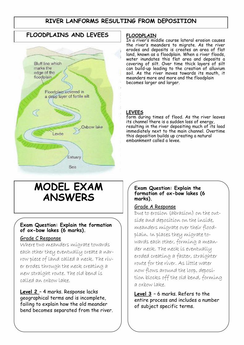
RIVER LANFORMS RESULTING FROM DEPOSITION
FLOODPLAINS AND LEVEES FLOODPLAIN In a river’s middle course lateral erosion causes the river’s meanders to migrate. As the river erodes and deposits is creates an area of flat land, known as a floodplain. When a river floods, water inundates this flat area and deposits a covering of silt. Over time thick layers of silt can build-up leading to the creation of alluvium soil. As the river moves towards its mouth, it meanders more and more and the floodplain becomes larger and larger.
LEVEES form during times of flood. As the river leaves its channel there is a sudden loss of energy, resulting in the river depositing much of its load immediately next to the main channel. Overtime this deposition builds up creating a natural embankment called a levee.
Exam Question: Explain the formation of ox-bow lakes (6 marks).
Grade A Response
Due to erosion (abrasion) on the out-
side and deposition on the inside,
meanders migrate over their flood-
plain. In places they migrate to-
wards each other, forming a mean-
der neck. The neck is eventually
eroded creating a faster, straighter
route for the river. As little water
now flows around the loop, deposi-
tion blocks off the old bend, forming
a oxbow lake.
Level 3 – 6 marks. Refers to the entire process and includes a number of subject specific terms.
Exam Question: Explain the formation of ox-bow lakes (6 marks).
Grade C Response
Where two meanders migrate towards
each other they eventually create a nar-
row piece of land called a neck. The riv-
er erodes through the neck creating a
new straight route. The old bend is
called an oxbow lake.
Level 2 – 4 marks. Response lacks geographical terms and is incomplete, failing to explain how the old meander bend becomes separated from the river.
MODEL EXAM ANSWERS

KEYWORD DEFINITION
PRECIPITATION ANY SOURCE OF MOISTURE REACHING THE GROUND
INTERCEPTION WATER BEING PREVENTED FROM REACHING THE SURFACE BY TREES
SURFACE STORAGE WATER HELD ON THE GROUND SURFACE
INFILTRATION WATER SINKING INTO SOIL/ROCK FROM THE GROUND SURFACE
SOIL MOISTURE WATER HELD IN THE SOIL LAYER
PERCOLATION WATER SEPING DEEPER BELOW THE SURFACE
GROUNDWATER WATER STORED IN THE ROCK
TRANSPIRATION WATER LOST THROUGH PORES IN VEGETATION
EVAPORATION WATER LOST FROM GROUND/VEGETATION SURFACE
SURFACE RUN-OFF WATER FLOWING ON TOP OF THE GROUND
THROUGHFLOW WATER FLOWING THROUGH THE SOIL LAYER PARALLEL TO THE SURFACE
GROUNDWATER FLOW
WATER FLOWING THROUGH THE ROCK LAYER PARALLEL TO THE SURFACE
WATER TABLE CURRENT UPPER LEVEL OF SATURATED ROCK/SOIL WHERE NO MORE WA-TER CAN BE ABSORBED

STORM HYDROGRAPH The peak rainfall is the time of highest rainfall. The peak discharge (the time when the river reaches its highest flow) is later because it takes time for the water to find its way to the river (lag time) . The normal (base) flow of the river starts to rise (rising limb) when run-off, ground and soil water reaches the river. Rock type, vegetation, slope and situation (ie is this an urban river?) affect the steepness of this limb. The falling limb shows that water is still reaching the river but in decreasing amounts. The run-off/discharge of the riv-er is measured in cumecs - this stands for cubic metres per second. Precipitation is measured in mm - this stands for millimetres.
FACTORS AFFECTING RIVER DISCHARGE
FACTOR EXPLANATION
RELIEF THE STEEPNESS OF THE LAND AFFECTS HOW QUICKLY WATER CAN REACH THE RIVER CHANNEL. (FASTER FLOW– STEEPER LAND)
TEMPERATURE AFFECTS THE LOSS OF WATER FROM THE DRAINAGE BASIN AND THEREFORE THE LEVEL OF DISCHARGE. WHEN TEMPERATURES ARE HIGHER THERE IS GREATER LOSS VIA EVAPORATION.
IMPERMEABLE ROCK IMPERMEABLE SURFACES DO NOT ALLOW WATER TO INFILTRATE THEREFORE THERE IS GREATER SURFACE RUN-OFF
DEFORESTATION IF TREES ARE REMOVED, WATER REACHES THE SURFACE FASTER AND THE TREES ARE NOT INTERCEPTING OR TAKING WATER FROM THE GROUND.
URBANISATION EXPANDING TOWNS CREATE AN IMPERMEABLE SURFACE. THIS IS MADE EVEN WORSE BY BUILDING DRAINS TO TAKE THE WATER AWAY FROM BUILDINGS QUICKLY– AND QUICKLY INTO THE RIVERS!
EXAM TIP You are expected to be able to construct, describe and explain hydrographs. A hydrograph shows two graphs -
rainfall (in bars) and discharge (in a line).
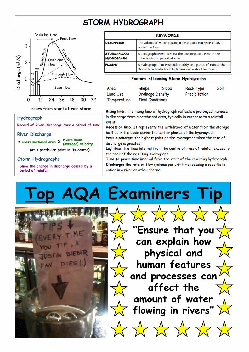
Top AQA Examiners Tip
‘‘Ensure that you can explain how physical and
human features and processes can
affect the amount of water flowing in rivers’’

Impermeable (Hard) Rock:
Under the soil so the rain cannot soak through
Hard Dry Soil:
When the soil is baked hard in summer the rain runs over.
Wet Soil:
When the soil is full of water no
more rain can soak through.
Steep Slopes:
Rain will run down a steep slope quickly
Cut down trees:
Leaves slow rainfall and roots take in water.
Buildings:
Rain cannot soak through tarmac and pavements
Factors that increase the risk of flooding
Physical Factors
Severe weather such as heavy or continuous precipitation (rainfall) is the most common cause of river flooding in the UK.
Impermeable surfaces, such as baked or saturated soil, increas-es surface flow and the amount of water entering the river system.
Snow melt in spring can lead to flooding in mountainous regions where thick layers of snow have built-up over the winter.
In upland areas with steep gra-dients there is little time for wa-ter to infiltrate into the soil, shortening lag time.
Human Factors
In wooded areas trees may intercept rainfall, trapping rainwater on their leaves. Additional rainwater may be absorbed by their roots and released back to the atmosphere through transpiration. When forests are cut down (deforested) less rainwater is intercepted and transpired so more water reaches the river and gets their quicker.
In urban areas, the landscape is made up of
mainly impermeable surfaces. As rainfall is unable to penetrate the surface, water flows into the drains and directly to the river. Sloping roofs also increased run-off and reduce surface storage.
Changing farming techniques have lead to
increased surface runoff. Up-and-down ploughing channels rainwater quickly downhill shortening lag time.
The extensive use of fossil fuels and changing
farming practices, have increased the amount of greenhouses (e.g. carbon dioxide and me-thane) in our atmosphere. These gases ‘trap-in’ the sun’s heat warming our climate. Higher global temperatures have lead to an increase in extreme weather conditions, such as hurri-canes and droughts, and increasingly unpre-dictable rainfall patterns.
REMEMBER:
PHYSICAL: Things created by nature
HUMAN: Things created
by people

Facts & Figures: -Other areas affected by flooding in July included Warwickshire, Shropshire, Worcestershire, Bed-fordshire, Oxfordshire and Berkshire. -Total cost of July floods was £6 billion.
CAUSES What Caused the Flooding? -The ground was already saturated -On 21 July 83mm of rain fell in a few hours (3 times average for July). -Heaviest rain fell on Tewkesbury and Evesham -River Severn burst its banks. -Much of the valley is low lying so flood waters quickly spread. -Much development on the flood plain of the river so little infiltration could take place. -Drains became blocked so water could not run-off.
Key Words and Terms
-rainfall -saturated -contaminated water -floodplains -burst banks
-emergency response -relief aid -water treatment -bowsers -flood defences
EFFECTS
What were the effects of the flooding? -Over 350 000 people lost access to running water for 2 weeks. -Water supplies were contaminated with sewage. -Homes and hospitals also lost electricity supply. -On the night of 21 July thousands of motorists were stranded on the M5. Rail passengers were also stranded at Gloucester station. -3 people died. Two men died trying to pump water out of Gloucester Rugby Club. -Thousands of people were forced to leave their homes. Belongings were lost and damaged. -many were trapped in their homes and had to be rescued by boat or helicopter. -Water treatment works closed. -Increase in cost of milk, bread and meat as farm-ers were unable to meet demand from consumers. -increased debate about the wisdom of building on floodplains.
RESPONSES
How did the authorities respond? -RAF Rescue helicopters scrambled to rescue peo-ple from roof tops (emergency response). -Fire and Rescue services rescued people and pumped water from flooded buildings. -Flood Relief Fund set up to raise money for house-holders (relief aid). -Severn Trent Water Company brought 50m litres of bottled water in. Also moved 1300 water bow-sers and 100 tankers into area. -Severn Trent donated £3.5m to communities most affected. -The Mythe Water Treatment works was repaired restoring water to most homes by the end of July. -Other water companies sent tankers to affected area. -British Red Cross sent food parcels to community centres where homeless residents were sheltering. -Governmental review into flood defences set up. -Visits to the area by the Prime Minister and Prince Charles.
Tewkesbury is in Gloucestershire in the South West of England
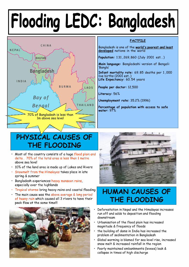
PHYSICAL CAUSES OF THE FLOODING
HUMAN CAUSES OF THE FLOODING
FACTFILE
Bangladesh is one of the world's poorest and least developed nations in the world
Population: 1 31 , 269, 860 (July 2001 est. . )
Main language: Bangladeshi version of Bengali: ‘Bangla’
Infant mortality rate: 69. 85 deaths per 1 , 000 live births (2001 est..)
Life Expectancy: 60. 54 years
People per doctor: 12,500
Literacy: 56%
Unemployment rate: 35.2% (1996)
Percentage of population with access to safe water: 97%
70% of Bangladesh is less than 1m above sea level

Over 57% of the land was destroyed by floodwater
THE EFFECTS OF THE FLOODING
THE RESPONSES OF THE FLOODING
Bangladesh GNP: $380 PER PERSON
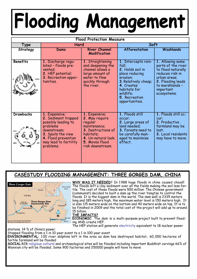
Flood Protection Measure
Type Hard Soft
Strategy Dams River Channel Modification
Afforestation Washlands
Benefits 1. Discharge regu-lated – floods pre-vented; 2. HEP potential; 3. Recreation oppor-tunities.
1. Straightening and deepening the channel allows a large amount of water to flow quickly through the river.
1. Intercepts rain-fall; 2. Holds soil in place reducing erosion; 3. Relatively cheap; 4. Creates habitats for wildlife; 5. Recreation opportunities.
1. Allowing some parts of the river to flood naturally reduces risk in urban areas; 2. Flooding leads to marshlands – important ecosystems.
Drawbacks 1. Expensive; 2. Sediment trapped possibly leading to problems downstream; 3. Spoils the view 4. Flood prevention may lead to fertility problems.
1. Expensive; 2. May require regular maintenance; 3. Destructions of habitats; 4. Un-natural look; 5. Moves flood risk downstream.
1. Floods still occur; 2. Large areas of land needed; 3. Forests need to be carefully man-aged to maximise effect.
1. Floods still oc-cur; 2. Productive farmland may be lost; 3. Local residents may have to move.
CASESTUDY FLOODING MANAGEMENT: THREE GORGES DAM, CHINA
WHY WAS IT NEEDED? In 1 988 huge floods in china caused chaos!! The floods left a clay sediment over all the fields making the soil less fer-tile. The cost of those floods were 500 million. The Chinese government (communist) decided to built a dam up the river Yangtze to control the floods. It is the biggest dam in the world. The dam wall is 2335 meters long and 185 meters high, the maximum water level is 150 meters high. It is also 115 meters wide on the bottom and 40 meters wide on top. It is to be finished in 2009 and the total cost of the project will add up to around 15 billion. THE IMPACTS? ECONOMIC: The dam is a multi-purpose project built to prevent flood-ing AND create HEP. The HEP station will generate electricity equivalent to 18 nuclear power
stations. 14 % of China’s power. Stopped flooding from a 1 in 10 year event to a 1 in 100 year event ENVIRONMENTAL: 1 00 river dolphins left in the area as dam has destroyed habitat, 60, 000 hectares of fertile farmland will be flooded SOCIAL:828 religious cultural and archaeological sites will be flooded including important Buddhist carvings 66% of Wanxian city will be flooded. Some 900 factories and 250000 people will have to move
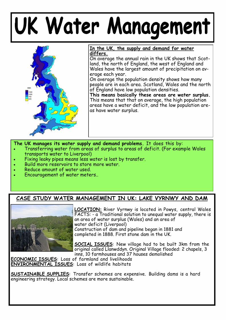
The UK manages its water supply and demand problems. It does this by: Transferring water from areas of surplus to areas of deficit. (For example Wales
transports water to Liverpool) Fixing leaky pipes means less water is lost by transfer. Build more reservoirs to store more water. Reduce amount of water used. Encouragement of water meters..
In the UK, the supply and demand for water differs. On average the annual rain in the UK shows that Scot-land, the north of England, the west of England and Wales have the largest amount of precipitation on av-erage each year. On average the population density shows how many people are in each area. Scotland, Wales and the north of England have low population densities. This means basically these areas are water surplus. This means that that on average, the high population areas have a water deficit, and the low population are-as have water surplus.
CASE STUDY WATER MANAGEMENT IN UK: LAKE VYRNWY AND DAM
LOCATION: River Vyrnwy is located in Powys, central Wales FACTS: - a Traditional solution to unequal water supply, there is an area of water surplus (Wales) and an area of water deficit (Liverpool) Construction of dam and pipeline began in 1881 and completed in 1888. First stone dam in the UK. SOCIAL ISSUES: New village had to be built 3km from the original called Llanwddyn. Original Village flooded: 2 chapels, 3 inns, 10 farmhouses and 37 houses demolished
ECONOMIC ISSUES: Loss of farmland and livelihoods ENVIRONMENTAL ISSUES: Loss of wildlife habitats SUSTAINABLE SUPPLIES: Transfer schemes are expensive. Building dams is a hard engineering strategy. Local schemes are more sustainable.

Processes of river erosion Hydraulic action: force of the water Abrasion: sand, boulders erode channel Attrition: load breaking up smaller pieces Solution: some rocks dissolve in river water
Processes of transportation Traction: boulders roll along river bed Saltation: small pebbles bounced along Suspension: sand / silt carried in flow Solution: dissolved minerals carried away
Valley long and cross profiles Upper course long profile: irregular, steep Lower course: lower, smoother, less steep Upper course cross profile: steep V shape Lower course: gentle V shape, flat
Landforms of river erosion Mainly found in upper course Waterfalls, gorges, interlocking spurs Formed by vertical erosion River cutting down towards sea level
Formation of waterfall and gorge Alternate outcrops of hard and soft rocks Hard is eroded slowly, soft is eroded fast Soft rocks undercut by water splashback Waterfall retreats upstream, leaving a gorge
Landforms of river deposition Mainly found in lower course Levées, flood plains, deltas River carries a large load of sediment Deposited where water flow slowed down
Formation of meander and ox-bow lake Outside bend: strong flow, erosion, cliff Inside bend: weak flow, slip-off slope Meander size increased by lateral erosion Narrow meander neck broken in a flood
River discharge Volume of water flowing in a river Factors: the weather, rock type, relief High discharge after heavy, prolonged rain Particularly impervious rock, steep slopes
Causes of flooding Physical: factors favouring high discharge Wet weather before; ground is saturated Snow melts, cool weather, little evaporation Human: deforestation, building construction
Hard engineering strategies Structures built to prevent flooding Dams and reservoirs Concrete / stone channel sides Raising the height of river banks
Soft engineering strategies Measures to reduce the scale of flooding
Plant trees on steep valley sides
Zoning: stop more building on flood plains
Issue flood alerts; prepare e.g. sandbags
Water supply in the UK Water surplus: north and west of UK High precipitation, lower population density Water deficit: south and east England Lowest precipitation, highest population
REVISION FLASHCARDS: WATER ON THE LAND

1. Using examples, describe some of the hazards of living on a destructive plate margin (4) Foundation
2. Using an example, outline the impact of a major earthquake on people and property in the developing world (9) Higher
3. Describe 2 ways in which buildings in developing countries can be made more resistant to earthquakes (2)
4. Explain how preparation and prediction could reduce tectonic hazards (volcanoes and earthquakes) (4)
5. Explain why some areas are more vulnerable than others (4)
6. Explain the role magma plays in shaping shield volcanoes (2)
7. How do tectonic plates move? (2)
8. Outline the responses made by a country to reduce the risk of future earthquakes. (9 marks HIGHER/6 mark FOUNDATION)
9. Using a diagram describe how volcanoes are formed along destructive plate margins (4 marks)
10. Using an example, Describe the potential impacts of a supervolcanic eruption (6 marks)
11. Using a case study outline the impacts of a tsunami on a land and its community (6 marks FOUNDATION/9marks HIGHER)
TRY some of these exam questions on lined paper or in your exercise books. Bring them to revision sessions and lessons if
you would like them to be marked by your class teacher!
1. What is the difference between the long profile and the cross profile of a river? (2 Marks) 2. Explain why the upper course of a river valley has a different cross profile from the lower course. (4 Marks) 3. Name and describe two other processes by which material is transported in Rivers. (4 Marks) 4. Deposition occurs when rivers slow down. Why do Rivers Slow down? (4 Marks) 5. Using a Diagram Explain the formation of a River cliff. (3 Marks) 6. Using a Diagram Explain the formation of an ox-bow lake. (6 Marks) 7. Describe, using a diagram the formation of Waterfalls. (6 Marks) 8. What is a flood plain? (1 Mark) 9. What are levees? and explain how they are formed (3 Marks) 10. Explain what the following terms mean: i) Peak discharge ii) Lag time (2 Marks) 11. Describe and compare the primary and secondary effects of flooding in an MEDC and in an LEDC. (6 Marks)
12. What is meant by hard and soft engineering strategies? (2 Marks) 13. Give two ways in which the supply of water in the UK can be managed. (2 Marks) 14. Describe the economic, social and environmental impact of a studied Reservoir (8 Marks)
TRY some of these exam questions on lined paper or in your exercise books. Bring them to revision sessions and lessons if
you would like them to be marked by your class teacher!
Recommended