The Role Of Data Matching Tools When Migrating To Automated Cartographic Production Systems
Patrick Revell
Ordnance Survey Research
International Cartographic Conference
November 2009

Ordnance Survey Mapping Products
Large Scale Database
OS MasterMap®
(Topography, ITN (road), Address, Imagery Layers)
1:10 000 Raster
Vector
1:25 000 Raster
1:50 000 Raster
(Vector), Gazetteer
1:250 000 Raster
Vector, Gazetteer
1:1000 000 Raster
(Vector)

Automatic Generalisation
• Aim to Capture Once (at most detailed scale)
• Use Many Times (to derive all smaller scale products)
• …then propagate updates to derived products
• Most efficient, cost-effective and flexible production method.
• Ordnance Survey Research have been investigating automatic generalisation for at least six years.

1:50 000 Scale Generalisation
1:10 000 ScaleGeneralisation

1:25 000 Scale Generalisation

• Automatic gen products are not totally consistent with manual ones.
How do we ensure no information is lost? (eg. names)
• Not all the required information is available at the most detailed scale.
How do we get this information into our database? (eg. r.o.w., tourist)
• Manually generated (legacy) products still need updating.
How do we make this as efficient as possible?
BUT…
All involve comparing spatial datasets…
Conflation/Spatial Data Integration
Conflation is a process carried out to integrate spatial datasets
1. Pre-Processing. eg. raster to vector conversion.
2. Feature matching. Finding corresponding features between datasets.
3. Integration. When correct matches have been found, can then do:
Correction of differences
Information transfer (geometry/attributes)
Geometry alignment

Conflation Software
• Hardly any tools in mainstream GIS.
• Open-source software:
• GeOxygene, COGIT laboratory, IGN France open framework for creating/deploying GIS applications. various tools for spatial data handling, including data matching
• Java Conflation Suite (JCS) from Vivid Solutions
• tools for common geospatial data integration problems.
• based on the Java Topology Suite (JTS), 2D spatial functions for geometric operations.
• Both can match road network datasets and polygon datasets

Application 1
• Data matching to improve update efficiency of small scale mapping
Matched
Updates
Small Scales
Large Scale

Matching 1:25 000 Scale Buildings
(a) one-to-one match (simplification) (b) many-to-one match (amalgamation, simplification)(c) one-to-nothing match (elimination)(d) another many-to-one match (amalgamation, displacement)(e) many-to-many match (typification/simplification)(f) poor match - requires an update

Building Matching Results
Java Conflation SuiteGeOxygene
Large Scale matched
Large Scale unmatched
1:25 000 Scale matched
1:25 000 Scale unmatched

• Size. Areas are similar.
• Position. Centres of gravity are close.
• Shape. Building shapes are similar:
• Convexity. Total area divided by the area of the convex hull.
• Elongation. The Smallest Minimum Bounding Rectangle’s (SMBR’s) length divided by its width.
Evaluating Building Matches
• Orientation. Building orientations are similar:
• SMBR Orientation. Orientation of the longest side of the SMBR.
• Wall Statistical Weighting Calculated from the orientation of each wall, weighted by the wall lengths.
SMBR:

Matching 1:25 000 Scale Roads
GeOxygene results

Application 2
• Data matching to enhance large scale data.
Matched
Attribute Transfer
Small Scales
Large Scale

Enhancing The Large Scale Rail Network
• Large scale rail network has no classification.
• 1:10 000 scale rail data, classified as:
• Narrow Gauge Railway:
• Multi Track Railway (generalised)
• Single Track Railway/Siding (generalised)

Matching Rail Networks
• Tried road network matching tools.
• Now developing custom matching tool.

Application 3
• Improving the consistency of names between different scale products using data matching.
Matched
Manual Correction
Small Scale
Names
Large Scale
Names

Matching Different Names Datasets

Application 4
• Attaching cartographic names to topographic features
Matched
Attribute Transfer
Large Scale Cartographic
Names
Large Scale Topographic
Features
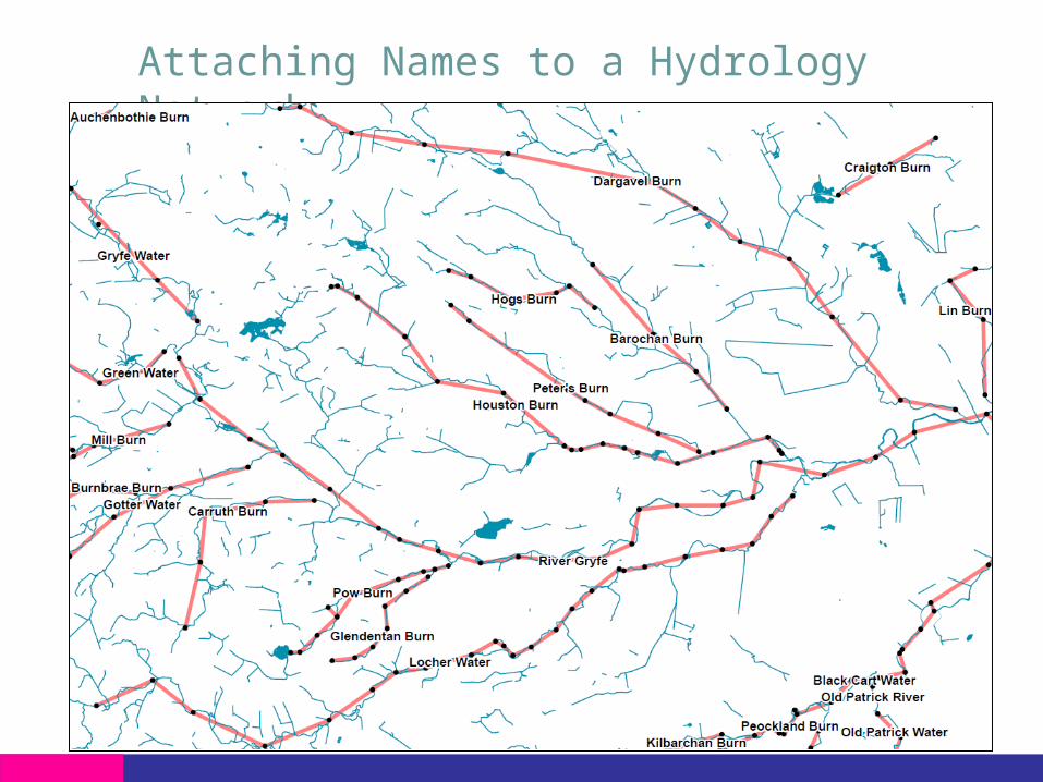
Attaching Names to a Hydrology Network

Conclusions
• Data matching is an essential tool to help migrate towards generating all mapping products from a single database.
• Allows our large scale database to be enriched with all the required information for automatic generalisation.
• Enables improved consistency across products.
• Can give an insight into the manual generalisation decision-making process.
• Can help make the update of manually generalised products more efficient.

Contact for further information:
Patrick Revell
Research (C530) Ordnance SurveyRomsey RoadSOUTHAMPTONUnited KingdomSO16 4GU
Website: www.ordnancesurvey.co.uk
Thanks for your attention!
Recommended