8/4/2019 Tectonic Impacts
http://slidepdf.com/reader/full/tectonic-impacts 1/13
Tectonic Impacts HSC E & E Science
Lithospheric Plates and their Motion
Describe the characteristics of lithospheric plates
Lithospheric plates are the plates that comprise the fractured surface of the earth. There
are two types, continental plates comprised mainly of granitic type rock rich in silica andaluminium and oceanic crust is comprised mostly of basaltic-type rocks rich inmagnesium and aluminium. Oceanic crust is denser than the continental crust.Earthquake and volcanic activity is common along lithospheric plate boundaries.
Oceanic Crust Continental Crust
Mean Thickness 7 km 30-50 km Thicker under mountains
Identify the relationship between the general composition of igneous
rocks and plate boundary typeIgneous rocks are classified by two main properties:
- mineral crystal size- mineral composition
• Mid-ocean ridges produces basalt which covers the seafloor, these basalts produced are hotter and less dense than the cooler basalts before they aresubducted
• Gabbro forms at divergent plate boundaries
• Convergent plate boundaries – andesite is produced in conjunction with other igneous rocks such as granite
Type of Boundary Type of Igneous Rock
Divergent Basaltic (mafic)
Convergent Oceanic – oceanic Basaltic early and as it matures andesite
Oceanic – Continental
Andesite
Continental – continental
Granite (placed as plutons)
Transform (or conservative) None
Outline the motion of plates and distinguish between the three typesof plate boundary
Convergent
• This is where two plates collide as a result of tectonic motion
• There are different types of convergent plate boundaries these are:o Oceanic – oceanic (Tonga – Philippine and Australian Plates)
o Oceanic – continental (The Andes – Nazca and South American Plates)
1
8/4/2019 Tectonic Impacts
http://slidepdf.com/reader/full/tectonic-impacts 2/13
Tectonic Impacts HSC E & E Science
o Continental – continental (Himalayas – Indo-Australian and Eurasian
Plates)
Divergent
•Basaltic magma is injected between two plates causing the plates to be pushedapart
• Originate along fault lines and these fault lines produce rift valleys
• Mid ocean ridges are also formed by this type of plate boundary – MORs arehundreds of kms wide and thousands of kms long
• Divergent plate boundaries cause tensional forces that pull the plates apart andaway from each other, creating normal faults
• The different types of divergent plate boundaries are:o Oceanic – oceanic (North Atlantic Rock)
o Continental – continental (East African Rift Valley – African plate
boundary)
Conservative or Transform
• When these boundaries occur on land they are subject to greater weathering andare therefore not as steep
• San Andreas Fault (Juan de Fuca and North American Plates) and Alpine Fault(Australian and Pacific Plates)
• Plate material is neither produced nor destroyed at this plate boundary but it may be metamorphosed
MUST PUT IN DIAGRAMS OF EACH PLATE BOUNDARY
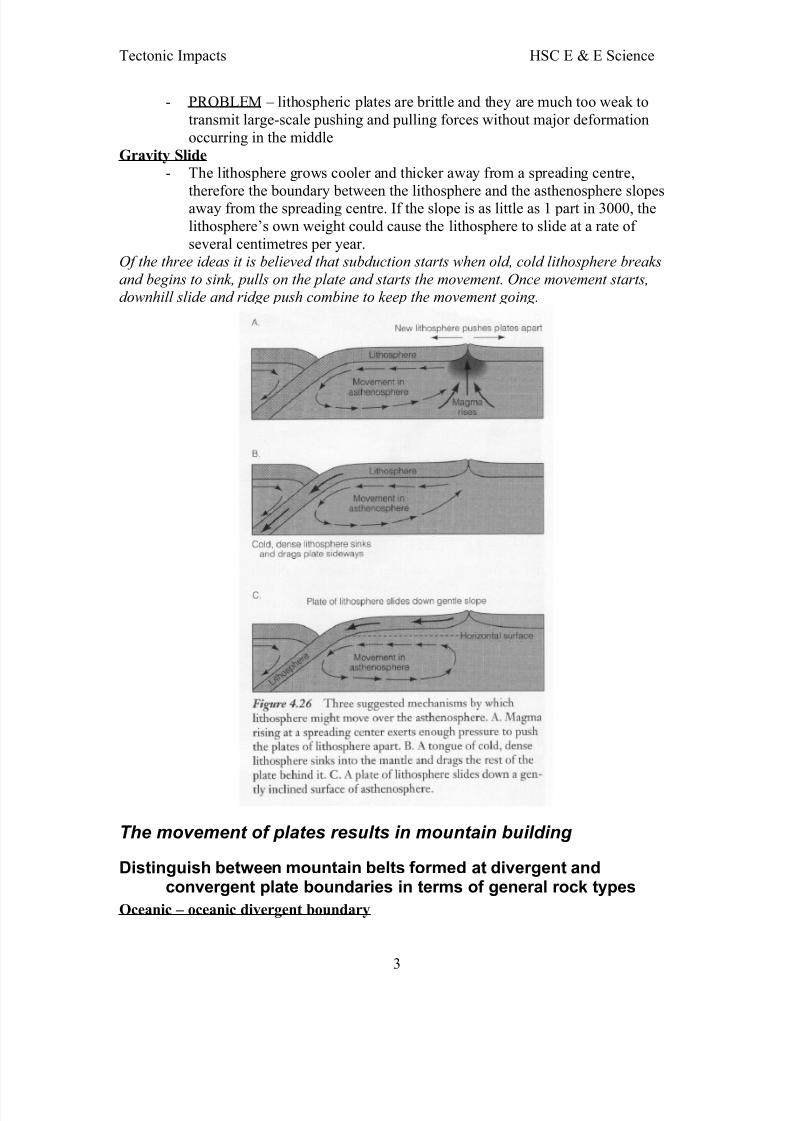
Describe current hypotheses used to explain how convectioncurrents and subduction drive plate motion
The three hypotheses are:- slab push from the MOR - Slab pull at subduction zone- Gravity slide
Slab Push
- Rising magma at a spreading centre creates new lithosphere and in the process
pushes the plates away from each other - PROBLEM – pushing involves compression, but the existence of rifts alongMORs indicates a state of tension
Slab Pull
- lithosphere breaks and starts to sink through the asthenosphere because coldlithosphere is more dense than the hot asthenosphere
2
8/4/2019 Tectonic Impacts
http://slidepdf.com/reader/full/tectonic-impacts 3/13
Tectonic Impacts HSC E & E Science
- PROBLEM – lithospheric plates are brittle and they are much too weak totransmit large-scale pushing and pulling forces without major deformationoccurring in the middle
Gravity Slide
- The lithosphere grows cooler and thicker away from a spreading centre,
therefore the boundary between the lithosphere and the asthenosphere slopesaway from the spreading centre. If the slope is as little as 1 part in 3000, thelithosphere’s own weight could cause the lithosphere to slide at a rate of several centimetres per year.
Of the three ideas it is believed that subduction starts when old, cold lithosphere breaks
and begins to sink, pulls on the plate and starts the movement. Once movement starts,downhill slide and ridge push combine to keep the movement going.
The movement of plates results in mountain building
Distinguish between mountain belts formed at divergent andconvergent plate boundaries in terms of general rock types
Oceanic – oceanic divergent boundary
3
8/4/2019 Tectonic Impacts
http://slidepdf.com/reader/full/tectonic-impacts 4/13
Tectonic Impacts HSC E & E Science
E.g. North Atlantic Ridge☻ ascending hot currents in the asthenosphere push the whole area up☻ dominant rock type is a volcanic lava of basaltic composition☻ extruded as pillow basalts☻ thin veneer of sediments
☻ normal faults are produced as tensional forces pull the lithosphere apartGET DIAGRAM FROM CLEZY’S REVISION
Oceanic – oceanic convergent boundary
E.g. Tonga (immature)☻ as subduction occurs the molten basaltic material rises to form an arc of
volcanic islands☻ restricted largely to igneous activity (initially basaltic) and does not include
widespread metamorphism or granitic intrusions☻ when two oceanic plates converge one is subducted under the other, and in the
process a trench is formed
☻ subduction processes in oceanic – oceanic plate convergence also result in theformation of volcanoes☻ such volcanoes are typically strung out in chains called island arcs☻ magmas that form island arc are produced by the partial melting of the
descending plate☻ over millions of years, the erupted lava and volcanic debris pile up on the
ocean floor until a submarine volcano rises above sea level to form an islandvolcano
☻ the descending plate also provides a source of stress as the two plates interact,leading to frequent moderate to strong earthquakes
☻ these earthquakes are shallow to deep focus and the pattern produced istermed a benioff zone
E.g. Japan (mature)☻ a more complex situation in which heat and or pressure combine to produce
distinctive rock associations and deformational patterns☻ rock sequences of oceanic sediments, pillow basalts from the oceanic crust, in
addition to sediment from erosion of the volcanic arc☻ partial melting produces andesitic/granitic magmas☻ A zone of high pressure, low temp. metamorphism (blue schist)☻ an inner zone of high temp metamorphism (green schist)☻ crustal deformation results in older rock to be compressed, folded and broken
by thrust faults
Continental – oceanic convergent boundary
E.g. Andes☻ before subduction sandstone, shale and limestone can accumulate along the
continental margin☻ deep marine sediments on the oceanic plate can be crumpled and deformed☻ slabs of oceanic crust, called ophiolite complexes, shear off
4
8/4/2019 Tectonic Impacts
http://slidepdf.com/reader/full/tectonic-impacts 5/13
Tectonic Impacts HSC E & E Science
Continental – continental convergent boundary
E.g. Himalayas☻ the convergence of two continental plates generates a mountain belt with
several different characteristics
☻ shallow and deep water sediments occur along the margin of the continents☻ a trench forms with all the characterisitics of a oceanic/continental subductionzone
☻ as continents approach segments of the remaining oceanic crust (ophiolite) aredeformed by overthrusting and are eventually squeezed between the plates
☻ as the continent moves into the subduction zone, its buoyancy prevents it fromdescending into the mantle. It can be thrust under the overriding plate,however, so that a double layer of low-density continental crust is produced.This layer rise buoyantly to create a wide belt of deformed rock.
☻ These regions are characterised by intense folding, thrust faulting andmetamorphism
☻ The oceanic slab of lithosphere, descending intot he mantle, ultimately becomes detached and sinks. When the slab has been consumed, the volcanicactivity and earthquakes it generates cease.
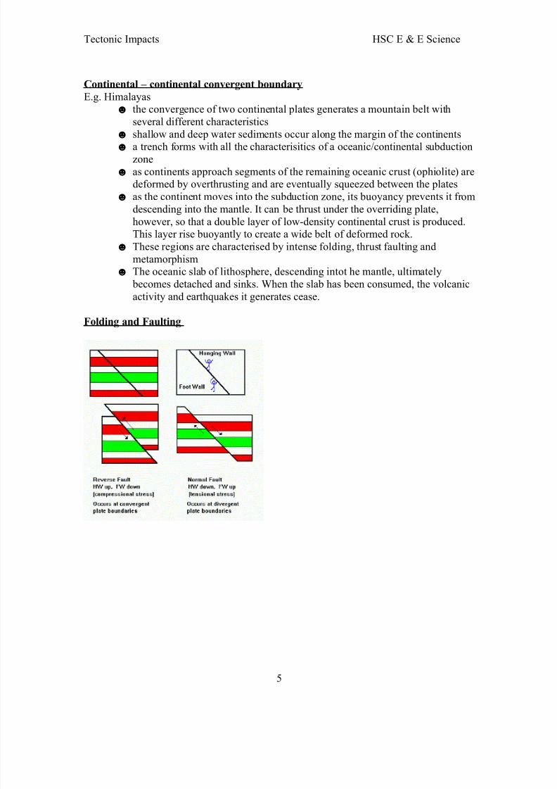
Folding and Faulting
5
8/4/2019 Tectonic Impacts
http://slidepdf.com/reader/full/tectonic-impacts 6/13
Tectonic Impacts HSC E & E Science
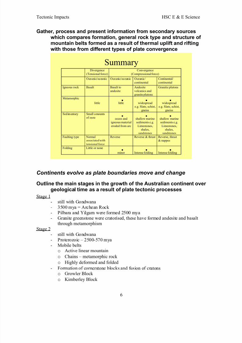
Gather, process and present information from secondary sourceswhich compares formation, general rock type and structure of mountain belts formed as a result of thermal uplift and riftingwith those from different types of plate convergence
SummaryDivergence
(Tensional force)
Convergence
(Compressional force)
Oceanic/oceanic Oceanic/oceanic Oceanic/
continental
Continental/
continental
Igneous rock Basalt Basalt to
andesite
Andesite
volcanics and
granite plutons
Granitic plutons
Metamorphic little
little
widespread
e.g. Slate, schist,
gneiss
widespread
e.g. Slate, schist,
gneiss
Sedimentary Small amounts
of ooze
oozes andigneous material
eroded from arc
shallow marinesediments e.g.
Limestones,shales,
sandstones
shallow marinesediments e.g.
Limestones,shales,
sandstones
Faulting type Normalassociated with
tensional force
Reverse Reverse & thrust Reverse, thrust& nappes
Folding Little or none
minor
Intense folding
Intense folding
Continents evolve as plate boundaries move and change
Outline the main stages in the growth of the Australian continent over geological time as a result of plate tectonic processes
Stage 1- still with Gondwana- 3500 mya = Archean Rock - Pilbara and Yilgarn were formed 2500 mya- Granite greenstone were cratorised, these have formed andesite and basalt
through metamorphismStage 2
- still with Gondwana
- Proterozoic – 2500-570 mya- Mobile belts
o Active linear mountain
o Chains – metamorphic rock
o Highly deformed and folded
- Formation of cornerstone blocks and fusion of cratonso Growler Block
o Kimberley Block
6
8/4/2019 Tectonic Impacts
http://slidepdf.com/reader/full/tectonic-impacts 7/13
Tectonic Impacts HSC E & E Science
o Mt Isa Block
Stage 3- still with Gondwana- Palaeozoic 570 – 230 mya- Subduction – accretion
- Tasmin belt formed – active island arcs and trench- Eastern rocks exhibit evidence of the presence of former island arcs and oceantrenches
- Major mountain building – Lachlan Fold Belt and New England Fold Belt- Active/mobile belt move east – producing Lord Howe Island- By 200 mya eastern third of Australia was cratorised
Stage 4- Mesozoic – 190 – 65 mya- Beginning of the breakup of Gondwana- Great Artesian Basin formed, then flood to form an inland sea and then it
dried and became non-marine
- Tasmin sea spreading- Sydney Basin – Foreland basin subsided as the magmatic arc eastward – Foreland Basin filled with sediment
Stage 5- Intra-continental earthquakes, hot spots and volcanoes- Tensional stresses – acting within plate boundaries to north pushing against
asian and pacific plates- Very old faults joined
Stage 6- still moving northward- interaction between the converging Australian and Pacific plates produce the
current New Guinea mobile belt
DRAW MAP OF AUST. WITH ALL NECESSARY MOVEMENTS
Summarise the plate tectonic super-cycle
- plates move due to thermal and gravitational affects, that is, by seafloor spreading and subduction
- continents were once apart of the supercontinent Pangea- approx. 200 mya Pangea split into Laurasia and Gondwana. Gondwana
includes the present continents of:o Australia
o Antarticao Africa
o South America
o Indian sub continent
Laurasia split into:o North America
o Eurasia
7
8/4/2019 Tectonic Impacts
http://slidepdf.com/reader/full/tectonic-impacts 8/13
Tectonic Impacts HSC E & E Science
Natural Disasters are often associated with tectonic activity and environmental conditions caused by this activity may contribute to the problems experienced by people
Identify where earthquakes and volcanoes are currently likely to
occur based on the plate tectonic modelEarthquakes and volcanoes occur along plate boundaries in particular around the “Ring of Fire”
Describe methods used for the prediction of volcanic eruptions andearthquakes
Scientist estimate earthquake probabilities in 2 ways:
- By studying the history of large earthquakes in a specific area- The rate at which strain accumulates in the rock
Volcanoes are monitored through the recording and analysis of measurable phenomenasuch as:- seismicity- ground movements- geophysical properties- gas geochemistry- hydrologic regime
Other instruments used include- strainometers- seismometers- lasers (surface mvt)
- tiltmetersDescribe the general physical, chemical and biotic characteristics of a volcanic regionand explain why people would inhabit such regions at risk
- traditional land ownership- fertile soils- biodiversity- geothermal energy- economic mineral deposits such as copper, gold, silver, lead- tourism- entertainment
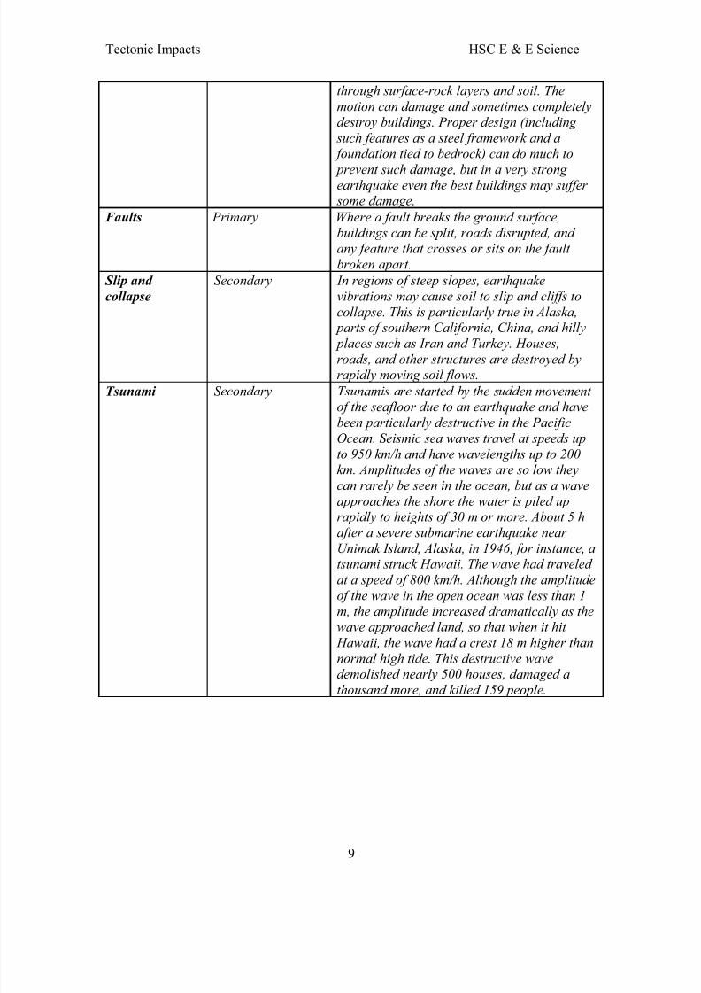
Describe hazards associated with earthquakes including groundmotion, tsunamis and collapse of structures
Name of Hazard Type of effect Description
Ground motion Primary Ground motion results from the movement of seismic waves, especially surface waves,
8
8/4/2019 Tectonic Impacts
http://slidepdf.com/reader/full/tectonic-impacts 9/13
Tectonic Impacts HSC E & E Science
through surface-rock layers and soil. The
motion can damage and sometimes completely
destroy buildings. Proper design (including
such features as a steel framework and a foundation tied to bedrock) can do much to
prevent such damage, but in a very strong earthquake even the best buildings may suffer some damage.
Faults Primary Where a fault breaks the ground surface,buildings can be split, roads disrupted, and
any feature that crosses or sits on the fault
broken apart.
Slip and
collapse
Secondary In regions of steep slopes, earthquake
vibrations may cause soil to slip and cliffs to
collapse. This is particularly true in Alaska, parts of southern California, China, and hilly
places such as Iran and Turkey. Houses,roads, and other structures are destroyed byrapidly moving soil flows.
Tsunami Secondary Tsunamis are started by the sudden movement of the seafloor due to an earthquake and have
been particularly destructive in the Pacific
Ocean. Seismic sea waves travel at speeds up
to 950 km/h and have wavelengths up to 200km. Amplitudes of the waves are so low they
can rarely be seen in the ocean, but as a wave
approaches the shore the water is piled up
rapidly to heights of 30 m or more. About 5 hafter a severe submarine earthquake near
Unimak Island, Alaska, in 1946, for instance, atsunami struck Hawaii. The wave had traveled
at a speed of 800 km/h. Although the amplitude
of the wave in the open ocean was less than 1
m, the amplitude increased dramatically as thewave approached land, so that when it hit
Hawaii, the wave had a crest 18 m higher than
normal high tide. This destructive wavedemolished nearly 500 houses, damaged a
thousand more, and killed 159 people.
9
8/4/2019 Tectonic Impacts
http://slidepdf.com/reader/full/tectonic-impacts 10/13
Tectonic Impacts HSC E & E Science
Describe hazards associated with volcanoes, including poisonousgas emissions, ash flows, lahars and lava flows and examinethe impact of these hazards on the environment, on people andother living things
Volcanic hazards Descriptions
1. Gas The volcanic gases that pose the greatest potential hazard are
• Sulfur dioxide
• Carbon dioxide
• Hydrogen fluoride
2. Lahars A mixture of water and rock fragmentsflowing down the slopes of a volcano
3. Landslides Large masses of rock and soil that fall,slide, or flow very rapidly under the force
of gravity4. Lava flows Streams of molten rock
5. Pyroclastic flows Are high-density mixtures of hot, dry rock fragments and hot gases that move awayfrom the vent at high speeds
6. Tephra General term for fragments of volcanicrock and lava regardless of size that are blasted into the air
7. Ash Flows Ash plumes carried downwind are animmediate threat to aircraft, crushinghouse, blocking roads, destroying crops and
killing livestock
Justify continued research into reliable prediction of volcanic activityand earthquakes
Seismic activity provides us with info on the interior of the earth, the structure of thecrust, density of rocks and possible resources and plate motion and geomorphology.Research helps to give warnings of potentially damaging earthquakes early enough toallow appropriate response to the disaster, minimising loss of life.
Describe and explain the impacts of shock waves (earthquakes) onnatural and built environments
Seismic events vary in destructiveness. Through the use of the modified Mercalli scale ananalysis can be prepared of the extent of the damage from an earthquake.
Kobe Earthquake, Japan 1995 Magnitude 7 - 5000 people died- 25 000 injured- 300 000 homeless- $80 billion damage
10
8/4/2019 Tectonic Impacts
http://slidepdf.com/reader/full/tectonic-impacts 11/13
Tectonic Impacts HSC E & E Science
Distinguish between plate margin and intra-plate earthquakes withreference to the origins of specific earthquakes recorded on theAustralian continent
Intraplate earthquakes are those occurring in the interior of plates, away from plate boundaries. They take place in the crust (up to 50km deep) and are caused by
compressive stress. An example of an intraplate earthquake in Australia was the one inMeckering, Western Australia in 1968 – it was a result of compressive force causingdamage to pipelines, roads and railway lines.
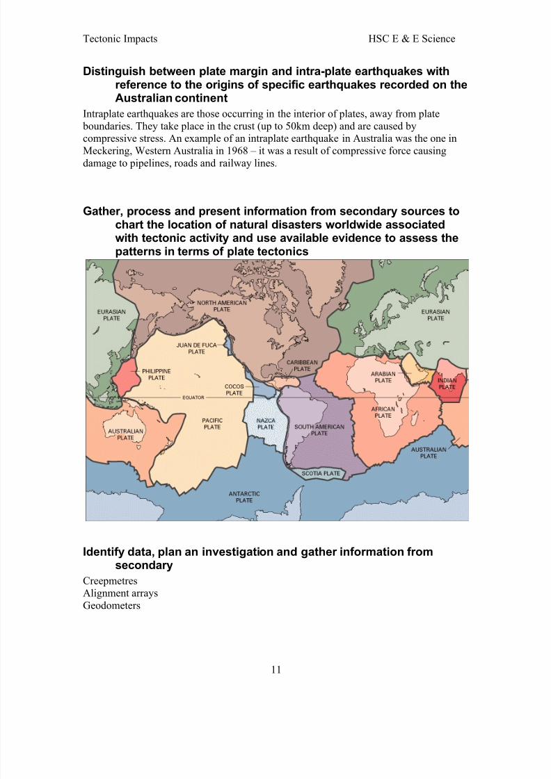
Gather, process and present information from secondary sources tochart the location of natural disasters worldwide associatedwith tectonic activity and use available evidence to assess thepatterns in terms of plate tectonics
Identify data, plan an investigation and gather information fromsecondary
CreepmetresAlignment arraysGeodometers
11
8/4/2019 Tectonic Impacts
http://slidepdf.com/reader/full/tectonic-impacts 12/13
Tectonic Impacts HSC E & E Science
Case Study of a Natural Disaster
Fact File
Name: Pakistan EarthquakeDate: 8th October 2005Magnitude: 7.6
Location: 34°N 73°EDeaths: over 80,000 affecting mainly Pakistan but also India and AfghanistanLocation of Epicentre: not far from Muzaffarabad in Nth PakistanExtent of Earthquake: felt as far west as Central Afghanistan and as far east as the westcoast of Bangladesh
Tectonic Movement
- Lies on the boundary of the Indo-Australian plate and the Eurasian plate- Convergent plate boundary – one plate was subducted underneath the other - Indo-Australian plate was subducted under the Eurasian plate- Indo-Australian plate moves northward at a rate of 4cm/yr
- Common in the regionDistance from the area of disaster
- Area impacted was vast – as far west as the middle of Pakistan and as far eastas the west coast of Bangladesh, as far north as the border of north-west chinaand as south as Jaipu in India
- Area of most devastation is central and north Pakistan and north west
India
- Worst damage was in Muzaffarabad- Cities of Pakistan– Abbottabad, Gujrat, Gujranwala, Lahore, Islamabad,
Rawalpindi- Cities of Kashmir – Jammu, Baramula, Srinagar
Recurrence- Area was overdue for a major earthquake with the last big one in Pakistan
being 1935- “It [an earthquake] might not appear for 10 to 20 years but if it occurred
tomorrow it wouldn’t be a surprise” Steven Wesnousky, Neotectonic Studiesat the University of Nevada
- This area is capable of much bigger earthquakes however the unpredictabilityof it is very high as there is a part of the fault which has not shifted or brokensince 1100
Technology
- Seismographs – record and measure earthquakes through the vibrations
created in the earth during an earthquake (seismograms)- Natural method – behavioural patterns in animals such as birds and insects for
an early warning sign- Strainmeter – currently under development in California measures the motion
of a geographical point in comparison with another geographical point- Other forms used include creep meter, leveling surveys, radon-gas counter, tilt
meter and the gravity meter Possible solutions used to minimise destruction
12
8/4/2019 Tectonic Impacts
http://slidepdf.com/reader/full/tectonic-impacts 13/13
Tectonic Impacts HSC E & E Science
- improvement of construction materials and designs of buildings- ductile materials such as steel and aluminium perform better than brittle
material such as brick, stone and unstrengthened concrete – Pakistan’sinfrastructure is mainly brittle material
- early warning systems and evacuation drills like they do in Japan
- improve country’s economy because in concern to Pakistan there is no moneyto have improved infrastructure
Plate Tectonics and Climate
Predict the possible effects of explosive volcanic activity on globaland local temperatures
Volcanoes affect the climate through- gases- dust particle emissions
The effect of volcanic dust may warm or cool the earth’s surface depending on howsunlight interacts with the volcanic material.Volcanic Gas – Sulfur
- volcanoes that release large amounts of sulfur compounds affect the climatemore strongly than those that just eject dust
- the sulfur compounds are gases that rise easily into the stratosphere- they combine with water to form a haze of tiny droplets of sulfuric acid- the effect is these tiny droplets are very light in colour and reflect a great deal
of sunlight – these reflective hazes can cause significant cooling of the earthfor as long as 2 years after a major-sulfur bearing explosion
Volcanic Dust
Volcanic dust blasted into the atmosphere causes temporary cooling- the amount of cooling is dependant on the amount of dust in the air - duration of cooling is dependant on the size of the dust particles
13
Recommended