1
STANDARD PROCEDURES FOR INVESTIGATION OF
POTENTIAL LANDSLIDE SITES
APRIL 1993
SABO TECHNICAL CENTRE
JAPAN INTERNATIONAL COOPERATION AGENCY

2
1 Standard Procedures for Investigation of Potential Landslide Sites
1.1 Scope
This manual describes standard procedures for investigation of potential landslide
sites. This provides for landslide control projects under the jurisdiction of the
Ministry of Public Works.
1.2 Investigation Method
1.2.1 Investigation Procedures
Identification of Potential Landslide Sites
Field Investigation
Coordination
Designation of Potential Landslide Areas
Review
1.2.2 Identification of Potential Landslide Sites, Potential Landslide Areas and
Potential Landslide Damage Areas.
(1) In determining Potential Landslide Sites, a group of 1) slide blocks that are
considered to move independently or 2) slide blocks that are considered to affect one
another during movement is regarded as a basic unit. The Potential landslide Site is
defined as a set of these unit areas plus areas that could be included in future, and is
determined in due consideration of desirable warning and evacuation systems and
landslide control works (see Section 4.1 in Reference Section).
(2) Areas with landslide potential are identified on the basis of aerial photographs
(1/5,000-1/20,000; larger-scale maps are desirable), topographic maps, geologic maps,
and other records. Landslide risks and potential landslide damage areas in places
that fall under (e) below need to be reviewed from time to time.
(a) Any place that has suffered damage supposed to have been inflicted by a
landslide (according to ancient documents, legends, records of investigation,
local residents’ accounts, etc.)

3
(b) Any place that shows signs of ground movement (cracks, cave-in, upheaval, etc.)
(c) Any place that shows landslide topography or that is considered to have
landslide potential judging from the type of rock, geological structure, etc.
(based on aerial photographs, topographic maps, geological maps, etc.; to be
determined according to Section 4.4 to 4.6 in Reference Section)
(d) Potential landslide areas designated according to the results of the past survey
(except those that no longer have landslide potential)
(3) Potential landslide sites are indicated on topographic maps (1/25,000) issued by the
Geographical Survey Institute.
(4) “Potential Landslide Areas” are designated according to the Potential Landslide
Sites thus determined. A “Potential Landslide Area” consists of a Potential Landslide
Site plus the zone of movement of slide blocks involved. “Potential Landslide Areas”
are determined according to Section 4.2 in Reference Section. The Potential
Landslide Areas thus determined are indicated on topographic maps (1/25,000)
issued by the Geographical Survey Institute.
(5) For landslide areas including or adjacent to torrents, “Potential Landslide Damage
Areas” are defined.
A “Potential Landslide Damage Area” consists of a Potential Landslide Area
plus and area along a torrent flowing through or near the Potential Landslide area
that is likely to be affected by blockage of the torrent caused by the movement of the
Potential Landslide Area (see Section 4.3 in Reference Section). The “Potential
Landslide Damage Areas” thus identified are indicated on topographic maps
(1/25,000) issued by the Geographical Survey Institute.
(6) Considerations
In determining the Potential Landslide Sites, the following should be taken into
consideration.
(a) Wherever possible, inquiries should be made at the relevant municipality to
collect information on recent landslide activity prior to the interpretation of
acquired data. Such inquiries might yield information on other landslide sites.
(b) During the interpretation, landslide topographies should be identified as many
as possible. Those landslide topographies are classified as “clear2, “fairly clear”
or “not clear”. Field investigation of as many landslide topographies as possible
should be conducted, giving priority to landslide topographies with higher

4
landslide risks.
(c) Landslides occur frequently in Tertiary landslide zones, large-scale tectonic
zones, serpentine belts, crystalline schist zones, and greenstone zones.
Also landslides occur frequently in areas where there are cap rocks,
intrusive rocks, fracture zones, faults, hydrothermal alteration zones (hot spring
zones), and the axes of anticline and syncline.
Areas with thick layers of colluvial deposits also must be examined
carefully.
(d) About 50% of the landslides in the past occurred in the vicinity of known
potential landslide sites. In the process of interpretation, therefore, the known
potential landslide sites and adjacent areas should be examined carefully.
(e) The planned sites of public facilities that have been made public at the time of
interpretation should be examined carefully.
(f) Care must be taken so as not to mistake river and coastal terraces, lava plateaus,
topographies formed by pyroclastic deposits, and other similar topographies for
landslide topographies.
(g) The scale of the topographic maps used for investigation purposes should be
1/10,000 or larger.
1.2.3 Prior Coordination
The topographic maps obtained from the process described in Section 1.2.2 above are
used in coordination with the related agencies. Thus, potential landslide sites that
require the direct attention of the Ministry of Public Works are determined.
1.2.4 Field Investigation at Potential Landslide Sites
The potential landslide sites identified are investigated. According to the results of the
investigation, the Potential Landslide Site Data Sheets (Form 1) and the Sketches of
Potential Landslide Sites (Form 3) are prepared (see Section 4.6 in Reference Section for
details of investigation).
The investigation should cover the following items:
(a) The names of rivers, river systems, main rivers and torrents
(b) Locations
(c) The area of each Potential Landslide Damage Area (see Section 4.3 in
Reference Section)
(d) Topography
Scarps, marshes, swamps, ponds, gradient of land, etc.

5
(e) Geology
The age of bedrock, type of bedrock, types of rock, names of layers,
geological structure, types of layers including slide blocks, dips of strata
forming landslide slopes, etc.
(f) Landslide activities
Landslide activities in the past, ongoing movement of cracks,
subsidence/upheaval, direction of slide movement, quantity of spring water,
etc.
(g) Coverage of protection in the Potential Landslide Damage Areas (see Section
4.3 in Reference Section)
(h) Rating of potential landslide sites
(i) Others
1.2.5 Designation of Potential Landslide Sites
The results of field investigation are put together, and the potential landslide sites are
determined, using topographic maps (1/25,000) and the Sketches of Potential Landslide
Sites (Form 3). Finally, the potential landslide sites to be placed under the direct control
of the Ministry of Public Works are determined.
1.2.6 Rating of Potential Landslide Sites (see Section 4.7 in Reference Section)
Each of the identified potential landslide sites is rated on the basis of such factors as
signs of landslide activity, landslide topography, geological conditions, and landslide
history, and is graded A, B or C accordingly. The landslide potential of each site is
scored using the rating score sheet shown in Table 1 and is graded A, B or C according
to the total scores.

6
Table 1 Landslide Potential Rating Score Sheet
Category Check Point Allotment Score
Signs of
movement
There is a continuous crack, upheaval or depression,
or abnormality in slope stabilization works.
Upheavals, cracks, etc. are observed on the road
surface.
2 0
There are signs of a small-scale failure or local
abnormality on the slope.
1 0
No sign observed. 0
Landslide
Topography
There is a scarp, hilly topography or
gentle slope; irregularity of contour
lines or bulge on a river bank is
observed.
Clear 1 0
Fairly clear 6
Not clear 2
Geo
logy
Geo
logic
al
Str
uct
ure
Fault/shattered zone 5
Volcanic alteration zone/solfataric clay 5
Back-slope 4
Stratum of opposite dip 2
Blocky 1
Others 0
Age
an
d
Lit
holo
gy
Mesozoic and palaeozoic formation
(crystalline schist, sedimentary rock)
2
Tertiary formation (sedimentary rock) 2
Green rock or serpentine distribution 2
Quarternary formation (sedimentary rock) 1
Others (volcanic rocks, igneous rocks) 0
Sp
rin
g w
ate
r
un
der
No
rma
l
Co
nd
itio
n Present 3
Absent
0
Landslide
History
Records of disasters and landslides in
the past, reliable legends, etc
Present 2 0
Absent 0
Total
Total Score Grade
Grade
40 or above (A)
20 or above and below 40 (B)
Below 20 (C)
Note:
Since the check points here are evaluated relatively using qualitative indications, the
resultant score does not necessarily show the current stability of the slope accurately.

7
1.3 Documents to be Made Out
(1) Potential Landslide Site Data Sheet 1 set
(2) Potential Landslide Site Rating Score Sheet (Form 2) 1 set
(3) Potential Landslide Site Map (1/25,000 topographic maps issued by the
Geographical Survey Institute) 1 set
The landslide Prevention Areas and the Potential Landslide Sites Should be
indicated distinctly using colors shown in Table 2.
(4) Location Map of Potential Landslide Sites (1/20,000 map of the prefectural
territory)
(5) The Sketches of Potential Landslide Sites (Form 3) 1 set
Table 2 Classification of Potential Landslide Sites by Color
Area
Color
Potential Landslide Site
Identified During the Past
Survey (excl. Prevention
Areas)
Newly Designates
Potential
Landslide Sites
Potential Landslide
Area (excl. Potential
Landslide Sites)
Potential Landslide
Damage Area (excl.
Potential Landslide
Areas)
Periph-
ery Red broken line Red Brown Blue
Inner
Area Not colored Not colored
Shaded in light
brown Shaded in light blue
2 Directions for Filling In Potential Landslide Site Data Sheet
1) “Ref No.” must be the same as the location map number
2) Fill in the blank space for “Name of Site” with the most widely used name of the
site
3) Fill in the bland space for “Name of River” with the name of the river system, main
river, or torrent involved.
4) Fill in the blank space for “Location” with the detailed address of the site.

8
5) Fill in the blank space for “Data on Potential Landslide” with approximate figures
according to Fig. 4.3. All numbers must be shown in meters (distance, at 10m
intervals; e.g., 50m, 70m) or hectares (area, to one decimal place; e.g., 8.3 ha, 6.2
ha).
6) Fill in the blank space for “type of Landslide” with the number corresponding to
one of the following:
1. Movement of Tertiary layer
2. Movement of fracture zone
3. Movement of hot spring area
4. Others
7) Fill in the blank space for “Scarp” with the number corresponding to one of the
following:
1. Yes
2. No
8) To fill in the blank space for “Gradient”, draw a longitudinal section on the basis of
the contours shown in the corresponding 1/25,000 map.
(1) If the upper and lower ends of the “unit of Potential Landslide Site” are not
clear, measure the gradient of the line connecting the upper and lower ends of
the potential landslide area. Then, indicate the direction of the cutting plane on
the corresponding 1/25,000 topographic map (Fig. 2.1)
(2) If the upper and lower ends of the “unit of potential landslide site” are clear,
indicate, by arrows, the upper and lower ends in a typical cross section
drawing (Fig. 2.2) and measure the gradient of the line connecting the upper
and lower ends.
The torrent, river or sea involved, if any, must be shown on the
longitudinal section drawing.

9
Figure 2.1
Distance from torrent
Figure 2.2

10
9) Fill in the blank space for “Age of Bedrock” with the number corresponding to one
of the following:
1. Quarternary
2. Neogene
3. Paleogene
4. Mesozoic/Paleozoic
5. Not known
10) Fill in the blank space for “Type of Bedrock” with the number corresponding to
one of the following:
1. Sedimentary rock (including green tuff)
2. Volcanic rock (including pyroclastic material)
3. Plutonic rock
4. Metamorphic rock
5. Others
6. Not known
11) Fill in the blank space for “Name of Bedrock” with the type of rock, along with
information on the basic unit of strata that could be involved in landslide
occurrence. For the type of rock, for example, put down mudstone, shale, lutaceous
schist, serpentinite, green schist, and so on. For the name of strata, put down the
name of the unit stratum likely to be involved in landslide occurrence (e.g.,
Teradomari formation). If they are not known, put down “not known”.
12) Fill in the blank space for “Geological Structure” with the number corresponding
to one of the following:
For Tertiary or Quarternary formation
1. Cap rock
2. Intrusive rock
3. Monoclinal structure
4. Axis of syncline
5. Axis of anticline
6. Dome structure
For other types of formation
7. Fault fracture zone
8. Regional fracture zone
9. Heavily weathered
10. Heavily altered
11
11. Others
12. Not known
13) Fill in the blank space for “Moving Mass Stratum” with the number corresponding
to one of the following:
1. Cohesive soil
2. Sandy soil
3. Gravelly soil
4. Weathered rock
5. Rock
14) Fill in the blank space for “Dip of Strata Forming the Slope” with the number
corresponding to one of the following:
1. Dip perpendicular or nearly perpendicular to landslide slope
2. Dip parallel or nearly parallel to landslide slope
3. Not known
15) Fill in the blank space for “Crack” with the number corresponding to one of the
following:
1. Yes
2. No
If yes, put down the number corresponding to one of the following:
1. Always
2. Sometimes
3. Not known
16) Fill in the blank space for “Subsidence/Upheaval” with the number corresponding
to one of the following:
1. Yes
2. No
17) Fill in the Blank space for “Swamp/Marsh/Pond” with the number corresponding
to one of the following:
1. Yes
2. No

12
18) Fill in the blank spaces for the quantity and number of places of “Spring Water”
with the number corresponding to one of the following:
For the quantity of water
1. Much (always coming out)
2. Little (sometimes coming out or making the site marshy)
3. None
For the number of places
1. Many (3 or more)
2. Few (less than 3)
3. None
19) Fill in the blank spaces for “Landslide History” with the number of places and the
year of the latest occurrence.
In cases where Fill in the blank space for “Occurrence in Surrounding Area”
(where “Surrounding Area” refers to the area within the boundary of the same
municipality) with the number corresponding to one of the following:
1. Yes
2. No
20) Fill in the blank space for “Expected Depth of Water” with the depth of diaplaced
material or the maximum difference in height of the river bed and the opposite
bank. Refer to “Section 4.3, Potential Landslide Damage Areas”.
21) Fill in the blank space for “influence on river” with the volume of earth based on
the assumed zone of landslide movement and depth of displaced material (see
Section 4.3).
22) Fill in the blank space for “Population” with the total population to be protected
from the potential landslides in the area. The “total population to be protected”
must be shown by river system. If the Potential Landslide Damage Area overlaps
other potential landslide sites, put down the simple total (above) as well as the
simple total minus the overlaps in parentheses (below).
23) Fill in the blank spaces for “Number of Houses” with the quantity corresponding to
each of the areas AB to E, referring to Fig. 4.3. The “Number of Houses” must be
shown by river system. If the Potential Landslide Damage Area overlaps other
Potential Landslide Sites, put down the simple total (above) as well as the simple
total minus the overlaps in parentheses (below).
13
24) Fill in the blank spaces for “Type and Number of Public Facilities” with one of the
following: national highway, prefectural highway, municipal road, woodland path,
railway, government or other public office, school, assembly hall, and hospital.
“Type and Number of Public Facilities” must be shown by river system. If the
Potential Landslide Damage Area overlaps other potential landslide sites, put down
the simple total (above) as well as the simple total minus the overlaps in
parentheses (below).
25) Fill in the blank space for “Cultivated Land” with the quantity corresponding to
each of the areas AB to E, referring to Fig. 4.3.
26) Fill in the blank space for “Progress of Work” and “Progress of Survey” with “O”
if the work or investigation has already begun.
27) Fill in the blank space for the past survey with the number corresponding to one of
the following:
1. Yes, the area was investigated in the past.
2. No, the area was not investigated in the past.
28) Fill in the blank space for “Designation” with the number corresponding to one of
the following:
1. Yes, the area has been designated as a Potential Landslide site.
2. No, the area has not been designated as Potential Landslide Site.
29) Fill in the blank space fro “Landslide Potential” with A, B or C according to the
procedure described in Section 1.2.6.
30) Fill in the blank space for “Designated under Laws” with the names of areas (e.g.,
sediment control areas, protection forests) under specific laws.

14
Form 1-1 (1) Province
Reference Number
Name of Site
Name of river
River System
Tributary
Torrent
Location
Country
Town/Village
Section of Village
Data on Potential
Landslide Site
Potential Landslide
Site A+B
Width
Length
Area
Potential Landslide
Area (excl. Potential
Landslide Site)
C
Width
Length
Area
Potential Landslide
Damage Area (excl.
Potential Landslide
Area)
D Length
Area
E Length
Area
Total Area of Potential Landslide Damage Area
A+B+C+D+E
Type of Landslide
Topography/
Geology
Scarp
Gradient
Age of Bedrock
Type of Bedrock
Name of Bedrock
Geological structure
Moving mass stratum
Dip of Strata Forming the Slope
(Opposite dip Back-slope)

15
Form 1-1 (2) Province Reference Number
Activity
Crack Occurrence
Frequency
Subsidence and Uplift
Swamp/Hydrology
Marah/pond
Spring water Quantity
Number of Places
Landslide History
Landslide Area Number of Places
Occurrence Year
Peripheral Area
Objects to be
protected in the
Area
Probable Ponding Depth (m)
Influence to River (m3)
Population
Number of Houses
A+B
C
D
E
Total
Type and number of
Public Facilities
A+B Facility
Quantity
C Facility
Quantity
D Facility
Quantity
E Facility
Quantity
Total Facility
Quantity
Arable Land
A+B
C
D
E
Total
Progress of Work
Progress of Survey
Survey in the Past
Designation
Landslide potential Total Score
Grade
Designation under Other Laws

16
Form 2 Summation of Potential Landslide Site
Province
La
nd
slid
e P
ote
nti
al
Nu
mb
er
of
Po
ten
tia
l
La
nd
slid
e S
ites Classification of Moving Material
Des
ign
ati
on
Sites Requiring
Construction
Works
Houses to be Protected on a class basis
Ter
tia
ry
La
nd
slid
e
Sh
att
ered
Zo
ne
La
nd
slid
e
Ho
t S
pri
ng
Are
a
Oth
ers
In P
rog
ress
Pla
nn
ed
-4 5-9 10-19 20-
A
B
C
To
tal

17
3 Procedure for Preparation of Sketches of Potential Landslide Sites
3.1 Each Potential Landslide Site must be shown on a separate sheet.
3.2 Data to be put Down
1) Reference number, name of site, location, area (outline)
2) Plan view (for the mode of representation, see the attached sheet)
(a) Orientation
(b) Scale (approx. 1/xxx)
(c) Potential landslide site: landslide area, adjacent areas
(d) Activity: cracks, subsidences, upheavals, direction of slide movement
(e) Property to be protected: Houses, railways, national highways, prefectural
highways, municipal roads, rivers, etc.
(f) Reservoirs, swamps, springs, etc.
(g) Protection forests, sediment control areas, etc.
(h) The names, types, tears of construction, and agencies concerned of existing
conservation facilities
(i) Others
Form 3 Sketch of Potential Landslide Site
Reference number Name of Site Location Area ha
18
4 Reference Section
4.1 Definition of Potential Landslide Site
In defining a potential landslide site,
(1) a slide block that is considered to move as a single unit, or
(2) a group of slide blocks that is moving or is expected to move while influencing one
another
is considered to be the basic unit.
The Potential Landslide Site is defined as a basic unit thus determined plus a
surrounding or adjacent area that could become part of the landslide zone. In
determining the potential landslide site, warning and evacuation methods and control
work plans are taken into consideration.
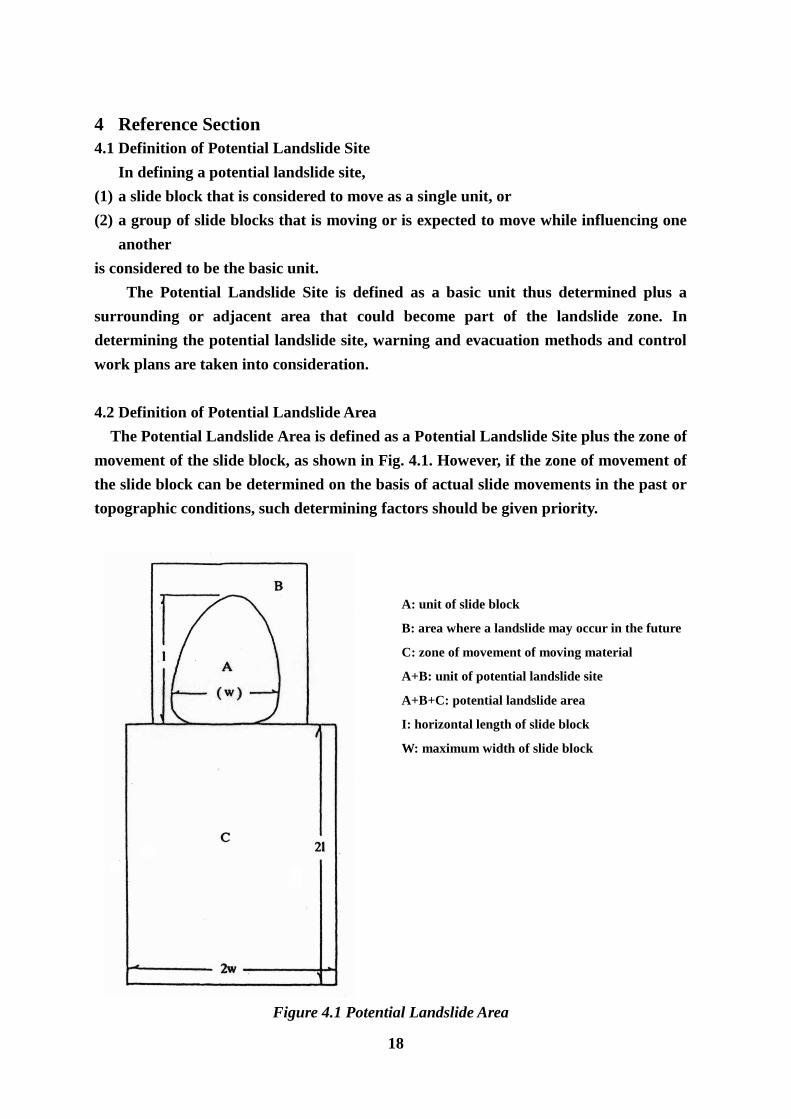
4.2 Definition of Potential Landslide Area
The Potential Landslide Area is defined as a Potential Landslide Site plus the zone of
movement of the slide block, as shown in Fig. 4.1. However, if the zone of movement of
the slide block can be determined on the basis of actual slide movements in the past or
topographic conditions, such determining factors should be given priority.
A: unit of slide block
B: area where a landslide may occur in the future
C: zone of movement of moving material
A+B: unit of potential landslide site
A+B+C: potential landslide area
I: horizontal length of slide block
W: maximum width of slide block
Figure 4.1 Potential Landslide Area

19
Plan View X – X’ section
In cases where there is a ridge on the opposite bank, the zone of movement is estimated considering
such a topographic condition to be a governing factor.
Figure 4.2 Example of the Zone of Movement of Moving Material Restricted by Topographical
Condition (symbols: same as those in Fig. 4.1).
4.3 Definition of Potential Landslide Damage Area
The Potential Landslide Damage Area is defined if a potential or actual landslide is
considered to occur under the influence of a torrent. The Potential Landslide Damage
Area is defined as a Potential Landslide Area plus areas likely to be affected by a
blockage of the river (torrent) by moving material. A Potential Landslide Damage Area
is determined as shown in Fig. 4.3:
(1) In cases where moving material blocks the river channel, the depth of displaced
material on the river bed is calculated as the maximum depth (hmax) of the slip
surface of the probable landslide. For landslide sites that have not been fully
investigated, the value of hmax is calculated as 1/7 of the width of the expected slide
block (fractions to be discarded). If there is a flatland on the opposite bank, the
maximum difference in height, h1, between the river bed and the opposite bank is
used in place of hmax.
(2) The upstream inundation area (D) in cases where moving material has blocked
material determined in (1) above.
(3) In cases where moving material has blocked the river channel, if the river is a
torrent prone to debris flow, the downstream inundation area (E) is usually the
same as the debris flow hazard area.
(4) If the river is not a torrent prone to debris flow, the downstream inundation area
(E) is usually defined as the portion of the river bed with gradients of 3O or below
plus the flat area (fan or valley bottom plain) with relative heights from the river
bed of up to several meters.
(5) If the river is not a torrent prone to debris flow and if the gradient of the river bed

20
under the deposited material is 3O or less, the downstream inundation area is
determined according to the condition of the downstream area.
Plan View
A: unit of slide block B: area where a landslide may occur in the future
C: zone of movement of moving material D: inundated area not included in potential landslide area
E: inundated area downstream from C
A + B + C: potential landslide area A + B: unit of potential landslide site
A + B + C + D: potential landslide damage area
X – X’ section X – X’ section
If the opposite bank is hillside If the opposite bank is flat land
Y – Y’ section
Figure 4.3 Potential Landslide Damage Area

21
4.4 Distribution of Landslide Sites
It is important to note that landslides often occur in areas where the conditions listed
below are satisfied.
4.4.1 Type of Rock (Bedrock)
1) Neogene mudstone or tuff
2) Crystalline schist or slate (green schist, lutaceous schist, black schist)along fracture
zones
3) Greenstone
4) Serpentinite
5) Areas that have volcanic alteration rock, such as solfataric soil.
4.4.2 Geological Structure
1) Areas adjacent to faults with fracture zones (Fig. 4.4); areas along tectonic lines
2) Areas on slopes consisting of strata that are parallel or nearly parallel to the slopes
(Fig. 4.4)
3) Areas near an axis of anticline or syncline in folds of Tertiary sandstone, mudstone,
etc. (Fig. 4.5)
4) Areas near the boundary of intrusive igneous rock (Fig. 4.6)
5) Areas where there are hard cap rocks (basalt, andesite, pyroclastic material, etc.)
covering soft ground (Fig. 4.7)

22
Figure 4.4 Monocline Structure (back-slope), Figure 4.5 Model of Bedrock Slide and Colluvial
Model of Bedrock Slide Caused by Fault Deposit Slide (along the lower face of
colluvial deposits) Caused by Fold
(anticlinal structure)
Ss: sandstone Dt: colluvial deposit
Tf: tuff Tf: tuff
Md: Mudstone Ss: sandstone
Md: mudstone
Fault and shattered portion Slip surface along the lower face of
colluvial deposits
Bed rock slip surface along the upper face Bedrock slip surface along the upper
of tuff caused by a shattered zone face of mudstone
Figure 4.6 Model of colluvial Deposit Slide caused by Figure 4.7 Model of colluvial Deposit Slip
Andesite intrusion caused by Laccolith Cap Rocks
Dt: colluvial deposit Dt: colluvial deposit
An: andesite Ba: basalt
Md: mudstone Sz: shattered zone
Ss: sandstone Ss: sandstone Md: mudstone
Shattered/altered zone caused by shattering Slip surface along the upper face
of bedrock involved in andesite intrusion of colluvial deposits
Slip surface along the lower face of
colluvial deposits.
(Fujiwara et al., 1979)

23
4.4.3 Topography
1) Areas classified as V-shaped valleys, where planation surface is eroded downward
2) Areas where there are thick layers of deposits produced by collapse; buried valleys
(Fig. 4.8)
3) Areas where there is a small depression on a hillside and there is a bulge below the
depression; where a river system bypasses a block; or where a river system
terminates (Fig. 4.9)
4) Areas where there is a water-hammered slope of rock of the type that is prone to
landslides; or area on both sides of a water-hammered slope of hard rock (Fig. 4.10)
5) Areas where a bend in a river has an unusual bulge that is being eroded (Fig. 4.10).
Figure 4.8
Ⅰ: topography before the formation of a buried valley, Ⅱ: present topography, Ⅲ: part of expected
topography in future, Pd: protruding deposits (in this case, colluvial deposits composed of pyroclastic
material, andesite tuff breccia Strata, etc.) Sd: the portion that is so-called “landslide topography”
composed of Pd, Fv: original valley aggraded by Pd, Dv: present river tunning along the periphery of Pd,
Sv: a kind of subsequent valley that develops on bedrock ms and an alternation bed of ms and ss, ms:
mudstone, ss: sandstone stratum, tb: pyroclastic basement material that was deposited at the same time
as ms and ss and that interfingers with ms and ss, L: landslide area
(Saburo Nakamura, 1977)

24
(a) When there is a depression impounding water
(b) When a waterway bypasses a certain block
Figure 4.9 Landslide-Prone Areas Recognizable Figure 4.10 Topographically Unusual
from the condition of water System (Unstable) Slope
and Topography (Takeda et al., 1976)
4.5 Characteristic of Landslide topography
It is important to note that landslide topography has the following characteristics.
1) Contour lines have irregular shapes. Areas where contour lined are dense in the
upper section, sparse in the middle section, and dense again in the lower section
(Figs. 4.11 to 4.15).
2) There is an inverted U-shaped or rectangular scarp at the head of a slope, and the
midsection forms a flat, gentle slope (Fig. 4.15); there is an isolated small hill (Fig.
4.16).
3) There is a concavity, depression, crack, etc. or there is a long, narrow depression in
a mountain or at the top of a mountain.
4) There are regularly arranged ponds, swamp or marshes.
5) There is a marshy zone or a crack on one or both sides of a slide block (Figs.
4.17(A), (B)).
6) A ridge behind a landslide area has a depression (Fig. 4.18).
7) There are terraced paddy fields.
8) The foot of a slope is steep and there is an upheaval or bulge there.
9) A railway or road is unusually curved, or a structure is displaced.
10) A swamp or river is unusual curved; a river is narrower than in other areas.
(a)
(b)
(a)
(b)

25
Figure 4.11 Convex Ridge Figure 4.12 Convex Plateau Figure 4.13 Concave Single Hill
Type Topography Type Topography Type Topography
Figure 4.14 Concave Multiple Hill Type Figure 4.15 Typical Figure of Landslide
Topography (Concave Single Hill Type)
(Watari et al., 1971)
(a) Scarp
(b) Secondary scarp
(c) Tongue (d) crown
(e) Top (f) Head
(g) Slip surface
(h) Foot (i) Tip
(j) Tip of tongue
(k) Tensile crack
(l) Compressive crack
(m) Uplift
(n) Compressive crack
(o) Flank (Side)
Figure 4.16 Landslide slope
(David J. Varns, 1958)

26
Figure 4.17 (A) Change in Side Crack
Closed Crack Opened Crack
Figure 4.17 (B) Side Crack
(Watari et al., 1975)
Figure 4.18 Shape of Ridge behind Landslide Area
(Yamada et al, 1971)
27
4.6 Field Investigation
Field investigation should be conducted to determine if there is any sign of the
following phenomena because they are characteristics of landslide-prone areas.
1) Cracks or other abnormality of roads, stone walls, stone stairways, waterways;
inclination of trees, utility poles, or buildings
2) Repaired waterways, leakage from waterways, wells running dry, turbidity of water,
spring water, marches
3) Upheavals at the foot of a slope, mudflow
4) Cracks in hillsides, slope failure, scarps
5) Soft rocks, fractured rocks, solfataric alteration rocks, expansible rocks, faults
4.7 Directions for Filling in Landslide Potential Rating Score Sheet
4.7.1 Signs of Slide Movement
Signs of landslide movement are rated on three-grade scale, as shown in the rating
score sheet. If more than one grade applies, take the higher one.
4.7.2 Landslide Topography
Characteristics of landslide topography have been described in Section 4.5. In filling
in the rating score sheet, consider the degree of clarity of those characteristics.
4.7.3 Geology
1) Geological Structure
To evaluate factors affecting the occurrence of landslides, indicate whether the
following signs are shown. You may choose more than one item here.
(1) Faults/fracture zones
Typical relative positions of fault or fracture zones and the slip surface are
illustrated in Fig. 4.4. Fault or fracture zones here do not mean “fracture zone
landslide” sites according to the established geological classification, but it means fault
or fracture zones and the occurrence of landslides is as follows:
(a) Part of a fault surface may constitute a slip surface or form a scarp to border a
landslide zone (F9g. 4.4).
(b) A fault surface or fracture zone may become a route of groundwater flow. Fault
clay may cut off groundwater flow so that the rerouted groundwater governs
the waterway and causes a landslide.
(c) Fault or fracture zones are prone collapse.

28
(2) Volcanic alteration zones and solfataric soil
In volcanic areas hot spring water deep underground causes chemical reaction of
surrounding rock. Such alteration of rock is called volcanic alteration. Rock subjected
to this process turns into solfataric soil, increasing the likelihood of landslide
occurrence.
(3) Strata prallel or nearly parallel to the slope
Slope consisting of strata parallel or nearly parallel to the slopes are subject to
landslides, particularly, tock slide type and fluidized landslides (Figs 4.4 and 4.5)
(4) Strata perpendicular or nearly perpendicular to the slope
Slope consisting of strata perpendicular or nearly perpendicular to the slopes are
subject to small or medium-scale failure-type landslides.
(5) Block structure
The geological structure as described below is referred to as “block structure”.
(a) Intrusive rock structure
Colluvial soil zones near intrusive rock, such as volcanic rock, are subject to
landslides (Fig. 4.6).
(b) Cap rock structure
In areas that have cap rock structure where hard rock lie on weak formation,
hard rock on the mountain top is highly weather-resistant and hence the likelihood
of landslides or collapse is low. On the other hand, the underlying weak formation
is less weather-resistant and is subject to landslides or collapse (Fig. 4.7).
2) Age and Lithology
Identify the age and lithology according to the classification given below, referring to
geologic maps and other data on the area under consideration.
(1) Paleozoic/Mesozoic formation (crystalline schist, sedimentary rock):
Crystalline schist such as Minami River crystalline schist, Sangun metamorphic
rock; Paleozoic/Mesozoic slate, shale, tuff, sandstone,
(2) Tertiary formation (sedimentary rock): Tertiary (Cainozoic) shale, mudstone, tuff,
sandstone, etc.
(3) Greenstone/serpentinite area: Area consisting of greenstone, such as Mikabu

29
greenstone, and serpentinite
(4) Quarternary formation (sedimentary rock): Quarternary (Cainozoic) mudstone,
tuff, sandstone, etc.
(5) Others (volcanic rock, igneous rock, etc.): rhyolite, andesite, basalt, granite, diorite,
etc.
3) Spring under Normal Condition
Groundwater is a major factor affecting the occurrence of landslides. Groundwater
comes in as inflow or infiltration from slopes above landslide sites or landslide slopes.
The inflow or infiltration often comes out as spring water at or around the lower end of
the slip surface, particularly around the lower end of either flank lf the slide block.
4.7.4 Landslide History
The objective of this survey is to trace the history of a particular landslide area. In
this survey landslide records and reliable legends are collected wherever possible.
Recommended