Special Report 82-31 December 1982
US Army Corps of Engineers Cold Regions Research & Engineering Laboratory
Reservoir bank erosion caused and influenced by ice cover
Lawrence W. Gatto
Prepared for
OFFICE OF THE CHIEF OF ENGINEERS Approved for public release; distribution unlimited

Special Report 82-31 December 1982.
US Army Corps of Engineers Cold Regions Research & Engineering Laboratory
Reservoir bank erosion caused and influenced by ice cover
Lawrence W. Gatto
[]:{]&OO~&c§OO&®©@ Susitna Joint Venture Document Number
Please Return To DOCUMENT CONTROL
Prepared for
OFFICE OF THE CHIEF OF ENGINEERS Approved for public release: distribution unlimited

For conversion of Sf metric units to U.S./British customary units of measurements consult ASTM Standard E380, Metric Practice Guide, published by the American Society for Testing and Materials, 1916 Race St., Philidelphia, Pa. 19103.

[
c r L
c c c c n
L
c r ~
c p L
[
c p L
u c ·c~ . _:.
f' 1~
Unclassified SECURITY CLASSIFICATION OF THIS PAGE (When Data Entarad)
REPORT DOCUMENTATION PAGE READ INSTRUCTIONS BEFORE COMPLETING FORM
I. REPORT NUMBER 2. GOVT ACCESSION NO. 3. RECIPIENT'S CATALOG NUMBER
.Special Report 82-31
4. Tl TL E (and Subtitle) 5. TYPE OF REPORT 6 PERIOD COVERED
RESERVOIR BANK EROSION CAUSED AND INFLUENCED BY ICE COVER
6. PERFORMING ORG. REPORT NUMBER
7. AUTHOR(e) 8. CONTRACT OR GRANT NUMSER(a)
Lawrence W. Gatto
9. PERFORMING ORGANIZATION NAME AND ADDRESS 10. PROGRAM ELEMENT, PROJECT, TASK
Army Cold Regions Research and AREA & WORK UNIT NUMBERS U.So Engineering Laboratory CWIS 31568 Hanover, New Hampshire 03755 II. CONTROLLING OFFICE NAME AND ADDRESS 12. REPORT DATE
Office of the Chief of Engineers December 1982 Washington, D.C. 20314 13. NUMBER OF PAGES
30 14. MONITORING AGENCY NAME & ADDRESS(ll dlllerant from Controlllnf Olllce) IS. SECURITY CLASS. (ol thla report)
Unclassified -~
ISa. DECLASSIFICATION/DOWNGRADING SCHEDUL.E
16. DISTRIBUTION STATEMENT (of thla Report)
Approved for public release; distribution unlimited. I 17. DISTRIBUTION STATEMENT (ol the abatract entered In Block 20, II dlllarent from Report)
18. SUPPLEMENTARY NOTES
19. KEY WORDS (Continua on reverae aide II naceaaaty and Identity by block number)
Banks (Reservoirs) Erosion Ice Reservoirs
20. ABSTRAC::"r (Caati:aue .. ,......,... aifl» II .._...._,. ..t. ldenJI{T by block nwnbar}
The purpose of this study was to evaluate the importance of reservoir h~nk erosion caused by an ice cover. The evaluation is based on a lite~ature :review · and on inferences made from field observations and experience. Very little is known about the amount of reservoir bank erosion caused by the actions of an ice cover, although considerable information is available on the processes of ice-related erosion along the shorelines or beaches of oceans, rivers or lakeso The importance of ice-related erosion along a reservoir bank seems to be deter-mined primarily by water level. If the reservoir water level is high enough
--
DD FOAII I JAil 73 Unclassified 1473 EDfnON OF J NOV fiS IS OBSOLETE
SECURITY CL.A.SSJFICATION OF THIS PAGE (lnten Data Entered)

[
c [
c c E c f'l
L
c r c E c c p L
[
c [
[
Unclassified SECURITY CL-ASSIFICATION OF THIS PAGE(WJI- Data Entered)
20. Abstract(cont'd)
for ice to act directly on the bank face, the amount o~ erosion caused by ice could be substantial. If the water level is below the bank, ice would have no direct effect on it. However, ice could indirectly increase bank instability by disrupting and eroding nearshore and beach zones, which could lead to bank erosion.
....
ii t'n::: las . ..; { f lL'd SII!:CUIUTY CI.AUI,ICATIO-. or TM!!> PAGE(lt?len Dete Entered)

[
[
[
[
[
c c n l
[
r [
E [
[
h u
[
c [
[
PREFACE
This report was prepared by Lawrence W. Gatto, Geologist, Earth
Sciences Branch, Research Division, u.s. Army Cold Regions Research and
Engineering Laboratory. The work was funded by the Office of the Chief of
Engineers under Civil Works Work Unit 31568, Erosion Potential of Inland
Shorelines and Embankments in Regions Subjected to Freezing and Thawinge
The author thanks James Wuebben, Ice Engineering Research Branch,
CRREL, and Bruce Brockett and Dr. Daniel Lawson, Earth Sciences Branch,
CRREL, for sharing their field observations. Most of the photographs in
this report are from their collections. Mr. Wuebben, Dr. Lawson, Dr. John
Reid of the University of North Dakota, and Dr. Tsong Wei of the U.S. Army
Corps of Engineers, Missouri River Division, technically reviewed the
manuscript.
iii
....

[
[
[
[
c E [ r, l
[
c c B [·
[
JJ L
c L [
[
CONTENTS Page
Abstract-------------------------------------------------- i Preface--------------------------------------------------- iii Introduction--------------------------------------------- 1 Ice as bank protection------------------------------------ 2 Ice-cover erosion processes------------------------------- 5
Direct erpsion---------------------------------------- 5 Indirect erosion------------------------------------- 7 Ice rafting------------------------------------------- 8 Factors influencing ice erosion----------------------- 11
Erosion features caused by ice covers--------------------- 13 Ice-push features------------------------------------- 16 Ice-scour features----------------------------------- 19
Summary and conclusions---------------------------------- 19 Literature cited------------------------------------------ 20
ILLUSTRATIONS
Figure 1. Narrow zone of shorefast ice------------------------ 2 2. Attached ice shelf---------------------------------- 3 3. Protective shorefast ice along Wilder Lake, Norwich,
Vermont, 4 March 1981--------------------------- 4 4. Icefoot along Grand Traverse Bay, Michigan, spring
1975-------------------------------------------- 4 5. Erosion during spring breakup----------------------- 6 6. Reservoir ice cover laid down onto the exposed res-
ervoir bottom below the banks------------------- 7 7. Mobile ice------------------------------------------ 8 8. Bank sediment deposited on shorefast ice------------ 9 9. Sediment frozen to the bottom of ice laid down onto
the reservoir bed----------------------------- 10 10. Dirty ice after shoving and grinding along the shore- 10 11. Wind-driven ice------------------------------------- 14 12. Ice pile-up on Belle Isle, Detroit River, Michigan,
during an ice run----------~-----~-------------- 15 13. Bank damage due to ice ride-up---------------------- 15 14. Trees broken by ice being let down as the reservoir
water level dropped after a winter flood-------- 16 15. Ice-push ridge formed at the end of November 1979
during a storm with 45-mph northwesterly winds-- 17 16. Ice and shore sediment uplifted where an ice pres-
sure ridge intersects the shoreline------------- 18
iv
...

[
[
r LJ
c c [
[ r' L
[
[
[]
E [
[
JJ u
c [
[
L
INTRODUCTION
RESERVOIR BANK EROSION CAUSED AND
INFLUENCED BY ICE COVERS
by
Lawrence W. Gatto
This report was prepared as part of an investigation of reservoir bank
erosion processes and impacts in cold regions. The specific objectives of
the investigation are 1) to measure and analyze the causes of and factors
contributing to bank erosion, 2) to determine the relative magnitudes of
the causes and factors, and 3) to assess the environmental impacts result
ing from the erosion. This report was done as part of the first two
objectives. The data acquired and the process-response relationships
analyzed during this investigation will aid in developing improved methods
for predicting the erosion potential of a slope, the rate and areal extent
of that erosion, and the time required for a slope to reach a noneroding
dynamic equilibrium.
--
Simons et al. (1978, 1979) and Pincus (1962) described some of the
causes of and factors contributing to bank erosion and recession, and
Seibel (1972) and Sterrett (1980) describe the complexity of their inter
relationships. This report, however, focuses on bank erosion caused just
by reservoir ice. It is based on a literature review and on field observa
tions made by colleagues or myself.
The literature review showed that the causes and impacts of erosion
have been identified; however, the magnitude of erosion caused by a given
process is only superficially known if at all. In fact, Ouellet and Baird
(1978) feel that it may be impossible to quantify the amount of erosion
that any one process contributes to total bank erosion since there are many
contributing processes, all of which are interdependent.
I did not find any references that reported measurements of ice-caused
bank erosion. Most of the literature on ice-related erosion dealt with ice
erosion processes along oceans or rivers and did not address ice erosion of
reservoir banks. Since the processes that cause ice erosion along oceans,
rivers or lakes can be similar, I reviewed references that dealt with all
/

three environments and used field observations to infer how ice—erosion
processes may act along a reservoir bank.
By necessity the review was limited to papers in the open literature.
Theses, dissertations and consultant reports not referenced in data bases
or in the open literature could not be obtained and reviewed. In addition,
foreign language papers were not reviewed.
ICE AS BANK PROTECTION
Before describing some of the ways an ice cover can erode reservoir
banks, it is important to mention that ice can also protect the bank from
erosion by waves and nearshore currents. Erosion caused by ice action is
frequently reduced by a nearshore ice barrier (Outhet 1974). Avakyn (1975)
reported that reservoir shore changes usually occur when the reservoir is
ice—free. When ice covers a river, lake or reservoir from shore to shore,
it dampens waves and protects the banks from normal wave erosion processes
(MacCarthy 1953, Varjo 1960, Brochu 1961, Coakley and Rust 1968, McCann
1972, Cohn 1975, John and Sugden 1975, Hadley 1976, Ouellet and Baird
1978). Erosion restarts at breakup when the ice becomes mobile; the ice
scrapes, shoves and scours the shore or bank, and transports sediment away.
Figure 1. Narrow zone of shorefast ice (5 December 1980,Wilder Lake, south of Hanover, New Hampshire).
2

The ice cover usually begins to form along the shoreline of a reser
voir. It can be attached to the sediment at the shoreline arid continue to
grow offshore (Fig. 1). After the ice completely covers the reservoir and
the water level drops during the winter, a shelf of ice can remain attached
to the shore as the ice farther offshore cracks and collapses (Fig. 2).
a
-
v
c4B
A
a. The shelf (A) is below the bank toe (B) and is separated from and higher than the ice cover (C), which isbeing lowered as the water level drops.
b. A crack has formed between the ice shelf (A) and thelowered ice cover (B); the glove (C) is for scale.
Figure 2. Attached ice shelf (30 January 1980, Orwell Res—ervoir, Minnesota).
A
B
3

Figure 3. Protective shorefast iceNorwich, Vermont, 4 March 1981.
II
along Wilder Lake,
Figure 4. Ice foot along Grand Traverse Bay, Michigan,spring 1975. Note the sediment deposited within the iceand on the ice—foot surface by waves overtopping the icefoot.
4

[
[.
r 6
c c [
[ n l
[
r c E c c p u
c [
_[
_[
This shelf can remain intact through the winter and protect the shoreline
from direct erosion by mobile ice farther out in the reservoir (Fig. 3).
The ice foot (Fig. 4) that often forms along portions of the Great
Lakes also stops shore erosion in the winter (O'Hara and Ayers 1972).
Descriptions of an ice foot as a protective structure along lakes are
common in the literature (Zumberge and Wilson 1954, Dionne 1974b, Dozier et
al. 1976, Evenson and Cohn 1979). An ice foot can also erode a shoreline
by freezing to the shoreline material during the winter (Nielsen 1979). In
the spring the ice foot can fall from the shore, removi~g attached sediment
and bedrock (Hamelin 1972). The ice and attached material then float away
and the sediment is deposited in the lake as the ice melts.
I have not observed nor found documentation of an ice foot forming
along reservoirs. It may be that small ice-foot features form but do not
reach the size of those reported along the Great Lakes. Judging from the
time required for an ice foot to form as described by O'Hara and Ayers
(1972), I suspect that most reservoirs do not remain ice-free long enough ...
into the winter for winter storms to cause the repeated wave spray
necessary for large-scale ice-foot-formation. Lawson 1 suggested that an
ice foot may form in the large reservoirs of the western U.S.
ICE-COVER EROSION PROCESSES
Direct erosion
Ice can erode reservoir banks when the reservoir water level is high
enough for the ice to directly loosen and remove soil particles by pushing
or grinding along the face or toe of a bank (Van Everdingen 1967, Jahn
1975). This some~imes happens along rivers, especially during spring
breakup (Fig. 5). Typically during a river ice run, mobile ice will slide
along shorefast ice at a shear wall (Outhet 1974). Occasionally ice will
slide directly against the bank and erode the soil (Martinson 1980). This
erosion can be significant enough to cause local bank failures (Dionne
1974b), although Eardley (1938) reported that the amount of bank erosion by
ice along the Yukon River appears to be inconsequential. These ice actions
can also disrupt the bank soil structure sufficiently to reduce soil
strength, so that the banks are more easily eroded by other processes.
1Personal communication, CRREL, 1982.
5
( / ~-

Rose (1946) described a predictive analysis of ice pressures based on
temperature and ice thickness. He reported maximum probable ice thrusts of
75,000—300,000 N/rn of shoreline in the continental United States arid about
440,000 N/rn in colder areas. He also pointed out that lowering a water
level reduces the ice pressure against the shoreline because the lowering
would likely cause the ice to bend and crack, rupturing the continuity of
the ice sheet. This reduces the ice thrust at the waterline, except when
water fills the cracks in the ice, freezes and expands the ice cover; if
the ice cover was complete, this expansion would then increase the thrust
at the edge of the ice cover.
Field observations show that water levels in many reservoirs are
lowered below the toes of the reservoirs’ banks during the winter, and the
ice is laid down onto the reservoir bottom. The ice is then ineffective in
causing erosion (Fig. 6). The water level normally rises in the spring,
and if the ice persists, it can be lifted and again moved by winds. The
ice may erode bottom or beach sediment during this time. If the level is
raised high enough, the mobile ice may strike the bank directly.
Reservoirs with complete covers of ice during winter are modified by
Figure 5. Erosion during spring breakup. The waterlevel is high enough for mobile ice to grind and shoveagainst the beach (A) and the bank (B) directly (spring1979, southwest of Mirre Point, St. Marys River, Michigan).
6

Figure 6. Reservoir ice cover (A) laid down onto theexposed reservoir bottom below the banks (B).
ice mainly during spring breakup. Typically, as spring progresses and
temperatures rise, the ice initially melts along the shore, leaving a
partial ice cover that moves with the wind. Also, the water levels of
reservoirs, especially flood—control reservoirs, usually rise in the
spring. The more mobile ice can then grind and shove along the banks.
These ice actions may not be as strong along reservoirs as along rivers,
however, since river currents are usually more rapid than wind— or
thermally induced currents along reservoirs.
Wuebben2 pointed out, however, that river currents are not always
faster than reservoir ice moved by wind shear. Also, wind—driven ice can
be pushed perpendicularly into a reservoir shore or bank; this more normal
force may cause more erosion than the river ice, which usually moves more
nearly parallel to the shoreline.
Indirect erosion
If the water level of an ice—covered reservoir is not high enough for
the ice to act directly on a bank, the ice may contribute to bank erosion
indirectly. While the ice cover is mobile, it can push, shove and remove
beach and nearshore sediment (Fig. 7). This can contribute to undermining
of the bank, which increases bank instability; the bank may eventually
2Personal communication, CRREL, 1982.
A — *
7

B
Figure 7. Mobile icc (A) can grindand shove the reservoir bottom (B)as the water level rises to ahigher level at the base of thereservoir banks (C) (February1974, Lake Koocanusa, Montana).
collapse and the bankline recede. Ice can also remove sediment that has
eroded from a bank and accumulated along the bank toe. By removing this
accumulation, water waves and currents can erode the bank toe directly.
Ice rafting
Ice rafting can also remove bank or beach sediment that becomes
attached to or incorporated into the ice cover. Dionne (1974b) observed
clay— to boulder—size sediment at the base, on the surface and within the
ice cover on the St. Lawrence River. At spring breakup the sediment is
transported and redeposited. Intertidal sediments are also frequently
raf ted in Labrador fjords (Rosen 1979).
Reimnitz and Bruder (1972) reported that only an insignificant amount
of sediment is rafted away from arctic Alaska’s deltas during sea ice
breakup. Much of the shorefast ice melts in place, and most of the
incorporated sediment is dropped before final breakup. Rafting of large
quantities of beach material attached to the bottom of an ice foot occurs,
however, in the Antarctic (Joyce 1950).
The importance of ice rafting in lakes or reservoirs is poorly docu
mented. I found no references that described the processes of ice rafting
or that reported measurements of the quantities of sediment that are
ice—rafted in lakes or reservoirs. Field observations show, however, that
sediment fallen from reservoir banks is frequently deposited on the surface
of shorefast ice (Fig. 8), especially in the spring as the banks thaw.
-.. -
8

b. Bank sediment (A) sliding (B) or flowing (C) ontosnow—covered nearshore ice (D) (4 March 1981).
Figure 8. Bank sediment deposited on shorefast ice, Wilder Lake, Norwich, Vermont.
ra. Bank sediment (A) sloughing (B) onto nearshore ice(C) (15 December 1981).
D
9
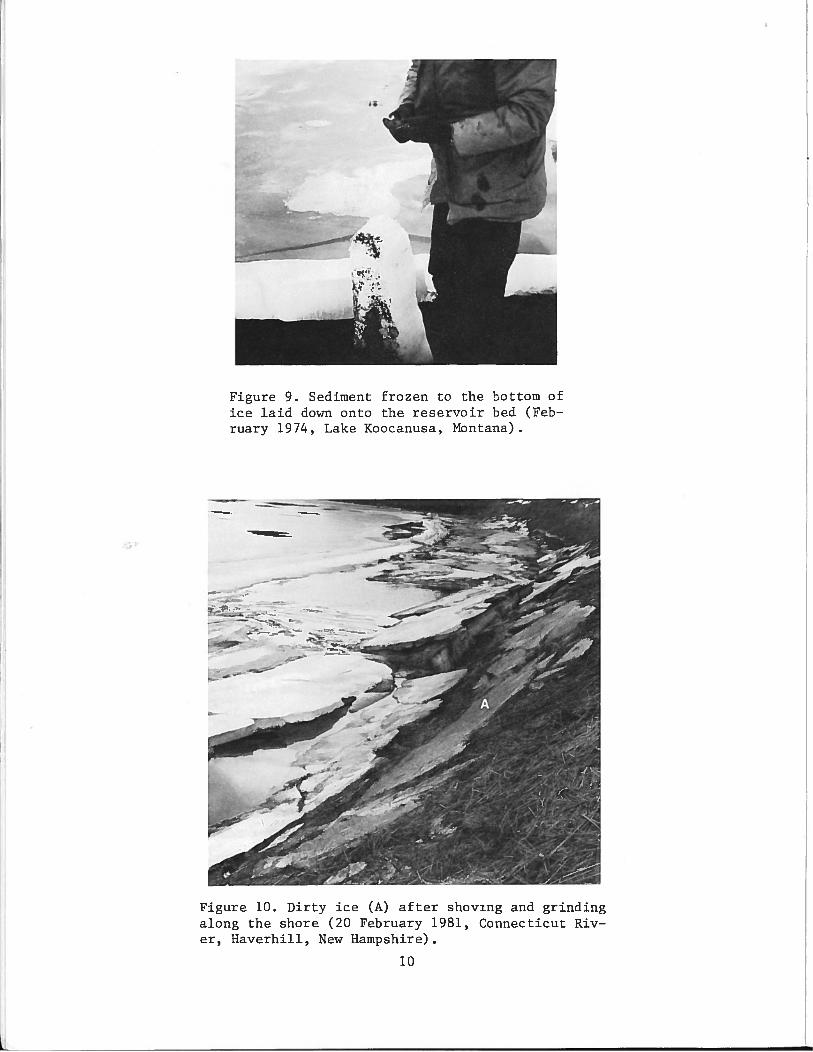
Figure 9. Sediment frozen to the bottom ofice laid down onto the reservoir bed (February 1974, Lake Koocanusa, Montana)
—
Figure 10. Dirty ice (A) after shoving and grindingalong the shore (20 February 1981, Connecticut River, Haverhill, New Hampshire).
10

[
[
r L
[
[
E [ r L
[
[
c [ I'
1 .._.
C. ~; L
c c [ . [
When ice is attached to the shore or bank or laid down onto the reservoir
bottom, sediment can also freeze to the ice (Fig. 9). On many lakes,
though, the shorefast ice melts in place and drops its sediment without
transport. It seems reasonable to assume that some sediment would be
removed if the shorefast ice becomes mobile.
When ice grinds and shoves along the shoreline and banks of rivers, it
can accumulate sediment on its surface. The sediment becomes frozen in and
on the ice (Fig. 10) and can be transported away. Bank or beach sediment
can be removed from along a reservoir in a similar fashion, but the water
level would have to be high enough for the ice to act directly on the
beaches or banks.
Factors influencing ice erosion
The amount of bank erosion caused by ice processes depends on the
interplay of many factors: water levels and their fluctuations; ice
strength and characteristics; mobility of the ice cover; degree of ice at-.
tachment to the beach, nearshore or bank sediments; the extent to which the
bank, beach and nearshore sediments are frozen; and shore configuration.
The importance of water levels, ice attachment to sediment, and mobility of
the ice has been discussed briefly. ·Additional information on the
strength, properties, mobility and duration of and pressures exerted by an
ice cover is available in the proceedings of the following conferences:
Conference on Ice Pressures Against Structures, Laval University, Quebec,
Canada, 1966; The Role of Snow and Ice in Hydrology, Banff, British Colum
bia, Canada, 1972; International Conferences on Port and Ocean Engineering
under Arctic Conditions; Symposium on Applied Glaciology, Cambridge, En
gland, 1976; International Association of Hydrologic Research International
Symposia on Ice Problems; and Third National Hydrotechnical Conference,
Canadian Society for Civil Engineering, Quebec, Canada, 1977.
The following individual reports also address ice formation, ice
structure, ice properties, ice-cover characteristics and duration, and ice
effects: Korzhavin 1962, Weeks and Assur 1969, Michel 1971, 1978, Donchen
ko 1972, Marshall 1977, Ashton 1979 and Haugen et al. 1979. Ficke and
Ficke (1977) summarized the literature on ice formation, characteristics
and effects on navigation, currents, shoreline structures and water quali
ty. Drouin and Michel (1974) reviewed the literature from 1922 to 1968 and
described the thermal properties of ice and ice-cover expansion or contrac
tion •
11

[
[
r L
r u
c E c n u
c c c [
c [
c u
c [
I~ ·r· ~ .:__j
Several papers address the pressures ex~rted by. ~n ice cover on
shores, dams and other structures and discuss the factors that affect the
magnitude of the pressures (Rose 1946, Monfore 1952, Zumberge and Wilson
1952, 1993, Montagne 1963, Sommerville and Burns 1968, Pessl 1969, Bergdahl
and Wernerson 1978). Some of these factors are air temperature, solar
energy absorption, ice temperature, rate of temperature change in the ice,
coefficient of thermal expansion, rheology of ice, ice thickness, amount of
water-filled cracks, and shore restrictions.
If the shoreline or bank sediment is frozen, ice effects can be mini
mal (Harper et al. 1978). Freezing along Monomoy Island, Massachusetts,
creates a stabilized beach of rocklike coarse sand, which slows or stops
normal beach processes (Davis 1973, Davis et al. 1976). Along the Great
Lakes shores, after the beach sands freeze and an ice foot forms, the beach
typically remai~s static for about 10 weeks. There are some ice-push
features that form, but for the most part, normal shore processes slow or
stop (Davis et al. 1976).
Owens and McCann (1970) concluded that offshore, nearshore and beach
ice limit wave action on the beach and bank, but do form ice-push and
ice-melt features along the shore. However, when the beach and nearshore
zone are frozen, the sediment there is stable and unaffected by either ice
push or storm waves.
....
The configuration of the shoreline also influences the amount of bank
erosion that could result from actions of a mobile ice cover. Along a
reach of reservoir with a straight shoreline, ice erosion of the shoreline
or bank could be more evenly distributed, with no one location being eroded
more than any other. Along a reach with an irregular shoreline, however,
ice would be more likely to erode the banks on the promontories than along
the bayse
Along reservoir shorelines with gentle offshore slopes it is more
likely that ice could become attached to or gouge offshore bottom sediment
and never reach or erode the shorelines or banks. As the water level drops
in these areas, ice becomes grounded sooner than in areas with steep
offshore slopes and less ice pressure is directed to shorelines or banks.
Along shorelines with steep offshore slopes, ice can advance to the shore
line or banks and erode them directly.
12

[
[
c [
c p u
[ fl
L
c n [
E c c 1J \.;:i
c c _[ [
EROSION FEATURES CAUSED BY ICE COVERS
There are several reviews of how ice erodes and reshapes nearshore
zones and shorelines (Bryan and Marcus 1972, Code 1973, Mackay and Mackay
1977). The ice creates a variety of erosion features: linear and cellular
scars, basins, ice-pushed and ice-deposited ridges or mounds (ice ram
parts), ice-contact cusps, and ice-rafted sediments including boulders,
pebbles and ice-cemented blocks (Dionne and Laverdiere 1972, Lawson 1972,
Short and Wiseman 1973, Dionne 1974b, 1981, Brochwicz-Lewinski and Rudowski
1976, Kovacs and Sodhi 1979). However, I did not find any references that
describe features left by ice erosion on reservoir banks.
It may be that the water level of most reservoirs is low enough when
there is ice that the ice seldom erodes the bank directly. This is
probably true for most flood-control reservoirs. Ice could be driven up a
reservoir bank, but this would require a large fetch and sustained winds.
Also, if the water level was low, it is unlikely that winds would be strong
enough to drive the ice cover over the shore up to the banks. Some of the
factors that limit the amount of shoreline rideup are water current drag,
friction, jamming, ice pileup on the beach slope, steep beach slopes, ice
flexural strength and thickness, and high freeboard (Croasdale et al.
1978). Tsang (1975) reported that a shore lead and gently sloping shores
allow more ice rideup.
Field observations along Whitefish Bay in Lake Superior show that ice
can be driven by winds up to and over banks that are as high as 25-30 ft
(Fig. 11). Ice driven by currents can also ride up and directly erode a
riverbank (F~g. 12). The erosion of the banks and the damage to bank
vegetation can be extensive (Fig. 13). Outhet (1974) also described how
ice can be pushed onto and over low·banks and small willow trees along the
Mackenzie River delta, Canada.
Reservoir bank erosion can occur when winter floods rapidly raise· the
water level of flood-control reservoirs. The ice cover on the reservoir is
lifted, broken up, and made mobile. It can then erode the banks directly
and damage bank vegetation (Fig. 14). This type of vegetation damage could
eventually lead to increased bank instability if the damage is severe
enough to kill the vegetation. The root systems which tend to bind the
upper sediment would decay, and the added stability would be lost.
As previously stated the disruption of the beach and nearshore zone by
ice can also lead to increased bank instability. The following sections
13
~

a
a. Ice over the bank (March 1979).
by the ice.
Figure 11.Michigan).
into May 1979. Note the sediment dislodged
Wind—driven ice (Whitefish Bay, Lake Superior,
ii;
- -
r
b. Ice remained
14

Figure 13. Bank damage due to ice ride—up (Whitefish Bay,
Michigan, Nay 1979.
-4$ - k
Figure 12. Ice pile—up on Belle Isle, Detroit River, Michigan, during an ice run (March 1978)
a. Tree damage.
_, C- -.
b. Upper bank damage.
15

address some of the erosion processes and features left by ice erosion
along the beach and nearshore. The most frequently reported features along
lakes are ice—push features.
Ice—push features
Dionne (1974a) summarized the literature on ice—push features, which
include ice ramparts, ice—push ridges (Fig. 15) and ice—thrust ridges.
Field observations of ice—push features cited in the literature are numer
ous; there is a debate on whether they result from ice expansion or from
wind—driven ice (Jones 1970, Montagne 1963). Since I am more concerned
with the extent rather than the causes of the shore disruption, I will only
summarize the debate.
Some investigators (Laskar and Strenzke 1941, Jennings 1958) feel that
ice push due to ice expansion dominates on lakes with diameters less than
3—4 km (Worsley 1975), small lakes about 5 km2 in area (Dionne 1979), and
narrow, shallow bays on large lakes (Pessl 1969). Wind—generated ice push
occurs more often on wide lakes (Dionne 1979, Varjo 1960) or large lakes
with fetches greater than 4 km (Worsley 1975). When winds are the cause of
the ice movement, moderate prevailing winds can push ice sufficiently to
Figure 14. Trees broken by ice being let down asthe reservoir water level dropped after a winterflood (December 1973, Franklin Falls Reservoir,Franklin, New Hampshire).
16

form a shoreline ridge (Bruun and Johanneson 1971, Bruun and Straumsnes
1970); strong winds are not necessary.
Taylor (1978) observed ice—push ridges and pit topography 185 m inland
across the beach of Somerset Island, Northwest Territories, Canada. Ice—
push ridges were observed along the South Arm of Yellowstone Park in
Wyoming (Montagne 1963), Wamplers Lake in southeastern Michigan (Zumberge
and Wilson 1952, 1953), Eleven Mile Canon Reservoir in central Colorado
(Monfore 1952), and Generator Lake on Baff in Island (Ward 1959). Along a
lake near Resolute Bay on Cornwallis Island, Northwest Territories, Canada,
the ridges were several feet high and usually had an asymmetrical cross
section (Nichols 1953). Backshore brush and trees have been damaged or
broken along Knob Lake in Labrador, Canada (Jones 1970) and along many
lakes in central Quebec and Labrador (Pyokari 1981).
Wagner (1970) observed that small ramparts formed along shores of
embayments with fine sediment and gentle slopes and that larger ramparts
formed along straight shores with intermediate—size sediment and moderate
slopes along Shelburne Bay, Lake Champlain, Vermont. He concluded that
ice—rampart formation was limited by a continuous snow cover, the develop
ment of pressure ridges in ice, short periods of partially open water, and
•1;r• 4 -
Figure 15. Ice—push ridge (about 90 cm high) formed at theend of November 1979 during a storm with 45—mph northwesterly winds; the ice was 10—12 cm thick (30 January 1980,Orwell Reservoir, Minnesota).
17

4;.
Figure 16. Ice (A) and shore sediment (B) uplifted (about60 cm) where an ice pressure ridge intersects the shoreline (30 January 1980, Orwell Reservoir, Minnesota).
ice weakened by breakup. The continuous snow cover insulates the ice from
air temperature fluctuations; consequently the ice temperature fluctuations
and resulting expansion and contraction are less. Field observations show
that when an ice cover is complete, the compressive forces that form pres
sure ridges in an ice cover can also cause shore sediment to be thrusted
where the pressure ridges intersect the shoreline (Fig. 16).
Worsley (1975) described the following ice—push features around
Grasvatn, Scandinavia, where ice thicknesses are normally 1.25 m: boulder
concentrations along the beach, boulder pavements, boulders and trails,
ramparts, planed subaqueous moraine ridges, and grooved or scraped surfaces
due to floe grounding. The average net shoreward movement of the ice cover
on Gardner Lake, Connecticut, was approximately 1 m in 30 days and produced
an ice—push beach ridge 1 m high (Pessi 1969). Ice—push ridges 0.6 m high
caused by ice expansion were reported along many German lakes (Goebeler
1972). Adams (1977) observed ice—push features and ice action along Astray
Lake, Labrador, Canada. He reported that the features are due to ice
expansion and wind; he found ice 6 m above the June water level and 1$ m
inland.
It is clear that ice disrupts and erodes lake shorelines. When winds
are strong enough or water levels are high enough, ice can erode lake or
A
‘IA
I
-
18

[
[
c [ n L
[
c r u
c r c c ·L
[
c h u
c [
[
[
reservoir banks and damage vegetation. How frequently this occurs and how
much bank erosion results are unanswered questions.
Ice-scour features
Ice-scour features are documented along marine and estuary coasts and
rivers, but I found no references for lakes or reservoirs. Ice along the
Beaufort Sea coast typically striates, planes and gouges the bottom and
beaches, leaving mounds and ridges (Hume and Schalk 1964, Barnes et al.
1977, FENOO 1975). Dionne (1969, 1974b) determined that most of the
erosion along the tidal flats in the St. Lawrence River estuary occurs in
the spring by ice gouging and ploughing. These processes form linear and
arcuate scars and basins; they scratch and polish soft rock, dislodge
previously broken rock fragments, and level weathered rock platforms. The
bed of the Tana River in Norway has also been gouged and flattened by ice
(Collinson 1971 ).
Many of these features could form along lake and reservoir shores in ~
the spring, especially where bottom slopes are gentle and the water is
shallow. As the water level rises, the ice breaks and floats. It can then
be pushed over shallow areas and modify the bottom configuration. If this
occurs near the toe of the bank, it may add to bank instability; if it
occurs far from the bank toe, the bank would probably be unaffected.
SUMMARY AND CONCLUSIONS
There is considerable information in the literature on the ice pro
cesses that erode and deposit sediment along lake shores as well as on the
features created by these processes. The general forces applied to a lake
or reservoir shoreline by an expanding or wind-driven ice cover have been
described and occasionally measured. The shoreline features fcrmed and the
changes resulting from ice actions along the waterline are documented.
However, the direct effects of an ice cover on bank erosion, the importance
of ice rafting, and the effects of an ice cover on the erodibility of bank
sediment by other processes have not been documented.
The importance of ice-related erosion along a reservoir bank is
determined by water level. If the reservoir water level is high enough for
ice to act directly on the bank face, the amount of ice erosion can be
substantial. If the water level is below the bank, ice may have no direct
effect on the bank but could indirectly cause increased bank instability by
disrupting the nearshore and beach zanes.
19

[
[ .,
c c 0 [ ~ [ n u
c r c E c c f1 u
c c c [
The relative importance of the factors and processes that con~~ibute
to bank erosion has not been determined. Simons et al. (1979) developed a
qualitative assessment using available data, a review of current theory,
personal experience, and sound professional judgment. Field studies
currently underway will provide measurements that can be used to evaluate
the relative importance of ice and other processes contributing to
reservoir bank erosion.
LITERATURE CITED
Adams, P. (1977) How spring ice breakup alters our shorelines. Canadian
Geographical Journal, 94(2):62-65.
Ashton, G.D. (1979) River ice. American Scientist, 67:38-45.
Avakyn, A.B. (1975) Problems of creating and operating reservoirs. Soviet
Hydrology: Selected Papers, 3:194-199.
Barnes, P., E. Reimnitz, G. Smith and J. Melchior (1977) Bathymetric and
shoreline changes in northwestern Prudhoe Bay, Alaska. U.S.
Geological Society Open-File Report 77-161, pp. 75-88.
....
Bergdahl, L. and L. Wernerson (1978) Probabilities of thermal ice pres
sures in five Swedish lakes •. Proceedings of the International
Association for Hydrologic Research Symposium on Ice Problems, Lulea,
Sweden, Part 1, pp. 349-361.
Brochu, M. (1961) Movement of boulders by ice along the St. Lawrence
River. Geographical Branch, Department of Mines and T~chnical
Surveys, Ottawa, Canada, Geographical Paper No. 30, 10 pp.
Brochwicz-Lewinski, W. and S. Rudowski (1976) The action of ice and frost
in the development of moderate climate Baltic beaches. Revue
Geographie Montreal, 30(1-2):155-160.
Bruun, P. and A. Straumsnes (1970) Piling up of ice on seashores and on
coastal structures. Proceedings of the First International
Association for Hydrologic Research Symposium on Ice Problems,
Reykjavik, Iceland, Paper 38, pp. 1-6.
Bruun, P. and P. Johanneson (1971) The interaction between ice and coastal
structures. Proceedings of the First International Conference on Port
and Ocean Engineering under Arctic Conditions, Trondheim, Norway, pp.
683-712.
20

[ --··
c c [
c c [ n L
c n c c c c 1 ~ h L;
[
[
[
[
Bryan, M.L. and M.G. Marcus (1972) Physical characteristics of nearshore
ice ridges~ Arctic, 25(3):182-192.
Coakley, J.P. and B.R. Rust (1968) Sedimentation in an arctic lake.
Journal of Sedimentary Petrology, 38(4):1290-1300.
Code, J.A. (1973) The stability of natural slopes in the Mackenzie Valley.
Task Force on Northern Oil Development, Environmental-Social Program,
Northern Pipelines, Information Canada, Report 73-9, 18 pp.
Cohn, B.P. (1975) Beach modification by ice, eastern shoreline of Lake
Ontario. Geological Society of America Abstracts with Programs,
7(1):40-41.
Collinson, J.D. (1971) Some effects of ice on a river bed. Journal of
Sedimentary Petrology, 41(21):557-564.
Croasdale, K.R., M. Metge and P.R. Verity (1978) Factors governing ice
ride-up on sloping beaches. Proceedings of the International
Association for Hydrologic Research Symposium on Ice Problems, Lulea,
Sweden, Part 1, pp. 405-420.
Davis, R.A., Jr. (1973) Coastal ice formation and its effect on beach
sedimentation. Shore and Beach, 4_1 (l) :3-10.
Davis, R.A., v. Goldsmith and Y.E. Goldsmith (1976) Ice effects on beach
sedimentation: Examples from Massachusetts and Lake Michigan. Revue
Geographie Montreal, 30(1-2):201-206.
Dionne, J.-c. (1969) Tidal flat erosion by ice at La Pocatiere, St.
Lawrence Estuary. Journal of Sedimentary Petrology, 39(3):1174-1181.
Dionne, J.-c. (1974a) Bibliographie annotee sur les aspects geologiques du
glaciel. Environment Canada Information Report LAU-X-9.
Dionne, J.-c. (1974b) How drift ice shapes the St. Lawrence. Canadian
Geographical Journal, 88(2):4-9.
Dionne, J.-c. (1979) Ice action in the lacustrine environ&ent - A review
with particular reference to subarctic Quebec, Canada. Earth Science
Reviews, 15:85-212.
Dionne, J.-c. (1981) Ice processes, related features and sediments in large
rivers, subarctic Quebec, Canada. Abstract in Modern and Ancient
Fluvial Systems: Sedimentology and Processes. Second International
Fluvial Conference, University of Keele, U.K.
Dionne, J.C. and C. Laverdiere (1972) Ice-formed beach features from Lake
St. Jean, Quebec. Canadian Journal of Earth Sciences, 9:979-990.
21
....

[
[
[
[
[
[
[
[
[
r [
E [
c~
h L
c c ~[
[
Donchenko, R.V. (1972) Peculiarities of ice cover formation on reservoirs.
Proceedings of the Banff Symposium on the Role of Snow and Ice in
Hydrology, pp. 564-574.
Dozier, J., B.O. Marsh and W.M. Marsh (1976) Ice cusp formation on the Lake
Superior ice foot. Revue Geographie Montreal, 30(1-2):161-169.
Drouin, M. and B. Michel (1974) Pressures of thermal origin exerted by ice
sheets upon hydraulic structures. Laval University, Mechanics of Ice
Laboratory Report S-23. (Also CRREL Draft Translation 427, 405 pp.)
Eardley, A.V. (1938) Yukon channel shifting. Geological Society of America
Bulletin, 49:343-358.
Evenson, E.B. and B.P. Cohn (1979) The ice-foot complex: Its morphology,
formation and role in sediment transport and shoreline protection.
z. Geomorph. N.F., 23(1):58-75.
FENCO (Foundation of Canada Engineering Corporation Limited) (1975) An
analytical study of ice scour and the sea bottom. Arctic Petroleum
Operators Association, Calgary, Alberta, Canada, Report 69-1, 185 pp.
Ficke, E.R. and J.F. Ficke (1977) Ice on rivers and lakes, A bibliographic
essay. U.S. Geological Survey Water Resources Investigations 77-95,
173 PP•
Goebeler, E. (1972) The mechanical effects of lake ice. Verhandl. Ges.
Erkunde Berlin, 18:176-184. (Also CRREL Draft Translation 301, 12
pp.)
Hadley, D.W. (1976) Shoreline erosion in southeastern Wisconsin. Wisconsin
Geologic·al and Natural History Survey, Madison, Wisconsin, Special
Report 5, 33 pp.
Hamelin, L.E. (1972) The Bechevnik: A river bank feature from Siberia.
Biuletyn Periglacjalny, 21:75-86.
Harper, J.R., E.H. Owens and W.J. Wiseman, Jr. (1978) Arctic beach
processes and the thaw of ice-bonded sediment in the littoral zone.
Proceedings of the Third International Conference on Permafrost, Vol.
1: 194-199.
Haugen, R.K., R.E. Bates and R.L. Mead (1979) Ice formation, thickness and
breakup on impoundments within the contiguous United States. Draft
contract report for the U.S. Army Engineer Waterways Experiment
Station, 36 pp.
Hume, J.D. and M. Schalk (1964) The effect of beach borrow in the Arctic.
Shore and Beach, April: 37-41.
22
--

[
[
c c c E c c [
c c E [
c . ~ u
c :C
[
L
;..\
Jahn, A. (1975) Problems of the Periglacial Zone. Washington, D.C.:
National Science Foundation, 223 pp. ··
Jennings, J.N. (1958) Ice action on lakes. Journal of Glaciology,
3(28):228-229.
John, B.S. and D.E. Sugden (1975) Coastal geomorphology of high latitudes.
Progress in Geography, 7:53-132.
Jones, J.A.A. (1970) Ice shove - A review with particular reference to the
Knob Lake area. In Studies of Lake Cover in Labrador-Ungava (W.P.
Adams, Ed.), Subarctic Research Paper 25, McGill University, p.
223-231.
Joyce, J.R.F. (1950) Notes on ice-foot development, Neny Fjord, Graham
Land, Antarctica. Journal of Geology, 58:646-649.
Korzhavin, K.N. (1962) Action of ice on engineering structures. Publishing
Rouse of Siberian Branch of USSR Academy of Sciences, 202 pp. (Also
CRREL Draft Translation 260, 319 pp.)
Kovacs, A. and D. Sodhi (1979) Shore ice pile-up and ride-up, Field obser
vations, models, theoretical analyses. Preprint, Workshop on Problems
of the Seasonal Sea Ice Zone, Naval Postgraduate School, Monterey,
California, 84 pp.
Laskar, K. and K. Strenzke (1941) Ice thrust on shores of northern
German lakes and its effect. Natur und Volk, 71:63-70. (Also
CRREL Draft Translation 405, 7 pp.)
Lawson, D.E. (1972) A lacustrine process-response model. Unpublished
report, Department of Geology, University of Illinois, 46 pp.
MacCarthy, G.R. (1953) Recent changes in the shoreline near Point Barrow,
Alaska. Arctic, 6(1):44-51.
Mackay, J.R. and D.K. Mackay (1977) The stability of ice-push features,
Mackenzie River, Canada. Canadian Journal of Earth Sciences,
14:2213-2225 •
Marshall, E.W. (1977) The geology of the Great Lakes ice cover. Ph.D
dissertation, University of Michigan, Ann Arbor, 614 pp.
Martinson, C. (1980) Sediment displacement in the Ottauquechee River -
1975-1978. CRREL Special Report 80-20, 17 pp.
McCann, S.B. (1972) Magnitude and frequency of processes operating on
arctic beaches, Queen Elizabeth Islands, N~W.T., Canada. Proceedings,
22nd International Geographical Congress, Montreal, Canada, pp. 41-43.
23
...
[
c 1 J
[
[
c c [ r
l
c n LJ
c E [
[ p L
[
c [
[
Michel, B. (1971) Water regime of rivers and lakes. CRREL Monograph
III-Bla, 139 pp.
Michel, B. (1978) Ice foot processes. Observations of erosion on a rocky
coait, Disko, West Greenland. Zeitschrift fur Geomorphologie,
23(3):321-331.
Monfore, G.E. (1952) Ice pressure against dams: Experimental investi
. gations by the Bureau of Reclamation: ASCE Proceedings,
78(162):1-13.
Montagne, J. (1963) Ice expansion ramparts on South Arm of Yellowstone
Lake, Wyoming. Wyoming University Contributions to Geology,
2(1):43-46.
Nichols, R.L. (1953) Marine and lacustrine ice-pushed ridges. Journal of
Glaciology, 2(13):172-175.
Nielsen, N. (1979) Ice foot processes, observations of erosion on a rocky
coast, Disko, West Greenland. Zeitschrift fur Geomorphologie, .-
23(3):321-331.
O'Hara, N.W. and J.C. Ayers (1972) Stages of shore ice development.
Proceedings of the 15th Conference on Great Lakes Research, Inter
national Association of Great Lakes Research, p. 521-535.
Ouellet, Y. and W. Baird (1978) L'erosion des rives dans le Saint-Laurent.
Canadian Journal of Civil Engineering, 5:311-323.
Outhet, D.N. (1974) Progress report on bank erosion studies in the
Mackenzie River delta, N.W.T. In Hydrologic Aspects of Northern
Pipeline Development, Task Force on Northern Oil Development,
Environmental-Social Program, Northern Pipelines, Report No. 74-12,
pp. 297-345.
Owens, E.H. and S.B. McCann (1970) The role of ice in the arctic beach
environment with special reference to Cape Richetts, Southwest Devon
Island, Northwest Territories, Canada. American Journal of Science,
26(8):397-414.
Pessl, F., Jr. (1969) Formation of a modern ice push ridge by thermal
expansion of lake ic~ in southeastern Connecticut. CRREL Research
Report 259, 13 PP•
Pincus, H.J. (1962) Recession of Great Lakes shorelines. American
Association for the Advancement of Science Publication 71, PP•
123-137.
2'•

[
c [
[
c [
[ r L
c c .__.
c E c c h u
[
c [
[
Pyokari, M. (1981) Ice action on lakeshores near Schefferville, central
Quebec-Labrador, Canada. ·canadian Journal of Earth Sciences·,
18(10):1629-1634.
Reimnitz, E. and K.F. Bruder (1972) River discharge into an ice-covered
ocean and related sediment dispersal, Beaufort Sea, coast of Alaska.
Geological Society of America Bulletin, 83(3):861-866.
Rose, E. (1946) Thrust exerted by expanding ice sheet. ASCE Transactions
23(14):571-585.
Rosen, P.S. (1979) Sediment transport by intertidal ice. Proceedings of
the Symposium on Research on the Labrador Coastal and Offshore Region,
Memorial University of Newfoundland, pp. 134-147.
Seibel, E. (1972) Shore erosion of selected sites along Lakes Michigan and
Huron. Ph.D. dissertation, University of Michigan, Ann Arbor, 175 pp.
Short, A.D. and W.J. Wiseman, Jr. (1973) Freezing effects on arctic
beaches. Coastal Studies Institute, Louisiana State University, Baton ~
Rouge, Technical Report 128, 9 pp.
Simons, D.B., M.A. Alawady and R.M. Li (1978) Literature review and discus
sion of erosion processes. Contract report for CRREL, Colorado State
University, Fort Collins, 197 pp •
t Simons, D.B., J.W. Andrew, R.M. Li and M.A. Alawady (1979) Report on
Connecticut River streambank erosion study, Massachusetts, New
Hampshire and Vermont. Contract report for the U.S. Army Corps of
Engineers, New England Division, Waltham, Massachusetts, 185 pp.
Sommerville, R.C. and G.E. Burns (1968) Damage to a Winnipeg reservoir due
to ice. In lee Pressures Against Structures. Associate Committee on
Geotechnical Research, National Research Council, Canada, Technical
Memo 92, p. 143-150.
Sterrett, R.J. (1980) Factors and mechanics of bluff erosion on Wisconsin's
Great Lakes shorelines. Ph.D. dissertation, Univ. of Wisconsin -
Madison, 372 PP•
Taylor, R.G. (1978) The occurrence of grounded ice ridges and shore ice pi
lings along the northern coast of Somerset Island, N.W.T. Arctic,
31(2):133-149.
Tsang, G. (1975) A field study on ice piling on shores and the associated
hydrometeorological parameters. Proceedings of the Third Internation
al Symposium on lee Problems, Hanover, N.H., p. 93-110.
25

[
[
[
c c E c n u
c n D D c 0 P, u
c [
[
[
r
~
u.s. Army Corps of Engineers (1982) Engineering and design: Ice engineer
ing. Office of the Chief of Engineers, Department of the Army, Engi
neer Manual EM 1110-2-1612, 94 pp.
Van Everdingen, R.O. (1967) Diefenbaker Lake, effects of bank erosion
on storage capacity. Inland Waters Branch, Department of Energy,
Mines and Resources, Ottawa, Canada, Technical Bulletin 10, 21 ·pp.
Varjo, U. (1960) On Lake Puruvesi and its shore features. Fennia,
84:31-42.
Wagner, W.P. (1970) Ice movement and shoreline modification, Lake
Champlain, Vermont. Bulletin of the Geological Society of America,
81:117-126.
Ward, W.H. (1959) Ice action and shores. Journal of Glaciology,
3(25):437.
Weeks, W.F. and A. Assur (1969) Fracture of lake and sea ice. CRREL
Research Report 269, 77 PP•
Worsley, P. (1975) Some observations on lake ice-push features, Grasvatn,
northern Scandinavia. Norsk Geogr. Tidsskr, 29:11-19.
... Zumberge, J.H. and J.T. Wilson (1952) Ice-push studies on Wampler's Lake,
Michigan= Abstracts, Geological Society of America Bulletin, 63:1318.
Zumberge, J.H. and J.T. Wilson (1953) Quantitative studies on thermal
expansion and contraction of lake ice. Journal of Geology,
61:374-383.
Zumberge, J.H. and J.T. Wilson (1954) Effect of ice on shore development.
Proceedings of the Fourth Coastal Engineering Conference, Chapter 13,
p. 201-205.
26
tfU ~ r.nVI=RII.IMI=NT PRIII.ITIII.Ir. nCC:If'C. 100., _ A .,.,nA 1'>4.,
Recommended