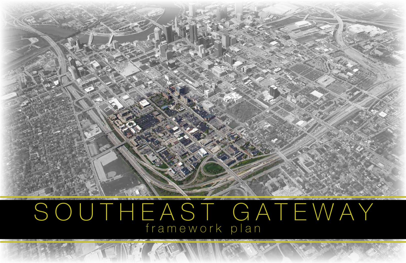
S O U T H E A S T G A T E W A Yf r a m e w o r k p l a n
2
Discovery SID
Cleve Ricksecker, Executive Director
Marc Conte, Deputy Director of Research, Planning, and Facilities
Steering Committee
Nancy Recchie, Resident
Matt Loving, Loving Realty
Chuck Wickert, Motorists Insurance Company
Patrick Bennett, Franklin University
Discovery District Development Corporation
Stakeholders
Dan Schmidt, City Space
George Kontogiannis, Americana
Matt Miller, Grant Medical Center
Stan Harris, Mt. Olivet Baptist Church
Angela Mingo, Nationwide Children’s Hospital
MKSK
Chris Hermann, Principal
Andrew Overbeck, Senior Associate
Denis de Verteuil, Urban and Regional Planner
A C K N O W L E D G M E N T S
PL
AN
CO
NT
EX
TS
OU
TH
EA
ST
GA
TE
WA
Y
3
TA
BL
E O
F C
ON
TE
NT
S
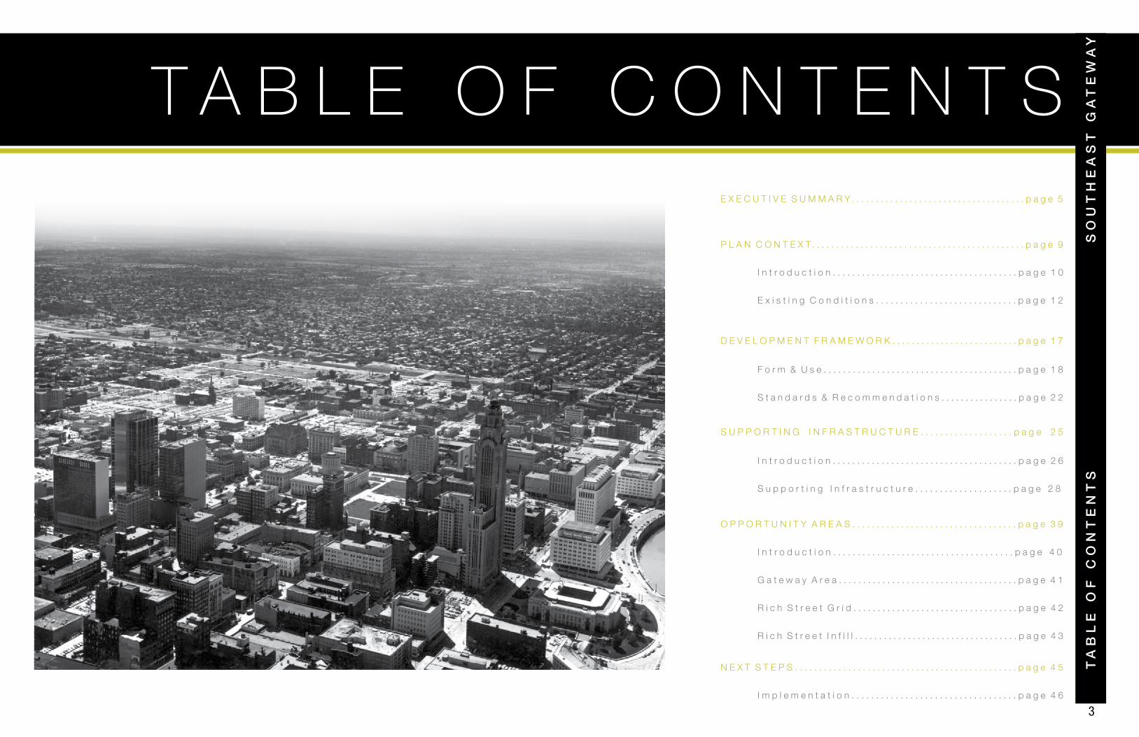
T A B L E O F C O N T E N T S
P L A N C O N T E X T . . . . . . . . . . . . . . . . . . . . . . . . . . . . . . . . . . . . . . . . . . . . p a g e 9
I n t r o d u c t i o n . . . . . . . . . . . . . . . . . . . . . . . . . . . . . . . . . . . . . . p a g e 1 0
E x i s t i n g C o n d i t i o n s . . . . . . . . . . . . . . . . . . . . . . . . . . . . . p a g e 1 2
F o r m & U s e . . . . . . . . . . . . . . . . . . . . . . . . . . . . . . . . . . . . . . . . p a g e 1 8
S t a n d a r d s & R e c o m m e n d a t i o n s . . . . . . . . . . . . . . . . p a g e 2 2
I n t r o d u c t i o n . . . . . . . . . . . . . . . . . . . . . . . . . . . . . . . . . . . . . p a g e 4 0
G a t e w a y A r e a . . . . . . . . . . . . . . . . . . . . . . . . . . . . . . . . . . . . . p a g e 4 1
R i c h S t r e e t G r i d . . . . . . . . . . . . . . . . . . . . . . . . . . . . . . . . . . p a g e 4 2
R i c h S t r e e t I n f i l l . . . . . . . . . . . . . . . . . . . . . . . . . . . . . . . . . . p a g e 4 3
I m p l e m e n t a t i o n . . . . . . . . . . . . . . . . . . . . . . . . . . . . . . . . . . p a g e 4 6
E X E C U T I V E S U M M A R Y . . . . . . . . . . . . . . . . . . . . . . . . . . . . . . . . . . . . p a g e 5
O P P O R T U N I T Y A R E A S . . . . . . . . . . . . . . . . . . . . . . . . . . . . . . . . . . p a g e 3 9
N E X T S T E P S . . . . . . . . . . . . . . . . . . . . . . . . . . . . . . . . . . . . . . . . . . . . . . p a g e 4 5
D E V E L O P M E N T F R A M E W O R K . . . . . . . . . . . . . . . . . . . . . . . . . . p a g e 1 7
SO
UT
HE
AS
T G
AT
EW
AY
I n t r o d u c t i o n . . . . . . . . . . . . . . . . . . . . . . . . . . . . . . . . . . . . . . p a g e 2 6
S u p p o r t i n g I n f r a s t r u c t u r e . . . . . . . . . . . . . . . . . . . . p a g e 2 8
S U P P O R T I N G I N F R A S T R U C T U R E . . . . . . . . . . . . . . . . . . . p a g e 2 5

4

PL
AN
CO
NT
EX
TS
OU
TH
EA
ST
GA
TE
WA
Y
5
EX
EC
UT
IVE
SU
MM
AR
Y
E X E C U T I V E S U M M A R Y
SO
UT
HE
AS
T G
AT
EW
AY
6
E X E C U T I V E S U M M A R Y
4 1 % S u r f a c e P a r k i n g
+ 1 0 , 0 0 0 A d d i t i o n a l C a r s D a i l y
MOUND STREET
MAIN STREET
FRANKLIN UNIVERSITY TOPIARY PARK
GRANT MEDICAL CENTER
MARKET EXCHANGE DISTRICT
DOWNTOWN LIBRARY
RICH STREET
GRANT AVENUE
WASHINGTON AVENUE
LESTER DRIVE
TOWN STREET
STATE STREET
BROAD STREET
FULTON STREET
MOUND STREET
MAIN STREET
FRANKLIN UNIVERSITY TOPIARY PARK
GRANT MEDICAL CENTER
MARKET EXCHANGE DISTRICT
DOWNTOWN LIBRARY
RICH STREET
GRANT AVENUE
WASHINGTON AVENUE
LESTER DRIVE
TOWN STREET
STATE STREET
BROAD STREET
FULTON STREET
The 2010 Downtown Columbus Strategic Plan recognized the potential for redevelopment in the
largely under-utilized area in the Southeast Gateway portion of Downtown. Taking into account the
pending infrastructure investment planned for this area as part of the I-70/I-71 Inner-belt project,
the Strategic Plan highlighted the opportunity presented by the re-connection of Mound Street and
the integration of Fulton Street into the Downtown street system. These new streets will be the
primary access to the rebuilt Inner-belt, increasing traffic along these corridors. No longer a cut-off
and forgotten portion of Downtown, this area is now primed for redevelopment as a gateway into
the City.
Sensing a need to guide this potential reinvestment in vacant and under-utilized ground, the
Discovery SID engaged MKSK to conduct additional study on the Southeast Gateway area and
develop a Framework Plan that provides guidelines for private reinvestment and redevelopment and
recommendations for public infrastructure improvements. Working with the Discovery SID board, a
Steering Committee of neighborhood representatives and consulting with a group of neighborhood
stakeholders, MKSK and the Discovery SID staff have developed this Framework Plan. Throughout
the process, the Discovery SID has also engaged the appropriate City departments to get input on
the elements contained within the plan.
With Mound and Fulton streets reconnected to the
Downtown street system, these corridors will now
carry more substantially more traffic on a daily basis.
Projected traffic on Mound Street will increase from
1,054 to 14,000 on a daily basis. Projected traffic
on Fulton Street will increase from 3,200 to 13,200
on a daily basis. With better access and visibility,
these corridors will likely become more attractive for
development.
I N T R O D U C T I O N
C O N T E X T
Likewise, the relocation of primary freeway access to Mound
and Fulton will take some traffic pressure off Grant Avenue,
Rich Street and Main Street. Taking advantage of these
changes by making Main and Rich two-way along its length
could also spur reinvestment.
With new infrastructure investment on the horizon, opportunity
exists to revitalize the dozens of acres of under-utilized ground
that are either vacant or used for surface parking lots.
7
EX
EC
UT
IVE
SU
MM
AR
YS
OU
TH
EA
ST
GA
TE
WA
Y
I-70
MOUND STREET
MAIN STREET
FRANKLIN UNIVERSITY TOPIARY PARK
GRANT MEDICAL CENTER
MARKET EXCHANGE DISTRICT
DOWNTOWN LIBRARY
RICH STREETGRANT AVENUE
WASHINGTON AVENUE
TOWN STREET
BROAD STREET
I-70
MOUND STREET
MAIN STREET
FRANKLIN UNIVERSITY TOPIARY PARK
GRANT MEDICAL CENTER
MARKET EXCHANGE DISTRICT
DOWNTOWN LIBRARY
RICH STREET
GRANT AVENUE
WASHINGTON AVENUE
TOWN STREET
STATE STREET
BROAD STREET
FULTON STREET
I-70
MOUND STREET
MAIN STREET
FRANKLIN UNIVERSITY TOPIARY PARK
GRANT MEDICAL CENTER
MARKET EXCHANGE DISTRICT
DOWNTOWN LIBRARY
RICH STREET
GRANT AVENUE
WASHINGTON AVENUE
TOWN STREET
BROAD STREET
FULTON STREET
I-70
MOUND STREET
MAIN STREET
FRANKLIN UNIVERSITY
GRANT MEDICAL CENTER
MARKET EXCHANGE DISTRICT
DOWNTOWN LIBRARY
RICH STREET
GRANT AVENUE
WASHINGTON AVENUE
TOWN STREET
FULTON STREET
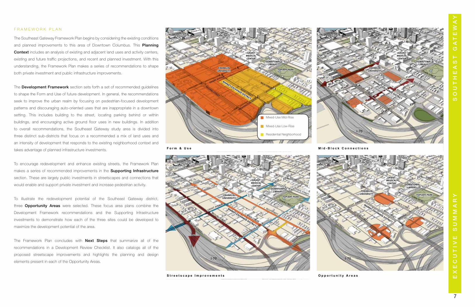
S t r e e t s c a p e I m p r o v e m e n t s
M i d - B l o c k C o n n e c t i o n s
O p p o r t u n i t y A r e a s
F o r m & U s e
FULTON STREET
F R A M E W O R K P L A N
The Southeast Gateway Framework Plan begins by considering the existing conditions
and planned improvements to this area of Downtown Columbus. This Planning
Context includes an analysis of existing and adjacent land uses and activity centers,
existing and future traffic projections, and recent and planned investment. With this
understanding, the Framework Plan makes a series of recommendations to shape
both private investment and public infrastructure improvements.
The Development Framework section sets forth a set of recommended guidelines
to shape the Form and Use of future development. In general, the recommendations
seek to improve the urban realm by focusing on pedestrian-focused development
patterns and discouraging auto-oriented uses that are inappropriate in a downtown
setting. This includes building to the street, locating parking behind or within
buildings, and encouraging active ground floor uses in new buildings. In addition
to overall recommendations, the Southeast Gateway study area is divided into
three distinct sub-districts that focus on a recommended a mix of land uses and
an intensity of development that responds to the existing neighborhood context and
takes advantage of planned infrastructure investments.
To encourage redevelopment and enhance existing streets, the Framework Plan
makes a series of recommended improvements in the Supporting Infrastructure
section. These are largely public investments in streetscapes and connections that
would enable and support private investment and increase pedestrian activity.
To illustrate the redevelopment potential of the Southeast Gateway district,
three Opportunity Areas were selected. These focus area plans combine the
Development Framework recommendations and the Supporting Infrastructure
investments to demonstrate how each of the three sites could be developed to
maximize the development potential of the area.
The Framework Plan concludes with Next Steps that summarize all of the
recommendations in a Development Review Checklist. It also catalogs all of the
proposed streetscape improvements and highlights the planning and design
elements present in each of the Opportunity Areas.
Mixed-Use Low-Rise
Mixed-Use Mid-Rise
Residential Neighborhood

9
PL
AN
CO
NT
EX
T
P L A N C O N T E X T
SO
UT
HE
AS
T G
AT
EW
AY
10
P L A N C O N T E X T
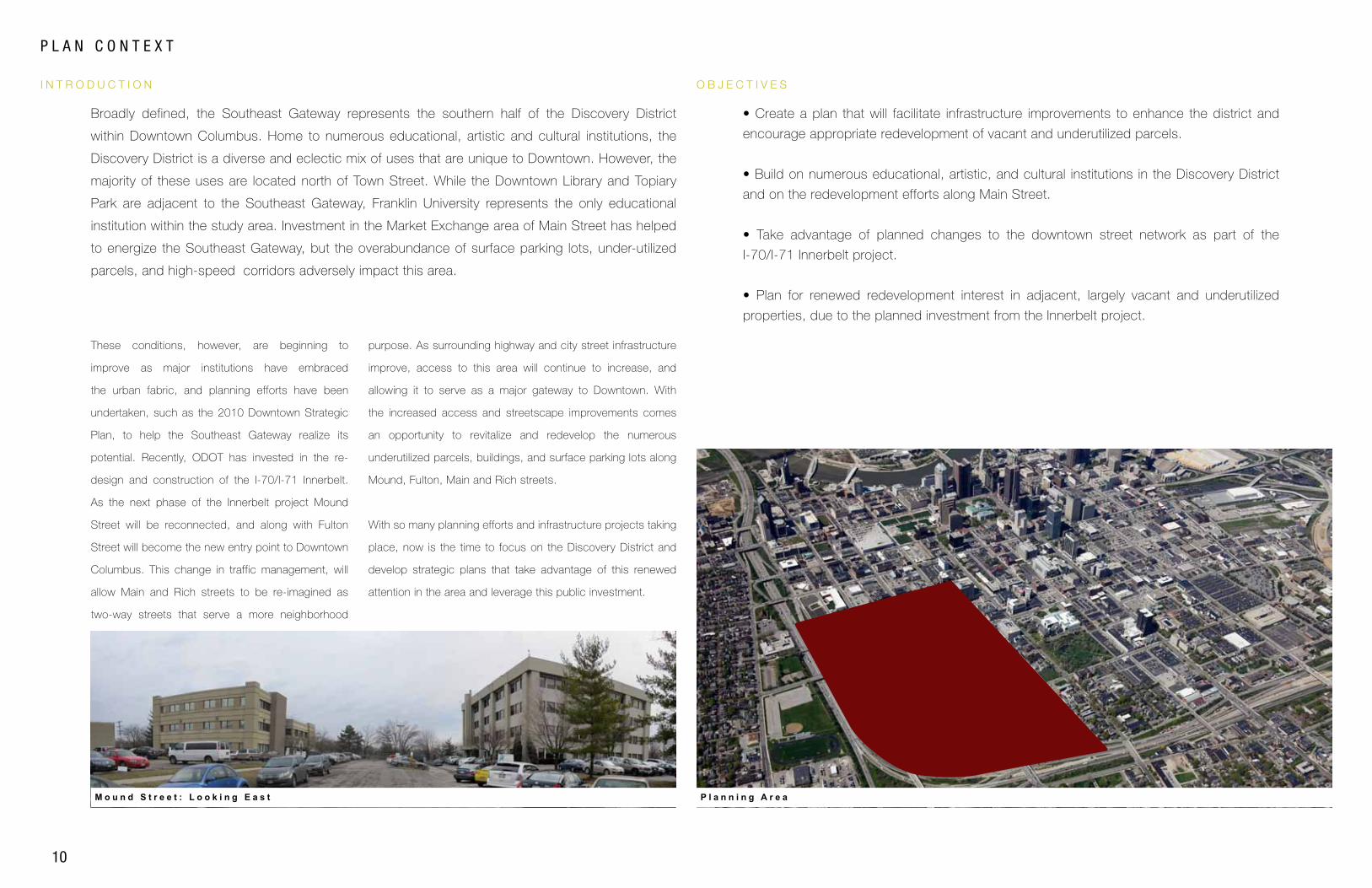
O B J E C T I V E SI N T R O D U C T I O N
M o u n d S t r e e t : L o o k i n g E a s t P l a n n i n g A r e a
• Create a plan that will facilitate infrastructure improvements to enhance the district and
encourage appropriate redevelopment of vacant and underutilized parcels.
• Build on numerous educational, artistic, and cultural institutions in the Discovery District
and on the redevelopment efforts along Main Street.
• Take advantage of planned changes to the downtown street network as part of the
I-70/I-71 Innerbelt project.
• Plan for renewed redevelopment interest in adjacent, largely vacant and underutilized
properties, due to the planned investment from the Innerbelt project.
Broadly defined, the Southeast Gateway represents the southern half of the Discovery District
within Downtown Columbus. Home to numerous educational, artistic and cultural institutions, the
Discovery District is a diverse and eclectic mix of uses that are unique to Downtown. However, the
majority of these uses are located north of Town Street. While the Downtown Library and Topiary
Park are adjacent to the Southeast Gateway, Franklin University represents the only educational
institution within the study area. Investment in the Market Exchange area of Main Street has helped
to energize the Southeast Gateway, but the overabundance of surface parking lots, under-utilized
parcels, and high-speed corridors adversely impact this area.
These conditions, however, are beginning to
improve as major institutions have embraced
the urban fabric, and planning efforts have been
undertaken, such as the 2010 Downtown Strategic
Plan, to help the Southeast Gateway realize its
potential. Recently, ODOT has invested in the re-
design and construction of the I-70/I-71 Innerbelt.
As the next phase of the Innerbelt project Mound
Street will be reconnected, and along with Fulton
Street will become the new entry point to Downtown
Columbus. This change in traffic management, will
allow Main and Rich streets to be re-imagined as
two-way streets that serve a more neighborhood
purpose. As surrounding highway and city street infrastructure
improve, access to this area will continue to increase, and
allowing it to serve as a major gateway to Downtown. With
the increased access and streetscape improvements comes
an opportunity to revitalize and redevelop the numerous
underutilized parcels, buildings, and surface parking lots along
Mound, Fulton, Main and Rich streets.
With so many planning efforts and infrastructure projects taking
place, now is the time to focus on the Discovery District and
develop strategic plans that take advantage of this renewed
attention in the area and leverage this public investment.
PL
AN
CO
NT
EX
TS
OU
TH
EA
ST
GA
TE
WA
Y
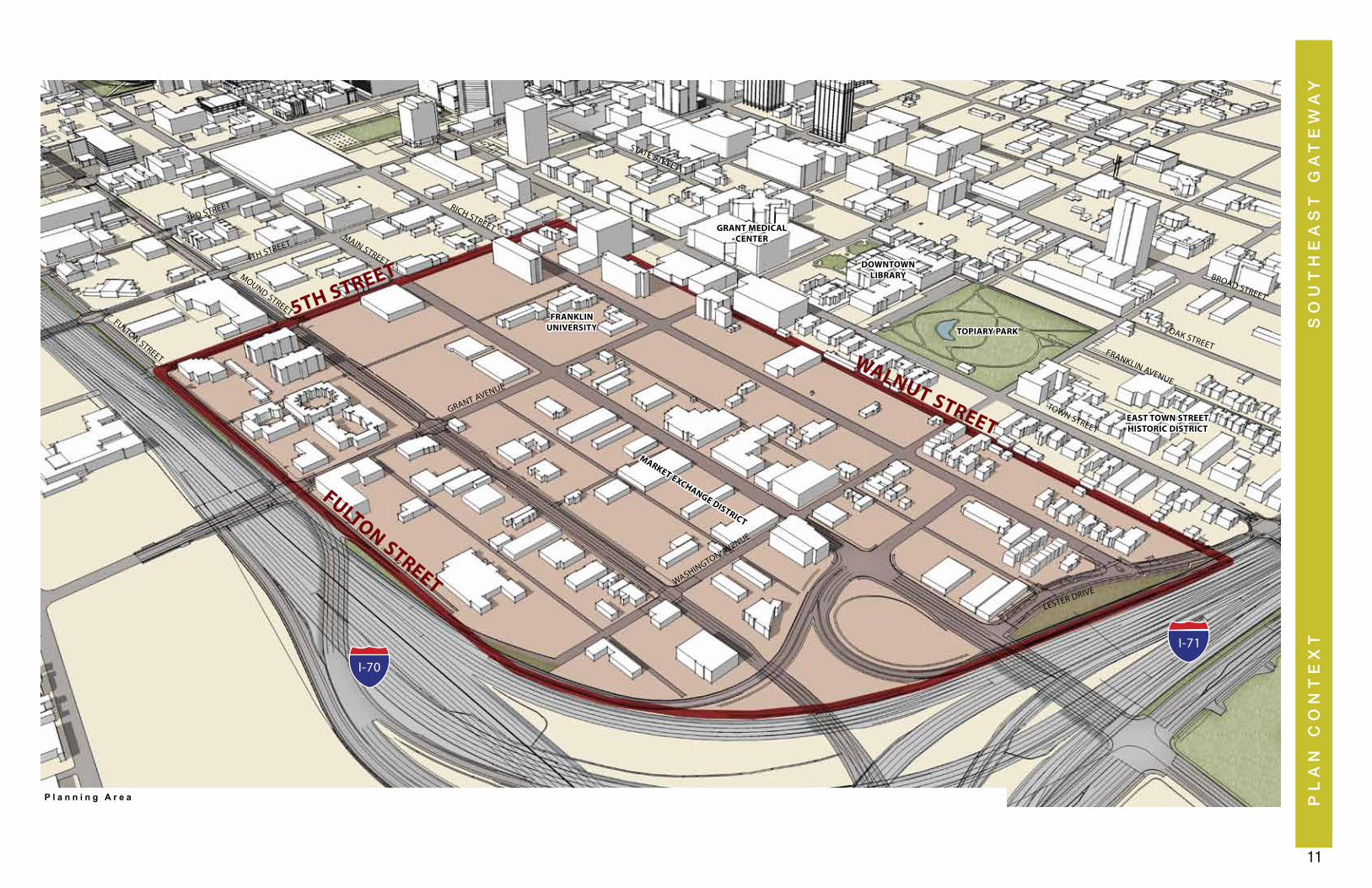
11
P l a n n i n g A r e a
FULTON STREET
FRANKLIN UNIVERSITY TOPIARY PARK
GRANT MEDICAL CENTER
MARKET EXCHANGE DISTRICT
DOWNTOWN LIBRARY
3RD STREET
4TH STREET
5TH STREET
GRANT AVENUE
WASHINGTON AVENUE
LESTER DRIVE
STATE STREET
BROAD STREET
MOUND STREET
MAIN STREET
RICH STREET
TOWN STREET
FULTON STREET
FRANKLIN AVENUE
OAK STREET
WALNUT STREET
I-70
I-71
EAST TOWN STREETHISTORIC DISTRICT
12
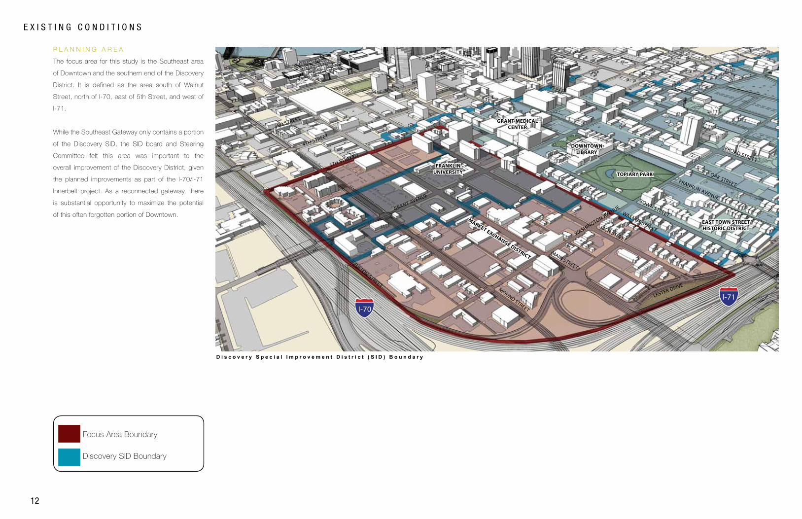
E X I S T I N G C O N D I T I O N S
Discovery SID Boundary
Focus Area Boundary
P L A N N I N G A R E A
D i s c o v e r y S p e c i a l I m p r o v e m e n t D i s t r i c t ( S I D ) B o u n d a r y
MOUND STREET
MAIN STREET
FRANKLIN UNIVERSITY TOPIARY PARK
GRANT MEDICAL CENTER
MARKET EXCHANGE DISTRICT
DOWNTOWN LIBRARY
RICH STREET
3RD STREET
4TH STREET
5TH STREET
GRANT AVENUE
WASHINGTON AVENUE
LESTER DRIVE
TOWN STREET
BROAD STREET
FULTON STREET
FRANKLIN AVENUE
OAK STREET
I-70
I-71
EAST TOWN STREETHISTORIC DISTRICT
The focus area for this study is the Southeast area
of Downtown and the southern end of the Discovery
District. It is defined as the area south of Walnut
Street, north of I-70, east of 5th Street, and west of
I-71.
While the Southeast Gateway only contains a portion
of the Discovery SID, the SID board and Steering
Committee felt this area was important to the
overall improvement of the Discovery District, given
the planned improvements as part of the I-70/I-71
Innerbelt project. As a reconnected gateway, there
is substantial opportunity to maximize the potential
of this often forgotten portion of Downtown. WALNUT STREET
PL
AN
CO
NT
EX
TS
OU
TH
EA
ST
GA
TE
WA
Y
13
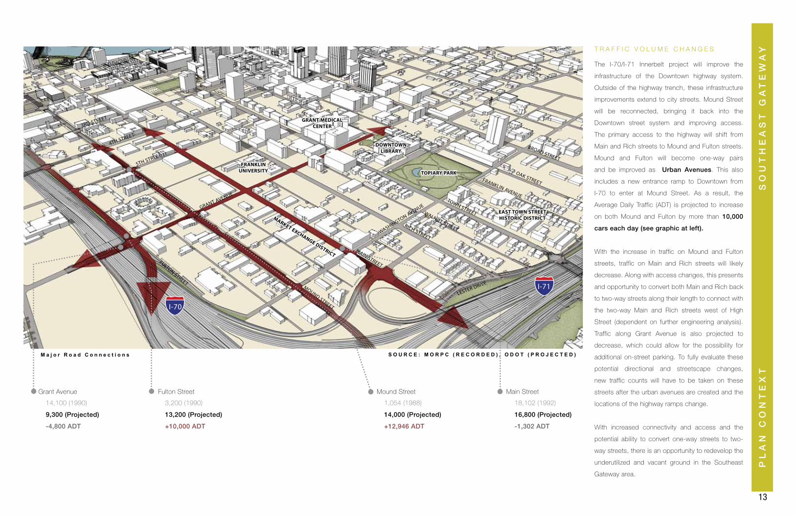
T R A F F I C V O L U M E C H A N G E S
MOUND STREET
MAIN STREET
FRANKLIN UNIVERSITY TOPIARY PARK
GRANT MEDICAL CENTER
MARKET EXCHANGE DISTRICT
DOWNTOWN LIBRARY
RICH STREET
3RD STREET
4TH STREET
5TH STREET
GRANT AVENUE
WASHINGTON AVENUE
LESTER DRIVE
TOWN STREET
BROAD STREET
FULTON STREET
FRANKLIN AVENUE
OAK STREET
Grant Avenue
14,100 (1990)
9,300 (Projected)
-4,800 ADT
3,200 (1990)
13,200 (Projected)
+10,000 ADT
1,054 (1988)
14,000 (Projected)
+12,946 ADT
18,102 (1992)
16,800 (Projected)
-1,302 ADT
Fulton Street Mound Street Main Street
M a j o r R o a d C o n n e c t i o n s S O U R C E : M O R P C ( R E C O R D E D ) , O D O T ( P R O J E C T E D )
I-70
I-71
EAST TOWN STREETHISTORIC DISTRICT
The I-70/I-71 Innerbelt project will improve the
infrastructure of the Downtown highway system.
Outside of the highway trench, these infrastructure
improvements extend to city streets. Mound Street
will be reconnected, bringing it back into the
Downtown street system and improving access.
The primary access to the highway will shift from
Main and Rich streets to Mound and Fulton streets.
Mound and Fulton will become one-way pairs
and be improved as Urban Avenues. This also
includes a new entrance ramp to Downtown from
I-70 to enter at Mound Street. As a result, the
Average Daily Traffic (ADT) is projected to increase
on both Mound and Fulton by more than 10,000
cars each day (see graphic at left).
With the increase in traffic on Mound and Fulton
streets, traffic on Main and Rich streets will likely
decrease. Along with access changes, this presents
and opportunity to convert both Main and Rich back
to two-way streets along their length to connect with
the two-way Main and Rich streets west of High
Street (dependent on further engineering analysis).
Traffic along Grant Avenue is also projected to
decrease, which could allow for the possibility for
additional on-street parking. To fully evaluate these
potential directional and streetscape changes,
new traffic counts will have to be taken on these
streets after the urban avenues are created and the
locations of the highway ramps change.
With increased connectivity and access and the
potential ability to convert one-way streets to two-
way streets, there is an opportunity to redevelop the
underutilized and vacant ground in the Southeast
Gateway area.
WALNUT STREET
14
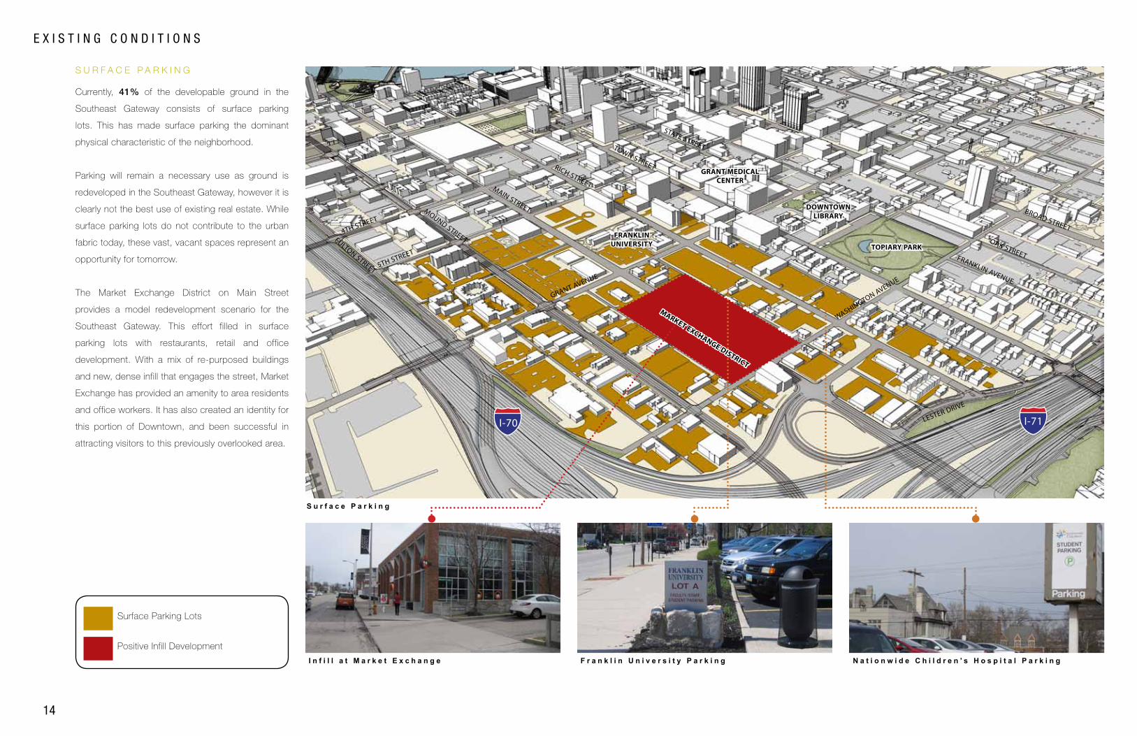
S U R F A C E P A R K I N G
Positive Infill Development
Surface Parking Lots
S u r f a c e P a r k i n g
E X I S T I N G C O N D I T I O N S
I n f i l l a t M a r k e t E x c h a n g e F r a n k l i n U n i v e r s i t y P a r k i n g N a t i o n w i d e C h i l d r e n ’ s H o s p i t a l P a r k i n g
I-70 I-71
FULTON STREET
FRANKLIN UNIVERSITY TOPIARY PARK
GRANT MEDICAL CENTER
DOWNTOWN LIBRARY
4TH STREET
5TH STREET
GRANT AVENUE
WASHINGTON AVENUE
LESTER DRIVE
STATE STREET
BROAD STREET
MOUND STREET
MAIN STREET
RICH STREET
TOWN STREET
FRANKLIN AVENUE
OAK STREET
MARKET EXCHANGE DISTRICT
Currently, 41% of the developable ground in the
Southeast Gateway consists of surface parking
lots. This has made surface parking the dominant
physical characteristic of the neighborhood.
Parking will remain a necessary use as ground is
redeveloped in the Southeast Gateway, however it is
clearly not the best use of existing real estate. While
surface parking lots do not contribute to the urban
fabric today, these vast, vacant spaces represent an
opportunity for tomorrow.
The Market Exchange District on Main Street
provides a model redevelopment scenario for the
Southeast Gateway. This effort filled in surface
parking lots with restaurants, retail and office
development. With a mix of re-purposed buildings
and new, dense infill that engages the street, Market
Exchange has provided an amenity to area residents
and office workers. It has also created an identity for
this portion of Downtown, and been successful in
attracting visitors to this previously overlooked area.
PL
AN
CO
NT
EX
TS
OU
TH
EA
ST
GA
TE
WA
Y
15
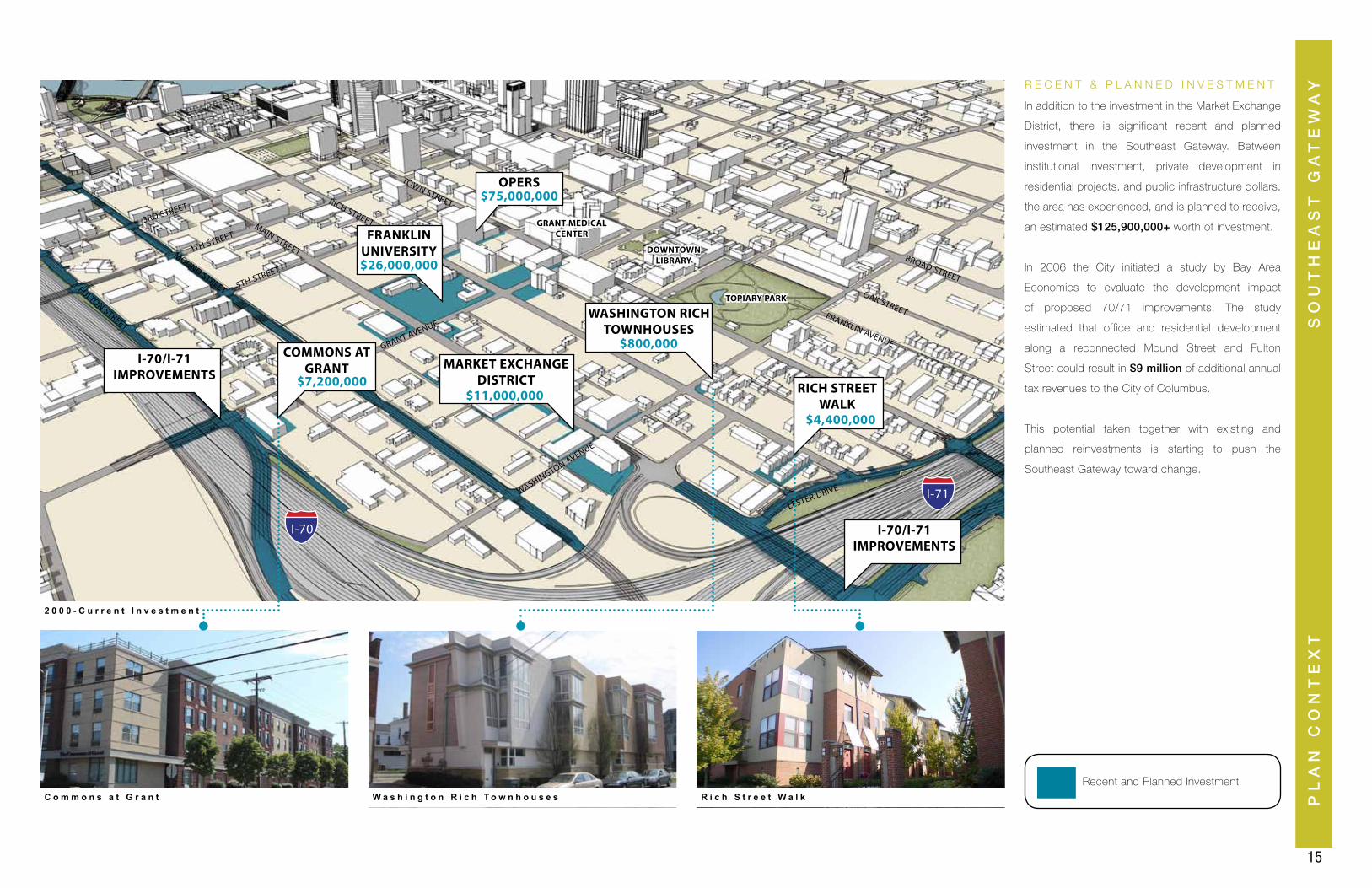
R E C E N T & P L A N N E D I N V E S T M E N T
FRANKLIN UNIVERSITY
WASHINGTON RICH TOWNHOUSES
RICH STREET WALK
MARKET EXCHANGE DISTRICT
COMMONS AT GRANT
OPERS$75,000,000
$26,000,000
$11,000,000
$800,000
$4,400,000
$7,200,000
I-70/I-71 IMPROVEMENTS
FULTON STREET
TOPIARY PARK
GRANT MEDICAL CENTER
DOWNTOWN LIBRARY
3RD STREET
4TH STREET
5TH STREET
GRANT AVENUE
WASHINGTON AVENUE
LESTER DRIVE
BROAD STREET
MOUND STREET
MAIN STREET
RICH STREET
TOWN STREET
FRANKLIN AVENUE
OAK STREET
I-70/I-71 IMPROVEMENTS
2 0 0 0 - C u r r e n t I n v e s t m e n t
C o m m o n s a t G r a n t W a s h i n g t o n R i c h T o w n h o u s e s R i c h S t r e e t W a l k
I-70
I-71
In addition to the investment in the Market Exchange
District, there is significant recent and planned
investment in the Southeast Gateway. Between
institutional investment, private development in
residential projects, and public infrastructure dollars,
the area has experienced, and is planned to receive,
an estimated $125,900,000+ worth of investment.
In 2006 the City initiated a study by Bay Area
Economics to evaluate the development impact
of proposed 70/71 improvements. The study
estimated that office and residential development
along a reconnected Mound Street and Fulton
Street could result in $9 million of additional annual
tax revenues to the City of Columbus.
This potential taken together with existing and
planned reinvestments is starting to push the
Southeast Gateway toward change.
Recent and Planned Investment

17
DEVELOPMENT FRAMEWORK
DE
VE
LO
PM
EN
T F
RA
ME
WO
RK
SO
UT
HE
AS
T G
AT
EW
AY
18
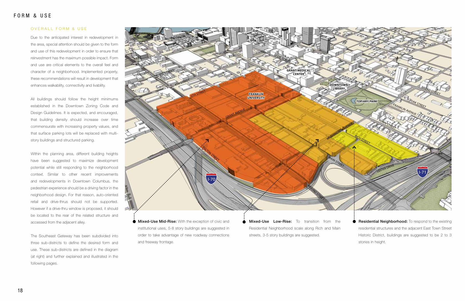
F O R M & U S E
Residential Neighborhood: To respond to the existing
residential structures and the adjacent East Town Street
Historic District, buildings are suggested to be 2 to 3
stories in height.
Mixed-Use Low-Rise: To transition from the
Residential Neighborhood scale along Rich and Main
streets, 3-5 story buildings are suggested.
Mixed-Use Mid-Rise: With the exception of civic and
institutional uses, 5-8 story buildings are suggested in
order to take advantage of new roadway connections
and freeway frontage.
O V E R A L L F O R M & U S E
MOUND STREET
MAIN STREET
FRANKLIN UNIVERSITY
TOPIARY PARK
GRANT MEDICAL CENTER
DOWNTOWN LIBRARY
3RD STREET
4TH STREET
5TH STREET
GRANT AVENUE
LESTER DRIVE
TOWN STREET
STATE STREET
BROAD STREET
RICH STREETFULTON STREET
WASHINGTON AVENUE
FRANKLIN AVENUE
OAK STREET
I-70
I-71
Due to the anticipated interest in redevelopment in
the area, special attention should be given to the form
and use of this redevelopment in order to ensure that
reinvestment has the maximum possible impact. Form
and use are critical elements to the overall feel and
character of a neighborhood. Implemented properly,
these recommendations will result in development that
enhances walkability, connectivity and livability.
All buildings should follow the height minimums
established in the Downtown Zoning Code and
Design Guidelines. It is expected, and encouraged,
that building density should increase over time
commensurate with increasing property values, and
that surface parking lots will be replaced with multi-
story buildings and structured parking.
Within the planning area, different building heights
have been suggested to maximize development
potential while still responding to the neighborhood
context. Similar to other recent improvements
and redevelopments in Downtown Columbus, the
pedestrian experience should be a driving factor in the
neighborhood design. For that reason, auto-oriented
retail and drive-thrus should not be supported.
However if a drive-thru window is proposed, it should
be located to the rear of the related structure and
accessed from the adjacent alley.
The Southeast Gateway has been subdivided into
three sub-districts to define the desired form and
use. These sub-districts are defined in the diagram
(at right) and further explained and illustrated in the
following pages.
DE
VE
LO
PM
EN
T F
RA
ME
WO
RK
19
SO
UT
HE
AS
T G
AT
EW
AY
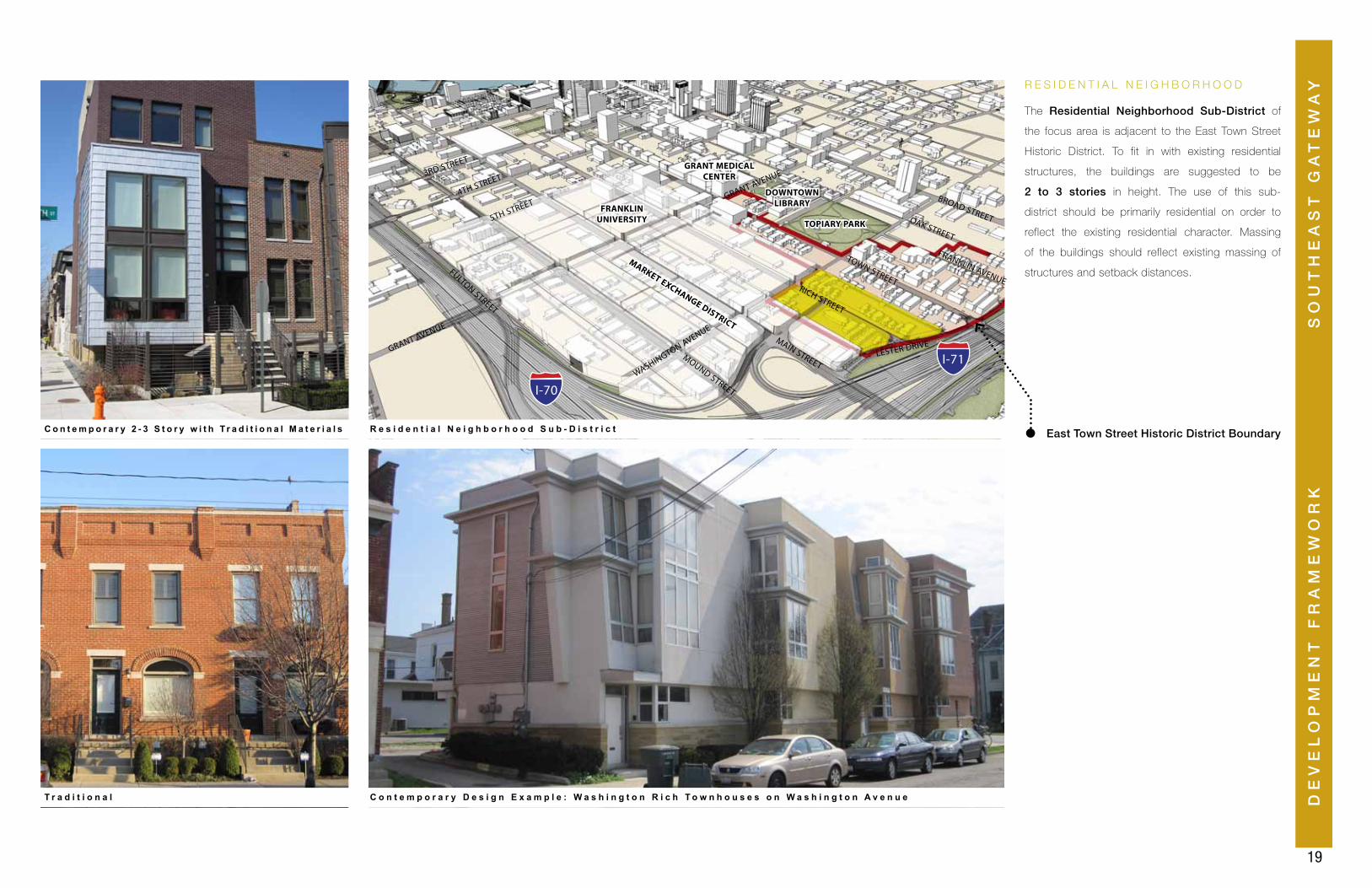
East Town Street Historic District Boundary
The Residential Neighborhood Sub-District of
the focus area is adjacent to the East Town Street
Historic District. To fit in with existing residential
structures, the buildings are suggested to be
2 to 3 stories in height. The use of this sub-
district should be primarily residential on order to
reflect the existing residential character. Massing
of the buildings should reflect existing massing of
structures and setback distances.
R E S I D E N T I A L N E I G H B O R H O O D
FULTON STREET
MOUND STREET
MAIN STREET
FRANKLIN UNIVERSITY TOPIARY PARK
GRANT MEDICAL CENTER
MARKET EXCHANGE DISTRICT
DOWNTOWN LIBRARY
RICH STREET
3RD STREET
4TH STREET
5TH STREETGRANT AVENUE
WASHINGTON AVENUE
LESTER DRIVE
TOWN STREET
FRANKLIN AVENUE
BROAD STREET
GRANT AVENUE
OAK STREET
R e s i d e n t i a l N e i g h b o r h o o d S u b - D i s t r i c tC o n t e m p o r a r y 2 - 3 S t o r y w i t h T r a d i t i o n a l M a t e r i a l s
T r a d i t i o n a l C o n t e m p o r a r y D e s i g n E x a m p l e : W a s h i n g t o n R i c h T o w n h o u s e s o n W a s h i n g t o n A v e n u e
I-70
I-71
20
F O R M & U S E
M I X E D - U S E L O W R I S E
FULTON STREETMOUND STREET
MAIN STREET
FRANKLIN UNIVERSITY TOPIARY PARK
GRANT MEDICAL CENTER
MARKET EXCHANGE DISTRICT
DOWNTOWN LIBRARY
RICH STREET
3RD STREET
4TH STREET
5TH STREETGRANT AVENUE
WASHINGTON AVENUE
LESTER DRIVE
TOWN STREET
FRANKLIN AVENUE
BROAD STREET
GRANT AVENUE
OAK STREET
M i x e d - U s e L o w - R i s e S u b - D i s t r i c t
R e t a i l w i t h 4 S t o r i e s A b o v e R e t a i l w i t h 2 S t o r i e s A b o v e
R e s i d e n t i a l 4 S t o r i e s W i t h a G r e e n R o o f
I-70
I-71
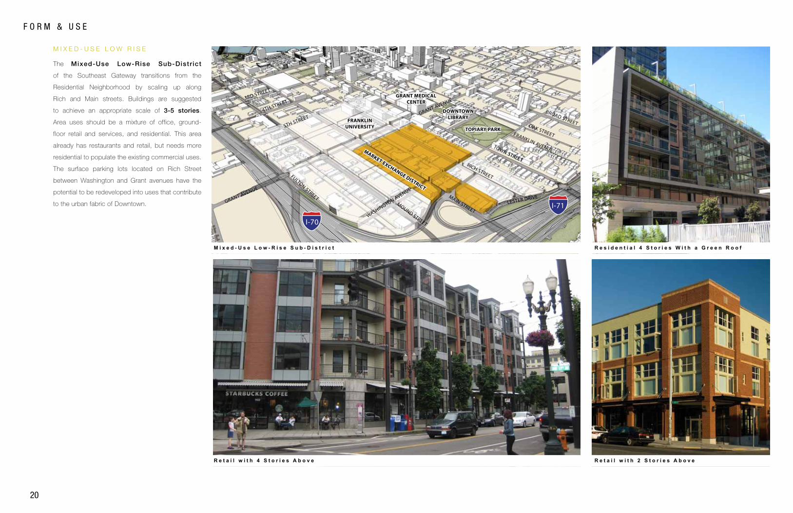
The Mixed-Use Low-Rise Sub-Distr ict
of the Southeast Gateway transitions from the
Residential Neighborhood by scaling up along
Rich and Main streets. Buildings are suggested
to achieve an appropriate scale of 3-5 stories.
Area uses should be a mixture of office, ground-
floor retail and services, and residential. This area
already has restaurants and retail, but needs more
residential to populate the existing commercial uses.
The surface parking lots located on Rich Street
between Washington and Grant avenues have the
potential to be redeveloped into uses that contribute
to the urban fabric of Downtown.
DE
VE
LO
PM
EN
T F
RA
ME
WO
RK
21
SO
UT
HE
AS
T G
AT
EW
AY
FULTON STREET
MOUND STREET
MAIN STREET
FRANKLIN UNIVERSITY TOPIARY PARK
GRANT MEDICAL CENTER
MARKET EXCHANGE DISTRICT
DOWNTOWN LIBRARY
RICH STREET
3RD STREET
4TH STREET
5TH STREETGRANT AVENUE
WASHINGTON AVENUE
LESTER DRIVE
TOWN STREET
FRANKLIN AVENUE
BROAD STREET
GRANT AVENUE
OAK STREET
M I X E D - U S E M I D - R I S E
M i x e d - U s e M i d - R i s e S u b - D i s t r i c t
R e t a i l w i t h 5 S t o r i e s A b o v e
R e t a i l w i t h 5 S t o r i e s A b o v e
R e t a i l w i t h 5 S t o r i e s A b o v e
I-70
I-71
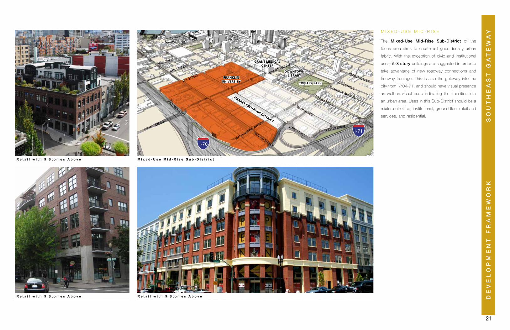
The Mixed-Use Mid-Rise Sub-District of the
focus area aims to create a higher density urban
fabric. With the exception of civic and institutional
uses, 5-8 story buildings are suggested in order to
take advantage of new roadway connections and
freeway frontage. This is also the gateway into the
city from I-70/I-71, and should have visual presence
as well as visual cues indicating the transition into
an urban area. Uses in this Sub-District should be a
mixture of office, institutional, ground floor retail and
services, and residential.
22
S T A N D A R D S & R E C O M M E N D A T I O N S
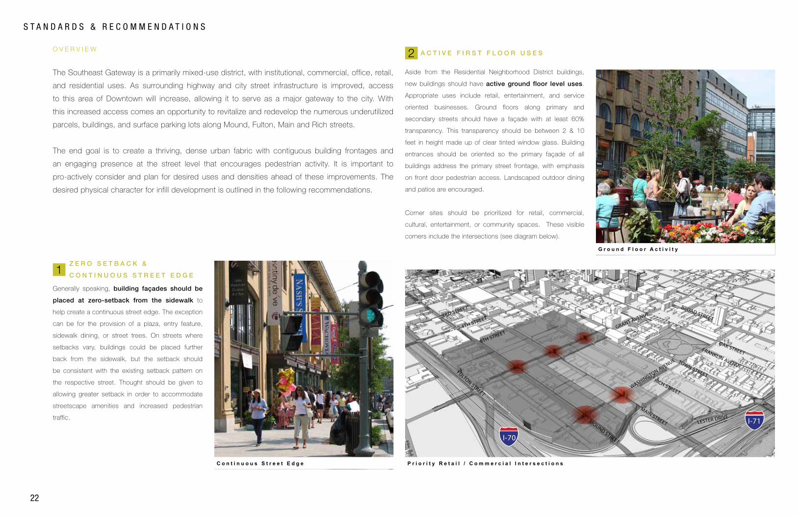
Z E R O S E T B A C K &
C O N T I N U O U S S T R E E T E D G E
O V E R V I E W
Generally speaking, building façades should be
placed at zero-setback from the sidewalk to
help create a continuous street edge. The exception
can be for the provision of a plaza, entry feature,
sidewalk dining, or street trees. On streets where
setbacks vary, buildings could be placed further
back from the sidewalk, but the setback should
be consistent with the existing setback pattern on
the respective street. Thought should be given to
allowing greater setback in order to accommodate
streetscape amenities and increased pedestrian
traffic.
The Southeast Gateway is a primarily mixed-use district, with institutional, commercial, office, retail,
and residential uses. As surrounding highway and city street infrastructure is improved, access
to this area of Downtown will increase, allowing it to serve as a major gateway to the city. With
this increased access comes an opportunity to revitalize and redevelop the numerous underutilized
parcels, buildings, and surface parking lots along Mound, Fulton, Main and Rich streets.
The end goal is to create a thriving, dense urban fabric with contiguous building frontages and
an engaging presence at the street level that encourages pedestrian activity. It is important to
pro-actively consider and plan for desired uses and densities ahead of these improvements. The
desired physical character for infill development is outlined in the following recommendations.
A C T I V E F I R S T F L O O R U S E S
FULTON STREET
MOUND STREET
MAIN STREET
RICH STREET
3RD STREET
4TH STREET
5TH STREETGRANT AVENUE
WASHINGTON AVENUE
LESTER DRIVE
TOWN STREET
BROAD STREET
FRANKLIN AVENUE
OAK STREET
C o n t i n u o u s S t r e e t E d g e P r i o r i t y R e t a i l / C o m m e r c i a l I n t e r s e c t i o n s
G r o u n d F l o o r A c t i v i t y
2
1
I-70
I-71
Aside from the Residential Neighborhood District buildings,
new buildings should have active ground floor level uses.
Appropriate uses include retail, entertainment, and service
oriented businesses. Ground floors along primary and
secondary streets should have a façade with at least 60%
transparency. This transparency should be between 2 & 10
feet in height made up of clear tinted window glass. Building
entrances should be oriented so the primary façade of all
buildings address the primary street frontage, with emphasis
on front door pedestrian access. Landscaped outdoor dining
and patios are encouraged.
Corner sites should be prioritized for retail, commercial,
cultural, entertainment, or community spaces. These visible
corners include the intersections (see diagram below).
DE
VE
LO
PM
EN
T F
RA
ME
WO
RK
23
SO
UT
HE
AS
T G
AT
EW
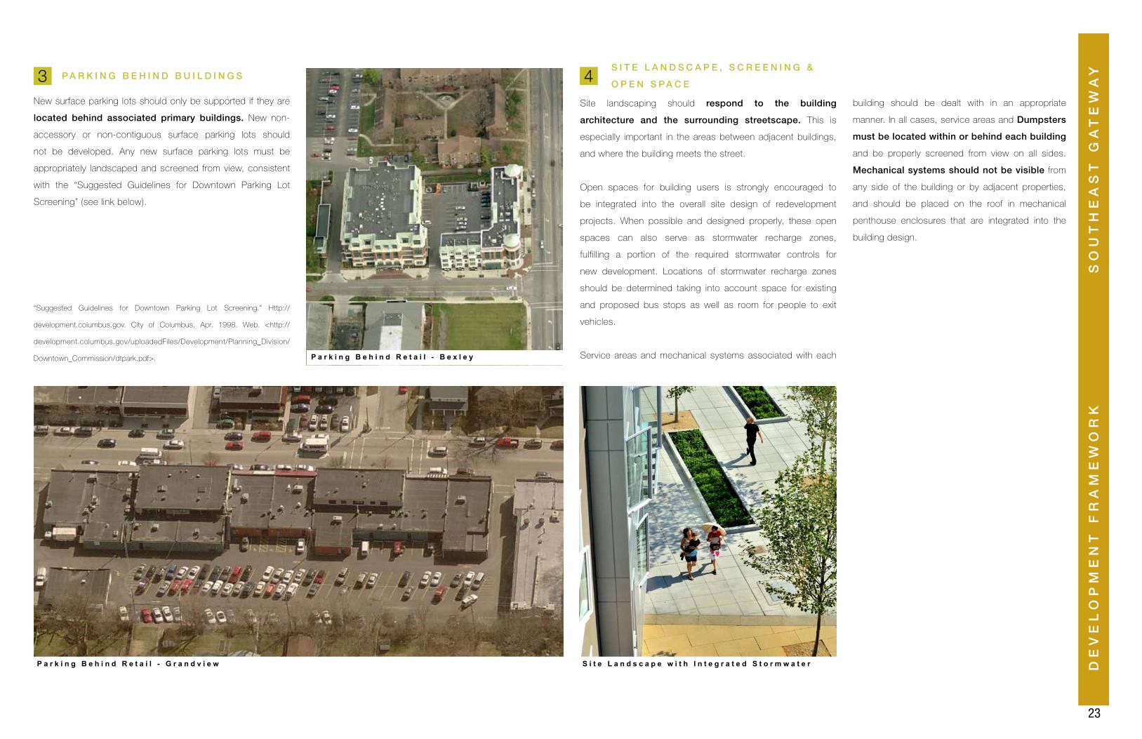
AYP A R K I N G B E H I N D B U I L D I N G S
New surface parking lots should only be supported if they are
located behind associated primary buildings. New non-
accessory or non-contiguous surface parking lots should
not be developed. Any new surface parking lots must be
appropriately landscaped and screened from view, consistent
with the “Suggested Guidelines for Downtown Parking Lot
Screening” (see link below).
“Suggested Guidelines for Downtown Parking Lot Screening.” Http://
development.columbus.gov. City of Columbus, Apr. 1998. Web. <http://
development.columbus.gov/uploadedFiles/Development/Planning_Division/
Downtown_Commission/dtpark.pdf>. P a r k i n g B e h i n d R e t a i l - B e x l e y
S I T E L A N D S C A P E , S C R E E N I N G &
O P E N S P A C E
Site landscaping should respond to the building
architecture and the surrounding streetscape. This is
especially important in the areas between adjacent buildings,
and where the building meets the street.
Open spaces for building users is strongly encouraged to
be integrated into the overall site design of redevelopment
projects. When possible and designed properly, these open
spaces can also serve as stormwater recharge zones,
fulfilling a portion of the required stormwater controls for
new development. Locations of stormwater recharge zones
should be determined taking into account space for existing
and proposed bus stops as well as room for people to exit
vehicles.
Service areas and mechanical systems associated with each
3 4
P a r k i n g B e h i n d R e t a i l - G r a n d v i e w S i t e L a n d s c a p e w i t h I n t e g r a t e d S t o r m w a t e r
building should be dealt with in an appropriate
manner. In all cases, service areas and Dumpsters
must be located within or behind each building
and be properly screened from view on all sides.
Mechanical systems should not be visible from
any side of the building or by adjacent properties,
and should be placed on the roof in mechanical
penthouse enclosures that are integrated into the
building design.

25
SUPPORTING INFRASTRUCTURE
SU
PP
OR
TIN
G I
NF
RA
ST
RU
CT
UR
ES
OU
TH
EA
ST
GA
TE
WA
Y
26
InformationalSignage
NewspaperBox
BikeRack
BenchTrashReceptacle
Mast arm Street Light
WayfindingSignage
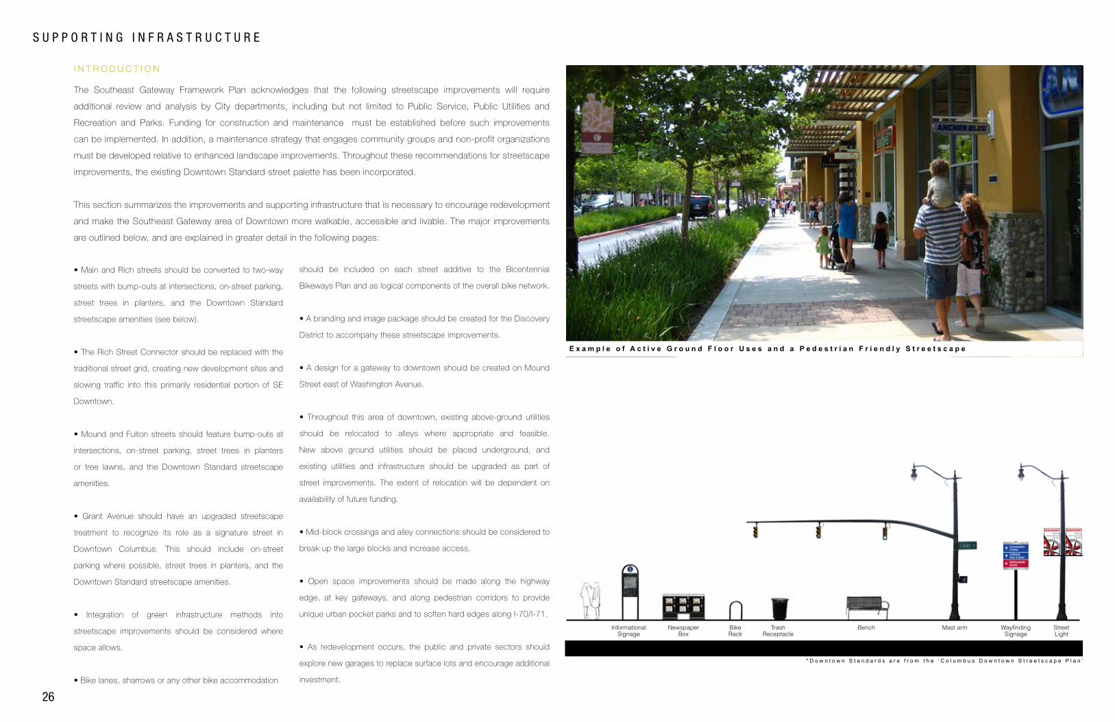
S U P P O R T I N G I N F R A S T R U C T U R E
I N T R O D U C T I O N
D o w n t o w n S t a n d a r d S t r e e t F u r n i s h i n g s + W a y f i n d i n g + S t r e e t S i g n a l L i g h t i n g P a l e t t e* D o w n t o w n S t a n d a r d s a r e f r o m t h e ‘ C o l u m b u s D o w n t o w n S t r e e t s c a p e P l a n ’
The Southeast Gateway Framework Plan acknowledges that the following streetscape improvements will require
additional review and analysis by City departments, including but not limited to Public Service, Public Utilities and
Recreation and Parks. Funding for construction and maintenance must be established before such improvements
can be implemented. In addition, a maintenance strategy that engages community groups and non-profit organizations
must be developed relative to enhanced landscape improvements. Throughout these recommendations for streetscape
improvements, the existing Downtown Standard street palette has been incorporated.
This section summarizes the improvements and supporting infrastructure that is necessary to encourage redevelopment
and make the Southeast Gateway area of Downtown more walkable, accessible and livable. The major improvements
are outlined below, and are explained in greater detail in the following pages:
• Main and Rich streets should be converted to two-way
streets with bump-outs at intersections, on-street parking,
street trees in planters, and the Downtown Standard
streetscape amenities (see below).
• The Rich Street Connector should be replaced with the
traditional street grid, creating new development sites and
slowing traffic into this primarily residential portion of SE
Downtown.
• Mound and Fulton streets should feature bump-outs at
intersections, on-street parking, street trees in planters
or tree lawns, and the Downtown Standard streetscape
amenities.
• Grant Avenue should have an upgraded streetscape
treatment to recognize its role as a signature street in
Downtown Columbus. This should include on-street
parking where possible, street trees in planters, and the
Downtown Standard streetscape amenities.
• Integration of green infrastructure methods into
streetscape improvements should be considered where
space allows.
• Bike lanes, sharrows or any other bike accommodation
should be included on each street additive to the Bicentennial
Bikeways Plan and as logical components of the overall bike network.
• A branding and image package should be created for the Discovery
District to accompany these streetscape improvements.
• A design for a gateway to downtown should be created on Mound
Street east of Washington Avenue.
• Throughout this area of downtown, existing above-ground utilities
should be relocated to alleys where appropriate and feasible.
New above ground utilities should be placed underground, and
existing utilities and infrastructure should be upgraded as part of
street improvements. The extent of relocation will be dependent on
availability of future funding.
• Mid-block crossings and alley connections should be considered to
break up the large blocks and increase access.
• Open space improvements should be made along the highway
edge, at key gateways, and along pedestrian corridors to provide
unique urban pocket parks and to soften hard edges along I-70/I-71.
• As redevelopment occurs, the public and private sectors should
explore new garages to replace surface lots and encourage additional
investment.
E x a m p l e o f A c t i v e G r o u n d F l o o r U s e s a n d a P e d e s t r i a n F r i e n d l y S t r e e t s c a p e
SU
PP
OR
TIN
G I
NF
RA
ST
RU
CT
UR
E
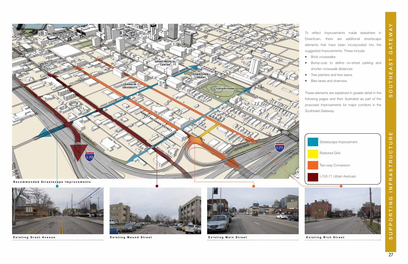
27
SO
UT
HE
AS
T G
AT
EW
AY
I-70/I-71 Urban Avenues
Restored Grid
Two-way Conversion
Streetscape Improvement
FULTON STREET
MOUND STREET
MAIN STREET
FRANKLIN UNIVERSITY TOPIARY PARK
GRANT MEDICAL CENTER
MARKET EXCHANGE DISTRICT
DOWNTOWN LIBRARY
RICH STREET
3RD STREET
4TH STREET
5TH STREET
GRANT AVENUE
WASHINGTON AVENUE
LESTER DRIVE
TOWN STREET
STATE STREET
BROAD STREET
MOUND STREET
MAIN STREET
RICH STREET
TOWN STREET
FULTON STREET
WASHINGTON AVENUEGRANT AVENUE
FRANKLIN AVENUE
OAK STREET
E x i s t i n g G r a n t A v e n u e
R e c o m m e n d e d S t r e e t s c a p e I m p r o v e m e n t s
E x i s t i n g M o u n d S t r e e t E x i s t i n g M a i n S t r e e t E x i s t i n g R i c h S t r e e t
I-70
I-71
To reflect improvements made elsewhere in
Downtown, there are additional streetscape
elements that have been incorporated into the
suggested improvements. These include:
• Brick crosswalks
• Bump-outs to define on-street parking and
shorten crosswalk distances
• Tree planters and tree lawns
• Bike lanes and sharrows
These elements are explained in greater detail in the
following pages and then illustrated as part of the
proposed improvements for major corridors in the
Southeast Gateway.
28
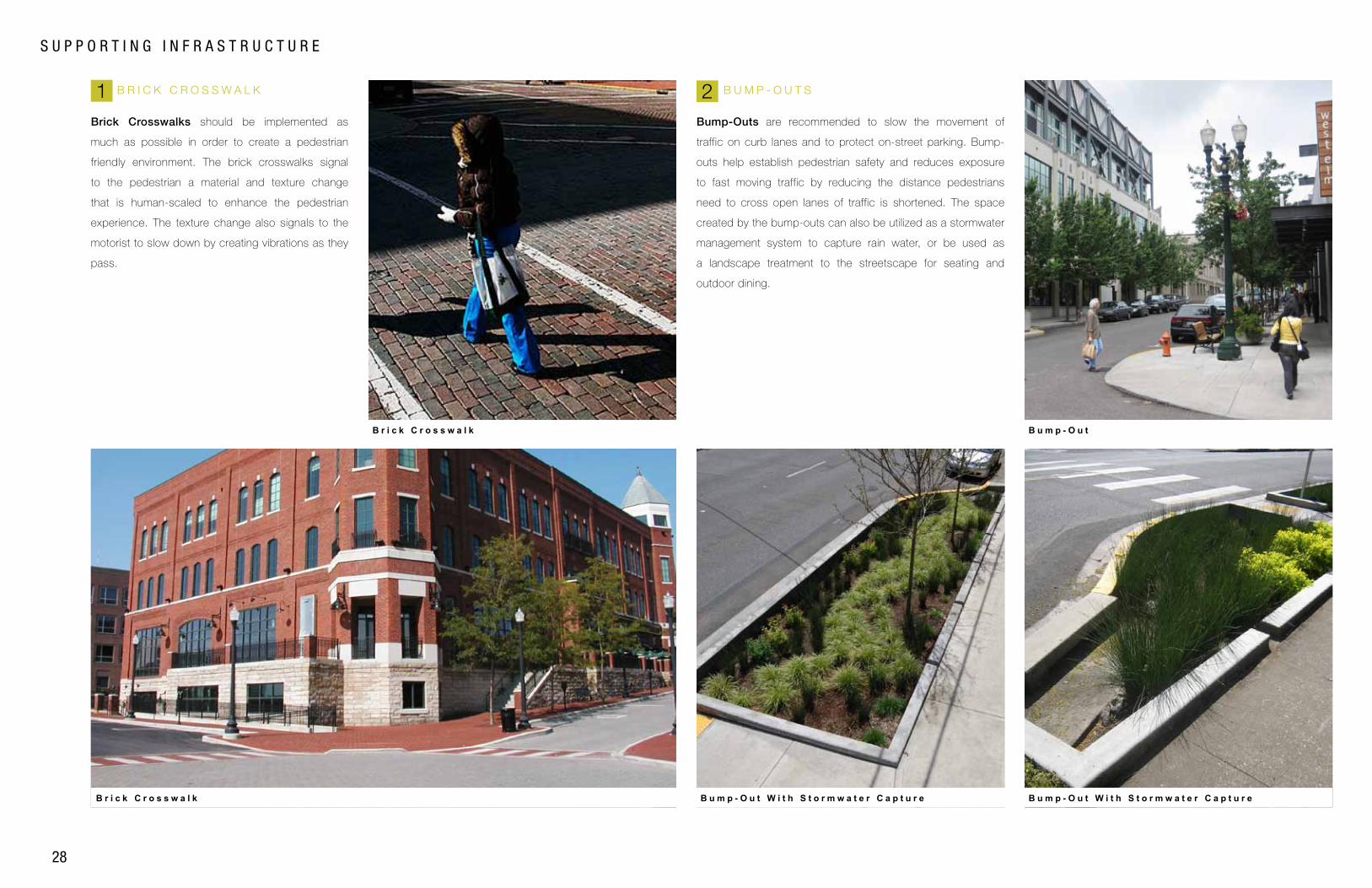
B R I C K C R O S S W A L K B U M P - O U T S
Brick Crosswalks should be implemented as
much as possible in order to create a pedestrian
friendly environment. The brick crosswalks signal
to the pedestrian a material and texture change
that is human-scaled to enhance the pedestrian
experience. The texture change also signals to the
motorist to slow down by creating vibrations as they
pass.
Bump-Outs are recommended to slow the movement of
traffic on curb lanes and to protect on-street parking. Bump-
outs help establish pedestrian safety and reduces exposure
to fast moving traffic by reducing the distance pedestrians
need to cross open lanes of traffic is shortened. The space
created by the bump-outs can also be utilized as a stormwater
management system to capture rain water, or be used as
a landscape treatment to the streetscape for seating and
outdoor dining.
S U P P O R T I N G I N F R A S T R U C T U R E
B r i c k C r o s s w a l k
B r i c k C r o s s w a l k
B u m p - O u t W i t h S t o r m w a t e r C a p t u r e B u m p - O u t W i t h S t o r m w a t e r C a p t u r e
B u m p - O u t
2 1
SU
PP
OR
TIN
G I
NF
RA
ST
RU
CT
UR
E
29
SO
UT
HE
AS
T G
AT
EW
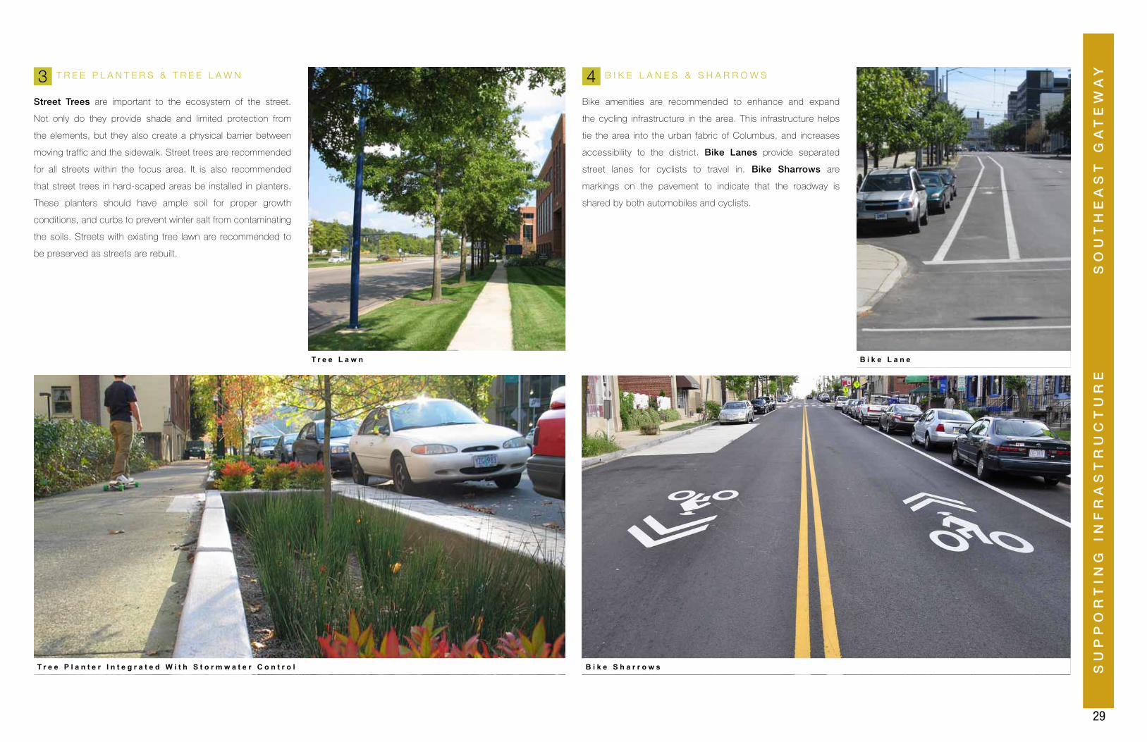
AYT R E E P L A N T E R S & T R E E L A W N
Street Trees are important to the ecosystem of the street.
Not only do they provide shade and limited protection from
the elements, but they also create a physical barrier between
moving traffic and the sidewalk. Street trees are recommended
for all streets within the focus area. It is also recommended
that street trees in hard-scaped areas be installed in planters.
These planters should have ample soil for proper growth
conditions, and curbs to prevent winter salt from contaminating
the soils. Streets with existing tree lawn are recommended to
be preserved as streets are rebuilt.
B I K E L A N E S & S H A R R O W S
Bike amenities are recommended to enhance and expand
the cycling infrastructure in the area. This infrastructure helps
tie the area into the urban fabric of Columbus, and increases
accessibility to the district. Bike Lanes provide separated
street lanes for cyclists to travel in. Bike Sharrows are
markings on the pavement to indicate that the roadway is
shared by both automobiles and cyclists.
T r e e P l a n t e r I n t e g r a t e d W i t h S t o r m w a t e r C o n t r o l
T r e e L a w n
B i k e S h a r r o w s
B i k e L a n e
3 4
30
S U P P O R T I N G I N F R A S T R U C T U R E
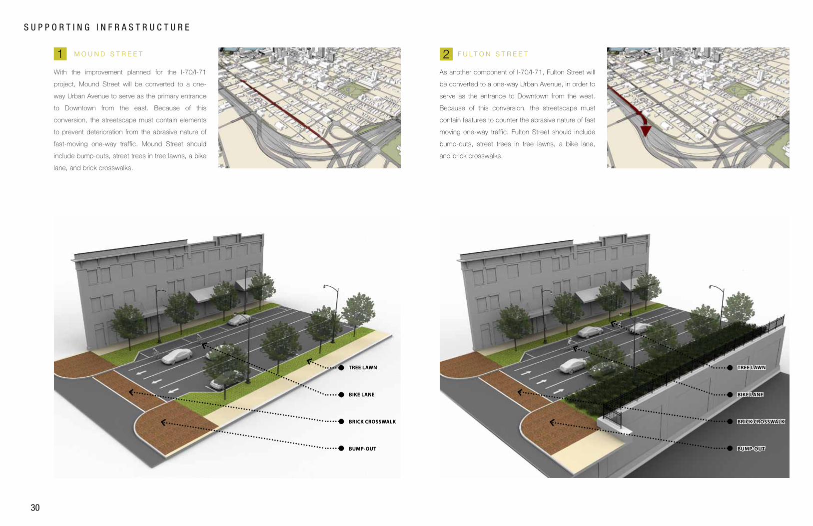
M O U N D S T R E E T F U L T O N S T R E E T
With the improvement planned for the I-70/I-71
project, Mound Street will be converted to a one-
way Urban Avenue to serve as the primary entrance
to Downtown from the east. Because of this
conversion, the streetscape must contain elements
to prevent deterioration from the abrasive nature of
fast-moving one-way traffic. Mound Street should
include bump-outs, street trees in tree lawns, a bike
lane, and brick crosswalks.
As another component of I-70/I-71, Fulton Street will
be converted to a one-way Urban Avenue, in order to
serve as the entrance to Downtown from the west.
Because of this conversion, the streetscape must
contain features to counter the abrasive nature of fast
moving one-way traffic. Fulton Street should include
bump-outs, street trees in tree lawns, a bike lane,
and brick crosswalks.
2 1
BUMP-OUT
BRICK CROSSWALK
BIKE LANE
TREE LAWN
BUMP-OUT
BRICK CROSSWALK
BIKE LANE
TREE LAWN
SU
PP
OR
TIN
G I
NF
RA
ST
RU
CT
UR
E
31
SO
UT
HE
AS
T G
AT
EW
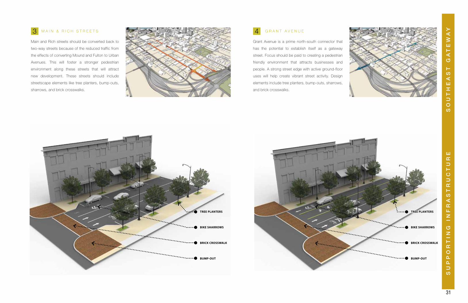
AYM A I N & R I C H S T R E E T S G R A N T A V E N U E
Main and Rich streets should be converted back to
two-way streets because of the reduced traffic from
the effects of converting Mound and Fulton to Urban
Avenues. This will foster a stronger pedestrian
environment along these streets that will attract
new development. These streets should include
streetscape elements like tree planters, bump-outs,
sharrows, and brick crosswalks.
Grant Avenue is a prime north-south connector that
has the potential to establish itself as a gateway
street. Focus should be paid to creating a pedestrian
friendly environment that attracts businesses and
people. A strong street edge with active ground-floor
uses will help create vibrant street activity. Design
elements include tree planters, bump-outs, sharrows,
and brick crosswalks.
3 4
BUMP-OUT BUMP-OUT
BRICK CROSSWALK BRICK CROSSWALK
BIKE SHARROWS BIKE SHARROWS
TREE PLANTERS TREE PLANTERS
32
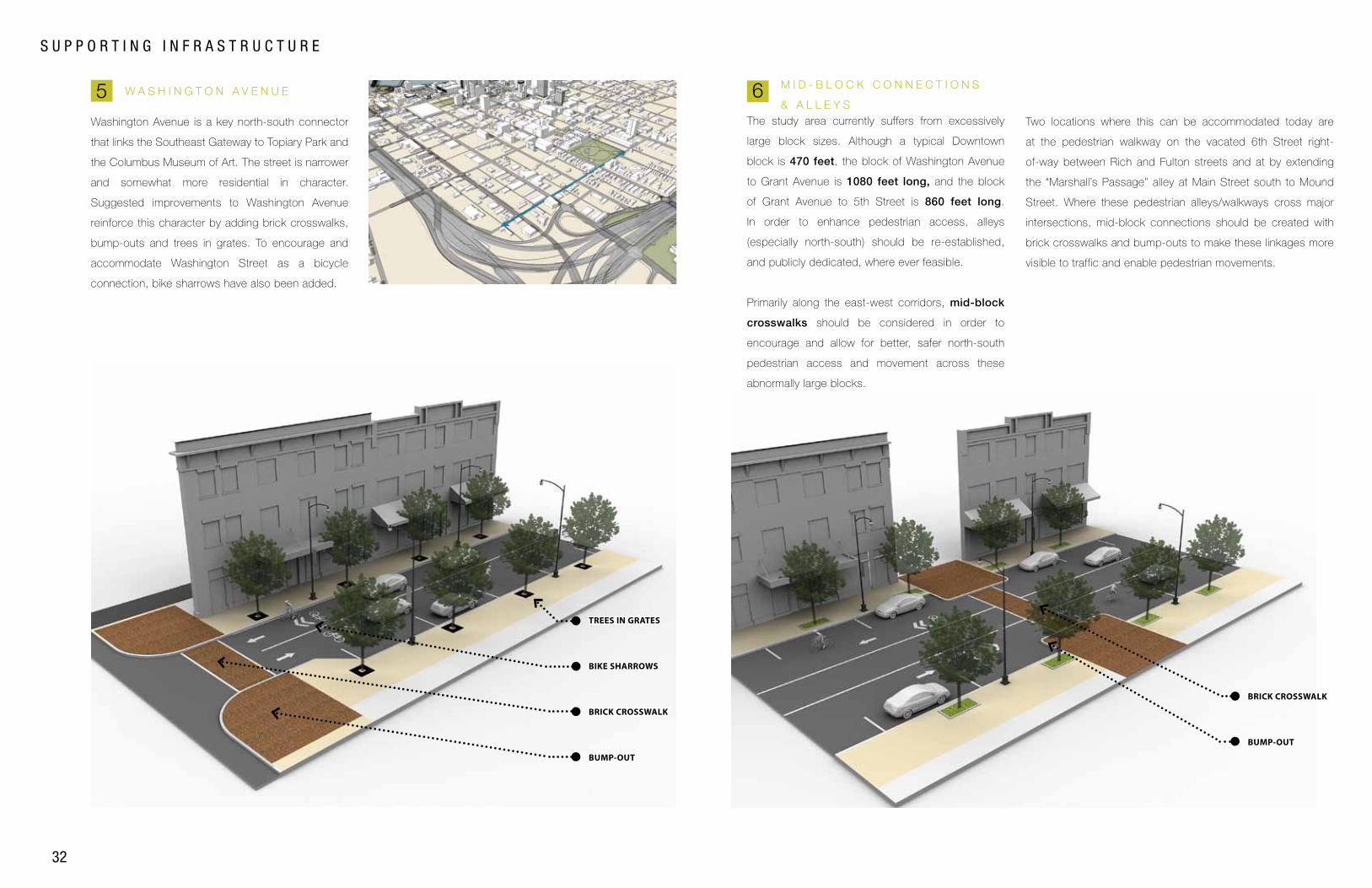
S U P P O R T I N G I N F R A S T R U C T U R E
M I D - B L O C K C O N N E C T I O N S
& A L L E Y S
M i d - B l o c k C o n n e c t i o n s
6 The study area currently suffers from excessively
large block sizes. Although a typical Downtown
block is 470 feet, the block of Washington Avenue
to Grant Avenue is 1080 feet long, and the block
of Grant Avenue to 5th Street is 860 feet long.
In order to enhance pedestrian access, alleys
(especially north-south) should be re-established,
and publicly dedicated, where ever feasible.
Primarily along the east-west corridors, mid-block
crosswalks should be considered in order to
encourage and allow for better, safer north-south
pedestrian access and movement across these
abnormally large blocks.
Two locations where this can be accommodated today are
at the pedestrian walkway on the vacated 6th Street right-
of-way between Rich and Fulton streets and at by extending
the “Marshall’s Passage” alley at Main Street south to Mound
Street. Where these pedestrian alleys/walkways cross major
intersections, mid-block connections should be created with
brick crosswalks and bump-outs to make these linkages more
visible to traffic and enable pedestrian movements.
W A S H I N G T O N A V E N U E
Washington Avenue is a key north-south connector
that links the Southeast Gateway to Topiary Park and
the Columbus Museum of Art. The street is narrower
and somewhat more residential in character.
Suggested improvements to Washington Avenue
reinforce this character by adding brick crosswalks,
bump-outs and trees in grates. To encourage and
accommodate Washington Street as a bicycle
connection, bike sharrows have also been added.
5
BUMP-OUT
BRICK CROSSWALK
BIKE SHARROWS
TREES IN GRATES
BUMP-OUT
BRICK CROSSWALK
SU
PP
OR
TIN
G I
NF
RA
ST
RU
CT
UR
E
33
SO
UT
HE
AS
T G
AT
EW
AY
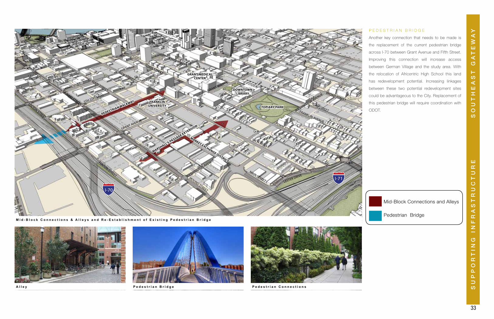
Pedestrian Bridge
Mid-Block Connections and Alleys
FULTON STREET
MOUND STREET
MAIN STREET
FRANKLIN UNIVERSITY TOPIARY PARK
GRANT MEDICAL CENTER
MARKET EXCHANGE DISTRICT
DOWNTOWN LIBRARY
RICH STREET
3RD STREET
4TH STREET
5TH STREET
GRANT AVENUE
WASHINGTON AVENUE
LESTER DRIVE
TOWN STREET
STATE STREET
BROAD STREET
MOUND STREET
MAIN STREET
RICH STREET
TOWN STREET
FULTON STREET
WASHINGTON AVENUEGRANT AVENUE
FRANKLIN AVENUE
OAK STREET
I-70
I-71
A l l e y P e d e s t r i a n B r i d g e P e d e s t r i a n C o n n e c t i o n s
M i d - B l o c k C o n n e c t i o n s & A l l e y s a n d R e - E s t a b l i s h m e n t o f E x i s t i n g P e d e s t r i a n B r i d g e
Another key connection that needs to be made is
the replacement of the current pedestrian bridge
across I-70 between Grant Avenue and Fifth Street.
Improving this connection will increase access
between German Village and the study area. With
the relocation of Africentric High School this land
has redevelopment potential. Increasing linkages
between these two potential redevelopment sites
could be advantageous to the City. Replacement of
this pedestrian bridge will require coordination with
ODOT.
P E D E S T R I A N B R I D G E
PEDESTRIAN WALKWAY
MARSHALL’S PASSAGE EXTENSION
34
S U P P O R T I N G I N F R A S T R U C T U R E
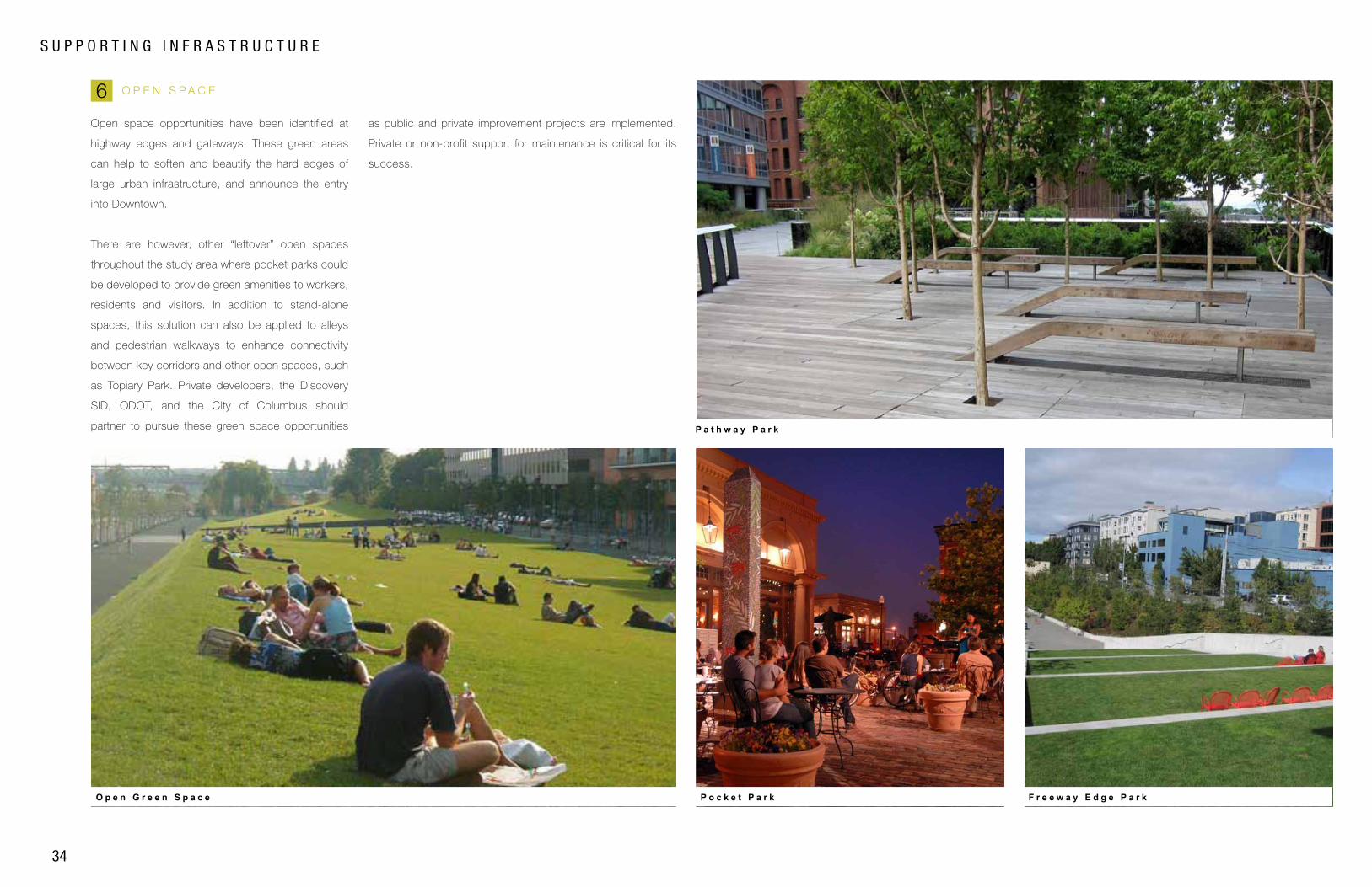
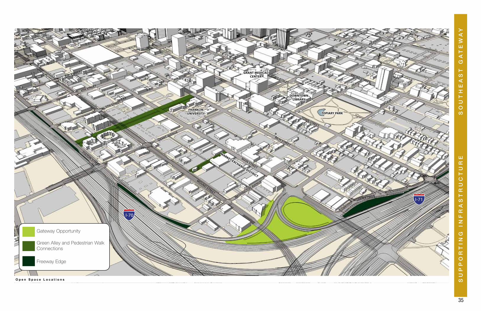
O P E N S P A C E
F r e e w a y E d g e P a r kP o c k e t P a r kO p e n G r e e n S p a c e
P a t h w a y P a r k
6 Open space opportunities have been identified at
highway edges and gateways. These green areas
can help to soften and beautify the hard edges of
large urban infrastructure, and announce the entry
into Downtown.
There are however, other “leftover” open spaces
throughout the study area where pocket parks could
be developed to provide green amenities to workers,
residents and visitors. In addition to stand-alone
spaces, this solution can also be applied to alleys
and pedestrian walkways to enhance connectivity
between key corridors and other open spaces, such
as Topiary Park. Private developers, the Discovery
SID, ODOT, and the City of Columbus should
partner to pursue these green space opportunities
as public and private improvement projects are implemented.
Private or non-profit support for maintenance is critical for its
success.
SU
PP
OR
TIN
G I
NF
RA
ST
RU
CT
UR
E
35
SO
UT
HE
AS
T G
AT
EW
AY
FULTON STREET
MOUND STREET
MAIN STREET
FRANKLIN UNIVERSITY TOPIARY PARK
GRANT MEDICAL CENTER
MARKET EXCHANGE DISTRICT
DOWNTOWN LIBRARY
RICH STREET
3RD STREET
4TH STREET
5TH STREET
GRANT AVENUE
WASHINGTON AVENUE
LESTER DRIVE
TOWN STREET
STATE STREET
BROAD STREET
O p e n S p a c e L o c a t i o n s
I-70
I-71
Gateway Opportunity
Freeway Edge
Green Alley and Pedestrian Walk Connections
36
S U P P O R T I N G I N F R A S T R U C T U R E
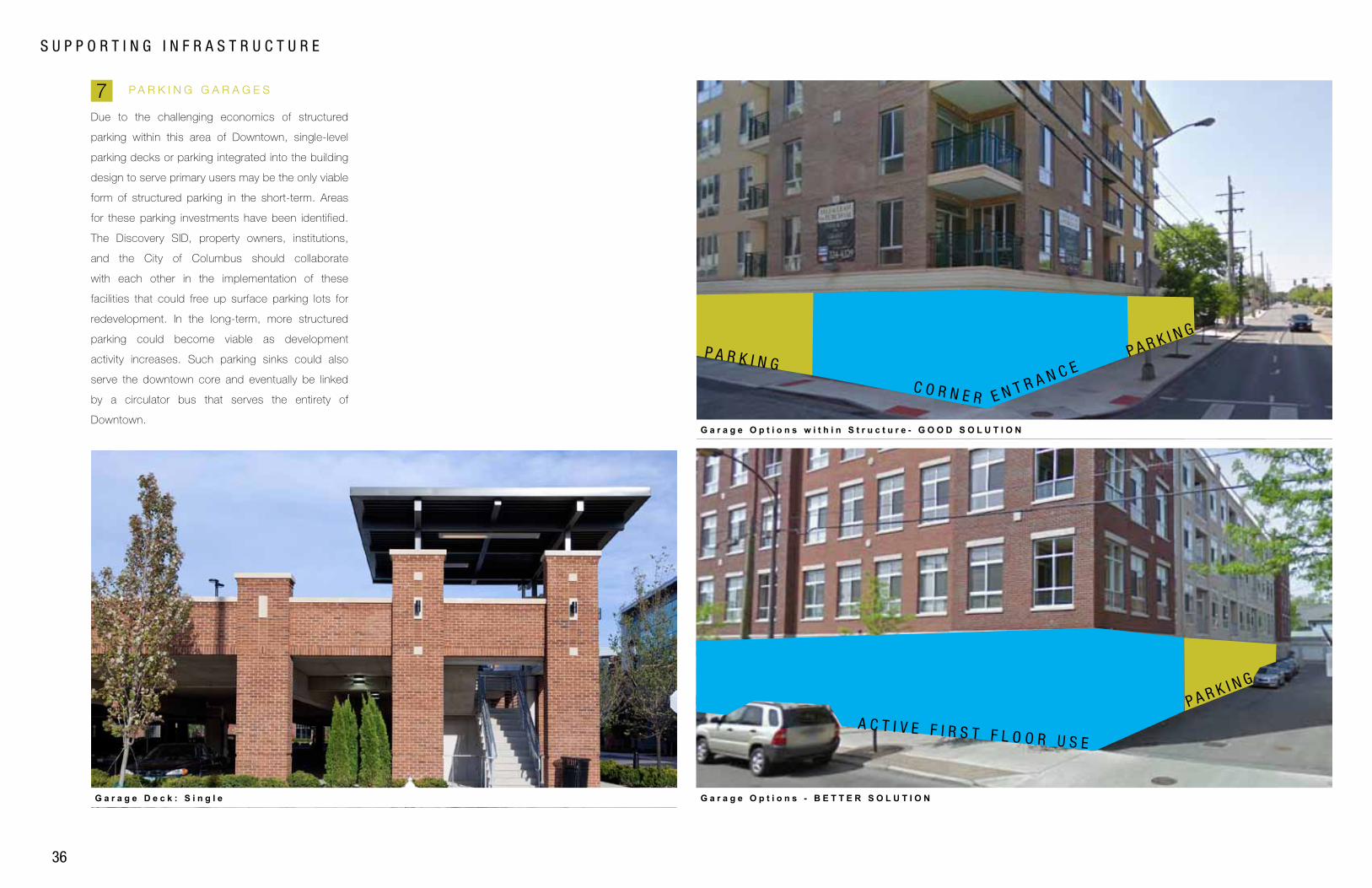
P A R K I N G G A R A G E S
G a r a g e O p t i o n s w i t h i n S t r u c t u r e - G O O D S O L U T I O N
G a r a g e O p t i o n s - B E T T E R S O L U T I O NG a r a g e D e c k : S i n g l e
A C T I V E F I R S T F L O O R U S E
P A R K I N G
P A R K I N G
E N T R A N C EP A R K I N G
C O R N E R
7 Due to the challenging economics of structured
parking within this area of Downtown, single-level
parking decks or parking integrated into the building
design to serve primary users may be the only viable
form of structured parking in the short-term. Areas
for these parking investments have been identified.
The Discovery SID, property owners, institutions,
and the City of Columbus should collaborate
with each other in the implementation of these
facilities that could free up surface parking lots for
redevelopment. In the long-term, more structured
parking could become viable as development
activity increases. Such parking sinks could also
serve the downtown core and eventually be linked
by a circulator bus that serves the entirety of
Downtown.
SU
PP
OR
TIN
G I
NF
RA
ST
RU
CT
UR
E
37
SO
UT
HE
AS
T G
AT
EW
AY
FULTON STREET
MOUND STREET
MAIN STREET
FRANKLIN UNIVERSITY TOPIARY PARK
GRANT MEDICAL CENTER
MARKET EXCHANGE DISTRICT
DOWNTOWN LIBRARY
RICH STREET
3RD STREET
4TH STREET
5TH STREET
GRANT AVENUE
WASHINGTON AVENUE
LESTER DRIVE
TOWN STREET
STATE STREET
BROAD STREET
P o t e n t i a l P a r k i n g G a r a g e L o c a t i o n s t h a t S e r v e M u l t i p l e U s e r s
I-70
I-71
Potential Parking Garage Locations

39
O P P O R T U N I T Y A R E A S
OP
PO
RT
UN
ITY
AR
EA
SS
OU
TH
EA
ST
GA
TE
WA
Y
40
MOUND STREET
MAIN STREET
FRANKLIN UNIVERSITY TOPIARY PARK
GRANT MEDICAL CENTER
MARKET EXCHANGE DISTRICT
DOWNTOWN LIBRARY
RICH STREETGRANT AVENUE
WASHINGTON AVENUE
LESTER DRIVE
TOWN STREET
STATE STREET
BROAD STREET
G A T E W A Y A R E A
R I C H S T R E E T
G R I D
R I C H S T R E E T I N F I L L
I N T R O D U C T I O N
O P P O R T U N I T Y A R E A S
O p p o r t u n i t y A r e a s
G A T E W A Y A R E A1
1
3
2
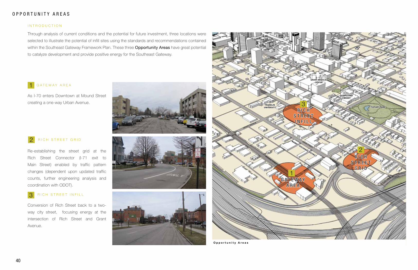
Through analysis of current conditions and the potential for future investment, three locations were
selected to illustrate the potential of infill sites using the standards and recommendations contained
within the Southeast Gateway Framework Plan. These three Opportunity Areas have great potential
to catalyze development and provide positive energy for the Southeast Gateway.
As I-70 enters Downtown at Mound Street
creating a one-way Urban Avenue.
Re-establishing the street grid at the
Rich Street Connector (I-71 exit to
Main Street) enabled by traffic pattern
changes (dependent upon updated traffic
counts, further engineering analysis and
coordination with ODOT).
Conversion of Rich Street back to a two-
way city street, focusing energy at the
intersection of Rich Street and Grant
Avenue.
R I C H S T R E E T G R I D
R I C H S T R E E T I N F I L L3
2
OP
PO
RT
UN
ITY
AR
EA
S
41
SO
UT
HE
AS
T G
AT
EW
AYG A T E W A Y A R E A
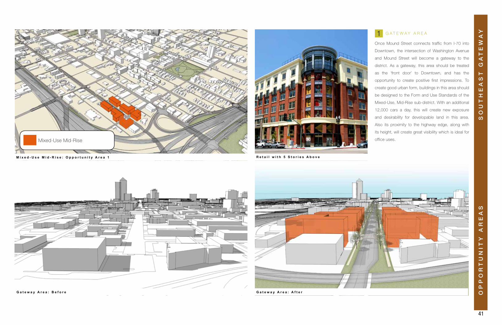
Once Mound Street connects traffic from I-70 into
Downtown, the intersection of Washington Avenue
and Mound Street will become a gateway to the
district. As a gateway, this area should be treated
as the ‘front door’ to Downtown, and has the
opportunity to create positive first impressions. To
create good urban form, buildings in this area should
be designed to the Form and Use Standards of the
Mixed-Use, Mid-Rise sub-district. With an additional
12,000 cars a day, this will create new exposure
and desirability for developable land in this area.
Also its proximity to the highway edge, along with
its height, will create great visibility which is ideal for
office uses.
G a t e w a y A r e a : A f t e rG a t e w a y A r e a : B e f o r e
M i x e d - U s e M i d - R i s e : O p p o r t u n i t y A r e a 1 R e t a i l w i t h 5 S t o r i e s A b o v e
1
Mixed-Use Mid-Rise
42
O P P O R T U N I T Y A R E A S
R I C H S T R E E T G R I D
R i c h S t r e e t G r i d : A f t e rR i c h S t r e e t G r i d : B e f o r e
M i x e d - U s e L o w - R i s e a n d R e s i d e n t i a l N e i g h b o r h o o d : O p p o r t u n i t y A r e a 2R e s i d e n t i a l 3 S t o r i e s
2
Mixed-Use Low-Rise
Residential Neighborhood
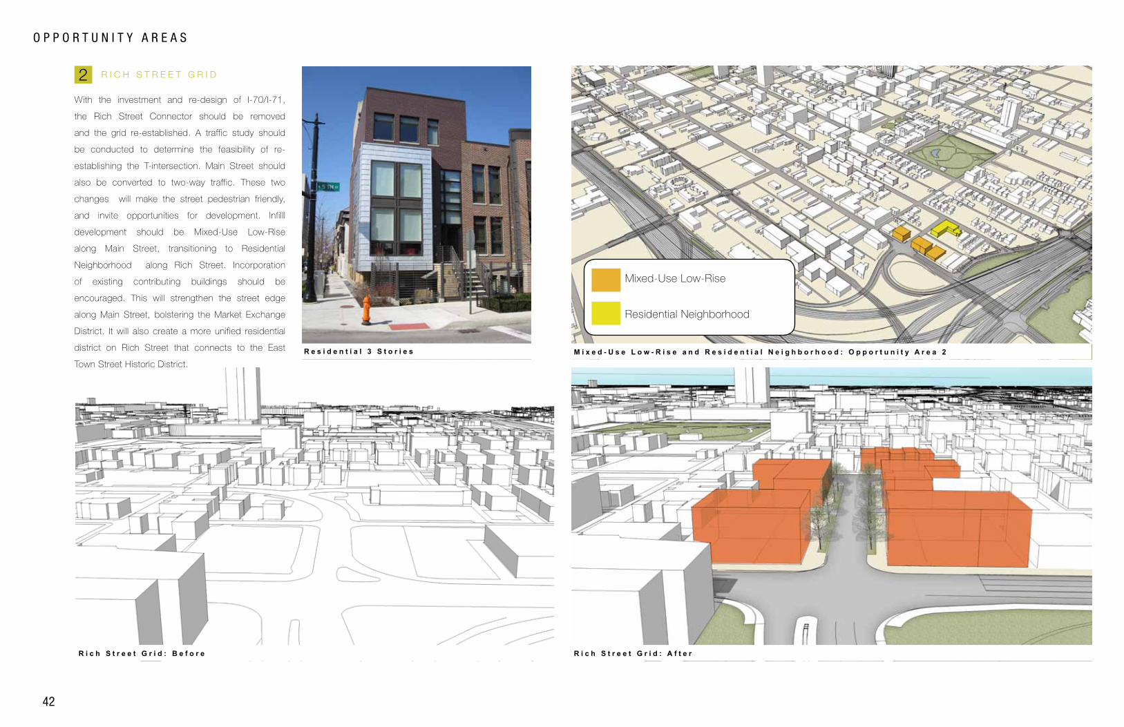
With the investment and re-design of I-70/I-71,
the Rich Street Connector should be removed
and the grid re-established. A traffic study should
be conducted to determine the feasibility of re-
establishing the T-intersection. Main Street should
also be converted to two-way traffic. These two
changes will make the street pedestrian friendly,
and invite opportunities for development. Infilll
development should be Mixed-Use Low-Rise
along Main Street, transitioning to Residential
Neighborhood along Rich Street. Incorporation
of existing contributing buildings should be
encouraged. This will strengthen the street edge
along Main Street, bolstering the Market Exchange
District. It will also create a more unified residential
district on Rich Street that connects to the East
Town Street Historic District.
OP
PO
RT
UN
ITY
AR
EA
S
43
SO
UT
HE
AS
T G
AT
EW
AYR I C H S T R E E T I N F I L L
R i c h S t r e e t I n f i l l : A f t e rR i c h S t r e e t I n f i l l : B e f o r e
M i x e d - U s e M i d - R i s e : O p p o r t u n i t y A r e a 3 R e t a i l w i t h 3 S t o r i e s A b o v e
3
Mixed-Use Low-Rise
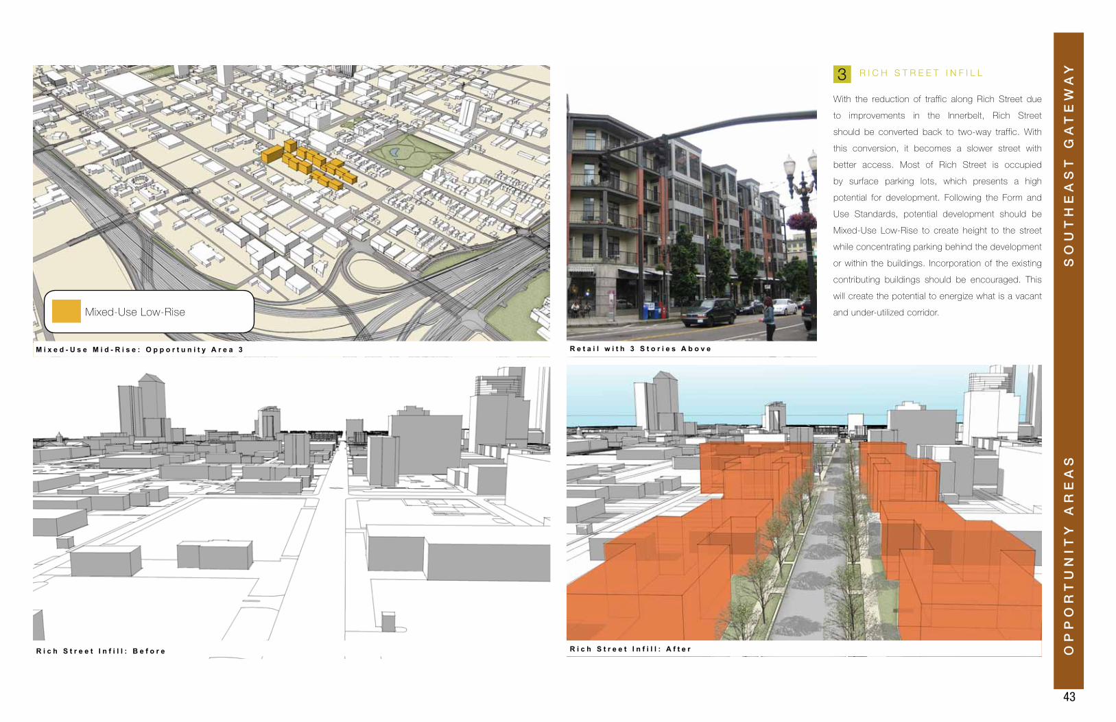
With the reduction of traffic along Rich Street due
to improvements in the Innerbelt, Rich Street
should be converted back to two-way traffic. With
this conversion, it becomes a slower street with
better access. Most of Rich Street is occupied
by surface parking lots, which presents a high
potential for development. Following the Form and
Use Standards, potential development should be
Mixed-Use Low-Rise to create height to the street
while concentrating parking behind the development
or within the buildings. Incorporation of the existing
contributing buildings should be encouraged. This
will create the potential to energize what is a vacant
and under-utilized corridor.

44

45
N E X T S T E P S
NE
XT
ST
EP
SS
OU
TH
EA
ST
GA
TE
WA
Y
46
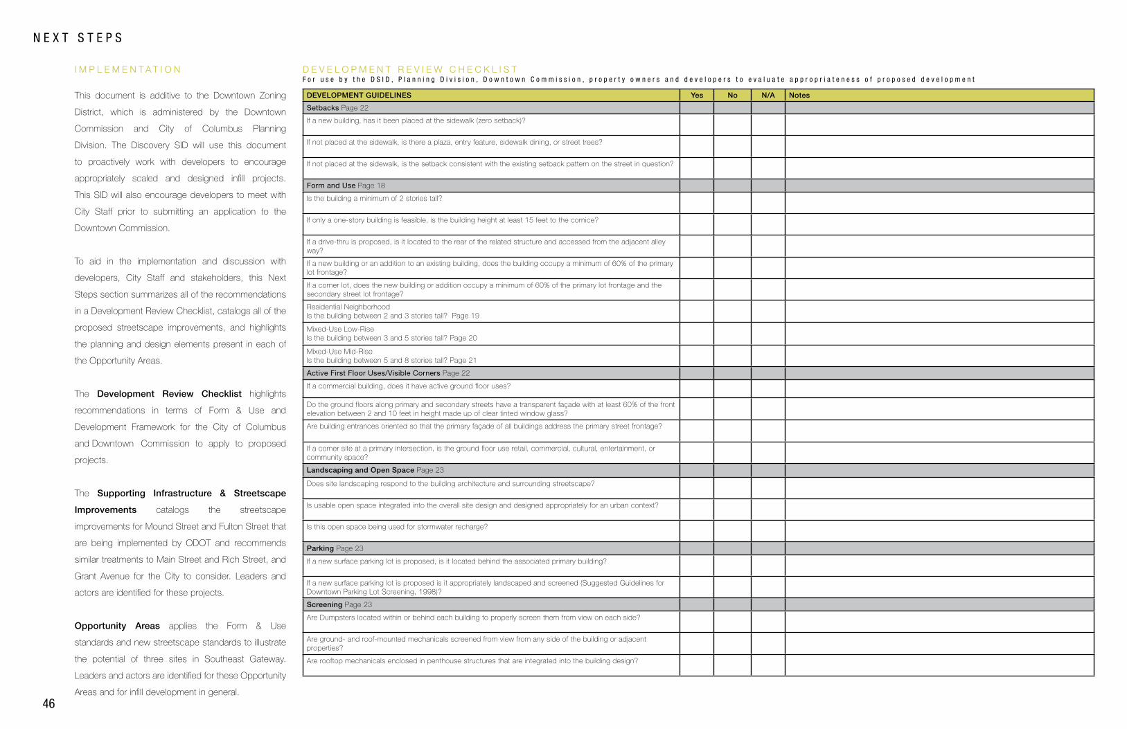
N E X T S T E P S
I M P L E M E N T A T I O N D E V E L O P M E N T R E V I E W C H E C K L I S TF o r u s e b y t h e D S I D , P l a n n i n g D i v i s i o n , D o w n t o w n C o m m i s s i o n , p r o p e r t y o w n e r s a n d d e v e l o p e r s t o e v a l u a t e a p p r o p r i a t e n e s s o f p r o p o s e d d e v e l o p m e n t
DEVELOPMENT GUIDELINES Yes No N/A Notes
Setbacks Page 22
If a new building, has it been placed at the sidewalk (zero setback)?
If not placed at the sidewalk, is there a plaza, entry feature, sidewalk dining, or street trees?
If not placed at the sidewalk, is the setback consistent with the existing setback pattern on the street in question?
Form and Use Page 18
Is the building a minimum of 2 stories tall?
If only a one-story building is feasible, is the building height at least 15 feet to the cornice?
If a drive-thru is proposed, is it located to the rear of the related structure and accessed from the adjacent alley way?
If a new building or an addition to an existing building, does the building occupy a minimum of 60% of the primary lot frontage?
If a corner lot, does the new building or addition occupy a minimum of 60% of the primary lot frontage and the secondary street lot frontage?
Residential Neighborhood Is the building between 2 and 3 stories tall? Page 19
Mixed-Use Low-Rise Is the building between 3 and 5 stories tall? Page 20
Mixed-Use Mid-RiseIs the building between 5 and 8 stories tall? Page 21
Active First Floor Uses/Visible Corners Page 22
If a commercial building, does it have active ground floor uses?
Do the ground floors along primary and secondary streets have a transparent façade with at least 60% of the front elevation between 2 and 10 feet in height made up of clear tinted window glass?
Are building entrances oriented so that the primary façade of all buildings address the primary street frontage?
If a corner site at a primary intersection, is the ground floor use retail, commercial, cultural, entertainment, or community space?
Landscaping and Open Space Page 23
Does site landscaping respond to the building architecture and surrounding streetscape?
Is usable open space integrated into the overall site design and designed appropriately for an urban context?
Is this open space being used for stormwater recharge?
Parking Page 23
If a new surface parking lot is proposed, is it located behind the associated primary building?
If a new surface parking lot is proposed is it appropriately landscaped and screened (Suggested Guidelines for Downtown Parking Lot Screening, 1998)?
Screening Page 23
Are Dumpsters located within or behind each building to properly screen them from view on each side?
Are ground- and roof-mounted mechanicals screened from view from any side of the building or adjacent properties?
Are rooftop mechanicals enclosed in penthouse structures that are integrated into the building design?
This document is additive to the Downtown Zoning
District, which is administered by the Downtown
Commission and City of Columbus Planning
Division. The Discovery SID will use this document
to proactively work with developers to encourage
appropriately scaled and designed infill projects.
This SID will also encourage developers to meet with
City Staff prior to submitting an application to the
Downtown Commission.
To aid in the implementation and discussion with
developers, City Staff and stakeholders, this Next
Steps section summarizes all of the recommendations
in a Development Review Checklist, catalogs all of the
proposed streetscape improvements, and highlights
the planning and design elements present in each of
the Opportunity Areas.
The Development Review Checklist highlights
recommendations in terms of Form & Use and
Development Framework for the City of Columbus
and Downtown Commission to apply to proposed
projects.
The Supporting Infrastructure & Streetscape
Improvements catalogs the streetscape
improvements for Mound Street and Fulton Street that
are being implemented by ODOT and recommends
similar treatments to Main Street and Rich Street, and
Grant Avenue for the City to consider. Leaders and
actors are identified for these projects.
Opportunity Areas applies the Form & Use
standards and new streetscape standards to illustrate
the potential of three sites in Southeast Gateway.
Leaders and actors are identified for these Opportunity
Areas and for infill development in general.
47
NE
XT
ST
EP
SS
OU
TH
EA
ST
GA
TE
WA
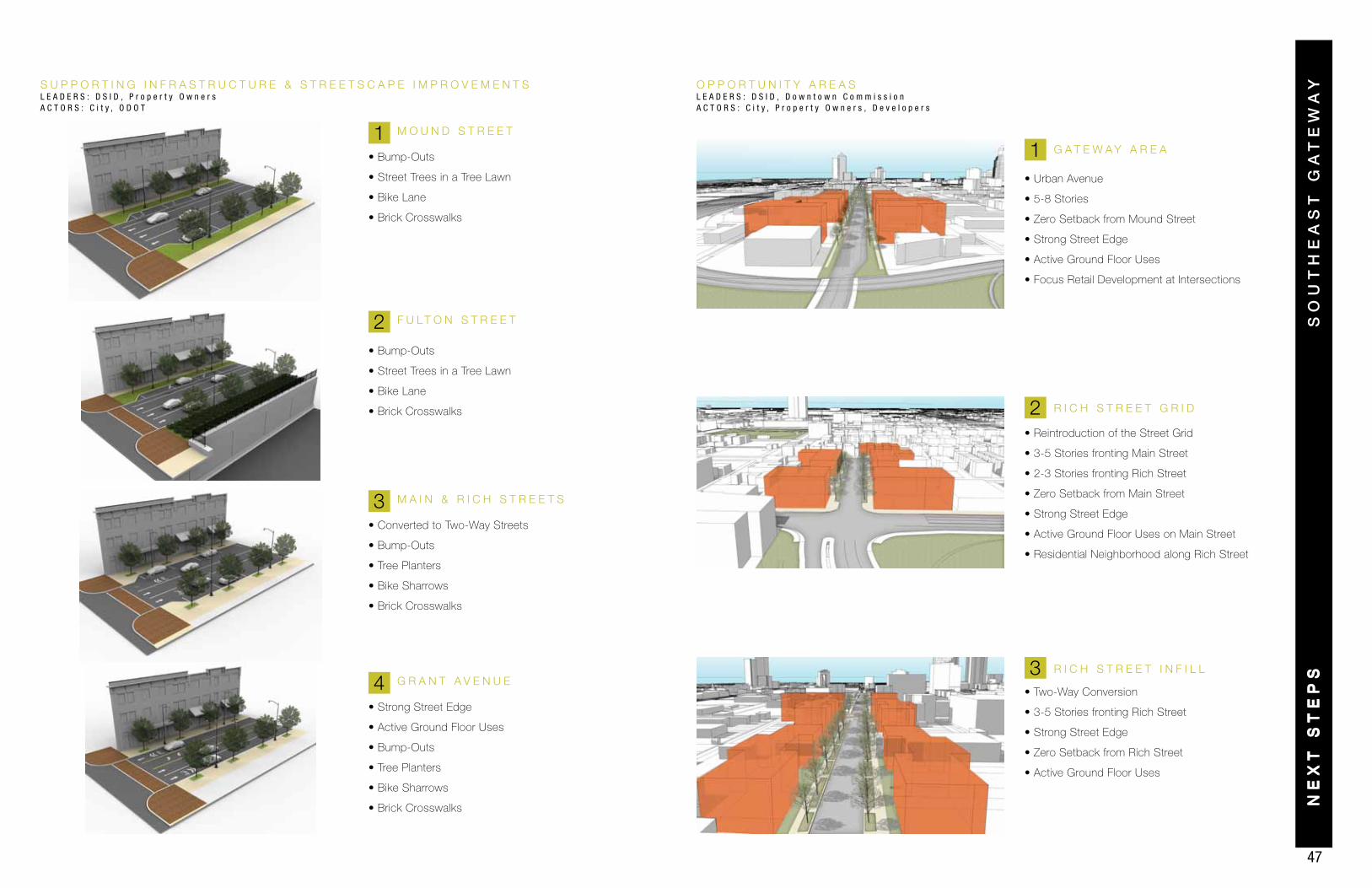
YS U P P O R T I N G I N F R A S T R U C T U R E & S T R E E T S C A P E I M P R O V E M E N T SL E A D E R S : D S I D , P r o p e r t y O w n e r sA C T O R S : C i t y , O D O T
O P P O R T U N I T Y A R E A SL E A D E R S : D S I D , D o w n t o w n C o m m i s s i o nA C T O R S : C i t y , P r o p e r t y O w n e r s , D e v e l o p e r s
NE
XT
ST
EP
S
M O U N D S T R E E T
• Bump-Outs
• Street Trees in a Tree Lawn
• Bike Lane
• Brick Crosswalks
• Bump-Outs
• Street Trees in a Tree Lawn
• Bike Lane
• Brick Crosswalks
F U L T O N S T R E E T
M A I N & R I C H S T R E E T S
• Converted to Two-Way Streets
• Bump-Outs
• Tree Planters
• Bike Sharrows
• Brick Crosswalks
G R A N T A V E N U E
• Strong Street Edge
• Active Ground Floor Uses
• Bump-Outs
• Tree Planters
• Bike Sharrows
• Brick Crosswalks
• Two-Way Conversion
• 3-5 Stories fronting Rich Street
• Strong Street Edge
• Zero Setback from Rich Street
• Active Ground Floor Uses
• Reintroduction of the Street Grid
• 3-5 Stories fronting Main Street
• 2-3 Stories fronting Rich Street
• Zero Setback from Main Street
• Strong Street Edge
• Active Ground Floor Uses on Main Street
• Residential Neighborhood along Rich Street
• Urban Avenue
• 5-8 Stories
• Zero Setback from Mound Street
• Strong Street Edge
• Active Ground Floor Uses
• Focus Retail Development at Intersections
1
3
2
2
1
4 3
R I C H S T R E E T G R I D
R I C H S T R E E T I N F I L L
G A T E W A Y A R E A
Recommended