Southbank and Fishermans Bend
Heritage Review Prepared for the City of Melbourne
23 June 2017

Southbank and Fishermans Bend Heritage Review
© Biosis 2017 – Leaders in Ecology and Heritage Consulting 326
Appendix 3 Citations for proposed new heritage places

Southbank and Fishermans Bend Heritage Review
Biosis Pty Ltd, Graeme Butler & Associates 2017: Appendix 3: 327
Contents
Bolte Bridge City Link, Port Melbourne .......................................................................................... 329
New St John’s Lutheran Church, 20 City Road, Southbank ........................................................... 335
G. P. Motors, Pty Ltd, 35-41 City Road, Southbank ........................................................................ 340
Crown Chemicals, Anderson & Sons printing works, 63-65 City Road, Southbank ..................... 347
Kosky Bros. Pty Ltd, furriers, 67-69 City Road, Southbank ............................................................ 354
Maurice Artaud & Co., 71-75 City Road, Southbank ...................................................................... 360
Spencer Street Bridge, Clarendon Street, Southbank ................................................................... 365
Eckersley & Sons soda fountain works, 93-103 Clarendon Street, Southbank ............................ 374
Melbourne and Metropolitan Tramways Board electricity substation 'S', 67-69 Clarke Street,
Southbank ........................................................................................................................................ 379
Thornycroft (Aust) Ltd, later Herald Sun television studio, 49-61 Coventry Street, Southbank . 383
William, M. & Thomas Anderson Factory, later Lanes Motors service department, 52-66 Dorcas
Street, Southbank ............................................................................................................................ 389
Vault sculpture, Grant & Dodds streets, Southbank ..................................................................... 395
Austral Otis engineering works, later Regent House, 63 Kings Way, Southbank ........................ 400
Kings Way Bridge Kings Way, Southbank ....................................................................................... 405
Government Aircraft Factory (GAF) Boeing, 226 Lorimer Street, Port Melbourne ...................... 417
Commonwealth Aircraft Corporation (CAC), 226 Lorimer Street, Port Melbourne ..................... 423
Aeronautical Research Laboratories Department of Defence, 502-550 Lorimer Street, Port
Melbourne ........................................................................................................................................ 428
Queens Bridge Hotel, 1-7 Queens Bridge Street, Southbank ....................................................... 432
Robur Tea Company factory/warehouse. 107-127 Queens Bridge Street, Southbank. .............. 437
Castlemaine Brewery complex with brewing tower and bottling stores adjoining, 107-127, 129-
131 and 133 Queens Bridge Street, Southbank ............................................................................. 444
Kraft factory, 162 Salmon Street (Vegemite Way), Port Melbourne ............................................. 458
SEC electricity substation, 224 Salmon Street, Port Melbourne ................................................... 462
General Motors Holden Nos. 3 & 5 plants, 241 Salmon Street, Port Melbourne ........................ 466
General Motors Holden engine and manufacturing plant, 241 Salmon Street (61-85 Cook Street),
Port Melbourne ................................................................................................................................ 472
General Motors Holden Social Centre, 241 Salmon Street (Caprice Avenue, Port Melbourne .. 477
General Motors Holden head office administration buildings, 251 Salmon Street, Port Melbourne .......................................................................................................................................................... 482
General Motors Holden administration building, 261 Salmon Street, Port Melbourne ............. 487
St Kilda Road Boulevard .................................................................................................................. 492
Repatriation Commission Outpatients Clinic, part of Victoria Barracks, 256-310 St Kilda Road,
Southbank ........................................................................................................................................ 498

Southbank and Fishermans Bend Heritage Review
Biosis Pty Ltd, Graeme Butler & Associates 2017: Appendix 3 328
Victoria Barracks, 256-310 St Kilda Road, Southbank .................................................................... 505
General Post Office (GPO) garage, stores & workshops, 45-99 Sturt Street, Southbank ............ 514
Commonwealth Artificial Limb Factory, 242-246 Sturt Street, Southbank .................................. 526
West Gate Bridge, West Gate Freeway, Port Melbourne ............................................................... 530
Electricity substations group, Southbank ....................................................................................... 542
Bluestone-pitched laneways group, Southbank ............................................................................ 550

Southbank and Fishermans Bend Heritage Review
Biosis Pty Ltd, Graeme Butler & Associates 2017: Appendix 3 329
Bolte Bridge City Link, Port Melbourne
City of Melbourne property number:
Type of place: bridge
Images of place 2016-2017
Historical associations:
Creation or major development date(s) of place: 1996-1999, Post-WW2
Major owners or occupiers: Victorian Government
Designer: Denton Corker Marshall
Heritage Gradings:
Proposed new system (C258):
Individually significant
Alphanumeric system (building A-E, streetscape 1-3):
Existing: Proposed: A3
Heritage values:
Aesthetic, Historical, Scientific
Heritage status:
Heritage Overlay: Proposed
Thematic context:
3.2 Expressing an architectural style
6.7 Transport

Southbank and Fishermans Bend Heritage Review
Biosis Pty Ltd, Graeme Butler & Associates 2017: Appendix 3 330
15.2 Raising monuments
Boundary of heritage place
Description
The Western Link and Bolte Bridge comprise a 4.6 kilometers elevated road with separate
parallel three-lane carriageways consisting of post-tensioned precast segmental box girders on
cylindrical reinforced concrete piers. The match-cast segmental box girder superstructures are
continuous over several spans. Much of the elevated roadway is built on compound curved
alignment. A distinctive elliptical three-pin arch sound tube encloses the elevated roadway for
300 metres near the northern end, providing noise protection to adjacent Flemington high-rise
housing commission estate.
The Bolte Bridge over the Yarra River at the Victoria Dock (now renamed Victoria Harbour)
entrance is a post-tensioned balanced cantilever variable-depth box girder structure with larger
tapered span sections cantilevered from a central pier, and smaller tapered sections cantilevered
from the two side piers, forming two central spans of 173 metres each and two 72-metre side
spans. The Bolte Bridge superstructure consists of twin parallel concrete box girders, each
carrying three lanes of traffic. The box girders are 12 metres deep at the centre pier with the
depth reducing to a slender 3.5 metres at mid-span. Twin hollow 140-metre tall concrete towers
flank the central pier as decorative landmark element of the design. The bridge clearance over
the river is 25 metres.
Interchanges are provided at the West Gate Freeway, Footscray Road, Dynon Road, Racecourse
Road and Mt Alexander Road. The elevated roadway crosses Moonee Ponds Creek four times
and several other roads, as well as running above the Upfield Railway line for about a kilometre.
The elevated roadway section incorporates 100 spans designed as a match cast segmental span
construction. A chloride-free super plasticising admixture, Rheobuild 1000, was incorporated
into the concrete mix to ensure that the concrete used in the precast segments met the required

Southbank and Fishermans Bend Heritage Review
Biosis Pty Ltd, Graeme Butler & Associates 2017: Appendix 3 331
design specifications. Each of the elevated roadway's spans measure about 45 metres in length,
and consists of 13 precast reinforced concrete segments weighing between 45 and 80 tonnes
each.
History
Planning for a western bypass of the Melbourne CBD was first considered in the 1929 Melbourne
Metropolitan Plan, and renewed in the 1954 Melbourne Metropolitan Board of Works (MMBW)
plan. However, these both considered using existing roads such as Cowper Street in West
Melbourne and Boundary Road in North Melbourne for the required route.
Both the Southern and Western CBD bypasses were placed more firmly on the drawing board in
the 1969 Melbourne Transport Plan (Metropolitan Transportation Committee, 1969) which
recommended an extensive freeway network across Melbourne to address projected rising
traffic volumes. Although much of this network was officially abandoned by the Hamer
government in the mid-1970s, this did not include the Southern and Western Bypasses.
In 1991, the Southern and Western Bypasses emerged again, in the State government’s
guidelines on private investment in public infrastructure, as a single-entity potential private
sector project. In addition, the federal government's tax concessions for private construction of
public infrastructure – part of its Working Nation package – made the project financially feasible
in a way that it had not been previously.
The Victorian State Government under Premier Kirner called for expressions of interest to
construct the Southern and Western Bypasses in March 1992, and in June 1992 the Minister for
Planning and Housing directed that an Environment Effects Statement be prepared. Despite
community opposition to both the expansion of the freeway system and the form of privatised
public roads, the project was awarded to a consortium of local and overseas firms under the
joint venture ‘Transfield Obayashi’. Baulderstone Hornibrook were engaged for the construction
of the five-kilometre elevated roadway and the new Yarra River bridge. The engineers for the
match cast structure, including David Jellie of RMIT, had presented a paper on the design to a
European engineering conference.
Denton Corker Marshall contributed design elements in the form of the non-functional paired
towers and surface treatments, creating a visual treatment they described as, ‘...two simple
gestures: a blade leaping across the river, and two slender silver sticks, 120 metres high, marking
the centre point and proclaiming the presence of the bridge across the city.’ The project won the
1999 Royal Australian Institute of Architects (RAIA) National Special Jury Award for the Most
Outstanding Works of Architecture, as well as the 1999 RAIA Victorian Chapter – Commendation
Urban Design.
Pre-casting of the 3,500 individual segments required for the superstructures was carried out at
purpose-built Baulderstone Hornibrook facility at North Laverton, with an additional 45-metre
span of 13-15 segments being erected every day and a half during the peak of construction in
late-1997.
The pre-cast facility comprised 14 moulds aligned in bays, such that each mould would cast a 65-
tonne, three-lane wide trapezoidal bridge unit against the previously cast unit, that is, against the
same unit which it would be connected to in its final erected state, hence the term 'match cast'.
Each mould was producing one complete unit per day, so the 14 moulds could manufacture 14
units daily. The units were delivered by road to site as required by the erection schedule (there
being no room for storage at the bridge site). Onsite they were lifted directly onto the erection
trusses and reunited with the matched neighbouring segments. As each span was erected, post-
tensioning cables were reeved through the segments and then loaded by means of hydraulic

Southbank and Fishermans Bend Heritage Review
Biosis Pty Ltd, Graeme Butler & Associates 2017: Appendix 3 332
jacks. Once each span was free-standing, the steel erection trusses were launched forward to the
next pier position. An average cycle time for this operation of two days per span was achieved
for each of two pairs of erection trusses.
The overall cost of the project was put at $2 billion, including $75 million for the Bolte Bridge
itself.
Comparative analysis
Few road construction projects have has as much impact on the development of Melbourne as
the City Link, with the Bolte Bridge transforming vehicle movement around the city.
The southern bypass (formerly the West Gate Freeway) through Melbourne’s south is a similarly
large-scaled, elevated roadway, and sections of the Monash Freeway (formerly the South Eastern
Freeway) are comparably-large elevated structures. However, the West Gate Bridge is the only
structure in Victoria that can compare in scale to the Bolte Bridge.
Other claimants for the longest bridge in Australia are the Houghton Highway north of Brisbane
(2.7 kilometres), Sheehan and Prince Albert bridges at Gundagai (1.14 and 0.92 kilometres
respectively), Silver Link Bridge over the Burdekin River, the Algebuckina railway bridge in South
Australia and Hornibrook Bridge in Brisbane.
Structurally, it compares with the smaller bridges of similar cantilevered, tapered box girder
designs including the 1986 Mooney Mooney Bridge in Brisbane Waters National Park and
Gateway bridges in Brisbane.
Statement of Significance
What is significant?
The Bolte Bridge & Western Link Elevated Tollway is a pre-stressed concrete road bridge with
post-tensioned precast segmental box girders. It was designed by Egis Consulting & Hyder
Consulting Ltd and was built by Baulderstone Hornibrook Engineering Pty Ltd for Transurban
City Link between 1996 and 1999.
How is it significant?
The Bolte Bridge & Western Link Elevated Tollway is significant for scientific (technical), historic,
social and aesthetic reasons at a state level.
Why is it significant?
The Bolte Bridge & Western Link Elevated Tollway is of State significance as one of the largest
and longest bridges in Victoria which employed important innovative design and construction
techniques and drastically altered the transport and planning configuration of Melbourne.
(Criterion A)
The bridge is of historical significance for the role it played in Melbourne planning, and in
particular its construction amidst competing arguments between public transport and freeway
development. It was the first major crossing of the lower Yarra River since the West Gate Bridge
was built, and completed the isolation of the historic Port of Melbourne (the river wharves and
Victoria Dock) from access for large shipping. The Western Link Elevated Freeway completed a
road route proposed as early as the 1954 Melbourne Strategy Plan, although the specific route
through the former docklands was the result of the Roads and Traffic Authority west link
planning of the 1990s. (Criterion A)

Southbank and Fishermans Bend Heritage Review
Biosis Pty Ltd, Graeme Butler & Associates 2017: Appendix 3 333
The bridge is of technical significance as the second-longest span bridge in Victoria, and in
conjunction with the Western Link, the longest bridge of any sort in Victoria (and probably
Australia). It was one of the first balanced cantilever bridges in Victoria after the Echuca rail
bridge, James Harrison Bridge and Westgate, and is important for the application of specialist
foundation construction techniques to cope with the particularly deep sediments of the Coode
Island silt, where bedrock occurs 20 metres deeper than at other major bridge and building sites
in the Melbourne area. (Criterion A)
The bridge is of aesthetic significance for the dramatic effect of the span’s form and the non-
functional 140-metre pylons which flank the bridge, while the Denton Corker Marshall-designed
'gateway' features of the sound tube and red and yellow pillars at the Flemington end of the
elevated road have won several design awards. This is an unusual aspect of modern bridges, and
was the result of the design and construct tender and contract process specifically requiring the
bridge to include a significant landmark element. (Criterion E)
Since its opening, it has become an established landmark in Melbourne and a popular subject for
artists and photographers.
Sources used for this assessment
The following sources and data were used for this assessment:
Vines, G., ‘Concrete Bridges Study’, VicRoads 2009 (revised 2010).
‘Citylink’, Melbourne City Link Authority, Information Brochures, 2000.
‘Newslink’, Melbourne City Link Transfield-Obayashi Joint Venture newsletters, 1996-1999.
Melbourne and Metropolitan Strategy Plan, MMBW, 1954.
Fox, Peter D., ‘Design & Construction of Yarra River Bridge’, presented at Long Span Structures
Workshop, Hanoi, Vietnam March 1999.
Wheeler, W. Ken, ‘Design of the Yarra River Bridge, Melbourne City Link’, in Concrete in Australia,
December 1997 – February 1998.
Wheeler, W.K., ‘The Bolte Bridge over the Yarra River, Melbourne’, in Structural Engineering
International, February 2002, no.1 v.12.
Laurie, J. B., FTSE, ‘Melbourne City Link Project’, Australian Academy of Technological Sciences
and Engineering, 2000.
DCM, Melbourne Gateway / Sound Tube / Bolte Bridge Melbourne, Australia Transurban CityLink
Project 1995-1999. http://www.dentoncorkermarshall.com/experiences/product-design-
sculpture/
Recommendations
Revise Heritage Places Inventory.
Proposed heritage overlay as Bolte Bridge
Apply external paint controls with policy to maintain original finishes and colour schemes.

Southbank and Fishermans Bend Heritage Review
Biosis Pty Ltd, Graeme Butler & Associates 2017: Appendix 3 334

Southbank and Fishermans Bend Heritage Review
Biosis Pty Ltd, Graeme Butler & Associates 2017: Appendix 3: 335
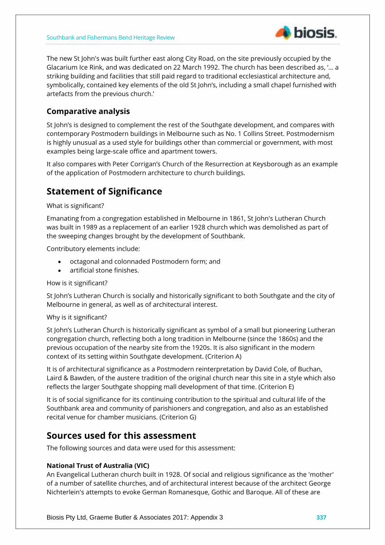
New St John’s Lutheran Church, 20 City Road, Southbank
City of Melbourne property number: 110378
Type of place: church
Images of place 2016-2017
Historical associations:
Creation or major development date(s) of place: 1992, Post-WW2
Major owners or occupiers: Lutheran community, South Melbourne
Designer: David Cole (Buchan, Laird & Bawden)
Heritage Gradings:
Proposed new system (C258):
Individually significant
Alphanumeric system (building A-E, streetscape 1-3):
Existing: Proposed: C3
Heritage values:
Historical, Social
Heritage status:
Heritage Overlay: Proposed

Southbank and Fishermans Bend Heritage Review
Biosis Pty Ltd, Graeme Butler & Associates 2017: Appendix 3 336
Thematic context:
10.2 Belonging to a religious denomination
15.1 Remembering the past
Boundary of heritage place
Description
The building is octagonal in overall shape, surrounded by galleries at the upper level and clad in
pink concrete or artificial stone. The centrepiece is a modern Knud Smenge pipe organ, built in
Australia in a German baroque style. The church is constructed in reinforced concrete with
stone-like cladding and aluminium frames to openings.
History
The St John’s Lutheran congregation was first established in Melbourne in 1861. The previous St
John's Lutheran Church, at 50 City Road, South Melbourne, was built in 1928 to the design of
architect George Nichterlein in a German arts and crafts style. The site was chosen for its central
location, which was occupied previously by a carriage factory, but is shown to be vacant in the
1920s version of the Mahlstedt Plans. The church was built at a cost of £8,000 and opened on
Sunday 2 December 1928, by Mr. T. J. Noske, who was later to give his residence organ to the
church. The building included many furnishings of distinctive design and stained glass, some of
which have been preserved in the chapel of the present building.
The new church of St John’s, Southgate, was designed by architect David Cole from Buchan, Laird
& Bawden, and links architecturally with the overall Southgate complex. Cole, as principal of the
Buchan Group, has been responsible for a number of large-scale urban projects, including No. 1
Martin Place in Sydney, redevelopment of the old Sydney GPO, the Park Hyatt Hotel, Quay West
at Southgate, the Channel Seven headquarters at Docklands and the Victoria Point Docklands.
Southbank and Fishermans Bend Heritage Review
Biosis Pty Ltd, Graeme Butler & Associates 2017: Appendix 3 337
The new St John's was built further east along City Road, on the site previously occupied by the
Glacarium Ice Rink, and was dedicated on 22 March 1992. The church has been described as, ‘… a
striking building and facilities that still paid regard to traditional ecclesiastical architecture and,
symbolically, contained key elements of the old St John’s, including a small chapel furnished with
artefacts from the previous church.’
Comparative analysis
St John’s is designed to complement the rest of the Southgate development, and compares with
contemporary Postmodern buildings in Melbourne such as No. 1 Collins Street. Postmodernism
is highly unusual as a used style for buildings other than commercial or government, with most
examples being large-scale office and apartment towers.
It also compares with Peter Corrigan’s Church of the Resurrection at Keysborough as an example
of the application of Postmodern architecture to church buildings.
Statement of Significance
What is significant?
Emanating from a congregation established in Melbourne in 1861, St John's Lutheran Church
was built in 1989 as a replacement of an earlier 1928 church which was demolished as part of
the sweeping changes brought by the development of Southbank.
Contributory elements include:
octagonal and colonnaded Postmodern form; and
artificial stone finishes.
How is it significant?
St John’s Lutheran Church is socially and historically significant to both Southgate and the city of
Melbourne in general, as well as of architectural interest.
Why is it significant?
St John’s Lutheran Church is historically significant as symbol of a small but pioneering Lutheran
congregation church, reflecting both a long tradition in Melbourne (since the 1860s) and the
previous occupation of the nearby site from the 1920s. It is also significant in the modern
context of its setting within Southgate development. (Criterion A)
It is of architectural significance as a Postmodern reinterpretation by David Cole, of Buchan,
Laird & Bawden, of the austere tradition of the original church near this site in a style which also
reflects the larger Southgate shopping mall development of that time. (Criterion E)
It is of social significance for its continuing contribution to the spiritual and cultural life of the
Southbank area and community of parishioners and congregation, and also as an established
recital venue for chamber musicians. (Criterion G)
Sources used for this assessment
The following sources and data were used for this assessment:
National Trust of Australia (VIC)
An Evangelical Lutheran church built in 1928. Of social and religious significance as the 'mother'
of a number of satellite churches, and of architectural interest because of the architect George
Nichterlein's attempts to evoke German Romanesque, Gothic and Baroque. All of these are
Southbank and Fishermans Bend Heritage Review
Biosis Pty Ltd, Graeme Butler & Associates 2017: Appendix 3 338
combined in the facade, with a hint of art deco, and to a lesser extent in the interior with its fine
timber wagon vault roof. Classified: 16 February 1984. Demolished October 1989.
St John’s web site: http://www.stjohnssouthgate.com.au/index.php/about-st-johns/
History of St John’s
The St John’s congregation was first established in Melbourne in 1861 and, on 31 July 2011, a
special service was held celebrating the 150th Anniversary of the Foundation of St John’s
congregation. The original St John’s church was built in 1927 and located off City Road not far
from the present church. The foundation stone was laid on 18 November 1928 and the building
was dedicated on 2 December 1928. The site was chosen because of its central location and
access to public transport. In 1989 the church building was demolished to make way for the
Southgate development. The beautiful, modern church building was designed by David Cole, an
architect from Buchan, Laird & Bawden, and was dedicated on 22 March 1992. The design of the
church links architecturally with the Southgate complex.
St John’s is first and foremost a place of worship. However, St John’s was also designed to serve a
range of purposes, and it is an ideal venue for concerts and a centre for meetings and functions.
The Lutheran church is one of the major Christian churches, and the largest Protestant church.
There are more than 60 million Lutherans in the world, traditionally mainly within northern
Europe and the USA. Currently, the fastest-growing Lutheran population is in Africa, with more
than 14 million members. Ethiopia, Tanzania, Malawi and Cameroon have substantial Lutheran
memberships. In Australia and New Zealand, 250,000 people call themselves Lutheran.
The Lutheran church is the oldest Protestant church. It dates back to the Reformation in the 16th
century, when Martin Luther challenged some of the teachings and practices of the church of his
day, nailing 95 theses on the doors of the church at Wittenberg, Germany. Lutherans celebrate
the Reformation as an event that signifies a freedom that is founded in Christ alone.
The Lutheran church was established in Australia and New Zealand 180 years ago. In the 1830s,
small groups of the Lutherans emigrated to Australia in search of religious freedom, settling
mainly in rural areas in various parts of the country. Today, the Lutheran church comprises
people from rural and urban areas and many different cultural backgrounds.
Organ Historical Trust of Australia website
http://www.ohta.org.au/organs/organs/Southgate.html
Historical and Technical Documentation by John Maidment
The previous St John's Lutheran Church, at 50 City Road, South Melbourne, was designed by
architect George Nichterlein in a German arts and crafts style. It was built in 1928 at a cost of
£8,000 and opened on Sunday 2 December of that year. It was noted in a press report that the
door was officially opened by Mr T. J. Noske, who was later to give his residence organ to the
church. The building included many furnishings of distinctive design and stained glass, some of
this preserved in the chapel of the present building.
The Noske family commissioned an organ in the 1920s from the German firm of Welte & Soehne
of Freiburg, for their house at 21 (later 39) Irving Road, Toorak. This organ incorporated a roll-
playing mechanism. The exact date of the organ cannot be confirmed, but an order for roll
number 726 (Mozart's ‘Ave Verum’) survives in the Welte archives, dated ‘Melbourne 8.2.29’. An
identical organ survives at the Schlosskapelle Meggenhorn, Meggen, Switzerland, dating from
1926. It appears that both instruments were a standard Welte stock model III-IV.

Southbank and Fishermans Bend Heritage Review
Biosis Pty Ltd, Graeme Butler & Associates 2017: Appendix 3 339
The organ was donated to St John's Lutheran Church and was installed in a gallery at the church
by Hill, Norman & Beard (Australia) Pty Ltd in 1933. A facade of metal dummy pipes enclosed
within woodwork was added in 1944 to screen the swell shutters.This organ was dedicated on 7
August 1960. The total cost of the work, including alterations to the gallery, was £10,062. With
the increasing commercialization of the area where this church was placed and demands for the
development of the area, the 1928 church was demolished in 1990. The organ was dismantled
and parts have been used elsewhere, seven ranks having been utilized by John Larner in his
house organ in Western Australia. The console was used by Australian Pipe Organs Pty Ltd at
Trinity Grammar School, Kew.
The new church of St John’s, Southgate, was dedicated on 22 March 1992. It was designed by
David Cole, an architect from Buchan, Laird & Bawden, and links architecturally with the overall
Southgate complex. It is octagonal in overall shape, with excellent lighting and surrounded by
galleries at the upper level. The building is much used for chamber music performance.
The organ was built in 1991 by Knud Smenge and the inaugural recital took place on 27 March
1992. It includes a Rückpositiv division (one of only four in Victoria, the other three being at
Ormond College, Parkville, St Peter's Church, Eastern Hill and Hamer Hall – organ now
dismantled and in storage). The tonal design is classical in inspiration, but includes a rich variety
of unison stops as well as complete choruses and solo mutations. The casework is of Victorian
Ash, with Blackwood utilized for the console. The instrument provides a worthy accompaniment
to services at St John's Church and its wider musical programme. A full history of the organs of St
John's Church was written by Graham Lieschke, 'The Organs of St Johns Southgate Lutheran
Church', and was published in the September 2001 issue of the journal Organo Pleno, pp.12-17.
The author is indebted to him and David Rumsey for much of the information in this webpage.
Recommendations
Revise Heritage Places Inventory.
Proposed heritage overlay as New St John’s Lutheran Church, 20 City Road, Southbank
Apply external paint controls with policy to maintain original finishes and colour schemes.
Apply internal alterations control with policy to cover original fittings from former St John’s
Church.

Southbank and Fishermans Bend Heritage Review
Biosis Pty Ltd, Graeme Butler & Associates 2017: Appendix 3: 340
G. P. Motors, Pty Ltd, 35-41 City Road, Southbank
City of Melbourne property number: 110351
Type of place: showroom, garage
Images of place 2016-2017
Historical associations:
Creation or major development date(s) of place: 1939-40, Inter-war (WW1-WW2)
Major owners or occupiers: G. P. Motors Pty Ltd
Designer: Wright, John
Heritage Gradings:
Proposed new system (C258):
Individually significant, Contributory to a precinct
Alphanumeric system (building A-E, streetscape 1-3):
Existing: C2, Proposed: C2
Heritage values:
Aesthetic, Historical
Heritage status:
Heritage Overlay: Proposed
Thematic context:

Southbank and Fishermans Bend Heritage Review
Biosis Pty Ltd, Graeme Butler & Associates 2017: Appendix 3 341
5.4 Developing a retail centre
5.5 Building a manufacturing industry
6.7 Transport
Boundary of heritage place
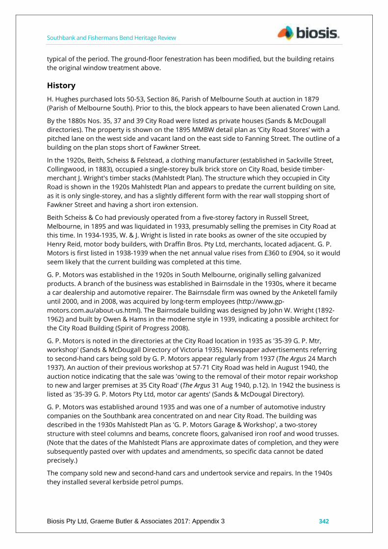
Description
The main facade to City Road is in a streamlined moderne styling with a parapeted two-storey
form, built to the street alignment with a pitched roof behind. The ground floor is finished with
terracotta faience tiles, with faceted door reveals to the main pedestrian entry on the east. The
former vehicle entry to the east has been closed to match the show windows, with cemented
streamlining at parapet and window shade levels, and a red brick sill below the windows, which
are steel-framed multi-pane glazing to the upper level, and large show windows with upper
panes at ground. The stair window has vertical cement ribbing, with four short projecting brick
string courses above the upper-level window hood. Oyster light fittings are at either side of the
door and transom lights to the show windows.
Internally, the building has been refitted, within presumed original timber truss roof framing and
a reinforced concrete upper floor.
The rear elevation has a low brick dwarf wall below similar multi-pane steel-framed glazing,
reinforced concrete pillars and beams. The former central vehicle entrance has been fitted with
modern sliding glass doors, while the western vehicle entrance has been narrowed with a part-
brick panel and modern steel roller door.
These retail premises represent a good example of the moderne style in the South Melbourne or
Southbank context. The ground floor faience and the horizontally-banded brickwork above are
Southbank and Fishermans Bend Heritage Review
Biosis Pty Ltd, Graeme Butler & Associates 2017: Appendix 3 342
typical of the period. The ground-floor fenestration has been modified, but the building retains
the original window treatment above.
History
H. Hughes purchased lots 50-53, Section 86, Parish of Melbourne South at auction in 1879
(Parish of Melbourne South). Prior to this, the block appears to have been alienated Crown Land.
By the 1880s Nos. 35, 37 and 39 City Road were listed as private houses (Sands & McDougall
directories). The property is shown on the 1895 MMBW detail plan as ‘City Road Stores’ with a
pitched lane on the west side and vacant land on the east side to Fanning Street. The outline of a
building on the plan stops short of Fawkner Street.
In the 1920s, Beith, Scheiss & Felstead, a clothing manufacturer (established in Sackville Street,
Collingwood, in 1883), occupied a single-storey bulk brick store on City Road, beside timber-
merchant J. Wright's timber stacks (Mahlstedt Plan). The structure which they occupied in City
Road is shown in the 1920s Mahlstedt Plan and appears to predate the current building on site,
as it is only single-storey, and has a slightly different form with the rear wall stopping short of
Fawkner Street and having a short iron extension.
Beith Scheiss & Co had previously operated from a five-storey factory in Russell Street,
Melbourne, in 1895 and was liquidated in 1933, presumably selling the premises in City Road at
this time. In 1934-1935, W. & J. Wright is listed in rate books as owner of the site occupied by
Henry Reid, motor body builders, with Draffin Bros. Pty Ltd, merchants, located adjacent. G. P.
Motors is first listed in 1938-1939 when the net annual value rises from £360 to £904, so it would
seem likely that the current building was completed at this time.
G. P. Motors was established in the 1920s in South Melbourne, originally selling galvanized
products. A branch of the business was established in Bairnsdale in the 1930s, where it became
a car dealership and automotive repairer. The Bairnsdale firm was owned by the Anketell family
until 2000, and in 2008, was acquired by long-term employees (http://www.gp-
motors.com.au/about-us.html). The Bairnsdale building was designed by John W. Wright (1892-
1962) and built by Owen & Hams in the moderne style in 1939, indicating a possible architect for
the City Road Building (Spirit of Progress 2008).
G. P. Motors is noted in the directories at the City Road location in 1935 as '35-39 G. P. Mtr,
workshop' (Sands & McDougall Directory of Victoria 1935). Newspaper advertisements referring
to second-hand cars being sold by G. P. Motors appear regularly from 1937 (The Argus 24 March
1937). An auction of their previous workshop at 57-71 City Road was held in August 1940, the
auction notice indicating that the sale was 'owing to the removal of their motor repair workshop
to new and larger premises at 35 City Road' (The Argus 31 Aug 1940, p.12). In 1942 the business is
listed as '35-39 G. P. Motors Pty Ltd, motor car agents' (Sands & McDougal Directory).
G. P. Motors was established around 1935 and was one of a number of automotive industry
companies on the Southbank area concentrated on and near City Road. The building was
described in the 1930s Mahlstedt Plan as 'G. P. Motors Garage & Workshop', a two-storey
structure with steel columns and beams, concrete floors, galvanised iron roof and wood trusses.
(Note that the dates of the Mahlstedt Plans are approximate dates of completion, and they were
subsequently pasted over with updates and amendments, so specific data cannot be dated
precisely.)
The company sold new and second-hand cars and undertook service and repairs. In the 1940s
they installed several kerbside petrol pumps.

Southbank and Fishermans Bend Heritage Review
Biosis Pty Ltd, Graeme Butler & Associates 2017: Appendix 3 343
The 1950s Mahlstedt Plan has a new label attached indicating the premises were occupied by
Dunlop Australia Ltd, but G. P. Motors were still advertising cars for sale from the address in
1955 (The Argus 4 March 1955), so it might be presumed that Dunlop moved into the place some
time after that.
In 1989, the Melbourne Spoleto Writers Festival had its office in the building, and it was most
recently occupied by Opera Australia for several years, having been extensively refurbished
(INCITE 7 August 1989, p.17).
The City of Melbourne CoMMap identifies the site as '2 storey brick building with gnd floor
offices. Built 1938. Refurbished 1998'.
Comparative analysis
G. P. Motors is one of the last surviving buildings of its type, and an excellent representative
example of the moderne-style automobile garages and showrooms that were once more
common in the Southbank area. Key examples were Brooklands in Sturt Street, 1939-1941, and
Melford Motors Service Centre at 112-118 Sturt Street, designed by Eric C. Beedham (both
demolished). In the immediate area, Melbourne Towing Service at 167 City Road provides a
strong comparison both historically and aesthetically as a moderne-style two-storey motor
garage. The Mac Robertson Girls High School provides a more substantial comparison, with its
similar use of cream brick and horizontal and vertical elements. The demolished Victoria Car
Park in Russell Street was a comparable use with similar forms, albeit in bare concrete without
the more elaborate surface treatments, while the Relova Redressing Laundry in Hoddle Street
incorporates a stronger, cylindrical motif above the entrance, contrasting with the more
restrained treatment at G. P. Motors.
Other later examples utilising the moderne style exist at 11 Hancock Street (1940-1955) and, in a
more austere and altered form, at 18-24 Moray Street. A number of significant streamlined
moderne examples are in the Central Activities District, including RMIT Building No. 9, designed
by the Public Works Department under Chief Architect Percy Everett; McPherson's Building
designed by Stuart P. Calder, and Reid & Pearson, built 1935-1936; Alkira House, a six-storey,
reinforced concrete office building, erected 1937; Yule House, designed by Oakley & Parkes and
built in 1932; Mitchell House, designed by the architect Harry Norris and built 1936-1937; and
Melford Motors Complex on in the CBD, on a prominent corner site bounded by Elizabeth,
Queensberry and O'Connell streets, designed by Harry Norris, 1936-1937. These are good but
typically much larger examples as befits their CAD location.
Statement of Significance
What is Significant?
G. P. Motors Pty Ltd is a mid-20th century motor garage built for the owners, and operated from
the 1930s until the early-1950s. The building comprises a brick masonry and iron-framed
structure, formerly with car ramps to the upper level, and an elaborate streamlined moderne
facade.
Contributory elements include:
a parapeted, two-storey form, built to the street alignment with pitched roof behind;
streamlined moderne styling, promoting the modern imagery of the firm;
cream-face brick upper-level facade cladding set against distinctive terracotta faience on
the ground level;
cemented streamlining on the facade, at parapet and storey levels;

Southbank and Fishermans Bend Heritage Review
Biosis Pty Ltd, Graeme Butler & Associates 2017: Appendix 3 344
multi-pane glazing to the upper level;
counter-posing of vertical and dominant horizontal elements, as seen in the stair window
ribbing, set under the upper-level window hood;
oyster light fittings either side of the door;
faceted terracotta door reveals to the entry;
transom lights to show windows; and
the plain but well-preserved rear elevation with some changes to openings.
The added panel sign is removable and is not contributory.
How is it significant?
G.P. Motors Pty Ltd is significant historically and aesthetically to Southbank and to the city of
Melbourne.
Why is it Significant?
G. P. Motors Pty Ltd is significant historically as representative of the continuing industrial
expansion in the Southbank area into the inter-war period, with associated motor trade
buildings nearby such as Brooklands (since demolished) and the Melbourne Towing Service.
(Criterion A)
It is a rare surviving example of the motor trade, for which the Southbank area was once highly
known. (Criterion B & D)
Aesthetically it is a good example of the moderne style as applied to retail imagery to promote a
modern industry, in this case, motor car retailing and service. (Criterion E)
Sources used for this assessment
The following sources and data were used for this assessment:
i-Heritage
35 to 41 City Road, Southbank, 3006
South Melbourne Conservation Study 1997 – Bryce Raworth
Architectural Style: Early Modern
Period: 1926-39 – Inter-war
Construction date: 1935 (c1935 on BIF)
Integrity: good
Condition: fair
Original Building Type
Description/Notable Features
These retail premises represent a good example of early Melbourne Modernism. The ground-
floor faience and the horizontally-banded brickwork above are typical of the period. The ground-
floor fenestration has been modified but the building retains the original window treatment
above.
BIF
Graded as C in level 2 streetscape
‘South Melbourne Conservation Study’ 1987 graded as B (Allom Lovell Sanderson Pty Ltd)
Sands & McDougall Directory of Victoria
1935
35-39 G. P. Mtn, workshop

Southbank and Fishermans Bend Heritage Review
Biosis Pty Ltd, Graeme Butler & Associates 2017: Appendix 3 345
1942
35-39 G. P. Motors, Pty Ltd motor car agents
COMMAPS
Opera Australia:
2-storey brick building with ground floor offices. Built 1938. Refurbished 1998.
MMBW 1895
Shown as ‘City Road Stores’ with pitched lane on west side, vacant land on east to Fanning Street.
Newspapers:
CHARGE OF SHOPBREAKING. Youth Committed for Trial.
The Age, 6 December 1928, p.7.
...breaking into the factory of G. P. Motors, City Road, and stealing a racing vehicle, the property
of Ray…
SAFEBREAKERS DISAPPOINTED.
The Argus, 4 April 1930, p.4.
...they blew open in the office of G. P. Motors, City Road, South Melbourne, early yesterday…
OBTAINED MOTOR TRUCK BY FALSE PRETENCES Then Stole One of the Wheels
Record, 29 June 1935, p.8.
...went to G. P. Motors, City Road, where the truck had been sent for repairs. He signed as 'J.
Grieves'. After using the truck that evening he, next morning, left it in a lane at the rear of G. P.
Motors…
SOUTH MELBOURNE COUNCIL
Record, 10 August 1935, p.8.
...granted, under the usual conditions, for the erection of six kerb, petrol pumps, at the premises
of G. P. Motors, City Road…
CAR ILLEGALLY USED. Easter Jaunt of 800 Miles.
The Age, 7 May 1938. p.28.
...G. P. Motors, South Melbourne where he was employed. Seeing the car later that day in City . . .
extending over six days, during which period he travelled 800 miles to abandon the car ... in the
city.
The Argus, 31 Aug 1940. p.12.
Under Instructions from G. P. MOTORS PTY LTD , owing to the removal of their motor repair
workshop to new and larger premises at 35 City Road.
CITY SOUTH, 57-61 CITY ROAD.
Touching St Kilda Road. Exceptional position centre of commercial and industrial activities.
Level access to docks and railway yards.
LOFTY GALVANISED IRON BUILDING.
Splendid property for motor repair workshop, for which purpose it is at present being utilised.
The Argus, 5 Mar 1940.
SINGER AGENCY
Southbank and Fishermans Bend Heritage Review
Biosis Pty Ltd, Graeme Butler & Associates 2017: Appendix 3 346
W. T. Cottman Ptv Ltd announces the appointment of G. P. Motors Pty Ltd as metropolitan agent
for Singer cars. A complete range of Singer models is now on view at the premises in South
Melbourne.
Mr. R. Kither, a director of G. P. Motors, reports that sales have been most satisfactory. The
service department is at the South Melbourne premises.
SOUTH MELBOURNE COUNCIL
Record, 10 August 1946. p.4.
...cleaning agency. Applications were received for permission to install kerbside petrol pumps as
follows: G. P. Motors, 3 dual pumps, at 35 City Road; Brooks, McGlashan & McHarg.
http://www.gp-motors.com.au/about-us.html
Established in the 1920s in South Melbourne, originally selling galvanized products, G.P. Motors
moved to Bairnsdale in the 1930s where it became a car dealership and automotive repairer. It
was owned by the Anketell family right up to the year 2000. In 2008 it changed ownership again
and the four current directors are all long-serving employees of G. P. Motors with over 100 years’
combined service in the industry. We have been the local emergency breakdown depot for over
75 years and a VACC member for almost 70 years.
http://artdecobuildings.blogspot.com.au/2012/12/a-building-in-bairnsdale.html
Re: Bairnsdale Art Deco building
Rob (Moderne Melbourne) December 23, 2012 at 10:01 AM
‘Isn't it a beauty! Dates from 1939, built for G. P. Motors (who also had a branch in South
Melbourne), designed by John Wright and built by Owen & Hams. The tower (40 feet high)
originally carried lettering of 'garage'. It was the latest in styling, material used and facilities
offered to customers seeking to buy a car or waiting for theirs to be serviced. The section
beneath the roundel was originally the entrance for the service department. See `Spirit of
Progress' Autumn 2008 and the ‘Herald’ 4/10/39.’
Recommendations
Revise Heritage Places Inventory.
Proposed heritage overlay as G. P. Motors Pty Ltd, 35-41 City Road, Southbank.
Apply external paint controls with policy to maintain original finishes and colour schemes.

Southbank and Fishermans Bend Heritage Review
Biosis Pty Ltd, Graeme Butler & Associates 2017: Appendix 3: 347
Crown Chemicals, Anderson & Sons printing works, 63-65 City
Road, Southbank
City of Melbourne property number: 110355
Type of place: factory
Images of place 2016-2017
Historical associations:
Creation or major development date(s) of place: 1915, Edwardian-era
Major owners or occupiers: George Simmill Buckley, chemist; John & William Anderson,
printers
Heritage Gradings:
Proposed new system (C258):
Individually significant, Contributory to a precinct
Alphanumeric system (building A-E, streetscape 1-3):
Existing: B2, Proposed: C2
Heritage values:
Aesthetic, Historical
Heritage status:
Heritage Overlay Proposed
Thematic context:
5.3 Developing a large, city-based economy

Southbank and Fishermans Bend Heritage Review
Biosis Pty Ltd, Graeme Butler & Associates 2017: Appendix 3: 348
5.6 Publishing newspapers and periodicals
Boundary of heritage place
Description
This parapeted, two storey-building is constructed of red brickwork (painted over) with ornate
giant-order arches with radiating voussoirs, demonstrating the influence of North American
architects such as H. H. Richardson. The facade is capped with a plain entablature with cement
cornice and string mouldings. Parts of the timber-framed windows and doors remain (see rear
elevation), with embossed spandrels on the upper level, while ornament at impost level includes
Medieval-inspired arts & crafts cement detailing. The rear elevation is also well-preserved with
only the lower-level brickwork over-painted, a timber, upper-level vertical boarded loading door
and largely-intact timber-framed windows.
The design relates to the warehouse at 75 City Road, with the facade being dominated by a
series of arches that extend down to ground level with brick piers. While similar to a number of
warehouses constructed in the City of Melbourne, particularly in Flinders Lane, the building
design is rare in the industrial areas of South Melbourne.
History
The property history at 63-65 City Road can be traced to a J. Walker who purchased lots 41 and
42, Section 86, Parish of Melbourne South at a Crown land auction in 1879 (Parish of Melbourne
South). Prior to this, the block appears to have remained Crown land. The MMBW plan shows
this block to be a vacant site in 1895, although it may have contained some of the ubiquitous
timber yards of that period, which then extended along both sides of City Road. In the 1890s, a
variety of private residential occupants are listed at 63 City Road, including John Casey Tailor in
1900.

Southbank and Fishermans Bend Heritage Review
Biosis Pty Ltd, Graeme Butler & Associates 2017: Appendix 3 349
‘J. L. Anderson & Sons, 63 City Road, near glacarium,’ advertised for ‘Boys, at once,’ on 6
September 1909 (The Age), indicating the business was operational by this time. It is likely to have
been started recently, as in the following year, an auction for land in City Road and Kavanagh
Street noted that it was located in 'The Centre of Mercantile Activity,' referring to Anderson's
Printing Works as one of several in the area. The firm also came to the attention of the South
Melbourne Council, which recommended the factory should be registered, as it was then
employing 11 males, and six females (Emerald Hill Record, 25 July 1909).
The Crown Chemical Company at 63 City Road was also noted in newspapers for the first time in
1909 (The Argus 11 Jan 1909). The Crown Chemical Company was formed by 1891, producing
disinfectant and taking advantage of the outbreaks of typhoid in Sydney to market its products
there (Sydney Morning Herald, 22 July 1891, p.4). In 1907, it was listed at City Road as 'medicinal
sundries makers', with one of its popular products being 'Bert's Cinnamon Compound'. Other
products were ,Iona-brand cordial extract, castor oil and white pine ointment. The works
employed six males and 10 females (Emerald Hill Record, 27 July 1907, p.2).
There were also Crown Chemical companies in Britain, the United States and, from the 1920s, in
O'Riordan Street, Alexandria, Sydney.
The 1910 Sands & McDougall Directory of Victoria identifies the occupants along the south side
of City Road as ‘Goldfields Diamond Drilling Co, Ltd, store – Winstone, C. J., mgr’; ‘Wright, J. &
Sons, carron timber yards’; and ‘41 Moore, J., & Sons Prop Ltd, tmbr yds’. By 1915, however,
number 63 was listed as ‘Anderson, J. L. & Sons, prnts & stnra’, with ‘Artaud, M. & Co, mfrs’
adjacent.
Rate books indicate that W. & J. Wright Merchants were owners and occupants of 63 City Road,
also referred to as ‘allotment 41’ in 1916-1917. and the owners listed as George Buckley (63 City
Road, valued at £100 NAV) and Koske Bros Pty Ltd (65-67 City Road £50 NAV). The occupants in
1916-1917 were J. L. Anderson & W. G. Anderson, printers, at 63 City Road, and the adjoining 65-
67 was marked as vacant land. Isabella Buckley is listed in the rate books as owner of 63 City
Road in 1928-1929, and Iona Products Co Pty Ltd, chemical manufacturers, in 1936-1937.
The building was partially damaged by a fire at the adjacent Crown Chemical Co in May 1915
(Bendigo Advertiser, 31 May 1915, p.3), and was the site of a foiled burglary and dramatic arrest
when an armed gang blew open the safe (Sydney Morning Herald, 19 April 1930).
The 1920s Mahlstedt Plan indicates that the Crown Chemical Co at 63 City Road was housed in a
masonry-walled two-storey building with steel columns and girders. It was flanked by Koske
Bros. Factory and G. P. Motors, the latter evidently relocating to a new site to the east in the
1930s.
Another firm known as the Paperized Writing Ink Pty Ltd was registered at the same address in
1923, evidently representing a subsidiary of Anderson & Sons.
Paperized Writing Ink Pty Ltd – Regd. 14.6.23. Authorised capital: £10,000 in £1 shares.
Directors: Spencer Yates, William Alfred Anderson, George Sutton, and Samuel Percy Marks.
Regd. Office: 63 City Road, South Melbourne,
– Daily Commercial News and Shipping List, 4 July 1923. p.5.
Anderson and Sons operated as a printer and publisher from at least 1908, when it printed the
Australasian Football Jubilee program (Newby 1908). The firm can be found under the name
Anderson's Printing and Publishing Co, Pty Ltd, in reference to a number of notable local
publications in from the 1920s to 1950s, including the ‘Adult Deaf & Dumb Society of Victoria's
Annual Reports’, The Australian Jewish Herald, 1935-1968’; ‘Some Irrefutable Facts about Money’;

Southbank and Fishermans Bend Heritage Review
Biosis Pty Ltd, Graeme Butler & Associates 2017: Appendix 3 350
the ‘official souvenir of the 1939 Port Melbourne Centenary Celebrations Committee; and ‘The
Official Organ of the Honorary Justices' Association of Victoria 1959’.
The company was responsible for the petition for liquidation for the Tivoli Theatre in 1931 (The
Age, 16 September 1931), but still paid a dividend in 1935 of seven pence and three farthings (The
Age, 21 June 1934).
The lot numbering along the street may have changed at some point, or part of this building was
sublet, as No.63 is noted in 1930 as being occupied by ‘Iona Products Co Pty Ltd, chem manfrs’,
with No.65 being ‘Anderson, J. L. & Sons Pty Ltd, prntrs’. Similar listings occur in 1935 with a slight
change in name to ‘Anderson's Printing Co Pty Ltd’. In 1936, the Multiplex Publicity Service Pty Ltd
was registered with a capital – £2,000 in £1 shares with its registered office at 63 City Road –
suggesting a further diversification of the company. Shareholders were Donald Malcolm
McConnell (director), Ernest Charles Anderson (director) and Julia Emma Anderson (The Age, 12
December 1936).
The 1950s Mahlstedt Plan identifies Iona Products as occupying the ground floor, and notes Nos.
63 and 65 as being part of the same building.
Comparative analysis
Victorian- and Edwardian-era warehouses are now uncommon in Southbank, though at one
point they were numerous. The tall, arched American Romanesque form, while more common in
the CBD in areas such as Flinders Lane, is uncommon in Southbank, with 71-75 City Road (former
Willmott Knitting Mill) as the only other existing example; it was graded B2 in 1997, and identified
as comparable to 63-65 City Road. However, it also has over-painted brickwork.
Statement of Significance
What is significant?
The Crown Chemical Company warehouse was built for manufacturing chemist George Buckley
by 1915, and occupied over a long period by Anderson's Printing and Publishing Co. Pty Ltd.
Contributory elements include:
parapeted two-storey form, with pitched roof behind;
face brick and cemented detailing to facade (now painted over);
tall, arched facade fenestration;
Romanesque revival-styling, typical of Edwardian-era warehouses; and
rear elevation red brickwork (partially over-painted) with a timber upper-level vertical-
board loading door and largely intact timber-framed windows.
A skillion awning and other joinery elements have been added to the City Road facade.
How is it significant?
The Anderson's Printing and Publishing Co. Pty Ltd warehouse is historically and aesthetically
significant to Southbank.
Why is it significant?
The Anderson's Printing and Publishing Co. Pty Ltd warehouse is significant historically as an
example of the major industrial development that occurred along the south bank of the Yarra
River during the Victorian-era and Inter-war periods. (Criterion A)

Southbank and Fishermans Bend Heritage Review
Biosis Pty Ltd, Graeme Butler & Associates 2017: Appendix 3 351
Aesthetically, the warehouse is significant for its tall, arched fenestration of the facade that
demonstrates an interest in medieval architectural sources and arts & crafts detailing in the
Edwardian-era warehouse design. (Criterion E)
Sources used for this assessment
The following sources and data were used for this assessment:
i-Heritage
63 to 65 City Road, Southbank, 3006.
South Melbourne Conservation Study 1997 – Bryce Raworth
Period 1876-99 – Victorian
Construction date: 1895
History
This warehouse is one of only three late-Victorian warehouses that were given decorated
facades that remain substantially intact in the industrial area of South Melbourne, the others
being at 272 & 75 City Road.
Description/Notable Features
Notable features include an elaborate and high standard design of cement rendered surfaces.
This two-storey building is constructed of cement rendered brickwork. Its ornate arches
demonstrate the influence of contemporary American architects such as H. H. Richardson.
Although altered internally, it remains in excellent condition for its age. The design of this
warehouse is similar to that of 75 City Road, with the facade being dominated by a series of
arches that extend down to ground level with brick piers. The influence of the American
Romanesque is clearly evident in the design, and while similar to a number of warehouses that
were constructed in the City of Melbourne, particularly in Flinders Lane, it is rare to find this style
in the industrial areas of South Melbourne. The building has also been altered internally.
Recommended Alterations
Signage, external air conditioner (inappropriate – remove).
Painted brick (inappropriate – remove).
Awning (extremely inappropriate – remove).
COMMAP
Building Details: 2-storey warehouse/factory. Built 1900.
MMBW 1895
Australia, Death Index, 1787-1985
Name: George Simmill Buckley
Birth year: about 1863
Age: 60
Death place: Balwyn, Victoria
Father's name: George Buckley
Mother's name: Emma Simmill
Registration year: 1923
Registration place: Victoria
Registration number: 4177
Newspapers:

Southbank and Fishermans Bend Heritage Review
Biosis Pty Ltd, Graeme Butler & Associates 2017: Appendix 3 352
The Age, 1 Jun 1915, p.10.
FIRE AT SOUTH MELBOURNE.
Pills and Patent Medicine Factory.
Chief Officer with 2 men, were in attendance at an outbreak of fire in a two-storied brick
premises in City Road, South Melbourne, at 7 a.m. yesterday, prepared with ample equipment to
meet a possible Spread to the many large stores and workshops in the vicinity. The premises are
owned by Mr. George S. Buckley, of Canterbury Road, Camberwell, who, under the name of the
Crown Chemical Company, occupied the ground floor of the building, and had therein a large
stock of patent medicines, pills, etc. The upper storey is occupied by Mr. J. E. Anderson, book
publisher, and, thanks to the efforts of the firemen, escaped serious damage. The building was
insured in the Union company for £2,000, and the damage done is estimated at ₤200. The stock
was also insured for £2000 and damage to the extent of ₤800 was caused. Appearances seemed
to show that the fire started near a copper at the western end of the building, and was
discovered in its early stages by George Richardson, night patrol, whose promptness in giving the
alarm enabled the brigades to arrive on the scene before the flames had gained too strong a
hold to be easily grappled with.
The Argus, 6 Apr 1923, p.1.
Family Notices
BUCKLEY — On the 2nd April (suddenly) at his residence ‘Zenda,’ Canterbury Road, Camberwell,
George S. Buckley, loved brother of Mrs W. H. Gill, Camberwell. (Privately interred.)
VPRO Probate
George S Buckley, Chemist, Canterbury Rd, Camberwell
2 Apr 1923 189/783 VPRS 28/P3, unit 1336; VPRS 7591/P2, unit 676
Includes: part CA42 Section 86 South Melbourne, City Road 50x225 links, with factory - valued at
₤4,400, also Camberwell house and farm at Warburton – total ₤7,800 – nett assets ₤38,871;
widow, Isabelle Buckley, executrix. Will 1906.
Isabelle Buckley, Widow, Camberwell, 20 Oct 1951 444/461 VPRS 28/P4, unit 233;
VPRS 7591/P2, unit 1547
Anderson's Printing and Publishing Co., Pty Ltd, 63 City Road, South Melbourne, S.C4.
http://nla.gov.au/nla.news-article167785403
Paperized Writing Ink Pty Ltd — Regd. 14.6.23. Authorised capital: £10,000 in £1 shares.
Directors: Spencer Yates, William Alfred Anderson, George Sutton, and Samuel Percy Marks.
Regd Office: 63 City Road, South Melbourne.
http://nla.gov.au/nla.news-article159919355).
Sands & McDougall Directory of Victoria
1910
Goldfields Diamond Drilling Co. Ltd, store – Winstone, C. J., manager
Wright, J. & Sons, carron timber yards
41 Moore, J. & Sons Pty Ltd, timber yards
1915
63 Anderson, J. L. & Sons, Printers & stationary
Artaud, M. & Co, manufacturers
1930
63 Iona Products Co Pty Ltd, chemical manufacturers

Southbank and Fishermans Bend Heritage Review
Biosis Pty Ltd, Graeme Butler & Associates 2017: Appendix 3 353
65 Anderson, J. L. & Sons Pty Ltd, printers
1935
63 Iona Products Co Pty Ltd, chemical manufacturers
65 Anderson's Printing Co Pty Ltd
South Melbourne Rate Books
Year No. On Roll, Occupier Occupation. Owner Occupation, Description of Property
Rate Detail (N.A.V.)
1916 3 W. & J. Wright
Merchants W. & J.
Wright
Merchants £75
1916-
1917 9 John Anderson
and William Anderson
Printers (T) George
Buckley
63 City Road,
no property
details given
£100
1916-
1917
9210 VL William Jay
Allotment 41 £50 £5
1922-
1923
8 J.L
Anderson &
W. G.
Anderson
Printers (T) George
Buckley
63 City Road £134 16,15
Recommendations
Revise Heritage Places Inventory.
Proposed heritage overlay as Anderson's Printing & Publishing Co. Pty Ltd, 63-65 City Road,
Southbank.
Apply external paint controls with policy to reintroduce original finishes and colour schemes.

Southbank and Fishermans Bend Heritage Review
Biosis Pty Ltd, Graeme Butler & Associates 2017: Appendix 3: 354
Kosky Bros. Pty Ltd, furriers, 67-69 City Road, Southbank
City of Melbourne property number: 110356
Type of place: warehouse
Images of place 2016-2017
Historical associations:
Creation or major development date(s) of place: 1923-4, Inter-war (WW1-WW2)
Major owners or occupiers: Kosky Bros
Designer: Gordon John Sutherland Bates, Smart & McCutcheon
Heritage Gradings:
Proposed new system (C258):
Individually significant, Contributory to a precinct
Alphanumeric system (building A-E, streetscape 1-3):
Existing: none Proposed: C2
Heritage values:
Aesthetic, Historical
Heritage status:
Heritage Overlay Proposed.

Southbank and Fishermans Bend Heritage Review
Biosis Pty Ltd, Graeme Butler & Associates 2017: Appendix 3 355
Thematic context:
5.5 Building a manufacturing industry
Boundary of heritage place
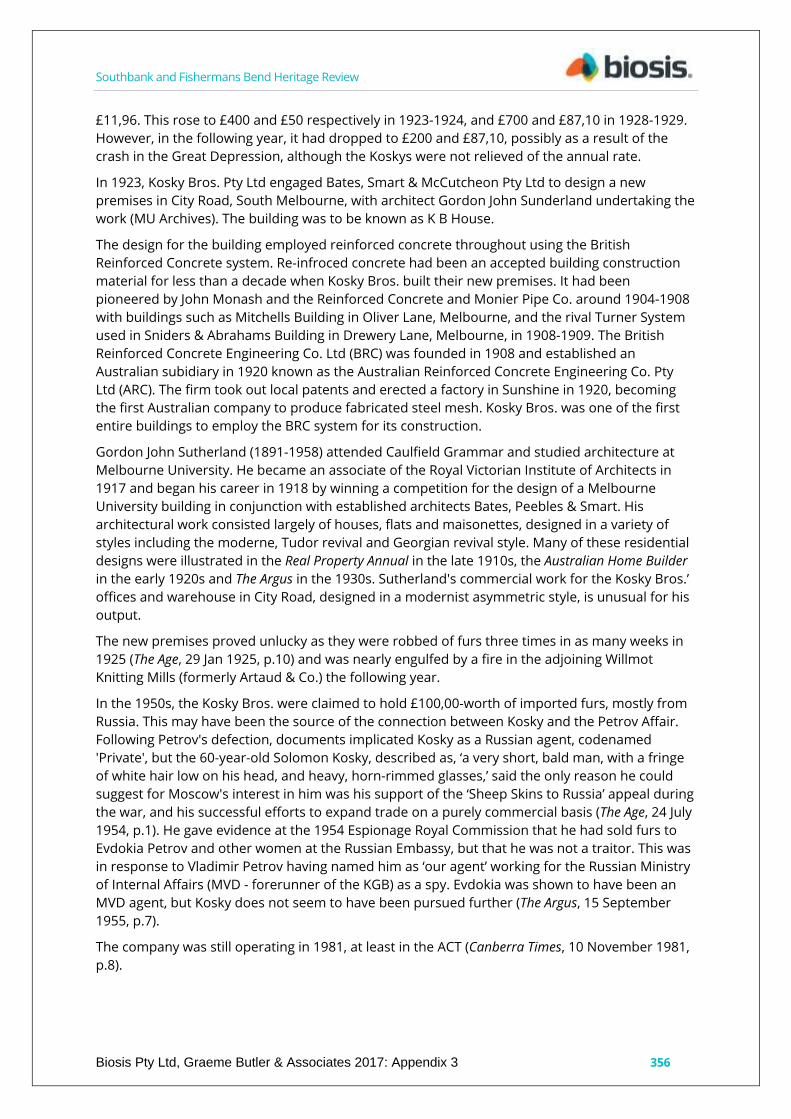
Description
The building presents a three-storey facade with large, square window openings between paired
minimalist pilasters and recessed spandrels. The central bay projects slightly while the entrance
is marked by an asymmetric hood. The parapet has similarly modern cubic mouldings, stepped
to the central bay in a ziggurat form. Behind are reinforced concrete columns and beams
forming the main structure. The long narrow form is provided with abundant natural light by
recessed side light wells and rows of windows (for lighting the sales and production areas) on
both sides. The rear elevation has a variety of sizes of steel-framed windows barred on the
ground and first floors, and offset loading doors with windows lighting the internal stairwell to
one side.
History
Kosky brothers Boris and Solomon established their fur business around 1917, after having left
Leningrad in Russia in 1907 and arrived in Australia in 1912. Solomon claimed he did not
‘...speak, read or write Russian and had never had the opportunity to do so as a child in Russia as
he lived in a Hebrew house’. (The Age, 24 July 1954).
They were located in 377 Chapel Street, South Yarra, in 1917 where they traded in fox and rabbit
skins among other furs. The firm was manufacturing fur coats as well as importing furs, and
titled their shop London Fur Stores, offering natural and seal-dyed Musquash, Russian Squirrel,
Seal Dyed Coney and New Zealand rabbit, advertising extensively in the Jewish Herald.
They are first listed in the rate books as owners of 65-67 City Road, Allotment 41, in 1922-1923
when the property described as vacant land and valued at £91 net assessed value, and rated at
Southbank and Fishermans Bend Heritage Review
Biosis Pty Ltd, Graeme Butler & Associates 2017: Appendix 3 356
£11,96. This rose to £400 and £50 respectively in 1923-1924, and £700 and £87,10 in 1928-1929.
However, in the following year, it had dropped to £200 and £87,10, possibly as a result of the
crash in the Great Depression, although the Koskys were not relieved of the annual rate.
In 1923, Kosky Bros. Pty Ltd engaged Bates, Smart & McCutcheon Pty Ltd to design a new
premises in City Road, South Melbourne, with architect Gordon John Sunderland undertaking the
work (MU Archives). The building was to be known as K B House.
The design for the building employed reinforced concrete throughout using the British
Reinforced Concrete system. Re-infroced concrete had been an accepted building construction
material for less than a decade when Kosky Bros. built their new premises. It had been
pioneered by John Monash and the Reinforced Concrete and Monier Pipe Co. around 1904-1908
with buildings such as Mitchells Building in Oliver Lane, Melbourne, and the rival Turner System
used in Sniders & Abrahams Building in Drewery Lane, Melbourne, in 1908-1909. The British
Reinforced Concrete Engineering Co. Ltd (BRC) was founded in 1908 and established an
Australian subidiary in 1920 known as the Australian Reinforced Concrete Engineering Co. Pty
Ltd (ARC). The firm took out local patents and erected a factory in Sunshine in 1920, becoming
the first Australian company to produce fabricated steel mesh. Kosky Bros. was one of the first
entire buildings to employ the BRC system for its construction.
Gordon John Sutherland (1891-1958) attended Caulfield Grammar and studied architecture at
Melbourne University. He became an associate of the Royal Victorian Institute of Architects in
1917 and began his career in 1918 by winning a competition for the design of a Melbourne
University building in conjunction with established architects Bates, Peebles & Smart. His
architectural work consisted largely of houses, flats and maisonettes, designed in a variety of
styles including the moderne, Tudor revival and Georgian revival style. Many of these residential
designs were illustrated in the Real Property Annual in the late 1910s, the Australian Home Builder
in the early 1920s and The Argus in the 1930s. Sutherland's commercial work for the Kosky Bros.’
offices and warehouse in City Road, designed in a modernist asymmetric style, is unusual for his
output.
The new premises proved unlucky as they were robbed of furs three times in as many weeks in
1925 (The Age, 29 Jan 1925, p.10) and was nearly engulfed by a fire in the adjoining Willmot
Knitting Mills (formerly Artaud & Co.) the following year.
In the 1950s, the Kosky Bros. were claimed to hold £100,00-worth of imported furs, mostly from
Russia. This may have been the source of the connection between Kosky and the Petrov Affair.
Following Petrov's defection, documents implicated Kosky as a Russian agent, codenamed
'Private', but the 60-year-old Solomon Kosky, described as, ‘a very short, bald man, with a fringe
of white hair low on his head, and heavy, horn-rimmed glasses,’ said the only reason he could
suggest for Moscow's interest in him was his support of the ‘Sheep Skins to Russia’ appeal during
the war, and his successful efforts to expand trade on a purely commercial basis (The Age, 24 July
1954, p.1). He gave evidence at the 1954 Espionage Royal Commission that he had sold furs to
Evdokia Petrov and other women at the Russian Embassy, but that he was not a traitor. This was
in response to Vladimir Petrov having named him as ‘our agent’ working for the Russian Ministry
of Internal Affairs (MVD - forerunner of the KGB) as a spy. Evdokia was shown to have been an
MVD agent, but Kosky does not seem to have been pursued further (The Argus, 15 September
1955, p.7).
The company was still operating in 1981, at least in the ACT (Canberra Times, 10 November 1981,
p.8).

Southbank and Fishermans Bend Heritage Review
Biosis Pty Ltd, Graeme Butler & Associates 2017: Appendix 3 357
Comparative analysis
The austere modernist facade of Kosky Bros. is unusual in Southbank. It could be compared with
the utilitarian facades of the GPO workshops in Sturt Street, or the geometric moderne of the
GMH offices in Salmon Street, Fishermans Bend.
Kosky Bros. is one of a small number of early all-reinforced concrete buildings surviving in
Melbourne. While smaller and a little later, it compares with the pioneering Sniders & Abrahams
and the Mitchells Buildings, and the more contemporary Cann's Pty Ltd building, 135-137
Swanston Street, Melbourne. Also, to Swanston House, Ezywalkin Boot Shoe and Slipper Store,
163-165 Swanston Street, Melbourne, although demonstrating a different reinforcing system.
Bourke House, 179-183 Bourke Street, is also a larger structure, but is closer in construction date
to the Kosky Bros. building, and also built using the ARC reinforcement system.
What makes Kosky Bros. stand out from this group of early reinforced-concrete buildings is its
use of a much more unadorned facade which acknowledges the materials used in construction,
rather than trying to replicate the earlier traditional appearance of masonry buildings.
Statement of Significance
What is significant?
Kosky Bros. Pty Ltd, furriers, 67-69 City Road, Southbank.
Contributory elements include:
parapeted three-storey form with pitched roof behind;
cement rendered facade (since painted over);
modelled parapet detail;
recessed side light wells and rows of windows (for lighting the sales and production
areas);
austere modernist styling, typical of Inter-war-era warehouses; and
rear elevation with barred steel frame windows.
How is it significant?
Kosky Bros. Pty Ltd furriers is historically and aesthetically significant to Southbank and the
overall city of Melbourne.
Why is it significant?
Kosky Bros, Pty Ltd furriers is of historical significance as being characteristic of the Inter-war
warehouses which typified the architectural style and function of City Road in most of the 20th
century. It was one of a number of fabric and clothing companies in the area (such as Maurice
Artaud, next door) with international origins reflecting the role of European immigrants in the
import and rag trades in Melbourne. (Criterion A)
It is also significant as an example of early reinforced-concrete construction in a design that
recognises the modernity of the material. (Criterion D)
The place is also indirectly related to the Petrov affair, through Kosky's selling of furs to Petrov's
wife and other embassy officials, and being accused in the Petrov papers of being an MVD spy.
(Criterion H)
The building is also of historical significance for demonstrating the style of prominent architect
Gordon John Sunderland in one of his rare commercial/industrial commissions. (Criteria B & H)

Southbank and Fishermans Bend Heritage Review
Biosis Pty Ltd, Graeme Butler & Associates 2017: Appendix 3 358
It is of aesthetic significance as a distinctive modernist treatment of the standard warehouse
form, hinting at the Egyptian revival employed by the architect at the Sandringham Masonic
Centre. (Criterion E)
Sources used for this assessment
The following sources and data were used for this assessment:
City of Bayside Inter-War & Post-War Heritage Study, Heritage Alliance 2008.
Frank Cain, The Australian Security Intelligence Organization: An Unofficial History, Routledge, 12
November 2012.
Lewis, M. B. Two Hundred Years of Concrete in Australia, Concrete Institute of Australia, North
Sydney, 1988.
History ARC, Smorgon, The Stone Family in Australia.
http://www.stonefamilyinaustralia.com.au/uploads/document/file/1135/History_ARC_Smorgon.p
df
Australian Reinforced Concrete Engineering Company. Applications of the B.R.C. system of
reinforced concrete construction, The Australian Reinforced Concrete Engineering Company Pty.
Limited, The Company, Melbourne, 1928.
Rate Books
Year No. on Roll Occupier Occupation Owner Occupation Description of Property Rate Detail
(N.A.V.) Rate Detail (Paid)
1923 9309 Vacant land Kosky Brothers ltd 377 Chapel St., South Yarra Allotment 41 £91 £11.76
1924 9335 Kosky Brothers Pty ltd (65-67 City Road, next address is 71/73, there is no 69 City
Road) Merchants Same Brick factory £400 £50
COMMAP
Building details: 2-storey warehouse/factory. Built 1900.
MMBW
1895 shown as vacant site
Mahlstedt Plans,
1920s & 1950s
MU Archives
Bates, Smart & McCutcheon Pty Ltd, 35/9/4 Kosky Bros. Premises, City Road, South Melbourne,
being erected by G. J. Sunderland. August 1923.
Newspapers
The Advertiser, 24 July 1954, p.1.
Fur Trader Denies Link With M.V.D.
MELBOURNE City Furrier was Witness Regularly Attended London Fur Sales Before War
Kosky told Mr. Gorman that he had no predilection towards any form of government. He was a
commercial man interested in commerce, not politics, he added. ‘No. They don't like…’
WITNESS AT COMMISSION Questioned About Russian Contacts Sol Kosky, senior member of the
Melbourne firm of Kosky Bros. Pty. Ltd., furriers, appeared before the Royal Commission on
Southbank and Fishermans Bend Heritage Review
Biosis Pty Ltd, Graeme Butler & Associates 2017: Appendix 3 359
Espionage yesterday. Senior counsel assisting the commission (Mr. W. J. V. Windeyer, Q.C.) said.
Kosky had been served with a summons to attend because a man of that name was referred to
in exhibits D5, Dll, A10 and G4. He said Vladimir Petrov had claimed the Kosky referred to was
Solomon Kosky. Soviet Government. This deal fell through. He had imported plywood on his own
account. He had also acted as agent for the Soviet Government In the purchase of 60,000 worth
of wool.' He regularly attended fur sales in London until the outbreak of war. The first time he
visited Russia after leaving it in 1907 was when he went to the fur sales In Leningrad In 1950. He
was there for 14 days examining furs, and rive days for the actual auction, and never moved out
of Leningrad. He could not speak, read or write Russian and had never had the opportunity to do
so as a child in Russia as he lived in a Hebrew house. ... there were 102 foreign fur buyers in
Leningrad and they all kept to themselves and apart from the Russians, whom they only saw at
the actual sales. He was the only Australian there and kept with the fur buyers. He bought as
much fur as his Import licence permitted. Mr. Gorman: Was any approach or advance made to
you during your stay In Russia. Kosky: No. Kosky said two of his brothers attended the fur sales
in 1951 and 1952 and he went again last year.
Recommendations
Revise Heritage Places Inventory.
Proposed heritage overlay as Kosky Bros. Pty Ltd, furriers, 67-69 City Road, Southbank.
Apply external paint controls with policy to reintroduce original finishes and colour schemes.

Southbank and Fishermans Bend Heritage Review
Biosis Pty Ltd, Graeme Butler & Associates 2017: Appendix 3: 360
Maurice Artaud & Co., 71-75 City Road, Southbank
City of Melbourne property number: 110357
Type of place: factory
Images of place 2016-2017
Historical associations:
Creation or major development date(s) of place: 1911, Edwardian-era
Major owners or occupiers: Maurice Artaud
Designer: R. Roberts
Heritage Gradings:
Proposed new system (C258):
Individually significant, Contributory to a precinct
Alphanumeric system (building A-E, streetscape 1-3):
Existing: Raworth, 1997 study Proposed: C2
Heritage values:
Aesthetic, Historical
Heritage status:
Heritage Overlay Proposed.
Thematic context:

Southbank and Fishermans Bend Heritage Review
Biosis Pty Ltd, Graeme Butler & Associates 2017: Appendix 3 361
5.5 Building a manufacturing industry
Boundary of heritage place
Description
Three-storey brick parapeted factory with five tall though ornate giant-order arches to the facade
with prominent capitals to the pilasters and key stones. The ground floor has a simple trabeated
form with a cornice at the first-floor level, while the facade is topped by a tall parapet, originally
intended for the company signage. The tall arch form and details demonstrate the influence of
North American architects such as H. H. Richardson. The facade is capped with a plain
entablature with cement cornice and string mouldings. Most of the timber-framed windows and
doors remain (see rear elevation) while ornaments at the impost level include Medieval-inspired
arts & crafts cement detailing. The rear elevation is also well-preserved, with only some bricked
up ground-floor openings and largely-intact timber-framed windows.
The design relates to the warehouse at 63-65 City Road, with the facade being dominated by a
series of arches that extend down to ground level with brick piers. While similar to a number of
warehouses constructed in the City of Melbourne, particularly in Flinders Lane, the building
design is rare in the industrial areas of South Melbourne.
History
Maurice Artaud was an importer and hat manufacturer who was born in France and made a
substantial business in Melbourne from about 1890 into the 1920s. He was recorded in the press
and courts in 1891 as a Frenchman trading in fancy goods at the Palais Royal, Bourke Street, but
that these were seized by customs for failure to pay duty and using false invoices, resulting in
Artaud being fined £100. (The Australasian, 29 August 1891, p.24). He was trading again in Smith
Street in 1892, dissolved his partnership with F. Maxey in 1894, was living and trading from

Southbank and Fishermans Bend Heritage Review
Biosis Pty Ltd, Graeme Butler & Associates 2017: Appendix 3 362
Lansdowne Street, East Melbourne, around 1895-1902, and then moved the business to larger
premises in the rag trade district in the Oriental Building in Flinders Lane by 1904. In 1906 he
was in Marshalls Building, Russell Street, and in 1906-1908 he leased the top floor of 160 Flinders
Lane from Thomson Davies & Co. Unfortunately the first of several fires to plague Artaud
destroyed most of his stock in 1908. The brigade was assisted by Lord and Lady Dudley and a
party from Government House, with Lady Dudley herself taking the hose and directing it on the
burning timbers on the top floor. (The Argus, 24 December 1908 ,p.5). Maurie's brother Gustav
was also in the rag trade, but died in 1910 while resident at Flinders Lane, adding further tragedy
to the Artaud family business.
Numerous situations vacant ads over the next few years hint at a growing business, and in 1911
the company moved to a new premises in City Road, ‘near the Glacarium,’ the construction of
which was announced in the papers as: ‘Builders invited by R. Roberts, architect, 418 Melbourne
Chambers, Little Collins Street, City, for large 3-storied factory to be erected for Maurice Artaud
and Co. City Road, South Melbourne" (The Age, 6 May 1911, p.3). R. Roberts is recorded as having
designed a number of Melbourne buildings around this time, including houses in Domain Road
in 1901,Clarendon Street in 1908 and 1910, and Drummond Street in 1913 (Miles Lewis
Architects Index).
The new factory was in operation by early-1912, as Artaud was advertising for more machinists
to staff it. Artaud apparently had also bought more land than needed and was offering a vacant
site next door for sale in 1912. Unfortunately, a fire in 1914 caused thousands of pounds worth
of damage, but was confined to the upper-floor, causing part of the roof to collapse. It was
prevented from spreading further by a stout internal brick wall.
The business appears to have been a prosperous one. One measure was the fact that thieves
were caught with £1,200 worth of silk (The Age, 21 June 1923).
Artaud retired from the business in 1923, offering as a parting concern that he would be willing
to stay on for another six to twelve months to assist the new owner in establishing themselves
(Sydney Morning Herald, 21 March 1925, p.28).
Another fire was reported as having gutted the building in 1926 when it was occupied by the
Willmott Knitting Mills, who leased it from Artaud (The Argus, 19 February 1926, p.8). Artaud
subsequently lived at 8 Acland Street, St Kilda. He died in 1936 in Mildura, leaving an estate of
real estate and personal property worth over £14,000 (The Argus, 6 September 1936, p.5).
Comparative analysis
Victorian- and Edwardian-era warehouses are now uncommon in Southbank despite once being
more numerous. The tall, arched American Romanesque form, while more common in the CBD
in areas such as Flinders Lane, is uncommon in Southbank. Maurice Artaud & Co. compares
closely with Crown Chemicals two doors down at 63-65 City Road.
Statement of Significance
What is significant?
Maurice Artaud and Co., 71-75 City Road, Southbank.
Contributory elements include:
parapeted three-storey form, with pitched roof behind;
brick face and cemented detailing to facade (since painted over);
tall, arched facade fenestration;

Southbank and Fishermans Bend Heritage Review
Biosis Pty Ltd, Graeme Butler & Associates 2017: Appendix 3 363
Romanesque revival styling typical of Edwardian-era warehouses; and
rear elevation red brickwork (partially over-painted), a timber upper-level vertical-
boarded loading door and largely-intact timber-framed windows.
How is it significant?
The Maurice Artaud and Co. warehouse is historically and aesthetically significant to Southbank.
Why is it significant?
The Maurice Artaud and Co. warehouse is historically significant as an example of the factory
and warehouse buildings that were characteristic of the Southbank area in the late-19th and
early-20th century. (Criterion A & B)
Artaud was an importer of fancy goods and a hat manufacturer, and one of a number of clothing
businesses concentrated in Flinders Lane and the inner suburbs of Melbourne as an important
part of the cities business prosperity. As such, it represents an important phase in the history of
Melbourne and Southbank.
The building is of aesthetic significance for its tall, arched fenestration of the facade that signals
an interest in medieval architectural sources and arts & crafts detailing during the Edwardian era
of warehouse design. (Criterion E)
Sources used for this assessment
The following sources and data were used for this assessment:
Miles Lewis Architects Index
Rate Books
Year No. on Roll Occupier Occupation Owner Occupation Description of Property Rate Detail
(N.A.V.) Rate Detail (Paid)
1912 9048 Vacant Land Maurice Artaud Manufacturer Brick factory & 82 ft £250 £25.25 / £125
£12.10
1913 9080 Maurice Artaud Manufacturer Same Brick store £400 £40
COMMAP
Building Details: 2-storey warehouse/factory. Built 1900.
MMBW
1895 shown as vacant site.
Mahlstedt Plans, 1920s & 1950s.
Sands & McDougall Melbourne & Suburban Directories.
Newspapers
The Australasian, 29 August 1891, p.24.
DEFRAUDING THE CUSTOMS, The Argus, 15 September, p.7.
Viewed 5 March 2017, http://nla.gov.au/nla.news-article8651042
The Age, 6 May 1911, p.3; 21 June 1923.
Sydney Morning Herald, 21 March 1925, p.2.
SOUTH MELBOURNE FIRE. The Argus, 19 February 1926, p.9. Viewed 5 March 2017.
http://nla.gov.au/nla.news-article3735646.
Southbank and Fishermans Bend Heritage Review
Biosis Pty Ltd, Graeme Butler & Associates 2017: Appendix 3 364
SOUTH MELBOURNE FIRE.
Three-storey premises in City Road, South Melbourne, owned by Maurice Artaud and Co. and
occupied by the Willmott Knitting Mill were gutted by fire last night.
The Argus, 24 December 1908, p.5; 6 September 1936, p.5.
Recommendations
Revise Heritage Places Inventory.
Proposed heritage overlay as Maurice Artaud & Co., 71-75 City Road, Southbank.
Apply external paint controls with policy to reintroduce original finishes and colour schemes.

Southbank and Fishermans Bend Heritage Review
Biosis Pty Ltd, Graeme Butler & Associates 2017: Appendix 3: 365
Spencer Street Bridge, Clarendon Street, Southbank
City of Melbourne property number:
Type of place: bridge
Images of place 2016-2017
Historical associations:
Creation or major development date(s) of place: 1929-30, Inter-war (WW1-WW2)
Major owners or occupiers: Victorian Government
Designer: Victorian Railways Construction Branch
Heritage Gradings:
Proposed new system (C258):
Individually significant,
Alphanumeric system (building A-E, streetscape 1-3):
Existing: Proposed: A3
Heritage values:
Aesthetic, Historical, Scientific
Heritage status:
Heritage Overlay Proposed
Thematic context:
6.6 Street-making, drainage and river works

Southbank and Fishermans Bend Heritage Review
Biosis Pty Ltd, Graeme Butler & Associates 2017: Appendix 3: 366
6.7 Transport
Boundary of heritage place
Description
The Spencer Street Bridge is a riveted steel, five-span road bridge with cast metal handrail and
bluestone abutments with prominent masonry towers as a form of giant detached newel posts.
The bridge presents a low-profile arched structure of three spans. However, it is actually of five
spans, of approximately 35’, 98’6”,130’, 98’6” & 35’, (7.62, 25.9, 33.5, 25.9 and 7.62 metres) as the
abutments are bridged between piles on the higher part of the bank and sunken piers, with
some on the edge of the water. The main spans comprise nine parallel riveted-steel plate girders
with arched lower flanges and a humped overall profile, while the abutment spans have eight
short, concrete girders placed between the cantilevered ends of the main metal girders. The
cantilevered section is 80 feet (14.5 metres).
The variable-depth arched plate girders are in three sections, with each of the two longer outer
sections being supported by a pair of bluestone and concrete half-piers, tapered to provide small
cut-waters. The girders are fabricated from large steel-plate verticals, with a gently curved upper
flange and shallow elliptical arched lower flanges between each pair of piers. Each of these
sections has a short half-arch section cantilevered over the outer and inner piers to form the
abutment spans and part of the central 110-foot span. The centre section of the central span is
suspended over the cantilevered ends of the shorter approach spans with the join located about
25 feet from each of the inner piers. Top and bottom flanges of the girders are formed from 20-
inch wide plates, attached with eight-inch wide angles and braced with 4-inch by 5-inch angle
vertical stiffeners. The girders are held on 18 fixed bearings on the outer piers and 18 expansion
bearings on the inner piers. Cross-braced frames between the girders are welded panels, riveted
into the girders, which are part of the original design.

Southbank and Fishermans Bend Heritage Review
Biosis Pty Ltd, Graeme Butler & Associates 2017: Appendix 3 367
The 110-foot wide deck is of reinforced concrete keyed to the girders with threaded bars bolted
through the upper flanges of the girders and cast in situ. These do not appear to be intended to
add to the stiffness or bearing strength of the girders, as the girders have constant and similar-
sized upper and lower flanges. The through-bolting may simply be intended to prevent lateral
movement of the girders in relation to the deck. The 1935 Lynch’s Bridge in Footscray was the
first composite steel/concrete girder bridge, built on a Tasmanian Model by the Country Roads
Board (CRB). The walkways are carried on reinforced concrete cantilevered beams and slabs. The
abutments and parapets are of finely-dressed ashlar bluestone masonry with eight-metre-high
pylons at each corner of the bridge. The handrails are of cast iron with deeply slotted panels of a
very similar pattern to those on Princes Bridge and Queens Bridge.
Cast iron plates for the original light poles are located on the balustrade posts and retain their
tie-down bolts. 24 lamp standards were located on the regularly-spaced small cast iron panels
along the handrail and four on either side on the abutments.
A partially-glass-roofed modern-styled footbridge was constructed downstream in 1998 to
connect the Melbourne Trade and Conference Centre and the Exhibition Centre. This has
involved cutting out panels in the handrails to allow crossing between the two bridges.
The bridge is located at the foot of Spencer Street, with the Flinders Street Viaduct separating the
bridge visually from the city. The former Melbourne Power Supply cooling water inlet building on
the upstream north bank complements the bridge abutments in its dressed bluestone finish.
The new footbridge is intrusive, but reflects the other dominant buildings nearby – the Exhibition
and Conference Centres – and at least has a similar profile and pier-spacing to the road bridge.
History
By the 1920s Melbourne had become one of the most prosperous cities in the world. Its services
had expanded to provide one of the most extensive tram and train networks, reticulated water,
hydraulic power, gas, electricity and telephone. Its road system was being improved upon and
reconstructed after years of neglect. However, the difficulty of obtaining adequate loan funding
for the construction of major bridges, particularly on municipal boundaries, was creating major
traffic bottlenecks. The State government was more concerned with rural interests, and local
municipalities were too small to undertake large-scale capital works individually. Municipal
rivalry as well as between government departments, including the MMBW, CRB, PWD and
Victorian Railways, prevented the cooperation required for a joint construction project. As the
Yarra River formed the municipal boundary, it was a formidable barrier which councils found
difficult to cross.
Motor vehicle registrations had increased eight-fold between 1917 and 1928, causing acute
traffic chaos, with bottlenecks particularly between the city and its industrial and transport
facilities near the docks, as well as on the routes to the growing suburbs of the south and east.
Only a handful of widely-spread bridges linked these areas. It seemed that the most urgent
connections were needed to link the poorer areas to the affluent suburbs – South Melbourne
and Footscray to Melbourne, Richmond to Hawthorn, Collingwood to Heidelberg. As joint
building often fell unequally on the residents of the adjoining areas, there was the general
feeling that funding should come from general revenue, and considerable resentment that
revenue from licence fees collected by the State government from drivers who contributed to
the congestion were not applied to metropolitan municipalities.
The Yarra River presented a considerable barrier to transport and communication in Melbourne
once the initial sea- and river-born settlement had been established. The pastoral estates and
the more salubrious wooded and seaside suburban lands south of the river were connected to
Southbank and Fishermans Bend Heritage Review
Biosis Pty Ltd, Graeme Butler & Associates 2017: Appendix 3 368
the town from the 1840s, first by punt and then by a rickety timber bridge near the foot of
Swanston Street. Lennox’s grand single-arch stone bridge replaced this in 1855, and was itself
replaced by the present Princes Bridge in 1888. However, the major transportation hubs for
Melbourne and Victoria were the docks and railways at the west end of the city, and the deep-
water piers at Sandridge or Port Melbourne. The connecting route via Princes Bridge or Queens
Bridge (built in 1886) was circuitous and congested.
A ferry operated across the Yarra at the foot of Spencer Street from about 1860. This was
progressively upgraded, and by the 1920s had grown to a steam-hauled vehicle ferry with its
own inset docks either side of the river to ensure it did not cause a hazard to shipping. The Little
Dock lay on the downstream side of the ferry and provided a small berthing area off the main
river channel, mainly used by fishing boats and small coastal sailing vessels. The major
impediment to constructing a bridge at this point was the need to keep open the Queens Wharf
area at the original Port of Melbourne. At the turn of the century, this area still welcomed a
significant proportion of Melbourne’s shipping and was jealously guarded by traders because of
its convenience to the central city. However, the extensions to the North and South Wharves,
construction of the Appleton Dock, and improvements to the Victoria Dock had enabled the
Harbour Trust to accept the closure of the wharves upstream of Spencer Street.
The Spencer Street Bridge required a special Act of Parliament due to the need to raise funds for
such a large bridge building project and to accommodate the conflicting needs of the several
councils depending on it, as well as the various statutory authorities with an interest in the
bridge including the MMBW, Melbourne Harbour Trust, railways, CRB and the Public Works
Department. The Spencer Street Bridge Act was proclaimed in Parliament on 28 September 1927
by then-Premier E. J. Hogan. However, the Government was replaced in late-1928 by the
McPherson National Party Government (Rasmussen, 1992).
The responsibility of the CRB did not then extend to major metropolitan roads and bridges, and
the adjoining municipalities did not have the capacity on their own to erect such a large and
expensive structure. The then-Labor Party was opposed to any increase in the powers of the
MMBW (Dingle & Rasmussen, 1994, p.194).
When Labor came into government they threw aside the previous plans for the MMBW to
construct the bridge and pushed through legislation to have the bridge built by the railways. The
bridge was constructed by the Board of Land and Works, Railway Construction Branch. The
design was the primary responsibility of Charles Heber Perrin, Chief Engineer of the Victorian
Railways Construction Branch.
Perrin had begun his career as a junior draftsman in the Railways Department on 28 August
1885 and was to gradually work his way up through the hierarchy to become Chief Engineer for
Railway Construction in 1923, a position he held until his retirement on 30 September 1932.
During this period he was involved in many major projects including the construction of the
Flinders Street Terminus, the Moe-Walhalla narrow-gauge railway (1901), Gheringhap-Maroona
Railway (1912-1913), Bairnsdale-Orbost Railway (1914-1916, on which he is attributed with the
design of the Nicholson, Mitchell & Tambo River Bridges), the South Kensington-West Footscray
Goods Line (including design of the Maribyrnong River Bridge), the Albion-Broadmeadows Goods
Lines (1928-1929, including the Maribyrnong/Albion Viaduct and Moonee Ponds Creek Viaduct),
the Murrabit (Gonn Crossing) and Robinvale (Euston) road/rail bridges over the Murray River
(1927-1929). During the early-1930s, the Railways Construction Branch under Perrin also
oversaw major strengthening work on the Bridge Road & Victoria Street bridges over the Yarra,
which included pioneering the use of electric arc welding.

Southbank and Fishermans Bend Heritage Review
Biosis Pty Ltd, Graeme Butler & Associates 2017: Appendix 3 369
Designs for the Spencer Street Bridge were completed in mid-1928, but construction did not
commence until 1929, possibly because of the change in government in the intervening months.
The first stage of construction involved the demolition and filling of the ferry dock to create
space for the bridge abutments. Timber staging was constructed from each bank to provide
access to the bridge piles, which were constructed as several steel cylinders jacked down
through the mud and filled with concrete. A narrow channel was maintained in the centre of the
river in the early stages of construction for the few ships still using the upstream berths.
Steelwork was fabricated by Kelly & Lewis Pty Ltd of Springvale, and transported to the
construction site by rail and then horse-drawn jinker in 110-foot sections. It was then erected
with the assistance of floating cranes and movable derrick cranes on a temporary timber bridge
built on the upstream side of the new structure. All nine main girders were in place by
September 1929, allowing in situ casting of the concrete deck to begin over-form work.
The Spencer Street Bridge was opened on the 12 February 1930 by the Hon. J. P. Jones, Minister
for Public Works. When opened, the bridge immediately changed transport and commerce
patterns in the area. While the river wharves upstream were closed to shipping, the industrial
areas of South and Port Melbourne gained easier access to Victoria Dock and the rail yards. By
the late-1930s the change was manifest as Doyle describes:
How rapid has been the progress since the erection of the Spencer Street Bridge, particularly
noticeable in the north-western area of the city (of South Melbourne), where a few years ago
the Robur Tea property stood almost alone, extensive factories and bulk stores have been built
from Clarendon Street westward in great numbers and of large extent.
Comparative analysis
Each of the main Yarra River bridges in Melbourne represents a peak of bridge design of its
period. The Spencer Street Bridge was only the second new bridge built across the lower Yarra
following a considerable lull in major bridge building lasting from 1900 until 1920. It followed
closely the construction of the open-spandrel reinforced-concrete arched Church Street Bridge
(completed in 1924), however, this structure replaced an earlier wrought-iron box girder bridge
built in the 1850s. The Spencer Street Bridge was therefore the first new crossing over the Yarra
built in over 20 years and, more importantly, was the first bridge to be built below the Falls,
effectively cutting off Melbourne's original port to all ocean-going and coastal shipping.
Its proportions, profile and materials intentionally complemented the existing Princes and
Queens Bridge, which lie within eyesight further upstream, down to the almost identical
handrails.
The design of the Spencer Street Bridge reflects some of the innovative ideas emerging from the
Victorian Railways Construction Branch during the 1920s. The use of variable-depth steel girders
was a first for the Victorian Railways and although, in part an aesthetic consideration, can also be
seen as an interesting response to the constraints of the site, particularly the need to maximise
high-water clearance and span width for the benefit of smaller recreational and passenger river
craft that would continue to use the river upstream of the bridge.
Whilst some aspects the Spencer Street Bridge parallel ideas emerging from the Country Roads
Board's design office in the same period, the Spencer Street Bridge was in many ways ahead of
its time, particularly in the use of variable-depth plate girders, which did not become common
until the 1950s when welded variable-depth girders were introduced by the CRB for the Napier
Street Bridge in Footscray and, the first such structure built in Victoria, the Woolsthorpe Caramut
Road Bridge over the Merri River in 1949.

Southbank and Fishermans Bend Heritage Review
Biosis Pty Ltd, Graeme Butler & Associates 2017: Appendix 3 370
Other major CRB road bridges built around the same time as the Spencer Street Bridge, which
are in other aspects comparable, include the Barwon River Bridge (1924-1926, with four
cantilever and suspended 104-foot constant-depth riveted steel plate girder spans and a
reinforced concrete deck, which may not have been keyed to the girders), the Tambo River
Bridge at Swan Reach (1931-1932, which used arc-weld steel plate girders and a reinforced
concrete deck) and Lynch's Bridge over the Maribyrnong River (1936-1938, with composite T-
beams formed from 70-foot, constant-depth welded steel plate girders keyed to an integral
reinforced concrete deck by shear connectors).
Statement of Significance
What is significant?
The Spencer Street Bridge, built by the Victorian Railways Construction Branch in 1929-1930, is
significant as a major new crossing of the Yarra River, reflecting engineering and design
standards intended to enhance the Yarra River as both an aesthetic and recreational adjunct to
the City of Melbourne.
Contributory elements include:
low triple-arched form;
cantilevered and suspended, riveted girder design;
cast iron balustrade and handrails; and
bluestone Newell post pillars, wingwalls and commemorative plaques.
How is it significant?
The Spencer Street Bridge is significant for aesthetic/architectural, historic, and technical reasons
at a state level.
Why is it significant?
The Spencer Street Bridge was constructed after a long period of stagnation in road and bridge
development in Victoria, in a climate of controversy and rivalry between public authorities, local
councils and politicians.
The Spencer Street Bridge is of historical significance as it is, in the 1920s, the first major new
crossing (as opposed to replacement of older bridges on existing crossings, such as the 1924
Church Street Bridge) to be created over the lower Yarra in Melbourne after a considerable lull in
such projects – the previous one was the Morell Bridge of 1899-1900. Its lagging construction
demonstrates the political difficulties of the time and the growing importance of motor vehicle
traffic to Melbourne’s commerce. The Spencer Street Bridge was the first permanent structure
over the Yarra built below the Falls and, as such, is historically important because it was the first
bridge to effectively cut the city off from direct contact with its port. For five decades Spencer
Street was the furthest downstream bridge on the Yarra River, and today it still forms a principal
gateway to the CBD, and is one of the most significant Yarra crossings. (Criterion A)
The bridge is also of historical significance as it is the largest and most prominent road bridge
built by the Victorian Railways Construction Branch during a decade during which the influence
and importance of the railway design office reached a peak, undertaking several major bridge
and railway construction projects in New South Wales and Malaya, in addition to the
construction of some 700 kilometres of new railway and several major railway bridges within
Victoria. (Criterion A)
The Spencer Street Bridge is also of historical significance for being a focus in the political and
local infighting that hindered cooperation between the various authorities with a stake in the

Southbank and Fishermans Bend Heritage Review
Biosis Pty Ltd, Graeme Butler & Associates 2017: Appendix 3 371
crossing, preventing the bridge being built for many years. It is also noteworthy for the social
change it created in Melbourne, altering travel and communication patterns between suburbs,
the industrial areas and the city following its construction. (Criterion A)
The bridge is of technical significance as it is the earliest known variable-depth steel plate girder
bridge in Victoria, and one of the earliest examples of composite road bridge design in which
plate girders were ‘keyed’ to a cast in situ, reinforcing the concrete deck by shear connectors to
form an integral structure with enhanced stiffness. While this was not part of structural design
for increasing bearing capacity of the bridge, this design choice foretells design trends which
would become a standard in the 1930s. (Criterion C)
The riveted steel girders were fabricated by Kelly & Lewis Pty. Ltd., one of Victoria’s most
prominent engineering firms in the early-20th century, and are a rare, early example of both
variable-depth plate girders and the combination of cantilevered and suspended spans. The
33.66 metre centre span of the Spencer Street Bridge is the second-longest extant riveted metal
plate girder road bridge span in Victoria (after the 42.7 metre Keilor Bridge over the Maribyrnong
River), and the ninth-longest span of all plate girder road bridges in Victoria. The unusual length
and innovative design of the Spencer Street Bridge girders, and their application in a composite
structural form with a shear connected, reinforced concrete deck, is of importance in the
development of bridge engineering technology in Victoria during the inter-war years, a period
when standardisation in bridge design was becoming the norm under the CRB, but
experimentation and innovation was still also apparent. (Criterion A)
The bridge is of aesthetic significance as a representative example of the nature of large civic
construction of the inter-war period, with its subdued art deco design. The aesthetic design
qualities of the bridge are apparent in its understated and somewhat austere parapets and
pylons using the standard Melbourne building material of bluestone, as well as the combination
of humped or arched overall deck profiles over the three individual arches of each variable-
depth girder span. (Criterion E)
Alterations to the bridge in recent years have demonstrated a lack of appreciation of the
significance of the bridge design. However, its historical and technical values are still intact and
can be appreciated, despite changes that have taken place, such as the addition of a modern
footbridge on the downstream side.
Sources used for this assessment
The following sources and data were used for this assessment:
Allom Lovell Sanderson, 1987, South Melbourne Urban Conservation Study.
Daley, Charles, 1940, History of South Melbourne, p.90.
Dingle, T. & Rasmussen, C. 1994, Vital Connections: Melbourne and its Board of Works. 1994,
p.194.
Gould, Meredith, 1992, City of Melbourne Conservation Study: Railways, Port and Industrial
Areas.
Harrigan, L., 1962, Victorian Railways to '62, Victorian Railways Public Relations and Betterment
Board, Melbourne.
Lewis, Miles, 1983, South Bank: Architectural and Historical Study: An Industrial Seed Bed, vol. 2.
O’Connor, C. 1983, Register of Australian Historic Bridges Institute of Engineers, p.71.
Southbank and Fishermans Bend Heritage Review
Biosis Pty Ltd, Graeme Butler & Associates 2017: Appendix 3 372
Rasmussen, C. 1992, ‘A Tale of Two Bridges: The Hawthorn Bridge Controversy 1929-30’, Victorian
Historical Journal, vol.63, no.1, June 1992.
South Melbourne’s Heritage, An illustrated guide to the history and development of South
Melbourne’s Heritage.
VicRoads, Prospect Hills Road Office, CRB bridge construction and design section, Bridge Files.
Victoria, 1922, Report of the Board of Inquiry in regard to the erection of a bridge over the River
Yarra at Spencer-Street, Govt. Printer, Melbourne, 1922. (SLV SF 624.25099451 R42R)
Victorian Parliament, Spencer Street Bridge Act, 1927.
Isaacs, D. V., Engineering experience with the Railway Construction branch of the Board of Land
and Works, with special reference to the design of Spencer Street Bridge, 1924.
Chapman, Wilfred Dinsey & Hughes, Harold, and the Institution of Engineers, Australia. Spencer
Street Bridge. Sydney, The Institution of Engineers Australia, 1929.
Hogan, E. J. Speech by the Hon. E. J. Hogan, MLA (Premier), delivered at State Parliament House,
Victoria, on, 27 July 1927. H. J. Green, Govt. Pr, Melbourne, 1927.
Institution of Engineers, Australia. Victoria Division 1984, Melbourne Yarra Bridges, Victoria
Division of the Institution of Engineers, Parkville, Victoria.
Newspapers
VICTORIA BUILDING
Construction Official Organ of the Master Builders’ Association of Melbourne. Victoria. No.572,
Vol.20. 12 December 1925.
SPENCER STREET BRIDGE, MELBOURNE
After nearly two months of deliberation, reinforced, we understand, by outside technical opinion,
the committee of adjudicators appointed to select prize designs from the thirty competitive
efforts submitted for a bridge over the River Yarra at Spencer Street, have at last announced
their decision. Prizes of £750 and £300 respectively were offered for the designs placed first and
second. A glance at the illustrations published in the Melbourne daily papers of the selected
designs would suggest that the mountains of labour and preparation and expectancy had
brought forth a mouse – or, should one say, a cat and a mouse, for there are, necessarily, two
offspring, and the first prize design might have swallowed the second if points were awarded for
originality. Altogether, it would be hard to arouse enthusiasm over either of these designs. The
small height above water level permissible without unduly steep grades on the approach streets,
limited the designers consider ably in the range of types of construction from which to choose.
The plate girder bridge awarded second prize was probably the best design of its class
submitted, and this possibly influenced the judges in giving it a place.
WINNING DESIGNS FOR SPENCER STREET BRIDGE (from Melbourne, The Argus)
The Committee of Adjudicators in the Spencer Street Bridge Competition have selected the two
designs illustrated from among a total of 30 submitted from Victoria and other States, and from
overseas. The first prize of £750, for a three-span cantilever type, reinforced concrete bridge has
been awarded to Messrs. Edward Saunders and Alan Wilson, engineers, and Messrs. Alfred R. La
Gerche and W. F. Gower, architects, all officers of the Victorian Electricity Commission. The
second prize goes to Mr. C. S. Steele, consulting engineer, in collaboration with Messrs.
Stephenson and Meldrum, architects, for a five-span plate web girder bridge. These designs are
criticised above.

Southbank and Fishermans Bend Heritage Review
Biosis Pty Ltd, Graeme Butler & Associates 2017: Appendix 3 373
Building: the magazine for the architect, builder, property owner and merchant. Vol.37, No 221.
12 January 1926
SPENCER STREET BRIDGE.
Prejudice Against Reinforced Concrete.
The unfortunate experiences that Melbourne has had lately with regard to reinforced concrete
has created some prejudice against building the Spencer Street bridge according to the design
awarded first prize in the recent competition. Recently, the Chairman of the Melbourne and
Metropolitan Board of Works expressed himself as being opposed to the building of any large
structure in reinforced concrete, whilst he questioned whether, in the case of the Spencer Street
bridge reinforced concrete would be a safe medium, because, in its use the ingredients may not
be maintained at the contract standard, and the result may mean disaster. From such
conclusions one can deduce that the chairman is not well-informed upon this subject with which
he has to deal and if he is not in a position to take a few University courses to keep up to date
with the advances science is making, then he should step down and allow a more practical and
better-learned man to take his place. Lack of proper supervision and failures in consequence
should not prejudice the use of such a powerful building material. All over the world large
buildings and bridges, including the Church Street bridge, in Melbourne, have been erected with
excellent results, yet it seems that if the building of the bridge is entrusted to the Board of
Works, that seems to know so little of the subject, then, like the chairman, we would all fear for
its safety. There is a likelihood of the first-prize design being passed over, and the second-prize
design, which provides for a five-span plate-web girder bridge, which has nothing aesthetically.
Recommendations
Revise Heritage Places Inventory.
Proposed heritage overlay as Spencer Street Bridge, Spencer Street Melbourne and Clarendon
Street Southbank.
Apply external paint controls with policy to maintain original finishes and colour schemes.

Southbank and Fishermans Bend Heritage Review
Biosis Pty Ltd, Graeme Butler & Associates 2017: Appendix 3: 374
Eckersley & Sons soda fountain works, 93-103 Clarendon Street,
Southbank
City of Melbourne property number: 110481
Type of place: factory
Images of place 2016-2017
Historical associations:
Creation or major development date(s) of place: 1913, Edwardian-era
Major owners or occupiers: Thomas & Arthur Eckersley
Heritage Gradings:
Proposed new system (C258):
Individually significant, Contributory to a precinct
Alphanumeric system (building A-E, streetscape 1-3):
Existing: --, Proposed: C2
Heritage values:
Aesthetic, Historical
Heritage status:
Heritage Overlay Proposed
Thematic context:

Southbank and Fishermans Bend Heritage Review
Biosis Pty Ltd, Graeme Butler & Associates 2017: Appendix 3 375
5.5 Building a manufacturing industry
Boundary of heritage place
Description
Single-storey brick factory with timber-framed windows and sawtooth roof. The facade features
prominent pilasters extending above the parapet, with dog-tooth corbelled frieze. A deep cornice
runs above the windows and a curved, bracketed window hood is above the main pedestrian
door. Several bays of the facade to Clarendon Street appear to have been removed or stripped
back and reclad, as modern laminated alloy sheeting is in place. The other elevations are intact.
History
Allotments 1 & 2, Section 79, were purchased by D. Boud in 1879. The blocks appear to have
remained unbuilt up to the end of the century. Eckersley & Sons established a soda fountain
manufacturing works in Clarendon Street, South Melbourne, by 1913, selling electrically-
operated and -refrigerated equipment to the catering and hospitality trade (The Age, 15 October
1913). They had previously operated from 623 Bourke Street producing Mentoline and other
health concoctions as well as equipment for the manufacture of aerated water.
Eckersley & Sons branded bottles are known from the early-20th century, generally packaging
cordial. The company expanded from cordial and aerated water manufacture to manufacture of
retail refrigeration and dispensing equipment. Advertising as ‘SODA FOUNTAINS – Eckersley's for
Electric Automatic Refrigerated Fountains’, they stressed that they were the ‘actual makers’, and
trademarked their claim that their soda was ‘made from pure carbonic acid’. They also had the
trademark brand ‘Clown’. In the 1920s the firm was making complex fittings incorporating
counters, soda dispensers, refrigerators, ice cream servers, sinks and cabinets, which were

Southbank and Fishermans Bend Heritage Review
Biosis Pty Ltd, Graeme Butler & Associates 2017: Appendix 3 376
advertised as the most modern and scientifically constructed. The firm had retail branches in
Queensland, South Australia and Western Australia (The Argus, 6 July 1927, p.9).
In the 1940s, Eckersley & Sons were advertising as refrigeration and air conditioning engineers,
but by the 1950s the factory had been taken over by Johnson & Phillips (Mahlstedt Plans). By the
1960s A. J. Eckersley & Sons Pty Ltd of Melbourne had been taken over by the South Australian
firm of Coldstream Refrigeration Ltd, which was the parent company of a number of
manufacturing businesses (GABR).
Comparative analysis
The more angular Edwardian elements of Eckersley & Sons are uncommon in Southbank,
although the much-defaced Herald Sun television studio in Dorcas Street would have once been
similar.
There are almost no other single-storey sawtooth-roof factory buildings left in Southbank. This
was once the ubiquitous style of building, particularly in the area west of Kings Way and Hannah
Street and concentrated around Whiteman Street, which Miles Lewis and Peter Milner defined as
‘Melbourne’s Industrial Seedbed’.
Austral Otis within the City of Melbourne, Johns & Waygood, and Union Can Company, just
outside the municipal boundaries, are the remaining comparative examples.
Statement of Significance
What is significant?
Eckersley & Sons soda fountain works, 93-103 Clarendon Street, Southbank.
Contributory elements include:
parapeted brick and cement rendered Edwardian-style facades to Clarendon Street, Haig
Street and Haig Lane;
timber- and steel-framed windows;
deep mouldings and brick decorations; and
corrugated iron clad sawtooth-roof profile.
How is it significant?
The Eckersley & Sons soda fountain works is historically and aesthetically significant to
Southbank and to the broader city of Melbourne.
Why is it significant?
The Eckersley & Sons soda fountain works is historically significant as it is one of few remaining
relatively intact engineering works in the Southbank area representing what was once the
characteristic building form and use. Eckersley & Sons was an unusual manufacturer as well, and
reflects the diversity of industrial activity that developed in Southbank in the early-20th century.
(Criterion A)
Eckersley & Sons is of aesthetic significance for its well-resolved utilitarian Edwardian style which
was typical of both the period and function. (Criterion E)
Sources used for this assessment
The following sources and data were used for this assessment:

Southbank and Fishermans Bend Heritage Review
Biosis Pty Ltd, Graeme Butler & Associates 2017: Appendix 3 377
Lewis, Miles. 'South Bank architectural and historical study'. Area history and development
analysis: An Industrial seed-bed, Volume 2. Victoria Deptartment of Planning, 1983.
Milner, P. 'Some significant industrial sites in South Melbourne’. National Trust of Australia
(Victoria), 1986.
CoMMap
Building Details: Single-storey brick warehouse and office building. Built 1913 and 1955.
Primary land use: Warehouse/Store.
Mahlstedt & Sons fire insurance plans
1920s
Eckersley & Sons Engineers
Single-storey, sawtooth galvanised iron roof
earth floor
c1928
Eckersley & Sons Engineers
Single-storey, sawtooth galvanised iron roof
timber floor
concrete floor on east side
SMCC Rate Books
93-103 Clarendon Street
Year No. on Roll Occupier Occupation Owner Occupation Description of Property Rate Detail
(N.A.V.) Rate Detail (Paid)
1912 7909 Vacant Land Whiting and Weatherley Solicitors 135 Ft £80 £8
1913 7953 Thomas & Arthur Eckersley Manufacturer Arthur J. Y. ... 628 Bourke Street Brick
Factory £180 £18
1935 8318 Eckersley & Sons Pty Ltd Eckersley & Sons Pty Ltd Brick Factory £450 £56.50
Australian Soft Drink Distributors, Manufacturers and Bottlers c 1830-1930
Eckersley & Sons. ‘Reliable recipes for the preparation of syrups and cordials.’ Compiled by
Eckersley & Sons, Eckersley, South Melbourne, 1950s.
Newspapers:
‘Advertising’ The Age, 15 October 1913, p.6. Accessed online 3 Mar 2017, from
http://nla.gov.au/nla.news-article196240174.
Royal Victorian Institute of Architects, Journal of the Royal Victorian Institute of Architects: 1940.
http://hdl.handle.net/11343/108591
GABR, Guide to Australian Business Records Coldstream Refrigeration Ltd.
http://www.gabr.net.au/biogs/ABE1726b.htm
Recommendations
Revise Heritage Places Inventory.
Proposed heritage overlay as Eckersley & Sons soda fountain works.
Apply external paint controls with policy to reintroduce original finishes and colour schemes.

Southbank and Fishermans Bend Heritage Review
Biosis Pty Ltd, Graeme Butler & Associates 2017: Appendix 3 378

Southbank and Fishermans Bend Heritage Review
Biosis Pty Ltd, Graeme Butler & Associates 2017: Appendix 3: 379
Melbourne and Metropolitan Tramways Board electricity
substation 'S', 67-69 Clarke Street, Southbank
City of Melbourne property number: 110464
Type of place: substation
Images of place 2016-2017
Historical associations:
Creation or major development date(s) of place: 1926, Inter-war (WW1-WW2)
Major owners or occupiers: Melbourne and Metropolitan Tramways Board (MMTB), VicTrack
Designer: Alan G. Monsborough, M&MTB
Heritage Gradings:
Proposed new system (C258):
Individually significant, Contributory to a precinct
Alphanumeric system (building A-E, streetscape 1-3):
Existing: --, Proposed: C3
Heritage values:
Historical
Heritage status:
Heritage Overlay: Proposed
Thematic context:

Southbank and Fishermans Bend Heritage Review
Biosis Pty Ltd, Graeme Butler & Associates 2017: Appendix 3 380
3.2 Expressing an architectural style
6.3 Providing essential services
6.7 Transport
Boundary of heritage place
Description
A tall brick structure with a hipped roof and rendered parapet, gables and upper part of the
walls, with large corner pilasters in the style of square Doric columns with large square capitals.
Three sides have recessed panels created a trabeated effect. Windows at the lower level are
small, deeply recessed and barred, while those high on the rendered part of the wall have steel
frames. A rendered geometric motif runs around the top of the pedestrian entrance on Hancock
Street (with steel fire door), a large vehicle entrance to Clarke Street (with modern roller door)
and upper windows. Another pedestrian door is on a mezzanine on the south wall accessed by
external staircase. Brickwork is of engineering red, machine-made bricks in English bond. Fittings
include metal grilled vents, large fabricated iron rain heads, through-wall glazed ceramic
insulators for carrying the high-tension cables, and circular roof vents. The letters ‘M.M.T.B.’ are
set into the rendered panel above the vehicle entrance.
History
The expansion of the electric tram network under the Melbourne & Metropolitan Tramways
Board (MMTB) created a need for greater capacity and control of the electricity distribution
system. This led to a series of new substations and refitting of existing substations. As
technology improved and various installations degraded, a variety of new installations were also
carried out which upgraded some equipment. All tramways used direct current (DC), and
originally power stations generated DC current and sold DC current to users. However, alternate
current (AC) technology was better for generation and transmission, and so was converted back

Southbank and Fishermans Bend Heritage Review
Biosis Pty Ltd, Graeme Butler & Associates 2017: Appendix 3 381
to DC at the tramway substations. Electricity supply was purchased from the railway supply
(Newport Power Station) and later SEC generators, and transmitted via the power existing grid.
The exception was the North Melbourne and Essendon Tramway, which had its own steam-
powered generators, as it also provided a domestic electric supply. The earliest systems used
rotary converters which employed a mechanical system using an electric motor to drive a
generator.
With the establishment of the MMTB came the provision of new substations for the converted
cable lines and new routes, and to systematise the distribution of power from the SEC Latrobe
Valley generation with 12 new substations. In some cases the cable tram tunnels were re-used
for power cables. The South Yarra substation in Daly Street was one of the first projects carried
out under the direction of MMTB architect, A. G. Monsborough, who designed a series of large
substations with common art deco elements between 1924 and 1929. These were built in
Camberwell, South Yarra, Ascot Vale, South Melbourne, Malvern Depot, Fitzroy (Young Street)
and Carlton as part of the aggregation of the former separate private and municipal trust
operated systems (Jones, 2014).
Extensions and conversion of cable trams in South Melbourne meant new electric routes along
Clarendon Street, Sturt Street, and, during WWII, Queens bridge and Hanna streets. Substation S,
therefore, was required to provide capacity in this area, and was commissioned in 1926 (Trams
Down Under).
Comparative analysis
This is one of a number of tramway substations constructed by the MMTB in the 1920s, generally
to the design of their in-house architect Monsburgh. It is one of the more austere, with similar
treatments evident on the examples from the same year at Young Street, Fitzroy, and
Maribyrnong Road, Ascot Vale.
In the City of Melbourne, the MMTB substation at Bouverie & Queensberry streets is similar, but
features a more elaborate facade, possibly reflecting the differences between the commercial
activities in the north and the industrial character of South Melbourne at the time.
Statement of Significance
What is significant?
The Melbourne and Metropolitan Tramways Board electric substation 'S', located at 67-69 Clarke
Street, Southbank, constructed in 1926.
Contributory elements include:
simple stripped classical- or Greek Revival-style parapeted single-storey form;
brick and cement rendered Inter-war-style facades facing Clark Street, Hancock Street
and City Link;
refined rendered decorative details; and
integrated fittings including wall and ridge vents and rain goods.
How is it significant?
The MMTB electric substation is historically and aesthetically significant to Southbank and to the
broader city of Melbourne.
Why is it significant?

Southbank and Fishermans Bend Heritage Review
Biosis Pty Ltd, Graeme Butler & Associates 2017: Appendix 3 382
Substation S is historically significant as one of several suburban tram substations erected by the
newly-formed MMTB to simplify and expand the Melbourne tramway system, and so creating
one of the world's largest single-city tram networks. In particular, it reflects the extension of
existing tramways in the city into the southern suburbs and the gradual replacement of cable
tramways with electric traction. By the late-1920s this created both commuter connection with
the bay-side suburbs, and provided workers much easier access to the South Melbourne
industrial areas. (Criterion A)
It is also significant as one of several related tramway substations designed by the MMTB’s
architect A. G. Monsborough in the 1920s. (Criterion H)
The substation is also of architectural interest due to its Greek Revival style design, which uses a
variety of traditional forms and decorative elements of brick and rendered masonry, adopting a
grand contemporary style for a utility building. (Criterion E)
Sources used for this assessment
The following sources and data were used for this assessment:
Trams Down Under Archive. http://tdu.to/85680.msg
Vines, G. Melbourne Tramways Heritage Study. http://www.dtpli.vic.gov.au/__data/assets/pdf_file/0005/218417/Tram-Heritage-Places_Part2.pdf
Russell Jones. From rotary converters to solid-state: tramway substation architecture in
Melbourne, 2014. http://www.hawthorntramdepot.org.au/papers/substations.htm
Recommendations
Revise Heritage Places Inventory.
Proposed heritage overlay as Melbourne and Metropolitan Tramways Board electricity
substation 'S', 67-69 Clark Street, Southbank.
Apply external paint controls with policy to reintroduce original finishes and colour schemes.

Southbank and Fishermans Bend Heritage Review
Biosis Pty Ltd, Graeme Butler & Associates 2017: Appendix 3: 383
Thornycroft (Aust) Ltd, later Herald Sun television studio, 49-61
Coventry Street, Southbank
City of Melbourne property number:
Type of place: garage, showroom, studio
Images of place 2016-2017
Historical associations:
Creation or major development date(s) of place: 1930, 1956, Inter-war (WW1-WW2) and
Post WW2
Major owners or occupiers: Thornycroft (Aust) Ltd
Heritage Gradings:
Proposed new system (C258):
Individually significant
Alphanumeric system (building A-E, streetscape 1-3):
Existing: Proposed: C3
Heritage values:
Historical
Heritage status:
Heritage Overlay: Proposed
Thematic context:
5.5 Building a manufacturing industry

Southbank and Fishermans Bend Heritage Review
Biosis Pty Ltd, Graeme Butler & Associates 2017: Appendix 3 384
6.7 Transport
10.1 Arts and creative life in the city
Boundary of heritage place
Description
Only the Dorcas Street frontage and main building along Wells Street are a part of the original
study site, which was previously listed as 50 Dorcas Street, South Melbourne. The brick and
concrete facade to Dorcas Street wraps around one bay on Wells Street and is backed by a
modern concrete panel wall to the rear of the site. The corner section has a corrugated iron clad
hipped roof upper storey hidden behind the parapet. Presumably a timber-framed structure
supports this roof.
The over-painted brick facade has some remaining steel-framed hopper sash windows with
pilasters between rising to the parapet with small projecting caps. Other windows appear to be
similar replacements.
Later extensions have incorporated the original building into a much larger complex.
History
In 1954, the Menzies government formally announced the introduction of the new two-tiered
television system, with the government-run Australian Broadcasting Commission (ABC) station,
and licences for competing commercial stations. Television began in Australia with the first test
transmissions broadcast by HSV-7 in July 1956, and broadcasting officially commenced on 4
November 1956, shortly after the first television broadcast licences were issued by the
Commonwealth government. (Australian Television: the first 24 years. Melbourne, Nelsen/Cinema
Papers, 1980).
Premier Henry Bolte officially opened the studios on 5 November (Canberra Times, 5 November
1956). This was the first television broadcast in Victoria, and the second in Australia (after TCN-9
in Sydney a week earlier). An interview with Mrs. Edna Everage (a comic creation of performing

Southbank and Fishermans Bend Heritage Review
Biosis Pty Ltd, Graeme Butler & Associates 2017: Appendix 3 385
artist Barry Humphries) was one of the programmes screened on HSV-7's first day of
programming in 1956.
In the opening ceremony, Eric Pearce declared, ‘We dedicate this station to the full service of the
community. To Australian life, the happy families in the homes, we promise to serve you
faithfully and well.’
HSV-7 was soon joined by ABV-2 (today, the ABC) and rival commercial station GTV-9, both in
time to broadcast the Melbourne Olympics. HSV-7 was originally owned by The Herald Sun and
Weekly Times Ltd, with the station name coming from a combination of the titles Herald and The
Sun, with the V standing for Victoria.
The station's main studios were in Dorcas Street, South Melbourne. Two sites were taken over on
the north side of Dorcas Street, with the offices and transmission tower on the east side of Wells
Street and the main studios in a converted industrial building on the west side. This latter was
previously occupied by Wyalla Pty Ltd, architects and builders, and prior to that it was the
workshop and showrooms for Thornycroft Trucks from about 1925 to the early-1950s.
HSV undertook extensive alterations, gutting the building and installing purpose-built sound
stages. Bridges were constructed across Wells Street and the lane to the north to provide access
to the various buildings (Mahlstedt Plans).
Programs broadcast from the Dorcas Street studios included World of Sport hosted by Ron Casey
and Doug Elliott, with regulars like Ron Casey and Jack Dyer, who were on the show until 1987,
helping forge Channel 7's reputation as the sports channel. In the 1970s, the variety
entertainment show The Penthouse Club was hosted by Mary Hardy, and later productions
included Fast Forward and Tonight Live with Steve Visard.
The South Melbourne studios and offices were progressively closed down between 2002 and
2007 when the station moved to Docklands and leased studio space from other companies. The
50 Dorcas Street Studios were sold to Global Television Australia. In 2012, architects Turner
Hughes undertook the extensive redesign of the studios for Fox Sport. The rest of the Channel 7
buildings were demolished and replaced with modern offices and apartments.
Comparative analysis
Intact Edwardian and Inter-war factories have become very rare in Southbank and South
Melbourne.
The stripped facade is reminiscent of Kosky Bros. in City Road, as well as the more elaborate
Eckersley & Sons on Clarendon Street, which it may have more closely resembled before
alterations. A similar example can also be found at 88-92 Kay Street, Carlton.
Early television studios in Melbourne included the GTV-9 studios in the former Heinze/Wertheim
Factory in Richmond from 1957, the ABC in adapted industrial buildings in Ripponlea from 1958,
and ATV-O in Nunawading from 1964. With the exception of Nunawading, all of these studios
have now been or are about to be vacated and converted to other uses.
Statement of Significance
What is significant?
The Thornycroft (Aust) Ltd showroom and service station of the 1920s, later Herald Sun television
studio, at 50 Dorcas Street, Southbank, established in 1956.
Contributory elements include:
Southbank and Fishermans Bend Heritage Review
Biosis Pty Ltd, Graeme Butler & Associates 2017: Appendix 3 386
simple Inter-war style parapeted two-storey brick form, one bay deep;
red brick cladding (painted) with concrete lintels; and
steel-framed industrial hopper sash windows with multi-pane glazing.
How is it significant?
The Thornycroft (Aust) Ltd showroom and service station, later the Herald Sun television studio is
historically significant to Southbank and to the city of Melbourne.
Why is it significant?
The Thornycroft (Aust) Ltd showroom and service station, later Herald Sun television studio, is
historically significant for its expression of the prevailing motor industry development in the
Southbank area during the Inter-war period, and as the last remaining building related the HSV-
7's Dorcas Street production, broadcast, administrative and studio facilities. The studio operated
for over 50 years from this site and was responsible for the first ever television broadcast in
Victoria and the second in Australia. (Criterion A)
The studio is of historical and social significance as it is the location where a large number of
long-lived, popular television programs have been produced over the years, including World of
Sport, The Penthouse Club with Mary Hardy, Fast Forward and Tonight Live with Steve Vizard.
(Criterion G)
Sources used for this assessment
The following sources and data were used for this assessment:
Herald Sun Television. A photographic record of the demolition carried out by ‘Whelan the
Wrecker’ and constructional work carried out by Hansen & Yuncken. Robin Clarke photographer.
(1955 or 1956) State Library of Victoria, H89.40/1.
Clarke, Robin. Demolition and construction of the Herald Sun Television studios and transmitter
tower. 1955. http://nla.gov.au/anbd.bib-an52214791.
Turner Hughes Architects, Fox Sports Studios, Melbourne. 2012.
http://www.turnerhughes.com.au/fox-sports-studio/
‘Australian Television: the first 24 years’. Melbourne, Nelsen/Cinema Papers. 1980.
Rate books
50 Dorcas Street & 49-61 Coventry Street
Year No. on Roll Occupier Occupation Owner Occupation Description of Property Rate Detail
(N.A.V.) Rate Detail (Paid)
1925 9394 Thornycroft (Aust) Ltd (Listed on corner of Dorcas and Wells streets), Manufacturer
The Crown U.J. Nicols Iron factory £400 £50.50
Mahlstedt & Son fire insurance plans
1950s, Herald Sun TV
Single-storey gal iron roof, wood columns & roof trusses, concrete floor
2-storey masonry office section in corner
Southbank and Fishermans Bend Heritage Review
Biosis Pty Ltd, Graeme Butler & Associates 2017: Appendix 3 387
Newspapers
Countryman, 13 December 1929.
Just as British commercial motor vehicles lead the transport world, so Thornycrofts lead the
British class. The majority of Britain's motoring achievements on land and sea have been
contributed by the John I. Thornycroft Company, an organisation world-renowned as the finest
engineering establishment. For the past 50 years it has been demonstrating its high engineering
practice – its high ideals in all productions and further, perfection of all lines manufactured.
BUILDING FOR 35 YEARS.
After gaining leadership for the construction of marine engines, coastal boats, launches, motor
tube boilers, cruisers, destroyers, shallow draft steamers, etc., Thornycroft decided to further the
interests of i motor transport, and from 1896 have never looked back in this regard. For 35 years
Thornycrofts have been designing and building the world's best in motor vehicles. They have
pioneered the way, conquered many obstacles, and met the needs of trans port users in no
uncertain manner. Industrial concerns, municipal bodies, defence departments, government
concerns, contractors, carriers, manufacturers, farmers – in every sphere where transport is
required – Thornycroft has emphatically won out and shown its definite superiority for service,
reliability, economy and efficiency. Thornycrofts are specialists not only in four-wheeled
commercial vehicles of 30 cwt., 2, 3, 4, 5, and 6 ton capacities, but in six-wheeled vehicles for
which they have secured praise and prestige from every country. There are three Thornycrofts of
the rigid six-wheeled design – the A3 3-ton type, 5-ton type, and the XB 5/6 ton. Each carries the
latest improvements in six-wheelers.
EASE AND EFFICIENCY. It is well known that if you want to be up-to-date you must be a
Thornycroft owner, and this fact is a tribute to the advantages and advancements embraced in
the Thornycroft design. Farmers handling wool and wheat the old way, that is by the two- or
four-horse team, and only where the roads are made, have been amazed at the thorough ease
and efficiency how the Thornycroft six-wheeler makes light of the heavy work. Its foremost
feature is the fact that it will traverse cross country, over ditches, through boggy, sandy, rocky
country, and up hills. The Thornycroft is definitely made to do this. Thus farmers who would
appreciate the great saving of time and convenience of cross-country transport, need have no
fear that it will break the vehicle. Not so with the high-grade Thornycroft that has shown and
proved what it can do.
DISTINCT ECONOMY. The next feature is its distinct economy. The ‘A3’ type of 3-ton capacity
gives 12 to 13 miles per gallon of petrol and up to 1000 miles per gallon of oil. The 5-ton type is
well known for its economy and efficiency. The XB type, which is suitable for carrying loads up to
.5/6 tons, has a petrol consumption of approximately 7 miles per gallon and up to 750 miles per
gallon of oil. Then again six-wheelers are nor only ideal for cross-country or rough roads
transport but for good ' roads. They '’give more miles per gallon carrying loads equal to the four-
wheelers. There is also decreased cost of registration, and the load limit is extended to 13 tons
gross load. Thornycrofts are fitted with an auxiliary gear box which allows eight forward and two
reverse speeds. For ordinary work the auxiliary gear box is not used at all. All vehicles work on
the standard gear-box. The riding qualities of every type is much improved, the wheel spin is
considerably reduced, and there Is much reduced load on each wheel which allows the weight of
the axels and wheels to be correspondingly reduced. In the rigid six-wheeler there is also
reduced Impact forces due to reduced axle weights and rear bogey suspension.
MANY OIL COMPANIES TESTIFY. Among the hundreds of users can be named at least three
famous Oil Companies: the Shell Company, Vacuum Oil Company, Texas Company, who find

Southbank and Fishermans Bend Heritage Review
Biosis Pty Ltd, Graeme Butler & Associates 2017: Appendix 3 388
Thornycroft six-wheelers a splendid medium in which to carry hundreds of gallons of petrol to
outback country districts of Victoria. In South Africa the railway authorities operate a fleet of
over three-hundred Thornycrofts as feeders to the railways. Transport has meant something real
there because of the satisfactory service given in outlying districts where no roads exist.
Agricultural development has there by been tremendously assisted, and the annual production
of cream alone has increased from 135,000 gallons to 391,000 gallons, and similar advances
have been made amongst cattle farmers and maize producers.
REPAIRS AND SERVICE. In order to offer the most up-to-date service to the great number 6t ,
Thornycroft owners, the company has installed the most modern equipment for carrying out
repairs And service work efficiently and in the shortest possible time. The company is a direct
factory branch, of John T. Thornycroft (London). Thus users have the unique advantage of
dealing direct with the manufacturers, thereby ensuring a better ‘after sales service/ so
necessary to operators of commercial vehicles. Thornycroft's service station and showrooms are
situated at the corner of Wells and Dorcas streets, South Melbourne, and an inspection or
enquiries are specially invited. As farmers are on the threshold of a New Year, it is now a good
time to review your transport — work out what it has cost you, then get in touch with an
establishment like Thornycroft, and ask them to show you comparative costs.
Central Queensland Herald, 23 February 1956, page 29.
£200 AN HOUR FOR TV SESSION MELBOURNE, February 20.
The Melbourne Herald Sun television station would be on the air well before the start of the
Olympic games in November, the manager of Herald Sun Television Pty Ltd (Mr Keith Cairns)
announced today.
Mr Cairns also announced the advertising rates far the station, which he said would range from
£20 for a 10-second spot announcement to £200 for a one-hour session.
These are the first television advertising rates announced in Australia.
Mr Cairns said the station would run a live-hour nightly service, although arrangements were
only tentative, pending discussions with the Broadcasting Control Board.
Canberra Times, 5 November 1956, p.3.
TELEVISION FOR MELBOURNE.
Television got away to a flying start in Melbourne tonight when thousands of people packed
town halls, private homes and jammed footpaths outside radio stores to watch the opening
programme. Just after 7 p.m. viewers saw a close-up of the Victorian Premier, Mr. Bolte, who
officially opened the first television station in Dorcas Street, South Melbourne.
‘How Seven trumped Nine’. The Age. Melbourne. 14 June 2007. Archived from the original on 17
June 2007, retrieved 27 June 2007.
Recommendations
Revise Heritage Places Inventory.
Proposed heritage overlay as Herald Sun television studio, 50 Dorcas Street, Southbank.
Apply external paint controls with policy to reintroduce original finishes and colour schemes.

Southbank and Fishermans Bend Heritage Review
Biosis Pty Ltd, Graeme Butler & Associates 2017: Appendix 3: 389
William, M. & Thomas Anderson Factory, later Lanes Motors
service department, 52-66 Dorcas Street, Southbank
City of Melbourne property number:
Type of place: factory, garage
Images of place 2016-2017
Historical associations:
Creation or major development date(s) of place: 1912 – Edwardian-era, c1930-5 – Inter-war
(WW1-WW2)
Major owners or occupiers: William M. & Thomas Anderson, Lanes Motors
Heritage Gradings:
Proposed new system (C258):
Individually significant
Alphanumeric system (building A-E, streetscape 1-3):
Existing: Proposed: C3
Heritage values:
Historical
Heritage status:
Heritage Overlay: Proposed
Thematic context:
5.5 Building a manufacturing industry

Southbank and Fishermans Bend Heritage Review
Biosis Pty Ltd, Graeme Butler & Associates 2017: Appendix 3: 390
6.7 Transport
Boundary of heritage place
Description
Lanes Motors is a single-storey timber-and-steel-framed, brick and corrugated iron walled
building of several bays. A prominent square section tower is placed centrally above the main
Dorcas Street facade and is emblazoned with the company name, ‘LANE'S MOTORS’, in raised
cement lettering running vertically along each side. Tall window openings reveal the internal
timber stars to the roof, presumably for adjusting the company flag. The front wall has several
vehicle entrances, generally corresponding with the middle of each bay, with shallow rendered
pilasters between them. Prominent rain heads match the position of valley gutters, with the
roofs mostly hidden behind a plain, tall parapet.
The main facade has been altered with new doors and enlarged entrances, although the
complex timber truss roof framing and corrugated iron cladding to the other walls are relatively
intact.

Southbank and Fishermans Bend Heritage Review
Biosis Pty Ltd, Graeme Butler & Associates 2017: Appendix 3: 391
History
Lanes Motors was one of the very early automobile retailers and service companies in
Melbourne. The firm was established in 1916 in Exhibition Street, taking over the premises of
Tarrant Motors. This building, however was gutted by a fire in 1922, causing £45,000 damage, as
a result of an explosion from a car's petrol tank (The Age, 22 September 1922, p.5). Managing
Director Robert T. Lane had previously been connected to Maples Furniture stores, having
gained financial backing from Joseph and Benjamin Nathan Junior (Lee, 2016). He also played a
prominent role in Melbourne society and stood for the Melbourne Council in 1941.
Lanes Motors took a prominent role in promoting the automobile industry, with investments in
land for future car manufacture in Fishermans Bend as early as 1924.
In the 1920s, Lanes Motors were agents for Buick Cars among various other models, and in the
1930s they held the Morris franchise and introduced the Chrysler 'Airstream' model. The
company was also prominent in early motor racing, assisting clubs by importing vehicles
intended especially for racing while the Midget Car Racing Club was stationed at the works
during the 1930s, and entered Australian Miss Joan Richmond in the Le Mans 45-hour race in
1935 (MG Archives).
The Dorcas Street site was initially constructed in 1912 for William M. & Thomas Anderson,
described as ‘Manufacturer’ with an Iron Factory and Allotment valued at £75. The previous year,
the site was described as 'Vacant'. In Anderson is still present with the value having increased to
£100. (Ratebooks). Anderson appears to have been prominent in local business and was
secretary to the local Freemason’s Lodge (Emerald Hill Record, 15 December 1917, p.3). The
property appears to have been leased Crown lands at the time, as it was occasionally advertised
for tender during Anderson’s occupancy (The Argus, 20 March 1914, p.2).
The building was occupied by Collins Motors from about 1926 (The Argus, 21 June 1926, p.7).
Lane's Motors took over the site by 1930 for its repair and service garage, as well as an additional
sales outlet (The Age, 30 August 1930, p.11). They extensively remodelled the place around 1936,
adding the distinctive tower.
By the 1950s, Lanes was one of the largest automotive dealers in Melbourne, with five suburban
branches, a turnover of over £7,000,000 and nearly half-million pounds of profit (The Age, 13
September 1951, p.6). In 1957, the firm expanded to the point that new offices and a separate
commercial division were required, which were erected at the corner of Queensberry and
Leicester streets in Carlton in 1957 to the design of Harry Norris.
In 1961 Lanes Motors became the main Melbourne dealer for Mercedes Benz, ultimately being
absorbed into the multinational organisation, but continuing to operate in the Southbank area.
Comparative analysis
Lanes Motors was one of a number of Edwardian- and moderne-style motor garages in the
Southbank area, which also including Cheney, Coffee/Morley Ford, Melford and the remaining
GP Motors. The use of streamlined moderne and other architectural styles was a signature of the
early motor garages that aimed to present themselves as up-to-date or even futuristic. The
prominent tower and wide frontage was characteristic of the form, for which Lanes is now the
only remaining example of this type.
Southbank and Fishermans Bend Heritage Review
Biosis Pty Ltd, Graeme Butler & Associates 2017: Appendix 3 392
Elsewhere in the City of Melbourne, Melford’s Showroom survives in Elizabeth Street, and the
Kellow Falkiner showroom remains on St Kilda Road; Kellow Falkiner’s service department is on
City Road in the City of Port Phillip.
Lanes Motors, however, is one of the only substantial surviving pre-WWII major automotive
dealer service centre left in Melbourne.
Statement of Significance
What is significant?
Lanes Motors is an extensive timber and corrugated iron, single-storey workshop building with
brick facade and prominent tower.
Contributory elements include:
simple moderne style parapeted single-storey form to street elevation;
steel-framed industrial hopper sash windows;
central tower with company name, internal stairs; and
internal bays of framed roof and posts with central doors.
How is it significant?
Lanes Motors is historically and aesthetically significant to Southbank and to the city of
Melbourne.
Why is it significant?
Lanes Motors is of historical significance as, in part, an early factory in this part of Southbank
and, as a facade, one of the last remaining of the early South Melbourne automotive service
centres of the pre-WWII period. It represents a phase in the area's historical development, when
a number of prestigious motor retailers established service and repair centres convenient to
commuters from the southern and eastern suburbs. The building represents the status and
character of these firms in its extensive undercover service areas and prominent tower
emblazoned with the company's name. (Criterion A)
The building is of aesthetic interest for its towered form, giving architectural expression to its
commercial purpose in the form of an austere service tower. (Criterion E)
Sources used for this assessment
The following sources and data were used for this assessment:
University of Melbourne Archives, J. B. Were Collection, 351 Lanes Motors (Holdings) Ltd.
State Library Picture Collection, Exterior, Lane's Motors, cnr Queensberry & Leicester streets,
Carlton. Commercial Vehicle Division. Lyle Fowler, 1891-1969.
Mahlstedt & Son fire insurance plans
1950s
Lanes Motors Ltd Workshops, 66 Dorcas St
Single-storey gal iron roof, wood columns & roof trusses, concrete floor, concrete mezzanine
floor on east side with stairs at rear masonry front wall; also occupied no. 38.

Southbank and Fishermans Bend Heritage Review
Biosis Pty Ltd, Graeme Butler & Associates 2017: Appendix 3 393
Rate books
52-66 Dorcas Street
Year No. on Roll Occupier Occupation Owner Occupation Description of Property Rate Detail
(N.A.V.) Rate Detail (Paid)
1911 All of the Land within Section 101A is Vacant Land
1912 8929 Anderson, William M. & Thomas Manufacturer Same Iron Factory and Allotment 25
£75 £7.10
1913 9004 Anderson Manufacturer same Iron Factory £100 £10.10
Note: street numbering appears to have changed in Dorcas Street, so confirmation needed of
the rate records.
Newspapers
‘Display Advertising’ The Argus, 21 June 1926, p.7. Accessed online 2 March 2017,
http://nla.gov.au/nla.news-article3790193.
‘COLLAPSE AT WHEEL’ The Argus, 13 July 1939, p.1. Accessed online 2 Mar 2017,
http://nla.gov.au/nla.news-article11235034.
MG Car Club Archives.
http://prewar.mgcc.info/Archives/archives%201.htm
The Commercial, Abe Nathan. The Furniture King. By Richard Lee, Albury & District Historical
Society Bulletin #564. https://alburyhistory.org.au/wp-content/uploads/2017/01/ADHS-Bulletin-
564.pdf
Sands & McDougall Directory of Victoria
1925
Thornycroft (Aust.) Ltd, motor engineers, Garage being built
Say, 0. J., gen engnr
Metrop Bd. sir yti
Duncalfe, Arth.
Joinery' works
McPherson's Pty Ltd, bulk stores
Goldby White Lead Co Pty Ltd
Vacant
1930
42 Evans & Lewis, mtr pntrs
42 Spence, C., mtr engnr
44 Lyon, Percy E., panel beater
50-66 Collins Mtrs Pty Ltd, servce statn
68-70 Neon Light Co (Aust) Pty Ltd, gas
72 Vacant
1935
42a Edmondson, E. M., electrical engineer
44-66 Lane's Motors Pty Ltd, service station
68-70 Claude Neon Lights (Vic) Ltd, elect signs

Southbank and Fishermans Bend Heritage Review
Biosis Pty Ltd, Graeme Butler & Associates 2017: Appendix 3 394
72 Caslake, C. R., art metal works
1942
34 Botterill, J., & Fraser, boat builders
38-40 Leysun Spring & Eng wks, spring mkrs
42-66 Lane's Motors Pty Ltd (service only)
68-72 Claude Neon Lights (Vic) Ltd, elect signs
Recommendations
Revise Heritage Places Inventory.
Proposed heritage overlay as Lanes Motors, 52-66 Dorcas Street, Southbank.
Apply external paint controls with policy to reintroduce original finishes and colour schemes.

Southbank and Fishermans Bend Heritage Review
Biosis Pty Ltd, Graeme Butler & Associates 2017: Appendix 3 395
Vault sculpture, Grant & Dodds streets, Southbank
City of Melbourne property number:
Type of place: public art
Images of place 2016-2017
Historical associations:
Creation or major development date(s) of place: 1980, Post WW2
Major owners or occupiers: City of Melbourne
Designer: Robertson Swann, Ron
Heritage Gradings
Proposed new system (C258):
Individually significant
Alphanumeric system (building A-E, streetscape 1-3):
Existing: -- Proposed: A2
Heritage values:
Aesthetic, Historical, Social
Heritage status:
Heritage Overlay Proposed
Thematic context:
3.4 Defining public space
10.1 Arts and creative life in the city

Southbank and Fishermans Bend Heritage Review
Biosis Pty Ltd, Graeme Butler & Associates 2017: Appendix 3: 396
Boundary of heritage place
Description
‘Vault’ is an abstract, minimalist sculpture constructed out of large, flat, thick polygonal sheets of
prefabricated steel, assembled in a way that suggests dynamic movement. It is painted a bright
'high alert' yellow in synthetic polymer paint.
History
‘Vault’, by contemporary artist Ron Robertson-Swann, was unveiled in 1980 in City Square as a
major public art commission to complement the newly-created open space in the middle of the
city. Robertson-Swann's design immediately drew controversy due to its striking and modern
form. It was dubbed the ‘Yellow Peril’ by Councillor Osborne. The organised competition criteria,
as put forward by the square's architects, had stated that entries must meet the challenge of
being a ‘grand, interlocked sculpture’. ‘Vault’ met these criteria, as well as the requirement of
being bold, visually simple and a strong focal point, which would offset the formal character of
the square. But while ‘Vault’ met these objectives, it was a little too abstract for public taste.
Born in Sydney in 1941, Ron Robertson-Swann studied in Sydney and London, and worked as
Henry Moore's assistant from 1965 until his return to Australia in 1968. A sculptor, painter and
teacher, his most controversial work was the large, bright yellow steel sculpture, 'Vault' placed in
Melbourne's City Square, and later moved to a site near the Yarra River. Robertson-Swann has
held lecturing appointments in London and Sydney and has won several awards. His work is
represented in the National Gallery of Australia, in most state galleries and several public,
regional and tertiary collections.
Professor Patrick McCaughey gave his full support to the work, applauding it for its design
excellence. Recognising McCaughey's reputation in visual arts, Council approved the plans. When

Southbank and Fishermans Bend Heritage Review
Biosis Pty Ltd, Graeme Butler & Associates 2017: Appendix 3 397
the sculpture was installed it was yet to be named, and despite Robertson-Swann soon naming it
‘Vault’, ‘Yellow Peril’, with its racist overtones, has stuck.
The main criticisms of ‘Vault’ were focused on its colour. A probably apocryphal story is that the
Queen was reported to have asked whether they couldn’t have made it a more agreeable shade.
Following its installation in 1980, Councillor Osborne tabled a survey showing Melburnians' lack
of support for the sculpture's prominent position based on the opinion that it was not
sympathetic to the nearby historic St Paul's Cathedral and Town Hall. Council resolved to
relocate the work, but not before it was scrawled with graffiti and used as a play structure. The
sculpture was dismantled later in 1980 when the Victorian government sacked the City Council.
The Builders Labourers Federation consequently placed bans on further works in City Square.
Despite the artist's objections, ‘Vault’ was moved to Batman Park in 1981 where, among other
things, it served as a shelter for the homeless.
In 2002, ‘Vault’ was unveiled at its new home outside ACCA, where most consider it in keeping
with the surrounding built environment.
Comparative analysis
A number of large steel sculptures have variously graced Melbourne’s public spaces, although
none has had the public profile and controversy of ‘Vault’. Inge King’s ‘Forward Surge’ at the Arts
Centre has a similar dramatic scale, while ‘Dervish’ by Clement Meadmore sits between
Southgate and Hamer Hall. ‘Vault’ has influenced other designers around Melbourne, being said
to be the inspiration behind Denton Corker Marshall’s vivid yellow diagonal beam for the City
Link International Gateway, while Wood Marsh ‘embraced this unloved artwork as the design
inspiration for their Australian Centre for Contemporary Art’ (RBA Architects).
‘‘High alert’ yellow appeared to become the city’s signature motif; a self-conscious disavowal of
‘Vault’’s rejection nearly 20 years earlier.’ Robertson was commissioned to help design several
tram safety barriers that evoke the yellow triangular shapes (Pederson 2015).
Statement of Significance
What is significant?
‘Vault’ sculpture, currently located in the Malthouse Plaza, corner of Dodds and Grant streets,
Southbank.
Contributory elements include:
painted yellow steel folded into abstract geometric forms; and
a 360º view to the sculpture.
How is it significant?
‘Vault’ is historically and aesthetically significant to Southbank and to the city of Melbourne.
Why is it significant?
‘Vault’ is historically significant as the main public art element that had been proposed for
Melbourne City Square as part of the revitalisation of the central city in the 1970s and 1980s. It
was intended to demonstrate the progressiveness of the city and act as a focal point for the
square, but due to public and media criticism, it became a controversial symbol of conservative
backlash, resulting in its dismantling and banishment to the much less-frequented Batman Park
on the Yarra. It is therefore historically significant as an iconic representation of the politicization

Southbank and Fishermans Bend Heritage Review
Biosis Pty Ltd, Graeme Butler & Associates 2017: Appendix 3 398
and responses to public art, and the conflict between conservative and progressive aesthetics
and urban planning ideas. (Criterion A)
It is of aesthetic significance as a finely-finished minimalist abstract sculpture, which has
ultimately been accepted and embraced by the art world and general public. (Criterion E)
Sources used for this assessment
The following sources and data were used for this assessment:
Geoffrey J. Wallis, PERIL IN THE SQUARE: THE SCULPTURE THAT CHALLENGED A CITY, Indra
Publishing, 2014.
Engberg, J. ‘Vault’, Australian Centre for Contemporary Art. Accessed 4 December 2014.
https://www.accaonline.org.au/about/vault
Courtney Pedersen, Art and the Anxious City: public art, public interest and the public good,
Queensland University of Technology, 2015.
RBA Architects, The Vault Sculpture – Relocation.
http://rbaarchitects.com.au/projects/monuments/the-vault-sculpture/
City of Melbourne maps
Title: Vault
Date Created: 1980
Makers Details: Robertson Swann, Ron
Born 1941, Sydney, Ron Robertson-Swann studied sculpture at St Martin's School of Art, in
London, under Tony Caro. Robertson-Swann was also an assistant to renowned sculptor Henry
Moore before returning to Australia in 1968.
Description: Yellow painted, welded plate steel sculpture.
History:
The unveiling of ‘The Vault’ in 1980 in the City Square by contemporary artist Ron Robertson-
Swann gave rise to one of the biggest art controversies. His work has often divided critics, but
none has been so controversial as Vault, unveiled in City Square in 1980.
Dubbed the ‘Yellow Peril’ by Councillor Osborne, the yellow metal sculpture caused a storm of
protest over its suitability for City Square. Ironically, it was commissioned for its compatibility
with the square's design. The winner of a competition organised by the square's architects,
Robertson-Swann's design met the challenge of being a ‘grand interlocked sculpture’. It also met
the requirement of being bold, visually simple and a strong focal point, which would offset the
formal character of the square. But while ‘Vault’ met these objectives, it was a little too abstract
for public taste.
Professor Patrick McCaughey gave his full support to the work, applauding it for design
excellence. Recognising McCaughey's reputation in visual arts, council approved the plans. When
the sculpture was installed it was yet to be named, and despite Robertson-Swann soon naming it
‘Vault’, ‘Yellow Peril’, with its racist overtones, has stuck.

Southbank and Fishermans Bend Heritage Review
Biosis Pty Ltd, Graeme Butler & Associates 2017: Appendix 3 399
Following its installation in 1980, Councillor Osborne tabled a survey showing Melburnians' lack
of support for the sculpture's prominent position, based on the opinion that it was not
sympathetic to the nearby historic St Paul's Cathedral and Town Hall. Council resolved to
relocate the work, but not before it was scrawled with graffiti and used as a play structure.
Despite the artist's objections, in 1981 ‘Vault’ was moved to Batman Park, where among other
things it served as a shelter for the homeless. In 2002, ‘Vault’ was unveiled at its new home
outside ACCA, where most consider it in keeping with the surrounding built environment.
Recommendations
Revise Heritage Places Inventory.
Proposed heritage overlay as individually significant place.
Apply external paint controls with policy to maintain original finishes and colour schemes.

Southbank and Fishermans Bend Heritage Review
Biosis Pty Ltd, Graeme Butler & Associates 2017: Appendix 3: 400
Austral Otis engineering works, later Regent House, 63 Kings
Way, Southbank
City of Melbourne property number: 110412
Type of place: factory
Images of place 2016-2017
Historical associations:
Creation or major development date(s) of place: 1888, Victorian-era
Major owners or occupiers: The Austral Otis Engineering and Elevator Company Limited
Heritage Gradings:
Proposed new system (C258):
Individually significant, Contributory to a precinct
Alphanumeric system (building A-E, streetscape 1-3):
Existing: Proposed: C2
Heritage values:
Aesthetic, Historical
Heritage status:
Heritage Overlay Proposed
Thematic context:
3.2 Expressing an architectural style

Southbank and Fishermans Bend Heritage Review
Biosis Pty Ltd, Graeme Butler & Associates 2017: Appendix 3 401
5.5 Building a manufacturing industry
Boundary of heritage place
Description
The site comprises a brick and stone masonry two-storey, Victorian Italian Renaissance revival
corner office section at 127 Kavanagh Street, which fronts a single double-height timber- and
iron-framed and corrugated iron-clad factory space behind. The office building features round
arched window openings to the ground floor and segmental arches in the upper floor, with a
splayed corner entrance (now bricked in). Partly rendered surfaces are articulated with
rusticated pilasters between pairs of windows with recessed panels, deep cornice mouldings and
shaped keystones. The whole has been over-painted. The post-WWII office block has a concrete
and steel structure with aluminium-framed windows.
History
The engineering firm of Hughes, Pye & Rigby was formed in 1878 to manufacture mining plants,
steam engines, elevators, and wool and other hydraulic presses. They had a small premises in
Moray Street, South Melbourne in the late 1880s. Hughes, Pye & Rigby was incorporated as a
public company in 1887 as The Austral Otis Engineering and Elevator Company Limited (The
Argus, 12 November 1887, p.7) and in October 1893, changed its name to The Austral Otis
Engineering Co Ltd. The company epitomised the boom era, having been founded with only £600
in capital, but by the end of the 1880s it employed 300 workers and was producing large
numbers of pumping engines, mining machinery, hydraulic lifts and huge steam engines for the
city's cable trams and first electric power stations (Milner 1989).

Southbank and Fishermans Bend Heritage Review
Biosis Pty Ltd, Graeme Butler & Associates 2017: Appendix 3 402
The new office premises in South Melbourne were designed by prominent architect Charles
D'Ebro, and built by W. Hearnden in 1888 (Architect Index), with the works overall covering about
four acres.
Austral Otis won numerous tenders for large steam engine installations as well two steam
traction engines, and had important agencies for machinery including Worthington pumps and
the Otis Bros & Co. elevators. The company undertook many major contracts for mining and
other machinery equipment and it was awarded prizes for its steam engines and hoisting
equipment at the Centennial Exhibition in 1888, at Melbourne. The company made steam
engines for the Melbourne cable tramway system, for gold mines and sluicing plants, and the
Ballarat Woollen Mills. It also built steam rollers, but only two examples of these are known in
the world. One of its more unusual products was Big Lizzie, constructed for the Mount Gunson
copper mine around 1912 as a super-heavy truck using Frank Bottrill's 1906 patent for
‘Dreadnaught Wheels’ to handle swamps and to ford small rivers.
Between 1895 and 1897 the Melbourne and Metropolitan Board of Works sewage pumping
station at Spotswood was being built and fitted with large, triple-expansion steam engines built
by Hathorn Davey & Co. of Leeds, UK, and Thompson & Co. Worthington-type triple-expansion
engines. Austral Otis built an engine for the No. 6 pumping well in 1901 which was patterned on
these earlier engines. Austral Otis subsequently prepared plans for four additional pumping
engines in 1909 based largely on the successful Hathorn Davey design. Austral Otis was able to
demonstrate its substantial expertise in steam engineering. The first two new Austral Otis
engines were commissioned in June and July 1911, with the remaining two following in mid-1914.
The development of multi-storeyed iron- and steel-framed buildings during the skyscraper boom
in the 1880s, was in part facilitated by the invention of safe, fast and reliable passenger lifts such
as those developed by the Otis Elevator Company in the United States and Waygood in Britain.
An initial system was developed in 1889 using a reticulated hydraulic power system, one of very
few in the world at that time. Austral Otis had a substantial part of this market. The Melbourne
City Building was originally served internally by an early Otis hydraulic lift, and Otis lifts were also
installed at the new Melbourne Stock Exchange Building in 1891. The 1932 Manchester Unity
Building has a rare surviving original Otis-Waygood escalator between the ground floor lobby
and mezzanine. This was the first building in Victoria to have escalators installed.
In 1958, a modern, two-storey concrete and steel warehouse and office building was constructed
along the Hannah Street (now Kings Way) frontage of the old Austral Otis Site, which was known
as 'Regent House'. Austral Otis changed its name to the Food Machinery Australia Ltd in 1952,
and then to FMC Ltd in 1962 (Defunct Companies Index).
Comparative analysis
Other Italian-style Victoria industrial premises in the study area include Sharp's and Moore's
timber yards, as well as White & Hancock's warehouse. All of these are in City Road.
Unlike many of the early manufacturing buildings of the period that incorporated relatively plain
company offices, Austral Otic adopted an elaborate architectural style consistent with shopfronts
and commercial premises commonly seen in the central business district, rather than the more
basic face brick of many of the contemporary industrial buildings of South Melbourne. Johns &
Waygood, for example, had a plane brick facade with minimal decorative elaborations.
It is necessary to look to the later warehouses on City Road, such as Maurice Artaud and Crown
Chemicals, or to some of the CBD warehouses such as Thomas Warburton’s warehouse at 365-
367 Little Bourke Street to find comparable buildings.

Southbank and Fishermans Bend Heritage Review
Biosis Pty Ltd, Graeme Butler & Associates 2017: Appendix 3 403
Statement of Significance
What is significant?
Austral Otis engineering works, 127-129 Kavanagh Street, Southbank.
Contributory elements include:
Classical masonry facade to Kavanagh Street with return section;
brick and cement render finishes including mouldings;
timber-framed windows;
corrugated iron clad timber and steel framed factory buildings, with original cladding to
east and south; and
a steel and concrete modern addition along Kings Way
How is it significant?
Austral Otis is historically and aesthetically significant to Southbank and to the city of Melbourne.
Why is it significant?
Austral Otis is of historical and aesthetic significance as a distinctive and long-lived engineering
firm which pioneered the development of steam and electric power installations in Melbourne,
and was a major contributor to the development of fast electric passenger lifts which facilitated
the design and construction of multi-storey office buildings in the late-19th century. As such, it
contributed to the Melbourne building boom and economic development in the state. (Criterion
A)
The corrugated iron clad factory buildings are of historic significance as a very rare survivor of
South Melbourne engineering works, which once formed the distinctive building type and use in
this area. (Criterion A & B)
The Kavanagh Street office building is of architectural significance with its elaborate Victorian
Italianate masonry facade on a shallow, two-storey office space and backed by characteristic
timber and steel-framed and corrugated iron double-height factory shell. This reflects the dual
function of such prominent industrial sites, providing an impressive public face with functional
works behind. The office building is also significant as an early example of the work of prominent
architect Charles Debro, who went on to design a number of important Melbourne buildings,
including Stonington, the Prahran Town Hall clock tower and the Winfield Building. (Criterion E)
The place is of aesthetic significance for its well-designed Victorian-era commercial elevation in
the prevailing Italian Renaissance revival manner only occasionally used for the higher status
engineering firms in Victoria at that time. (Criterion E)
Sources used for this assessment
The following sources and data were used for this assessment:
Milner, P. Cnr. Kavanagh Street and Kings Way, South Melbourne. University of Melbourne, Dept.
of Mechanical and Manufacturing Engineering, Parkville, Victoria, 1989.
eMelbourne School of Historical Studies Department of History, University of Melbourne, July
2008.
Latreille, Anne. ‘The ups and downs in the world of lifts’. The Age, 3 March 1981.
Lewis, Miles. Melbourne: The City’s History and Development.

Southbank and Fishermans Bend Heritage Review
Biosis Pty Ltd, Graeme Butler & Associates 2017: Appendix 3 404
The Australasian ironmonger, builder, engineer and metal worker: a strictly inter-colonial journal.
May 1889.
Ratebooks
127-129 Kavanagh Street
Year No. on Roll Occupier Occupation Owner Occupation Description of Property Rate Detail
(N.A.V.) Rate Detail (Paid)
1887 Vacant Land Grant St and Kavanagh
1890 8201 Austral Otis Elevator and Engineering Co. Ltd of Grant Street Austral Otis Elevator and
Engineering Co. Ltd Brick and Iron Buildings £2250 £168.15
City of Melbourne maps
Regent House:
Two-storey brick and concrete warehouse and office building. Incorporates a brick building built
in 1890 and a concrete extension built in 1958. There are two rateable advertising signs on the
roof.
Lewis, M. Australian Architecture Index:
1888 Chas D'EBRO
Acceptance of tender - erection of new factory, stores and offices for the Austral Otis Elevator &
Engineering Co, South Melbourne, W. Hearnden.
National Trust b6088 Austral Otis Building
Melbourne University Archives
Engineers. Founded 1878 as Hughes Pye & Rigby. 1887 gained franchise for local manufacture of
Otis elevators and called Austral Otis Engineering and Elevator Co. Ltd., 1893 Austral Otis
Engineering Co. Ltd. 1927-1937 formed a subsidiary Austral Otis Andebar Cannery Equipment
Pty. Ltd. 1948 controlled by United States Food Machinery and Chemical Co. and called Food
Machinery (Australia) Limited.
Recommendations
Revise Heritage Places Inventory.
Proposed heritage overlay as Austral Otis, 63 Kings Way, Southbank; also 127-129 Kavanagh
Street.
Apply external paint controls with policy to reintroduce original finishes and colour schemes.

Southbank and Fishermans Bend Heritage Review
Biosis Pty Ltd, Graeme Butler & Associates 2017: Appendix 3: 405
Kings Bridge & Kings Way, Southbank
City of Melbourne property number:
Type of place: bridge
Images of place 2016-2017
Historical associations:
Creation or major development date(s) of place: 1959-61, Post-WW2
Heritage Gradings
Proposed new system (C258):
Individually significant
Alphanumeric system (building A-E, streetscape 1-3):
Existing: none Proposed: C3
Heritage values:
Aesthetic, Historical, Scientific, Social
Heritage status:
Heritage Overlay Proposed
Thematic context:
6.7 Transport

Southbank and Fishermans Bend Heritage Review
Biosis Pty Ltd, Graeme Butler & Associates 2017: Appendix 3 406
Boundary of heritage place
Description
Kings Bridge and Kings Way comprise a continuous elevated roadway of 23-span steel girder and
concrete spans with a total length of 793 metres, and maximum spans of 73.76 metres over City
Road and 35 metres over the Yarra River (VicRoads database). The river crossing incorporated
dual-lane roadways in each direction for the main route, and two further lanes on either side to
provide crossings between Queens Wharf Road and Yarra Bank Road, as well as on/off ramps to
these roads and footways. This gives a total width of about 40 metres.
The longer span over the Queens Bridge Street and City Road intersection features very deep
girders while all spans incorporate cantilevered sections over doubled piers of about 40 feet,
with 160-foot suspended sections. The girders are of several types and depths. The southern
spans up to the north side of Queens Bridge Street have deep girders of about 2.5 metres in
depth, with welded vertical web stiffeners spaced between 1 and 1.8 metres apart. The spans
from Queens Bridge Street to Whiteman Street and the approach spans at either end comprise
shallower girders of about 1.5 metres’ depth with web stiffeners up to 7 metres apart. The
southern approach spans have concrete panels cladding the sides, disguising the steel structure
beneath (VicRoads bridge files, Project 2806, drawings 19509-25, 202931-69).
The reinforced concrete deck is keyed to the upper flange of the steel girders providing an
integrated load-bearing element of the overall composite structure.
The foundations comprise a series of 123 five-foot diameter steel cylinders filled with concrete,
sunk by the “Benoto” method through the Coode Island Silt and founded on bedrock. The piers
are a combination of reinforced concrete and steel trestle frames. A feature of the pier design is
the pairing of closely spaced piers to carry the cantilever spans.
The bridge crosses the river on a skew of about 25 degrees and then follows a gentle curve to
align with the former Hannah Street route – now Kings Way. The Yarra Bridge is a low structure
with a pronounced curve in the deck, with the side spans giving it the impression of a gentle
arch, while the main roadway rises gradually to the elevated road.

Southbank and Fishermans Bend Heritage Review
Biosis Pty Ltd, Graeme Butler & Associates 2017: Appendix 3 407
The original aesthetic effect has been partly reduced by the truss span footpaths with curved top
chord (referencing ships gangways) and the steeply-dipping new roadway on the south bank,
which now gives access to the River Promenade and Crown Casino car park.
The bridge handrails are a simple post and rail system with vertical pickets in welded square
section steel with vertical bars.
The Flinders Street Overpass (now demolished) was similar in design, but had shorter spans,
shallower girders and no suspended spans (National Trust Classification Report, Bridge Reg.
No.4040).
The Kings Way elevated roadway is now seen in two discrete sections. The low river crossing is
framed by the casino tunnel and Flinders Street railway viaduct and, being wide and skewed,
presents a considerable bulk to the viewer on the riverbank. The elevated road is most apparent
at City Road. When on the elevated road, the narrowness of the carriageway (with no emergency
stopping lanes or verges) and steepness of the approaches contrasts with the more modern City
Link elevated roadways nearby, revealing its late-1950s gestation and the different design
speeds – originally 80 km/h for the King Street Bridge and 130 km/h for the West Gate Bridge.
The enclosure of a substantial section of the structure within the Casino building obscures the
fact that this is a particularly long bridge.
Beside Kings Way, a number of prominent 19th and early-20th century buildings provide unusual
views from the elevated roadway. These include the Castlemaine Brewery and former City Road
primary school, later the J. H. Boyd Domestic College. The Flinders Street Overpass, part of the
initial conception over the bottom of King Street, was a more conventional steel girder design.
The Flinders Street Overpass was demolished in 2005 to open up the bottom end of the city to
the re-landscaped riverbank precinct, being replaced with a traffic-light controlled intersection.
History
The layout of central Melbourne was established in 1837 by surveyors Robert Russell and Robert
Hoddle. They laid out a grid of 24 blocks, each 10-chain square aligned along the straight reach
of the Yarra River at the point where a natural rock bar separated the fresh and salt water, and
so defined both the upper limit of navigation and the lowest available fresh water. Initially,
communication was by boat from the south, and land to the north, so the river crossing was not
so much of an issue. However, once the settlement south of the river had expanded and the
Sandridge Beach became a significant port of call for ships not able to traverse the shallow
channel of the River, a bridge became essential. Initially the privately-built and -operated
Balbernie’s Toll Bridge served the function, soon to be replaced by Lennox’s grand stone arch
Princes Bridge. A second crossing was provided by the Falls Bridge and, in the 1880s, both the
crossings were improved with the present Princes and Queens Bridges being constructed.
Early routes south of the Yarra originally traversed undesirable swamp or flatland and converged
on crossings between The Falls and Swanston Street. Kingsway was plotted as an alternative to
join King Street to a south-eastern exit point. Later, in the 1980s, the West Gate Elevated Freeway
was routed to carry vehicles around instead of through the central city.
The industrial settlement on the south bank was part of the settlement of South Melbourne.
Early wharves, building trades and a few noxious industries were displaced by manufacturers
and warehouses. The wharves fell into disuse as port facilities were moved downstream,
particularly after the low bridge joining Spencer and Clarendon streets was opened in 1929.
In 1997 the Crown Casino was opened, comprising a gambling complex with a 500-room hotel,
ballroom, shops, restaurants, a 14-theatre cinema and space for over 8,000 parked cars. Kings

Southbank and Fishermans Bend Heritage Review
Biosis Pty Ltd, Graeme Butler & Associates 2017: Appendix 3 408
Way is bridged by the complex, adding a dimension of competition for inner urban space to the
view of the bridge.
The role of road- and bridge-building in the metropolitan area became a matter of debate
between various public works authorities in the mid-20th century. The 1929 Melbourne Strategy
Plan was an attempt by the Town and Country Planning Commission to provide consistent urban
planning across Melbourne. The Commission was an advocate for road development and
addressed issues of the bottlenecks in and out of the central city and, in particular, those caused
by the limited crossings of the Yarra River, where only two bridges (Princes and Queens) served
much of the south and south-eastern suburbs. An element of this plan was the development of
Hannah Street (now Kings Way) through South Melbourne as an alternative city approach to St
Kilda Road. The original intention was to link Hannah Street to a proposed ring road along Grant
Street and eventually to Clarendon Street and the Spencer Street Bridge. However, this changed
with the 1954 MMBW town plan that identified a need for three more river crossings and,
following preliminary inquiries, King Street was given first priority. The project was initially
conceived as just a river bridge, but was expanded into an overpass from Flinders Street to Grant
Street as a result of a preliminary 1955 study by the Country Roads Board (CRB) (Lay 2003,
p.173).
A precedent for Kings Way can also be found in the Spencer Street Bridge, built by the Board of
Land and Works Railway Construction Branch as the third city river crossing in 1929-1930,
authorised by an Act of Parliament of 28 September 1927. The Spencer Street Bridge was the
first structure in Victoria to use a combination of cantilevered and suspended steel girders with a
reinforced concrete deck, achieving a clear span of 110 feet (33.66 metres) for the main river
span.
Like its predecessor, Kings Street Bridge incorporated the most up-to-date engineering and
design practises of the time. As Melbourne’s main gateways crossing the principal river of the
metropolis, the Yarra River bridges have always claimed a highest status, and therefore the
chosen designs needed to demonstrate the importance of each crossing.
Heavily-congested roads resulted from the dramatic increase in car ownership in the 1920s,
when traffic jams in the southern part of the city led to the construction of the Spencer Street
Bridge, and even more so in the post-WWII boom of the 1950s and 1960s. One of the most
pressing demands on bridges and bridge engineers in the post-war period was the increase in
legal mass limits for heavy vehicles, which meant that many older bridges required replacement
or were given restrictive load limits.
After WWII, the Melbourne & Metropolitan Board of Works (MMBW) was given responsibility for
metropolitan planning and developed a Melbourne Metropolitan Planning Scheme in 1954. As
part of this strategy a series of interlinking arterial roads were proposed which appeared to draw
to some extent on the 1929 plan, but introduced freeway standard roads with a series of
controlled-access, divided roads, radiating from the CBD and circulating around the city in three
ring roads. About 450 kilometres of controlled-access arterial roads were proposed in the
scheme, only a fraction of which were subsequently built, and some (such as the Metropolitan
Ring Road and Scoresby Freeway, now the Eastlink) have only recently come to fruition.
Initially, road-widening had accommodated increased traffic, but this was clearly having
destructive results for urban areas. For example, widening Hoddle Street resulted in the removal
of all the houses and shops along the west side of the street. The Country Roads Act of 1956
dealt in part with bypass roads, and can be seen as the first stage in the development of
freeways in Victoria, but it only applied to country towns. The MMBW, however, began to take a
more prominent role in road planning and construction at this time and was constituted as the

Southbank and Fishermans Bend Heritage Review
Biosis Pty Ltd, Graeme Butler & Associates 2017: Appendix 3 409
Metropolitan Main Roads Authority in 1956 (MMBW Act 1956) on the basis that it administered
town planning (Anderson 1994, p.91). Its freeway proposals were slowly implemented, with the
first projects being initiated by the MMBW over the following decade. The South Eastern Freeway
was seen as a means to reduce congestion on Toorak Road and other routes to the eastern
suburbs. The MMBW commenced construction of the freeway in 1962, while the CRB
constructed Victoria’s first freeway-standard road in 1961, with the completion of the Maltby
Bypass around Werribee. By 1968, the Tullamarine Freeway had been jointly constructed by the
MMBW and CRB, linking the city to the new international airport (Anderson 1994, p.200-204).
Both the 1929 Melbourne Strategy Plan and the MMBW 1954 Melbourne Metropolitan Planning
Scheme, identified a major traffic route to the city along Hannah and Roy streets in South
Melbourne, and discussed the need for three new river crossings in the city area. Following
preliminary enquiries, King Street was given the first priority among these crossings (Darwin
1960, p.167).
The project was seen as part of the road strategy for Melbourne, developed by the MMBW as the
metropolitan planning authority at the time and, once completed, the bridge would be the
responsibility of the MMBW. However, the expertise in bridge construction lay more with the
CRB, and the latter organisation was made the responsible authority for supervising construction
under the King Street Bridge Act (1957). The CRB had previously been given responsibilities for
major bypass roads which were eventually incorporated into modern freeways. The King Street
Bridge was perhaps the beginning of a new age of road building, which saw multi-lane bypass
roads and freeways as the solution to road planning. Such roads relied on grade separation a
major intersections, and so demanded a new type of bridge – a road over a road. A key part of
the design was the Flinders Street overpass across the bottom of King Street to ensure traffic
could enter the city grid from the south unhindered by traffic lights or cross-traffic.
A number of industrial and warehouse sites along the south side of the river on Yarra Bank Road
– including Gunnersen Nosworthy’s plywood store, Taubman’s Paints, H. T. Parker, Caldwells Pty
Ltd, J. S. Lee and the Forest Products Laboratory of CSIRO – were compulsorily acquired for the
bridge, as were many other properties along the Kings Way route through South Melbourne.
The CRB provided preliminary drawings for tender purposes which determined the location and
general form of the bridge, including the unusual side ramps on the river crossing. The brief was
to prepare specification:
…with a view to the invitation of worldwide tenders, for the design and construction of a
bridge 410 feet long and 149 feet wide with a continued elevated structure of 1,800 feet long
and 63 feet wide over the Yarra River at King Street, together with an overpass at Flinders
Street 600 feet long and 58 feet between kerbs. The whole project is estimated to cost
£3,500,000. (CRB Annual Report, 1956, p.22)
Tenders were invited on a worldwide basis for design and construction in 1957, with seven
tenderers submitting a total of 14 tenders. The CRB had the responsibility of assessing the
tenders and advised the Government to accept the tender of Utah Australia Limited, for
£2,374,360, noting that construction was due to start in early 1958 with a scheduled completion
date in September 1960. The contract between Utah and the CRB was signed on 13 August 1957.
The design and construct tender form was unusual in Australia at the time. It had been
employed 30 years earlier for the Sydney Harbour Bridge, in circumstances where specifications
were very constrained, limiting opportunities for alternative designs. With the King Street Bridge,
the design and construct tender system allowed for a wide range of designs and materials, and
was apparently chosen out of the belief that it would deliver a superior result in terms of cost

Southbank and Fishermans Bend Heritage Review
Biosis Pty Ltd, Graeme Butler & Associates 2017: Appendix 3 410
savings. There was also an implied assumption that local consulting engineers would not be able
to meet the workload involved in the bridge design (Charrett, 2004).
Cec Wilson, Senior Design Engineer with the CRB, was in charge of overseeing the tenders and
received a wide variety of designs and costings, including both pre-stressed concrete girder and
steel beam designs. One unusual proposal was for a concrete bridge formed from closely-spaced
mushroom columns, connected at the top to form the roadway. Raleigh Robinson, who assisted
Wilson, suggested that the CRB was fairly conservative in its design approach at the time, and so
the more radical designs were not considered. Among these was a nonconforming foundation
design using slender piles prevented from buckling by the lateral support of the soft silt, using a
theory developed by Professor Arthur Francis of the University of Melbourne (CRB Annual Report
1957, p.21; 1961, p.48; Anderson p.192-196; VicRoads Retirees Association, 1995 p.63-64).
Wilson went on to be associated with the West Gate Bridge, and his experience with Kings Way
perhaps explains the preference for bolting to welding, which had unfortunate consequences.
Design and construction of the bridge was undertaken by Utah Australia Ltd as part of a
consortium known as King Street Bridge Design Ltd. The CRB’s chief engineer responsible was J.
Mathieson and the deputy chairman was C. Roberts, whose signatures on the drawings indicate
the organisation’s approval of the drawings submitted by Utah Australia.
Utah Australia was a subsidiary of the Utah Construction Company, originally formed in Ogden,
Utah, in 1900 by prominent Mormons including Thomas D. Dee (the first company president)
and several members of the Wattis family. The company prospered with lucrative railroad
contracts and soon expanded into building dams. In 1931, Utah Construction became a major
partner in Six Companies, which built the $55 million Hoover Dam. Projects further diversified to
include residential and commercial construction, spreading to 13 countries across five
continents. Utah undertook the enlargement of the Eildon Dam in 1951 and established the
subsidiary Utah Australian as part of the King Street Bridge consortium. Utah Australia went on
to work on major projects such as the Jindabyne Dam in 1963. In 1976, Utah merged with
General Electric, but continued to operate as an individual entity until it was purchased by BHP in
1984.
The King Street Bridge drawings record the designers only by their initials, W. H. and H. R. Roy
Hardcastle led the design team as part of the firm King Street Bridge Design Ltd, which was
formed specifically to carry out the design of the bridge. Roy was seconded to KBD from
Hardcastle & Richards (H & R) Consulting Engineers. H & R was first established in Melbourne in
1952 after having initially won the competition for the design of the 1956 Olympics’ main
stadium grandstand that was to have been built at Carlton football ground (now Optus Oval).
The main stadium was moved to the Melbourne Cricket Ground by the first Cain Labour
government after H & R had left the structural engineering manufacturers Johns and Waygood,
and set up H & R on the strength of their winning the competition. H & R eventually expanded to
have offices in Melbourne, Perth, Sydney, Brisbane and Broken Hill, before being absorbed into
URS in the 1990s (URS website).
Clearance of properties was completed in June 1958 and Utah Australia began their operations
on the site on 25 November 1957, constructing a temporary bridge over the river to give access
to the river pier locations. The first piers to be constructed were adjacent to Riverside Avenue
and at the north bank of the river (CRB Annual Report 1958, p.26-27). Because of the difficulty of
constructing foundations in the Coode Island silt, the contractors employed the Benoto method,
importing two machines for the purpose directly from France. Using this method, 123 five-foot-
diameter welded steel cylinders lined with concrete were sunk into a firm foundation, then
belled out to provide a greater bearing area. The lower portions of the cylinders were concreted

Southbank and Fishermans Bend Heritage Review
Biosis Pty Ltd, Graeme Butler & Associates 2017: Appendix 3 411
by means of a tremie, a device used to place concrete or grout underwater, to make an adequate
plug. The cylinder was then pumped out and the remainder cast in the dry (CRB Annual Report
1958, p.26-27).
Traffic commenced using the east and west lanes of the low-level bridge in November 1960. The
King Street Bridge was completed and officially opened in conjunction with the elevated section
of Kings Way and the Flinders Street Overpass on 12 April 1961 by the then-premier, the
Honourable H. E. Bolte, and The Commissioner of Public Works, the Honourable Sir Thomas K.
Maltby, unveiled the commemorative plaque (CRB Annual Report 1961, p.42).
The bridge became the responsibility of the MMBW under the terms of the King Street Bridge Act
(1957) and the MMBW Act (1956), a responsibility that, according to historians at the MMBW, was
assumed with some reluctance (Dingle & Rasmussen 1991, p.246).
This was the first example in Victoria of a major grade-separation bridge extending across
multiple road intersections. However, it did not include on-and-off interchange ramps with the
main roads it crossed. While the side lanes of the river bridge gave access to Yarra Bank Road
and Queens Wharf Road, there was no access to City Road, the main road crossed by the
elevated section. Therefore, it did not serve the same purpose as the full freeway interchanges
which came soon after with such projects as the Maltby Bypass and South Eastern Freeway.
The design incorporated several innovative features. Firstly it used all-welded, high-tensile steel
girders instead of the usual mild steel, with suspended and cantilevered spans, and incorporated
a mix of concrete and steel-trestle piers. The CRB engineers were sufficiently impressed by the
importance of the project that a substantial article was produced on the engineering of the
bridge, under part authorship of the chairman himself, who had a hands-on involvement with
the development of the project (Darwin et al 1960).
However, Darwin’s enthusiasm was perhaps premature, since the King Street Bridge gained
unfortunate notoriety when, a little over a year old, on a cold morning on 10 July 10 1962, a
girder cracked due to loss of ductility, resulting in the partial collapse of a section of the roadway.
A subsequent royal commission into the failure found that the cause of the collapse was
inadequate contract coordination, inadequate supervision (in which the form of tendering was a
factor) and deficient systems for testing of the steel. The CRB was not found primarily
responsible for the failure, but was criticised for preparing an unsuitable contract which failed to
provide the necessary overall supervision of the various aspects of the work, as well as for the
absence of a proper coordination of the contract. The board’s specifications and drawings were
also described as being unsuitable, and the systems for acceptance and testing of the steel used
on the project were deficient in several respects. The royal commission was chaired by Edward
Hamilton Esler Barber, who also chaired the later West Gate Bridge Royal Commission, and went
on to become a Supreme Court Justice (Royal Commission 1963; Anderson 1994, p.190-198).
The MMBW Highways Branch successfully carried out repairs to the King Street Bridge to the
design of their engineer Bill Burren. The method of repair by prestressing with high-tensile steel
rods was highly innovative. It is likely that, despite the royal commission not directly blaming the
CRB for the failure of the bridge, the incident was embarrassing politically for them, and
probably delayed the appointment of the CRB as Melbourne’s sole main road authority for
several years (Manning, 1991, p.70-77; Anderson 1994, p.198, 206).
The collapse of the King Street Bridge became a cause of considerable public interest and
possibly derision. The incident was covered dramatically in local papers, and was even quickly
written into the Melbourne University Architecture Revue, with a piece by a barbershop quartet
satirising the various parties involved. Even Zig and Zag got into the act, with fellow comic

Southbank and Fishermans Bend Heritage Review
Biosis Pty Ltd, Graeme Butler & Associates 2017: Appendix 3 412
"Cousin Roy" (Lyons) when they went out on the infamously cracked bridge and, in silent film
mode, pretended to crack it with a coconut for their TV show, Peters Fun Fair. It also was the
subject of a popular song written by Clem Parkinson, a labour union songwriter, in 1964, ‘King
Street Bridge or The Bridge of Sighs’.
The failure of more brittle, high-tensile steel under load and cold conditions on the King Street
Bridge was perhaps a consequence of unfamiliarity with new materials and construction
techniques being employed in Australia for the first time. Construction had employed welding of
high-strength steel in a process that later was shown to be less than optimal in its potential for
loss of ductility, resulting from the heating during welding. The shortcomings of the systems for
design, specification, testing and supervision were perhaps inevitable, given the dramatic change
in management practises on this project. Previously, most contractor work was closely
supervised by the CRB and other construction authorities, and more often than not, large
projects involved most of the design, quality control and construction work being done ‘in-house’
by the authority’s own staff, through a familiar but perhaps inefficient, bureaucratic process.
The failure had an impact on bridge design in Victoria, with more bolted splice designs chosen in
preference to onsite welding. This influenced the choice of bolted splices in the West Gate Bridge
construction, which would be a factor in its future collapse.
The royal commission drew its members from the engineering establishment, including
Professor Neil Greenwood – Dean of Applied Science, University of Melbourne – and Doctor
Louis Matheson – a British engineering professor, first vice-chancellor of Monash University, and
one-time professor of Civil Engineer at the University of Melbourne (Monash Magazine, Issue 9,
2002; Hardcastle).
Because of its creation under a separate act of parliament, the transfer of formal responsibility
for the King Street Bridge required an amendment bill to regularise it once the MMBW ceased to
play a significant role in planning and roads infrastructure. This was achieved through
amendments to the Transport Act in 1997, with a particular clause written to continue an
existing immunity provision in relation to obstructions to the Yarra River brought about by the
building, presence or maintenance of the King Street Bridge. The King-street (sic) Bridge Act of
1957 was thus repealed and authority for the bridge finally transferred to the successors of the
CRB (Transport Acts (Amendment) Bill 1997, Clause 35).
Repairs carried out by the MMBW involved additional strengthening, and the jacking up and
replacement of the cracked beams. A unique feature of the repairs was the addition of external
post-stressing using underslung high-tensile steel rod tensioners anchored in concrete blocks
over each pier crosshead. This is a process rarely used in steel structures (Max Lay 2004).
Further alterations and repairs were carried out by the CRB in the mid-1980s, and then very
substantial changes occurred in the 1990s with works associated with the Crown Casino
development. This involved the addition of new carriageways on either side south of Whiteman
Street, which allow traffic to access the casino car parks. Also, the side spans on the Yarra Bridge
were redesigned on the southern side so that rather than turn onto the Yarra Bank, they now led
directly into the casino car park.
Comparative analysis
In terms of its date and scale, the King Street Bridge & Kings Way Viaduct form a unique bridge
structure. It is difficult with the available data to make precise comparisons among the range of
steel-plate girder bridges. On VicRoads and National Trust Bridges databases, only seven bridges
are specifically identified as being of welded steel-plate construction, although there are clearly
many more which have been identified merely as ‘plate girder bridges’. Of the broader category,

Southbank and Fishermans Bend Heritage Review
Biosis Pty Ltd, Graeme Butler & Associates 2017: Appendix 3 413
there are at least 100 steel plate-girder road bridges in Victoria (as opposed to universal
beam/RSJ and riveted plate girder). Almost all of these have been constructed after the 1950s.
The following table provides a summary of road bridges in Victoria with welded steel-girder
spans that exceed 35 metres.
Kings Bridge and Kings Way forms the second-longest steel road bridge in Victoria after the West
Gate Bridge, which has five steel spans totalling 848 metres in length. The main structural
element of the West Gate Bridge’s steel spans are welded trapezoidal box girders erected in
high-tensile bolted sections with steel cable suspension stays.
Kings Bridge and Kings Way also cimprises the longest welded plate-girder road bridge in
Victoria, and has the longest span length for this type of bridge with its 73.76-metre span over
City Road. Its main river span over the Yarra measures 34.47 metres, being eighth in span length
for this type of structure. The next most comparable structure is the Morshead Overpass over
Punt Road, completed a year later in 1962, for the first stage of the South Eastern Freeway (now
part of City Link). It has a maximum span of 48.77 metres on a high-skew alignment, and is 482
metres in overall length. Since the 1950s a number of freeway bridges have been constructed
with welded-plate girder spans in the range of 30-40 metres. However, none are longer in overall
length than the Kings Bridge and Kings Way.
Prior to the World War II, all metal-girder road bridges in Victoria typically had maximum span
lengths of no more than 30 metres. There were a small number of metal truss road bridges with
maximum spans in the range of 30-60 metres. The two standout exceptions built before 1900
were the old Barwon River and Church Street Bridges. Built to a similar riveted, wrought-iron,
tubular, box girder design, both opened in 1859 and had two spans of 64 metres, and a single
span of 60 metres, respectively. Both were demolished in the 1920s, having proved inadequate
for the loadings demanded by modern motor road transport.
Otherwise, only the Bethanga Truss Bridge, at 752 metres overall (a maximum span of 82
metres), and a few railway bridges over wide floodplains come close to the length of the Kings
Way Bridge. The now-demolished Wodonga-Cudgewa Railway Bridge over the Kiewa River was
834 metres long, and the Bairnsdale-Orbost Railway Bridge over the Snowy River Flood Plain is
marginally shorter than the King Street Bridge at 769 metres, although most of its spans are
made of timber.
Statement of Significance
What is significant?
Kings Bridge and Kings Way are located on the southern approach to Melbourne’s CBD and
incorporates a 23-span steel girder and concrete deck elevated roadway extending from
Kavanagh Street, South Melbourne, to Flinders Street. Built between 1959 and 1961, it
incorporates a crossing of the Yarra River with unusual split-level side lanes, formerly connecting
minor roads (Yarra Bank and Queens Wharf roads) on the north and south banks. The structure
comprises cantilevered and suspended spans in varying span lengths up to 160 feet (48.7
metres) in length, with larger spans over the Queens Bridge Street and City Road intersection.
How is it significant?
Kings Bridge and Kings Way are significant for aesthetic, historic, social and scientific (technical)
reasons at a national level.
Why is it significant?

Southbank and Fishermans Bend Heritage Review
Biosis Pty Ltd, Graeme Butler & Associates 2017: Appendix 3 414
It is significant because it is the first major, elevated, controlled-access road structure in Victoria,
providing grade separation over multiple intersections, and was probably the first structure of its
kind in Australia. It predates the opening of the Cahill Expressway in Sydney by a few months,
and was completed five years after the Clifton Hill Overpass that provided Victoria’s first grade
separation of a major road intersection and railway crossing. (Criterion A)
Kings Bridge and Kings Way provided a new southern approach to the city, relieving congestion
on St Kilda Road and Princes Bridge that had become a chronic problem during the post-war
period. The bridge was the first example in Victoria of a major elevated road intended to improve
traffic flow through multiple intersections by grade separation. As such, it can be seen as a
precursor to Victoria’s later urban freeways.
It is also historically significant due to the controversy it sparked over the collapse of a section on
10 July 1962, and the subsequent royal commission which took place, that found flaws in the
design and management of this major public works project, and would influence government
decisions about the issue of responsibility in such projects for some time after.
King Street Bridge is of technical significance, being the most adventurous bridge construction
project in Victoria up until its time, with considerable innovation demonstrated in its design and
construction through the input of CRB engineers, Melbourne consulting engineer Roy Hardcastle
(who led the design team (King Street Bridge Design Pty Ltd)), and the construction firm, Utah
Australia. Further, the ‘design and construct’ tender process for public works of such magnitude
was a first in Victoria, the largest precedent in Australia being the Sydney Harbour Bridge. The
tender process was considered by the royal commission to be a factor contributing to the
bridge’s later collapse. (Criterion C)
Kings Bridge and Kings Way was the largest structure erected on the Coode Island silt at that
time, resulting in a great deal of design and construction attention being devoted to its
foundations, and eliciting a non-conforming tender (which was not adopted) for a foundation
design with slender piles prevented from buckling by the lateral support of the soft silt, a theory
which had been developed by Professor Arthur Francis of the University of Melbourne.
When completed, Kings Bridge and the Kings Way elevated roadway (with an overall length of
793 metres) was the longest continuous road bridge in Victoria. It is still the second-longest
metal road bridge in Victoria, after the 848-metre long cable-stayed metal girder section of the
West Gate Bridge, and is the sixth-longest bridge in Victoria in overall length after the Bolte
Bridge and City Link Elevated Tollway (4,110 metres, opened 1999), the West Gate Bridge (2,582.6
metres, opened in 1978), the West Gate elevated freeway (1,850 metres, opened 1987-1988), the
Kooyong elevated viaduct on the former South Eastern Freeway (now CityLink Tollway, 1,197
metres, opened 1970) and the Melbourne Airport Departure Terminals Bridge (850 metres,
opened 1970). The City Road span of the King Street Bridge is the second-longest non-truss
metal road bridge span in Victoria, after the 336 metre cable-stayed main span of the West Gate
Bridge. Prior to the 1950s, most metal bridges in Victoria with span lengths over 30 metres were
of truss designs.
The use of high-tensile welded steel for a bridge of this scale had not been undertaken before in
Australia, and while the novel materials and unfamiliarity of the CRB in managing such a project
may have contributed to a failure of a girder, the knowledge gained in building this bridge
contributed to the development of not only further welded-steel bridge construction, but also a
more thorough approach to inspection, control and management of major bridge projects.
Kings Bridge and Kings Way are of aesthetic and architectural significance as a major landmark
at the southern approach to Melbourne which, while compromised by its partial enclosure by
the casino complex, still presents a dramatic engineered form in the complex urban streetscapes

Southbank and Fishermans Bend Heritage Review
Biosis Pty Ltd, Graeme Butler & Associates 2017: Appendix 3 415
of the Southbank area. The river crossing section of the bridge is also of aesthetic significance for
its gentle, curved form – suggesting an arch form – and skewed angle, contrasting with the
modern materials. (Criterion E)
Kings Bridge and Kings Way are of social significance because of its prominent landmark quality.
It is also significant because of its dominant role in city travel, the quantity of traffic it carries on a
regular basis, and the shared experience of the many travellers who experience the congested
commuter traffic queuing to cross the bridge. The unique tunnel through the casino section
further enhances this experience. (Criterion G)
Sources used for this assessment
The following sources and data were used for this assessment:
Allom Lovell Sanderson Pty Ltd, 1987. ;South Melbourne Urban Conservation Study’.
Anderson, W. K. 1994, ‘Roads for the People, A History of Victoria’s Roads’, VicRoads, Hyland
House, Melbourne.
Butler, G. & Lewis, M. 1983. South Bank Architectural and Historical Study.
Charrett, D. E., ‘A Tale of Two Bridges: Issues Arising from Design and Construct Contracts’, BDPS
Paper Monash University Civil Engineering, reprinted in Australian Construction Law Newsletter
No.97, July/August 2004, p.28-243.
Country Roads Board, Annual Reports, 1956-61.
CRB Chief Engineers Reports 1925-1965, indexed by Norm Butler for metal bridge references,
1957, p.48; 1958, p.69; 1959, p.69; 1961 p.76.
Daley, C., 1940. The History of South Melbourne, Robertson and Mullens.
Darwin, D., George H., Matheison, J., & Wilson C., 1960, ‘King Street Bridge Project’, Journal of the
Institution of Engineers Australia, 32. p.167-182.
Dingle, T. & Rasmussen, C. 1991, Vital Connections: Melbourne and its Board of Works 1891-1991,
p.246, McPhee Gribble/Penguin, Melbourne.
Hardcastle, R. Personal Communication, December 2004.
Lay, M.G. 2003, Melbourne Miles: The Story of Melbourne’s Roads, Australian Scholarly Publishing.
Manning, I., 1991, The Open Street: Public Transport, Motor Cars and Politics in Australian Cities.
Transit Australia Publishing, Sydney.
Melbourne and Metropolitan Board of Works, 1953, ‘Melbourne Metropolitan Planning Scheme
1954’, Melbourne and Metropolitan Board of Works.
Metropolitan Town Planning Commission, 1929. ‘Plan of General Development: Melbourne,
Report’, Melbourne; Victorian Government Printer.
Priestley, S., 1995. South Melbourne: A History. Melbourne University Press.
Victoria. Royal Commission into the Failure of King's Bridge. Report of Royal Commission into the
Failure of Kings Bridge. Melbourne, A. C. Brooks, Victorian Government Printer. 1963. Chairman:
Judge Barber. (Known as The Barber report.)
Smyth, D., 1980. The Bridges of the Yarra - A Book of Paintings, Poetry and Prose, Melbourne, 1979
(2nd. edition, 1980).

Southbank and Fishermans Bend Heritage Review
Biosis Pty Ltd, Graeme Butler & Associates 2017: Appendix 3 416
VicRoads Retirees Association, 1995, Reminiscences of life in the Country Roads Board. VicRoads
Retirees Association, Kew, Vic. : SLTF 354.94008642 R28V.
Recommendations
Revise Heritage Places Inventory.
Proposed heritage overlay as Kings Bridge and Kings Way.
Apply external paint controls with policy to maintain original finishes and colour schemes.

Southbank and Fishermans Bend Heritage Review
Biosis Pty Ltd, Graeme Butler & Associates 2017: Appendix 3: 417
Government Aircraft Factory (GAF) Boeing, 226 Lorimer Street,
Port Melbourne
City of Melbourne property number: 559377
Type of place: factory
Images of place 2016-2017
Historical associations:
Creation or major development date(s) of place: 1939, Inter-war (WW1-WW2)
Major owners or occupiers: Commonwealth Government
Heritage Gradings:
Proposed new system (C258):
Individually significant
Alphanumeric system (building A-E, streetscape 1-3):
Existing: Proposed: C3
Heritage values:
Aesthetic, Historical
Heritage status:
Heritage Overlay Proposed
Thematic context:
4.8 Defending the city

Southbank and Fishermans Bend Heritage Review
Biosis Pty Ltd, Graeme Butler & Associates 2017: Appendix 3 418
5.5 Building a manufacturing industry
Boundary of heritage place
Description
Moderne-style main building fronting Lorimer Street with some WWII-era sawtooth wings
behind. Extensive ranges of steel-framed, sawtooth roof factory buildings with both corrugated
steel and brick wall cladding extend to the south and east of the main office. Roofs are
southeast-facing (as opposed the more common south-facing sawtooth), apparently
accommodating the diagonal alignment of Lorimer Street as it bends around the river. They are
generally clad in fibre-cement sheeting, some having been renewed in corrugated metal. A
number of modern buildings have been erected to the southeast on the site of the former
runways, and to the west corner of the site, reflecting the recent updating of the factory for
Boeing.
History
In the 1930s, concern about international militarisation in Germany, Italy and Japan led Essington
Lewis of BHP and several other prominent Australian industrialists, including General Motors
Holden, to consider creation of an Australian aircraft manufacturing company capable of
supplying the Royal Australian Air Force with locally-built military aeroplanes as a contingency
against the eventuality that aircraft might not be available from overseas in time of war. In 1936,
the CAC was established in Fishermans Bend to manufacture aero engines and complete aircraft.
Lawrence Wackett, a captain with the Australian Flying Corps known for his engineering
ingenuity, began designing and manufacturing civil aircraft after World War I. He was in
command of the RAAF Experimental Section, established at Randwick, Sydney, in 1924. The chief
of air staff, Sir Richard Williams, nominated Wackett to set up and manage the CAC operation at

Southbank and Fishermans Bend Heritage Review
Biosis Pty Ltd, Graeme Butler & Associates 2017: Appendix 3 419
Fishermans Bend. Wackett selected an American aircraft with which to begin production, which
was named the Wirraway I. The first prototype was flying by June 1938, and the first deliveries to
the RAAF took place in July 1939. It was a general purpose military aeroplane chosen primarily
because it would be useful to the RAAF, and was relatively simple to build.
In 1939, the Commonwealth government decided to set up facilities to manufacture the British-
designed Bristol Beaufort twin-engine bomber in Australia, and a new factory was erected for the
Beaufort Division of the Department of Aircraft Production, later named the Government Aircraft
Factory (GAF). During World War II, CAC manufactured Wirraway general purpose aircraft,
Wackett trainers, Boomerang fighters and Mustang fighters at its Fishermans Bend plant.
In 1942, when the threat of invasion of northern Australia seemed highly possible,
manufacturing facilities were concentrated in southern Australia for safety. Two United States
butler hangars were erected at the CAC facility at Fishermans Bend in which aeroplanes arriving
from the United States were assembled, with an additional demountable bellman hangar added
by August 1943. The butler hangar was also the wartime base of Associated Airlines, the private
corporate airline of BHP and its associated Collins House group of companies. Its aircraft were
also used by Essington Lewis in his role as Director of Munitions, and were also often used by the
Prime Minister in preference to airline services at Essendon Airport. The US army and naval
attaches also based their executive transport aircraft at the butler hangar during the war due to
the high level of security there, as well as because of easier access to Melbourne.
Comparative analysis
The offices of the GAF and the Material Research Laboratory are similar in period and
architectural style, as well in their related historical functions. The adjacent CAC and Aeronautical
Research Laboratories also have steel-framed sawtooth-roof industrial buildings of the similar
period. General Motors Holden has one surviving pre-war range of sawtooth-roof buildings,
while part of the Kraft factory may retain a few bays of 1945 examples of the sawtooth-roof style.
A small part of the GPO workshops in Sturt Street may also date back to the WWII period.
Overall, however, pre-war sawtooth-roof factory buildings have become rare. Timber-framed
versions of factory sawtooth roofs are nearly extinct.
Statement of Significance
What is significant?
The Government Aircraft Factory, Lorimer Street, Fishermans Bend.
Contributory elements include:
red brick, two-storey moderne-style office buildings;
corrugated iron, brick-clad, and timber- and steel-framed factory forms;
sawtooth and pitched roof forms; and
garden plantings and landscaping.
How is it significant?
The GAF is historically and aesthetically significant to Southbank and to the city of Melbourne.
Why is it significant?
The GAF is historically significant for its role in the development and manufacture of aircraft
during and after WWII as an essential part of Australia's war effort. The factory was created in
1939 from scratch in a very short period of time, demonstrating Australia’s capacity and skills in
a highly-technical endeavour. (Criterion A)

Southbank and Fishermans Bend Heritage Review
Biosis Pty Ltd, Graeme Butler & Associates 2017: Appendix 3 420
Aesthetically, the office block facing Lorimer Street is a good example of the distinctive
Commonwealth government style used during the Inter-war period. (Criterion E)
Sources used for this assessment
The following sources and data were used for this assessment:
Mellor, D. P., The Role of Science and Industry, Australia in the War of 1939-45 series, Canberra,
1958, p.381-422.
State Library of South Australia Commonwealth Aircraft Corporation factory PRG 247/143/1.
http://collections.slsa.sa.gov.au/resource/PRG+247/143/1
CAC Australia – 25 Years of Construction in the Aircraft Industry, Commonwealth Aircraft
Corporation Pty Ltd: The Corporation, 1962.
Commonwealth Aircraft Corporation Pty Ltd, Commonwealth Aircraft Corporation Pty Ltd, Port
Melbourne.
National Trust Classification Report – Butler and Bellman Hangars at Commonwealth Aircraft
Corporation, Fishermans Bend. http://vhd.heritagecouncil.vic.gov.au/places/12650/download-
report
The Story Of The Commonwealth Aircraft Corporation.
http://www.beaufortrestoration.com.au/Pages/ProductionChild/Manufacturers/CAC.html
Alex Post, 'Wackett, Sir Lawrence James (1896-1982)', Australian Dictionary of Biography, National
Centre of Biography, Australian National University. Published first in hardcopy 2012, accessed
online 16 September 2016. http://adb.anu.edu.au/biography/wackett-sir-lawrence-james-
15887/text27088
Geoff Goodall Collection, 114112c6800-121R. http://www.goodall.com.au/australian-
aviation/tugan-gannet/tugan-gannet.htm
Prime Minister's Department, 'Immigration Artisans. Commonwealth Aircraft Corporation', 23
pages, 1938.
National Archives
Excerpt from Research Guide Immigration to Australia 1901-39, Chapter 8, Vocational Immigration
A461, N349/1/6.
http://www.naa.gov.au/Publications/research_guides/guides/immig/chapt08.htm
In January 1938, the Managing Director of General Motors Holden Ltd wrote to the Prime
Minister on behalf of the Commonwealth Aircraft Corporation, pointing out that the aircraft
industry was handicapped owing to the lack of skilled tradesmen. He suggested that the assisted
passage scheme, the resumption of which was then under consideration, might be utilised to
overcome the shortage and, if the operatives were unavailable in Great Britain, Northern Europe
might be tried. The Corporation guaranteed 8-12 months' employment although this was
considered insufficient to induce skilled men to emigrate with their families. In view of the
importance of the aircraft industry to Australia's defence, assisted passages were granted to
selected artisans from the United Kingdom; however, since the men were manual labourers
coming to Australia under contract, it was necessary that the terms of engagement were
acceptable to the Minister for the Interior in accordance with the Contract Immigrants' Act. The
Minister required the Corporation to guarantee employment for at least three years at not less
than award rates.

Southbank and Fishermans Bend Heritage Review
Biosis Pty Ltd, Graeme Butler & Associates 2017: Appendix 3 421
The Commonwealth Aircraft Corporation, 1999-2007 CTIE.
http://www.ctie.monash.edu.au/hargrave/MEGGS_CAC.html
In 1936, the Victorian Government purchased 140 acres for the establishment of the
Commonwealth Aircraft Corporation (CAC) with a factory in Lorimer Street and an airstrip
extending from where the AMRL main gate now stands.
The CAC built 1683 aircraft from this Lorimer Street factory and flew them out from this airstrip,
the fourth to be built in the Fishermans Bend area.
Government Aircraft Factories (GAF), Aerospace Technologies of Australia (ASTA).
http://www.globalsecurity.org/military/world/australia/gaf.htm
In 1937, the Department of Aircraft Production (DAP) established its own factory to build fighter
and bomber aircraft alongside CAC, sharing the runway at Fishermans Bend, Melbourne. This
facility became known as the Government Aircraft Factories, and later as AeroSpace
Technologies of Australia (ASTA) before it was bought by Rockwell, then Boeing.
With the outbreak of war inevitable, the Australian Government began planning for the
acquisition of more modern combat aircraft. Eventually settling on the British-designed Beaufort
bomber, the Beaufort Division of the Department of Aircraft Production (DAP) established a
factory alongside CAC at Fishermans Bend. The first of 700 Beauforts was delivered to the RAAF
in November 1941, making the Beaufort the first Australian-built type to be used in the defence
of the country. In 1942, the Australian War Cabinet decided to follow the Beaufort program at
DAP with the construction of the Beaufighter. The RAAF received 365 of these twin-engined
heavy fighter aircraft between May 1944 and November 1945.
The Government Aircraft Factories manufactured the Lincoln bomber that saw service with one
squadron in Malaya. Following World War II, aviation technology moved at a very rapid rate, with
the introduction of the jet engine requiring new aircraft for the RAAF. By 1946, DAP Beaufort
Division had become the Government Aircraft Factories, and along with CAC and de Havilland
Australia, all of the local companies were heavily involved with licence production of military
aircraft for the RAAF. Major programs included the Avro Lincoln, with 73 built by GAF and the
Canberra bomber, with 48 built by GAF. GAF was later to produce the first Australian manned jet,
the Pika, the Jindivick jet target drone and the Nomad. Two aircraft were designed initially: a
manned version called Pika and the unmanned radio-controlled Jindivick. Only two of the
manned Pika were built to prove the basic Jindivick design and its electronic guidance and
control systems. It was the smallest jet aircraft in the world at that time. They were flown
between 1950 and 1954. Jindivick was an unmanned, jet-propelled target plane designed to
measure missile performance. Between 1952 and 1997 Jindivick made $34 million in sales to
Britain, Sweden and the US Navy.
By the late 1950s, the Avon Sabre fighter was becoming ou-tdated, and in 1960, the Dassault
Mirage III was selected as the new fighter for the RAAF. In an indication of the future of the
aircraft industry in Australia, responsibility for the Mirage program was divided, with GAF the
prime contractor and responsible for construction of the fuselage and final assembly, and CAC
manufacturing the wings, fin and engine.
In addition to the continuing military programs, the Australian industry also produced a locally
designed civilian type during this period. Designed in the late 1960s, GAF produced the prototype
Nomad light transport aircraft in 1971. During a production run lasting until 1984, 170 Nomads
were built for civil and military use.
Another area of expertise for the Australian industry was in the field of guided weapons design
and production. During the 1950s, GAF had developed the Malkara anti-tank missile for the

Southbank and Fishermans Bend Heritage Review
Biosis Pty Ltd, Graeme Butler & Associates 2017: Appendix 3 422
British Army, and later that decade used this knowledge to develop the Ikara system. A torpedo-
carrying guided missile, Ikara was used by the Royal Australian Navy, as well as the Brazilian and
British navies. The Ikara design later contributed the basis of the Turana target drone for the
Royal Australian Navy.
By the late 1970s, structural problems with the Macchi trainer resulted in a study for the
replacement of this aircraft and the CT4 basic trainer with a new type. In 1981, a consortium
consisting of CAC, GAF and HdH had formed to design and produce a training aircraft to this
requirement. After changes in specifications, the failure of a possible British order for the aircraft
and the expenditure of approximately $70m, the Wamira project was cancelled at the end of
1985. In its place, the Pilatus PC-9 was ordered for the RAAF, and HdH, who by this time had
taken over CAC, built 65 of the 67 PC-9s ordered by the RAAF. This project was to be the last time
aircraft were produced under licence in Australia. Subsequent programs such as the Sikorsky
Black Hawk and Seahawk helicopters were assembled by HdH and GAF respectively, from
imported components with minor local modifications.
Hawker de Havilland [HdH] and Commonwealth Aircraft Corporation [CAC] were merged on 09
July 1986. The merger produced a streamlined organisation but, importantly, gave the two
companies the range of skills and a large enough workforce to compete internationally, and to
countenance risk-sharing projects. But the merger also left GAF, already the odd man out as the
only State owned manufacturer, as the distinct outsider. As a State-owned concern, GAF's
dependence on Government work, and particularly defence work, was even greater. GAF was
overmanned and unprofitable, yet technologically probably more advanced than any other
Australian aerospace firm. The Government Aircraft Factories were incorporated as Aerospace
Technologies of Australia Pty Ltd in November 1986 and became operational in March 1987.
Recommendations
Revise Heritage Places Inventory.
Proposed heritage overlay as Government Aircraft Factory (GAF) Boeing, 226 Lorimer Street, Port
Melbourne.
Apply external paint controls with policy to reintroduce original finishes and colour schemes.

Southbank and Fishermans Bend Heritage Review
Biosis Pty Ltd, Graeme Butler & Associates 2017: Appendix 3: 423
Commonwealth Aircraft Corporation (CAC), 226 Lorimer Street,
Port Melbourne
City of Melbourne property number: 589450
Type of place: factory
Images of place 2016-2017
Historical associations:
Creation or major development date(s) of place: 1936, Inter-war (WW1-WW2)
Major owners or occupiers: Commonwealth Aircraft Corporation
Designer: Commonwealth Government
Heritage Gradings:
Proposed new system (C258):
Individually significant
Alphanumeric system (building A-E, streetscape 1-3):
Existing: Proposed: C3
Heritage values:
Historical
Heritage status:
Heritage Overlay Proposed
Thematic context:

Southbank and Fishermans Bend Heritage Review
Biosis Pty Ltd, Graeme Butler & Associates 2017: Appendix 3 424
4.8 Defending the city
5.5 Building a manufacturing industry
Boundary of heritage place
Description
A single range of original sawtooth-roof production buildings survive adjacent to the modern
buildings erected for various commercial businesses. The former CAC buildings are now part of
the adjacent Boeing Aerostructures Australia works to the west, having previously been part of
the CAC to the east. The remaining CAC buildings are flanked by Beaufort and Canberra streets.
Reclad but original in form, the structures retain their sawtooth-roof profile of two ranges of
buildings at different heights – five bays of the taller section and seven of the lower section.
It is now occupied by the adjacent Boeing Firm, which occupies a substantial part of the former
Government Aircraft Factory, but is differentiated from these by its five-degree off-set alignment,
which matched the alignment of the rest of the CAC to the east, now demolished.
History
In the 1930s, concern about international militarisation in Germany, Italy and Japan led Essington
Lewis of BHP and several other prominent Australian industrialists, including General Motors
Holden, to consider creation of an Australian aircraft manufacturing company capable of
supplying the Royal Australian Air Force with locally-built military aeroplanes as a contingency
against the eventuality that aircraft might not be available from overseas in time of war. In 1936,
the CAC was established in Fishermans Bend to manufacture aero engines and complete aircraft.
Lawrence Wackett, a captain with the Australian Flying Corps known for his engineering
ingenuity, began designing and manufacturing civil aircraft after World War I. He was in
command of the RAAF Experimental Section established at Randwick, Sydney, in 1924. The chief

Southbank and Fishermans Bend Heritage Review
Biosis Pty Ltd, Graeme Butler & Associates 2017: Appendix 3 425
of air staff, Sir Richard Williams, nominated Wackett to set up and manage the CAC operation at
Fishermans Bend. Wackett selected an American aircraft with which to begin production, named
the Wirraway I. The first prototype was flying by June 1938 and the first deliveries to the RAAF
took place in July 1939. It was a general purpose military aeroplane chosen primarily because it
would be useful to the RAAF and was relatively simple to build.
In 1939, the Commonwealth government decided to set up facilities to manufacture the British-
designed Bristol Beaufort twin-engine bomber in Australia, and a new factory was erected for the
Beaufort Division of the Department of Aircraft Production, later named the Government Aircraft
Factory (GAF). During World War II CAC manufactured Wirraway general purpose aircraft,
Wackett trainers, Boomerang fighters and Mustang fighters at its Fishermans Bend plant.
In 1942, when the threat of invasion of northern Australia seemed highly possible,
manufacturing facilities were concentrated in southern Australia for safety. Also, two United
States butler hangars were erected at the CAC facility at Fishermans Bend in which aeroplanes
arriving from the United States were assembled, with an additional demountable bellman
hangar added in August 1943. The butler hangar was also the wartime base of Associated
Airlines, the private corporate airline of BHP and its associated Collins House group of
companies. Its aircraft were also used by Essington Lewis in his role as Director of Munitions,
and were also often used by the prime minister, in preference to airline services at Essendon
Airport. The US army and naval attaches also based their executive transport aircraft at the
butler hangar during the war due to the high level of security there and easier access to
Melbourne.
Comparative analysis
The adjacent GAF and Aeronautical Research Laboratories also have steel-framed sawtooth-roof
industrial buildings from the similar period. General Motors Holden has one surviving pre-war
range of saw tooth roof buildings, while part of the Kraft factory may retain a few bays of 1945
sawtooth-roof designs. A small part of the PMG workshops in Sturt Street may also date from the
WWII period. Overall, however, original, pre-war sawtooth-roof factory buildings are becoming
increasingly rare. Timber-framed versions of sawtooth-roof factory buildings are nearly extinct.
Statement of Significance
What is significant?
Commonwealth Aircraft Corporation, 262-276 Lorimer Street, Fishermans Bend
Contributory elements include:
sawtooth-roof factory forms;
CGI-clad steel-framed structure; and
Steel-framed hopper-sash and roof-light glazing.
How is it significant?
The Commonwealth Aircraft Corporation is historically significant to Fishermans Bend and to the
city of Melbourne.
Why is it significant?
The CAC sawtooth factory building is of historical significance as it is the only remaining fabric of
the earliest major aircraft-manufacturing enterprise in Australia, created specifically to develop
local capacity in the event of war, and which became a major supplier of military aircraft and
other munitions during World War II. (Criterion A)

Southbank and Fishermans Bend Heritage Review
Biosis Pty Ltd, Graeme Butler & Associates 2017: Appendix 3 426
Sources used for this assessment
The following sources and data were used for this assessment:
Mellor, D. P., The Role of Science and Industry, Australia in the War of 1939-45 series, Canberra,
1958, p.381-422.
State Library of South Australia Commonwealth Aircraft Corporation factory PRG 247/143/1.
http://collections.slsa.sa.gov.au/resource/PRG+247/143/1
National Trust classification report, ‘Butler and Bellman Hangars at Commonwealth Aircraft
Corporation Fishermans Bend’. http://vhd.heritagecouncil.vic.gov.au/places/12650/download-
report
The Story Of The Commonwealth Aircraft Corporation.
http://www.beaufortrestoration.com.au/Pages/ProductionChild/Manufacturers/CAC.html
Alex Post, 'Wackett, Sir Lawrence James (1896–1982)', Australian Dictionary of Biography, National
Centre of Biography, Australian National University. Published first in hardcopy 2012, accessed
online 16 September 2016. http://adb.anu.edu.au/biography/wackett-sir-lawrence-james-
15887/text27088
Geoff Goodall Collection, 114112c6800-121R. http://www.goodall.com.au/australian-
aviation/tugan-gannet/tugan-gannet.htm
CAC Australia – 25 years of construction in the aircraft industry, Commonwealth Aircraft
Corporation Pty Ltd. The Corporation, 1962.
Commonwealth Aircraft Corporation Pty Ltd. Commonwealth Aircraft Corporation Pty Ltd, Port
Melbourne.
Prime Minister's Department, 'Immigration Artisans. Commonwealth Aircraft Corporation', 23
pages, 1938.
Excerpt from Research Guide: Immigration to Australia 1901-39. Chapter 8, Vocational Immigration
A461, N349/1/6.
National Archives
http://www.naa.gov.au/Publications/research_guides/guides/immig/chapt08.htm
In January 1938, the Managing Director of General Motors Holden Ltd wrote to the Prime
Minister on behalf of the Commonwealth Aircraft Corporation, pointing out that the aircraft
industry was handicapped owing to the lack of skilled tradesmen. He suggested that the assisted
passage scheme, the resumption of which was then under consideration, might be utilised to
overcome the shortage and, if the operatives were unavailable in Great Britain, Northern Europe
might be tried. The Corporation guaranteed 8-12 months' employment although this was
considered insufficient to induce skilled men to emigrate with their families. In view of the
importance of the aircraft industry to Australia's defence, assisted passages were granted to
selected artisans from the United Kingdom; however, since the men were manual labourers
coming to Australia under contract, it was necessary that the terms of engagement were
acceptable to the Minister for the Interior in accordance with the Contract Immigrants' Act. The
Minister required the Corporation to guarantee employment for at least three years at not less
than award rates.
The Commonwealth Aircraft Corporation, 1999-2007, CTIE.
http://www.ctie.monash.edu.au/hargrave/MEGGS_CAC.html

Southbank and Fishermans Bend Heritage Review
Biosis Pty Ltd, Graeme Butler & Associates 2017: Appendix 3 427
In 1936, the Victorian Government purchased 140 acres for the establishment of the
Commonwealth Aircraft Corporation (CAC) with a factory in Lorimer Street and an airstrip
extending from where the AMRL main gate now stands. The CAC built 1683 aircraft from this
Lorimer Street factory and flew them out from this airstrip, the fourth to be built in the
Fishermans Bend area.
Recommendations
Revise Heritage Places Inventory.
Proposed heritage overlay as Commonwealth Aircraft Corporation (CAC), 226 Lorimer Street,
Port Melbourne.
Apply external paint controls with policy to reintroduce original finishes and colour schemes.

Southbank and Fishermans Bend Heritage Review
Biosis Pty Ltd, Graeme Butler & Associates 2017: Appendix 3: 428
Aeronautical Research Laboratories Department of Defence,
502-550 Lorimer Street, Port Melbourne
City of Melbourne property number: 110508
Type of place: factory
Images of place 2016-2017
Historical associations:
Creation or major development date(s) of place: 1939, Inter-war, (WW1-WW2) and Post-WW2
Major owners or occupiers: Commonwealth of Australia (CSIRO)
Heritage Gradings
Proposed new system (C258):
Individually significant
Alphanumeric system (building A-E, streetscape 1-3):
Existing: Proposed: B3
Heritage values:
Aesthetic, Historical, Scientific
Heritage status:
Heritage Overlay Proposed
Thematic context:
4.8 Defending the city
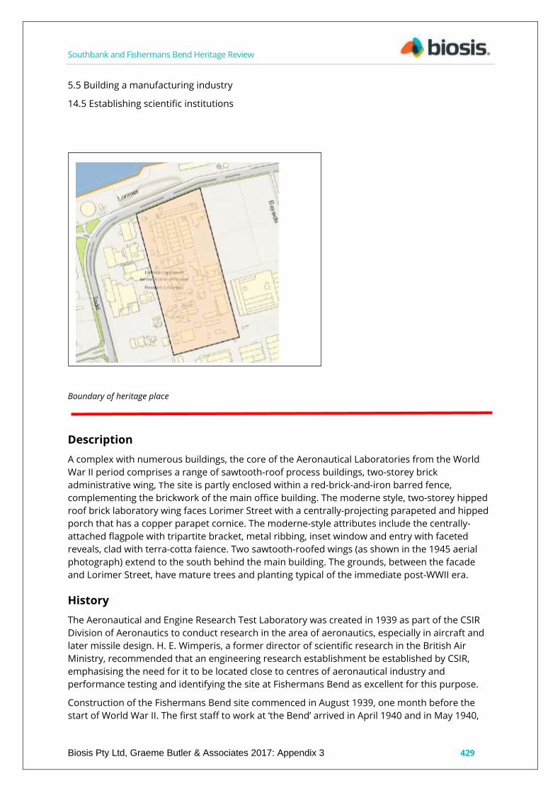
Southbank and Fishermans Bend Heritage Review
Biosis Pty Ltd, Graeme Butler & Associates 2017: Appendix 3 429
5.5 Building a manufacturing industry
14.5 Establishing scientific institutions
Boundary of heritage place
Description
A complex with numerous buildings, the core of the Aeronautical Laboratories from the World
War II period comprises a range of sawtooth-roof process buildings, two-storey brick
administrative wing, The site is partly enclosed within a red-brick-and-iron barred fence,
complementing the brickwork of the main office building. The moderne style, two-storey hipped
roof brick laboratory wing faces Lorimer Street with a centrally-projecting parapeted and hipped
porch that has a copper parapet cornice. The moderne-style attributes include the centrally-
attached flagpole with tripartite bracket, metal ribbing, inset window and entry with faceted
reveals, clad with terra-cotta faience. Two sawtooth-roofed wings (as shown in the 1945 aerial
photograph) extend to the south behind the main building. The grounds, between the facade
and Lorimer Street, have mature trees and planting typical of the immediate post-WWII era.
History
The Aeronautical and Engine Research Test Laboratory was created in 1939 as part of the CSIR
Division of Aeronautics to conduct research in the area of aeronautics, especially in aircraft and
later missile design. H. E. Wimperis, a former director of scientific research in the British Air
Ministry, recommended that an engineering research establishment be established by CSIR,
emphasising the need for it to be located close to centres of aeronautical industry and
performance testing and identifying the site at Fishermans Bend as excellent for this purpose.
Construction of the Fishermans Bend site commenced in August 1939, one month before the
start of World War II. The first staff to work at ‘the Bend’ arrived in April 1940 and in May 1940,

Southbank and Fishermans Bend Heritage Review
Biosis Pty Ltd, Graeme Butler & Associates 2017: Appendix 3 430
and the laboratory formally became the Division of Aeronautics, part of CSIR, with L. P. Coombes,
formerly of the Royal Aircraft Establishment Farnborough, as chief.
The organisation changed its name to the Aeronautical Research Laboratories in 1949. In March
1994, the Aeronautical Research Laboratory merged with the Materials Research Laboratory to
form the Aeronautical and Maritime Research Laboratory of the Defence, Science and
Technology Organisation (DSTO).
The facility has been responsible for a number of world innovations, including the 'black box'
flight recorder, with the prototype of the first airborne flight memory recorder unit invented by
Doctor David Warren at the Aeronautical Research Laboratories.
Comparative analysis
The moderne-style brick office building is similar to that at the nearby Government Aircraft
Factory (GAF), and reflects the Commonwealth house style of the period. The adjacent GAF and
Commonwealth Aircraft Corporation sites also have steel-framed sawtooth-roof industrial
buildings of the similar period. General Motors Holden has one surviving pre-war range of
sawtooth-roof buildings, while part of the Kraft factory might retain a few bays of 1945 sawtooth-
roof buildings. A small part of the GPO workshops in Sturt Street may also date back to the WWII
period. Overall, however, original pre-war sawtooth-roof factory buildings are increasingly rare.
Timber-framed versions of sawtooth-roof factory buildings are nearly extinct.
Statement of Significance
What is significant?
Aeronautical Research Laboratories Department of Defence, 502 Lorimer Street, Fishermans
Bend.
Contributory elements include:
parapeted and hipped-roof form;
inset windows and entry with faceted reveals;
red brick, cement render and terracotta faience finishes’
moderne-style attributes – attached flagpole, tripartite bracket, metal ribbing; and
Sawtooth-roofed fabrication buildings.
How is it significant?
The Aeronautical Research Laboratories are historically and aesthetically significant to
Southbank, the city of Melbourne and the state of Victoria.
Why is it significant?
The Aeronautical Laboratories are historical significance for the critical role they played in
providing scientific backing for the military operations during World War II, testing and proving
airframes and engines for RAAF and allied use. (Criterion A)
The place is of scientific significance for its historic and ongoing developments in aeronautics,
including the first black box flight recorders.
The place is of aesthetic significance for its characteristic moderne style used for Commonwealth
buildings in Victoria during the Inter-war and World War II eras, as well as for its mature garden
plantings, typical of the World War II era. (Criterion E)

Southbank and Fishermans Bend Heritage Review
Biosis Pty Ltd, Graeme Butler & Associates 2017: Appendix 3 431
Sources used for this assessment
The following sources and data were used for this assessment:
Long, G., The leading edge: sixty years of aeronautical research and development for Australia's
defence 1939 - 1999, Aeronautical & Maritime Research Laboratory, Melbourne, 1999.
Kepert, J. L., Fishermans Bend – A Centre Of Australian Aviation Department Of Defence,
Defence Science and Technology Organisation, Aeronautical Research Laboratory, Melbourne,
Victoria.
Museum Victoria Collection. http://collections.museumvictoria.com.au/items/405748
Recommendations
Revise Heritage Places Inventory.
Proposed heritage overlay as Aeronautical Research Laboratories, 502-550 Lorimer Street, Port
Melbourne.
Apply external paint controls with policy to maintain original finishes and colour schemes.
Apply tree controls to mature garden plantings.

Southbank and Fishermans Bend Heritage Review
Biosis Pty Ltd, Graeme Butler & Associates 2017: Appendix 3: 432
Queens Bridge Hotel, 1-7 Queens Bridge Street, Southbank
City of Melbourne property number: 108040
Type of place: hotel
Images of place 2016-2017
Historical associations:
Creation or major development date(s) of place: 1927, Inter-war (WW1-WW2)
Major owners or occupiers:
A. Borthwick, Carlton Breweries Ltd
Designer: Peck & Kempter
Heritage Gradings:
Proposed new system (C258):
Individually significant
Alphanumeric system - (building A-E, streetscape 1-3):
Existing: D, Proposed: C3
Heritage values:
Aesthetic, Historical
Heritage status:
Heritage Overlay Proposed
Thematic context:
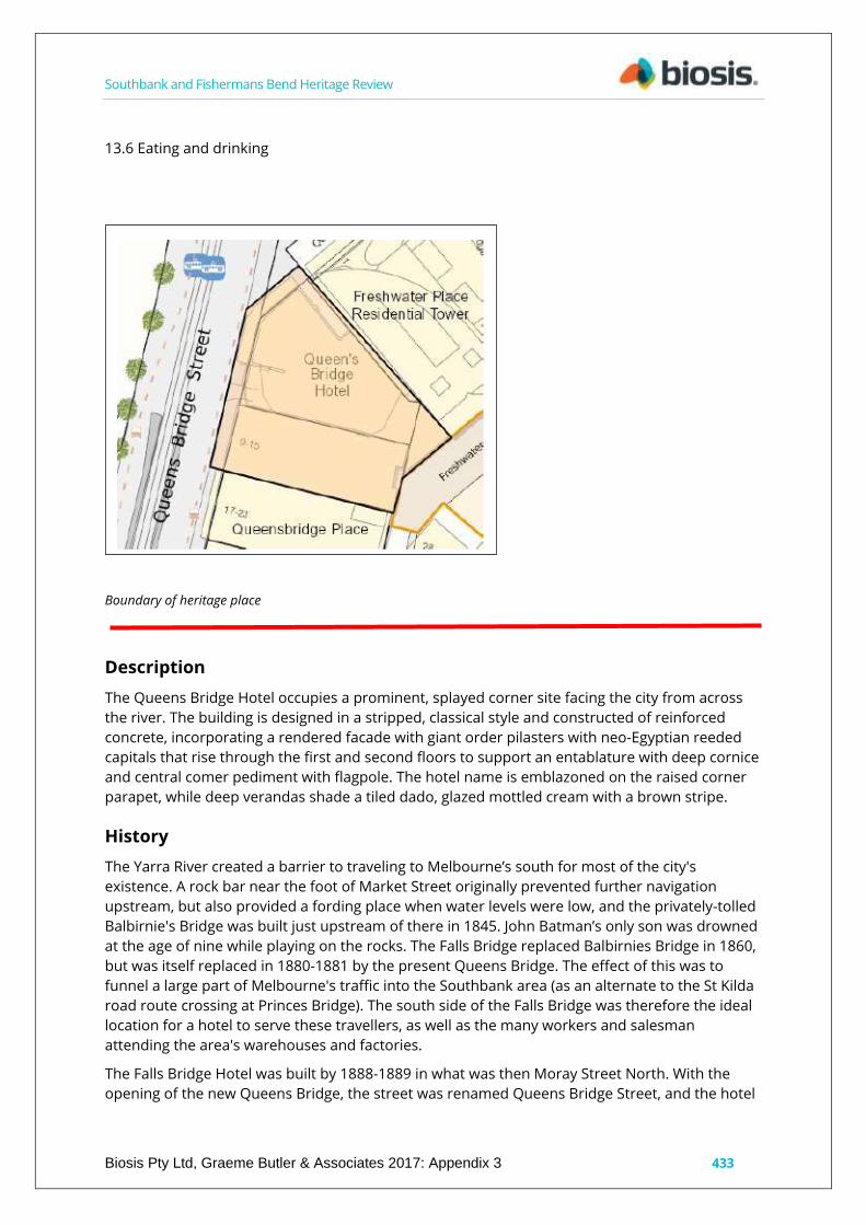
Southbank and Fishermans Bend Heritage Review
Biosis Pty Ltd, Graeme Butler & Associates 2017: Appendix 3 433
13.6 Eating and drinking
Boundary of heritage place
Description
The Queens Bridge Hotel occupies a prominent, splayed corner site facing the city from across
the river. The building is designed in a stripped, classical style and constructed of reinforced
concrete, incorporating a rendered facade with giant order pilasters with neo-Egyptian reeded
capitals that rise through the first and second floors to support an entablature with deep cornice
and central comer pediment with flagpole. The hotel name is emblazoned on the raised corner
parapet, while deep verandas shade a tiled dado, glazed mottled cream with a brown stripe.
History
The Yarra River created a barrier to traveling to Melbourne’s south for most of the city's
existence. A rock bar near the foot of Market Street originally prevented further navigation
upstream, but also provided a fording place when water levels were low, and the privately-tolled
Balbirnie's Bridge was built just upstream of there in 1845. John Batman’s only son was drowned
at the age of nine while playing on the rocks. The Falls Bridge replaced Balbirnies Bridge in 1860,
but was itself replaced in 1880-1881 by the present Queens Bridge. The effect of this was to
funnel a large part of Melbourne's traffic into the Southbank area (as an alternate to the St Kilda
road route crossing at Princes Bridge). The south side of the Falls Bridge was therefore the ideal
location for a hotel to serve these travellers, as well as the many workers and salesman
attending the area's warehouses and factories.
The Falls Bridge Hotel was built by 1888-1889 in what was then Moray Street North. With the
opening of the new Queens Bridge, the street was renamed Queens Bridge Street, and the hotel

Southbank and Fishermans Bend Heritage Review
Biosis Pty Ltd, Graeme Butler & Associates 2017: Appendix 3 434
was renamed the Queens Bridge Hotel. The hotel was considered to be a death trap, as there
was a varnish works operating at its rear, and following intervention of the Liquor Licensing
Board, the earlier building was replaced by the existing modern, reinforced-concrete structure in
1926 when the hotel was acquired by Carlton & United Breweries (CUB). The firm of Peck &
Kemter, who also designed the Heidelberg Town Hall and Capitol Theatre, was engaged to
transform the Victorian building, providing a three-storeyed, stuccoed, neo-Classical framework.
Below the cantilevered veranda, the exterior was finished with glazed tiling in mottled cream
with brown stripes. In 1940, further updating was carried out by CUB.
Comparative analysis
The Queens Bridge Hotel has a stripped classical style with neo-Egyptian motifs, reflects a style
applied to several hotels built during the same period, with prominent examples including the
Greyhound Hotel in Swan Street, Richmond and the Tankerville Arms in Fitzroy. Locally, Kosky
Bros. also suggests a displays a Modernist geometric form.
Statement of Significance
What is significant?
The Queens Bridge Hotel, 1-3 Queens Bridge Street, Southbank.
Contributory elements include:
parapeted three-storey corner form;
stuccoed ornamentation in a trabeated form in a neo-Classical style, terminating on a
cornice at the parapet;
stepped parapet, entablature and central flagpole, providing a moderne flavour;
neo-Egyptian, reeded capitals to the pilasters, in keeping with the exotic derivation of the
stepped parapet;
cantilever street veranda;
glazed tiling in a typical mottled cream with a brown striped pattern, with dado;
openings still fitted with their varnished-timber doors; and
concertina wrought-iron security grilles.
The hotel exterior is very close to the original.
How is it significant?
The Queens Bridge Hotel is historically and aesthetically significant to Southbank and the city of
Melbourne.
Why is it significant?
It is of local historical significance for its role in serving travellers and workers in the Southbank
area. Its history is notable for the association with the nearby Queens Bridge and its precursor,
the Falls Bridge, after which the hotel was named and then renamed. It is also notable for its
associations with architects Peck & Kemter. (Criterion A & H)
As a major focus for workers from the Southbank area, as well as travelling salesmen visiting the
districts businesses, it reflects the former historical makeup of the Southbank area.
The hotel is aesthetically significant for its stripped Classical style and Egyptian motifs, as well as
its prominent corner position giving it a landmark status on one of the main entries from the city
into the Southbank area. (Criterion E)
Southbank and Fishermans Bend Heritage Review
Biosis Pty Ltd, Graeme Butler & Associates 2017: Appendix 3 435
Sources used for this assessment
The following sources and data were used for this assessment:
SBCS V1 FOOTNOTES
18. Queens Bridge Hotel
1. Cole Collection (SLV)
2. MMBW, 17727
3. (a) ibid
(b) photograph, 1925, (MUA)
4. Cole Collection (State Library of Victoria)
Rate books
1-7 Queens Bridge Street
Ratebooks
Year No. on Roll Occupier Occupation Owner Occupation Description of Property Rate Detail
(N.A.V.) Rate Detail (Paid)
1920 8117 James Dwyer of 1/3 Queens Bridge Licensed Victualler (LV) James Dwyer 20
Bedrooms £300 £30
1920 8118 Shanks & Cox Pty Ltd of 5/7 Queens Bridge Merchants James Dwyer Brick store £240
£24
1921 8146 James Dwyer of 1/3 Queens Bridge LV James Dwyer 20 Bedrooms etc £350 £39.76
1921 8147 Shanks Co. Pty Ltd of 5/7 Queens Bridge Merchants Borthwick AJ Bros. Brick Store
$260 £29.50
1923 3587 Ellen Dillon of 1 Queens Bridge LV J. Dwyer 45 Bedrooms £800 £100
1923 3586 Shanks Pty Ltd of 3 Queens Bridge Merchant Borthwick AJ Bros Brick Store £260
£32.10
1925 8365 Shanks Pty Ltd of 3 Queens Bridge Merchant Borthwick AJ Bros Brick store £260
£32.10
1929 8353 Mildred Cass of 1/3 Queens Bridge LV Carlton Breweries Ltd 33 Bedrooms + Bar
£1200 £150
1929 8354 Shanks Pty Ltd of 5/7 Queens Bridge Merchant Borthwick AJ executors Brick store
£260 £32.10
1934 8373 Mildred Cass of 1/3 Queens Bridge LV Carlton Breweries Ltd Queens Bridge Hotel 33
Bedrooms + bar £900 £112.10
1934 8374 Shanks Pty Ltd of 5/7 Queens Bridge Merchant Shanks Pty Ltd Brick store £200 £25
MMBW map series. 40 feet to 1 inch. 1892. State Library of Victoria.
Mahlstedt Fire Insurance Plans, South Melbourne, c1920, c1930, c1950, State Library of Victoria.
Newspapers
LICENSING COURT: Hotels to be Reconstructed.
The Licensing Court, sitting in the Court of Marine Inquiry, yesterday considered the cases of
further hotels in the Emerald Hill subdivision of the Port Melbourne Licensing District, in
connection with its deprivation proposals.
One of the hotels concerning which evidence was taken was the Queen's Bridge Hotel, Queen's
Bridge, of which A. V. Scott is the licensee.

Southbank and Fishermans Bend Heritage Review
Biosis Pty Ltd, Graeme Butler & Associates 2017: Appendix 3 436
Licensing-inspector Brown said that the existing hotel building was of unsatisfactory construction
in view the possibility of fire, and it should be rebuilt.
Mr. Wilson (Messrs. Pavey, Wilson, and Cohen), appearing for the owners (the Carlton and United
Breweries Pty. Ltd.) and also for the licensee, said that the owners were prepared, in the event of
the hotel being permitted to remain, immediately to pull down the structure, and erect a
thoroughly modern building, at a cost of £17,000, independently of the value of the land.
The Court reserved its decision.
When the Main Point Hotel, Moray Street, the owner of which is Mrs. Rubira, was under
consideration, Mr. J. Rubira, husband of the owner, said that if this hotel were permitted to
remain he contemplated erecting an establishment for the south side of the river on the lines of
his Bourke street cafe. The serving of meals would be properly carried out in trading hours, and
would not be limited to half an hour. He owned extensive properties on both sides of the site of
the Main Point Hotel Mr. Lewers (Instructed by Messrs. Snowden, Neave, and Demonic)
appeared for Mrs Rubira.
Concerning the Castlemaine Hotel, Moray street, the Court was informed that if the hotel were
not delicensed it was proposed to add an additional storey to the building and to reconstruct the
interior at a cost of £6,000.
Decision was also reserved in these two cases.
The Age, 11 November 1927, p.6, ‘THIEVES BREAK INTO HOTEL’.
Breaking into the storeroom of Queen's Bridge Hotel, Queen's Bridge Street, South Melbourne,
between 7 and 11 o'clock on Wednesday night, thieves stole a quantity of spirits, including two
cases of gin, to the value of £16. The hotel is in course of being rebuilt, and the entrance was
gained by forcing a street door with a jemmy.
‘Advertising’, The Age, 4 November 1929, p.16. Accessed online 9 February 2017.
http://nla.gov.au/nla.news-article203256733
Queens Bridge Hotel recently rebuilt.
Recommendations
Revise Heritage Places Inventory.
Proposed heritage overlay as Queens Bridge Hotel, 1-7 Queens Bridge Street, Southbank.
Apply external paint controls with policy to reintroduce original finishes and colour schemes.

Southbank and Fishermans Bend Heritage Review
Biosis Pty Ltd, Graeme Butler & Associates 2017: Appendix 3: 437
Robur Tea Company factory/warehouse. 107-127 Queens Bridge
Street, Southbank.
City of Melbourne property number: 108050
Type of place: warehouse
Images of place 2016-2017
Historical associations:
Creation or major development date(s) of place: 1904, Edwardian-era
Major owners or occupiers: W. Train (1881), Robur Tea Company
Designer: Barnet, Nahum
Heritage Gradings:
Individually significant, Contributory to a precinct
Alphanumeric system (building A-E, streetscape 1-3):
Existing: D1 Proposed: C2
Heritage values:
Aesthetic, Historical
Heritage status:
Heritage Overlay Proposed
Thematic context:
5.3 Developing a large, city-based economy
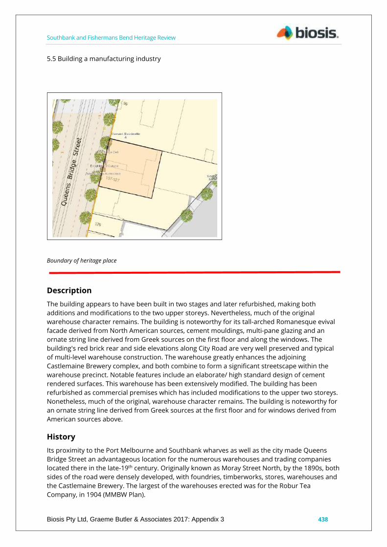
Southbank and Fishermans Bend Heritage Review
Biosis Pty Ltd, Graeme Butler & Associates 2017: Appendix 3 438
5.5 Building a manufacturing industry
Boundary of heritage place
Description
The building appears to have been built in two stages and later refurbished, making both
additions and modifications to the two upper storeys. Nevertheless, much of the original
warehouse character remains. The building is noteworthy for its tall-arched Romanesque evival
facade derived from North American sources, cement mouldings, multi-pane glazing and an
ornate string line derived from Greek sources on the first floor and along the windows. The
building's red brick rear and side elevations along City Road are very well preserved and typical
of multi-level warehouse construction. The warehouse greatly enhances the adjoining
Castlemaine Brewery complex, and both combine to form a significant streetscape within the
warehouse precinct. Notable features include an elaborate/ high standard design of cement
rendered surfaces. This warehouse has been extensively modified. The building has been
refurbished as commercial premises which has included modifications to the upper two storeys.
Nonetheless, much of the original, warehouse character remains. The building is noteworthy for
an ornate string line derived from Greek sources at the first floor and for windows derived from
American sources above.
History
Its proximity to the Port Melbourne and Southbank wharves as well as the city made Queens
Bridge Street an advantageous location for the numerous warehouses and trading companies
located there in the late-19th century. Originally known as Moray Street North, by the 1890s, both
sides of the road were densely developed, with foundries, timberworks, stores, warehouses and
the Castlemaine Brewery. The largest of the warehouses erected was for the Robur Tea
Company, in 1904 (MMBW Plan).

Southbank and Fishermans Bend Heritage Review
Biosis Pty Ltd, Graeme Butler & Associates 2017: Appendix 3 439
W. Train purchased lot 32 in 1881 in an area of the south of Melbourne that had yet to be
developed. The Robur Tea Company already had a presence in Queens Bridge Street from as
early as 1900, when the manager, J. H. Thompson, gave it as the company address in
newspapers (The Age, 29 November 1900, p.8).
The earliest references to the Robur Tea Company are in the mid-1890s, when articles began to
appear in the papers. In June 1900, new owners acquired the brand and embarked upon an
aggressive advertising campaign, expanding the firm’s sales considerably. The Robur Tea
Company grew into one of Australia’s largest suppliers of packet tea, operating out of a large six-
storey red brick building in South Melbourne. Robur Tea Company was one of a number of
business interests of James Service (1823-1899) and his firm James Service & Co., one of the
larger trading firms in Melbourne. The Robur Tea Company Ltd was registered in Victoria in 1928
and from its inception, was one of the larger tea firms, taking over Griffith Bros. in the 1960s. It
was, in turn, acquired by D. & J. Fowler Ltd in 1974.
By 1903, the Robur Tea Company was advertising its warehouse at Queens Bridge Street, South
Melbourne (Brisbane Courier, 1 August 1903, p.13). However, two years later they give their
address as 28-34 Clarendon Street, South Melbourne (Emerald Hill, 7 October 1905, p.3). It would
appear that Robur Tea Company occupied both buildings for some time, with listings for ‘Robur
Tea Company, James Service, Proprietor, tea stores & blending warehouse’ at 107 and 109
Queens Bridge Street. By 1910, however, C. Hall, C. 3., perambulator manufacturers, are at 107-
109 Queens Bridge Street, Robur Tea Store is at 111 Queens Bridge Street, and McIntyre Bros.
tea warehouse is at 117 Queens Bridge Street. These occupants are the same in 1909 and 1915,
with the addition of the ordnance store of the Defence Department at number 115. By 1925, the
occupants along this stretch are Newnham & Roberts, engineers, at 109; Service, Jas., & Co, bulk
store, at 111-113; and the Austral Canning Co Pty Ltd, butter exporters, at 115-117 (Sands &
McDougall Directory of Victoria).
The Mahlstedt Plan in the 1920s indicates that Disher & McBrien, pram-makers, were occupants
of the three-storey building at 107-109, with Eclipse Radio Pty Ltd in the five-storey building at
111-115, as well as in the two-storey section and rear yard behind.
Over the years, numerous fires broke out in the buildings, each causing extensive damage to
stock. Fortunately for the buildings, however, the fire brigade appears to have been able to
contain the fires. Employees of C. J. Hall in the lower levels and James Anderson, furniture-
maker, on the third floor, alerted the brigades on 14 December 1907, The fire on 11 April 1908
affected Hall and the Standard Chemical Company; this fire was noted as being the third to occur
within 12 months (The Age, 13 April 1908 p.8). Another fire occurred in 1935, gutting the second
floor of the three-storey building occupied by Disher & McBrien and Eclipse Radio (The Age, 3 Oct
1935, p.13).
Comparative analysis
Victorian- and Edwardian-era warehouses are now uncommon in Southbank, though they were
once more numerous. The tall-arched American Romanesque form, while more common in the
CBD in areas such as Flinders Lane, is uncommonly seen in Southbank. Maurice Artaud & Co. at
71-75 City Road and Crown Chemicals at 63-65 City Road compare closely in style to the Robur
Tea Company factory/warehouse.
Statement of Significance
What is significant?
Southbank and Fishermans Bend Heritage Review
Biosis Pty Ltd, Graeme Butler & Associates 2017: Appendix 3 440
The Robur Tea Company factory/warehouse, 107-127 Queens Bridge Street, Southbank.
Contributory elements include:
multi-storey form with Romanesque and Classical facade elements;
cement moulding details;
multi-paned glazing;
exposed red brick utilitarian industrial rear and side elevations; and
rear loading doors.
How is it significant?
The factory/warehouse is historically and aesthetically significant to Southbank and to the city of
Melbourne.
Why is it significant?
It is of local historical significance as it is one of the largest warehouse buildings in the
Southbank area, comparable with the Jones Bond Store and the Clarendon Street Teahouse. It
represents the important mercantile activity that developed along the south bank of the Yarra
River around the turn of the 20th century, and as such, is representative of the major industrial
development that occurred in the Victorian-era and Inter-war periods in the area. It is also
significant for its association with James Service & Co., one of Melbourne's most successful
import and trading firms. (Criterion A)
The factory/warehouse is aesthetically significant for its well-developed architectural treatment
and its tall-arched fenestration of the facade, demonstrating the style’s interest in medieval
architectural sources as well as arts & crafts detailing observed in the Edwardian-era warehouse
design. (Criterion E)
Sources used for this assessment
The following sources and data were used for this assessment:
i-Heritage
Image used from i-Heritage c1997, 107 to 127 Queens bridge Street, Southbank, 3006.
South Melbourne Conservation Study 1997 – Bryce Raworth.
Milner, P. 107-113 Queens Bridge Street, South Melbourne. University of Melbourne, Dept. of
Mechanical and Industrial Engineering, 1989.
Geoffrey Serle, 'Service, James (1823–1899)', Australian Dictionary of Biography, National Centre of
Biography, Australian National University, published first in hardcopy in 1976, accessed online 7
March 2017. http://adb.anu.edu.au/biography/service-james-4561/text7483
Robur Tea Company Limited (1928 - 1974). Guide to Australian Business Records.
http://www.gabr.net.au/biogs/ABE2323b.htm
State Library of South Australia, D. & J. Fowler archives.
http://www.slsa.sa.gov.au/archivaldocs/brg/BRG14_DandJFowler_serieslist.pdf
Building Identification Form 1997 (BIF)
Graded D/1

Southbank and Fishermans Bend Heritage Review
Biosis Pty Ltd, Graeme Butler & Associates 2017: Appendix 3 441
Built c1910, has ‘elaboration/high standard design of cement rendered surfaces.’
COMMAP 2016
Building Details: Three refurbished older buildings. At 107-115 Queens Bridge, a five-storey
former Victorian warehouse. At 117 Queens Bridge, a two-storey brick office building built
in1888. At 216 (sic) City Road a two-storey brick building built in the mid 1930s. Consolidated,
refurbished and subdivided in 1988 with a further subdivision in 2004.
Mahlstedt & Son c1928 (MUA)
shown as 107-109 (3 storey, Disher & McBrien), 111-115 (five-storey Eclipse Radio Pty Ltd) with 2
storey (Eclipse Radio P/L) covering rear yard.
Rate books
107-127 Queens Bridge Street
Year No. on Roll Occupier Occupation Owner Occupation Description of Property Rate Detail
(N.A.V.) Rate Detail (Paid)
1902 7275 James Ormond Randall Alcock 107/109 Queens Bridge Street Tea Merchants The
Australian Deposit and Mortgage Bank Ltd. Brick store £213 £21.6
1902 7276 James Ormond Randall Alcock 111/113 Queens Bridge Street Tea Merchants The
Australian Deposit and Mortgage Bank Ltd. Brick store £127 £12.14
Sands & McDougall Directory of Victoria
1904
107 Robur Tea Co; Service, J., & Co, proprietors
109 Service, Jas., & Co, tea strs & blending warehouse
1910
107 Hall, C. 3., perambulator. etc., mfr
111 Robur Tea Store
SUN ACETYLENE COMPANY, Queen's Bridge St., opposite Castlemaine Brewery, South Melbourne
117 McIntyre Bros. tea wrehse
1915
107 Hall. C. J.. perambulator, etc. mfr
111 Robur Tea Store —Service. Jas. &
115 Ordnance store, Defence Dept
117 McIntyre Bros. tea wrehse
117 Moran Loftus, tea merch
1920
107 Hall, C. Z., perambulator. etc. mfr
111 Robur Tea Store —Service, Jas. & Co
115 Bond Manfg Co, salt merchts
1925
109 Newnham & Roberts. encnrs
111-113 Service, Jas., & Co, bulk store
115 Austral Canning Co Pty Ltd
1942

Southbank and Fishermans Bend Heritage Review
Biosis Pty Ltd, Graeme Butler & Associates 2017: Appendix 3 442
107 Disher & McBrien Pty Ltd, pram manfrs
109 Cosynook Sandwich Shop
111-113 Vacant
115-117 Austral Canning Co Pty Ltd. Butter exporters
Newspapers:
‘ROBUR TEA COMPANY.’ Albury Banner and Wodonga Express (NSW : 1896 - 1938) 11 September
1896: 35. Web. 7 Mar 2017 <http://nla.gov.au/nla.news-article99434684>.
‘TEA CULTURE IN VICTORIA.’ The Age (Melbourne, Vic. : 1854 - 1954) 29 November 1900: 8. Web. 7
Mar 2017 <http://nla.gov.au/nla.news-article188637803>
‘Advertising’ The Brisbane Courier (Qld. : 1864 - 1933) 1 August 1903: 13. Web. 7 Mar 2017.
<http://nla.gov.au/nla.news-article19234474>
SOUTH MELBOURNE CITY COUNCIL’ Record (Emerald Hill, Vic. : 1881 - 1954) 7 October 1905: 3.
Web. 7 Mar 2017 <http://nla.gov.au/nla.news-article162258899>
OUTBREAK AT SOUTH MELBOURNE. The Age (Melbourne, Vic. : 1854 - 1954) 13 April 1908: 8.
Web. 7 Mar 2017 <http://nla.gov.au/nla.news-article196107025>.
Record (Emerald Hill, Vic. : 1881 - 1954) Sat 13 Feb 1904 Page 2.
About Robur warehouse in Queens Bridge St.
Geraldton Express (WA : 1906 - 1919) Wed 1 Apr 1908 Page 4.
Detailed account of operations at Clarendon St warehouse
Record (Emerald Hill, Vic. : 1881 - 1954) Sat 12 Oct 1901.
Robur complains of footpath in Queens Bridge St to Council.
The Mercury (Hobart, Tas. : 1860 - 1954) Fri 15 Dec 1933 Page 11.
FACTORY FOR ROBUR TEA CO.
The erection of additional factory premises for the Robur Tea Co. Ltd. At Clarendon Street, South
Melbourne, marks another stage in the growth of a concern which has been little affected in its
trading operations by constantly changing fashions. Other factories, however, have rendered it
necessary for the company to provide extra facilities, including Increased accommodation for
employees, improvements in the general lay-out, and the introduction of special methods. The
plans contain provision for the construction of a brick, steel and concrete two-storey building.
The main structural items specified for the work, which will be put in hand immediately,
comprise a steel roof of saw-tooth design, an unusually large number of windows, taking: up
about half the area of the walls, and a well for a goods lift.
The Age (Melbourne, Vic. : 1854 - 1954) Tue 17 Oct 1933.
Factory for Robur Tea Co.
The erection of additional factory premises for the Robur Tea Co. Ltd. at Clarendon-street, South
Melbourne, marks an other stage in the growth of a concern which has been little affected in its
trading operations by constantly changing fashions. Other factories, however, have now
rendered it necessary for the company to provide extra facilities, including increased
accommodation for employees, improvements in the general lay-out,' and the introduction of
special' methods which will still further attract attention to the various tea blends with their

Southbank and Fishermans Bend Heritage Review
Biosis Pty Ltd, Graeme Butler & Associates 2017: Appendix 3 443
distinctive labels. Plans prepared by . Messrs. Twentyman and Askew, architects, of Bourke-
street, contain provision for the construction of a brick, steel and concrete two-storey building oil
the area south of land between the present premises and the railway line. The building will have
a frontage of only 15 feet to Clarendon street, but will widen out to about 60 feet at the western
side, with a depth of 140 feet. An interesting aspect is that the foundations, on account of the
site being nil old reclaimed portion along the river, will be carried on a concrete raft. To make
way for the new structure an existing building of obsolete type will be removed. The main
structural items specified for the work, which will he put in hand immediately, comprise a steel
roof of saw-tooth (Resign, an unusually large number of windows, taking up about halt the area
of the walls, and a yell for a goods lift.
Recommendations
Revise Heritage Places Inventory.
Proposed heritage overlay as Robur Tea Company factory/warehouse, 107-127 Queens Bridge
Street, Southbank, and within City Road industrial and warehouse precinct.
Apply external paint controls with policy to reintroduce original finishes and colour schemes.

Southbank and Fishermans Bend Heritage Review
Biosis Pty Ltd, Graeme Butler & Associates 2017: Appendix 3: 444
Castlemaine Brewery complex with brewing tower and bottling
stores adjoining, 107-127, 129-131 and 133 Queens Bridge Street,
Southbank
City of Melbourne property number: 108051
Type of place: brewery
Images of place 2016-2017
Historical associations:
Creation or major development date(s) of place: 1888, 1892; Victorian-era
Major owners or occupiers: Castlemaine Brewery Ltd.
Designer: R. B. Whitaker
Heritage Gradings:
Proposed new system (C258):
Individually significant, Contributory to a precinct
Alphanumeric system (building A-E, streetscape 1-3):
Existing: A1 Proposed: A2
Heritage values:
Aesthetic, Historical, Social
Heritage status:
Heritage Overlay Proposed

Southbank and Fishermans Bend Heritage Review
Biosis Pty Ltd, Graeme Butler & Associates 2017: Appendix 3 445
Thematic context:
5.3 Developing a large, city-based economy
Boundary of heritage place
Description
The Castlemaine Brewery complex comprises a five-storey brew tower flanked by identical two-
storey storage warehouses. Notable features include unpainted decorative bi-chrome brickwork
surmounted by a tiled, mansard roof. The facades are of red brick with quoins, window heads
and string courses at each floor level in contrasting cream brick. A decorative arch motif, five
stories in height, relieves the front façade. These stores were a coherent group of three
buildings, each built in polychrome brickwork.
The mansard roof of the brew tower is punctuated by two rows of dormer windows. The flanking
buildings have decorative rendered parapets, however they have had their original bi-chrome
brickwork rendered over, resulting in a loss of coherence over the group. The facade has
projecting brick pilasters and arched windows, all originally trimmed in cream brick. Low,
shallow-arched vents were set below the ground floor windows. The north wing had a wide door
at the ground level of the central bay, while the south wing contained windows matching those
on either side, now opened into a new entrance.
The sandblasting of the brickwork of the central tower has been detrimental to its fabric. A large,
double-sided advertising sign that surmounts the building significantly detracts from its
appearance.
Internally, the south wing retains the cast iron columns and riveted beams that support the first
floor, along with the majority of the original timber-lined ceiling. The walls of the ground floor
are brick face, with deep arched recesses aligned with the window openings of the adjacent

Southbank and Fishermans Bend Heritage Review
Biosis Pty Ltd, Graeme Butler & Associates 2017: Appendix 3 446
tower. Granite blocks are built into the north and south walls to support the floor beams which
don’t sit on the blocks at the north end (the wall of the central tower) but have been packed. The
Conservation Management Plan notes that slopes in the floors and packed beam ends suggest
that the brew tower has sunk on its foundations by 500-600 millimetres due to the ‘notoriously
unstable Coode Island silt that underlies the area during construction.’ This suggests that the
building probably has substantial piled or timber raft footings, as are known to exist under the
Jones Bond Store and Robur Teahouse nearby.
The ground floor was 450 millimetres lower than the present floor level, made up of brick laid
over a concrete base. A layer of cork with a 50-millimetre thick layer of concrete overtop
indicates that part of the area was used for cool storage. The first floor of the bottle store at 133
Queens Bridge Street is of timber and slopes notably. A brick wall enclosing a yard runs along
the City Road boundary, where a former brick structure once abutted this wall, probably
comprising lean-to sheds or stables (1895 MMBW plan).
To the south was the rear wall and yard of the former Castlemaine Hotel. Gates, visible in a
photograph taken in 1905 provided access to the yard. The wall originally extended for the full
length of the City Road boundary of the property, but the sections at the rear of 129 and 131
Queens Bridge Street have now been demolished.
History
The south bank of the Yarra River was only partially-developed in the mid-19th century, with a
series of shipping-related structures – including wharves, warehouses and engineering works –
along the river bank. Sandridge Road ran up to the Falls Bridge and St Kilda Road, where the first
private bridge was erected in 1844-1845 (Balbirnie’s Bridge), followed by Lennox's Princes Bridge
which opened in 1851 and the Falls Bridge in 1860. This last was replaced by the Queens Bridge
in 1889, which gave its name to Queens Bridge Street, formerly Moray Street North. As a result,
the route between Melbourne and the bay-side piers at Sandridge became one of the principal
thoroughfares south of the river, along with St Kilda Road. The proximity of initial industry to the
wharves also determined the character of the area, notable for the absence of any residential
buildings north of City Road.
Beer-brewing was one of the first industries in Melbourne, with brewers and maltsters located
around the fringe of the CBD. Thomas Capel was selling locally-brewed beer from the Britannia
Brewery near the Yarra wharves by 18438 (Garyowen). Later in the year, John Moss began to
manufacture ale at the Ship Inn Hotel in Flinders Lane and by 1839 a third brewery was
established. By 1850 there were seven breweries in Melbourne, mostly concentrated in the CBD.
By the mid-1850s, breweries were established in Victoria Parade, Carlton, Fitzroy, Collingwood,
Richmond, West Melbourne and South Melbourne, such as Thomas Graham’s brewery (later the
Shamrock Brewery) in Victoria Street, Abbottsford (1852), Thomas Aitken’s ‘fire’ brewery (later the
Victoria Brewery) in Victoria Parade, East Melbourne (1854) and John Wood's Yorkshire Brewery
in Wellington Street, Collingwood (1861) (Allom Lovell 2001).
Lack of cold storage and the demand for fresh beer ensured that breweries were located close to
areas of consumption. By 1871 there were 125 breweries in Victoria, 80% of which were located
outside Melbourne. One of these local breweries was Fitzgerald’s Brewery Bond Store, on
Castlemaine-Maldon Road in Castlemaine, established by Nicholas Fitzgerald and his brother
Edward, sons of an Irish brewer, soon after they arrived to the colony in 1857. By 1872 they had
branches in Melbourne, New South Wales and Queensland.
In 1871 they commenced operations on the north side of Queens Bridge Street (then called
Moray Street North) with J. B. Perrins as managing director, and by 1874, erected the malthouse

Southbank and Fishermans Bend Heritage Review
Biosis Pty Ltd, Graeme Butler & Associates 2017: Appendix 3 447
on the north side of Queens Bridge Street for the company (Butler 1982, p.46). ‘Tenders are
invited for the erection of a Malt House, plans available at Castlemaine Brewery, Moray Street,
South Melbourne’ (The Argus, 24 December 1874, p.2). Presumably this was on the west side of
the street.
The site at 115-133 Queens Bridge Street was initially used for the brewery's stables until stores
were built here in 1881 (Sands & McDougal Melbourne Directories). In 1887 Nicholas Fitzgerald
and Perrins were recorded as occupying the property on the south of Queens Bridge Street, 115-
133, for the Castlemaine Brewery Company, and its net annual value (NAV) was listed as £1,500
(Rate Books). In 1888, the property at 115-133 Queens Bridge Street, described as 'Brick Stores',
had a NAV of £4,606, and it is from this dramatic increase in their NAV – several times that of
1887 – that the construction of the standing brewery buildings is inferred. In 1890 the building
was listed as being at Moray Street North, and while it was portrayed as the 'new brewery' and
bottling stores, built originally as a standby in case of fire in the main brewery, at that date the
building was fully utilised. The location of the Castlemaine Brewery buildings to the north and
south of Queens Bridge Street are illustrated in the 1895 MMBW plans. The buildings to the east
and west, at 127 and 133 Queens Bridge Street, were the bottling stores of the complex.
During the 1870s, brewing technology developed, and new gravity-fed manufacturing processes
became the norm, requiring multi-storey brewing tower buildings with improved ventilation to
assist with cooling. These structures, often four to six stories in height, were erected at many
Victorian breweries during the 1870s, including the Yorkshire Brewery in Abbotsford,
McCracken’s City Brewery in Collins Street, the Ballarat Brewery in Ballarat and the Carlton
Brewery in Bouverie Street.
In 1885, Fitzgerald & Co., Brewers, were recorded as the owners and occupiers of a brick and
iron store on the south side of Moray Street North, now occupied by the buildings at 129-133
Queens Bridge Street. This was apparently a smaller structure than what now exist, and had
replaced the original stables with the brewery. In the same year, Fitzgerald is recorded as owner
and John Clark as licensee of a hotel on the triangular allotment adjacent, on the corner of City
Road. This was known as the Castlemaine Hotel and stood until demolished in the 1960s to
make way for the Kings Way overpass.
The site at 115-133 Queens Bridge Street was initially used for the brewery's stables until stores
were built here in c1881, (Sands & McDougal Melbourne Directories). In 1887-8, Nicholas
Fitzgerald and James Perrins (Brewers) were rated as occupying 'Brick stores', owned by the
Castlemaine Brewery Co. In the next year the N.A.V increases to £4606; having increased 4½
times. By 1890, these stores were portrayed as the 'new brewery and bottling stores' built,
originally as standby capacity, in case of fire in the main brewery, opposite, but now were fully
utilised.
The Castlemaine Brewery expanded in the 1890s, thanks to its ability to use the extensive trail
system to distribute its products; at the same time, the number of breweries in Melbourne
reduced from 26 in 1871 to only 13 in 1890. The Castlemaine Brewery was described in 1890 as
being one of the most extensive, most prosperous breweries existing in Australia (Garyowen). In
1892, a new, larger malthouse was erected for the Castlemaine Brewing Company property on
Sturt Street, South Melbourne.
The brewery became a public company by 1888, with shares worth £75,000, and branches in
Adelaide, Brisbane and Newcastle. Fitzgerald was first chairman of board, and later managing
director between 1892 and 1906, when the company amalgamated with the Carlton Brewery.
The buildings at 129-133 Queens Bridge Street, along with the adjacent Castlemaine Hotel,
continued to be in the ownership of the Castlemaine Brewery until 1907 when the company
Southbank and Fishermans Bend Heritage Review
Biosis Pty Ltd, Graeme Butler & Associates 2017: Appendix 3 448
joined with five other brewers to form a new entity, the Carlton and United Brewing Company
(Allom Lovell, 2001). This was a period of cartel operations by brewers, which saw the closure of
large numbers of the smaller companies.
Production was centralised north of the Yarra at the Carlton Brewery in Bouverie Street, and the
other breweries, such as those in Queens Bridge Street, were initially retained for use in
emergencies, but were progressively redeveloped or sold off.
A fire occurred in part of the Queens Bridge Street premises in 1907, gutting a store, although it
is unclear whether this was one of the surviving buildings (Bendigo Advertiser, 17 July 1907, p.5).
Fire occurred again in 1924 when the site was described as 'Scales Bond stores, formerly the
premises of the Castlemaine Brewery' (The Adelaide Register, 30 June 1924, p.13).
The 1920s Mahlstedt Plans depict the brewery building occupants as The Austral Canning
Company (115-127 Queens Bridge Street), McIntyre Bros Tea Merchants (131 Queens Bridge
Street) and Herbert Walker Factory (133 Queens Bridge Street). Following the amalgamation of
the Carlton and United Brewery the property at 115-133 remained within possession of the
Castlemaine Brewery until the 1930s, when the buildings on the east side of Queens Bridge
Street were sold off by the Carlton and United Brewing Company. Herbert Walter & Company Pty
Ltd was then listed as owner of 133 Queens Bridge Street, with the tenant being the Bacchus
Marsh Milk Company (Rate Books, 1930).
The 1936-1938 South Melbourne rate books show that the property had been purchased as
three separate lots, with the Austral Canning Company purchasing 115-127 Queens Bridge
Street, Loftus Moran Pty Ltd purchasing 129-131 Queens Bridge Street, and Thomas McClave
purchasing the property at 133 Queens Bridge Street, the building being described at this time
as a factory (Rate Books, 1936-1938).
The Castlemaine Hotel continued to operate and was now owned by Henry Stokes of the
Commercial Hotel, Fitzroy.
Comparative analysis
Victoria's extensive brewing industry of the 19th century is represented today by a number of
buildings of varying degrees of intactness. Those most akin to the Castlemaine Brewery include
the former Victoria Brewery in East Melbourne, the former Yorkshire Brewery in Collingwood,
and the former Carlton & United Brewery in Carlton
Former Yorkshire Brewery, 8 Wellington Street, Collingwood.
Established in 1858 by John Wood, the Yorkshire Brewery became a major Melbourne brewing
enterprise and remains probably the most significant brewing complex in Victoria. The most
prominent feature of the complex is the six-storey brew tower, completed in 1877 to the design
of John Wood's architect son, James. The tower is made of polychromatic brick with a slate-clad
mansard roof. More elaborate than the tower of the Castlemaine brewery, it has full-height bays
to all elevations, defined by pilasters with cream brick quoining with arched windows
surmounted by a parapet. The mansard roof has round-arched dormer vents and is capped by a
wrought-iron balustrade 'widow's walk'. Other surviving buildings have survived in the complex,
providing a notable example of a 19th century brewery.
Former Victoria Brewery, 416-442 Victoria Parade and Powlett Street, East Melbourne.
Founded in 1854, the former Victoria Brewery is the oldest surviving brewing complex in the
state. It is an extensive complex and, although recently redeveloped, retains many of the original
structures from different periods. One of the earliest buildings on the site is the old brew tower,

Southbank and Fishermans Bend Heritage Review
Biosis Pty Ltd, Graeme Butler & Associates 2017: Appendix 3 449
originally four stories tall, constructed in 1858 with an additional floor added in 1879. At the
same time, the tower was refaced in polychrome brickwork. The old brew tower is not only
visible from within the development. A number of buildings on the site, including the distinctive
1895 Lager Bier Cellar building on the corner of Victoria and Powlett streets, were designed by
the notable architect William Pitt. Pitt's pilastered and castellated design was continued in later
buildings extending along both Victoria and Powlett streets, giving the complex a distinctive
character.
Former Carlton and United Brewery, Bouverie and Swanston streets, Carlton.
Replacing an earlier brewery business established on the site in 1858, the Carlton Brewery began
operation on this site in 1864 and, under various owners, developed rapidly through the 1870s
and 1880s until, by 1897, it was the second-largest brewery in Melbourne. In 1905 the company
bought the Victoria Brewery, and in 1907, amalgamated with McCracken's City Brewery, Foster's
Brewery, the Shamrock Brewery and the Castlemaine Brewery to form Carlton and United
Breweries. Most of the buildings on the property have now been demolished, with the exception
of the bluestone buildings along Bouverie Street, which date from 1883 to 1925, and the 1904
malthouse in Swanston Street. The mansard-roofed brew tower on Bouverie Street has been
demolished.
Other surviving brewery buildings.
A single-storey building is all that remains of McCrackens City Brewery of Collins Street,
Melbourne.
Two buildings of the Foster Lager Brewing Company in Rokeby Street, Collingwood, remain on
the site: a four-storey building and a detached single-storey building.
A malt tower and one other building survive from Burton's Brewery in Stanley Street, West
Melbourne.
The former Volum brewery in Geelong is largely demolished, with only three walls of a bluestone
store remaining.
The Carlton & United Breweries operation at Abbotsford is very extensive, but a mostly modern
complex.
Much of the former Ballarat Brewery has been demolished, however a brewing tower and
chimney stack remain.
Like the brew towers of the Yorkshire Brewery and the Victoria Brewery, the tower at
Castlemaine Brewery and its flanking wings were built of polychromatic brick, with vertical bays
defined by pilasters surmounted by a cornice and parapet. However, the Castlemaine Brewery is
more restrained in design with a relatively plain cornice and parapet. The use of mansard roof
was a popular element at the time, also appearing on the brew towers of the Carlton Brewery
(1872), the McCracken Brewery (1870s) and the Victoria Brewery (1879), giving what was arguably
a Lombardic Romanesque style, with overtones of French Second Empire style.
At this time, it has not been possible to establish an architect for all of the buildings, although
architects known to have completed similar projects include George Wharton (1822-1891), who
redesigned the brew tower of Victoria Brewery (1879), and James Wood (1854-1897), the
architect for the Yorkshire Brewery buildings of 1876. The notable architect William Pitt (1855-
1918) completed several projects from about 1895 onwards.
The surviving buildings of the Castlemaine Brewery, despite the facade being altered, still
predominantly retain their original form. Whilst significant for this reason, architecturally the
complex is of lesser significance than the Yorkshire and the Victoria breweries. The complex is,

Southbank and Fishermans Bend Heritage Review
Biosis Pty Ltd, Graeme Butler & Associates 2017: Appendix 3 450
however, significant as a surviving example of the boom in Melbourne breweries during the late-
19th century, and unlike many others, the Castlemaine Brewery complex still substantially retains
its original form. The two-storey building at 133 Queens Bridge Street and the former bottling
stores of the Castlemaine Brewery are significant as being part of the wider complex.
Statement of Significance
What is Significant?
The Castlemaine Brewery complex (bottling stores and brewing tower at 117-127, 129-131 and
133 Queens Bridge Street) is a group of three buildings constructed in 1888 for the Castlemaine
Brewery: a central five-storey brew tower and two two-storey bottling store buildings arranged
symmetrically around the tower.
The Castlemaine Brewery Company was established in 1859 by the brothers Edward and
Nicholas Fitzgerald. The company's brewery at Queens Bridge Road, South Melbourne, was first
established on the west side of Queens Bridge Street in 1871, and the land opposite was first
used for stables. In 1888, the three buildings, assumed to be designed by R. B. Whitaker, were
constructed on the site of the former stables, and although they were initially intended to be
used as standby in case of fire in the main brewery opposite, the buildings were fully-utilized
from the beginning. The central building was a traditional brew tower, and the two buildings
flanking it were the bottling stores of the complex. In 1890, the brewery was described as 'one of
the most extensive, as it is also one of the most prosperous breweries at present existing in
Australia'. However, the company lost money in the early-20th century when its beer was affected
by a bacterial contamination. The company was also in poor financial shape when it became one
of the six breweries that amalgamated to form Carlton & United Breweries in 1907, at which
point the Castlemaine Brewery as its own entity ceased to operate. The once-extensive brewery
complex on the west side of the street has now been demolished. The former stores are now
used as offices.
The bottling stores of the former Castlemaine at 117-127 and 133 Queens Bridge Street are two-
storey buildings, originally of polychrome brick with a parapet and a central, arched pediment
above, which has now been rendered and painted. The arched windows are divided by brick
pilasters. The ground floor openings were altered in the post-World War II period, and new
arched openings similar to the originals were reinstated in 2003. The former yard at the rear has
been built over. It’s said that the building retains the cast-iron columns and riveted beams that
support the first flood, as well as the original timber-lined ceiling.
The central five-storey brewing tower is constructed of polychrome brickwork surmounted by a
Mansard roof with dormer windows and by a cast-iron widow's walk balustrade. The tower's four
facades are of red brick with quoins, window heads and string courses at each floor level in
contrasting cream brick. A decorative arch motif, five stories in height, relieves the front facade.
The tower is visible from across the Yarra River as a landmark, at one point facing another major
brewing complex – McCracken's in Little Collins Street West, since demolished.
This is a coherent group of three buildings, each built in polychrome brickwork. The three
buildings remain and the central tower is substantially intact including its mansard roof;
however, the lower buildings have been rendered over, resulting in some loss of coherency over
the group. The sandblasting of the brickwork of the central tower has been detrimental to its
fabric.

Southbank and Fishermans Bend Heritage Review
Biosis Pty Ltd, Graeme Butler & Associates 2017: Appendix 3 451
Nearby, an associated building in the complex is the former Castlemaine Brewery malthouse
designed by Richard Buckley Whitaker and built in 1892. It was converted into a theatre complex
in 1989, with three main buildings of two and three storeys, refurbished in 2006.
How is it Significant?
The Castlemaine Brewery complex is historically, socially, technically and aesthetically significant
to both Southbank and the city of Melbourne.
Why is it Significant?
(derived from Conservation Management Plan)
The former Castlemaine Brewery is of significance as a rare, large and substantially intact
surviving part of one of South Melbourne's largest industries, and for being an architectural
landmark in the area. Despite their altered state, the two-storeyed buildings are integral to the
significance.
The Castlemaine Brewery complex is significant both historically and socially, as:
representative of the boom in Melbourne's brewing history during the late-19th century,
and in particular, as one of South Melbourne's largest industries during a period of
substantial growth in the area;
being acknowledged, in 1890, as one of 'the most prosperous breweries at present
existing in Australia'; and
having a connection with the Fitzgerald Bros. and their managing director, J. B. Perrins,
who, from their earliest establishment in Castlemaine and then in South Melbourne,
went on to develop breweries in Newcastle, NSW, and Brisbane – eventually becoming
one of Australia's major brewing operations, under the name, Castlemaine Perkins.
(Criterion A)
Aesthetically, it is significant as:
being part of a wider brewing group that includes the significant Castlemaine Brewery
Malt House (113 Sturt Street, Southbank, designed by Richard Buckley Whitaker and built
in 1892), also rare and large;
being an architectural landmark in the area;
having a multi-storey brewing tower form, an innovation in local brewing technology
which greatly enhanced the company’s prosperity, but is not so rare in Victoria; and
a well-preserved example of a 19th century brewing complex, including a brew tower and
bottling stores, distinguished by its symmetrical composition and prominence in views
across the Yarra River from Melbourne's CBD. (Criterion E)
Sources used for this assessment
The following sources and data were used for this assessment:
Primary heritage study
Bryce Raworth – South Melbourne Conservation Study, 1997.
Other heritage studies
Southbank Heritage Study 1982, 129-31 Queens bridge St. Graded A; 127,133 Queens bridge St
Brewery Co. Graded C
Building Identification Form 1997 (BIF)
#527208 115-117 Queens Bridge Street Graded A/1

Southbank and Fishermans Bend Heritage Review
Biosis Pty Ltd, Graeme Butler & Associates 2017: Appendix 3 452
#108051 129-131 Queens Bridge Street Graded A/1
#108052 133 Queens Bridge Street Graded A/1
Other References
‘Conservation Management Plan’, 133 Queens bridge Street, Southbank, Part of the Former
Castlemaine Brewery, McDonald Coleman Architects Pty Ltd., Architects, 2005.
Allom Lovell & Associates. Conservation Management Plan for the former Yorkshire Brewery, 88
Wellington Street, Collingwood, 2001.
Allom Lovell & Associates. Conservation Plan Review for the Victoria Brewery, Victoria Parade,
East Melbourne, 1997.
Butler, G., ‘Southbank Architectural and Historical Study.’ Vol.1, September 1982, p 46.
‘Garryowen’ (Edmund Finn), The Chronicles of Early Melbourne 1835-1852, p 754.
Jubilee History of South Melbourne, 1905.
The Australian Brewers’ Journal, 20 January 1890, p.50.
Plan prepared by City of Melbourne, dated 27.9.1932, to record changes in street numbering
held in Local History Collection at Port Melbourne Library, City of Port Phillip.
COMMAPS
115-117 Queensbridge Street
Retail/Office/Residential/Carpark
At 117 Queens Bridge a two-storey brick office building built in 1888.
129-131 Queens Bridge Street
Offices
Formerly the brew tower of what was the Castlemaine Brewery. A six-storey polychromatic brick
building built in 1888. Refurbished and converted to offices in 1980. There is a rooftop sign.
133 Queens Bridge Street
Retail
Part of the former Castlemaine Brewery. A two-storey brick building built in 1888. Refurbished
and converted into a retail building. It was extended in 2006. There is a rateable sign on the
southern wall of this extension.
The property contains one shop and one food and drink outlet.
Lewis, M. Australian Architecture Index:
Argus 24.12.1874 p 2
Tenders are invited for the erection of a Malt House, plans available at Castlemaine Brewery,
Moray St., South Melbourne. Mahlstedt & Son Fire Insurance Plans (MUA) 1928. Shown as 115-
127 (2-storey Austral Canning Co, ground floor shown as concrete, 1st floor wood), 131(5, 1
storeys, McIntyre’s Tea), 133 (2-storey, Herbert Walker Factory). Castlemaine Hotel on corner, 2-
storey. Index to Defunct Hotel Licences, VPRO VPRS 8159 Castlemaine Hotel - see download of
index cards

Southbank and Fishermans Bend Heritage Review
Biosis Pty Ltd, Graeme Butler & Associates 2017: Appendix 3 453
Newspaper Articles and Advertising
The Argus, 24 December 1874, p.2.
Tenders are invited for the erection of a Malt House, plans available at Castlemaine Brewery,
Moray Street, South Melbourne.
"THE CASTLEMAINE BREWERY, SOUTH MELBOURNE." Record, 22 February 1890, p.2.
Web. 28 Nov 2016 http://nla.gov.au/nla.news-article111968423.
The Age, 27 April 1911, p.8.
CASTLEMAINE BREWERY CO.
The half yearly meeting of the shareholders in the Castlemaine Brewery Company, Melbourne.
Ltd. was held yesterday at Scott's Hotel; Mr Edward Fanning presiding. The Chairman stated that
the meeting was purely statutory. The six months of the united breweries had been as
satisfactory as that of the six months ended 31st December, 1910. This would enable them to
make the usual distribution amongst the other breweries, and the direction of the Castlemaine
Brewery could thus declare the 6 per cent. dividend for the half year. Mr Fanning announced
that the offices of the company were about to be moved to the South-British buildings in Queens
Street. The directors had been successful in letting the whole of the old brewery premises at
South Melbourne.
Mr F. G. Whitby: To what extend will the land taxes interfere with the profits of the company?
The Chairman: I don’t think it will be to any extraordinary extent. I think we will still be able to
declare dividends. (Laughter.)
Record, 22 February 1890.
THE CASTLEMAINE BREWERY, SOUTH MELBOURNE
The Castlemaine Brewery is one of the most extensive, as it is also one of the most prosperous
breweries at present existing in Australasia, and while being but one of many similar
establishments owing to their origin to the parent brewery established at Castlemaine in the
year 1856 by Mr Fitzgerald, it is the largest of any trading under that time-honoured name. It was
in November of the year 1871 that the Castlemaine-Brewery was started by the Hon. Nicholas
Fitzgerald, a member of the Legislative Council of Victoria, and his brother Mr. Edward Fitzgerald,
in conjunction with Mr J. B. Perrins. These three gentlemen were the original proprietors, trading
as "Fitzgerald and Perrins". The first brewer was Mr. White, and their output for the first year
averaged from 30 to 40 hhds for the first few weeks to 100 to 150 hhds for the later part of the
year. This will appear to our readers ridiculously small when compared to their present trade,
which averages no less than 1,400hhds and from 4,000 to 6,000 dozen bottles ales per week.
So great was the prejudice existing in favour of beers brewed in the Castlemaine district a the
time this enterprise was started that it was a matter of difficulty to induce customers to extend
their patronage to beers of local brew. As an illustration of this may be mentioned the following,
communicated to our reporter by an old hand, who claim the honor of having been connected
with this establishment since its foundation. Speaking of the difficulty experienced in introducing
their locally-made beer to those who had been accustomed to obtain their supplies from
Castlemaine, he said "As an illustration of prejudice, soon after we started a customer of some
years' standing with the old brewery, called and asked for a sample of our best brew. I supplied
him with a glass of the best in the cellar, which after having critically tasted, he condemned as
comparative rubbish, assuring me at the same time that, in his opinion we would never be able

Southbank and Fishermans Bend Heritage Review
Biosis Pty Ltd, Graeme Butler & Associates 2017: Appendix 3 454
to brew anything approaching in quality to the Castlemaine ales, and being a publican of some
thirty years' standing he ought to know something about it". Our friend added: "I did not tell him
the beer he had just tasted had only arrived that morning from Castlemaine, and was in fact, a
sample of the very beer of which he had spoken with so much regard, fearing that any such
insinuation of thirty years' experience might prove detrimental to his future patronage". Such
was the prejudice that the founders of the Castlemaine Brewery, had to contend with – they
have done so with the utmost success our readers will readily see.
Among the various gentlemen who have acted as brewers in this establishment may be
mentioned Messrs Kirby, H.B. Godby and E. T. Moulden. This responsible position is at the
present time occupied by Mr Edmund Baron, and it has been during this latter gentleman's term
of service that the trade has thrown such a remarkable increase.
It was on 1st March 1885, that the business was floated into a public company, the proprietors
receiving £20,000 as goodwill. The trade done at that time was from 400 to 500 hhds per week.
The shares of the company, which were originally 20s, are not valued at from 58s to 60s each, at
which figure sales are effected daily, and for the past two years the dividend has been 25 percent
on the paid-up capital.
The brewery premises and the Malthouse are situated in Moray-Street South Melbourne, where
they cover an area of rather more than two acres – a valuable property; indeed, when we
consider that they are within five minutes walk of the centre of the city. To give our readers a
further evidence of the enviable position commanded by this company at the present time,
thanks mainly to the untiring zeal and energy at all times shown by its managing director (Mr.
James B. Perrins), and the judgement displayed by the chairman of its director (Mr. Nicholas
Fitzgerald), we would quote the following statements which fell from the lips of the latter
gentleman at the half-yearly meeting of the shareholders of this company, held at Scott's Hotel
on the 19th inst: - "The directors felt justified in declaring an interim dividend at the rate of 15
per cent per annum and a bonus of 1s per share, which was equal to a dividend at the rate of 25
per cent per annum. The business continued to be as prosperous as the best wishes for its
success could desire, and had grown beyond anything they had reason to expect". It is a matter
of congratulations that this brewery is locally owned, and not the property of English capitalists,
as is the tendency for all such prosperous concerns to become, and while the business is in the
hands of such competent men as its present board and indefatigable managing director, it is
quite possible that its present board and indefatigable managing director, it is quite possible that
its present results will appear as insignificant in the near future as the results of the previous
satisfactory position of to-day.
Ovens and Murray Advertiser, 30 April 1892, p.2.
A MAN DROWNED AT SOUTH MELBOURNE
The dead body of a man, apparently of the labouring class, aged about 56, was found in about
two feet of water at the rear of the Castlemaine Brewery, South Melbourne, on Saturday
afternoon. The corpse was removed to the Morgue by the police, and on the clothing being
searched, an out-patient's ticket for the eye and Ear Hospital, bearing the name of William Trow,
was found in one of the pockets. A stone weighing about 2lb. was found in another pocket, also a
newspaper dated the 18th inst., a cake of tobacco, and a sum of one shilling and four pence.
There is a bruise on the dead man's face, which was probably caused by a fall, for there is no
suspicion of foul play.
Newcastle Morning Herald and Miners' Advocate, 2 August 1897, p.5.

Southbank and Fishermans Bend Heritage Review
Biosis Pty Ltd, Graeme Butler & Associates 2017: Appendix 3 455
DROWNED IN BEER
Joseph Hartley, 68 years of age, a night watchman employed at the Castlemaine Brewery, South
Melbourne, met his death in a peculiar manner early this morning. At the brewery, a large vat of
beer was brewed yesterday, and it was a part of Hartley's work to attend to this during the night
and skim the waste off it. At 3 o'clock this morning he was seen by two men employed at the
brewery, and about an hour afterwards was missed. As he did not return, and the search of the
building for the man was unsuccessful. They went round the different beer vats, in one of which
Hartley was found floating, face downwards. The body was removed, and the matter reported to
the coroner. The beer was allowed to run into the drain under the supervision of a customs
officer. The vat full was valued at £140.
The Argus, 25 October 1929, p.4.
COMPANY MEETINGS CASTLEMAINE BREWERY CO LEASING THE OLD PREMISES
Following the leasing of the old brewery premises in South Melbourne, profits of the
Castlemaine Brewery Co. (Melbourne) Ltd. had increased to the figure at which they stood three
years ago, said the chairman of directors (Mr. Raynes W. S. Dickson) in moving the adoption of
the annual report and balance sheet at the 82nd ordinary general meeting of shareholders
yesterday. Even with the increased rents, however, the directors felt that it was a pity to allow the
frontage to Queen's Bridge street, between the most easterly portion of the brewery premises
and that street, to remain idle, and three months ago arrangements were made under which the
company agreed to build on the frontage, and on the southern portion of Hanna street, for
Austin Distributors Pty. Ltd. That company had taken a lease of the building for five years, and
intended to use it as a showroom for motor-cars and as a general repair station. The building,
which would consists of only one storey, and would contain 6,600 square feet, would be
completed next week.
It had also been decided, the chairman continued to extend the old brewery premises to Hanna
street, and a building was being erected on the west side of the premises, which would be
occupied by the Austin Distributors Pty Ltd for use as a factory. It would comprise about 6,450
square feet on the ground floor, and about 6,500 square feet on the floors above. it was hoped
that a lease on the building would be arranged on satisfactory terms. Profits from other portions
of the company's business had remained well up to the average…
Australian Business Records
Castlemaine Brewery Company Ltd, Melbourne (1885-1959)
Registered in Victoria in 1885, the company joined with six other brewers in 1907 to form Carlton
United Breweries Ltd.
Details: Edward Fitzgerald, from Galway, Ireland, started a brewery in Castlemaine Victoria in
1857; he was joined by his brother Nicholas in 1859. In 1871 the name The Castlemaine Brewery
was adopted. The brewery moved to Melbourne to cope with the demand for its product.
Castlemaine Brewery Co (Melbourne) Ltd was registered in Melbourne on February 26, 1885.
The brothers went on to establish breweries in Sydney, Brisbane, Newcastle, Daylesford and
Newbridge. The various Castlemaine companies split and went their own way. Nicholas formed
the South Melbourne Brewery with J. B. Perrins. Fitzgerald and Perrin sold out in 1885 to form a
public company, with Perrin as the first managing director.
In August 1903 the society of Melbourne Brewers was formed of which the Castlemaine Brewery
Co (Melbourne) Ltd, was a member. The society help fix the price of beer. In April 1906, to make

Southbank and Fishermans Bend Heritage Review
Biosis Pty Ltd, Graeme Butler & Associates 2017: Appendix 3 456
themselves more competitive, it was announced that the members of the Society of Melbourne
Brewers: Carlton Brewery Ltd, McCracken's City Brewery Ltd, Castlemaine Brewery Co
(Melbourne) Ltd, Shamrock Brewing and Malting Co. Ltd, The Foster Brewing Co. Pty Ltd and the
Victoria Brewery Pty Ltd, would amalgamate into one company.
The new company, Carlton & United Breweries was registered on 8 May 1907 and all the parties
signed the agreement on 30 June 1907. Nicholas Fitzgerald, as the representative from
Castlemaine Brewery Co (Melbourne) Ltd was one of the directors on the new board.
Castlemaine received 1/8 of the shares distributed for the new company. After the
amalgamation Carlton & United was to make the beer, while the other companies were to be
brewers in name only: they became holding companies for CUB shares.
Castlemaine Brewery Co (Melbourne) Ltd, continues to be a holding company until March 1973,
when in a restructure of the capital structure of the Carlton United Breweries Ltd group,
shareholders in Castlemaine were reissued with Carlton United Brewery shares.
(Sources used to compile this history): Original date from D. Teriwiel, S. P. Ville and G. A. Fleming,
Australian Business Records: An Archival guide, Canberra: Australia National University, Faculty
of Economics and Commerce, Department of Economic History 1998. Subsequent information
provided by RMIT, MBIT student, Catherine Nolan)
Australian Dictionary of Biography
Fitzgerald, Nicholas (1829-1908) – by D. J. Dwyer
Published in Australian Dictionary of Biography, Volume 4, (MUP), 1972
Nicholas Fitzgerald (1829-1908), politician, brewer and pastoralist, was born on 7 August 1829 in
Galway, Ireland, the eighth son of Francis Fitzgerald, brewer, and his wife Eleanor, nee Joyce: a
brother, Sir Gerald Fitzgerald, K.C.M.G., became accountant-general of the Navy in 1885-96. In
1845 Nicholas entered Trinity College, Dublin, studied law in 1848 at the King's Inn and in 1849
won a scholarship to the new Queen's College in Galway. In 1852 he turned to commerce, partly
in Ceylon and India, and arrived in Melbourne in 1859. He joined his brother Edward who had
just started the Castlemaine brewery. In 1875 they opened a brewery in South Melbourne. In
1885 they converted to a public company, the Castlemaine Brewery Co. Melbourne Ltd, selling
for £75,000; in 1888 it paid a dividend of 25 per cent. They extended business to Newcastle and
Brisbane in 1887 and to Adelaide the next year. Nicholas was managing director from 1892 till
1906 when, in the great amalgamation of breweries, he became a director of Carlton and United.
In 1863 Fitzgerald was appointed a magistrate and in 1864 was elected for North-Western
Province to the Legislative Council after a close contest. As a councillor until 1906 he until 1906
he never accepted office though offered the ministry of defence in the Patterson government.
According to (Sir) John Davies, Fitzgerald 'preferred to do his duty as a private member rather
than join a Government which did not agree with him on the education issue'. He was a brilliant
orator with clear ideas on important political issues. He was a member of the National
Australasian Convention in Sydney in 1891 and in 1894 represented Victoria at the Colonial
Conference in Ottawa, Canada, where he was staunchly imperialistic. In 1903 he became the
Legislative Council's chairman of committees.
With large pastoral interests in the 1880s and 1890s in New South Wales and Queensland,
Fitzgerald's main station was Fort Bourke on the Darling but drought forced him to sell many of
his holdings. In 1887 he helped to found the National Trustees Executors and Agency Co.,
planned largely to meet the needs of the Irish Catholics; Fitzgerald was managing director and

Southbank and Fishermans Bend Heritage Review
Biosis Pty Ltd, Graeme Butler & Associates 2017: Appendix 3 457
associated with him were William Cain and Walter Madden. He was chairman of the Dunlop
Pneumatic Tyre Co. in the 1890s and a director of the Manchester Fire Assurance Co. and the
Bellambi Coal Co.
A prominent Catholic layman, Fitzgerald was awarded the papal knighthood of St Gregory by
Pope Leo XII. He often spoke at public gathering connected with the Church and was an
enthusiastic for completing St Patrick's Cathedral. He presented the laity's address when his
friend Archbishop Thomas Carr was welcomed to Melbourne and again at his jubilee. His
commonest theme was Catholic education. 'Justice', he said, 'has been put aside for power, but
no wrong can be sanctified by success… The sense of that injustice will never be removed until
the law is altered'. He was at his best when speaking to his fellow countrymen on subjects
appealing to their native sympathies.
In 1863 Fitzgerald married Marianne, the eldest daughter of John O'Shanassy; they had seven
sons. He died at this home, Moira, Alma Road, St Kilda, on 17 August 1908, survived by his
widow. He left an estate valued at £5318.
Recommendations
Include as an individual significant place in the heritage overlay.
Revise Heritage Places Inventory.
Include adjacent Castlemaine Hotel site on Victorian Heritage Inventory.
Apply external paint controls with policy to reintroduce original finishes and colour schemes.

Southbank and Fishermans Bend Heritage Review
Biosis Pty Ltd, Graeme Butler & Associates 2017: Appendix 3: 458
Kraft factory, 162 Salmon Street (Vegemite Way), Port
Melbourne
City of Melbourne property number: 110590
Type of place: factory
Images of place 2016-2017
Historical associations:
Creation or major development date(s) of place: 1945, 1957, Post-WW2
Heritage Gradings:
Proposed new system (C258):
Individually significant
Alphanumeric system (building A-E, streetscape 1-3):
Existing: Proposed: A3
Heritage values:
Aesthetic, Historical
Heritage status:
Heritage Overlay Proposed
Thematic context:
3.2 Expressing an architectural style
5.5 Building a manufacturing industry

Southbank and Fishermans Bend Heritage Review
Biosis Pty Ltd, Graeme Butler & Associates 2017: Appendix 3: 459
Boundary of heritage place
Description
The Kraft complex comprises a range of sawtooth and pitched-roof factory buildings fronted by a
glass curtain walled office building of two stories, featuring red, ceramic glass in horizontal
panels. The facade of the office section is articulated in a series of interlocking glass-walled
rectangular forms on several planes, with the main entrance demarcated by an overhanging
block. These forms are mirrored by the smaller section of the factory entrance buildings to the
west, executed in concrete and brick but with the same complex interlocking rectangular forms.
Behind are a complex array of production buildings with the tall boiler house and truncated brick
chimney on the east side, a range of single-storey steel-framed and corrugated fibre cement
sheet clad, sawtooth-roof buildings across the middle of the site, and several functionally-specific
buildings, such as elevated storage tanks, ventilation towers and process rooms.
History
Fred Walker was an Australia entrepreneur who had been experimenting with the processing of
cheese while working with J. Bartram & Sons, produce and export merchants, in 1899. In 1910 he
began to can meats, butter, dripping and Red Feather-brand cheese, which was preserved in
sulphite, for export to South Africa and Asia, and, during World War I, to England. In 1918, he was
manufacturing Bonox, and in 1923 he came up with a major innovation: Vegemite spread.
Walker had learnt about the process that had been developed and patented by J. L. Kraft of
Chicago, and travelled to the States to obtain the Australian rights for Kraft cheddar processed
cheese. In 1926, he formed the Kraft Walker Cheese Company in Melbourne, the parent
company for Kraft Foods Ltd.
These companies were amalgamated in 1935 following the death of Fred Walker, with the
American Kraft Company taking a controlling interest. Around this time a new, large premises

Southbank and Fishermans Bend Heritage Review
Biosis Pty Ltd, Graeme Butler & Associates 2017: Appendix 3 460
was erected on Riverside Avenue in Southbank, which later became the location of W. L. Allen's
confectionary works.
In 1950, Kraft Foods Ltd was formed and continued the production of a range of – by then – well-
known food products, including Vegemite, Bonox and Kraft Cheddar Cheese. Outgrowing its
Southbank site, a new factory was built in Port Melbourne in 1951. It is likely that an earlier
wartime factory had operated on this site prior to 1945, as a series of sawtooth-roof buildings
are shown on aerial photos of the period, and records include images of potato dehydration at
the ‘Kraft Walker Cheese Company factory in Salmon Street’.
The Port Melbourne factory is listed in Sands McDougall for the first time in 1956. At this time,
the general sales and registered offices are located at the corner of Salmon and Cook streets.
The factory was still recorded as being located on Riverside Avenue, South Melbourne. In 1957,
the company was listed as Kraft Foods Ltd, on the corner of Salmon and Cook streets,
Melbourne. Presumably the factory was now located here as well.
A range of sawtooth-roof factory buildings are shown on the northeast corner of Salmon and
Cook streets in the 1945 aerial photos. Comparisons with current aerial photos indicate that the
buildings in the older images match the central-range sawtooth-roof buildings still present,
although a new structure cuts through the middle. It is evident that the company had occupied
some existing buildings prior to the 1957 listing on this site.
Comparative analysis
The glass curtain wall with ceramic glass panels is highly reminiscent of the roughly
contemporary GMH Dandenong Factory and ETA factory in Braybrook and other Modernist style
industrial designs.
In the immediate surrounds but outside the Melbourne city boundaries, the Johns & Waygood
office, designed by Bates Smart & McCutcheon and built in 1960 in City Road, provides a
comparable industrial application of the glass curtain wall.
Statement of Significance
What is significant?
The Kraft factory and office buildings, Cook Street, Port Melbourne.
Contributory elements include:
glass curtain wall office facade to Cook Street (Vegemite Way);
brick and concrete factory facade and sawtooth and pitched roofline;
tall, brick boiler house and chimney; and
rendered and cream brick facades facing Salmon Street and Douglas Street.
How is it significant?
The Kraft factory is historically and aesthetically significant to Fishermans Bend, the city of
Melbourne in general, and to the state of Victoria.
Why is it significant?
The Kraft Factory is of historical significance as the continuing presence of a major Australian
food manufacturer who was innovative in the area of processed food; specifically, inventing and
manufacturing the iconic Vegemite. While reflecting the influence of the American Kraft
Corporation, the buildings also demonstrate the important role of the food manufacturing

Southbank and Fishermans Bend Heritage Review
Biosis Pty Ltd, Graeme Butler & Associates 2017: Appendix 3 461
industry in the post-war years, as well as its effect of capital and commercial systems imported
from America under the new globalised company. (Criterion A)
The buildings are of architectural significance for their expression of a design philosophy
influenced by the international Modernist style, specifically in the use of reinforced concrete
structural systems paired with lightweight aluminium-framed glass curtain walls, comparable to
the contemporary General Motors Holden factory at Doveton, designed by Stephenson & Turner.
(Criterion E)
Sources used for this assessment
The following sources and data were used for this assessment:
Sands McDougall
Listed for the first time in 1956. At this time the General Sales Office and Registered Office is
located at the corner of Salmon and Cook. The Factory was located on Riverside Ave, South
Melbourne. In 1957, this was listed as Kraft Foods Limited on the corner of Salmon and Cook
Streets, Melbourne. Presumably the factory was now located here as well.
Kraft Walker Cheese Co (1957). The Kraft story : Commemorating the opening of the Kraft Port
Melbourne Factory, Tuesday March 19th, 1957. Kraft Walker Cheese Co, Melbourne.
K. T. H. Farrer, 'Walker, Fred (1884–1935)', Australian Dictionary of Biography, National Centre of
Biography, Australian National University, http://adb.anu.edu.au/biography/walker-fred-
8953/text15747, published first in hardcopy 1990, accessed online 1 March 2017.
Australian War Memorial Collection, item 111138.
National Archives, Image no. A1200, L22720, photo Neil Murray.
Recommendations
Revise Heritage Places Inventory.
Proposed heritage overlay as Kraft Factory, 91 Cook Street, Port Melbourne.
Apply external paint controls with policy to maintain original finishes and colour schemes.
The Kraft factory should be nominated to the Victorian Heritage Register.

Southbank and Fishermans Bend Heritage Review
Biosis Pty Ltd, Graeme Butler & Associates 2017: Appendix 3: 462
SEC electricity substation, 224 Salmon Street, Port Melbourne
City of Melbourne property number: 110592
Type of place: substation
Images of place 2016-2017
Historical associations:
Creation or major development date(s) of place: 1936, Inter-war (WW1-WW2)
Major owners or occupiers: State Electricity Commission, City Power
Heritage Gradings:
Proposed new system (C258):
Individually significant
Alphanumeric system (building A-E, streetscape 1-3):
Existing: Proposed: C3
Heritage values:
Aesthetic, Historical
Heritage status:
Heritage Overlay Proposed
Thematic context:
5.3 Developing a large, city-based economy
6.3 Providing essential services

Southbank and Fishermans Bend Heritage Review
Biosis Pty Ltd, Graeme Butler & Associates 2017: Appendix 3: 463
Boundary of heritage place
Description
The Salmon Street State Electricity Commission (SEC) substation is a plain, concrete, single-storey
structure on rectangular plan, with parapets extending above the pitched roof and high, steel-
framed strip windows. The smooth external surfaces are broken only by shallow pilasters along
the sides and recessed vertical lines in the parapets. The surrounding switch yard is largely a
more recent installation and a non-contributory cream brick building from the 1970s is located
to the east.
History
Fishermans Bend’s development in the late-1930s focused primarily on large-scale
manufacturing. The General Motors Holden (GMH) factory put down its foundations in 1935, and
various government and commercial aircraft industries soon followed, between 1936 and 1939.
The area was previously undeveloped, but there was already a main transmission line that
existed, constructed through the area to the Yarraville Terminal station, while other services –
including water, drainage and roads – were under government jurisdiction. However, the SEC
was required to supply electricity.
It was a joint decision to establish Fishermans Bend as an industrial area, at a ‘...conference of
representatives of the State and Federal governments’ defence department, Civil Aviation Board,
Harbour Trust, State Electricity Commission, Melbourne and Port Melbourne City Councils, and
representatives of the aircraft factory, to be established in the Commonwealth, with an issued
capital of £600,000’ (The Age 4 November 1936).
A site on Salmon Street was chosen as the location for a centralised substation for distributing
power to the nearby factories. This was in place by 1936, when GMH commenced its operations,
and was supplied with its own water tank for cooling, probably as a consequence of the
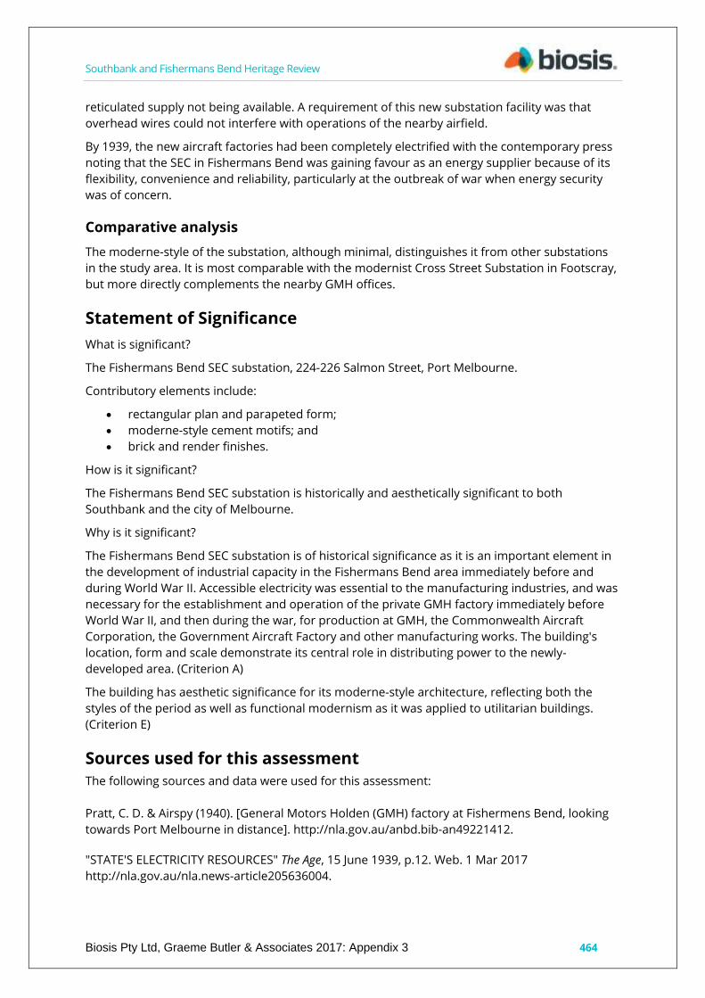
Southbank and Fishermans Bend Heritage Review
Biosis Pty Ltd, Graeme Butler & Associates 2017: Appendix 3 464
reticulated supply not being available. A requirement of this new substation facility was that
overhead wires could not interfere with operations of the nearby airfield.
By 1939, the new aircraft factories had been completely electrified with the contemporary press
noting that the SEC in Fishermans Bend was gaining favour as an energy supplier because of its
flexibility, convenience and reliability, particularly at the outbreak of war when energy security
was of concern.
Comparative analysis
The moderne-style of the substation, although minimal, distinguishes it from other substations
in the study area. It is most comparable with the modernist Cross Street Substation in Footscray,
but more directly complements the nearby GMH offices.
Statement of Significance
What is significant?
The Fishermans Bend SEC substation, 224-226 Salmon Street, Port Melbourne.
Contributory elements include:
rectangular plan and parapeted form;
moderne-style cement motifs; and
brick and render finishes.
How is it significant?
The Fishermans Bend SEC substation is historically and aesthetically significant to both
Southbank and the city of Melbourne.
Why is it significant?
The Fishermans Bend SEC substation is of historical significance as it is an important element in
the development of industrial capacity in the Fishermans Bend area immediately before and
during World War II. Accessible electricity was essential to the manufacturing industries, and was
necessary for the establishment and operation of the private GMH factory immediately before
World War II, and then during the war, for production at GMH, the Commonwealth Aircraft
Corporation, the Government Aircraft Factory and other manufacturing works. The building's
location, form and scale demonstrate its central role in distributing power to the newly-
developed area. (Criterion A)
The building has aesthetic significance for its moderne-style architecture, reflecting both the
styles of the period as well as functional modernism as it was applied to utilitarian buildings.
(Criterion E)
Sources used for this assessment
The following sources and data were used for this assessment:
Pratt, C. D. & Airspy (1940). [General Motors Holden (GMH) factory at Fishermens Bend, looking
towards Port Melbourne in distance]. http://nla.gov.au/anbd.bib-an49221412.
"STATE'S ELECTRICITY RESOURCES" The Age, 15 June 1939, p.12. Web. 1 Mar 2017
http://nla.gov.au/nla.news-article205636004.

Southbank and Fishermans Bend Heritage Review
Biosis Pty Ltd, Graeme Butler & Associates 2017: Appendix 3 465
"FISHERMAN'S BEND SITE." The Age, 4 November 1936, p.12. Web. 1 Mar 2017
http://nla.gov.au/nla.news-article205945943.
"PLANE TESTING GROUND" The Age, 18 June 1938, p.18. Web. 1 Mar 2017
http://nla.gov.au/nla.news-article206945366.
Recommendations
Revise Heritage Places Inventory.
Proposed heritage overlay as SEC Electricity Substation, 224 Salmon Street, Port Melbourne.
Apply external paint controls with policy to reintroduce original finishes and colour schemes.

Southbank and Fishermans Bend Heritage Review
Biosis Pty Ltd, Graeme Butler & Associates 2017: Appendix 3: 466
General Motors Holden Nos. 3 & 5 plants, 241 Salmon Street,
Port Melbourne
City of Melbourne property number: 110509
Type of place: factory
Images of place 2016-2017
Historical associations:
Creation or major development date(s) of place: 1945, Inter-war, (WW1-WW2)? Yes
Post-WW2
Major owners or occupiers: General Motors Holden
Heritage Gradings:
Proposed new system (C258):
Individually significant
Alphanumeric system (building A-E, streetscape 1-3):
Existing: Proposed: B3
Heritage values:
Historical
Heritage status:
Heritage Overlay Proposed
Thematic context:

Southbank and Fishermans Bend Heritage Review
Biosis Pty Ltd, Graeme Butler & Associates 2017: Appendix 3 467
5.3 Developing a large, city-based economy
Boundary of heritage place
Description
General Motors Holden (GMH) Nos. 3 & 5 plants is made up of a range of steel-frame sawtooth-
roof factory assembly buildings with ancillary structures around them, including amenities,
ventilation equipment, electricity supply and stores. The buildings have south-facing sawtooth
roofs, clad in corrugated iron (with some small sections of the original corrugated fibre cement
sheeting) and steel-hopper sash windows around most elevations.
The factory is divided into three sections, with Plant 3 attached to the modern tech centre (built
on the site of the former tennis courts) to the east of the Social Centre, and Plant 5 to the west of
the social centre. Plant 5 has been cut in two, forming two separate buildings connected by a
service-pipe bridge.
The earliest part of the group of manufacturing buildings, and the oldest surviving sawtooth roof
building from GMH’s Fishermans Bend factory is the section of Plant 3 between the Social Centre
and the modern tech centre. This structure was in place in 1945, and is believed to have been
part of the works used for munitions production during the war, and where the first production
of the 18 120 and FJ Holdens after the war. The Number 5 plant was added around the late-
1940s or early-1950s to provide additional capacity for the manufacture of the new Holden car.
Note that the social centre, head office, administration building and engine plant all have
separate citations in this study. The following is a key map to the various GMH elements.

Southbank and Fishermans Bend Heritage Review
Biosis Pty Ltd, Graeme Butler & Associates 2017: Appendix 3 468
History
The Adelaide coach-building firm of James Alexander Holden started as a saddlery business as
early as 1854, which expanded into coach building before Holden’s sons transitioned into motor
body building, eventually erecting a large factory at Woodville. The firm evolved over the years,
moving into the automotive field in 1908, repairing car upholstery, then into full-scale production
of vehicle body shells. Throughout the 1920s, Holden supplied tramcars for Melbourne, but
became more prominent as a motor body builder and assembler of various models, particularly
the imported General Motors chassis. In 1931, Holden merged with General Motors to become
General Motors Holden Limited (GMH), and in 1936, the firm opened a new headquarters and
assembly plant in Salmon Street in Fishermans Bend.
The national significance of the endeavour was recognised by the attendance of the state
premier and the prime minister at the official ceremonies. The commencement of construction
was marked by an official ceremony for the laying of the foundation stone on 23 February 1936,
attended by then-Victorian premier A. A. Dunstan. The factory was officially opened by Prime
Minister J. A. Lyons on 5 November 1936.

Southbank and Fishermans Bend Heritage Review
Biosis Pty Ltd, Graeme Butler & Associates 2017: Appendix 3 469
Production initially involved the continued assembly of locally-made bodies on imported
mechanical components. However, the advent of the World War caused works to shift
production to military equipment under Commonwealth contracts.
During World War II the factory produced more than 30,000 vehicle bodies for the Australian and
United States forces and manufactured a wide range of equipment including field guns, aircraft,
aero and marine engines. After the war, Holden returned to producing vehicle bodies, including
Buick, Chevrolet, Pontiac and Vauxhall.
Before the war ended, the Australian government had already taken steps to encourage an
Australian automotive industry. Both GM and Ford provided the Australian government with
studies into creating an Australian-designed car. Although Ford's proposal was the government's
first choice, financial costs saw the government choose the GM proposal due to the low level of
government intervention required.
Holden's managing director Laurence Hartnett favoured development of a local design, while
GM preferred to see an American design as the basis for ‘Australia's Own Car’. Holden
commenced manufacture of a fully-Australian product in 1948, the 48-215, nicknamed the FX
,with the second version the more famous FJ.
The factory was expanded at the end of World War II in recognition of the company’s future role
in civil society, and as part of post-war reconstruction. The Social Centre was constructed as part
of this expansion. Plant No. 3 was completed prior to 1945, with the whole of Plant No. 5 added
shortly after the war.
The launch of the Holden 48-215 was an event of national significance, with Prime Minister Ben
Chifley and GM Managing Director Harold Bettle officiating on 29 November 1948. The Social
Centre was chosen as the venue for the launch.
Expansion of production saw Holden establish a second Victorian assembly plan in Dandenong
in the late-1950s ending complete vehicle construction at Fishermans Bend in lieu of
concentrating on component manufacture with a focus on substantial engine manufacturing.
The earliest part of the plant was at the corner of Salmon and Lorimer streets, with reinforced
concrete art deco office buildings fronting large areas of steel-framed sawtooth-roof factory
space. The factory was designed by a team of four: L. H. Hartnett, managing director; E. J. L.
Gibson, construction engineer; J. S. Storey, director of engineering and N. A. Pointer, equipment
engineer.
The 1950s saw major expansion to the south and west, including the construction of the engine
plant (now mostly abandoned). In the 1990s, the new V6 engine plant was constructed towards
Todd Road, filling the last remaining vacant land. Holden began to sell off sections of its 38-
hectare manufacturing plant in more recent years, with the original office now occupied by
Boral, and the earliest assembly buildings demolished to make way for an industrial park. The
1950s boiler house, which featured an early glass curtain wall design, was demolished in 2011.
The Social Centre was recognised for its important role within the factory worker community and
the social history of the industry sector. In 1996 a major refurbishment was undertaken, and in
2009 it was renamed JC's Café in recognition of long-standing employee John Connell. A time
capsule was placed behind a plaque outside the Social Centre by Prime Minister John Howard on
29 November 1998 to recognise the 50th anniversary of the FJ Holden, to be opened in 2048
(Commemorative plaques).
Southbank and Fishermans Bend Heritage Review
Biosis Pty Ltd, Graeme Butler & Associates 2017: Appendix 3 470
Comparative analysis
The Holden Nos. 3 & 5 plants comprise the earliest surviving large-scale automotive
manufacturing plant employing a sawtooth-roof design. The site compares with the Ford
Geelong plant of the same era (VHR H2305) and the later GMH Dandenong plant, Ford
Broadmeadows plant and Martin & King Motor Producers Ltd in Clayton. Plants 3 & 5 are the
oldest surviving parts of the manufacturing section of the Holden Fishermans Bend works.
The Government Aircraft Factory and small parts of the Commonwealth Aircraft Corporation and
Aeronautical Research Laboratories have steel-framed sawtooth-roof industrial buildings of a
similar style and period as GMH, while part of the Kraft factory may also retain a few bays of
1945 sawtooth-roof buildings. Some of the PMG workshops in Sturt Street may also date from
the WWII period. Overall, however, pre-war sawtooth-roof factory buildings have become
increasingly rare. Timber-framed versions of factory sawtooth roofs are nearly extinct.
Statement of Significance
What is significant?
General Motors Holden Nos. 3 & 5 plants, Salmon Street, Fishermans Bend.
Contributory elements include:
corrugated iron-clad sawtooth-roof form;
steel-framed windows;
red brick ventilation structures; and
brick masonry office section elevations.
How is it significant?
General Motors Holden is historically significant to Fishermans Bend, the city of Melbourne and
to Victoria in general.
Why is it significant?
This place is historically significant as it is a major surviving component of the original 1936
works of GMH, established in response to government initiatives to ensure Australian
manufacturing in preference to imported motor vehicles, in partnership with General Motors
Canada and the Holden motor body builders.
The factory is also significant as the place where the first Holden vehicles were manufactured,
known as 'Australia's Own Car', a nationally-significant manufacturing endeavour which was
promoted as part of the independent economic and political revival of the country after World
War II, and later seen as a precursor to the post-war boom. (Criterion A)
The factory is significant in its scale and form, being the largest surviving part of the original pre-
and immediate post-war production areas. It is also significant in its association with Sir
Laurence John Hartnett CBE, an engineer who made several important contributions to the
Australian automotive industry, who is often called ‘The Father of the Holden'. (Criterion H)
Sources used for this assessment
The following sources and data were used for this assessment:
Davis, Tony; Kennedy, Ewan; Kennedy, Alistair (1998). The Holden Heritage: Eighth Edition.
Blakehurst, New South Wales: Marque Publishing. ISBN 0-947079-57-2.

Southbank and Fishermans Bend Heritage Review
Biosis Pty Ltd, Graeme Butler & Associates 2017: Appendix 3 471
Darwin, N, 1983, The History of Holden Since 1917 Melbourne: Gordon & Gotch ; History of Holden,
Holden History In Brief, http://history.gmheritagecenter.com/wiki/index.php/History_of_Holden.
Holden Retirees Club website, http://www.hrc.org.au.
Australia Builds a Motor Car, General Motors Australia Pty Ltd, 1948. http://www.hrc.org.au/files/GM%20Australia/GMA%20Aust%20builds%20a%20Motor%20car%20OPT.pdf
Recommendations
Revise Heritage Places Inventory.
Proposed heritage overlay individually as General Motors Holden Nos. 3 & 5 plants, 251 Salmon
Street, Fishermans Bend.
Nominate to Victorian Heritage Register.
Apply external paint controls with policy to reintroduce original finishes and colour schemes.
Recommend a Conservation Management Plan be prepared for all GMH sites prior to any future
development.

Southbank and Fishermans Bend Heritage Review
Biosis Pty Ltd, Graeme Butler & Associates 2017: Appendix 3: 472
General Motors Holden engine and manufacturing plant, 241
Salmon Street (61-85 Cook Street), Port Melbourne
City of Melbourne property number: 537568
Type of place: factory
Images of place 2016-2017
Historical associations:
Creation or major development date(s) of place: 1950, Post-WW2
Major owners or occupiers: General Motors Holden
Heritage Gradings:
Proposed new system (C258):
Individually significant
Alphanumeric system (building A-E, streetscape 1-3):
Existing: Proposed: C3
Heritage values:
Historical
Heritage status:
Heritage overlay Proposed
Thematic context:
5.5 Building a manufacturing industry
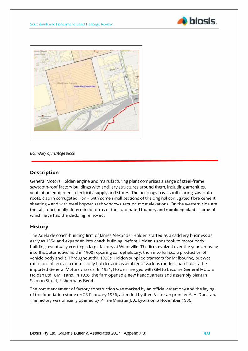
Southbank and Fishermans Bend Heritage Review
Biosis Pty Ltd, Graeme Butler & Associates 2017: Appendix 3: 473
Boundary of heritage place
Description
General Motors Holden engine and manufacturing plant comprises a range of steel-frame
sawtooth-roof factory buildings with ancillary structures around them, including amenities,
ventilation equipment, electricity supply and stores. The buildings have south-facing sawtooth
roofs, clad in corrugated iron – with some small sections of the original corrugated fibre cement
sheeting – and with steel hopper sash windows around most elevations. On the western side are
the tall, functionally-determined forms of the automated foundry and moulding plants, some of
which have had the cladding removed.
History
The Adelaide coach-building firm of James Alexander Holden started as a saddlery business as
early as 1854 and expanded into coach building, before Holden’s sons took to motor body
building, eventually erecting a large factory at Woodville. The firm evolved over the years, moving
into the automotive field in 1908 repairing car upholstery, then into full-scale production of
vehicle body shells. Throughout the 1920s, Holden supplied tramcars for Melbourne, but was
more prominent as a motor body builder and assembler of various models, particularly the
imported General Motors chassis. In 1931, Holden merged with GM to become General Motors
Holden Ltd (GMH) and, in 1936, the firm opened a new headquarters and assembly plant in
Salmon Street, Fishermans Bend.
The commencement of factory construction was marked by an official ceremony and the laying
of the foundation stone on 23 February 1936, attended by then-Victorian premier A. A. Dunstan.
The factory was officially opened by Prime Minister J. A. Lyons on 5 November 1936.

Southbank and Fishermans Bend Heritage Review
Biosis Pty Ltd, Graeme Butler & Associates 2017: Appendix 3 474
Production initially involved the continued assembly of locally-made bodies on imported
mechanical components. However, the interruption of war caused works to shift production
towards military equipment under Commonwealth contracts.
During World War II the factory produced more than 30,000 vehicle bodies for the Australian and
United States forces, and manufactured a wide range of equipment including field guns, aircraft,
aero and marine engines. After the war, Holden returned to producing vehicle bodies including
Buick, Chevrolet, Pontiac and Vauxhall.
Before the end of World War II, the Australian government had already taken steps to encourage
an Australian automotive industry. Both GM and Ford provided the government with studies into
building an Australian-designed car. Although Ford's proposal was the government's first choice,
financial costs saw the government choose the GM proposal due to the low level of government
intervention required.
Holden's managing director, Laurence Hartnett, favoured the development of a local design,
while GM preferred to see an American design be used as the basis for ‘Australia's Own Car’.
Holden commenced manufacture of a fully-Australian product in 1948, the 48-215, nicknamed
the FX, followed by a second version, the more famous FJ.
At the end of World War II the factory was expanded, in recognition of the company’s future role
in civil life, and as part of post-war reconstruction efforts. The Social Centre was constructed as
part of this expansion.
The launch of the Holden 48-215 was an event of national significance, with Prime Minister Ben
Chifley and GM Managing Director Harold Bettle officiating, on 29 November 1948. The Social
Centre was chosen as the venue for the launch.
Expansion of production saw Holden establish a second Victorian assembly plant in Dandenong
in the late-1950s, ceasing complete car construction at Fishermans Bend. Instead, the
Fishermans Bend began to concentrate on component manufacture, including a substantial
engine manufacturing plant.
The earliest part of the plant was at the corner of Salmon and Lorimer streets, with reinforced
concrete art deco office buildings fronting large areas of steel-framed sawtooth-roof factory
space. The factory was designed by a team of four: L. H. Hartnett, managing director; E. J. L.
Gibson, construction engineer; J. S. Storey, director of engineering and N. A. Pointer, equipment
engineer.
The 1950s saw major expansion into the south and west, including the engine plant (now mostly
abandoned). In the 1990s, the new V6 engine plant was constructed towards Todd Road, filling
the remaining vacant land. Holden began to sell off sections of its 38-hectare manufacturing
plant in recent years, with the original office now occupied by Boral, and the earliest assembly
buildings demolished to make way for an industrial park. The 1950s boiler house, which featured
an early glass curtain wall design, was demolished in 2011.
The Social Centre was recognised for its important role within the factory worker community,
and the social history of the works. In 1996 a major refurbishment was undertaken, and in 2009
the Centre was renamed JC's Café in recognition of long-standing employee John Connel. A time
capsule was placed behind a plaque outside the Social Centre by Prime Minister John Howard on
29 November 1998, to recognise the 50th anniversary of the FJ Holden, to be opened in 2048
(Commemorative plaques).

Southbank and Fishermans Bend Heritage Review
Biosis Pty Ltd, Graeme Butler & Associates 2017: Appendix 3 475
Comparative analysis
The Holden engine and manufacturing plant is among the largest expanses of sawtooth-roofed
factory spaces in Victoria. At over 200 metres by 400 metres, it compares with the later GMH
Dandenong plant, the Ford Broadmeadows plant and the Martin & King Motor Producers Ltd
space in Clayton. It is more than twice as large as its contemporary, Olex Cables in Sunshine
Road, Tottenham.
The Government Aircraft Factory and small parts of the Commonwealth Aircraft Corporation and
Aeronautical Research Laboratories have steel-framed sawtooth-roofed industrial buildings from
a similar period to GMH, while part of the Kraft factory may retain a few bays of its 1945
sawtooth roof. A small part of the PMG workshops in Sturt Street may also date back to the
World War II period. Overall, however, pre-war sawtooth-roof factory buildings have become
increasingly rare, and even the 1950s-1970s welded-steel sawtooth-roof factories are becoming
rare. Today, timber-framed versions of factory sawtooth roofs are nearly extinct.
Statement of Significance
What is significant?
General Motors Holden factory engine and manufacturing plant, 241 Salmon Street (61-85 Cook
Street), Fishermans Bend.
Contributory elements include:
corrugated iron clad sawtooth-roof form;
steel-framed windows; and
the specialised form of the tall foundry buildings.
How is it significant?
General Motors Holden factory engine and manufacturing plant is historically significant to
Fishermans Bend, as well as the city of Melbourne.
Why is it significant?
This place is historically significant as a demonstration of the later expansion of the GMH factory
in the 1960s, at a time when local manufacture of motor vehicles was increasing dramatically
and Holden was becoming the largest car-maker in Australia. The expansion and modernisation
of the plant reflected the great prosperity Australia enjoyed during the 'Long Boom' of the post-
war period. (Criterion A)
The factory is also significant as it is the place where engines and other components were
manufactured for Holden cars for over 50 years.
Sources used for this assessment
The following sources and data were used for this assessment:
Directories
Salmon Street appears in the Port Melbourne Rate Book for the first time in 1942 and first
appears in Sands McDougall in 1938 in Port Melbourne West. 1945 lists GMH as works on 50
acres. Caprice Avenue and Cook Street aren’t mentioned before 1949.
Rate books
General Motors Holden

Southbank and Fishermans Bend Heritage Review
Biosis Pty Ltd, Graeme Butler & Associates 2017: Appendix 3 476
Year No. on Roll Occupier Occupation Owner Occupation Description of Property Rate Detail
(N.A.V.) Rate Detail (Paid)
1936 3336 General Motors Holden Ltd on Fishermans Bend B, G, I works £1618 £2022.10
Davis, Tony; Kennedy, Ewan; Kennedy, Alistair (1998). The Holden Heritage: Eighth Edition.
Blakehurst, New South Wales: Marque Publishing. ISBN 0-947079-57-2.
Darwin, N, 1983, The History of Holden Since 1917, Melbourne: Gordon & Gotch ; History of
Holden, Holden History In Brief,
http://history.gmheritagecenter.com/wiki/index.php/History_of_Holden.
Holden Retirees Club website, http://www.hrc.org.au/
Australia Builds a Motor Car, General Motors Australia Pty Ltd., 1948.
http://www.hrc.org.au/files/GM%20Australia/GMA%20Aust%20builds%20a%20Motor%20car%20
OPT.pdf
Recommendations
Revise Heritage Places Inventory.
Proposed heritage overlay individually as General Motors Holden Engine and Manufacturing
Plant.
Apply external paint controls with policy to reintroduce original finishes and colour schemes.
Recommend that a conservation management plan be prepared for all GMH sites prior to any
future development.

Southbank and Fishermans Bend Heritage Review
Biosis Pty Ltd, Graeme Butler & Associates 2017: Appendix 3: 477
General Motors Holden Social Centre, 241 Salmon Street (Caprice
Avenue, Port Melbourne
City of Melbourne property number: 537568
Type of place: amenities building
Images of place 2016-2017
Historical associations:
Creation or major development date(s) of place: 1945, Post-WW2
Major owners or occupiers: General Motors Holden
Heritage Gradings:
Proposed new system (C258):
Individually significant
Alphanumeric system (building A-E, streetscape 1-3):
Existing: Proposed: A3
Heritage values:
Aesthetic, Historical
Heritage status:
Heritage Overlay Proposed
Thematic context:
5.5 Building a manufacturing industry

Southbank and Fishermans Bend Heritage Review
Biosis Pty Ltd, Graeme Butler & Associates 2017: Appendix 3 478
9.1 A working class
9.3 Working in the post-war city
Boundary of heritage place
Description
The General Motors Holden Social Centre is a brick masonry hall in streamlined moderne style
with art deco decorative detailing. The building is situated between two factory buildings – Plants
3 and 5 – and surrounded by internal factory roadways with a small tree plantation at the front.
The recently created Bayside Avenue passes the front (northern) elevation of the building but
does not provide access as the building is still within the GMH property.
The facade is in the form of progressively-projecting bays rising in steps in a ziggurat form, with
the central bay in cement render surmounted by an attached flagpole with fins, flanked by
cream brick bays. Windows in the facade are multi-pane steel-framed, the central bay having
glass bricks that decrease in size towards the outer bay. Side windows are similarly steel-framed
with opening casements.
An upper outdoor terrace has cross-pattern metal railings.
Internally, the building features a large dining hall with parquetry floor, side aisles and a stage
with a proscenium arch. On either side, painted murals depict the ‘History of Transport’. Behind
the stage is a large commercial kitchen and above this the executive dining room with strap-
panelled ceiling timber joinery cupboards, benches and stairs. A dumbwaiter is connected to the
kitchen below and there are built-in upholstered benches around the walls.
History
The Adelaide coach-building firm of James Alexander Holden started as a saddlery business as
early as 1854, and expanded into coach building, and then his sons developed motor body
building, eventually erecting a large factory at Woodville. The firm evolved over the years, moving
into the automotive field in 1908, repairing car upholstery, then the full-scale production of

Southbank and Fishermans Bend Heritage Review
Biosis Pty Ltd, Graeme Butler & Associates 2017: Appendix 3 479
vehicle body shells. Throughout the 1920s Holden had supplied tramcars for Melbourne, but was
more prominent as a motor body builder and assembler of various models, particularly for the
imported General Motors chassis. In 1931, Holden merged with GM to become General Motors
Holden's Limited (GMH), and in 1936, the firm opened a new headquarters and assembly plant in
Salmon Street, Fishermans Bend in Port Melbourne.
The national significance of the endeavour was recognised by the attendance of Premiers and
Prime Ministers at official ceremonies, and extensive media coverage. The commencement of
construction was marked by an official ceremony and laying the foundation stone on 23
February 1936 attended by then Victorian Premier A.A. Dunstan. The factory was officially
opened by the Prime Minister J.A. Lyons on 5th November 1936.
Production initially involved the continued assembly of locally made bodies on imported
mechanical components. However, the intervention of war caused the works to shift production
to military equipment under Commonwealth contracts.
During World War Two the factory produced more than 30,000 vehicle bodies for the Australian
and United States forces and manufactured a wide range of equipment, including field guns,
aircraft, aero and marine engines. After the war, Holden returned to producing vehicle bodies,
including Buick, Chevrolet, Pontiac and Vauxhall.
Before the war ended, the Australian Government had already taken steps to encourage an
Australian automotive industry. Both GM and Ford provided studies to the Australian
Government for an Australian-designed car. Although Ford's proposal was the government's first
choice, financial costs saw the government choose the GM proposal due to the low level of
government intervention.
Holden's managing director, Laurence Hartnett, favoured development of a local design, while
GM preferred to see an American design as the basis for "Australia's Own Car". Holden
commenced manufacture of a fully-Australian product in 1948, the 48-215, nicknamed the FX,
with the second version being the more famous FJ.
The factory was expanded with at the end of World War Two - in recognition of the future civil
role and as part of post war reconstruction. The Social Centre was constructed as part of this
expansion.
The launch of the Holden 48-215 was a event of national significance with the Prime Minister Ben
Chifley and GM Managing Director Harold Bettle officiating on 29 November 1948. The Social
Centre was chosen as the venue for the launch.
Expansion of production saw Holden establish a second Victorian assembly plan in Dandenong
in the late 1950s, so that complete construction of cars ceased at Fishermans Bend, and would
concentrate on component manufacture including a substantial engine manufacturing plant.
The earliest part of the plant was at the corner of Salmon Street and Lorimer Street, with
reinforced concrete 'Art Deco' office buildings fronting large areas are steel-framed saw-tooth
roof factory space. The factory was designed by a team of four (L H Hartnett, Managing Director;
E J L Gibson, Construction Engineer; J S Storey, Director of Engineering and N A Pointer,
Equipment Engineer).
In the 1950s, major expansion to the south and west occurred, including the engine plan (which
is now mostly abandoned). In the 1990s, the new V6 engine plant was constructed towards Todd
Road, filling the last remaining vacant land. Holden started selling off sections of its 38-hectare
manufacturing plant in the last few years, with the original office now occupied by Boral, and the

Southbank and Fishermans Bend Heritage Review
Biosis Pty Ltd, Graeme Butler & Associates 2017: Appendix 3 480
earliest assembly buildings having been demolished to make way for an industrial park. The
1950s Boiler House, which featured an early glass curtain wall design, was demolished in 2011.
The Social Centre was recognised for its important role in among the factory workers and the
social history of the works. In 1996 a major refurbishment was undertaken, and in 2009 it was
renamed JC's Café in recognition of long standing employee John Connell A time capsule was
placed behind a plaque outside the Social Centre by Prime Minister John Howard on 29
November 1998, to recognise the 50th anniversary of the FJ Holden, to be opened in 2048
(commemorative plaques).
Comparative analysis
The moderne elements of the Social Centre complement the slightly-older GMH office buildings
on Salmon Street. The Rootes Factory a little further south on Salmon Street is also a notable
example of a similar style in the nearby area.
Elsewhere in the study area, the Streamlined moderne style that was once common in the
automotive industry buildings is now rare. The 1936 Mitchell House in the CBD is an example of
the style as it was applied to office buildings, while the Relova Redressing Laundry on Hoddle
Street shows the use of prominent architectural expression of a modern industrial activity. This
was a well-established direction in industrial architecture by the 1930s with several examples to
be found in the industrial northern and western suburbs, such as with Olympic Tyres, Pilkington
Glass, the Southern Can Company and Hopkins Odlum, all in Footscray.
Statement of Significance
What is significant?
The General Motors Holden Social Centre, constructed in 1945 off Salmon Street, Fishermans
Bend.
Contributory elements include:
moderne styling with prominent facade treatment;
attached flagpole and fins, glass brick and steel-framed windows;
upper outdoor terrace and metal railings;
internal fittings and finishes including parquetry floor and stairs;
'History of Transport' murals;
stage and proscenium arch; and
internal panelling, joinery, dumbwaiter and built-in benches to executive dining room.
How is it significant?
The General Motors Holden Social Centre is historically, socially and aesthetically significant to
Fishermans Bend, the city of Melbourne and to Victoria more broadly.
Why is it significant?
The Social Centre is historically significant as it was the focus for workers' amenities and social
activities for over 70 years, and has been an integral part of the overall GMH Fishermans Bend
plant. Its construction at the end of World War II reflected the optimism for the future
commercial success of the company, particularly as the manufacturer of the Australian FJ
Holden, highlighted by the site being used in 1948 to launch the 48-215 Holden, known as
'Australia's Own Car'. (Criterion A)

Southbank and Fishermans Bend Heritage Review
Biosis Pty Ltd, Graeme Butler & Associates 2017: Appendix 3 481
The Social Centre is of aesthetic significance for its finely-detailed and decorative streamlined
moderne styling and its intact interior, which includes the 'History of Transport' mural. (Criterion
E)
Sources used for this assessment
The following sources and data were used for this assessment:
Davis, Tony; Kennedy, Ewan; Kennedy, Alistair (1998). The Holden Heritage: Eighth Edition.
Blakehurst, New South Wales: Marque Publishing. ISBN 0-947079-57-2.
Darwin, N, 1983, The History of Holden Since 1917 Melbourne: Gordon & Gotch; History of Holden,
Holden History In Brief, http://history.gmheritagecenter.com/wiki/index.php/History_of_Holden.
Holden Retirees Club website, http://www.hrc.org.au/
Australia Builds a Motor Car, General Motors Australia Pty Ltd, 1948.
http://www.hrc.org.au/files/GM%20Australia/GMA%20Aust%20builds%20a%20Motor%20car%20
OPT.pdf.
Directories
Salmon Street appears in the Port Melbourne Rate Book for the first time in 1942 and first
appears in Sands McDougall in 1938 in Port Melbourne West. 1945 lists GMH as works on 50
acres. Caprice Avenue and Cook Street aren’t mentioned before 1949.
Rate books
General Motors Holden
Year No. on Roll Occupier Occupation Owner Occupation Description of Property Rate Detail
(N.A.V.) Rate Detail (Paid)
1936 3336 General Motors Holden Ltd on Fishermans Bend B, G, I works £1618 £2022.10
Recommendations
Revise Heritage Places Inventory.
Proposed heritage overlay individually as General Motors Holden Social Centre, 241 Salmon
Street (Caprice Avenue, Port Melbourne.
Nominate to Victorian Heritage Register.
Apply external paint controls with policy to reintroduce original finishes and colour schemes.
Apply internal alteration control to murals, original joinery and parquetry floor.
Recommend that a conservation management plan be prepared for all GMH sites prior to any
future development.

Southbank and Fishermans Bend Heritage Review
Biosis Pty Ltd, Graeme Butler & Associates 2017: Appendix 3: 482
General Motors Holden head office administration buildings, 251
Salmon Street, Port Melbourne
City of Melbourne property number: 110593
Type of place: office
Images of place 2016-2017
Historical associations:
Creation or major development date(s) of place: 1935-6, Inter-war (WW1-WW2)
Major owners or occupiers: General Motors Holden
Heritage Gradings:
Proposed new system (C258):
Individually significant
Alphanumeric system (building A-E, streetscape 1-3):
Existing: Proposed: A3
Heritage values:
Aesthetic, Historical
Heritage status:
Heritage Overlay Proposed
Thematic context:
3.2 Expressing an architectural style

Southbank and Fishermans Bend Heritage Review
Biosis Pty Ltd, Graeme Butler & Associates 2017: Appendix 3 483
5.3 Developing a large, city-based economy
Boundary of heritage place
Description
The General Motors Holden (GMH) administration building is a reinforced two- and three-storey
building with symmetrical projecting central and end bays surmounted centrally by a tower. The
building is in a streamlined modern style with art deco decorative detailing. It faces onto Salmon
Street with a small garden plantation at the front. The corners on the buildings feature groups of
five raised vertical strips which were originally painted in contrasting colours to provide
highlights with incised vertical sections between the steel-framed windows. The exterior design,
with its art deco styling and motifs, reflects the predominant industrial style of the period and is
clearly the work of a competent architect, although who this was has not yet been determined.
The buildings bear some resemblance to the 1928 GM assembly plant in Regina, Canada, so it is
possible that the design came from another GM office in North America. (The private road
adjacent to the building and known as Central Boulevard still remains, but the ‘gate posts’ in the
central median are a recent addition and do not have heritage significance.)
History
The Adelaide coach-building firm of James Alexander Holden started as a saddlery business as
early as 1854, and expanded into coach building, and then his sons developed motor body
building, eventually erecting a large factory at Woodville. The firm evolved over the years, moving
into the automotive field in 1908, repairing car upholstery, then the full-scale production of
vehicle body shells. Throughout the 1920s Holden had supplied tramcars for Melbourne, but was
more prominent as a motor body builder and assembler of various models, particularly for the
imported General Motors chassis. In 1931, Holden merged with GM to become General Motors

Southbank and Fishermans Bend Heritage Review
Biosis Pty Ltd, Graeme Butler & Associates 2017: Appendix 3 484
Holden's Limited (GMH), and in 1936, the firm opened a new headquarters and assembly plant in
Salmon Street, Fishermans Bend in Port Melbourne.
The national significance of the endeavour was recognised by the attendance of Premiers and
Prime Ministers at official ceremonies, and extensive media coverage. The commencement of
construction was marked by an official ceremony and laying the foundation stone on 23
February 1936 attended by then Victorian Premier A.A. Dunstan. The factory was officially
opened by the Prime Minister J.A. Lyons on 5th November 1936.
Production initially involved the continued assembly of locally made bodies on imported
mechanical components. However, the intervention of war caused the works to shift production
to military equipment under Commonwealth contracts.
During World War Two the factory produced more than 30,000 vehicle bodies for the Australian
and United States forces and manufactured a wide range of equipment, including field guns,
aircraft, aero and marine engines. After the war, Holden returned to producing vehicle bodies,
including Buick, Chevrolet, Pontiac and Vauxhall.
Before the war ended, the Australian Government had already taken steps to encourage an
Australian automotive industry. Both GM and Ford provided studies to the Australian
Government for an Australian-designed car. Although Ford's proposal was the government's first
choice, financial costs saw the government choose the GM proposal due to the low level of
government intervention.
Holden's managing director, Laurence Hartnett, favoured development of a local design, while
GM preferred to see an American design as the basis for "Australia's Own Car". Holden
commenced manufacture of a fully-Australian product in 1948, the 48-215, nicknamed the F X
,with the second version the more famous FJ.
The factory was expanded with at the end of World War Two - in recognition of the future civil
role and as part of post war reconstruction. The Social Centre was constructed as part of this
expansion.
The launch of the Holden 48-215 was a event of national significance with the Prime Minister Ben
Chifley and GM Managing Director Harold Bettle officiating on 29 November 1948. The Social
Centre was chosen as the venue for the launch.
Expansion of production saw Holden establish a second Victorian assembly plan in Dandenong
in the late 1950s, so that complete construction of cars ceased at Fishermans Bend, and would
concentrate on component manufacture including a substantial engine manufacturing plant.
The earliest part of the plant was at the corner of Salmon Street and Lorimer Street, with
reinforced concrete art deco office buildings fronting large areas are steel-framed saw-tooth roof
factory space. The factory was designed by a team of four (L H Hartnett, Managing Director; E J L
Gibson, Construction Engineer; J S Storey, Director of Engineering and N A Pointer, Equipment
Engineer).
In the 1950s, major expansion to the south and west occurred, including the engine plan (which
is now mostly abandoned). In the 1990s, the new V6 engine plant was constructed towards Todd
Road, filling the last remaining vacant land. Holden started selling off sections of its 38-hectare
manufacturing plant in the last few years, with the original office now occupied by Boral, and the
earliest assembly buildings having been demolished to make way for an industrial park. The
1950s Boiler House, which featured an early glass curtain wall design, was demolished in 2011.

Southbank and Fishermans Bend Heritage Review
Biosis Pty Ltd, Graeme Butler & Associates 2017: Appendix 3 485
Comparative analysis
The GMH Fishermans Bend plant compares with Geelong’s Ford factory as another likely-
American-imported design. (The Geelong Ford factory was almost certainly an off-the-shelf
design by Albert Kahn.) The nearby Rootes factory also demonstrates the moderne style as
applied to a car factory, although in this case, executed in fibre cement sheeting. Finally, the GPO
workshops in Sturt Street reflect the contemporary government application of the moderne
style.
Statement of Significance
What is significant?
General Motors Holden head office administration buildings, 251 Salmon Street, Fishermans
Bend.
Contributory elements include:
wide, symmetrical plan and elevations;
reinforced concrete structural form;
streamlined moderne style; and
steel-framed windows.
How is it significant?
The broader General Motors Holden site is historically and aesthetically significant to Fishermans
Bend and the greater city of Melbourne.
Why is it significant?
GMH is historically significant as a major surviving component of the original 1936 General
Motors Holden works, which was established as a response to government initiatives to ensure
Australian manufacturing of motor vehicles would be preferred to imports, but in partnership
between General Motors Canada and the Holden Motor Body Builders. (Criterion A)
The factory is also significant as it is the place where the first Holden vehicles were
manufactured, known as ‘Australia's Own Car’, a nationally-significant manufacturing endeavour
which was promoted as part of building the nation’s independence economically and as a sort of
political revival after World War II; these efforts would later be seen as precursor to the post-war
boom.
The building is significant for its strong public presentation, demonstrating the scale and
importance of the post-war endeavour. It is also significant in its association with Sir Laurence
John Hartnett CBE, an engineer who made several important contributions to the Australian
automotive industry, and is often called ‘The Father of the Holden’. (Criterion H)
The site is aesthetically significant for its fully-resolved moderne architectural style, executed on
a grand scale. (Criterion E)
Sources used for this assessment
The following sources and data were used for this assessment:
Davis, Tony; Kennedy, Ewan; Kennedy, Alistair (1998). The Holden Heritage: Eighth Edition.
Blakehurst, New South Wales: Marque Publishing. ISBN 0-947079-57-2.

Southbank and Fishermans Bend Heritage Review
Biosis Pty Ltd, Graeme Butler & Associates 2017: Appendix 3 486
Darwin, N, 1983. The History of Holden Since 1917 Melbourne: Gordon & Gotch; History of Holden,
Holden History In Brief, http://history.gmheritagecenter.com/wiki/index.php/History_of_Holden.
Holden Retirees Club website. http://www.hrc.org.au/
Australia Builds a Motor Car, General Motors Australia Pty Ltd, 1948.
http://www.hrc.org.au/files/GM%20Australia/GMA%20Aust%20builds%20a%20Motor%20car%20
OPT.pdf.
Directories
Salmon Street appears in the Port Melbourne Rate Book for the first time in 1942 and first
appears in Sands McDougall in 1938 in Port Melbourne West. 1945 lists GMH as works on 50
acres. Caprice Avenue and Cook Street aren’t mentioned before 1949.
Rate books
General Motors Holden
Year No. on Roll Occupier Occupation Owner Occupation Description of Property Rate Detail
(N.A.V.) Rate Detail (Paid)
1936 3336 General Motors Holden Ltd on Fishermans Bend B, G, I works £1618 £2022.10
Recommendations
Revise Heritage Places Inventory.
Proposed heritage overlay individually as General Motors Holden head office administration
buildings, 251 Salmon Street, Fishermans Bend.
Nominate to Victorian Heritage Register.
Apply external paint controls with policy to reintroduce original finishes and colour schemes.
Apply tree controls to mature palms in front of building on Salmon Street.
Recommend that a conservation management plan be prepared for all GMH sites prior to any
future development.

Southbank and Fishermans Bend Heritage Review
Biosis Pty Ltd, Graeme Butler & Associates 2017: Appendix 3: 487
General Motors Holden administration building, 261 Salmon
Street, Port Melbourne
City of Melbourne property number: 110594
Type of place: office
Images of place 2016-2017
Historical associations:
Creation or major development date(s) of place: 1935-1936, Inter-war (WW1-WW2)
Major owners or occupiers: General Motors Holden
Heritage Gradings:
Proposed new system (C258):
Individually significant
Alphanumeric system (building A-E, streetscape 1-3):
Existing: Proposed: A3
Heritage values:
Aesthetic, Historical
Heritage status:
Heritage Overlay Proposed
Thematic context:
3.2 Expressing an architectural style
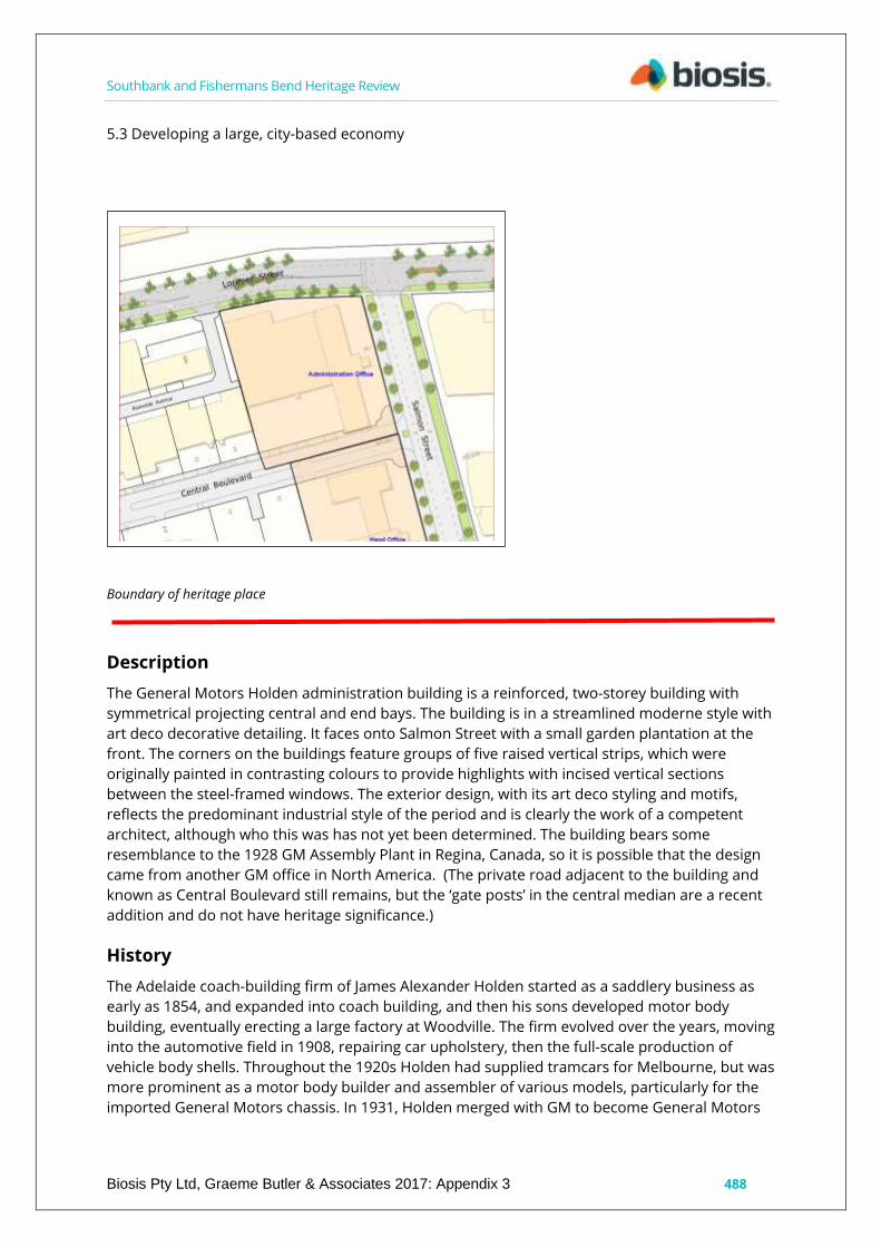
Southbank and Fishermans Bend Heritage Review
Biosis Pty Ltd, Graeme Butler & Associates 2017: Appendix 3 488
5.3 Developing a large, city-based economy
Boundary of heritage place
Description
The General Motors Holden administration building is a reinforced, two-storey building with
symmetrical projecting central and end bays. The building is in a streamlined moderne style with
art deco decorative detailing. It faces onto Salmon Street with a small garden plantation at the
front. The corners on the buildings feature groups of five raised vertical strips, which were
originally painted in contrasting colours to provide highlights with incised vertical sections
between the steel-framed windows. The exterior design, with its art deco styling and motifs,
reflects the predominant industrial style of the period and is clearly the work of a competent
architect, although who this was has not yet been determined. The building bears some
resemblance to the 1928 GM Assembly Plant in Regina, Canada, so it is possible that the design
came from another GM office in North America. (The private road adjacent to the building and
known as Central Boulevard still remains, but the ‘gate posts’ in the central median are a recent
addition and do not have heritage significance.)
History
The Adelaide coach-building firm of James Alexander Holden started as a saddlery business as
early as 1854, and expanded into coach building, and then his sons developed motor body
building, eventually erecting a large factory at Woodville. The firm evolved over the years, moving
into the automotive field in 1908, repairing car upholstery, then the full-scale production of
vehicle body shells. Throughout the 1920s Holden had supplied tramcars for Melbourne, but was
more prominent as a motor body builder and assembler of various models, particularly for the
imported General Motors chassis. In 1931, Holden merged with GM to become General Motors

Southbank and Fishermans Bend Heritage Review
Biosis Pty Ltd, Graeme Butler & Associates 2017: Appendix 3 489
Holden's Limited (GMH), and in 1936, the firm opened a new headquarters and assembly plant in
Salmon Street, Fishermans Bend in Port Melbourne.
The national significance of the endeavour was recognised by the attendance of Premiers and
Prime Ministers at official ceremonies, and extensive media coverage. The commencement of
construction was marked by an official ceremony and laying the foundation stone on 23
February 1936 attended by then Victorian Premier A.A. Dunstan. The factory was officially
opened by the Prime Minister J.A. Lyons on 5th November 1936.
Production initially involved the continued assembly of locally made bodies on imported
mechanical components. However, the intervention of war caused the works to shift production
to military equipment under Commonwealth contracts.
During World War Two the factory produced more than 30,000 vehicle bodies for the Australian
and United States forces and manufactured a wide range of equipment, including field guns,
aircraft, aero and marine engines. After the war, Holden returned to producing vehicle bodies,
including Buick, Chevrolet, Pontiac and Vauxhall.
Before the war ended, the Australian Government had already taken steps to encourage an
Australian automotive industry. Both GM and Ford provided studies to the Australian
Government for an Australian-designed car. Although Ford's proposal was the government's first
choice, financial costs saw the government choose the GM proposal due to the low level of
government intervention.
Holden's managing director, Laurence Hartnett, favoured development of a local design, while
GM preferred to see an American design as the basis for "Australia's Own Car". Holden
commenced manufacture of a fully-Australian product in 1948, the 48-215, nicknamed the F X
,with the second version the more famous FJ.
The factory was expanded with at the end of World War Two - in recognition of the future civil
role and as part of post war reconstruction. The Social Centre was constructed as part of this
expansion.
The launch of the Holden 48-215 was a event of national significance with the Prime Minister Ben
Chifley and GM Managing Director Harold Bettle officiating on 29 November 1948. The Social
Centre was chosen as the venue for the launch.
Expansion of production saw Holden establish a second Victorian assembly plan in Dandenong
in the late 1950s, so that complete construction of cars ceased at Fishermans Bend, and would
concentrate on component manufacture including a substantial engine manufacturing plant.
The earliest part of the plant was at the corner of Salmon Street and Lorimer Street, with
reinforced concrete art deco office buildings fronting large areas are steel-framed saw-tooth roof
factory space. The factory was designed by a team of four (L H Hartnett, Managing Director; E J L
Gibson, Construction Engineer; J S Storey, Director of Engineering and N A Pointer, Equipment
Engineer).
In the 1950s, major expansion to the south and west occurred, including the engine plan (which
is now mostly abandoned). In the 1990s, the new V6 engine plant was constructed towards Todd
Road, filling the last remaining vacant land. Holden started selling off sections of its 38-hectare
manufacturing plant in the last few years, with the original office now occupied by Boral, and the
earliest assembly buildings having been demolished to make way for an industrial park. The
1950s Boiler House, which featured an early glass curtain wall design, was demolished in 2011.
the Social Centre was recognised for its important role in among the factory workers and the
social history of the works. In 1996 a major refurbishment was undertaken, and in 2009 it was

Southbank and Fishermans Bend Heritage Review
Biosis Pty Ltd, Graeme Butler & Associates 2017: Appendix 3 490
renamed JC's Café in recognition of long standing employee John Connell A time capsule was
placed behind a plaque outside the Social Centre by Prime Minister John Howard on 29
November 1998, to recognise the 50th anniversary of the FJ Holden, to be opened in 2048
(commemorative plaques).
Comparative analysis
The GMH Fishermans Bend plant compares to Geelong’s Ford factory as another likely-American-
imported design. (Ford was almost certainly an off-the-shelf design by Albert Kahn.) The nearby
Rootes factory also demonstrates the moderne style as applied to a car factory, although in this
case executed in fibre cement sheeting. Finally, the PMG workshops in Sturt Street reflect the
contemporary government application of the moderne style.
Statement of Significance
What is significant?
The General Motors Holden administration building, constructed in 1936 at 261 Salmon Street,
Fishermans Bend.
Contributory elements include:
two-storey symmetrical form;
moderne styling with prominent facade treatment;
attached flagpole and fins, glass brick and steel-framed windows; and
upper outdoor terrace and metal railings.
How is it significant?
General Motors Holden is historically, socially and aesthetically significant to Fishermans Bend,
to the city of Melbourne and to Victoria as a whole.
Why is it significant?
The GMH plant is historically significant as a major surviving component of the original 1936
works of GMH, which was established in response to government initiatives intended to ensure a
preference for Australian-manufactured vehicles in preference to imports, but in partnership
between General Motors Canada and the Holden Motor Body Builders. (Criterion A)
The factory is also significant as it is the place where the first Holden vehicles were
manufactured, known as 'Australia's Own Car', a nationally-significant manufacturing endeavour
which was promoted as part of building the nation’s independence economically and as a sort of
political revival of the country after World War II; these efforts would later be seen as precursors
to the post-war boom.
The building is significant for its strong public presentation, demonstrating the scale and
importance of the endeavour. It is also significant for its association with Sir Laurence John
Hartnett CBE, an engineer who made several important contributions to the Australian
automotive industry, and is often called 'The Father of the Holden'. (Criterion H)
It is aesthetically significant for its fully-resolved moderne architectural style. (Criterion E)
Sources used for this assessment
The following sources and data were used for this assessment:

Southbank and Fishermans Bend Heritage Review
Biosis Pty Ltd, Graeme Butler & Associates 2017: Appendix 3 491
Davis, Tony; Kennedy, Ewan; Kennedy, Alistair (1998). The Holden Heritage: Eighth Edition.
Blakehurst, New South Wales: Marque Publishing. ISBN 0-947079-57-2.
Darwin, N, 1983 The History of Holden Since 1917, Melbourne: Gordon & Gotch ; History of Holden,
Holden History In Brief, http://history.gmheritagecenter.com/wiki/index.php/History_of_Holden.
Holden Retirees Club website. http://www.hrc.org.au/.
Australia Builds a Motor Car, General Motors Australia Pty Ltd, 1948.
http://www.hrc.org.au/files/GM%20Australia/GMA%20Aust%20builds%20a%20Motor%20car%20
OPT.pdf.
Directories
Salmon Street appears in the Port Melbourne Rate Book for the first time in 1942 and first
appears in Sands McDougall in 1938 in Port Melbourne West. 1945 lists GMH as works on 50
acres. Caprice Avenue and Cook Street aren’t mentioned before 1949.
Rate books
General Motors Holden
Year No. on Roll Occupier Occupation Owner Occupation Description of Property Rate Detail
(N.A.V.) Rate Detail (Paid)
1936 3336 General Motors Holden Ltd on Fishermans Bend B, G, I works £1618 £2022.10
Recommendations
Revise Heritage Places Inventory.
Proposed heritage overlay individually as General Motors Holden administration building, 261
Salmon Street, Fishermans Bend.
Nominate to Victorian Heritage Register.
Apply external paint controls with policy to reintroduce original finishes and colour schemes.
Apply tree controls to mature palms in front of building on Salmon Street.
Recommend that a conservation management plan be prepared for all GMH sites prior to any
future development.

Southbank and Fishermans Bend Heritage Review
Biosis Pty Ltd, Graeme Butler & Associates 2017: Appendix 3: 492
St Kilda Road Boulevard
City of Melbourne property number:
Type of place: road/landscape
Images of place 2016-2017
Historical associations:
Creation or major development date(s) of place: 1860s, Victorian-era
Major owners or occupiers: colonial government
Heritage Gradings:
Proposed new system (C258):
Individually significant
Alphanumeric system (building A-E, streetscape 1-3):
Existing: Proposed: A1
Heritage values:
Aesthetic, Historical, Scientific
Heritage status:
Heritage Overlay Proposed
Victorian Heritage Register: H2359
Thematic context:
6.6 Street making, drainage and river works
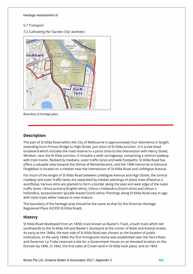
Heritage Assessment of
Biosis Pty Ltd, Graeme Butler & Associates 2017: Appendix 3 493
6.7 Transport
7.2 Cultivating the ‘Garden City’ aesthetic
Boundary of heritage place
Description
The part of St Kilda Road within the City of Melbourne is approximately four kilometres in length,
extending from Princes Bridge to High Street, just short of St Kilda Junction. It is a tree-lined
boulevard which includes the road reserve to a point close to the intersection with Henry Street,
Windsor, near the St Kilda Junction. It includes a wide carriageway, comprising a central roadway
with tram tracks, flanked by medians, outer traffic lanes and wide footpaths. St Kilda Road has
offers a valuable view towards the Shrine of Remembrance, and the 1908 memorial to Edmund
Fitzgibbon is located on a median near the intersection of St Kilda Road and Linlithgow Avenue.
For much of the length of St Kilda Road between Linlithgow Avenue and High Street, the central
roadway and outer traffic lanes are separated by median plantings of plane trees (Platanus x
aceriflolia). Various elms are planted to form a border along the east and west edge of the outer
traffic lanes: Ulmus procera (English elms), Ulmus x hollandica (Dutch elms) and Ulmus x
hollandica, 'purpurascens' (purple-leaved Dutch elms). Plantings along St Kilda Road vary in age,
with most trees either mature to over-mature.
The boundary of the heritage area should be the same as that for the Victorian Heritage
Registered Place (H2359 St Kilda Road).
History
St Kilda Road developed from an 1830s track known as Baxter's Track, a bush track which led
southwards to the St Kilda Hill and Baxter's Stockyard at the corner of Robe and Acland streets.
As early as the 1840s, the east side of St Kilda Road was chosen as the location of public
institutions. In the early 1840s the first Immigrants Home was established near the Yarra River,
and Governor La Trobe reserved a site for a Government House on an elevated location on the
Domain by 1840. In 1842, the first sales of Crown land in St Kilda took place, and an 1843

Heritage Assessment of
Biosis Pty Ltd, Graeme Butler & Associates 2017: Appendix 3 494
advertisement made an early mention of a track to St Kilda from Melbourne. By 1847, residents
of St Kilda and the Melbourne Corporation had agreed to donate £25 each towards improving
the 'highway' from St Kilda to Melbourne, although little was done before the 1850s. St Kilda
Road was also known as the Brighton Road in this period, with the growth of Brighton also
influencing the road's use and development as coach services connected both localities to
Melbourne.
The first stone bridge across the Yarra River was opened in 1850. In 1853, the Melbourne Central
Road Board instructed an engineer to survey St Kilda Road from Princes Bridge to St Kilda
Junction with a view towards improvements. The Roads Act of 1853, which provided for wide
roadways for a number of radial routes from Melbourne, indicates that then-Surveyor-General
Robert Hoddle envisaged the growing town as a future city. St Kilda Road was a main
thoroughfare by the early-1850s, and the 1853 Roads Act designated it to be of a three-chain (60
metres) width. The line of the road can be seen on an 1858 plan and broadly reflects the existing
alignment. Further institutions were established along St Kilda Road in the 1850s and 1860s,
including the Military Barracks (1854), Melbourne Grammar School (1856), the Observatory
(1861), Wesley College (1865), and the Deaf and Dumb Institute and School for the Blind (both
1866). Government House was constructed off St Kilda Road in the Domain parklands between
1871 and 1875, and the Jewish Almshouses near St Kilda Junction were established in 1870.
Likewise, the Domain parklands were developed at the northern end of the road throughout the
19th century. In 1867, the northern end of St Kilda Road was used as part of the ceremonial route
from Sandridge (Port Melbourne) to Melbourne for the arrival of the Duke of Edinburgh.
Historian Judith Buckrich recounts how the procession had 50 carriages, and as it wound into St
Kilda Road it was met by a group of schoolboys, including a contingent from Wesley College who
presented arms. Closer to the bridge, the women at the Immigrants Home were standing on
raised benches specially erected so they could see easily the prince and procession. In the mid-
1870s, the first allotments along St Kilda Road, near Fawkner Park, were auctioned off for
residential development. (VHR citation)
Comparative analysis
Other grand avenue or boulevard-type roads in Melbourne have their roots in the same early
planning started under Governor LaTrobe and William Hoddle. Royal Parade and Flemington
Road to the north of the city present the same form of multiple rows of trees dividing separate
carriageways, while Wellington Parade and Victoria Parade do the same for east-west travel.
Dandenong Road continues the southern approach to the southeast. Queens Parade and
Alexander Parade form narrower and later avenues, thanks to landscaping and improvement
schemes instigated in the early 20th century.
The development of these boulevards was shaped by the 1853 Roads Act, which provided for a
number of wide (three- or four-chains’ width, approximately 60 or 80 metres) main radial routes
from Melbourne, which Surveyor-General Robert Hoddle envisaged as being important for the
growth of Melbourne as important thoroughfares and transport routes. The roads deemed
‘main’ under this legislation included St Kilda Road, Royal Parade, Wellington Parade, Hoddle
Street, Victoria Parade, Queens Parade, Flemington Road, Dandenong Road east of Chapel
Street, Brighton Road south of Carlisle Street and Geelong Road.
By the late-19th century, a number of Hoddle’s main radial roads had been improved through the
planting of trees and the use of central medians, which would ultimately development into
boulevards. The extent and success of these improvements varied, particularly when multiple
councils held responsibility for the roads. The improvement of these roads related both to a
desire to create ‘picturesque’ thoroughfares, and a recognition of the increasing diversity in

Heritage Assessment of
Biosis Pty Ltd, Graeme Butler & Associates 2017: Appendix 3 495
traffic types, particularly with the introduction of trams and motor vehicles. In recent years,
bicycle lanes have been added to Melbourne’s boulevards to further separate traffic types and
increase commuter safety.
Statement of Significance
What is significant?
St Kilda Road, the boulevard leading south from the city, being the road reserve commencing at
Princes Bridge, Melbourne, to a point close to Henry Street, Windsor, near the St Kilda Junction.
This includes the roadway, medians, garden beds, kerbing, footpaths, trees, the Edmund
Fitzgibbon Memorial and a single lamppost on the east median, south of High Street.
History Summary St Kilda Road developed from Baxter's Track which led from Melbourne to
Baxter's Stockyard in St Kilda from the 1830s.
As early as the 1840s, the east side of St Kilda Road was chosen as the location of public
institutions, such as the first Immigrants Home, and Governor La Trobe had reserved a site for a
Government House in the nearby Domain by 1840. By the early 1850s St Kilda Road was a main
thoroughfare and more institutions were built along it, such as Victoria Barracks (1856-72),
Melbourne Grammar School (1856), the Observatory (1861) and the School for the Blind (1866).
In the mid-1870s, the first allotments along St Kilda Road, near Fawkner Park, were auctioned for
residential development. Improvements were undertaken to St Kilda Road in the late 1880s,
prompted by the introduction of cable tramways along the length of the road in 1888. The road
was soon after referred to as a 'boulevard'.
The ceremonial and symbolic importance of St Kilda Road was enhanced with the construction of
the Shrine of Remembrance in 1934 which incorporated the vista along St Kilda Road and
Swanston Street. With the 1950s rezoning of land along St Kilda Road to allow for non-residential
development, the character of the built form along St Kilda Road began to change, with the
demolition of nineteenth century residences and construction of commercial and office
buildings.
The road itself has remained a boulevard, and community appreciation of it continued into the
late twentieth century. St Kilda Road continues to be the southern gateway to Melbourne and an
important thoroughfare connecting the southern suburbs with the city, and it retains its role as a
location for public ceremonies, such as the annual Anzac Day parade, and gatherings.
Description Summary St Kilda Road, Melbourne is approximately four kilometres in length. It is a
tree-lined boulevard which includes the road reserve commencing at Princes Bridge, Melbourne
to a point close to the intersection with Henry Street, Windsor near the St Kilda Junction. It
includes a wide carriageway, comprising a central roadway with tram tracks, flanked by medians,
outer traffic lanes, and wide footpaths.
St Kilda Road has important views to the Shrine of Remembrance, and the 1908 memorial to
Edmund Fitzgibbon is located on a median near the intersection of St Kilda Road and Linlithgow
Avenue.
For much of its length between Linlithgow Avenue and High Street the central roadway and
outer traffic lanes are separated by median plantings of Plane Trees (Platanus × aceriflolia).
There are border plantings of Elms: Ulmus procera (English Elms), Ulmus x hollandica (Dutch
Elms) and Ulmus x hollandica 'purpurascens' (Purple leaved Dutch Elms) along the east and west
edge of the outer traffic lanes. Plantings along St Kilda Road vary in age with most trees either
mature to over-mature. This site is part of the traditional land of the Kulin Nation.
How is it significant?

Heritage Assessment of
Biosis Pty Ltd, Graeme Butler & Associates 2017: Appendix 3 496
St Kilda Road is of historical and aesthetic significance to the state of Victoria. It satisfies the
following criterion for inclusion in the Victorian Heritage Register:
Criterion A: Importance to the course, or pattern, of Victoria's cultural history.
Criterion D: Importance in demonstrating the principal characteristics of a class of cultural places
and objects.
Criterion E: Importance in exhibiting particular aesthetic characteristics.
Why is it significant?
St Kilda Road is historically significant as one of Melbourne's longest and grandest major
thoroughfares. For over a century this European-style boulevard has had an iconic status as the
southern gateway to the city.
Dating from the 1850s, St Kilda Road was developed into a magnificent tree-lined boulevard
during the late-19th century and was the location of some of Victoria's major public institutions.
From the 1880s, Melbourne's wealthy constructed impressive residences at this prestigious
address, and from the 1950s it became a centre for commercial activity. St Kilda Road has been
used for ceremonial and celebratory processions including those associated with the Duke of
Edinburgh's visit to Melbourne in 1867, the opening of the International Exhibition of 1880 and
the opening of the Australian Federal Parliament in 1901. It remains the site of Victoria's annual
Anzac Day march, Moomba parades and political protests. (Criterion A)
St Kilda Road is significant as a fine and representative example of a boulevard. It was one of the
first of Melbourne's main roads (along with Royal Parade, Flemington Road, Dandenong Road
and Queens Parade) to be laid out in boulevard-style around 1889, and is the longest
metropolitan boulevard in Melbourne. Boulevards are wide, tree-lined roads which often
separate traffic types with medians strips. They are a form of urban design that characterised
the development of European cities from the 1750s onwards, and first appeared in Australia
from the mid-19th century. St Kilda Road demonstrates many characteristics of a boulevard, with
consistent medians and trees extending almost the whole length of the road – approximately
four kilometres in length – although there is variation in the intactness of some of the plantings.
St Kilda Road has developed over time to safely accommodate many different modes of traffic,
including trams, cars, bicycles and buses. (Criterion D)
St Kilda Road is of aesthetic significance as an iconic boulevard which has been recognised as a
place of beauty and a visually outstanding element in Melbourne's urban landscape. A broad and
stately thoroughfare, its intact and impressive plantings of mature elm and plane trees beautify
the southern access to the city. The overarching tree canopies are of considerable visual appeal,
providing a sense of enclosure and exemplify the aesthetic use of trees as a road design device.
The sweeping views between the Shrine of Remembrance, St Kilda Road and Swanston Street
are significant for their emphasis on St Kilda Road as a processional route between the Shrine
and the city. There are also important visual associations with the Queen Victoria Garden and
Domain parklands to the east. (Criterion E)
Sources used for this assessment
The following sources and data were used for this assessment:
Primary heritage study
Bryce Raworth – South Melbourne Conservation Study 1997. (no specific mention)
Other heritage studies
South Melbourne Conservation Study 1987. (no specific mention)

Heritage Assessment of
Biosis Pty Ltd, Graeme Butler & Associates 2017: Appendix 3 497
Building Identification Form 1997.
Other References
Victorian Heritage Register:
http://vhd.heritagecouncil.vic.gov.au/places/198047/download-report
Buckrich, Judith Raphael, Birkenbeil, Antoinette, 1954- and State Library of Victoria, Melbourne's
grand boulevard : the story of St Kilda Road. State Library of Victoria, Melbourne, 1996.
Lovell Chen, Nomination Of St Kilda Road to The Victorian Heritage Register, Supporting
Documentation, Prepared for Melbourne Metro Rail Authority December 2015.
St Kilda Road VHR Number H2359 Heritage Council Determination 26 August 2016.
Maps
MMBW map series. 40 feet to 1 inch. 1892. State Library of Victoria.
Mahlstedt Fire Insurance Plans, South Melbourne, c1920, c1930, c1950, State Library of Victoria.
The City of Melbourne CoMMap.
Recommendations
Include as an individual significant place in the heritage overlay.
Revise Heritage Places Inventory.
Consolidate parts of HO5 and HO6, as well as VHR-registered area into new heritage overlay.
Apply tree controls to mature street trees.

Southbank and Fishermans Bend Heritage Review
Biosis Pty Ltd, Graeme Butler & Associates 2017: Appendix 3: 498
Repatriation Commission Outpatients Clinic, part of Victoria
Barracks, 256-310 St Kilda Road, Southbank
City of Melbourne property number:
Type of place: Hospital
Images of place 2016-2017
Historical associations:
Creation or major development date(s) of place: 1937, Inter-war (WW1-WW2)
Major owners or occupiers: Repatriation Commission, Australian government, Commonwealth
Department of Defence
Designer: George Hallendal, under Commonwealth Works Department Director, H. L. McKennall
Heritage Gradings:
Proposed new system (C258):
Individually significant
Alphanumeric system (building A-E, streetscape 1-3):
Existing: A2, Proposed: A1
Heritage values:
Aesthetic, Historical, Social
Heritage status:
Heritage Overlay Proposed
Thematic context:
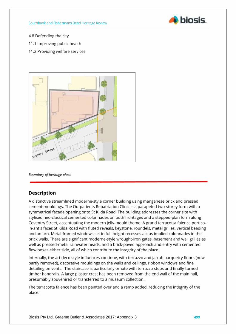
Southbank and Fishermans Bend Heritage Review
Biosis Pty Ltd, Graeme Butler & Associates 2017: Appendix 3 499
4.8 Defending the city
11.1 Improving public health
11.2 Providing welfare services
Boundary of heritage place
Description
A distinctive streamlined moderne-style corner building using manganese brick and pressed
cement mouldings. The Outpatients Repatriation Clinic is a parapeted two-storey form with a
symmetrical facade opening onto St Kilda Road. The building addresses the corner site with
stylised neo-classical cemented colonnades on both frontages and a stepped-plan form along
Coventry Street, accentuating the modern jelly-mould theme. A grand terracotta faience portico-
in-antis faces St Kilda Road with fluted reveals, keystone, roundels, metal grilles, vertical beading
and an urn. Metal-framed windows set in full-height recesses act as implied colonnades in the
brick walls. There are significant moderne-style wrought-iron gates, basement and wall grilles as
well as pressed-metal rainwater heads, and a brick-paved approach and entry with cemented
flow boxes either side, all of which contribute the integrity of the place.
Internally, the art deco style influences continue, with terrazzo and jarrah parquetry floors (now
partly removed), decorative mouldings on the walls and ceilings, ribbon windows and fine
detailing on vents. The staircase is particularly ornate with terrazzo steps and finally-turned
timber handrails. A large plaster crest has been removed from the end wall of the main hall,
presumably souvenired or transferred to a museum collection.
The terracotta faience has been painted over and a ramp added, reducing the integrity of the
place.

Southbank and Fishermans Bend Heritage Review
Biosis Pty Ltd, Graeme Butler & Associates 2017: Appendix 3 500
The clinic is adjunct to the Victoria Barracks with its mainly Victorian-era bluestone construction,
but also a visually-related Moderne-style brick wing from 1940 to the west along Coventry Street.
History
The former Repatriation Commission Outpatients Clinic was designed for the Commonwealth
Repatriation Commission by noted Melbourne-based architect George Hallandal, acting under H.
J. Mackennal of the Commonwealth Department of the Interior, and built by Blease McPherson &
Co. of Queen Street. The clinic opened in 1937.
The clinic was part of a million-pound repatriation program undertaken by the Commonwealth
Government across Australia, and widely reported upon during its planning stages and upon
completion. It was one of a large number of military buildings developed by the Commonwealth
Works Department in Victoria as part of strategic preparation for World War II. The clinic
replaced an earlier galvanised structure at the southeastern corner of the site. Lieutenant
Colonel White, acting minister for repatriation, announced the proposal to build an outpatients'
clinic for returned soldiers in 1936 at a cost of £10,000. The building was purpose-built for
outpatients in order to reduce congestion in the facilities available at the Caulfield Repatriation
Hospital at the time (The Argus, 1936).
The design met some controversy, with well-known artist Sir Arthur Streeton condemning the
contrast of the brown brickwork with the existing bluestone structures of Victoria Barracks.
Streeton wanted the clinic built in bluestone to match the barracks as well as Melbourne
Grammar, feeling that this would be a fitting addition to the great boulevard that was St Kilda
Road. Director of the Commonwealth Public Works Department, Mr. H. J. Mackennal, replied that
the brick was chosen to make the building ‘unpretentious’, and that the cost of building in
bluestone would have been four times the final contract price of £16,000 (The Argus, 1937).
The building housed an outpatient clinic that included medical examination rooms, operating
theatres, a massage section and a dispensary. A canteen was located in the basement, with
accommodation for staff on the first floor above the clinic. It was considered to be a thoroughly
modern art deco design and was one of the first public buildings in Victoria to have mechanical
air conditioning. A major extension to the rear (fronting Coventry Street) was built in compatible
materials and style during the 1940s. The original Barracks’ bluestone wall had to be rebuilt
closer to B Block to enlarge the site for the Repatriation Centre (Godden Mackay Logan, 2011a, p.
22).
George Hallandal was responsible for the design of many of the other Defence buildings, with
notable buildings from the same period including the Royal Australian Army Medical Corps
Training Depot and the Royal Melbourne Regiment Drill Hall. Hallandal worked with the
Commonwealth Works Department from 1923 to 1966, and had a long and distinguished career.
New matching wings were added in 1946-1947, designed by another noted Commonwealth
architect, D. B. Windebank. Many ex-servicemen received invaluable treatment there over the
years.
The clinic was administered by the Repatriation Commission as part of its healthcare role for
veterans, as it was specifically built to manage demands on existing facilities (The Argus, 1936).
The Repatriation Commission was established in 1920 by proclamation of the Australian Soldiers’
Repatriation Act 1920 (Department of Veterans' Affairs, 2014). The Repatriation Commission was
intended to manage returned soldiers, and encompassed healthcare, settlement, pensions and
vocational training. This was an unusual example of a federal approach to healthcare, with most
healthcare institutions at the time being managed by the state (Sax, 1984, pp. 15-42). The clinic is
also an unusual example of a centre being built specifically to manage healthcare controlled by

Southbank and Fishermans Bend Heritage Review
Biosis Pty Ltd, Graeme Butler & Associates 2017: Appendix 3 501
the Repatriation Commission. Most hospitals used by the Commission were typically former field
hospitals managed by the Services that had now been handed over to the Commission, generally
after World War II; for example, the Heidelberg Repatriation Hospital was formerly the 115th
Heidelberg Military Hospital (Austin Health, 2015).
The role of the Repatriation Commission shifted after the introduction of Veterans’ Entitlements
Act of 1986 and the establishment of the Department of Veterans' Affairs, after which
Repatriation Hospitals were gradually transferred to state control. The length of use of this
Repatriation Centre as a clinic is unknown, but it was temporarily used as a store for Defence,
and also used by the Maintenance Engineering Agency for a time during the 1990s. In 1999, it
was described as unoccupied and in 'disrepair', and has been vacant since. All asbestos material
is recorded as having been removed in 2005, and the exterior was refurbished in 2006 (Godden
Mackay Logan, 2011a, p. 22), however the absence of asbestos material is currently
unconfirmed.
Comparative analysis
The clinic is typical of the late-1930s Commonwealth government architecture, erected in the
lead-up to the World War II in the form of drill halls and other military structures. Two drill halls
in the Melbourne CBD are on the Victorian Heritage Register, both designed by the same person,
and both highly-significant, although one has been altered.
The streamlined moderne-style used for the clinic fits the corner site and purpose of the
building, and detailing such as the terracotta, wrought-iron grilles and gates is notable, as is the
building's condition and integrity.
Statement of Significance
What is significant?
The former Repatriation Outpatients Clinic, designed for the Commonwealth Repatriation
Commission by noted Melbourne-based architect George Hallandal acting under H. J. Mackennal
of the Commonwealth Department of the Interior, built by Blease McPherson & Co. of Queen
Street, and opened in 1937.
New matching wings were added in 1946-1947, designed by another noted Commonwealth
architect, D. B. Windebank.
The use of manganese brick differentiated the design from the adjoining barracks, as was its
function. This approach attracted criticism from the artist Sir Arthur Streeton who wanted
bluestone, but otherwise the clinic was heralded across Victoria as a modern, much-needed
facility. The construction was part of a million-pound repatriation program undertaken by the
Commonwealth Government across Australia.
At the time, St Kilda Road was regarded as one of the `Great Streets of the World'.
Contributory elements include:
streamlined moderne-style, parapeted two-storey form;
symmetrical facade to St Kilda Road;
salt-glazed manganese brickwork and pressed cement detailing;
corner site with stylised neo-classical cemented colonnade addressing both frontages,
rounded corners and stepped-plan form along Coventry Street;
grand terracotta faience portico-in-antis facing St Kilda Road with fluted reveals,
keystone, roundels, metal grilles, vertical beading and an urn;

Southbank and Fishermans Bend Heritage Review
Biosis Pty Ltd, Graeme Butler & Associates 2017: Appendix 3 502
metal-framed windows set in full-height recesses, acting as implied colonnades in the
brick walls;
significant moderne-style wrought-iron gates, basement and wall grilles, also pressed
metal rainwater heads; and
brick-paved approach and entry with cemented flow boxes on either side.
The terracotta faience has been painted over and a ramp added, reducing the integrity of the
place.
How is it significant?
Outpatients Repatriation Clinic part of the Victoria Barracks is historically, socially and
aesthetically significant to Southbank, the city of Melbourne and to greater Victoria.
Why is it significant?
Historically and socially, the Outpatients Repatriation Clinic is significant for its association with
an important phase of major building activity in Melbourne, prior to the commencement of
World War II. (Criterion A)
Aesthetically, the clinic is a fine and well-preserved example of the moderne-style phase of
Commonwealth government architecture that existed in the late-1930s in the lead-up to World
War II. The use of brickwork, terracotta, wrought iron grilles and gates is notable, as is the
building's condition and integrity. (Criterion E)
Sources used for this assessment
The following sources and data were used for this assessment:
Victorian Heritage Database
National Trust of Australia (Vic)
Statement of Significance:
The Outpatients Repatriation Clinic, built in 1936-37 and thought to be the design of George
Hallendal under Commonwealth Works Department Director, H L McKennall, is of regional
historical and architectural significance. Hallendal designed many buildings and several fine drill
halls in a long and distinguished career with the Commonwealth Department of Works.
Additions in the mid-1940 s were designed by another prominent architect, D B Windebank.
Architecturally, the clinic is typical of 1930s Commonwealth government architecture. The use of
wrought iron grilles and gates is notable, as is the building's condition and integrity. Historically,
the Outpatients Repatriation Clinic is significant for its association with an important phase of
building activity prior to the Second World War which included various barracks and several
notable drill halls. Classified: 03/06/1996 - See more at:
http://vhd.heritagecouncil.vic.gov.au/places/65672#sthash.HSdooBCb.dpuf.
Allom Lovell & Associates Pty Ltd. (1999). Victoria Barracks Melbourne: Conservation Analysis and
Management Plan. Melbourne: An unpublished report to the Australian Government
Department of Defence.
Austin Health. (2015). Heidelberg Repatriation Hospital. Retrieved December 2, 2015, from Austin
Health. http://www.austin.org.au/heidelberg-repatriation-hospital.
Department of Veterans' Affairs. (2014, October 23). Functions and powers. Retrieved December
02, 2015, from Australian Government Department of Veterans' Affairs:

Southbank and Fishermans Bend Heritage Review
Biosis Pty Ltd, Graeme Butler & Associates 2017: Appendix 3 503
http://www.dva.gov.au/about-dva/accountability-and-reporting/annual-reports/annual-reports-
2012-13/repatriation-commissi-0.
Godden Mackay Logan. (2011a). Victoria Barracks, Melbourne: Heritage Management Plan.
Sydney: Unpublished report to the Australian Government Department of Defence.
Godden Mackay Logan. (2011b). Victoria Barracks, Melbourne: Heritage Handbook and Heritage
Assets Management Schedules. Sydney: Unpublished report to the Australian Government
Department of Defence.
Heritage Office. 1996. How to prepare archival recordings of heritage item. Published by the
Heritage Office and Department of Urban Affairs and Planning.
Heritage Office. 2006. Photographic recording of heritage items using film or digital capture.
Published by the Heritage Office and Department of Urban Affairs and Planning.
Kerr, J. (2004). Conservation Plan - Sixth Edition. Sydney: National Trust.
Pruszinski, J. (2007a). Victoria Barracks Melbourne, Victoria: Heritage Management Plan.
Adelaide: Unpublished report to the Australian Government Department of Defence.
Pruszinski, J. (2007b). Victoria Barracks Melbourne, Victoria: Heritage Handbook. Adelaide:
Unpublished report to the Australian Government Department of Defence.
Sax, S. (1984). A Strife of Interests – politics and policies in Australian health services. Sydney: George
Allen & Unwin.
Newspapers
The Argus. 1936, January 18, p.22.
New Soldiers' Clinic. OUT-PATIENTS' CLINIC.
New Building for Soldiers. £10,000 TO BE EXPENDED.
The Federal Government has decided to build o new out-patients' clinic for returned soldiers at
the corner of St. Kllda-road and Coventry-street. Plans have not yet been prepared, but the clinic
will 'be one story of brick, and will cost £10,000. Making this announcement yesterday, Mr. White,
Acting Minister of Repatriation, said that as there had been a considerable growth In the number
of outpatients under treatment at the existing clinic and to avoid congestion, it had been
necessary to extend the period between visits of out-patients, though such had not been done
with potential inpatients, who were kept under close observation. Such a state of affairs was
neither satisfactory to the out-patients, nor to the medical staffs, and as the accommodation had
been of a temporary nature and was now overcrowded and unsuitable, It was proposed to erect
a more suitable and ' substantial structure where the whole -of the out-patient clinic would be
housed. When completed, the more adequate accommodation and improved facilities provided
would add to the comfort of patients and bring the clinic into line with present requirements,
and be thoroughly up-to-date. The Minister pointed out that 200 ex-soldiers dally attended me
out-patients' clinics. Wounds were dressed, massage was given, and eye and nerve cases were
dealt with.
The Argus. 1937, March 5, p.12.
Brick Clinic in St. Kilda Road Condemned.
The brown brickwork of the new outpatients' clinic being erected in St. Kilda road for the
Repatriation Commission will contrast sharply with the massive bluestone buildings of Victoria
Barracks, which it adjoins. "A building in this part of St Kilda road in anything but bluestone will
ruin this magnificent boulevard " said Sir Arthur Streeton yesterday. In condemn-ing the
proposal to erect a new clinic for the Repatriation Commission in brown brick and terra-cotta

Southbank and Fishermans Bend Heritage Review
Biosis Pty Ltd, Graeme Butler & Associates 2017: Appendix 3 504
tiles alongside Vic-toria Barracks. The barracks, he added was one of the finest buildings in Mel-
bourne, and was in complete harmony with the Melbourne Grammar School and other imposing
structures on the tree-lined road. If the new clinic were to be built of brick one might as well
think of de molishing the other structures and rebuilding them of brick also. The director of the
Commonwealth Public Works Department (Mr. H. J. Mackennal) has explained that brown brick
was chosen for the new building to make it "unpretentious." To erect the clinic in bluestone, he
said, would have cost four times as much as the contract price for the brick building-£ 16,000.
Recommendations
Include as an individual significant place in the heritage overlay.
Revise Heritage Places Inventory.
Apply external paint controls with policy to maintain original finishes and colour schemes.
Apply internal alteration controls to retain configuration of main hall, examination room, internal
fittings, stairs and wall panelling, and original heating and air conditioning units, ducts and
vents,.

Southbank and Fishermans Bend Heritage Review
Biosis Pty Ltd, Graeme Butler & Associates 2017: Appendix 3 505
Victoria Barracks, 256-310 St Kilda Road, Southbank
City of Melbourne property number:
Type of place: defence
Images of place 2016-2017
Historical associations:
Creation or major development date(s) of place: 1860, Victorian-era, Edwardian-era
Major owners or occupiers: Victorian government, Australian Government
Designer: Gustav Joachimi and J. Duncan, Royal Engineers
Heritage Gradings:
Proposed new system (C258):
Individually significant? Yes
Alphanumeric system (building A-E, streetscape 1-3):
Existing: Proposed: A1
Heritage values:
Aesthetic, Historical, Social
Heritage status:
Heritage Overlay Proposed
Thematic context:
4.8 Defending the city
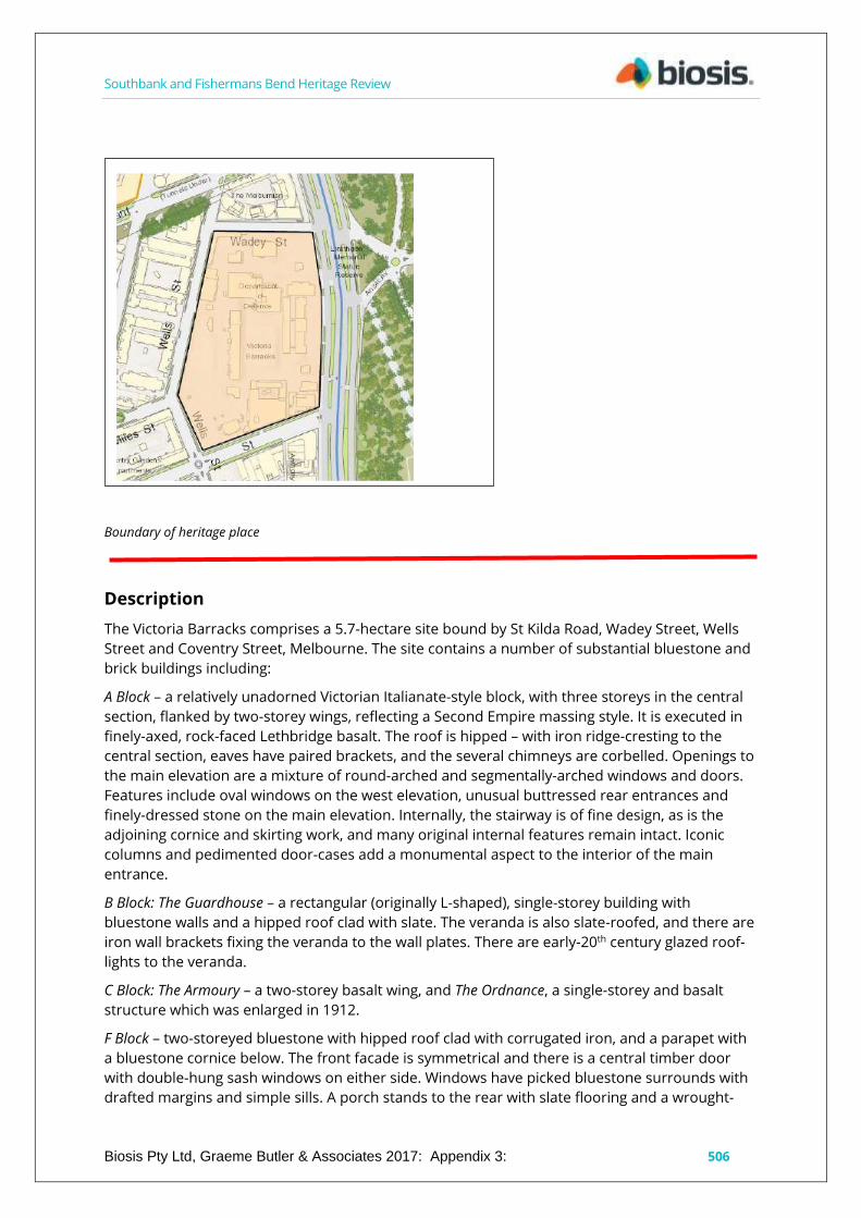
Southbank and Fishermans Bend Heritage Review
Biosis Pty Ltd, Graeme Butler & Associates 2017: Appendix 3: 506
Boundary of heritage place
Description
The Victoria Barracks comprises a 5.7-hectare site bound by St Kilda Road, Wadey Street, Wells
Street and Coventry Street, Melbourne. The site contains a number of substantial bluestone and
brick buildings including:
A Block – a relatively unadorned Victorian Italianate-style block, with three storeys in the central
section, flanked by two-storey wings, reflecting a Second Empire massing style. It is executed in
finely-axed, rock-faced Lethbridge basalt. The roof is hipped – with iron ridge-cresting to the
central section, eaves have paired brackets, and the several chimneys are corbelled. Openings to
the main elevation are a mixture of round-arched and segmentally-arched windows and doors.
Features include oval windows on the west elevation, unusual buttressed rear entrances and
finely-dressed stone on the main elevation. Internally, the stairway is of fine design, as is the
adjoining cornice and skirting work, and many original internal features remain intact. Iconic
columns and pedimented door-cases add a monumental aspect to the interior of the main
entrance.
B Block: The Guardhouse – a rectangular (originally L-shaped), single-storey building with
bluestone walls and a hipped roof clad with slate. The veranda is also slate-roofed, and there are
iron wall brackets fixing the veranda to the wall plates. There are early-20th century glazed roof-
lights to the veranda.
C Block: The Armoury – a two-storey basalt wing, and The Ordnance, a single-storey and basalt
structure which was enlarged in 1912.
F Block – two-storeyed bluestone with hipped roof clad with corrugated iron, and a parapet with
a bluestone cornice below. The front facade is symmetrical and there is a central timber door
with double-hung sash windows on either side. Windows have picked bluestone surrounds with
drafted margins and simple sills. A porch stands to the rear with slate flooring and a wrought-
Southbank and Fishermans Bend Heritage Review
Biosis Pty Ltd, Graeme Butler & Associates 2017: Appendix 3 507
iron balustrade. Internally, the building is divided into offices, retaining many of the original
beaded architraves and skirtings, angled timber window reveals, incised dado mouldings and
fireplaces. The first floor rooms have timber floors and lathe-and-plaster ceilings. A basalt stair
leads to the first floor and there is an original glazed skylight above it.
G Block – a large, long, rectangular building constructed of rock-faced, squared, coursed rubble
bluestone, with quoins of various finishes. The building is two storeys plus a basement. The
hipped roof, now clad in iron but originally slate, is set behind a parapet. Originally the building
was designed as separate units, with a separate roof to each unit. The facade is simple and
marked by the repetition of the units, giving the building an austere look. Windows are generally
12-pane double-hung sashes, and there are top-lights above the doors. At each entrance there is
a flight of stairs leading to a bridge – with balustrades – which connects to the door. The western,
rear elevation has a series of two- and three-storey projecting towers with basements.
J Block – a part of the Victoria Barracks' axial plan, and very similar to F Block except for the
veranda. J Block is a two-storey bluestone with tooled and picked detailing, hipped slate roof,
two-storey veranda to the south and east, and clad with corrugated galvanised iron. There is a
low bluestone parapet. The south and east facades, in keeping with the Victorian Georgian style
of the building, are symmetrical, with a central door flanked by double-hung six-pane sash
windows. Windows and doors are decorated with quoins.
The Keep – the central embrasure of the perimeter wall, part of the original axial planning of the
complex. It is built of rock-faced basalt and was given prominence with quoins emphasised by
fine-drafted margins and fine dressings to openings. Capping is freestone. There are slit
windows and a crenellated parapet. Various sections of the perimeter wall survive as well. The
wall and Keep have rougher stonework than the other buildings in the complex, designed to
convey an impression of impregnability.
History
Dates for construction of the Victoria Barracks are contradictory, but a newspaper account from
1862, referring to their commencement five years previous, suggests 1857 as the date of initial
construction. This is backed up by other sources as well. The Barracks were built for the British
Imperial Garrison, including the 12th and 40th Regiment of Foot, who were involved in putting
down the armed Eureka Stockade rebellion in Ballarat, Victoria, and later the Colony of Victoria's
colonial forces (The Age, 24 June 1862, p.6).
The Barracks first appear on a map of the military reservation dated in 1859. The progress of the
construction of A Block was dependent on available funding, although its completion was clearly
a priority of many of those in command. In March 1860, the Deputy Adjutant General's office
wrote to the Honorary Commissioner of Public Works stressing its importance: '...it is desirable
that the Officers Quarters should be proceeded with without delay, both as a matter of
convenience and discipline.'
The earliest building, G Block, was built by soldiers of the 40th Regiment under the supervision of
a royal engineer officer. Later, building was undertaken by civil contractors. A large extension – A
Block, New Wing – was added in 1917 to accommodate the headquarters of the Department of
Defence, designed in the style of the original A Block building, although the construction method
and interior were completely modern for the time. The art deco M Block was added in 1939, and
the floor was the first continuous concrete pour in Australia. The Barracks were named in
honour of Queen Victoria.
From 1901 to 1958 this was the site of the Commonwealth Department of Defence
headquarters.
Southbank and Fishermans Bend Heritage Review
Biosis Pty Ltd, Graeme Butler & Associates 2017: Appendix 3 508
During World War II, the Victoria Barracks housed the Australian War Cabinet Room. The War
Cabinet comprised senior members of parliament from the Government and Opposition parties.
The Defence Secretariat occupied the second floor of A Block New Wing, which also contained
the offices of senior military staff, the Secretary of the Department Defence Sir Frederick
Shedden, visiting Ministers of State and their secretaries and support staff. The wartime prime
ministers, Robert Menzies and later John Curtin, also had offices near the War Cabinet Room
throughout the world wars. It is believed that the American general Douglas MacArthur had an
office at the Barracks, however this is not likely as his headquarters were at the Hotel Australia in
the Melbourne CBD. It was, in fact, General Sir Thomas Blamey who had his headquarters at the
Barracks while serving as Commander-in-Chief, Australian Military Forces, and simultaneously in
international command as Commander-in-Chief, Allied Land Forces in the South-West Pacific
Area under MacArthur (Department of Defence 2013).
Comparative analysis
The Victoria Barracks present a unique classically-derived bluestone facade to St Kilda Road,
which is complemented by the nearby painted Police Barracks and the bluestone gothic style of
Wesley College down the road. The Queenscliff and Point Nepean defence installations also
reflect the same combination of austere classically-derived architecture and massive stone
defensive forms. Elsewhere in the City of Melbourne, the Old Melbourne Gaol provides a
relevant architectural comparison.
Statement of Significance
What is significant?
Victoria Barracks, 256-310 St Kilda Road, Southbank.
Contributory elements include:
classically-derived bluestone facades;
finely-detailed masonry with carved mouldings;
hipped slate roofs;
landscaped grounds with mature exotic trees;
cannons in the forecourt;
composite timber-and-iron verandas;
The Keep’s fortified wall remnants; and
entrance gates with flanking bluestone pillars and guard house.
How is it significant?
The Victoria Barracks are significant for historic, social and aesthetic reasons to Southbank, the
city of Melbourne, greater Victoria and Australia as a whole.
Why is it significant?
The Victoria Barracks are historically significant as being the earliest and most substantial
colonial military facility in Victoria, representing the initial British military presence in the colony,
the early Victorian colonial forces and the Commonwealth Department of Defence. (Criterion A)
It is also notable for its association with major phases of Australia's defence and military history.
The site was integral in the imperial defence of the colonies and was used increasingly for
offices, as defence administration was concentrated at Victoria Barracks. Following Federation,
key defence figures were accommodated in the buildings. During World War I, Block A housed
the headquarters for Australia's defence administration and remained associated with defence

Southbank and Fishermans Bend Heritage Review
Biosis Pty Ltd, Graeme Butler & Associates 2017: Appendix 3 509
headquarters until the move to Canberra in the late-1950s. A1 Block, along with the flanking J
and F blocks, are significant historically for their direct association with the War Cabinet and
Advisory War Council during World War II, where major wartime decision-making activities took
place. (Criterion A)
The buildings have strong associations with key individuals in Australia's military, political and
architectural history. These people include wartime prime ministers –Sir Robert Menzies, John
Curtin and Ben Chifley, ministers and departmental secretaries, senior military officers –Major
Generals Hoad and Bridges, architects – J. S. Murdoch and G. Joachimi, and Allied military and
political leaders. (Criterion H)
The buildings are of architectural significance as they are outstanding examples of the Victorian
Public Works Department's work during the period of Victorian Italianate style and Second
Empire massing, displaying highly-skilled workmanship in basalt and refined detailing. Other
notable features include oval windows to the west facade of A Block and the unusual buttressed
rear entrances. (Criterion E)
A Block is a key element of the axiality that is a central part of the Victoria Barracks design.
Further, fronting St Kilda Road – a major Melbourne thoroughfare – it is the public face of the
complex and presents a formal and imposing military presence towards the streetscape. The
spaces around A Block (and A1 Block especially) facing St Kilda Road are also significant to the
buildings' aesthetic value. (Criterion E)
As buildings associated with Australia's defence administration for many decades, and as major
edifices in inner Melbourne and key parts of the central city's military complex, the buildings
have social significance both within the military community and the public at large.
Sources used for this assessment
The following sources and data were used for this assessment:
Department of Defence, Victoria Barracks Melbourne, Victoria, Commonwealth of Australia 2013.
http://www.defence.gov.au/id/_Master/docs/NCRP/VIC/1043VictoriaBarracksMelbourneVic.pdf
Nigel Lewis and Associates, for the 'Masterplan, Victoria Barracks : Melbourne' prepared by the
Department of Housing and Construction for the Department of Defence in February 1984.
Allom Lovell & Associates Pty Ltd, ‘Victoria Barracks, Melbourne: Conservation Analysis and
Management Plan – Review’. Prepared for the Department of Defence, 1999.
Vazenry, G. R., ‘Military Forces of Victoria 1854-1967’. Extracts on Department of the Army,
Southern Command, File 707/S7/Z.
National Trust of Australia (Victoria), file 204.
‘Analysing Nineteenth Century Military Building Typologies: an Australian Perspective’, N. K. Boyd
& J. Rice WIT Transactions on The Built Environment, Vol 143, 2014.
Newspapers
The Age, 24 June 1862, p.6.
THE MILITARY BARRACKS.
The military barracks on the St. Kilda road, the building of which was commenced some five
years ago, have lately been made considerable progress with. Structures of this character are
seldom distinguished by beauty of design, nor can those we are alluding to be considered an
exception to the rule. Utility has certainly not been sacrificed for ornament, nor comfort for
display. The most recent erections are, however, for more pleasing to the sight than the earlier

Southbank and Fishermans Bend Heritage Review
Biosis Pty Ltd, Graeme Butler & Associates 2017: Appendix 3 510
portions, and when the buildings are completed, and the plantations adjacent are grown up, we
may expect that a further improvement in external appearances 'will be effected. The barracks
consist, not of one, but of a series of detached edifices, situated upon a reserve of 150 acres, and
ending at the parade ground, 520 feet long by 200 feet width. Pacing the St Kilda road are the
officers' quarters, at the rear are the barrack houses fur the men, and to the left lie the hospital,
the arsenal, the gun sheds. On the right the square is open, the buildings to be erected there
having yet to be commenced. The design of the barracks is for a regiment of 800 men, and there
is now accommodation for 400. To provide this more than half of the buildings have had to be
erected, us much of the accommodation is common to all. The officers' quarters, which, being
the most prominent portion of the buildings, claim first attention, have but just been completed.
Without possessing claims to architectural merit, the dressed stone, tho large windows, and the
deeply recessed entrance, combine to give the edifice of a handsome appearance, and one
suitable to the purpose for which it is designed. The entrance is into a spacious hall, 48 feet long,
and both wide and lofty. To the right hand lies the officers' mess-room, 60 feet in length by 22
feet in breadth, and 10 feet high. The fittings of the rooms are of cedar wood, and handsome
and substantial, according well with the large dimensions of the apartment and the manner in
which it is furnished. To the right of the hall is the ante-room, and also the reading room, and tho
remainder of the accommodation on the ground and first floors is devoted to private
apartments for officers. Of these a subaltern is entitled to one, and a captain to [...] The
Government contribute a table and two chairs towards the furniture of these apartments, and
aught else that may be thought desirable has to be supplied by the officers themselves. The
central building has a second door, and here a billiard room is provided, […] entrance is obtained
to the observatory on the roof, from which there is a fine view of the Bay and the country
surrounding Melbourne. The handsome railing round the observatory is an ornament to the
building. The staff officers occupy the rooms to the extreme left «f the quarters. The
accommodation provided for them is of the same commodious character as that we have
already noticed. In the basement of the building are situated the kitchen offices, the wine cellar,
larder, pantries, etc. The cooking ranges and every thing here is complete, and having been
erected to meet the requirements of a regiment, go quite beyond the wants of the present
garrison. When finished the length of tho building will be 274 feet. The length of the central
portion and the left wing, which are now erected, is 108 feet, with an elevation for the central
portion of 55 feet. The soldiers' quarters in the rear constitute the structure which have long
formed an eyesore to travellers between Melbourne and the southern suburbs – a long, uniform
flat range, destitute of the slightest relief, and built in the plainest manner. If a moderate
expenditure would mitigate the severe ugliness of the building the money could scarcely be
grudged by the most parsimonious. Fortunately for the casual observer the quarters are now
nearly hidden from sight, as they are concealed by the more pretentious structure just adverted
to, and, fortunately for the soldiers, the defects of the building are of the exterior only, the
accommodation being of a superior order. The quarters contain live houses, classified according
to the letters of the alphabet, A house, B house, C house, & c. Each house contains eight rooms
and accommodates eighty men. Five of the rooms are sleeping apartments, well ventilated, lofty,
and large, the dimensions of each being 44 feet long, 21 feet wide, and 13 feet high. There are
twenty beds in each room, and these, through having no double debt to pay, being beds by night
and nothing more by day, are neatly stowed away in the day time, so as to leave the room clean
and clear until night. The mess-room is situated in the basement story of the building, and here
the men, when not otherwise engaged, sit during the day, many of them employing their spare
time in making cabbage-tree hats, boots and shoes, or adopting other methods of eking out their
income. The regimental sergeants have their rooms in the back portions of the houses. The
apartments are comfortable in appearance, and ire about twelve feet square. The various out-
offices — the kitchens, the ablution rooms, etc. — are situated in a detached building at the rear
Southbank and Fishermans Bend Heritage Review
Biosis Pty Ltd, Graeme Butler & Associates 2017: Appendix 3 511
of the quarters. To a stranger, their most striking characteristic is the scrupulous cleanliness
everywhere observable and to a stranger, also, every convenience seems to have been provided.
The Yan Yean is not yet laid on to tho barracks, but is speedily to be so. When the work is
accomplished, the ablution rooms are to have shower baths constructed in them, and in the hot
weather they will doubtless be found of great utility in preserving the health of the men. All the
woodwork about these buildings, we may remark, is painted a dark blue, on account of the
mosquitoes and flies. The canteen accommodation, which adjoins the quarters, is wretched, and
ought to be immediately improved. A sum of money for the erection of a proper building has
been already appropriated by Parliament, the Commissioner of Public Works has not thought fit
to sanction its expenditure, and has thus caused much dissatisfaction to be felt among the
persons interested. On the left side of the barrack-square, are situated the armoury, store-
rooms, powder magazine, and gun sheds, all of which it is proposed to keep apart from the
remainder of the building B as an arsenal, and the hospital. The hospital was the first building
erected, and was commenced by the soldiers of the 40th themselves. It was original intended for
a library and school rooms, but there being no accommodation for the sick, it had to be
converted into the hospital. However, not having been built for an establishment of this kind, it is
found to be rather unsuitable, and not some future time it will probably be used, as was
intended, for educational purposes. The building contains twelve rooms, and there are at
present 50 men in them on the Bick list. The percentage of sickness in tho troops hero is about
the army average. At the rear lie a long range of gun sheds, recently constructed, and which
derive a special interest from being the habitation of the battery of six 12-pound Armstrong guns
which arrived a short time ago from England. The sheds are substantially constructed, and well
fitted up. They are 176 feet long, 9 feet high in the clear, and 30 feet wide. The width is sufficient
for the puns to stand in with their carriages, be that the doors can be thrown open and the
battery run out without delay. The sheds include a blacksmith's room, a harness room, and tho
necessary workshops, and these have been so constructed that upon an emergency arising, they
could be made available for the housing of a Second battery. The armoury, the store rooms, and
the military offices are situated in one building, which like all the others, is of solid bluestone
structure. The Store room is fitted up with racks, so as to admit of a classification of the goods,
and consequently everything looks systematic and business like. Tho armoury contains nearly
6000 stand of arms, including the Brown Bess's originally issued to the volunteers the Lancaster,
and the breech-loading Westley Richards' Whitworth's, just arrived. A portion of these arms
belong to the Imperial Government, but the majority, together with the Armstrong battery, are
the property of the colony. The armoury and its contents are well worthy of a separate
description, and on the present occasion we need but mention that the arms are kept in
beautiful order, the guns in racks and the swords and pistols hung in devices round the rooms.
The only building to the right of the square is the staff Sergeants' house, which calls for no
particular comment; it is very similar both in construction and accommodation to the other
portions of the barracks. This completes the list of edifices already erected. Guard rooms and
stabling are now being proceeded with, and it is intended next to construct quarters for married
couples, and a suitable canteen, both of which are urgently required. The number of men at the
barracks at the present time is small. The Artillery muster about 90 men, the 40th Regiment, 140,
and the Royal Engineers, 20. As it is not probable that the Imperial forces in the Colony will be
numerous or at least, for some time to come, there is no great prospect of the barracks being
soon completed, according to the original plain. The officers' and […] quarters were designed by
Captain Pasley and the remaining portions of the barracks have been executed by Captain
Scratchley, R. E., through the Public Works Department. The method of proceeding favours of the
Circumlocution Office, as though Captain Scratchley superintends the works, the contractors
cannot receive instructions from him. Every trivial matter has to form the subject of a
communication with the Public Works Department, and as may be easily imagined no little delay

Southbank and Fishermans Bend Heritage Review
Biosis Pty Ltd, Graeme Butler & Associates 2017: Appendix 3 512
is caused, while it would be difficult to say who would be actually responsible should a fault be
discovered. The cleanliness and good order of the existing accommodation are such us to reflect
great credit upon the men and upon the Barrack Master, Captain Pitt, and the energy and skill
displayed by Captain Scratchley in the constitution of the works are very obvious. The soldiers'
quarters have cost £25,000, the officers' quarters £16,000, and the outer buildings £10,000 in
addition — making a total cost, up to the present, of about £51,000.
City of Melbourne maps
Victoria Barracks Melbourne:
Defence complex of 5.7 ha. Established on this site in 1856 and first built for the British Imperial
Garrison. From 1901 to 1958 it was the site of the Headquarters for the Commonwealth
Department of Defence. During World War Two it housed the Australian War Cabinet. Noted for
its many Colonial era structures. Of note is A Block facing St Kilda Road. A three storey bluestone
structure originally built as officers' quarters in 1876 with the South Wing added in 1917. The
earliest structure is G Block a two storey bluestone building and built between 1856 and 1858 as
a barracks. At one stage in the 1890's it was an industrial school and used to accommodate
destitute children. J Block, originally the Staff Sergeants' quarters, a two storey bluestone
building was designed in the Georgian style by the Public Works Architect Gustav Joachimi and
built in 1860. It was used later as a police hospital. The Guard House, known as B Block, is a
single storey bluestone building and built in 1862. C Block is a three storey building and built
around 1870. F Block a two storey bluestone building was built in 1867 as a hospital and is the
earliest surviving hospital building in Victoria. M Block designed in the art deco style was built in
1939. It is thought to be the first continuous concrete pour in Australia. Also of note is the
remnant of a bluestone wall on the Western Boundary. This is known as The Keep and is part of
the original fortification built in 1860.
City of Melbourne i-Heritage
The Victoria Barracks extends over a large tract of land and comprises many buildings, a number
of which are already recognised as of cultural significance by their having been listed on
statutory registers. It has been beyond the scope of this study to expand on the research on the
Barracks undertaken by the Dept of Housing and Construction. That work has been most
comprehensive in identifying sites and buildings of consequence on the site, and particularly the
work by Nigel Lewis and Associates for the 'Masterplan, Victoria Barracks : Melbourne' prepared
by the Department of Housing and Construction for the Department of Defence in February
1984.`
Description/Notable Features: The Victorian Barracks comprise a number of buildings
constructed over a long period of time in a variety of architectural styles. The buildings are
generally in good condition although their integrity varies from structure to structure.
Statement of Significance: The Victoria Barracks site as a whole is of significance for having been
a major influence on the development and planning of South Melbourne since the formation of
the suburb. The significance of the individual buildings within the barracks has been researched
by the Department of Housing and Construction and has not been expanded on in this study.
Other Comments: Many of the individual buildings and the group itself are of extremely high
significance.

Southbank and Fishermans Bend Heritage Review
Biosis Pty Ltd, Graeme Butler & Associates 2017: Appendix 3 513
Recommendations
Revise Heritage Places Inventory.
Include as an individual significant place in the heritage overlay in the event that the place is sold
or divested by the Commonwealth, and if so:
Apply external paint controls with policy to reintroduce original finishes and colour
schemes.
Apply tree controls to mature palms in front of main building on St Kilda Road and to
other mature trees within compound.
Investigate interiors for original fittings and joinery with a view of inclusion on future
internal controls.

Southbank and Fishermans Bend Heritage Review
Biosis Pty Ltd, Graeme Butler & Associates 2017: Appendix 3: 514
General Post Office (GPO) garage, stores & workshops, 45-99
Sturt Street, Southbank
City of Melbourne property number: 537125, 567774 and others
Type of place: factory
Images of place 2016-2017
Historical associations:
Creation or major development date(s) of place: 1930-1937: Inter-war (WW1-WW2), 1940-1944
: Post-WW2
Major owners or occupiers: Commonwealth Government
Designer: J. S. Murdoch, chief architect for the
Commonwealth of Australia; H J Mackennal,
Works Director, Victoria
Heritage Gradings:
Proposed new system (C258):
Individually significant
Alphanumeric system (building A-E, streetscape 1-3):
Existing: Proposed: C2
Heritage values:
Aesthetic, Historical
Heritage status:

Southbank and Fishermans Bend Heritage Review Heritage Assessment
Biosis Pty Ltd, Graeme Butler & Associates 2017: Appendix 3 515
Heritage Overlay Proposed HO1203
Victorian Heritage Register: HO1203
Thematic context:
3.7 Establishing and maintaining communications
Boundary of heritage place
Description
The first major workshop wing of the General Post Office (GPO) complex at the corner of Dodds
and Grant streets was built in 1930 using a form of modern classicism, the favoured style of
then-Director of Works and Chief Commonwealth Architect, John Smith Murdoch.
Two facade bays front Dodds Street where this part of the complex has two storeys, with walls of
red brick and rendered continuous lintels in reinforced concrete over the ground- and first-floor
openings. Window sills and parapet panels are also cement-rendered. Projecting brick pilasters
correspond to structural bays of the steel framing, with brick spandrels and glazing between. A
gabled, pitched roof form is evident, with projecting eaves and guttering trimmed by gabled
parapet end-walls and corbelled cement brackets.
The windows are typically steel-framed, multi-pane glazing – some with wire-framed glazing –
with hopper sashes, and applied as regular fenestration between piers. Ornamental elements
include the stylised Georgian exaggerated cemented keystones set into moulded architraves at
one major entry while at the corner of Dodds and Grant streets, the main entry is marked by a
raised parapet, a small, corbelled porch and cement panelling. The upper floor is surmounted by
a rendered panel proclaiming the construction date as ‘1930’.

Southbank and Fishermans Bend Heritage Review Heritage Assessment
Biosis Pty Ltd, Graeme Butler & Associates 2017: Appendix 3 516
The one-storey Sturt Street workshop wing is in a simple moderne style, with a parapeted
sawtooth-roof form, presumably constructed under Works Director Mackennal in 1937 and
1940, coinciding with the significant drill hall complexes designed in that era under Mackennal. A
cemented parapet panel has a cavetto cornice, cement streamlining with lozenge medallion, and
soldier-course brickwork to the panel and the parapet capping. Otherwise, the elevations share
the fenestration and trabeation of the 1930 wing. A cavetto mould is also placed over window
openings while elegant sheet-metal-clad doors are set into a recess. A matching sawtooth-roof
internal wing is from 1944, since reclad.
The Sturt Street elevation is broken by the added 1970s Amenities Block infill wing, which
replaced part of the former workshop wing, featuring bands of vertical windows and a recessed
entrance with a small, similarly-glazed first floor on the north end, but continues as the PMG
Garage (45 Dodds Street) at the north end. A new break in the facade also allows entry into the
courtyard where a new wing has been added to the former PMG Department Workshop wing
with new visually-unrelated internal structure. In Dodds Street, openings have been also created
to allow for courtyard access.
The complex has been modified internally to create a gallery – which opened in 2001 – and
studio spaces for the Victorian College of the Arts, typically with the addition of partitions, but
retention of the rolled steel-joist framing, concrete ground floor, timber upper-level flooring and
general plan form.
An brick, Edwardian-style electricity substation is located at the corner of Sturt and Grant streets,
probably having been built specifically to serve the PMG site. This is a small, pavilion-style
building with a gambrel roof and ventilator surmounted by a finial, and clad in asbestos cement
tiles.
The former General Post Office Garage, Stores & Workshop complex is located opposite the
similarly-designed former Victoria Police stable and hospital complex and not far from the
Victoria Barracks, marking the area a public building precinct.
The important government architect John Smith Murdoch employed variations on the modern
classical style, with his significant High Court Building (modern Georgian), Little Bourke Street
(1928, Victorian Heritage Register) and the earlier and grander Melbourne Mail Exchange, 1917,
as a seven-storey, steel-framed red-brick-clad building (Victorian Heritage Register). His imposing
telephone exchanges in Melbourne (City West Telephone Exchange 1929, 1937) and Sydney (City
South Exchange) provide other more sophisticated examples of his style.
Local Commonwealth government designs under Mackennal during the 1930s were typically
moderne-style with significant drill hall complexes included among them, such as A'Beckett
Street (Victorian Heritage Register). This complex befits its utilitarian propose with simple but
nevertheless stylised elevations. This complex is distinguished and a recognisable
Commonwealth of Australia design.
The adjacent Mounted Police stables on Dodd and Grant streets offer a variation on the red-
brick-and-cement-bands style that typifies Commonwealth utilitarian architecture of the 1920s-
1940s. The RAAF Williams Laverton airbase represents a large complex of such buildings, where
rendered and white-painted horizontal bands through red brick walls and steel-framed windows
tie together a diverse range of buildings for accommodation barracks, warehouses and aircraft
hangars.
A similar effect can be found at the Richmond Airbase in New South Wales. These can be seen as
an evolved form of the earlier first wave of Commonwealth industrial buildings types, primarily
of red brick and corrugated iron, found at sites such as the Federal Woollen Mills in Geelong, the

Southbank and Fishermans Bend Heritage Review Heritage Assessment
Biosis Pty Ltd, Graeme Butler & Associates 2017: Appendix 3 517
Naval Drill Hall in Port Melbourne, and the Royal Australia Field Artillery Barracks in Maribyrnong,
all designed by Commonwealth chief architect John Smith Murdoch.
The combination of red brick and white rendered bands can be seen as a signature device in
Commonwealth buildings, both in plain utilitarian structures or applied to more elaborate public
buildings such as the Richmond South Post Office (1905).
The substation compares with a small group of contemporary Edwardian and Inter-war
substations scattered around the City of Melbourne, such as that on the corner of Munro and
Johnston streets, South Melbourne (Vines 2007).
History
The Australian Commonwealth government took over responsibility for postal, telegraphic and
telephone services from the new states at Federation in 1901. All these services came under the
control of the Postmaster General, and the need for their formation was a major factor in the
unification of the states and strategic defence.
Prior to Federation, individual states were responsible for postal, telegraph and telephone
services. With the creation of the Postmaster General, a post first held by the Honourable J. G.
Drake, these became centralised Commonwealth services with a uniform penny post and federal
postage stamps (both introduced in 1911) substituting for the various colonial systems.
Employees of the postal telegraph and telephone services automatically became federal public
servants. The PMG became the largest Commonwealth department with about 10,000
permanent staff and another 6,000 contractors (Lee 2003).
A trunk line link to Sydney was created in 1907, and Australia's first automatic exchange was
opened in Geelong in 1912. Airmail was a further development; Australia's first overseas call
reached London in 1930, and Victoria was linked to Tasmania by submarine cable in 1935. As the
effects of the Depression waned, the Postmaster General's department commenced an
extensive building campaign, providing, for example, automatic telephone exchanges at
Caulfield (2,000 lines), Brunswick (3,600 lines) and City West (6,000 lines).
In 1935, Caulfield was the first to be completed, coinciding with the start of the City West
Exchange building. After a lull, during World War II some millions of pounds were spent on a
temporarily-curtailed capital works programme for communications in general. In 1935, 92
telephones per 1,000 people were connected, via 1,650 Victorian exchanges. It took nearly 20
years for this figure to double.
Crown Land in South Melbourne near St Kilda Road was reserved from sale for potential future
uses until well into the 20th century. This proved to be beneficial for the establishment of
facilities for the new Commonwealth postal service.
The block bounded by Sturt, Dodds, Grant and Nolan streets remained Crown land (Section C,
lots 1 & 7-12) until quite late, having been retained as part of a large area for government
purposes. Subdivision occurred in 1885, with the block initially divided into 12 allotments.
However, of these, only four properties were created. The land was occupied partly by the
Victoria Barracks, and progressively, parts were reserved either for government purposes or
were gradually sold off. A subdivision by J. H. Reed, Assistant Surveyor, was undertaken by 1885,
creating about two dozen allotments on either side of Sturt Street, of one rood and 32 perches
each (about 0.18 hectares), as well as some other odd-sized lots.
In 1895, the middle part of the block contained stonecutting yards, with the post office stables at
the north end, spanning Dodds and Sturt streets (MMBW Plan). New two-storey masonry
workshops for the postal department were built facing Sturt Street at the northern end of the
Southbank and Fishermans Bend Heritage Review Heritage Assessment
Biosis Pty Ltd, Graeme Butler & Associates 2017: Appendix 3 518
site in 1899 by Thomas Cockram & Son for £1,943 (NAA). A timber caretaker's cottage was
located at the south end of the site at that time.
By the early-20th century, the block was occupied (from north to south) by Radio Corporation Pty
Ltd (lots 11-12), Alcock Thomson & Taylor billiard table manufacturers (Lots 9-10), C. M. Kerr & J.
Train (lots 7-8), and the Commonwealth of Australia (lot 1, formerly lots 1-6). The Radio
Corporation site became the present-day Recital Centre location. Alcocks continued occupation
into the 21st century. The Kerr and Train lot at 43-47 Sturt Street was occupied by Lucy Secor
Dressmaker from around 1936 (at 35 Sturt Street) until at least 1957 (Sands & McDougal
Directories).
The presence of the PMG garage in Sturt Street, South Melbourne, is recorded in newspapers by
at least 1923, when a PMG van driver from the Sturt Street garage was involved in a 'street
fatality' (The Ballarat Star, 25 September 1923, p.7.). A new gabled masonry workshop wing was
planned for the complex in 1926 under J. S. Murdoch's authority as Director General of Works,
located facing Grant, Moore, Power and Macgowan streets; this appears to have since been
demolished.
Extensive damage was caused to the motor garage in 1927 when two RAAF aeroplanes taking
part in the aerial welcome to the Duke and Duchess of York collided in mid-air, with one crashing
into the building, ‘…where it caught fire and destroyed five motor cars…’ (Jerilderie Herald and
Urana Advertiser, 28 April 1927, p.3.).
The damage to the buildings was described in detail thus:
"… the interior of the garage of the Postmaster-Generals department in Sturt Street had become a raging furnace. Employees of the garage, none of whom, fortunately, was beneath the portion of the roof through which the aeroplane crashed, had found it quite impossible to approach anywhere near the blazing machine. One side of the garage is one storey, and the other of two stories, so that the roof rather resembles a large step. It was on this "step" that the aeroplane fell. It tore through the sheets of corrugated iron as if they had been paper, smashed the floor of the upper storey of the building, and crashed with a great roar to the stone floor of the garage itself. The upper floor, it is understood, is little used. The aeroplane fell across four large motor-trucks and three motor-wagons, such as are used to collect mail from street pillars. There were many other motor vehicles in close proximity, and much petrol about the place, and but for the prompt action of several postal employees, who drove out as many of the vehicles as they could, much more damage must have been done. Certainly the position would have become exceedingly dangerous owing to the possibility of an explosion…" (The Argus, 22 April 1927, p.16.)
The garage buildings were rebuilt in 1928 with a sumptuous ceremony, perhaps designed to
purge the tragic memories of the previous year:
The new Postal Garage was opened with a dance with the building decorated with bunting while the opening ceremony was presided over by the deputy Director of the Postmaster-Generals Department Mr R. N. Partington, Among those present were representatives of many business and State organisations, the P.M.G. being represented by the Chief Inspector of Stores and Transport (Mr. P. C. Cameron), the State superintendent (Mr. W. Packer) and Supt. Salmon (of the Motor Branch). Mr. C. K. Bremen (transport officer) acted as the chairman for the evening, and Mr. R. A. Sullivan as honourable secretary. During the evening a clock was presented to Mr. Bromell, the case of which was made of wood from the original Princes Bridge. After the ceremony some 350 guests joined in the dancing (The Argus, 5 May 1928, p.32.).
The Mahlstedt Plans of the 1920s indicate that only the southern half of the block was occupied
by the PMG facilities, with mostly single-storey, corrugated iron buildings – including the motor
garage, cable store and open store yard, blacksmith’s shop, horse yard and stables. A small, two-
storey masonry building on Sturt Street was labelled the 'GPO Workshop'.

Southbank and Fishermans Bend Heritage Review Heritage Assessment
Biosis Pty Ltd, Graeme Butler & Associates 2017: Appendix 3 519
An inquiry was held by the Commonwealth Parliament to debate the need for new buildings '…
to accommodate the various sections of the telegraph and telephone workshops' in June 1928. It
is apparent that the pressing need from the rapid expansion of the still relatively new technology
was causing difficulties in meeting demand. Hansard records the committee's results as follows:
QUESTION POSTAL WORKSHOPS, SOUTH MELBOURNE, Mr HILL: Minister for Works and Railways · Echuca · CP.
– I move -
That, in accordance with the provisions of the Commonwealth Public Works Committee Act 1913-1921, it is expedient to carry out the following proposed work, which was referred to the Parliamentary Standing Committee on Public Works, and on which the committee has duly reported to this House the result of its inquiries: South Melbourne (Victoria) – Erection of Postal Workshops. This proposal is for the erection at South Melbourne of a building to accommodate the various sections of the telegraph and telephone workshops. The proposed site is Commonwealth property abutting on Sturt, Grant and Dodds streets, South Melbourne. The building has been designed to meet requirements for approximately ten years after the date of erection. The present accommodation is both inadequate and unsuitable. The two main workshops are at present situated in widely separated parts of the city, the telephone workshops being in Spencer-street, adjoining the General Post Office, and the telegraph workshops at Jolimont, over a mile away. This separation of the workshops is an inefficient and uneconomical arrangement. Moreover, the Jolimont workshops must shortly be vacated, when the site will be utilized for recreation purposes. The present accommodation at the Spencer Street General Post Office is also required for other purposes. The proposed site in Sturt-street, South Melbourne, is at present used by the Postmaster-General’s Department for the storage of cable, and transport and workshop material. It has a frontage of approximately 462 feet to Sturt Street, 347 feet to Grant Street, and 298 feet to Dodds Street. The proposed building is a simply-designed concrete structure of two floors providing a working space of approximately 53,000 square feet. It will provide better accommodation than that of the existing workshop buildings, which were not designed for the purposes for which they are now being used. The cost of the building is estimated at £56,500. Sufficient ground space is available to enable an extension of the workshop to be made when needed. The proposed building is designed to permit of extensions. The various sections comprising the workshops are - Telephone, telegraph, carpenters and joiners, painters and polishers, installation staff, motor car, cycle and lorry, and coach building. The number of permanent men employed is approximately 360. An additional 200 men are employed in a temporary capacity. The number of telephone stations in Victoria, which in September 1927, was 141,535, is rapidly increasing, about 11,400 stations being added yearly. The repair and renovation work will, in consequence, increase in direct ratio to the number maintained. The following statement comparing the cost of erecting workshops on Commonwealth property at Sturt-street, South Melbourne, with the original proposal to erect workshops alongside the General Post Office, Melbourne, will be of interest to honourable members: The Sturt Street project represents a saving of about £1,910 per annum. The rental of the existing telegraph workshops at Jolimont is £448 per annum. That amount would be saved under either scheme. As the type of fire protection for the building has not yet been decided the estimated cost of it has not been included in the financial statement. The cost of a sprinkler installation would be £3,500, with annual charges estimated at approximately £270, but having regard to the class of work to be done and the comparatively small fire risk which would be incurred, it is considered likely that an automatic thermostat alarm system, costing approximately £450 to install, and approximately ‘£80 in annual charges, will meet requirements. The distance from the workshops to the nearest fire brigade station is 1,880 yards. The protection offered by a thermostat system, if considered adequate, will be much the more economical arrangement. As the Postmaster-General regards this matter as urgent, steps will be taken to carry out the work as early as possible.

Southbank and Fishermans Bend Heritage Review Heritage Assessment
Biosis Pty Ltd, Graeme Butler & Associates 2017: Appendix 3 520
Question resolved in the affirmative. (Hansard, House of Representatives, 14 June 1928, pg.6125.).
Construction of the buildings was announced soon after, in 1928, although economies were
sought to reduce costs by staging the works, and also by only erecting a smaller building than
originally planned at the corner of Grant and Dodds streets:
POSTAL workshops:
SECTION TO BE ERECTED. Tenders Early Next Year,
For reasons of economy, the Postmaster General's department has decided not to complete the
new workshops which are to be erected in Sturt Street, South Melbourne, in accordance with the
original plans. A smaller building will be erected on the site, but, space will be left for extensions.
Tenders for the first section will be called early in the new year. The original estimate of cost for
a building of two stories covering a site 221ft. by 291ft. was £60.0O0 (The Argus, 29 December
1928, p.14.).
The designs of the buildings can be ascribed to the Commonwealth Chief Architect, John Smith
Murdoch, who was resident in Melbourne (at St Kilda West and later the Commercial Travellers
Club), for much of the time he was charged with design work for public buildings at the
Australian Capital Territory (Electoral rolls 1909-1940). Other local Commonwealth Government
designs were carried out under H. J. Mackennal from the 1930s in typical moderne style.
There was a delay in awarding contracts as approval took another 13 months:
`POSTAL WORKSHOPS. ERECTION AT SOUTH MELBOURNE. Expenditure of £60,000. CANBERRA - Approval of the proposal of the Postmaster General's department to erect telegraph and telephone workshops on land owned by the Commonwealth in Grant, Sturt, and Dodds streets, South Melbourne, at a cost of about ₤60,000, is contained in a report presented to the House of Representatives .by the Public Works Committee. The committee states that economy and efficiency justify the erection of the building, which is expected to provide sufficient space for workshop activities for 10 years. The existing accommodation was said in the report to be unsuitable and inadequate. The two main workshops were at present in widely separated parts of the city. The accommodation occupied at Spencer street by the telephone workshops was required for extensions to the General Post-office and the site of the telegraph works at Jolimont was on park land which must be vacated at the first opportunity.
The proposed building would be of two storeys with a frontage of 221ft to Grant Street and 201ft to Dodds Street. The skeleton of the building would be of rolled steel construction' (Construction and Local Government Journal, 29 Jan 1930, p. 10)
Plans for the new wing were dated 1928 and signed by J. S. Murdoch, Director General of Works,
showing the main entrance at the corner leading to a central timber stair set on the diagonal and
flanked by the engineer's office on the right, and the clerks' office on the left. The rest was open-
plan with one section labelled The Store and Sifting Room, with a hydraulic lift and associated
motor room on the north wall. (PROA). Later plans show a locker room, men's lavatory (as on the
upper level) and saddlers and coachbuilders room: this configuration was repeated above as a
mezzanine. The elevations shop steel-frame 18-pane glazing between piers, with hopper sashes
in the centre bay (since replaced with modern multi-pane glazing). Roller shuttering was
proposed for most of the workshop entry points with folding timber panelled doors with
catheads over on the upper level facing the internal courtyard. Roof framing was steel trusses
with RSJ columns and 24-inch-deep (600 millimetres) joists filled in with timber flooring; ground
floor was concrete. A similar wing was shown adjoining on the north in Dodds Street as a ‘future
extension’, as existing. Other ‘future extensions’ were shown at the west end and across the
north end of the block, with the centre as a large open yard.

Southbank and Fishermans Bend Heritage Review Heritage Assessment
Biosis Pty Ltd, Graeme Butler & Associates 2017: Appendix 3 521
The second level held partitioning along the street facade, including a place for the workshop
supervisor at the top of the stairs, a girls’ lunch room and lavatories, and coil winding and repair
room adjoining. Next to that was the test room: a nickelling room with adjoining men's lavatories
and locker room was on the north-west wall. Roofing was corrugated iron, with sky-lighting in
what was a generally unceiled space.
Contract plans were signed by Cant & Bennett, builders, dated 1929, and with Mackennal's
signature as Works Director added. Cant & Bennet also constructed the 1913 historic Hamilton
Uniting Church, as well as a number of Commonwealth contracts in the Inter-war period.
A block plan of 1935 shows the new workshop wing without extensions, the caretaker's cottage
at the Sturt and Grant streets corner, the single-storey gabled, timber-framed motor workshops
facing Sturt Street, the two-storey 1899 workshop office block, and the stables along the north
boundary.
During the 1930s, these substantial new buildings were in use for maintenance of PMG
equipment, including the telephone service. It was noted that the readers of The Age could:
‘…obtain old-type telephones at the PMG postal workshops, Sturt Street, South Melbourne.' (The
Age, 13 March 1936 p.2.).
The extent of the works that existed at this time can be seen in the next edition of the Mahlstedt
Plan. The PMG Department still occupies only the southern portion of the block, but now
buildings cover almost all their land. Lucy Secor dress manufacturer and the RACV occupied the
buildings immediately to the north.
The PMG buildings now comprised the new moderne-style Postal Motor Garage of 1936 now in
part, at 45 Sturt Street (in place of the stables) and later as the iron shop, two-storey workshops
with brick masonry walls and ‘corrugated asbestos cement’, or ‘fibro cement’, or ‘fibrolite’ roofing
over most of the buildings, and a timber-framed single-storey workshop covering the central
(former) courtyard. The two-storey buildings generally have steel columns and beams, a concrete
ground floor and timber upper floors. The motor garage at the north end of the complex had a
combination of timber columns and steel beams, with timber-trussed roofs clad in corrugated
asbestos cement.
The new garage was announced in 1937, indicating the further expansion of the
telecommunication services and the need to upgrade maintenance facilities:
The Commonwealth Gazette contains a notification of the acceptance of Mr. H. P. Brady, of Murray Street, Richmond, for the erection of a garage for the Postmaster-General's Department in Sturt Street, South Melbourne. The tender price is £16,161 and the work is to be completed by May 29 (The Deniliquin Independent 18 January 1937 p.6.).
The Commonwealth Department of Works plans of 1940, signed by Victorian Works Director H.
M. Rollands, show the completion of the Sturt and Grant streets’ elevation, as existing, in a
parapeted moderne style, with saw-tooth profile fibre cement sheet roofing. This was to become
the Motor Repair Shop. The workshop offices of 1899 are shown adjoining to the north, but the
caretaker's cottage and the old PMG garage were to be demolished. Elevations show 20 pane
glazing and roller shutters to openings.
By World War II, the complex we see today was mostly complete. A freestanding electrical
substation erected by the Melbourne Electric Supply Co. (later MCC electricity supply) and SEC is
located today at the corner of Grant and Sturt Streets. This was almost certainly installed
specifically to cater for the power needs of the PMG workshops. This was in place by 1926 when
an approval was given for extension (Emerald Hill Record, 25 December 1926. p.6.).

Southbank and Fishermans Bend Heritage Review Heritage Assessment
Biosis Pty Ltd, Graeme Butler & Associates 2017: Appendix 3 522
Works for the war-time construction authority, Allied Works Council (Australia) (1942-1945), were
carried out in 1943-1944 here, including a new entry to Grant Street and the matching extension
to the north end in Dodds Street. The upper level of this wing held a new modern cafeteria
added in 1944. Additions to the Machine Shop in 1944 nearly filled in what remained of the
courtyard, using the saw-tooth roof form of the adjoining 1940 wing. The open roof for the 1930
wing was sealed with fibrous plaster for better working conditions and concurring with the new
adjoining wing.
The PMG took over the Radio Corporation Pty Ltd factory at the north end of the block and Lucy
Secor's factory by the late 1950s, but Alcock's Billiards, James Richardson and Witners continued
to occupy the small sites in between.
A new amenities block for the PMG workshops was constructed in Sturt Street in the early 1970s,
comprising a Modernist-styled brick and glass two-storey structure with bands of windows
divided in vertical strips. This replaced the earliest building on the site, the workshop wing of
1899.
The PMG ultimately vacated the site and the Victorian College of The Arts expanded into the
existing buildings at 45-99 Sturt Street, Southbank. They were extensively refurbished in 1993
and 1994 to a design by Forward Viney Wallan. The University of Melbourne Theatre Building
facing Dodds Street is a modern three-storey concrete building designed by C. S. & T. Pty Ltd,
and Edmond & Corrigan and built by Kane Constructions in 2003. There were further
refurbishments and additions made in 2007 (CoMMap). These modern buildings are not
considered to be a part of the current heritage place.
Comparative analysis
This simple brick-walled and sawtooth roof building is characteristic of the Inter-war period, with
some similarities in its original form to the administration buildings at the Government Aircraft
Factory and Materials Research Laboratories.
Statement of Significance
What is Significant?
The former Postmaster Generals Department (PMG) workshops, garage & stores, comprising
mostly 1930-40s one and two storey red brick buildings at 45-99 Sturt Street, South Melbourne,
bounded by Sturt, Dodds and Grant streets and the modern Recital Centre to the north.
Contributory elements include:
fabric from the 1930s-1940s;
one- and two- storey form;
modern classical and moderne styling marking the staged construction in the lead-up to
World War II;
parapeted wings and expressed eaves marking the two styles;
red brick walls with some patterned brickwork;
cemented panels with streamlining and stylised classical motifs;
multi-pane metal-framed glazing and joinery, some original and others in the style of the
original;
regular trabeation in the form of brick piers and spandrels, and fenestration;
steel framing and timber flooring;
pitched and sawtooth roofing; and

Southbank and Fishermans Bend Heritage Review Heritage Assessment
Biosis Pty Ltd, Graeme Butler & Associates 2017: Appendix 3 523
proximity to and visual relationship with the former Victoria Police complex and other
government sites, marking a public building precinct.
How is it Significant?
The former PMG postal workshops are historically and aesthetically significant to South
Melbourne as well as to the city of Melbourne.
Why is it Significant?
The former PMG postal workshops garage & stores are historically significance as being
representative of the growth of telecommunications in the lead-up to World War II, and a
massive Commonwealth government building program beginning in the first decade after
Federation to create unified communication services across the country. Prior to 1901, postal
and telephone services were the responsibility of separate colonial governments, but under
Federation of the colonies, the role reverted to the Commonwealth and became a major factor in
the unification of the states. (Criterion A)
The buildings are of aesthetic significance as well-preserved examples of the application of both
the modern classical and moderne styles to utilitarian buildings, as done by the important
Commonwealth architects J. S. Murdoch and H. J. Mackennal, respectively. It is also significant as
being complimentary to the similarly-styled Victorian Police Mounted Branch. (Criterion E)
Sources used for this assessment
The following sources and data were used for this assessment:
Lee, Robert, 2003, Australia: Our national stories Australian Heritage Commission, Chapter 7:
Communication by Post, Telephones and Telegraph, 1800-1970.
Vines, G. 2007, Cross Street Electrical Substation, report to City of Maribyrnong (comparative
analysis section).
Newspaper Articles and Advertising
‘STREET FATALITY’ The Ballarat Star, 25 September 1923, p.7. Web. 9 Nov 2016.
http://nla.gov.au/nla.news-article213828042.
‘SOUTH MELBOURNE COUNCIL’ Record, 25 December 1926, p.6. Web. 26 Nov 2016
http://nla.gov.au/nla.news-article164446441.
Hansard House of Representatives, 14 June 1928, 10th Parliament, 1st Session p.6125.
https://historichansard.net/hofreps/1928/19280614_reps_10_119/#subdebate-38-0.
TERRIBLE FLYING TRAGEDY FOUR AIRMEN KILLED MACHINES COLLIDE AND FALL ONE CRASHES
THROUGH GARAGE ROOF THOUSANDS WITNESS ACCIDENT', The Argus, 22 April 1927, p.16.
‘POSTAL WORKSHOPS.’ The Argus, 29 December 1928, p.14. Web. 9 Nov 2016.
http://nla.gov.au/nla.news-article3978113
‘REPLIES TO READERS.’ The Age, 13 March 1936, p.2. Web. 9 Nov 2016. http://nla.gov.au/nla.news-
article205255342.

Southbank and Fishermans Bend Heritage Review Heritage Assessment
Biosis Pty Ltd, Graeme Butler & Associates 2017: Appendix 3 524
‘£16161 P.M.G. GARAGE FOR SOUTH MELBOURNE.’ The Independent, 18 January 1937, p.6. Web. 9
Nov 2016. http://nla.gov.au/nla.news-article130217704.
South Melbourne Rate Books
Rate book entries for the Sturt Street block are incomplete, partly due to the probably exemption
of Commonwealth properties from the requirement of paying council rates.
Year No. on Roll Occupier Occupation Owner Occupation Description of Property Rate Detail
(N.A.V.) Rate Detail (Paid)
1936-1938 Fletcher, May Café Proprietor Sargood Gardiner Pty Ltd 40-78 Sturt Street–Front
Shop £600 £15
1936-1938 Sargood Gardiner Pty Ltd 40-78 Sturt Street – Back Factory £13 £3, 15
1936-1938 Wilkin & Cain Pty Ltd Motor Engineers 80-84 Sturt Street
Factory £240 £40
1936-1938 Leslie Jay & Oswald A. Bevan Motor Engineers Wilkin & Cain Pty Ltd 86-92 Sturt
Street Factory £375 £46, 17
1936-1938 Leonard Dogmore & George Buchannan Pattern Maker Commonwealth Barbwire
& Nails 94-100 Sturt Street – Front Works £20 £2, 10
1936-1938 Commonwealth Barbwire & Nails Commonwealth Barbwire & Nails 94-100 Sturt
Street – Back Factory £300 £37, 10
Sands and McDougall Directory of Victoria
1930
69 G.P.O. Motor Workshops
65 Flynn, Con.
1935
49-83 G.P.O. garage, store and workshop
85 Page, Geo.
1942
45-83 G.P.O. garage, store and workshop
67 Isherwood, A., tea rooms
67 Sturt St
Maps
MMBW map series. 40 feet to 1 inch. 1892. State Library of Victoria.
Mahlstedt Fire Insurance Plans, South Melbourne, c1920, c1930, c1950, State Library of Victoria.
COMMAPS
Victorian College of the Arts, 45-99 Sturt Street, Southbank.
Mostly former Telstra workshops. Built in moderne-style in 1930. Now an educational complex of
one, two- and three-storey brick buildings. Extensively refurbished in 1993 and 1994 to a design
by Forward Viney Wallan. The University of Melbourne Theatre Building facing Dodds Street is a
three-storey concrete building designed by C. S. & T. Pty Ltd and Edmond & Corrigan, and built
by Kane Constructions in 2003. There were further refurbishments and additions in 2007.
WEB
Australia Post – our past. http://auspost.com.au/education/ourpost/students/our-
post/timeline.html.

Southbank and Fishermans Bend Heritage Review Heritage Assessment
Biosis Pty Ltd, Graeme Butler & Associates 2017: Appendix 3 525
Recommendations
Revise Heritage Places Inventory.
Revise Melbourne Planning Scheme map to include these buildings, as mapped, and revise
address to ‘45-99 Sturt Street, Southbank'.
Include as an individual significant place in the heritage overlay.
Apply external paint controls with policy to maintain original finishes and colour schemes.

Southbank and Fishermans Bend Heritage Review
Biosis Pty Ltd, Graeme Butler & Associates 2017: Appendix 3: 526
Commonwealth Artificial Limb Factory, 242-246 Sturt Street,
Southbank
City of Melbourne property number:
Type of place: factory
Images of place 2016-2017
Historical associations:
Creation or major development date(s) of place: 1918: Inter-war(WW1-WW2), 1940 : Post
WW2
Major owners or occupiers: Commonwealth government
Designer: Chief architect, Department of Interior
Heritage Gradings
Proposed new system (C258):
Individually significant
Alphanumeric system (building A-E, streetscape 1-3):
Existing: Proposed: C3
Heritage values:
Historical, Social
Heritage status:
Heritage Overlay Proposed
Thematic context:

Southbank and Fishermans Bend Heritage Review Heritage Assessment
Biosis Pty Ltd, Graeme Butler & Associates 2017: Appendix 3 527
4.8 Defending the city
11.3 Caring for the sick
Boundary of heritage place

Southbank and Fishermans Bend Heritage Review
Biosis Pty Ltd, Graeme Butler & Associates 2017: Appendix 3: 528
Description
The existing building is a one- and two-storey brick building with sawtooth roof. Elements of the
original can still be discerned, including the ground floor fenestration and the sawtooth roof
space behind. The corner section appears to have been built around the earlier walls to provide
stairs to the upper-level office space, while a large vehicle entrance has been cut through the
single-storey section to the south. The original entrance is still in place, although modified.
History
The first proposal for a government-run factory for producing artificial limbs for returned
soldiers came from a Mr J. Smith of Ringwood in 1915. In the later years of World War I, the
needs of returning servicemen were met by the Caulfield Military Hospital, which employed 24
men (all but four having lost a limb themselves) in the manufacture of artificial limbs for
wounded servicemen. An American expert, Mr C. A. Aunger, was brought to Australia by the
Commonwealth to assist in establishing a factory. Manufacture of limbs began at Caulfield in
November 1917, and was transferred to a new factory in Sturt Street behind the Victoria
Barracks in March 1918, initially under the control of the Defence Department, but transferred to
the Repatriation Department by December 1920. Five Commonwealth Artificial Limb Factories
were established by 1919, employing 40 men, most of whom were also amputees.
Major Charles Morley was appointed assistant manager in 1918, and by August 1919 the South
Melbourne factory was turning out 80 limbs a month. There were, however, complaints about
the distance that men had to walk on crutches from the tram for fittings and repairs. Meanwhile
Melbourne also had to serve Tasmanians who had to make the journey to Victoria to be fitted.
The tramline was eventually extended down Sturt Street and a shelter constructed near the
factory at the request of the Returned Servicemen's Amputees Association.
Alterations and additions to the factory were undertaken in 1940, and further additions done in
1978.
Comparative analysis
This simple, brick-walled and sawtooth-roof building is characteristic of the inter-war period, with
some similarities in its original form to the administration buildings at the Government Aircraft
Factory and Materials Research Laboratories.
Statement of Significance
What is significant?
The Commonwealth Artificial Limb Factory at 242-246 Sturt Street, Southbank.
Contributory elements include:
parapeted two-storey form with pitched roof behind;
articulated brick facades; and
steel-framed windows.
How is it significant?
The Commonwealth Artificial Limb Factory is both historically and socially significant to
Southbank and the city of Melbourne.
Why is it significant?
Southbank and Fishermans Bend Heritage Review
Biosis Pty Ltd, Graeme Butler & Associates 2017: Appendix 3 529
The Commonwealth Artificial Limb Factory is of social and historical significance for its role in
providing essential services to returned servicemen from World War II. As an adjunct to the
rehabilitation services of the Department of Defence (as also expressed in the nearby
Repatriation Clinic), it also reflects the important and extensive services provided in the South
Melbourne area following World War I, and expanding its following during and following World
War II. These confirmed the area around the Shrine and the Victoria Barracks as the public
centre for defence activities in Melbourne at these times. (Criteria A & G)
Sources used for this assessment
The following sources and data were used for this assessment:
Newspapers:
ARTIFICIAL LIMBS FOR WOUNDED SOLDIERS. 1915, December 24. Ringwood and Croydon
Chronicle, p.5. Retrieved March 1, 2017, from http://nla.gov.au/nla.news-article92085491.
‘COMMONWEALTH ARTIFICIAL LIMB FACTORY.’ The Argus, 24 January 1923, p.9. Web. 1 Mar 2017.
http://nla.gov.au/nla.news-article1870975.
The Commonwealth Artificial Limb Factory is a little-known enterprise of the Repatriation
department, where excellent work is done in equipping maimed soldiers to earn a living. The
factory is situated at the rear of the barracks in Sturt Street, South Melbourne. The views
depicted show various phases of factory work, including the carving-out of an artificial foot, fixing
the thumb to an artificial hand (this work is done entirely by limbless returned men), and
finishing off the completed article with emery-paper.
The kia ora coo-ee news Cairo: A.I.F. Headquarters, 18 December 1918 No.18.
Repatriation, Department of Repatriation Issue Volume 1, number 7, 25 September 1919.
1940, 'Advertising', The Age, 16 March, p.20. Viewed 1 Mar 2017, http://nla.gov.au/nla.news-
article204425402.
ARTIFICIAL LIMB FACTORY. 1920, December 21. Daily Telegraph, p.4. Retrieved March 1, 2017,
from http://nla.gov.au/nla.news-article153019083.
‘…The factory, which was originally established at Caulfield Hospital in November, 1917, and was
transferred to its present site at the back of Victoria Barracks in March. 1918, was until recently
under the control of the 'Defence Department, but is now in the hands of the Repatriation
Department.’
Recommendations
Revise Heritage Places Inventory.
Proposed heritage overlay as Commonwealth Artificial Limb Factory.
Apply external paint controls with policy to reintroduce original finishes and colour schemes.

Southbank and Fishermans Bend Heritage Review
Biosis Pty Ltd, Graeme Butler & Associates 2017: Appendix 3 530
West Gate Bridge, West Gate Freeway, Port Melbourne
City of Melbourne property number: 638532
Type of place: bridge
Images of place 2016-2017
Historical associations:
Creation or major development date(s) of place: 1968-1978
Major owners or occupiers: West Gate Bridge Authority
Designer: Freeman Fox
Heritage Gradings:
Proposed new system (C258):
Individually significant
Alphanumeric system (building A-E, streetscape 1-3):
Existing: Proposed: A3
Heritage values:
Aesthetic, Historical, Scientific, Social
Heritage status:
Heritage Overlay Proposed
Thematic context:
6.7 Transport
Section of box girder in Westgate Park.

Southbank and Fishermans Bend Heritage Review
Biosis Pty Ltd, Graeme Butler & Associates 2017: Appendix 3: 531
Boundary of heritage place
Description
The West Gate Bridge is a cable-stayed, box girder bridge of 28 spans, with five main river spans
of steel box girders and 23 approach spans of concrete box girders. Outside the main abutments
are two minor spans of steel plate girders at the eastern end and three similar spans at the
western end. The main river span is 336 metres. Over 90,000 cubic metres of concrete and
13,000 tonnes of reinforced steel were used. The bridge is supported by concrete and steel piles
extending up to 60 metres to solid rock. Specifications of the bridge are as follows:
Overall length: 2,582.6 metres
Main river span: 336 metres
Concrete approach viaducts: 1,505 metres
Steel bridge: 848 metres
Minor spans: 192 metres
East & west abutments (steel): 37 metres
Maximum width: 37.3 metres
Minimum navigational clearance to low water: 53.7 metres
Height from water to road surface: 58 metres (varies)
Height from low water to top of towers: 102 metres
Number of lanes: 4, plus a breakdown lane in each direction
25 span – main river span 336 metres
2 either side at 128

Southbank and Fishermans Bend Heritage Review
Biosis Pty Ltd, Graeme Butler & Associates 2017: Appendix 3 532
18 at 192
2 at 37
The bridge originally carried two four-lane carriageways, and emergency lanes (increased to five
for peak-hour traffic in 2011). Lighting was provided by centrally-placed stanchions with
‘mushroom’ canopies. The cables and towers were illuminated at night by coloured neon tubes.
Red and green navigation markers suspended from the bridge deck to guide shipping in the
river channel.
A memorial to the men who died has been erected at the base of Pier 10 off Douglas Parade,
Spotswood. This was paid for by the workers who completed work on the West Gate Bridge, and
was unveiled on 15 October 1978. The memorial is a polished brown marble plaque inscribed
with the names and occupations of the 35 workers who died in the West Gate Bridge collapse.
In 2004, West Gate Memorial Park was established under the western end of the bridge to
honour and remember those who died in the accident. It features 35 pillars – one for each of the
workers who lost their lives – arranged in a line beneath the span that collapsed.
The bridge is the most prominent landmark on the Lower Yarra River, and is part of the West
Gate Freeway, which extends from Kings Way, South Melbourne, to Laverton, where it joins the
Princess Freeway to Geelong. The immediate environment of the bridge is formed by the Yarra
estuary, which has remained undeveloped in part, with West Gate Park immediately below the
bridge on the eastern side, and the Stony Creek Backwash, site of the collapsed span, on the
west bank. Industrial development and various wharves and docks surround these parks and
the river banks.
History
When Melbourne was settled, an early decision was made to provide a deep-water port at
Williamstown, while the upper limit of navigation placed the main settlement on the Yarra. This
resulted in a long, circuitous trip between the two points via a ford on the Maribyrnong River at
Avondale Heights. A shorter route through Footscray required traversing the West Melbourne
Swamp and crossing the Maribyrnong by punt. Eventually road bridges were provided at
Footscray, continuing the development of that route as the principal way in and out of the city to
the west.
In 1838 a 30-metre stone jetty was built by convict labour where Gem Pier now stands. That
same year a ferry service between Melbourne and Williamstown was established aboard the
steamer 'Fire Fly'. The ferry carried passengers down the river and across Hobsons Bay.
John Stewart Spotswood, a Van Diemen’s Land merchant, arrived in Williamstown with his family
in 1839. Shortly afterwards he purchased a block of land fronting the west bank of the Yarra
River and covering the suburb, Spotswood, which is now named after him. The land stretched
from Melbourne Road to the Yarra River, and from Stony Creek in the north to the current line of
Craig and McLister streets.
Until 1848-1849, the overland route between Melbourne and Geelong had been via the punt of
Michael Lynch over the Saltwater River at Keilor. Lynch lost his first site through the sale of the
approach land and, while he was relocating himself nearer to Footscray, Spotswood seized the
chance and set up his own punt which could take vehicles or livestock across the Yarra in the
vicinity of Stony Creek, landing on his land. Ham’s ‘Map of Melbourne and Lands’ shows a track
from Melbourne across the swamps to Spotswood’s punt in 1856, marked ‘proposed route to
Geelong’. Spotswood died in 1851, but the punt continued to run, being auctioned off in 1857
and recorded in 1864 as being ‘out of repair’. By then Lynch’s bridge was the preferred vehicle
route between Melbourne and the country west of Port Phillip Bay.
Southbank and Fishermans Bend Heritage Review
Biosis Pty Ltd, Graeme Butler & Associates 2017: Appendix 3 533
On 23 May 1873, Williamstown Council inaugurated a steam ferry service using a rope-driven
vessel built at Kennedy’s boatyard on the Yarra, with the assistance of a government grant of
£500. Named ‘The Link’, it was designed by William White of White’s Boatyard at Williamstown
and cost £1,750. As Councillor Clough had fought long and hard to have the ferry service
established at Newport, locals gave it the name ‘Clough’s Short Road Ferry’. It was destined never
to run at a profit, particularly in the early years, because of sand drifts that frequently blocked
the Sandridge Road – or ‘Short Road’ – where it crossed the deserted swampland between the
river and South Melbourne. Plagued by breakdowns, the old ferry was eventually replaced in
1907 by another steam ferry, built by Baldwin & Gray for £3,700. This second ferry sank in the
river in 1931 and was replaced by a sturdy, steel-hulled vessel by Thomson’s Engineering & Pipe
Works at Williamstown that was equipped with a pair of vertical Tangye steam engines and used
a pair of chains to pull itself across the river. It bore the somewhat unromantic name of ‘Newport
Steam Ferry No. 3’. The service continued for the next 40 years, and is still fondly remembered
by older residents of Williamstown.
In the 1970s the western ferry landing had to be changed, and the new manoeuvres for the craft
caused wear and tear which eventually led to a breakdown on 29 January 1974. The ferry had
been losing money and the Williamstown City Council could not afford to repair it. It was docked
at Newport, and after two years of stripping and other vandalism, eventually sank in May 1976.
The remains of the western ferry landing can still be seen on the riverbank near the former
Newport power station site.
Proposals for new downstream crossings of the river generally failed because of the
development of Melbourne’s river wharves and docks meant that any bridge would have to be
tall enough to allow the largest ships to pass underneath, or provide a complex opening span.
The MMBW was responsible for metropolitan planning, and developed a Melbourne
Metropolitan Planning Scheme in 1954. As part of this strategy, a series of interlinking arterial
roads were proposed which appeared to draw to some extent on the 1929 plan, but introduced
a series of controlled-access arterial roads with service lanes and divided carriageways, radiating
from the CBD and circulating around the city as three ring roads. About 450 kilometres of arterial
roads were proposed in the scheme, many of which were subsequently built as freeways,
beginning with the Maltby Bypass, the first section of a freeway-standard road to Geelong, as
well as the South Eastern Freeway. By 1970 the Tullamarine Freeway had been constructed to
link the city to the new international airport (Anderson 1994, p.200-204).
The full transition to a car-based culture can be recognised in the establishment of the
Metropolitan Transportation Committee in 1963, which prepared the 1964-1966 Melbourne
Traffic Plan. This prescribed a radical freeway-based remedy for Melbourne’s transport
problems. Within the decade, the South Eastern and Tullamarine Freeways had been
constructed, a start made on the West Gate Bridge Crossing and Eastern Freeways, and a
network of reserves created in planning schemes for future freeways (Anderson 1994, p.206).
Responsibility for metropolitan roads was transferred from the MMBW to the CRB in 1974
(Metropolitan Bridges, Highways and Foreshores Act 1974) following lobbying by the CRB and the
recommendations of the Bland Report.
(Note: Much of the following section is sourced from West Gate, by Melbourne Herald journalist Bill
Hitchings who covered the collapse of the bridge, the subsequent royal commission, and all the stormy
events leading to the final opening of the bridge in 1978. His book was published in 1979 by Outback
Press.)
In 1957 the Western Industries Association was formed by industries in Williamstown,
Spotswood, Altona, Footscray and adjacent areas to lobby for a crossing of some description

Southbank and Fishermans Bend Heritage Review
Biosis Pty Ltd, Graeme Butler & Associates 2017: Appendix 3 534
across the Lower Yarra. In 1958, discussions between the government, the association and
interested municipalities resulted in the Minister for Public Works intimating that at that time
there was no money available to build this crossing, suggesting that it might be financed by
private enterprise.
In 1961, a company called the Lower Yarra Crossing Company Ltd was incorporated, which took
up further negotiations with the government and, in 1962, the government acting through the
CRB, carried out considerable sub-surface investigations.
In 1964, a committee was appointed to examine the question of whether a crossing should be
made by way of a bridge sufficiently high to keep the river open to shipping, or whether it would
be more appropriate to construct a tunnel. The committee failed to agree on an answer, but the
government eventually decided upon crossing by way of a high-level bridge rather than by
tunnel.
In 1965, the Lower Yarra Crossing Company went into voluntary liquidation and a company was
formed called the Lower Yarra Crossing Authority Ltd.
Through the Lower Yarra Crossing Authority Act 1965 (No. 7365), authority was vested with
certain powers, and the general scheme of the Act was that that the company would be able to
borrow money on debentures to finance the construction of the crossing. It was given the
necessary powers for the compulsory acquisition of land, and it was also given power to raise
tolls on the bridge so that, when completed and opened to the public, a toll could be charged,
with the funds received used to gradually pay off the debenture debt which the company had
raised.
In the final result the bridge would be paid for by those using it, and at the stage when all loans
had been discharged, the bridge would become the property of the state government.
In 1966, borings were carried out by George Wilmot & Company Ltd, and further information
was obtained about the sub-soil and foundations for the proposed crossing. In February 1966,
consulting engineers Maunsell & Partners suggested that because of their own limited
experience with major bridges of structural steel, that consultants should be called in, in
particular, an English consulting and civil engineering firm of worldwide reputation: Messrs.
Freeman, Fox & Partners.
In February 1967, ‘Preliminary Information to Tenderers’ was published by the Authority, inviting
prospective tenderers to submit applications for qualification as registered tenderers, supported
by information and particulars establishing their capacity and experience.
When the tender documents were issued, only the registered tenderers in respect of each
contract were invited to tender. The tender documents for:
Contract F – Bridge foundations;
Contract C – Concrete bridge works; and
Contract S – Steel bridge works
were ultimately issued to registered tenderers in October 1967.
Contract S was awarded to World Services & Construction Pty Ltd (WSC), an international
company. Contracts C and F were awarded to John Holland (Constructions) Pty Ltd (JHC), a
Melbourne-based company with much experience in concrete work. All of the contracts were
formally signed in July 1968.
The bridge’s steel spans were to consist of pairs of steel box girders fabricated in two workshops
at the bridge site, with each steel box having 21 stiffened plate panels.
Southbank and Fishermans Bend Heritage Review
Biosis Pty Ltd, Graeme Butler & Associates 2017: Appendix 3 535
From April 1968, work on the foundations under Contract F proceeded satisfactorily, and
practical completion was reached on 25 September 1969. Contract C also proceeded
satisfactorily, and despite some early loss of time, was expected to reach practical completion in
late-March 1971.
With Contract S, specifications were worked out – on the quality of steel needed and which tests
should be carried out on it – by WSC in conjunction with the Broken Hill Company Pty Ltd, and
approved by the joint consultants. WSC's first steel purchase order was finally submitted to BHP
on 16 August, 1968.
When construction commenced in April 1968, it was hoped that the bridge would be finished by
the end of December 1970. In February 1970, the Authority gave notice to WSC that under the
terms of Contract S, due to slow progress, the company was required to show cause of why
certain clauses of the contract should not be enforced against it.
A settlement was reached in which it was agreed that WSC should continue to fabricate the
boxes and carry out the work of sub-assembly, but that completed boxes would be handed over
to JHC, who would be responsible for all further operations involved in erecting the boxes and
completing the construction of the steel portion of the bridge, including all concrete work and
the block top for the roadway.
JHC, with no previous experience in box girder construction, transferred responsibility for
engineering decisions on erection stresses to Freeman, Fox & Partners via a labour management
contract.
The main river span and two spans on either side – numbered 10-11 through to 14-15 – were
constructed of steel trapezoidal box girders. The 10-11 span was erected in a previously-untried
method involving fabrication on the ground in two long halves, which were then jacked up into
place and bolted together.
Milford Haven Bridge Collapse
On 2 June 1970, one span of the Milford Haven Bridge in Wales collapsed during construction,
killing four men. This collapse followed a ‘failure’ along the Fourth Danube Bridge in Vienna in
November 1969, but this ‘failure’ went relatively unnoticed (it had sagged up to three feet along
parts of its length), and it was only when Milford Haven also collapsed that people began to ask
questions about the safety of West Gate Bridge. All three bridges were, in fact, related. They
were all built on the box-girder principle, which Freeman, Fox & Partners had pioneered and
used in most of its bridge-building projects. They all had the same common ingredient – human
error – but Milford Haven and West Gate were even more strongly linked because they were
designed and built by Freeman, Fox & Partners, and both collapsed during construction.
When the news of the Milford Haven collapse reached the bridge workers, shop stewards and
union officials approached management to inquire if a similar accident could occur here. They
were assured that it could not as a different erection procedure was to be used, and that
management had a ‘Belt and Braces’ approach to safety, which meant doubling of all safety
procedures.
Chief Engineer Jack Hindshaw from Freeman, Fox & Partners informed the workers that he had
built bridges all over the world and was a recognised expert. He said he would spend six hours of
every day up on top of the bridge with the other workers, and he did not intend to risk his life.
The shop stewards insisted Hindshaw address the workforce in company time, which he did, and
he answered many questions, again repeating the message of taking a ‘Belt and Braces’
approach. On these assurances, work continued.

Southbank and Fishermans Bend Heritage Review
Biosis Pty Ltd, Graeme Butler & Associates 2017: Appendix 3 536
After the Milford Haven collapse, certain steps were taken to strengthen the steel spans of the
West Gate Bridge. At the time that JHC took over Contract E, WSC had, in fact, assembled the two
half-spans on the east side of the river between piers 14 and 15, and had successfully lifted them
into position on top of the pier. But the joining of them, and the bolting together had not yet
been completed, so that JHC had to complete the joining of those two half-spans. On the west
side there had been a certain amount of work done on the northern half-span between piers 10
and 11, and at the time of the changeover, this partly-assembled span was still on the ground.
Jacking up of this north half-span between piers 10 and 11 commenced on 15 May 1970. After
delays caused by strikes and bad weather, the rolling beam level was reached by 9 June 1970
and on 19 June, the rolling of the north half-span across the rolling beam commenced. This
operation was completed on 22 June.
The jacking of the southern half-span commenced on 17 August. By 28 August, it had reached
the rolling beam level. On the 29th, it was rolled across, and the process was completed on 1
September.
The situation immediately prior to the 15 October 1970 was that on the east side, two half-spans
– 14 and 15 – had been joined, and cantilevering for the next span reached box 12, where it
rested temporarily on a trestle specially-erected for that purpose, about mid-way between piers
11 and 12. On the west side, the two half-spans 10 and 11 had both been elevated and were
resting on the rolling beams. They had been brought to their positions, but the longitudinal
jointing between the two halves was less than a third completed.
Events Leading up to the Collapse
When the two half-girders on the west side – span 10-11 – were brought into close proximity up
in the air, a camber difference of about 4.5 inches existed. It was proposed by JHC that time
might be saved if the vertical difference of level could be taken out by using kentledge to push
down the north half span relative to its south counterpart. It so happened that 10 cube-shaped
concrete blocks, each weighing about eight tons, were on-site from a previous operation, and it
was thought that these would give about the right order of load to remove the camber
difference, if positioned as a more or less concentrated load near mid-span.
Hindshaw (M.I.C.E, Resident Engineer, Freeman Fox & Partners for the project) discovered that
the use of kentledge had caused a buckle to develop. His diary entry for Wednesday 9
September 1970 includes the observation, ‘Obvious overstress due to concrete kentledge.’
On Wednesday 14 October, Ward (D. Ward, M.I.C.E., Section Engineer, Freeman Fox & Partners,
West Side) gave formal written instructions for work to be done to straighten the buckle on span
10-11 ‘without further delay’. This involved completing the bolting of the No. 4 diaphragm and
unbolting the 4-5 splice. After about sixteen bolts had been loosened, there was significant
slipping of the two plates relative to one another, such that the loosened bolts were jammed
tightly in their holes and could not be removed. A pneumatic wrench was then used to tighten
the bolts until they broke. The shock reaction of the bolts failing in tension dislodged the broken
pieces and thus cleared the holes.
Eventually about 30 bolts were removed from the Box 5 side of the splice, and about seven bolts
from the Box 4 side. The bulge had flattened from about 31/2 inches to about 11/8 inches, but
adjacent to the longitudinal centre line the sliding movement was said to have been so great that
some holes were completely blind. The buckle spread into the adjacent two outer, upper panels,
accompanied by the buckling failure of the upper part of the inner web plate.
The Collapse

Southbank and Fishermans Bend Heritage Review
Biosis Pty Ltd, Graeme Butler & Associates 2017: Appendix 3 537
At about 11.00 am on 15 October, Hindshaw was advised that things were not going according to
plan, and he telephoned Gerit Hardenberg (M.C.E., Senior Representative of Werkspoor-Utrecht,
Wescon and WSC in Melbourne) to ask advice. Almost immediately after that telephone
conversation, at 11.50 am, span 10-11 collapsed. Among those who died were Hindshaw,
Crossley and William Tracy (B.C.E, Section Engineer, JHC, West Side). (Extracts from Report of the
Royal Commission into the Failure of West Gate Bridge, 1971, Victoria)
The whole 2,000-ton mass plummeted into the Yarra mud with an explosion of gas, dust and
mangled metal that shook buildings hundreds of metres away. Homes were spattered with flying
mud. The roar of the impact, the explosion and the fire that followed could be heard more than
two miles away. The rescue teams found 32 bodies that day.
As news of the crash hit Melbourne the government declared a disaster plan and all available
firemen, ambulance officers and policemen were called in. The police threw a cordon around the
disaster area, breaking it only for the constant stream of ambulances, nurses, doctors, priests,
Salvation Army workers, boy scouts and men among the passers-by who converged on the
broken bridge to do what they could.
The nearby ACI factory opened its canteen to supply everyone with food, and the Port
Emergency Service and others like the Salvation Army workers helped to clean off the injured
and set up hot-drink areas. That night rescue workers used flood lamps to try to find more
bodies, and at dawn fresh crews took over from them. Cranes, trucks and bulldozers were
brought in and men with oxy-acetylene guns began the long job of cutting through the twisted
span to look for more bodies.
On the following morning, 16 October, Sir Henry Bolte (Premier of Victoria) announced that a
Royal Commission would be set up immediately to look into the cause of the disaster. Prime
Minister John Gorton said, ‘I am sure the whole of Australia is shocked and saddened by the
serious accident at West Gate Bridge. Please extend my deepest sympathy to all those families to
whom this tragic event has brought such grief.’
The Royal Commission
The Royal Commission into the Failure of the West Gate Bridge, chaired by Mr. Justice Barber,
began on 28 October 1970 and concluded on 14 July 1971. The commission completed collecting
the evidence from 52 witnesses on May 1971. It had sat for 73 days, broken only for Christmas
and Easter, and had listened to more than two million words of evidence.
The commissioners took little more than a month to complete their 120-page report, and it was
released in the Victorian Parliament on 3 August 1971.
The introduction of the Report of the Royal Commission begins:
On the 15th October, 1970, at 11.50 am, the 367-ft span of the West Gate Bridge, known as
span 10-11, being one of the spans on the western side of the River Yarra, suddenly collapsed.
There can be no doubt that the particular action which precipitated the collapse of span 10-11
was the removal of a number of bolts from a transverse splice in the upper flange plating near
to mid-span. The bolts were removed in an attempt to straighten out a buckle which had
occurred in one of the eight panels which constitute the upper flange. The buckle in turn, had
been caused by the application of kentledge in an attempt to overcome difficulties caused by
errors in camber.
To attribute the failure of the bridge to this single action of removing bolts would be entirely
misleading. In our opinion, the sources of the failure lay much further back; they arise from
two main causes.

Southbank and Fishermans Bend Heritage Review
Biosis Pty Ltd, Graeme Butler & Associates 2017: Appendix 3 538
Primarily the designers of this major bridge, FF & P (Freeman Fox and Partners) failed
altogether to give a proper and careful regard to the process of structural design. They failed
also to give a proper check to the safety of the erection proposals put forward by the original
contractors, WSC (World Services and Construction Pty Ltd). In consequence, the margins of
safety for the bridge were inadequate during erection; they would also have been inadequate
in the service condition had the bridge been completed.
A secondary cause leading to the disaster was the unusual method proposed by WSC for the
erection of spans 10-11 and 14-15. This erection method, if it was to be successful, required
more than usual care on the part of the contractor and a consequential responsibility on the
consultants to ensure that such care was indeed exercised. Neither contractor, WSC nor later
JHC (John Holland & Co), appears to have appreciated this need for great care, while the
consultants FF & P, failed in their duty to prevent the contractor from using procedures liable
to be dangerous.
In July, 1970, following the collapse of the Milford Haven Bridge in Wales, a substantial
program of strengthening was put in hand on the partly built West Gate Bridge. Despite this
extra strengthening we are not satisfied that beyond all reasonable doubt that the stresses at
all points of the steel bridge, as now designed, will be within safe limits, unless further
modifications are made. (See Section 5.1.1) We recommend that before construction is
recommenced a thorough check be made of the whole design by an independent authority.
At the time of the collapse, men were working on the span in various capacities, and others were
in or near, some lightly-constructed huts which had been placed immediately beneath the span,
and onto which the span fell. Of the men on the bridge, or beneath it, 35 were killed outright, or
died as a result of their injuries. Many others were injured in various degrees of severity.
Twenty years after the collapse, two engineers from Ballarat University’s Division of Engineering
& Science, Brian Coles and Trevor Gourley (1990), wrote a case study for engineering students on
the incident, based on the evidence presented to the Royal Commission. Coles and Gourley
characterised the West Gate Bridge collapse as ‘this blot on Australia’s engineering history’.
Melbourne engineering firm Vickers Ruwolt Pty Ltd had won a contract to provide structural
steelwork for five minor spans that were built outside the main bridge abutments to cross for
Todd Road at the eastern end and the Williamstown and Geelong railways at the western end.
With considerable experience in fabricating steel bridge work dating back to the 1920s (including
the large Bethanga Truss Bridge), they had also tendered unsuccessfully for the fabrication of
the main span box girders on the West Gate Bridge. A senior manager with the firm was later to
reflect that in light of subsequent events, it was perhaps the most fortunate contract the firm
had ever lost.
The bridge construction recommenced in 1972 and took another six years. Ultimately, the bridge
took 10 years to complete and cost $202 million. On 15 November 1978 the bridge was officially
opened to traffic with a 60-cent one-way car toll.
The bridge toll, introduced as part of the means for paying for construction, was never popular,
and because alternative existing routes were still attractive, traffic volumes on the bridge did not
meet projections. The Cain Labor government subsequently removed the tolls in 1985.
In 1987 the West Gate Freeway, which had been opened in the 1970s in two sections, on the
west side of the river up to Williamstown Road, and on the east side between Todd Road and
Lorimer Street, was completed all the way through to Kings Way along a further elevated
structure through South Melbourne. In 1997 the Western Ring Road connected to the West Gate
Freeway, and in 1999 the Melbourne City Link connected the West Gate Freeway with the

Southbank and Fishermans Bend Heritage Review
Biosis Pty Ltd, Graeme Butler & Associates 2017: Appendix 3 539
Tullamarine Freeway (via the Bolte Bridge) and South Eastern Freeway (renamed the Monash
Freeway, via two tunnels under the Yarra River).
Since 1982, VicRoads has been responsible for the bridge, and approximately $2 million annually
is spent on regular maintenance. Recent major works include recoating the cables, replacing
lighting, cleaning the painted steel under-surface of the bridge, and resurfacing two lanes on the
steel section of the bridge.
A major widening of the West Gate Freeway addressed congestion and safety concerns on the
West Gate Freeway between Altona North and the West Gate Bridge, and included sound
barriers to reduce the impact of traffic noise. The widening was completed in February 2000 and
was funded by the State Government's Better Roads Victoria Program. In 2002 the west side
concrete approach span girders were strengthened by application of carbon-fibre reinforcing
strips to allow widening of Williamstown Road on ramp by an additional lane.
In 2008, with traffic flows reaching an average of 160,000 vehicles a day, the West Gate Bridge
was nearing its maximum capacity and work commenced on a major upgrade of the bridge. The
first stage of this project involved a thorough structural analysis of the bridge and a planning and
design process. VicRoads has appointed world-renowned UK design specialist, the Flint & Neill
Partnership, and local engineering firm, Sinclair Knight & Merz, to undertake this complex phase.
Construction partner, JHC joined the project in mid-2008. Changes undertaken under the project
included the addition of a fifth traffic lane in either direction to be available for use in peak hour
traffic flows, requiring strengthening of the outer edge of the decking. Other work included the
installation of ‘anti suicide’ safety barriers and a new traffic management system. As part of the
works the entire bridge was closed to all traffic in both directions for eight hours during the
night of 16-17 October 2011, for the first time in 32 years since the bridge opened.
Comparative analysis
No other bridges in Australia are of a scale or construction form comparable with the West Gate
Bridge. Two bridges of the same design and construction method – Milford Haven in the UK and
Fourth Danube Bridge in Austria – were also related through the involvement of Freeman Fox &
Partners in pioneering the designs. Many later bridges adopted this design, but rarely the same
construction method. Examples include the Anzac Bridge in Glebe or the Eleanor Schonell Bridge
in Brisbane. In the City of Melbourne, Seafarers Bridge might be seen as taking its cable-stayed
form from the West Gate Bridge, as well as referencing the mast stays of sailing ships.
Statement of Significance
What is significant?
The West Gate Bridge is a composite, divided-carriageway freeway bridge comprising cable-
stayed, welded steel, box-girder main spans, prestressed precast concrete box girder approach
spans and steel beam supplementary spans crossing the Yarra River between Spotswood and
Port Melbourne. It was designed by Freeman Fox & Partners and erected by a consortium, WSC
and JHC. When built, it was the longest road bridge in Victoria by a considerable margin, and had
one of the longest cable-stayed girder bridge spans in the world. It is today the second-longest
bridge in Victoria (after the combined Bolte Bridge and Western Link elevated tollway), and ranks
as the fourth-longest-operating road bridge in Australia. It was constructed between 1968 and
1978 to provide a freeway link over the Lower Yarra between Melbourne and the western
suburbs and Geelong. In 1970 it was the site of the worst non-mining related industrial accident
in Australia’s history, when a span collapsed during construction killing 35 workers and injuring
others.

Southbank and Fishermans Bend Heritage Review
Biosis Pty Ltd, Graeme Butler & Associates 2017: Appendix 3 540
How is it significant?
The West Gate Bridge is significant for aesthetic, historic, social and scientific (technical) reasons
at a national level.
Why is it significant?
The West Gate Bridge is of historical significance as a unique achievement in Victorian bridge-
building. It was the largest bridge construction project undertaken in Australia at the time of
completion and made world headlines as the site of one of Australia’s worst industrial disasters
when a partially-erected 112-metre (367.5 feet) span between piers 10 and 11 collapsed on 15
October 1970, resulting in the loss of life of 35 workers. The subsequent royal commission called
into question construction and design standards, safety requirements and project management
on engineering works, leading to dramatic changes in occupational health and safety measures,
the role of workers in site safety committees, and the methods and procedures of constructing
large engineering projects. (Criterion A)
The West Gate Bridge is of technical significance as a unique Australian bridge design and, when
built, was one of the longest cable-stayed box girder bridges in the world. At 336 metres it has
the third-longest span of any bridge in Australia (after the Sydney Harbour Bridge at 503 metres,
and the ANZAC Bridge at Glebe Island at 345 metres), and it is the fourth-longest road bridge of
any type in Australia. It is twice the length of the Sydney Harbour Bridge.
When completed in 1978, the overall length of the West Gate Bridge, at 2,583 metres, was more
than twice as long as the next largest bridge in Victoria, and its three cable-stayed steel centre
spans, at 848 metres, were longer than any other steel bridge in Victoria. It was the first cable-
stayed bridge in Victoria and incorporated a host of other innovative design features including
the first use of precast concrete cantilever arms to provide additional deck width. The West Gate
Bridge is of aesthetic or architectural significance for its grand scale and clean lines, determined
by the structural design. The sweeping curves of the approaches give the bridge a sinuous form
when viewed from a distance, while the triangles created by the cables and towers are a
signature feature. The bridge is one of the most prominent and recognisable landmarks of
Melbourne. Viewed from below, the combination of central box girder and concrete cantilever
arms under the deck of the approach spans create a distinctive impression like the spine and
ribs of a giant inanimate serpent. (Criterion A)
The West Gate Bridge is of social significance for the memorial plaque on base of No. 10 Pier,
remembering the 35 workers killed in 1970, and a public sculpture installation under the span
that collapsed. The collapse is commemorated every anniversary by survivors, family and friends
of the victims. (Criterion G)
Sources used for this assessment
The following sources and data were used for this assessment:
Hitchings, Bill, 1979, West Gate, Outback Press, Melbourne.
Victoria. Lower Yarra Crossing Authority & Maunsell & Partners & Freeman, Fox, and Partners
(1966). Proposed lower Yarra bridge, Melbourne, December 1966. The Authority, Melbourne.
Lower Yarra Crossing Authority, West Gate Bridge Project, Lower Yarra Crossing Authority.
Victoria. Lower Yarra Crossing Authority West Gate Bridge : the dawn of a new era. Melbourne,
1969.
Southbank and Fishermans Bend Heritage Review
Biosis Pty Ltd, Graeme Butler & Associates 2017: Appendix 3 541
Victoria. Lower Yarra Crossing Authority Structures in West Gate Bridge project. Lower Yarra
Crossing Authority, Melbourne, Vic., 1970.
Coles B., & Gourley T., 1990, Occupational Health and Safety for Engineers, Australia’s National
Occupational Health & Safety Commission.
Brian Coles, Collapse of the West Gate Bridge: A Case Study for Engineering Students NOHSC, 1990.
Report of Royal Commission Into the Failure of West Gate Bridge: Presented to Both Houses of
Parliament Pursuant to Section 7 of the West Gate Bridge Royal Commission Act 1970, Issue
7989 By Authority, C.H. Rixon, Government Printer, 1971.
Adam Carey, Forty years on, the West Gate Bridge collapse still looms large. The Age 16/10/2010.
West Gate Bridge Memorial 2017, West Gate Bridge Memorial Committee.
http://www.westgatebridge.org/
Public Records Office VPRS 24/P3 Inquest Deposition Files, unit 120- Includes the Report on West
Gate Bridge Collapse by the Technical Committee set up by the City Coroner, and a Plan of
Survey of Portion of the West Gate Bridge (stamped ‘original copy’). Report of the Royal
Commission into the Failure of West Gate Bridge (1971, Victoria).
Smyth, Dacre, 1980, The Bridges of the Yarra - A Book of Paintings, Poetry and Prose, Melbourne,
1979 (2nd. edition,).
VPRS 2591/P0 and 2591/P1 Transcript of Proceedings. Documents relating to the Royal
Commission into the failure of West Gate Bridge, including transcripts of the proceedings,
correspondence, the report and newspaper clippings.
VPRS 9310/P1 Classified Subject Index Cards, unit 3. Section on West Gate Bridge Authority
contains cards registering file details of Treasury department records in VPRS 1207 and VPRS
9458.
VPRS 9458/P1 General Correspondence Files, Annual Single Number System, unit 154.
Includes a Treasury department file containing information about the development of the West
Gate Park from 1980–1985.
VPRS 8291/P1 General Correspondence Files, units 341, 353, 367. Footscray municipal records
VPRS 11565/P1 General Correspondence Files, Alpha-Numeric System, unit 59. Williamstown
municipal records.
Recommendations
Revise Heritage Places Inventory.
Proposed heritage overlay as West Gate Bridge, West Gate Freeway, Fishermans Bend.
Apply external paint controls with policy to maintain original finishes and colour schemes.

Southbank and Fishermans Bend Heritage Review
Biosis Pty Ltd, Graeme Butler & Associates 2017: Appendix 3: 542
Electricity substations group, Southbank
City of Melbourne property number:
Type of place:
Images of place 2016-2017
Historical associations:
Creation or major development date(s) of place: 1890s – 1930s: Victorian-era, Inter-war
(WW1-WW2)
Major owners or occupiers: Melbourne Electric Supply Company.1
Heritage Gradings:
Proposed new system (C258):
Contributory to a precinct
Alphanumeric system (building A-E, streetscape 1-3):
Existing: Proposed: D3
Heritage values:
Aesthetic, Historical
Heritage status:
Heritage Overlay Proposed group
Thematic context:
6.3 Providing essential services
1 http://marvmelb.blogspot.com.au/2013/11/melbourne-history-in-posters.html
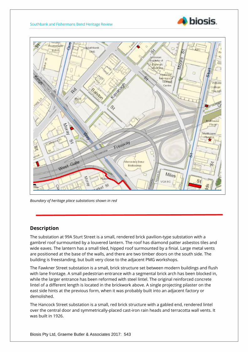
Southbank and Fishermans Bend Heritage Review
Biosis Pty Ltd, Graeme Butler & Associates 2017: 543
Boundary of heritage place substations shown in red
Description
The substation at 99A Sturt Street is a small, rendered brick pavilion-type substation with a
gambrel roof surmounted by a louvered lantern. The roof has diamond patter asbestos tiles and
wide eaves. The lantern has a small tiled, hipped roof surmounted by a finial. Large metal vents
are positioned at the base of the walls, and there are two timber doors on the south side. The
building is freestanding, but built very close to the adjacent PMG workshops.
The Fawkner Street substation is a small, brick structure set between modern buildings and flush
with lane frontage. A small pedestrian entrance with a segmental brick arch has been blocked in,
while the larger entrance has been reformed with steel lintel. The original reinforced concrete
lintel of a different length is located in the brickwork above. A single projecting pilaster on the
east side hints at the previous form, when it was probably built into an adjacent factory or
demolished.
The Hancock Street substation is a small, red brick structure with a gabled end, rendered lintel
over the central door and symmetrically-placed cast-iron rain heads and terracotta wall vents. It
was built in 1926.
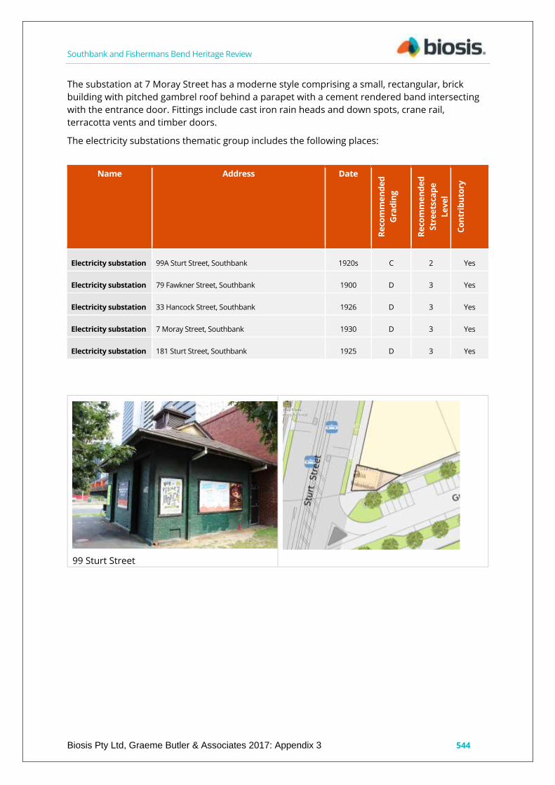
Southbank and Fishermans Bend Heritage Review
Biosis Pty Ltd, Graeme Butler & Associates 2017: Appendix 3 544
The substation at 7 Moray Street has a moderne style comprising a small, rectangular, brick
building with pitched gambrel roof behind a parapet with a cement rendered band intersecting
with the entrance door. Fittings include cast iron rain heads and down spots, crane rail,
terracotta vents and timber doors.
The electricity substations thematic group includes the following places:
Name Address Date
Re
com
me
nd
ed
Gra
din
g
Re
com
me
nd
ed
Str
ee
tsca
pe
Le
ve
l
Co
ntr
ibu
tory
Electricity substation 99A Sturt Street, Southbank 1920s C 2 Yes
Electricity substation 79 Fawkner Street, Southbank 1900 D 3 Yes
Electricity substation 33 Hancock Street, Southbank 1926 D 3 Yes
Electricity substation 7 Moray Street, Southbank 1930 D 3 Yes
Electricity substation 181 Sturt Street, Southbank 1925 D 3 Yes
99 Sturt Street
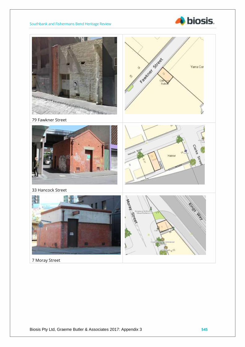
Southbank and Fishermans Bend Heritage Review
Biosis Pty Ltd, Graeme Butler & Associates 2017: Appendix 3 545
79 Fawkner Street
33 Hancock Street
7 Moray Street

Southbank and Fishermans Bend Heritage Review
Biosis Pty Ltd, Graeme Butler & Associates 2017: Appendix 3 546
181 Sturt Street
History
Provision of Melbourne's reticulated electricity supply can be traced back to 1880-1881 with the
Melbourne Electricity Co. and Victorian Electric Light Company constructing their generators in
Melbourne and Richmond. Melbourne was only the third city in the world to construct a public
electricity supply system. Substations to step down the high voltage from the distribution
network to the consumer lines were required in strategic locations. One of the first, constructed
in 1882 below-ground in Russell Place in the CBD for the Victorian Electric Co., still survives.
Competing private companies in the late-19th century included the Australian Electrical Co. Ltd,
who had a power station in Russell Place in the city, the New Australian Electric Lighting
Company, who built the Richmond Power Station, and Alcock's Electric Light and Motive Power
Company, who established a generating station in Corr’s Lane, Melbourne. In 1889, Alcock
moved to a new site in Neptune Street, Richmond. His company supplied electric light to
Richmond, Fitzroy, Collingwood, Kew and South Melbourne.
The inefficiencies and inadequate coverage of competing private electricity companies led to the
development of municipal electricity suppliers, and ultimately nationalisation under the State
Electricity Commission. Electricity generation in Victoria had started out with a wide array of
private companies moving into the emerging market of electric light and power. To regulate
these companies in 1896, the first Electric Light and Power Act was introduced, determining
which suppliers could operate and establishing municipal electricity undertakings. The City of
Melbourne commenced its own electricity supply in 1897 with a power station on Spencer Street.
In 1899, the Brush Electrical Engineering Co. of England took over both the Alcock Company and
the New Australia Electric Lighting Company to form the Electric Light and Traction Company of
Australia Ltd. It was renamed the Melbourne Electric Supply Co. in 1908 and supplied power to
southern Richmond, Prahran and South Melbourne. Their network formed the basis of the State
Electricity Commission (SEC) distribution system when the SEC was formed in 1919 and
progressively unified the various systems in the 1920s.
Southbank and Fishermans Bend Heritage Review
Biosis Pty Ltd, Graeme Butler & Associates 2017: Appendix 3 547
Comparative analysis Electrical substations around Melbourne show a variety of architectural treatments, generally reflecting the civic and urban design concerns of municipal-based electricity supply departments rather than the earlier commercial electric companies or the role of the SEC. The City of Melbourne in particular has some fine pavilion-style substations, located in or adjacent to parkland – such as Fitzroy Gardens and Royal Park – and others from a similar period, designed by the Melbourne City Council City Architect in South Yarra, Parkville and East Melbourne. The pavilion types are atypical because of their parkland settings. Other contemporary substations in urban streetscapes tend to reflect more austere modernism, such as an example in Nottingham Street, Kensington, built around the 1920s, which displays red brick all over, but with details such as a projecting cornice and string and soldier courses over the doorways and vents. The more common substations of the period are more likely to be quite plain red brick structures with gabled or hipped roofs, rarely with decorative treatments.
Although there are other substations elsewhere in Melbourne, and also in the City of Melbourne, the Southbank substations are more consistent in age and style, having been installed to facilitate the industrial and commercial development of the area in the period 1890s to 1930s.. The group listing is important because it comprises the substations which still exist in the Southbank area and the substations are among the only fabric remaining that relate to the period when Southbank was primarily an industrial district.
Statement of Significance What is significant?
The Southbank electrical substations are located at 99A Sturt Street, 79 Fawkner Street, 33 Hancock Street, 7 Moray Street and 181 Sturt Street, Southbank.
Contributory elements include: o rectangular plans and parapeted forms; o brick finishes with rendered lintels and brick drip moulds; o fittings, including rain goods, terracotta vents and timber doors; and o wide eaves and gambrel roof forms.
How is it significant?
The Southbank electricity substations are historically significant to Southbank and the City of Melbourne.
Why is it significant?
The Southbank electricity substations are historically significant as they represent the provision of reticulated electricity to the Southbank area in the early-20th century as local engineering firms created a much-increased demand for electricity, and former Crown land reserves were sold for new development. The individual substations were generally connected to specific industrial developments in their local area, such as the 99 Sturt Street substation being established adjacent to the PMG workshops in the 1920s. (Criterion A)
The substations are of aesthetic interest for their utilitarian brick, Inter-war style, which was typical of both the period and function. (Criterion E)

Southbank and Fishermans Bend Heritage Review
Biosis Pty Ltd, Graeme Butler & Associates 2017: Appendix 3 548
Sources used for this assessment The following sources and data were used for this assessment:
Primary heritage study
Bryce Raworth South Melbourne Conservation Study 1997 (no specific mention).
Other heritage studies
South Melbourne Conservation Study 1987 (no specific mention).
Building Identification Form 1997 (BIF).
Other references
Miles Pierce, ‘Early Electricity Supply in Melbourne’, 3rd Australasian Engineering Heritage Conference 2009, Miles Pierce B. E. (Elec), FIE Australia.
Melbourne Open House, Russell Place Substation. Accessed online 1 September 2015. http://wongm.com/2011/07/melbourne-municipal-electricity-undertakings/
City Power, Electricity in Early Victoria. Accessed 1 September 2015. http://www.powercor.com.au/docs/pdf/Community%20and%20Environment/Fact%20Sheet%20-%20Electricity%20in%20early%20Victoria%20and%20through%20the%20years.pdf
Maps
MMBW Sewerage Plan, 1 inch to 160 feet, 1897.
MMBW map series. 40 feet to 1 inch. 1892. State Library of Victoria.
Mahlstedt Fire Insurance Plans, South Melbourne, c1920, c1930, c1950, State Library of Victoria.
The City of Melbourne CoMMap.
Recommendations Revise Heritage Places Inventory.
Include as a thematic group in the heritage overlay.
Apply external paint controls with policy to reintroduce original finishes and colour schemes.

Mcgowan St
Balston St
Clarke St
Whiteman St
Hannah St
Market St
Dodd
s St
Ballantyne St
Miles St
Haig St
Tope St
Walke
r St
Haig La
ne
Kavanagh
St
Grant St
Catherine St
Hancock St
Chessell St
Kings Way
Fawkner S
t
Moore
St
Sturt
StQuee
ns Br
idge S
t
City Rd
Kings Way
Kavanagh St
Sturt
St
Power St
Moray StStu
rt St
Moray St
Power St
Clarendon St
Southbank Bvd
West Gate Fwy
Burnley Tunl
Kings Way
Domain Tunl
Yarra River
Marib
yrnon
g Rive
r
Matter: 23066,Date: 21 April 2017,Checked by: GV, Drawn by: SSK, Last edited by: lmilneLocation:\\bio-data-
Scale: 1:2,500 @ A3Coordinate System: GDA 1994 MGA Zone 55
Biosis Pty LtdBallarat, Brisbane, Canberra, Hobart, Melbourne,
Newcastle, Sydney, Wangaratta & Wollongong
Figure 92 Proposed Electricity substation thematic group precinct
0 100
Metres
LegendStudy areaParcel boundaryTree canopyBuilding outlineElectricity substation
Acknowledgements: State Government of Victoria - VicMap - Nearmap
±
549

Southbank and Fishermans Bend Heritage Review
Biosis Pty Ltd, Graeme Butler & Associates 2017: Appendix 3 550
Bluestone-pitched laneways group, Southbank City of Melbourne property number:
Type of place: laneways
Images of place 2016-2017
Historical associations:
Creation or major development date(s) of place: 1870s: Victorian-era
Designer: South Melbourne council
Heritage Gradings:
Proposed new system (C258):
Contributory to a precinct (part)

Southbank and Fishermans Bend Heritage Review
Biosis Pty Ltd, Graeme Butler & Associates 2017: Appendix 3 551
Alphanumeric system (building A-E, streetscape 1-3):
Existing: --, Proposed: D3
Heritage values:
Aesthetic, Historical
Heritage status:
Heritage Overlay Proposed group
Thematic context:
6.6 Street-making, drainage and river works

Southbank and Fishermans Bend Heritage Review
Biosis Pty Ltd, Graeme Butler & Associates 2017: 552
Boundary of heritage place lanes shown outlined in black
Description The bluestone-paved lanes comprise several separate sections of laneway which retain their original pattern of bluestone pitchers, generally with a central surface drain formed from one or more lines of slightly depressed pitchers. The sides of the lanes slope gently to this drain. In

Southbank and Fishermans Bend Heritage Review
Biosis Pty Ltd, Graeme Butler & Associates 2017: Appendix 3 553
some cases interruptions such as sewer access covers have been paved around in curving patterns of stones, indicating the lanes were constructed or re-laid following the connection of the sewers.
Stone pitchers are generally between 20 to 30 centimetres wide and 30 to 40 centimetres long, and 15 to 20 centimetres deep. They are formed with tapered sides so that the top surface can be fitted closely together, and the smaller base was originally set in sand. This was intentional, as it allowed water to soak through.
The Southbank bluestone-paved laneways group comprises the following sections of laneways:
Name Address Date
Reco
mm
ende
d G
radi
ng
Reco
mm
ende
d St
reet
scap
e Le
vel
Cont
ribu
tory
Stone-pitched lane, Anthony Lane
Anthony Lane, between Coventry Street and Dorcas Street, Southbank
c1870 D 3 Yes
Stone-pitched lane, Blakeney Place, SML639
Blakeney Place, off Clarendon Street, Southbank
c1870 D 3 Yes
Stone-pitched lane, off Catherine Street, Sm0477
Between 4 and 8 Catherine Street, Southbank
c1870 D 3 Yes
Stone-pitched lane, off City Road, Sm199
Off City Road, Southbank c1870 D 3 Yes
Stone-pitched lane, off Clarendon Street, Sm0337
Adjacent to 54 Clarendon Street, Southbank
c1870 D 3 Yes
Stone-pitched lane, Fawkner Street
Adjacent to 11-13 Hancock Street, Southbank
c1870 D 3 Yes
Stone-pitched lane, Haig Lane Haig Lane between Kings Way and Clarke Street, Southbank
c1870 D 3 Yes
Stone-pitched lane, off Hancock Street, SN549
off Hancock Street, Southbank
c1870 D 3 Yes
Stone-pitched lane, off Power Street, PL5195
Southeast of 76-80 Power Street, Southbank
c1870 D 3 Yes
Stone-pitched lane, Wells Place, Sml609, 247
Wells Place, Southbank c1870s D 3 Yes

Southbank and Fishermans Bend Heritage Review
Biosis Pty Ltd, Graeme Butler & Associates 2017: Appendix 3 554
Anthony Lane Blakeney Place
Lane Sml477 off Catherine Street Lane Sm199 off City Road
Lane Sm0377 off Clarendon Street Haig Lane

Southbank and Fishermans Bend Heritage Review
Biosis Pty Ltd, Graeme Butler & Associates 2017: Appendix 3 555
Fawkner Street Lane Sn459 off Hancock Street
Lane PL5195 off Power Street Wells Place
History: The South Melbourne lanes were created as part of subdivisions during to the Victorian era as service access to the rear of properties. Crown parcels sold at auction from the 1850s, were generally larger blocks that ran from street to street, so the lanes were created by private owners subdividing the Crown allotments as a means of maximising lot yield. Although intended as service lanes in the CBD due to a prohibition of crossovers into the main streets, in some cases, the lanes in the inner suburbs also became access to residential properties built fronting them. In many cases, these became associated with the city's gold rush and 1890s depression-era slums (Bate, 1994).
Councils were responsible for constructing and maintaining roads and streets. Bluestone pitchers were cut into standard sizes, usually within the quarries in the northern and western suburbs of Melbourne, and either delivered to the site, or excess supplies were stored in council depots around the municipality.
Construction of stone paving, kerbs and channels for streets and lanes began in the 1850s and appears to have been a continuing practice up until the 1930s. The use of concrete for kerb and channel construction began around 1912 in some areas, however it appears that bluestone continued to be used for kerb and channel for many years after this in other parts of the municipality. The South Melbourne City Surveyor Annual Report to the Public Works Committee in 1912-1913 outlined that 1,325 lineal feet of bluestone kerbing and 1,770 lineal feet of concrete kerbing had been used in road construction and maintenance during that year. The Annual Report for South Melbourne in 1927-1928 outlined that 318 lineal feet of bluestone and 1,609

Southbank and Fishermans Bend Heritage Review
Biosis Pty Ltd, Graeme Butler & Associates 2017: Appendix 3 556
lineal feet of concrete kerbing had been used in road construction in that year (Port Phillip Laneways).
South Melbourne council reported construction of ‘lanes less than 33 feet wide’ in the Record during the 1890s and early-1900s, and also dealt with maintenance, having received legal opinion regarding responsibility (Emerald Hill Record, 16 September 1905, p.4). In some cases, the local board of health gave instruction to councils to pave kerbs, footpaths and laneways in order to remove ‘nuisance’, which generally meant raw sewage and liquid industrial wastes sitting in depressions adjacent to buildings and thoroughfares (Emerald Hill Record and Sandridge Advertiser, 1 May 1873, p.3). This role became in part the responsibility of the MMBW from the 1890s, when the installation of the reticulated sewerage scheme removed much of the nuisance, as well as one of the main purposes of the lanes – access to rear yards by the night carts to empty cess pits and collect toilet pans. The lanes then became vehicle access for factory and warehouse deliveries.
The bluestone laneway formerly known as Phayer Street was also identified as being suitable for inclusion in the group listing. However it is noted that the laneway is already included in HO764 which affects the area around Polly Woodside and the Melbourne Convention and Exhibition Centre. On this basis Phayer Street has not been included as part of the group listing for bluestone laneways.
The current names of Anthony Lane, Wells Place, Haig Lane, Fawkner Street and Blakeney Place are all relatively modern, as the names where historically un-named. Anthony Lane takes its name from Mr. Thomas Anthony, the original owner of most of the adjoining land. The company, T. Anthony and Co. (timber merchants) occupied the site until the 1930s (57/6/SM246). Fawkner Street is named for John Pascoe Fawkner, one of the founders of Melbourne who is believed to have ploughed and cultivated the land in 1837 where the street is now located. Haig Lane is named after nearby Haig Street for Dr. William Haig, an early resident, councillor (1859-1861), magistrate, and then health officer until his death. Wells Place is named after nearby Wells Street for William Elliott Wells, councillor (1883-1886) and lord mayor (1886) (CoMMap).
Comparative analysis The Southbank stone-paved lanes area is a fragmentary remnant of once more extensive laneways, many of which have been re-laid, or subsumed into new road alignments and widening or private allotments. They compare with the more extensive networks of laneways throughout Melbourne and the inner suburbs, although less intact than the less-developed mostly-residential areas.
The Southbank blue-stone lanes are fragmentary remnants of an extensive laneway network which used to exist throughout the Southbank area. All the laneways included in the group listing are in highly original condition, whereas other Southbank laneways have been either re-paved in asphalt or concrete, re-laid, or resumed into new road alignments, road widening or adjoining private allotments. The Southbank laneways compare with the more extensive networks of laneways throughout Melbourne and the inner suburbs although the Southbank laneways are less intact than highly original residential areas.
Most lanes in comparable former industrial areas such as South Carlton, West Melbourne, parts of North Melbourne and Kensington, have been re-laid in asphalt, with only the kerb and channel, and sometimes a central drain remaining in bluestone.

Southbank and Fishermans Bend Heritage Review
Biosis Pty Ltd, Graeme Butler & Associates 2017: Appendix 3 557
Statement of Significance What is significant?
The Southbank bluestone-paved laneways are located at Anthony Lane (SML246), Blakeney Place (SML639), Fawkner Street, Haig Lane, off Catherine Street (Sm0477), off City Road (Sm199), off Clarendon Street (Sm0337), off Hancock Street (SN549), off Power Street (PL5195), Street and Wells Place (SMLs 609, 247 & 248).
(Note that ‘Sm’, ‘Sml’ and ‘PL’ are City of Melbourne location designations from its CoMMap system, and variously use upper and lower cases with three- or four-digit numbers. Presumably they refer to ‘South Melbourne Lane’, ‘Private Lane’, or some similar nomenclature.)
The significant fabric comprises all bluestone pitchers, including the arrangement and method of setting, dry-jointing (without mortar or cement), alignment of stones and existing levels and slope angles.
How is it significant?
The Southbank bluestone-paved laneways are historically and aesthetically significant to Southbank, South Melbourne and the City of Melbourne.
Why is it significant?
They are of historical significance for their representation of the character of 19th and early-20th century urban design and the historical patterns of use which required rear service access for factories and warehouses, and night cart access for emptying cesspits and toilet pans prior to the construction of the Melbourne sewerage system. (Criterion A)
The lanes provide a direct and tangible link to the former industrial and working class residential character of the Southbank area, which has been entirely assimilated into modern commercial and high-rise residential development. They represent the last fragments of the original road and lane surfaces from the middle-to-late-19th century and were once the standard form for inner-city areas.
The lanes are of aesthetic significance as representing past urban design styles and the use of natural materials in urban street construction, prior to the greater availability of materials such as concrete and asphalt. The lanes retain the distinctive patterns created by hand skills of their makers, and over 100 years of use producing a smoothly-worn patina and fine rutting from steel-wheeled delivery vehicles. (Criterion E)
Sources used for this assessment The following sources and data were used for this assessment:
Primary heritage study
Bryce Raworth, South Melbourne Conservation Study 1997 (no specific mention).
Other heritage studies
South Melbourne Conservation Study 1987 (no specific mention).
Building Identification Form 1997 (BIF).
Southbank and Fishermans Bend Heritage Review
Biosis Pty Ltd, Graeme Butler & Associates 2017: Appendix 3 558
Other references
Bate, Weston & Melbourne (Vic.) & State Library of Victoria (1994). Essential but unplanned: the story of Melbourne's lanes. City of Melbourne: State Library of Victoria, Melbourne.
MMBW Sewerage Plan, 1 inch to 160 feet, 1897.
City of Port Phillip, Heritage kerbs, channels & laneways history, significance & guidelines, no date. http://www.portphillip.vic.gov.au/Heritage_Kerbs_Channels_and_Laneways.pdf
City of Melbourne operating procedure: Bluestone in Melbourne’s streets and lanes, January 2017. https://www.melbourne.vic.gov.au/SiteCollectionDocuments/operating-procedure-bluestone.pdf
Newspaper articles and advertising
Emerald Hill Record, 16 Sep 1905, p.4, 1 May 1873, p.3.
Maps
MMBW map series. 40 feet to 1 inch. 1892. State Library of Victoria.
Mahlstedt Fire Insurance Plans, South Melbourne, c1920, c1930, c1950, State Library Vic.
The City of Melbourne CoMMap.
Recommendations Include as a thematic heritage overlay group. (with the exception of Phayer Street, which is already within HO764)
Revise Heritage Places Inventory
Ensure management in accordance with heritage provisions of City of Melbourne operating procedure: ‘Bluestone in Melbourne’s streets and lanes’.
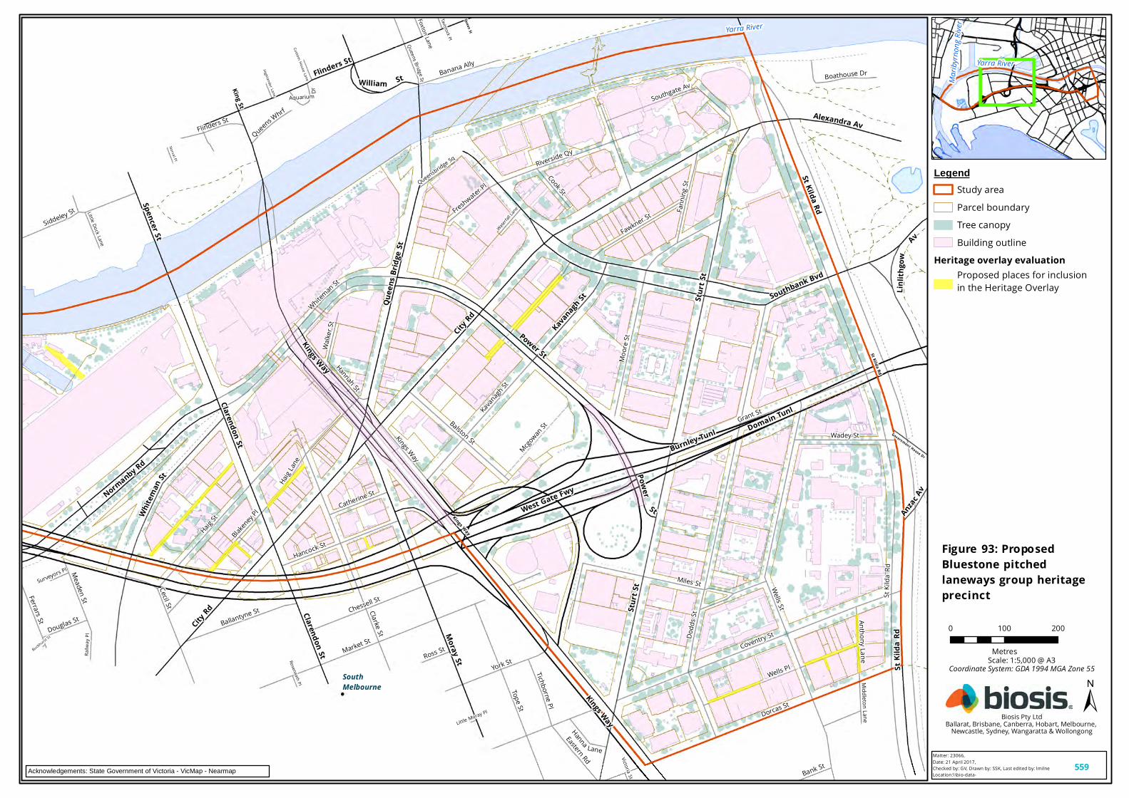
Wells Pl
Mcgowan St
Dodd
s St
Meaden StFerrars St
Buckhurst S
t
Haig St
Balston St
Little Moray Pl
Cecil St
Siddeley St
Victoria St
Whiteman St
Clarke St
Wadey St
Hannah St
Aquarium Dr
Coventry St
Queens BridgeStDorcas St
Tavistock Pl
Roseneath Pl Middleton Lane
Wells St
Highlander Lane
Norval Pl
York St
Surveyors Pl
Foxton LaneCustom House Lane
Southgate Av
Flinders St
Boathouse Dr
Ross St
Miles St
Blakeney P
l
Waterfal
l Lane
Bank St
Anthony Lane
Little Dock Lane
Railw
ay Pl
Riverside Qy
Fann
ing St
Douglas St
Queensbridge Sq
Tope St
Hanna Lane
Walke
r St
Cook St
Queens Whrf
Kavanagh
St
Grant St
Haig La
ne
S tK il
d aR d
Catherine St
Hancock St
Chessell St
Market St
Freshwater Pl
Tichborne Pl
Eastern Rd
Kings Way
Banana Ally
Fawkner St
Ballantyne StMo
ore St
Queen St
Sturt
St
Kings Way
Quee
ns Br
idge S
t
St Kilda Rd
Whitem
anSt
City Rd
Clarendon St
Alexandra Av
Flinders St
Clarendon StKings Way
Normanby Rd
Kavanagh St
Sturt
St
King StAnzac Av
St Kilda Rd
Power
St
City Rd
Moray St
Southbank Bvd
William St
Gov ern m en t H o use D r
Spencer St
Power St
Linli t
hgow
AvSt
Kilda
Rd
West Gate Fwy
Burnley Tunl Domain Tunl
Kings Way
Yarra River
SouthMelbourne
Matter: 23066,Date: 21 April 2017,Checked by: GV, Drawn by: SSK, Last edited by: lmilneLocation:\\bio-data-
Scale: 1:5,000 @ A3Coordinate System: GDA 1994 MGA Zone 55
Biosis Pty LtdBallarat, Brisbane, Canberra, Hobart, Melbourne,
Newcastle, Sydney, Wangaratta & Wollongong
Fig ure 93: Pro po sed Bluestone pitched laneways group heritage precinct
0 100 200
Metres
LegendStudy areaParcel boundaryTree canopyBuilding outline
Heritage overlay evaluationProposed places for inclusion in the Heritage Overlay
Acknowledgements: State Government of Victoria - VicMap - Nearmap
±
Yarra River
Marib
yrnon
g Rive
r
559

Southbank and Fishermans Bend Heritage Review
© Biosis 2017 – Leaders in Ecology and Heritage Consulting 560
Appendix 4 Citations for archaeological places

Southbank and Fishermans Bend Heritage Review
561
City Road Park / Castlemaine Hotel (archaeological), 135 Queens bridge Street, Southbank .. 562
South Melbourne Post Office site (archaeological), 229 City Road, Southbank ........................... 565

Southbank and Fishermans Bend Heritage Review
562

Southbank and Fishermans Bend Heritage Review
563

Southbank and Fishermans Bend Heritage Review
564

Southbank and Fishermans Bend Heritage Review
565
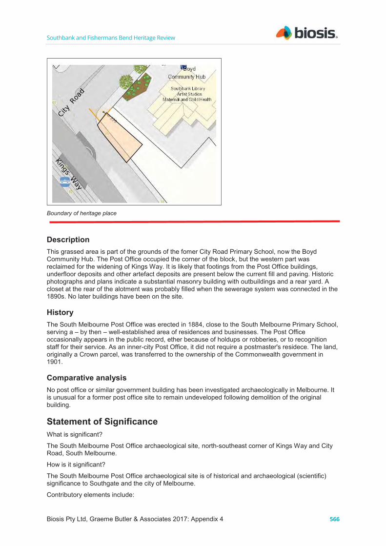
Southbank and Fishermans Bend Heritage Review
566
Southbank and Fishermans Bend Heritage Review
567
APS MMBW 1895 DP shows Post Office site with building located on City Rd Contemporary Photographs City Road - South Melbourne Post Office [Year identified: 1960] National Archives B5919, 494 https://recordsearch.naa.gov.au/scripts/PhotoSearchItemDetail.asp?M=0&B=6528833&SE=1 City Road (South Melbourne) - Post Office and related history, 1901 - 1988, Series B5846 NAA: B5846 City Road Post Office, South Melbourne [picture] [1917-1930] State Library Vic. Accession no(s) H89.105/54 http://handle.slv.vic.gov.au/10381/304471 Newspapers Portland Guardian (Vic. : 1876 - 1953), Monday 1 February 1897, page 3 Melbourne News (Anglo-Australian Press Agenoy.) MELBOURNE, This Day. ARREST OF BURGLARS. An attempt has been made to burgle the City Road Post Ofhce, at South Melbourne, but which was frustrated through the electric alarm giving information to the police, who were thus able to arrest Thomas Kilrain, a powerful man and a notorious criminal. The police also subsequently arrested Richard Buckley, who has been shadowed for many days, but a third man escaped. The police then drove out to Carlton and arrested Mary Jamcc, 3essie James and William James (the latter only ten years old), and Catherine Connell, all of whom are accused of disposing of stolen stamps. The man Buckley, as soon as he found himself covered by the revolvers of the detectives, rushed for his own revolver, which was fully loaded, but he mistook the drawer in which it was concealed. Detective O'Donnell had a narrow escape of shooting his own son, who had come to tell him of the arrest of Kilrain. Record (Emerald Hill, Vic. : 1881 - 1954), Saturday 10 August 1912, page 5 Postmistress Honored PRESENTATION TO MISS M., WEBB. For fifteen years or more Bliss M Webb held the position of postmistress at the City-road post office, South Melbourne. During that lengthy period she, by her pleasant manner, unfailing courtesy, and strict attention to the business of the office, made many friends. The office had been let under the contract system, . andMiss Webb, unfortunately for herself. as it afterwards proved, had worked the business up to such an extent that the department was compelled to make it a stall office. The public was loth to lose Miss Webb, and petitioned the Postmaster-General to retain her services. The ' request was granted for a time, but eventually it was intimated that tbc laws of the department demanded (hat. a staff officer be placed' to charge. Those who had been in the habit oMransacting business at the office determined to fittingly recognise the good work- Bliss

Southbank and Fishermans Bend Heritage Review
568
Webb bad done, and the innumerable sacrifices she had many other ways -endeared herself to made to oblige the public. Apart from her official duties, she had in , a very large number of people. As the result of the efforts of prominent citizens, a pleasant social gathering took place at Marks's Trades. Hotel on Saturday evening, when Miss Webb was the siiest. The chair was occu-About. SO -ladies -and gentlemen, were 5 resent, including Mr, Lemon (representing the Postmaster-General's department), and the principals of all the leading, manufactories and other business places in the district. Apologies were read from Messrs. Bell and Valentine, Messrs. tavies, Shcppard - and 'Co., Messrs. Henri Foissin and Co., Mr. Jos. O'Donnell (Australian Manufacturing Co.), and Cr. J. Sloss. ...On the proposition of Cr. I vers a special vote of thanks was conveyed to both ladies for their kindness. Before dispersing, tile company sang the National Anthem and " Auid Lang Syne." Gippsland Times (Vic. : 1861 - 1954), Thursday 9 January 1936, page 1 HOLD UP AT SOUTH MELBOURNE. Masked Gunmen Raid Post Office. With pistols drawn, two masked men walked calmly into the City road post-office, South Melbourne yesterday, snatched up a cash-box containing postal notes, stamps, and cash worth. £45, and escaped in a stolen car, Before they left they locked the postmaster (Mr. J. Evans) and his assistant ('Mr. J. Felding) in a rear room, and jabbing them with pistols, warned them "to stay quiet." Unable to open a window showing on to the street, the two imprisoned men knocked on it until they attracted the attention of a passer-by, who released them. Police are scouring the district for the bandits. Barely had the doors been opened at 9 a.m. when a man, wearing a handkerchief across the lower portion of his face, and carrying an automatic pistol, walked into the office, and, springing to the counter, leapt smartly across the grille. "Stick them up-Quick!" he said in quiet, menacing tones to the two officials. Neither the postmaster nor his assistant was quick to comply, but when the young man repeated the demand with what seemed an added threat in his voice they put their hands above their heads. Keeping them covered, the bandit backed to a door separating the official section of the Post-office from the public portion, and, unlocking it, admitted a masked accomplice. This man, who also carried a pistol, forced Mr. Felding to the wall while the first man kept the muzzle of his automatic uncomfortably close to the post-master. Warning Mr. Evans not to move or he would ‘let him have it,’ the gunman snatched the keys and, opening the strongroom, removed the cash box which it contained. ‘Get in there!’ he then ordered the two officials, indicating a back room with his pistol. ‘Step on it!’ Evans and Felding, their hands still upraised, were forced into the room, and the two gunmen slammed the door, turned the key and walked out of the office. They slammed the front door behind them and walked across City Road to a hotel on the opposite corner. There they jumped into a car, which was driven off at a fast speed.
POST OFFICE SAFE Removed from Montague By removing bricks from a wall and making a hole through which they managed to operate a bolt and bars of a door, thieves gained entrance early on Saturday morning to the news agency of Mr. F. Dayble, City Road, South Melbourne, which is also the Montague Post Office, and stole a safe weighing 5 cwt. and containing £90 in cash, stamps and postal notes. The safe was the property of the Postmaster-General's department. Because of the weight of the safe the thieves had to roll it out of the shop to the back lane, where they had a motor car parked. As they could not lift it into the car they obtained a tent from a tent maker's shop next door to the post office and wrapped the safe in it. With the aid of the car the safe was then dragged through several streets to a lane off Richardson Street, Albert Park. Senior Detective Roscwarne, Detective Coe and First Constable Sheehan later followed a trail through the streets by means of the marks made by the safe and fragments of the tent, but lost it at the lane In Richardson Street. They searched several backyards, in one of which they found a broken mattock. A search was made of the house and the safe was found, broken open. All of the stamps and a small portion of the money were found. The detectives later visited two houses in Port Melbourne and arrested two men. Later at the City Watch House two men were charged with shopbreaking and stealing. www.hawthorntramdepot.org.au/papers/substations.htm.

Southbank and Fishermans Bend Heritage Review
© Biosis 2017 – Leaders in Ecology and Heritage Consulting 569
Appendix 5 Potential heritage places for future investigation

Sout
hban
k an
d Fi
sher
man
s Be
nd H
erita
ge R
evie
w
© B
iosi
s 20
17 –
Lea
ders
in E
colo
gy a
nd H
erita
ge C
onsu
lting
57
0
Tabl
e 16
Su
mm
ary
listi
ng o
f pla
ces
for
pote
ntia
l fut
ure
asse
ssm
ent
Ther
e ar
e th
e 26
oth
er p
lace
s co
nsid
ered
to h
ave
pote
ntia
l to
be a
dded
to h
erita
ge o
verla
y pe
ndin
g fu
rthe
r res
earc
h.
Nam
e Ad
dres
s D
ate
Grading
Streetscape level
Grading revised
Streetscape level revised
Reco
mm
enda
tion
Im
age
Mel
bour
ne
Tow
ing
Serv
ice
167-
169
City
Ro
ad,
Sout
hban
k
1950
C-
D
2 Co
ntrib
utor
y to
pre
cinc
t. Re
pres
enta
tive
of im
port
ant S
outh
bank
hi
stor
ic m
otor
them
e, ra
re s
urvi
vor a
nd
char
acte
ristic
. Fu
rthe
r his
toric
al a
nd c
ompa
rativ
e as
sess
men
t may
reac
h th
resh
old.
Re
lativ
ely
mod
ern
stru
ctur
e in
mod
erni
st
styl
e m
ay n
ot b
e re
cogn
ised
gen
eral
ly fo
r its
aes
thet
ic s
igni
fican
ce.
W. J
. Bus
h Lt
d /
Pott
er &
Moo
re
perf
ume
&
cosm
etic
s, n
ow
Urb
an C
entr
al
344
City
Roa
d,
Sout
hban
k 19
40
D
2 Co
ntrib
utor
y to
pre
cinc
t. Al
tere
d bu
t rar
e la
rge
war
time
indu
stria
l pr
emis
es re
flect
ing
form
er c
hara
cter
of
Sout
hban
k.
Low
inte
grity
and
util
itaria
n ap
pear
ance
.

Sout
hban
k an
d Fi
sher
man
s Be
nd H
erita
ge R
evie
w
© B
iosi
s 20
17 –
Lea
ders
in E
colo
gy a
nd H
erita
ge C
onsu
lting
57
1
Nam
e Ad
dres
s D
ate
Grading
Streetscape level
Grading revised
Streetscape level revised
Reco
mm
enda
tion
Im
age
Buck
eye
Har
vest
er C
o. /
Kelly
& L
ewis
m
otor
gar
age
56-5
8 Cl
aren
don
Stre
et, S
outh
bank
19
50
D
3 In
divi
dual
HO
. Ex
ampl
e of
form
erly
-com
mon
bui
ldin
g ty
pe a
nd u
se in
rela
tion
to th
e So
uthb
ank
indu
stry
them
e, ra
re s
urvi
vor.
Util
itaria
n pl
ace
and
rece
nt a
ge.
Ev
an W
alke
r Br
idge
Ya
rra
Rive
r, So
uthb
ank
1992
C
3 In
divi
dual
HO
. H
isto
rical
and
soc
ial v
alue
as
part
of
Sout
hban
k sc
hem
e.
Nam
ed fo
r Eva
n W
alke
r and
soc
ially
si
gnifi
cant
for l
ove-
lock
phe
nom
ena.
Re
cent
age
.
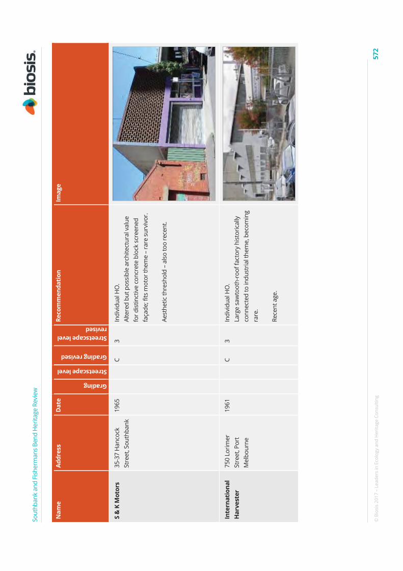
Sout
hban
k an
d Fi
sher
man
s Be
nd H
erita
ge R
evie
w
© B
iosi
s 20
17 –
Lea
ders
in E
colo
gy a
nd H
erita
ge C
onsu
lting
57
2
Nam
e Ad
dres
s D
ate
Grading
Streetscape level
Grading revised
Streetscape level revised
Reco
mm
enda
tion
Im
age
S &
K M
otor
s 35
-37
Han
cock
St
reet
, Sou
thba
nk
1965
C
3 In
divi
dual
HO
. Al
tere
d bu
t pos
sibl
e ar
chite
ctur
al v
alue
fo
r dis
tinct
ive
conc
rete
blo
ck s
cree
ned
faça
de; f
its m
otor
them
e –
rare
sur
vivo
r. Ae
sthe
tic th
resh
old
– al
so to
o re
cent
.
Inte
rnat
iona
l H
arve
ster
75
0 Lo
rimer
St
reet
, Por
t M
elbo
urne
1961
C
3 In
divi
dual
HO
. La
rge
saw
toot
h-ro
of fa
ctor
y hi
stor
ical
ly
conn
ecte
d to
indu
stria
l the
me,
bec
omin
g ra
re.
Rece
nt a
ge.

Sout
hban
k an
d Fi
sher
man
s Be
nd H
erita
ge R
evie
w
© B
iosi
s 20
17 –
Lea
ders
in E
colo
gy a
nd H
erita
ge C
onsu
lting
57
3
Nam
e Ad
dres
s D
ate
Grading
Streetscape level
Grading revised
Streetscape level revised
Reco
mm
enda
tion
Im
age
MFB
Sta
tion
N
o 38
26
-40
Mor
ay
Stre
et,
Sout
hban
k
1991
C
3 In
divi
dual
HO
. Po
tent
ial A
rchi
tect
ural
val
ue, n
eeds
to b
e co
nfirm
ed fr
om s
ourc
es.
Rece
nt a
ge.
Sout
hern
Cro
ss
Win
dmill
s 18
-24
Mor
ay
Stre
et
Sout
hban
k
1937
C-
D
3 In
divi
dual
HO
- Ra
re s
urvi
ving
indu
stria
l bu
ildin
g re
late
d to
them
e– p
oten
tial
arch
itect
ural
val
ue a
s re
pres
enta
tive
of
perio
d Re
lativ
ely
plai
n so
arc
hite
ctur
al v
alue
lim
ited,
may
onl
y be
typi
cal o
f his
toric
al
uses

Sout
hban
k an
d Fi
sher
man
s Be
nd H
erita
ge R
evie
w
© B
iosi
s 20
17 –
Lea
ders
in E
colo
gy a
nd H
erita
ge C
onsu
lting
57
4
Nam
e Ad
dres
s D
ate
Grading
Streetscape level
Grading revised
Streetscape level revised
Reco
mm
enda
tion
Im
age
Child
ren’
s Co
urt
9-15
Que
ens
Brid
ge S
tree
t, So
uthb
ank
1930
D
3
C-D
3
Indi
vidu
al H
O.
Alte
red
1930
s bu
ildin
g, b
ut re
cent
soc
ial
hist
ory
as a
chi
ldre
n’s
cour
t. Ea
rlier
war
ehou
se u
se h
isto
rical
si
gnifi
canc
e di
min
ishe
d by
alte
ratio
ns,
mor
e re
cent
soc
ial v
alue
as
child
ren’
s co
urt m
ay b
e di
fficu
lt to
sub
stan
tiate
.
Cr
own
Prom
enad
e H
otel
40-5
6 Q
ueen
s Br
idge
Str
eet,
Sout
hban
k
2003
C
2 In
divi
dual
HO
. Si
gnifi
canc
e as
arc
hite
ctur
al a
war
d w
inne
r. Re
cent
age
.

Sout
hban
k an
d Fi
sher
man
s Be
nd H
erita
ge R
evie
w
© B
iosi
s 20
17 –
Lea
ders
in E
colo
gy a
nd H
erita
ge C
onsu
lting
57
5
Nam
e Ad
dres
s D
ate
Grading
Streetscape level
Grading revised
Streetscape level revised
Reco
mm
enda
tion
Im
age
Vacu
um O
il Co
mpa
ny
stor
es
87-8
9 Q
ueen
s Br
idge
Str
eet,
Sout
hban
k
1930
D
2
D
3 Co
ntrib
utor
y to
pre
cinc
t. H
isto
rical
sig
nific
ance
as
rare
sur
vivi
ng
indu
stria
l bui
ldin
g re
late
d to
Sou
thba
nk
hist
oric
al th
eme.
So
me
arch
itect
ural
val
ue in
Art
D
eco/
Mod
erne
ele
men
ts.
May
be
sign
ifica
nt e
noug
h fo
r a
cont
ribut
ory
plac
e in
a p
reci
nct,
but
utili
taria
n de
sign
and
alte
ratio
n di
min
ish
aest
hetic
val
ue.
His
toric
al v
alue
onl
y as
repr
esen
tativ
e of
fo
rmer
mot
orin
g in
dust
ry th
eme.
Eure
ka T
ower
3-
7 Ri
vers
ide
Qua
y,
Sout
hban
k
2002
-20
06
C 3
Indi
vidu
al H
O.
Arch
itect
ural
aw
ard
win
ner.
Rece
nt a
ge.

Sout
hban
k an
d Fi
sher
man
s Be
nd H
erita
ge R
evie
w
© B
iosi
s 20
17 –
Lea
ders
in E
colo
gy a
nd H
erita
ge C
onsu
lting
57
6
Nam
e Ad
dres
s D
ate
Grading
Streetscape level
Grading revised
Streetscape level revised
Reco
mm
enda
tion
Im
age
Sout
hgat
e 3
Sout
hgat
e Av
enue
, So
uthb
ank
1990
-19
92
C-D
2
Indi
vidu
al H
O.
His
toric
al a
nd s
ocia
l val
ue.
The
proj
ect t
hat t
rigge
red
Sout
hban
k tr
ansf
orm
atio
n.
Rece
nt a
ge.
Vacu
um O
il /
Mob
il /
Sout
hgat
e Ap
artm
ents
28-3
2 So
uthg
ate
Aven
ue
Sout
hban
k
1960
/ 19
96
D
3 O
rigin
ally
a e
arly
sig
nific
ant g
lass
cur
tain
w
all b
uild
ing,
con
tem
pora
ry w
ith IC
I ho
use.
Fi
rst o
f the
tran
sfor
mat
iona
l de
velo
pmen
ts s
outh
of t
he ri
ver.
Hea
vily
alte
red,
pro
babl
y in
suffi
cien
tly-
inta
ct fo
r her
itage
con
side
ratio
n.

Sout
hban
k an
d Fi
sher
man
s Be
nd H
erita
ge R
evie
w
© B
iosi
s 20
17 –
Lea
ders
in E
colo
gy a
nd H
erita
ge C
onsu
lting
57
7
Nam
e Ad
dres
s D
ate
Grading
Streetscape level
Grading revised
Streetscape level revised
Reco
mm
enda
tion
Im
age
Shel
l Wes
t Gat
e se
rvic
e ce
ntre
W
est G
ate
Free
way
C-
D
3 In
divi
dual
HO
. La
rges
t ten
sion
ed-fa
bric
roof
str
uctu
re in
Vi
ctor
ia.
Rece
nt a
ge.
Sout
hern
Lin
k el
evat
ed ro
ad
Wes
t Gat
e Fr
eew
ay,
Sout
hban
k
1987
-19
88
C-D
3
Indi
vidu
al H
O.
Long
est e
leva
ted
road
way
: his
toric
al a
nd
tech
nica
l dev
elop
men
t. Re
cent
age
, util
itaria
n an
d po
or
aest
hetic
s.

Sout
hban
k an
d Fi
sher
man
s Be
nd H
erita
ge R
evie
w
© B
iosi
s 20
17 –
Lea
ders
in E
colo
gy a
nd H
erita
ge C
onsu
lting
57
8
Nam
e Ad
dres
s D
ate
Grading
Streetscape level
Grading revised
Streetscape level revised
Reco
mm
enda
tion
Im
age
Crow
n Ca
sino
2-
68 W
hite
man
St
reet
, Sou
thba
nk
1997
B-
C 2
Indi
vidu
al H
O.
Arch
itect
ural
aw
ard
win
ner.
Rece
nt a
ge, c
omm
unity
stig
ma
may
be
atta
ched
to it
.
Mel
bour
ne
Exhi
biti
on
Cent
re
Conv
entio
n Ce
ntre
Pla
ce,
Sout
h W
harf
1996
B-
C 2
Indi
vidu
al H
O.
Sign
ifica
nce
as a
rchi
tect
ural
aw
ard
win
ner:
Will
iam
War
dell
Awar
d fo
r Pub
lic
Arch
itect
ure,
Sus
tain
able
Arc
hite
ctur
e Aw
ard,
Mel
bour
ne P
rize,
Vic
toria
n Ar
chite
ctur
e M
edal
for s
ucce
ssfu
lly
cros
sing
des
ign
boun
darie
s.
Rece
nt a
ge; c
onfli
ctin
g vi
ews
may
exi
st a
s to
its
aest
hetic
mer
its.

Sout
hban
k an
d Fi
sher
man
s Be
nd H
erita
ge R
evie
w
© B
iosi
s 20
17 –
Lea
ders
in E
colo
gy a
nd H
erita
ge C
onsu
lting
57
9
Nam
e Ad
dres
s D
ate
Grading
Streetscape level
Grading revised
Streetscape level revised
Reco
mm
enda
tion
Im
age
Mel
bour
ne
Conv
enti
on
Cent
re
Conv
entio
n Ce
ntre
Pla
ce,
Sout
h W
harf
1996
B-
C 2
Indi
vidu
al H
O.
Sign
ifica
nce
as a
rchi
tect
ural
aw
ard
win
ner.
Rece
nt a
ge.
Mel
bour
ne
Reci
tal C
entr
e 31
Stu
rt S
tree
t, So
uthb
ank
2009
B-
C 1
Indi
vidu
al H
O.
Sign
ifica
nce
as a
rchi
tect
ural
aw
ard
win
ner.
Rece
nt a
ge.

Sout
hban
k an
d Fi
sher
man
s Be
nd H
erita
ge R
evie
w
© B
iosi
s 20
17 –
Lea
ders
in E
colo
gy a
nd H
erita
ge C
onsu
lting
58
0
Nam
e Ad
dres
s D
ate
Grading
Streetscape level
Grading revised
Streetscape level revised
Reco
mm
enda
tion
Im
age
Mel
bour
ne
Thea
tre
Com
pany
140
Sout
hban
k Bo
ulev
ard,
So
uthb
ank
2009
B-
C 1
Indi
vidu
al H
O.
Sign
ifica
nce
as a
rchi
tect
ural
aw
ard
win
ner.
Rece
nt a
ge.
ACCA
/ M
alth
ouse
Pl
aza
111
Stur
t Str
eet,
Sout
hban
k 20
02
B-C
2 In
divi
dual
HO
, or i
n pr
ecin
ct w
ith
Mal
thou
se a
nd V
ault.
Ar
chite
ctur
al A
war
d W
inne
r Re
cent
age
.

Sout
hban
k an
d Fi
sher
man
s Be
nd H
erita
ge R
evie
w
© B
iosi
s 20
17 –
Lea
ders
in E
colo
gy a
nd H
erita
ge C
onsu
lting
58
1
Nam
e Ad
dres
s D
ate
Grading
Streetscape level
Grading revised
Streetscape level revised
Reco
mm
enda
tion
Im
age
VCA
Dra
ma
Scho
ol
Dod
ds S
tree
t, So
uthb
ank
2002
C
3 D
esig
ned
by C
orrig
an.
Sign
ifica
nce
as a
rchi
tect
ural
aw
ard
win
ner.
Not
reco
mm
ende
d fo
r HO
due
to re
cent
ag
e.
Vict
oria
n Co
llege
of t
he
Arts
St K
ilda
Road
&
Dod
ds S
tree
t, So
uthb
ank
2001
B-
C 3
Curr
ently
in H
O91
0 fo
r Pol
ice
Dep
ot
build
ings
. Al
so h
as m
oder
n ar
chite
ctur
al
sign
ifica
nce:
200
4 Au
stra
lian
Inst
itute
of
Arch
itect
s pr
ize
for B
est N
ew In
stitu
tiona
l Bu
ildin
g.
Rece
nt a
ge.

Sout
hban
k an
d Fi
sher
man
s Be
nd H
erita
ge R
evie
w
© B
iosi
s 20
17 –
Lea
ders
in E
colo
gy a
nd H
erita
ge C
onsu
lting
58
2
Nam
e Ad
dres
s D
ate
Grading
Streetscape level
Grading revised
Streetscape level revised
Reco
mm
enda
tion
Im
age
Seaf
arer
s Br
idge
So
uth
Wha
rf
2009
C
3 In
divi
dual
HO
. Si
gnifi
canc
e as
arc
hite
ctur
al a
war
d w
inne
r. Re
cent
age
.
Russ
ell &
Ru
ssel
l gau
ge
man
ufac
ture
rs
11-1
3 H
anco
ck
Stre
et, S
outh
bank
19
40
C 3
Indi
vidu
al H
O.
Rare
sur
vivi
ng M
oder
ne-s
tyle
fact
ory;
ver
y in
tact
exa
mpl
e of
indu
stria
l bui
ldin
g an
d re
pres
enta
tive
of th
e fo
rmer
cha
ract
er o
f So
uthb
ank
area
.

Southbank and Fishermans Bend Heritage Review
© Biosis 2017 – Leaders in Ecology and Heritage Consulting 583
Appendix 6 Study Brief


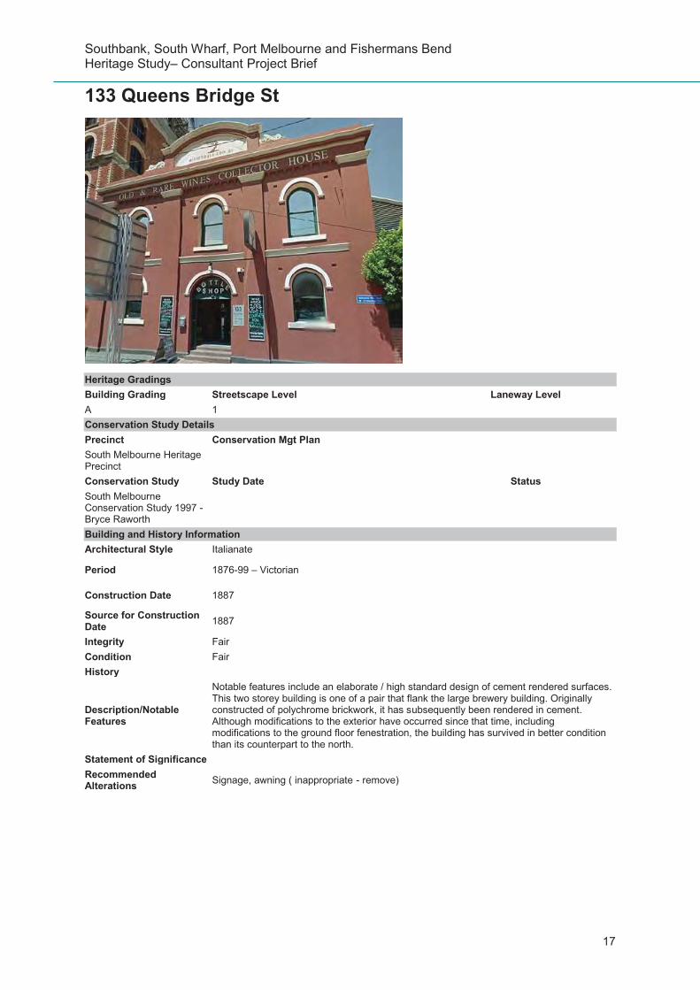
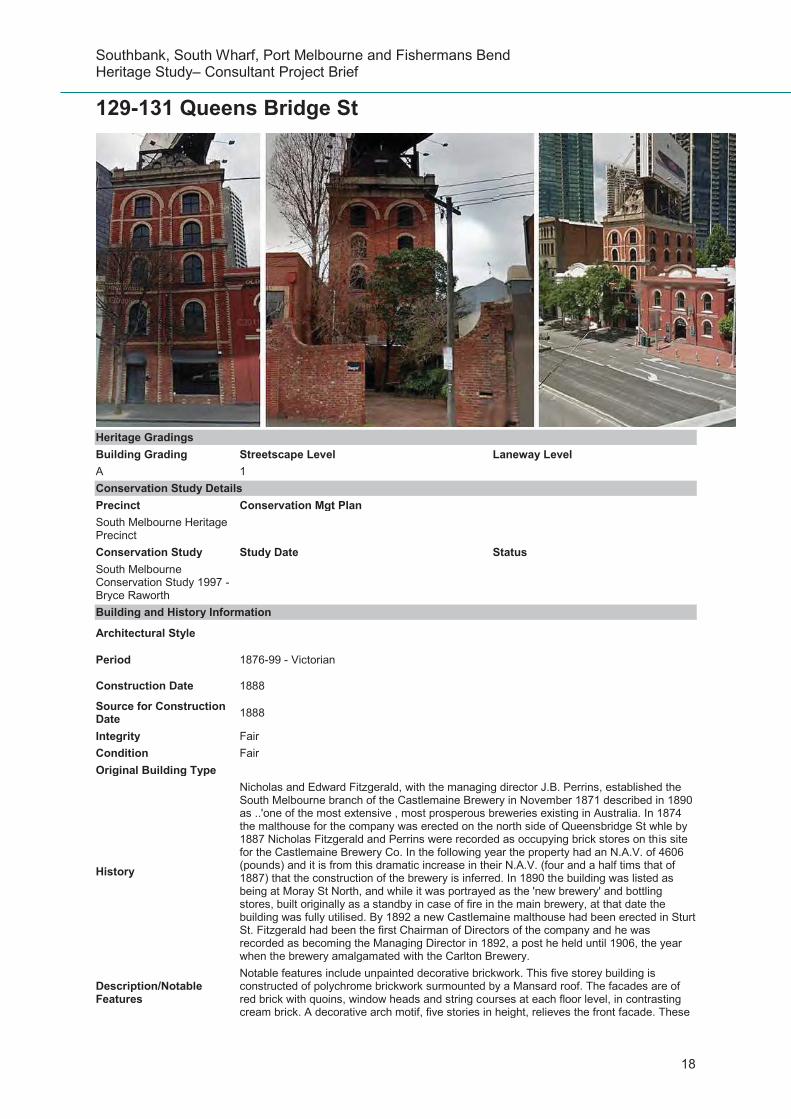


Recommended