Tunbridge Wells Borough Council
Site Assessment Sheets for Southborough
Strategic Housing and Economic Land Availability Assessment – Regulation 19 Consultation
January 2021

Page
1 of 38
Tunbridge Wells Borough Council
Site Assessment Sheets for Southborough
Date of publication – January 2021
Site Reference: SALP AL/SO1
Site Address: Land at Yew Tree Road (Southborough Library)
Location: Southborough
Settlement: Main Urban Area: Southborough/Royal Tunbridge Wells
Gross area (ha): 0.12
Developable area (ha): 0.12
Site type: PDL site inside the LBD of Southborough
Potential site use: Site has been assessed for development potential, notably for
residential use
Potential yield if
residential: Less than 10 units
Issues to consider: Ecology: TPO;
2016 Landscape Designation;
HLC Period: Late post-medieval;

Page
2 of 38
Tunbridge Wells Borough Council
Site Assessment Sheets for Southborough
Date of publication – January 2021
APA: General background archaeological potential;
ALC: URBAN;
LCA: Urban
Site Description: The site comprises of the Southborough library building. It is on a
corner plot on the junction with the A26 and Yew Tree Road.
There are a number of trees, some with TPO’s within and in
proximity to the site. The site itself bounded by the road junction
to the north and the west, residential development to the east and
Southfields Park to the south. To the west of the site beyond the
A26 and to the north beyond Yew Tree Road is the commercial
centre of Southborough, which is also the edge of the town centre
boundary and the Primary Shopping Area.
Suitability: This PDL site inside the LBD is considered to be a sustainable
site, however it is a small site.
Availability: Available
Single ownership
Achievability: N/A
Sustainability
Assessment: Site is not a reasonable alternative.
Conclusion: This site is considered to be sustainable site however due to its
small size it is considered unsuitable as a potential site allocation.
Reason: This PDL site lies within the Limits to Built Development and as
such is a sustainable site. Any likely yield is considered to be of a
scale that is not considered suitable for allocation

Page
3 of 38
Tunbridge Wells Borough Council
Site Assessment Sheets for Southborough
Date of publication – January 2021
Site Reference: 4
Site Address: Land east of London Road and south of St
Andrews Park Road, Southborough
Location: Southborough
Settlement: Main Urban Area: Southborough/Royal Tunbridge Wells
Gross area (ha): 0.06
Developable area (ha): 0.06
Site type: Greenfield site inside the LBD of Southborough
Potential site use: Site has been assessed for development potential, notably for
residential use
Potential yield if
residential:
Less than 10 units
Issues to consider: HLC Period: Late 20th century;
APA: General background archaeological potential;
ALC: URBAN;
LCA: Urban
Site Description: The site is an unmanaged parcel of land. There are trees on the
site and no existing buildings on the site. The A26 London Road
adjoins to the west. There are retail units adjacent, some
residential uses, and vacant land to the south. Site boundaries
comprise broken wooden fencing. There is currently a lack of

Page
4 of 38
Tunbridge Wells Borough Council
Site Assessment Sheets for Southborough
Date of publication – January 2021
vehicular access into the site. There are adjoining pavements
around the site curtilage. The site is generally flat. Public views
into the site are limited due to trees and shrubbery screening.
Suitability: This is considered to be an unsuitable site for allocation due to the
fact that it is a small greenfield site that is constrained by
extensive tree cover on the site.
Availability: Unavailable
Ownership unconfirmed
Achievability: N/A
Sustainability
Assessment: Site is not a reasonable alternative.
Conclusion: This site is considered unsuitable as a potential site allocation.
Reason: The greenfield site lies within the Limits to Built Development and
as such is considered to be a sustainable site. There is however
extensive tree coverage on the site and any likely yield is
considered to be of a scale that is not considered suitable for
allocation.

Page
5 of 38
Tunbridge Wells Borough Council
Site Assessment Sheets for Southborough
Date of publication – January 2021
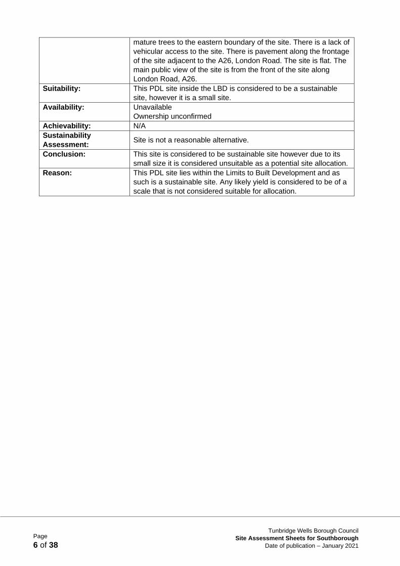
Site Reference: 5
Site Address: 85 London Road, Southborough
Location: Southborough
Settlement: Main Urban Area: Southborough/Royal Tunbridge Wells
Gross area (ha): 0.07
Developable area (ha): 0.07
Site type: PDL within LBD of Southborough
Potential site use: Site has been assessed for development potential, notably for
residential use
Potential yield if
residential:
Less than 10 units
Issues to consider: HLC Period: Early modern;
APA: General background archaeological potential;
ALC: URBAN;
LCA: Urban;
As at 01 April 2020, site includes recent completed scheme
18/01667/PNM for 1 dwelling, and 18/02258/FULL for 6 dwellings
Site Description: The site comprises a vacant former bank. The site is adjoined by
vacant land to the north and a takeaway to the south. It also
adjoins residential, retail and other commercial uses. The footprint
of the vacant building fills the entire width of the plot. There are
Page
6 of 38
Tunbridge Wells Borough Council
Site Assessment Sheets for Southborough
Date of publication – January 2021
mature trees to the eastern boundary of the site. There is a lack of
vehicular access to the site. There is pavement along the frontage
of the site adjacent to the A26, London Road. The site is flat. The
main public view of the site is from the front of the site along
London Road, A26.
Suitability: This PDL site inside the LBD is considered to be a sustainable
site, however it is a small site.
Availability: Unavailable
Ownership unconfirmed
Achievability: N/A
Sustainability
Assessment: Site is not a reasonable alternative.
Conclusion: This site is considered to be sustainable site however due to its
small size it is considered unsuitable as a potential site allocation.
Reason: This PDL site lies within the Limits to Built Development and as
such is a sustainable site. Any likely yield is considered to be of a
scale that is not considered suitable for allocation.

Page
7 of 38
Tunbridge Wells Borough Council
Site Assessment Sheets for Southborough
Date of publication – January 2021
Site Reference: 8
Site Address: Wheelers Field, Powder Mill Lane, Southborough
Location: Southborough
Settlement: Main Urban Area: Southborough/Royal Tunbridge Wells
Gross area (ha): 1.08
Developable area (ha): 0.71
Site type: Greenfield site within LBD of Southborough
Potential site use: Potential to use site in association with site submission 10.
Potential recreation/community use or residential use
Potential yield if
residential:
21
Issues to consider: Ecology: LNR, Ancient Woodland, LWS;
MGB;
Adjacent to the AONB
HLC Period: Late 20th century, Early modern;
APA: Iron Age Findspots;
ALC: URBAN, GRADE 4;
LCA: Urban, Wooded Farmland;
Land contamination (landfill site);
Highway matters
Site Description: The site comprises a grassed parcel of land. There are no existing

Page
8 of 38
Tunbridge Wells Borough Council
Site Assessment Sheets for Southborough
Date of publication – January 2021
buildings on the site. The site is adjoined by residential properties,
woodland and a field. Site boundaries are mostly trees and
hedging along the east and west boundaries. The southern
boundary is higher than the main site and is composed of mature
trees and fencing. The northern boundary comprises a bramble
hedge with trees. There is a gated entrance from Powder Mill
Lane. Pedestrian access onto the site is from Powder Mill Lane.
There is a lack of pavements. There is an unmade footpath from
Barnetts Way that crosses through the site. There is a Public
Right of Way along Barnetts Way to the south of the site. The site
is flat, but set at a lower than adjacent land. There is a significant
difference in level between the site and Barnetts Way including at
the junction with Powder Mill Lane. There is a public view of the
site from Powder Mill Lane and Barnetts Way and private views
from adjacent residential properties.
Suitability: This site is considered unsuitable because of harm that would be
caused to the Green Belt, if the site were to be released from it,
which would result in very high harm. There are also concerns in
relation to heritage, ecology and landscape due to its location
adjacent to the AONB. There are also land contamination as well
as highways concerns.
Availability: Available
Single ownership
Achievability: N/A
Sustainability
Assessment:
This is a reasonably located site which scores several neutrals
and positives, a reflection of its location on the edge of the
settlement/main urban area and the services and facilities
including transport available. The heritage score is let down by a
significant portion of the site having archaeological potential.
Conclusion: This site is considered unsuitable as a potential site allocation
within the Local Plan.
Reason: There is concern over the impact on the Green Belt. This site is
part of a larger parcel the release of which would cause very high
harm of released from the Green Belt. There is also concern in
relation to heritage, ecology and land contamination as well as
highways concerns.

Page
9 of 38
Tunbridge Wells Borough Council
Site Assessment Sheets for Southborough
Date of publication – January 2021
Site Reference: 10
Site Address: The Piggery, Powder Mill Lane, Southborough
Location: Southborough
Settlement: Main Urban Area: Southborough/Royal Tunbridge Wells
Gross area (ha): 2.35
Developable area (ha): 1.24
Site type: Greenfield site adjacent to LBD of Southborough
Potential site use: Potential to use site in association with site submission 8.
Potential recreation/community use and residential use
Potential yield if
residential:
37
Issues to consider: Ecology: LNR, Ancient Woodland, LWS;
AONB Component Part: Wildflower Meadows;
MGB;
Adjacent to the AONB;
HLC Period: Early modern, Early 20th century;
APA: Former site of Post Medieval brickworks and associated
Kilns and Quarries - Scotch Kiln;
ALC: GRADE 4;
LCA: Wooded Farmland;
Land contamination (landfill site);

Page
10 of 38
Tunbridge Wells Borough Council
Site Assessment Sheets for Southborough
Date of publication – January 2021
Highway matters;
Adjacent to existing Limits to Built Development
Site Description: The site consists of a field and also includes some woodland.
There are no existing buildings on the site. The site is adjoined by
woodland and a green parcel of land to the south. The boundaries
to the site comprise a mix of trees and brambles and some
fencing. There is a metal gate to the site from Powder Mill Lane.
This is an unmade access. There are issues with levels in the
wider area, with Powder Mill Lane set at a lower level than
Barnetts Way, including the junction. There is a footpath through
from the site to the south. There is a lack of pavements along
Powder Mill Lane along this stretch. There are pavements further
south and along the southern side of Barnetts Way. There is a
Public Right of Way further south along Barnetts Way and
informal footpaths. The site has a slight slope across it, down from
west to east. There is a bank along the southern boundary and a
rise up to the west. There are public views of the site from Powder
Mill Lane and a view across the site through to woodland.
Suitability: This site is considered unsuitable because of harm that would be
caused to the Green Belt, if the site were to be released from it,
which would result in very high harm. There are also concerns in
relation to heritage, ecology and landscape due to its location
adjacent to the AONB. There are also concerns in relation to land
contamination and highways.
Availability: Available
Single ownership
Achievability: N/A
Sustainability
Assessment:
This is a reasonable site which scores neutrals and positives, a
reflection of its location close to the edge of the settlement/main
urban area and the services and facilities including transport
available. It is let down on its land use score due to it being Green
Belt land, part of a parcel that has very high harm if released. It
scores negatively on landscape and biodiversity as part of the site
is a wildflower meadow and the site is adjacent to a Local Nature
Reserve.
Conclusion: This site is considered unsuitable as a potential site allocation in
the Local Plan.
Reason: There is concern over the impact on the Green Belt. The site is
part of a larger parcel the release of which would cause very high
harm if released from the Green Belt. There are also concerns in
relation to heritage, ecology and landscape due to its location
adjacent to the AONB. There are also concerns in relation to land
contamination and highways.

Page
11 of 38
Tunbridge Wells Borough Council
Site Assessment Sheets for Southborough
Date of publication – January 2021
Site Reference: 45
Site Address: Land adjoining Birchwood Avenue/Dower House
Crescent, Southborough
Location: Southborough
Settlement: Main Urban Area: Southborough/Royal Tunbridge Wells
Gross area (ha): 7.43
Developable area (ha): 6.91
Site type: Greenfield site adjacent to LBD of Southborough
Potential site use: Site has been assessed for development potential, notably for
residential use
Potential yield if
residential:
207
Issues to consider: Ecology: Ancient Woodland, LWS;
AONB Component Part: Ancient Woodland, Wildflower Meadows,
Historic Field Boundaries;
MGB;
AONB;
HLC Period: Late 20th century, Early medieval;
APA: Concentration of findspots possibly associated with spring;
ALC: URBAN, GRADE 3;
LCA: Urban, Wooded Farmland;

Page
12 of 38
Tunbridge Wells Borough Council
Site Assessment Sheets for Southborough
Date of publication – January 2021
Highway matters;
Adjacent to existing Limits to Built Development
Site Description: The site comprises a field. There are no existing buildings on the
site. The site is adjoined by residential properties, fields and an
area of woodland. The boundaries of the site consist of mostly
trees, and some hedging. The eastern boundary is more open.
There is a field gate fronting Birchwood Avenue. There are
pavements along Birchwood Avenue and Dower House Crescent.
There is a Public Right of Way adjacent to the northern boundary
of the site and others in the area. The site slopes down in a
southerly direction. There are public views of the site from
Birchwood Avenue/Dower House Crescent and from the adjacent
Public Right of Way.
Suitability: This site is considered unsuitable because of harm that would be
caused to the Green Belt if the site were to be released from it,
resulting in moderate harm. It would also cause harm to the
AONB. There are also ecological and historic concerns as well as
highways concerns.
Availability: Available
Single ownership
Achievability: N/A
Sustainability
Assessment:
This site includes a mix of scores. It scores positively in terms of
housing provision and transport but is let down by its land use
score (Green Belt location the release of which would cause
moderate harm to the Green Belt) and landscape score (loss of a
greenfield site in the AONB in an historic landscape). It is let down
by a lack of key services and facilities within a desirable walking
distance from the site. It is an assart field which lowers the
heritage score of the site and the biodiversity score is informed by
its location adjacent to Ancient Woodland, a Local Wildlife Site
and a wildflower meadow.
Conclusion: This site is considered unsuitable as a potential allocation in the
Local Plan.
Reason: There is concern over the impact on the Green Belt. The site is
within a Green Belt parcel, the release of which would cause
moderate harm if released from the Green Belt. It would also
cause harm to the AONB. There are also concerns in relation to a
number of other constraints including ecological, historic and
highways concerns.

Page
13 of 38
Tunbridge Wells Borough Council
Site Assessment Sheets for Southborough
Date of publication – January 2021
Site Reference: 90 (Local Plan Allocation AL/SO 2 in part)
Site Address: Mabledon, London Road, Southborough TN4 0UH
Location: Southborough
Settlement: Main Urban Area: Southborough/Royal Tunbridge Wells
Gross area (ha): 12.43
Developable area (ha): 12.00
Site type: Greenfield site outside of LBD of Southborough
Potential site use: Site has been assessed for development potential, notably for a
mix of hotel, leisure and conference uses
Potential yield if
residential:
Not to be allocated for residential
Issues to consider: Heritage: Historic Parks and Gardens EH, adjacent to Listed
Buildings;
Ecology: TPO, Ancient Woodland;
AONB Component Part: Ancient Woodland, Water Courses,
Ponds;
MGB;
AONB;
HLC Period: Early modern;
APA: Mabledon C19th century landscaped gardens - RPG;
ALC: GRADE 4, GRADE 3;
Page
14 of 38
Tunbridge Wells Borough Council
Site Assessment Sheets for Southborough
Date of publication – January 2021
LCA: Wooded Farmland;
Highway matters
Site Description: The site consists of a parkland landscape, walled garden and
derelict cottage. There are trees and ponds within the site. The
site is adjoined by the A26 London Road, residential uses, farm
land, woodland and some commercial use. The A21 is close by.
The boundaries of the site comprise mostly trees. Boundaries are
open in parts. The site has a frontage with the A26 London Road.
The site abuts the driveway to ‘Mabledon’ to the north of the site.
There is pavement along the eastern stretch of London Road
opposite the site. There is some pavement and a pedestrian
crossing point along the frontage of the site. There is a further
crossing point to the south. The topography of the site is complex.
This site is generally enclosed.
Suitability: This greenfield site is not considered suitable on its own, but is
considered suitable with the adjacent site as part of Site SO2
which is considered to be a suitable site for development for a
specific use namely hotel, leisure and conference uses. It is
considered to be in a suitable location for such a use subject to
sensitive development and appropriate mitigation. Any
development will need to respect the sites location within the
Green Belt, the AONB and its historic status. See also Site SO2.
Availability: Available
Single ownership
Achievability: This site is a suitable site when considered together with site
SO2. It is a site that is available and is in single ownership. It is
considered that the site could come forward during the Local Plan
period.
Sustainability
Assessment:
This site transverses the boundary with Tonbridge and Malling
Borough Council thus negative impacts that have been predicted
for the objectives consider aspects in the adjacent constituencies
e.g. the AONB, Tonbridge AQMA. The benefit to wellbeing of
opening up a heritage asset to the public ensures the health
objective scores highly. Carbon scores negatively for this site as
the hotel and leisure facilities will have high energy demands and
are likely to be visited by private car only. However, the provision
of new leisure facilities allows the services and health objectives
to score positively. The adverse impacts on the AONB predicted
by the 2020 LVIA report has been considered in the Landscape
and Heritage scores.
Conclusion: This site is only considered to be suitable when considered
alongside Site SO2 as a potential Local Plan allocation as
confirmed by the SA subject to further consideration for specific
uses, namely hotel and leisure uses. Due to the sensitive nature
of the site, it is not proposed to be released from the Green Belt
and any development coming forward for the site would need to
demonstrate very special circumstances. See also Site SO2.
Reason: The site when considered together with Site SO2 is considered to
be a suitable site on the edge of the main urban area of Tunbridge
Wells and Southborough, close to the main road network. It is well

Page
15 of 38
Tunbridge Wells Borough Council
Site Assessment Sheets for Southborough
Date of publication – January 2021
located for hotel, leisure and associated uses and is considered
suitable for sensitive development subject to appropriate
mitigation. Any development will need to respect the sites
location within the Green Belt, the AONB and its historic status.
The site is considered appropriate as a Local Plan allocation for
this specific use. See also Site SO2.

Page
16 of 38
Tunbridge Wells Borough Council
Site Assessment Sheets for Southborough
Date of publication – January 2021
Site Reference: Local Plan Allocation AL/SO 2, including
most of site 90
Site Address: Land at Mabledon House
Location: Southborough
Settlement: Main Urban Area: Southborough/Royal Tunbridge Wells
Gross area (ha): 12.62
Developable area (ha): 12.61
Site type: Part greenfield site / part PDL site in proximity of LBD of
Southborough
Potential site use: Site has been assessed for development potential, notably for a
mix of hotel, leisure and conference uses
Potential yield if
residential:
Not to be allocated for residential
Issues to consider: Heritage: Historic Parks and Gardens EH, adjacent to Listed

Page
17 of 38
Tunbridge Wells Borough Council
Site Assessment Sheets for Southborough
Date of publication – January 2021
Buildings;
Ecology: TPO, Ancient Woodland;
AONB Component Part: Ancient Woodland, Water Courses,
Ponds; Historic Routeways Roads;
MGB;
AONB;
HLC Period: Early modern;
APA: Mabledon C19th century landscaped gardens - RPG;
ALC: GRADE 4, GRADE 3;
LCA: Wooded Farmland;
Highway matters
Site Description: The site consists of a parkland landscape, walled garden and
derelict cottage. There are trees and ponds within the site. The
site is adjoined by the A26 London Road, residential uses, farm
land, woodland and some commercial use. The A21 is close by.
The boundaries of the site comprise mostly trees. Boundaries are
open in parts. The site has a frontage with the A26 London Road.
The site abuts the driveway to ‘Mabledon’ to the north of the site.
There is pavement along the eastern stretch of London Road
opposite the site. There is some pavement and a pedestrian
crossing point along the frontage of the site. There is a further
crossing point to the south. The topography of the site is complex.
This site is generally enclosed.
Suitability: This part greenfield/ part PDL site, although subject to constraints,
is considered to be a suitable site for development for a specific
use namely hotel, leisure and conference uses. It is considered to
be in a suitable location for such a use subject to sensitive
development and appropriate mitigation. Any development will
need to respect the sites location within the Green Belt, the AONB
and its historic status. See also Site 90.
Availability: Available
Single ownership
Achievability: This site is a suitable site. It is a site that is available and is in
single ownership. It is considered that the site could come forward
during the Local Plan period.
Sustainability
Assessment:
This site transverses the boundary with Tonbridge and Malling
district thus negative impacts that have been predicted for the
objectives consider aspects in the adjacent constituencies e.g. the
AONB, Tonbridge AQMA. The benefit to wellbeing of opening up
a heritage asset to the public ensures the health objective scores
highly. Carbon scores negatively for this site as the hotel and
leisure facilities will have high energy demands and are likely to
be visited by private car only. However, the provision of new
leisure facilities allows the services and health objectives to score
positively. The adverse impacts on the AONB predicted by the
2020 LVIA report has been considered in the Landscape and
Heritage scores.
Conclusion: This part greenfield/part PDL site is considered to be suitable as a
potential Local Plan allocation as confirmed by the SA subject to
further consideration for specific uses, namely hotel and leisure

Page
18 of 38
Tunbridge Wells Borough Council
Site Assessment Sheets for Southborough
Date of publication – January 2021
uses. Due to the sensitive nature of the site, it is not proposed to
be released from the Green Belt and any development coming
forward for the site would need to demonstrate very special
circumstances. See also Site 90.
Reason: The site is a part PDL site in proximity to the LBD of the main
urban area of Tunbridge Wells and Southborough, close to the
main road network. It is well located for hotel, leisure and
associated uses and is considered suitable for sensitive
development subject to appropriate mitigation. Any development
will need to respect the sites location within the Green Belt, the
AONB and its historic status. The site is considered appropriate
as a Local Plan allocation for this specific use. See also Site 90.

Page
19 of 38
Tunbridge Wells Borough Council
Site Assessment Sheets for Southborough
Date of publication – January 2021
Site Reference: 221
Site Address: St Andrews Medical Centre, St Andrews Court,
Pinewood Gardens, Southborough, TN4 0LZ
Location: Southborough
Settlement: Main Urban Area: Southborough/Royal Tunbridge Wells
Gross area (ha): 0.13
Developable area (ha): 0.13
Site type: PDL site inside the LBD of Southborough
Potential site use: Site has been assessed for development potential, notably for
residential use
Potential yield if
residential:
Less than 10
Issues to consider: HLC Period: Late 20th century, Early modern;
APA: General background archaeological potential;
ALC: URBAN;
LCA: Urban
Site Description: The site comprises a medical centre and associated car park.
There is an existing medical centre building on the site.

Page
20 of 38
Tunbridge Wells Borough Council
Site Assessment Sheets for Southborough
Date of publication – January 2021
Residential uses adjoin the site including some sheltered housing.
Site boundaries comprise a security fence surrounding the site.
There is existing vehicular access to the site. This doubles up as
a pedestrian pathway. There is pavement along Pinewood
Gardens. The site is flat. Public views of the site are relatively
limited due to its siting at the end of a cul-de-sac. It is seen in the
context of the immediate surrounding area.
Suitability: This PDL site inside the LBD is considered to be a sustainable
site, however it is a small site.
Availability: Available
Multiple ownership
Achievability: N/A
Sustainability
Assessment: Site is not a reasonable alternative.
Conclusion: This site is considered to be a sustainable site however due to its
small size it is considered unsuitable as a potential site allocation.
Reason: This PDL site lies inside the LBD and as such is a sustainable
site. Any likely yield on this site is likely to be of a scale that is not
considered suitable for allocation.

Page
21 of 38
Tunbridge Wells Borough Council
Site Assessment Sheets for Southborough
Date of publication – January 2021
Site Reference: 232; SALP AL/GB1 (Local Plan Allocation
AL/SO 1)
Site Address: Land between Bright Ridge and Speldhurst Road,
Former Speldhurst Road Allotments, Southborough
Location: Southborough
Settlement: Main Urban Area: Southborough/Royal Tunbridge Wells
Gross area (ha): 0.56
Developable area (ha): 0.56
Site type: Mostly greenfield site / part PDL within LBD of Southborough
Potential site use: Site has been assessed for development potential, notably for
residential use
Potential yield if
residential:
16
Issues to consider: Adjacent to MGB;
HLC Period: Late 20th century;
APA: General background archaeological potential;
ALC: URBAN, GRADE 3;
LCA: Urban, Wooded Farmland;
Existing allocation AL/GB1 in Site Allocations Local Plan;
As at 01 April 2020, site includes extant planning permission

Page
22 of 38
Tunbridge Wells Borough Council
Site Assessment Sheets for Southborough
Date of publication – January 2021
18/02618/OUT for 16 dwellings.
Site Description: The top part of the site nearest the adjacent houses is hard
surfaced with paving slabs. The bottom rectangular parcel is a
green field. It is a former, now dis-used, allotments. There are no
existing buildings on the site. The site is adjoined by residential
properties. The public highway adjoins to the south and there are
fields beyond to the west. There is hedging along the southern
boundary. The top part is a chain linked fence with a pedestrian
gate through. To the east and west are hedgerows. There is a
tree located towards the north eastern corner of the site to the
rear of adjacent dwellings. There is a timber field gate along the
frontage with Speldhurst Road. There is a field gate to the site
from the north east corner off Bright Ridge. A pedestrian path
divides the two parts of the site east - west. There is a lack of
pavements along this stretch of Speldhurst Road. The site is
generally flat but the wider landscape to the south undulates.
From Bright Ridge there is an open view of the top part of the site
through to the middle area of the bottom part.
Suitability: This mostly greenfield, but part PDL site is considered to be a
suitable site inside the LBD of Southborough which has planning
permission.
Availability: Available
Multiple ownership
Achievability: This site is available and currently has planning permission. It is
likely to be deliverable within the Local Plan period.
Sustainability
Assessment:
The site is entirely within flood zone 1 and would not put great
pressure on existing water supplier so the water objective scores
slightly positively. Noise scores negative due to the location of the
edge of the main Gatwick flight path. Air quality score is scored as
mixed overall because the site is located so that a wide range of
services can be reached without private car but it is still likely to
increase traffic in the AQMA.
Conclusion: Site is suitable as a potential Local Plan allocation.
Reason: Site is inside the LBD, located in the main urban area of
Southborough. The site is sustainable in this context. It has
previously been allocated for development and has extant
planning consent for residential development as at 01 April 2020.

Page
23 of 38
Tunbridge Wells Borough Council
Site Assessment Sheets for Southborough
Date of publication – January 2021
Site Reference: 233
Site Address: Land rear Hornbeam Avenue / Walnut Way,
Southborough
Location: Southborough
Settlement: Main Urban Area: Southborough/Royal Tunbridge Wells
Gross area (ha): 1.49
Developable area (ha): 1.49
Site type: Greenfield site inside the LBD of Southborough
Potential site use: Site has been assessed for development potential, notably for
residential use
Potential yield if
residential:
Northern part of site: Up to 15
Southern part of site: less than 10
Issues to consider: Ecology: TPO;
Transport Infrastructure: PRoW;
HLC Period: Late 20th century;
APA: General background archaeological potential;
ALC: URBAN, GRADE 3;
LCA: Urban;
Highways (access);
Potential noise;
Land contamination (Railway Land – tracks mainly, Works

Page
24 of 38
Tunbridge Wells Borough Council
Site Assessment Sheets for Southborough
Date of publication – January 2021
Unspecified Use – medium);
As at 01 April 2020, part of site includes extant planning
permission 18/03805/OUT for 15 dwellings
Site Description: The site comprises an overgrown parcel of land with extensive
tree cover. There are no existing buildings on the site. The site is
adjoined by residential properties, a railway line, a footpath and
some industrial uses. The site boundaries comprise some
domestic treatments and trees. There is currently a lack of
vehicular access to the site. There is a footpath through the site.
There are pavements in Hornbeam Avenue / Walnut Way. There
is a footpath that runs along the eastern edge of the site. The site
is generally flat. It is at an elevated position relative to the railway
line. The site is an enclosed site. Public views of the site are
limited.
Suitability: This is considered to be a sustainable site inside the LBD of
Southborough, however the site is considered in two parts and the
suitable part is a relatively small site.
Availability: Available
Single ownership
Achievability: N/A
Sustainability
Assessment:
A reasonable site that scores several neutrals and positives which
is well located in terms of provision of services, facilities and
transport. The site is let down on biodiversity grounds as it is a
designated Site of Nature Conservation Value.
Conclusion: This site is considered to be a sustainable site in part for built
development however it is a relatively small site and already
benefits from planning permission on part of the site.
Reason: The site lies inside the LBD within the main urban area and as
such is considered a sustainable site in this context. It is however
a constrained site due to its location adjacent to the main railway
line and tree cover. Any yield arising is likely to be of a scale that
is not considered suitable for allocation.

Page
25 of 38
Tunbridge Wells Borough Council
Site Assessment Sheets for Southborough
Date of publication – January 2021
Site Reference: 234; SALP AL/SO2
Site Address: Southborough Hub, London Road,
Southborough,TN4 0ND
Location: Southborough
Settlement: Main Urban Area: Southborough/Royal Tunbridge Wells
Gross area (ha): 1.79
Developable area (ha): 1.79
Site type: Part PDL/part greenfield site inside the LBD of Southborough
Potential site use: Site has been assessed for development potential, notably for a
mixed use scheme including residential, retail, and other mixed
uses
Potential yield if
residential:
69
Issues to consider: Heritage: Adjacent to Listed Building;
Ecology: TPO;
2016 Landscape Designation;
HLC Period: Early modern, Early 20th century;
APA: General background archaeological potential;
ALC: URBAN;
LCA: Urban;
Existing allocation AL/SO2 in Site Allocations Local Plan;

Page
26 of 38
Tunbridge Wells Borough Council
Site Assessment Sheets for Southborough
Date of publication – January 2021
Highway matters;
Potential land contamination;
Transport Infrastructure: In proximity to local cycle route;
As at 01 April 2020, site includes extant planning permission
16/06081/HYBRID for 69 dwellings (site has been mostly
completed as at 01 April 2020), and 17/03335/FULL for 20
dwellings;
As at 01 April 2020, this site also includes extant planning consent
for a new, mixed use Community Hub (18/03558/FULL)
Site Description: Prior to being developed (see planning consent references
above), the site comprised playing fields, the Royal Victoria Hall,
the Southborough Town Council offices and some unmanaged
land. The site includes a car park. There was also a disused
theatre, the Southborough Town Council offices and outbuildings
used for storage on the site.
The site is adjoined by the Ridgeway playing fields and residential
properties to the north of the site. It also adjoins retail/commercial
uses and other residential uses. Allotment gardens adjoin the far
eastern corner of the site. There was fencing around the
unmanaged area to the south and some trees. There was metal
fencing along the boundary fronting London Road. The site has
an open boundary to the north. This site has vehicle access. The
car park area of the site can be accessed from Yew Tree Road.
There are pavements along London Road and Yew Tree Road.
The site is flat. The site is generally enclosed but the car park
area to the south is exposed.
Suitability: This is considered to be a sustainable site that has planning
permission and has largely been implemented.
Availability: Available
Multiple ownership
Achievability: This site is an existing allocation which has extant planning
consents (which have been implemented). The site is available
and it is considered that the site will be delivered within the Local
Plan period.
Sustainability
Assessment:
Site is not a reasonable alternative.
Conclusion: This part PDL/part greenfield site is considered to be a
sustainable site that has planning permission and has largely
been implemented.
Reason: Site is a part PDL site inside the LBD, located in the centre of the
main urban area of Southborough. The site is sustainable in this
context. The site currently has planning permission which has
largely been implemented and it is therefore no longer considered
necessary to allocate it within the Local Plan.
Page
27 of 38
Tunbridge Wells Borough Council
Site Assessment Sheets for Southborough
Date of publication – January 2021
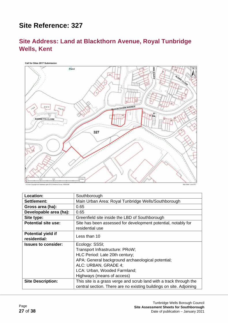
Site Reference: 327
Site Address: Land at Blackthorn Avenue, Royal Tunbridge
Wells, Kent
Location: Southborough
Settlement: Main Urban Area: Royal Tunbridge Wells/Southborough
Gross area (ha): 0.65
Developable area (ha): 0.65
Site type: Greenfield site inside the LBD of Southborough
Potential site use: Site has been assessed for development potential, notably for
residential use
Potential yield if
residential: Less than 10
Issues to consider: Ecology: SSSI;
Transport Infrastructure: PRoW;
HLC Period: Late 20th century;
APA: General background archaeological potential;
ALC: URBAN, GRADE 4;
LCA: Urban, Wooded Farmland;
Highways (means of access)
Site Description: This site is a grass verge and scrub land with a track through the
central section. There are no existing buildings on site. Adjoining

Page
28 of 38
Tunbridge Wells Borough Council
Site Assessment Sheets for Southborough
Date of publication – January 2021
uses include residential and industrial. There is fencing within the
site but the boundaries are open to the north. There is currently
no vehicle access to the site. There is a pedestrian track through
the site from the north. The site is steeply sloping down from the
north to south. This site is exposed.
Suitability: This greenfield site inside the LBD is considered to be a
sustainable site however it is a small site.
Availability: Available
Single ownership
Achievability: N/A
Sustainability
Assessment:
This is a reasonably located site which scores several neutrals
and positives, a reflection of its location where there are services
and facilities and transport.
Conclusion: This site is considered to be a sustainable site however due to its
small size it is considered unsuitable as a potential site allocation.
Reason: This greenfield site lies inside the LBD at the main urban area and
as such is considered a sustainable site in this context. It is a
constrained site. Any likely yield on this site is likely to be of a
scale that is not considered suitable for allocation.

Page
29 of 38
Tunbridge Wells Borough Council
Site Assessment Sheets for Southborough
Date of publication – January 2021
Site Reference: 335
Site Address: Land to the north of Speldhurst Road & to the west
of Bright Ridge, Southborough, Kent
Location: Southborough
Settlement: Main Urban Area: Royal Tunbridge Wells/Southborough
Gross area (ha): 3.67
Developable area (ha): 3.67
Site type: Greenfield site adjacent to the LBD of Southborough
Potential site use: Site has been assessed for development potential, notably for
residential use
Potential yield if
residential: 110
Issues to consider: AONB Component Part: Historic Field Boundaries, Historic
Routeways Roads;
MGB;
AONB;
HLC Period: Early post-medieval, Late 20th century;
APA: Concentration of Mesolithic Findspots;
ALC: URBAN, GRADE 3;
LCA: Urban, Wooded Farmland;

Page
30 of 38
Tunbridge Wells Borough Council
Site Assessment Sheets for Southborough
Date of publication – January 2021
Heritage: Proposed KCC Historic Park and Garden
Highways issues
Site Description: The site is a greenfield site on which there are no existing
buildings. The site is adjoined by residential properties and fields.
Speldhurst Road adjoins the site to the south. Site boundaries
include hedges and trees. There is a field gate to the south of the
site. There is a Public Right of Way nearby to the north of the site.
Site is mostly flat. There are private views of the site from
adjoining properties and more open public views from Speldhurst
Road.
Suitability: This site is considered unsuitable because of harm that would be
caused to the Green Belt, if the site were to be released from it,
resulting in moderate harm. It would also harm the AONB. There
are also historical, ecological and highways concerns.
Availability: Available
Single ownership
Achievability: N/A
Sustainability
Assessment:
This site scores some neutrals and positives but is let down on its
heritage, land use and landscape scores. The whole site has
archaeological potential and is an historic field. Land use score
reflects the findings of the Green Belt Study.
Conclusion: This site is considered unsuitable as a potential site allocation.
Reason: There is concern over the impact on the Green Belt. The site is
part of a parcel the release of which would cause moderate harm
if released from the Green Belt. It would also cause harm to the
AONB. There are also historic, ecological and highways
concerns. This is not considered a suitable site for allocation
within the Local Plan.

Page
31 of 38
Tunbridge Wells Borough Council
Site Assessment Sheets for Southborough
Date of publication – January 2021
Site Reference: 441
Site Address: Southfields Park, St John’s Road, Southborough,
Kent
Location: Southborough
Settlement: Main Urban Area: Royal Tunbridge Wells/Southborough
Gross area (ha): 9.29
Developable area (ha): 9.29
Site type: Greenfield site inside the LBD of Southborough used as school
sports pitches
Potential site use: Site has been assessed for development potential, notably for
residential use
Potential yield if
residential: 279
Issues to consider: Ecology: TPO;
2016 Landscape Designation;
HLC Period: Early 20th century;
APA: General background archaeological potential;
ALC: URBAN;
LCA: Urban;
Highway issues
Site Description: This site is used as sports pitches by Skinners school. There is a

Page
32 of 38
Tunbridge Wells Borough Council
Site Assessment Sheets for Southborough
Date of publication – January 2021
sports pavilion on the site. Adjoining uses are predominantly
residential. This site has strong boundaries all around. The A26
runs along the western side of the site and there is a dense
woodland boundary along the entire edge of this site. Fencing and
hedging borders the rest of the site. There is vehicular access into
the site from Chestnut Avenue. Pedestrian access is from
Chestnut Avenue off Yew Tree Road. This site is relatively flat.
This site is relatively well enclosed due to strong boundary
features.
Suitability: This greenfield site inside the LBD is not considered to be suitable
as it is currently in recreational use by Skinners School and it is
constrained by ecological issues and potential access issues.
Availability: Availability is uncertain
Single ownership
Achievability: N/A
Sustainability
Assessment:
This is a reasonable site, located within accessible distance to key
services and facilities and transport provision. Being adjacent to
the A26 London Road it is let down on its noise score.
Conclusion: This greenfield site inside the LBD currently used as sports
pitches is considered unsuitable as a potential site allocation.
Reason: There is significant concern regarding achievability of this site
during the Local Plan period and it is subject to a number of
constraints, including ecology, highways and access. It is
therefore not considered suitable as a Local Plan allocation.

Page
33 of 38
Tunbridge Wells Borough Council
Site Assessment Sheets for Southborough
Date of publication – January 2021
Site Reference: 445
Site Address: Mabledon and Nightingale east of A26 and south
of the A21, Southborough, Kent
Location: Southborough
Settlement: In proximity to the Main Urban Area: Royal Tunbridge
Wells/Southborough and Tonbridge
Gross area (ha): 171.88
Developable area (ha): 125.06
Site type: Mix of greenfield and PDL including PDL in proximity to the LBD
of Southborough.
Potential site use: Site has been assessed for development potential, notably for a
mixed use scheme including residential and economic (land-
based) uses
Potential yield if
residential: 50-120
Issues to consider: Heritage: Conservation Area, Listed Buildings;
Ecology: TPO, Ancient Woodland, LWS;
AONB Component Part: Ancient Woodland, Farmstead, Historic
Routeways PRoW, Historic Settlements, Water Courses, Ponds,
Historic Field Boundaries, Heathland;
Transport Infrastructure: PRoW;

Page
34 of 38
Tunbridge Wells Borough Council
Site Assessment Sheets for Southborough
Date of publication – January 2021
MGB;
AONB;
Flood Zone 2;
Flood Zone 3;
HLC Period: Early medieval, Early 20th century;
APA: Milestone on London Road A26;
ALC: GRADE 4, GRADE 3;
LCA: Wooded Farmland, Forested Plateau;
Land contamination (Railway Land – tracks mainly, Hospitals,
landfill site)
Site Description: The site comprises a mix of uses including a farm, private
dwellings, woodland, camping/caravan site, isolation hospital and
fields. There are several existing buildings on the site. The site is
adjoined by residential uses, agricultural land and the A26,
London Road. Boundaries of the site comprise mostly trees and
boundaries are open in parts. The southern boundary follows a
stream and there are ponds on the site. There are trees within the
site. There is existing vehicular access to the site off the A26
London Road and Vauxhall Lane runs through the site. There is
pavement along the eastern stretch of London Road along the site
frontage. There is some pavement on the western stretch of
London Road but not opposite the site. The site has a complex
topography. Public views possible including views from London
Road, Vauxhall Lane.
Suitability: This site is considered unsuitable because of harm that would be
caused to the Green Belt, if the site were to be released from it,
resulting in very high harm. There would also be significant harm
to the AONB and the landscape in this area as well as concerns in
relation to ecology and the historic environment.
Availability: Available
Single ownership
Achievability: N/A
Sustainability
Assessment:
This site has mixed scores. Water score reflects fact that there
are areas of flood zone 2 and 3 within the site. Business and
housing objectives scores positively as the proposed site use is
for extensive land-based economic development thus benefitted
the rural economy, whilst also meeting housing needs. There are
large sites of biodiversity value in the area and, without detail on
layout and design. There is a risk these could be negatively
impacted upon. The adverse impacts on the AONB predicted by
the 2020 LVIA report have been considered in the Landscape and
Land Use scores.
Conclusion: This site is considered unsuitable as a potential allocation.
Reason: There is concern over the impact on the Green Belt. The site is
part of a larger parcel the release of which would cause very high
harm if released from the Green Belt. There would also be
significant harm to the AONB and the landscape in this area as
well as concerns in relation to ecology and the historic
environment. This site is not considered suitable to be allocated
within the Local Plan.

Page
35 of 38
Tunbridge Wells Borough Council
Site Assessment Sheets for Southborough
Date of publication – January 2021
Site Reference: DPC13 (Local Plan Allocation AL/SO3)
Site Address: Baldwin's Lane, North Farm Road, Tunbridge
Wells
Parish: Southborough
Settlement: Southborough
Gross area (ha): 1.82
Developable area (ha): 1.75
Site type: PDL site inside the LBD of Southborough
Potential site use: Site has been assessed for development potential, notably for
residential development
Potential yield if
residential:
26
Issues to consider: Ecology: SSSI;
Transport Infrastructure: PRoW;
HLC Period: Early modern, Early 20th century;
APA: General background archaeological potential;
ALC: URBAN;
LCA: Urban;

Page
36 of 38
Tunbridge Wells Borough Council
Site Assessment Sheets for Southborough
Date of publication – January 2021
Land Contamination: Landfill Site, Manufacture of Clay Bricks,
Unknown Filled Ground, Works Unspecified Use – Medium Risk,
Repairs and Sales of Motor Vehicles, Works Unspecified Use –
High Risk;
Within Limits to Built Development
This site currently has planning permission for 26 dwellings on
part of the site (20/00881/FULL) as of 1st April 2020
Site Description: This site is a mixed commercial area with a range of commercial
buildings, a water tank, areas of parking and vacant buildings and
plots within the extent of the submitted area. The site consists of
frontage on to North Farm Road with large vacant buildings on the
frontage. There is a single access point from High Brooms Road
via Baldwins Lane which runs up the western boundary of the site.
The site is subject to significant changes in topography and rises
steeply to the rear of the site. To the north and east of the site are
further commercial buildings within the High Brooms Industrial
area. To the south is residential development at Wellbeck
Avenue close up to the boundary of the site. Further residential
development is found to the west at Colebrook Road. There is a
Public Right of Way linking North Farm Road and Colebrook Road
(via a flight of steps) to the west of the site. The site is in close
proximity to High Brooms Train Station.
Suitability: This PDL site inside the LBD is considered to be a suitable site in
part for development within the Local Plan. It is well located for
access to existing services and facilities within the Main Urban
Area and in close proximity to High Brooms Railway Station.
Availability: Available in part
Multiple ownership
Achievability: This is a suitable site in part that has existing planning permission
on part of the site. It is available in part and is considered likely to
be delivered in the Local Plan period.
Sustainability
Assessment:
Largely sustainable site. The resources objective is scored to
reflect the necessity for demolition. The remaining negative
scores are minor and reflect loss of existing business space and
noise sensitive location. The urban location means reliance on
private car use is not essential for access the wide range of
facilities and services.
Conclusion: This PDL site is considered suitable in part as a potential Local
Plan allocation as confirmed by the SA.
Reason: This site is a PDL site inside the LBD of Southborough and is
considered to be a sustainable site in this context. The whole site
is in a number of different ownerships and availability is therefore
uncertain. Therefore the part of the site that is available and has
existing planning permission is considered to be suitable as a
Local Plan allocation.
If you require this document in another format,
please contact:
Planning Policy
Planning Services
Tunbridge Wells Borough Council
Town Hall
Royal Tunbridge Wells
Kent TN1 1RS
Telephone: 01892 5 5 4 0 5 6
Recommended