Geography Grade 12
www.learnxtra.co.za
Brought to you by Page 1
SESSION TWO: MID-LATITUDE AND TROPICAL CYCLONES TOPIC 1: MID-LATITUDE CYLONES KEY CONCEPTS:
In this session we will focus on summarising what you need to know about:
Mid-Latitude Cyclones:
- Introduction - Stages of Development
- Cold Front Conditions - Warm Front Conditions - Cold Front Occlusion
- Warm Front Occlusion - Satellite Photo of Mid-Latitude Cyclone
- Synoptic Map of Mid-Latitude Cyclone
Learners note:
It is important to note that Mid-latitude are associated with the westerlies and Tropical cyclones with the easterlies. When studying this section we need to use
synoptic maps, satellite photographs and pictures showing the impact of the cyclones.
X-PLANATION
INTRODUCTION:
These are low pressure weather systems that occur in the middle latitudes of the earth, usually between 30° and 60° latitude north and south of the equator. They are
sometimes called temperate cyclones, extra-tropical cyclones, mid-latitude cyclones, frontal depressions or wave cyclones.
The system is made up of a cold front and a warm front. The cold fronts reach South Africa mostly in winter when all the pressure belts and wind systems move slightly
north. This is why the south-western Cape receives winter rainfall. The rain is brought by cold fronts passing over this area passing from east to west. The warm
front is bent southwards away from South Africa.
Geography Grade 12
www.learnxtra.co.za
Brought to you by Page 2
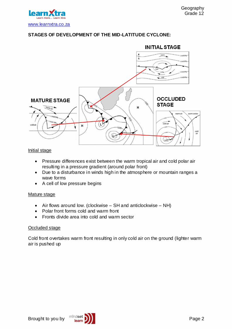
STAGES OF DEVELOPMENT OF THE MID-LATITUDE CYCLONE:
Initial stage
Pressure differences exist between the warm tropical air and cold polar air
resulting in a pressure gradient (around polar front)
Due to a disturbance in winds high in the atmosphere or mountain ranges a
wave forms
A cell of low pressure begins
Mature stage
Air flows around low. (clockwise – SH and anticlockwise – NH)
Polar front forms cold and warm front
Fronts divide area into cold and warm sector
Occluded stage Cold front overtakes warm front resulting in only cold air on the ground (lighter warm
air is pushed up
Geography Grade 12
www.learnxtra.co.za
Brought to you by Page 3
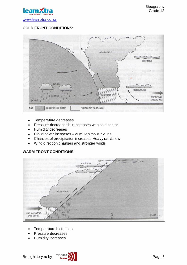
COLD FRONT CONDITIONS:
Temperature decreases
Pressure decreases but increases with cold sector
Humidity decreases
Cloud cover increases – cumulonimbus clouds
Chances of precipitation increases Heavy rain/snow
Wind direction changes and stronger winds
WARM FRONT CONDITIONS:
Temperature increases
Pressure decreases
Humidity increases
Geography Grade 12
www.learnxtra.co.za
Brought to you by Page 4
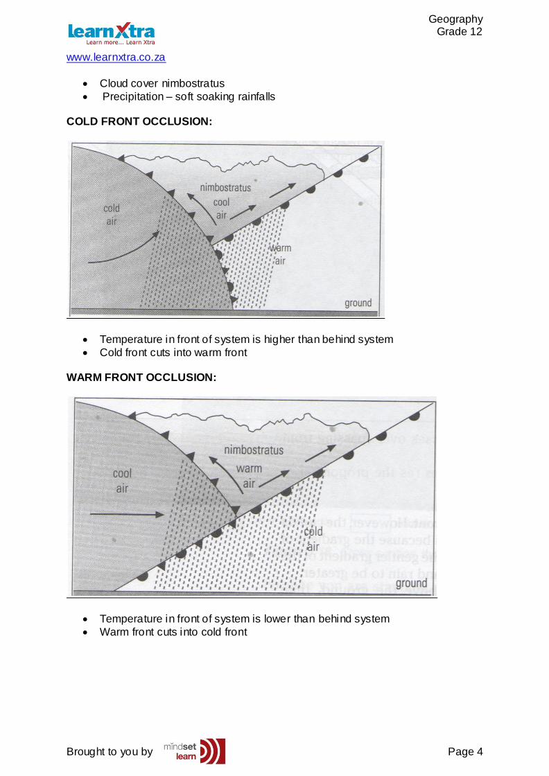
Cloud cover nimbostratus
Precipitation – soft soaking rainfalls
COLD FRONT OCCLUSION:
Temperature in front of system is higher than behind system
Cold front cuts into warm front
WARM FRONT OCCLUSION:
Temperature in front of system is lower than behind system
Warm front cuts into cold front
Geography Grade 12
www.learnxtra.co.za
Brought to you by Page 5
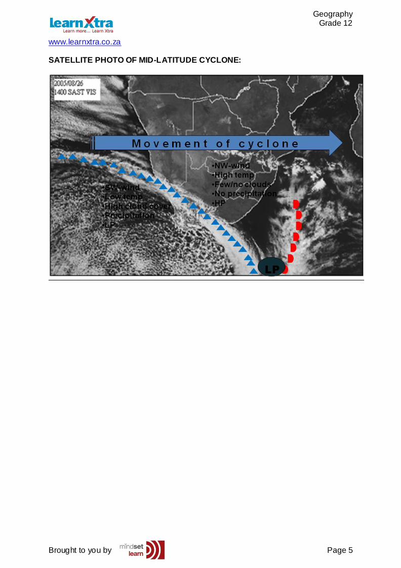
SATELLITE PHOTO OF MID-LATITUDE CYCLONE:
Geography Grade 12
www.learnxtra.co.za
Brought to you by Page 6
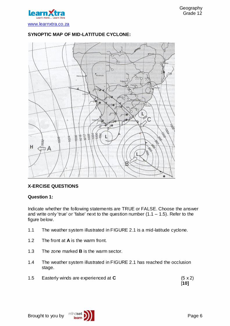
SYNOPTIC MAP OF MID-LATITUDE CYCLONE:
X-ERCISE QUESTIONS
Question 1:
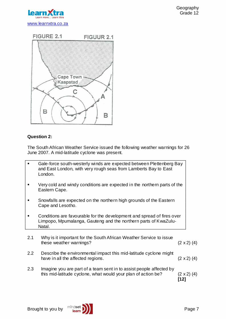
Indicate whether the following statements are TRUE or FALSE. Choose the answer and write only 'true' or 'false' next to the question number (1.1 – 1.5). Refer to the
figure below. 1.1 The weather system illustrated in FIGURE 2.1 is a mid-latitude cyclone.
1.2 The front at A is the warm front.
1.3 The zone marked B is the warm sector.
1.4 The weather system illustrated in FIGURE 2.1 has reached the occlusion stage.
1.5 Easterly winds are experienced at C (5 x 2)
[10]
Geography Grade 12
www.learnxtra.co.za
Brought to you by Page 7
Question 2:
The South African Weather Service issued the following weather warnings for 26 June 2007. A mid-latitude cyclone was present.
Gale-force south-westerly winds are expected between Plettenberg Bay and East London, with very rough seas from Lamberts Bay to East
London.
Very cold and windy conditions are expected in the northern parts of the Eastern Cape.
Snowfalls are expected on the northern high grounds of the Eastern Cape and Lesotho.
Conditions are favourable for the development and spread of fires over
Limpopo, Mpumalanga, Gauteng and the northern parts of KwaZulu-
Natal.
2.1 Why is it important for the South African Weather Service to issue these weather warnings? (2 x 2) (4)
2.2 Describe the environmental impact this mid-latitude cyclone might have in all the affected regions. (2 x 2) (4)
2.3 Imagine you are part of a team sent in to assist people affected by this mid-latitude cyclone, what would your plan of action be? (2 x 2) (4) [12]
Geography Grade 12
www.learnxtra.co.za
Brought to you by Page 8
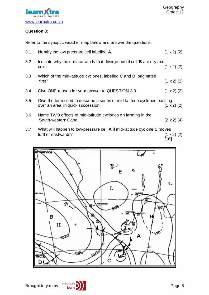
Question 3:
Refer to the synoptic weather map below and answer the questions:
3.1. Identify the low pressure cell labelled A. (1 x 2) (2)
3.2 Indicate why the surface winds that diverge out of cell B are dry and
cold. (1 x 2) (2)
3.3 Which of the mid-latitude cyclones, labelled C and D, originated
first? (1 x 2) (2)
3.4 Give ONE reason for your answer to QUESTION 3.3. (1 x 2) (2)
3.5 Give the term used to describe a series of mid-latitude cyclones passing over an area in quick succession. (1 x 2) (2)
3.6 Name TWO effects of mid-latitude cyclones on farming in the
South-western Cape. (2 x 2) (4) 3.7 What will happen to low-pressure cell A if mid-latitude cyclone C moves
further eastwards? (1 x 2) (2) [16]
Geography Grade 12
www.learnxtra.co.za
Brought to you by Page 9
X-AMPLE QUESTIONS:
Question 1:
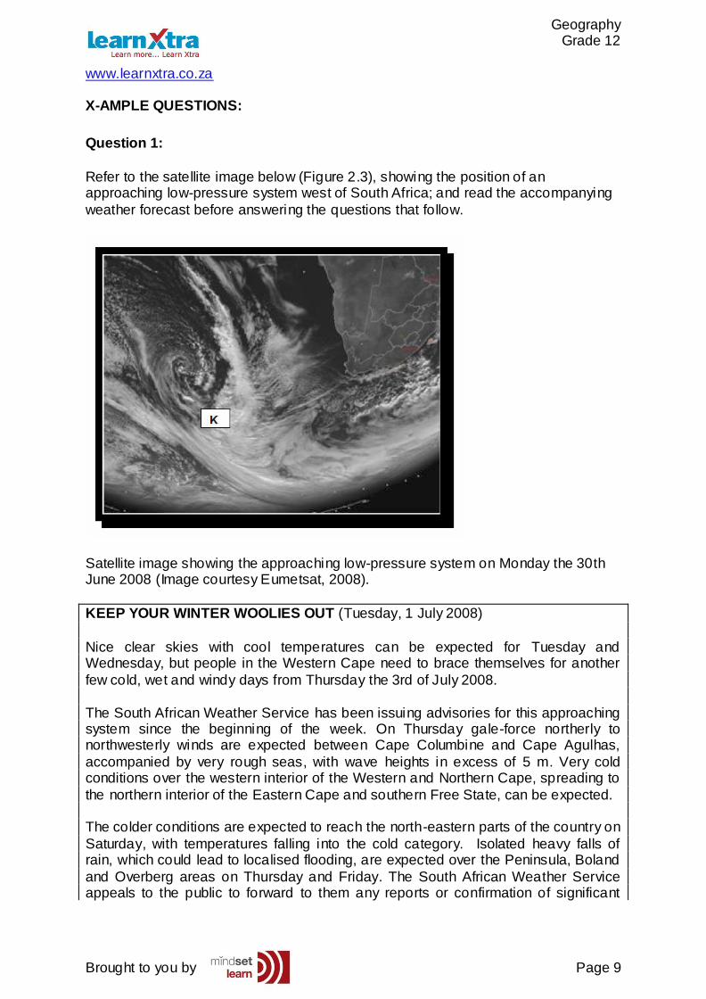
Refer to the satellite image below (Figure 2.3), showing the position of an approaching low-pressure system west of South Africa; and read the accompanying
weather forecast before answering the questions that follow.
Satellite image showing the approaching low-pressure system on Monday the 30th June 2008 (Image courtesy Eumetsat, 2008).
KEEP YOUR WINTER WOOLIES OUT (Tuesday, 1 July 2008)
Nice clear skies with cool temperatures can be expected for Tuesday and Wednesday, but people in the Western Cape need to brace themselves for another
few cold, wet and windy days from Thursday the 3rd of July 2008.
The South African Weather Service has been issuing advisories for this approaching system since the beginning of the week. On Thursday gale-force northerly to northwesterly winds are expected between Cape Columbine and Cape Agulhas,
accompanied by very rough seas, with wave heights in excess of 5 m. Very cold conditions over the western interior of the Western and Northern Cape, spreading to
the northern interior of the Eastern Cape and southern Free State, can be expected. The colder conditions are expected to reach the north-eastern parts of the country on
Saturday, with temperatures falling into the cold category. Isolated heavy falls of rain, which could lead to localised flooding, are expected over the Peninsula, Boland
and Overberg areas on Thursday and Friday. The South African Weather Service appeals to the public to forward to them any reports or confirmation of significant
Geography Grade 12
www.learnxtra.co.za
Brought to you by Page 10
weather events such as snowfalls, hailstorms, heavy rain, damaging winds etc, when they are observed. Such information can also be used for further research, which will
contribute to the improvement of weather predictions for that particular area.
1.1 Identify the low pressure system labelled K on the satellite image in
Figure 2.3 (1 X 2) (2) 1.2 During which season does the above-mentioned low-pressure system usually
affect the weather of South Africa? (1 X 2) (2) 1.3 Give the general direction of the movement of the low-pressure system usually mentioned in 1.1 (1 X 2) (2)
1.4 Give one reason for direction of the movement of the low-pressure system as mentioned in 1.3 (1 X 2) (2)
1.5 Draw a sketch map of the low pressure system appearing in the satellite image above; indicating its position in relation to South Africa. (3 x 2) (6)
1.6 Why is it important for the South African weather service to issue weather
warnings? Use the source above to write a short essay (no longer than 12 lines), clearly indicating the value of weather forecasts and warnings. In your
answer also indicate how reports forwarded by the public can improve weather forecasts. (6 x 2)
(12)
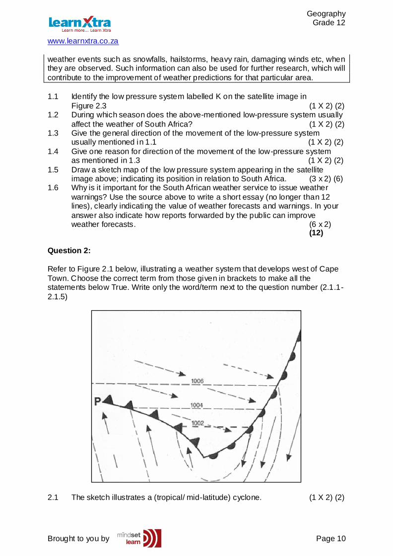
Question 2:
Refer to Figure 2.1 below, illustrating a weather system that develops west of Cape
Town. Choose the correct term from those given in brackets to make all the statements below True. Write only the word/term next to the question number (2.1.1-
2.1.5)
2.1 The sketch illustrates a (tropical/ mid-latitude) cyclone. (1 X 2) (2)
Geography Grade 12
www.learnxtra.co.za
Brought to you by Page 11
2.2 The weather system illustrated in Figure 2.1 is in the (mature/ occlusion) stage of development. (1 X 2) (2)
2.3 Air rotates (anticlockwise/ clockwise) around the centre of the weather system. (1 X 2) (2) 2.4 This weather system generally passes over Cape Town during (winter/
summer). (1 X 2) (2) 2.5 The front labelled P is the (cold/ warm) front. (1 X 2) (2)
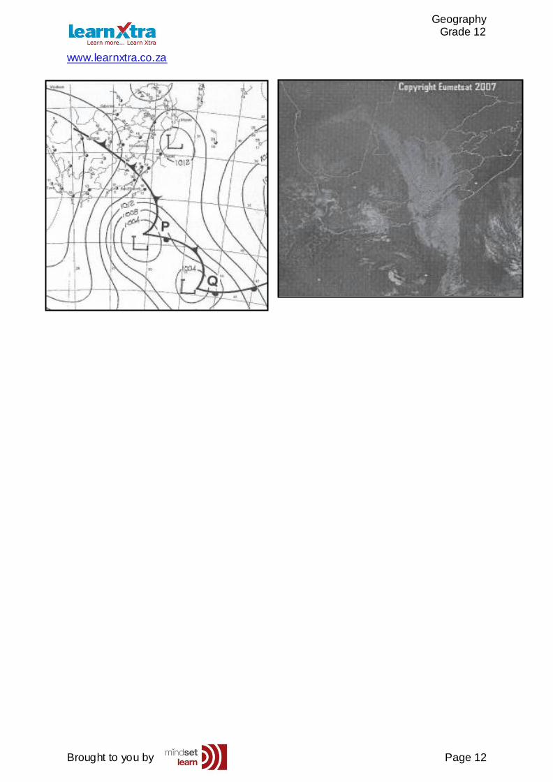
Question 3:
Refer to the figure below showing a satellite image and synoptic weather chart for 26 June 2007. Find the two mid-latitude cyclones labelled P and Q. Carefully read
through the weather update and answer the following questions. 3.1 (a) Provide evidence from the synoptic chart indicating that P
and Q are mid-latitude cyclones. (1 x 2) (2) (b) Which one of the two mid-latitude cyclones, P or Q, is most likely to be
older? (1 x 2) (2) (c) Give ONE reason for your answer to QUESTION 3.1(b). (1 x 2) (2)
3.2 (a) With reference to the satellite image and synoptic weather chart, explain why the Eastern Cape is experiencing rain and very cold
conditions. (4 x 2) (8) (b) Which weather condition, not mentioned in the weather report, is clearly visible on the satellite image? (1 x 2) (2)
(c) Give ONE reason why it is important for people living in the Eastern Cape to be made aware of the weather conditions mentioned in
QUESTION 3.2(a). (1 x 2) (2) [18]
Weather Update:
As the cold front moves over the central and south-eastern parts of South Africa today, it has left a trail of heavy falls, very cold conditions, very tough seas and gale force winds over the interior and along the coast. At present the cold front is
positioned over the Eastern Cape, bringing heavy rain and very cold temperatures to the province. Snowfalls are expected on the mountains of the Eastern Cape today,
as well as Lesotho, the Drakensberg and the Eastern Free State overnight and tomorrow. Sea conditions remain very hazardous, with gale force winds and very rough seas persisting along the southern Cape coast today, spreading towards the
Wild Coast and KwaZulu-Natal coast later on Tuesday.
Geography Grade 12
www.learnxtra.co.za
Brought to you by Page 12
Geography Grade 12
www.learnxtra.co.za
Brought to you by Page 13
SESSION TWO: MID-LATITUDE AND TROPICAL CYCLONES TOPIC 2: TROPICAL CYLONES KEY CONCEPTS:
In this session we will focus on summarising what you need to know about:
Tropical Cyclones: - Introduction - Stages of Development of a Tropical Cyclone
- Phenomena Associated with Tropical Cyclones - A Synoptic Map Showing a Tropical Cyclone
X-PLANATION
INTRODUCTION:
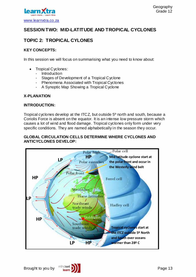
Tropical cyclones develop at the ITCZ, but outside 5º north and south, because a Coriolis Force is absent on the equator. It is an intense low pressure storm which causes a lot of wind and flood damage. Tropical cyclones only form under very
specific conditions. They are named alphabetically in the season they occur. GLOBAL CIRCULATION CELLS DETERMINE WHERE CYCLONES AND ANTICYCLONES DEVELOP:
Mid latitude cyclone start at
the polar front and occur in
the Westerly wind belt
Tropical cyclones start at
the ITCZ outside 5º North
and South over oceans
warmer than 28º C
HP
HP
HP
HP
LP
LP
LP
Geography Grade 12
www.learnxtra.co.za
Brought to you by Page 14
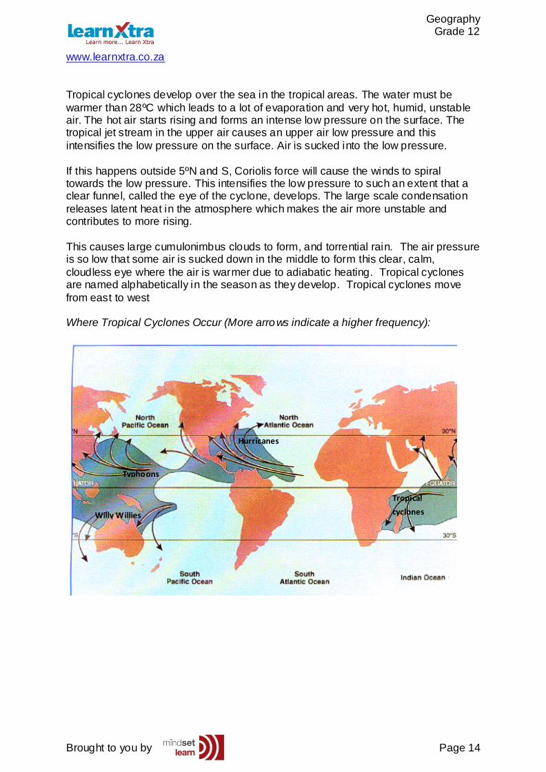
Tropical cyclones develop over the sea in the tropical areas. The water must be
warmer than 28ºC which leads to a lot of evaporation and very hot, humid, unstable air. The hot air starts rising and forms an intense low pressure on the surface. The tropical jet stream in the upper air causes an upper air low pressure and this
intensifies the low pressure on the surface. Air is sucked into the low pressure.
If this happens outside 5ºN and S, Coriolis force will cause the winds to spiral towards the low pressure. This intensifies the low pressure to such an extent that a clear funnel, called the eye of the cyclone, develops. The large scale condensation
releases latent heat in the atmosphere which makes the air more unstable and contributes to more rising.
This causes large cumulonimbus clouds to form, and torrential rain. The air pressure is so low that some air is sucked down in the middle to form this clear, calm,
cloudless eye where the air is warmer due to adiabatic heating. Tropical cyclones are named alphabetically in the season as they develop. Tropical cyclones move
from east to west Where Tropical Cyclones Occur (More arrows indicate a higher frequency):
Willy Willies
Typhoons
Hurricanes
Tropical
cyclones
Geography Grade 12
www.learnxtra.co.za
Brought to you by Page 15
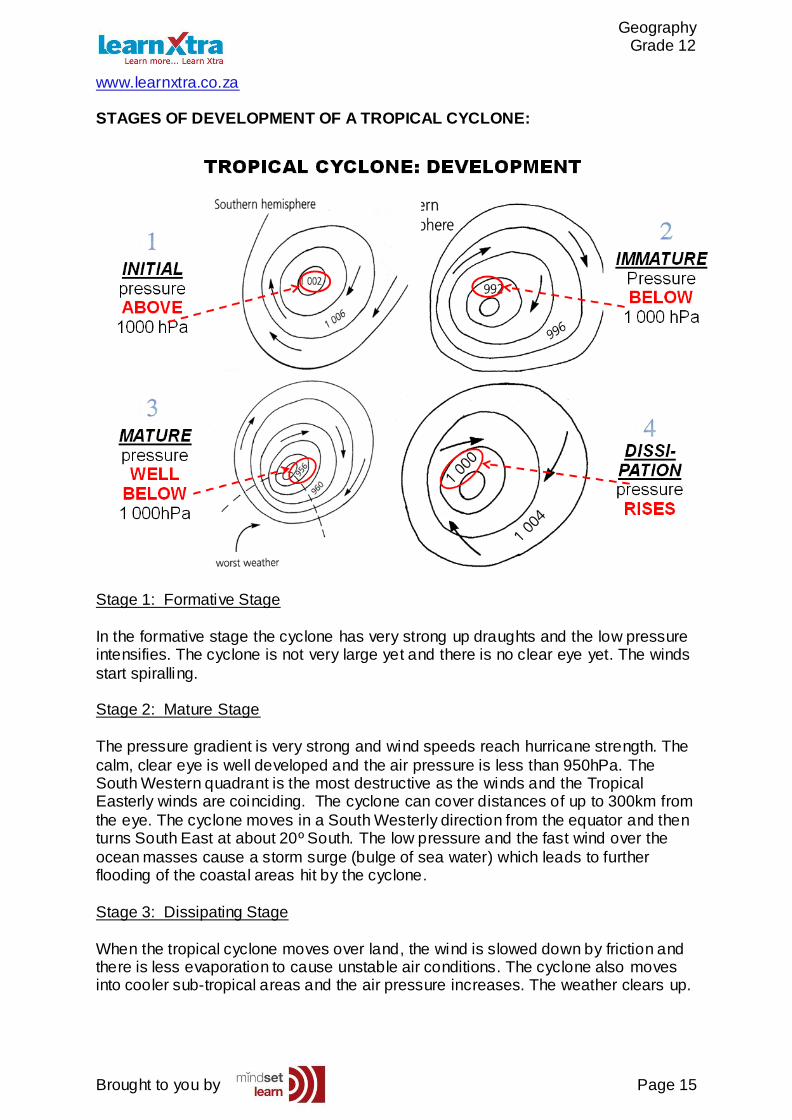
STAGES OF DEVELOPMENT OF A TROPICAL CYCLONE:
Stage 1: Formative Stage
In the formative stage the cyclone has very strong up draughts and the low pressure intensifies. The cyclone is not very large yet and there is no clear eye yet. The winds
start spiralling. Stage 2: Mature Stage
The pressure gradient is very strong and wind speeds reach hurricane strength. The
calm, clear eye is well developed and the air pressure is less than 950hPa. The South Western quadrant is the most destructive as the winds and the Tropical Easterly winds are coinciding. The cyclone can cover distances of up to 300km from
the eye. The cyclone moves in a South Westerly direction from the equator and then turns South East at about 20º South. The low pressure and the fast wind over the
ocean masses cause a storm surge (bulge of sea water) which leads to further flooding of the coastal areas hit by the cyclone.
Stage 3: Dissipating Stage
When the tropical cyclone moves over land, the wind is slowed down by friction and there is less evaporation to cause unstable air conditions. The cyclone also moves into cooler sub-tropical areas and the air pressure increases. The weather clears up.
Geography Grade 12
www.learnxtra.co.za
Brought to you by Page 16
TROPICAL CYCLONES
NAME:
Alphabet...
Andrew
Bonny
Carl
Deborah
ORIGIN:
In tropics.
Oceans
Not nearer
than 5° from equator.
DESTRUCTION:
Storm winds
Very hard rain
Flooding
IN EYE:
No...
Wind
Clouds
Rain
WEATHER:
Before eye
During eye
After eye
DISSIPATION:
Over land...
No moisture
No warm air
Friction
MANAGED:
Sand bags
Early warning
Track storm
Services
Inform people
Evacuation
Cross Section of a Tropical Cyclone in its Mature Stage:
Geography Grade 12
www.learnxtra.co.za
Brought to you by Page 17
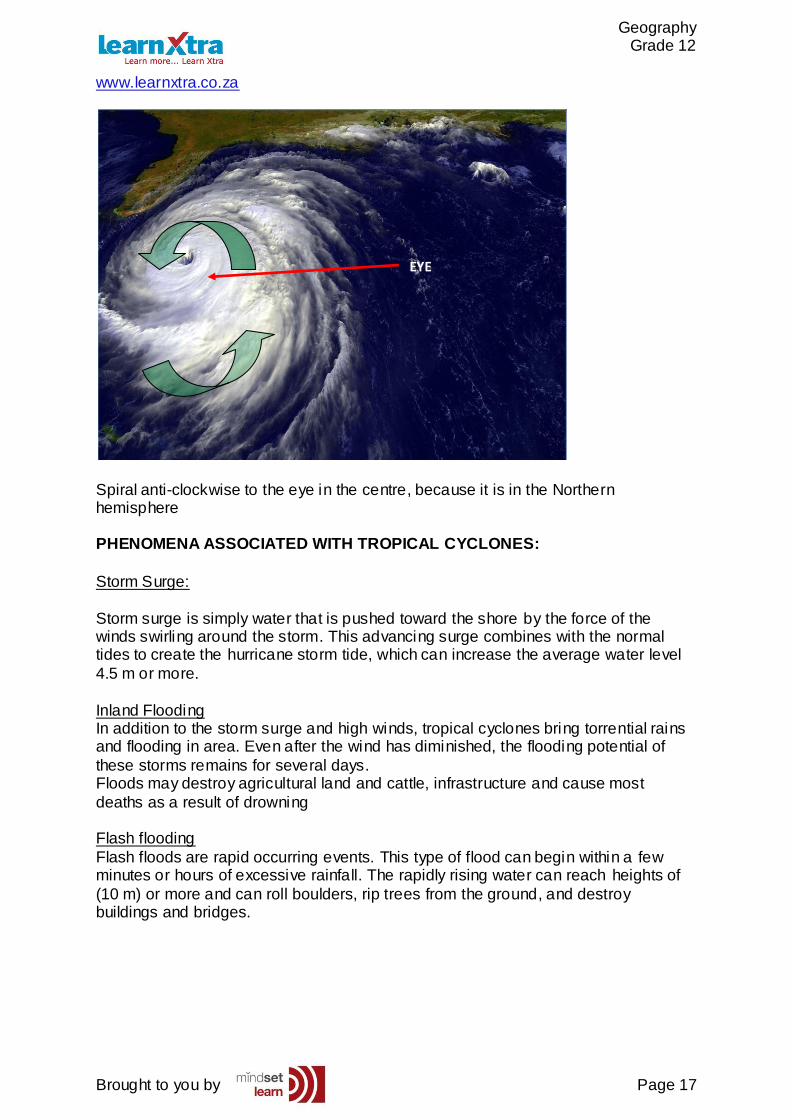
Spiral anti-clockwise to the eye in the centre, because it is in the Northern hemisphere PHENOMENA ASSOCIATED WITH TROPICAL CYCLONES:
Storm Surge:
Storm surge is simply water that is pushed toward the shore by the force of the winds swirling around the storm. This advancing surge combines with the normal tides to create the hurricane storm tide, which can increase the average water level
4.5 m or more.
Inland Flooding In addition to the storm surge and high winds, tropical cyclones bring torrential rains and flooding in area. Even after the wind has diminished, the flooding potential of
these storms remains for several days. Floods may destroy agricultural land and cattle, infrastructure and cause most
deaths as a result of drowning Flash flooding
Flash floods are rapid occurring events. This type of flood can begin within a few minutes or hours of excessive rainfall. The rapidly rising water can reach heights of
(10 m) or more and can roll boulders, rip trees from the ground, and destroy buildings and bridges.
EYE
Geography Grade 12
www.learnxtra.co.za
Brought to you by Page 18
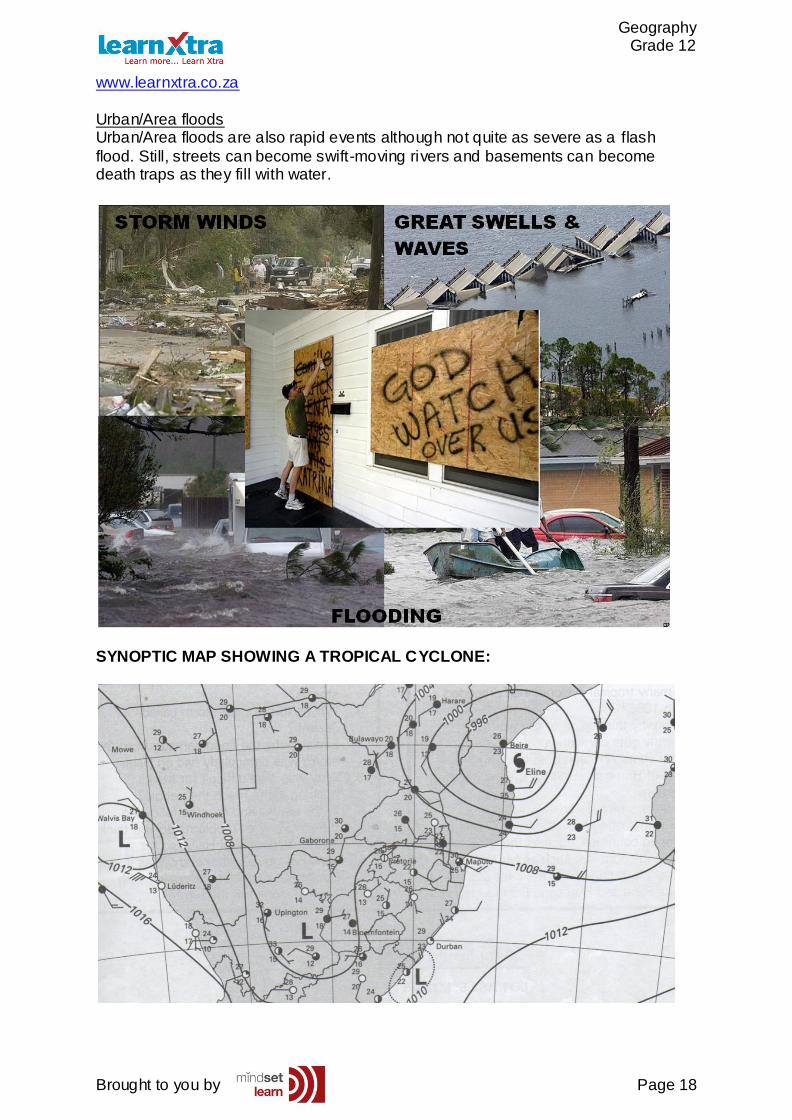
Urban/Area floods Urban/Area floods are also rapid events although not quite as severe as a flash
flood. Still, streets can become swift-moving rivers and basements can become death traps as they fill with water.
SYNOPTIC MAP SHOWING A TROPICAL CYCLONE:
Geography Grade 12
www.learnxtra.co.za
Brought to you by Page 19
X-AMPLE QUESTIONS
Question 1:
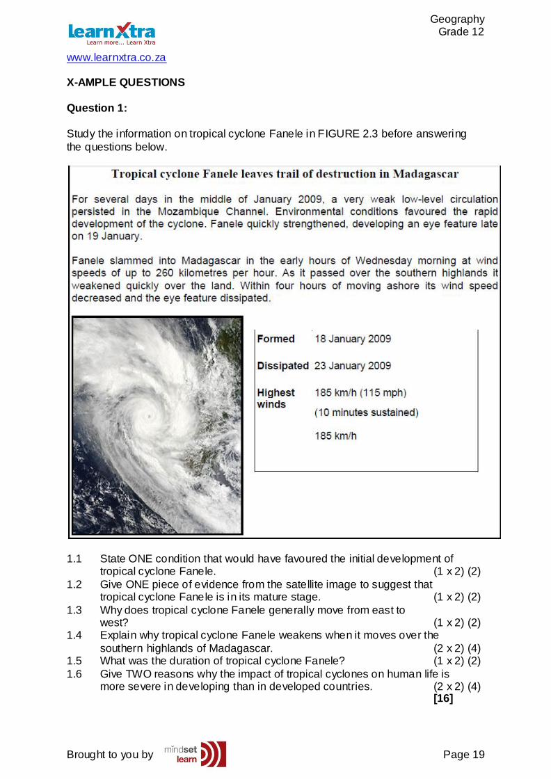
Study the information on tropical cyclone Fanele in FIGURE 2.3 before answering
the questions below.
1.1 State ONE condition that would have favoured the initial development of tropical cyclone Fanele. (1 x 2) (2)
1.2 Give ONE piece of evidence from the satellite image to suggest that tropical cyclone Fanele is in its mature stage. (1 x 2) (2)
1.3 Why does tropical cyclone Fanele generally move from east to west? (1 x 2) (2) 1.4 Explain why tropical cyclone Fanele weakens when it moves over the
southern highlands of Madagascar. (2 x 2) (4) 1.5 What was the duration of tropical cyclone Fanele? (1 x 2) (2)
1.6 Give TWO reasons why the impact of tropical cyclones on human life is more severe in developing than in developed countries. (2 x 2) (4) [16]
Geography Grade 12
www.learnxtra.co.za
Brought to you by Page 20
X-ERCISE QUESTIONS
Question 1:
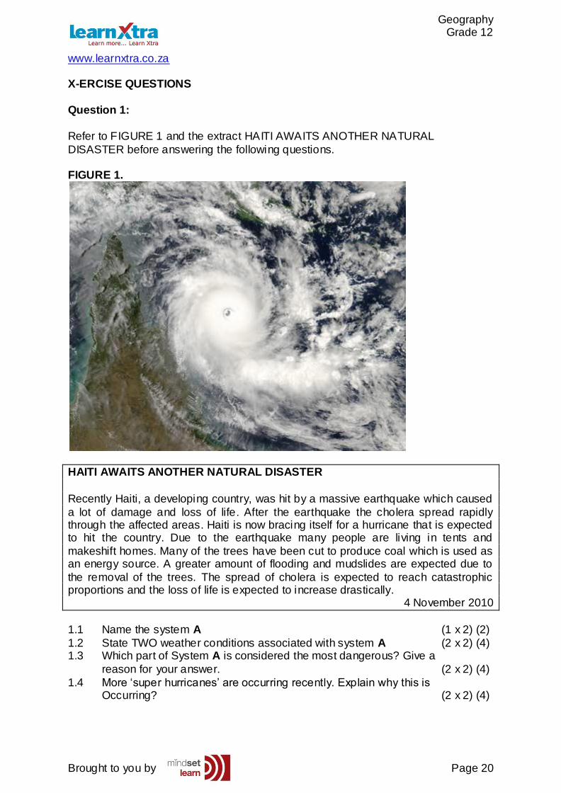
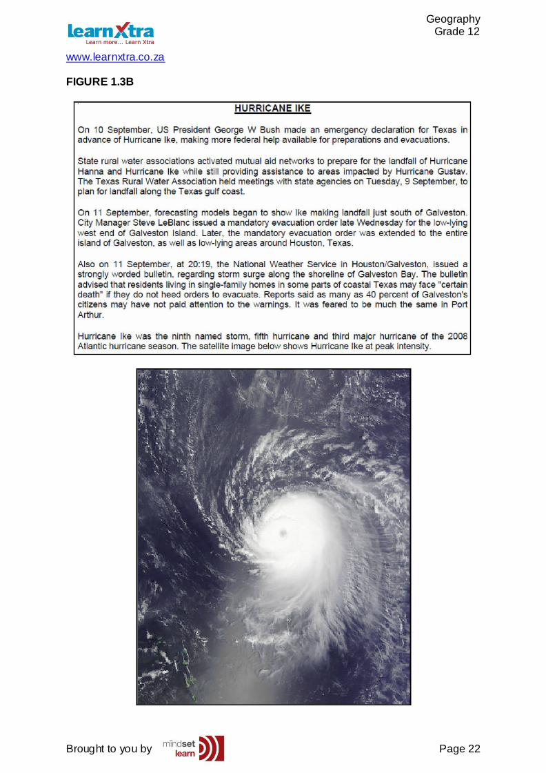
Refer to FIGURE 1 and the extract HAITI AWAITS ANOTHER NATURAL
DISASTER before answering the following questions. FIGURE 1.
HAITI AWAITS ANOTHER NATURAL DISASTER
Recently Haiti, a developing country, was hit by a massive earthquake which caused
a lot of damage and loss of life. After the earthquake the cholera spread rapidly through the affected areas. Haiti is now bracing itself for a hurricane that is expected to hit the country. Due to the earthquake many people are living in tents and
makeshift homes. Many of the trees have been cut to produce coal which is used as an energy source. A greater amount of flooding and mudslides are expected due to
the removal of the trees. The spread of cholera is expected to reach catastrophic proportions and the loss of life is expected to increase drastically.
4 November 2010
1.1 Name the system A (1 x 2) (2)
1.2 State TWO weather conditions associated with system A (2 x 2) (4) 1.3 Which part of System A is considered the most dangerous? Give a
reason for your answer. (2 x 2) (4)
1.4 More ‘super hurricanes’ are occurring recently. Explain why this is Occurring? (2 x 2) (4)
Geography Grade 12
www.learnxtra.co.za
Brought to you by Page 21
1.5 In many cases, especially in developing countries, the effect of natural disasters on the economy, living conditions and loss of life is greater after a
natural disaster has occurred. In a single paragraph (no more than 12 lines), explain why this is the case. 6 x 2) (12)
Question 2:
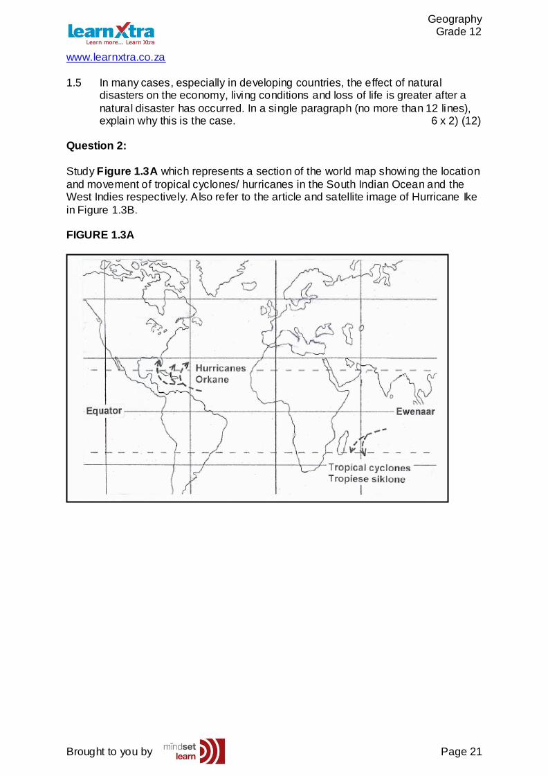
Study Figure 1.3A which represents a section of the world map showing the location
and movement of tropical cyclones/ hurricanes in the South Indian Ocean and the West Indies respectively. Also refer to the article and satellite image of Hurricane Ike
in Figure 1.3B. FIGURE 1.3A
Geography Grade 12
www.learnxtra.co.za
Brought to you by Page 22
FIGURE 1.3B
Geography Grade 12
www.learnxtra.co.za
Brought to you by Page 23
2.1 Give ONE similarity, visible in Figure 1.3A, between tropical cyclones in the
South Indian Ocean and hurricanes in the West Indies. (1x2) (2) 2.2 Explain the point of origin of both tropical cyclones and hurricanes. (3x2) (6) 2.3 Very intense hurricanes, such as Ike, occur more often and more regularly.
Many meteorologists link the latter with global warming. Why is this so? (3x2) (6)
2.4 With reference to Figure 1.3A, give one reason why tropical cyclones seldom hit the coast of southern Africa. (1x2) (2)
2.5 Should a tropical cyclone and a hurricane of similar strength hit the coastlines
of southern Africa and the United States of America respectively, the United States of America would suffer more damage to infrastructure, while southern
Africa would experience more loss of life. Write a short essay (no more than 12 lines) to explain why this is the case. Your answer should refer to the level of development in the two regions respectively. (6x2) (12)
Geography Grade 12
www.learnxtra.co.za
Brought to you by Page 24
ANSWERS TO HOMEWORK X-ERCISES
SESSION 2: MID-LATITUDE CYCLONES AND TROPICAL CYCLONES
TOPIC 1: MID-LATITUDE CYCLONES
Question 1:
1.1 Mid latitude / temperate cyclone / mid latitude depression (1 X 2) (2)1.2 Winter
1.3 West to east/ eastward/ to the east (1 X 2) (2)1.4 Situated in the westerly windbelt Driven by the westerly winds (1 X 2) (2)
1.5
(1 X 2) (2) 1.6 Value of weather forecasts and warnings:
To timeously alert people Possible precautionary measures can be taken
Evacuation can take place Preparation can be done in terms of protection for harsh weatherFishermen will know not to go on the sea
Cancel outdoor activities Rescue services alerted beforehand
Tourists can adjust their plans [Any other reasonable answer] (6 X 2)
(12)Question 2:
2.1 Mid-latitude 2.2 Mature 2.3 Clockwise
2.4 Winter 2.5 Cold front (5 X 2) (10)
Question 3:
3.1 (a) Presence of cold and warm fronts (1 x 2) (2)
(b) Q (1 x 2) (2) (c) Furthest east (1 x 2) (2)
Geography Grade 12
www.learnxtra.co.za
Brought to you by Page 25
3.2 (a) Cold front is passing over
Cold air mass (sector) follows cold front Cold air forces warm air ahead of it to rise Rising air condenses resulting in cloud formation and rain (4 x 2) (8)
(b) Clouds (1 x 2) (2) (c) Possible flooding and people should evacuate
Snowfall and very cold conditions and people must find shelter Stock up on food/medical supplies Purchase lamps/candles in case power is cut
Put sandbags down to prevent water coming in [Any ONE] (1 x 2) (2)
TOPIC 2: TROPICAL CYCLONES
Question 1:
1.1 Tropical cyclone/hurricane (2) (1x2) (2) 1.2 hurricane force winds (2)
Torrential rainfall (2) High temperatures (2)
High humidity (2) (Any TWO) (2 X 2) (4) 1.3 the forward left hand quadrant (2)
It has the steepest pressure gradient (2) (2 X 2) (4)
1.4 Hurricanes depend on high temperatures, the higher the temperature the stronger the hurricane. (2) Global warming has increased temperature significantly resulting
in more super hurricanes. (2) (2 x 2) (4) 1.5 Developing countries don’t have the resources and money to deal
properly with the damages caused by natural disasters. (2) Due to poor infrastructure it is hard to get to effected areas. (2) Due to lack of productivity economy suffers. (2)
Electricity is cut off and developing countries don’t have proper backup systems in place. (2)
Piped water could be cut off leading to spread of water bourne diseases. (2) Lack of medical facilities leads to spread of disease and an increased death rate. (2)
No proper facilities leads to lawlessness. (2) Any SIX answers- accept other relevant answers) (6 x 2) (12)
Question 2:
2.1 Develop along the east coast Latitudinal position similar
Move away from equator Move east to west
Geography Grade 12
www.learnxtra.co.za
Brought to you by Page 26
[Any One] (1x2) (2) 2.2 Originate between 5°- 25°N and S
Need Coriolis force that comes into operation at 5° Coriolis force does not exist at equator Situated over hot oceans
Greatest evaporation between 5°- 25° N and S Latent heat needed for development stored in water vapour
[Any Three] (3x2) (6) 2.3 Global warming increases temperatures Ocean temperatures increase and stay warmer for longer
Increased temperatures increase evaporation and condensation Leads to the release of more latent heat
Leads to deepening of the low More intense hurricanes developing more often [Any Three] (3x2) (6)
2.4 Southern Africa is shielded/ protected by MadagascarTropical cyclones dissipate over Madagascar
Steered away by South Indian Anticyclone/ High Pressure [Any One] (1x2) (2) 2.5 United States of America
USA is a developed nation USA has more and better
More can be damaged Warning systems are readily available Earlier evacuations can take place
Better rescue services Health facilities are more readily available
Less loss of life Southern Africa
Southern Africa has little and poorly developed
Less can be damaged Warning systems are not able to reach the majority of the population as some
of them are in deep rural areas Few early evacuations can take place Not enough rescue services
Few health facilities are available More loss of life
[To discuss Any Three from USA and Any Three from Southern Africa] (6x2) (12)
Recommended