04/13/2018 01:39 pm MT Page of1 Arapaho and Roosevelt National Forests 26
Projects Occurring in more than one Region (excluding Nationwide)
R2 - Rocky Mountain Region, Occurring in more than one Forest (excluding Regionwide)
Arapaho and Roosevelt National Forests, Forestwide (excluding Projects occurring in more than one Forest)
This report contains the best available information at the time of publication. Questions may be directed to the Project Contact.
Project PurposeProject Name DecisionPlanning Status Project ContactExpected
Implementation
04/01/2018 to 06/30/2018
R2 - Rocky Mountain Region
- Special use management
- Special use management
On Hold
Developing ProposalEst. Scoping Start 06/2018
N/A
Expected:07/2018
David [email protected]
Jaime [email protected]
UNIT - Ashley National Forest All Units, Grand Valley Ranger District, Norwood Ranger District, Yampa Ranger District, Hahns Peak/Bears Ears Ranger District, Pine Ridge Ranger District, Sulphur Ranger District, East Zone/Dillon Ranger District, Paonia Ranger District, Boulder Ranger District, West Zone/Sopris Ranger District, Canyon Lakes Ranger District, Salida Ranger District, Gunnison Ranger District, Mancos/Dolores Ranger District. STATE - Colorado, Nebraska, Utah. COUNTY - Chaffee, Delta, Dolores, Eagle, Grand, Gunnison, Jackson, Lake, La Plata, Larimer, Mesa, Montrose, Routt, Saguache, San Juan, Dawes, Daggett, Uintah. LEGAL - Not Applicable. Linear transmission lines located in Colorado, Utah, and Nebraska.
UNIT - Boulder Ranger District, East Zone/Holy Cross Ranger District, Canyon Lakes Ranger District. STATE - Colorado. COUNTY - Boulder, Eagle, Larimer. LEGAL - Not Applicable. Indian Peaks Wilderness from May 1st to November 30th, east of the continental divide, and ice climbing within the Canyon Lakes and Holy Cross Ranger District's.
Location:
Location:
N/A
07/2018
Western Area Power Administration Right-of-Way Maintenance and Reauthorization Project
Colorado Mountain School
Schedule of Proposed Action (SOPA)
Update vegetation management activities along 278 miles of transmission lines located on NFS lands in Colorado, Nebraska, and Utah. These activities are intended to protect the transmission lines by managing for stable, low growth vegetation.
The Forest Service proposes to issue a ten-year outfitter and guide permit for mountaineering, avalanche education, and ski touring. This will replace a transitional priority use permit.
Description:
Description:
Web Link: http://www.fs.usda.gov/project/?project=30630
Arapaho and Roosevelt National Forests
EIS
CE

04/13/2018 01:39 pm MT Page of2 Arapaho and Roosevelt National Forests 26
Arapaho and Roosevelt National Forests, Forestwide (excluding Projects occurring in more than one Forest)
Arapaho and Roosevelt National Forests, Occurring in more than one District (excluding Forestwide)
Project PurposeProject Name DecisionPlanning Status Project ContactExpected
Implementation
R2 - Rocky Mountain Region
R2 - Rocky Mountain Region
- Wildlife, Fish, Rare plants - Watershed management
- Land management planning - Recreation management
- Special use management
In Progress:Scoping Start 09/28/2015
In Progress:Comment Period Public Notice 07/10/2015
Developing ProposalEst. Scoping Start 06/2018
Expected:10/2017
Expected:07/2018
Expected:07/2018
Cambria [email protected]
Sarah [email protected]
Jaime [email protected]
UNIT - Arapaho and Roosevelt National Forests All Units. STATE - Colorado. COUNTY - Boulder, Larimer. LEGAL - Not Applicable. Flood-impacted area of Canyon Lakes and Boulder Ranger Districts.
UNIT - Clear Creek Ranger District, Sulphur Ranger District, Boulder Ranger District, Canyon Lakes Ranger District. STATE - Colorado. COUNTY - Boulder, Clear Creek, Gilpin, Grand, Jefferson, Larimer, Park. LEGAL -Not Applicable. Arapaho and Roosevelt National Forests.
UNIT - Sulphur Ranger District, Boulder Ranger District. STATE - Colorado. COUNTY - Boulder, Grand. LEGAL - Not Applicable. Forest Service system trails located within and outside the Indian Peaks/James Peak Wildernesses on the Boulder and Sulphur Ranger District's.
Location:
Location:
Location:
08/2018
08/2018
08/2018
Post-Flood Stream Restoration
Arapaho and Roosevelt National Forest Recreational Sport Shooting Project
Boy Scouts of America, Denver Area Council
The Forest Service is proposing to implement stream and floodplain restoration projects, for the purpose of improving watershed condition and fisheries health within the flood-impacted area on the Canyon Lakes and Boulder Ranger Districts.
The Forest Service is considering amending the Forest Plan to provide direction on recreational sport shooting activities on the Arapaho and Roosevelt National Forests.
The Forest Service proposes to issue a ten-year outfitter and guide permit for hiking and backpacking. This will replace a transitional priority use permit.
Description:
Description:
Description:
Web Link:
Web Link:
Web Link:
http://www.fs.usda.gov/project/?project=45878
http://www.fs.usda.gov/project/?project=46910
http://www.fs.usda.gov/project/?project=29884
CE
EA
CE

04/13/2018 01:39 pm MT Page of3 Arapaho and Roosevelt National Forests 26
Arapaho and Roosevelt National Forests, Occurring in more than one District (excluding Forestwide)
Project PurposeProject Name DecisionPlanning Status Project ContactExpected
Implementation
R2 - Rocky Mountain Region
- Special use management
- Special use management
- Special use management
- Special use management
Developing ProposalEst. Scoping Start 06/2018
Developing ProposalEst. Scoping Start 06/2018
Developing ProposalEst. Scoping Start 06/2018
Developing ProposalEst. Scoping Start 06/2018
Expected:07/2018
Expected:07/2019
Expected:07/2019
Expected:07/2018
Jaime [email protected]
Jaime [email protected]
Jaime [email protected]
Jaime [email protected]
UNIT - Boulder Ranger District, Canyon Lakes Ranger District. STATE - Colorado. COUNTY - Boulder, Larimer. LEGAL - Not Applicable. Ironclads and within the Canyon Lakes Ranger District.
UNIT - Boulder Ranger District, Canyon Lakes Ranger District. STATE - Colorado. COUNTY - Boulder, Larimer. LEGAL - Not Applicable. Deer Ridge and trails west, east, and north of Meeker Park. House Rock and Pierson Park within the Canyon Lakes Ranger District.
UNIT - Boulder Ranger District, Canyon Lakes Ranger District. STATE - Colorado. COUNTY - Boulder, Larimer. LEGAL - Not Applicable. Deer Ridge and trails west and northwest of Meeker Park. House Rock and Pierson Park within the Canyon Lakes Ranger District.
UNIT - Sulphur Ranger District, Boulder Ranger District, Canyon Lakes Ranger District. STATE - Colorado. COUNTY - Boulder, Gilpin, Larimer. LEGAL - Not Applicable. Forest Service system trails outside and within the Indian Peaks Wilderness, and within the Canyon Lakes and Sulphur Ranger District.
Location:
Location:
Location:
Location:
08/2018
08/2019
08/2019
08/2018
Kent Mountain Adventure Center
Lane Guest Ranch
Meeker Park Lodge
YMCA of the Rockies, Estes Park Center
The Forest Service proposes to issue a ten-year outfitter and guide permit for backpacking and rock climbing. Thiswill replace a transitional priority use permit.
The Forest Service proposes to issue a ten-year outfitter and guide permit for horseback riding. This will replace atransitional priority use permit.
The Forest Service proposes to issue a ten-year outfitter and guide permit for horseback riding. This will replace a transitional priority use permit.
The Forest Service purposes to issue a ten-year outfitter and guide permit for hiking. This will replace a transitional priority use permit.
Description:
Description:
Description:
Description:
Web Link:
Web Link:
http://www.fs.usda.gov/project/?project=10696
http://www.fs.usda.gov/project/?project=10687
CE
CE
CE
CE

04/13/2018 01:39 pm MT Page of4 Arapaho and Roosevelt National Forests 26
Arapaho and Roosevelt National Forests Boulder Ranger District (excluding Projects occurring in more than one District)
Project PurposeProject Name DecisionPlanning Status Project ContactExpected
Implementation
R2 - Rocky Mountain Region
- Recreation management
- Special use management
- Special use management
- Special use management
On Hold
On Hold
In Progress:Scoping Start 01/19/2018
Developing ProposalEst. Scoping Start 04/2018
N/A
N/A
Expected:04/2018
Expected:08/2018
Matthew [email protected]
Mike [email protected]
Mike [email protected]
Mike [email protected]
UNIT - Boulder Ranger District. STATE - Colorado. COUNTY - Boulder. LEGAL - T.2N., R.71W., Section 4. Located less than a quarter mile east of the intersections of State Highways 7 and 72 near Allenspark, Colorado.
UNIT - Boulder Ranger District. STATE - Colorado. COUNTY - Boulder. LEGAL - Not Applicable. Allenspark area.
UNIT - Boulder Ranger District. STATE - Colorado. COUNTY - Boulder. LEGAL - Not Applicable. Beaver Reservoir area.
UNIT - Boulder Ranger District. STATE - Colorado. COUNTY - Gilpin. LEGAL - Not Applicable. Globe Flower road.
Location:
Location:
Location:
Location:
N/A
N/A
04/2018
08/2018
Allenspark Recreational Shooting Project
Allenspark Water and Sanitation District water diversion.
American Legion water line
Anton access
The Forest Service proposes to manage recreational shooting at the former Allenspark Dump Site to address safety concerns.
The Forest Service proposes to issue a new special use authorization for a water diversion structure. The previousauthorization has expired.
The Forest Service proposes to issue a new special use authorization for a water line. The previous authorization has expired.
The Forest Service proposes to authorize the use and maintenance of a road for access to private property.
Description:
Description:
Description:
Description:
Web Link: http://www.fs.usda.gov/project/?project=32622
*UPDATED*
*UPDATED*
*UPDATED*
*NEW LISTING*
EA
CE
CE
CE
04/13/2018 01:39 pm MT Page of5 Arapaho and Roosevelt National Forests 26
Arapaho and Roosevelt National Forests Boulder Ranger District (excluding Projects occurring in more than one District)
Project PurposeProject Name DecisionPlanning Status Project ContactExpected
Implementation
R2 - Rocky Mountain Region
- Special use management
- Special use management
- Watershed management
- Forest products - Vegetation management (other than forest products) - Fuels management
Developing ProposalEst. Scoping Start 06/2018
In Progress:Scoping Start 01/19/2018
Developing ProposalEst. Scoping Start 12/2017
Developing ProposalEst. Scoping Start 03/2018
Expected:06/2018
Expected:05/2018
Expected:05/2018
Expected:08/2018
Jaime [email protected]
Mike [email protected]
Mary Chambers970 834 [email protected]
Kevin [email protected]
UNIT - Boulder Ranger District. STATE - Colorado. COUNTY - Boulder. LEGAL - Not Applicable. Ironclads.
UNIT - Boulder Ranger District. STATE - Colorado. COUNTY - Boulder. LEGAL - section 26, township 3 north, range 73 west, 6th principal meridian. Allenspark, CO.
UNIT - Boulder Ranger District. STATE - Colorado. COUNTY - Boulder, Gilpin, Jefferson. LEGAL - Not Applicable. Boulder District.
UNIT - Boulder Ranger District. STATE - Colorado. COUNTY - Boulder. LEGAL - S.4,5,8,9, 21 of T1N, R71W. S.
Location:
Location:
Location:
Location:
07/2018
05/2018
06/2018
04/2019
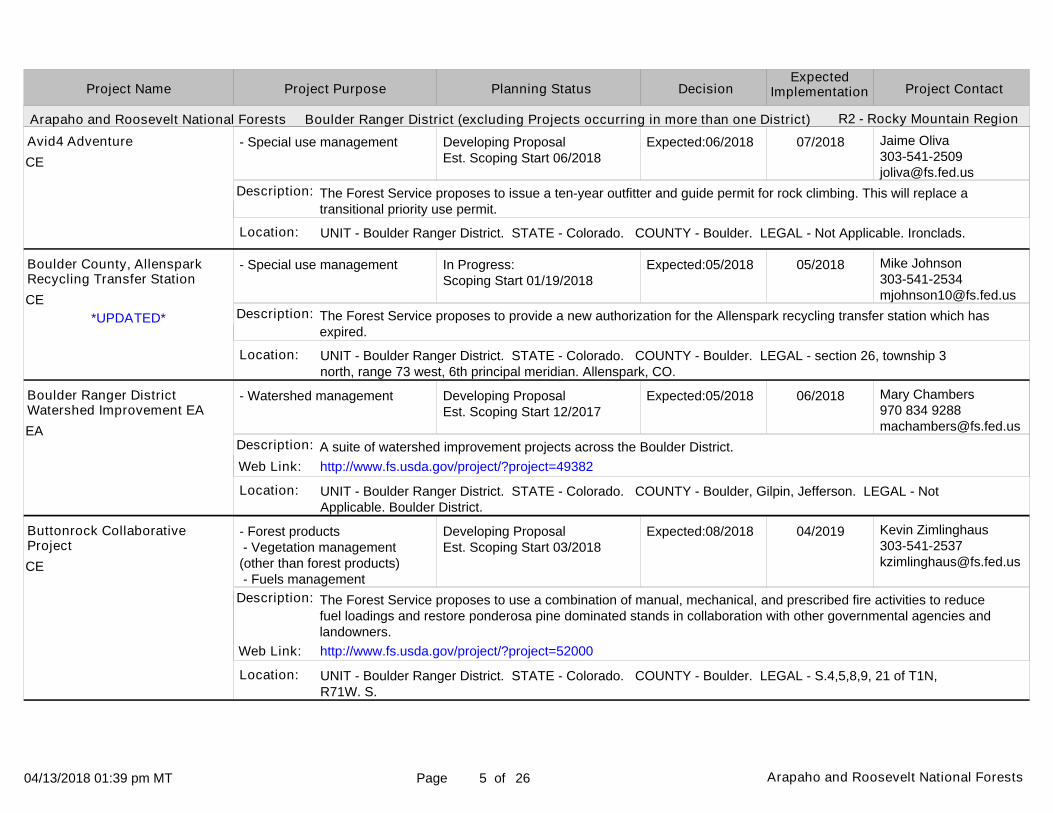
Avid4 Adventure
Boulder County, Allenspark Recycling Transfer Station
Boulder Ranger District Watershed Improvement EA
Buttonrock Collaborative Project
The Forest Service proposes to issue a ten-year outfitter and guide permit for rock climbing. This will replace a transitional priority use permit.
The Forest Service proposes to provide a new authorization for the Allenspark recycling transfer station which has expired.
A suite of watershed improvement projects across the Boulder District.
The Forest Service proposes to use a combination of manual, mechanical, and prescribed fire activities to reduce fuel loadings and restore ponderosa pine dominated stands in collaboration with other governmental agencies and landowners.
Description:
Description:
Description:
Description:
Web Link:
Web Link:
http://www.fs.usda.gov/project/?project=49382
http://www.fs.usda.gov/project/?project=52000
*UPDATED*
CE
CE
EA
CE

04/13/2018 01:39 pm MT Page of6 Arapaho and Roosevelt National Forests 26
Arapaho and Roosevelt National Forests Boulder Ranger District (excluding Projects occurring in more than one District)
Project PurposeProject Name DecisionPlanning Status Project ContactExpected
Implementation
R2 - Rocky Mountain Region
- Special use management
- Vegetation management (other than forest products)
- Special use management
- Special use management
In Progress:Scoping Start 08/15/2017
Developing ProposalEst. Scoping Start 01/2018
In Progress:Scoping Start 01/19/2018
Developing ProposalEst. Scoping Start 06/2018
Expected:08/2018
Expected:03/2018
Expected:04/2018
Expected:07/2018
Mike [email protected]
Kevin [email protected]
Mike [email protected]
Jaime [email protected]
UNIT - Boulder Ranger District. STATE - Colorado. COUNTY - Boulder. LEGAL - Not Applicable. Niwot Ridge.
UNIT - Boulder Ranger District. STATE - Colorado. COUNTY - Boulder. LEGAL - S.8,T1S,R72W. The unit is located north of Ridge Road on NFS lands approximately 2 miles northeast of Nederland.
UNIT - Boulder Ranger District. STATE - Colorado. COUNTY - Boulder. LEGAL - Not Applicable. Camp Dick area.
UNIT - Boulder Ranger District. STATE - Colorado. COUNTY - Boulder. LEGAL - Not Applicable. Forest Service system trails within and outside of the Indian Peaks Wilderness.
Location:
Location:
Location:
Location:
08/2018
05/2018
04/2018
08/2018
CU Mountain Research Station
Cold Springs Fire Tree Planting Project
Colorado Division of Water Resources stream gauge
Colorado Mountain Ranch
The Forest Service proposes to authorize the University of Colorado, Mountain Research Station, to use and maintain facilities on NFS land for research and to conduct research studies on NFS land.
The planting of tree seedlings in the Cold Springs Fire (approximately 100 acres).
The Forest Service proposes to issue a new special use authorization for a stream gauge. The previous authorization has expired.
The Forest Service proposes to issue a ten-year outfitting and guide permit for hiking. This will replace a transitional priority use permit.
Description:
Description:
Description:
Description:
Web Link:
Web Link:
http://www.fs.usda.gov/project/?project=50742
http://www.fs.usda.gov/project/?project=10692
*UPDATED*
CE
CE
CE
CE

04/13/2018 01:39 pm MT Page of7 Arapaho and Roosevelt National Forests 26
Arapaho and Roosevelt National Forests Boulder Ranger District (excluding Projects occurring in more than one District)
Project PurposeProject Name DecisionPlanning Status Project ContactExpected
Implementation
R2 - Rocky Mountain Region
- Special use management
- Special use management
- Special use management
- Special use management
Developing ProposalEst. Scoping Start 01/2018
Developing ProposalEst. Scoping Start 01/2018
On Hold
In Progress:Scoping Start 02/02/2018
Expected:08/2018
Expected:08/2018
N/A
Expected:06/2018
Mike [email protected]
Mike [email protected]
Jaime [email protected]
Mike [email protected]
UNIT - Boulder Ranger District. STATE - Colorado. COUNTY - Gilpin. LEGAL - Not Applicable. Lump Gulch.
UNIT - Boulder Ranger District. STATE - Colorado. COUNTY - Boulder. LEGAL - Not Applicable. various.
UNIT - Boulder Ranger District. STATE - Colorado. COUNTY - Boulder. LEGAL - Not Applicable. Southeast of Allenspark, Colorado.
UNIT - Boulder Ranger District. STATE - Colorado. COUNTY - Boulder. LEGAL - Not Applicable. Jamestown.
Location:
Location:
Location:
Location:
08/2018
08/2018
N/A
06/2018
FinLand (Gregg) Access
Heithold Access
Highlands Presbyterian Camp and Retreat Center
Hittle access
The Forest Service proposes to issue an authorization for the use and maintenance of a road for access to private property.
The Forest Service proposes to authorize Heithold to maintain a Forest Road for access to private property.
The Forest Service proposes to issue a ten-year outfitter and guide permit for hiking. This will replace a transitional priority use permit.
The Forest Service proposes to authorize access to private property.
Description:
Description:
Description:
Description:
Web Link:
Web Link:
http://www.fs.usda.gov/project/?project=51344
http://www.fs.usda.gov/project/?project=49761
*NEW LISTING*
CE
CE
CE
CE

04/13/2018 01:39 pm MT Page of8 Arapaho and Roosevelt National Forests 26
Arapaho and Roosevelt National Forests Boulder Ranger District (excluding Projects occurring in more than one District)
Project PurposeProject Name DecisionPlanning Status Project ContactExpected
Implementation
R2 - Rocky Mountain Region
- Vegetation management (other than forest products) - Fuels management
- Special use management
- Special use management
- Special use management
In Progress:Scoping Start 01/11/2018
In Progress:Scoping Start 01/19/2018
Developing ProposalEst. Scoping Start 10/2017
In Progress:Scoping Start 01/19/2018
Expected:08/2018
Expected:04/2018
Expected:09/2018
Expected:05/2018
Cambria [email protected]
Mike [email protected]
Mike [email protected]
Mike [email protected]
UNIT - Boulder Ranger District. STATE - Colorado. COUNTY - Boulder. LEGAL - Not Applicable. The project area is generally located southwest of Lyons, CO, south/east of Colorado State Highway 7 and west of U.S. Highway 36 adjacent to Boulder County Open Space, Heil Valley Ranch.
UNIT - Boulder Ranger District. STATE - Colorado. COUNTY - Boulder. LEGAL - Not Applicable. Sugarloaf area.
UNIT - Boulder Ranger District. STATE - Colorado. COUNTY - Boulder. LEGAL - Not Applicable. Sawmill Road area.
UNIT - Boulder Ranger District. STATE - Colorado. COUNTY - Boulder. LEGAL - Not Applicable. Mammoth Gulch area.
Location:
Location:
Location:
Location:
09/2018
04/2018
09/2018
05/2018
Ingersoll Collaborative Burn Project
Jay Midyette leach field reauthorization
Jeff and Andrea VanSambeek access
Larry and Di'Anna Clark access
In cooperation with Boulder County, the Boulder Ranger District is proposing to broadcast burn 28 acres of National Forest System (NFS) lands. Thinning of smaller diameter trees may be done before burning to reduce mortality of larger diameter trees.
The Forest Service proposes to issue a new special use authorization to continue using a leach field. The previousauthorization has expired.
The Forest Service proposes to issue a special use authorization to private property on a road that has been closed to public use.
The Forest Service proposes to issue a special use authorization for access to private property on an existing road
Description:
Description:
Description:
Description:
Web Link: http://www.fs.usda.gov/project/?project=53456
*NEW LISTING*
*UPDATED*
*UPDATED*
CE
CE
CE
CE

04/13/2018 01:39 pm MT Page of9 Arapaho and Roosevelt National Forests 26
Arapaho and Roosevelt National Forests Boulder Ranger District (excluding Projects occurring in more than one District)
Project PurposeProject Name DecisionPlanning Status Project ContactExpected
Implementation
R2 - Rocky Mountain Region
- Recreation management - Road management
- Special use management
- Special use management
- Special use management
Developing ProposalEst. Scoping Start 08/2018
In Progress:Scoping Start 01/19/2018
On Hold
On Hold
Expected:08/2019
Expected:04/2018
N/A
N/A
Matthew [email protected]
Mike [email protected]
Mike [email protected]
Mike [email protected]
UNIT - Boulder Ranger District. STATE - Colorado. COUNTY - Boulder. LEGAL - Not Applicable. T.2N., R71W., Sections 15,16,17,20,21,22,27,28,& 29.
UNIT - Boulder Ranger District. STATE - Colorado. COUNTY - Boulder. LEGAL - Not Applicable. Sugarloaf area.
UNIT - Boulder Ranger District. STATE - Colorado. COUNTY - Boulder. LEGAL - Section 21, T 1 S, R 73 W, 6th P.M. Eldora Townsite.
UNIT - Boulder Ranger District. STATE - Colorado. COUNTY - Boulder. LEGAL - Not Applicable. Castle Gulch in Lefthand Canyon.
Location:
Location:
Location:
Location:
08/2019
04/2018
N/A
N/A
Lefthand Motorized Roads & Trails Project
Margaret Eldredge water line
Pryor Water Transmission Line
Rabbitt Cabin and Access
The Forest Service proposes to analyze access and sustainable management to the Lefthand motorized roads andtrails area. Due to the 2013 flood, the motorized access into the motorized trails area were severely damaged and destroyed.
The Forest Service proposes to issue a new special use authorization for a spring box and water. The previous authorization has expired.
The Forest Service proposes to issue a new permit for a water transmission line.
The Forest Service proposes to authorize a cabin and access to the cabin for a period of 10 years while a permanent resolution to the encroachment is found.
Description:
Description:
Description:
Description:
Web Link:
Web Link:
Web Link:
http://www.fs.usda.gov/project/?project=51312
http://www.fs.usda.gov/project/?project=37965
http://www.fs.usda.gov/project/?project=49760
*UPDATED*
*UPDATED*
*UPDATED*
EA
CE
CE
CE

04/13/2018 01:39 pm MT Page of10 Arapaho and Roosevelt National Forests 26
Arapaho and Roosevelt National Forests Boulder Ranger District (excluding Projects occurring in more than one District)
Project PurposeProject Name DecisionPlanning Status Project ContactExpected
Implementation
R2 - Rocky Mountain Region
- Special use management
- Special use management
- Special use management
- Special use management
Developing ProposalEst. Scoping Start 04/2018
Developing ProposalEst. Scoping Start 06/2018
Developing ProposalEst. Scoping Start 06/2018
Developing ProposalEst. Scoping Start 04/2018
Expected:09/2018
Expected:07/2018
Expected:07/2019
Expected:09/2018
Mike [email protected]
Jaime [email protected]
Jaime [email protected]
Mike [email protected]
UNIT - Boulder Ranger District. STATE - Colorado. COUNTY - Boulder. LEGAL - Not Applicable. Jamestown area.
UNIT - Boulder Ranger District. STATE - Colorado. COUNTY - Boulder. LEGAL - Not Applicable. Taylor Mountain Trail #932; Bright Trail #921.
UNIT - Boulder Ranger District. STATE - Colorado. COUNTY - Boulder. LEGAL - T1 S, R73W, Sec 23, 24, 26, and 27. T1 S, R72W, Sec 9, 10, 16, 17, and 20. The project area is located in the West Magnolia area on FS System trails and roads. The area is 1 mile south of Nederland, CO, off of County Road 132 West and East, from the Peak to Peak Highway.
UNIT - Boulder Ranger District. STATE - Colorado. COUNTY - Boulder. LEGAL - Not Applicable. county road 100J.
Location:
Location:
Location:
Location:
09/2018
07/2018
08/2019
09/2018
Randy Oxley water line
Rocky Mountain Pathways Ranch
Singletrack Mountain Bike Adventures
Steve Barrow access
The Forest Service proposes to authorize the construction and use of a water line to provide water to private property
The Forest Service proposes to issue a ten-year outfitter and guide permit for hiking. This will replace a transitional priority use permit.
The US Forest Service proposes to issue a ten-year outfitter and guide permit for mountain biking. This will replace a transitional priority use permit.
The Forest Service proposes to issue a special use authorization for access to private property on an existing road.
Description:
Description:
Description:
Description:
Web Link: http://www.fs.usda.gov/project/?project=29881
*UPDATED*
*UPDATED*
CE
CE
CE
CE

04/13/2018 01:39 pm MT Page of11 Arapaho and Roosevelt National Forests 26
Arapaho and Roosevelt National Forests Boulder Ranger District (excluding Projects occurring in more than one District)
Project PurposeProject Name DecisionPlanning Status Project ContactExpected
Implementation
R2 - Rocky Mountain Region
- Special use management
- Special use management
- Special use management
- Special use management
On Hold
In Progress:Scoping Start 01/19/2018
Developing ProposalEst. Scoping Start 01/2018
Developing ProposalEst. Scoping Start 01/2018
N/A
Expected:05/2018
Expected:10/2018
Expected:10/2018
Jaime [email protected]
Mike [email protected]
Mike [email protected]
Mike [email protected]
UNIT - Boulder Ranger District. STATE - Colorado. COUNTY - Boulder. LEGAL - Sections 23, 24,26, and 27 of Township 1 south, Range 73W, 6th PM. One mile due south of the town of Nederland, CO, off of County Road 132 West, and west of the Peak to Peak Highway.
UNIT - Boulder Ranger District. STATE - Colorado. COUNTY - Boulder. LEGAL - section 26, township 3 north, range 73 west, 6th principal meridian. Allenspark, CO.
UNIT - Boulder Ranger District. STATE - Colorado. COUNTY - Gilpin. LEGAL - Not Applicable. Emory Road.
UNIT - Boulder Ranger District. STATE - Colorado. COUNTY - Gilpin. LEGAL - Not Applicable. various locations on Boulder Ranger District.
Location:
Location:
Location:
Location:
N/A
05/2018
10/2018
10/2018
Sundance Stables
The Old Gallery parking
Tregae Access
Watson septic tank
The Forest Service proposes to issue a ten-year outfitter and guide permit for horseback riding. This will replace a transitional priority use permit.
The Forest Service proposes to authorize parking for The Old Gallery near the Allenspark Recycling Transfer Station.
The Forest Service proposes to authorize use and maintenance of a Forest Road for access to private property
The Forest Service proposes to provide a new authorization for a septic system that has expired.
Description:
Description:
Description:
Description:
Web Link:
Web Link:
Web Link:
http://www.fs.usda.gov/project/?project=18634
http://www.fs.usda.gov/project/?project=51343
http://www.fs.usda.gov/project/?project=48446
*UPDATED*
CE
CE
CE
CE

04/13/2018 01:39 pm MT Page of12 Arapaho and Roosevelt National Forests 26
Arapaho and Roosevelt National Forests Boulder Ranger District (excluding Projects occurring in more than one District)
Arapaho and Roosevelt National Forests Canyon Lakes Ranger District (excluding Projects occurring in more than one District)
Project PurposeProject Name DecisionPlanning Status Project ContactExpected
Implementation
R2 - Rocky Mountain Region
R2 - Rocky Mountain Region
- Special use management
- Special use management
- Special use management
Developing ProposalEst. Scoping Start 06/2018
In Progress:Scoping Start 03/01/2018
Cancelled
Expected:07/2018
Expected:03/2019
N/A
Jaime [email protected]
Mike [email protected]
UNIT - Boulder Ranger District. STATE - Colorado. COUNTY - Boulder. LEGAL - Not Applicable. Forest Service system trails outside and within the Indian Peaks Wilderness.
UNIT - Boulder Ranger District. STATE - Colorado. COUNTY - Boulder, Gilpin. LEGAL - Not Applicable. Magnolia Road, down county road 97, down South Beaver Creek Road, down highway 119, down Dory Hill Road to Central City.
UNIT - Canyon Lakes Ranger District. STATE - Colorado. COUNTY - Larimer. LEGAL - Not Applicable. Pierson Park/Homestead Meadows area near Estes Park.
Location:
Location:
Location:
08/2018
03/2019
N/A
Wild Bear Center for Nature Discovery
Xcel Energy- Tungsten to Bobtail new gas line
Aspen Lodge Special Use Authorization
The Forest Service proposes to issue a ten-year outfitter and guide permit for hiking. This will replace a transitional priority use permit.
The Forest Service proposes to authorize the construction and use of a gas pipeline.
The Forest Service proposes to issue a new Priority Outfitter/Guide special use authorization for commercial guided horseback riding to replace an existing expiring authorization.
Description:
Description:
Description:
Web Link: http://www.fs.usda.gov/project/?project=32982
*UPDATED*
CE
CE
CE

04/13/2018 01:39 pm MT Page of13 Arapaho and Roosevelt National Forests 26
Arapaho and Roosevelt National Forests Canyon Lakes Ranger District (excluding Projects occurring in more than one District)
Project PurposeProject Name DecisionPlanning Status Project ContactExpected
Implementation
R2 - Rocky Mountain Region
- Watershed management - Special use management - Road management
- Special use management
- Special use management
In Progress:Scoping Start 08/10/2017Est. Comment Period Public Notice 10/2017
Developing ProposalEst. Scoping Start 01/2018
In Progress:Scoping Start 01/01/2018
Expected:02/2018
Expected:08/2018
Expected:05/2018
Michele [email protected]
Michele [email protected]
UNIT - Canyon Lakes Ranger District. STATE - Colorado. COUNTY - Larimer. LEGAL - Township 7 North, Range 71 West, sections 16, 17,18 and T. 7N., R72W., sections 13, 14. Buckhorn road, northwest of Masonville CO.
UNIT - Canyon Lakes Ranger District. STATE - Colorado. COUNTY - Larimer. LEGAL - Not Applicable. Located off Colorado Highway 36, Township 4 North, 71 and 72 West. Accesses Big Elk Meadows subdivision and Forest land.
UNIT - Canyon Lakes Ranger District. STATE - Colorado. COUNTY - Larimer. LEGAL - Not Applicable. area in/around Comanche Peak Wilderness for deer, elk hunts; all NFS lands on CLRD (except Comanche Peak, Neota, Rawah wildernesses) for mtn. lion hunts; as approved for bighorn sheep, moose hunts.
Location:
Location:
Location:
03/2018
09/2018
06/2018
Authorization for County Road 44H Reconstruction
Authorization for Larimer County Road 47 Reconstruction
Comanche Wilderness Outfitters Special Use Authorization
The Forest Service proposes to authorize Larimer County to reconstruct CR 44H ("Buckhorn road"), which was damaged in the flood of September 2013. Larimer County has an easement and segments of the road on NFS land are proposed to be realigned.
Due to the 2013 flood, county road 47 was damaged. The Forest Service proposes to issue a temporary road construction permit with an operation plan to allow for staging areas and after construction an easement would be issued to Larimer County.
The Forest Service proposes to issue a new Priority Outfitter/Guide special use authorization for commercial guided hunting to replace an existing expiring authorization.
Description:
Description:
Description:
Web Link:
Web Link:
Web Link:
http://www.fs.usda.gov/project/?project=50401
http://www.fs.usda.gov/project/?project=46614
http://www.fs.usda.gov/project/?project=53103
EA
CE
CE

04/13/2018 01:39 pm MT Page of14 Arapaho and Roosevelt National Forests 26
Arapaho and Roosevelt National Forests Canyon Lakes Ranger District (excluding Projects occurring in more than one District)
Project PurposeProject Name DecisionPlanning Status Project ContactExpected
Implementation
R2 - Rocky Mountain Region
- Land ownership management
- Wildlife, Fish, Rare plants - Vegetation management (other than forest products) - Fuels management
- Special use management
In Progress:Comment Period Public Notice 02/10/2016
In Progress:Scoping Start 02/11/2018
In Progress:Scoping Start 01/01/2018
Expected:07/2018
Expected:08/2018
Expected:04/2018
Patti [email protected]
Cambria [email protected]
UNIT - Canyon Lakes Ranger District. STATE - Colorado. COUNTY - Larimer. LEGAL - Township 5 North, Range 72 West,secs. 3, 10; T.6N,R71W, secs. 31, 32, 36 (Forest Service lands); T.5N, R72W, sec.2; T.7N, R72W, sec.14; T6N,R72W, secs. 9,10,15; T6N,R71W, sec. 32 (Non-Federal lands). Proposed exchange parcels are west of Drake, Colorado and east of Estes Park, CO; one parcel is located off Buckhorn road (County road 44H) along Crystal Mtn road.
UNIT - Canyon Lakes Ranger District. STATE - Colorado. COUNTY - Larimer. LEGAL - Not Applicable. The project is located near the community of Red Feather Lakes, CO. It is generally located south of Larimer County Road (LCR) 67J, east of LCR 69, north of LCR 68C, and west of LCR 74E.
UNIT - Canyon Lakes Ranger District. STATE - Colorado. COUNTY - Larimer. LEGAL - Not Applicable. Rawah Wilderness and adjacent areas.
Location:
Location:
Location:
12/2018
09/2018
05/2018
Husted-Maitland Land Exchange
Magic Feather Collaborative Project
Outward Bound Special Use Authorization
The Forest Service proposes an exchange of approx. 356 acres of Forest Service System land for approx. 367 acres of non-Federal land including a public trail easement.
In cooperation with the NRCS, TNC, and Coalition for the Poudre River Watershed, the Canyon Lakes Ranger District is proposing to broadcast burn 2,791 acres of National Forest System (NFS) lands and 1,113 acres of non-NFS lands.
The Forest Service proposes to issue a new Priority Outfitter/Guide special use authorization for commercial backpacking to replace an existing expiring authorization.
Description:
Description:
Description:
Web Link:
Web Link:
Web Link:
http://www.fs.usda.gov/project/?project=48335
http://www.fs.usda.gov/project/?project=52945
http://www.fs.usda.gov/project/?project=53104
*UPDATED*
*UPDATED*
EA
CE
CE

04/13/2018 01:39 pm MT Page of15 Arapaho and Roosevelt National Forests 26
Arapaho and Roosevelt National Forests Canyon Lakes Ranger District (excluding Projects occurring in more than one District)
Project PurposeProject Name DecisionPlanning Status Project ContactExpected
Implementation
R2 - Rocky Mountain Region
- Recreation management - Watershed management
- Special use management
- Wildlife, Fish, Rare plants - Forest products - Vegetation management (other than forest products) - Fuels management
On Hold
On Hold
Developing ProposalEst. Scoping Start 03/2018
N/A
N/A
Expected:04/2019
Kevin [email protected]
Cambria [email protected]
UNIT - Canyon Lakes Ranger District. STATE - Colorado. COUNTY - Larimer. LEGAL - Not Applicable. Trailswithin flood-impacted area on CLRD.
UNIT - Canyon Lakes Ranger District. STATE - Colorado. COUNTY - Larimer. LEGAL - various. Estes Park area.
UNIT - Canyon Lakes Ranger District. STATE - Colorado. COUNTY - Larimer. LEGAL - Not Applicable. The Roaring Creek Project Area is located in the western portion of the Canyon Lakes RD. It is bound by the Laramie River on the west, the Cache la Poudre River on the south.
Location:
Location:
Location:
N/A
N/A
05/2019
Post-Flood Trail Restoration
Ravencrest Chalet Special Use Authorization
Roaring Creek Project
The Forest Service proposes to repair, reconstruct and restore flood-impacted trails on CLRD including but not limited to Fox Creek, West Creek and Homestead Meadows.
The Forest Service proposes to issue a Priority Outfitter/Guide special use authorization for hiking, backpacking, rock climbing/rapelling and mountain biking to replace an existing expired Temporary authorization.
The Forest Service proposes vegetation management activities in the Roaring Creek project area for the purposes of providing economic timber projects, improving forest health, reducing hazardous fuels, maintaining wildlife habitat and meadows.
Description:
Description:
Description:
Web Link:
Web Link:
http://www.fs.usda.gov/project/?project=47240
http://www.fs.usda.gov/project/?project=44599
*UPDATED*
CE
CE
EA

04/13/2018 01:39 pm MT Page of16 Arapaho and Roosevelt National Forests 26
Arapaho and Roosevelt National Forests Canyon Lakes Ranger District (excluding Projects occurring in more than one District)
Project PurposeProject Name DecisionPlanning Status Project ContactExpected
Implementation
R2 - Rocky Mountain Region
- Special use management
- Special use management
- Special use management
In Progress:NOI in Federal Register 02/01/2006Est. DEIS NOA in Federal Register 09/2018
On Hold
In Progress:Scoping Start 01/14/2018
Expected:06/2020
N/A
Expected:04/2018
Leslie [email protected]
Katie [email protected]
Leslie [email protected]
UNIT - Canyon Lakes Ranger District. STATE - Colorado. COUNTY - Larimer. LEGAL - Sects. 28 & 33, T9N, R70W. Northwest of Fort Collins, Colorado, in Larimer County.
UNIT - Canyon Lakes Ranger District. STATE - Colorado. COUNTY - Larimer. LEGAL - Township 6 North, Range 71 West, sections 21, 27, 34 and 35. West of Drake, Colorado off of County Road 43.
UNIT - Canyon Lakes Ranger District. STATE - Colorado. COUNTY - Larimer. LEGAL - T8N, R75W, Sec 16, 6th PM. East portal of Laramie-Poudre Tunnel location along highway 14, near Tunnel Picnic Area.
Location:
Location:
Location:
05/2029
N/A
09/2018
Seaman Reservoir Water Management Project
Storm Mountain Public Improvement District Number 55 Road Authorization
Tunnel Water Company - Access Road Relocation for Laramie-Poudre Tunnel Repairs.
The Forest Service proposes to issue an authorization for the expansion of Seaman Reservoir (City of Greeley) and location of a portion of a new dam on NFS lands
The Forest Service proposes to issue a special use road authorization to these two entities for use and maintenance of Forest roads accessing these subdivisions.
The Forest Service proposes to authorize relocation of a road used by Tunnel Water Company to access the east portal of Laramie-Poudre Tunnel. Existing road is too steep to accommodate equipment necessary for previously authorized repair work.
Description:
Description:
Description:
Web Link:
Web Link:
http://www.fs.usda.gov/project/?project=40823
http://www.fs.usda.gov/project/?project=53565
*UPDATED*
*NEW LISTING*
EIS
CE
CE

04/13/2018 01:39 pm MT Page of17 Arapaho and Roosevelt National Forests 26
Arapaho and Roosevelt National Forests Canyon Lakes Ranger District (excluding Projects occurring in more than one District)
Arapaho and Roosevelt National Forests Clear Creek Ranger District (excluding Projects occurring in more than one District)
Project PurposeProject Name DecisionPlanning Status Project ContactExpected
Implementation
R2 - Rocky Mountain Region
R2 - Rocky Mountain Region
- Special use management
- Special use management
- Special use management
On Hold
In Progress:DEIS NOA in Federal Register 09/19/2014Est. FEIS NOA in Federal Register 02/2018
In Progress:Scoping Start 01/19/2018
N/A
Expected:02/2018
Expected:07/2018
Katie [email protected]
Katie [email protected]
Patti [email protected]
UNIT - Canyon Lakes Ranger District. STATE - Colorado. COUNTY - Larimer. LEGAL - T7N, R73W, Secs. 21 and 28. Twin Lakes Reservoir.
UNIT - Canyon Lakes Ranger District. STATE - Colorado. COUNTY - Larimer. LEGAL - Township 5North, Range 71W, sec. 27 and Township 5 North, Range 72West, secs. 26, 34, 35. Estes Park to Lyons - line segmentson Forest is Pole Hill area.
UNIT - Clear Creek Ranger District. STATE - Colorado. COUNTY - Clear Creek. LEGAL - Sec 2, T5S, R75W.Leavenworth area, off of Guanella Pass Road.
Location:
Location:
Location:
N/A
03/2018
08/2018
Water Facility Easement for Twin Lake Reservoir
Western Area Power Administration (Western) Estes-Flat Iron Proposed Transmission Line Rebuild
Access Driveway
The Forest Service proposes to convert a special use permit to an easement for the City of Greeley for operation of Twin Lake Reservoir and the diversion ditch on Pennock Creek. There is no anticipated change to the existing use.
The Forest Service will analyze Western's proposal to remove a115 kV line and rebuild a115 kv line both of which are authorized under special use permits. These parallel lines cross approx.imately 3.8 miles of National Forest System lands.
The Forest Service proposes to approve the construction, use and maintenance of a 250' by 12'access driveway toreach private property.
Description:
Description:
Description:
Web Link: http://ww2.wapa.gov/sites/western/transmission/infrastruct/Pages/Estes-Flatiron.aspx
*NEW LISTING*
CE
EIS
CE

04/13/2018 01:39 pm MT Page of18 Arapaho and Roosevelt National Forests 26
Arapaho and Roosevelt National Forests Clear Creek Ranger District (excluding Projects occurring in more than one District)
Project PurposeProject Name DecisionPlanning Status Project ContactExpected
Implementation
R2 - Rocky Mountain Region
- Special use management
- Special use management
- Special use management
- Special use management
In Progress:Scoping Start 01/19/2018
In Progress:Scoping Start 01/19/2018
In Progress:Scoping Start 01/02/2017
Developing ProposalEst. Scoping Start 09/2018
Expected:04/2018
Expected:04/2018
Expected:07/2017
Expected:11/2018
Patti [email protected]
Patti [email protected]
Leslie [email protected]
UNIT - Clear Creek Ranger District. STATE - Colorado. COUNTY - Clear Creek. LEGAL - T3S, R73W, Sections 3 & 4. Columbine Campground Area.
UNIT - Clear Creek Ranger District. STATE - Colorado. COUNTY - Gilpin. LEGAL - T3S, R73W, sec 10. Bald Mountain.
UNIT - Clear Creek Ranger District. STATE - Colorado. COUNTY - Gilpin. LEGAL - T3S., R73W, Sec 5, 6th P.M., T2S., R73W., Sec 31, 6th P.M. Broomfield Gulch and Pecks Gulch.
UNIT - Clear Creek Ranger District. STATE - Colorado. COUNTY - Clear Creek, Gilpin. LEGAL - Not Applicable. All of Clear Creek Ranger District.
Location:
Location:
Location:
Location:
05/2018
05/2018
07/2017
12/2018
Access Road
Bald Mountain Cemetery
Central City Water Collection System Upgrade
Colorado Mountain Club Special Use Authorization for Outfitting and Guiding
The Forest Service proposes to approve the use of an existing road to access private property.
The Forest Service proposes to approve the continued use and maintenance of the Bald Mountain Cemetery.
The Forest Service proposes to allow Central City to upgrade or replace two existing water diversion and collectionstructures located on National Forest System lands under their current authorization.
The Forest Service proposes to issue a 10 year outfitter and guide permit for environmental education, including avalanche awareness, snow travel, and rock climbing. This replaces a transitional priority permit.
Description:
Description:
Description:
Description:
Web Link:
Web Link:
http://www.fs.usda.gov/project/?project=50906
http://www.fs.usda.gov/project/?project=49001
*NEW LISTING*
*NEW LISTING*
*UPDATED*
CE
CE
CE
CE

04/13/2018 01:39 pm MT Page of19 Arapaho and Roosevelt National Forests 26
Arapaho and Roosevelt National Forests Clear Creek Ranger District (excluding Projects occurring in more than one District)
Project PurposeProject Name DecisionPlanning Status Project ContactExpected
Implementation
R2 - Rocky Mountain Region
- Vegetation management (other than forest products)
- Special use management
- Special use management
- Special use management
Developing ProposalEst. Scoping Start 01/2018
In Progress:Scoping Start 06/16/2017
In Progress:Scoping Start 01/19/2018
On Hold
Expected:02/2018
Expected:03/2018
Expected:04/2018
N/A
Kevin [email protected]
Patti [email protected]
Leslie [email protected]
UNIT - Clear Creek Ranger District. STATE - Colorado. COUNTY - Jefferson. LEGAL - S.32, T5S, R71W. The units are located on NFS lands north of South Warhawk Drive near Conifer in units from The units were cut and cut as a result of the Evergreen Fuel Reduction Project (decision 9/2004).
UNIT - Clear Creek Ranger District. STATE - Colorado. COUNTY - Clear Creek. LEGAL - T5S, R76W, Sec 28. T5S, R76W, Sec 28.
UNIT - Clear Creek Ranger District. STATE - Colorado. COUNTY - Clear Creek. LEGAL - T3S, R75W, Section 10. Mines Peak off of Berthoud Pass.
UNIT - Clear Creek Ranger District. STATE - Colorado. COUNTY - Clear Creek. LEGAL - T3S, R73W, Sec 18 and T3S, R74W, Sec 13, 6th P.M. Northwest of Dumont.
Location:
Location:
Location:
Location:
05/2018
05/2018
08/2018
N/A
Evergreen Tree Planting
Loveland Ski Area Lift 1 Replacement.
Mine's Peak Cell Tower
Old Mine Road Association Right-of-Way
The planting of seedlings in approximately 25 acres where the units did not meet NFMA stocking requirements.
The Forest Service proposes to approve Clear Creek Ski Corporation (Loveland Ski Areas) replacement of lift 1. The current triple fixed grip lift will be replaced with a detachable quad.
The Forest Service proposes to approve the construction, operation and maintenance for a new 85' commercial cell tower on Mines Peak. Only a tower will be constructed, associated equipment will be installed in the existing building.
The Forest Service proposes to issue Old Mine Road Association a Right-of-Way for an existing road to access private property. The road is not identified on the Motor Vehicle Use Map as an open public road.
Description:
Description:
Description:
Description:
Web Link:
Web Link:
http://www.fs.usda.gov/project/?project=53371
http://www.fs.usda.gov/project/?project=52227
*NEW LISTING*
*NEW LISTING*
*UPDATED*
CE
CE
CE
CE
04/13/2018 01:39 pm MT Page of20 Arapaho and Roosevelt National Forests 26
Arapaho and Roosevelt National Forests Clear Creek Ranger District (excluding Projects occurring in more than one District)
Project PurposeProject Name DecisionPlanning Status Project ContactExpected
Implementation
R2 - Rocky Mountain Region
- Recreation management - Special use management
- Special use management
- Minerals and Geology
Developing ProposalEst. Scoping Start 06/2018
On Hold
In Progress:Scoping Start 05/01/2017
Expected:11/2018
N/A
Expected:11/2017
Patti [email protected]
Leslie [email protected]
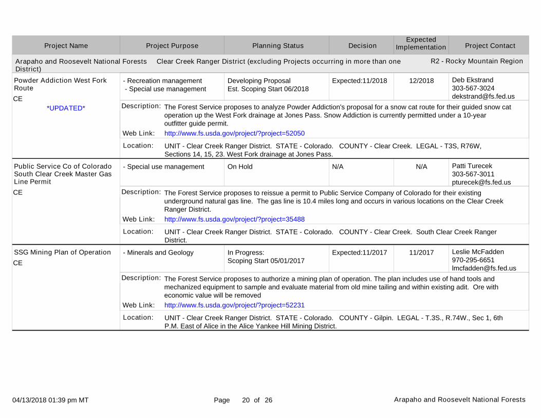
UNIT - Clear Creek Ranger District. STATE - Colorado. COUNTY - Clear Creek. LEGAL - T3S, R76W, Sections 14, 15, 23. West Fork drainage at Jones Pass.
UNIT - Clear Creek Ranger District. STATE - Colorado. COUNTY - Clear Creek. South Clear Creek Ranger District.
UNIT - Clear Creek Ranger District. STATE - Colorado. COUNTY - Gilpin. LEGAL - T.3S., R.74W., Sec 1, 6thP.M. East of Alice in the Alice Yankee Hill Mining District.
Location:
Location:
Location:
12/2018
N/A
11/2017
Powder Addiction West Fork Route
Public Service Co of Colorado South Clear Creek Master Gas Line Permit
SSG Mining Plan of Operation
The Forest Service proposes to analyze Powder Addiction's proposal for a snow cat route for their guided snow catoperation up the West Fork drainage at Jones Pass. Snow Addiction is currently permitted under a 10-year outfitter guide permit.
The Forest Service proposes to reissue a permit to Public Service Company of Colorado for their existing underground natural gas line. The gas line is 10.4 miles long and occurs in various locations on the Clear Creek Ranger District.
The Forest Service proposes to authorize a mining plan of operation. The plan includes use of hand tools and mechanized equipment to sample and evaluate material from old mine tailing and within existing adit. Ore with economic value will be removed
Description:
Description:
Description:
Web Link:
Web Link:
Web Link:
http://www.fs.usda.gov/project/?project=52050
http://www.fs.usda.gov/project/?project=35488
http://www.fs.usda.gov/project/?project=52231
*UPDATED*CE
CE
CE

04/13/2018 01:39 pm MT Page of21 Arapaho and Roosevelt National Forests 26
Arapaho and Roosevelt National Forests Clear Creek Ranger District (excluding Projects occurring in more than one District)
Arapaho and Roosevelt National Forests Pawnee Ranger District (excluding Projects occurring in more than one District)
Project PurposeProject Name DecisionPlanning Status Project ContactExpected
Implementation
R2 - Rocky Mountain Region
R2 - Rocky Mountain Region
- Special use management
- Special use management
- Special use management
- Special use management
In Progress:Scoping Start 09/12/2016
In Progress:Scoping Start 04/15/2016
Developing ProposalEst. Scoping Start 09/2018
In Progress:Scoping Start 01/19/2018
Expected:07/2017
Expected:03/2018
Expected:11/2018
Expected:04/2018
Leslie [email protected]
Leslie [email protected]
Patti [email protected]
UNIT - Clear Creek Ranger District. STATE - Colorado. COUNTY - Clear Creek. LEGAL - T.3 S., R.75 W., Sec. 10, 6th P.M. Mines Peak Communication Site.
UNIT - Clear Creek Ranger District. STATE - Colorado. COUNTY - Clear Creek. LEGAL - Not Applicable. Loch Lomond.
UNIT - Clear Creek Ranger District. STATE - Colorado. COUNTY - Clear Creek, Gilpin. LEGAL - Not Applicable. Clear Creek Ranger District.
UNIT - Clear Creek Ranger District. STATE - Colorado. COUNTY - Clear Creek. LEGAL - T4S, R72, Section WNE 10. Soda Creek Road.
Location:
Location:
Location:
Location:
07/2017
03/2018
12/2018
05/2018
State of Colorado - Mines Peak Communication Site
The Agricultural Ditch and Reservoir Company Access to Loch Lomond Reservoirs
Turner Services Special Use Authorization for Outfitting and Guiding Services
Well and Pipeline
The Forest Service proposes to issue a new communication site lease to replace the expired lease for an existing facility. No changes to the operation or facilities are planned.
The Forest Service proposes to issue a private road easement or special use permit to the Agricultural Ditch Company to provide access to their existing Loch Lomond Group of Resevoirs.
The Forest Service proposes to issue a 10 year outfitter and guide permit for hunting on specific game units and ATV tours on system roads. This replaces a transitional priority permit.
The Forest Service proposes to approve the continued use of an existing well and pipeline to serve a residence.
Description:
Description:
Description:
Description:
Web Link: http://www.fs.usda.gov/project/?project=49002*UPDATED*
*NEW LISTING*
CE
CE
CE
CE
04/13/2018 01:39 pm MT Page of22 Arapaho and Roosevelt National Forests 26
Arapaho and Roosevelt National Forests Pawnee Ranger District (excluding Projects occurring in more than one District)
Arapaho and Roosevelt National Forests Sulphur Ranger District (excluding Projects occurring in more than one District)
Project PurposeProject Name DecisionPlanning Status Project ContactExpected
Implementation
R2 - Rocky Mountain Region
R2 - Rocky Mountain Region
- Wildlife, Fish, Rare plants
- Minerals and Geology
- Special use management
- Special use management
Completed
In Progress:Comment Period Public Notice 10/26/2017
In Progress:Scoping Start 11/01/2016
On Hold
Actual: 10/13/2006
Expected:05/2018
Expected:04/2018
N/A
Elizabeth [email protected]
Vernon [email protected]
Deanna [email protected]
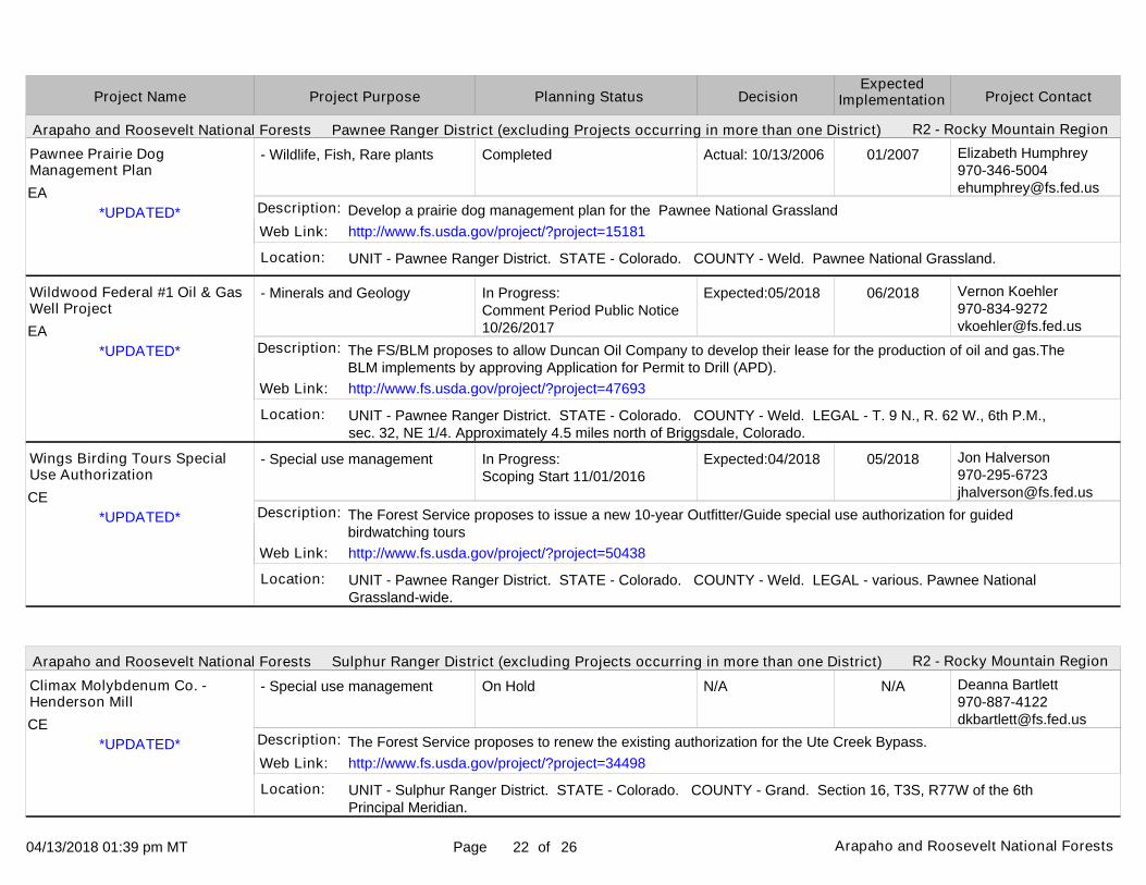
UNIT - Pawnee Ranger District. STATE - Colorado. COUNTY - Weld. Pawnee National Grassland.
UNIT - Pawnee Ranger District. STATE - Colorado. COUNTY - Weld. LEGAL - T. 9 N., R. 62 W., 6th P.M., sec. 32, NE 1/4. Approximately 4.5 miles north of Briggsdale, Colorado.
UNIT - Pawnee Ranger District. STATE - Colorado. COUNTY - Weld. LEGAL - various. Pawnee National Grassland-wide.
UNIT - Sulphur Ranger District. STATE - Colorado. COUNTY - Grand. Section 16, T3S, R77W of the 6th Principal Meridian.
Location:
Location:
Location:
Location:
01/2007
06/2018
05/2018
N/A
Pawnee Prairie Dog Management Plan
Wildwood Federal #1 Oil & Gas Well Project
Wings Birding Tours Special Use Authorization
Climax Molybdenum Co. - Henderson Mill
Develop a prairie dog management plan for the Pawnee National Grassland
The FS/BLM proposes to allow Duncan Oil Company to develop their lease for the production of oil and gas.The BLM implements by approving Application for Permit to Drill (APD).
The Forest Service proposes to issue a new 10-year Outfitter/Guide special use authorization for guided birdwatching tours
The Forest Service proposes to renew the existing authorization for the Ute Creek Bypass.
Description:
Description:
Description:
Description:
Web Link:
Web Link:
Web Link:
Web Link:
http://www.fs.usda.gov/project/?project=15181
http://www.fs.usda.gov/project/?project=47693
http://www.fs.usda.gov/project/?project=50438
http://www.fs.usda.gov/project/?project=34498
*UPDATED*
*UPDATED*
*UPDATED*
*UPDATED*
EA
EA
CE
CE

04/13/2018 01:39 pm MT Page of23 Arapaho and Roosevelt National Forests 26
Arapaho and Roosevelt National Forests Sulphur Ranger District (excluding Projects occurring in more than one District)
Project PurposeProject Name DecisionPlanning Status Project ContactExpected
Implementation
R2 - Rocky Mountain Region
- Special use management
- Special use management
- Special use management - Road management
- Recreation management - Special use management
On Hold
In Progress:Scoping Start 10/25/2017
On Hold
Developing ProposalEst. Scoping Start 04/2018
N/A
Expected:05/2018
N/A
Expected:05/2018
Deanna [email protected]
Deanna [email protected]
Deanna [email protected]
Matthew [email protected]
UNIT - Sulphur Ranger District. STATE - Colorado. COUNTY - Grand. Section 16, T3S, R77W of the 6th Principal Meridian.
UNIT - Sulphur Ranger District. STATE - Colorado. COUNTY - Grand. LEGAL - sec. 23, T. 2S., R. 75W., 6th Principal Meridian, Grand County, CO. Hwy. 40, Fraser River Sediment Pond.
UNIT - Sulphur Ranger District. STATE - Colorado. COUNTY - Grand. Darling Creek Road, at the head of the William's Fork drainage.
UNIT - Sulphur Ranger District. STATE - Colorado. COUNTY - Grand. LEGAL - sec. 34, T2S R75W, 6th PM, Grand County, CO. North side of 1st Creek drainage approximately 1/2 mile west of US Hwy. 40.
Location:
Location:
Location:
Location:
N/A
05/2018
N/A
08/2018
Climax Molybdenum Co. - Henderson Mill Right-of-Entry Parcel Authorization
Colorado Department of Transportation (CDOT) Fraser Sediment Pond Project Permit Reissuance
Denver Water Road Authorization-Darling Creek Road
Grand Huts 1st Creek Cabin
The Forest Service proposes to authorize a small parcel of land for right-of-way entry purposes adjacent to Henderson subsurface operations.
The Forest Service is proposing to reissue a new special use permit to CDOT for continued operation and maintenance of the Fraser River Sediment Pond for activities occurring outside of the existing highway easement.
Forest Service proposes to issue a special use authorization for the Darling Creek Road. Decision on hold pending roadless issue resolution.
The Forest Service proposes to issue an authorization for the preservation and maintenance of the existing 1st Creek Cabin and reconstruct and designate a user created trail from an existing trailhead to the cabin.
Description:
Description:
Description:
Description:
Web Link: http://www.fs.usda.gov/project/?project=51297*UPDATED*
*NEW LISTING*
CE
CE
CE
CE

04/13/2018 01:39 pm MT Page of24 Arapaho and Roosevelt National Forests 26
Arapaho and Roosevelt National Forests Sulphur Ranger District (excluding Projects occurring in more than one District)
Project PurposeProject Name DecisionPlanning Status Project ContactExpected
Implementation
R2 - Rocky Mountain Region
- Special use management
- Special use management
- Vegetation management (other than forest products)
In Progress:Scoping Start 09/06/2013
Developing ProposalEst. Scoping Start 04/2018
In Progress:Scoping Start 02/16/2018
Expected:10/2018
Expected:05/2018
Expected:07/2018
Deanna [email protected]
Matthew [email protected]
Kevin [email protected]
UNIT - Sulphur Ranger District. STATE - Colorado. COUNTY - Grand. LEGAL - Not Applicable. Winter Park Resort.
UNIT - Sulphur Ranger District. STATE - Colorado. COUNTY - Grand. LEGAL - Not Applicable. Sulphur Ranger District roads and trails.
UNIT - Sulphur Ranger District. STATE - Colorado. COUNTY - Grand. LEGAL - Sections 19, 20, 28-32, T4N R77W, and Sections 24, 25, 26, 35 and 36,T4N R78W, 6th PM, Grand County, Colorado. Sulphur Ranger District of the Arapaho National Forest in Grand County, Colorado, approximately 10 miles northwest of Granby, Colorado.
Location:
Location:
Location:
10/2018
06/2018
07/2019
Intrawest/Winter Park Operations Corp. Distributed Antenna System
Issuance of Recreation Special Use Permits for Outfitting and Guiding
Kauffman Creek Vegetation Management Project
The Forest Service proposes to issue an authorization to Intrawest/Winter Park Operations Corp. to install, operateand maintain a distributed antenna system to enhance cellualar coverage at Snoasis and Lunch Rock buildings at Winter Park Resort.
The Forest Service proposes to issue priority Outfitting and Guiding special use authorizations for horseback riding, kayaking, canoeing, stand-up paddle boarding, hiking, backpacking and fishing.
The Forest Service proposes to salvage approximately 1,600 acres of standing dead lodgepole pine trees, which are a result of widespread mountain pine beetle.
Description:
Description:
Description:
Web Link: http://www.fs.usda.gov/project/?project=42852
*NEW LISTING*
*NEW LISTING*
CE
CE
CE
04/13/2018 01:39 pm MT Page of25 Arapaho and Roosevelt National Forests 26
Arapaho and Roosevelt National Forests Sulphur Ranger District (excluding Projects occurring in more than one District)
Project PurposeProject Name DecisionPlanning Status Project ContactExpected
Implementation
R2 - Rocky Mountain Region
- Recreation management - Wildlife, Fish, Rare plants - Watershed management
- Special use management
- Wildlife, Fish, Rare plants - Fuels management
- Special use management
In Progress:Scoping Start 12/15/2016Est. Comment Period Public Notice 05/2018
Cancelled
On Hold
On Hold
Expected:03/2019
N/A
N/A
N/A
Eric [email protected]
Matthew [email protected]
Kevin [email protected]
Deanna [email protected]
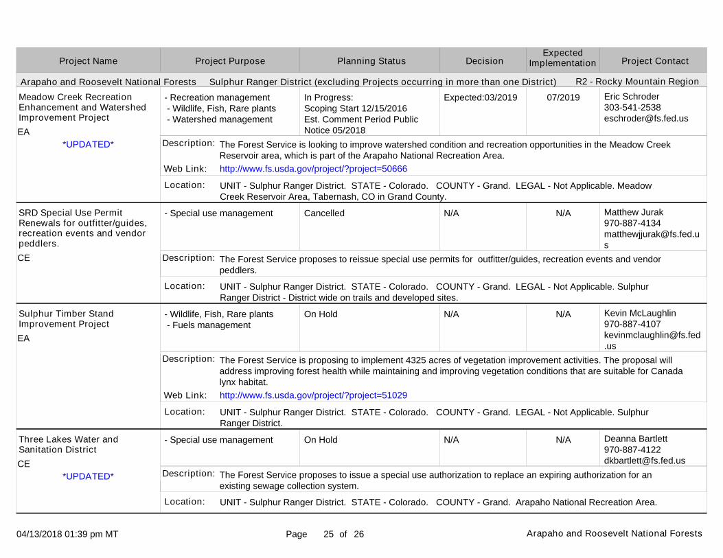
UNIT - Sulphur Ranger District. STATE - Colorado. COUNTY - Grand. LEGAL - Not Applicable. Meadow Creek Reservoir Area, Tabernash, CO in Grand County.
UNIT - Sulphur Ranger District. STATE - Colorado. COUNTY - Grand. LEGAL - Not Applicable. Sulphur Ranger District - District wide on trails and developed sites.
UNIT - Sulphur Ranger District. STATE - Colorado. COUNTY - Grand. LEGAL - Not Applicable. Sulphur Ranger District.
UNIT - Sulphur Ranger District. STATE - Colorado. COUNTY - Grand. Arapaho National Recreation Area.
Location:
Location:
Location:
Location:
07/2019
N/A
N/A
N/A
Meadow Creek Recreation Enhancement and Watershed Improvement Project
SRD Special Use Permit Renewals for outfitter/guides, recreation events and vendor peddlers.
Sulphur Timber Stand Improvement Project
Three Lakes Water and Sanitation District
The Forest Service is looking to improve watershed condition and recreation opportunities in the Meadow Creek Reservoir area, which is part of the Arapaho National Recreation Area.
The Forest Service proposes to reissue special use permits for outfitter/guides, recreation events and vendor peddlers.
The Forest Service is proposing to implement 4325 acres of vegetation improvement activities. The proposal will address improving forest health while maintaining and improving vegetation conditions that are suitable for Canadalynx habitat.
The Forest Service proposes to issue a special use authorization to replace an expiring authorization for an existing sewage collection system.
Description:
Description:
Description:
Description:
Web Link:
Web Link:
http://www.fs.usda.gov/project/?project=50666
http://www.fs.usda.gov/project/?project=51029
*UPDATED*
*UPDATED*
EA
CE
EA
CE

04/13/2018 01:39 pm MT Page of26 Arapaho and Roosevelt National Forests 26
The U.S. Department of Agriculture (USDA) prohibits discrimination in all its programs and activities on the basis of race, color, national origin, age, disability, and where applicable, sex, marital status, familial status, parental status, religion, sexual orientation, genetic information, political beliefs, reprisal, or because all or part of an individual's income is derived from any public assistance program. (Not all prohibited bases apply to all programs.) Persons with disabilities who require alternative means for communication of program information (Braille, large print, audiotape, etc.) should contact USDA's TARGET Center at (202) 720-2600 (voice and TDD).
To file a complaint of discrimination, write USDA, Director, Office of Civil Rights, 1400 Independence Avenue, SW, Washington, DC 20250-9410 or call (800) 795-3272 (voice) or (202) 720-6382 (TDD). USDA is an equal opportunity provider and employer.
This report contains the best available information at the time of publication. Questions may be directed to the Project Contact.
Project PurposeProject Name DecisionPlanning Status Project ContactExpected
Implementation
Recommended