SANTAQUIN CITY TRAIL CORRIDOR AND RIGHT OF WAY DESIGN
Project ID: CEEn_2016CPST_010
by
Silverstone Engineering & Surveying Savannah Keane
Joel Whitmer Clay Hansen
Brandon Walker
A Capstone project submitted to
Norm Beagley Santaquin City
Department of Civil and Environmental Engineering Brigham Young University
12/20/16

Contained herein is a proposed plan to complete the trail corridor and right of way design requested by Santaquin City.
Members of the team who prepared this proposal can be contacted by the following means:
Name Email Phone Number
Savannah Keane [email protected] (208) 305-9436
Joel Whitmer [email protected] (801) 836-2320
Clay Hansen [email protected] (801) 400-2325
Brandon Walker [email protected] (385) 224-2644

Introduction
PROJECT TITLE: Trail and Right of Way Corridor Design for the City of Santaquin PROJECT ID: CEEn-2016CPST-010 PROJECT SPONSOR: The City of Santaquin TEAM NAME: Silverstone Engineering and Surveying
The objective of this project is to complete a full functioning design of a trail and right of way
corridor for the city of Santaquin. The purpose is to provide a safe, comfortable route for
pedestrians to travel along the existing frontage road. This trail will also serve as a showpiece
that will be visible from the Interstate 15 freeway. Our team will do a full engineering
assessment for the trail and right of way corridor. Components of the project will include:
- Complete design of an 8 ft wide trail along Highland Drive from 120 East to
approximately 130 South. Design aspects include:
- Full cut and fill design for the corridor
- Meandering curve trail as per Santaquin City Standards.
- Full runoff and drainage analysis
- Possible property acquisition to complete all Right-of-Way improvements
- Rerouting or relocation of driveways directly connecting onto Highland Drive, as
is practical.
- Full curb & gutter design on the southeast side of the frontage road
- Design of landscaping
- Design of water/power lines along the corridor to supply sprinklers/drinking
fountains
- Full design of storm drainage facilities to accommodate storm drain capture,
collection & conveyance
- Financial analysis and cost calculations of the entire project

The project will begin in January 2017 and will be worked on by 3 undergraduate students for 8
to 10 hours per week. It will be fully completed by April 10th and will be ready for presentations
after that date.
Proposed Work Plan
The trail corridor is to be located on the east side of Highland drive, from 120 East to 130
South.
Figure 1: Aerial view of Trail Corridor Design location on Highland Drive in Santaquin, Utah highlighted in yellow.
The purpose of the corridor is to provide a safe and comfortable route for pedestrians to travel
along the existing frontage road, Highland drive. Our capstone team will provide full engineering
analysis and design for the trail and right of way corridor. Not only will necessary calculations
need to be made, but design aesthetics will also be a major factor in the trail and right of way
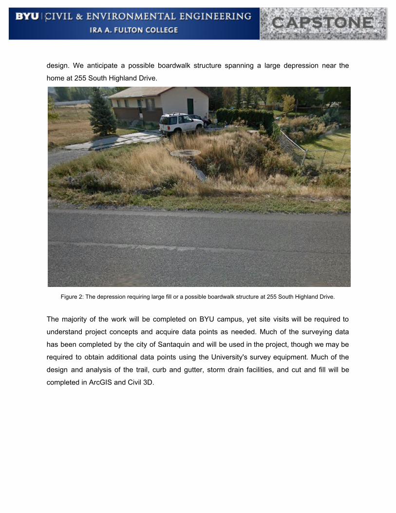
design. We anticipate a possible boardwalk structure spanning a large depression near the
home at 255 South Highland Drive.
Figure 2: The depression requiring large fill or a possible boardwalk structure at 255 South Highland Drive.
The majority of the work will be completed on BYU campus, yet site visits will be required to
understand project concepts and acquire data points as needed. Much of the surveying data
has been completed by the city of Santaquin and will be used in the project, though we may be
required to obtain additional data points using the University's survey equipment. Much of the
design and analysis of the trail, curb and gutter, storm drain facilities, and cut and fill will be
completed in ArcGIS and Civil 3D.
Components and key tasks to be completed include:
- Complete design of an 8 foot wide trail along Highland Drive from 120 East to
approximately 130 south. Design aspects include:
- Full cut and fill design for the corridor
- Meandering curve trail as per Santaquin City Standards.
- Full runoff and drainage analysis
- Full design of storm drainage facilities to accommodate storm drain capture, collection,
and conveyance.
- Reroute or relocations of driveways to connect to Highland drive, as is practical.
- Possible property acquisition to complete all right of way improvements.
- Full curb and gutter design on the southeast side of Highland drive
- Preliminary landscape design
- Design of water/power lines along corridor to supply sprinkler systems and possible
drinking fountains
- Financial analysis and cost calculations of the entire project
Portions of the project will be divided among team members to increase efficiency, yet much of
the project will be conducted as a group. The capstone group will meet for approximately 6
hours throughout the week to work on the project. Because of the variable school and work
schedules of the team, group meetings will be scheduled on a week to week basis, achieving a
minimum of 6 group hours. Additional time will be spent individually each week to accomplish
assigned member tasks. Meetings will be held once a month to evaluate progress, problems,
and future assignments. The sponsor may attend these meetings if desired. A final meeting will
be held with the sponsor before the project deadline to discuss completed work. Site visits will
occur monthly to maintain familiarity with the site.
Schedule
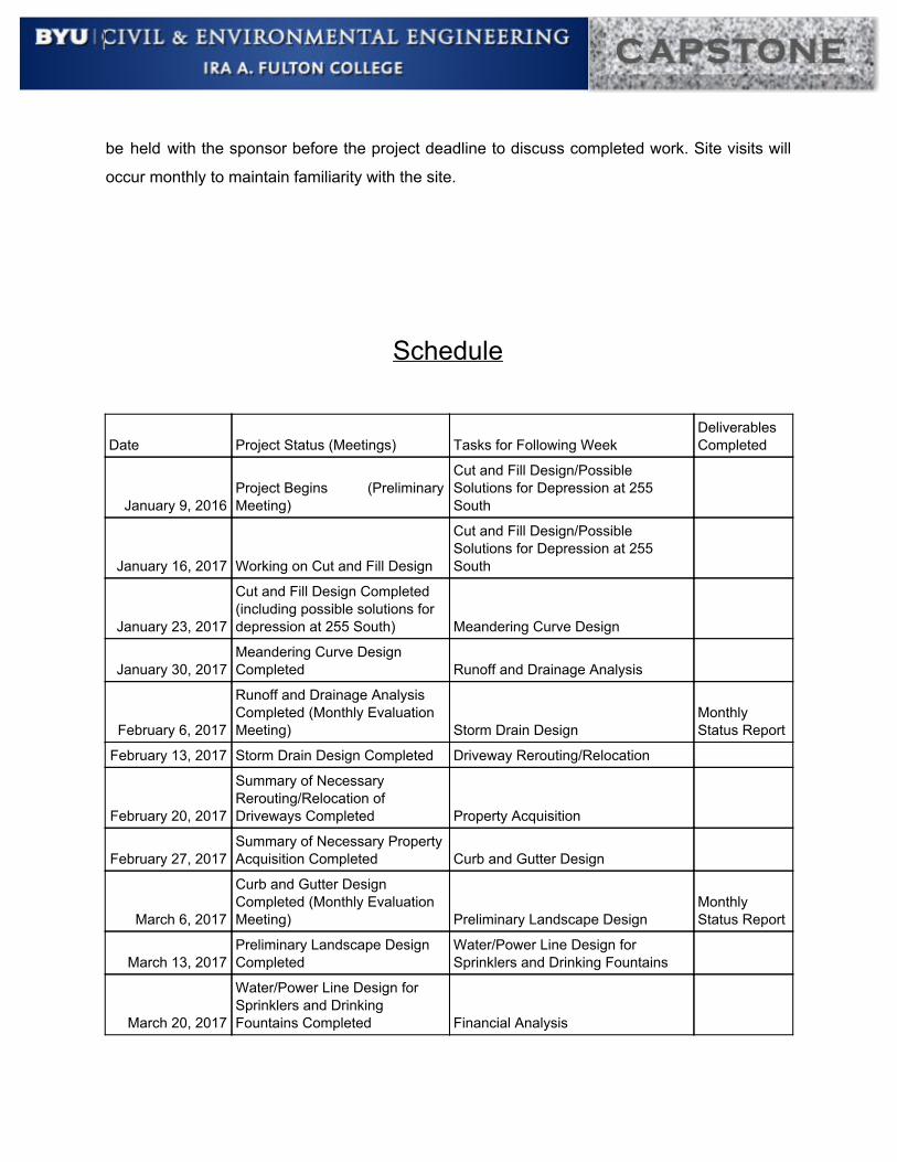
Date Project Status (Meetings) Tasks for Following Week Deliverables Completed
January 9, 2016 Project Begins (Preliminary Meeting)
Cut and Fill Design/Possible Solutions for Depression at 255 South
January 16, 2017 Working on Cut and Fill Design
Cut and Fill Design/Possible Solutions for Depression at 255 South
January 23, 2017
Cut and Fill Design Completed (including possible solutions for depression at 255 South) Meandering Curve Design
January 30, 2017 Meandering Curve Design Completed Runoff and Drainage Analysis
February 6, 2017
Runoff and Drainage Analysis Completed (Monthly Evaluation Meeting) Storm Drain Design
Monthly Status Report
February 13, 2017 Storm Drain Design Completed Driveway Rerouting/Relocation
February 20, 2017
Summary of Necessary Rerouting/Relocation of Driveways Completed Property Acquisition
February 27, 2017 Summary of Necessary Property Acquisition Completed Curb and Gutter Design
March 6, 2017
Curb and Gutter Design Completed (Monthly Evaluation Meeting) Preliminary Landscape Design
Monthly Status Report
March 13, 2017 Preliminary Landscape Design Completed
Water/Power Line Design for Sprinklers and Drinking Fountains
March 20, 2017
Water/Power Line Design for Sprinklers and Drinking Fountains Completed Financial Analysis
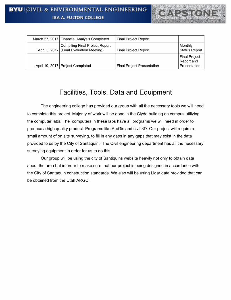
March 27, 2017 Financial Analysis Completed Final Project Report
April 3, 2017 Compiling Final Project Report (Final Evaluation Meeting) Final Project Report
Monthly Status Report
April 10, 2017 Project Completed Final Project Presentation
Final Project Report and Presentation
Facilities, Tools, Data and Equipment
The engineering college has provided our group with all the necessary tools we will need
to complete this project. Majority of work will be done in the Clyde building on campus utilizing
the computer labs. The computers in these labs have all programs we will need in order to
produce a high quality product. Programs like ArcGis and civil 3D. Our project will require a
small amount of on site surveying, to fill in any gaps in any gaps that may exist in the data
provided to us by the City of Santaquin. The Civil engineering department has all the necessary
surveying equipment in order for us to do this.
Our group will be using the city of Santiquins website heavily not only to obtain data
about the area but in order to make sure that our project is being designed in accordance with
the City of Santaquin construction standards. We also will be using Lidar data provided that can
be obtained from the Utah ARGC.
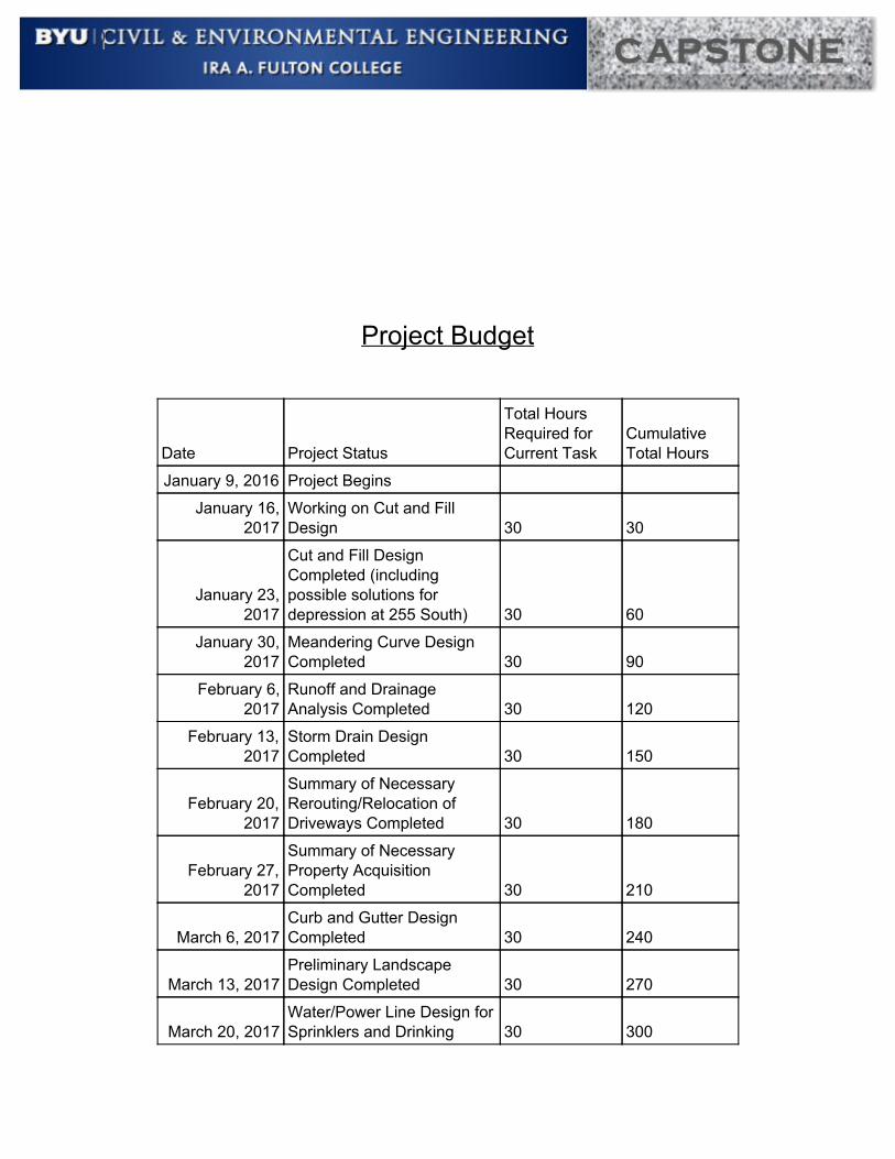
Project Budget
Date Project Status
Total Hours Required for Current Task
Cumulative Total Hours
January 9, 2016 Project Begins
January 16, 2017
Working on Cut and Fill Design 30 30
January 23, 2017
Cut and Fill Design Completed (including possible solutions for depression at 255 South) 30 60
January 30, 2017
Meandering Curve Design Completed 30 90
February 6, 2017
Runoff and Drainage Analysis Completed 30 120
February 13, 2017
Storm Drain Design Completed 30 150
February 20, 2017
Summary of Necessary Rerouting/Relocation of Driveways Completed 30 180
February 27, 2017
Summary of Necessary Property Acquisition Completed 30 210
March 6, 2017 Curb and Gutter Design Completed 30 240
March 13, 2017 Preliminary Landscape Design Completed 30 270
March 20, 2017 Water/Power Line Design for Sprinklers and Drinking 30 300

Fountains Completed
March 27, 2017 Financial Analysis Completed 30 330
April 3, 2017 Compiling Final Project Report 30 360
April 10, 2017 Project Completed 30 390
Deliverables
Once a month, a status report documenting challenges, questions, solutions, and progress will
be provided. These status reports will answer the following questions.
1- What challenges have our team encountered in our Capstone project?
2- What actions did our team decide to take to overcome these challenges?
3- Was there any progress in overcoming these challenges?
4- Is the project on schedule?
a) A summary of progress and current status will be given.
b) A description of how challenges negatively impacted our progress and our
plan to get back on schedule.
Upon completion on April 10th, the following will be provided to the sponsor:
● A full trail corridor and right of way analysis and design including plans and design
description.
● A final report completed in Word, including the full analysis and details of all the work
completed.
● A poster containing a summary of the project to be presented to student, faculty, and
other interested individuals in the final undergraduate seminar.
● A powerpoint presentation summarizing the project.
● An excel spreadsheet detailing the financial analysis.

Performance Standards
Team will provide work for this Capstone project “as is” using best practices and with best
effort. Project results cannot be construed as work performed by licensed professionals and
cannot be used as “stamped deliverables” without first being reviewed, approved and stamped
by a qualified and relevant license professional engineer.
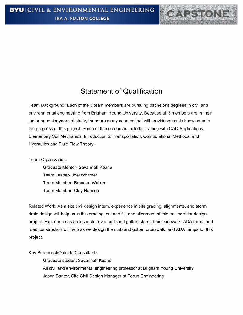
Statement of Qualification Team Background: Each of the 3 team members are pursuing bachelor's degrees in civil and
environmental engineering from Brigham Young University. Because all 3 members are in their
junior or senior years of study, there are many courses that will provide valuable knowledge to
the progress of this project. Some of these courses include Drafting with CAD Applications,
Elementary Soil Mechanics, Introduction to Transportation, Computational Methods, and
Hydraulics and Fluid Flow Theory.
Team Organization:
Graduate Mentor- Savannah Keane
Team Leader- Joel Whitmer
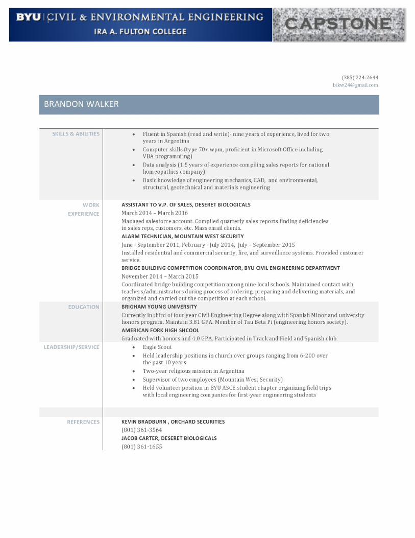
Team Member- Brandon Walker
Team Member- Clay Hansen
Related Work: As a site civil design intern, experience in site grading, alignments, and storm
drain design will help us in this grading, cut and fill, and alignment of this trail corridor design
project. Experience as an inspector over curb and gutter, storm drain, sidewalk, ADA ramp, and
road construction will help as we design the curb and gutter, crosswalk, and ADA ramps for this
project.
Key Personnel/Outside Consultants
Graduate student Savannah Keane
All civil and environmental engineering professor at Brigham Young University
Jason Barker, Site Civil Design Manager at Focus Engineering

Collaboration Plan: 6 hours of weekly group work will be required to ensure effective project
progress. These group hours will allow for project work, creative ideas to be shared, and group
problem solving. Monthly site visits as a team will also help us to remain familiar with the site
and to visualize necessary changes.
Appendix A


Recommended


![D]Q)### D]Q*### D]Q2### · 2020. 1. 10. · õ õ T T T T T T T T T4 #P$) Ú s j n # ¯ õ õ T T T T T T T T $*#P$, Ú m 3 q n 3 c [ ¯ õ õ T T T T T T T T T T T $. Ú s ÷ Æ](https://img.pdfslide.us/doc/110x75/60ccfb0c192ea8696a7b5b30/dq-dq-dq2-2020-1-10-t-t-t-t-t-t-t-t-t4-p-s-j-n-.jpg)