Bonjetti C
reek
Bonjetti C
reek
McE
lroy
Cree
k
McE
lroy
Cree
k
Aubry Cre
ek
Aubry Cre
ek
Lyndon Canyon Creek
Lyndon Canyon Creek
Trout Creek
Trout Creek
Sanborn Creek
Sanborn Creek
To
dd Creek
To
dd Creek
1.4
0.5
0.6
0.7
1.4
0.1
0.3
0.7
1.2
0.1
0.2
1.2
0.4
0.5
0.90.5
0.4
0.6
0.3
0.2
0.2
3.4
0.4
1.4
0.5
0.6
0.7
1.4
0.1
0.3
0.7
1.2
0.1
0.2
1.2
0.4
0.5
0.90.5
0.4
0.6
0.3
0.2
0.2
3.4
0.4
2800
2400
2200
1800
2800
1600
2400
2000
2200
1200
1600
1800
1000
2400
2800
2400
2200
1800
2800
1600
2400
2000
2200
1200
1600
1800
1000
2400
3000
1600
1200
1200
1400
1000
2000
1400
3000
1600
1200
1200
1400
1000
2000
1400
JOHN NICHOLAS
TRAIL
SANANDREAS
TRAIL
SANANDREAS
TRAIL
SANBORN TRAIL
SANBORNTRAIL
SANANDREAS
TRAIL
SANANDREAS
TRAIL
SKYLINETRAIL
SKYLINE TRAIL
SUMMIT ROCKLOOP TRAIL
PETE
RSON
SKYLINE TRAIL
JOHN NICHOLAS TRAIL
LAKERANCH TRAIL
JOHN NICHOLAS
TRAIL
SANANDREAS
TRAIL
SANANDREAS
TRAIL
SANANDREAS
TRAIL
SANBORN TRAIL
SANBORNTRAIL
SANANDREAS
TRAIL
SANANDREAS
TRAIL
SANANDREAS
TRAIL
SKYLINETRAIL
SKYLINE TRAIL
SUMMIT ROCKLOOP TRAIL
PETE
RSON
SKYLINE TRAIL
JOHN NICHOLAS TRAIL
LAKERANCH TRAIL
LOGHRYWOODS
TRAIL
LOGHRYWOODS
TRAIL
RIDGE TRAIL
SARATOG
A G
AP
T R AIL
SERENITY TRAIL
AQUINAS TR.
RIDGE TRAIL
SARATOG
A G
AP
T R AIL
SERENITY TRAIL
AQUINAS TR.
CastleRock
CastleRock
PartridgeFarm
PartridgeFarm
Goat RockGoat Rock
INDIANROCK
INDIANROCK
SUMMIT ROCKSUMMIT ROCK
Skyline Blvd.
Skyline Blvd.
Black Rd.
Black Rd.
Montevina Rd.
Sanborn Rd.
Bohlman Rd.
Gaetti Rd.(not open to public)
Skyline Blvd.
Skyline Blvd.
Black Rd.
Black Rd.
Montevina Rd.
Sanborn Rd.
Bohlman Rd.
Gaetti Rd.(not open to public)
Gaetti Rd.(not open to public)
Gaetti Rd.(not open to public)
HAKONEGARDENSHAKONE
GARDENS
SARATOGA GAPOPEN SPACE PRESEVE
SARATOGA GAPOPEN SPACE PRESEVE
CASTLE ROCKSTATE PARK
CASTLE ROCKSTATE PARK
EL SERENOOPEN SPACE PRESERVE
EL SERENOOPEN SPACE PRESERVE
CASTLE ROCKSTATE PARK
CASTLE ROCKSTATE PARK
QUARRY PARK(City of Saratoga)
QUARRY PARK(City of Saratoga)
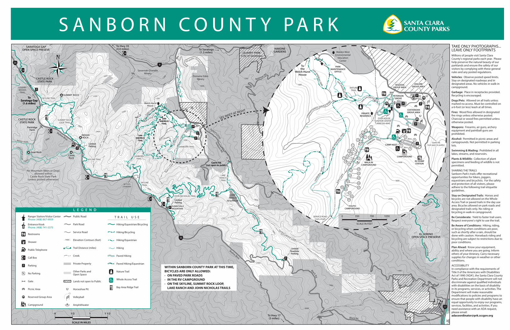
WITHIN SANBORN COUNTY PARK AT THIS TIME,BICYCLES ARE ONLY ALLOWED:· ON PAVED PARK ROADS· IN THE RV CAMPGROUND · ON THE SKYLINE, SUMMIT ROCK LOOP, LAKE RANCH AND JOHN NICHOLAS TRAILS
BITTLESSTAIRWAY
BITTLESSTAIRWAY
Welch-HurstHouse
Welch-HurstHouse
Domaine EdenWinery
(no public access) (no public access)
Savannah-ChanelleWinery
LAKERANCH
RESERVOIR
No Mountain Bikes or Dogsallowed within
Castle Rock State Park(unless posted otherwise)
No Mountain Bikes or Dogsallowed within
Castle Rock State Park(unless posted otherwise)
SUNNYVALEMOUNTAINSUNNYVALEMOUNTAIN
SEE INSET AT RIGHT
TAKE ONLY PHOTOGRAPHS...LEAVE ONLY FOOTPRINTSMillions of people visit Santa Clara County's regional parks each year. Please help preserve the natural beauty of our parklands and ensure the safety of our visitors by complying with these general rules and any posted regulations.
Vehicles: Observe posted speed limits. Stay on designated roadways and in designated areas. No vehicles in walk-in campground.
Garbage: Place in receptacles provided. Recycling is encouraged.
Dogs/Pets: Allowed on all trails unless marked no access. Must be controlled on a 6-foot (or less) leash at all times.
Fires: Wood �res allowed in designated �re rings unless otherwise posted. Charcoal or wood �res permitted unless otherwise posted.
Weapons: Firearms, air guns, archery equipment and paintball guns are prohibited.
Alcohol: Permitted in picnic areas and campgrounds. Not permitted in parking lots.
Swimming & Wading: Prohibited in all lakes, streams, and reservoirs.
Plants & Wildlife: Collection of plant specimens and feeding of wildlife is not permitted.
SHARING THE TRAILSSanborn Park's trails o�er recreational opportunities for hikers, joggers, equestrians and bicyclists. For the safety and protection of all visitors, please adhere to the following trail etiquette guidelines.
Stay on Designated Trails: Horses and bicycles are not allowed on the Whole Access Trail or paved trails in the day use area. Bicycles allowed on park roads and designated trails only. No riding or bicycling in walk-in campground.
Be Considerate: Yield to faster trail users. Respect everyone's right to use the trail.
Be Aware of Conditions: Hiking, riding, or bicycling when conditions are poor, such as shortly after a rain, should be done with caution. Horseback riding and bicycling are subject to restrictions due to poor conditions.
Plan Ahead: Know your equipment, ability and where you are going. Inform others of your itinerary. Carry necessary supplies for changes in weather or other conditions.
ACCESSIBILITYIn compliance with the requirements of Title II of the Americans with Disabilities Act of 1990 ('ADA'), the Santa Clara County Parks and Recreation Department will not discriminate against quali�ed individuals with disabilities on the basis of disability in its programs, services, or activities. The Department will make reasonable modi�cations to policies and programs to ensure that people with disability have an equal opportunity to enjoy our programs, services, facilities, and activities. If you need assistance with an ADA request, please email: [email protected] Hwy 17
(5 miles)
To Hwy 35(4.0 miles) To Saratoga
(1.3 miles)
ToSaratoga Gap
(1.6 miles)
ToSaratoga Gap
(1.6 miles)
To Hwy 17(5 miles)
To Hwy 35(4.0 miles) To Saratoga
(1.3 miles)
ToSaratoga Gap
(1.6 miles)
ToSaratoga Gap
(1.6 miles)
ToSaratoga Gap
(1.6 miles)
LimitedRoadsideParking
LimitedRoadsideParking
935
35
17
LimitedParkingLimitedParking
LimitedParkingLimitedParking
1
23
4
67
8
9
5
10
15
1413
12
20
1918
17
25
2423
22
3029
2827
11
16
21
26
33
32
31
28
915
COSTANOANGROUP AREACOSTANOANGROUP AREA
DYER HOUSEVISITOR CENTER(408)356-4945
DYER HOUSEVISITOR CENTER(408)356-4945
PARKMAINTENANCE
OFFICE
PARKMAINTENANCE
OFFICE
PRIVATERESIDENCE
Walden WestEnvironmental
EducationCenter
Walden WestEnvironmental
EducationCenter
PETERSONGROVE
PETERSONGROVE
OHLONEGROUP AREA
OHLONEGROUP AREA
CAMP HOST
thru
thru
CAMPGROUNDCAMPGROUND
WALK-INCAMPGROUND
WALK-INCAMPGROUND
YOUTHCAMPGROUND
YOUTHCAMPGROUND
SEQUOIAGROUP AREA
SEQUOIAGROUP AREA
Tothe
Welch-HurstHouse
Tothe
Welch-HurstHouse
RV DUMPSTATION
RV DUMPSTATION
Gaetti Rd.(not open to public)
Gaetti Rd.(not open to public)
PETE
RSO
N MEM
ORIAL T
RAIL
SANB
ORN
TRA
IL
SAN ANDREAS TRAIL
NATURETRAIL
SANBORN TRAIL
SAN ANDREAS TRAIL
SAN ANDREAS
PETE
RSO
N MEM
ORIAL T
RAIL
SANB
ORN
TRA
IL
SAN ANDREAS TRAIL
NATURETRAIL
SANBORN TRAIL
SAN ANDREAS TRAIL
SAN ANDREAS
1600
2000
1800
1600
1600
2000
1800
1600
UNM
AIN
TAINED SERVICE ROAD
SERVICE ROAD(not a trail)
UNM
AIN
TAINED SERVICE ROAD
SERVICE ROAD(not a trail)
Aubry
Cre
ek
Aubry
Cre
ek
Sanborn Rd.
Sanborn Rd.
R V
0.4
0.6
0.1
0.1
0.1
0.2
0.1
0.1
0.3
0.1
0.1
0.3
0.5
0.4
0.6
0.1
0.1
0.1
0.2
0.1
0.1
0.3
0.1
0.1
0.3
0.5
Public Road
Park Road
Service Road
Elevation Contours (feet)
Trail Distance (miles)
Creek
Private Property
Other Parks and Open Space
Lands not open to Public
Horseshoe Pit
Volleyball
Amphitheater
Hiking/Equestrian/Bicycling
Hiking/Bicycling
Hiking/Equestrian
Hiking
Paved Hiking
Paved Hiking/Equestrian
Nature Trail
Whole Access Trail
Bay Area Ridge Trail
Ranger Station/Visitor CenterPhone: (408) 867-9959
Entrance KioskPhone: (408) 741-5375
Restrooms
Shower
Public Telephone
Call Box
Parking
No Parking
Gate
Picnic Area
Reserved Group Area
Campground
00 1/21/2 1 1/21 1/211
SCALE IN MILESSCALE IN MILES
0 350 1050700
SCALE IN FEET
1.1
14001400
T R A I L U S E
L E G E N D
S A N B O R N C O U N T Y P A R K
Recommended