Page 1 of 52
REPUBLIC OF TRINIDAD AND TOBAGO
IN THE HIGH COURT OF JUSTICE
Claim No. CV 2015 -03484
BETWEEN
DEOSARAN BOODOORAM Claimant
AND
KRISHNA KHADAR CHANDOOL
THATAREE LEWIS
PHOOLMATIE CHANDOOL LOBAI
BERTINA CHANDOOL
HARRISCHAND CHANDOOL Defendants
Before the Honourable Madam Justice Margaret Y Mohammed
Dated the 21st September, 2017
APPEARANCES
Mr. Jerome Rajcoomar instructed by Ms. Alisa Khan Attorneys at law for the Claimant.
Mr. Brent Hallpike instructed by Ms. Kamini Persaud-Maharaj Attorneys at law for the
Defendants.

Page 2 of 52
JUDGMENT
1. The Claimant is the owner of all and singular that certain piece or parcel of land situate
at Lopinot, Arouca in the Ward of Tacarigua in the Island of Trinidad comprising one
thousand six hundred and seventeen point nine square metres and bounded on the
North and East by lands of Chandool on the South by lands of Roopnarine Singh and
on the West by Lopinot Road and which said piece or parcel of land is also described
firstly in Deed registered as No. 2683 of 1972 as measuring one hundred and fifty on
the East and West and one hundred and twenty-five feet on the North and South be
the same more or less and bounded on the North by lands of A. Besson on the South
by lands of Ramnath of the East by lands of A. Besson and on the West by Lopinot
Road together with the buildings thereon and appurtenances thereto belonging
subject to the reservations contained in deed registered as No. 14218 of 1941 (“the
disputed land”). The disputed land is described in Deed dated 6th January 1992 and
registered as No. DE 199200692088 (“the 1992 Deed”). The Claimant commenced the
instant claim after the Second Defendant caused a concrete structure to extend over
the northern boundary of the disputed land. The reliefs which the Claimant seek
against the Defendants are:
a. An order for possession of the disputed land.
b. An order that the Claimant is the registered owner of the disputed land.
c. An order that the Defendants and their servants/agents forthwith remove
themselves from the disputed land.
d. Damages for trespass to the disputed land.
e. An injunction restraining the Defendants whether by themselves or by their
servants and/or agents or otherwise howsoever from entering, being in
occupation of or in any way interfering with the Claimant’s occupation of
the disputed land.
Page 3 of 52
f. An injunction to restrain the Defendants whether by themselves or by their
servants and/or agents or otherwise howsoever from molesting,
threatening, annoying or in any way interfering with the Claimant’s
occupation and use of the disputed land.
g. An injunction to restrain the Defendants whether by themselves or by their
servants and/or agents or otherwise howsoever from remaining on or
continuing occupation of the disputed land.
h. An order setting aside the orders of:
i. Deyalsingh J in H.C.A. 4171 of 1982 (“the 1982 action”) Bertina
Chandool v Balla Boodram and Rookmin Boodram.
ii. Ramlogan J in H.C.A. No. 721 of 1992. (“the 1992 action”) Bertina
Chandool v. Deosaran Boodooram and Marilyn Boodooram.
The Claim
2. The Claimant has grounded his claim on three limbs. He averred that he has a superior
title to any title of the Defendants. He pleaded that the root of title associated with the
disputed land is as follows:
(a) By Deed dated the 12th March 1941 and registered as No. 1418 of 1941 (“the
1941 Deed”) the Administrator General, Thomas Malcolm Milne sold to the
Claimant’s uncle, Dokin Boodooram, the disputed land.
(b) By Deed dated the 25th July 1958 and registered as No. 9400 of 1958 (“the
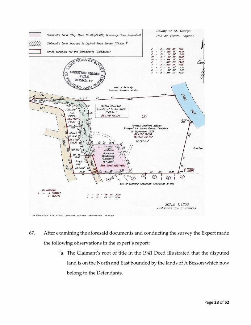
1958 Deed”) Dokin Boodooram sold the disputed land to George Adolphus
Jack.
(c) By Deed dated the 17th February, 1972 and registered as No. DE 1972 0268
3098 (“the 1972 Deed”) Eltha Dorothy Jack, the legal personal
representative of George Adolphus Jack, deceased conveyed the disputed
land to Eltha Dorothy Jack, Peter Jack and Gemma Jack.
Page 4 of 52
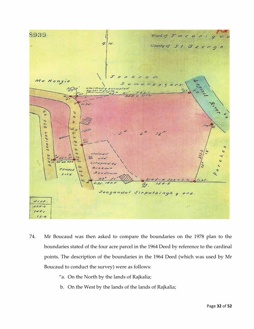
(d) By the 1992 Deed Eltha Dorothy Jack, Peter Jack and Gemma Jack conveyed
the disputed land to the Claimant.
3. The Claimant averred that since he purchased the disputed land in 1992 he left it
vacant, while he saved money with the intention of constructing a house thereon.
4. The Claimant contended that the Defendants are not the owners of the disputed land
but that they are the owners of ALL that parcel of land situate formerly in the Ward
of Caura but now in the Ward of Tacarigua comprising Four Acres and abutting on
the North and West upon lands of Rajkalia, on the South upon lands of Ramsaroop
Maraj and on the East by Little Arouca River (which said parcel of land forms part of
the parcel of land comprising twelve acres three roods and five perches described in
a certain deed registered as No. 2141 of 1901) together with the buildings thereon and
the appurtenances thereto belonging ( “the four acre parcel”).
5. The Claimant asserted that the root of title associated with the four acre parcel is as
follows:
(a) By Deed of Conveyance dated the 11th November, 1976, and registered as
No. 19763 of 1976 (“the 1976 Deed”) Gladys Claire Harris, the legal
personal representative of Conrad Knowlson Harris, deceased conveyed to
James Francis Chandool the four acre parcel.
(b) By Deeds of Assent dated the 6th September, 1983 and registered as No.
20868 of 1983 (“the 1983 Deed”) and No. 20869 of 1983, Bertina Chandool,
the legal personal representative of James Francis Chandool, deceased
conveyed from the estate of the deceased to herself the four acre parcel in
fee simple on trust for herself and the children of the deceased.
Page 5 of 52
(c) By Deed of Conveyance dated the 1st September, 2003 and registered as No.
DE 2003 036532 (”the 2003 Deed”), Bertina Chandool, the legal personal
representative conveyed to herself and to the children of the deceased,
Harrischand Chandool, Krishna Khadar Chandool, Thataree Lewis and
Phoolmatie Chandool Lobai, the four acre parcel in fee simple as tenants in
common in the following shares- a one third share and interest to herself
and a one sixth share and interest for each child.
6. The Claimant also pleaded that there were three previous High Court actions
instituted by the Defendants and their ancestors concerning the four acre parcel and
that the orders obtained in those matters were obtained by fraud and was an attempt
by James Chandool and later the Fourth Defendant to mislead the Court. The Claimant
averred that the Defendants predecessor in title James Francis Chandool, the Fourth
Defendant’s husband commenced High Court Action No. 3692 of 1979 (“the 1979
action”) against the Claimant’s parents Bala and Rookmin Boodram who were
occupiers and not the owners of the disputed land. The claim was in respect of an
alleged wrongful occupation by the Defendants. Bala and Rookmin Boodram’s
defence was that the disputed land was owned by members of the Jack family who
had permitted occupation of the disputed land. In support of the claim, a survey plan
was prepared by a licensed surveyor Michael Boucaud in 1978 (“the 1978 plan”) for
James Chandool. In the 1978 plan Mr Boucaud concluded that the parcel of land
owned by James Chandool was three acres two roods and twelve perches.
7. James Francis Chandool passed away during the 1979 matter and his wife Bertina
Chandool, the Fourth Defendant commenced High Court proceedings HCA 4171 of
1982 (“the 1982 action”) against Bala and Rookmin Boodram. According to the
Claimant’s pleading, the issues in dispute were the same as in the 1979 action. The
Page 6 of 52
Honourable Mr Justice Deyalsingh consolidated the proceedings in the 1979 action
and the 1982 action and on 21st November, 1983 (“the 1983 order”) he granted an
injunction against Bala and Rookmin Boodram ordering them to break down wooden
structures which they had built on the disputed land.
8. The Claimant asserted that the 1983 order was obtained by fraud and was an attempt
by the Fourth Defendant to mislead the Court since the 1983 Deed the Defendants
were entitled to a four acre parcel of land, however the 1978 plan showed the area of
land claimed by the Defendants consisted of three acres, two roods and twelve perches
and it wrongfully claimed the land which was occupied by Rookmin Boodram.
Further the 1978 plan failed to take into account four other parcels of land which were
owned by the Defendants situated to the west of the three acre two roods and twelve
perches parcel which the Fourth Defendant failed to disclose to the Court.
9. The Claimant also averred that after he purchased the disputed land, the Fourth
Defendant instituted the 1992 action against him and his wife Marilyn Boodooram.
On 16th March, 1992 (“the 1992 order”) the Honourable Mr Justice Ramlogan granted
an interim injunction restraining the Claimant and his wife (the Defendants in those
proceedings) from entering onto the four acre parcel. The 1992 action did not go to
trial and was not disposed of on the merits.
10. The Claimant asserted that the Fourth Defendant also obtained the 1992 order based
on fraud and an attempt to mislead the Court. The Claimant averred that the Fourth
Defendant relied on a survey plan dated 16th June 1984 (“the 1984 plan”) prepared by
Mr Michael Boucaud and she failed to disclose that she had conveyed lands situated
to the left of the Lopinot Road to The Church of God of Prophecy by Deed of
Conveyance dated the 8th February 1985 and registered as No. 4575 of 1985 (“the 1985
Page 7 of 52
Deed”) and to The Incorporated Trustees of the Sanatan Dharma Maha-Sabha of
Trinidad and Tobago by Deed of Gift dated 28th September 1987 and registered as No.
19353 of 1987 (“the 1987 Deed”).
11. In the 1985 Deed the Fourth Defendant conveyed onto The Church of God of
Prophecy, all and singular that piece or parcel of land situate in the Ward of Tacarigua
in the Island of Trinidad comprising six hundred and ninety-six point eight square
metres (696.8 m2) (being portion of a larger parcel of land comprising four acres
described in the 1983 Deed) and bounded on the North by other lands of Bertina
Chandool on the South by a Temple Site on the East by the New Lopinot Road and on
the West by Old Lopinot Road.
12. In the 1987 Deed, the Fourth Defendant conveyed onto The Incorporated Trustees of
the Sanatan Dharma Maha-Sabha of Trinidad and Tobago all and singular that certain
piece or parcel of land situate in the Ward of Tacarigua in the Island of Trinidad
measuring approximately fifty-five (55) feet on the Northern and Southern boundary
lines and one hundred (100) feet on the Eastern and Western boundary lines (being
portion of a larger parcel of land comprising Four Acres described secondly in the
Schedule to the 1983 Deed) and bounded on the North by other lands of Bertina
Chandool on the South by lands of Soogandai Sirpatsingh and others on the East by
New Lopinot Road and on the West by lands of Sookdeo.
13. After the 1992 action commenced, the Claimant averred that the Fourth Defendant
further sold two other properties out of the four acre parcel and she failed to disclose
it to the Court in the 1992 action. In particular the Claimant pleaded that by Deed of
Conveyance dated the 3rd September 1992 and registered as No. 16737 of 1992 (“the
1992 Deed”), the Fourth Defendant conveyed onto Felix Valere all and singular that
Page 8 of 52
certain piece or parcel of land situate at Lopinot Road, Arouca in the Ward of
Tacarigua in the Island of Trinidad comprising one thousand and fifty point two
square metres (1050.2 m2) and bounded on the North and East upon the New Lopinot
Road on the South upon other lands of Bertina Chandool and on the West partly by
other lands of Bertina Chandool and partly by the Old Lopinot Road.
14. Further, by Deed of Conveyance dated 22nd July 1994 and registered as No. 3910 of
1995 (“the 1995 Deed”), the Fourth Defendant conveyed to the Republic of Trinidad
and Tobago all and singular that piece or parcel of land situate in the Ward of
Tacarigua in the Island of Trinidad comprising one thousand and forty three point
two (1043.2 m2) be the same more or less and shown coloured pink being a portion of
a larger parcel of land comprising Four Acres which is secondly described in the
Schedule to the 1964 Deed.
15. The Claimant contended that the total acreage of land comprised in the above
mentioned four deeds which were sold out of the four acre parcel, when added to the
three acre two roods and twelve perches amounted to 4.39 acres which is 0.39 acres
more than what the Defendants was entitled to by 0.39 acres (equivalent to 1578 square
metres) which is almost equivalent to the disputed land.
16. The Claimant averred that he has paid land and building taxes from 1992 until 2009
for the disputed land. The Claimant’s allegations of trespass are: the Second
Defendant and her husband had built a foundation adjoining the land to the disputed
land prior to January 2014 and in or about January 2014 they encroached by
approximately twelve to fifteen feet onto the disputed land by extending the said
foundation. On or about the 17th May 2014, the Second Defendant and her husband
filled the said foundation with concrete.
Page 9 of 52
17. On the 1st June 2014, Bobby Chandool and his son began digging holes and casting
steel posts on the south-eastern end of the boundary of the disputed land. At that time
six pillars were erected and work had begun to enclose the disputed land.
18. On the 11th June 2014, a pre-action protocol letter was sent to the Defendants asking
them to refrain from their actions on the disputed land. In the Defendants reply dated
25th July 2014 they indicated that they will relate information to the Claimant’s
attorney regarding the location of the lands described in the 1941 deed. However, no
action was taken by the Defendants after they replied by letter 25th July 2014.
19. On or about April, 2015 the Defendants erected a few rows of bricks on the disputed
land and then stopped. On Saturday the 1st August, 2015 the Claimant observed that
the disputed land was being cleared by the Fifth Defendant, and other persons. On
the 16th January, 2016 the Defendants deposited a load of sand on the disputed land.
On the 17th January 2016, the Defendants cleared the disputed land again by cutting
the grass, and continuing the building of the structure and on the 19th January, 2016
the Defendants continued the building of the structure.
The Defence
20. The Defendant admitted that they are the owners of the four acre parcel described in
the 2003 deed. They asserted that the four acre parcel was surveyed by Mr Michael
Boucaud in 1984 and the plan dated 16th June 1984(“the 1984 plan”) is registered as No
87302 in the Land and Surveys Division. The Defendants have disputed the Claimant’s
case on three grounds. They pleaded that the Claimant does not have a reasonable
cause of action since he has failed to demonstrate that he has title/or superior title to
the disputed land. The Defendants averred that their title is superior to the Claimant’s
Page 10 of 52
title since in addition to the Deeds pleaded by the Claimant they also rely on Deed No
2141 of 1901 (“the 1901 Deed”) and Deed No 3153 of 1964 (“the 1964 Deed”) to prove
their superior title.
21. The Defendants admitted the 1979 action, the 1983 action and the 1992 actions.
However, they contended that there was no fraud or attempt to mislead the Court in
obtaining the orders in the said actions. They averred that the instant claim is an abuse
of process since the issue of title to the disputed land was decided by the 1983 order
and it has been res judicata for over 30 years. The Defendants pleaded that in the 1982
action there was due process of law whereby the Defendants (Bala Boodram and
Rookmin Boodram) offered evidence, were represented by Counsel were granted an
opportunity to cross examine the Fourth Defendant and the surveyor Mr. Michael
Boucaud. After the decision in the 1982 action i.e. the 1983 order, the Claimant’s
predecessor in title failed and/or refused to appeal the said decision.
22. The Defendants also averred that the Claimant’s insertion of a cause of action of fraud
is an abuse of process since he is attempting to quash the 1983 order without an appeal
and/or adhering to the due process of the law. They asserted that fraud does not arise
as the Claimant’s complaint is based on facts subsequent to the decision in the 1983
order.
23. In response to the Claimant’s allegations of fraud, the Defendants averred that they
owned the four acre parcel and that the 1984 plan correctly identified the Defendants’
land south of the New Lopinot Road which includes the disputed land. The 1984 plan
also identified the Defendants land South of the Lopinot Road and in particular to the
illegal occupation and/or trespass of Rookmin Boodram. Further, the Defendants
Page 11 of 52
averred that the conveyances were done after the 1983 order and concerned land
which are not in dispute.
24. With respect to the allegations of fraud concerning the 1992 action the Defendant
averred that the Fourth Defendant disclosed to the Court materials that demonstrated
her title in the disputed land. In the 1992 action the Claimant (who was the Defendant)
had his opportunity to file responses and engage in the due process of the law.
25. On the Claimant’s allegation of the calculation of the four acre parcel, the Defendants
averred that the Claimants’ arithmetic is flawed since all four parcels of the four acre
parcel together with the property described in the 1984 plan constituted the four acres.
26. In response to the Claimants allegations of trespass, the Defendants averred that all
works done by the Second Defendant her servants and/or agents were done on the
four acre parcel. They averred that since 1988 the Second Defendant has been
constructing her home on a portion of the four acre parcel when the foundation
measuring 24 feet by 40 feet was dug out and four posts were erected. The Second
Defendant then halted construction until in or around 1993 when the foundation
works continued and materials were purchased. In or around 2010 foundation blocks
were placed and filled with dirt from time to time, until it was finally completed in or
around 2012. The Second Defendant received WASA connection in 2010.
27. The Defendants denied that the Fifth Defendant who is also called “Bobby Chandool”
dug holes or enclosed the disputed land. They averred that all works done by the
Fifth Defendant were conducted on the four acre parcel.
Page 12 of 52
28. The Defendants also averred that their former Attorney at Law, Mr. Maurice Haynes
exchanged several correspondences between himself and the Claimant’s Attorney at
Law relative to this matter, which went beyond 2014.The Defendants pleaded that
since January 2016 despite great hardship being experienced in their living
arrangements they gave an undertaking not to carry out further construction on the
four acre parcel until the determination of the instant matter.
29. The Defendants also averred that they have been in exclusive and undisturbed
possession of the disputed land for an excess of 16 years, whereby they have cleaned,
cleared, planted, harvested and lived on it. They averred that during the period 1992
to 1998 they have been subjected to ridicule and threats and on the 5th June 2014 the
Claimant, his servants and/or agents destroyed posts which were installed on the four
acre parcel.
30. The Defendants have counterclaimed that they are the owners of the four acre parcel;
special damages for the acts of trespass in June 2014 in the sum of $2,150.00; damages
for the acts of trespass in June 2014; aggravated damages and costs.
31. In the course of the instant matter, the Third Defendant passed away and nobody was
substituted to represent her interest.
The issues
32. The issues for determination are as follows:
(a) Whether the Claimant ought to be prevented from litigating this claim on
the ground of res judicata or abuse of process;
Page 13 of 52
(b) Where is the location of the disputed land and is it within the four acre
parcel ; and
(c) If the disputed land is where the Claimant alleges, whether the Defendants
are now entitled to same by reason of adverse possession.
33. At the pre-trial review the parties agreed to the appointment of a joint expert in the
field of land surveying. They agreed on Christian Persad (“the Expert”) who prepared
a report (“the expert’s report”) for the Court and who presented himself for cross-
examination at the trial.
34. At the trial, the Claimant gave evidence on his behalf and he also called three
witnesses namely, Lena Kalloo, Kern Sargeant and Joseph Sookhoo Maltin. The
Second, Fourth and Fifth Defendants gave evidence on their behalf and they also
called Mr. Michael Boucaud.
Whether the Claimant ought to be prevented from litigating this claim on the
ground of res judicata or abuse of process
35. Halsbury’s Laws of England1 describes the doctrine of res judicata as:
“The doctrine of res judicata provides that, where a decision is pronounced by
a judicial or other tribunal with jurisdiction over a particular matter, that same
matter cannot be reopened by parties bound by the decision, save on appeal. It
is most closely associated with the legal principle of cause of action estoppel',
which operates to prevent a cause of action being raised or challenged by either
party in subsequent proceedings where the cause of action in the later
1 Vol 11 (2015)) para 1603
Page 14 of 52
proceedings is identical to that in the earlier proceedings, the latter having been
between the same parties (or their privies), and having involved the same
subject matter. However, res judicata also embraces 'issue estoppel', a term that
is used to describe a defence which may arise where a particular issue forming
a necessary ingredient in a cause of action has been litigated and decided, but,
in subsequent proceedings between the same parties involving a different cause
of action to which the same issue is relevant, one of the parties seeks to reopen
that issue. For this reason, res judicata has been described as a portmanteau
term which is used to describe a number of different legal principles with
different juridical origins upon which the courts have endeavoured to impose
some coherent scheme only in relatively recent times.”
36. Halsbury’s Laws of England 2 describes estoppel by record as:
“Under the doctrine of res judicata, a matter that has been adjudicated on by a
competent court cannot be re-litigated; thus a form of estoppel known as
estoppel by record arises when a judgment has been given which is a matter of
record, principally matters appearing on the records of courts of law. Estoppel
by record may now arise whether or not the judicial decision in question has
been pronounced by a tribunal that is required to keep a written record of its
decisions.
The rationale for the existence of estoppel by record can be summed up in two
expressions:
(1) that it is in the public interest that there should be an end of litigation; and
(2) that no one should be proceeded against twice for the same cause.
2 Vol 11(2015)) para 1610
Page 15 of 52
It accords with the first of these expressions that a party relying on estoppel
by record should be able to show that the matter has been determined by a
court of competent jurisdiction in a judgment which is final.”
37. The elements that give rise to issue estoppel are:
(a) The issue in the previous proceedings must have been the issue raised in
the current proceedings;
(b) The issue must have been determined by a Court of competent jurisdiction;
(c) The decision on the issue must have been conclusive; and
(d) The litigant in the existing claim must have been the litigant in the previous
proceedings or his privy.
38. Halsbury’s Laws of England3 categorises three classes of privies namely:
(1) privies in blood (for example, ancestor and heir) ;
(2) privies in law (for example, (formerly) tenant by the curtesy or in
dower) and others that came in by act in law (for example, testator
and executor, intestate and administrator, bankrupt and trustee in
bankruptcy);
(3) privies in estate or interest (for example, testator and devisee ,
vendor and purchaser, landlord and tenant, a husband and his wife
claiming under his title and a wife and a husband claiming under
hers , successive incumbents of the same benefice , assignor and
3 4th ed Vol 11 (2015) at paragraph 1634
Page 16 of 52
assignee of a bond, and the employee of a corporation defending a
claim of trespass at the cost of his employers and justifying under
their title and the corporation itself ).
39. The question of whether someone is to be regarded as a privy is a question of fact. In
Carl-Zeiss-Stiftung v Rayner 4 Lord Guest stated that:
“The next requirement is that the judgment should have been between the same
parties or their privies…There is a dearth of authority in England on the
question of privies…"Privies" have been described as those who are "privy to
the party in estate or interest"5.”
40. It was submitted on behalf of the Defendants that the 1983 order granted possession
of the four acre parcel to Bertina Chandool (ie the Fourth Defendant); ordered Bala
and Rookmin Boodram to tear down the structures they had constructed and it
restrained them from re-entering. Counsel for the Defendants contended that the 1983
order made the order for possession based on the 1978 plan, therefore the Court
considered the issue of the location of the four acre parcel and the land Bala and
Rookmin Boodram were occupying. Counsel also submitted that the Claimant is a
privy of Bala and Roookmin Boodram since they were his parents and that the
Claimant’s plea of fraud which was designed to set aside the 1983 order was a bare
pleading and was not made out on the evidence.
41. In response the Counsel for the Claimant argued that in the absence of a written
judgment for the 1983 order it is impossible to determine with certainty whether that
issue, which the Claimant concedes was raised on the pleadings, was determined at
4 [1966] 2 All ER 536 5 Supra page 566
Page 17 of 52
the trial. Further, even if it was determined and may raise the estoppel, the Claimant
cannot, as a matter of law, be regarded as a privy of Bala and Rookmin Boodram in
this matter and therefore cannot be bound by the 1983 order; and the Claimant’s
pleading of fraud is an alternative pleading which only becomes relevant if the Court
finds that the Claimant is a privy and that there is evidence of fraud.
42. In light of the submissions, it appeared that the Defendants did not pursue that the
1992 order gave rise to the issue of res judicata and abuse of process. In any event, the
1992 action was not determined at trial and it was only with respect to an interim
injunction order where the Defendants (the Claimant in the instant case and his wife)
had given an undertaking.
43. Is the Claimant a privy of Bala and Rookmin Boodram? In my opinion, he is not a
privy of his parents by virtue of blood neither is he a privy of estate or interest. In
Spencer and Spencer v Williams6 the Court held that a child is not automatically a
privy of the parent unless the child is claiming rights through the parent. In that case
the children commenced probate proceedings in their own right after previous
proceedings involving their parents had been dismissed on the merits. Lord Penzance
noted at pages 235-236:
“In the suit before me the parties are not the same as in the suits in the Court
of Chancery, nor do they claim under the same. The parties in the suits of
Chancery were Sarah Spencer, Samuel Williams, and others. Here the
plaintiffs are the children of Sarah Spencer, but they do not claim through
their mother as such, or under her in her character of administratrix of their
father; they rest their claim on the ground that Mary Emsley died intestate,
leaving certain next of kin, who have all renounced and refused to take
6 (1871) L.R. 2 P. & D. 230
Page 18 of 52
administration, and that they are the next of kin of one of the next of kin of
the deceased, and that without a grant they cannot obtain that to which they
are entitled. They invoke the rule of this Court under which, if the next of
kin choose to stand aside and renounce their rights, the next of kin of the
next of kin is entitled to represent the intestate. It would be improper to say
that, applying in that character, they derive their title through their mother,
Sarah Spencer. She might have applied herself, but she elected to stand aside.
If she had come here, it is hardly necessary to say that Williams would have
been bound by the decision of the Court of Chancery as against her; but is
he barred as against the children? They claim this grant on the ground that
they are the children of their father, and kin of the next of kin of Mary
Emsley; but they do not claim the grant through their father, still less do they
claim it through their mother in the character of their father's executrix.
They stand on an independent right which accrued to them in relation to
Mary Emsley's estate upon the renunciation of the next of kin who had the
prior right.”
44. The case of Liverpool and North Wales Steamship Company v Mersey Docks 7
provides learning on privies in estate or interest in land matters. This case involved a
parcel of land which had been leased to a company by crown leases. On the parcel of
land was a jetty which had been constructed outside of the boundaries approved
contained in the provisional order giving the company the parcel of land. The
company was wound up and dissolved and eventually the portion of land containing
the jetty was acquired by the Plaintiff. After discovering the issue with his title, the
7 [1909] 1 Ch 209
Page 19 of 52
Plaintiff procured new crown grants in respect of the area of the land on which the
jetty was located. The Court noted that in litigation involving a parcel of land, a litigant
who does not derive title from a previous owner is not to be regarded as a privy of the
previous owner. Farewell LJ commented at page 217:
“Notwithstanding what has been urged before us, I do not understand any
ground on which the defendants can be debarred from setting up the truth
unless it is by estoppel. Even assuming that the original company would
have been estopped, as to which I express no opinion, I cannot see how Mr.
Horton, claiming as he does under an independent title by grants from the
Crown, can be said to be either party or privy to any estoppel so as to bring
himself within any recognized doctrine of the law.”
45. The Court found that since Mr Horton did not claim through the company but through
an independent grant of title from the crown, he could not be regarded as a privy to
an estoppel against the company (if there was one).
46. In Lady Wenman v McKenzie 8 the Court found that a landlord is not bound by
litigation against a tenant unless the tenant was litigating with the landlord’s express
authority.
47. The Defendants in the 1982 action Bala and Rookmin Boodram were not the owners
of the disputed land. They were occupiers, either as tenants, licensees or adverse
possessors. The Claimant does not derive title from his parents but he purchased the
disputed land which title can be traced to the 1941 Deed, the 1958 Deed, the 1972 Deed
and the 1992 Deed. Therefore, the Claimants title is from a separate grant and not
8 (1855) 5 E & B 477
Page 20 of 52
through his parents rendering him a privy of the Jack family and not of his parents. In
my opinion, the Claimant could have only been bound as a privy of the Jacks but the
Jacks themselves were not bound by the 1983 order since they were not made a party.
48. Is the instant action an abuse of process? It was common ground that the test for
striking out a claim on the ground of abuse of process was considered by the Court of
Appeal in The Attorney General v Trevor Mahabir 9 which applied the test
formulated by the House of Lords in Johnson v Gore Wood10. Mendonca JA stated at
paragraph 23 that:
“23. In our judgment the approach recommended in Johnson v Gore
Wood in relation to the Henderson type abuse and endorsed in Glauser
in a case that more approximates this matter, is the appropriate one.
What is required is a balancing exercise of the competing public and
private interests taking into account all the circumstances of the case
focusing attention on the question whether in all the circumstances the
claimant is misusing or abusing the process of the Court by seeking to
pursue the second claim. Of course, as we have mentioned, the Court
must seek to give effect to the overriding objective which is to deal with
cases justly (see rule 1.1 of the CPR) and one of the factors that must be
taken into account is whether in pursuing the second claim there is a
disproportionate use by the claimant of the Court’s resources. This
entails an appreciation of the extent to which the combined effect of the
earlier proceedings and the present claim places a disproportionate
burden on the Court’s resources (see Wahab v Khan and Ors [2011]
EWHC 908). After considering all the relevant circumstances the Court
9 Civ Appeal P238 of 2013 10 [2001] 1 All ER 481
Page 21 of 52
must then form a judgment as to what justice requires overall.”
(Emphasis added).
49. In Johnson v Gore Wood & Co11the House of Lords examined privies on the basis of
res judicata. The Court noted that the Court should be cautious in shutting out a party
where he is not the same party in an earlier action but his privy. Lord Millet stated at
page 526 at paragraph g as follows:
“Particular care, however, needs to be taken where the plaintiff in the second
action is not the same as the plaintiff in the first, but his privy. Such situations
are many and various, and it would be unwise to lay down any general rule.
The principle is, no doubt, capable in theory of applying to a privy; but it is
likely in practice to be easier for him to rebut the charge that his proceedings
are oppressive or constitute an abuse of process than it would be for the original
plaintiff to do so.”
50. Counsel for the Defendants submitted that there are no special circumstances and
that the only further material was the expert’s report by the Expert.
51. However, it was argued by Counsel for the Claimant that it would be unjust to prevent
the Claimant from ventilating his claim since he never had the opportunity to litigate
his entitlement to the disputed land. It was also argued that based on the pleaded facts
it is impossible to conclude that the Claimant is pursuing a second claim and is
misusing the Court’s process since the Claimant is the first person in his line of title to
litigate the title to the disputed land.
11 [2001] 1 All ER 481
Page 22 of 52
52. I am not of the opinion that the Claimant has misused or abused the Court’s process
in pursuing the instant claim. The Claimant was not a privy to the 1982 action therefore
the issue of where the disputed land is situated in the context of the four acre parcel
was not put forward by the respective owner of the disputed land. Further, through
no fault of the Claimant, the 1992 action was not determined on its merits since he was
a Defendant and the onus was on Bertina Chandool who was the Claimant to
prosecute the matter.
53. The underlying purpose for the doctrine of res judicata is that there may be finality in
litigation. However, one of the exceptions to the doctrine is where the decision has
been obtained by fraud or the Court was misled in arriving at its decision. Having
found that the Claimant was not a privy of Bala and Rookmin Boodram, it is not
necessary at this stage to address the allegations of fraud made by the Claimant in the
obtaining of the orders in the 1982 action and the 1992 action. In my opinion, it is more
appropriate to deal with this issue after I examine the evidence.
54. Did the Defendants waive their rights to raise the objections on the grounds of res
judicata and abuse of process? It was submitted by Counsel for the Claimants that the
Defendants are not entitled to rely on res judicata or abuse of process as they have
waived any entitlement to do so by engaging in a dispute on the merits of the matter
despite raising res judicata and abuse of process in their pleadings.
55. It was argued on behalf of the Defendants that the issue of waiver does not arise since
at the case management stage the Court took the approach that a swift trial will
determine all the issues between the parties in the matter.
Page 23 of 52
56. In Chambers v An Bord Pleanala12 the Supreme Court of Ireland stated that the
subsequent actions of a party amounted to waiver where it had raised res judicata.
Egan J stated at page 145 that:
“It was argued but the Court was not really pressed to hold that this
question had been answered inferentially by Blayney J on the 11th
February, 1990, when he refused the applications then before him. It is
true that the first defendant did not join the second defendant in its claim
but this would not necessarily, in my view, have prevented the matter
from being res judicata. I have decided, however, that any inference to be
drawn from the decision of Blayney J was effectively waived by the
plaintiffs when they consented to the actual trial of the issue with which
we are dealing. I would have thought that the plaintiffs would not have
consented to the trial of the issue if they were satisfied that the issue had
already been decided.”
57. It was not in dispute that the Defendants raised a plea of abuse of process. In my
opinion the Defendants actions amounted to a waiver of it pleas of res judicata and
abuse of process as raised in their Defence. During the case management stage of this
matter, the boundaries of the disputed land in the context of the four acre parcel was
identified as one of the main substantive issue to be determined at trial. At the request
of Counsel for the Claimant and to which Counsel for the Defendants agreed, the
parties visited the site and engaged in discussions to resolve the matter at the pre-trial
stage. The discussions having not borne fruit, the Court took the position that the only
way that the matter was to be resolved between the parties was by a trial of the main
substantive issue. When the Court indicated this approach there was no objection by
12 [1992] 1 IR 134
Page 24 of 52
Counsel for the Defendants and instead both the Claimant and the Defendants agreed
to the appointment of the Expert to assist the Court in the determination of the main
substantive issue. Further, both the Claimant and Defendants actively participated in
the expert’s survey; they complied with all the Court’s direction in preparation for the
trial in particular they agreed in the agreed facts and issue filed on the 21st October
2016 that an agreed issues was “what constitutes the original four acre parcel which
belonged to the Defendants”. Counsel for the Defendant also appeared with Counsel
for the Claimant before the Court on 2nd May, 2017 and agreed to vacate the first day
of trial to allow for the expert’s report to be completed on the basis that this would
substantially deal with most of the matter.
Where is the location of the disputed land and is it within the four acre parcel?
58. The major issue in dispute between the Claimant and the Defendants relate to the
location of the disputed land and the four acre parcel since both have claimed that
their respective parcels are located in the same area, opposite the Shiv Mandir off of
the Lopinot Road.
59. The boundaries for the disputed land as described in the 1992 Deed are:
(a) North and East by lands of Chandool;
(b) South by lands of Roopnarine Singh and
(c) West by Lopinot Road.
60. The boundaries for the four acre parcel as described in the 1983 Deed are:
(a) North and West by land of Rajkalia but now of Sookram Samaroo and Mc
Kenzie;
Page 25 of 52
(b) South upon land of Ramsaroop Maraj but now of Soongandai Sirpatsingh
and
(c) East by the Little Arouca River but now of Panchoo and the Little Arouca
River.
61. Two land surveyors gave evidence on the location of the disputed land, the Expert
and Mr Michael Boucaud a witness for the Defendants. The expert’s report was dated
the 5th May 2017 and filed on the 8th May 2017. In the expert’s report he stated that he
is a Trinidad and Tobago Land Surveyor, registered with the Land Survey Board. In
July 2005 he obtained a B.Sc. Degree in Surveying and Land Information from the
University of the West Indies, and in July 2008 he obtained his license to undertake
Cadastral Surveys in Trinidad & Tobago. He is a Director of the land surveying firm
Ali, Deonanan & Associates Ltd and he has been practicing land surveying at that firm
since January 2012. He has conducted numerous surveys in Trinidad and Tobago, for
both private and public clients.
62. The Expert stated that he received joint instructions by letter dated 17th February 2017
from Instructing Attorneys at law for the Claimant and the Defendants. Attached to
the said letter were copies of the 1992 Deed and the 1983 Deed, two Cadastral index
sheets and a copy of the 1978 plan. He subsequently received from Instructing
Attorney at law for the Claimant copies of portions of two Cadastral index sheets, and
a copy of a survey plan dated September 1978.
63. To prepare the expert’s report, the Expert stated that he examined deeds, cadastral
sheets, survey plans and he conducted a survey and prepared a survey plan (“the
Expert’s plan”). With respect to the disputed land, the Expert examined a Deed
Registered as No 637 of 1925 (“the 1925 Deed”), the 1941 Deed, the 1958 Deed, the
Page 26 of 52
1972 Deed and the 1992 Deed. The Deeds which were provided to him which he
examined concerning the four acre parcel were the 1964 Deed, the 1983 Deed and the
2003 Deed. He acquired a copy of the 1901 Deed which he also examined.
64. The cadastral sheets which the Expert examined were portions of Cadastral Sheets
B.19, B.19.I and 14E from the Lands and Surveys Division which he used to identify
the survey plans.
65. The following survey plans were examined by the Expert:
a. A survey plan titled “Plan of Settlers on the Bon Air Estate” dated
December 1889 from the Lands and Surveys Division.
b. A survey plan dated 18thAugust 1978 showing a survey of two parcels of
land comprising together 4.784 Acres for Soogandai Sirpatsingh & Others
from the Lands and Surveys Division.
c. The 1978 plan.
d. The 1984 plan.
e. A survey plan dated 20th December 1984 showing a survey of a parcel of
land comprising 696.8m2 for Bertina Chandool from the Lands and Surveys
Division. This plan was identical to the plan attached to the 1985 Deed.
f. A survey plan dated 3rd May 1985 showing a survey of a parcel of land
comprising 1050.2m2 for Bertina Chandool from the Lands and Surveys
Division. This plan was identical to the plan attached to the 1992 Deed.
g. A survey plan with a date of survey stated as July 1990, showing a survey
of 11 parcels of Roopnarine Singh & others. This plan, signed by Hugo
Somarsingh – Land Surveyor, was acquired from the records of another
Land Surveyor, Mr. Anwar Ali.
Page 27 of 52
h. A survey plan dated 3rd June 1994 showing a survey of a parcel of land
comprising 1043.2m2 for Bertina Chandool for a transfer to the Republic of
Trinidad and Tobago from the Lands and Surveys Division. This plan was
identical to the plan attached to the 1995 Deed.
i. A survey plan dated 3rd January 1992 showing a survey of a parcel of land
comprising 1617.9m2 for the E. Jack & Others. This plan was attached to the
1992 Deed.
j. A survey plan dated 3rd October 1994 for a parcel of land comprising
511.0m2 for the Sanatan Dharma Maha-Sabha which he received with his
instructions on 17th February 17th 2017.
k. A survey plan dated 17th July 2009 showing a survey of a parcel of land
comprising 1938.9m2 for Bertina Chandool from the Lands and Surveys
Division.
66. The Expert also visited the site and conducted a survey. The Claimant and the Second
Fourth and Fifth Defendants were present for the survey. The Claimant pointed out
the area he claimed to be the disputed land and the Fifth Defendant pointed out some
markers which he claimed to be along the four acre parcel. The expert prepared a plan
(“the expert’s plan”) after his survey which he attached as “CP 7” to the expert’s report
and which is now reproduced as:
Page 28 of 52
67. After examining the aforesaid documents and conducting the survey the Expert made
the following observations in the expert’s report:
“a. The Claimant’s root of title in the 1941 Deed illustrated that the disputed
land is on the North and East bounded by the lands of A Besson which now
belong to the Defendants.
Page 29 of 52
b. The Claimant’s root of title in the 1941 Deed stated that the disputed land
is bound on the West by Lopinot Road.
c. The area of the smaller parcels of land sold by Bertina Chandool and those
retained by her add up to 16,012.4 m2 or 3.96 acres.
d. The 3.96 acres did not match four acres referred to in the 1983 Deed ie the
Defendants’ title deed.
e. The 1983 Deed described the four acre parcel as being bounded on the East
by the Little Arouca River but that the Little Arouca River was north of the
four acre parcel as shown in the 1978 plan.
f. The 1983 Deed does not refer to a road whereas the 1978 plan shows the
Old Lopinot Road to the West.”
68. The Expert therefore concluded that the boundaries in the 1992 Deed matched those
of the disputed land which the Claimant surveyed and the boundaries described in
the Defendants Deeds, namely the 1964 Deed and the 1983 Deed did not match the
parcel of land which the 1978 plan had shown as belonging to the Defendants.
69. The Expert was questioned extensively by Counsel for the Defendants. The material
evidence which was elicited from the questioning were the 1901 Deed and the 1941
did not have survey plans annexed to them. In the 1901 Deed there was no South
boundary for Ramsaroop Maharaj. In the 1981 Deed there was no South boundary for
Ramsaroop Maharaj/ Boodooram/ George Jack. The Lopinot Road was around in 1970.
Page 30 of 52
70. The Expert accepted that the Defendant’s root of title was earlier in date than that of
the Claimant’s. He stated that the four acre parcel was surveyed in 1978 by Michael
Boucaud and that the procedure adopted in conducting a survey includes informing
all neighbours. He stated that surveys were based on instructions which were not
necessarily from the paper title owner. He could not say if the Little Arouca River and
the Lopinot River were the same. He could not give the precise measurements for a
lot of land but he stated that when the total acreage of the Defendants’ surveys were
combined the four acre parcel was just less than four acres. He confirmed that there
are other properties in the Bon Air Estate belonging to A. Besson. He admitted that he
did not walk around the entire property of the Defendants during the survey since it
was not necessary and in preparing the expert’s plan he considered the 1978 plan.
71. The Expert also confirmed that the names on the cadastral sheets and plans are not
indicative of owners and that that the use of names in deeds and survey plans as a
guide to confirming boundaries was unreliable since the records of the Lands and
Survey Division were poorly updated and not every survey plan was lodged at that
Division. Accordingly, property could be sold to several new owners without the
descriptions of adjacent parcels ever being updated. He stated that the use of more
permanent landmarks such as rivers and roads were more reliable.
72. Mr Michael Boucaud has been a registered land surveyor in Trinidad and Tobago
since May 1972. He first became familiar with the Fourth Defendant, her husband,
James Chandool, deceased and the First, Second, Third and Fifth Defendants when he
was engaged in 1978 to survey the four acre parcel described in the 1964 Deed. Mr
Boucaud stated at paragraphs 4 and 5 of his witness statement that he used the
description of the four acre parcel in the 1964 Deed in order to conduct his survey and
Page 31 of 52
that he then produced the 1984 plan which identified the boundaries of the four acre
parcel.
73. In cross-examination, Mr Boucaud confirmed that the description in the 1964 Deed
had been the basis upon which his survey was conducted and upon which the 1984
plan was produced. Mr Boucaud also confirmed that the names of lots are only
updated on deeds after a survey has been conducted. Mr Boucaud was shown the
1984 plan and he was asked how was it possible that the 1984 plan stated that it was
done at the request of Bertina Chandool and dated after the decision in the 1983 action.
Mr Boucaud’s response was that there was a previous survey plan which he had
produced for her husband James Francis Chandool in 1978 which he had not been
referred to nor annexed to his witness statement. Mr Boucaud was presented with a
copy of the 1978 plan which the Expert had exhibited as the 3rd document in exhibit
CP6 to the expert report. Mr Boucaud confirmed that this document was the 1978 plan
prepared by him. The following is CP 6:
Page 32 of 52
74. Mr Boucaud was then asked to compare the boundaries on the 1978 plan to the
boundaries stated of the four acre parcel in the 1964 Deed by reference to the cardinal
points. The description of the boundaries in the 1964 Deed (which was used by Mr
Boucaud to conduct the survey) were as follows:
“a. On the North by the lands of Rajkalia;
b. On the West by the lands of the lands of Rajkalia;
Page 33 of 52
c. On the South by the lands of Ramsaroop Maraj; and
d. On the East by the little Arouca River.”
75. The boundaries in the 1978 plan were:
“a. On the North, partially by the lands of Sookram Samaroo;
b. On the West by the Lopinot Road;
c. On the South by the lands of Soogondar Sirpatsingh and Others; and
d. On the East, partially by the lands of Panchoo and partially by the Lopinot
River.”
76. When the contradictions between the boundaries stated in the 1964 Deed and the 1978
plan were pointed out to Mr Boucaud, he first insisted that his survey showed a river
to the East in order to give the impression that the 1978 plan matched the 1964 Deed.
Yet he subsequently admitted that the 1978 plan showed a river only partly on the
East. Mr Boucaud also admitted in cross-examination that at the time he conducted
his survey in 1978 he was not aware of the Claimant’s predecessor’s in title. He stated
that he only learned of these names subsequent to the 1978 survey.
77. Mr Boucaud was also questioned on his participation in two other matters before the
High Court namely CV 2007-02343 Pundit v Pundit and CV No. 2009-02354 Lochan
v Jagpersad and Republic Bank. He stated that he could not recall what happened
with regard to his participation in those cases.
78. There was evidence from two other witnesses on the location of the boundaries of the
four acre parcel and the disputed land. Mr Maltin’s evidence was that he is 72 years
and he lived in Lopinot all his life. In cross-examination he stated that he knew the
New Lopinot Road in 1962 and the Old Lopinot Road was there since he was a child.
Page 34 of 52
79. The Fourth Defendant’s evidence in her witness statement was that in 1964 her
husband James Francis Chandool purchased two parcels of land, one of which was
the four acre parcel, from Conrad Harris. The said Conrad Harris showed her husband
the boundaries of the four acre parcel. In 1978 Michael Boucaud was hired to conduct
a survey of the four acre parcel to determine if Bala and Rookmin Boodram had
encroached on the four acre parcel. After the 1983 order she sold four parcels of land
from the four acre parcel. The 1979 action was brought by her husband against Bala
and Rookmin Boodram since they had wrongly entered and erected a wooden house
on the four acre parcel. After her husband died she instituted the 1982 action against
the same parties. She also instituted the 1992 action since the Claimant had trespassed
on the four acre parcel.
80. In cross-examination, the Fourth Defendant admitted that in the 1964 Deed there was
no road on the West of the four acre parcel. Yet she stated that the four acre parcel was
bounded by two roads, the Old Lopinot Road and the New Lopinot Road. The Fourth
Defendant accepted that in the 1979 action the Western boundary of the four acre
parcel was stated as the New Lopinot Road.
81. The Fourth Defendant was shown her affidavit filed in the 1982 action13. She accepted
that in her affidavit filed in the 1982 action the Western boundary was stated as the
Old Lopinot Road. The Fourth Defendant initially refused to accept that if Mr Boucaud
and James Francis Chandool were wrong regarding the location of the four acre parcel,
then she too would be wrong regarding the location. However, after being pressed
repeatedly, she admitted that this would be the case.
13 Filed the 28th January 1982
Page 35 of 52
82. The evidence of the other witnesses for the Defendants with regard to the boundaries
of the four acre parcel was of little use since they have all stated that their knowledge
of the location of the four acre parcel claimed by them was derived from what James
Francis Chandool had shown them and the 1978 plan. Further like Fourth Defendant,
the Second Defendant initially refused to accept that if Mr Boucaud and James Francis
Chandool were wrong regarding the location of the four acre parcel, then she too
would be wrong regarding its location. However, after being pressed repeatedly, she
admitted that this would be the case.
83. In my opinion, the Expert’s evidence and the expert’s report were untarnished in
cross-examination. He answered all questions asked with forthrightness. He was able
to defend all of his conclusions by reference to the documents and by his knowledge
of surveying practice and his conclusions were independently verifiable on a review
of the agreed documents. I also find that the Expert’s position that the use of more
permanent landmarks such as rivers and roads would be more accurate in the
description of a boundary rather that the use of names of a person, because they did
not move, to be reasonable given that the records of the Lands and Surveys Division
were not always updated.
84. On the other hand, the reliability of Mr Boucaud’s survey exercise in 1978 was
undermined since he admitted that he was not aware of the Claimant’s predecessor’s
in title when he conducted his survey. In cross-examination he stated that he only
learned of these names subsequent to the 1978 survey. Therefore by his own admission
when he conducted his survey, he did not have the usual background information that
a reasonable and prudent surveyor would have when conducting a survey. As such
the reliability of the 1978 plan was undermined.
Page 36 of 52
85. In my opinion, the weight of the evidence presented on the location of the disputed
land supports a finding that it is highly probable that the disputed land which was
described in the 1941 Deed was the same land which was conveyed to the Claimant in
the 1992 Deed. I have arrived at this position since the description of the boundaries
using the more reliable landmark of a road, the Western boundary was described as
the Lopinot Road and Mr Maltin’s unchallenged evidence was that the New Lopinot
Road was in existence when he was a child in the 1940’s.
86. On the other hand, the 1978 plan which was the main plank of the Defendants claim
that the four acre parcel included the disputed land was proven to be unreliable in
demonstrating their contention. The 1964 Deed which was executed over 20 years after
the construction of the New Lopinot Road (which logically came after the Old Lopinot
Road had already been in existence) did not refer to the Old or New Lopinot Road and
it stated that the entire Western boundary is bounded by land (ie of Rajkalia). Mr
Boucaud’s 1978 plan for the first time suggested that there are two roads, the New
Lopinot Road running through the four acre parcel and the Old Lopinot Road which
bounds the four acre parcel on the West. It was patently clear that the boundaries in
the 1978 plan using the more reliable features of roads and rivers were very different
from that of the four acre parcel in the 1964 Deed. In particular, in the 1964 Deed the
Eastern boundary was described as the Little Arouca River and in the 1978 plan it was
described as being bounded partially by lands of Panchoo and partly by the Lopinot
River. In my opinion, there was no reasonable explanation for this significant
difference in the Eastern boundary and I absolutely reject the submission by Counsel
for the Defendants that the river changed its course over a 100 year period. In my
opinion there was no evidence presented to support the contention that the river
completely changed direction and to make such a finding would be at best speculative.
In any event, the 1964 Deed referred to the river on the Eastern boundary and the 1978
Page 37 of 52
plan shows a river in the South East. Further the river in the 1964 Deed is the Little
Arouca River and the river in the 1978 plan is the Lopinot River.
87. Further despite the 1978 plan quite remarkably in the 1983 Deed the Eastern boundary
was described as the Little Arouca River.
88. For these reasons I have concluded that the expert’s plan is an accurate representation
of the location of the disputed land in the context of the four acre parcel.
89. Having found that the description of the four acre parcel in the 1978 plan is
inconsistent with the description of the four acre parcel in the 1964 Deed it is apt at
this juncture for me to address the Claimant’s allegations of fraud on the part of the
Fourth Defendant in obtaining the 1983 order.
90. In Thomas v Stoutt and Ors14, a decision on the Court of Appeal of the Eastern
Caribbean Supreme Court Byron CJ (as he then was) confirmed that for a judgment to
be set aside the “alleged fraud came to light since the hearing which it sought to impugn.
Such an action would normally be stayed or dismissed as being vexatious, unless it is founded
on a discovery of new and material evidence since the judgment.”15 Byron CJ also went on
to state that:
“The requirement that there must be a reason other than mere falsehood for
setting aside the judgment, was referred to in Flower v Lloyd (1879) 10 Ch D 327
at pages 333 and 334:
Assuming all the alleged falsehood and fraud to have been substantiated,
14 (1997) 55 WIR 112 15 Supra at page 119
Page 38 of 52
Is such a suit as the present sustainable? That question would require very
grave consideration indeed before it is answered in the affirmative. Where is
litigation to end if a judgment obtained in an action fought out adversely
between two litigants sui juris and at arm’s length could be set aside by a fresh
action on the ground that perjury had been committed in the first action, or that
false answers had been given to interrogatories, or a misleading production of
documents, or of a machine, or of a process had been given? There are hundreds
of actions tried every year in which the evidence is irreconcilably conflicting,
and must be on one side or the other willfully and corruptly perjured…
Perjuries, falsehoods, frauds, when detected, must be punished and punished
severely; but in their desire to prevent parties from obtaining any benefit from
such foul means, the court must not forget the evils which may arise from
opening such new sources of litigation, amongst such evils not the least being
that it would be certain to multiply indefinitely the mass of those very perjuries,
falsehood and frauds”16
91. The procedure to set aside an order obtained by fraud as stated by the Privy Council
in Boodoosingh v Ramnarace17 is:
“There is no doubt that a judgment obtained by fraud can be set aside either by
order made in afresh action brought in fraud to impeach it or on appeal to the
Court of Appeal by adducing fresh evidence sufficient to establish the fraud.
Sometimes the more appropriate remedy will be by original action…. Certainly
an appeal rather than a fresh action in fraud is the appropriate course where
16 Supra at page 120 17 All England Official Transcripts (1997-2008)
Page 39 of 52
part only of a judgment is being impugned. A fresh action, if well-founded, is
apt to set aside a judgment18.”
92. It was submitted on behalf of the Claimant that the 1978 plan was so obviously and
patently inconsistent with the description of the four acre parcel in the 1964 Deed, that
it could have only been deliberately prepared in that manner in order to unlawfully
acquire lands surrounding the Old and New Lopinot Road since no reasonable and
honest person conducting a survey based on the 1964 Deed could conclude that the
parcel of land shown in the 1978 plan matched the description in the 1964 Deed.
93. It was also submitted by the Claimant that Mr. James Chandool, the husband of the
Fourth Defendant was aware of the difference between what was described in the 1964
Deed and what was surveyed in the 1978 plan and he attempted to obtain an order in
the 1979 action which referred to the 1964 Deed but which better matched the 1978
plan.
94. As stated previously, the boundaries of the four acre parcel in t the 1964 Deed are:
(a) North and West upon the lands of Rajkalia.
(b) South upon lands of Ramsaroop Maraj.
(c) East by the Little Arouca River.
95. The boundaries used to describe the four acre parcel in the 1979 action were as
follows:
(a) On the North by lands of Sookram Samaroo and partly by the Lopinot
River;
(b) On the East partly by lands Parahoo and partly by the Lopinot River;
18 Paragraph 18
Page 40 of 52
(c) On the West by the Public Road known as the New Lopinot Road; and
(d) On the South by lands of Soogandai Sirpatsingh.
96. The four acre parcel was described in the 1982 action as three acres, two roods and
twelve perches with the following boundary descriptions:
(a) On the North by lands of Sookram Samaroo and others and McKenzie.
(There are two owners instead of one and there is no reference to any river);
and
(b) On the South by lands of Soogandai Sirpatsingh and ors.
(c) On the East by the Lopinot River and lands of Parahoo
(d) On the West by the Old Lopinot Road (instead of the New Lopinot Road).
97. The 1979 action and the 1982 action were consolidated although on the face of it they
were with respect to two parcels of land with different acreage and boundaries. The
1983 order described the four acre parcel as comprising three acres two roods and
twelve perches and bounded:
(a) On the North by lands of Sookram Samaroo and other and Mc Kenzie,
(b) On the South by the lands of Soogandai Sirpatsingh & Ors.
(c) On the East by the Lopinot River and lands of Parahoo and
(d) On the West by Old Lopinot Road.
98. Based on the descriptions of the aforesaid boundaries for the four acre parcel it was
clear that in the 1982 action the Fourth Defendant, Bertina Chandool was claiming
land on both sides of the new Lopinot Road whereas in the 1979 action her husband
James Francis Chandool had only claimed lands to the West of the new Lopinot Road.
Page 41 of 52
99. It was also obvious that the boundaries of the four acre parcel in the 1964 Deed and
the 1979 action are different with the boundaries in the 1979 action being consistent
with that of the 1978 plan. Although the 1979 action referred to the 1964 Deed it did
not use the boundaries in the 1964 Deed but used boundaries which better matched
the 1978 plan, though not entirely.
100. It is difficult to accept that James Francis Chandool, deceased was unaware of the
obvious inconsistencies between the descriptions of the boundaries of the four acre
parcel in the 1964 Deed and the 1978 plan which was the basis of the 1979 action. In
my opinion it is highly likely that he knew.
101. Based on the Fourth Defendants admissions in cross-examination it is clear that she
too was aware that the description of the four acre parcel in the 1982 action was not
consistent with that in the 1964 Deed. Therefore the weight of the evidence supports
a conclusion that both James Chandool deceased and the Fourth Defendant misled the
Court in obtaining the 1983 order.
102. Further, while the aforesaid inconsistencies were in the knowledge of James Francis
Chandool deceased and the Fourth Defendant, Bertina Chandool the Claimant only
became aware of the material inconsistencies after the 1983 order since he was not a
party to the 1979 action or 1982 action nor was he a privy by blood or estate.
103. In the 1992 action which was commenced by the Fourth Defendant, Bertina Chandool
against the Claimant and his wife, the Fourth Defendant swore to an affidavit which
was filed on the 6th March 1992 where she described the four acre parcel as comprising
four acres in the Ward of Caura and bounded on the North and West upon lands of
Rajkalia but now of Sookram Samaroo and McKenzie, on the South upon lands of
Page 42 of 52
Ramsaroop Maraj but now of Soogandai Sirpatsingh and on the East by the Little
Arouca River but now of Panchoo and the Little Arouca River. The 1992 action was
not determined on its merits and given the new material which was available to the
Claimant after the 1983 order, the order obtained in the 1992 action is also set aside.
If the disputed land is where the Claimant alleges, whether the Defendants are now
entitled to it by reason of adverse possession.
104. Having found that the disputed land is where the Claimant has asserted, it necessarily
follows that I must now determine if his title to the disputed land has been
extinguished by the Defendants allegations of adverse possession.
105. Section 3 of the Real Property of Limitation Act19 prevents the paper title owner from
the right to recover lands either by action or entry within 16 years from the time when
the right to bring the action or make an entry first accrued. Section 22 provides that
where after the expiration of the limitation period prescribed by section 3 (i.e. 16 years)
the person entitled to do so has not brought an action or made an entry for the recovery
of the land his right and title to the land shall be extinguished. The conjoint effect is
the person making the claim extinguishes the right of the title of the paper title owner
to the land at the end of the statutory period. Time stops running when the owner
either makes an effective entry on the land or takes legal proceedings.
106. The law will presume that the paper title owner, in this case the Claimant was in actual
possession of the disputed land. At paragraph 40 J A Pye (Oxford) Ltd v Graham20
the House of Lords approved the following statement from Powell v Mc Farlane21:
19 Chapter 56:03 20 [2013] 1 AC 419 21 39 P&CR 470
Page 43 of 52
"(1) In the absence of evidence to the contrary, the owner of land with the
paper title is deemed to be in possession of the land, as being the person with
the prime facie right to possession. The law will thus, without reluctance,
ascribe possession either to the paper owner or to persons who can establish a
title as claiming through the paper owner. (2) If the law is to attribute possession
of land to a person who can establish no paper title to possession, he must be
shown to have both factual possession and the requisite intention to possess
('animus possidendi')."
107. According to the learning in J A Pye (Oxford) Ltd v Graham the two elements
necessary for legal possession are (a) a sufficient degree of physical custody and
control (“the factual possession”) and (b) an intention to exercise such custody and
control on one’s own behalf and for one’s own benefit (“an intention to possess”).
108. In Bligh v Martin22, Pennycuick J opined that:
“(1) Possession is a matter of fact depending on all the particular circumstances
of a case. In very many cases possession cannot, in the nature of things, be
continuous from day to day, and it is well established that possession may
continue to subsist notwithstanding that there are intervals, and sometimes
long intervals, between the acts of user.”
109. The onus is on the party claiming possessory title, in the instant case the Defendants
to prove, on a balance of probability that they have been in continuous undisturbed
possession for the 16 years prior to 2015 (ie 1999). They must prove the two elements
of factual possession and the intention to possess.
22 [1968] 1 WLR 804 at 811 F
Page 44 of 52
110. Slade J in Powell v Mc Farlane described “factual possession” as23:
“Factual possession signifies an appropriate degree of physical control. It must
be a single and [exclusive] possession though there can be a single possession
exercised by or on behalf of several persons jointly. Thus an owner of land and
a person intruding on that land without his consent cannot both be in
possession of the land at the same time. The question what acts constitute a
sufficient degree of exclusive physical control must depend on the
circumstances of the case in particular, the nature of the land and the manner
in which land of that nature is commonly used or enjoyed. Everything must
depend on the particular circumstances, but broadly, I think what must be
shown as constituting factual possession is that the alleged possessor has been
dealing with the land in question as an occupying owner might have been
expected to deal with it and that no one else has done so.”
111. Slade J in Powell v Mc Farlane24 described the “necessary intention to possess” as:
“3. ‘intention, in one’s own name and on one’s own behalf, to exclude the world
at large, including the owner with the paper title if he be not himself the
possessor, so far as is reasonably practicable and so far as the processes of the
law will allow”.
112. It was not in dispute that the Claimants are the paper title owners of the property. Did
the Defendants have factual possession of the disputed land?
113. The Defendants case on adverse possession was based on the alleged construction on
the disputed land and the alleged planting of short crops on the disputed land.
23 [1977] 38 P& CR 452 at page 470-471 24 [1977] 38 P&CR 452 at page 470
Page 45 of 52
114. With regard to the alleged construction, the Second Defendant’s evidence according
to paragraphs 9-11 of her witness statement was that:
“9. … since 1988 I have been constructing my home on the disputed lands when
the foundation was dug out and four posts were erected on a 24 foot by 40 feet
foundation.
10. I halted construction until 1993 when the foundation works continued
and materials were purchased. Further foundation blocks were placed in or
around 2010 and being filled with dirt from time to time, until the foundation
was finally completed in or around 2012…
11. By early 2014, I then commenced erecting blocks unto the said
foundation for the construction of walls…. ”
115. In cross-examination, the Second Defendant denied that the disputed land was bushy
before 2013. She stated that between1988 to 1993 there was only a foundation which
was 24 ft x 40 ft. She admitted that she stopped construction in 1993 to 2010 and that
in 2013 she restarted construction when she started to put the blocks on the
foundation. She admitted that she did not return to the foundation until she started to
put up the blocks. She also admitted that for 17 years she did not do any construction
because she had to accumulate funds. She stated that in 2010-2012 she put blocks on
the foundation, which she said was 25 x 30 feet. At first she admitted that foundation
was north of the disputed land. She then changed her evidence to state that part of the
foundation was on the disputed land and that the original foundation was 24 x 40 feet.
116. In my opinion, the Second Defendant’s evidence did not support the Defendants
contention that she was in continuous undisturbed possession of the disputed land
Page 46 of 52
since 1999. The impression which the Second Defendant sought to convey in her
witness statement as that she had been building on the disputed land since 1988.
However in cross-examination this evidence was undermined since by her own
admission she ceased construction between1993 to 2010 and she only restarted in 2013.
117. Therefore, Defendants’ failed to prove that they had continuous undisturbed
possession based on the alleged construction before 2013.
118. The Defendants evidence of planting short crops was from the Second Defendant, the
Fourth Defendant and the Fifth Defendant. According to paragraph 13 of the Second
Defendant’s witness statement she stated that:
“In the meantime, my mother has always from time to time planted the
portion the said property that is in contention and my brother
Harrischand from time to time will clean it. We have been living on the
property without interference or issue from the Claimant or any other
person since 1992 until 2014.”
119. In cross-examination, The Second Defendant was cross-examined about the Fourth
Defendant’s (her mother’s) physical ability to plant the disputed land which she
agreed was a hilly terrain. She was adamant that her mother planted the land for all
the years the Defendants have been in occupation.
120. The Fourth Defendant’s evidence at paragraph 12 her witness statement was that:
“In the meantime, I have personally planted the land and my son Harishcand from
time to time will clean it. I have planted a variety of short crops on it: bodi, cucumber,
peas, sorrel, ochro and saim. From 1992 my children and I enjoyed peace from
Page 47 of 52
interference or disruption from anyone concerning the 4 acres of land, in particular
the portion now in dispute, until 2014.”
121. In cross-examination the Fourth Defendant admitted that her husband left lots of land
after his death including a Cocoa Estate in Arouca and a large estate in Arima and that
they had workers working the lands for them.
122. Counsel for the Fourth Defendant was asked whether in 1992 the Claimant went onto
the disputed parcel and started planting coconut trees. She denied knowing anything
about that. She was then taken to paragraph 11 of her affidavit in the 1992 action
which stated:
“(11) On the 27th February 1992, the Defendants, Deosaran Boodram and
Marilyn Boodram and other members of their family came upon the said
disputed land and started demolishing the barb wire fence and the wooden
posts and removed the entire fence and planted young coconut trees on the
western portion of the said disputed lands. Also they threatened Phulmatie
Chandool, my sixteen (1^) year old daughter.”
123. After reading the paragraph, the Fourth Defendant denied that she stated that in her
affidavit. It was also put to Fourth Defendant that she had used the 1979 action and
1982 action to grab land to which she remained silent.
124. The Fifth Defendant’s evidence at paragraph 7 his witness statement was:
“I, who live in my own house on the said property, have always cleaned
and cleared the said property, while my mother has planted short crops
from time to time.”
Page 48 of 52
125. The Fifth Defendant stated in cross-examination that he had a full time job as a
mechanic but maintained that he cleaned the entire four acre parcel. He also stated for
the first time that he also planted the disputed land but unlike the Fourth Defendant’s
evidence about planting short crops, he said that she planted other trees on the
disputed land. He also admitted that his family had a number of workers but
maintained that he cleared the lands personally.
126. On the other hand the Claimant’s evidence in his witness statement was that he had
planted on the land on two occasions subsequent to 1992 and that he observed that his
boundary markers and plants had been removed on each occasion. In cross-
examination, the Claimant stated that he visited the Mandir every morning to offer
prayer and that there was no evidence of the Defendants having entered onto the
disputed land save and except with respect when he observed that his boundary
markers and plants had been removed on each occasion.
127. The evidence of Kern Sargeant was that in 2008, the disputed land contained tall bush
and many stick trees and there was no evidence of anyone being in occupation. He
stated that he was hired by the Defendants to clear the bush on the disputed land in
2008 but that the Claimant caused him to cease his work due since he was told that the
Claimant was the owner of the disputed land.
128. Lena Kalloo who occupied a house to the south of the disputed land had a view of it
and she used a staircase on the southern boundary of it in order to access Lopinot
Road observed the Defendants first trespassing onto the disputed land in 2008, then
in 2010 and then in 2014.
Page 49 of 52
129. According to Joseph Sookoo Maltin, another neighbour who observed the disputed
lands and who was familiar with all persons involved, confirmed the aforementioned
timeline by Lena Kalloo. He also stated in cross-examination that between 1992-2010
the disputed land was covered in bush. He had never seen the Fourth Defendant’s
sons planting or clearing the disputed land. He had never seen any of the Defendants
on the disputed land after the board house on it was demolished in 1988.
130. In my opinion, it was highly improbable that the Fourth Defendant who is an aged
person was able to plant the disputed land due to its hilly terrain. It was also not
plausible that the Fourth Defendant who admitted that she had workers on other
lands which she owned planted the disputed land herself and that the Fifth Defendant
who was employed on a full time basis cleared the disputed land. Indeed even if the
Defendants did any planting of the disputed land, at best it may have been periodic
and not continuous since there is no evidence as to the periods in which planting
would have occurred and in 2008 the Claimant was exercising dominion over the
disputed land when he caused Kern Sargeant to stop clearing the bush on it.
131. I have therefore concluded that the Defendants have failed to discharge their burden
that they have been in continuous undisturbed possession of the disputed land since
1999.
Conclusion
132. The action is not struck out on the basis of res judicata or abuse of process. The
Claimant was not a privy of his parents by virtue of blood neither is he a privy of
estate of interest in the 1979 action and the 1982 action. In any event, the Defendants
subsequent actions after raising this plea in its Defence demonstrated that they had
Page 50 of 52
waived these defences. Further, through no fault of the Claimant the 1992 action was
not determined on its merits. In any event, fraud and misleading the Court are two
valid exceptions to the res judicata rule. Based on the inconsistencies in the
boundaries for the four acre parcel in the 1964 Deed, the 1978 plan, the 1979 action
and the 1982 action there was sufficient material to find that the Fourth Defendant
attempted to mislead the court in obtaining the 1983 order. The order in the 1992 action
is also since the substantive issue was not determined on its merits.
133. I accept the Expert’s evidence and the expert’s report. His evidence was untarnished
in cross-examination. I find that the evidence of Michael Boucaud was undermined in
cross-examination, which did not make him a credible witness. I also find that the 1978
plan was unreliable.
134. I have concluded that the disputed land as illustrated in the expert’s plan at CP 7 is an
accurate representation of its location. This location is consistent with the boundaries
for the Claimant’s root of title the 1941 Deed and his deed, which is the 1992 Deed.
135. The Defendants have failed to discharge their burden that they have been in
continuous undisturbed possession of the disputed land since 1999. The Second
Defendant’s evidence did not support the Defendants contention that she was in
continuous undisturbed possession of the disputed land since 1999. The impression
which the Second Defendant sought to convey in her witness statement that she had
been building on the disputed land since 1988 was undermined in cross-examination
since by her own admission she ceased construction between1993 to 2010 and she only
restarted in 2013.
Page 51 of 52
136. Further, it was highly improbable that the Fourth Defendant who is an aged person
was able to plant the disputed land due to its hilly terrain. It was also not plausible
that the Fourth Defendant who admitted that she had workers on other lands which
she owned planted the disputed land herself and that the Fifth Defendant who was
employed on a full time basis cleared the disputed land. Indeed even if the
Defendants did any planting of the disputed land, at best it may have been periodic
and not continuous since there is no evidence as to the periods in which planting
would have occurred and in 2008 the Claimant was exercising dominion over the
disputed land when he caused Kern Sargeant to stop clearing the bush on it.
Order
137. Judgment for the Claimant.
138. The Claimant is the registered owner of the disputed land as described in the expert’s
plan at CP7 aforesaid.
139. Possession of the disputed land to the Claimant.
140. The Defendants and their servants/agents forthwith remove themselves from the
disputed land.
141. No award is made for damages for trespass since no evidence was led to support this
loss.
142. The Defendants whether by themselves or by their servants and/or agents or
otherwise howsoever are restrained from entering, being in occupation of or in any
way interfering with the Claimant’s occupation of the disputed land.
Page 52 of 52
143. The Defendants whether by themselves or by their servants and/or agents or
otherwise howsoever are restrained from molesting, threatening, annoying or in any
way interfering with the Claimant’s occupation and use of the disputed land.
144. The Defendants whether by themselves or by their servants and/or agents or
otherwise howsoever are restrained from remaining on or continuing occupation of
the disputed land.
145. The order by Deyalsingh J in H.C.A. 4171 of 1982 Bertina Chandool v Balla Boodram
and Rookmin Boodram is set aside.
146. The order by Ramlogan J in H.C.A. No. 721 of 1992 Bertina Chandool v. Deosaran
Boodooram and Marilyn Boodooram is set aside.
147. The Defendants counterclaim is dismissed.
148. The Defendants to pay the Claimants the costs of the claim and the counterclaim in
the sum of $28,000.00 pursuant to Part Rule 67.5(2) (c) CPR.
………………………………………
Margaret Y Mohammed
Judge
Recommended