REPORT C6731RA OCTOBER 2015 REMEDIAL STRATEGY for land at PHASE 2A, SMIRTHWAITE STREET, BURNLEY prepared for KEEPMOAT HOMES LIMITED
REPORT NUMBER:
C6731RS REPORT STATUS:
FINAL
REPORT TYPE:
REMEDIATION STRATEGY
REPORT DATE:
OCTOBER 2015
SITE:
PHASE 2A, SMIRTHWAITE STREET, BURNLEY
PREPARED FOR:
KEEPMOAT HOMES LIMITED
PREPARED BY:
Sirius Geotechnical and Environmental Ltd 4245 Park Approach Thorpe Park Leeds LS15 8GB
Tel: 01132 649 960 Fax: 01132 649 962
This report is written for the sole use of Keepmoat Homes Limited. No other third party may rely on or reproduce the contents of this report without the written approval of Sirius. If any unauthorised third party comes into possession of this report, they rely upon it entirely at their own risk and the authors do not owe them any Duty of Care or Skill.
Remedial Strategy – October 2015 Page i of ii
C6731RS: Smirthwaite Street, Burnley Prepared for: Keepmoat Homes Limited
REMEDIAL STRATEGY
for land at
PHASE 2A, SMIRTHWAITE STREET
BURNLEY, LANCASHIRE
Prepared for
KEEPMOAT HOMES LIMITED
CONTENTS
1. INTRODUCTION ......................................................................................................... 1
2. SITE DETAILS ............................................................................................................ 3 2.1. Site Description .............................................................................................. 3
2.2. Historical Development ................................................................................... 3
3. SUMMARY OF PREVIOUS INVESTIGATIONS ......................................................... 4 3.1. Ground Conditions.......................................................................................... 4
3.2. Identified Contamination ................................................................................. 5 3.3. Hazardous Ground Gas .................................................................................. 5
3.4. Invasive Plants ............................................................................................... 6 3.5. Shallow Mine Workings .................................................................................. 7
4. REMEDIATION STRATEGY ....................................................................................... 8
5. GEOENVIRONMENTAL ENGINEER ....................................................................... 10
6. CONTAMINATION CONSIDERATIONS .................................................................. 11 6.1. Localised Removal of Made Ground ............................................................ 11
6.2. Reporting of Unexpected Contamination ...................................................... 11 6.3. General ......................................................................................................... 12
7. OFF SITE DISPOSAL ............................................................................................... 14
8. CLEAN COVER LAYER CONSTRUCTION ............................................................. 15 8.1. General ......................................................................................................... 15 8.2. Reuse of Topsoil and Subsoil ....................................................................... 15 8.3. Import of Topsoil and Subsoil ....................................................................... 16
8.4. Placement of Cover Soils ............................................................................. 17 8.5. Verification of Required Depth ...................................................................... 17 8.6. Verification of Remediation Scheme............................................................. 17
9. REGULATORY APPROVAL .................................................................................... 18
Remedial Strategy – October 2015 Page ii of ii
C6731RS: Smirthwaite Street, Burnley Prepared for: Keepmoat Homes Limited
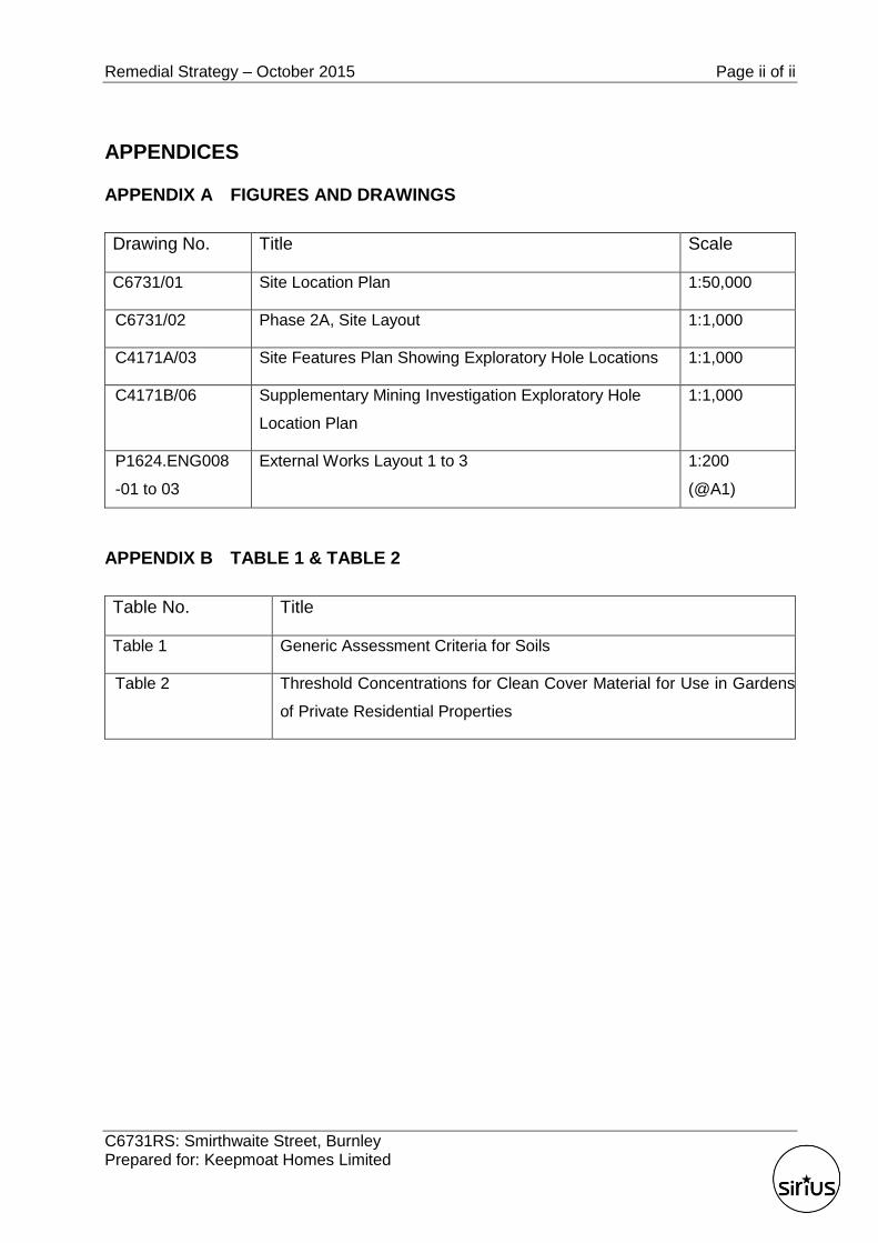
APPENDICES
APPENDIX A FIGURES AND DRAWINGS
Drawing No. Title Scale
C6731/01 Site Location Plan 1:50,000
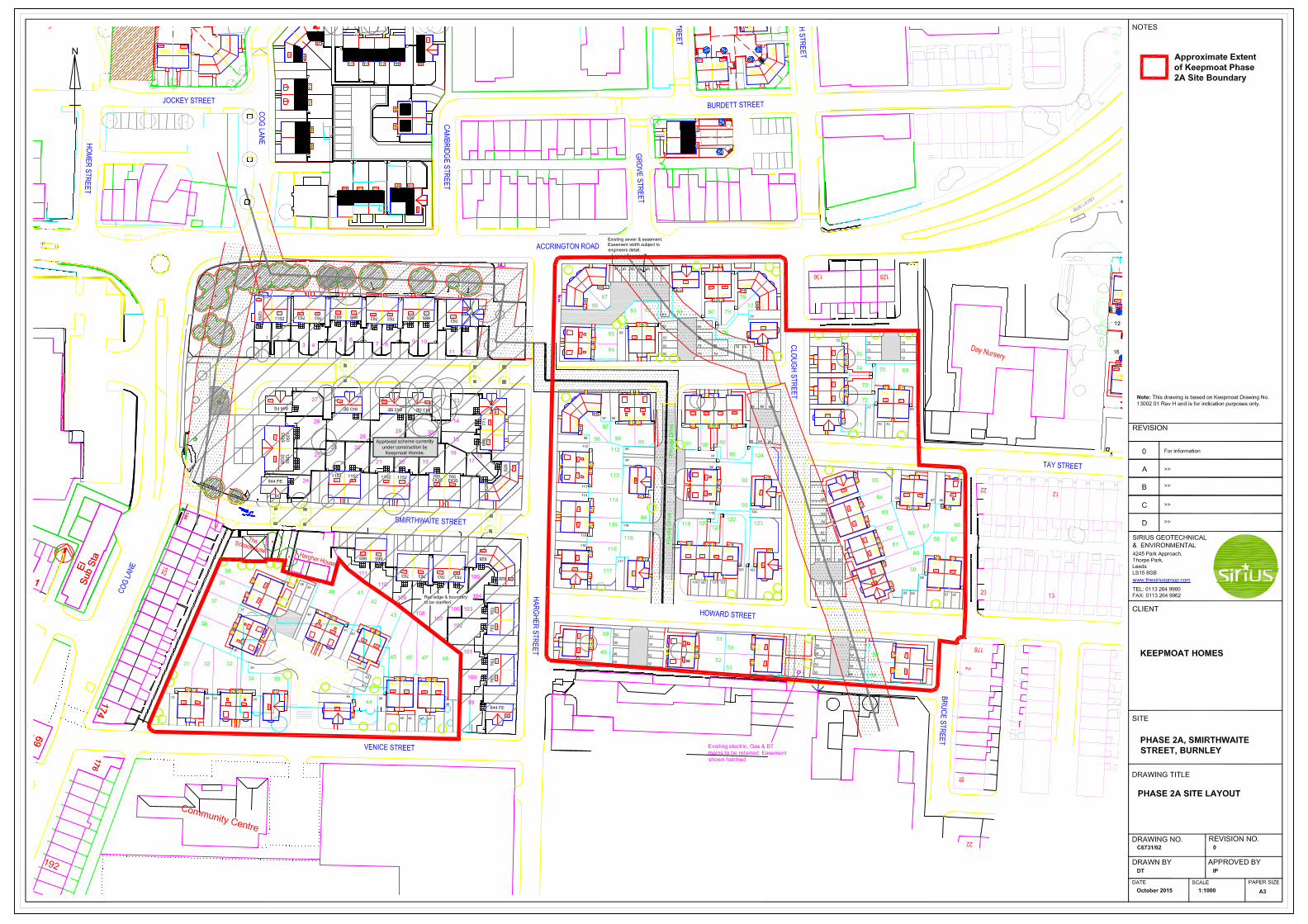
C6731/02 Phase 2A, Site Layout 1:1,000
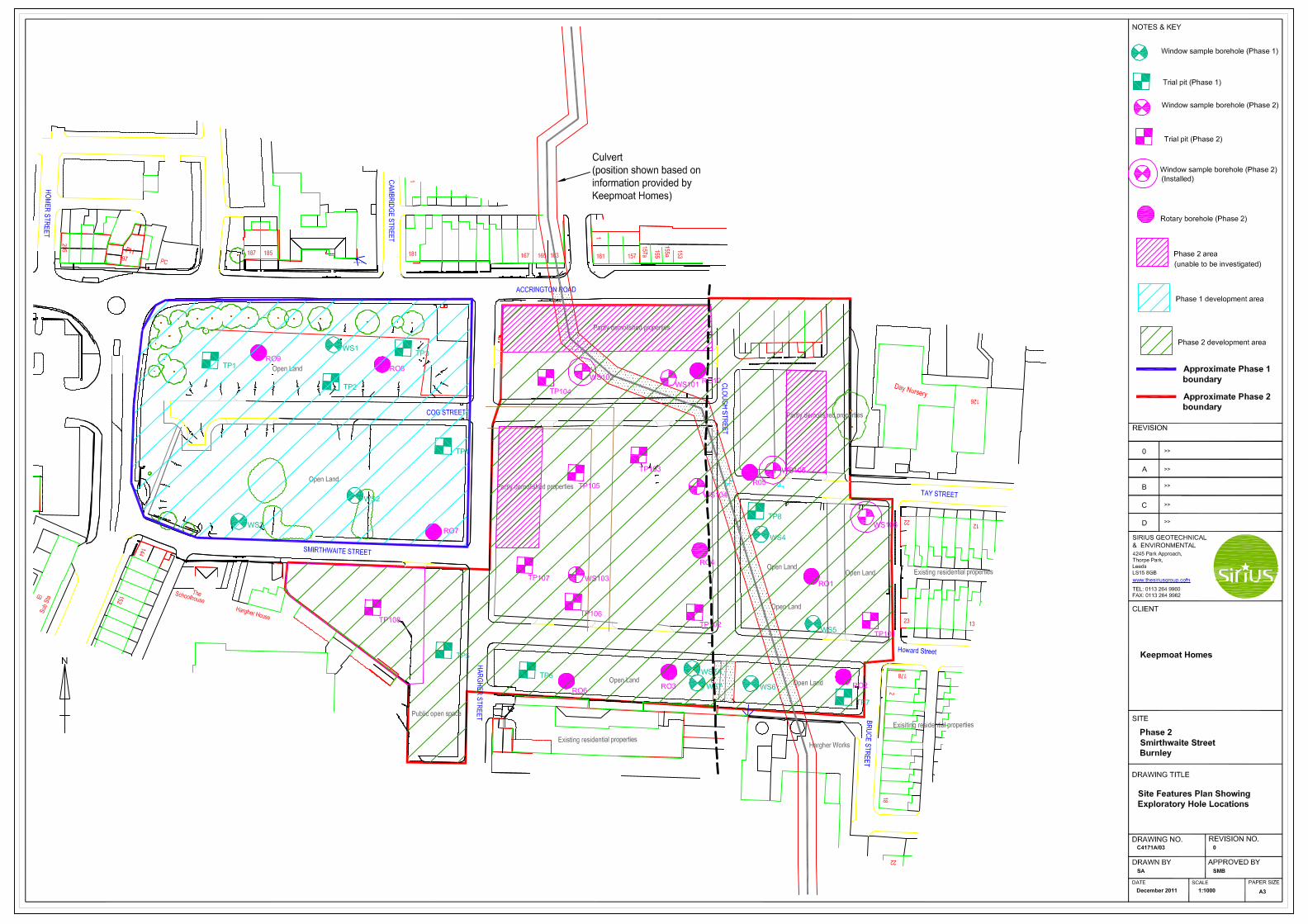
C4171A/03 Site Features Plan Showing Exploratory Hole Locations 1:1,000
C4171B/06 Supplementary Mining Investigation Exploratory Hole
Location Plan
1:1,000
P1624.ENG008
-01 to 03
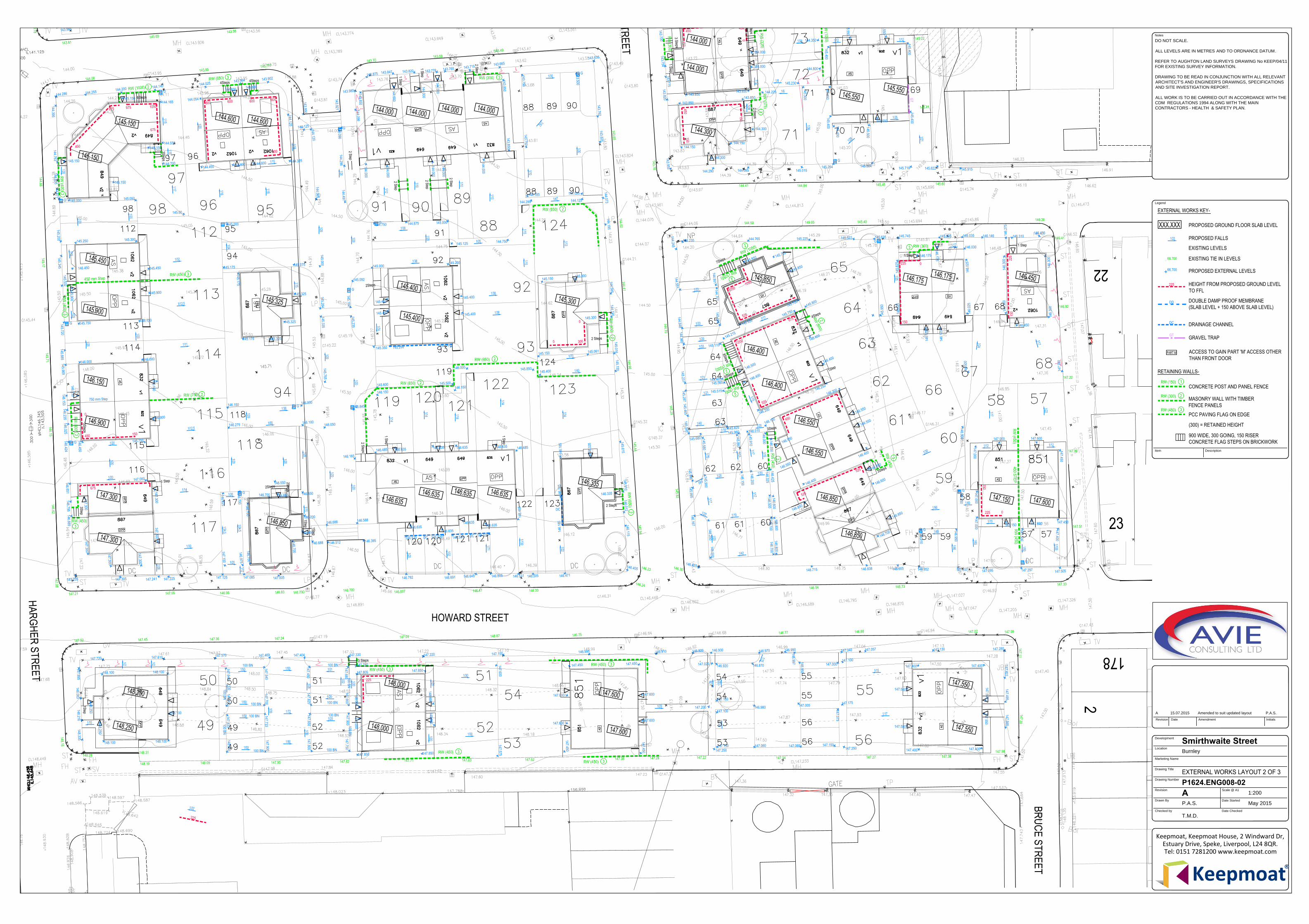
External Works Layout 1 to 3 1:200
(@A1)
APPENDIX B TABLE 1 & TABLE 2
Table No. Title
Table 1 Generic Assessment Criteria for Soils
Table 2 Threshold Concentrations for Clean Cover Material for Use in Gardens
of Private Residential Properties

Remedial Strategy – October 2015 Page 1 of 18
C6731RS: Smirthwaite Street, Burnley Prepared for: Keepmoat Homes Limited
1. INTRODUCTION
Sirius Geotechnical and Environmental Ltd (Sirius) was commissioned by Keepmoat Homes
Limited (Keepmoat), to produce a Remedial Strategy, required to facilitate redevelopment of
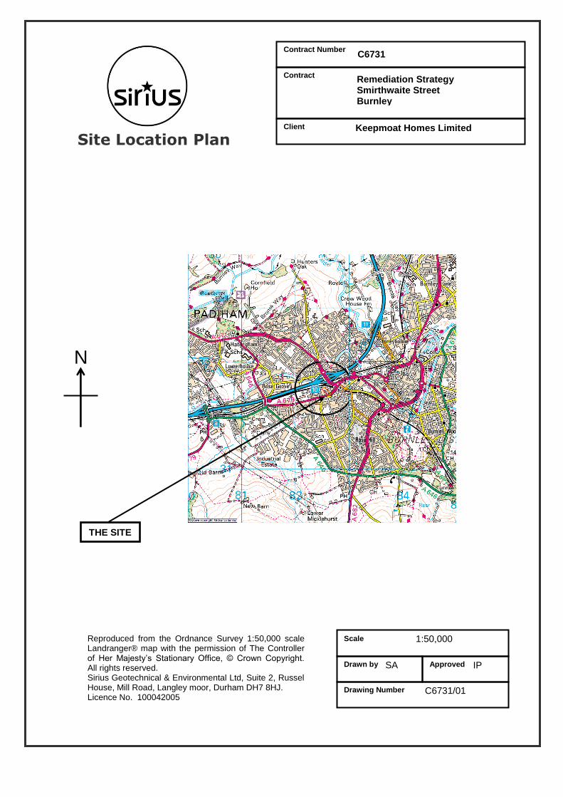
their Phase 2A area located on land at Smirthwaite Street, Burnley (the “site”). The site location
is presented within Appendix A as Drawing No. C6731/01.
It is understood that Keepmoat propose to redevelop the site for a residential end use
comprising 81 low rise residential houses with gardens including car parking and estate roads. It
is also understood that foundation solutions under consideration generally comprise either
traditional spread foundations or, in the area of the former Hargher Clough, piles terminating in
solid geology and/or ground improvement via vibro replacement techniques.
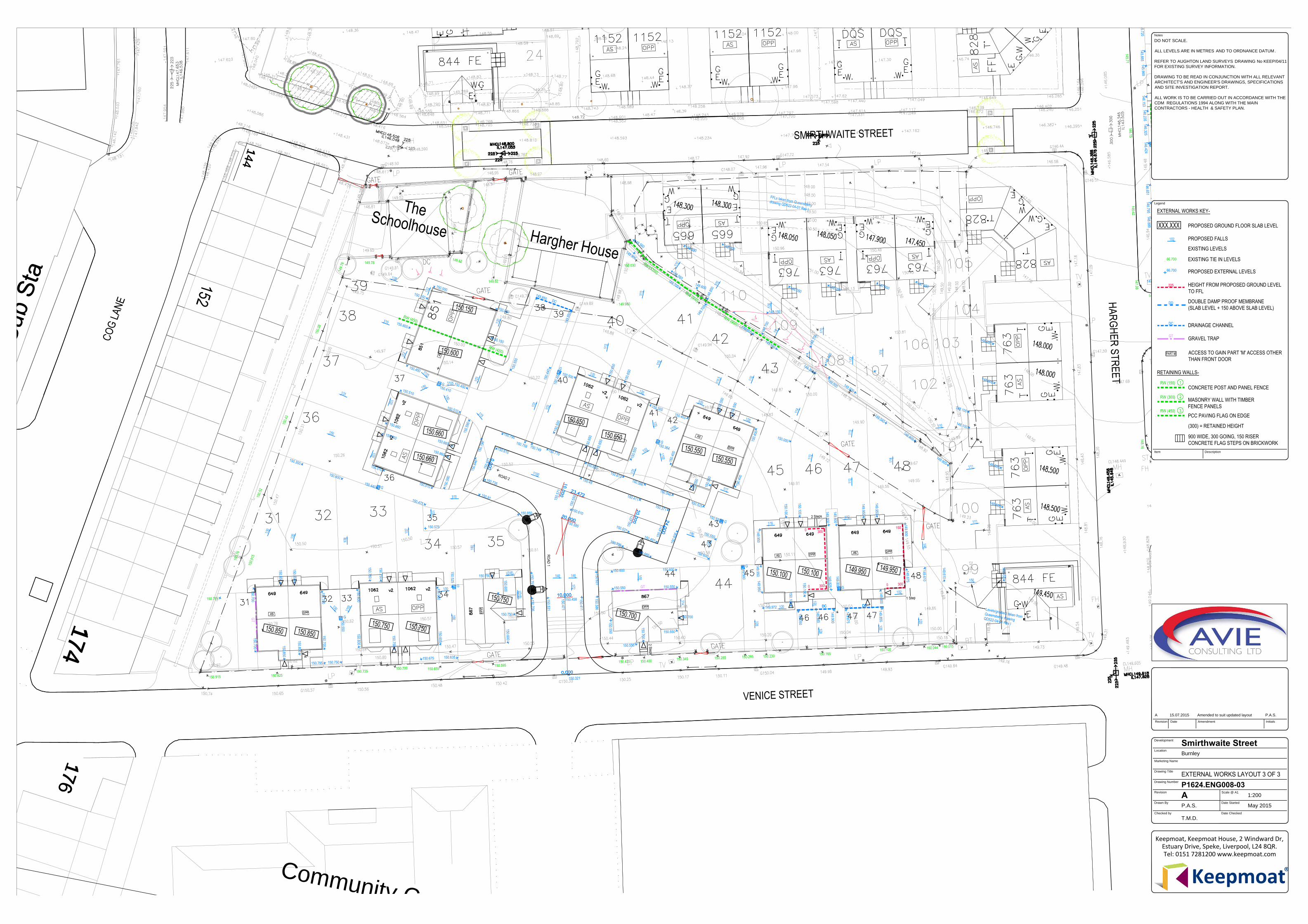
The proposed redevelopment excludes any significant earthworks and will not significantly
change site levels. The proposed development layout (provided by Keepmoat) is included as
Drawing No. C6731/02 in Appendix A to this strategy. Also in Appendix A and presented as
Drawings No. P1624.ENG008-01 to 03 is the External Works Layout.
The site has been subject to previous geoenvironmental investigations by Sirius and the key
reference documents are:
Geoenvironmental Appraisal of land off Smirthwaite Street, Burnley (Phase 1). Report
C4171. June 2011.
Geoenvironmental Appraisal of land off Smirthwaite Street, Burnley (Phase 2). Report
C4171A. March 2012.
Geoenvironmental Appraisal Report of land off Smirthwaite Street, Burnley (Phase 3).
Report C4171B. May 2015.
C4171B Phase 2, Smirthwaite Street, Burnley - Supplementary Ground Investigation.
Report C4171B. June 2015.
The documents above are the principal source of information used in the preparation of this
Strategy. Although this document summarises the site investigation works undertaken to date,
the reports referenced above should be read in conjunction with this strategy. Please note that
the phases referenced above refer to the Sirius phase of investigation and do not correspond to
the Keepmoat phase of development.
Remedial Strategy – October 2015 Page 2 of 18
C6731RS: Smirthwaite Street, Burnley Prepared for: Keepmoat Homes Limited
This document details the remedial works required to provide a site considered suitable for a
residential with garden end use. This document is intended to detail the approach to be taken
to ensure that the risks to sensitive receptors are suitably mitigated, potential risks associated
with contamination during the preparatory and construction phase of the development are
controlled, and that any potential contamination not previously revealed during the course of the
previous investigations are dealt with in an appropriate manner.
The main aims of this remedial strategy are:
To summarise the works required to remediate soils at the site to a condition considered
suitable for the proposed end use; and
To satisfy the Local Planning Authority (LPA), Environmental Health Department or other
building warranty providers that the remediated site will be suitable for the proposed
development.
Should changes or amendments to the proposed layout, site levels and / or end use be made,
then these should be confirmed by Keepmoat and if required addendums to this strategy made.
This document is written for the use of Keepmoat. No other third party may rely on or reproduce
the contents of this report without the prior written approval of Sirius. If any unauthorised third
party comes into possession of this report they rely on it at their own risk and the authors do not
owe them a Duty of Care or Skill.
No works should be undertaken on site until the strategy is approved by the relevant regulators.
It is the responsibility of the Principal Contractor (PC) to produce detailed Method Statements
describing how the objectives set out in this remedial strategy will be achieved, with appropriate
consideration of construction environmental management (including but not limited to dust
suppression, odour control, etc).
Remedial Strategy – October 2015 Page 3 of 18
C6731RS: Smirthwaite Street, Burnley Prepared for: Keepmoat Homes Limited
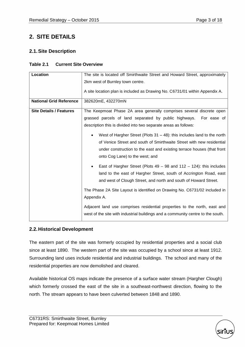
2. SITE DETAILS
2.1. Site Description
Table 2.1 Current Site Overview
Location The site is located off Smirthwaite Street and Howard Street, approximately
2km west of Burnley town centre.
A site location plan is included as Drawing No. C6731/01 within Appendix A.
National Grid Reference 382620mE, 432270mN
Site Details / Features The Keepmoat Phase 2A area generally comprises several discrete open
grassed parcels of land separated by public highways. For ease of
description this is divided into two separate areas as follows:
West of Hargher Street (Plots 31 – 48): this includes land to the north
of Venice Street and south of Smirthwaite Street with new residential
under construction to the east and existing terrace houses (that front
onto Cog Lane) to the west; and
East of Hargher Street (Plots 49 – 98 and 112 – 124): this includes
land to the east of Hargher Street, south of Accrington Road, east
and west of Clough Street, and north and south of Howard Street.
The Phase 2A Site Layout is identified on Drawing No. C6731/02 included in
Appendix A.
Adjacent land use comprises residential properties to the north, east and
west of the site with industrial buildings and a community centre to the south.
2.2. Historical Development
The eastern part of the site was formerly occupied by residential properties and a social club
since at least 1890. The western part of the site was occupied by a school since at least 1912.
Surrounding land uses include residential and industrial buildings. The school and many of the
residential properties are now demolished and cleared.
Available historical OS maps indicate the presence of a surface water stream (Hargher Clough)
which formerly crossed the east of the site in a southeast-northwest direction, flowing to the
north. The stream appears to have been culverted between 1848 and 1890.
Remedial Strategy – October 2015 Page 4 of 18
C6731RS: Smirthwaite Street, Burnley Prepared for: Keepmoat Homes Limited
3. SUMMARY OF PREVIOUS INVESTIGATIONS
3.1. Ground Conditions
Sirius has carried out four phases of intrusive fieldworks at the site comprising the excavation of
trial pits as well as the drilling of window sample and rotary boreholes. Exploratory hole
locations are shown on Drawing No. C4171A/03 Supplementary Mining Investigation
Exploratory Hole Location Plan and Drawing No. C4171B/06 Site Features Plan Showing
Exploratory Hole Locations presented in Appendix A.
Exploratory holes generally encountered thin reworked topsoil overlying made ground. East of
Hargher Street, made ground deepened centrally and to the east within the general vicinity of
Hargher Clough (encountered to approximate depths of between 2.2m and 4.1m bgl). Made
ground in the vicinity of Hargher Clough was recorded to comprise cohesive fill, described as
locally soft slightly sandy slightly gravelly clay. Gravel was recorded to comprise brick,
sandstone, concrete and slate. The cohesive fill was found to generally overlie granular made
ground consisting of ash, shells, glass bottles and pottery. Elsewhere made ground was found
to depths of between 1.3m and 1.8m bgl and was recorded to comprise variable cohesive and
granular soils. The made ground generally consisted of soft to firm slightly sandy slightly
gravelly clay and sand and gravel with low to moderate cobble and boulder content of brick,
concrete and sandstone with occasional glass timber and slate. Gravel of slag and clinker were
identified in made ground in WS105 to 0.5m bgl. Domestic waste and electrical equipment was
noted within made ground in TP103.
West of Hargher Street, made ground was encountered to an approximate depth of 0.5m and
was both granular and cohesive. The cohesive fill was described as soft dark greyish brown
sandy gravelly clay with the gravel recorded to comprise brick, sandstone and clinker. The
granular made ground comprised a sandy gravel of brick, sandstone, cement, coal, clinker and
tarmacadam.
Natural strata generally comprised firm to stiff, low to high strength cohesive glacial soils,
recorded to depths exceeding 5.45m bgl. Soft, low strength, organic clay with peat lenses was
identified directly underlying made ground at 4.1m at WS5, indicating possible alluvial
superficial deposits associated with Hargher Clough. Underlying solid geology typically
comprised Lower Coal Measures strata, proven to a maximum depth of 30.00m, comprising
bands of siltstone, sandstone, mudstone and intact coal.
Remedial Strategy – October 2015 Page 5 of 18
C6731RS: Smirthwaite Street, Burnley Prepared for: Keepmoat Homes Limited
Two intact coal seams were recorded as underlying the site at shallow depth. These are the
Inferior Cannel Mine in the west and the King Mine in the east, each being fault-bounded. The
King Mine seam is the thickest, being recorded on the geological map section at between
approximately 1.4 and 1.8m thick. The Inferior Cannel Mine to the east of the site is recorded to
be between 0.3 and 0.6m thick.
Two faults are recorded to outcrop across the site, aligned roughly north west/south east, within
the eastern and western thirds of the site. The western fault is shown to down-throw strata to
the east with the eastern fault down-throwing strata to the west, creating a central down-thrown
fault block.
Rotary probeholes have not identified evidence of mineworkings within either the King Mine or
Inferior Cannel Mine coal seams beneath the site. However zones of soft strata were
encountered within two probeholes (RO211 and RO212), although given the proven ground
conditions within adjacent probeholes, in addition to the full recovery of flush returns during the
drilling of these probeholes, it is considered that the soft ground encountered is associated with
the presence of either a band of soft weathered coal/mudstone/seat earth, and/or potential
zones of weakness/“wash out” associated with the recorded geological fault and watercourse
within the immediate proximity of these probeholes, respectively.
3.2. Identified Contamination
Selected samples were taken and scheduled as part of the Sirius investigation for chemical
testing. The results identified localised concentrations of polycyclic aromatic hydrocarbons
(PAHs) in made ground soils above generic assessment criteria (GAC) for residential end use.
3.3. Hazardous Ground Gas
The ground gas regime has been assessed and outline recommendations for gas protection
measures for Phase 2A are divided as follows:
West of Hargher Street (Plots 31 to 48): Characteristic Situation (CS) 1, i.e. No gas
protection measures are required.
East of Hargher Street (Plots 49 to 98 and 112 to 124): The overall ground gas regime
has been assessed as CS1, requiring no gas protection measures. However, organic
clay with peat lenses was identified directly underlying the made ground at 4.1m at WS5,
indicating possible alluvial superficial deposits associated with Hargher Clough.
Remedial Strategy – October 2015 Page 6 of 18
C6731RS: Smirthwaite Street, Burnley Prepared for: Keepmoat Homes Limited
Therefore it is recommended to incorporate CS2 precautions, where houses are piled
over the former Hargher Clough, to mitigate risk from underlying possible fluvial/alluvial
soils.
In accordance with British Standard BS8485:20151 a minimum gas protection score of 3.5
should be achieved through a combination of two or more of the following three types of
protection measures:
The structural barrier of the floor slab;
Ventilation measures; and
Gas resistant membrane.
The installation of gas protection measures and the verification inspections, monitoring and
testing of the measures should be recorded in a report. Reference should be made to any
specific regulatory requirements. The design parameters, specifications, justifications and
method of verification should be approved in advance of the works by the appropriate regulatory
authority.
Radon protection measures are not required for the proposed development on this site.
There may be local shallow areas of potentially putrescible soils, associated with the former
development, for example, in backfilled basements. These soils should be removed from site as
part of the enabling works.
3.4. Invasive Plants
No invasive plant species were identified during the Sirius site investigation.
It is recommended that the presence or absence of invasive species is confirmed by a qualified
consultant ecologist and their advice taken on appropriate treatment. The treatment of any
invasive species, if required, should take place in advance of the proposed construction works.
1 BS 8485:2015, Code of Practice for the Design of Protective Measures for Methane and Carbon Dioxide
Ground Gases for New Buildings.
Remedial Strategy – October 2015 Page 7 of 18
C6731RS: Smirthwaite Street, Burnley Prepared for: Keepmoat Homes Limited
3.5. Shallow Mine Workings
A total of 45 probeholes drilled as part of previous ground investigations undertaken by Sirius
have not identified evidence of mine workings within either the King Mine or Inferior Cannel
Mine coal seams beneath the site.
However, given the shallow depth of the Inferior Cannel Mine and King Mine coal seams the
possibility of unrecorded historical crop workings / bell pits or unrecorded mine entries cannot
be discounted. It is therefore recommended that all excavations are inspected for the presence
of mine entries/features. If any disturbed ground is suspected, advice regarding treatment /
foundation precautions should be sought from a suitably qualified engineer.
Remedial Strategy – October 2015 Page 8 of 18
C6731RS: Smirthwaite Street, Burnley Prepared for: Keepmoat Homes Limited
4. REMEDIATION STRATEGY
The primary objective of the remediation works is to render the site suitable for residential
development with gardens whilst mitigating the transient and long term risks to receptors
including human health and the environment.
Following discussion with Keepmoat, it is considered that where made ground is placed or
remains in situ below proposed gardens and public open space, capping is the most cost
effective and sustainable remedial solution.
The main requirements of the remediation works are given below in the approximate sequence
of works. Pertinent elements of the works are discussed in greater detail in subsequent
sections of this document.
Clearance of general debris.
Breaking out and uplifting of relict slabs, foundations, relict structures, and areas of
hardstanding identified at the surface which are not to be retained.
Re-profiling of the site, where required to form a suitable development plateau to
achieve the desired remediated site levels.
A watching brief during site enabling works to identify any previously unidentified
sources of contamination. If any grossly contaminated soils, liquid or drummed wastes,
underground fuel storage tanks (USTs), materials suspected to contain asbestos or
similar are encountered during the remediation works, then a suitably qualified
geoenvironmental consultant shall be consulted.
Placement of “clean” cover soil in all gardens / soft landscaping comprising a minimum
thickness of 150mm topsoil and 450mm subsoil, where made ground is present.
All excavations into natural soils should be inspected for the possible presence of
unrecorded mine entries or infilled unrecorded surface workings (i.e. bell pits).
Validation of the clean cover soil should be carried out by a suitably qualified
Geoenvironmental Engineer (GE). This should be documented in a validation report
produced by a suitably qualified GE on completion of the works. This report will include
verification of the thickness of the capping system and the results of chemical testing to
demonstrate the chemical suitability.
Remedial Strategy – October 2015 Page 9 of 18
C6731RS: Smirthwaite Street, Burnley Prepared for: Keepmoat Homes Limited
Where made ground extends to a depth of less than 600mm below finished garden levels and a
cover layer cannot be incorporated, consideration should be given to localised full depth
removal of made ground to a licenced waste disposal facility and levels made up with clean
subsoil and topsoil as required.
As it is understood that shallow made ground to the west of Hargher Street is to be subject to
complete removal in order to construct floor slabs to plots (also removing the need for cover
soils in gardens), it is considered that potential volatile vapour hazards presented by localised
elevated naphthalene impacted made ground (recorded in TP302 only) will not be required.
Made ground in TP302 was recorded as extending to only 500mm below original ground level.
Notwithstanding the above, in the event a suspended floor slab is to be constructed (e.g. where
made ground is >600mm thick or ground improvement is undertaken) and made ground
remains beneath the dwelling, it is recommended that an appropriate vapour resistant
membrane is installed and selected in accordance with CIRIA 748 and validated in accordance
with CIRIA 735.
Remedial Strategy – October 2015 Page 10 of 18
C6731RS: Smirthwaite Street, Burnley Prepared for: Keepmoat Homes Limited
5. GEOENVIRONMENTAL ENGINEER
A suitably experienced and qualified Geoenvironmental Engineer (GE) should be appointed by
Keepmoat to validate the removal of made ground in areas to the west of Hargher Street, as
well as verify the construction of clean cover capping system, as required in garden / soft
landscaping areas.
The responsibilities of the GE shall include, but not be limited to, the following:
Liaison with Client, their appointed Principal Contractor (PC) and statutory bodies in
relation to the remedial works.
Supervision and quality control of the remedial works.
The supervision of soil sampling as required under the strategy.
Implementation of additional testing and contingency measures if unexpected
contamination is found during the work.
Attendance at site to inspect and sample cover soils as instructed by Keepmoat or their
PC.
Review of site records and test results as they become available and make comment
and act upon those results accordingly.
The GE will provide either a single validation report for the entire site, or a series of validation
reports detailing the works undertaken including those associated with any unforeseen
contamination encountered. The validation report(s) shall include relevant site records
including:
Demonstration of cover layer thickness and chemical suitability of both placed subsoil
and topsoil;
Detailing areas where clean cover soils are not required; and
Acting as certification that the cover layer has been constructed in accordance with this
strategy.
The report(s) will serve to confirm the works were undertaken in accordance with the relevant
legislation, the remediation strategy and any relevant planning conditions, together with
detailing any agreed departures from the above, if required.
Remedial Strategy – October 2015 Page 11 of 18
C6731RS: Smirthwaite Street, Burnley Prepared for: Keepmoat Homes Limited
6. CONTAMINATION CONSIDERATIONS
6.1. Localised Removal of Made Ground
Where a clean cover layer is not proposed, for example potentially in the area to the west of
Hargher Street, then these areas must be validated that made ground has been removed.
Following the removal of made ground and prior to any infilling works, validation samples for
chemical analysis shall be taken by the GE from the exposed natural ground surfaces i.e. on a
nominal 25m grid or as agreed with the GE, to confirm that all potentially hazardous made
ground has been removed. All testing should be undertaken at a UKAS and MCERTS
accredited laboratory.
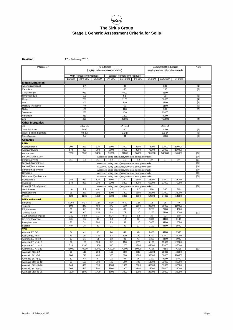
Samples shall be tested for the identified contaminants of concern including pH, total metals
(copper, nickel, zinc, chromium (total), chromium (VI), arsenic, mercury, selenium, cadmium and
lead) and speciated PAHs. The results will be compared to the residential GAC listed in Table 1
in Appendix B of this strategy. Analysis for other determinands may be appropriate and should
be undertaken as necessary.
If the referenced GAC concentrations are exceeded then additional soils should be removed
and further validation samples recovered. This shall be an iterative process until validation test
results fall below the referenced concentrations or until excavation depth reaches 600mm in
gardens or the depth of the underside of floor slabs below plots.
Any excavations backfilled prior to receipt and review of laboratory validation test results by the
GE, are done so at the risk of the Contractor.
6.2. Reporting of Unexpected Contamination
In addition to the potential contamination associated with made ground, there is the possibility
that areas of more significant contamination not previously identified may be encountered
during redevelopment.
Vigilance should be maintained during site clearance and construction works for any hotspots
not identified as part of the intrusive works. If any previously unidentified grossly contaminated
soils, liquid or drummed wastes, or similar are encountered during site clearance/ development
works, they should be reported and appropriate advice sought from the GE. Any deviation from
this strategy should be agreed with the local authority.

Remedial Strategy – October 2015 Page 12 of 18
C6731RS: Smirthwaite Street, Burnley Prepared for: Keepmoat Homes Limited
The possibility of encountering asbestos containing materials (ACMs) (such as asbestos
sheeting, used as shuttering, and/or fragments of asbestos-containing materials within made
ground or fill materials) cannot be entirely discounted. If suspected ACMs are encountered,
work in the immediate area should cease and the excavation covered over and recorded
pending specialist advice from an appropriately qualified asbestos specialist and an appropriate
strategy developed for the safe removal/disposal of the material.
Additional laboratory analysis of any previously unidentified contamination sources will be
required in order to determine the requirements for remediation and should be assessed against
residential with plant uptake assessment criteria detailed within Table 1 in Appendix B to this
strategy.
6.3. General
Excavations should not be left open for longer than is necessary and should be securely
cordoned off using appropriate fencing and warning signs, whenever excavation works are
suspended.
Any potentially contaminated materials requiring assessment or contaminated materials
designated for removal from site shall be placed in temporary stockpiles on hardstanding or
heavy-duty Visqueen sheeting, suitably covered and bunded with appropriate signage and
identification. Off-site disposal requirements are discussed in Section 7 of this strategy.
During the remediation and construction it will be necessary to protect the health and safety of
site personnel. General guidance on these matters is given in the Health and Safety Executive
(HSE) document ‘Protection of Workers and the General Public during the Redevelopment of
Contaminated Land (HS(G)66)’. In summary, the following measures are suggested to provide
a minimum level of protection:
All ground workers should be issued with high visibility clothing, hard hats, protective
footwear and impermeable heavy duty gloves. Personnel should be instructed as to how
they are to be used;
Hand washing and boot cleaning facilities shall be provided;
No smoking on site other than in designated areas if any are present on site; and,
Good practices relating to personal hygiene shall be adopted.
Remedial Strategy – October 2015 Page 13 of 18
C6731RS: Smirthwaite Street, Burnley Prepared for: Keepmoat Homes Limited
Before site operations are commenced the necessary COSHH Assessment, Method Statements
and Health and Safety Plans should be completed and issued by the PC in accordance with the
CDM Regulations 2007.
All site personnel shall undergo a site specific health and safety induction prior to
commencement of work on site.
During the progress of the works, if significant dewatering is required necessitating disposal to
surface water drains or foul sewer, appropriate discharge consents must be obtained from the
Environment Agency / appropriate water authority. This is likely to require chemical analysis of
such groundwater. In the event that significantly contaminated groundwater is encountered, this
should be removed by tanker and disposed at a licenced disposal facility.
The PC shall ensure that potentially contaminated waters and leachate from excavations or
stockpiling areas do not reach watercourses, surface water drains, etc.
All such waters will be removed from site by tanker to a suitable disposal facility or alternatively
treated on site for subsequent disposal to foul sewer.
The PC will be responsible in obtaining all necessary permits and consents for disposal to foul
sewer prior to the commencement of works.
Contaminated waters pumped from excavations should be stored in a holding tank and
chemically tested prior to disposal. All discharges to foul sewer should be recorded in relation to
date, time, quantity and quality. All records should be maintained at all times and be made
available to the GE upon request.
Remedial Strategy – October 2015 Page 14 of 18
C6731RS: Smirthwaite Street, Burnley Prepared for: Keepmoat Homes Limited
7. OFF SITE DISPOSAL
Any material removed from site as part of the enabling/ remedial works shall be disposed of at
an appropriate facility, in accordance with Duty of Care (DoC) Regulations/ Waste Management
Guidance.
Materials designated for off-site disposal shall be safely stockpiled, sampled and analysed at
rates sufficient to allow the material to be adequately categorised to the satisfaction of the
receiving landfill operator in accordance with the Hazardous Waste Regulations (HWR) 2005.
Any material exported from site to landfill shall be hauled by a registered waste carrier in
accordance with the HWR and DoC regulations. A waste transfer or consignment note shall be
completed, signed and retained by all parties involved. The waste transfer or consignment note
shall state the volume of waste, a physical description of the waste and statement of its
chemical composition.
These notes shall be kept by the PC for a period of at least two years and copies of all
paperwork should be provided to Keepmoat.
Remedial Strategy – October 2015 Page 15 of 18
C6731RS: Smirthwaite Street, Burnley Prepared for: Keepmoat Homes Limited
8. CLEAN COVER LAYER CONSTRUCTION
8.1. General
The remediation strategy for the site, with respect to protection of future end users, includes for
the provision of a ‘clean’ cover layer soil capping system to form a physical separation between
made ground contaminants and site end users within soft landscaped areas, where made
ground remains at development level.
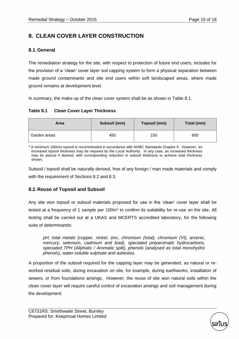
In summary, the make-up of the clean cover system shall be as shown in Table 8.1.
Table 8.1 Clean Cover Layer Thickness
Area Subsoil (mm) Topsoil (mm) Total (mm)
Garden areas 450 150 600
* A minimum 100mm topsoil is recommended in accordance with NHBC Standards Chapter 9. However, an increased topsoil thickness may be required by the Local Authority. In any case, an increased thickness may be placed if desired, with corresponding reduction in subsoil thickness to achieve total thickness shown.
Subsoil / topsoil shall be naturally derived, free of any foreign / man made materials and comply
with the requirement of Sections 8.2 and 8.3.
8.2. Reuse of Topsoil and Subsoil
Any site won topsoil or subsoil materials proposed for use in the ‘clean’ cover layer shall be
tested at a frequency of 1 sample per 100m3 to confirm its suitability for re-use on the site. All
testing shall be carried out at a UKAS and MCERTS accredited laboratory, for the following
suite of determinands:
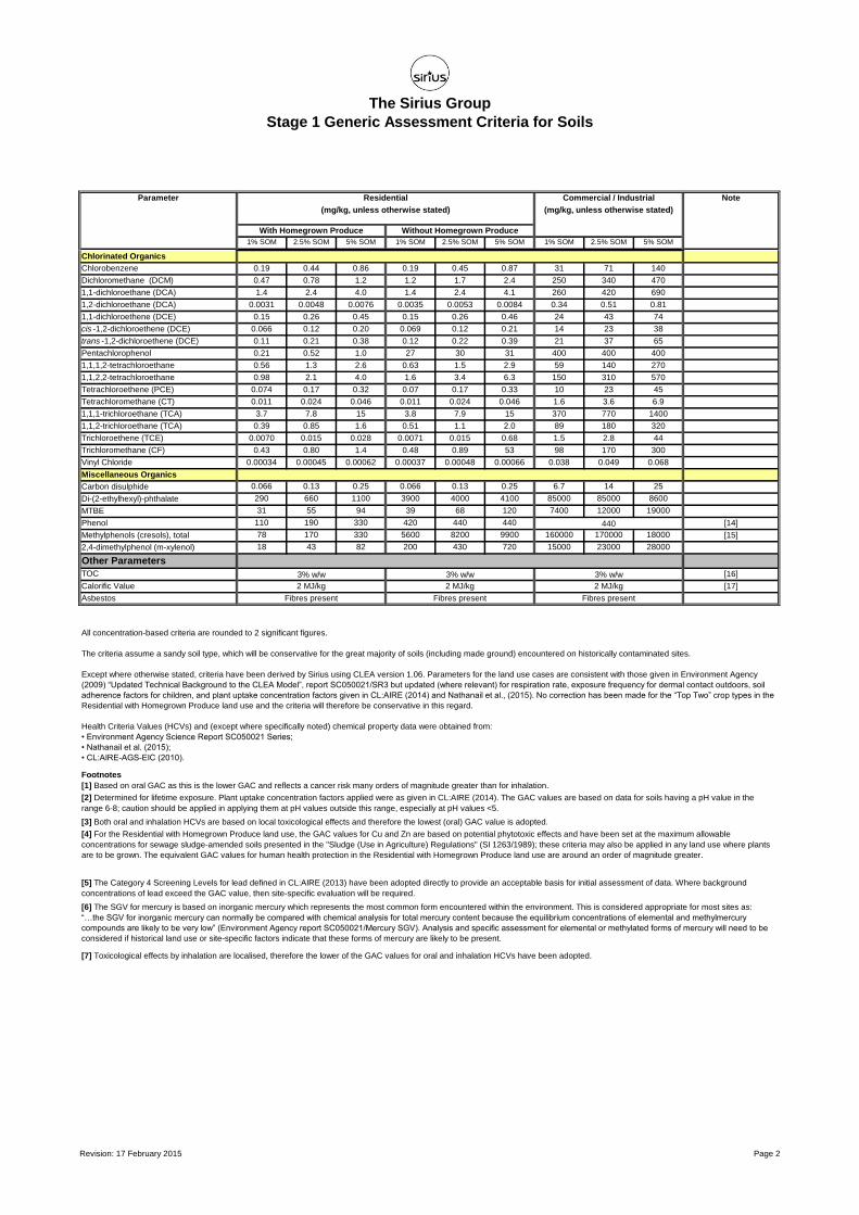
pH, total metals (copper, nickel, zinc, chromium (total), chromium (VI), arsenic, mercury, selenium, cadmium and lead), speciated polyaromatic hydrocarbons, speciated TPH (Aliphatic / Aromatic split), phenols (analysed as total monohydric phenols), water-soluble sulphate and asbestos.
A proportion of the subsoil required for the capping layer may be generated, as natural or re-
worked residual soils, during excavation on site, for example, during earthworks, installation of
sewers, or from foundations arisings. However, the reuse of site won natural soils within the
clean cover layer will require careful control of excavation arisings and soil management during
the development.

Remedial Strategy – October 2015 Page 16 of 18
C6731RS: Smirthwaite Street, Burnley Prepared for: Keepmoat Homes Limited
Owing to the potential for cross-contamination of natural soils during excavation or subsequent
stockpiling prior to use, any site won natural soils, proposed for re-use as subsoil materials in
the make-up of the ‘clean’ cover layer shall be tested at the same frequency and for the same
suite of determinands as detailed for site won topsoil above.
General
The analytical testing will be undertaken on a seven day turnaround and shall be forwarded to
the GE as they become available. The results shall be compared with the threshold guideline
values given in Table 2 in Appendix B of this strategy. Should any analyte exceed the
concentrations shown, then the soil should be considered unsuitable for use within the capping
layer.
8.3. Import of Topsoil and Subsoil
For any imported materials required to complete the cover soils, then these shall be tested in
accordance with the guidance given in the YAHPAC document Verification Requirements for
Cover Systems, Version 3.2 dated October 2015. These are summarised in Table 8.2 below.
Table 8.2 Sampling and Testing for Imported Soils
Type Number of Samples Testing Schedule Assessment Criteria
Virgin Quarried Material
1 or 2 depending on the type of stone used
Standard metals/metalloids (As, Cd, Cr, Cr(VI), Cu, Hg, Ni, Pb, Se, Zn)
As per Table 2
Appendix B
Crushed Hardcore, Stone, Brick
Minimum 1 per 1000m³ Standard metals/metalloids (As above)
PAH (16 USEPA speciation)
Asbestos
Greenfield/ Manufactured Soils
Minimum 3 or 1 per 250m³ (whichever is greater)
Standard metals / metalloids (As above)
PAH (16 USEPA speciation)
Asbestos
Brownfield/ Screened Soils
Minimum 6 or 1 per 100m³ (whichever is greater)
Standard metals / metalloids (As above)
PAH (16 USEPA speciation)
TPH (CWG banded)
Asbestos
Any additional analysis dependant on the history of the donor site.
The test results shall be made available to the GE prior to any material being delivered to site.
Remedial Strategy – October 2015 Page 17 of 18
C6731RS: Smirthwaite Street, Burnley Prepared for: Keepmoat Homes Limited
8.4. Placement of Cover Soils
Clean cover soils shall be placed in all areas of gardens and soft landscaped areas throughout
the site where made ground underlies the site. The cover soil materials shall be placed by
Keepmoat or their subcontractor(s), and shall be lightly compacted following placement, to
ensure minimal future settlements.
It is envisaged that capping soil horizons shall be placed within individual areas of garden and
landscaping on completion of development of individual plots. This will act to minimise the
potential for disturbance of the capping system and physical destruction of topsoil structure i.e.
via plant trafficking, following placement.
Notwithstanding the above, following placement of the clean cover layer, care will be required to
prevent cross contamination of the clean cover layer soils with adjacent materials. Keepmoat
and their subcontractor should provide method statements and adopt methods of work for
activities which may give rise to cross contamination between site areas and soil types.
8.5. Verification of Required Depth
Verification of depth of topsoil and subsoil shall be carried out by a suitably qualified GE by
excavation of a small trial pit. Pits shall be excavated at a rate of 1 per 3 plots for private rear
garden areas or spaced on a minimum of a 25m grid for landscaped/POS areas (minimum 3 per
landscaped area). The frequency should be agreed with the Local Planning Authority (LPA) /
Environmental Health Department. Evidence for validating the depth of cover shall accord with
the YAHPAC document Verification Requirements for Cover Systems, Version 2.2 dated
September 2015.
8.6. Verification of Remediation Scheme
A verification report must be prepared that documents completion of the measures described in
the approved remedial strategy. This must be submitted to and approved in writing by the LPA.

Remedial Strategy – October 2015 Page 18 of 18
C6731RS: Smirthwaite Street, Burnley Prepared for: Keepmoat Homes Limited
9. REGULATORY APPROVAL
A copy of this specification should be forwarded to the LPA, and other regulators as appropriate
for their approval prior to the works.
Sufficient time should be allowed for regulatory approval to be obtained during the
redevelopment programme.

APPENDIX A
DRAWINGS AND FIGURES
Site Location Plan
C6731
Remediation Strategy Smirthwaite Street Burnley
Keepmoat Homes Limited
Scale
Approved Drawn by
Drawing Number
Reproduced from the Ordnance Survey 1:50,000 scale Landranger® map with the permission of The Controller of Her Majesty’s Stationary Office, © Crown Copyright. All rights reserved. Sirius Geotechnical & Environmental Ltd, Suite 2, Russel House, Mill Road, Langley moor, Durham DH7 8HJ. Licence No. 100042005
Contract Number
Contract
Client
1:50,000
C6731/01
THE SITE
N
SA IP
T
A
R
M
A
C
G
R
A
S
S
B
L
O
C
K
P
A
V
IN
G
K
E
R
B
H
A
R
D
S
T
A
N
D
IN
G
G
R
A
S
S
C
o
n
c
r
e
te
T
A
R
M
A
C
T
A
R
M
A
C
T
.
F
IR
.F
T
A
R
M
A
C
T
P
S
H
A
R
D
S
T
A
N
D
IN
G
T
A
R
M
A
C
T
A
R
M
A
C
S
W
A
L
L
B
W
A
L
L
H
A
R
A
S
.F
R
IN
G
C
O
B
B
L
E
S
T
A
R
M
A
C
B
W
A
L
L
IR
.F
IR
.F
B
W
A
L
L
C
O
N
C
R
A
M
P
S
W
A
L
L
IF
S
W
A
L
L
BW
ALL
G
R
A
S
S
G
R
A
S
S
G
R
A
S
S
A
c
c
r
i
n
g
t
o
n
R
o
a
d
C
l
o
u
g
h
S
t
r
e
e
t
A
c
c
r
i
n
g
t
o
n
R
o
a
d
G
r
o
v
e
S
t
r
e
e
t
C
l
o
u
g
h
S
t
r
e
e
t
C
o
g
S
t
r
e
e
t
C
o
g
S
t
r
e
e
t
S
w
irth
w
a
ite
S
tre
e
t
S
w
i
r
t
h
w
a
i
t
e
S
t
r
e
e
t
C
o
g
S
t
r
e
e
t
C
o
g
L
a
n
e
Cog Lane
H
a
r
g
h
e
r
S
t
r
e
e
t
H
a
r
g
h
e
r
S
t
r
e
e
t
H
a
r
g
h
e
r
S
t
r
e
e
t
H
o
w
a
r
d
S
t
r
e
e
t
H
o
w
a
r
d
S
t
r
e
e
t
H
o
w
a
r
d
S
t
r
e
e
t
H
o
w
a
r
d
S
t
r
e
e
t
B
r
u
c
e
S
t
r
e
e
t
P
o
l
l
a
r
d
S
t
r
e
e
t
C
l
o
u
g
h
S
t
r
e
e
t
C
l
o
u
g
h
S
t
r
e
e
t
P
e
r
t
h
S
t
r
e
e
t
P
e
r
t
h
S
t
r
e
e
t
T
a
y
S
t
r
e
e
t
T
a
y
S
t
r
e
e
t
C
o
g
S
t
r
e
e
t
IR
.F
IR
.F
Culvert
Preliminary Rotary
Probehole
Secondary Rotary
Probehole
Trial Pit
Phase 3 Rotary
Probehole
Conjectured Line
of Fault
Phase 2 Area
Boundary
Phase 3 Area
Boundary
PAPER SIZESCALE
APPROVED BYDRAWN BY
DRAWING NO.
DATE
SITE
REVISION NO.
CLIENT
C
D
A
B
REVISION
0
NOTES
KEEPMOAT HOMES
C4171B/06 0
NJI MB
May 2015 1:1000
A3
N
DRAWING TITLE
SIRIUS GEOTECHNICAL
& ENVIRONMENTAL
4245 Park Approach,
Thorpe Park,
Leeds
LS15 8GB
TEL: 0113 264 9960
FAX: 0113 264 9962
www.thesiriusgroup.com
>>
>>
>>
>>
>>
SMIRTHWAITE STREET,
BURNLEY
SUPPLIMENTARY MINING
INVESTIGATION
EXPLORATORY HOLE
LOCATION PLAN

PROPOSED GROUND FLOOR SLAB LEVEL
HEIGHT FROM PROPOSED GROUND LEVELTO FFL
225
DOUBLE DAMP PROOF MEMBRANE(SLAB LEVEL + 150 ABOVE SLAB LEVEL)
DD
PROPOSED FALLS
DRAINAGE CHANNELDC
ACCESS TO GAIN PART 'M' ACCESS OTHERTHAN FRONT DOOR
900 WIDE, 300 GOING, 150 RISERCONCRETE FLAG STEPS ON BRICKWORK
PROPOSED EXTERNAL LEVELS
EXISTING LEVELS
GT GRAVEL TRAP
EXTERNAL WORKS KEY-
EXISTING TIE IN LEVELS
CONCRETE POST AND PANEL FENCE1
MASONRY WALL WITH TIMBERFENCE PANELSPCC PAVING FLAG ON EDGE
RW (150)
2
3
RW (300)
RW (450)
RETAINING WALLS-
(300) = RETAINED HEIGHT
66.700
66.700
G
G
G
G
G
G
G
G
G
G
G
G
G
145.17144.66
144.08
143.85
143.49
143.65144.02
144.41
143.70143.59
143.50143.99
144.41
143.78
143.39
144.66
144.84
144.59 145.05 145.40
143.49143.54
143.56143.69
143.81
143.78143.45
142.88142.46
142.36142.27
142.37142.52
142.71142.95
143.09
143.15143.27
143.35
143.33143.42
143.33143.27
143.24ACCRINGTON ROAD
CLOUGH STREET
GROVE STREET
143.825144.195
144.585
144.765 145.225
144.585 145.015
143.955
143.565
143.445143.525
143.665143.715
143.735
143.865
143.985
143.505
144.255
144.025
143.875143.765
143.665143.635
145.345144.835
143.955143.590
143.055142.635
142.535142.445
142.180142.220
142.545142.695
142.870143.125
143.265
142.355 142.395
144.745
143.762144.073
143.715143.820143.847 143.778
143.777
143.950
143.921
144.125 144.120
145.284
145.184145.235
144.125
144.096143.902
143.964
144.140144.200
144.395
144.286
144.763144.971
145.200
145.900
145.900
145.5323
RW (400)
145.450
145.300
146.450
145.250
145.050
450 mm Step3RW (450)
145.000
145.150
145.150
3RW
(400)
145.150144.550
144.165145.150
144.700
450
975
675
975 1050
145.00
144.450
144.054
144.600 144.600
144.600144.600144.325
600 600
2RW (1000)
3RW (650)
600 600
300
144.565
145.000
145.000
145.175 145.075
145.325
145.175
144.497144.096
145.000
144.750
145.092
145.400
145.400145.400
145.400
145.250
145.000
145.300
145.150 145.300
143.985144.296 144.000
144.875
144.000
144.000
144.000
144.000
144.000
3RW (300) 143.850144.000
144.000
143.850
143.850
144.750
144.285
143.750
144.185
145.125
144.025
144.125
2RW (650)
143.750
143.500
143.892 143.810 143.777143.730
143.696 143.673 143.642 143.595 143.590 143.545
143.495
143.341
143.070
142.815
142.571 142.648142.500
142.424
142.911
143.150143.377
143.668
143.790143.790
143.640
3RW (450)
143.640
450
143.750
143.750
143.750143.750143.600 143.600
143.600
143.600
143.550
143.600
143.500
143.500143.500
143.500
143.660
143.550143.550
143.600
143.660143.660
143.600
143.650143.650
143.480
143.480 143.445
143.565143.530
143.200
143.550
143.350
375375
143.350
143.350143.000
143.150
143.150143.150
143.150
143.550
375
375
143.050
142.975
142.750
142.975
143.000
142.825142.825
142.340
143.100
143.250
143.100
3RW (350)
2RW (825)
143.250
142.800
900900
600
144.245144.551
144.235 145.522
145.264144.290
143.775143.820
143.754143.700
143.629143.582
143.525143.552
144.498
145.750
RW (600)
145.700145.800
525
145.850
144.801
10501050
2RW (1050)
145.850
145.700
2RW (1050)
144.701145.098
144.300
144.150
144.300
143.850143.850
144.150
150
450150
143.850
145.400 145.400
145.300
3RW
(375)
144.225
144.000
145.400145.400
143.600
143.550
RW (300)
GT
143.700
145.550
144.385
144.635
144.610
144.350
RW (1050)
144.800
145.230
144.000
144.285
144.256
144.400
143.550
143.700
143.600
150
450450
143.700
143.700
RW (375)
136 128
3Steps
6Steps
4Steps 4Steps
2Steps
2 Step
1 Step
1 Step
2 Step
2 Step
2 Step
2 Step
3Steps
1 Step
1 Step
2 Steps
2 Steps
2 Steps
2 Steps2 Steps
2 Steps
2 Steps
1Step
3 Steps
6 Steps
3 Steps
4Steps
7Steps
3 Steps
2 Steps
1 Step
1 Step
3 Steps
1 Step
143.450
143.000
225
0
150
143.550
143.550143.500
144.485
142.545 142.725
142.875
143.580
100 BN
100 BN
100 BN
100 BN
100 BN
100 BN
100 BN 100 BN
100 BN100 BN
100 BN
100 BN
100 B
N
100 BN
100 BN
100 BN
TAY STREET
G
G
143.100142.715
2 Steps
142.500
RW (3
00)
RW (300)
142.925
600143.200
142.590
142.800G143.075
142.875
142.780
142.800 142.880
RW (450)
G143.350
RW (600)
100 BN
100 BN
Item Description
Legend
Notes
DO NOT SCALE.
ALL LEVELS ARE IN METRES AND TO ORDNANCE DATUM.
REFER TO AUGHTON LAND SURVEYS DRAWING No KEEP/04/11
FOR EXISTING SURVEY INFORMATION.
DRAWING TO BE READ IN CONJUNCTION WITH ALL RELEVANT
ARCHITECT'S AND ENGINEER'S DRAWINGS, SPECIFICATIONS
AND SITE INVESTIGATION REPORT.
ALL WORK IS TO BE CARRIED OUT IN ACCORDANCE WITH THE
CDM REGULATIONS 1994 ALONG WITH THE MAIN
CONTRACTORS - HEALTH & SAFETY PLAN.
Keepmoat, Keepmoat House, 2 Windward Dr,Estuary Drive, Speke, Liverpool, L24 8QR.Tel: 0151 7281200 www.keepmoat.com
Keepmoat®
Checked by
Drawn By
Drawing Title
Drawing Number
Revision
Location
Development
Marketing Name
Date Started
Scale @ A1
Date Checked
Smirthwaite Street
Burnley
P1624.ENG008-01
C
P.A.S.
T.M.D.
1:200
May 2015
DateRevision Amendment Initials
15.07.2015A Amended to suit updated layout P.A.S.
20.07.2015B Amended to suit updated layout for
parking areas 81,87 and 78,79
P.A.S.
14.08.2015C Entrance to parking areas 81,87
relocated
P.A.S.
G
G
G
G
G
G
G
G
G
G
G
G
G G
G
G
G
147.05147.21
147.08146.62
146.15145.71
145.17144.66
144.08
143.85
146.83146.95
143.49
143.65144.02
144.41144.98
145.44145.94
146.23
146.24146.33146.47
143.70143.59
148.16
147.52 147.45 147.36 147.24 147.04 146.87 146.75
147.28147.38147.52147.63147.71147.82147.95148.09
148.31148.28
148.19
144.41
143.78
145.45144.84
144.59 145.05 145.40
146.73146.54
146.30
145.82
145.29144.70
146.28
146.41
146.92
147.22
147.40
147.51
147.33
147.02 147.09
147.11147.39
147.58147.38147.27147.24147.22
146.88146.77
143.54143.56
143.69
143.81
143.78
145.22
145.41
HOWARD STREET
CLOUGH STREET
BRUCE STREET
HARGHER STREET
147.610 147.570 147.220 147.100 146.990 147.280147.057146.990147.330
147.130
147.720
147.225147.255 147.005147.125 146.505146.645
146.905146.715 147.505146.405
143.825144.195
144.585145.155
145.615146.115
146.475
145.995
145.465144.848
144.765 145.225 145.635146.455
144.585 145.015
143.955
143.985
144.255
144.025
143.875143.765
143.665143.635
146.795146.325
145.885145.345
144.835
225
147.895148.335
148.216
148.250
148.100 148.100
148.083
148.250
148.100148.100
148.100
147.404147.469
147.900
147.800
148.000
147.540
147.640147.833
147.733
147.650
147.800
147.700
147.750147.680
147.450
147.900
147.625
147.900
148.000148.000
147.780
100 BN100 BN
100 BN100 BN
100 BN
100 BN
100 BN
100 BN
100 BN
100 BN 100 BN
100 BN147.850 147.850
147.850147.8053RW (450)
225
148.000148.000
3RW (450)
147.600147.575
147.450
147.450
146.920146.910 146.970 146.997147.450147.450
147.600
147.600
3RW (450)
147.600
147.600
3RW (450)
146.920
146.930
147.020
147.200
147.100
147.100
147.150147.250
146.870
146.950
147.000
147.040
147.100
147.250147.150
147.175
147.075
147.060147.060
146.980 147.005
147.565147.422
147.495
147.550147.550
147.400147.400
147.400 147.400
147.550
147.550
147.305 147.085
146.607146.790
146.688
146.512 146.395
146.700
146.588
146.782 146.471146.531
145.910
144.745145.016
143.762144.073
143.715143.820143.847 143.778
143.777
143.950
143.921
144.125 144.120
145.284145.335
145.184145.235
144.125
144.096
143.902143.964
144.140144.200
144.395
144.286
144.763144.971
145.200145.720
145.969146.153
146.235146.424
146.651
145.765
146.688
146.850
146.850
146.700146.700
146.975
146.700
146.700
146.825147.100
147.300
147.300
147.300 147.300
147.300
147.300
147.241
146.889
3RW (450)
147.000
146.750
146.900
146.450
675
2RW
(600)
750 mm Step2RW (750)
146.000
146.150
146.150
146.000
146.750145.750
145.900
145.900
145.5323
RW (400)
145.450
145.300
146.450
145.250
145.050
450 mm Step3RW (450)
145.000
145.150
145.150
3RW
(400)
145.150144.550
144.165145.150
144.700
450
975
675
975 1050
145.00
144.450
144.054
144.600 144.600
144.600144.600144.325
600 600
2RW (1000)
3RW (650)
600 600
300
144.565
145.000
145.000
145.175 145.075
145.325
145.325
145.325145.175
145.175
146.150
146.050146.275 146.100
146.550
146.700
146.700
146.550
144.497144.096
145.000
145.845
145.500
145.250145.350
145.600
144.750
145.092
145.250
145.400
145.400145.400
145.400
145.250
145.000
146.535
146.605
146.165
146.635
146.691
146.535 146.535 146.535146.635
146.635146.635
146.4
85
146.635 146.635 146.635 146.635 146.485146.485
146.000
2RW (650)
2RW (650)
146.150146.150
145.850145.400
145.150
146.1
8514
6.185
146.3
35
146.1
85
146.012
146.335
2RW
(650)
145.061
145.300
2RW
(600)
0 300
0
145.150 145.300
143.985
144.296 144.000
144.875
144.000
144.000
144.000
144.000
144.000
3RW (300) 143.850144.000
144.000
143.850
143.850
144.750
144.285
143.750
144.185
145.125
144.025
144.125
2RW (650)
143.750
143.500
143.892
146.838 147.095 147.297146.952 147.037
146.167145.946
145.595144.965
144.245144.551
144.235 145.522 146.035
145.564145.264144.290
143.775143.820
143.754143.700
145.915145.822145.718
146.700
146.850
146.850
146.850
146.400
146.550
146.550
146.000146.325
146.500146.700
146.700
146.500146.250
145.900145.580
145.860
146.425146.600
146.800146.800
146.550
145.910146.200
146.100
525
525
146.400
146.550
146.550
146.010
146.150
145.680145.960
145.725145.825
145.287145.231
3RW
(450)
3RW
(450)
145.215
146.500
146.400
145.565
2RW (900)
145.115
145.465
145.515
145.750
2RW (1050)
2RW (600)
525
1200
675
146.200
146.250
146.300
450
145.700
145.9
50
146.0
25
146.1
75
146.1
75
145.935
145.800
145.325525
145.850
144.801
10501050
2RW (1050)
145.850
145.700
2RW (1050)
144.701145.098
146.0
25
146.3
00
146.146 146.310
146.3
0014
6.300
147.2
50
146.5
00
146.400
146.400
147.400
147.500
147.600147.000
147.000
147.450147.600
0225
150
147.000
147.150
147.000
147.450
450 STEPRW
(450)RW
(450)
146.930146.950
146.910
146.900
146.600
145.400GT
145.550
145.400
144.300
144.150
144.300
143.850143.850
143.850
144.150
150
450150
143.850
145.400 145.400
145.500
145.300
3RW
(375)
144.225
144.000
145.400145.400
143.600
RW (300)
145.550
145.550
144.350
RW (1050)
144.800
145.230
144.000
150
450450
RW (375)
150
0
450
DC DC
DC
146.000
22
23
2
178
1Step
3 Steps
1Step 1Step
3Step
1 Step
3Steps
3Steps
6Steps
4Steps 4Steps
2Steps2Steps
2Steps
1 Step
1 Step2 Steps
2 Steps
2 Steps
2 Step
1 Step
1 Step
2 Step
2 Step
2 Step
2 Step
3Steps
3Steps
6Steps
8Steps
4Steps
1Step
7Steps
3 Steps
2 Steps
1 Step
3 Steps
146.3
00 225
150
146.450
146.2
75
146.0
25
146.175
1 Step
145.8
25
145.745
1 Step
146.030
0225
150
3 RW (300) 146.175
145.60
PROPOSED GROUND FLOOR SLAB LEVEL
HEIGHT FROM PROPOSED GROUND LEVELTO FFL
225
DOUBLE DAMP PROOF MEMBRANE(SLAB LEVEL + 150 ABOVE SLAB LEVEL)
DD
PROPOSED FALLS
DRAINAGE CHANNELDC
ACCESS TO GAIN PART 'M' ACCESS OTHERTHAN FRONT DOOR
900 WIDE, 300 GOING, 150 RISERCONCRETE FLAG STEPS ON BRICKWORK
PROPOSED EXTERNAL LEVELS
EXISTING LEVELS
GT GRAVEL TRAP
EXTERNAL WORKS KEY-
EXISTING TIE IN LEVELS
CONCRETE POST AND PANEL FENCE1
MASONRY WALL WITH TIMBERFENCE PANELSPCC PAVING FLAG ON EDGE
RW (150)
2
3
RW (300)
RW (450)
RETAINING WALLS-
(300) = RETAINED HEIGHT
66.700
66.700
Notes
DO NOT SCALE.
ALL LEVELS ARE IN METRES AND TO ORDNANCE DATUM.
REFER TO AUGHTON LAND SURVEYS DRAWING No KEEP/04/11
FOR EXISTING SURVEY INFORMATION.
DRAWING TO BE READ IN CONJUNCTION WITH ALL RELEVANT
ARCHITECT'S AND ENGINEER'S DRAWINGS, SPECIFICATIONS
AND SITE INVESTIGATION REPORT.
ALL WORK IS TO BE CARRIED OUT IN ACCORDANCE WITH THE
CDM REGULATIONS 1994 ALONG WITH THE MAIN
CONTRACTORS - HEALTH & SAFETY PLAN.
Keepmoat, Keepmoat House, 2 Windward Dr,Estuary Drive, Speke, Liverpool, L24 8QR.Tel: 0151 7281200 www.keepmoat.com
Keepmoat®
Checked by
Drawn By
Drawing Title
Drawing Number
Revision
Location
Development
Marketing Name
Date Started
Scale @ A1
Date Checked
Smirthwaite Street
Burnley
P1624.ENG008-02
A
P.A.S.
T.M.D.
1:200
May 2015
DateRevision Amendment Initials
Item Description
Legend
15.07.2015A Amended to suit updated layout P.A.S.
G
G
G
G
G
G
G
G
G
147.21
147.08146.62
146.15145.71
148.16
149.82
150.7
6
150.5
2
150.4
3
150.0
8
149.63
149.7
8 149.78
HARGHER STREET
VENICE STREET
147.255
146.795146.325
145.885145.720
145.969146.153
146.235146.424
146.651146.889
146.150
149.700
149.7
00
149.600
149.550
149.350
149.000
149.040
150.825150.735 150.655
150.595150.425 150.345 150.285
150.165150.105
150.015
150.915
150.700
150.600
150.700
150.600
150.550
150.750150.795
150.600150.600
150.525
150.321
150.675 150.635
150.700150.700150.785
GT
150.850
150.850
150.750
150.750
150.750
150.850
150.850
150.750
150.700
150.700
149.610
149.450
149.675
150.458
150.595
150.610
150.5
50
150.6
71
150.5
71
150.4
71
150.4
31
150.735
150.615
150.49
150.411
150.371
150.531
150.491
150.471
150.531
150.411
150.706
150.586
150.91
150.790
150.706
150.666
150.665
150.586
150.546
150.6
06
150.8
46
150.750
150.600
150.751
150.600
150.631
150.550
150.400
150.550GT
150.600 150.600
150.550
150.550
150.550
Levels/gradient taken fromQueensberry drawingQD522-04-01 Rev I
150.230150.255
149.900
149.972
150.100
150.050
149.900
150.100
149.800
149.825
149.985
149.950149.950 0 300
0 300149.950
149.855149.800
149.875
DCDC
150.100
150.100
149.950
149.950
0 300
150
150.044
149.800
150.510
150.510
150.440
150.475
150.660
150.660
150.510
150.7
90
150.5
90
150.5
90
150.510
150.660
150.660
150.450
150.000
RW (450)
150.150
RW (450)
150.450
150.410
149.850
149.8
50
150.759
150.5
50
150.150
150.000
150.300
150.400
150.4
00
150.5
00
150.613
150.500
150.364
150.5
50
150.5
50
150.400
150.4
00
150.550
150.500
150.600
150.5
50
150.5
50
150.4
00
150.525
149.610
150.715
150.5
00
150.4
4015
0.450 150.500
150.6
50
150.6
50
150.6
50
150.6
50
149.980
150.749
149.800
149.800
150.9
15
150.600
DCDC
ROAD 2
ROAD 1
152
Schoolhouse Hargher House
The
1
7
41
7
6
E
l
S
u
b
S
t
a
C
o
m
m
u
n
ity
C
e
n
tre
1
4
4
150.700
150.575
150.850
2 Steps
2 Steps
1 Step
148.300148.300
148.050148.050
147.900147.450
148.000
148.000
148.500
148.500
150.030
148.560
RW (1350)
149.900
148.600RW (900)
150.000
148.8
50
148.7
00
148.150RW (900)
148.7
50
149.000
148.8
50
148.900
148.100
148.100
148.900
DC
148.560
FFLs taken from Queensberrydrawing QD522-04-01 Rev I
PROPOSED GROUND FLOOR SLAB LEVEL
HEIGHT FROM PROPOSED GROUND LEVELTO FFL
225
DOUBLE DAMP PROOF MEMBRANE(SLAB LEVEL + 150 ABOVE SLAB LEVEL)
DD
PROPOSED FALLS
DRAINAGE CHANNELDC
ACCESS TO GAIN PART 'M' ACCESS OTHERTHAN FRONT DOOR
900 WIDE, 300 GOING, 150 RISERCONCRETE FLAG STEPS ON BRICKWORK
PROPOSED EXTERNAL LEVELS
EXISTING LEVELS
GT GRAVEL TRAP
EXTERNAL WORKS KEY-
EXISTING TIE IN LEVELS
CONCRETE POST AND PANEL FENCE1
MASONRY WALL WITH TIMBERFENCE PANELSPCC PAVING FLAG ON EDGE
RW (150)
2
3
RW (300)
RW (450)
RETAINING WALLS-
(300) = RETAINED HEIGHT
66.700
66.700
Notes
DO NOT SCALE.
ALL LEVELS ARE IN METRES AND TO ORDNANCE DATUM.
REFER TO AUGHTON LAND SURVEYS DRAWING No KEEP/04/11
FOR EXISTING SURVEY INFORMATION.
DRAWING TO BE READ IN CONJUNCTION WITH ALL RELEVANT
ARCHITECT'S AND ENGINEER'S DRAWINGS, SPECIFICATIONS
AND SITE INVESTIGATION REPORT.
ALL WORK IS TO BE CARRIED OUT IN ACCORDANCE WITH THE
CDM REGULATIONS 1994 ALONG WITH THE MAIN
CONTRACTORS - HEALTH & SAFETY PLAN.
Keepmoat, Keepmoat House, 2 Windward Dr,Estuary Drive, Speke, Liverpool, L24 8QR.Tel: 0151 7281200 www.keepmoat.com
Keepmoat®
Checked by
Drawn By
Drawing Title
Drawing Number
Revision
Location
Development
Marketing Name
Date Started
Scale @ A1
Date Checked
Smirthwaite Street
Burnley
P1624.ENG008-03
A
P.A.S.
T.M.D.
1:200
May 2015
DateRevision Amendment Initials
Item Description
Legend
15.07.2015A Amended to suit updated layout P.A.S.

APPENDIX B
TABLES
The Sirius Group
Stage 1 Generic Assessment Criteria for Soils
Revision:
1% SOM 2.5% SOM 5% SOM 1% SOM 2.5% SOM 5% SOM 1% SOM 2.5% SOM 5% SOM
Metals/MetalloidsArsenic (inorganic) [1]
Cadmium [2]
Chromium (III)
Chromium (VI) [3]
Copper [4]
Lead [5]
Mercury (inorganic) [6]
Nickel [7]
Selenium
Vanadium
Zinc [4]
Other Inorganics
pH
Total Sulphate [8]
Water-Soluble Sulphate [8]
Free Cyanide [9]
Organics
PAHs
Acenaphthene 200 490 920 2000 3600 4900 75000 92000 100000
Acenaphthylene 170 400 760 2000 3600 4900 76000 93000 100000
Anthracene 2300 5300 9400 30000 34000 36000 520000 540000 540000 [10]
Benzo(a)anthracene [10]
Benzo(a)pyrene 2.1 2.1 2.2 2.3 2.3 2.3 27 27 27 [11]
Benzo(b)fluoranthene [10]
Benzo(k)fluoranthene [10]
Benzo(g,h,i)perylene [10]
Chrysene [10]
Dibenzo(a,h)anthracene [10]
Fluoranthene 280 560 820 1500 1600 1600 23000 23000 23000
Fluorene 170 390 730 2200 3400 4000 60000 67000 70000
Indeno(1,2,3-c,d)pyrene [10]
Naphthalene 1.0 2.3 4.6 1.0 2.4 4.7 110 260 510
Phenanthrene 95 220 380 1300 1400 1500 22000 22000 23000
Pyrene 620 1200 1900 3700 3800 3800 54000 54000 54000
BTEX and related
Benzene 0.063 0.13 0.24 0.16 0.30 0.38 15 28 49
Toluene 100 240 460 370 830 1100 33000 68000 110000
Ethylbenzene 26 62 120 34 81 110 3200 7400 14000
Xylenes (total) 28 67 130 33 78 110 3200 7700 15000 [12]
1,2,4-trimethylbenzene 0.22 0.53 1.1 0.24 0.58 1.2 39 93 170
Iso-propylbenzene 6.6 16 32 6.8 17 33 1300 3100 6100
Propylbenzene 21 51 100 23 57 110 3800 9100 17000
Styrene 6.9 16 32 21 49 93 3100 6100 9500
TPH
Aliphatic EC 5-6 24 41 68 24 41 48 2400 4100 6900
Aliphatic EC >6-8 53 110 210 53 110 150 5300 11000 21000
Aliphatic EC >8-10 13 31 61 13 31 43 1300 3100 6000
Aliphatic EC >10-12 62 150 300 62 150 220 6100 15000 28000
Aliphatic EC >12-16 510 1200 2300 510 1200 1700 43000 72000 85000
Aliphatic EC >16-35 41000 70000 90000 42000 70000 80000 >1E6 >1E6 >1E6 [13]
Aromatic EC >5-7 53 110 200 150 300 380 15000 28000 48000
Aromatic EC >7-8 100 240 460 370 820 1100 33000 68000 110000
Aromatic EC >8-10 20 48 94 22 54 75 2200 5200 9800
Aromatic EC >10-12 63 150 290 120 290 400 11000 22000 30000
Aromatic EC >12-16 140 320 570 1100 1900 2100 35000 37000 37000
Aromatic EC >16-21 260 540 840 1800 1900 1900 28000 28000 28000
Aromatic EC >21-35 1100 1500 1700 1900 1900 1900 28000 28000 28000
17th February 2015
34 1400
2400
0.5 g/l
Note
0.5 g/l
34
(mg/kg, unless otherwise stated)
0.5 g/l
<5 or >9 <5 or >9 <5 or >9
2400 2400
410 1200 9000
450 40000 750000
180 180 980
250 430 12000
200 310 2300
40 56 1100
11 85 190
910 4000 8600
Assessed using benzo(a)pyrene as a surrogate marker
Assessed using benzo(a)pyrene as a surrogate marker
Assessed using benzo(a)pyrene as a surrogate marker
Parameter Residential
(mg/kg, unless otherwise stated)
Commercial / Industrial
37 40 630
With Homegrown Produce Without Homegrown Produce
6.0 6.1 33
Assessed using benzo(a)pyrene as a surrogate marker
Assessed using benzo(a)pyrene as a surrogate marker
Assessed using benzo(a)pyrene as a surrogate marker
Assessed using benzo(a)pyrene as a surrogate marker
200 7100 68000
Revision: 17 February 2015 Page 1
The Sirius Group
Stage 1 Generic Assessment Criteria for Soils
1% SOM 2.5% SOM 5% SOM 1% SOM 2.5% SOM 5% SOM 1% SOM 2.5% SOM 5% SOM
Note
(mg/kg, unless otherwise stated)
Parameter Residential
(mg/kg, unless otherwise stated)
Commercial / Industrial
With Homegrown Produce Without Homegrown Produce
Chlorinated Organics
Chlorobenzene 0.19 0.44 0.86 0.19 0.45 0.87 31 71 140
Dichloromethane (DCM) 0.47 0.78 1.2 1.2 1.7 2.4 250 340 470
1,1-dichloroethane (DCA) 1.4 2.4 4.0 1.4 2.4 4.1 260 420 690
1,2-dichloroethane (DCA) 0.0031 0.0048 0.0076 0.0035 0.0053 0.0084 0.34 0.51 0.81
1,1-dichloroethene (DCE) 0.15 0.26 0.45 0.15 0.26 0.46 24 43 74
cis -1,2-dichloroethene (DCE) 0.066 0.12 0.20 0.069 0.12 0.21 14 23 38
trans -1,2-dichloroethene (DCE) 0.11 0.21 0.38 0.12 0.22 0.39 21 37 65
Pentachlorophenol 0.21 0.52 1.0 27 30 31 400 400 400
1,1,1,2-tetrachloroethane 0.56 1.3 2.6 0.63 1.5 2.9 59 140 270
1,1,2,2-tetrachloroethane 0.98 2.1 4.0 1.6 3.4 6.3 150 310 570
Tetrachloroethene (PCE) 0.074 0.17 0.32 0.07 0.17 0.33 10 23 45
Tetrachloromethane (CT) 0.011 0.024 0.046 0.011 0.024 0.046 1.6 3.6 6.9
1,1,1-trichloroethane (TCA) 3.7 7.8 15 3.8 7.9 15 370 770 1400
1,1,2-trichloroethane (TCA) 0.39 0.85 1.6 0.51 1.1 2.0 89 180 320
Trichloroethene (TCE) 0.0070 0.015 0.028 0.0071 0.015 0.68 1.5 2.8 44
Trichloromethane (CF) 0.43 0.80 1.4 0.48 0.89 53 98 170 300
Vinyl Chloride 0.00034 0.00045 0.00062 0.00037 0.00048 0.00066 0.038 0.049 0.068
Miscellaneous Organics
Carbon disulphide 0.066 0.13 0.25 0.066 0.13 0.25 6.7 14 25
Di-(2-ethylhexyl)-phthalate 290 660 1100 3900 4000 4100 85000 85000 8600
MTBE 31 55 94 39 68 120 7400 12000 19000
Phenol 110 190 330 420 440 440 [14]
Methylphenols (cresols), total 78 170 330 5600 8200 9900 160000 170000 18000 [15]
2,4-dimethylphenol (m-xylenol) 18 43 82 200 430 720 15000 23000 28000
Other Parameters
TOC [16]
Calorific Value [17]
Asbestos
Footnotes
[6] The SGV for mercury is based on inorganic mercury which represents the most common form encountered within the environment. This is considered appropriate for most sites as:
“…the SGV for inorganic mercury can normally be compared with chemical analysis for total mercury content because the equilibrium concentrations of elemental and methylmercury
compounds are likely to be very low” (Environment Agency report SC050021/Mercury SGV). Analysis and specific assessment for elemental or methylated forms of mercury will need to be
considered if historical land use or site-specific factors indicate that these forms of mercury are likely to be present.
[7] Toxicological effects by inhalation are localised, therefore the lower of the GAC values for oral and inhalation HCVs have been adopted.
All concentration-based criteria are rounded to 2 significant figures.
The criteria assume a sandy soil type, which will be conservative for the great majority of soils (including made ground) encountered on historically contaminated sites.
Except where otherwise stated, criteria have been derived by Sirius using CLEA version 1.06. Parameters for the land use cases are consistent with those given in Environment Agency
(2009) “Updated Technical Background to the CLEA Model”, report SC050021/SR3 but updated (where relevant) for respiration rate, exposure frequency for dermal contact outdoors, soil
adherence factors for children, and plant uptake concentration factors given in CL:AIRE (2014) and Nathanail et al., (2015). No correction has been made for the “Top Two” crop types in the
Residential with Homegrown Produce land use and the criteria will therefore be conservative in this regard.
Health Criteria Values (HCVs) and (except where specifically noted) chemical property data were obtained from:
• Environment Agency Science Report SC050021 Series;
• Nathanail et al. (2015);
• CL:AIRE-AGS-EIC (2010).
[1] Based on oral GAC as this is the lower GAC and reflects a cancer risk many orders of magnitude greater than for inhalation.
[2] Determined for lifetime exposure. Plant uptake concentration factors applied were as given in CL:AIRE (2014). The GAC values are based on data for soils having a pH value in the
range 6-8; caution should be applied in applying them at pH values outside this range, especially at pH values <5.
[3] Both oral and inhalation HCVs are based on local toxicological effects and therefore the lowest (oral) GAC value is adopted.
[4] For the Residential with Homegrown Produce land use, the GAC values for Cu and Zn are based on potential phytotoxic effects and have been set at the maximum allowable
concentrations for sewage sludge-amended soils presented in the "Sludge (Use in Agriculture) Regulations" (SI 1263/1989); these criteria may also be applied in any land use where plants
are to be grown. The equivalent GAC values for human health protection in the Residential with Homegrown Produce land use are around an order of magnitude greater.
[5] The Category 4 Screening Levels for lead defined in CL:AIRE (2013) have been adopted directly to provide an acceptable basis for initial assessment of data. Where background
concentrations of lead exceed the GAC value, then site-specific evaluation will be required.
3% w/w 3% w/w 3% w/w
440
Fibres present Fibres present Fibres present
2 MJ/kg 2 MJ/kg 2 MJ/kg
Revision: 17 February 2015 Page 2

The Sirius Group
Stage 1 Generic Assessment Criteria for Soils
1% SOM 2.5% SOM 5% SOM 1% SOM 2.5% SOM 5% SOM 1% SOM 2.5% SOM 5% SOM
Note
(mg/kg, unless otherwise stated)
Parameter Residential
(mg/kg, unless otherwise stated)
Commercial / Industrial
With Homegrown Produce Without Homegrown Produce
[17] ICRCL (1986) Guidance Note 61/84, 2nd Edition, Notes on the Fire Hazards of Contaminated Land. Calorific value is not an indication of direct human health risk but may be useful in
assessment of the potential fire risk posed by made ground or natural soils containing elevated concentrations of potentially combustible organic matter.
[12] For screening purposes, a single GAC has been set for total xylene. This is the lowest of the values calculated for the three individual xylene isomers.
[13] “No GAC” indicates that no value has been specified for this land use as the TDSI cannot be exceeded at achievable soil concentrations.
[14] 440mg/kg is the minimum concentration that is protective for direct skin contact with phenol (See Environment Agency SR050021/Phenol SGV) and is adopted where GACs for chronic
exposure are higher.
[15] For screening purposes, a single GAC has been set for total methylphenol. This is the lowest of the values calculated for the three individual methylphenol isomers.
[16] The Hazardous Waste (England and Wales) Regulations 2005. TOC content in itself does not represent a potential risk to human health. This GAC is provided for indicative assessment
of disposal options, in the case that off-site landfill of soil is undertaken. This GAC is specified at the ‘Inert’ waste threshold and should be considered as for information purposes only.
[8] BRE (2005). Sulphate is not considered to pose a potential risk to human health under normal circumstances – this GAC applies to construction cases only and is set at the upper limit
for DS-1 Design Sulphate Class concrete.
[9] GAC calculated for acute risk. Further information can be provided upon request.
[10] The genotoxic PAHs (benz(a)anthracene, benzo(b)fluoranthene, benzo(k)fluoranthene, benzo(g,h,i)perylene, chrysene, dibenz(a,h)anthracene, indeno(1,2,3-c,d)pyrene) are routinely
assessed using benzo(a)pyrene as a surrogate (HPA (2010) “Risk Assessment Approaches for Polycyclic Aromatic Hydrocarbons (PAHs)”, version 5). Separate information on this
approach is provided.
[11] Calculated using a 'minimum risk' oral index dose derived from the application of a 10,000x safety factor to the BMD10 presented in CL:AIRE (2014) for benzo(a)pyrene as a surrogate
marker and the inhalation index dose specified in CL:ARE (2014) and Nathanail et al . (2015). As a conservative measure, the GAC is based on combined exposure pathways to account for
systemic carcinogenic effects. Further information on the derivation can be provided upon request.
Revision: 17 February 2015 Page 3
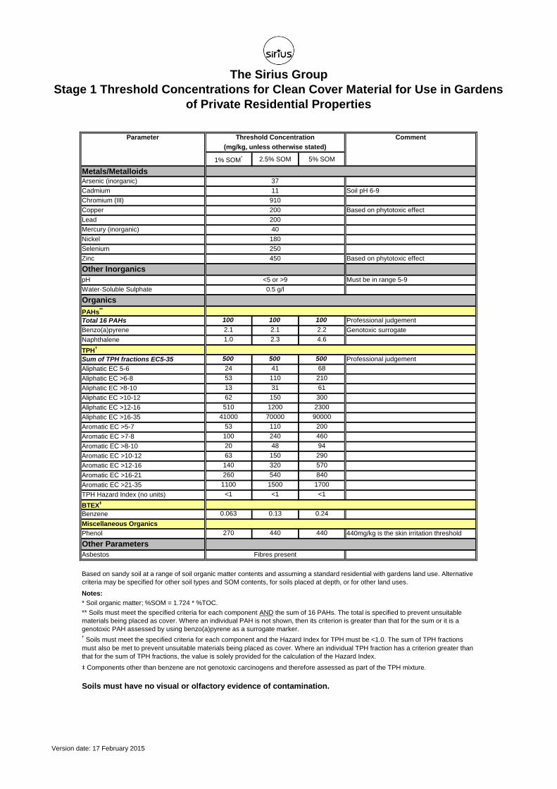
The Sirius Group
Stage 1 Threshold Concentrations for Clean Cover Material for Use in Gardens
of Private Residential Properties
1% SOM* 2.5% SOM 5% SOM
Metals/MetalloidsArsenic (inorganic)
Cadmium Soil pH 6-9
Chromium (III)
Copper Based on phytotoxic effect
Lead
Mercury (inorganic)
Nickel
Selenium
Zinc Based on phytotoxic effect
Other Inorganics
pH Must be in range 5-9
Water-Soluble Sulphate
Organics
PAHs**
Total 16 PAHs 100 100 100 Professional judgement
Benzo(a)pyrene 2.1 2.1 2.2 Genotoxic surrogate
Naphthalene 1.0 2.3 4.6
TPH†
Sum of TPH fractions EC5-35 500 500 500 Professional judgement
Aliphatic EC 5-6 24 41 68
Aliphatic EC >6-8 53 110 210
Aliphatic EC >8-10 13 31 61
Aliphatic EC >10-12 62 150 300
Aliphatic EC >12-16 510 1200 2300
Aliphatic EC >16-35 41000 70000 90000
Aromatic EC >5-7 53 110 200
Aromatic EC >7-8 100 240 460
Aromatic EC >8-10 20 48 94
Aromatic EC >10-12 63 150 290
Aromatic EC >12-16 140 320 570
Aromatic EC >16-21 260 540 840
Aromatic EC >21-35 1100 1500 1700
TPH Hazard Index (no units) <1 <1 <1
BTEX‡
Benzene 0.063 0.13 0.24
Miscellaneous Organics
Phenol 270 440 440 440mg/kg is the skin irritation threshold
Other Parameters
Asbestos
Notes:
Soils must have no visual or olfactory evidence of contamination.
‡ Components other than benzene are not genotoxic carcinogens and therefore assessed as part of the TPH mixture.
250
180
<5 or >9
** Soils must meet the specified criteria for each component AND the sum of 16 PAHs. The total is specified to prevent unsuitable
materials being placed as cover. Where an individual PAH is not shown, then its criterion is greater than that for the sum or it is a
genotoxic PAH assessed by using benzo(a)pyrene as a surrogate marker.† Soils must meet the specified criteria for each component and the Hazard Index for TPH must be <1.0. The sum of TPH fractions
must also be met to prevent unsuitable materials being placed as cover. Where an individual TPH fraction has a criterion greater than
that for the sum of TPH fractions, the value is solely provided for the calculation of the Hazard Index.
Fibres present
* Soil organic matter; %SOM = 1.724 * %TOC.
Comment
11
(mg/kg, unless otherwise stated)
Parameter Threshold Concentration
Based on sandy soil at a range of soil organic matter contents and assuming a standard residential with gardens land use. Alternative
criteria may be specified for other soil types and SOM contents, for soils placed at depth, or for other land uses.
200
450
40
910
37
0.5 g/l
200
Version date: 17 February 2015

Sirius Geotechnical and Environmental Ltd
Suite 2 Russel House 4245 Park Approach Cinnamon House 35 St Pauls Square Mill Road Century Way Cinnamon Park Birmingham Langley Moor Thorpe Park Crab Lane, Fearnhead B3 1QX Durham Leeds Warrington DH7 8HJ LS15 8GB WA2 0XP
t. 0191 378 9972 t. 0113 264 9960 t. 01925 661 700 t. 0121 232 4670 f. 0191 378 1537 f. 0113 264 9962 f. 0191 378 1537 f. 0121 212 3363
Report printed on 100% recycled paper
Recommended