Remedial Investigation/Alternatives Analysis Report/Interim Remedial Measures Report 6157 S. Transit Road Site Lockport, New York
September 2011 0218-001-300
Prepared For:
Basil Toyota
Prepared By:
2558 Hamburg Turnpike, Suite 300, Buffalo, New York 14218 | phone: (716) 856-0635 | fax: (716) 856-0583
REMEDIAL INVESTIGATION/
ALTERNATIVES ANALYSIS REPORT/ INTERIM REMEDIAL MEASURES REPORT
6157 SOUTH TRANSIT ROAD SITE
LOCKPORT, NEW YORK BCP SITE No. C932130
September 2011 0218-001-300
Prepared for:
Basil Toyota
Prepared By:
TurnKey Environmental Restoration, LLC
2558 Hamburg Turnpike, Suite 300 Buffalo, NY 14218
(716)856-0635
RI/AAR/IRM REPORT
6157 South Transit Road Site
Table of Contents
0218-001-300
iT K
1.0 INTRODUCTION ...................................................................................................... 1 1.1 Purpose and Scope .......................................................................................................1 1.2 Background ..................................................................................................................2
1.2.1 Property and Site Description ............................................................................................................ 2 1.2.2 Previous Investigations ....................................................................................................................... 2
1.2.2.1 May 2009 – Phase I Environmental Site Assessment ...................................................... 2 1.2.2.2 May 2009 – Phase II Environmental Site Investigation ................................................... 2 1.2.2.3 December 2007 – Supplemental Site Investigation ............................................................ 3
2.0 INVESTIGATION APPROACH .................................................................................. 4 2.1 Soil/Fill Investigation...................................................................................................4
2.1.1 Subsurface Soil/Fill .......................................................................................................................... 4 2.1.2 Soil/Fill Sample Analyses ................................................................................................................ 5 2.1.3 Catch Basin Sediments ...................................................................................................................... 5
2.2 Groundwater Investigation...........................................................................................5 2.2.1 Monitoring Well Installation ............................................................................................................. 6 2.2.2 Groundwater Sample Collection ........................................................................................................ 6 2.2.3 Groundwater Sample Analyses ......................................................................................................... 7
2.3 Field Specific Quality Assurance/Quality Control Sampling ......................................7 2.4 Site Mapping ................................................................................................................7
3.0 SITE PHYSICAL CHARACTERISTICS ........................................................................ 8 3.1 Site Topography and Drainage ....................................................................................8 3.2 Geology and Hydrogeology .........................................................................................8
3.2.1 Overburden ....................................................................................................................................... 8 3.2.2 Bedrock ............................................................................................................................................. 8 3.2.3 Hydrogeology ..................................................................................................................................... 9
4.0 INVESTIGATION RESULTS BY MEDIA ................................................................... 10 4.1 Subsurface Soil/Fill ....................................................................................................10
4.1.1 Volatile Organic Compounds .......................................................................................................... 10 4.1.2 Semi-Volatile Organic Compounds ................................................................................................. 10 4.1.3 Inorganic Compounds ...................................................................................................................... 10 4.1.4 Pesticides, Herbicides and Polychlorinated Biphenyls ........................................................................ 10 4.1.5 Subsurface Soil/Fill Summary ........................................................................................................ 10
4.2 Catch Basin Sediments ..............................................................................................11 4.2.1 Semi-Volatile Organic Compounds ................................................................................................. 11 4.2.2 Inorganic Compounds ...................................................................................................................... 11 4.2.3 Polychlorinated Biphenyls ................................................................................................................ 11 4.2.4 Sediments Summary ........................................................................................................................ 11
4.3 Groundwater ..............................................................................................................11 4.3.1 Volatile Organic Compounds .......................................................................................................... 12
RI/AAR/IRM REPORT
6157 South Transit Road Site
Table of Contents
0218-001-300
iiT K
4.3.2 Semi-Volatile Organic Compounds ................................................................................................. 12 4.3.3 Inorganic Compounds ...................................................................................................................... 12 4.3.5 Summary ........................................................................................................................................ 12
4.4 Data Usability Summary ............................................................................................13
5.0 INTERIM REMEDIAL MEASURES .......................................................................... 15
6.0 FATE AND TRANSPORT OF COPCS ....................................................................... 18 6.1 Fugitive Dust Generation ...........................................................................................18 6.2 Volatilization..............................................................................................................18 6.3 Surface Water Runoff ................................................................................................19 6.4 Leaching .....................................................................................................................19 6.5 Groundwater Transport ..............................................................................................19 6.6 Exposure Pathways ....................................................................................................20
7.0 QUALITATIVE RISK ASSESSMENT ......................................................................... 21 7.1 Potential Human Health Risks ...................................................................................21 7.2 Potential Ecological Risks .........................................................................................22
8.0 REMEDIAL ALTERNATIVES EVALUATION ............................................................ 23 8.1 Remedial Action Objectives ......................................................................................23 8.2 Future Land Use Evaluation ......................................................................................24 8.3 Alternatives Evaluation ..............................................................................................25
8.3.1 IRM/No Further Action ............................................................................................................... 25 8.3.2 Unrestricted Use Alternative ........................................................................................................... 26
8.4 Recommended Remedial Measure ............................................................................28
9.0 RI/IRM/AAR SUMMARY AND CONCLUSIONS .................................................... 29
10.0 REFERENCES ........................................................................................................ 31
RI/AAR/IRM REPORT
6157 South Transit Road Site
Table of Contents
0218-001-300
iiiT K
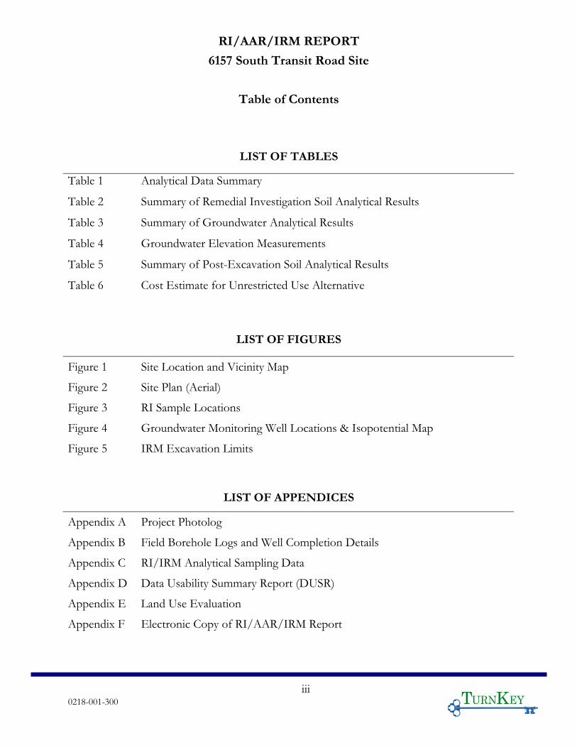
LIST OF TABLES
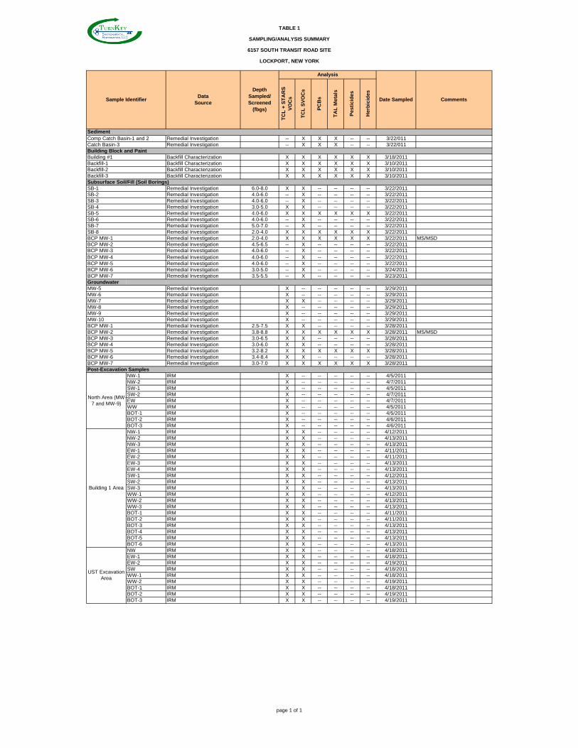
Table 1 Analytical Data Summary
Table 2 Summary of Remedial Investigation Soil Analytical Results
Table 3 Summary of Groundwater Analytical Results
Table 4 Groundwater Elevation Measurements
Table 5 Summary of Post-Excavation Soil Analytical Results
Table 6 Cost Estimate for Unrestricted Use Alternative
LIST OF FIGURES
Figure 1 Site Location and Vicinity Map
Figure 2 Site Plan (Aerial)
Figure 3 RI Sample Locations
Figure 4 Groundwater Monitoring Well Locations & Isopotential Map
Figure 5 IRM Excavation Limits
LIST OF APPENDICES
Appendix A Project Photolog
Appendix B Field Borehole Logs and Well Completion Details
Appendix C RI/IRM Analytical Sampling Data
Appendix D Data Usability Summary Report (DUSR)
Appendix E Land Use Evaluation
Appendix F Electronic Copy of RI/AAR/IRM Report
RI/AAR/IRM REPORT 6157 SOUTH TRANSIT ROAD SITE
0218-001-300 1 T K
1.0 INTRODUCTION This Remedial Investigation/Alternatives Analysis Report/Interim Remedial
Measures (RI/AAR/IRM) Report has been prepared on behalf of co-applicants 6157 S.
Transit, LLC; 6179 S. Transit, LLC; and Mike Basil Motors, Inc. dba Basil Toyota
(collectively referred to as Basil Toyota), for the 6157 South Transit Road, in the Town of
Lockport, Niagara County, New York (Site; see Figures 1 and 2).
Basil Toyota elected to pursue cleanup and redevelopment of the Site under the New
York State Brownfield Cleanup Program (BCP), and executed a Brownfield Cleanup
Agreement (BCA) with the New York State Department of Environmental Conservation
(NYSDEC) in January 2011 (BCP Site No. C932130). The RI/AAR/IRM Work Plan was
approved by the NYSDEC, with concurrence of the New York State Department of Health
(NYSDOH), on March 24, 2011. TurnKey Environmental Restoration, LLC (TurnKey)
performed RI activities at the Site during March 2011, and IRM activities were completed at
the Site in May 2011.
1.1 Purpose and Scope
This RI/AAR/IRM Report has been prepared on behalf of Basil Toyota to describe
and present the findings of the RI and IRM activities, and evaluate remedial alternatives for
the Site.
This report contains the following sections:
Section 2.0 presents the approach for the RI
Section 3.0 describes the physical characteristics of the Site as they pertain to the investigation findings
Section 4.0 presents the investigation results by media
Section 5.0 summarizes the IRM activities
Section 6.0 describes the fate and transport of the constituents of primary concern (COPCs).
Section 7.0 presents the qualitative risk assessment.
Section 8.0 evaluates remedial alternatives for the Site.
Section 9.0 presents the RI/AAR/IRM summary and conclusions
Section 10.0 provides a list of references for this report.
RI/AAR/IRM REPORT 6157 SOUTH TRANSIT ROAD SITE
0218-001-300 2 T K
1.2 Background
1.2.1 Property and Site Description
The BCP property located at 6157 South Transit Road, in the Town of Lockport,
New York (Niagara County S.B.L. No. 138.00-1-26.1) is an approximate 4.5-acre portion of
a greater 27.2-acre parcel. The Site is bound by South Transit Road to the west, commercial
properties to the north and south, and vacant vegetated areas to the east (see Figures 1 and
2). The Site was used as an automobile dealership and service facility from approximately
1962 to 2008. Former service and repair operations impacted the Site requiring remediation.
The Site is currently being redeveloped as a new car dealership (Basil Toyota).
1.2.2 Previous Investigations
A summary of the investigations that have occurred at the Site are presented below.
1.2.2.1 May 2009 – Phase I Environmental Site Assessment
TurnKey’s sister company, Benchmark Environmental Engineering and Science,
PLLC (Benchmark) completed a Phase I ESA for the subject property in May 2009. The
Phase I ESA identified recognized environmental conditions (RECs), which included:
the Site was used as an automobile dealership and service facility from
approximately 1962 to 2008;
hazardous/regulated materials and/or wastes associated with auto repair activities
were historically used, stored or generated on-Site;
evidence of former waste oil and gasoline UST(s); and,
evidence of in-ground lifts were noted in Buildings #1 and #2.
1.2.2.2 May 2009 – Phase II Environmental Site Investigation
Benchmark completed a Phase II Environmental Site Investigation for the Site,
report dated May 2009. The investigation included the advancement of ten (10) soil borings
at the Site. During the investigation petroleum-like odors were noted and elevated PID
readings indicated on-Site impacts. Soil samples were collected and analyzed for volatile
organic compounds (VOCs), semi-volatile organic compounds (SVOCs), and
polychlorinated biphenyls (PCBs). The Phase II investigation identified that on-Site soils
RI/AAR/IRM REPORT 6157 SOUTH TRANSIT ROAD SITE
0218-001-300 3 T K
have been impacted by VOCs, including 1,2,4-trimethylbenzene, 1,3,5-trimethlybenzene, p-
cymene, acetone, isopropylbenzene, methylene chloride, n-propylbenzene, and xylene above
regulatory guidelines. Based on the analytical results, the NYSDEC was notified, and Spill
No. 09-02040 was issued for the Site. The NYSDEC sent a letter to the owner of the Site in
July 2009, requesting a work plan to address the contamination.
1.2.2.3 December 2007 – Supplemental Site Investigation (North Adjacent Site)
Benchmark completed a supplemental investigation at the north adjacent property
(6145 S. Transit Rd.) in 2007; and subsequent remediation of the north adjacent property.
During the investigation, monitoring wells were advanced on the northern portion of
Subject Site. Five (5) monitoring wells were advanced on the 6157 S. Transit Road Site, and
three of those wells (MW-7, MW-9 and MW-10) showed elevated levels of VOCs in
groundwater above GWQS/GV, including chlorobenzene, 1,2-, 1,3-, and 1,4-
dichlorobenzene, cis-1,2-dichloroethene, ethylbenzene, isopropylbenzene, methylene
chloride, 1,2,4- and 1,3,5-trimethylbenzene, dichlorodifluoromethane, n-propylbenzene, n-
butylbenzene, sec-butylbenzene, and xylene. The NYSDEC, at that time, did not require
remediation of the impacted area (i.e., MW-7 and MW-9 area) on the Subject Site during
environmental remediation work on the northern adjacent site as the environmental impacts
on the Subject Site were attributable to automobile storage, washing and detailing in the
gravel-covered parking area on the northern portion of the Subject Site.
1.3 Constituents of Potential Concern (COPCs)
Based on the findings related to historic use of the Site, the Constituents of Potential
Concern (COPCs) are presented below:
Soil, Sediment, Groundwater: Petroleum-related volatile organic
compounds (VOCs), and semi-volatile organic compounds (SVOCs).
RI/AAR/IRM REPORT 6157 SOUTH TRANSIT ROAD SITE
0218-001-300 4 T K
2.0 INVESTIGATION APPROACH The purpose of the RI field activities was to define the nature and extent of
contamination on the BCP Site, and to collect data of sufficient quantity and quality to
perform the remedial alternatives evaluation. The field investigation was completed across
the BCP Site to supplement previous environmental data and to delineate areas requiring
remediation. On-site field activities included: advancement of soil borings; subsurface soil
sampling; catch basin sediment sampling; monitoring well installation; groundwater
sampling; and, collection of hydrogeologic data.
Field team personnel collected environmental samples in accordance with the
rationale and protocols described in the Field Sampling Plan (FSP) presented in the Quality
Assurance Project Plan (QAPP). USEPA and NYSDEC-approved sample collection and
handling techniques were used. Samples for chemical analysis were analyzed in accordance
with USEPA SW-846 methodology with an equivalent Category B deliverable package to
meet the definitive-level data requirements. Analytical results were evaluated by a third-party
data validation expert in accordance with provisions described in the QAPP.
The investigation activities are described below. Figure 3 presents the RI sample
locations as well as historic sample locations. Appendix A contains photographs of field
activities.
2.1 Soil/Fill Investigation
A soil/fill investigation was completed across the site to supplement previous
environmental data and to further delineate contamination on-Site. The Soil/Fill
Investigation included the advancement of soil borings across the Site and collection of
sediment samples from former parking/roadway catch basins. No surface samples were
collected as the Site primarily is covered by buildings and asphalt parking areas.
2.1.1 Subsurface Soil/Fill
The subsurface soil/fill investigation included the advancement of fifteen (15) soil
borings, identified as BCP MW-1 through BCP MW-7, and SB-1 though SB-8 across the Site
(see Figure 3). Soil borings were advanced using direct-push drilling techniques to a target
depth of 10 feet below ground surface (fbgs) or refusal. Subsurface soil/fill samples were
RI/AAR/IRM REPORT 6157 SOUTH TRANSIT ROAD SITE
0218-001-300 5 T K
collected from the soil borings and field-screened for the presence of VOCs using a field
photoionization detector (PID). Soil/fill samples were collected using dedicated stainless
steel sampling tools. Representative soil samples were placed in pre-cleaned laboratory
provided sample bottles, cooled to 4ºC in the field, and transported under chain-of-custody
command to Test America Laboratory, located in Amherst, New York, a New York State
Department of Health (NYSDOH) ELAP-certified analytical laboratory.
2.1.2 Soil/Fill Sample Analyses
All fifteen subsurface soil/fill samples were analyzed for Target Compound List
(TCL) SVOCs and sample locations BCP MW-1, SB-1, SB-5 and SB-6 were analyzed for
TCL plus STARS VOCs. Site characterization samples for pesticides, herbicides,
polychlorinated biphenyls (PCBs), and Target Analyte List (TAL) metals were collected from
BCP MW-1, SB-5, and SB-8.
All samples were collected and analyzed in accordance with USEPA SW-846
methodology with equivalent NYSDEC Category B deliverables to allow for independent
third-party data usability assessment.
2.2 Catch Basin Sediments
Accumulated sediments within on-Site parking area catch basins, identified as CB-1,
CB-2, and CB-3, were sampled for laboratory analysis during the RI. Sediment samples were
analyzed for TCL SVOCs, TAL Metals, and PCBs. As described below in Section 5, all
sediments and vegetation accumulated within the three catch basins were removed and
disposed off-site at a permitted commercial disposal facility.
2.3 Groundwater Investigation
TurnKey personnel provided oversight for the installation of seven new
groundwater monitoring wells (i.e., BCP MW-1 through BCP MW-7) to investigate
groundwater flow and quality. In addition to the seven newly installed monitoring wells,
TurnKey personnel collected samples from five existing one inch monitoring wells,
identified as MW-5, MW-6, MW-7, MW-9, and MW-10. Details of the well installation,
well development and groundwater sampling are provided below. Figure 4 presents the
location of the monitoring well network.
RI/AAR/IRM REPORT 6157 SOUTH TRANSIT ROAD SITE
0218-001-300 6 T K
2.3.1 Monitoring Well Installation
Seven soil boring location, identified as BCP MW-1 through BCP MW-7, were
subsequently converted to monitoring wells. The monitoring wells were installed using a
direct-push drill rig capable of advancing hollow-stem augers to install two-inch inside
diameter (ID) monitoring wells in accordance with the approved RI/AAR/IRM Work Plan.
Monitoring well construction details are presented on the Field Borehole Logs in Appendix
B. Locations of the monitoring wells are presented on Figure 4.
2.3.2 Groundwater Sample Collection
The seven newly installed and five existing monitoring wells were developed prior to
sampling to remove residual sediments and ensure good hydraulic connection with the
water-bearing zone. A minimum of three well volumes were removed from each well during
development. Prior to sample collection, static water levels were measured and recorded
from all on-site monitoring wells. Following water level measurement, TurnKey personnel
purged and sampled monitoring wells using a pump and dedicated pump tubing following
low-flow/minimal drawdown purge and sample collection procedures. Prior to sample
collection, groundwater was evacuated from each well at a low-flow rate (typically less than
0.1 L/min). Field measurements for pH, specific conductance, temperature, turbidity,
dissolved oxygen, and water level, as well as visual and olfactory field observations, were
periodically recorded and monitored for stabilization. Purging was considered complete
when pH, specific conductivity, and temperature stabilized, and when turbidity
measurements fell below 50 Nephelometric Turbidity Units (NTU) or became stable above
50 NTU. Upon stabilization of field parameters, groundwater samples were collected.
Immediately following collection of groundwater samples, field measurements for
pH, specific conductance, temperature, turbidity, dissolved oxygen, and water levels, as well
as visual and olfactory field observations, were recorded.
All collected groundwater samples were placed in pre-cleaned, pre-preserved
laboratory provided sample bottles, cooled to 4C in the field, and transported under chain-
of-custody command to Test America for laboratory analysis.
RI/AAR/IRM REPORT 6157 SOUTH TRANSIT ROAD SITE
0218-001-300 7 T K
2.3.3 Groundwater Sample Analyses
Groundwater samples collected from wells BCP MW-1 through BCP MW-7 were
analyzed for TCL plus STARs VOCs and TCL SVOCs. Samples from BCP MW-2, BCP
MW-5, and BCP MW-7 were also analyzed for TAL Metals, PCBs, herbicides and pesticides.
Existing wells MW-5, MW-6, MW-7, MW-9, and MW-10 were analyzed for TCL plus
STARs VOCs, and MW-7 was also analyzed for TCL SVOCs. All samples were collected
and analyzed in accordance with USEPA SW-846 methodology with equivalent NYSDEC
Category B deliverables to allow for independent third-party data usability assessment.
2.4 Field Specific Quality Assurance/Quality Control Sampling
In addition to the subsurface soil/fill and groundwater samples described above,
field-specific quality assurance/quality control (QA/QC) samples were collected and
analyzed to ensure the reliability of the generated data as described in the QAPP and to
support the required third-party data usability assessment effort. Site-specific QA/QC
samples included matrix spikes, matrix spike duplicates, blind duplicates, and trip blanks.
2.5 Site Mapping
A Site map was developed during the RI field investigation. All sample points and
relevant Site features were located on the map. TurnKey personnel employed a handheld
GPS unit to identify the locations of all sample locations relative to State planar grid
coordinates. Monitoring well elevations were measured by TurnKey’s surveyor. An
isopotential map showing the groundwater elevations was prepared based on water level
measurements relative to USGS vertical datum (see Figure 4).
RI/AAR/IRM REPORT 6157 SOUTH TRANSIT ROAD SITE
0218-001-300 8 T K
3.0 SITE PHYSICAL CHARACTERISTICS The physical characteristics of the Site observed during the RI are described in the
following sections.
3.1 Site Topography and Drainage
The Site is generally flat lying with limited distinguishable Site features. The surface
was predominately covered with pavement (i.e. asphalt and concrete), and foundation related
to the former Building No. 1 (demolished during IRM activities). Precipitation (i.e., rain or
melting snow) moves to the storm drains on-Site and in the roadways via overland flow.
Surface and shallow groundwater flow are likely impacted by various cycles of development
and filling, as well as utility lines and foundations.
3.2 Geology and Hydrogeology
3.2.1 Overburden
Based on the U.S. Department of Agriculture Soil Conservation Service soil survey
map of Niagara County (Ref. 6) the surrounding areas surficial soil type in the vicinity of the
Site as a combination of Ovid silt loam, 0 to 2 percent slope (OvA) and Hilton silt loam, 0 to
3 percent slopes (HlA). Surficial Geologic Map of New York, Niagara Sheet, presented by
NYS Geologic Survey (1988), indicates that the surficial soil type in the vicinity of the Site
generally consist of a lacustrine silty clay (lsc), a till (t), and till moraine (tm).
The geology at the Site was investigated during the RI and is generally described as
asphalt overlying native brown/reddish-brown silty clay to depths of approximately 8.9 fbgs.
3.2.2 Bedrock
Based on the bedrock geologic map of Niagara County (Ref. 8), the Site is underlain
by Silurian and Devonian age stratified limestone, dolomite, and shale of marine origin. The
bedrock is virtually flat lying, with a gentle dip to the south of only about 30 to 40 feet per
mile and exhibits only very gentle folding. The bedrock surface was deeply eroded by
weathering and stream action prior to glaciation and by glacial scour during glaciation. The
carbonate rocks and the shale are nearly impermeable as homogeneous rock.
The primary bedrock type that forms the bedrock surface in the northern part of the
Lake Erie-Niagara River Basin is the fine- to coarse-grained Lockport Dolomite; a white or
RI/AAR/IRM REPORT 6157 SOUTH TRANSIT ROAD SITE
0218-001-300 9 T K
grey, magnesium-rich sedimentary rock resembling limestone, but harder and more resistant.
The Lockport extends into New York for 200 miles from Niagara County to Herkimer
County. The maximum thickness of the Lockport is approximately 150 feet.
Based on the findings of the RI and IRM, visual observations of bedrock and/or
subsurface boring refusal (suspected bedrock) ranged from approximately 5.0 to 8.9 fbgs.
3.2.3 Hydrogeology
Based on the groundwater gauging completed during the RI, localized groundwater
flow was determined to be southwest for the majority of the Site. The northwest section of
the Site, immediately adjacent to S. Transit Road, appears heavily influenced by the presence
of Town of Lockport subsurface utilities and roadway drainage ditches. Groundwater was
typically encountered between 4.0 to 6.0 fbgs during the soil boring investigation. Figure 4
depicts the groundwater isopotential map, and monitoring well and groundwater elevation
data are shown on Table 4.
RI/AAR/IRM REPORT 6157 SOUTH TRANSIT ROAD SITE
0218-001-300 10 T K
4.0 INVESTIGATION RESULTS BY MEDIA The following sections discuss the analytical results of the Remedial Investigation.
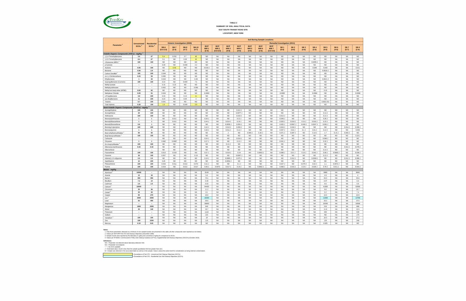
Tables 2 and 3 summarize the soil/fill and groundwater analytical data, respectively.
Appendix C includes the laboratory analytical data packages. Sample locations are shown on
Figure 3.
4.1 Subsurface Soil/Fill
4.1.1 Volatile Organic Compounds
No VOCs were detected above Part 375 Unrestricted SCOs during the RI (see Table
2). Historic soil boring data is included on Table 2 for reference. Historic borings were
located inside the former Building #1; all soils represented by the historic borings were
removed during IRM activities (see Section 5).
4.1.2 Semi-Volatile Organic Compounds
No SVOCs were detected above Part 375 Unrestricted SCOs. The vast majority of
the analyzed SVOCs were reported as non-detectable or at trace (estimated) concentrations
below the sample quantitation limit by the analytical laboratory.
4.1.3 Inorganic Compounds
The majority of inorganic compounds were detected below Part 375 Unrestricted
SCOs. The only constituent detected above Part 375 Residential SCOs was iron.
4.1.4 Pesticides, Herbicides and Polychlorinated Biphenyls
Pesticides, herbicides, and PCBs were reported as non-detectable by the analytical
laboratory.
4.1.5 Subsurface Soil/Fill Summary
As described above, no VOCs, SVOCs, pesticides, herbicides, and PCBs were
detected above Part 375 Unrestricted SCOs. The only constituent detected above
Unrestricted SCOs was iron at three sample locations (see Table 2). However, the
concentrations appear to be associated with naturally occurring background levels of iron.
RI/AAR/IRM REPORT 6157 SOUTH TRANSIT ROAD SITE
0218-001-300 11 T K
4.2 Catch Basin Sediments
4.2.1 Semi-Volatile Organic Compounds
Elevated polycyclic aromatic hydrocarbons (PAHs) were detected above Part 375
Residential SCOs (i.e., total PAHs greater than 500 ppm). Therefore, accumulated
sediments from CB-1, CB-2, and CB-3 were removed and disposed off-site as part of the
IRMs. Details of the sediment removal are described in Section 5 below.
4.2.2 Inorganic Compounds
Inorganic compounds were reported as non-detectable, at trace (estimated)
concentrations below the sample quantitation limit or below Part 375 Unrestricted SCOs,
with the minor exception of lead and zinc. No inorganic compounds were detected above
Part 375 Residential SCOs.
4.2.3 Polychlorinated Biphenyls
All PCBs were reported as non-detectable by the analytical laboratory.
4.2.4 Sediments Summary
As described above, concentrations of inorganic compounds and PCBs were reported
as non-detectable or below Part 375 Unrestricted SCOs. Select PAHs were detected at
concentrations above Part 375 Residential SCOs. All sediment collected within the on-Site
catch basins was removed and properly disposed of off-site. Details of the sediment
removal are described in Section 5 below.
4.3 Groundwater
The sampling results for groundwater monitoring completed during the RI are
discussed in the following sections. Table 3 presents a comparison of the detected
groundwater parameters to the Class GA Groundwater Quality Standards (GWQS) per
NYSDEC Division of Water Technical and Operational Guidance Series (TOGS) 1.1.1
Ambient Water Quality Standards and Guidance Values and Groundwater Effluent
Limitations (June 1988).
RI/AAR/IRM REPORT 6157 SOUTH TRANSIT ROAD SITE
0218-001-300 12 T K
4.3.1 Volatile Organic Compounds
The majority of analytes were reported as non-detectable or trace (estimated)
concentrations below the laboratory quantitation limit. Benzene, cis-1,2-dichloroethene,
toluene, and xylene were detected slightly above GWQS in select wells (see Table 3).
Additional VOC constituents were detected in MW-7 during the RI; however, soils from the
MW-7 area and surrounding area were removed during IRM activities (see Section 5).
4.3.2 Semi-Volatile Organic Compounds
No SVOCs were detected above GWQS for newly installed on-Site BCP monitoring
wells. Only 4-methylphenol and naphthalene were detected in MW-7 at concentrations
slightly above GWQS; however, soils from the MW-7 area and surrounding area were
removed during IRM activities (see Section 5).
4.3.3 Inorganic Compounds
Metals detected at concentrations above GWQS were primarily limited to naturally-
occurring minerals, including iron, magnesium, manganese, and sodium. Arsenic,
chromium, lead, and nickel were also detected slightly above GWQS in BCP MW-7.
Samples were not filtered in the field, and detected constituents may be associated with
sediments in the unfiltered sample.
4.3.4 Pesticides
The majority of analytes were reported as non-detectable or trace (estimated)
concentrations below the laboratory quantitation limit. Endrin, gamma-chlordane and
heptachlor epoxide were detected slightly above the GWQS in select wells (see Table 3).
4.3.5 Summary
As described above and shown on Table 3, SVOCs, PCBs, and herbicides were
predominantly reported as non-detectable, trace (estimated), or detected at concentrations
below the GWQS. Several VOCs were detected slightly above GWQS in monitoring wells
BCP MW-1, BCP MW-3, BCP MW-4, and BCP MW-7. Three pesticides, endrin, gamma-
chlordane and heptachlor epoxide were detected slightly above their respective GWQS.
Metals detected at concentrations above GWQS are primarily naturally occurring minerals,
RI/AAR/IRM REPORT 6157 SOUTH TRANSIT ROAD SITE
0218-001-300 13 T K
including iron, manganese, magnesium, and sodium; additionally arsenic, chromium, lead
and nickel were detected slightly above GWQS in BCP MW-7.
Some analytes were detected slightly above GWQS on-Site. However, IRM activities
(see Section 5 below) removed three on-Site source areas, including: the northern MW-7 and
MW-9 area; the former Bldg. #1 in-ground hydraulic lifts and petroleum-impacted area; and
the historic USTs petroleum area. These IRM areas are located upgradient and/or adjacent
to BCP MW-1, BCP MW-3, BCP MW-4, and BCP MW-6. Based on the removal of in-
ground hydraulic lifts and reservoirs, removal of impacted building foundations, discovery
and removal of two abandoned USTs, and the extent of source area soils removed to below
unrestricted SCOs, remaining concentrations of constituents within the groundwater are
expected to naturally decrease over time. Furthermore, groundwater use is prohibited on-Site
by Niagara County, further reducing any potential contact with groundwater.
4.4 Data Usability Summary
In accordance with the RI/AAR/IRM Work Plan, the laboratory analytical data from
this investigation was assessed and, as required, submitted for independent review. Data
Validation Services located in North Creek, New York performed the data usability
summary assessment, which involved a review of the summary form information and sample
raw data, and a limited review of associated QC raw data. Specifically, the following items
were reviewed:
Laboratory Narrative Discussion Custody Documentation Holding Times Surrogate and Internal Standard Recoveries Matrix Spike Recoveries/Duplicate Recoveries Field Duplicate Correlation Preparation/Calibration Blanks Control Spike/Laboratory Control Samples Instrumental IDLs Calibration/CRI/CRA Standards ICP Interference Check Standards ICP Serial Dilution Correlations Sample Results Verification
RI/AAR/IRM REPORT 6157 SOUTH TRANSIT ROAD SITE
0218-001-300 14 T K
The Data Usability Summary Report (DUSR) was conducted using guidance from the
USEPA Region 2 validation Standard Operating Procedures, the USEPA National
Functional Guidelines for Data Review, as well as professional judgment.
In summary, no data were rejected, but some data were further qualified during the
data validation. Any additional qualifications of the data have been incorporated to the
summary data tables. Appendix D includes the DUSR.
RI/AAR/IRM REPORT 6157 SOUTH TRANSIT ROAD SITE
0218-001-300 15 T K
5.0 INTERIM REMEDIAL MEASURES In accordance with the NYSDEC-approved RI/AAR/IRM Work Plan, immediately
following the RI fieldwork, an IRM was implemented based on the nature and extent of the
impacts identified during the RI, as well as previously known conditions (e.g., northern MW-
7 and MW-9 area and former Blgd#1 area). As stated in the approved RI/AAR/IRM Work
Plan, Basil Toyota’s intent was for the IRM to substantially or completely constitute the final
NYSDEC-approved BCP remedy for the Site. Figure 5 presents the location of IRM
excavation areas. Specific elements of the IRM, as implemented, included:
Prior to demolition of the former Building #1, approximately 4.21-tons of abandoned paper and cardboard was removed, transported off-Site by Buffalo Transportation, and recycled at Cascades Recovery US, Inc. in Rochester New York.
Demolition of the former Building #1 automobile sales and service facility. Non-stained building materials (i.e., brick, block and concrete) were sampled and subsequently approved by the NYSDEC for re-use as backfill material.
Excavation of approximately 412.16-tons of non-hazardous VOC-impacted soil/fill from the northern (MW-7 and MW-9) area, followed by off-Site transportation by Modern Transportation for disposal at Modern Landfill in Model City, New York. The remedial excavation was expanded due to the discovery of an abandoned storm water line which had evidence of petroleum impact in the bedding material. Approximately 120-ft of petroleum-impacted pipe and bedding material was excavated and transported off-site for disposal, as described above. The main MW-7 and MW-9 excavation area ranged from 7 to 8-ft in depth; and the pipe run area was approximately 4-ft in depth. The approximate lateral extents of the excavation are shown on Figure 5. Post-excavation soil samples were below Part 375 Unrestricted Use SCOs, with the minor exception of acetone (a common lab contaminant), which was well below its Part 375 Residential SCO.
Removal of five in-ground hydraulic lifts, with multiple reservoirs and circulation lines. Hydraulic lifts were emptied of residual product and cleaned on-Site prior to off-site recycling as scrap at David Dunn’s Salvage, Inc. in Middleport, New York. All residual hydraulic oil collected was containerized and used at Basil Toyota’s repair shop in their oil-fired heating furnace.
Excavation of approximately 1,087.52-tons of non-hazardous petroleum-impacted soil from the Bldg. #1 area, followed by off-Site transportation by RE Lorenz for biotreatment and recycling at Tonawanda Terminal Biotreatment facility in Tonawanda, New York. Post-excavation soil samples were below Part 375 Unrestricted Use SCOs, with the minor exception of acetone (a common lab contaminant), which was well below its Part 375 Residential SCO.
RI/AAR/IRM REPORT 6157 SOUTH TRANSIT ROAD SITE
0218-001-300 16 T K
Excavation of approximately 172.03-tons of stained concrete footers and
foundation from the former Building #1, followed by off-Site transportation by Modern Transportation for disposal at Modern Landfill in Model City, NY.
Discovery and removal of two (2) approximate 900-gallon former fuel oil USTs south of the former Building #1. The USTs were discovered during building foundation removal and grading activities. Approximately 2,020-gallons of petroleum-water mixture and tank cleaning residuals were extracted from the USTs by Green Environmental Services, Inc. (GES) and disposed of at Environmental & Industrial Contracting Services, Inc. (EICS) in Niagara Falls, New York. GES transported the cleaned USTs to Niagara Metals in Niagara Falls, New York for recycling as scrap.
Excavation of approximately 716.35-tons of non-hazardous petroleum-impacted soil from the UST area followed by off-Site transportation by RE Lorenz for biotreatment and recycling at Tonawanda Terminal Biotreatment facility in Tonawanda, New York. Post-excavation soil samples were below Part 375 Unrestricted Use SCOs, with the minor exception of one sample with acetone (a common lab contaminant), which was well below its Part 375 Residential SCO.
Approximately 3.58-tons of sediment and/or debris were removed and properly disposed, including of accumulated sediment/debris from on-Site catch basins (i.e. CB-1, CB-2, and CB-3) and accumulated sediments within the temporary excavation dewatering tanks. The material was collected by GES and disposed at EICS in Niagara Falls, New York.
Approximately 10,000-gallons of groundwater from the on-Site excavation areas was extracted and transferred to on-Site temporary storage tanks during IRM activities. The accumulated water was transported by GES to the City of Lockport Wastewater Treatment Plan (WWTP) for approved discharge into the sewer treatment plant.
Collection of 37 post-excavation confirmation samples (i.e., 9 from the northern MW-7 and MW-9 area, 19 from the Bldg. #1 area, and 9 from the UST area) for analysis of TCL plus NYSDEC STARS List VOCs (the Bldg. #1 area and UST Area were also analyzed for TCL SVOCs); post-excavation soil sample results were below 6NYCRR Part 375 Unrestricted Soil Cleanup Objectives (SCOs), with the minor exceptions mainly related to laboratory matrix blank contamination as noted in Table 5. All post-excavation soil sample results were below 6NYCRR Part 375 Residential SCOs.
Placement and compaction of backfill materials. Backfill materials consisted of approximately 500-tons of on-Site recycled building materials (i.e., concrete and block); approximately 1,650-tons of on-parcel native soils. Both the building material and on-parcel soil was tested to confirm they met NYSDEC criteria and were approved by NYSDEC to reuse as backfill. Additionally, approximately
RI/AAR/IRM REPORT 6157 SOUTH TRANSIT ROAD SITE
0218-001-300 17 T K
249.41-tons of virgin gravel/stone from Buffalo Crushed Stone, Wehrle Plant, was used for cover over the backfill in certain areas, based on the redevelopment plans.
The Final Engineering Report, to be submitted as a separate document, includes
additional details and supporting documentation of the IRM.
RI/AAR/IRM REPORT 6157 SOUTH TRANSIT ROAD SITE
0218-001-300 18 T K
6.0 FATE AND TRANSPORT OF COPCS The subsurface soil/fill, catch basin sediment, and groundwater sample analytical
results were incorporated with the physical characterization of the Site to evaluate the fate
and transport of COPCs in Site media. The mechanisms by which the COPCs can migrate
to other areas or media are briefly outlined below. In all instances, the potential pathways
are evaluated in the context of post-IRM conditions.
6.1 Fugitive Dust Generation
Volatile and non-volatile chemicals present in soil can be released to ambient air as a
result of fugitive dust generation. Impacted soil/fill and sediments were excavated/removed
and disposed of off-Site as part of the IRM activities. Furthermore, the majority of the Site is
covered by buildings, asphalt and concrete pavement.
Based on the IRMs completed, the future land use, and the majority of the Site being
covered by buildings, concrete, and asphalt; this migration pathway is not relevant under the
current and reasonably anticipated future land use, as long as paved (i.e. asphalt and
concrete) areas across the Site are maintained.
6.2 Volatilization
Volatile chemicals present in soil/fill and groundwater may be released to ambient or
indoor air through volatilization either from or through the soil/fill underlying building
structures. Volatile chemicals typically have a low organic-carbon partition coefficient (Koc),
low molecular weight, and a high Henry’s Law constant.
No volatile organic compounds were detected in on-Site soils above 6NYCRR Part
375 Residential SCOs. In fact, the vast majority of soil samples were detected below Part
375 Unrestricted SCOs. Several post-excavation soil samples did contain concentrations of
acetone above Part 375 Unrestricted SCOs, but below Part 375 Residential SCOs. It should
be noted that the laboratory report notes acetone contamination in the matrix blank.
Therefore, the release of VOCs from soils is not considered relevant in current and future
use scenarios.
Several petroleum VOCs were detected in Site groundwater at concentrations slightly
above Class GA GWQS. However, these petroleum-related volatile chemicals are present in
Site groundwater at relatively low (i.e., maximum of 37 ug/L total VOCs) concentrations.
Based on the IRM source area remedial excavations which achieved Part 375 Unrestricted
RI/AAR/IRM REPORT 6157 SOUTH TRANSIT ROAD SITE
0218-001-300 19 T K
SCOs in the majority of samples locations, VOCs concentrations will continue to degrade
over time as a result of natural biodegradation. It should also be noted that no VOCs were
detected above GWQS in the upgradient monitoring wells, BCP MW-5 and BCP MW-7.
Based on the low concentrations or non-detection of contaminants in soil/fill and
groundwater that could potentially contribute to vapor intrusion, it was determined, with
concurrence from NYSDEC and NYSDOH, that a Soil Vapor Intrusion (SVI) assessment
was not necessary for the Site. Accordingly, volatilization from soil and/or groundwater is
not considered a relevant pathway.
6.3 Surface Water Runoff
The potential for soil particle transport with surface water runoff is low, as the
majority of the Site is covered by concrete, asphalt or buildings. Precipitation waters are
collected in on-Site catch basins, and transmitted to the Niagara Falls storm sewer collection
and treatment system. The storm sewer system provides a mechanism for controlled surface
water transport but will ultimately result in sediment capture in the Niagara Falls grit
chambers followed by disposal at a permitted sanitary landfill. As such, surface water runoff
is not considered a relevant migration pathway.
6.4 Leaching
Leaching refers to chemicals present in soil/fill migrating downward to groundwater
as a result of infiltration of precipitation. The completed IRM excavation/removal and off-
Site disposal of impacted soil/fill and sediment from the Site mitigates potential leaching of
chemicals to groundwater. Furthermore, the majority of the Site is covered by impermeable
surfaces (i.e., asphalt, concrete, and buildings) which limit infiltration of precipitation. As
described above, surface waters from the site are collected and processed through the City of
Niagara Falls storm sewer system. As such, leaching is not considered a relevant migration
pathway.
6.5 Groundwater Transport
Groundwater underlying the Site primarily migrates to the southwest, with the
exception of the northwest corner of the Site which is strongly influenced by the location of
municipal subgrade utility corridor. Chemicals present in groundwater may be transported
across the Site via this pathway. However, volatile chemicals detected in groundwater are
RI/AAR/IRM REPORT 6157 SOUTH TRANSIT ROAD SITE
0218-001-300 20 T K
present at relatively low concentrations (i.e., 7.9 ug/L was the maximum individual VOC
concentration detected). Groundwater flows through a relatively low permeability silty clay
geologic unit, with an estimated hydraulic conductivity of 1x10⁻⁵ to 1x10⁻⁶ centimeters per
second (cm/s) and porosity range of 0.3 and 0.4 (Ref. 7); and a measured average hydraulic
gradient of approximately 0.00267 ft/ft. Darcy’s velocity calculation indicates that shallow
overburden groundwater migrates to the southwest at a rate of approximately 2.53x10⁻⁴ to
1.90x10⁻⁵ ft/day.
The Site and surrounding area are serviced by a municipal (supplied) water service,
with no evidence of potable wells in the area of the subject property. As such, transport off-
site via groundwater migration is not a relevant migration pathway.
6.6 Exposure Pathways
Based on the analysis of chemical fate and transport provided above, no pathways
were identified through which Site COPCs could reach receptors at significant exposure
point concentrations.
RI/AAR/IRM REPORT 6157 SOUTH TRANSIT ROAD SITE
0218-001-300 21 T K
7.0 QUALITATIVE RISK ASSESSMENT
7.1 Potential Human Health Risks
The 6157 South Transit Road Site is currently being redeveloped as a new automobile
sales and service facility. The planned commercial use is consistent with the surrounding
property use and Site zoning. As such, under current conditions (i.e. redevelopment) human
contact with the Site can be expected to occur primarily by two types of receptors:
trespassers who may traverse the property, and construction workers. Trespassers may be
comprised of adolescents or adults, whereas construction workers would be limited to
adults. In both instances, exposure frequency is expected to be minimal. For trespasser and
construction workers, the Site contaminants in soil were removed to below residential
standards, which provide a level of cleanup greater than required to protect these receptors
at commercial facilities.
The reasonably anticipated future use of the Site is consistent with its former
commercial use and zoning, with exposed receptors comprised of adults who may work on
the property in an occupational setting, customers (adults, adolescents and children) who
visit the property for short durations, and occasional construction workers who may access
subsurface utilities during non-routine maintenance activities. Site soils were remediated to
residential levels, which are more protective of this type of end use.
Extensive remedial activities were conducted as IRMs related to COPCs in the
subsurface soil/fill. Only two COPCs, iron and acetone, were detected above Unrestricted
SCOs in the subsurface soil/fill sample locations, indicating that the Site is fully protective of
human health risk for incidental ingestion, dermal contact and/or inhalation of re-suspended
particulates. It should be noted that several of the analytical results for acetone were flagged
by the laboratory for the presence of acetone in the method blank, indicating potential
laboratory contamination.
For groundwater, given the extent of source material removed during the IRMs; low-
level exceedance of GWQS; the likely decrease in residual COPCs concentrations due to
natural degradation; and, the availability of municipal water source at the Site, mitigates the
potential for routine direct human contact or ingestion (i.e., as might occur with use of on-
Site groundwater water for potable or process purposes). Non-routine contact with Site
groundwater is expected to be limited to short durations under specific construction
RI/AAR/IRM REPORT 6157 SOUTH TRANSIT ROAD SITE
0218-001-300 22 T K
conditions (e.g., a construction worker managing groundwater during deep excavation work).
Given the limited frequency and duration of these non-routine activities direct groundwater
exposure pathways for on-Site receptors are not considered relevant.
The IRMs were completed to reduce/eliminate exposure to COPCs and were
successful in achieving Restricted SCOs, and, in most cases achieved Unrestricted SCOs.
7.2 Potential Ecological Risks
The 6157 South Transit Road BCP Site is a former commercial facility located within
a developed area in the Town of Lockport. The Site is primarily covered with asphalt,
concrete and buildings, which provide little or no wildlife habitat or food value. No natural
waterways are present on or adjacent to the Site. The reasonably anticipated future use is
commercial with the majority of the Site covered by buildings, concrete sidewalks and
asphalt. As such, no unacceptable ecological risks are anticipated under the current or
reasonably anticipated future use scenario.
RI/AAR/IRM REPORT 6157 SOUTH TRANSIT ROAD SITE
0218-001-300 23 T K
8.0 REMEDIAL ALTERNATIVES EVALUATION
8.1 Remedial Action Objectives
The final remedial measures for the 6157 South Transit Road Site must satisfy
Remedial Action Objectives (RAOs). Remedial Action Objectives are site-specific
statements that convey the goals for minimizing or eliminating substantial risks to public
health and the environment. Appropriate RAOs for the 6157 South Transit Road Site are:
Removal of historic in-ground hydraulic lifts and impacted soil/fill (i.e., source areas) to levels protective of human health (Part 375 Residential SCOs);
Mitigate contaminant loadings to groundwater from impacted soil/fill sufficiently to achieve or nearly achieve compliance with groundwater quality standards.
In addition to achieving RAOs, NYSDEC’s Brownfield Cleanup Program calls for
remedy evaluation in accordance with DER-10 Technical Guidance for Site Investigation
and Remediation. Specifically, the guidance states “When proposing an appropriate remedy,
the person responsible for conducting the investigation and/or remediation should identify
and develop a remedial action that is based on the following criteria..:”
Overall Protection of Public Health and the Environment. This criterion is
an evaluation of the remedy’s ability to protect public health and the environment, assessing how risks posed through each existing or potential pathway of exposure are eliminated, reduced, or controlled through removal, treatment, engineering controls, or institutional controls.
Compliance with Standards, Criteria, and Guidance (SCGs). Compliance with SCGs addresses whether a remedy will meet applicable environmental laws, regulations, standards, and guidance.
Long-Term Effectiveness and Permanence. This criterion evaluates the long-term effectiveness of the remedy after implementation. If wastes or treated residuals remain on-site after the selected remedy has been implemented, the following items are evaluated: (i) the magnitude of the remaining risks (i.e., will there be any significant threats, exposure pathways, or risks to the community and environment from the remaining wastes or treated residuals), (ii) the adequacy of the engineering and institutional controls intended to limit the risk, (iii) the reliability of these controls, and (iv) the ability of the remedy to continue to meet RAOs in the future.
RI/AAR/IRM REPORT 6157 SOUTH TRANSIT ROAD SITE
0218-001-300 24 T K
Reduction of Toxicity, Mobility or Volume with Treatment. This criterion evaluates the remedy’s ability to reduce the toxicity, mobility, or volume of Site contamination. Preference is given to remedies that permanently and significantly reduce the toxicity, mobility, or volume of the wastes at the Site.
Short-Term Effectiveness. Short-term effectiveness is an evaluation of the potential short-term adverse impacts and risks of the remedy upon the community, the workers, and the environment during construction and/or implementation. This includes a discussion of how the identified adverse impacts and health risks to the community or workers at the Site will be controlled, and the effectiveness of the controls. This criterion also includes a discussion of engineering controls that will be used to mitigate short term impacts (i.e., dust control measures), and an estimate of the length of time needed to achieve the remedial objectives.
Implementability. The implementability criterion evaluates the technical and administrative feasibility of implementing the remedy. Technical feasibility includes the difficulties associated with the construction and the ability to monitor the effectiveness of the remedy. For administrative feasibility, the availability of the necessary personnel and material is evaluated along with potential difficulties in obtaining specific operating approvals, access for construction, etc.
Cost. Capital, operation, maintenance, and monitoring costs are estimated for the remedy and presented on a present worth basis.
Community Acceptance. This criterion evaluates the public’s comments, concerns, and overall perception of the remedy.
8.2 Future Land Use Evaluation
In developing and screening remedial alternatives, NYSDEC’s Part 375 regulations
require that the reasonableness of the anticipated future land be factored into the evaluation.
The regulations identify 16 criteria that must be considered. These criteria and the resultant
outcome for the 6157 South Transit Road Site are presented in the Land Use Evaluation
presented in Appendix E. As indicated, this evaluation supports commercial use as the
reasonably anticipated future use of the Site, which is consistent with past use. Accordingly,
remedial alternatives to clean up the Site to commercial end use are identified and evaluated
herein.
Although the Site is intended to be used for commercial purposes, evaluating a more
restricted-use scenario is a requirement of the BCP. Therefore, Tables 2 and 4 present a
comparison of the soil/fill analytical data to Part 375 Unrestricted SCOs. Per NYSDEC
RI/AAR/IRM REPORT 6157 SOUTH TRANSIT ROAD SITE
0218-001-300 25 T K
DER-10 Technical Guidance for Site Investigation and Remediation, evaluation of a “no-
action” alternative is also required to provide a baseline for comparison against other
alternatives. Since an IRM has already been completed for the Site, the alternatives
discussed in greater detail in Section 8.3 include:
No Further Action beyond which was completed as IRMs; and,
Unrestricted Use Cleanup
8.3 Alternatives Evaluation
8.3.1 IRM/No Further Action
Under this alternative, the Site would remain in its current state, with no additional
controls in-place.
Overall Protection of Public Health and the Environment – The Site is fully
protective of human health and the environment, based on the achieved level of cleanup (i.e.
below Part 375 Residential Use SCOs). Accordingly, no further action is protective of public
health and does satisfy the RAOs.
Compliance with SCGs – Under the current and reasonably anticipated future use
scenario (commercial), the concentrations of constituents detected in the soil/fill and
groundwater generally comply with applicable SCOs and GWQS, with certain low-
concentration COPCs in soil/fill and groundwater posing minor exceptions.
Long-Term Effectiveness and Permanence – The no further action alternative
involves no additional equipment, institutional controls or facilities subject to maintenance.
Based on the extent of source area removal completed during the IRMs, this alternative does
provide long-term effectiveness, and achieves the RAOs.
Reduction of Toxicity, Mobility, or Volume with Treatment – The IRMs
completed at the Site have reduced the toxicity, mobility and volume of COPCs. The IRMs
were successful in achieving levels below Part 375 Residential SCOs, and therefore this
alternative is protective of public health and satisfies the RAOs.
RI/AAR/IRM REPORT 6157 SOUTH TRANSIT ROAD SITE
0218-001-300 26 T K
Short-Term Effectiveness – There would be no short-term adverse impacts and
risks to the community, workers, or the environment attributable to implementation of the
no further action alternative.
Implementability – No technical or administrative implementability issues are
associated with the no further action alternative.
Cost – The capital cost of the IRMs was approximately $250,000. There would be
no capital or long-term operation, maintenance, or monitoring costs associated with the no
further action alternative.
Community Acceptance – The RI/AAR/IRM Work Plan was made available for
comment from October 27, 2010 through December 13, 2010. No comments opposing the
work were received.
8.3.2 Unrestricted Use Alternative
An Unrestricted Use alternative would necessitate remediation of all soil/fill where
concentrations exceed the Unrestricted SCOs per 6NYCRR Part 375 (see Tables 2 and 4).
For Unrestricted Use scenarios, excavation and off-site disposal of impacted soil/fill is
generally regarded as the most applicable remedial measure, because institutional controls
cannot be used to supplement the remedy. As such, the Unrestricted Use alternative
assumes that those areas which exceed Unrestricted SCOs would be excavated and disposed
at an off-Site commercial solid waste landfill.
Based on the historic use and planned future reuse of the site as a commercial facility,
and the results of the RI/IRM, all areas of the Site not excavated during the IRM would
need to be excavated to an average depth of eight feet fbgs. Approximately 3.75-acres of
surface area exist within the BCP site boundaries, which was not previously excavated and
would need to be excavated to 8 fbgs. The estimated total volume of impacted soil/fill that
would be removed from these areas is approximately 47,300 cubic yards.
Based on the minor exceedances of groundwater concentrations, as described above,
and the removal of 8-ft of soil/fill across the Site; thereby removing any potential source
area, this alternative assumes that no groundwater remediation or long-term monitoring
would be required.
RI/AAR/IRM REPORT 6157 SOUTH TRANSIT ROAD SITE
0218-001-300 27 T K
Overall Protection of Public Health and the Environment – The Unrestricted
Use alternative would achieve the corresponding Part 375 SCOs, which are designed to be
protective of human health under any reuse scenario.
Compliance with SCGs – Similar to the IRM soil/fill removal activities, the
Unrestricted Use alternative would need to be performed in accordance with applicable,
relevant, and appropriate standards, guidance, and criteria.
Long-Term Effectiveness and Permanence – The Unrestricted Use alternative
would achieve removal of all residual impacted soil/fill; therefore, no soil/fill exceeding the
Unrestricted SCOs would remain on the Site. As such, the Unrestricted Use alternative
would provide long-term effectiveness and permanence. Post-remedial monitoring and
certifications would not be required.
Reduction of Toxicity, Mobility, or Volume with Treatment – Through removal
of all impacted soil/fill, the Unrestricted Use alternative would permanently and significantly
reduce the toxicity, mobility, and volume of Site contamination.
Short-Term Effectiveness – The short-term adverse impacts and risks to the
community, workers, and environment during implementation of the Unrestricted Use
alternative are not considered significant and are controllable, but would increase the
duration of time community, workers, and the environment is exposed to fugitive dust and
potential off-site exposures during remediation.
Implementability – Technical implementability would be a major barrier to
construction of the Unrestricted Use alternative. The Site is currently being redeveloped
with the construction of the new automobile dealership building and surface parking areas.
Excavating the entire Site is not considered a reasonable alternative given the current and
reasonably anticipated future use of the Site.
Cost – The capital cost of implementing an Unrestricted Use alternative is estimated
at $5,920,000 (see Table 6), which is the cost of the unrestricted use cleanup plus the capital
RI/AAR/IRM REPORT 6157 SOUTH TRANSIT ROAD SITE
0218-001-300 28 T K
costs of the IRM that was completed. Post-remedial groundwater monitoring and annual
certification costs would not be incurred.
Community Acceptance – Community acceptance will be evaluated based on
comments to be received from the public in response to Fact Sheets and other planned
Citizen Participation activities.
8.4 Recommended Remedial Measure
Based on the Alternatives Analysis evaluation, the completed IRM fully satisfies the
remedial action objectives and is fully protective of human health and the environment.
Accordingly, the completed IRM is the recommended final remedial approach for the 6157
South Transit Road Site.
RI/AAR/IRM REPORT 6157 SOUTH TRANSIT ROAD SITE
0218-001-300 29 T K
9.0 RI/IRM/AAR SUMMARY AND CONCLUSIONS Based on the data and analyses presented in the preceding sections, we offer the
following summary and conclusions:
Based on the sub-surface soil data, concentrations of VOCs, SVOCs, metals, pesticides, herbicides, and PCBs were below Part 375 Residential SCOs, with the minor exception of iron and acetone. However, iron is a naturally-occurring metal and acetone was detected in the laboratory blank samples and is considered a laboratory contaminant.
Based on the groundwater data, the vast majority of analytes were detected below GWQS.Certain VOCs, metals and pesticides were detected slight above GWQS. However, based on the extent of source area soils removed to below unrestricted SCOs, remaining concentrations of organic constituents within the groundwater are expected to naturally decrease over time. Furthermore, on-Site groundwater is not used for potable or other purposes, further reducing any potential contact with or ingestion of groundwater.
Based on the nature and extent of the impacts identified during the RI, as well as
previously known conditions (e.g., in-ground hydraulic lifts, northern MW-7 and MW-9 area), planned IRMs were discussed with and approved by NYSDEC and NYSDOH. The IRMs included: excavation and off-site disposal of approximately 412-tons of VOC-impacted soil/fill and approximately 120-ft of petroleum impacted storm water pipe and bedding material from the northern MW-7 and MW-9 area; excavation and off-site commercial biotreatment of approximately 1,088-tons of petroleum impacted soil from the Building #1 area; excavation, cleaning and off-site disposal for scrap of two approximate 900-gallon steel abandoned fuel oil USTs; excavation and off-site commercial biotreatment of approximately 716-tons of petroleum impacted soil from the UST area; excavation and off-Site disposal of approximately 172-tons of stained building footer and concrete material; extraction and off-Site treatment of approximately 10,000-gallons of collected excavation water; removal and off-Site disposal of approximately 3.6-tons of accumulated sediments within on-Site catch basins and temporary excavation dewatering tanks; and, placement and compaction of backfill material, including approximately 500-tons of NYSDEC approved recycled building materials (i.e., block and concrete), approximately 1,650-tons of approved on-parcel soil, and approximately 250-tons of imported virgin stone.
Post-excavation confirmatory soil samples collected from the areas of the excavated impacted soil indicate that all confirmatory samples are below Part 375 Unrestricted SCOs with the minor exception of acetone, which is a common
RI/AAR/IRM REPORT 6157 SOUTH TRANSIT ROAD SITE
0218-001-300 30 T K
laboratory contaminant and was reported at concentrations well below Part 375 Residential SCOs. Based on the RI and IRM data, the remedial work essentially achieved an Unrestricted Use cleanup.
The Final Engineering Report, to be submitted as a separate document, includes
additional details and supporting documentation of the IRMs.
As stated in the approved RI/AAR/IRM Work Plan, Basil Toyota’s intent was for the IRM to substantially or completely constitute the final NYSDEC-approved BCP remedy for the Site. The remedial work essentially achieved an Unrestricted Use cleanup, although the Site will be utilized for commercial purposes. Based on the Alternatives Analysis evaluation, the completed IRMs fully satisfies the remedial action objectives and is protective of human health and the environment. Accordingly, the completed IRM is the recommended final remedy for the 6157 South Transit Road Site.
RI/AAR/IRM REPORT 6157 SOUTH TRANSIT ROAD SITE
0218-001-300 31 T K
10.0 REFERENCES
1. Benchmark Environmental Engineering and Science, PLLC. Phase I Environmental Site Assessment Report, 6157 S. Transit Road Site, Lockport, New York. May 2009.
2. Benchmark Environmental Engineering and Science, PLLC. Phase II Site Investigation Report, 6157 South Transit Road, Lockport, New York. May 2009.
3. Benchmark Environmental Engineering and Science, PLLC. Additional Supplemental Site Investigation Report, 6145-6157 South Transit Road Site, Lockport, New York. December 2007.
4. TurnKey Environmental Restoration, LLC. Work Plan for Remedial Investigation / Alternatives Analysis Report / Interim Remedial Measures, 6157 South Transit Road Site, Lockport, New York. September 2010, Revised March 2011.
5. New York State Department of Environmental Conservation. DER-10; Technical Guidance for Site Investigation and Remediation. May 2010.
6. United States Department of Agriculture (USDA), Soil Conservation Service. Soil Survey of Niagara County, New York. December 1986.
7. Chow, V., Maidment, D., and Mays, L. 1988. Applied Hydrology. McGraw-Hill.
8. Geologic Map of New York, Niagara Sheet, Compiled and Edited by Lawrence V. Rickard and Donald W. Fisher, University of the State of New York, The State Education Department, March 1970.

RI/AAR/IRM REPORT 6157 SOUTH TRANSIT ROAD SITE
0218-001-300 T K
TABLES
SedimentRemedial Investigation -- X X X -- -- 3/22/011Remedial Investigation -- X X X -- -- 3/22/011
Building Block and PaintBackfill Characterization X X X X X X 3/18/2011Backfill Characterization X X X X X X 3/10/2011Backfill Characterization X X X X X X 3/10/2011Backfill Characterization X X X X X X 3/10/2011
Subsurface Soil/Fill (Soil Borings)Remedial Investigation 6.0-8.0 X X -- -- -- -- 3/22/2011Remedial Investigation 4.0-6.0 -- X -- -- -- -- 3/22/2011Remedial Investigation 4.0-6.0 -- X -- -- -- -- 3/22/2011Remedial Investigation 3.0-5.0 X X -- -- -- -- 3/22/2011Remedial Investigation 4.0-6.0 X X X X X X 3/22/2011Remedial Investigation 4.0-6.0 -- X -- -- -- -- 3/22/2011Remedial Investigation 5.0-7.0 -- X -- -- -- -- 3/22/2011Remedial Investigation 2.0-4.0 X X X X X X 3/22/2011Remedial Investigation 2.0-4.0 X X X X X X 3/22/2011 MS/MSDRemedial Investigation 4.5-6.5 -- X -- -- -- -- 3/22/2011Remedial Investigation 4.0-6.0 -- X -- -- -- -- 3/22/2011Remedial Investigation 4.0-6.0 -- X -- -- -- -- 3/22/2011Remedial Investigation 4.0-6.0 -- X -- -- -- -- 3/22/2011Remedial Investigation 3.0-5.0 -- X -- -- -- -- 3/24/2011Remedial Investigation 3.5-5.5 -- X -- -- -- -- 3/23/2011
GroundwaterRemedial Investigation X -- -- -- -- -- 3/29/2011Remedial Investigation X -- -- -- -- -- 3/29/2011Remedial Investigation X X -- -- -- -- 3/29/2011Remedial Investigation X -- -- -- -- -- 3/29/2011Remedial Investigation X -- -- -- -- -- 3/29/2011Remedial Investigation X -- -- -- -- -- 3/29/2011Remedial Investigation 2.5-7.5 X X -- -- -- -- 3/28/2011Remedial Investigation 3.8-8.8 X X X X X X 3/28/2011 MS/MSDRemedial Investigation 3.0-6.5 X X -- -- -- -- 3/28/2011Remedial Investigation 3.0-6.0 X X -- -- -- -- 3/28/2011Remedial Investigation 3.2-8.2 X X X X X X 3/28/2011Remedial Investigation 3.4-8.4 X X -- -- -- -- 3/28/2011Remedial Investigation 3.0-7.0 X X X X X X 3/28/2011
Post-Excavation SamplesNW-1 IRM X -- -- -- -- -- 4/5/2011NW-2 IRM X -- -- -- -- -- 4/7/2011SW-1 IRM X -- -- -- -- -- 4/5/2011SW-2 IRM X -- -- -- -- -- 4/7/2011EW IRM X -- -- -- -- -- 4/7/2011WW IRM X -- -- -- -- -- 4/5/2011BOT-1 IRM X -- -- -- -- -- 4/5/2011BOT-2 IRM X -- -- -- -- -- 4/6/2011BOT-3 IRM X -- -- -- -- -- 4/6/2011NW-1 IRM X X -- -- -- -- 4/12/2011NW-2 IRM X X -- -- -- -- 4/13/2011NW-3 IRM X X -- -- -- -- 4/13/2011EW-1 IRM X X -- -- -- -- 4/11/2011EW-2 IRM X X -- -- -- -- 4/11/2011EW-3 IRM X X -- -- -- -- 4/13/2011EW-4 IRM X X -- -- -- -- 4/13/2011SW-1 IRM X X -- -- -- -- 4/12/2011SW-2 IRM X X -- -- -- -- 4/13/2011SW-3 IRM X X -- -- -- -- 4/13/2011WW-1 IRM X X -- -- -- -- 4/12/2011WW-2 IRM X X -- -- -- -- 4/13/2011WW-3 IRM X X -- -- -- -- 4/13/2011BOT-1 IRM X X -- -- -- -- 4/11/2011BOT-2 IRM X X -- -- -- -- 4/11/2011BOT-3 IRM X X -- -- -- -- 4/13/2011BOT-4 IRM X X -- -- -- -- 4/13/2011BOT-5 IRM X X -- -- -- -- 4/13/2011BOT-6 IRM X X -- -- -- -- 4/13/2011NW IRM X X -- -- -- -- 4/18/2011EW-1 IRM X X -- -- -- -- 4/18/2011EW-2 IRM X X -- -- -- -- 4/19/2011SW IRM X X -- -- -- -- 4/18/2011WW-1 IRM X X -- -- -- -- 4/18/2011WW-2 IRM X X -- -- -- -- 4/19/2011BOT-1 IRM X X -- -- -- -- 4/18/2011BOT-2 IRM X X -- -- -- -- 4/19/2011BOT-3 IRM X X -- -- -- -- 4/19/2011
SAMPLING/ANALYSIS SUMMARY
Backfill-1Backfill-2Backfill-3
Date Sampled
TC
L +
ST
AR
S
VO
CsData
Source
Depth Sampled/ Screened
(fbgs)
Comments
Analysis
PC
Bs
TA
L M
etal
s
SB-2SB-3SB-4
Pes
tici
des
Her
bic
ides
TC
L S
VO
Cs
Sample Identifier
Comp Catch Basin-1 and 2Catch Basin-3
Building #1
SB-1
SB-5SB-6SB-7SB-8BCP MW-1BCP MW-2BCP MW-3BCP MW-4BCP MW-5BCP MW-6BCP MW-7
MW-5
BCP MW-5BCP MW-6BCP MW-7
MW-6MW-7MW-8MW-9MW-10BCP MW-1
TABLE 1
North Area (MW-7 and MW-9)
Building 1 Area
UST Excavation Area
LOCKPORT, NEW YORK
6157 SOUTH TRANSIT ROAD SITE
BCP MW-2BCP MW-3BCP MW-4
page 1 of 1
SB-6 (0.4-2.0)
SB-7 (2-4)
SB-9 (4-7)
SB-10 (4-7)
BCP MW 1 (2-4)
BCP MW 2
(4.5-6.5)
BCP MW 3 (4-6)
BCP MW 4 (4-6)
BCP MW 5 (4-6)
BCP MW 6 (3-5)
BCP MW 7
(3.5-5.5)
SB 1 (6-8)
SB 2 (4-6)
SB 3 (4-6)
SB 4 (3-5)
SB 5 (4-6)
SB 6 (4-6)
SB 7 (5-7)
SB 8 (2-4)
Volatile Organic Compounds (VOCs) - mg/Kg 4
1,2,4-Trimethylbenzene 3.6 47 5.4 0.032 0.7 45 ND NA NA NA NA NA NA ND NA NA ND ND NA NA ND
1,3,5-Trimethylbenzene 8.4 47 5.1 ND 0.28 32 ND NA NA NA NA NA NA ND NA NA ND ND NA NA ND
2-Butanone (MEK) 4 100 100 ND ND ND ND ND NA NA NA NA NA NA ND NA NA 0.0055 J ND NA NA ND
p-Cymene -- -- 0.29 ND 0.039 2.2 ND NA NA NA NA NA NA ND NA NA ND ND NA NA ND
Acetone 0.05 100 ND 0.43 ND ND 0.019 J NA NA NA NA NA NA ND NA NA 0.046 0.042 NA NA 0.011
Benzene 0.06 2.9 ND ND ND ND ND NA NA NA NA NA NA ND NA NA ND 0.0016 J NA NA ND
Carbon Disulfide4 100 100 0.044 ND ND ND ND NA NA NA NA NA NA ND NA NA ND ND NA NA ND
cis-1,2-Dichloroethene 0.25 59 0.095 ND ND ND ND NA NA NA NA NA NA ND NA NA ND ND NA NA ND
Ethylbenzene 1 30 0.043 ND ND 0.38 ND NA NA NA NA NA NA ND NA NA ND 0.0021 J NA NA ND
Isopropylbenzene (Cumene) 100 100 0.23 ND 0.059 7.5 ND NA NA NA NA NA NA ND NA NA ND ND NA NA ND
Methyl acetate -- -- 0.15 0.23 ND ND ND NA NA NA NA NA NA ND NA NA ND ND NA NA ND
Methylcyclohexane -- -- 0.052 ND ND 0.093 ND NA NA NA NA NA NA ND NA NA ND ND NA NA ND
Methyl tert butyl ether (MTBE) 0.93 62 ND ND ND ND ND NA NA NA NA NA NA ND NA NA ND 0.15 NA NA ND
Methylene Chloride 0.05 51 0.024 ND ND ND 0.0083 NA NA NA NA NA NA 0.0083 NA NA 0.0084 ND NA NA 0.0066
n-Propylbenzene 3.9 100 0.33 ND 0.13 11 ND NA NA NA NA NA NA ND NA NA ND ND NA NA ND
sec-Butylbenzene 11 100 0.23 ND 0.04 3 ND NA NA NA NA NA NA ND NA NA ND ND NA NA ND
Toluene 0.7 100 0.041 ND ND ND ND NA NA NA NA NA NA ND NA NA ND 0.0021 BJ NA NA ND
Total Xylenes 0.26 100 1.6 ND 0.049 3.9 ND NA NA NA NA NA NA ND NA NA ND ND NA NA ND
Semi-Volatile Organic Compounds (SVOCs) - mg/Kg 3
Acenaphthylene 100 100 ND ND ND ND ND ND ND 0.013 J ND ND ND ND ND ND ND ND ND ND ND
Acenaphthene 20 100 ND ND ND ND ND ND ND 0.0077 J ND ND ND ND ND ND ND 0.14 J ND ND ND
Anthracene 100 100 ND ND ND ND ND ND ND 0.018 J ND ND ND 0.013 J ND ND ND 0.14 J ND ND ND
Benzo(a)anthracene 1 1 ND 0.011 ND ND 0.26 J ND ND 0.12 J ND ND ND 0.049 J ND ND ND 0.26 J ND ND ND
Benzo(b)fluoranthene 1 1 ND 0.011 ND ND 0.44 J ND 0.014 J 0.16 J ND ND ND 0.033 J 0.019 J 0.15 J 0.016 J 0.23 J ND ND ND
Benzo(k)fluoranthene 0.8 1 ND ND ND ND ND ND 0.0058 J 0.059 J ND ND ND 0.025 J 0.0067 J 0.049 J 0.0047 J 0.091 J ND ND ND
Benzo(g,h,i)perylene 100 100 ND ND ND ND 0.22 J ND 0.013 J 0.058 J ND ND ND 0.024 J 0.016 J ND ND ND ND 0.014 J 0.098 J
Benzo(a)pyrene 1 1 ND ND ND ND 0.26 J ND 0.011 J 0.12 J ND ND ND 0.037 J 0.02 J 0.1 J 0.01 J 0.13 J ND ND 0.054
Bis(2-ethylhexl) phthalate 4 50 50 ND ND ND ND ND ND 2 ND 0.069 J 0.36 J ND 0.071 J 0.087 J ND 0.18 J 1.7 0.15 J 0.093 J ND
Butyl benzyl phthalate 4 100 100 ND ND ND ND ND ND ND ND ND ND ND ND ND ND ND ND ND ND 0.28 J
Carbazole -- -- ND ND ND ND 0.04 J ND ND 0.018 J ND ND ND ND ND ND ND 0.066 J ND ND ND
Chrysene 1 1 0.082 0.0087 ND ND 0.27 J ND ND 0.12 J ND ND ND 0.041 J ND ND ND 0.32 J ND ND ND
Di-n-butyl phthalate 4 100 100 ND ND ND ND ND ND 0.13 J ND ND ND ND ND ND ND ND ND ND ND ND
Dibenzo(a,h)anthracene 0.33 0.33 ND ND ND ND ND ND ND ND ND ND ND ND ND ND ND ND ND 0.013 J 0.078 J
Dibenzofuran -- -- ND ND ND ND ND ND ND ND ND ND ND ND ND ND ND 0.14 J ND ND ND
Fluoranthene 100 100 0.013 0.018 ND ND 0.57 J ND 0.019 J 0.24 ND 0.0053 J ND 0.088 J 0.01 J 0.19 J 0.042 J 0.99 J 0.0093 J ND 0.038 J
Fluorene 30 100 0.057 ND ND 0.19 ND ND ND 0.0097 J ND ND ND ND ND ND ND 0.13 J ND ND ND
Indeno(1,2,3-cd)pyrene 0.5 0.5 ND ND ND ND 0.19 J ND 0.0085 J 0.075 J ND ND ND ND 0.012 J ND 0.0069 J ND ND 0.012 J 0.086 J
Naphthalene 12 100 0.45 ND ND ND ND ND 0.0054 J ND ND ND ND ND ND ND ND ND ND ND ND
Phenanthrene 100 100 0.034 0.011 0.013 0.074 0.21 J ND ND 0.1 J ND ND ND 0.047 J ND 0.079 J 0.02 J 1.1 0.0072 J ND ND
Pyrene 100 100 0.019 ND 0.013 0.017 0.46 J 0.0073 0.017 J 0.19 J ND 0.0062 J ND 0.068 J 0.015 J 0.19 J 0.028 J 0.78 J 0.011 J ND 0.044 J
Metals - mg/Kg
Aluminum4 10000 -- NA NA NA NA 8140 NA NA NA NA NA NA NA NA NA NA 6980 NA NA 6840
Arsenic 13 16 NA NA NA NA 5.2 NA NA NA NA NA NA NA NA NA NA 2.9 NA NA 4
Barium 350 350 NA NA NA NA 74.1 NA NA NA NA NA NA NA NA NA NA 43.3 NA NA 45.6
Beryllium 7.2 14 NA NA NA NA 0.44 NA NA NA NA NA NA NA NA NA NA 0.37 NA NA 0.4
Cadmium 2.5 2.5 NA NA NA NA 0.53 NA NA NA NA NA NA NA NA NA NA 0.6 NA NA 0.9
Calcium4 10000 -- NA NA NA NA 94400 NA NA NA NA NA NA NA NA NA NA 41800 NA NA 50900
Chromium 30 36 NA NA NA NA 11.2 NA NA NA NA NA NA NA NA NA NA 9.6 NA NA 10.7
Cobalt 4 20 30 NA NA NA NA 8.1 NA NA NA NA NA NA NA NA NA NA 5.2 NA NA 7.4
Copper 50 270 NA NA NA NA 16.6 NA NA NA NA NA NA NA NA NA NA 13.4 NA NA 22.8
Iron 4 2000 2000 NA NA NA NA 16300 NA NA NA NA NA NA NA NA NA NA 11600 NA NA 13700
Lead 63 400 NA NA NA NA 26.6 NA NA NA NA NA NA NA NA NA NA 33.2 NA NA 37.5
Magnesium -- -- NA NA NA NA 35800 NA NA NA NA NA NA NA NA NA NA 20200 NA NA 18500
Manganese 1600 2000 NA NA NA NA 640 NA NA NA NA NA NA NA NA NA NA 510 NA NA 668
Nickel 30 140 NA NA NA NA 19.7 NA NA NA NA NA NA NA NA NA NA 11.6 NA NA 13.5
Potassium -- -- NA NA NA NA 1110 NA NA NA NA NA NA NA NA NA NA 493 NA NA 639
Sodium -- -- NA NA NA NA 215 NA NA NA NA NA NA NA NA NA NA ND NA NA 170
Vanadium 4 100 100 NA NA NA NA 19 NA NA NA NA NA NA NA NA NA NA 16.3 NA NA 17.2
Zinc 109 2200 NA NA NA NA 115 NA NA NA NA NA NA NA NA NA NA 120 NA NA 248
Mercury 0.18 0.81 NA NA NA NA ND NA NA NA NA NA NA NA NA NA NA 0.025 NA NA ND
Notes:1. Only those parameters detected at a minimum of one sample location are presented in this table; all other compounds were reported as non-detect.2. Values per 6NYCRR Part 375 Soil Cleanup Objectives (December 2006).3. Sample results were reported by the laboratory in ug/Kg and converted to mg/Kg for comparison to SCOs.4. Values per NYSDEC Commissioner's Policy Soil Cleanup Guidance (CP-51); Supplemental Soil Cleanup Objectives (SSCO's) (October 2010).
Definitions:ND = Parameter not detected above laboratory detection limit.NA = Parameter not Analysed."--" = No SCO available.J = Estimated value; result is less than the sample quantitation limit but greater than zero. B = Analyte was detected in the associated blank as well as in the sample. Value is above the action level for consideration as being external contamination.
= Exceedance of Part 375 - Unrestriced Soil Cleanup Objectives (SCO's)
= Exceedance of Part 375 - Residential Use Soil Cleanup Objectives (SCO's)
Parameter 1Historic Investigation (2009) Remedial Investigation (2011)Unrestricted
SCOs 2Residential
SCOs 2
TABLE 2
SUMMARY OF SOIL ANALYTICAL DATA
6157 SOUTH TRANSIT ROAD SITE
LOCKPORT, NEW YORK
Soil Boring Sample Locations
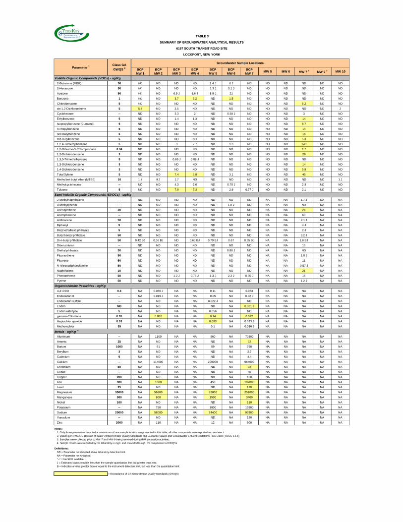
BCP MW 1
BCP MW 2
BCP MW 3
BCP MW 4
BCP MW 5
BCP MW 6
BCP MW 7
MW 5 MW 6 MW 7 3 MW 9 3 MW 10
Volatile Organic Compounds (VOCs) - ug/Kg
2-Butanone (MEK) 50 ND ND ND ND 2.4 J 6 J ND ND ND ND ND ND
2-Hexanone 50 ND ND ND ND 1.3 J 3.1 J ND ND ND ND ND ND
Acetone 50 ND ND 6.9 J 5.6 J 8.9 J 21 ND ND ND ND ND ND
Benzene 1 ND ND 3.7 3.2 ND 1.5 ND ND ND ND ND ND
Chlorobenzene 5 ND ND ND ND ND ND ND ND ND 6.2 ND ND
cis-1,2-Dichloroethene 5 5.7 ND 3.5 ND ND ND ND ND ND ND ND 2
Cyclohexane -- ND ND 3.3 2 ND 0.58 J ND ND ND 3 ND ND
Ethylbenzene 5 ND ND 1.4 1.3 ND ND ND ND ND 14 ND ND
Isopropylbenzene (Cumene) 5 ND ND ND ND ND ND ND ND ND 8.7 ND ND
n-Propylbenzene 5 ND ND ND ND ND ND ND ND ND 14 ND ND
sec-Butylbenzene 5 ND ND ND ND ND ND ND ND ND 15 ND ND
tert-Butylbenzene 5 ND ND ND ND ND ND ND ND ND 5.3 ND ND
1,2,4-Trimethylbenzene 5 ND ND 3 2.7 ND 1.3 ND ND ND 140 ND ND
1,2-Dibromo-3-Chloropropane 0.04 ND ND ND ND ND ND ND ND ND 1.7 ND ND
1,2-Dichlorobenzene 3 ND ND ND ND ND ND ND ND ND 29 ND ND
1,3,5-Trimethylbenzene 5 ND ND 0.86 J 0.88 J ND ND ND ND ND ND ND ND
1,3-Dichlorobenzene 3 ND ND ND ND ND ND ND ND ND 14 ND ND
1,4-Dichlorobenzene 3 ND ND ND ND ND ND ND ND ND 5.8 ND ND
Total Xylene 5 ND ND 7.4 6.8 ND 3.1 ND ND ND 45 ND ND
Methyl tert butyl ether (MTBE) 10 1.7 9.7 1.7 ND ND ND ND ND ND ND ND 1.1
Methylcyclohexane -- ND ND 4.3 2.6 ND 0.75 J ND ND ND 2.3 ND ND
Toluene 5 ND ND 7.9 7.3 ND 2.9 0.77 J ND ND 2.1 ND ND
Semi-Volatile Organic Compounds (SVOCs) - ug/Kg
2-Methylnaphthalene -- ND ND ND ND ND ND ND NA NA 1.7 J NA NA
4-Methylphenol -- ND ND ND ND ND 1.8 J ND NA NA ND NA NA
Acenaphthene 20 ND ND ND ND ND ND ND NA NA 24 NA NA
Acetophenone -- ND ND ND ND ND ND ND NA NA 68 NA NA
Anthracene 50 ND ND ND ND ND ND ND NA NA 2.1 J NA NA
Biphenyl 5 ND ND ND ND ND ND ND NA NA 4 J NA NA
Bis(2-ethylhexl) phthalate 5 ND ND ND ND ND ND ND NA NA 2 J NA NA
Butyl benzyl phthalate 50 ND ND ND ND ND ND ND NA NA 3.2 J NA NA
Di-n-butyl phthalate 50 0.42 BJ 0.36 BJ ND 0.63 BJ 0.79 BJ 0.67 0.55 BJ NA NA 1.8 BJ NA NA
Dibenzofuran -- ND ND ND ND ND ND ND NA NA 16 NA NA
Diethyl phthalate 50 ND ND ND ND ND 0.86 J ND NA NA ND NA NA
Fluoranthene 50 ND ND ND ND ND ND ND NA NA 1.8 J NA NA
Fluorene 50 ND ND ND ND ND ND ND NA NA 11 NA NA
N-Nitrosodiphenylamine 50 ND ND ND ND ND ND ND NA NA 0.57 J NA NA
Naphthalene 10 ND ND ND ND ND ND ND NA NA 21 NA NA
Phenanthrene 50 ND ND 1.2 J 0.76 J 1.3 J 2.3 J 0.95 J NA NA 16 NA NA
Pyrene 50 ND ND ND ND ND ND ND NA NA 1.2 J NA NA
Organochlorine Pesticides - ug/Kg
4,4'-DDD 0.3 NA 0.036 J NA NA 0.11 NA 0.053 NA NA NA NA NA
Endosulfan II -- NA 0.019 J NA NA 0.05 NA 0.02 J NA NA NA NA NA
Endosulfan sulfate -- NA ND NA NA 0.022 J NA ND NA NA NA NA NA
Endrin ND NA ND NA NA ND NA 0.031 J NA NA NA NA NA
Endrin aldehyde 5 NA ND NA NA 0.056 NA ND NA NA NA NA NA
gamma-Chlordane 0.05 NA 0.082 NA NA 0.14 NA 0.072 NA NA NA NA NA
Heptachlor epoxide 0.03 NA ND NA NA 0.083 NA 0.023 J NA NA NA NA NA
Methoxychlor 35 NA ND NA NA 0.1 NA 0.036 J NA NA NA NA NA
Metals - ug/Kg 4
Aluminum -- NA 1100 NA NA 560 NA 70300 NA NA NA NA NA
Arsenic 25 NA ND NA NA ND NA 32 NA NA NA NA NA
Barium 1000 NA 91 NA NA 59 NA 790 NA NA NA NA NA
Beryllium 3 NA ND NA NA ND NA 2.7 NA NA NA NA NA
Cadmium 5 NA ND NA NA ND NA 4.4 NA NA NA NA NA
Calcium -- NA 114000 NA NA 200000 NA 664000 NA NA NA NA NA
Chromium 50 NA ND NA NA ND NA 92 NA NA NA NA NA
Cobalt -- NA ND NA NA ND NA 50 NA NA NA NA NA
Copper 200 NA ND NA NA ND NA 160 NA NA NA NA NA
Iron 300 NA 1000 NA NA 450 NA 107000 NA NA NA NA NA
Lead 25 NA ND NA NA ND NA 120 NA NA NA NA NA
Magnesium 35000 NA 56800 NA NA 78000 NA 251000 NA NA NA NA NA
Manganese 300 NA 900 NA NA 1500 NA 3400 NA NA NA NA NA
Nickel 100 NA ND NA NA ND NA 110 NA NA NA NA NA
Potassium -- NA 790 NA NA 1800 NA 15900 NA NA NA NA NA
Sodium 20000 NA 58000 NA NA 74400 NA 96900 NA NA NA NA NA
Vanadium -- NA ND NA NA ND NA 130 NA NA NA NA NA
Zinc 2000 NA 110 NA NA 12 NA 900 NA NA NA NA NA
Notes:1. Only those parameters detected at a minimum of one sample location are presented in this table; all other compounds were reported as non-detect.2. Values per NYSDEC Division of Water Ambient Water Quality Standards and Guidance Values and Groundwater Effluent Limitations - GA Class (TOGS 1.1.1)3. Samples were collected prior to MW-7 and MW-9 being removed during IRM excavation activities.4. Sample results were reported by the laboratory in mg/L and converted to ug/L for comparison to GWQSs.
Definitions:ND = Parameter not detected above laboratory detection limit.NA = Parameter not Analysed."--" = No SCO available.J = Estimated value; result is less than the sample quantitation limit but greater than zero. B = Indicates a value greater than or equal to the instrument detection limit, but less than the quantitation limit.
= Exceedance of GA Groundwater Quality Standards (GWQS)
TABLE 3
SUMMARY OF GROUNDWATER ANALYTICAL RESULTS
6157 SOUTH TRANSIT ROAD SITE
LOCKPORT, NEW YORK
Parameter 1Groundwater Sample Locations
Class GA
GWQS 2
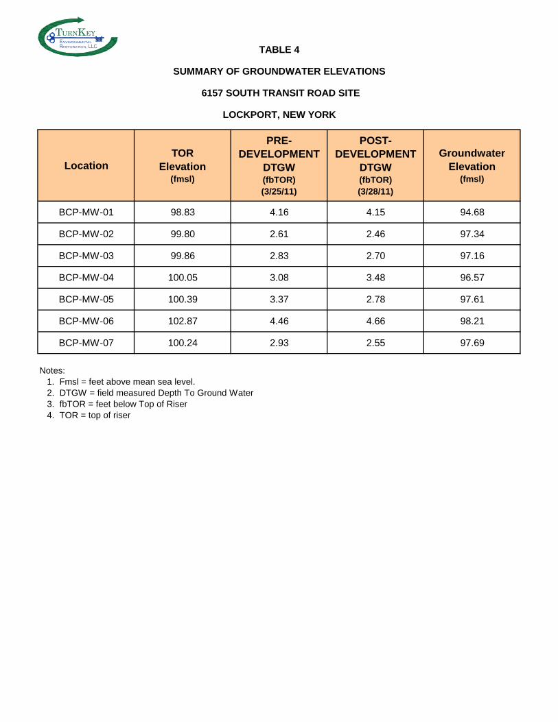
TABLE 4
SUMMARY OF GROUNDWATER ELEVATIONS
6157 SOUTH TRANSIT ROAD SITE
LOCKPORT, NEW YORK
LocationTOR
Elevation (fmsl)
PRE-DEVELOPMENT
DTGW(fbTOR)(3/25/11)
POST-DEVELOPMENT
DTGW(fbTOR)(3/28/11)
GroundwaterElevation
(fmsl)
BCP-MW-01 98.83 4.16 4.15 94.68
BCP-MW-02 99.80 2.61 2.46 97.34
BCP-MW-03 99.86 2.83 2.70 97.16
BCP-MW-04 100.05 3.08 3.48 96.57
BCP-MW-05 100.39 3.37 2.78 97.61
BCP-MW-06 102.87 4.46 4.66 98.21
BCP-MW-07 100.24 2.93 2.55 97.69
Notes:1. Fmsl = feet above mean sea level.2. DTGW = field measured Depth To Ground Water3. fbTOR = feet below Top of Riser4. TOR = top of riser
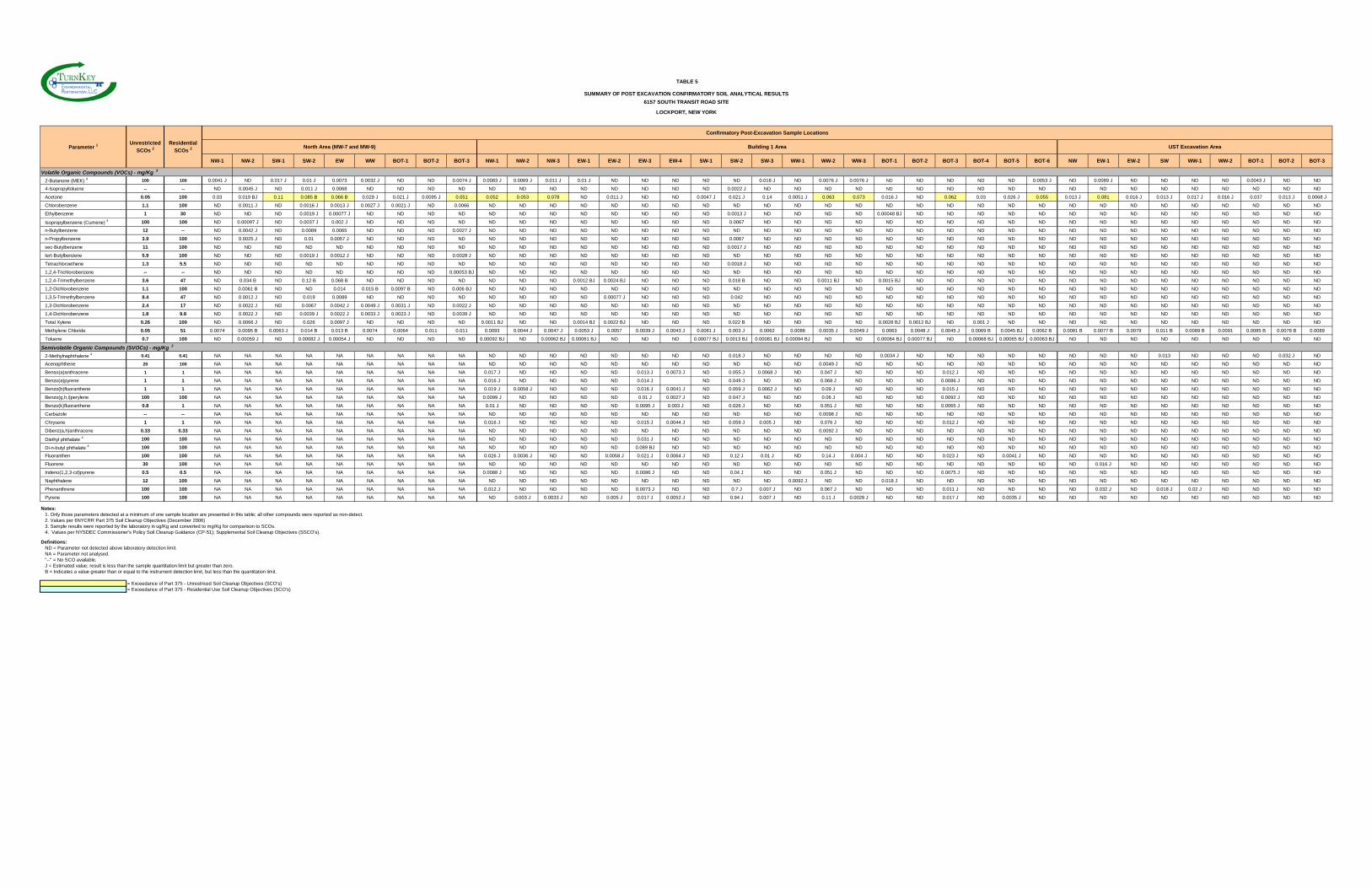
Confirmatory Post-Excavation Sample Locations
North Area (MW-7 and MW-9) Building 1 Area UST Excavation Area
NW-1 NW-2 SW-1 SW-2 EW WW BOT-1 BOT-2 BOT-3 NW-1 NW-2 NW-3 EW-1 EW-2 EW-3 EW-4 SW-1 SW-2 SW-3 WW-1 WW-2 WW-3 BOT-1 BOT-2 BOT-3 BOT-4 BOT-5 BOT-6 NW EW-1 EW-2 SW WW-1 WW-2 BOT-1 BOT-2 BOT-3
Volatile Organic Compounds (VOCs) - mg/Kg 3
2-Butanone (MEK) 4 100 100 0.0041 J ND 0.017 J 0.01 J 0.0073 0.0032 J ND ND 0.0074 J 0.0083 J 0.0069 J 0.011 J 0.01 J ND ND ND ND ND 0.018 J ND 0.0076 J 0.0076 J ND ND ND ND ND 0.0053 J ND 0.0089 J ND ND ND ND 0.0043 J ND ND
4-Isopropyltoluene -- -- ND 0.0045 J ND 0.011 J 0.0068 ND ND ND ND ND ND ND ND ND ND ND ND 0.0022 J ND ND ND ND ND ND ND ND ND ND ND ND ND ND ND ND ND ND ND
Acetone 0.05 100 0.03 0.019 BJ 0.11 0.085 B 0.066 B 0.029 J 0.021 J 0.0095 J 0.051 0.052 0.053 0.078 ND 0.011 J ND ND 0.0047 J 0.021 J 0.14 0.0051 J 0.063 0.073 0.016 J ND 0.062 0.03 0.026 J 0.055 0.013 J 0.081 0.016 J 0.013 J 0.017 J 0.016 J 0.037 0.013 J 0.0068 J
Chlorobenzene 1.1 100 ND 0.0011 J ND 0.0016 J 0.0013 J 0.0027 J 0.0021 J ND 0.0066 ND ND ND ND ND ND ND ND ND ND ND ND ND ND ND ND ND ND ND ND ND ND ND ND ND ND ND ND
Ethylbenzene 1 30 ND ND ND 0.0019 J 0.00077 J ND ND ND ND ND ND ND ND ND ND ND ND 0.0013 J ND ND ND ND 0.00048 BJ ND ND ND ND ND ND ND ND ND ND ND ND ND ND
Isopropylbenzene (Cumene) 4 100 100 ND 0.00097 J ND 0.0037 J 0.002 J ND ND ND ND ND ND ND ND ND ND ND ND 0.0067 ND ND ND ND ND ND ND ND ND ND ND ND ND ND ND ND ND ND ND
n-Butylbenzene 12 -- ND 0.0042 J ND 0.0089 0.0065 ND ND ND 0.0027 J ND ND ND ND ND ND ND ND ND ND ND ND ND ND ND ND ND ND ND ND ND ND ND ND ND ND ND ND
n-Propylbenzene 3.9 100 ND 0.0025 J ND 0.01 0.0057 J ND ND ND ND ND ND ND ND ND ND ND ND 0.0067 ND ND ND ND ND ND ND ND ND ND ND ND ND ND ND ND ND ND ND
sec-Butylbenzene 11 100 ND ND ND ND ND ND ND ND ND ND ND ND ND ND ND ND ND 0.0017 J ND ND ND ND ND ND ND ND ND ND ND ND ND ND ND ND ND ND ND
tert-Butylbenzene 5.9 100 ND ND ND 0.0019 J 0.0012 J ND ND ND 0.0028 J ND ND ND ND ND ND ND ND ND ND ND ND ND ND ND ND ND ND ND ND ND ND ND ND ND ND ND ND
Tetrachloroethene 1.3 5.5 ND ND ND ND ND ND ND ND ND ND ND ND ND ND ND ND ND 0.0018 J ND ND ND ND ND ND ND ND ND ND ND ND ND ND ND ND ND ND ND
1,2,4-Trichlorobenzene -- -- ND ND ND ND ND ND ND ND 0.00053 BJ ND ND ND ND ND ND ND ND ND ND ND ND ND ND ND ND ND ND ND ND ND ND ND ND ND ND ND ND
1,2,4-Trimethylbenzene 3.6 47 ND 0.034 B ND 0.12 B 0.068 B ND ND ND ND ND ND ND 0.0012 BJ 0.0024 BJ ND ND ND 0.018 B ND ND 0.0011 BJ ND 0.0015 BJ ND ND ND ND ND ND ND ND ND ND ND ND ND ND
1,2-Dichlorobenzene 1.1 100 ND 0.0061 B ND ND 0.014 0.015 B 0.0097 B ND 0.006 BJ ND ND ND ND ND ND ND ND ND ND ND ND ND ND ND ND ND ND ND ND ND ND ND ND ND ND ND ND
1,3,5-Trimethylbenzene 8.4 47 ND 0.0012 J ND 0.019 0.0089 ND ND ND ND ND ND ND ND 0.00077 J ND ND ND 0.042 ND ND ND ND ND ND ND ND ND ND ND ND ND ND ND ND ND ND ND
1,3-Dichlorobenzene 2.4 17 ND 0.0022 J ND 0.0067 0.0042 J 0.0049 J 0.0031 J ND 0.0022 J ND ND ND ND ND ND ND ND ND ND ND ND ND ND ND ND ND ND ND ND ND ND ND ND ND ND ND ND
1,4-Dichlorobenzene 1.8 9.8 ND 0.0022 J ND 0.0039 J 0.0022 J 0.0033 J 0.0023 J ND 0.0039 J ND ND ND ND ND ND ND ND ND ND ND ND ND ND ND ND ND ND ND ND ND ND ND ND ND ND ND ND
Total Xylene 0.26 100 ND 0.0066 J ND 0.026 0.0097 J ND ND ND ND 0.0011 BJ ND ND 0.0014 BJ 0.0022 BJ ND ND ND 0.022 B ND ND ND ND 0.0028 BJ 0.0012 BJ ND 0.001 J ND ND ND ND ND ND ND ND ND ND ND
Methylene Chloride 0.05 51 0.0074 0.0095 B 0.0063 J 0.014 B 0.013 B 0.0074 0.0064 0.011 0.011 0.0093 0.0044 J 0.0047 J 0.0053 J 0.0057 0.0039 J 0.0043 J 0.0081 J 0.003 J 0.0062 0.0086 0.0035 J 0.0049 J 0.0063 0.0048 J 0.0045 J 0.0069 B 0.0045 BJ 0.0062 B 0.0081 B 0.0077 B 0.0079 0.011 B 0.0089 B 0.0091 0.0085 B 0.0078 B 0.0089
Toluene 0.7 100 ND 0.00059 J ND 0.00082 J 0.00054 J ND ND ND ND 0.00092 BJ ND 0.00062 BJ 0.00061 BJ ND ND ND 0.00077 BJ 0.0013 BJ 0.00081 BJ 0.00094 BJ ND ND 0.00084 BJ 0.00077 BJ ND 0.00068 BJ 0.00065 BJ 0.00063 BJ ND ND ND ND ND ND ND ND ND
Semivolatile Organic Compounds (SVOCs) - mg/Kg 3
2-Methylnaphthalene 4 0.41 0.41 NA NA NA NA NA NA NA NA NA ND ND ND ND ND ND ND ND 0.018 J ND ND ND ND 0.0034 J ND ND ND ND ND ND ND ND 0.013 ND ND ND 0.032 J ND
Acenaphthene 20 100 NA NA NA NA NA NA NA NA NA ND ND ND ND ND ND ND ND ND ND ND 0.0049 J ND ND ND ND ND ND ND ND ND ND ND ND ND ND ND ND
Benso(a)anthracene 1 1 NA NA NA NA NA NA NA NA NA 0.017 J ND ND ND ND 0.013 J 0.0073 J ND 0.055 J 0.0068 J ND 0.047 J ND ND ND 0.012 J ND ND ND ND ND ND ND ND ND ND ND ND
Benzo(a)pyrene 1 1 NA NA NA NA NA NA NA NA NA 0.016 J ND ND ND ND 0.014 J ND 0.049 J ND ND 0.068 J ND ND ND 0.0086 J ND ND ND ND ND ND ND ND ND ND ND ND
Benzo(b)fluoranthene 1 1 NA NA NA NA NA NA NA NA NA 0.019 J 0.0058 J ND ND ND 0.016 J 0.0041 J ND 0.059 J 0.0062 J ND 0.09 J ND ND ND 0.015 J ND ND ND ND ND ND ND ND ND ND ND ND
Benzo(g,h,i)perylene 100 100 NA NA NA NA NA NA NA NA NA 0.0099 J ND ND ND ND 0.01 J 0.0027 J ND 0.047 J ND ND 0.06 J ND ND ND 0.0092 J ND ND ND ND ND ND ND ND ND ND ND ND
Benzo(k)fluoranthene 0.8 1 NA NA NA NA NA NA NA NA NA 0.01 J ND ND ND ND 0.0095 J 0.003 J ND 0.026 J ND ND 0.051 J ND ND ND 0.0065 J ND ND ND ND ND ND ND ND ND ND ND ND
Carbazole -- -- NA NA NA NA NA NA NA NA NA ND ND ND ND ND ND ND ND ND ND ND 0.0098 J ND ND ND ND ND ND ND ND ND ND ND ND ND ND ND ND
Chrysene 1 1 NA NA NA NA NA NA NA NA NA 0.016 J ND ND ND ND 0.015 J 0.0044 J ND 0.059 J 0.005 J ND 0.076 J ND ND ND 0.012 J ND ND ND ND ND ND ND ND ND ND ND ND
Dibenz(a,h)anthracene 0.33 0.33 NA NA NA NA NA NA NA NA NA ND ND ND ND ND ND ND ND ND ND ND 0.0092 J ND ND ND ND ND ND ND ND ND ND ND ND ND ND ND ND
Diethyl phthalate 4 100 100 NA NA NA NA NA NA NA NA NA ND ND ND ND ND 0.031 J ND ND ND ND ND ND ND ND ND ND ND ND ND ND ND ND ND ND ND ND ND ND
Di-n-butyl phthalate 4 100 100 NA NA NA NA NA NA NA NA NA ND ND ND ND ND 0.089 BJ ND ND ND ND ND ND ND ND ND ND ND ND ND ND ND ND ND ND ND ND ND ND
Fluoranthen 100 100 NA NA NA NA NA NA NA NA NA 0.026 J 0.0036 J ND ND 0.0058 J 0.021 J 0.0064 J ND 0.12 J 0.01 J ND 0.14 J 0.004 J ND ND 0.023 J ND 0.0041 J ND ND ND ND ND ND ND ND ND ND
Fluorene 30 100 NA NA NA NA NA NA NA NA NA ND ND ND ND ND ND ND ND ND ND ND ND ND ND ND ND ND ND ND ND 0.016 J ND ND ND ND ND ND ND
Indeno(1,2,3-cd)pyrene 0.5 0.5 NA NA NA NA NA NA NA NA NA 0.0088 J ND ND ND ND 0.0086 J ND ND 0.04 J ND ND 0.051 J ND ND ND 0.0075 J ND ND ND ND ND ND ND ND ND ND ND ND
Naphthalene 12 100 NA NA NA NA NA NA NA NA NA ND ND ND ND ND ND ND ND ND ND 0.0092 J ND ND 0.018 J ND ND ND ND ND ND ND ND ND ND ND ND ND ND
Phenanthrene 100 100 NA NA NA NA NA NA NA NA NA 0.012 J ND ND ND ND 0.0073 J ND ND 0.7 J 0.007 J ND 0.067 J ND ND ND 0.011 J ND ND ND ND 0.032 J ND 0.018 J 0.02 J ND ND ND ND
Pyrene 100 100 NA NA NA NA NA NA NA NA NA ND 0.003 J 0.0033 J ND 0.005 J 0.017 J 0.0052 J ND 0.94 J 0.007 J ND 0.11 J 0.0028 J ND ND 0.017 J ND 0.0035 J ND ND ND ND ND ND ND ND ND ND
Notes:1. Only those parameters detected at a minimum of one sample location are presented in this table; all other compounds were reported as non-detect.2. Values per 6NYCRR Part 375 Soil Cleanup Objectives (December 2006)3. Sample results were reported by the laboratory in ug/Kg and converted to mg/Kg for comparison to SCOs.4. Values per NYSDEC Commissioner's Policy Soil Cleanup Guidance (CP-51); Supplemental Soil Cleanup Objectives (SSCO's).
Definitions:ND = Parameter not detected above laboratory detection limit.NA = Parameter not analysed."--" = No SCO available.J = Estimated value; result is less than the sample quantitation limit but greater than zero. B = Indicates a value greater than or equal to the instrument detection limit, but less than the quantitation limit.
= Exceedance of Part 375 - Unrestriced Soil Cleanup Objectives (SCO's)= Exceedance of Part 375 - Residential Use Soil Cleanup Objectives (SCO's)
TABLE 5
SUMMARY OF POST EXCAVATION CONFIRMATORY SOIL ANALYTICAL RESULTS
6157 SOUTH TRANSIT ROAD SITE
LOCKPORT, NEW YORK
Unrestricted
SCOs 2Residential
SCOs 2Parameter 1
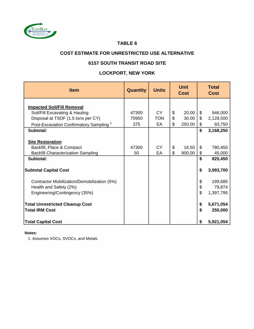
TABLE 6
COST ESTIMATE FOR UNRESTRICTED USE ALTERNATIVE
6157 SOUTH TRANSIT ROAD SITE
LOCKPORT, NEW YORK
Item Quantity UnitsUnitCost
TotalCost
Impacted Soil/Fill RemovalSoil/Fill Excavating & Hauling 47300 CY 20.00$ 946,000$ Disposal at TSDF (1.5 tons per CY) 70950 TON 30.00$ 2,128,500$
Post-Excavation Confirmatory Sampling 1 375 EA 250.00$ 93,750$
Subtotal: 3,168,250$
Site RestorationBackfill, Place & Compact 47300 CY 16.50$ 780,450$ Backfill Characterization Sampling 50 EA 900.00$ 45,000$
Subtotal: 825,450$
Subtotal Capital Cost 3,993,700$
Contractor Mobilization/Demobilization (5%) 199,685$ Health and Safety (2%) 79,874$ Engineering/Contingency (35%) 1,397,795$
Total Unrestricted Cleanup Cost 5,671,054$ Total IRM Cost 250,000$
Total Capital Cost 5,921,054$
Notes:
1. Assumes VOCs, SVOCs, and Metals
RI/AAR/IRM REPORT 6157 SOUTH TRANSIT ROAD SITE
0218-001-300 T K
FIGURES
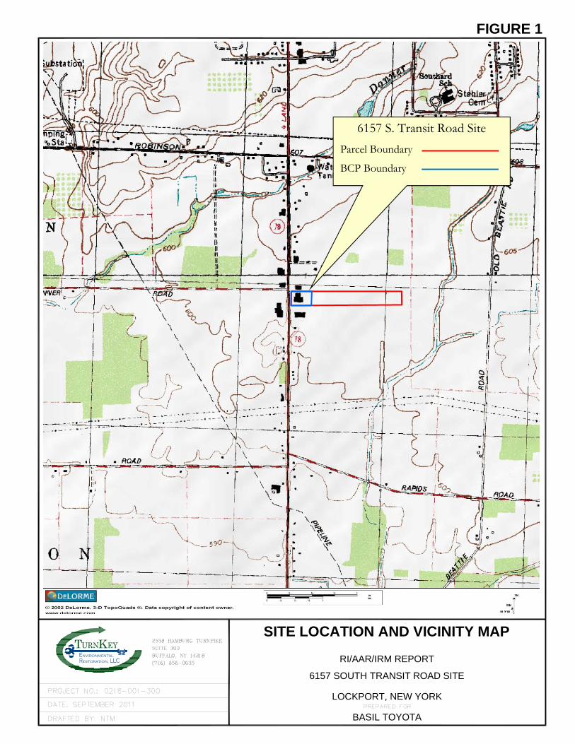
Kestoration,
nvironmental
TSITE LOCATION AND VICINITY MAP
RI/AAR/IRM REPORT
BASIL TOYOTA
6157 SOUTH TRANSIT ROAD SITE
LOCKPORT, NEW YORK
FIGURE 1
6157 S. Transit Road Site
Parcel Boundary
BCP Boundary
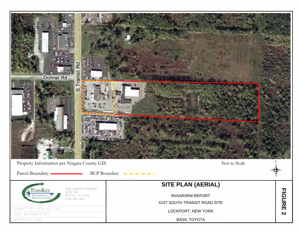
nvironmental
estoration,
T K
FIG
UR
E 2
SITE PLAN (AERIAL)
RI/AAR/IRM REPORT
LOCKPORT, NEW YORK
6157 SOUTH TRANSIT ROAD SITE
BASIL TOYOTA
Property Information per Niagara County GIS Not to Scale
Parcel Boundary BCP Boundary
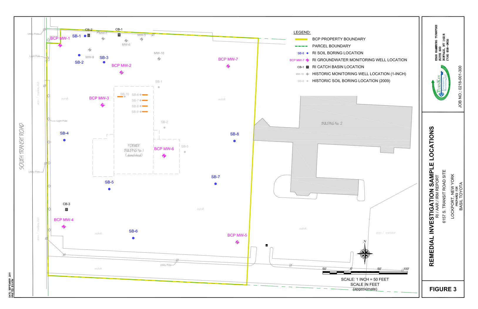
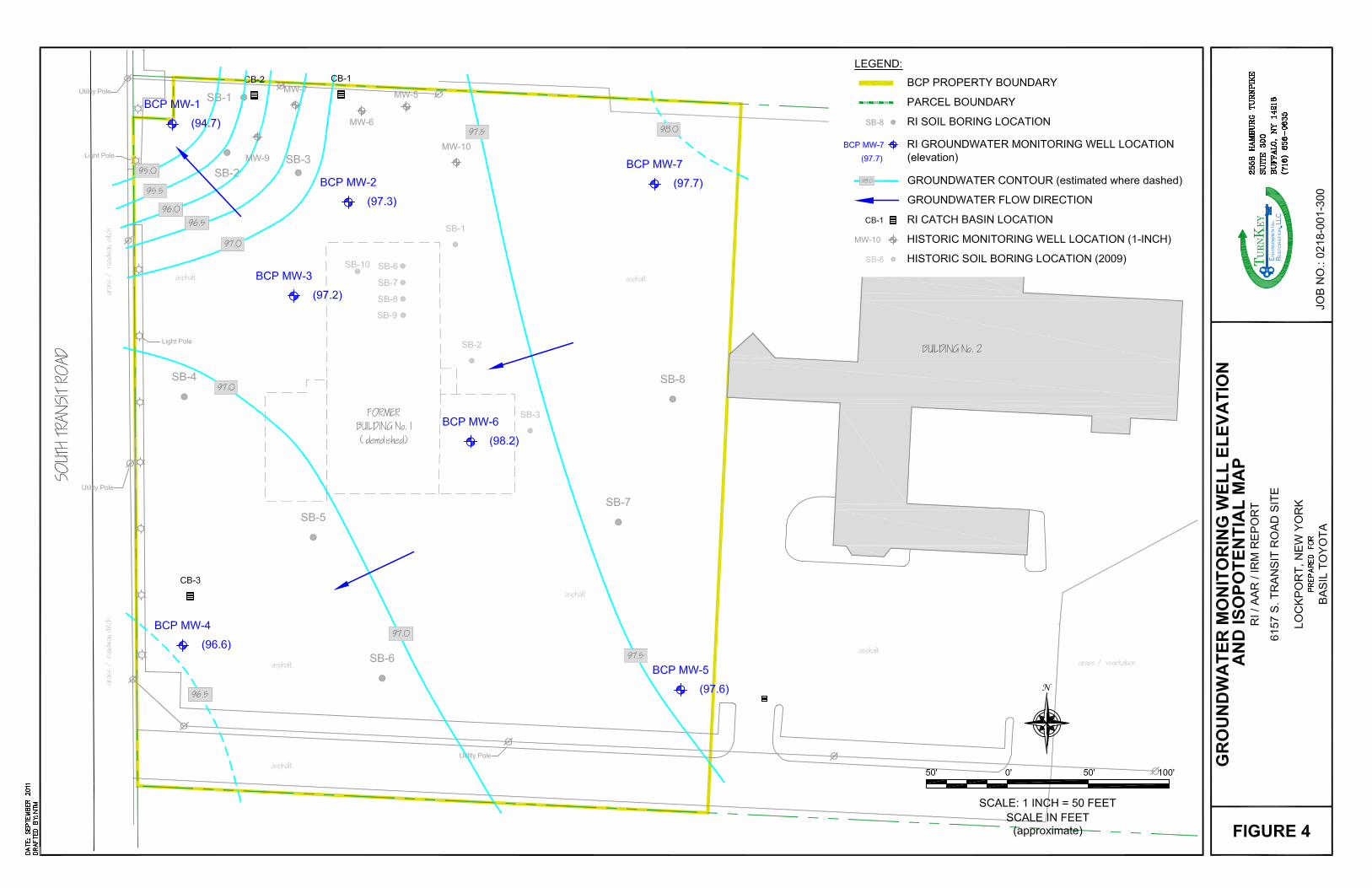
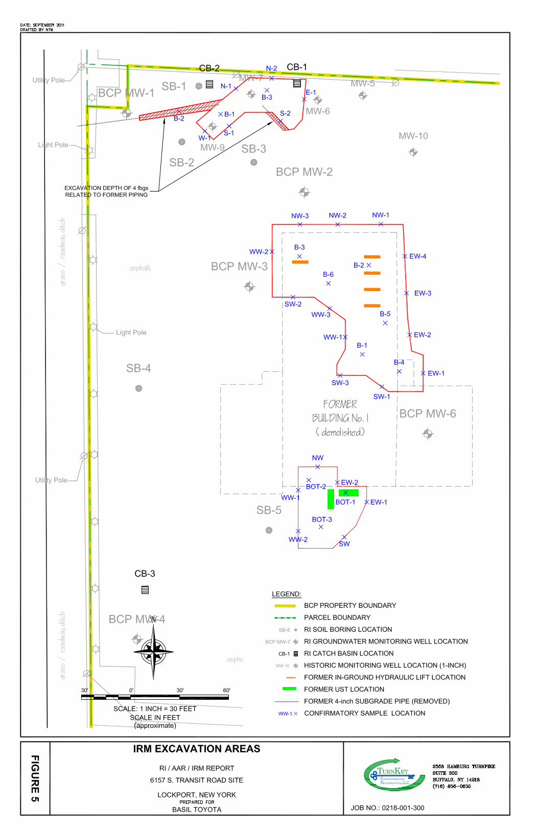
RI/AAR/IRM REPORT 6157 SOUTH TRANSIT ROAD SITE
0218-001-300 T K
APPENDIX A
PROJECT PHOTOLOG
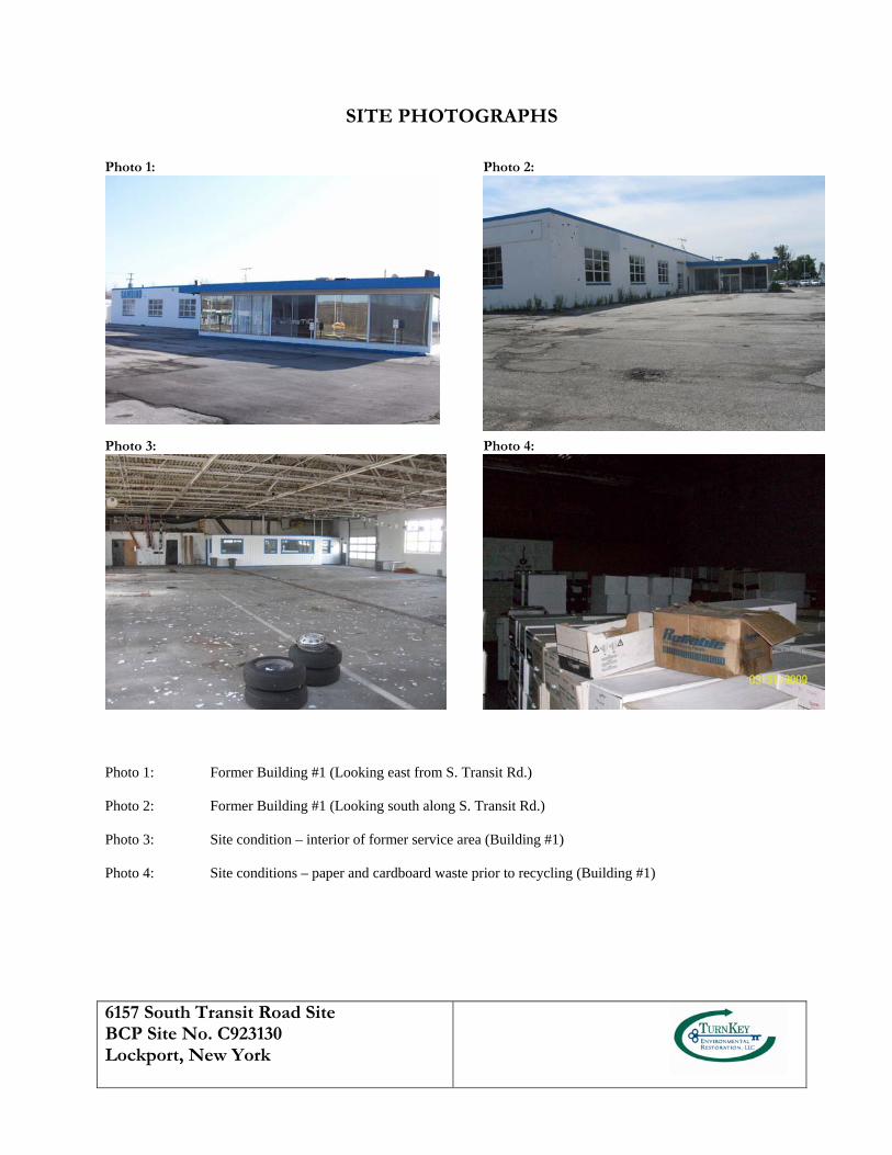
6157 South Transit Road Site BCP Site No. C923130 Lockport, New York
SITE PHOTOGRAPHS Photo 1: Photo 2:
Photo 3: Photo 4:
Photo 1: Former Building #1 (Looking east from S. Transit Rd.) Photo 2: Former Building #1 (Looking south along S. Transit Rd.) Photo 3: Site condition – interior of former service area (Building #1) Photo 4: Site conditions – paper and cardboard waste prior to recycling (Building #1)
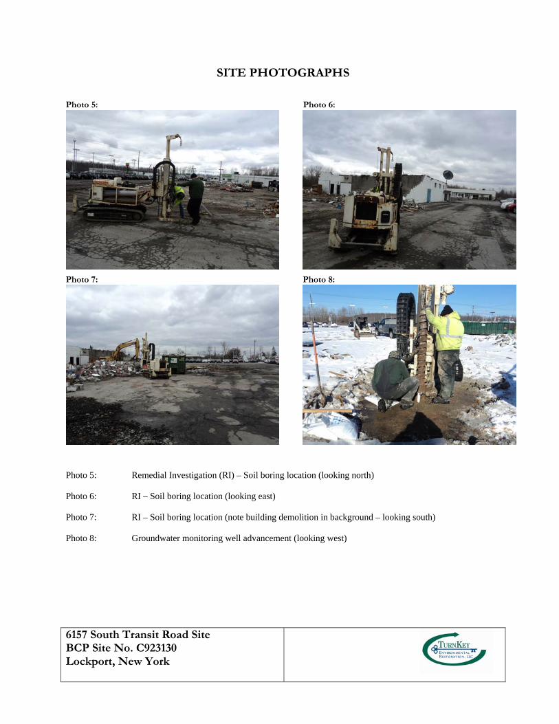
6157 South Transit Road Site BCP Site No. C923130 Lockport, New York
SITE PHOTOGRAPHS
Photo 5: Photo 6:
Photo 7: Photo 8:
Photo 5: Remedial Investigation (RI) – Soil boring location (looking north) Photo 6: RI – Soil boring location (looking east) Photo 7: RI – Soil boring location (note building demolition in background – looking south) Photo 8: Groundwater monitoring well advancement (looking west)
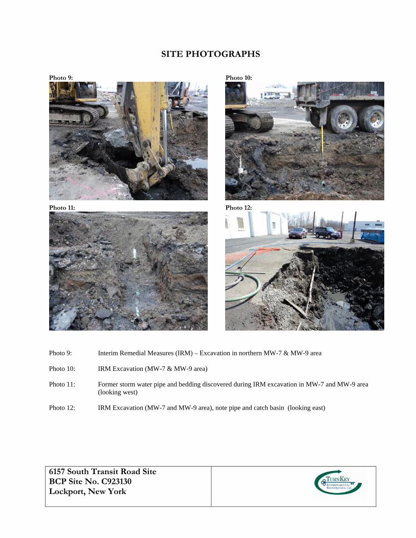
6157 South Transit Road Site BCP Site No. C923130 Lockport, New York
SITE PHOTOGRAPHS
Photo 9: Photo 10:
Photo 11: Photo 12:
Photo 9: Interim Remedial Measures (IRM) – Excavation in northern MW-7 & MW-9 area Photo 10: IRM Excavation (MW-7 & MW-9 area) Photo 11: Former storm water pipe and bedding discovered during IRM excavation in MW-7 and MW-9 area
(looking west) Photo 12: IRM Excavation (MW-7 and MW-9 area), note pipe and catch basin (looking east)
6157 South Transit Road Site BCP Site No. C923130 Lockport, New York
SITE PHOTOGRAPHS
Photo 13: Photo 14:
Photo 15: Photo 16:
Photo 13: Accumulated vegetation and sediment within catch basins (CB-1) Photo 14: IRM MW-7 and MW-9 excavation (looking south) Photo 15: IRM Excavation of former Bldg. #1 foundation/footers Photo 16: IRM Excavation of former Bldg. #1 foundation/footers
6157 South Transit Road Site BCP Site No. C923130 Lockport, New York
SITE PHOTOGRAPHS
Photo 17: Photo 18:
Photo 19: Photo 20:
Photo 17: IRM Bldg. #1 in-ground hydraulic lift removal Photo 18: Excavation of hydraulic lifts Photo 19: Excavation of hydraulic lifts Photo 20: Staging of excavated hydraulic lifts on poly prior to cleaning and off-site recycling as scrap
6157 South Transit Road Site BCP Site No. C923130 Lockport, New York
SITE PHOTOGRAPHS
Photo 21: Photo 22:
Photo 23: Photo 24:
Photo 21: IRM Bldg. #1 excavation area – post-lift removal (looking north) Photo 22: IRM Bldg. #1 excavation Photo 23: IRM Bldg. #1 excavation (floor) Photo 24: Backfilling Bldg. #1 excavation (DEC approved reuse of former building concrete and block)
6157 South Transit Road Site BCP Site No. C923130 Lockport, New York
SITE PHOTOGRAPHS
Photo 25: Photo 26:
Photo 27: Photo 28:
Photo 25: Backfill of former Bldg. #1 footers with approved block and concrete Photo 26: Backfilling and grading Bldg. #1 excavation (looking south) Photo 27: Discovery of UST #1 Photo 28: Cleaning residual product-water mixture from UST (looking southwest)
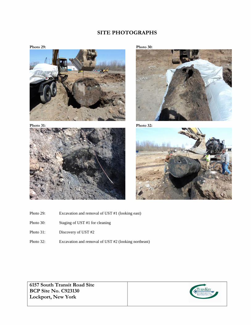
6157 South Transit Road Site BCP Site No. C923130 Lockport, New York
SITE PHOTOGRAPHS
Photo 29: Photo 30:
Photo 31: Photo 32:
Photo 29: Excavation and removal of UST #1 (looking east) Photo 30: Staging of UST #1 for cleaning Photo 31: Discovery of UST #2 Photo 32: Excavation and removal of UST #2 (looking northeast)
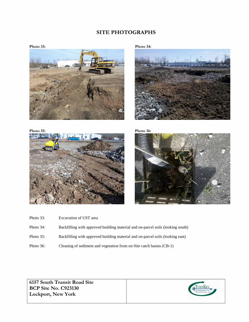
6157 South Transit Road Site BCP Site No. C923130 Lockport, New York
SITE PHOTOGRAPHS
Photo 33: Photo 34:
Photo 35: Photo 36:
Photo 33: Excavation of UST area Photo 34: Backfilling with approved building material and on-parcel soils (looking south) Photo 35: Backfilling with approved building material and on-parcel soils (looking east) Photo 36: Cleaning of sediment and vegetation from on-Site catch basins (CB-1)
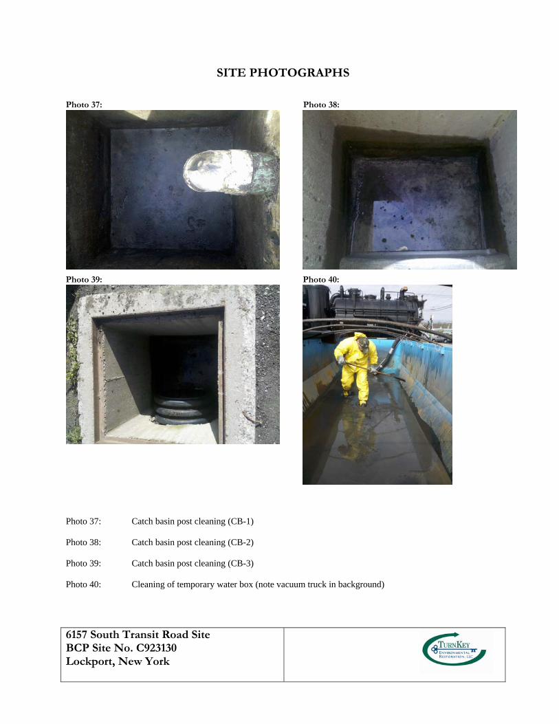
6157 South Transit Road Site BCP Site No. C923130 Lockport, New York
SITE PHOTOGRAPHS
Photo 37: Photo 38:
Photo 39: Photo 40:
Photo 37: Catch basin post cleaning (CB-1) Photo 38: Catch basin post cleaning (CB-2) Photo 39: Catch basin post cleaning (CB-3) Photo 40: Cleaning of temporary water box (note vacuum truck in background)
RI/AAR/IRM REPORT 6157 SOUTH TRANSIT ROAD SITE
0218-001-300 T K
APPENDIX B
FIELD BOREHOLE LOGS AND WELL COMPLETION DETAILS
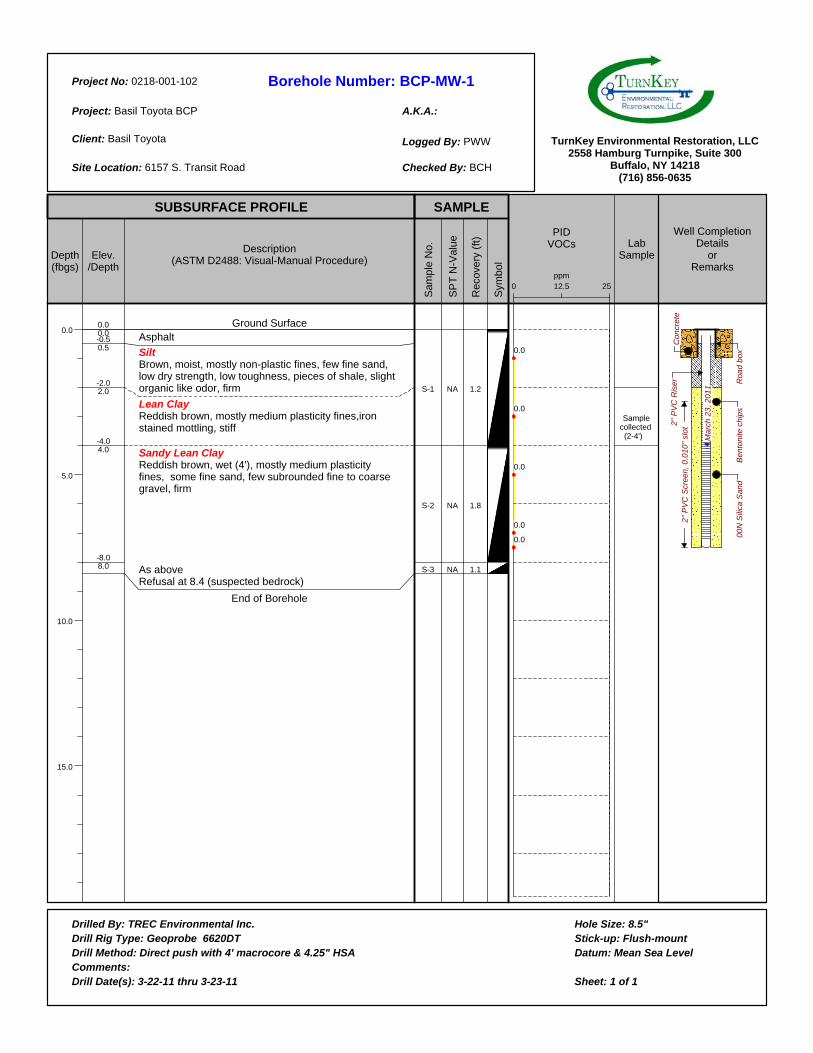
Borehole Number:
A.K.A.:
Project No:
Project:
Client:
Site Location:
Logged By:
Checked By:
Drilled By:Drill Rig Type:Drill Method:Comments:Drill Date(s):
Hole Size:Stick-up:Datum:
Sheet: 1 of 1
TurnKey Environmental Restoration, LLC2558 Hamburg Turnpike, Suite 300
Buffalo, NY 14218(716) 856-0635
SUBSURFACE PROFILE SAMPLE
Depth(fbgs)
0.0
5.0
10.0
15.0
Elev./Depth
Description(ASTM D2488: Visual-Manual Procedure)
Sam
ple
No.
SP
T N
-Val
ue
Rec
over
y (f
t)
Sym
bol
PIDVOCs Lab
Sample
Well CompletionDetails
orRemarks
BCP-MW-10218-001-102
Basil Toyota BCP
Basil Toyota
6157 S. Transit Road
PWW
BCH
0.00.0-0.50.5
-2.02.0
-4.04.0
-8.08.0
Ground SurfaceAsphalt
SiltBrown, moist, mostly non-plastic fines, few fine sand, low dry strength, low toughness, pieces of shale, slight organic like odor, firm
Lean ClayReddish brown, mostly medium plasticity fines,iron stained mottling, stiff
Sandy Lean Clay Reddish brown, wet (4'), mostly medium plasticity fines, some fine sand, few subrounded fine to coarse gravel, firm
As aboveRefusal at 8.4 (suspected bedrock)
End of Borehole
S-1
S-2
S-3
NA
NA
NA
1.2
1.8
1.1
12.50 25ppm
0.0
0.0
0.0
0.0
0.0
Sample collected (2-4') M
arc
h 2
3,
20
11
Ro
ad
bo
xB
en
ton
ite c
hip
s
Co
ncr
ete
2"
PV
C R
ise
r2
" P
VC
Scr
ee
n,
0.0
10
" sl
ot
00
N S
ilica
Sa
nd
TREC Environmental Inc.Geoprobe 6620DT
Direct push with 4' macrocore & 4.25" HSA
3-22-11 thru 3-23-11
8.5"Flush-mount
Mean Sea Level
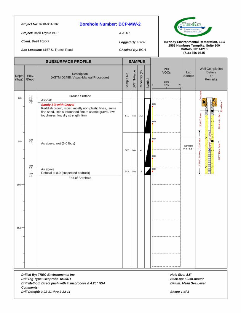
Borehole Number:
A.K.A.:
Project No:
Project:
Client:
Site Location:
Logged By:
Checked By:
Drilled By:Drill Rig Type:Drill Method:Comments:Drill Date(s):
Hole Size:Stick-up:Datum:
Sheet: 1 of 1
TurnKey Environmental Restoration, LLC2558 Hamburg Turnpike, Suite 300
Buffalo, NY 14218(716) 856-0635
SUBSURFACE PROFILE SAMPLE
Depth(fbgs)
0.0
5.0
10.0
15.0
Elev./Depth
Description(ASTM D2488: Visual-Manual Procedure)
Sam
ple
No.
SP
T N
-Val
ue
Rec
over
y (f
t)
Sym
bol
PIDVOCs Lab
Sample
Well CompletionDetails
orRemarks
BCP-MW-20218-001-102
Basil Toyota BCP
Basil Toyota
6157 S. Transit Road
PWW
BCH
0.00.0-0.50.5
-5.05.0
-8.08.0
-8.98.9
Ground SurfaceAsphalt
Sandy Silt with GravelReddish brown, moist, mostly non-plastic fines, some fine sand, little subrounded fine to coarse gravel, low toughness, low dry strength, firm
As above, wet (6.0 fbgs)
As aboveRefusal at 8.9 (suspected bedrock)
End of Borehole
S-1
S-2
S-3
NA
NA
NA
3.2
4
.5
12.50 25ppm
0.0
0.0
0.0
0.0
0.0
Sampled (4.5 -6.5') M
arc
h 2
3,
20
11
Ro
ad
bo
xB
en
ton
ite c
hip
s
Co
ncr
ete
2"
PV
C R
ise
r2
" P
VC
Scr
ee
n,
0.0
10
" sl
ot
00
N S
ilica
Sa
nd
TREC Environmental Inc.Geoprobe 6620DT
Direct push with 4' macrocore & 4.25" HSA
3-22-11 thru 3-23-11
8.5"Flush-mount
Mean Sea Level
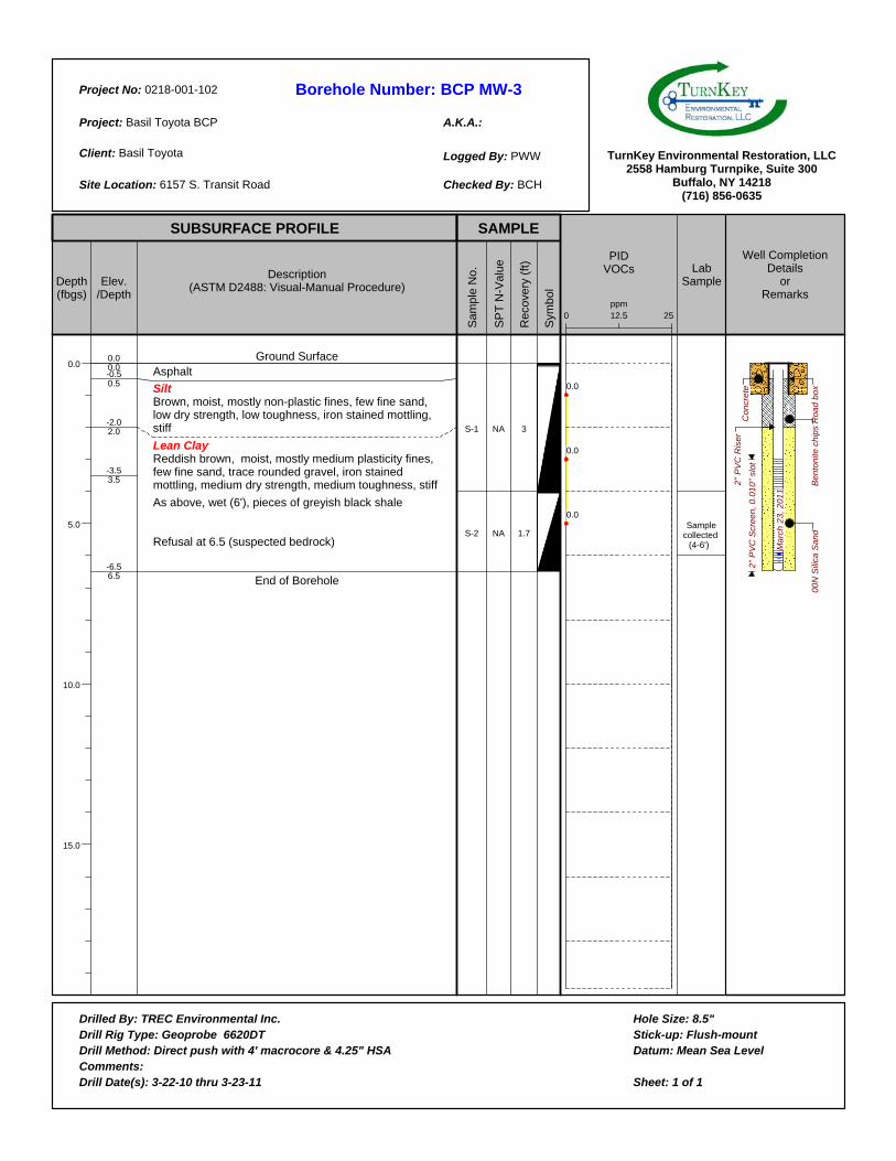
Borehole Number:
A.K.A.:
Project No:
Project:
Client:
Site Location:
Logged By:
Checked By:
Drilled By:Drill Rig Type:Drill Method:Comments:Drill Date(s):
Hole Size:Stick-up:Datum:
Sheet: 1 of 1
TurnKey Environmental Restoration, LLC2558 Hamburg Turnpike, Suite 300
Buffalo, NY 14218(716) 856-0635
SUBSURFACE PROFILE SAMPLE
Depth(fbgs)
0.0
5.0
10.0
15.0
Elev./Depth
Description(ASTM D2488: Visual-Manual Procedure)
Sam
ple
No.
SP
T N
-Val
ue
Rec
over
y (f
t)
Sym
bol
PIDVOCs Lab
Sample
Well CompletionDetails
orRemarks
BCP MW-30218-001-102
Basil Toyota BCP
Basil Toyota
6157 S. Transit Road
PWW
BCH
0.00.0-0.50.5
-2.02.0
-3.53.5
-6.56.5
Ground SurfaceAsphalt
SiltBrown, moist, mostly non-plastic fines, few fine sand, low dry strength, low toughness, iron stained mottling, stiff
Lean ClayReddish brown, moist, mostly medium plasticity fines, few fine sand, trace rounded gravel, iron stained mottling, medium dry strength, medium toughness, stiff
As above, wet (6'), pieces of greyish black shale
Refusal at 6.5 (suspected bedrock)
End of Borehole
S-1
S-2
NA
NA
3
1.7
12.50 25ppm
0.0
0.0
0.0 Sample collected
(4-6') Ma
rch
23
, 2
01
1
Ro
ad
bo
xB
en
ton
ite c
hip
s
Co
ncr
ete
2"
PV
C R
ise
r
2"
PV
C S
cre
en
, 0
.01
0"
slo
t
00
N S
ilica
Sa
nd
TREC Environmental Inc.Geoprobe 6620DT
Direct push with 4' macrocore & 4.25" HSA
3-22-10 thru 3-23-11
8.5"Flush-mount
Mean Sea Level
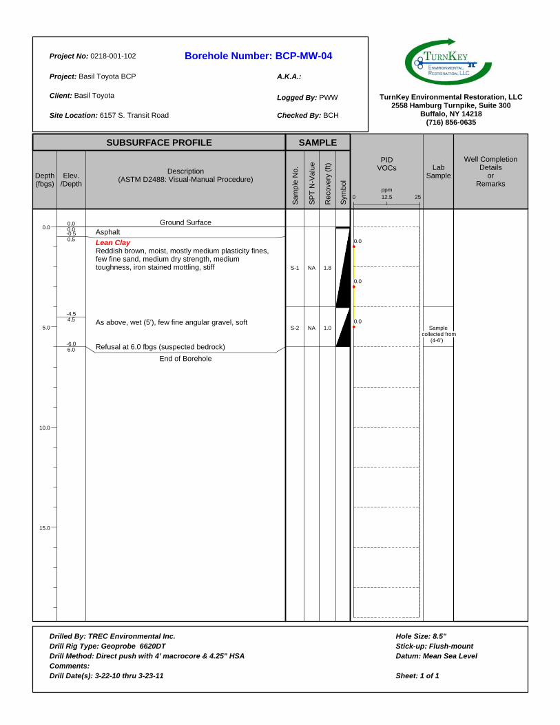
Borehole Number:
A.K.A.:
Project No:
Project:
Client:
Site Location:
Logged By:
Checked By:
Drilled By:Drill Rig Type:Drill Method:Comments:Drill Date(s):
Hole Size:Stick-up:Datum:
Sheet: 1 of 1
TurnKey Environmental Restoration, LLC2558 Hamburg Turnpike, Suite 300
Buffalo, NY 14218(716) 856-0635
SUBSURFACE PROFILE SAMPLE
Depth(fbgs)
0.0
5.0
10.0
15.0
Elev./Depth
Description(ASTM D2488: Visual-Manual Procedure)
Sam
ple
No.
SP
T N
-Val
ue
Rec
over
y (f
t)
Sym
bol
PIDVOCs Lab
Sample
Well CompletionDetails
orRemarks
BCP-MW-040218-001-102
Basil Toyota BCP
Basil Toyota
6157 S. Transit Road
PWW
BCH
0.00.0-0.50.5
-4.54.5
-6.06.0
Ground SurfaceAsphalt
Lean ClayReddish brown, moist, mostly medium plasticity fines, few fine sand, medium dry strength, medium toughness, iron stained mottling, stiff
As above, wet (5'), few fine angular gravel, soft
Refusal at 6.0 fbgs (suspected bedrock)
End of Borehole
S-1
S-2
NA
NA
1.8
1.0
12.50 25ppm
0.0
0.0
0.0 Sample
collected from (4-6')
TREC Environmental Inc.Geoprobe 6620DT
Direct push with 4' macrocore & 4.25" HSA
3-22-10 thru 3-23-11
8.5"Flush-mount
Mean Sea Level

Borehole Number:
A.K.A.:
Project No:
Project:
Client:
Site Location:
Logged By:
Checked By:
Drilled By:Drill Rig Type:Drill Method:Comments:Drill Date(s):
Hole Size:Stick-up:Datum:
Sheet: 1 of 1
TurnKey Environmental Restoration, LLC2558 Hamburg Turnpike, Suite 300
Buffalo, NY 14218(716) 856-0635
SUBSURFACE PROFILE SAMPLE
Depth(fbgs)
0.0
5.0
10.0
15.0
Elev./Depth
Description(ASTM D2488: Visual-Manual Procedure)
Sam
ple
No.
SP
T N
-Val
ue
Rec
over
y (f
t)
Sym
bol
PIDVOCs Lab
Sample
Well CompletionDetails
orRemarks
BCP MW-50218-001-102
Basil Toyota BCP
Basil Toyota
6157 S. Transit Road
PWW
BCH
0.00.0-0.50.5
-4.04.0
-8.08.0
Ground SurfaceAsphalt
Sandy Lean ClayBrownish black, moist, mostly low plasticity fines, some fine to coarse sand, medium dry strength, medium toughness, iron stained mottling, firm
Lean ClayReddish brown, wet (6'), mostly medium plasticity fines, few fine sand, few medium angular gravel, iron stained mottling, stiff
As aboveRefusal at 8.4 fbgs (suspected bedrock)
End of Borehole
S-1
S-2
S-3
NA
NA
NA
2.4
3.4
.45
12.50 25ppm
0.0
0.0
0.0
0.0
Sample collected from
(4-6')
Ma
rch
23
, 2
01
1R
oa
d b
ox
Be
nto
nite
ch
ips
Co
ncr
ete
2"
PV
C R
ise
r
2"
PV
C S
cre
en
, 0
.01
0"
slo
t
00
N S
ilica
Sa
nd
TREC Environmental Inc.Geoprobe 6620DT
Direct push with 4' macrocore & 4.25" HSA
3-22-10 thru 3-23-11
8.5'Flush-mount
Mean Sea Level
Borehole Number:
A.K.A.:
Project No:
Project:
Client:
Site Location:
Logged By:
Checked By:
Drilled By:Drill Rig Type:Drill Method:Comments:Drill Date(s):
Hole Size:Stick-up:Datum:
Sheet: 1 of 1
TurnKey Environmental Restoration, LLC2558 Hamburg Turnpike, Suite 300
Buffalo, NY 14218(716) 856-0635
SUBSURFACE PROFILE SAMPLE
Depth(fbgs)
0.0
5.0
10.0
15.0
Elev./Depth
Description(ASTM D2488: Visual-Manual Procedure)
Sam
ple
No.
SP
T N
-Val
ue
Rec
over
y (f
t)
Sym
bol
PIDVOCs Lab
Sample
Well CompletionDetails
orRemarks
BCP MW-060218-001-102
Basil Toyota BCP
Basil Toyota
6157 S. Transit Road
PWW
BCH
0.00.0-0.50.5
-2.02.0
-7.87.8
Ground SurfaceAsphalt
Lean Clay with Sand and GravelBrown, moist, mostly medium plasticity fines, few fine sand, few fine to coarse subrounded gravel, medium dry strength, medium toughness, stiff
As above, reddish brown, wet (5'), slow dilatency
Refusal at 7.8 fbgs (suspected bedrock)
End of Borehole
S-1
S-2
NA
NA
4.0
2.9
12.50 25ppm
0.0
0.0
0.0
0.0
Sample collected from
(3-5') Ma
rch
24
, 2
01
1
Ro
ad
bo
xB
en
ton
ite c
hip
s
Co
ncr
ete
2"
PV
C R
ise
r
2"
PV
C S
cre
en
, 0
.01
0"
slo
t
00
N S
ilica
Sa
nd
TREC Environmental Inc.Geoprobe 6620DT
Direct push with 4' macrocore & 4.25" HSA
3-24-11
8.5"2'
Mean Sea Level
Borehole Number:
A.K.A.:
Project No:
Project:
Client:
Site Location:
Logged By:
Checked By:
Drilled By:Drill Rig Type:Drill Method:Comments:Drill Date(s):
Hole Size:Stick-up:Datum:
Sheet: 1 of 1
TurnKey Environmental Restoration, LLC2558 Hamburg Turnpike, Suite 300
Buffalo, NY 14218(716) 856-0635
SUBSURFACE PROFILE SAMPLE
Depth(fbgs)
0.0
5.0
10.0
15.0
Elev./Depth
Description(ASTM D2488: Visual-Manual Procedure)
Sam
ple
No.
SP
T N
-Val
ue
Rec
over
y (f
t)
Sym
bol
PIDVOCs Lab
Sample
Well CompletionDetails
orRemarks
BCP MW-070218-001-102
Basil Toyota BCP
Basil Toyota
6157 S. Transit Road
PWW
BCH
0.00.0-0.50.5
-2.02.0
-6.96.9
Ground SurfaceAsphalt
Lean Clay with Sand and GravelBrown, moist, mostly medium plasticity fines, few fine sand, few fine to coarse subrounded gravel, medium dry strength, medium toughness, stiff
As above, reddish brown, wet (5.5'), iron stained mottling
Refusal at 6.9 fbgs (suspected bedrock)
End of Borehole
S-1
S-2
NA
NA
4.0
2.9
12.50 25ppm
0.0
0.0
0.0
0.0
Sampled (3.5-5.5')
Ma
rch
23
, 2
01
1
Ro
ad
bo
xB
en
ton
ite c
hip
s
Co
ncr
ete
2"
PV
C R
ise
r2
" P
VC
Scr
ee
n,
0.0
10
" sl
ot
00
N S
ilica
Sa
nd
TREC Environmental Inc.Geoprobe 6620DT
Direct push with 4' macrocore & 4.25" HSA
3-23-10
8.5"Flush-mount
Mean Sea Level
Borehole Number:
A.K.A.:
Project No:
Project:
Client:
Site Location:
Logged By:
Checked By:
Drilled By:Drill Rig Type:Drill Method:Comments:Drill Date(s):
Hole Size:Stick-up:Datum:
Sheet: 1 of 1
TurnKey Environmental Restoration, LLC2558 Hamburg Turnpike, Suite 300
Buffalo, NY 14218(716) 856-0635
SUBSURFACE PROFILE SAMPLE
Depth(fbgs)
0.0
5.0
10.0
15.0
20.0
Elev./Depth
Description(ASTM D2488: Visual-Manual Procedure)
Sam
ple
No.
SP
T N
-Val
ue
Rec
over
y (f
t)
Sym
bol
PIDVOCs Lab
Sample
Well CompletionDetails
orRemarks
BCP SB-010218-001-102
Basil Toyota BCP
Basil Toyota
6157 S. Transit Road
PWW
BCH
0.00.0-0.50.5
-2.02.0
-4.04.0
-7.07.0
-8.08.0
Ground SurfaceAsphalt
Silt Brown, moist, mostly non-plastic fines, few fine sand, low dry strength, low toughness, firm
As above, reddish brown, iron stained mottling
Lean ClayBrown, moist, mostly medium plasticity fines, few fine to coarse sand, medium dry strength, medium toughness, stiff
As above, reddish brown, wet (7'), few subrounded fine to coarse gravel
As aboveRefusal at 8.4 fbgs (suspected bedrock)
End of Borehole
S-1
S-2
S-3
NA
NA
NA
2.7
3.8
.25
12.50 25ppm
0.0
0.0
0.0
0.0
0.0 sampled
(6-8')
Ma
rch
22
, 2
01
1
TREC Environmental Inc.Geoprobe 6620DT
Direct push with 4' macrocore
3-22-10
3.0"NA
Mean Sea Level

Borehole Number:
A.K.A.:
Project No:
Project:
Client:
Site Location:
Logged By:
Checked By:
Drilled By:Drill Rig Type:Drill Method:Comments:Drill Date(s):
Hole Size:Stick-up:Datum:
Sheet: 1 of 1
TurnKey Environmental Restoration, LLC2558 Hamburg Turnpike, Suite 300
Buffalo, NY 14218(716) 856-0635
SUBSURFACE PROFILE SAMPLE
Depth(fbgs)
0.0
5.0
10.0
15.0
Elev./Depth
Description(ASTM D2488: Visual-Manual Procedure)
Sam
ple
No.
SP
T N
-Val
ue
Rec
over
y (f
t)
Sym
bol
PIDVOCs Lab
Sample
Well CompletionDetails
orRemarks
BCP SB-020218-001-102
Basil Toyota BCP
Basil Toyota
6157 S. Transit Road.
PWW
BCH
0.00.0-0.50.5
-5.05.0
-6.06.0
-7.87.8
Ground SurfaceAsphalt
SiltBrown, moist, mostly non-plastic fines, few fine sand, low dry strength, low toughness, iron stained mottling, stiff
Lean ClayReddish brown, moist, mostly medium plasticity fines, few fine sand, iron stained mottling, medium dry strength, medium toughness, stiff
Sandy Lean ClayReddish brown, wet (6'), mostly medium plasticity fines, some fine sand, few subrounded fine to coarse gravel, stiff
Refusal at 7.8 fbgs (suspected bedrock)
End of Borehole
S-1
S-2
NA
NA
3.2
4.0
12.50 25ppm
0.0
0.0
0.0
0.0
0.0
Sample collected from
(4-6') Ma
rch
22
, 2
01
1
TREC Environmental Inc.Geoprobe 6620DT
Direct push with 4' macrocore
3-22-10
3.0"NA
Mean Sea Level
Borehole Number:
A.K.A.:
Project No:
Project:
Client:
Site Location:
Logged By:
Checked By:
Drilled By:Drill Rig Type:Drill Method:Comments:Drill Date(s):
Hole Size:Stick-up:Datum:
Sheet: 1 of 1
TurnKey Environmental Restoration, LLC2558 Hamburg Turnpike, Suite 300
Buffalo, NY 14218(716) 856-0635
SUBSURFACE PROFILE SAMPLE
Depth(fbgs)
0.0
5.0
10.0
15.0
20.0
Elev./Depth
Description(ASTM D2488: Visual-Manual Procedure)
Sam
ple
No.
SP
T N
-Val
ue
Rec
over
y (f
t)
Sym
bol
PIDVOCs Lab
Sample
Well CompletionDetails
orRemarks
BCP SB-030218-001-102
Basil Toyota BCP
Basil Toyota
6157 S. Transit Road
PWW
BCH
0.00.0-0.50.5
-5.05.0
-8.08.0
Ground SurfaceAsphalt
SiltBrown, moist, mostly non-plastic fines, few fine sand, low dry strength, low toughness, iron stained mottling, stiff
Sandy Lean ClayReddish brown, wet (6'), mostly medium plasticity fines, some fine sand, few subrounded fine to coarse gravel, stiff
As aboveRefusal at 8.0fbgs (suspected bedrock)
End of Borehole
S-1
S-2
S-3
NA
NA
NA
3.2
4.0
.3
12.50 25ppm
0.0
0.0
0.0
0.0
0.0
Sample collected
(4-6') Ma
rch
22
, 2
01
1
TREC Environmental Inc.Geoprobe 6620DT
Direct push with 4' macrocore
3-22-10
3.0"NA
Mean Sea Level
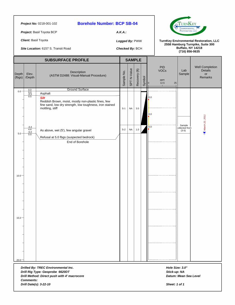
Borehole Number:
A.K.A.:
Project No:
Project:
Client:
Site Location:
Logged By:
Checked By:
Drilled By:Drill Rig Type:Drill Method:Comments:Drill Date(s):
Hole Size:Stick-up:Datum:
Sheet: 1 of 1
TurnKey Environmental Restoration, LLC2558 Hamburg Turnpike, Suite 300
Buffalo, NY 14218(716) 856-0635
SUBSURFACE PROFILE SAMPLE
Depth(fbgs)
0.0
5.0
10.0
15.0
20.0
Elev./Depth
Description(ASTM D2488: Visual-Manual Procedure)
Sam
ple
No.
SP
T N
-Val
ue
Rec
over
y (f
t)
Sym
bol
PIDVOCs Lab
Sample
Well CompletionDetails
orRemarks
BCP SB-040218-001-102
Basil Toyota BCP
Basil Toyota
6157 S. Transit Road
PWW
BCH
0.00.0-0.50.5
-4.44.4-5.05.0
Ground SurfaceAsphalt
Silt Reddish Brown, moist, mostly non-plastic fines, few fine sand, low dry strength, low toughness, iron stained mottling, stiff
As above, wet (5'), few angular gravel
Refusal at 5.0 fbgs (suspected bedrock)
End of Borehole
S-1
S-2
NA
NA
3.0
1.0
12.50 25ppm
0.0
0.0
0.0 Sample
collected from (3-5) M
arc
h 2
2,
20
11
TREC Environmental Inc.Geoprobe 6620DT
Direct push with 4' macrocore
3-22-10
3.0"NA
Mean Sea Level
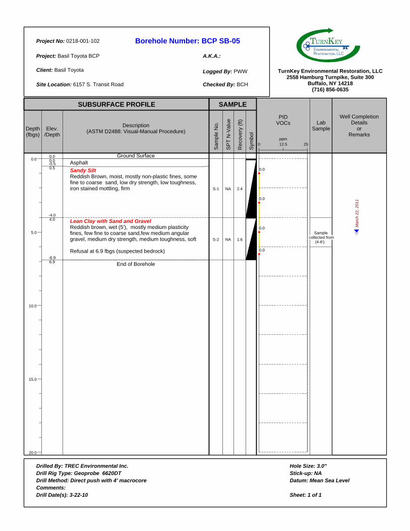
Borehole Number:
A.K.A.:
Project No:
Project:
Client:
Site Location:
Logged By:
Checked By:
Drilled By:Drill Rig Type:Drill Method:Comments:Drill Date(s):
Hole Size:Stick-up:Datum:
Sheet: 1 of 1
TurnKey Environmental Restoration, LLC2558 Hamburg Turnpike, Suite 300
Buffalo, NY 14218(716) 856-0635
SUBSURFACE PROFILE SAMPLE
Depth(fbgs)
0.0
5.0
10.0
15.0
20.0
Elev./Depth
Description(ASTM D2488: Visual-Manual Procedure)
Sam
ple
No.
SP
T N
-Val
ue
Rec
over
y (f
t)
Sym
bol
PIDVOCs Lab
Sample
Well CompletionDetails
orRemarks
BCP SB-050218-001-102
Basil Toyota BCP
Basil Toyota
6157 S. Transit Road
PWW
BCH
0.00.0-0.50.5
-4.04.0
-6.96.9
Ground SurfaceAsphalt
Sandy SiltReddish Brown, moist, mostly non-plastic fines, some fine to coarse sand, low dry strength, low toughness, iron stained mottling, firm
Lean Clay with Sand and GravelReddish brown, wet (5'), mostly medium plasticity fines, few fine to coarse sand,few medium angular gravel, medium dry strength, medium toughness, soft
Refusal at 6.9 fbgs (suspected bedrock)
End of Borehole
S-1
S-2
NA
NA
2.4
1.6
12.50 25ppm
0.0
0.0
0.0
0.0
Sample collected from
(4-6')
Ma
rch
22
, 2
01
1
TREC Environmental Inc.Geoprobe 6620DT
Direct push with 4' macrocore
3-22-10
3.0"NA
Mean Sea Level
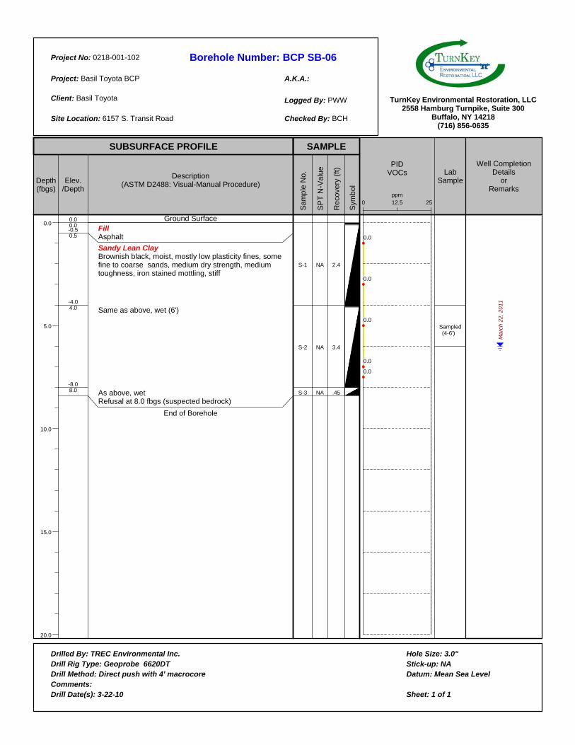
Borehole Number:
A.K.A.:
Project No:
Project:
Client:
Site Location:
Logged By:
Checked By:
Drilled By:Drill Rig Type:Drill Method:Comments:Drill Date(s):
Hole Size:Stick-up:Datum:
Sheet: 1 of 1
TurnKey Environmental Restoration, LLC2558 Hamburg Turnpike, Suite 300
Buffalo, NY 14218(716) 856-0635
SUBSURFACE PROFILE SAMPLE
Depth(fbgs)
0.0
5.0
10.0
15.0
20.0
Elev./Depth
Description(ASTM D2488: Visual-Manual Procedure)
Sam
ple
No.
SP
T N
-Val
ue
Rec
over
y (f
t)
Sym
bol
PIDVOCs Lab
Sample
Well CompletionDetails
orRemarks
BCP SB-060218-001-102
Basil Toyota BCP
Basil Toyota
6157 S. Transit Road
PWW
BCH
0.00.0-0.50.5
-4.04.0
-8.08.0
Ground SurfaceFillAsphalt
Sandy Lean ClayBrownish black, moist, mostly low plasticity fines, some fine to coarse sands, medium dry strength, medium toughness, iron stained mottling, stiff
Same as above, wet (6')
As above, wetRefusal at 8.0 fbgs (suspected bedrock)
End of Borehole
S-1
S-2
S-3
NA
NA
NA
2.4
3.4
.45
12.50 25ppm
0.0
0.0
0.0
0.0
0.0
Sampled (4-6')
Ma
rch
22
, 2
01
1
TREC Environmental Inc.Geoprobe 6620DT
Direct push with 4' macrocore
3-22-10
3.0"NA
Mean Sea Level
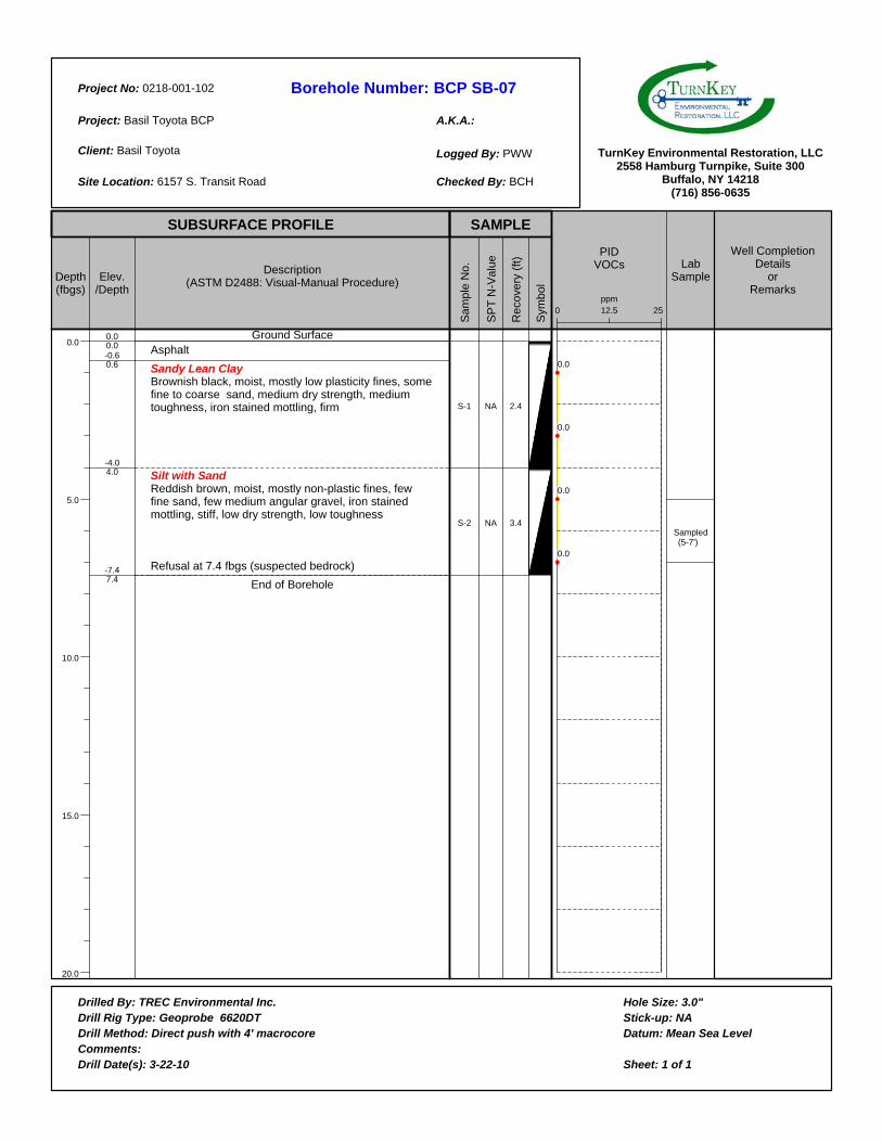
Borehole Number:
A.K.A.:
Project No:
Project:
Client:
Site Location:
Logged By:
Checked By:
Drilled By:Drill Rig Type:Drill Method:Comments:Drill Date(s):
Hole Size:Stick-up:Datum:
Sheet: 1 of 1
TurnKey Environmental Restoration, LLC2558 Hamburg Turnpike, Suite 300
Buffalo, NY 14218(716) 856-0635
SUBSURFACE PROFILE SAMPLE
Depth(fbgs)
0.0
5.0
10.0
15.0
20.0
Elev./Depth
Description(ASTM D2488: Visual-Manual Procedure)
Sam
ple
No.
SP
T N
-Val
ue
Rec
over
y (f
t)
Sym
bol
PIDVOCs Lab
Sample
Well CompletionDetails
orRemarks
BCP SB-070218-001-102
Basil Toyota BCP
Basil Toyota
6157 S. Transit Road
PWW
BCH
0.00.0-0.60.6
-4.04.0
-7.47.4
Ground SurfaceAsphalt
Sandy Lean ClayBrownish black, moist, mostly low plasticity fines, some fine to coarse sand, medium dry strength, medium toughness, iron stained mottling, firm
Silt with SandReddish brown, moist, mostly non-plastic fines, few fine sand, few medium angular gravel, iron stained mottling, stiff, low dry strength, low toughness
Refusal at 7.4 fbgs (suspected bedrock)
End of Borehole
S-1
S-2
NA
NA
2.4
3.4
12.50 25ppm
0.0
0.0
0.0
0.0
Sampled (5-7')
TREC Environmental Inc.Geoprobe 6620DT
Direct push with 4' macrocore
3-22-10
3.0"NA
Mean Sea Level
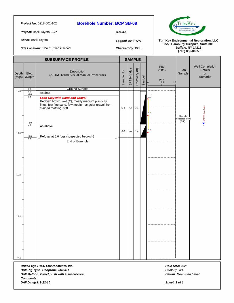
Borehole Number:
A.K.A.:
Project No:
Project:
Client:
Site Location:
Logged By:
Checked By:
Drilled By:Drill Rig Type:Drill Method:Comments:Drill Date(s):
Hole Size:Stick-up:Datum:
Sheet: 1 of 1
TurnKey Environmental Restoration, LLC2558 Hamburg Turnpike, Suite 300
Buffalo, NY 14218(716) 856-0635
SUBSURFACE PROFILE SAMPLE
Depth(fbgs)
0.0
5.0
10.0
15.0
20.0
Elev./Depth
Description(ASTM D2488: Visual-Manual Procedure)
Sam
ple
No.
SP
T N
-Val
ue
Rec
over
y (f
t)
Sym
bol
PIDVOCs Lab
Sample
Well CompletionDetails
orRemarks
BCP SB-080218-001-102
Basil Toyota BCP
Basil Toyota
6157 S. Transit Road
PWW
BCH
0.00.0-0.60.6
-4.04.0
-5.65.6
Ground SurfaceAsphalt
Lean Clay with Sand and GravelReddish brown, wet (4'), mostly medium plasticity fines, few fine sand, few medium angular gravel, iron stained mottling, stiff
As above
Refusal at 5.6 fbgs (suspected bedrock)
End of Borehole
S-1
S-2
NA
NA
3.1
1.4
12.50 25ppm
0.0
0.0
0.0
Sample collected from
(2-4') Ma
rch
22
, 2
01
1
TREC Environmental Inc.Geoprobe 6620DT
Direct push with 4' macrocore
3-22-10
3.0"NA
Mean Sea Level
Recommended