DEPARTMENT OF THE ARMY ALASKA DISTRICT, U.S. ARMY CORPS OF ENGINEERS
REGULATORY DIVISION
Regulatory Division POA-1982-290
Heatherdafe Resources Attention: Mr. Patrick Smith 1040 W Georgia Street, 151
h Floor Vancouver, BC V6E 4H8
Dear Mr. Smith:
P.O. BOX 6898 JBER, ALASKA 99506-0898
JUL 2 8 Z014
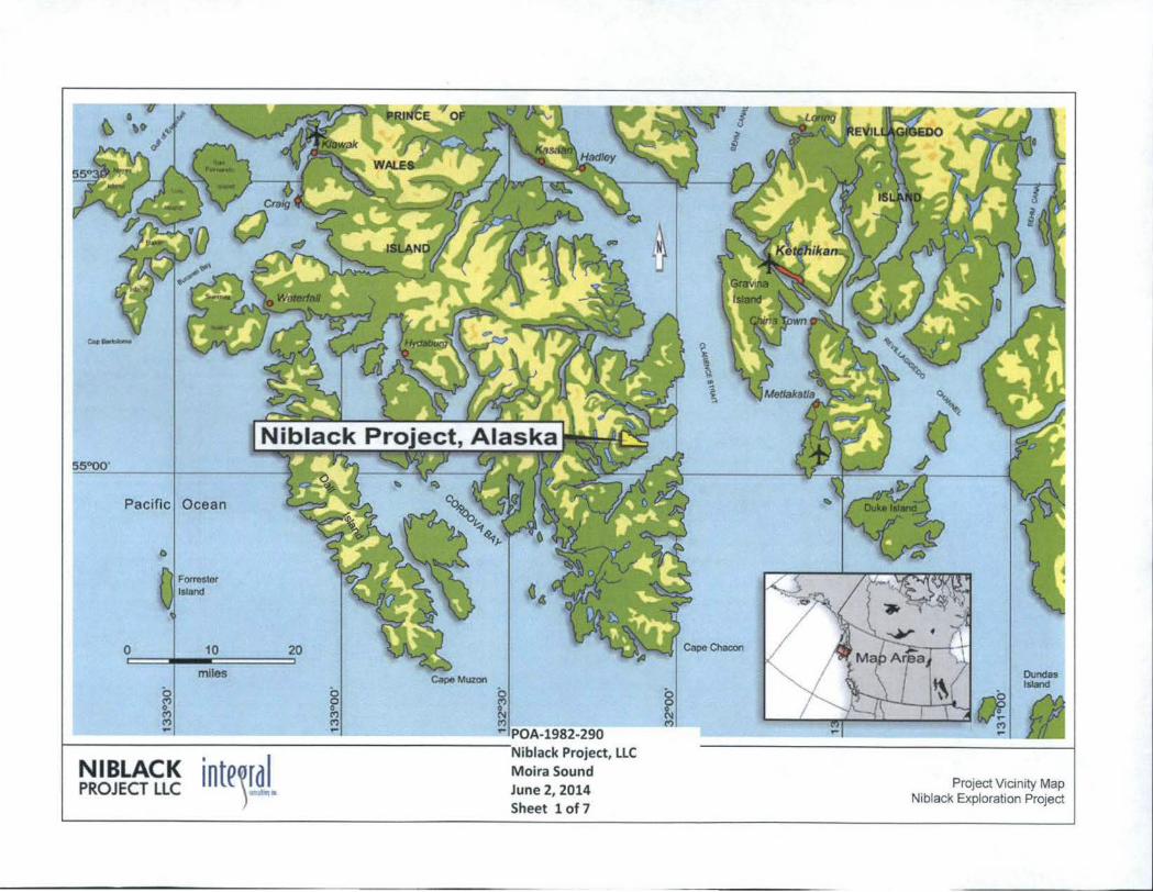
This is in response to your March 17, 2014, application for a Department of the Army (DA) permit to construct an 830-foot long by 6-inch diameter outfall line (of which 480-foot would occur below the high tide fine of Moira Sound in both vegetated and unvegetated estuarine intertidal waters). The new discharge pipe would lead to the proposed marine discharge outfall at an elevation of 14-feet below mean lower low water on the seafloor. The estimated maximum amount of rock and/or concrete fill material to be placed below the high tide line of Moira Sound is 11 cubic yards to anchor the outfall fine. It has been assigned fife number POA-1 982-290, Moira Sound, which should be referred to in all future correspondence with this office. The project site is located within Section 34, T. 78 S., R. 88 E. , Copper River Meridian; USGS Quad Map Craig A-1; Latitude 55.0664° N., Longitude 132.1465° W.; at the Niblack Mine Exploration Project in Moira Sound on Prince of Wales Island, Alaska.
Based on our review of the information you furnished and available to us, we have preliminarily determined the above project area contains waters of the United States (U.S.), including wetlands, under the Corps' regulatory jurisdiction (Please see the attached Preliminary Jurisdictional Determination Form).
DA permit authorization is necessary because your project would involve work in and placement of structures and fill material into waters of the U.S. under our regulatory jurisdiction.
Based upon the information and plans you provided, we hereby verify that the work described above, which would be performed in accordance with the enclosed plan (sheets 1-7), dated June 2, 2014, is authorized by Nationwide Permit (NWP) No.7, Outfall Structures. NWP No. 7 and its associated Regional and General Conditions can be accessed at our website at: www.poa.usace.army mii/Missions/Regulatory/Permits.aspx. Regional Conditions F, G, and H apply to your project. You must comply with all terms and conditions associated with NWP No. 7, as well as with the special condition fisted below:
Documentation of an Alaska Pollution Discharge Elimination System (APDES) permit authorized by Alaska Department of Environmental Conservation and a State of Alaska Tidelands Lease authorized by Alaska Department of Natural Resources to the applicant shall be required prior to construction.
Further, please note General Condition 30 requires that you submit a signed certification to us once any work and required mitigation are completed. Enclosed is the form for you to complete and return to us.
This verification is valid until March 18, 201 7, unless the NWP is modified, reissued, or revoked. It is incumbent upon you to remain informed of changes to the NWPs. Nothing in this letter excuses you from compliance with other Federal, State, or local statutes, ordinances, or regulations.
-2-
Please contact me via email at [email protected], by mail at the address above, by phone at (907) 753-5759, or toll free from within Alaska at (800) 478-2712, if you have questions or to request paper copies of the regional and/or general conditions. For more information about the Regulatory Program, please visit our website at http://www.poa usace.army.mii/Missions/Regulatory.aspx.
Enclosures
Sincerely,
Marcia L. Heer Project Manager
US Army Corps of Engineers Alaska District
Permit Number: POA-1982-290
Name of Permittee: Mr Patrick Smith, Heatherdale Resources
Date of Issuance: JUL 2 8 ZD14
Upon completion of the activity authorized by this permit and any mitigation required by the permit, sign this certification and return It to Ms. Marcia L. Heer at the following address:
U.S. Army Corps of Engineers Alaska District Regulatory Division Post Office Box 6898 JBER, Alaska 99506-0898
Please note that your permitted activity is subject to a compliance inspection by an U.S. Army Corps of Engineers representative. If you fail to comply with this permit you are subject to permit suspension, modification, or revocation.
I hereby certify that the work authorized by the above-referenced permit has been completed in accordance with the terms and conditions of the said permit, and required mitigation was completed in accordance with the permit conditions.
Signature of Permittee Date
Pacific I Ocean
()
0 I
F Of'l'tStor tstand
10
mtles
NIBLACK intevdJ. PROJECT LLC
20 ......,~._ ~- I I ---- .... ___
1982-290 Niblack Project, LLC Moira Sound June 2, 2014 Sheet 1 of 7
. I I ""- I r I .. / I 1 Dundas ~ ' j ISland '\
8 0 N (')
- -~· ...
Project Vicinity Map Niblack Exploration Project

/
·'
Se«lemenV Treatment Ponds
.6f' "'
~~~~~~ inte)w ..
'·
300Feet A L--1.--L--1-..I..--'--'---'---
75 150
POA-1982-290 Niblack Project, llC Moira Sound June 2, 2014 Sheet z of7
m
Proposed OUifall Pipe
MLLW
High Tide '11/atertone
[~.:.'::.:.1 Mo"a Sound Area Plan - Crucial Habi!at and Mining Access
l..!!.J Moira Sound Area Plan -Mining Access
e Eelgrass Present
- Eelgrass Bed -- Existing Dra1n Pipe and Drain Line
-- Temporary Access/Haul Road
Locat Streams
Topograpl>ic Contours (50 flontervaO 1 ,--- - · · ·- · -· -·-·· · - - --, ~~To soiiStock leArea ·---------------------- ~ p PI ..-------------------------- [=:::J LandApplocationArea
• • •
High Tide Waterline
•
Ha, m
c:::J E2EM1P Estuarin&-Emergem Intertidal
~ E2US1N Estuarine-Unvegetated lntenldal
C PF0-48 Needleleaf FO<est WeUand
c:::J PFO.SS48 Nee<ileleaf FOtes!IScNi>-Shrub Wetland
ProJect Area
-~·/
'~ (E) 4" HOPE PORTAL ORAIN.L.:__--\
PIPE TO S(OII.IENT PONDS I
I --·
"" '-,
~
,, (E) PORTAL "SHOP" ~-t-... :r·~ AREA (COIITAINERS)
.....
"..........._- ....... ' ....... ""'- -, . - ----
' 1/ ---
iD1~~~~~.!.~~.'.~!!.~~~~~~ ~
90 &oX SUfi KnOfiKAN, ALASKA 99901 C9Cn) 617·8982 I bt'[email protected]"J.COm
BASE MAPPING DATED 11/25/09 PROVIDED BY NIBlACK PROJECT lLC
NA SCALE IN FEET
125 250 500
.---- I (E) O~D CAMP (CORE ~OGCINC AND STORACE AREA) I
I
I '
j; "c. ( '-~
\ .' '' ... ,·>
~D lONES 6 · 10 I ,
I
/ ;' (E) COVERED HISTORICA~ NIB~CK , MINE SHAFT (IIOT IN SERVICE) '
/
'? ZONES 4·5
- ,~ .. ·--, ---~-1
" ' ~ .... _ ... ~: ...
I
I
' ' ' c./_ ) •\ "''--,::_, _ .. '
(....._ '~ ... <"' _ ... ' -.......- ~ .~:
I ' ' ')
~
~
EBB TIDE OIRECTIOII
~
~
N IBlACK ANCIIORAG£
·.::..:...·:.;;. -....,._,.-_::..::-'r-f!:.:::·~-.:...::-~1 '
(E) 20,000 GAl LON f UEL _j • - --TANK AND REfUEUNG BERioA
J ' 1- -\
~----- 2SO \ ------ ~
PROJECT LOCATION NIBlACK loAINE NIBlACK ANCHORAGE, MOIRA SOUND PRINCE Of WAlES IS~ND. A~SKA SEC34 T78S R88E CRM
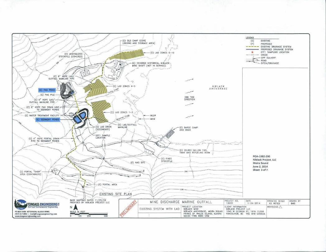
~EGEND
(£) (P)
*
EXISTING
PROPOSED EXISTING DRAINAGE SYST(M PROPOSED DRAINAGE SYST£1oA t rn SAUPLING ~OCATION
----- CREEK
~CPP CU~VERT
==,f.....__;,- ROAD DITCH/DRAINAGE
POA-1982-290 Nibladt Project, LLC Moira Sound June 2, 2014 Sheet 3 of 7
' \ \
\
~~ (E) 4" HOPE PORUL OR/liN c \/
PIPE TO SEDIMENT PONDS -- -------,/ -
...... "-, ·-.
(E) PORTAL "SHOP"~~"" AREA (CONTAINERS) ·,
"-'
\019~~~.~.!.~~.1.~.~~.~!~.~~ PO SOX 5436 K£TotiKAN, ALASKA 99901 (907) 61N!982 )
SCALE IN FEET
12~ 250 500
(E) 01.0 c;.r.<P {CORE l()GCING AND STORACE AREA) !
/ '
,r ( ~-:
~ ,, > \ I ~ ,/
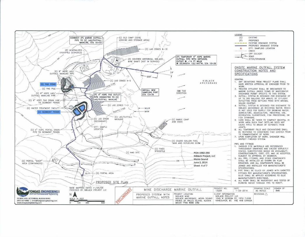
LEGEND
(E) {P)
EXISTING
PROPOSED ----- EXISTING DRAINAGE SYSTEM
PROPOSED DRAINAGE SYSTO.t
LAO ZONES 6-10 * EFF I SAMPLING LOCATION
-·-·- CREEK
~ . 1-3 , -/ - \
oe-J> ~- '--"WLLW "'0\ef~~.. ~MHW
_;;;...- I I \
(£) LAD/OUTFALL '- \ MAINUNE \ ',
I ' ;
~
~
EBB TIDE DIRECTION
~
~
(E) SARGE CAMP AND DOC~
NIBLACK ANCNORAGE
~:;c.:,-.::.:._- -=-~ -..=-:.--;.::. ;,~-::::-=..:.:-~· -(E) 20,D()O GALLON FUEL -' --TANK AND REFUELING BERM
-\ -_)-
POA-1982-290
--\- Niblack Project, LLC
:Z)(I \ M oira Sound , June 2, 2014
--\ - - Sheet 4 of7
----,oo--.__.
~ CPP CULVERT Ro;.o DITCH/DRAINAGE
ONSITE MARINE OUTFALL SYSTEM CONSTRUCTION NOTES AND SPECIFICATIONS
GENERAL I. ANY DEVIATIONS rROt.< PROJECT PLANS SH;.U.
HAVE WRITTEN APPROVAL BY ENGINEER PRIOR TO WORK.
2. TREATED EFFLUENT SHALl BE DISCHARGED TO MARINE OUTFALL UNDER TERt.tS OF WASTEWATER DISCHARGE PERMIT SPECIFIC TO THIS SYSTEM.
J. OUTFAl L SYSTEM IS DESIGNED FOR DISCHARGE OF UP TO 300 GALLONS PER MINUTE OF EFFLUENT OUTLETTINC FROM SmUNC POND WITH MINIMAL SOLIDS CONTENT.
4 . OUTFALL SYSTEM IS DESIGNED FOR DISCHARGE TO NIBLACK ANCHOR;.CE AS RECEIVING WATER, WHICH IS NOT USED FOR SUPPLY FOR DRINKING WATER, AGRICULTIJRE, ;.OUACULTURE, INDUSTRIAL USE, RECREA liON, SUBSISTENC(, FISH PROCESSING, OR FISH SPAWNING.
5. CARE SHALL BE TAKEN TO COMPACT BACKFILl IN WORK AREA SUCH THAT SETTUNG DOES NOT CAUSE PIPES TO BREAK OF SEPARUE FROM JOINTS.
6. All TEMPORARY FillS AND EXCAVATIONS SHALL BE RESTORED TO CONDITIONS THAT EXISTED PRIOR TO COMIIENCEMENT Of WORK.
7. UPON COMPLETION OF WORK, ENGINEER WILL INSPECT FINISHED SYSTEM.
PIPE AND FITIINGS I. VARIOUS PIPE MATERIALS ARE REFERENCED
THROUGHOUT OR;.WINGS ;.NO UNLESS EXPLICITLY STATED, SUBSTITUTIONS BASED ON AVAILABILITY. CONSTRUCTABILITY, COST, ETC. MAY BE ACCEPTED, SUBJECT TO APPROVAL BY ENGINEER.
2. All PIPE, FITIINGS, AND OTHER COMPONENTS SHALL BE INSTALlED AS SHOWN ON PLAN DRAWINGS, AND All COMPONENTS SHALl BE JOINED AND INSTALLED PER MANUFACTURER'S SPECIFICA liONS.
3. PIPE SHALl BE GUJED OR JOINED WITH CASKETED FlnJNCS PER MANUfACTURER'S SPECIFICATIONS. GlUE SHALL BE APPLIED ACCORDINC TO GLUE MANUFACTURER'S DIRECTIONS.
4. ;.LL WORK Sl-tAU. SE WATERTIGHT ;.NO TESTED BY RUNNINC WATER THROUCH PIPE TO VERifY,
PROJECT LOCATION NIBLACK MINE
CLIENT INFORMATION NIBLACK PROJECT LLC
NIBLACK ANCHORAGE, MOIR;. SOUND PRINCE OF WALES ISLAND, ALASK;. SEC3~ T78S R88E CRM
1040 W GEORGIA ST, 15TH FLOOR VANCOUVER. BC V6E 4H8 CANADA
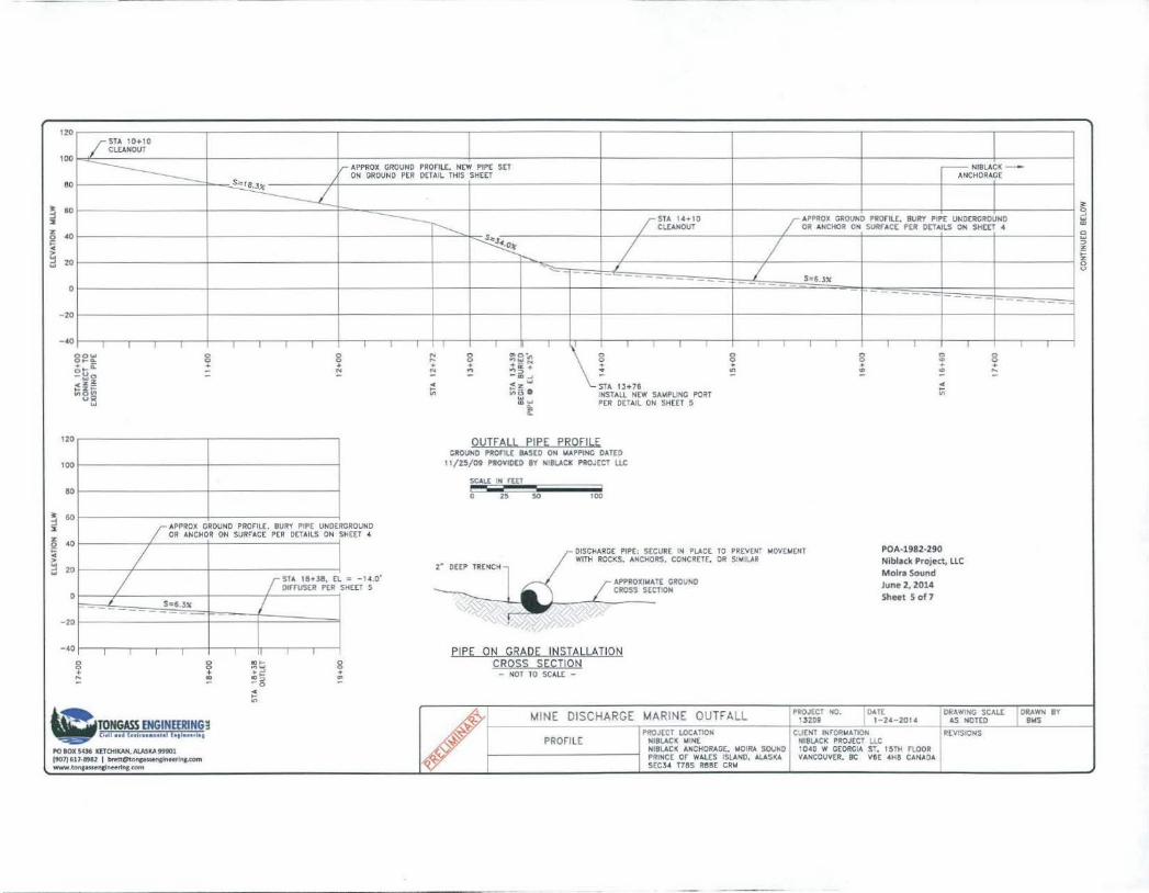
120 /STA 10+10
CLEAN OUT 100
~ fr APPROX GROUND PROnU:, Ntw PIPE SET r- NIBLACK - -ON GROUND PER DETAIL THIS SHEET ANCHORAGE
ao
~ ~ 60 ,____ 3'
--r---..... g
2 fSTA IHIO / APPROX GROUND PROfiLE, BURY P'PE UNDERGROUND w z Cu:ANOUT OR ANCHOR O• SURrAtt PER DETAILS ON SHtET 4 "'
~ •o s"J•.o.t-
0
I I I w ::> z
::! 20 r--.. ;:
z ~ I I
0 - - v -- -- S=6.JX 0 ------- - -- - - -~.- -
20
- •o I I T . T ' ' I l I I I I T T
8ow 8 8 N 0 ~Sin 0 0 8 ~ 8 ...... ... 0 0 0
c;tii: .. + + + ·-"' + + + + +
= ~ ~ ::! ..... ~ + .. .... .. "' ::: - ..,<> -....... - - - -.zz ~
•z,.. STA 13+76 ~ o-% 1= 11')8~ ~(3 0 INSTALL NEW SA~PLING PORT "' w ~ ~ PER DETAIL ON SHEET 5
0::
120 OUTFAU. EIEE EBQFILE GROUND PROfiU: BASCO o• loiAPPING DATED
100 11/25/09 PROVIOEO BY NIBLACK PROJECT LLC
SCAU: IN rtET
110 0 25 50 100
~ 60 :s I APPROX GROUND PROFIU:, BURY PIPE UNDERGROUND
% OR ANCHOR ON SURFACE PER DETAILS ON SHEET 4
~ 40
I DISCHARGE PIPE: SECURE IN PLACE TO PREVENT MOVEioiEHT POA·l982·290
~ 2" OEEP TRENCH WITH ROCKS. ANCHORS, CONCRETE. OR SIMILAR NibliCk Project, LLC ... 20 ...
I Moira Sound r STA 18+Ja, EL = -1 4.0'
OUTIISER PER SHEET 5 / ,;.pf'ROXIIIATE G~OUNO June 2, 2014
0 CROSS SECTION
J I Sheet 5 of7
S•6 J"
- 20
I , ~. ,
-40 I I I I II I EIPE QN (IBA1:2E I~SIA!.LA TION
8 8 ~~ 0 ~RQSS SE~IIQ!::I 0
.!: + +,... + - NOT TO SCAU: -~ "'" !!! -o
~ "'
-~~~~.!.f!~.~.~~~~~ .. ~.?,~ / MINE DISCHARGE MARINE OUTFALL PROJECT NO. OAT[ DRAWING SCALE I ORAWH BY
13209 1-2• -2014 AS NOTED BloiS
PROJECT LOCATIOII CJEIIT INFORioiATION REVISIONS PROFILE NIBLACK ~IN[ MIBLACK PROJECT LLC
PO lOX S"-l6 mOIIICAH, AlASKA fttOl NIBLACK AMCfiORAGE, ~DIRA SOUND I 1o•D w GEORGIA sr. I~TH FLOOR, I (907) 617-IMl I [email protected] PRINCE or WAU:S ISLAND, ALASKA VANCOUVER, BC V6E 4HS CANADA W\11/W ,tonl•uencfneerinc.com S£CJ4 T7SS R88E CRM
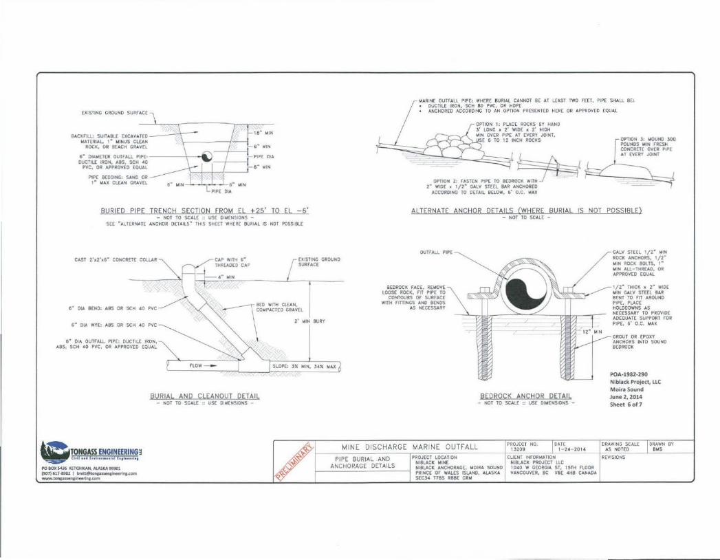
EXISn NG GROUND SURrACE
h""~ ·~"" "'"'tt"- \ - ~ l.lATERIAI... 1" WINUS CUAN -! ROCK, OR lEACH GRAVEl \
6" O!Aij£TER ovrrALL PIPE:\ i) 1 I OUCTIU: IRON. ASS, SCH .tO , , ,
PVC, OR APPROVED COVAL
PIP[ BEDO< 'IG: SAND OR 1" WAX Cl.[AN GRAVEL
18" WIN
6 .. MIN
PIPE OcA
a· >tl,.
BURIED PIPE TRENCH SECTION fROM EL +25' TO EL -6' - NOT TO SCALE :: USE DIMENSIONS -
SEE "AlTERNATE ANCHOR DETAILS" THIS SHfET WHERE BURIAL IS NOT POSSIBLE
WARIN( OuTrAll PIPE: WHERE BURIAL CANNOT BE AI U:AST TWO fEET, PIPE SHALL BE: DUCTILE IRON, SCH 80 PVC, OR HOPE ANCHORED ACCORDING TO Ml OPTION PRESENTED HER( OR APPROVED EOUAl
OPTION 1: PLACE ROCKS BY HAND J' LONG x 2' WID( x 2' HIGH OliN OVER PIPE AT EVERY JOINT, VSE 6 TO 12 INCH ROCKS
~·~ " "'"' "~ " ... ~~ 2" WID[ x 1/2" CAlV STEEL BAR ANCHORED ACCORDING TO D(!Ail BELOW, 6' D.C. >lAX
ALTERNATE ANCHOR DETAILS (WHERE BURIAL IS NOT POSSIBLE) - NOT TO SCALE -
CAST 2'x2' d" CO~CRETC COLlAR [X:STINC GROUND SURfACE
CALV STE£l 1/2" WIN ROCK ANCHORS, 1/2" WiN ROCK BOI.TS. I " lliN AU-THREAD. OR APPRDV(D (OVAl
6" DIA BEND: ASS OR SCH •o
6" DIA WYE: ASS OR SCH 40
6" OIA OUTfALL PIP(: DUCTILE IRON. ABS, SCH •O PVC. OR APPROVED EQUAL
\Dm~¥.l~.~~.'.~'-~~~!~~~ PO BOX SC6 IC£TO<IKAt;, AlASKA !19901 (907)61NI!Ia2 J ,....,..onc>-"-rina.com www.tof\l•~•.com
BURIAL AND CLEANOUT DETAIL - NOT TO SCALE " USE DI WEHSIONS -
SLOPE: 3X WIN, J•X l.fU
aEDROCK fAC(. REWOVE lOOSE ROCK, m PIPE TO
CONTOURS Of SURfACE WITH rtniNCS AND BENDS
AS NECESSARY
BEDROCK ANCHOR DETAIL - NOT TO SCALE :: USE DIWENSIONS -
/
MINE DISCHARGE MARINE OUTFALL PIPE BURIAL AND PROJECT LOCATION
NIBlACK >liNt ANCHORAGE DETAILS NIBlACK ANCHORAGE. MOIRA SOUND
PRINCE or WAI.£S ISlAND. AlASI(A stcl• nas RaaE CRII
DAlE 1- 24-2014
CLIENT INrORMATION NIBlACk PROJECT UC 1040 W GEORGIA ST. 15TH rLOOR VANCOUVER. BC V6E 4H8 CANADA
1/2" THICK X 2" WIDE W N CALV STE£l BAR 8£NT TO r1T AROUND PIPE. PLACE HOlODOWNS AS NECESSARY TO PROVIDE AOEOUAT( SUPPORT rOR PIPE. 6' O.C. MAX
GROUT OR EPOXY ANCHORS INTO SOUND BEDROCK
POA-1982-290 Niblack Project, LlC
Moira Sound June 2, 2014 Sheet 6 of 7
DRAWING SCALE AS NOTED
REVISIONS
DRAWN BY BOIS
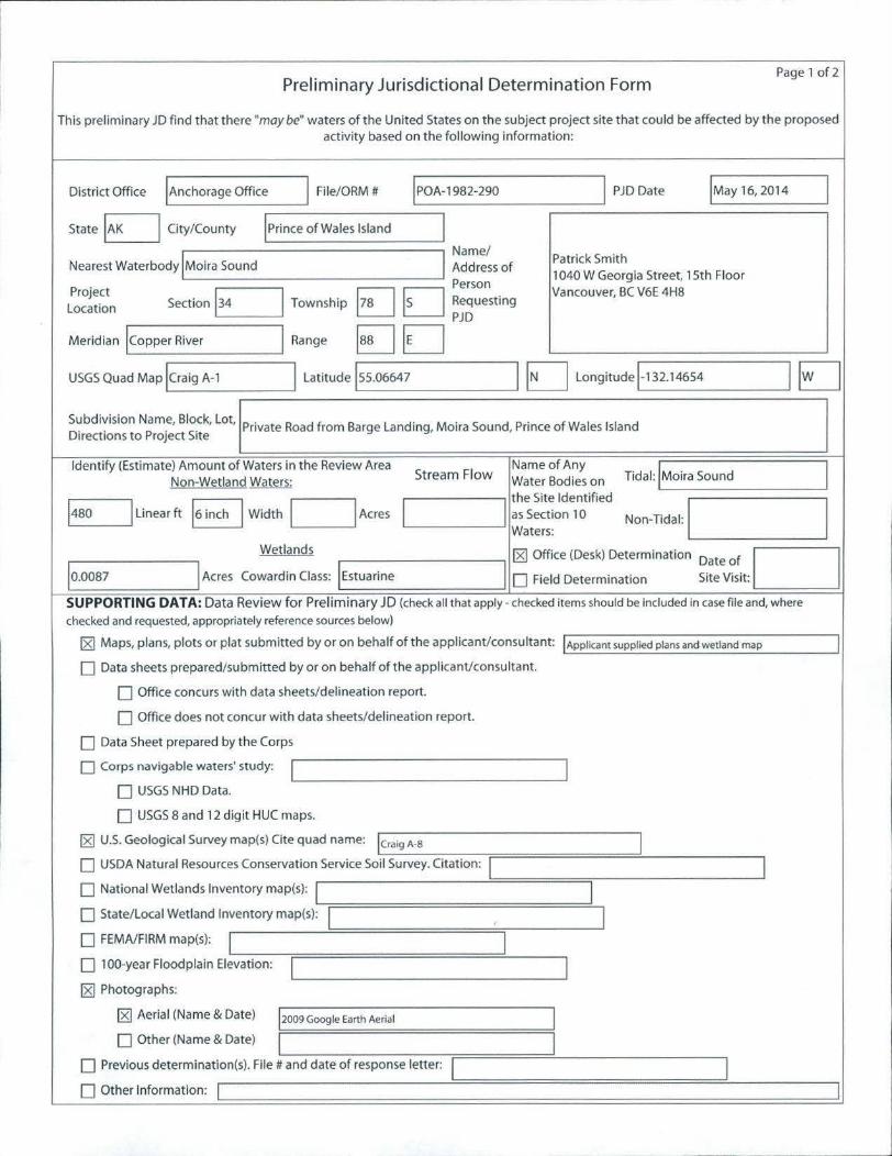
Preliminary Jurisdictional Determination Form Page 1 of2
This preliminary JD find that there "may be" waters of the United States on the subject project site that could be affected by the proposed activity based on the following information:
District Office !Anchorage Office I File/ORM # IPOA-1982-290 I PJD Date !May 16,2014 I State EJ City/County I Prince of Wales Island I
Name/ Nearest Waterbody I Moira Sound I Address of
Patrick Smith 1040 W Georgia Street. 15th Floor
Project Section 134 I Township
Person Vancouver, BC V6E 4H8
Location EJ D Requesting PJD
Meridian !copper River I Range §JD USGS Quad Map !craig A-1 I latitude lss.06647 I D Longitudel-132.14654 IEJ Subdivision Name, Block, lot,
Private Road from Barge Landing, Moira Sound, Prince of Wales Island Directions to Project Site
Identify (Estimate) Amount of Waters in the Review Area Stream Flow
Name of Any Tidal: I Moira Sound I Non-Wetland Waters: Water Bodies on
1
the Site Identified
Non-Tidal: I I 1480 I Linear ft 16 inch I Width I I Acres I as Section 10 Waters:
Wetlands 181 Office (Desk) Determination ~ate ~f. I I ,0.0087 I Acres Cowardin Class: I Estuarine I 0 Field Determination S1te V1s1t:
SUPPORTING DATA: Data Review for Preliminary JD (check all that apply - checked items should be included in case file and, where
checked and requested, appropriately reference sources below)
181 Maps, plans, plots or plat submitted by or on behalf of the applicant/consultant: I Applicant supplied plans and wetland map I O Data sheets prepared/submitted by or on behalf of the applicant/consultant.
0 Office concurs with data sheets/delineation report.
O Office does not concur with data sheets/delineation report.
O Data Sheet prepared by the Corps
O Corps navigable waters' study: I J 0 USGS NHD Data.
0 USGS 8 and 12 digit HUC maps.
181 U.S. Geological Survey map(s) Cite quad name: !craig A·S I 0 USDA Natural Resources Conservation Service Soil Survey. Citation: 1 I 0 National Wetlands Inventory map(s): 1 I O State/local Wetland Inventory map(s): 1 I 0 FEMA/FIRM map(s): I I 0 1 00-year Floodplain Elevation: I I 181 Photographs:
181 Aerial (Name & Date) 12009 Google Earth Aerial I 0 Other (Name & Date) I I
O Previous determination(s). File# and date of response letter: 1 I 0 Other Information: 1 I
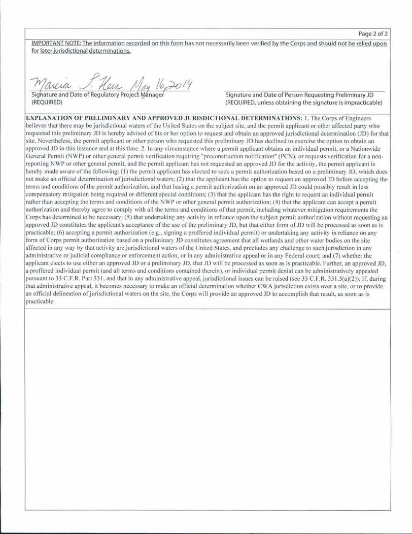
Page 2 of2
IMPORTANT NOTE: The information recorded on this form has not necessarily been verified .lrl!!JJ!Qmll and should not be relied upon for ]9ill jurisdictional determinations.
/1~ / ~ AM /(;~It; Sigl-lature and Date of Regulatory Pro jed ~nager (REQUIRED)
Signature and Date of Person Requesting Preliminary JD (REQUIRED, unless obtaining the signature is impracticable)
EXPLANATION OF PRELIM INA RY AND APPROVED J URISOlCTIONAL DETERM INATIONS: I. The Corps of Engineers believes that there may be jurisdictional waters of the United States on the subject site, and the permit applicant or other affected party who requested this preliminary JD is hereby advised of his or her option to request and obtain an approved jurisdictional detcrm ination (.ID) for that site. Nevertheless. the pcm1it applicant or other person who requested this preliminary JD has declined to exercise the option to obtain an approved JD in this instance and at this time. 2. In any circumstance where a permit applicant obtains an individual permit, or a Nationwide General Permit (NWP) or other general permit verification requiring "preconstruction notification" (PCN), or requests verification for a nonreporting NWP or other general permit, and the permit applicant has not requested an approved .10 for the activity, the permit applicant is hereby made aware of the following: ( I) the permit applicant has elected to seek a permit authorization based on a preliminary JD. which does not make an official determination of jurisdictional waters: (2) that the applicant has the option to request an approved JD before accepting the terms and conditions of the permit authorization. and that basing a permit authorization on an approved JD could possibly result in less compensatory mitigation being required or different special conditions; (3) that the applicant has the right to request an individual permit rather than accepting the terms and conditions or the NWP or other general permit authorization: (4) that the applicant can accept a permit authorization and thereby agree to comply with all the terms and conditions of that permit, including whatever mitigation requirements the Corps has determined to be necessary; (5) that undertaking any activity in reliance upon the subject permit authorization without requesting an approved JD constitutes the applicant's acceptance of the use of the preliminary JD, but that either form of JD will be processed as soon as is practicable; (6) accepting a pem1it authorization (e.g .. signing a proffered individual permit) or undertaking any activity in reliance on any form of Corps permit authorization based on a preliminary JD constitutes agreement that all wetlands and other water bodies on the site affected in any way by that activity are jurisdictional waters of the United States, and precludes any challenge to such jurisdiction in any administrative or judicial compliance or enforcement action. or in any administrative appeal or in any Federal court: and (7) whether the applicant elects to use either an approved JD or a preliminary JD, that JD will be processed as soon as is practicable. Further, an approved JD. a proffered individual permit (and all terms and conditions contained therein), or individual permit denial can be administratively appealed pursuant to 33 C.F.R. Part331, and that in any administrative appeal, jurisdictional issues can be raised (see 33 C.F.R. 331 .5(a)(2)). If, during that administrative appeal. it becomes necessary to make an official determination whether CWA jurisdiction exists over a site. or to provide an official delineation of jurisdictional waters on the site. the Corps will provide an approved JD to accomplish that result, as soon as is practicable.
• •
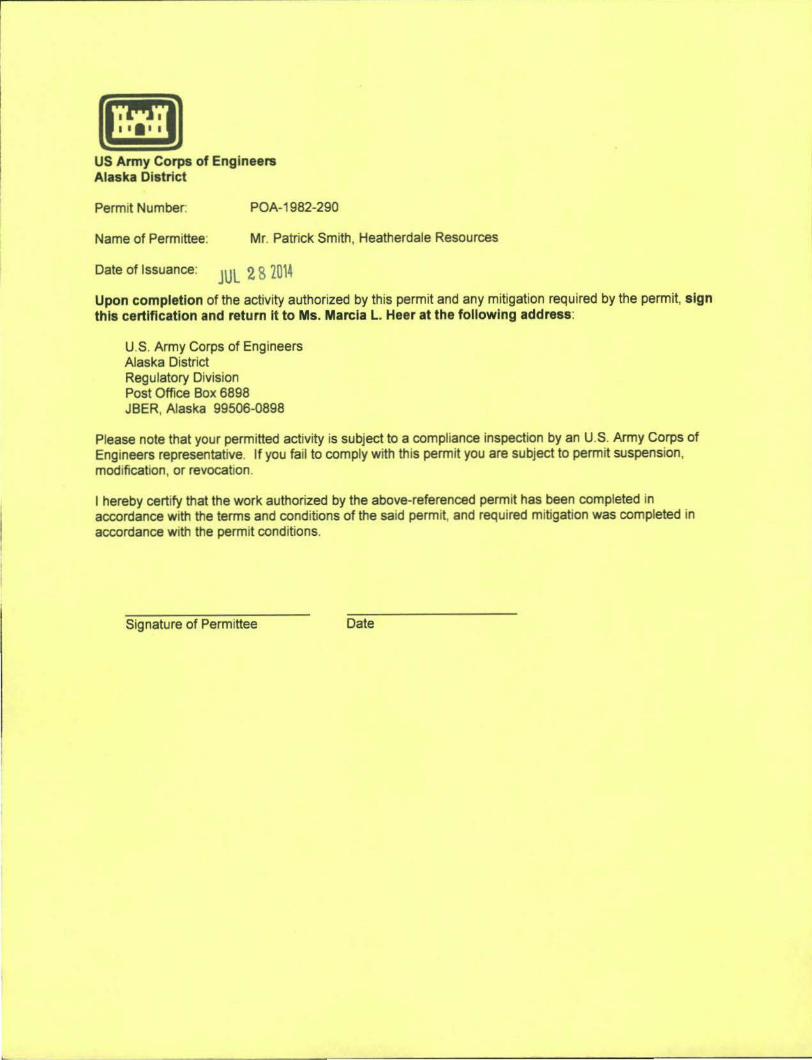
US Army Corps of Engineers Alaska District
Permit Number: POA-1982-290
Name of Permittee. Mr. Patrick Smith, Heatherdale Resources
Date of Issuance: JUL 2 8 2014 Upon completion of the activity authorized by this permit and any mitigation required by the permit, sign this certification and return It to Ms. Marcia L. Heer at the following address:
U.S. Army Corps of Engineers Alaska District Regulatory Division Post Office Box 6898 JBER, Alaska 99506-0898
Please note that your permitted activj ty is subject to a compliance inspection by an U.S. Army Corps of Engineers representative. If you fail to comply with this permit you are subject to permit suspension, modification, or revocation.
I hereby certify that the work authorized by the above-referenced permit has been completed in accordance with the terms and conditions of the said permit, and required mitigation was completed in accordance with the permit conditions.
Signature of Permittee
I •
Recommended