47
RE
GIO
N 4
Kootenay
8-12
8-13
8-14 8-15
8-23
8-24
8-258-26
3-43
7-2
3-36
3-35
3-34
3-42
VERNON
Salmon Arm
Sicamous
Mica
Creek
Donald
Station
Golden
Revelstoke
Invermere
FairmontHot Springs
Canal Flats
Elkford
Fernie
CRANBROOK
Kimberley
Kitchener
Creston
Balfour
Kaslo
NELSON
Castlegar
TrailGrandForks
Fauquier
NakuspMeadow
Creek
MabelL
SugarL
Trout L
DuncanLake
Windermere L
Columbia L
LAKE
KOOTENAY
LAKE
Cottonwood
Cr
LAKE
Slocan
Lake
LOWER
ARROW
LAKE
Canoe Reach
Columbia
Reach LAKE
REVELSTOKE
KINBASKET
LAKE
Ket
tle
River
t R
Gra
nby
R
B
urre
ll C
r
Shuswap
R
Eagle
R
Wap
Cr
Per
ry
R
Seym
our R
Gold R
Bigmouth Cr
Goldstream R
ScripCr
Woo
d R
Bush
R
Tangier R
Illec
illewaet
R
Spillamacheen R
Kicking Horse R
Blaeberry
R
Inco
map
pleu
x R
ia
Rive
r
Dog
Cr
Sloca
n
R
Koch Cr
Lemon Cr KOOTENAY R
Sal
mo
R
Next Cr
Summit Cr
Goat R
Moy
ie
R
St. Mary River
Perry
Cr Joseph
Cr
Gold Cr
Yahk R
Blo
om C
r
Redding Cr
Kuskanax Cr
Halfway R
Pingston Cr
Arrow Park
Cr
Barnes Cr
Bonanza Cr Wils
o n C
r
Lardeau R Duncan R
Kaslo R
Hamill Cr
Fry Cr
Campbell Cr
COLUM
BIA
RIV
ERFrancis C
r
Horsetheif Cr
KO
OTEN
AY
R
IVER
Palliser R
White R
Findla
y Cr
Skookumchuck
Cr
Lussier R
Bull
Riv
er
Elk
Rive
r
Flathead
R
Wigw
am R
Tepee Cr
A
L
B
E
R
T
A
AL
BE
RT
A
4-40
4-36
4-39
4-38 4-37
4-33 4-344-28
4-27
4-29
4-26
4-204-22
4-23
4-14-2
4-3
4-4
4-5
4-64-7
4-84-9
4-21
4-24
4-32
4-15
4-16
4-19
4-18
4-31
4-30
4-17
4-1
4
4-35
4-25
For information on Wildlife Permits and Commercial Licences, please see page 24.
Compulsory InspeCtIon Centres
Qualified Compulsory Inspectors will provide this service at the locations listed below. Please see the Ministry website or contact the regional office for more information www.gov.bc.ca/hunting.
CI Locations: Creston, Revelstoke, Radium Hot Springs, Sparwood, Cranbrook, Fruitvale, Nakusp
Ministry Regional Office, Cranbrook: . . . . . .(250) 489-8540 Nelson . . . . . . . . . . . . . . . . . . . . . . . . . . . . .(250) 354-6333
ConservatIon offICer servICe DIstrICt offICes
Please call 1-877-952-7277 for recorded information or to make an appointment at any of the following Field Offices:Castlegar, Cranbrook, Creston, Fernie, Invermere, Nelson, and Golden
REPORT ALL POACHERS/
POLLUTERS (RAPP)
Please see Notice on page 26 for details
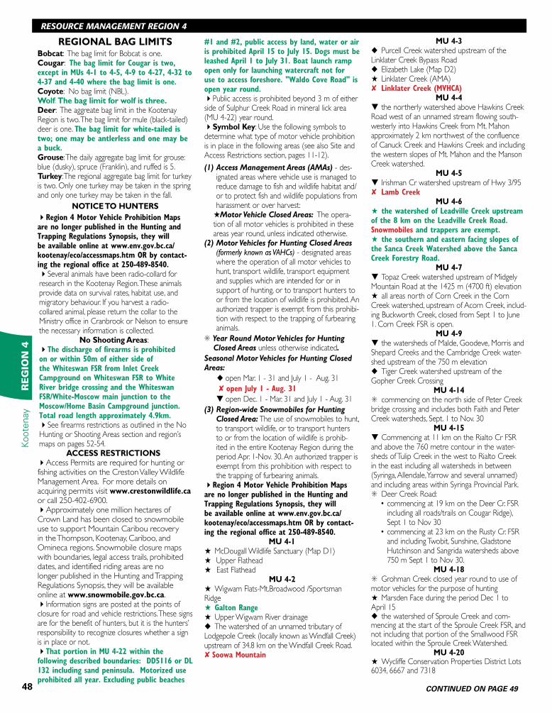
These M.U. boundaries are approximate only. For a more precise definition consult the BC Recreational Atlas, 6th edition.
Major Regulation Changesfor 2016 - 2018
1. Increased bag limit for wolves.2. Reduced antlerless white-tailed deer bag limit.3. Added Compulsory Inspection requirements
for wolf, bobcat, moose and West Kootenay elk(see page 21 for details).
4. Closed the wolverine hunting season.5. Converted multiple motor vehicle for hunting
closed areas to Access Management Areas.
NOTICE!TO HUNTERS
Hunters can produce their own maps through iMap BC available at www.data.gov.bc.ca/dbc/geographic/.
Hunters are reminded that restrictions apply to Recreation Sites (e.g., Cranbrook Community Forest). See Recreation Sites and Trails on page 11.
Region 4 Motor Vehicle Prohibition Maps are no longer published in the Hunting and Trapping Regulations Synopsis, they will be available online at www.env.gov.bc.ca/kootenay/eco/access.htm OR by contacting the regional office at 250-489-8540.
Recreation Access Management PlansA copy of the following plans is located online at www.recplans.gov.bc.ca/
Refer to the Southern Rocky Mountain Management Plan for recreation access zoning in MUs 4-1, 4-2, 4-22 and 4-23.
Refer to the Golden Backcountry Recreation Plan for recreation access zoning in MUs 4-34, 4-36 and 4-40.
Check website www.gov.bc.ca/hunting for in-season
changes prior to your hunt.
KOOTENAY
REGION 4
48
RESOURCE MANAGEMENT REGION 4Kootenay
RE
GIO
N 4
REGIONAL BAG LIMITSBobcat: The bag limit for Bobcat is one.Cougar: The bag limit for Cougar is two, except in MUs 4-1 to 4-5, 4-9 to 4-27, 4-32 to 4-37 and 4-40 where the bag limit is one.Coyote: No bag limit (NBL).Wolf: The bag limit for wolf is three.Deer: The aggreate bag limit in the Kootenay Region is two. The bag limit for mule (black-tailed) deer is one. The bag limit for white-tailed is two; one may be antlerless and one may be a buck.Grouse: The daily aggregate bag limit for grouse: blue (dusky), spruce (Franklin), and ruffed is 5.Turkey: The regional aggregate bag limit for turkey is two. Only one turkey may be taken in the spring and only one turkey may be taken in the fall.
NOTICE TO HUNTERS
4Region 4 Motor Vehicle Prohibition Maps are no longer published in the Hunting and Trapping Regulations Synopsis, they will be available online at www.env.gov.bc.ca/kootenay/eco/accessmaps.htm OR by contact-ing the regional office at 250-489-8540.4Several animals have been radio-collard for research in the Kootenay Region. These animals provide data on survival rates, habitat use, and migratory behaviour. If you harvest a radio-collared animal, please return the collar to the Ministry office in Cranbrook or Nelson to ensure the necessary information is collected.
No Shooting Areas: 4The discharge of firearms is prohibited on or within 50m of either side of the Whiteswan FSR from Inlet Creek Campground on Whiteswan FSR to White River bridge crossing and the Whiteswan FSR/White-Moscow main junction to the Moscow/Home Basin Campground junction. Total road length approximately 4.9km.4See firearms restrictions as outlined in the No Hunting or Shooting Areas section and region’s maps on pages 52-54.
ACCESS RESTRICTIONS4Access Permits are required for hunting or fishing activities on the Creston Valley Wildlife Management Area. For more details on acquiring permits visit www.crestonwildlife.ca or call 250-402-6900.4Approximately one million hectares of Crown Land has been closed to snowmobile use to support Mountain Caribou recovery in the Thompson, Kootenay, Cariboo, and Omineca regions. Snowmobile closure maps with boundaries, legal access trails, prohibited dates, and identified riding areas are no longer published in the Hunting and Trapping Regulations Synopsis, they will be available online at www.snowmobile.gov.bc.ca.4Information signs are posted at the points of closure for road and vehicle restrictions. These signs are for the benefit of hunters, but it is the hunters’ responsibility to recognize closures whether a sign is in place or not. 4That portion in MU 4-22 within the following described boundaries: DD5116 or DL 132 including sand peninsula. Motorized use prohibited all year. Excluding public beaches
#1 and #2, public access by land, water or air is prohibited April 15 to July 15. Dogs must be leashed April 1 to July 31. Boat launch ramp open only for launching watercraft not for use to access foreshore. "Waldo Cove Road" is open year round.4Public access is prohibited beyond 3 m of either side of Sulphur Creek Road in mineral lick area (MU 4-22) year round. 4Symbol Key: Use the following symbols to determine what type of motor vehicle prohibition is in place in the following areas (see also Site and Access Restrictions section, pages 11-12).
(1) Access Management Areas (AMAs) - des-ignated areas where vehicle use is managed to reduce damage to fish and wildlife habitat and/or to protect fish and wildlife populations from harassment or over harvest:
H Motor Vehicle Closed Areas: The opera-tion of all motor vehicles is prohibited in these areas year round, unless indicated otherwise.
(2) Motor Vehicles for Hunting Closed Areas (formerly known as VAHCs) - designated areas where the operation of all motor vehicles to hunt, transport wildlife, transport equipment and supplies which are intended for or in support of hunting, or to transport hunters to or from the location of wildlife is prohibited. An authorized trapper is exempt from this prohibi-tion with respect to the trapping of furbearing animals.
S Year Round Motor Vehicles for Hunting Closed Areas unless otherwise indicated.
Seasonal Motor Vehicles for Hunting Closed Areas:
u open Mar. 1 - 31 and July 1 - Aug. 31
8 open July 1 - Aug. 31
t open Dec. 1 - Mar. 31 and July 1 - Aug. 31
(3) Region-wide Snowmobiles for Hunting Closed Area: The use of snowmobiles to hunt, to transport wildlife, or to transport hunters to or from the location of wildlife is prohib-ited in the entire Kootenay Region during the period Apr. 1-Nov. 30. An authorized trapper is exempt from this prohibition with respect to the trapping of furbearing animals.
4Region 4 Motor Vehicle Prohibition Maps are no longer published in the Hunting and Trapping Regulations Synopsis, they will be available online at www.env.gov.bc.ca/kootenay/eco/accessmaps.htm OR by contact-ing the regional office at 250-489-8540.
MU 4-1H McDougall Wildlife Sanctuary (Map D1)H Upper FlatheadH East Flathead
MU 4-2H Wigwam Flats-Mt.Broadwood /Sportsman RidgeH Galton RangeH Upper Wigwam River drainageu The watershed of an unnamed tributary of Lodgepole Creek (locally known as Windfall Creek) upstream of 34.8 km on the Windfall Creek Road.8 Soowa Mountain
MU 4-3u Purcell Creek watershed upstream of the Linklater Creek Bypass Roadu Elizabeth Lake (Map D2)H Linklater Creek (AMA)8 Linklater Creek (MVHCA)
MU 4-4t the northerly watershed above Hawkins Creek Road west of an unnamed stream flowing south-westerly into Hawkins Creek from Mt. Mahon approximately 2 km northwest of the confluence of Canuck Creek and Hawkins Creek and including the western slopes of Mt. Mahon and the Manson Creek watershed.
MU 4-5t Irishman Cr watershed upstream of Hwy 3/958 Lamb Creek
MU 4-6H the watershed of Leadville Creek upstream of the 8 km on the Leadville Creek Road. Snowmobiles and trappers are exempt. H the southern and eastern facing slopes of the Sanca Creek Watershed above the Sanca Creek Forestry Road.
MU 4-7t Topaz Creek watershed upstream of Midgely Mountain Road at the 1425 m (4700 ft) elevationH all areas north of Corn Creek in the Corn Creek watershed, upstream of Acorn Creek, includ-ing Buckworth Creek, closed from Sept 1 to June 1. Corn Creek FSR is open.
MU 4-9t the watersheds of Malde, Goodeve, Morris and Shepard Creeks and the Cambridge Creek water-shed upstream of the 750 m elevationu Tiger Creek watershed upstream of the Gopher Creek Crossing
MU 4-14S commencing on the north side of Peter Creek bridge crossing and includes both Faith and Peter Creek watersheds, Sept. 1 to Nov. 30
MU 4-15t Commencing at 11 km on the Rialto Cr FSR and above the 760 metre contour in the water-sheds of Tulip Creek in the west to Rialto Creek in the east including all watersheds in between (Syringa, Allendale, Yarrow and several unnamed) and including areas within Syringa Provincial Park.S Deer Creek Road:
• commencing at 19 km on the Deer Cr. FSR including all roads/trails on Cougar Ridge), Sept 1 to Nov 30
• commencing at 23 km on the Rusty Cr. FSR and including Twobit, Sunshine, Gladstone Hutchinson and Sangrida watersheds above 750 m Sept 1 to Nov 30.
MU 4-18S Grohman Creek closed year round to use of motor vehicles for the purpose of hunting H Marsden Face during the period Dec 1 to April 15 u the watershed of Sproule Creek and com-mencing at the start of the Sproule Creek FSR, and not including that portion of the Smallwood FSR located within the Sproule Creek Watershed.
MU 4-20H Wycliffe Conservation Properties District Lots 6034, 6667 and 7318
RESOURCE MANAGEMENT REGION 4
CONTINUED ON PAGE 49
49
KOOTENAYR
EG
ION
4Kootenay
H Baribeau Creek watershed upstream from 1.0 km on the Baribeau Creek Road snowmobiles and trappers are exemptu the watershed of Bradford Creeku the watershed of an unnamed creek (locally known as Patrick Creek) flowing into Dewar Creek between Mt. Patrick and Mt. Manson upstream of the Dewar Creek access roadu the watershed of Skookumchuck Creek upstream from a point downstream 1 kilometre from its confluence with Greenland CreekH Cherry Creeku the watershed of Copper Creek upstream of the Skookumchuck Forest Access Rd crossingu the watershed of Buhl Creek from 0.5 kilome-tre upstream of the Skookumchuck Creek Bridge crossing near the confluence of Buhl Creek with Skookumchuck Creek
MU 4-21u the watershed of the easterly headwaters of Coyote CreekH Premier Ridge 8 Island Pond
MUs 4-22, 4-23 and 4-248 White River and Bull River
MU 4-22H Baynes Lake area (Map D15)H Powerplant areaH the Pickering Hills and Sheep Mtn. areas excludes Lot 3, Plan 12040, District Lot 325, Kootenay land District H the watershed of North Galbraith Creek and of that portion of the watershed of Galbraith Creek south and east of their confluenceu the watershed of Big Tower, Little Tower, Swanson Creek, Harrison Creek and Haynes Creek. The main Harrison Creek FSR open to motorized use for hunting. All roads leading off main Harrison Creek FSR above 67 km are closed to motorized use for hunting. All other roads within this MVHC remain closed to motorized use for hunting.u the watershed of Burton Creek upstream of 3.5 km on Burton Creek FSRu the watershed of McDermid Creekt the watersheds of Little Sand Creek above the Galloway Road and of Big Sand Creek upstream of its confluence with Whimpster Creekt the watershed of Iron and Lime Creek.u the watershed of Quinn Creek upstream of its confluence with Alpine Creek, including the water-shed of Alpine Creek
MU 4-23H Barnes Lake (except snowmobiles) H Chauncey-Todhunter areaH Grave Prairie areaH Corbin CreekH Weigert Creek (except snowmobiles) H Upper Elk Valley/Fording River (snowmobiles allowed). Snowmobiles prohibited above 1900 m on Mt. Bleasdell/Abby Ridge. Snowmobiles continue to be allowed elsewhere within this AMA. Roads shown as open lines are open year round. H Alexander Creek Access Management Area.
MU 4-24H that portion of the Mutton Creek watershed upstream of the westerly boundary of Whiteswan Lake Park
u Blackfoot Creek watershed upstream from 38 km on the Blackfoot Creek Roadu Fenwick Creek watershed upstream from 50 km on the Fenwick Creek Roadu Elk Creek watershed upstream from the White Rock Forestry Access Road u the watershed of Nilksuka Creek upstream of the North White River haul roadu Grave Creek watershed upstream from 48 km on the Main Grave Creek Roadu the watershed of Nine Mile Creek upstream of 1300 metre elevationu the watershed of the middle fork of White River upstream of the first bridge crossing
MUs 4-25, 4-26, 4-34 and 4-35l Use of a conveyance of any description which is powered by a motor which exceeds a rating of 10 horsepower is prohibited within the Columbia Wetlands Wildlife Management Area (MUs 4-25, 4-26, 4-34, 4-35). Boats operating on NAVIGABLE portions of the Columbia River are exempt from the regulation, and the following rights of way are also excluded from this regulation: l Horsethief Creek Forest Service Road #5467.01 located at Radiuml Plan 22153 of DL 11383 located at Briscol Plan 26T1689of DL 2566 located at Spillimacheenl Spillimacheen Forest Service Road # 7752.01 located at Parsonsl Canyon Creek Road located at Nicholsenl The Dogtooth Rd located at Golden (Map D22)
MU 4-25H Stoddart Creek areaH Columbia Lake areau Albert River watershed upstream from 52.5 km on the Albert River Road u Cross River watershed upstream from 27.3 km on the Cross River Road, and on side roads further than 100 m road distance from the Cross River main line between 20.4 km and 27.3 kmu the watershed of Pedley Creeku North fork of Dry Creek watershed upstream from 19.6 km on Dry Creek Rdu the upper watersheds of Madias Creek and Tatley Creek upstream from the easterly boundary of the Columbia Lake Indian Reserve
MU 4-26H Hoodoo Conservation Property H that portion of the watershed of Goldie Creek upstream of 1525 metre elevationH Dutch Creek-FindlayH the watersheds of Dutch Creek and the unnamed drainage between the drainages of Dutch Creek and Brewer Creek above the Dutch/Brewer Creek forest access road and the drainages of Brewer Creek upstream of and including the watershed of Thorald Creek u Crown land in the watershed of Lavington Creek upstream of the northerly boundary of sublot 137, Kootenay Land District
MU 4-29u the easterly watershed of the Lardeau River between the northerly boundaries of District Lots 7527 and 9378, Kootenay Land District and the northerly height of land of Lake Creek (includ-ing the Lake Creek watershed), from Oct. 20 to Dec.10.
MU 4-30H the Duncan-Lardeau area, highway 31 is open year round
MU 4-32u the watershed on the north east side of Barnes Creek upstream of the 30 km marker on east Barnes Creek Main, south of the height of land with Keefer Lake and south of the height of land with Fife Creek. The closure on the Fife Creek side commences at the height of land on Branch 40 by way of Fife Creek FSR
MU 4-34H Holt and Lang Creek area. The Holt Creek closure begins at approximately 4.8 km on Holt Creek Road. The Lang Creek closure begins at approximately 3.4 km on the Lang Creek Road
MU 4-35u the drainages of Ice River and the easterly watershed of Beaverfoot River upstream of Ice River
MU 4-38u the watershed of Downie Creek including the Sorcerer Creek drainage, upstream of the 15 km sign on the Downie Creek FSR
COMPULSORY INSPECTION4See page 21 for provincial and regional Compulsory Inspection and Compulsory Reporting requirements.
KOOTENAY
CONTINUED FROM PAGE 48
Shop on line forSitka Gear, Eberlestock
Packs and more!
791-7th Ave, Fernie, BC
1-877-423-7239www.elkriver.ca
Offi cial Dealers of:
Trail, BC Stocking Dealer
1281 Bay Ave., Trail, V1R 4A5
Tel: 250-364-2242 Toll Free: 1-866-785-2246
Valley Firearms (2012) Ltd.
We o� en hear “I’ve called everywhere and you have it!”
Try calling us fi rst
Archery, Firearms, Optics, Reloading Accessories
50
Kootenay
RE
GIO
N 4
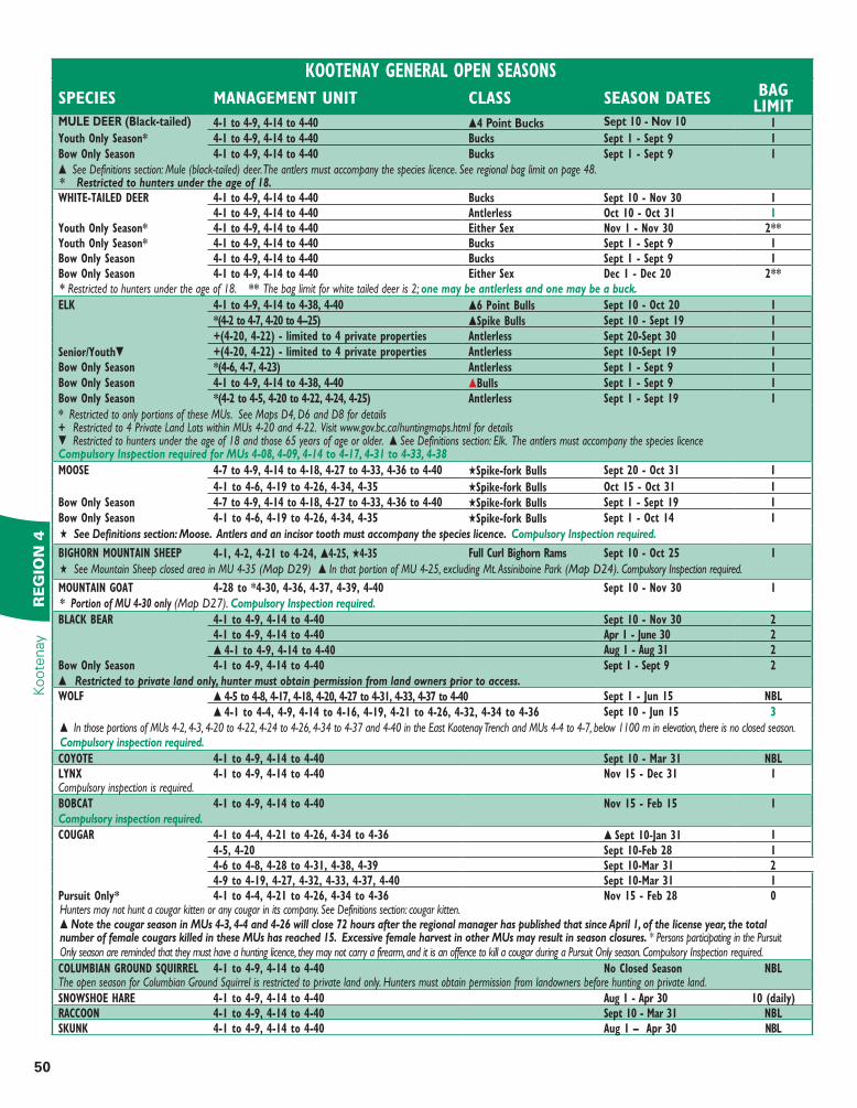
KOOTENAY GENERAL OPEN SEASONS
SPECIES MANAGEMENT UNIT CLASS SEASON DATES BAG LIMIT
MULE DEER (Black-tailed) 4-1 to 4-9, 4-14 to 4-40 s4 Point Bucks Sept 10 - Nov 10 1
Youth Only Season* 4-1 to 4-9, 4-14 to 4-40 Bucks Sept 1 - Sept 9 1
Bow Only Season 4-1 to 4-9, 4-14 to 4-40 Bucks Sept 1 - Sept 9 1
s See Definitions section: Mule (black-tailed) deer. The antlers must accompany the species licence. See regional bag limit on page 48.* Restricted to hunters under the age of 18.WHITE-TAILED DEER 4-1 to 4-9, 4-14 to 4-40 Bucks Sept 10 - Nov 30 1
4-1 to 4-9, 4-14 to 4-40 Antlerless Oct 10 - Oct 31 1Youth Only Season* 4-1 to 4-9, 4-14 to 4-40 Either Sex Nov 1 - Nov 30 2**Youth Only Season* 4-1 to 4-9, 4-14 to 4-40 Bucks Sept 1 - Sept 9 1Bow Only Season 4-1 to 4-9, 4-14 to 4-40 Bucks Sept 1 - Sept 9 1Bow Only Season 4-1 to 4-9, 4-14 to 4-40 Either Sex Dec 1 - Dec 20 2*** Restricted to hunters under the age of 18. ** The bag limit for white tailed deer is 2; one may be antlerless and one may be a buck.
ELK 4-1 to 4-9, 4-14 to 4-38, 4-40 s6 Point Bulls Sept 10 - Oct 20 1
*(4-2 to 4-7, 4-20 to 4--25) sSpike Bulls Sept 10 - Sept 19 1
+(4-20, 4-22) - limited to 4 private properties Antlerless Sept 20-Sept 30 1
Senior/Youtht +(4-20, 4-22) - limited to 4 private properties Antlerless Sept 10-Sept 19 1
Bow Only Season *(4-6, 4-7, 4-23) Antlerless Sept 1 - Sept 9 1
Bow Only Season 4-1 to 4-9, 4-14 to 4-38, 4-40 sBulls Sept 1 - Sept 9 1
Bow Only Season *(4-2 to 4-5, 4-20 to 4-22, 4-24, 4-25) Antlerless Sept 1 - Sept 19 1
* Restricted to only portions of these MUs. See Maps D4, D6 and D8 for details + Restricted to 4 Private Land Lots within MUs 4-20 and 4-22. Visit www.gov.bc.ca/huntingmaps.html for detailst Restricted to hunters under the age of 18 and those 65 years of age or older. s See Definitions section: Elk. The antlers must accompany the species licenceCompulsory Inspection required for MUs 4-08, 4-09, 4-14 to 4-17, 4-31 to 4-33, 4-38
MOOSE 4-7 to 4-9, 4-14 to 4-18, 4-27 to 4-33, 4-36 to 4-40 HSpike-fork Bulls Sept 20 - Oct 31 1
4-1 to 4-6, 4-19 to 4-26, 4-34, 4-35 HSpike-fork Bulls Oct 15 - Oct 31 1
Bow Only Season 4-7 to 4-9, 4-14 to 4-18, 4-27 to 4-33, 4-36 to 4-40 HSpike-fork Bulls Sept 1 - Sept 19 1
Bow Only Season 4-1 to 4-6, 4-19 to 4-26, 4-34, 4-35 HSpike-fork Bulls Sept 1 - Oct 14 1
H See Definitions section: Moose. Antlers and an incisor tooth must accompany the species licence. Compulsory Inspection required.
BIGHORN MOUNTAIN SHEEP 4-1, 4-2, 4-21 to 4-24, s4-25, H4-35 Full Curl Bighorn Rams Sept 10 - Oct 25 1
H See Mountain Sheep closed area in MU 4-35 (Map D29) s In that portion of MU 4-25, excluding Mt. Assiniboine Park (Map D24). Compulsory Inspection required.
MOUNTAIN GOAT 4-28 to *4-30, 4-36, 4-37, 4-39, 4-40 Sept 10 - Nov 30 1
* Portion of MU 4-30 only (Map D27). Compulsory Inspection required.
BLACK BEAR 4-1 to 4-9, 4-14 to 4-40 Sept 10 - Nov 30 24-1 to 4-9, 4-14 to 4-40 Apr 1 - June 30 2
s 4-1 to 4-9, 4-14 to 4-40 Aug 1 - Aug 31 2
Bow Only Season 4-1 to 4-9, 4-14 to 4-40 Sept 1 - Sept 9 2
s Restricted to private land only, hunter must obtain permission from land owners prior to access.WOLF s 4-5 to 4-8, 4-17, 4-18, 4-20, 4-27 to 4-31, 4-33, 4-37 to 4-40 Sept 1 - Jun 15 NBL
s 4-1 to 4-4, 4-9, 4-14 to 4-16, 4-19, 4-21 to 4-26, 4-32, 4-34 to 4-36 Sept 10 - Jun 15 3
s In those portions of MUs 4-2, 4-3, 4-20 to 4-22, 4-24 to 4-26, 4-34 to 4-37 and 4-40 in the East Kootenay Trench and MUs 4-4 to 4-7, below 1100 m in elevation, there is no closed season. Compulsory inspection required.
COYOTE 4-1 to 4-9, 4-14 to 4-40 Sept 10 - Mar 31 NBLLYNX 4-1 to 4-9, 4-14 to 4-40 Nov 15 - Dec 31 1Compulsory inspection is required. BOBCAT 4-1 to 4-9, 4-14 to 4-40 Nov 15 - Feb 15 1
Compulsory inspection required.COUGAR 4-1 to 4-4, 4-21 to 4-26, 4-34 to 4-36 s Sept 10-Jan 31 1
4-5, 4-20 Sept 10-Feb 28 14-6 to 4-8, 4-28 to 4-31, 4-38, 4-39 Sept 10-Mar 31 24-9 to 4-19, 4-27, 4-32, 4-33, 4-37, 4-40 Sept 10-Mar 31 1
Pursuit Only* 4-1 to 4-4, 4-21 to 4-26, 4-34 to 4-36 Nov 15 - Feb 28 0Hunters may not hunt a cougar kitten or any cougar in its company. See Definitions section: cougar kitten.s Note the cougar season in MUs 4-3, 4-4 and 4-26 will close 72 hours after the regional manager has published that since April 1, of the license year, the total number of female cougars killed in these MUs has reached 15. Excessive female harvest in other MUs may result in season closures. * Persons participating in the Pursuit Only season are reminded that they must have a hunting licence, they may not carry a firearm, and it is an offence to kill a cougar during a Pursuit Only season. Compulsory Inspection required.
COLUMBIAN GROUND SQUIRREL 4-1 to 4-9, 4-14 to 4-40 No Closed Season NBLThe open season for Columbian Ground Squirrel is restricted to private land only. Hunters must obtain permission from landowners before hunting on private land. SNOWSHOE HARE 4-1 to 4-9, 4-14 to 4-40 Aug 1 - Apr 30 10 (daily)RACCOON 4-1 to 4-9, 4-14 to 4-40 Sept 10 - Mar 31 NBLSKUNK 4-1 to 4-9, 4-14 to 4-40 Aug 1 – Apr 30 NBL
51
RE
GIO
N 4
Kootenay
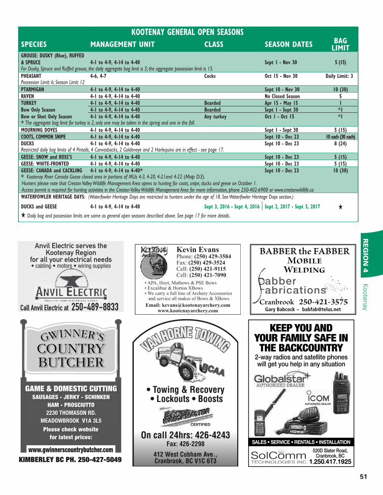
KOOTENAY GENERAL OPEN SEASONS
SPECIES MANAGEMENT UNIT CLASS SEASON DATES BAG LIMIT
GROUSE: DUSKY (Blue), RUFFED
& SPRUCE 4-1 to 4-9, 4-14 to 4-40 Sept 1 - Nov 30 5 (15)For Dusky, Spruce and Ruffed grouse, the daily aggregate bag limit is 5; the aggregate possession limit is 15.
PHEASANT 4-6, 4-7 Cocks Oct 15 - Nov 30 Daily Limit: 3Possession Limit: 6; Season Limit: 12
PTARMIGAN 4-1 to 4-9, 4-14 to 4-40 Sept 10 - Nov 30 10 (30)RAVEN 4-1 to 4-9, 4-14 to 4-40 No Closed Season 5TURKEY 4-1 to 4-9, 4-14 to 4-40 Bearded Apr 15 - May 15 1Bow Only Season 4-1 to 4-9, 4-14 to 4-40 Bearded Sept 1 - Sept 30 *1Bow or Shot Only Season 4-1 to 4-9, 4-14 to 4-40 Any turkey Oct 1 - Oct 15 *1* The aggregate bag limit for turkey is 2, only one may be taken in the spring and one in the fall.
MOURNING DOVES 4-1 to 4-9, 4-14 to 4-40 Sept 1 - Sept 30 5 (15)COOTS, COMMON SNIPE 4-1 to 4-9, 4-14 to 4-40 Sept 10 - Dec 23 10 each (30 each)DUCKS 4-1 to 4-9, 4-14 to 4-40 Sept 10 - Dec 23 8 (24)Restricted daily bag limits of 4 Pintails, 4 Canvasbacks, 2 Goldeneye and 2 Harlequins are in effect - see page 17.
GEESE: SNOW and ROSS’S 4-1 to 4-9, 4-14 to 4-40 Sept 10 - Dec 23 5 (15)GEESE: WHITE-FRONTED 4-1 to 4-9, 4-14 to 4-40 Sept 10 - Dec 23 5 (15)GEESE: CANADA and CACKLING 4-1 to 4-9, 4-14 to 4-40* Sept 10 - Dec 23 10 (30)* Kootenay River Canada Goose closed area in portions of MUs 4-3, 4-20, 4-21and 4-22 (Map D3).Hunters please note that Creston Valley Wildlife Management Area opens to hunting for coots, snipe, ducks and geese on October 1. Access permit is required for hunting activities in the Creston Valley Wildlife Management Area for more information, phone 250-402-6900 or www.crestonwildlife.caWATERFOWLER HERITAGE DAYS: (Waterfowler Heritage Days are restricted to hunters under the age of 18. See Waterfowler Heritage Days section.)
DUCKS and GEESE 4-1 to 4-9, 4-14 to 4-40 Sept 3, 2016 - Sept 4, 2016 Sept 2, 2017 - Sept 3, 2017 H
H Daily bag and possession limits are same as general open seasons described above. See page 17 for more details.
Kevin EvansPhone: (250) 429-3584Fax: (250) 429-3524Cell: (250) 421-9115Cell: (250) 421-7090
Email: [email protected]
• APA, Hoyt, Mathews & PSE Bows• Excalibur & Horton XBows• We carry a full line of Archery Accessories and service all makes of Bows & XBows
On call 24hrs: 426-4243Fax: 426-2298
412 West Cobham Ave., Cranbrook, BC V1C 6T3
VAN HORNE TOWING
CERTIFIED
Anvil Electric serves the Kootenay Region
for all your electrical needs
Call Anvil Electric at 250-489-8833
KEEP YOU ANDYOUR FAMILY SAFE INTHE BACKCOUNTRY
2-way radios and satellite phoneswill get you help in any situation
520D Slater Road, Cranbrook, BC
1.250.417.1925
AUTHORIZED DEALER
BABBER the FABBER Mobile
Welding
Cranbrook 250-421-3575
abberabricationsabricationsabrications
Gary Babcock ~ [email protected]
GAME & DOMESTIC CUTTING
SAUSAGES - JERKY - SCHINKEN
HAM - PROSCIUTTO
2230 THOMASON RD.
MEADOWBROOK V1A 3L5
Please check website
for latest prices:
GWINNER’S
COUNTRY
BUTCHER
KIMBERLEY BC PH. 250-427-5049
www.gwinnerscountrybutcher.com
52
RESOURCE MANAGEMENT REGION 4Kootenay
RE
GIO
N 4
M.U.
4-25
To
b y C r .
INVERMERE
1100 m
1100 mColumbia L.
M.U.
4-22
M.U.
4-20
M.U.
4-3
M.U.
4-4
M.U.
4-5
M.U.
4-695
93
9395
9593
St. Mary R.
LumbertonR.
LumbertonR.
Peavine Cr.
Elk
Riv
er
Bull R
.
Perry C
r.
Skookumchuck
Cr.
1100m
1100 m
1100m1100m
1100 m
1100m
Lu
ss
ier
R.
1100m
KIMBERLEY
CRANBROOK
Joseph
C r.
Mo
yie
R.
NewgateNewgate
Teepee Cr.
Gold Cr.
Blo
om
Cr.
CavenCr.
1100m
Cotton Cr.
MoyieL.
9593
1100 m
1100 m
1100 m
Findlay Cr.
1100m
St. Mary’sL.
Shuswap Creek
drainage northend
M.U.
4-2
M.U.
4-21
M.U.
4-20
M.U.
4-24
Summit Creek
Campground and
Recreation Area
Evans Road Trail
West Creston Road Corn Cr.
Summit Creek
KootenayRiver
Old
Kootenay
River
Channel
3
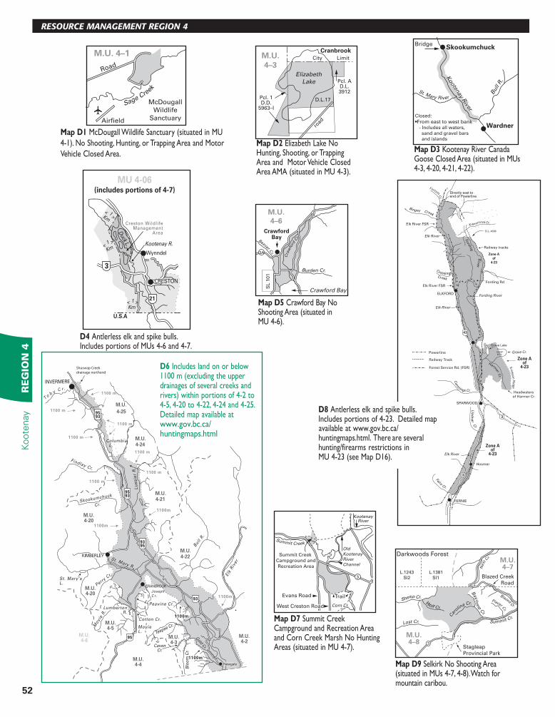
MapD7 Summit CreekCampground and Recreation Area and Corn Creek Marsh No Hunting Areas (situated in MU 4-7). Stagleap
Provincial Park
Blazed Creek
Road
L.1243
Sl2
L.1381
Sl1
Darkwoods Forest
Sheep Cr.
W
olf Cr.
Lost Cr. Summit Cr. C
ar
olina Cr.
Blazed
Cr.
Placer Cr.
Next
Cr.
Bayo
nne C
r.
M.U.4–7
M.U.4–8 3
MapD9 Selkirk No Shooting Area(situated in MUs 4-7, 4-8). Watch for mountain caribou.
Eric
kso
n R
idg
e
Ford
ing
Riv
er
Grave Lake
Fording Rd
Fording River
43
CrossingCreek
Elk River FSR
ELKFORD
Cu
m
mings Cr.
SPARWOOD
FERNIE
Hosmer
Fairy Cr.
Grave Cr.
Lla
dn
ar C
r
Powerline
Railway Track
Forest Service Rd. (FSR)
Elk River
Elk River
3
3
Zone Aof
4-23
Zone Aof
4-23
Elk River FSR
Bingey Creek
Railway tracks
Elk River
Harmer
Cr.
SHEEP
MTN
Zone Aof
4-23
ForsythC
r.
Headwaters
of Harmer Cr
Directly east toend of Powerline
Kilmarnock Cr.
D.L. 4588
D8Antlerless elk and spike bulls.Includes portions of 4-23. Detailed map
Burden Cr.
Crawford Bay
Beaver Cr.
Cra
wfo
rd C
r.
SL
10
1
CrawfordBay
M.U.
4–6
3A
MapD5 Crawford Bay NoShooting Area (situated in MU 4-6).
21
3
Creston WildlifeManagement
Area
CRESTON
Wynndel
MU 4-06(includes portions of 4-7)
Duck L. Kootenay R.
1< >Km
1<
>
Km
1< >Km
U.S.A
D4Antlerless elk and spike bulls.Includes portions of MUs 4-6 and 4-7.
Skookumchuck
Wardner
Bridge
Closed:
Kooten
ay River
Bull
R.
St. Mary River
MapD3Kootenay River CanadaGoose Closed Area (situated in MUs 4-3, 4-20, 4-21, 4-22).
Elizabeth
Lake
Pcl. 1D.D.
5963–I
Pcl. AD.L.3912
D.L.17
City Limit
CranbrookM.U.
4–3
road
MapD2Elizabeth Lake NoHunting, Shooting, or Trapping Area and Motor Vehicle Closed Area AMA (situated in MU 4-3).
Road
Airfield
McDougall
Wildlife
Sanctuary
M.U. 4–1
Sage Cre
ek
MapD1 McDougall Wildlife Sanctuary (situated in MU4-1). No Shooting, Hunting, or Trapping Area and Motor Vehicle Closed Area.
available at www.gov.bc.ca/huntingmaps.html. There are several hunting/firearms restrictions in MU 4-23 (see Map D16).
D6Includes land on or below 1100 m (excluding the upper drainages of several creeks and rivers) within portions of 4-2 to 4-5, 4-20 to 4-22, 4-24 and 4-25.Detailed map available atwww.gov.bc.ca/huntingmaps.html
53
KOOTENAYR
EG
ION
4Kootenay
KOOTENAY
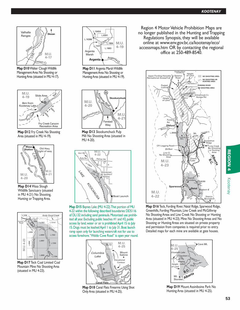
Region 4 Motor Vehicle Prohibition Maps are no longer published in the Hunting and Trapping
Regulations Synopsis, they will be available online at www.env.gov.bc.ca/kootenay/eco/
accessmaps.htm OR by contacting the regional office at 250-489-8540.
Henretta Cr
SeismicRoad
Upper Fording HenrettaRecreational Access Trail
Heightof Land
Mt.Lyne
GraveLake
Heightof Land
PostedCutline
CFI Logging Road
Elk River
Line Cr.No Shooting
Area
L.8965
L.8289
DistrictBoundary
DistrictBoundary
Kilmarnock Cr.
Cha
uncey Cr.
Tornado Cr.
Line C
r.
Harmer C
r.
Boivin Cr.
Fordin
g R
iver
C.P
.R.
FordingMtn.
Elkford
HorseshoeRidge
Line CreekNo Shooting
or HuntingArea
Erickson Cr.
Mich
el
NatalSparwood
M.U.4–22
M.U.4–23
43
Alb
erta
B.C
.
Spruce
Cr.
Kilmarnock Cr.Access Rd.
NO SHOOTING OR HUNTING AREA
NO SHOOTING AREA
FORDING RIVER
NO SHOOTING AREA
Fording
Rd
Fording River
MapD16 Teck, Fording River, Natal Ridge, Sparwood Ridge, Greenhills, Fording Mountain, Line Creek and McGillivray No Shooting Areas and Line Creek No Shooting or Hunting Area (situated in MU 4-23). Mine No Shooting Areas and No Shooting or Hunting Areas are situated on private property and permission from companies is required prior to entry. Detailed maps for each mine are available at gate houses.
LAKE K
OO
CA
NU
SA
P.13924
DD5116 of DL 132
DD5116 of DL 132
Kyte Rd. Palmer Rd.
Kerr Rd.
Sharp
e Rd.
Sharp
e Rd.
Abandoned
BC Southern
Railway
Abandoned
BC Southern
Railway
M.U.
4–22
Boat Launch
MapD15 Baynes Lake (MU 4-22). That portion of MU 4-22 within the following described boundaries: DD5116 of DL132 including sand peninsula. Motorized use prohib-ited all year. Excluding public beaches #1 and #2, public access by land, water or air is prohibited April 15 to July 15. Dogs must be leashed April 1 to July 31. Boat launch ramp open only for launching watercraft not for use to access foreshore. “Waldo Cove Road” is open year round.
Andy Good CreekC.P.R.
Scrubby Cr.
Co
rbin
Cr.
Fla
thead
Rd
.
M
ichel Cr.
L.7000
L.7001 L.10147
L.7292L.6999
L.6998
L.6997
L.6995L.7294
L.6
996
L.7293
L.6994
M.U
. 4–2
3
CorbinRoad Height of Lan
d
MapD17 Teck Coal Limited Coal Mountain Mine No Shooting Area (situated in MU 4-23).
Fry Creek CanyonRecreation Area
6km fromKootenay Lake
600m
500m
Slide Area Trai
l
Fry C
reek
M.U.4–19
MapD12 Fry Creek No Shooting Area (situated in MU 4-19).
M.U.4–19
ArgentaArgenta Cr.
Carter C
r.
L.8391
L.1884
L.1883L.7828
L.16404
L.16386
Argenta
Marsh
MapD11Argenta Marsh Wildlife Management Area No Shooting or Hunting Area (situated in MU 4-19).
Valhalla
Ranges
Slo
can
Lemon Cr.
C.P
.R. 6 M.U.
4–17
Slocan
MapD10 Walter Clough Wildlife Management Area No Shooting or Hunting Area (situated in MU 4-17).
C.P.R
.
M.U.4–20
M.U.4–21
WasaStation Old Hwy.
right of way
1
Koote
nay R
iver
MapD14 Wasa Slough Wildlife Sanctuary (situated in MU 4-21) No Shooting, Hunting or Trapping Area.
Skookumchuck Cr.
M.U.4–20
M.U.4–21
Kootenay River
Skookumchuck
Farstad
Way
95
MapD13 Skookumchuck Pulp Mill No Shooting Area (situated in MU 4-20).
Columbia
Lake
Canal Flats
Koote
nay R
.Forest A
ccess
Road
SL72
Airfield
MountSabine
9395
Elevational
Contour
1067m
884m
M.U.4–25
MapD18 Canal Flats Firearms Using Shot Only Area (situated in MU 4-25).
B.C.
Alberta
Cave Mt.
Mt.
Sturdee
M.U.4–25Elizabeth Lake
Cerulean L.
Magog
Lake.Gog L.
Magog Cr.
Height
of Land
MapD19Mount Assiniboine Park No Hunting Area (situated in MU 4-25).
54
RESOURCE MANAGEMENT REGION 4Kootenay
RE
GIO
N 4
Co
lum
bia
RadiumHot Springs
Sinclair Creek
9395
95
L272 L
9011
L9560
L3947
L9010
9009
8207
L9565
9566
L5111
L286
L10112
L9677
River
B.C. Hydro R/W
Ko
ote
nay
Nati
on
al P
ark
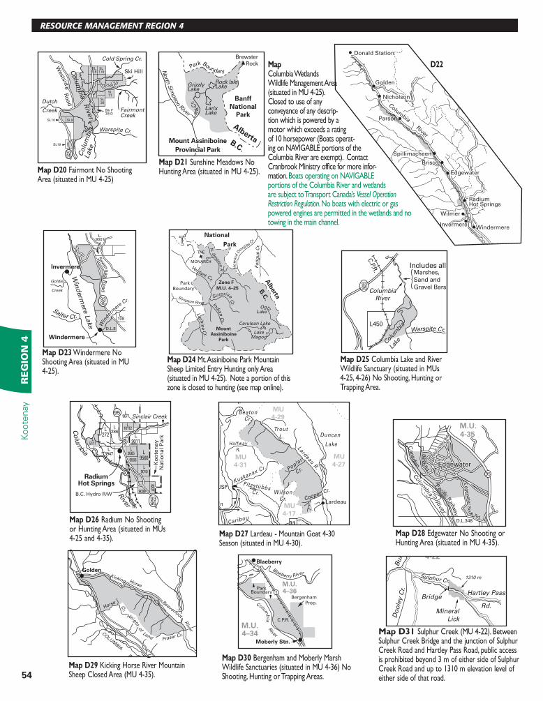
MapD26 Radium No Shooting or Hunting Area (situated in MUs 4-25 and 4-35).
L450
Marshes,
Sand and
Gravel Bars
Includes all
Col
umbi
a
Lake
Warspite Cr.
C.P.R
.
Columbia
River
9395
MapD25 Columbia Lake and River Wildlife Sanctuary (situated in MUs 4-25, 4-26) No Shooting, Hunting or Trapping Area.
Blaeberry River
Columb
ia R
iver
C.P.R.
Bergenham
Prop.
ParkBoundary
Moberly Stn.
Blaeberry
1
M.U.4–34
M.U.4–36
MapD30 Bergenham and Moberly Marsh Wildlife Sanctuaries (situated in MU 4-36) No Shooting, Hunting or Trapping Areas.
GoldenKicking Horse
Beaverfoot
Riv
er
Horse Cr.
Height o
f Land
COLU
MBIA RIVER
Fraser Cr.
MapD29 Kicking Horse River Mountain Sheep Closed Area (MU 4-35).
9595
EdgewaterEdgewater
Edgew
ate
r South Rd.
Edgew
ate
r South Rd.
D.L.348
Bench
Rd.
Canadian Pacific R
ailway
Colu
mbia
Colu
mbia
Rive
r
McC
aula
y R
d.
McC
aula
y R
d.
M.U.4-35
MapD28Edgewater No Shooting or Hunting Area (situated in MU 4-35).
Lardeau6
MU
4-31
MU
4-29
MU
4-17
MU
4-27
31
Kuskanax Cr.
BeatonCr.
Trout
L.
Lardeau R.
Duncan
Lake
Poplar
Cr.
Halfway
R.
FitzstubbsCr. Wilson
Cr.Slewiskin
Caribou
r.
NAKUSP
Inc
Cooper Cr.
MapD27Lardeau - Mountain Goat 4-30 Season (situated in MU 4-30).
LakeMagog
Cerulean Lake
OgLake
National
ParkTHE
MONARCH
Verdant Cr. N
. Sim
pson
R.
MountAssiniboine
Park
Ho
ward
Douglas
Cr.
Fati
gu
e C
r.
Simpson River
Surprise Cr. Ind
ian
Cr.
Lach
ine C
r.
M.U. 4–25Park
Boundary
Alb
erta
B.C
.Zone F
MapD24 Mt. Assiniboine Park Mountain Sheep Limited Entry Hunting only Area (situated in MU 4-25). Note a portion of this zone is closed to hunting (see map online).
Win
derm
ere
Lake
Salter Cr.
Goldie
Creek
L.108
L.9001
D.L.8
Win
derm
ere C
r.
Windermere
Invermere
Sw
anse
a R
oad
9395
MapD23 Windermere No Shooting Area (situated in MU 4-25).
Park Boundary
Brewster
Rock
North
Sim
pso
n River
Mount Assiniboine
Provincial Park
Lari
x C
r.
GrizzlyLake
LarixLake
Rock IsleLake
AlbertaB.C.
Banff
National
Park
MapD21Sunshine Meadows No Hunting Area (situated in MU 4-25).
Co
lum
bia
Lake
Co
lum
bia
Riv
er
Warspite Cr.
Dutch
Creek
Westsid
e R
oad
Cold Spring Cr.
FairmontCreek
SL119
Blk P3043
SL11
SL36
SL9SL10
SL19
SL118 Ski Hill
9395
MapD20 Fairmont No Shooting Area (situated in MU 4-25)
Columbia River
Golden
Donald Station
Nicholson
Edgewater
Radium Hot Springs
Nicholson
Edgewater
Radium Hot Springs
Wilmer
InvermereInvermereWindermere
Parson
Spillimacheen
Brisco
FairmontFairmont
Map D22 Columbia Wetlands Wildlife Management Area (situated in MU 4-25). Closed to use of any conveyance of any descrip-tion which is powered by a motor which exceeds a rating of 10 horsepower (Boats operat-ing on NAVIGABLE portions of the Columbia River are exempt). Contact Cranbrook Ministry office for more infor-mation. Boats operating on NAVIGABLE portions of the Columbia River and wetlands are subject to Transport Canada’s Vessel Operation Restriction Regulation. No boats with electric or gas powered engines are permitted in the wetlands and no towing in the main channel.
Bridge
Mineral
Lick
1310 m
Hartley Pass
Rd.
Bu
ll R
iver
Sulphur Cr.
Do
ole
y C
r.
4-22
MapD31Sulphur Creek (MU 4-22). Between Sulphur Creek Bridge and the junction of Sulphur Creek Road and Hartley Pass Road, public access is prohibited beyond 3 m of either side of Sulphur Creek Road and up to 1310 m elevation level of either side of that road.
55
RE
GIO
N 4
Kootenay
WildSheepandDisease
Across most of their historic range in western North America, bighorn sheep (Ovis canadensis), declined significantly between the mid-1800s and the mid-1900s. The causes of the decline included over harvesting as well as habitat alienation and health issues. Recovery efforts resulted in population increases in many areas, but not to historic levels. Bighorn sheep in BC remain on the BC Conservation Data Centre’s provincial blue-list (i.e. the list of ecological communities, and indigenous species and subspecies of special concern in BC), partly because of their vulnerability to disease.
Wild sheep in general, both bighorn sheep and thinhorn sheep (Ovis dalli), are susceptible to a variety of infectious organisms, in particular those that cause respiratory diseases such as pneumonia. Respiratory disease in wild sheep can occur “naturally” and includes infection by their own species of lungworms as well as bacteria. However, the syndrome of severe, life threatening pneumonia is associated with bacteria that include specific strains of Pasteurella multocida, Mannheimia haemolytica and Mycoplasma ovipneumoniae. These bacteria may be carried by domestic sheep/goats where they may or may not cause disease due to adaptations from thousands of years of domestication. When wild sheep are exposed to such organisms they cannot develop effective immune responses and pneumonia outbreaks can result in die-offs, affecting 5-95% of the herd. The disease may persist in survivors, resulting in years of low lamb survival and population declines. Research efforts have informed North American wild sheep managers that physical separation of wild and domestic sheep/goats is the only management tool currently available to reduce the risk of disease transmission.
To assist in maintaining this separation, producers of domestic sheep and goats on private land in areas shared by wild sheep are encouraged to better understand this issue and to work with wildlife managers (see www.wafwa.org/Documents%20and%20Settings/37/Site%20Documents/Working%20Groups/Wild%20Sheep/Publications/Rec_For_DS_and_GT_Management_in_WS_Habitat.pdf). Options recommended in that publication include switching species to other domestic livestock, using fencing practices that prevent nose-to-nose contact between wild sheep and domestic sheep and goats, employing effective livestock guardian dogs and controlling movements of domestic sheep and goats in areas where they may attract, or be attracted to, wild sheep.
If you observe wild sheep displaying potential signs of poor health (e.g. excessive coughing, running noses, diarrhea, lethargy), or wild sheep that are in the same pasture as domestic sheep and goats, please report it to the RAPP line at 1-877-952-7277, or the local FLNRO Regional Office. For more information on wild sheep and diseases, please see the documents and webpages developed by the Western Association of Fish and Wildlife Agencies (www.wafwa.org), the Wild Sheep Foundation (www.wild-sheepfoundation.org) and the Wild Sheep Society of BC (www.wildsheepsociety.com). Further, see the Wild Sheep Society of BC’s article in this synopsis on the collaborative BC Sheep Separation Program.
CLEAN QUIET COMFORTABLEStay a day or stay a week, it’s up to you!
Traditional value, modern convenience, friendly service. Shopping Centres, Walmart,
Restaurants, Gas Stations, Tim Hortons nearby.Single Queen, Double Queen or King Rooms, Adjoining
Rooms, Suites, Wheelchair Accessible.
Where we go that extra mile for you… Enjoy your stay at the Model A
1908 Cranbrook St. N, Cranbrook BC, V1C 3T1
1-888-489-4600 www.booking.com/hotel/ca/model-a-inn
Advertise in the BC Freshwater Fishing Regulations Synopsis,
Call 250-480-3244 or email
WESTERN CANADA SCHOOL OF TAXIDERMY
www.grifonetaxidermy.comCELEBRATING 25 YEARS OF INSTRUCTION
ph 250.365.6327 email [email protected]
Custom taxidermy....
by Lino Grifone
90 day delivery on gameheads
Wild Sheep and Disease
NOTICE!BADGER SIGHTINGS
Hunters & trappers should be aware that the BC subspecies of Badger is federally endan-gered and on the BC Red List. There are no hunting or trapping seasons for badgers. The estimated population is less than 300 animals. Badgers still occur in the Cariboo, Thompson, Nicola, Okanagan, Boundary & East Kootenay. Please report sightings of Badgers in BC to 1-888-223-4376. Badger information can be found at ww.badgers.bc.ca.
RICK'S FINE MEATS & AWARD WINNING SAUSAGES
Is your place for service and quality - a cut above the rest!
Certified meat-cutter and sausage maker on premises
Full retail / fresh meats / custom-cutting & slaughtering available
Widest variety of fresh and smoke sausage in the Kootenays.
No nitrates and preservatives. Hunters we offer total
processing, aging, cutting and wrapping.
Jerky, Sausage-Making and special service for out of town hunters.
Mon – Fri 9:00 to 5:30 Sat 9-5 1350-B Theatre Road, Cranbrook BC 250.426.7770
Serving Cranbrook for 30 Years.
Largest ProcessingFacility in the
Kootenays.
Specializing in wild game cutting & processing-sausage making, garlic rings, smokies, jerky, beer sausage, & much more.
14 km North of Kimberley on Hwy 95A or 10 km South of Tata Creek Store on Hwy 95A
OPEN 7 days a week
3433 McGinty RdKimberley, BCV1A 3L5
Kimberley Sausage & Meats
250-427-7766
making, garlic rings, smokies, jerky, beer sausage, & much more.
OPEN 7 days a week
3433 McGinty RdKimberley, BC
Sausage & Meats
56
Kootenay
RE
GIO
N 4
www.tourismradium.com
www.radiumhotsprings.com
Whatever your version of peace is…
you’ll find it here!
CANADA’S PREMIER FIREARM AMMUNITION
& ACCESSORY RETAILER
WANSTALLSWANSTALLSONLINE.COM 1-888-967-4867
WANTED: bobcat and lynx
trail camera photos
Researchers at UBC Okanagan are seeking photos of bobcats and lynx from all corners of BC and from all time periods to help learn more about where and when lynx and bobcats occur. Please send your photos, along with the date and location of each photo, to [email protected].
Recommended