RED RIVER FLOODWAY PUBLIC CONSULTATION ON THE RULES OF OPERATION
VOLUME I
REPORT ON THE PUBLIC CONSULTATION
OCTOBER 2010
FARLINGER CONSULTING GROUP INC.
H N WESTDAL & ASSOCIATES
Public Consultation on the Rules of Operation Page | i
RED RIVER FLOODWAY PUBLIC CONSULTATION ON THE RULES OF OPERATION
Volume 1: Report on the Public Consultation
Volume2: Written Comments and Record of Meetings
Volume 1
Table of Contents
Executive Summary
1. Introduction ..........................................................................................................................................1 2. Background ...........................................................................................................................................2 The Basics of Floodway Operation............................................................................................................3 History of Floodway Operations ...............................................................................................................4 Operating Decisions ..................................................................................................................................5 Manitoba Clean Environment Commission Hearings ...............................................................................5 City of Winnipeg Flood Protection Measures ...........................................................................................6 Artificial Flooding ......................................................................................................................................6 Rule 4: Emergency Summer Operations ...................................................................................................7 Flood Protection Upstream of the Floodway............................................................................................7 Flood Mitigation Downstream of the Floodway Outlet............................................................................8 The Red River Floodway Act .....................................................................................................................8
3. The Public Consultation Process ...........................................................................................................9 Meetings with Municipalities....................................................................................................................9 Public Open Houses ................................................................................................................................10 Advertisements .......................................................................................................................................11 Written Comments .................................................................................................................................12 Web Access .............................................................................................................................................13
4. What we Heard ...................................................................................................................................14 Comments from North of the City ..........................................................................................................14 Comments from Within the Floodway ...................................................................................................17 Comments from south of the Floodway .................................................................................................18 In Their Own Words ................................................................................................................................21 In Their Own Words (cont’d) ..................................................................................................................24
Appendices
Appendix A: Manitoba Environment Act Licence & Rules of Operation Appendix B: Open House Advertisements Appendix C: Internet site Appendix D: Open House Storyboards
Public Consultation on the Rules of Operation Page | ii
Executive Summary
Manitoba Water Stewardship conducted a public consultation on the rules of operation for the Red River Floodway in the period May through August, 2010. The public consultation is a component of the public review required in the licence granted in 2005 under the Manitoba Environment Act in respect to the expansion of the floodway. The rules of operation for the Red River Floodway are issued under the general authority of The Water Resources Administration Act. The rules stipulate how the floodway gates are to be used under normal, major and extreme water flows and during emergency summer operations after the spring snowmelt has crested. The rules of operation, in essence, determine the water levels both inside the City of Winnipeg and upstream of the floodway inlet based upon flow conditions. The intent of operating rules 1 to 3 is to provide flood protection to the City of Winnipeg. Emergency operations under Rule 4 are intended to deal only with the risk of sewer backup, basement flooding and resultant health risks, in the period after the spring flood has passed. The consultation gave the public an opportunity to comment on floodway operating rules. Meetings with municipalities north and south of the floodway, open houses, and an internet site with links to relevant information and legislation were part of the consultation process. The open houses were attended by staff from Manitoba Water Stewardship with expertise in floodway operations and included storyboards which explained floodway operations, the rules of operation and historic data on operations. The public was invited to provide comment at the open houses and/or to provide written submissions by mail or e‐mail to Manitoba Water Stewardship.
There are two volumes to this report:
Volume 1: Report on the Public Consultation; and Volume 2: Written Comments and Record of Meetings Volume 1 contains a description of the public consultation process, details on open houses, a copy of the open house storyboards, and a summary of comments made by the public. Volume 1 includes descriptions of floodway operations, but as a report on a public consultation it does not include analysis of technical issues. This report does not arrive at any conclusions nor make recommendations. The report simply reports on the consultation process and documents comments received from the public. Volume 2 includes a copy of records of meetings with municipalities, and written comments made by the City of Winnipeg, municipal governments, government agencies and community associations.
Public Consultation on the Rules of Operation Page | iii
Perspectives on floodway operations tend to be particular to a respondent’s property and place of residence. This applies to the City of Winnipeg, municipal governments and individuals. For example, residents north of the floodway, have different perspectives than people resident south of the floodway, reflecting different types of effects. Generally, those north of the floodway have concerns about flooding due to ice jams, which they perceive as being exacerbated by the floodway, and concerns about the regular loss of the Dunning Road Crossing. People resident south of the floodway have concerns about artificial flooding and the impact to property, lifestyle and peace of mind. People within the floodway’s protection are mostly concerned about high water levels that affect bank stability and the use and enjoyment of the Red River and the walkway. The 1997 flood was devastating to southern Manitoba and in particular to those people and communities residing south of the floodway structure. Since 1997, measures have been taken to mitigate flood damage to the residents of the Red River valley. Since 2002, emergency summer use of the floodway has occurred four times, including in 2010. Each use of the floodway under Rule 4 results in artificial flooding. In addition to property damage, the public noted that artificial flooding causes stress and anxiety throughout the community. Compensation provided for emergency summer use was generally thought to be inadequate. North of the floodway, severe ice jams were noted as the major cause of flooding, causing property damage and cutting off access to property and services.
Public Consultation on the Rules of Operation Page | 1
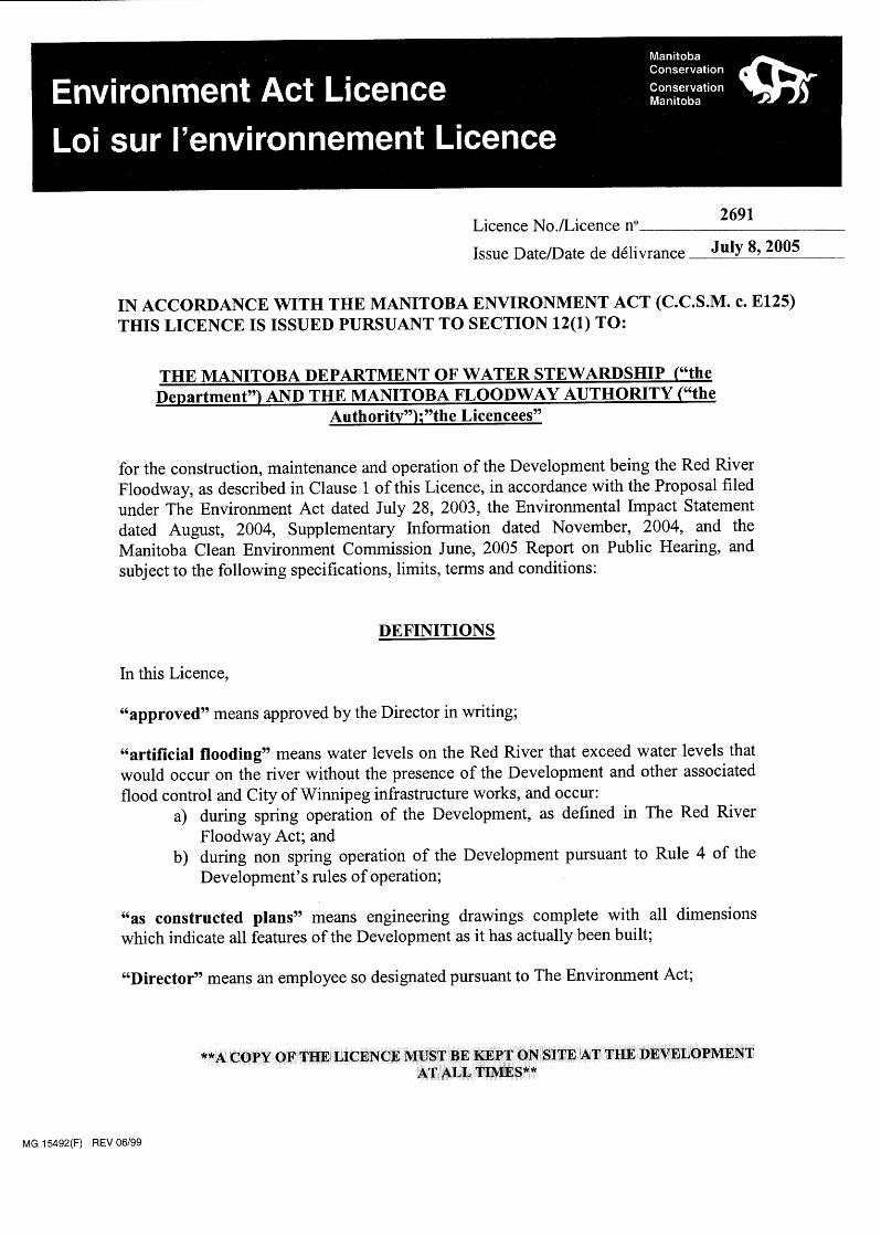
1. Introduction This report describes the public consultation on the Rules of Operation of the Red River Floodway conducted in the period April through August 2010. The floodway was built between 1962 and 1968 to provide flood protection to the City of Winnipeg. It was expanded starting in 2006 and the final elements of the expansion are expected to be complete in the fall of 2010. The floodway is a provincial facility operated by Manitoba Water Stewardship in accordance with operating rules issued under the authority of the Water Resources Administration Act. These rules are also a condition of a licence under the Manitoba Environment Act (licence 2691), issued July 8, 2005. One condition of the Environment Act Licence states, in part, that:
“the Department shall conduct a public review of the rules of operation of the Development not less than once every five years,
commencing with the date of this Licence” The public consultation is a component of the public review required in the licence. The issues and comments presented in this report are those solely raised by members of the public, the City of Winnipeg, community associations and interested municipal governments. While this report includes descriptions of floodway operations there are no technical issues analysed as part of this consultation. This report does not arrive at any conclusions nor make recommendations. The report simply reports on the consultation process and documents comments received from the public. There are two volumes to this report: Volume 1: Report on the Public Consultation; and Volume 2: Written Comments and Record of Meetings
Public Consultation on the Rules of Operation Page | 2
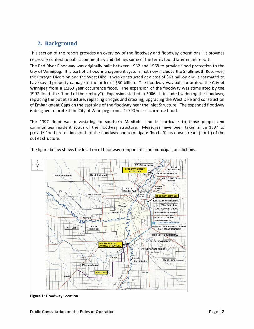
2. Background
This section of the report provides an overview of the floodway and floodway operations. It provides
necessary context to public commentary and defines some of the terms found later in the report.
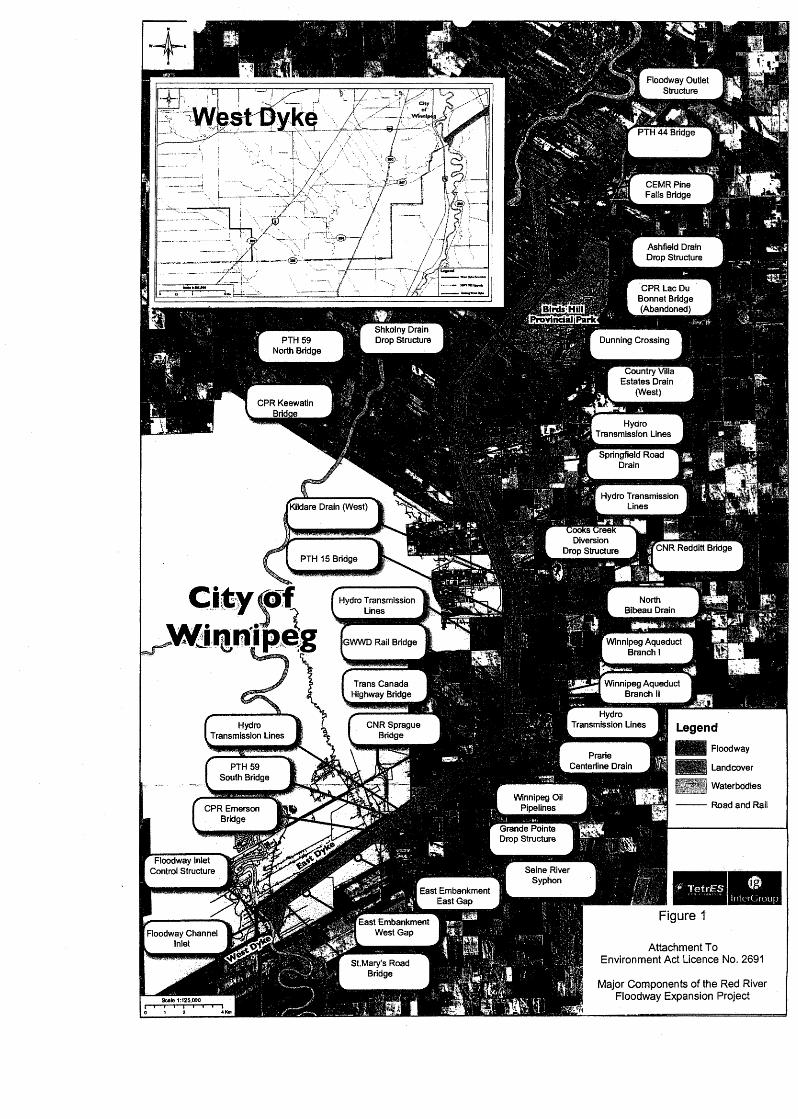
The Red River Floodway was originally built between 1962 and 1968 to provide flood protection to the City of Winnipeg. It is part of a flood management system that now includes the Shellmouth Reservoir, the Portage Diversion and the West Dike. It was constructed at a cost of $63 million and is estimated to have saved property damage in the order of $30 billion. The floodway was built to protect the City of Winnipeg from a 1:160 year occurrence flood. The expansion of the floodway was stimulated by the 1997 flood (the “flood of the century”). Expansion started in 2006. It included widening the floodway, replacing the outlet structure, replacing bridges and crossing, upgrading the West Dike and construction of Embankment Gaps on the east side of the floodway near the Inlet Structure. The expanded floodway is designed to protect the City of Winnipeg from a 1: 700 year occurrence flood. The 1997 flood was devastating to southern Manitoba and in particular to those people and communities resident south of the floodway structure. Measures have been taken since 1997 to provide flood protection south of the floodway and to mitigate flood effects downstream (north) of the outlet structure. The figure below shows the location of floodway components and municipal jurisdictions.
Figure 1: Floodway Location
Public Consultation on the Rules of Operation Page | 3
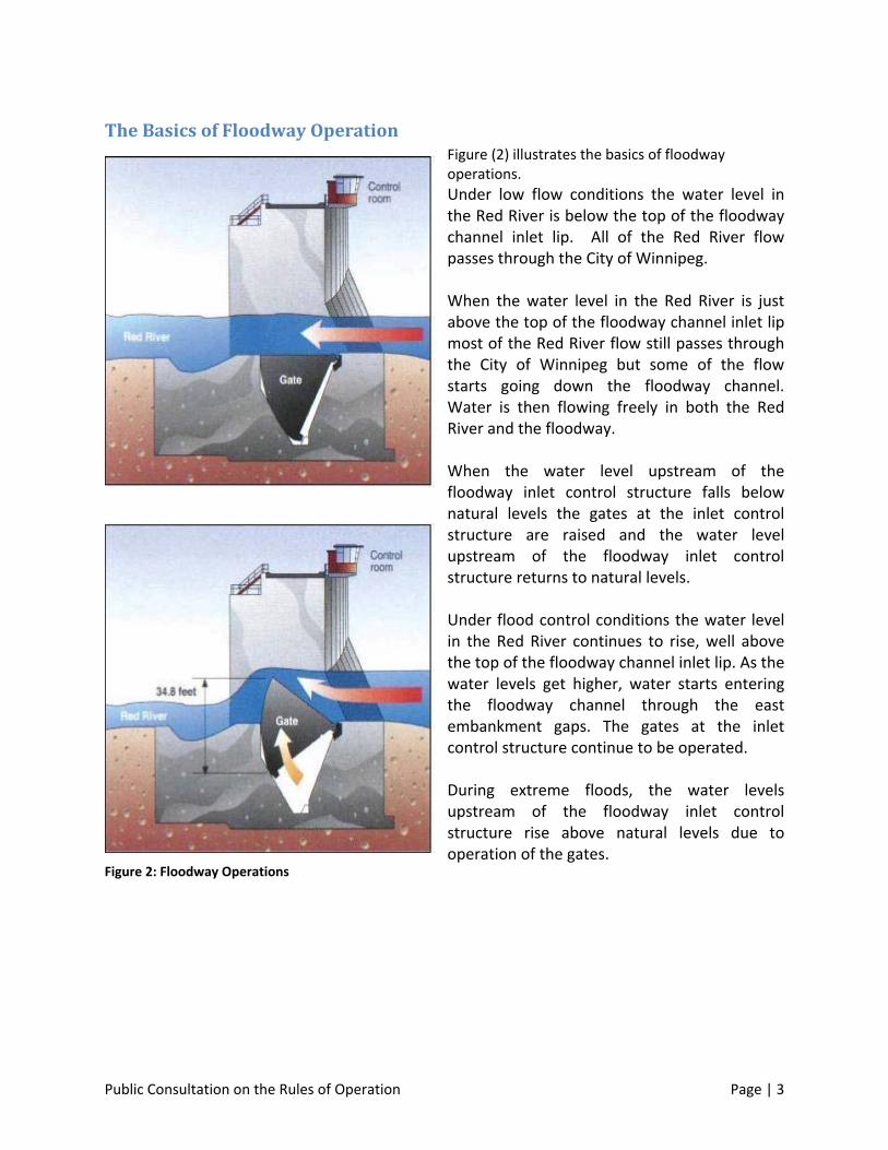
The Basics of Floodway Operation Figure (2) illustrates the basics of floodway operations.
Under low flow conditions the water level in the Red River is below the top of the floodway channel inlet lip. All of the Red River flow passes through the City of Winnipeg. When the water level in the Red River is just above the top of the floodway channel inlet lip most of the Red River flow still passes through the City of Winnipeg but some of the flow starts going down the floodway channel. Water is then flowing freely in both the Red River and the floodway. When the water level upstream of the floodway inlet control structure falls below natural levels the gates at the inlet control structure are raised and the water level upstream of the floodway inlet control structure returns to natural levels. Under flood control conditions the water level in the Red River continues to rise, well above the top of the floodway channel inlet lip. As the water levels get higher, water starts entering the floodway channel through the east embankment gaps. The gates at the inlet control structure continue to be operated. During extreme floods, the water levels upstream of the floodway inlet control structure rise above natural levels due to operation of the gates.
Figure 2: Floodway Operations
Public Consultation on the Rules of Operation Page | 4
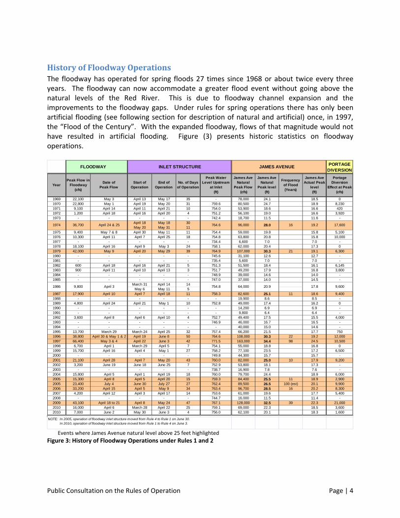
History of Floodway Operations The floodway has operated for spring floods 27 times since 1968 or about twice every three years. The floodway can now accommodate a greater flood event without going above the natural levels of the Red River. This is due to floodway channel expansion and the improvements to the floodway gaps. Under rules for spring operations there has only been artificial flooding (see following section for description of natural and artificial) once, in 1997, the “Flood of the Century”. With the expanded floodway, flows of that magnitude would not have resulted in artificial flooding. Figure (3) presents historic statistics on floodway operations.
FLOODWAY INLET STRUCTURE JAMES AVENUEPORTAGE
DIVERSION
1969 22,100 May 3 April 13 May 17 35 - 78,000 24.1 18.5 01970 22,800 May 1 April 19 May 20 31 759.6 80,500 24.7 18.9 8,2301971 9,100 April 14 April 11 April 21 10 754.0 53,900 18.6 16.6 4201972 1,200 April 18 April 16 April 20 4 751.2 56,100 19.0 16.6 3,9201973 - - - - - 742.4 18,700 11.5 11.6 -
April 18 May 18 30May 20 May 31 11
1975 9,400 May 7 & 8 April 30 May 11 11 754.4 59,000 19.8 15.8 5,1001976 10,300 April 11 April 7 April 25 18 754.8 63,800 20.8 15.8 10,0001977 - - - - - 734.4 6,600 7.0 7.0 -1978 18,100 April 16 April 9 May 3 24 758.1 62,000 20.4 17.3 01979 42,000 May 9 April 20 May 29 39 764.9 107,000 30.3 21 19.1 6,3001980 - - - - - 745.6 31,100 12.6 12.7 -1981 - - - - - 735.4 5,600 7.0 7.0 -1982 600 April 18 April 16 April 21 5 751.3 51,500 18.4 16.1 6,1451983 900 April 11 April 10 April 13 3 751.7 49,200 17.9 16.8 3,8001984 - - - - - 748.9 39,000 14.6 14.0 -1985 - - - - - 747.0 37,000 14.0 14.5 -
March 31 April 14 14May 6 May 11 5
1987 17,900 April 10 April 7 April 18 11 758.3 82,600 25.1 11 18.6 9,4001988 - - - - - - 19,900 8.6 8.5 -1989 4,800 April 24 April 21 May 1 10 752.8 49,000 17.4 16.2 01990 - - - - - - 14,200 6.9 6.9 -1991 - - - - - - 9,800 6.4 6.4 -1992 3,600 April 8 April 6 April 10 4 752.7 49,400 17.5 15.5 4,0001993 - - - - - 746.9 46,000 16.7 16.5 -1994 - - - - - - 40,000 15.0 14.6 -1995 13,700 March 29 March 24 April 25 32 757.4 66,200 21.5 17.7 7501996 38,800 April 30 & May 1 & 2 April 19 June 8 50 764.6 108,000 30.3 22 19.2 12,0001997 66,400 May 3 & 4 April 22 June 3 42 771.5 163,000 34.4 98 24.5 10,5001998 6,700 April 1 March 29 April 5 7 754.1 55,000 18.8 16.8 01999 15,700 April 16 April 4 May 1 27 758.2 77,100 23.5 17.2 6,5002000 - - - - - 749.8 44,300 15.7 15.7 -2001 21,100 April 28 April 7 May 20 43 760.0 82,000 25.0 10 17.9 9,2002002 3,200 June 19 June 18 June 25 7 752.9 53,800 18.1 17.3 -2003 - - - - - 738.7 16,900 7.8 7.6 -2004 15,800 April 5 April 1 April 19 18 760.0 79,700 24.4 18.9 6,0002005 15,300 April 8 April 5 April 20 15 759.3 84,400 25.5 11 18.9 2,9002005 23,400 July 4 June 30 July 27 27 762.4 89,500 26.5 100 (est) 20.1 9,9002006 33,200 April 15 April 5 May 9 34 763.4 96,700 28.5 16 20.2 8,3002007 4,200 April 12 April 3 April 17 14 753.6 61,000 19.6 17.7 5,4002008 - - - - - 744.7 16,000 11.5 11.4 -2009 43,100 April 18 to 21 April 8 May 24 47 767.1 128,000 32.5 39 22.3 21,0002010 16,000 April 6 March 28 April 22 25 759.1 69,000 22.3 18.5 3,6002010 7,000 June 2 May 30 June 3 4 756.0 62,100 20.1 18.3 1,600
17.8
28.0
20.9
Frequency of Flood(Years)
16 19.2
Peak Water Level Upstream
at Inlet(ft)
764.6
754.8
James Ave Natural
Peak level(ft)
James Ave Natural
Peak Flow (cfs)
1974
9,8001986
Peak Flow in Floodway
(cfs)
Portage Diversion
Effect at Peak(cfs)
17,600
9,600
96,000
James Ave Actual Peak
level(ft)
64,000
NOTE: In 2005, operation of floodway inlet structure moved from Rule 4 to Rule 1 on June 30. In 2010, operation of floodway inlet structure moved from Rule 1 to Rule 4 on June 3.
No. of Days of Operation
End of Operation
Start of Operation
Date of Peak Flow
Year
April 3
36,700 April 24 & 25
Events where James Avenue natural level above 25 feet highlighted
Figure 3: History of Floodway Operations under Rules 1 and 2
Public Consultation on the Rules of Operation Page | 5
Operating Decisions Floodway spring operating decisions are made by Manitoba Water Stewardship in accordance with the approved operating rules. According to the rules, the floodway gates should not be operated until the ice on the river is moving freely, unless flooding in Winnipeg is imminent. In the spring of 2009 the floodway was operated before ice had broken up in the vicinity of the floodway inlet. This was done to reduce an immediate threat of flooding within the City of Winnipeg. There is a Red River Floodway Operation Advisory Board in place to;
“ provide input, guidance and advice to the Minister of Water Stewardship on the operation of the floodway control gates in accordance with the approved operating rules during periods of flooding on the Red River,
work together as a team to identify and resolve issues that may arise as a result of proposed gate operations
facilitate the exchange of relevant and timely information between local residents and the government agencies regarding gate operations and their impact on residents.”
Members of the Advisory Board are:
Manitoba Water Stewardship (Chair)
Federal Government
Rural Municipality of Ritchot
Rural Municipality of MacDonald
Rural Municipality of Morris
City of Winnipeg
Selkirk and District Planning Area
Manitoba Clean Environment Commission Hearings The original floodway was built prior to environmental legislation that would require public
review, public hearings and licencing. The recent expansion of the floodway, however, was a
project that required a licence under the Environment Act of Manitoba and permits under
various federal acts.
In the licencing process, the Manitoba Clean Environment Commission (CEC) received technical
reports, testimony and recommendations related to complaints about floodway operations
including ice jamming, ground water contamination, lowering of the water table due to ground
water escaping to the floodway channel and artificial flooding. The hearings constituted a
thorough review of significant aspects of floodway operations.
Public Consultation on the Rules of Operation Page | 6
The Executive Summary of the CEC report noted in part that: “the Floodway operating rules
determine the water levels both inside the City of Winnipeg and upstream of the Floodway Inlet
Control Structure. In so doing they determine whether upstream residents will be subject to
artificial flooding and the degree of artificial flooding. The [operating] rules must be clear,
publically agreed upon, and adhered to.”
City of Winnipeg Flood Protection Measures The City of Winnipeg has undertaken substantial measures to mitigate flood effects. These
measures include:
1) Reducing basement flooding in combined sewer areas which is rainfall driven; and
2) Improving the overall flood protection system.
In total the city has spent about $345 million on these measures since 1977.
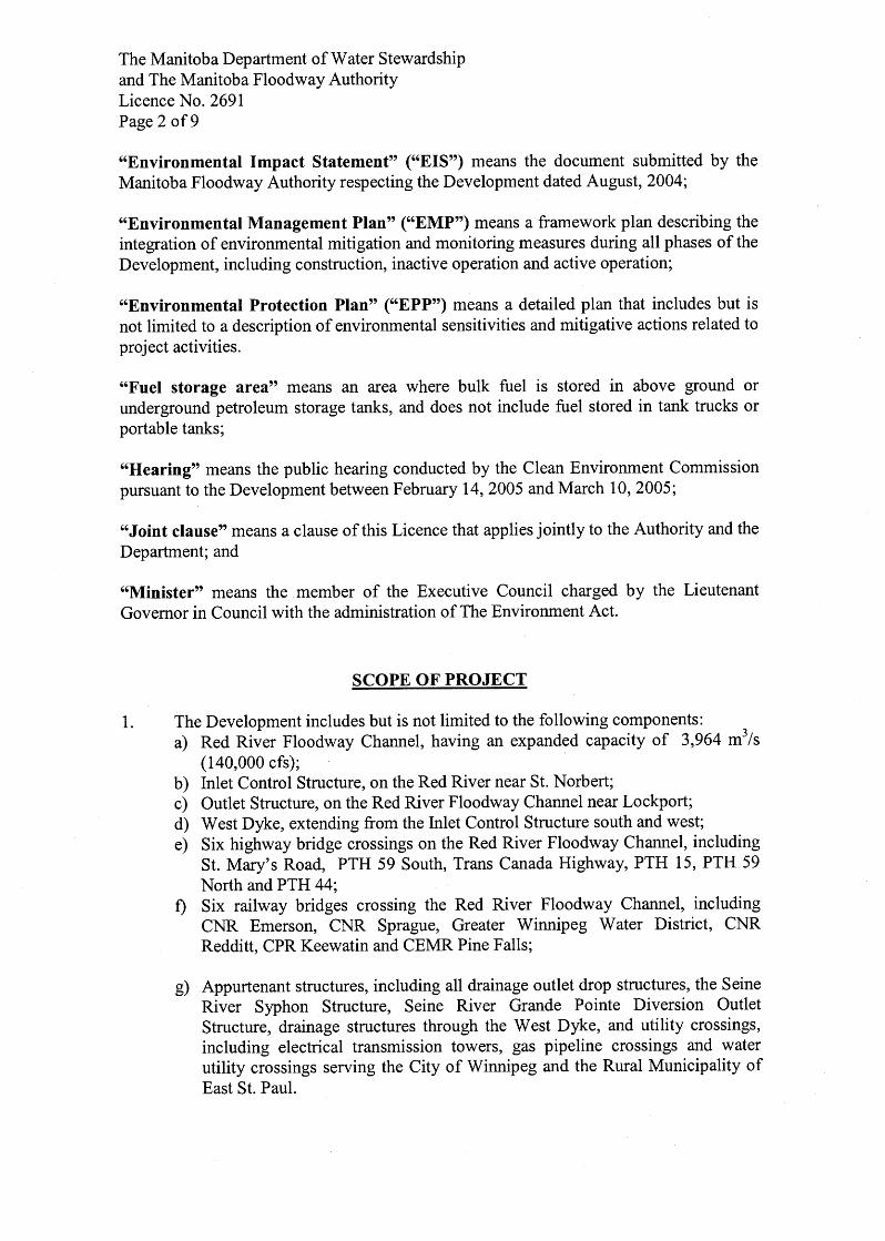
Artificial Flooding Artificial flooding is incremental flooding above the natural water level. The definition given in the Red River Floodway Act is as follows: “artificial flooding”, in relation to a given event means flooding
(a) caused by floodway operation during spring flooding; and (b) in which the Red River exceeds the natural level at the time of the event
The extent of artificial flooding is determined using a hydrodynamic model calibrated for each flood. Elevation data is obtained from hydrometric gauging stations. Aerial photos are used to evaluate the extent of artificial flooding. Artificial flooding in accordance with the above definition occurred during spring operations in 1997. Floodway operations in the summer under Rule 4 also result in artificial flooding due to natural levels being exceeded Natural Water Level
The term “natural water level” refers to the level that would have occurred in the absence of flood control works with the level of urban development at the time of construction of these works. The natural level at the Red River Floodway inlet is calculated based on a relationship developed in 2004 between the flow at James Avenue and the floodway inlet. The relationship is also affected by the flow contributed by the Assiniboine River, Shellmouth Reservoir, Portage Diversion, the floodway and other developments which all influence the actual water level at the inlet.
Public Consultation on the Rules of Operation Page | 7
The precise definition of natural water level taken from the Red River Floodway Act is as follows: “natural level” means the scientifically demonstrable water level that would be expected in the Red River at a given time during spring flooding in the absence of the floodway, the Assiniboine River Diversion, the Assiniboine River dikes, the Shellmouth dam, the primary dikes in the City of Winnipeg, and urban development in the area protected by the floodway since its design was finalized.
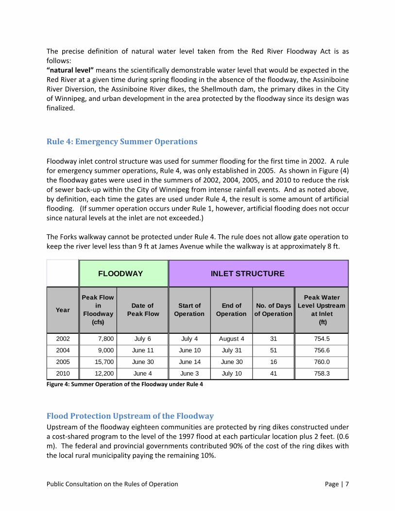
Rule 4: Emergency Summer Operations
Floodway inlet control structure was used for summer flooding for the first time in 2002. A rule for emergency summer operations, Rule 4, was only established in 2005. As shown in Figure (4) the floodway gates were used in the summers of 2002, 2004, 2005, and 2010 to reduce the risk of sewer back‐up within the City of Winnipeg from intense rainfall events. And as noted above, by definition, each time the gates are used under Rule 4, the result is some amount of artificial flooding. (If summer operation occurs under Rule 1, however, artificial flooding does not occur since natural levels at the inlet are not exceeded.) The Forks walkway cannot be protected under Rule 4. The rule does not allow gate operation to keep the river level less than 9 ft at James Avenue while the walkway is at approximately 8 ft.
FLOODWAY INLET STRUCTURE
2002 7,800 July 6 July 4 August 4 31 754.5
2004 9,000 June 11 June 10 July 31 51 756.6
2005 15,700 June 30 June 14 June 30 16 760.0
2010 12,200 June 4 June 3 July 10 41 758.3
Peak Water Level Upstream
at Inlet (ft)
Start of Operation
Date of Peak Flow
Year
Peak Flow in
Floodway (cfs)
No. of Days of Operation
End of Operation
Figure 4: Summer Operation of the Floodway under Rule 4
Flood Protection Upstream of the Floodway Upstream of the floodway eighteen communities are protected by ring dikes constructed under a cost‐shared program to the level of the 1997 flood at each particular location plus 2 feet. (0.6 m). The federal and provincial governments contributed 90% of the cost of the ring dikes with the local rural municipality paying the remaining 10%.
Public Consultation on the Rules of Operation Page | 8
Similarly, almost all rural individual homes and farmsteads upstream of the floodway inlet are protected to the same level (1997 plus 2 ft.) under a voluntary program, whereby government has contributed approximately 90% of the cost of either ring dikes or the raising of structures on earthen mounds in the areas affected by spring flooding of the Red River and tributaries, with the remainder paid for by the property owner. In total, since 1997, the provincial and federal governments have spent over $110 million on
flood protection upstream of the floodway.
Flood Mitigation Downstream of the Floodway Outlet As noted elsewhere the City of Selkirk, the R.M. of St. Clements, the Coalition for Flood
Protection North of the Floodway and a number of individuals expressed the opinion that
floodway operation exacerbated ice jams downstream of the floodway outlet which in turn
causes flooding upstream of the jam location. The storyboards displayed at the public meetings
showed copies of newspaper articles as well as a report from Sir Sanford Fleming indicating that
serious ice jams had occurred as early as the mid to late 1800’s and several individuals
attending the public meetings stated that ice jams had been a serious problem for a number of
years.
The province initiated an ice jam mitigation program in recent years. This program involves the
cutting and/or boring of river ice and subsequent breaking of ice by two Amphibex ice breakers
from the mouth of Netley Creek to south of the Selkirk Bridge, a distance of approximately
27 km.
The Red River Floodway Act Compensation for artificial flooding is a major concern for residents of the Red River Valley. In March, 2004, the province introduced the Red River Floodway Act to help address this issue. The Act allows those who suffer property damage and/or economic loss from artificial spring flooding on the Red River to claim compensation, including individuals, farms, businesses, non‐profit organizations and local authorities. The Red River Floodway Act covers a broader range of damage and loss than the Disaster Financial Assistance Program (DFA). It covers financial loss due to the
inability to work or carry on a business. There is no claim limit and no deductible. This compensation is in addition to the assistance available under other government flood protection and damage programs. In particular, the provincial program is separate from the DFA and covers losses in excess of those covered by DFA. Artificial flooding due to summer operations is provided under an ad hoc program announced after each event.
Public Consultation on the Rules of Operation Page | 9
3. The Public Consultation Process Condition 15 of the Environment Act Licence #2691 requires a public review of the rules of operation of the floodway not less than once every five years and a review process to be approved by the Director of Environmental Assessment, Manitoba Conservation. The public review process was approved by the Director in 2006 and a letter approving the proposed timelines for the review was received from the Director in May 2010. The public consultation was one part of the public review. The consultation process had several broad components:
Meetings with affected municipalities; Letters to the City of Winnipeg and adjacent municipalities advising of the review
process and an invitation to provide comments; Public open houses; Newspaper advertisements; A website; and An invitation for the public to provide written comments.
This section of the report provides details of the review process: a summary of meetings, location of open houses, attendance, description of the web site and the number of comments received. Attachments provide copies of newspaper ads, web based material and storyboards used in open houses. In the “What We Heard” section of this report we relate comments received from the public. In Volume 2, we present meeting notes from municipal meetings and written comments from the City of Winnipeg, municipal government and community associations.
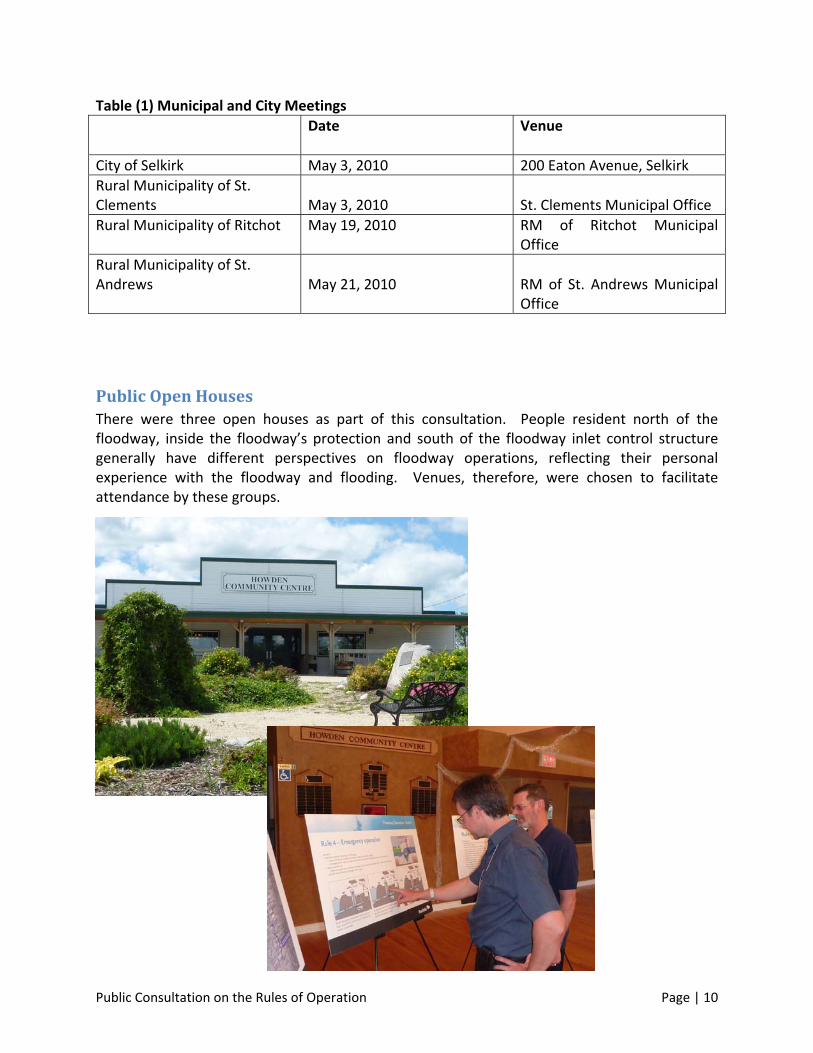
Meetings with Municipalities There were meetings with three municipalities and the City of Selkirk. Meetings were either with council or senior municipal staff. In each case a record was kept of each meeting. In two cases the meeting notes constitute the primary expression of municipal concerns.
Public Consultation on the Rules of Operation Page | 10
Table (1) Municipal and City Meetings
Date
Venue
City of Selkirk May 3, 2010 200 Eaton Avenue, Selkirk
Rural Municipality of St. Clements
May 3, 2010
St. Clements Municipal Office
Rural Municipality of Ritchot May 19, 2010 RM of Ritchot Municipal Office
Rural Municipality of St. Andrews
May 21, 2010
RM of St. Andrews Municipal Office
Public Open Houses There were three open houses as part of this consultation. People resident north of the floodway, inside the floodway’s protection and south of the floodway inlet control structure generally have different perspectives on floodway operations, reflecting their personal experience with the floodway and flooding. Venues, therefore, were chosen to facilitate attendance by these groups.
Public Consultation on the Rules of Operation Page | 11
The open houses included a comprehensive set of storyboards to explain floodway history, operations and rules. Water Stewardship staff were in attendance to explain technical details of floodway operations, related regulations, supporting legislation, and floodway related research and studies. The open house hours were from 2:00PM to 8:00 PM.
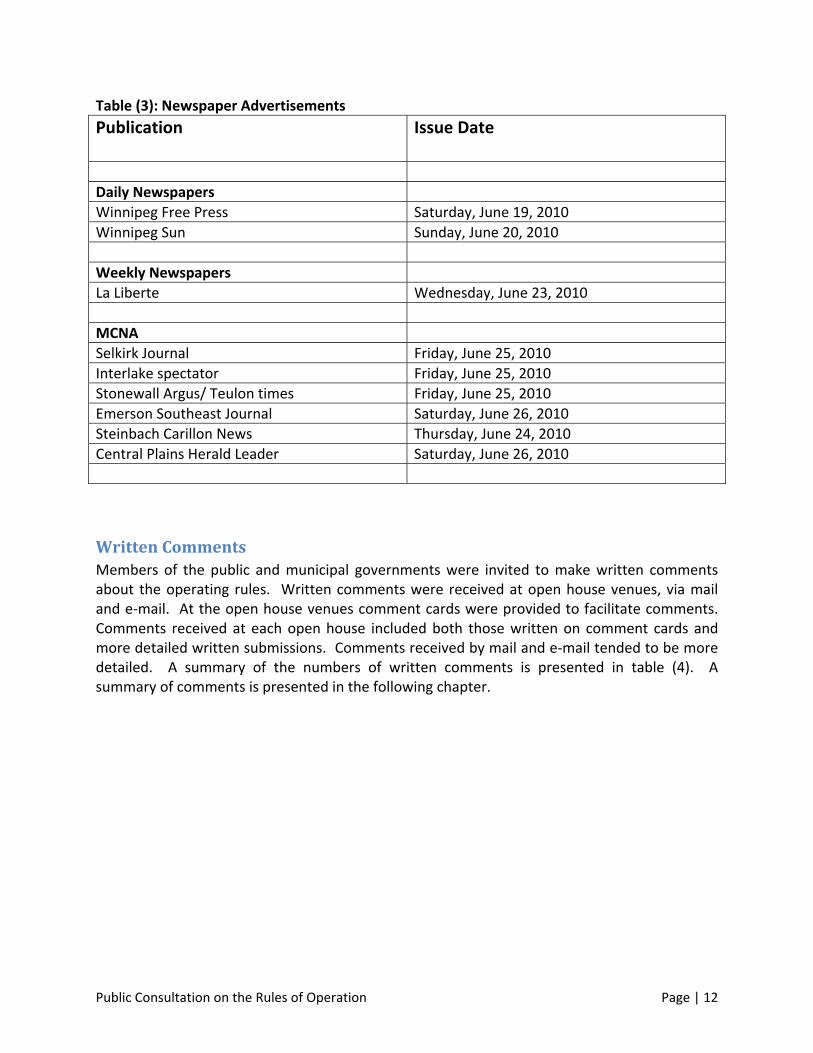
Table (2): Open House Venues
Dates Venue Attendance
Monday, July 5th Selkirk Inn & Conference Centre, Selkirk
27
Tuesday July 6th Holiday Inn Winnipeg South, 1330 Pembina Highway, Winnipeg
37
Thursday July 8th Howden Community Centre 1078 Red River Drive, Rural Municipality of Ritchot
44
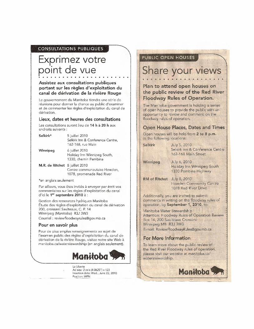
Advertisements The public was notified about the public consultation through newspaper advertisements that invited the public to “Share Your Views” by attending open houses, submitting comments in writing, and learning more about the public review at the Water Stewardship website. Table (3) provides a list of newspapers and issue dates for the ads. Copies of the English and French version of the ads are presented in Appendix (B).
Public Consultation on the Rules of Operation Page | 12
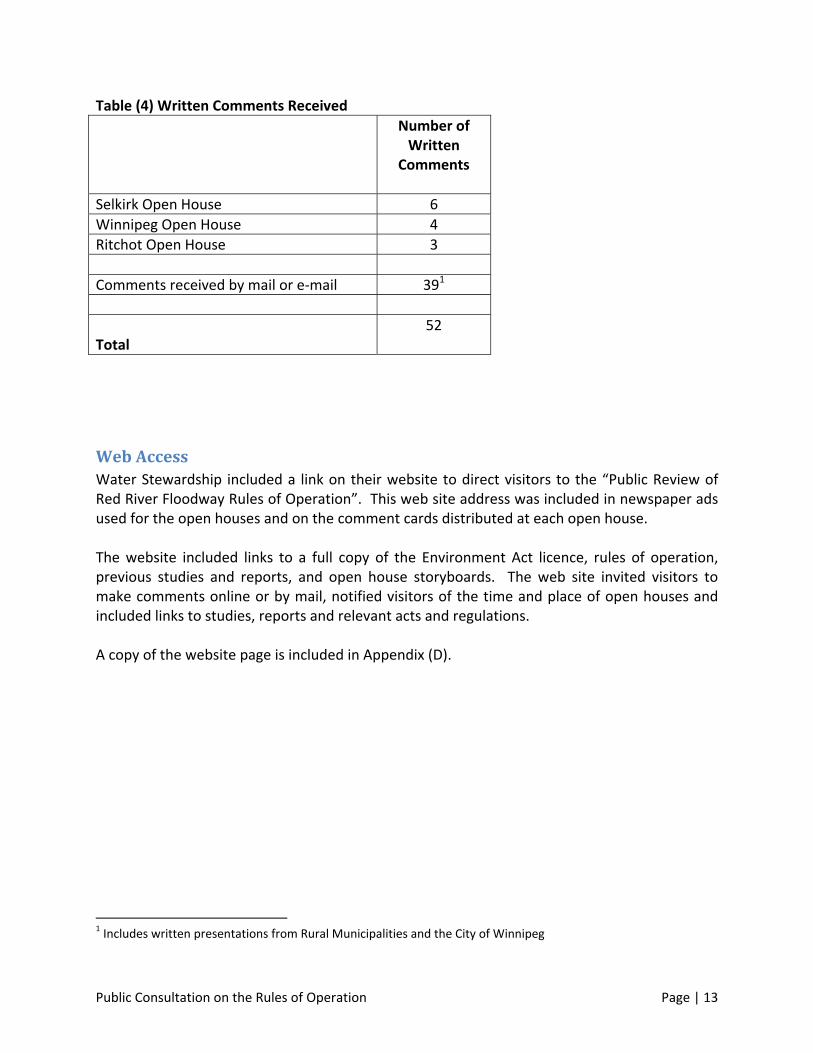
Table (3): Newspaper Advertisements
Publication
Issue Date
Daily Newspapers
Winnipeg Free Press Saturday, June 19, 2010
Winnipeg Sun Sunday, June 20, 2010
Weekly Newspapers
La Liberte Wednesday, June 23, 2010
MCNA
Selkirk Journal Friday, June 25, 2010
Interlake spectator Friday, June 25, 2010
Stonewall Argus/ Teulon times Friday, June 25, 2010
Emerson Southeast Journal Saturday, June 26, 2010
Steinbach Carillon News Thursday, June 24, 2010
Central Plains Herald Leader Saturday, June 26, 2010
Written Comments Members of the public and municipal governments were invited to make written comments about the operating rules. Written comments were received at open house venues, via mail and e‐mail. At the open house venues comment cards were provided to facilitate comments. Comments received at each open house included both those written on comment cards and more detailed written submissions. Comments received by mail and e‐mail tended to be more detailed. A summary of the numbers of written comments is presented in table (4). A summary of comments is presented in the following chapter.
Public Consultation on the Rules of Operation Page | 13
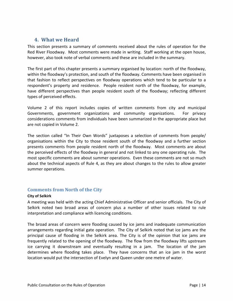
Table (4) Written Comments Received
Number of Written
Comments
Selkirk Open House 6
Winnipeg Open House 4
Ritchot Open House 3
Comments received by mail or e‐mail 391
Total
52
Web Access Water Stewardship included a link on their website to direct visitors to the “Public Review of Red River Floodway Rules of Operation”. This web site address was included in newspaper ads used for the open houses and on the comment cards distributed at each open house. The website included links to a full copy of the Environment Act licence, rules of operation, previous studies and reports, and open house storyboards. The web site invited visitors to make comments online or by mail, notified visitors of the time and place of open houses and included links to studies, reports and relevant acts and regulations. A copy of the website page is included in Appendix (D).
1 Includes written presentations from Rural Municipalities and the City of Winnipeg
Public Consultation on the Rules of Operation Page | 14
4. What we Heard This section presents a summary of comments received about the rules of operation for the Red River Floodway. Most comments were made in writing. Staff working at the open house, however, also took note of verbal comments and these are included in the summary. The first part of this chapter presents a summary organised by location: north of the floodway, within the floodway’s protection, and south of the floodway. Comments have been organised in that fashion to reflect perspectives on floodway operations which tend to be particular to a respondent’s property and residence. People resident north of the floodway, for example, have different perspectives than people resident south of the floodway; reflecting different types of perceived effects. Volume 2 of this report includes copies of written comments from city and municipal Governments, government organizations and community organizations. For privacy considerations comments from individuals have been summarized in the appropriate place but are not copied in Volume 2. The section called “In Their Own Words” juxtaposes a selection of comments from people/ organisations within the City to those resident south of the floodway and a further section presents comments from people resident north of the floodway. Most comments are about the perceived effects of the floodway in general and not linked to any one operating rule. The most specific comments are about summer operations. Even these comments are not so much about the technical aspects of Rule 4, as they are about changes to the rules to allow greater summer operations.
Comments from North of the City City of Selkirk
A meeting was held with the acting Chief Administrative Officer and senior officials. The City of Selkirk noted two broad areas of concern plus a number of other issues related to rule interpretation and compliance with licencing conditions. The broad areas of concern were flooding caused by ice jams and inadequate communication arrangements regarding initial gate operation. The City of Selkirk noted that ice jams are the principal cause of flooding in the Selkirk area. The City is of the opinion that ice jams are frequently related to the opening of the floodway. The flow from the floodway lifts upstream ice carrying it downstream and eventually resulting in a jam. The location of the jam determines where flooding takes place. They have concerns that an ice jam in the worst location would put the intersection of Evelyn and Queen under one metre of water.
Public Consultation on the Rules of Operation Page | 15
The City’s concern with communication derives from their experience that they do not receive information on a timely basis. Flood waters can rise very quickly and require a rapid response to avoid serious damage. See Volume 2 for a full account of Selkirk’s concerns. Rural Municipality of St. Clements A meeting was held with the Mayor of St. Clements and the Chief Administrative Officer. Mayor Steve Strang also forwarded written comments. The RM of St. Clements has concerns related to safety, finance and inconvenience. Dunning Road crosses the floodway at grade with a ford type crossing of the central drain. The crossing provides access from Henderson Highway to Highway 59 in the vicinity of the Pineridge Trailer Park. When the floodway is in use the crossing is unusable. Before the crossing can be returned to use the municipality often has to restore the road to a useable condition at their own cost. If the floodway is used under Rule 4 (emergency summer operations) the crossing is lost again with additional expense. For this reason the municipality is opposed to any rule change which would allow further summer operations. Closing of the Dunning Road Crossing is not only an inconvenience and cost but also a safety issue as when the Crossing is closed emergency vehicles have a longer response time to areas east of the floodway. A broad issue is that the floodway effectively cuts the municipality in half creating development issues and a loss of tax base. Cost issues relate to the regular re‐building of Dunning Road Crossing, policing of the floodway, illegal use of the floodway by ATVs and dumping. The floodway puts a strain on municipal drainage systems and has led to increased flooding. The municipality also feels it is unreasonable that it has to defend itself against floodway operation through the use of engineering reports to make its case for compensation and/or modifications to floodway operations. Lastly, the municipality is critical of notification procedures. There is no requirement to notify municipalities north of the floodway that it has gone into operation. And as the floodway typically goes into operation during the day, it is dark when the floodway waters reach the outlet in St. Clements, heightening the stress on residents. The Municipality would like to see the floodway go into operation around midnight. Floodwaters would then reach St. Clements about six in the morning which would allow the Municipality to (go on flood‐watch) visit homes
Public Consultation on the Rules of Operation Page | 16
and critical sites in daylight. (note later, the comment from RM of Ritchot was that they would like to see the floodway go into operation in the morning.) See Volume 2 for notes from the meeting held with the mayor and for a copy of the mayor’s written comments. Rural Municipality of St. Andrews The Municipality is of the opinion that the design of the floodway did not take into account downstream issues and that issues raised by the municipality have been ignored. There is a local perception that ice jamming on the Red River has been exacerbated by floodway operations and that riverbank failure in the vicinity of the floodway outlet is also cause by floodway operations. The time of day that the floodway goes into operation is also a concern. By the time floodway waters arrive in St. Andrews it is dark. Notes from a meeting with the council of St. Andrews are presented in Volume 2. Comments from the Public The Coalition for Flood Protection North of the Floodway “The Coalition for Flood Protection North of the Floodway (“Coalition”) has been an active non‐profit, voluntary, Red River Floodway centric organization since the flood of 1996 dealing with flood related issues impacting property and homes. The Coalition members reside in the City of Selkirk, the RM of St Andrews and St Clements, and over the years the common bond between all of these people and the floods have been and continue to be floods caused by ICE JAMS.” The Coalition has presented two papers both of which are included in full in Volume 2. A brief summary of those papers is presented here. The Coalition paper, Non Natural Impact of 2009 Floodway Operations, is a review and analysis of hydrological data undertaken by Coalition members. In the opinion of the Coalition their analysis shows a connection between the operation of the floodway and downstream water levels during the spring flood event of 2009. They contend that their analysis supports their contention that the travel time through the floodway is much faster than in the Red River. This is the principal cause of ice jamming and contradicts testimony by the Floodway Authority at licencing hearings. This conclusion has led the Coalition to recommend:
Public Consultation on the Rules of Operation Page | 17
That actual impacts of floodway operations be studied and understood, and procedures developed to minimize these impacts. This requirement should form part of future licensing stipulations.
That conditions of floodway licensing not be expanded until the current potential for impacts have been studied, are understood, and procedures have been put into place to minimize the impacts.
The second Coalition paper, Public Review of Floodway Rules of Operation Comments on Floodway Operations and Related Rules elaborates further on the relationship between the floodway, ice, ice jams and flooding. The paper makes a number of observations about specific operating rules and requests, “a hearing to deal with the identified issues and concerns as soon as possible so a set of revised operating rules can be adopted and implemented accordingly.” Other comments from individuals north of the floodway related to ice jams and the lack of dredging of the Red River. Some of these comments are quoted below in the section, “In their Own Words”. Related to flooding caused by ice jams is commentary on stress and illness related to flooding, loss of property values and conflicts over compensation.
Comments from Within the Floodway City of Winnipeg Comments
The City of Winnipeg submitted a letter that made technical observations on each rule and requested clarification of Rule 2. The City notes that it supports Rule 4 and “would be supportive if the Province would review their summertime operation to see if there is potential to operate the Floodway to keep the river walkways at the Forks open as long as possible.” Comments from Organizations Comments were received from:
The Forks Renewal Corporation,
Economic Development Winnipeg Inc.
Travel Manitoba
The Elm Park Residents Association; and
City of Winnipeg Councillor Jenny Gerbasi. Presentations from each of these sources are included in Volume 2. The Forks Renewal Corporation notes that they have a “huge interest in floodway operations as, by sitting at the confluence of the Red and Assiniboine rivers, we are impacted daily by their ebb and flow. We understand the implications of the upstream effect of using the floodway for summer control measures and are appreciative of the need for balance in all floodway operations.” The paper from the Forks notes significant economic losses resulting from high water levels in the summer. These include: high maintenance costs, lost tourism opportunities
Public Consultation on the Rules of Operation Page | 18
and damage to image and reputation. The Forks “are encouraging the Province to continue to look to ways of using the floodway for summer control levels to 7‐feet James …….so Winnipeg’s premier tourist destination can flourish.” Economic Development Winnipeg notes that tourism is an important economic driver for Winnipeg and the Forks is a key element in the tourism industry. “The Forks walkways also provide a path through a historic region of our great city. We are a river city that must continue to celebrate and showcase this important part of our heritage in the tradition of all great river cities.” Travel Manitoba would “support any measures which would allow both residents and visitors greater enjoyment of the Red River and uninterrupted pedestrian access to the Forks.” Councillor Jenny Gerbasi wrote in support of having the rules for the summer control operations for the Red River Floodway reviewed. “The walkway is too far an important trail not only for residents but for visitors to our city to have it sitting underwater for the majority of the season.” The Elm Park Residents Association commented on spring, summer and fall operations. In the spring the association would like to see the floodway in operation, regardless of ice conditions, early enough to minimize damage to river banks cause by ice breaking up at levels above 12 feet James. Written submissions from the City and organizations are presented in Volume 2. Comments from the Public
Comments from people resident in the City of Winnipeg were in favour of expanding the use of the floodway during summer months. Respondent noted:
that improved drainage in agricultural lands south of the Winnipeg have increasing impacted on safety, erosion, and amenity of the Red River within the city;
the condition of the Red River is “atrocious”, tarnishing the image of Manitoba;
river banks are failing. Riverbank erosion is a serious problem;
the river has become unusable; and
repeated flooding of the walkway affect tourist and recreational use of the Red River.
Comments from south of the Floodway Municipal Comments A meeting was held with the Rural Municipality of Ritchot and a written submission was provided by Mayor Stefaniuk. In the meeting with the Mayor and Council they noted several broad issues:
The floodway is inadequate for both the City of Winnipeg and the RM of Ritchot. It serves neither of them well;
The City of Winnipeg cannot be protected without causing flooding upstream. If the province wants to protect Winnipeg in this manner it should buy out the forebay;

Public Consultation on the Rules of Operation Page | 19
Compensation is inadequate. Residents of Ritchot suffer from stress and have been treated shabbily under the Red River Floodway Act. Residents have abandoned St. Adolph Park due to repeated flooding; and
It was noted that Rule 4 addresses City of Winnipeg problems only. Septic fields that are flooded in Ritchot cannot be used for an extended period of time after waters recede; and
With respect to timing of operations it was noted that summer operations raise water levels very quickly. It may be preferable to open the gates in the morning to allow the RM to deal with flooding in daylight hours.
In his written submission, Mayor Stefaniuk noted that “Summer operations of the floodway should not be allowed under Rule 4. The floodway channel is not designed for this type of operation and river levels upstream of the control structure have to be lifted significantly before water enters the floodway channel. There are other solutions to Winnipeg’s summer river level problems such as reconfiguring the floodway entrance, redesigning the forks walkway and upgrading Winnipeg’s antiquated sewage pumping stations.” He also noted that “Ritchot continues to become the reservoir needed to augment a floodway that does not have the physical capacity to protect the City of Winnipeg to the 700 year flood level.” Notes from the meeting with the RM of Ritchot and a copy of Mayor Stefaniuk’s comments are included in full in Volume 2. Comments from Organizations A written presentation was received from the North Ritchot Action Committee (NRAC). A copy of this presentation is included in Volume 2. The NRAC note that the experience of people resident upstream of the floodway has created an environment where “affected residents are distrustful and cynical of anything proposed by the Province of Manitoba or the Manitoba Floodway Authority (MFA).” The NRAC note that this history includes a provincial denial of artificial flooding associated with the 1997 flood until confronted with independent evidence to the contrary, exclusion from meaningful participation in new rules of operations and calculation of natural levels, and a general sense of lack of consideration for rights of upstream residents. The NRAC submission makes seven points:
The Province should negotiate with land owners to obtain legal permission to expropriate their private property for temporary water storage;
The City of Winnipeg should, in the words of the International Joint Commission “adopt a flood culture” and cease developing lands that depends on artificial low water levels to be functional;
Imprecision associated with estimates must be interpreted to the benefit of the aggrieved;
Public Consultation on the Rules of Operation Page | 20
Whatever the rules they must be enforceable and enforced;
Share the protection offered by all the floodworks in southern Manitoba by reducing water elevations upstream of Winnipeg below natural whenever possible;
The need for Rule 4 to persist has not been established and summer operation should be prohibited; and
The City of Winnipeg should bring its sewer infrastructure to modern standards to reduce the frequency with which it is overwhelmed by rain.
The submission notes that flooding is not just about money. Like other commentators from south of the floodway, the NRAC notes that stress, anxiety and trauma has taken a heavy toll on the health and quality of life for those impacted by artificial flooding. Comments from the Public Written submissions and comments were received from people resident in the Rural Municipality of Ritchot. The submissions and comments were opposed to an expanded use of the floodway during the summer due to damage and hardship resulting from artificial flooding. Verbal comments at the Ritchot open house were largely focused on the damage caused by artificial flooding, frustration in dealing with the compensation process, and inadequate compensation. A market gardener noted that 2010 was the fourth time in eight years that the floodway has been operated during the summer and that summer operation of the floodway has had a very negative impact on their business. They hired a tree expert to evaluate the damage to trees on their property from flooding. The expert concluded, amongst other things, that the operation of the floodway led to the loss of portions of the woodland. The market gardeners noted that the amount of summer artificial flooding has been very stressful. “It has been physically, emotionally, and financially draining on both of us. It leaves us both frustrated and depressed. We can’t sleep at night because we worry and are passionate about our business.” Other comments from Ritchot included complaints about closing of Courchaine Road (access road for the floodway inlet structure) every time the floodway goes into operation. Other verbal comments included a perspective that artificial flooding should be dealt with under the Red River Floodway Act.
Public Consultation on the Rules of Operation Page | 21
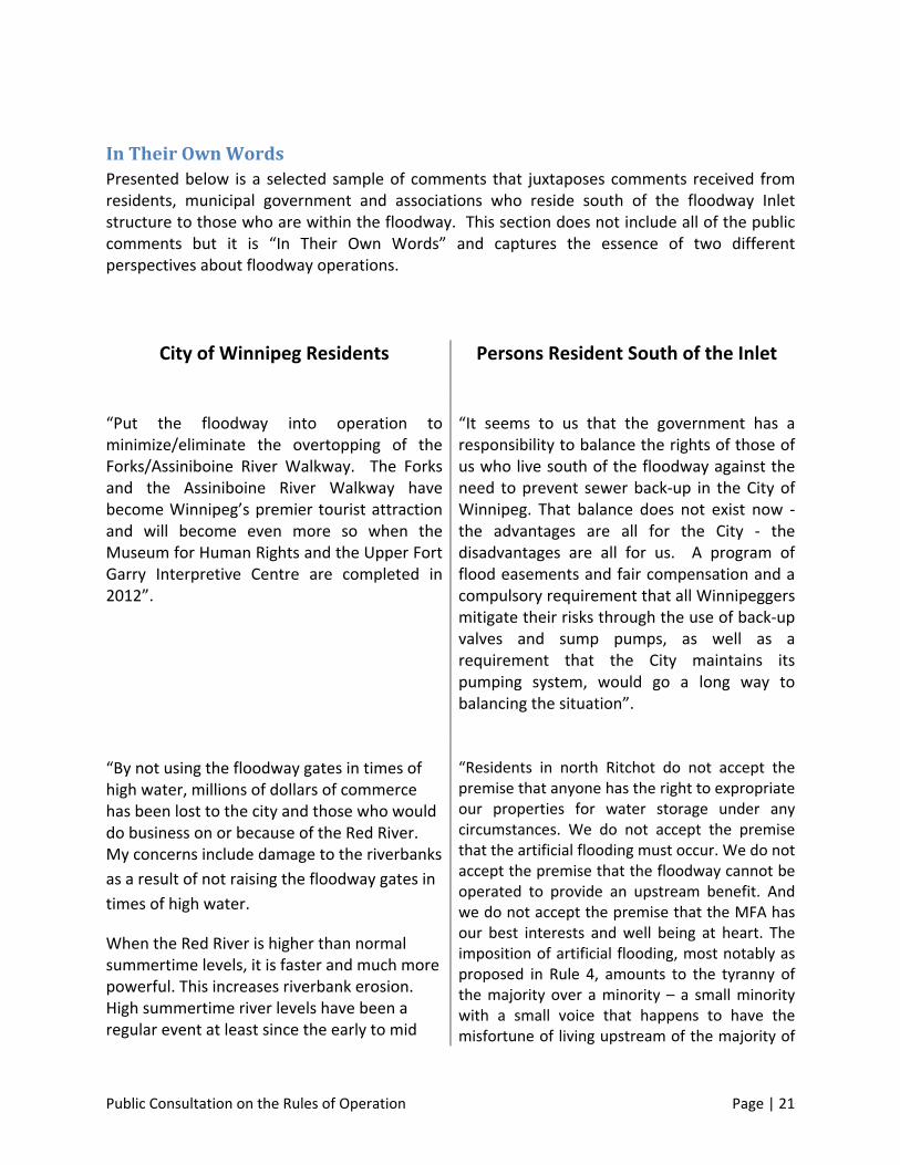
In Their Own Words Presented below is a selected sample of comments that juxtaposes comments received from residents, municipal government and associations who reside south of the floodway Inlet structure to those who are within the floodway. This section does not include all of the public comments but it is “In Their Own Words” and captures the essence of two different perspectives about floodway operations.
City of Winnipeg Residents
Persons Resident South of the Inlet
“Put the floodway into operation to minimize/eliminate the overtopping of the Forks/Assiniboine River Walkway. The Forks and the Assiniboine River Walkway have become Winnipeg’s premier tourist attraction and will become even more so when the Museum for Human Rights and the Upper Fort Garry Interpretive Centre are completed in 2012”.
“It seems to us that the government has a responsibility to balance the rights of those of us who live south of the floodway against the need to prevent sewer back‐up in the City of Winnipeg. That balance does not exist now ‐ the advantages are all for the City ‐ the disadvantages are all for us. A program of flood easements and fair compensation and a compulsory requirement that all Winnipeggers mitigate their risks through the use of back‐up valves and sump pumps, as well as a requirement that the City maintains its pumping system, would go a long way to balancing the situation”.
“By not using the floodway gates in times of high water, millions of dollars of commerce has been lost to the city and those who would do business on or because of the Red River. My concerns include damage to the riverbanks
as a result of not raising the floodway gates in
times of high water.
When the Red River is higher than normal summertime levels, it is faster and much more powerful. This increases riverbank erosion. High summertime river levels have been a regular event at least since the early to mid
“Residents in north Ritchot do not accept the premise that anyone has the right to expropriate our properties for water storage under any circumstances. We do not accept the premise that the artificial flooding must occur. We do not accept the premise that the floodway cannot be operated to provide an upstream benefit. And we do not accept the premise that the MFA has our best interests and well being at heart. The imposition of artificial flooding, most notably as proposed in Rule 4, amounts to the tyranny of the majority over a minority – a small minority with a small voice that happens to have the misfortune of living upstream of the majority of
Public Consultation on the Rules of Operation Page | 22
90’s. If the Province employed a different approach for use of the floodway in the summertime, riverbank erosion would be lessened, our riverbanks would have an opportunity to be reforested, and the costs to maintain and repair would be lessened by millions of dollars.”
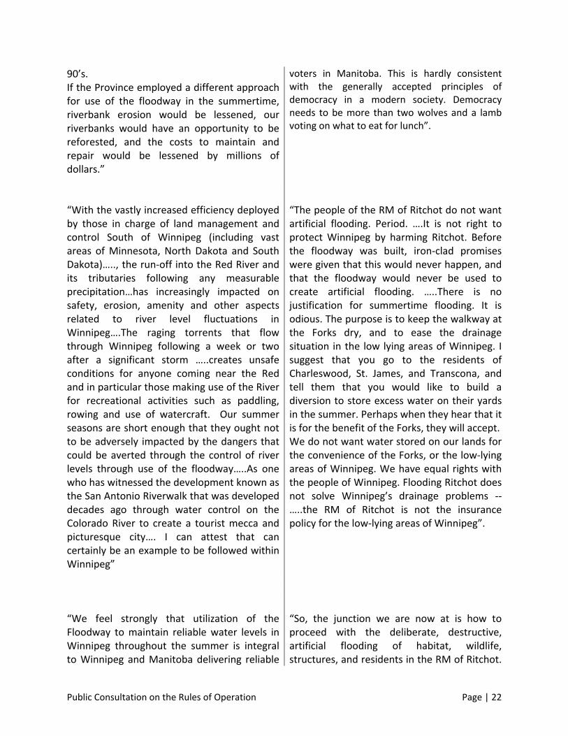
voters in Manitoba. This is hardly consistent with the generally accepted principles of democracy in a modern society. Democracy needs to be more than two wolves and a lamb voting on what to eat for lunch”.
“With the vastly increased efficiency deployed by those in charge of land management and control South of Winnipeg (including vast areas of Minnesota, North Dakota and South Dakota)….., the run‐off into the Red River and its tributaries following any measurable precipitation…has increasingly impacted on safety, erosion, amenity and other aspects related to river level fluctuations in Winnipeg….The raging torrents that flow through Winnipeg following a week or two after a significant storm …..creates unsafe conditions for anyone coming near the Red and in particular those making use of the River for recreational activities such as paddling, rowing and use of watercraft. Our summer seasons are short enough that they ought not to be adversely impacted by the dangers that could be averted through the control of river levels through use of the floodway…..As one who has witnessed the development known as the San Antonio Riverwalk that was developed decades ago through water control on the Colorado River to create a tourist mecca and picturesque city…. I can attest that can certainly be an example to be followed within Winnipeg”
“The people of the RM of Ritchot do not want artificial flooding. Period. ….It is not right to protect Winnipeg by harming Ritchot. Before the floodway was built, iron‐clad promises were given that this would never happen, and that the floodway would never be used to create artificial flooding. …..There is no justification for summertime flooding. It is odious. The purpose is to keep the walkway at the Forks dry, and to ease the drainage situation in the low lying areas of Winnipeg. I suggest that you go to the residents of Charleswood, St. James, and Transcona, and tell them that you would like to build a diversion to store excess water on their yards in the summer. Perhaps when they hear that it is for the benefit of the Forks, they will accept. We do not want water stored on our lands for the convenience of the Forks, or the low‐lying areas of Winnipeg. We have equal rights with the people of Winnipeg. Flooding Ritchot does not solve Winnipeg’s drainage problems ‐‐…..the RM of Ritchot is not the insurance policy for the low‐lying areas of Winnipeg”.
“We feel strongly that utilization of the Floodway to maintain reliable water levels in Winnipeg throughout the summer is integral to Winnipeg and Manitoba delivering reliable
“So, the junction we are now at is how to proceed with the deliberate, destructive, artificial flooding of habitat, wildlife, structures, and residents in the RM of Ritchot.
Public Consultation on the Rules of Operation Page | 23
tourism experiences. Attractions and activities such as our river walkways, Splash Dash Tours and river cruises rely on specific water levels. Frontiers North Adventures are strong supporters of Splash Dash Tours (with whom we've been working for 5+ years) and the Canadian Museum for Human Rights. In 2013, with the opening of the CMHR, tourist volumes in Winnipeg, specifically at The Forks, are expected to increase dramatically. Will we be ready? Also consider by this time the Assiniboine Park Zoo (potentially accessible by water) will be well underway with their $180 million redevelopment of the Park and Zoo. What sort of impression of Winnipeg will our guests receive if during mid‐summer The Forks are submerged under water and our Rivers are neither safe nor accessible? Currently tourism in Manitoba generates $480 million in export revenue, $238 million in provincial tax revenues and $64.9 million in Municipal tax revenues. 61% of tourists in Manitoba are other Manitobans. Revising the Floodway operations policy will positively affect tourism operations at the Forks and along our waterways. Active water‐level management will also improve the tourism experience we are able to deliver to the residents of our great City and Province. Please seriously consider this information in your protocol review”.
The long history of deception and distrust relating to flood issues in the impoundment area is well established. It is an unfortunate adversarial situation. Although there is a strong bias to embrace economic, technical, and engineering principles in pursuing flood protection issues, there must be a holistic grasp of how floodway operations really impact the upstream community. Humanity needs to be embraced. Information must be disclosed. Accountability for decisions has to be evident. The challenge at the feet of the Steering Committee is to create a meaningful outcome of this exercise which provides environmental integrity along with physical, financial, and emotional security to the upstream residents of the RM of Ritchot”.
“I believe the province must take action. An improved balance must be found for the use of the floodway during summertime months.”
“We already sacrifice our land, crops, peace of mind, business, income, time & attention, money & even access to our own homes during emergency spring operations. The government cannot expect us to – nor be allowed to force us to endure floodgate operations during non‐spring water events.”
Public Consultation on the Rules of Operation Page | 24
In Their Own Words (cont’d) North of the Floodway “The rural Municipality [St. Clements] has been one of the most affected by the Red River Floodway. The floodway cuts the southern part of the RM in two, creating numerous servicing issues and greatly reducing our ability to subdivide properties east of the project. We have lost a good portion of our most valuable property to make way for the floodway with nothing in return.” “Dunning Crossing connects the Pineridge trailer park (400 plus homes) and numerous “east of Highway 59” properties to Henderson Highway. The crossing is heavily used throughout the year. Each instance the floodway gates are opened results in this road being lost to the public. Once the water has receded the RM is responsible to restore the road to a useable condition. It is for this reason we oppose increased operation of the floodway outside of its current licencing requirements” “The first problem we had was in 1996 when the opening of the floodway caused a surge of water against ice that was not ready to breakup causing a devastating ice jam for our area. The wall of water came and rose several feet in less than one hour. In 2004, again when the ice was not ready to move the floodway opening caused flooding in our area. In 2009 we had the same thing happen again.” “To us, the Floodway Rules if Operation appear to be more concerned with Winnipeggers and residents living upstream of the floodway inlet than residents such as us, in the north. …….. It is our opinion that the expansion of the floodway caused artificial flooding on our property. ………We request the following be added to the rules:
1. The floodway not be opened until river ice has broken and moved past Breezy Point …… 2. That an independent study be completed to review how the Floodway impacts residents
living north of the outlet 3. That portable dikes be made available ………. 4. That compensation …. programs …. be made available to all property owners.”
“This spring ……. we flooded for the third time in 13 years, the first being in 1996, when we were evacuated, via Zodiac, in the dead of night. ….. We had lived on this property for 30 years, were accustomed to spectacular river breakups, but only small amounts of water on the driveway for short periods of time. We had no warning of the impending disaster, which began occurring just six hours after the Floodway Gates were opened. A huge ice jam was the cause, for which we fault the Province in that the Floodway Gates had been opened before it was safe to do so given the ice had not broken up further north. Compensation did not come close to replacing what was lost.”
Public Consultation on the Rules of Operation Page | 25
“We believe that the Manitoba Floodway is, in large part, responsible for flooding in the south Breezy Point area.”
“We believe the Floodway negatively impacts us and we attribute our loss directly to its
expansion. It is unbelievable that we flooded in 2009 when we never flooded before and when
old timers who have lived in this area tell us our property had never flooded.”
“The Coalition for Flood Protection North of the Floodway has long maintained that the floodway operation affects downstream water events. These claims have consistently been discounted by officials within the Water Stewardship Branch and the Manitoba Floodway Authority. The Coalition has consistently maintained that the floodway impacts need to be first studied and understood, and then operational procedures established to minimize impacts. In order to accomplish this, better monitoring than exists today must first be established. Unfortunately it is the same government officials who consistently refuse to acknowledge that any floodway impacts exist, who would need to first champion the establishment of better monitoring, and then conduct the necessary reviews and studies to develop better operational procedures. Left to itself this is not likely to happen.”

APPENDIX A MANITOBA ENVIRONMENT ACT LICENCE & RULES OF OPERATION

APPENDIX B OPEN HOUSE ADVERTISEMENTS

APPENDIX C Internet Site
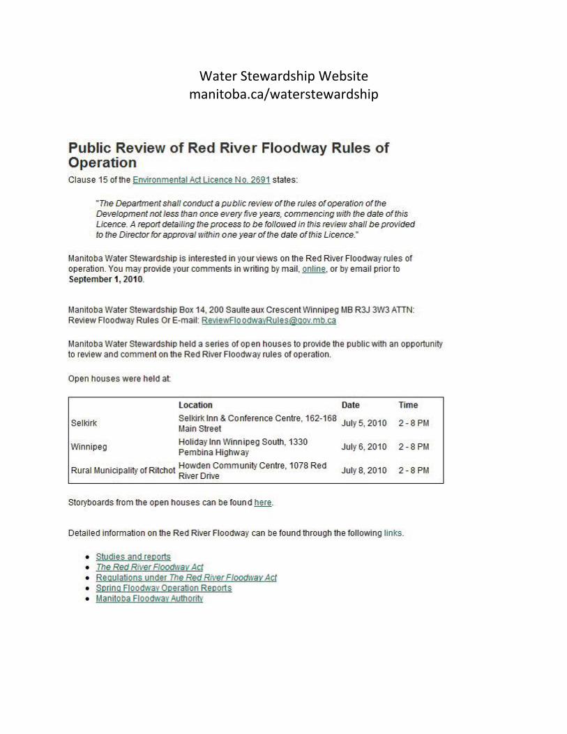
Water Stewardship Website manitoba.ca/waterstewardship

APPENDIX D OPEN HOUSE STORY BOARDS
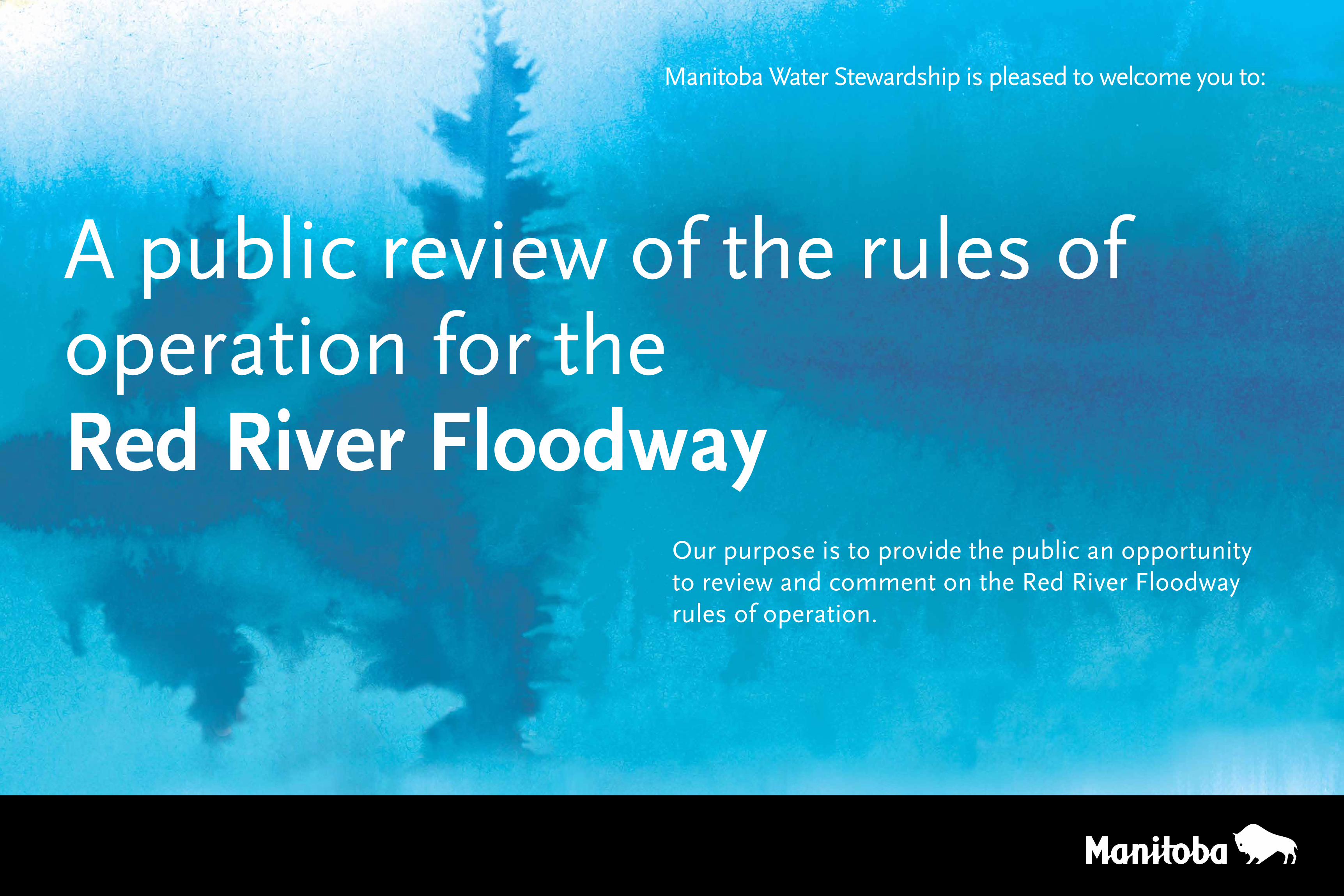
Manitoba Water Stewardship is pleased to welcome you to:
A public review of the rules of operation for the Red River Floodway
Our purpose is to provide the public an opportunity to review and comment on the Red River Floodway rules of operation.
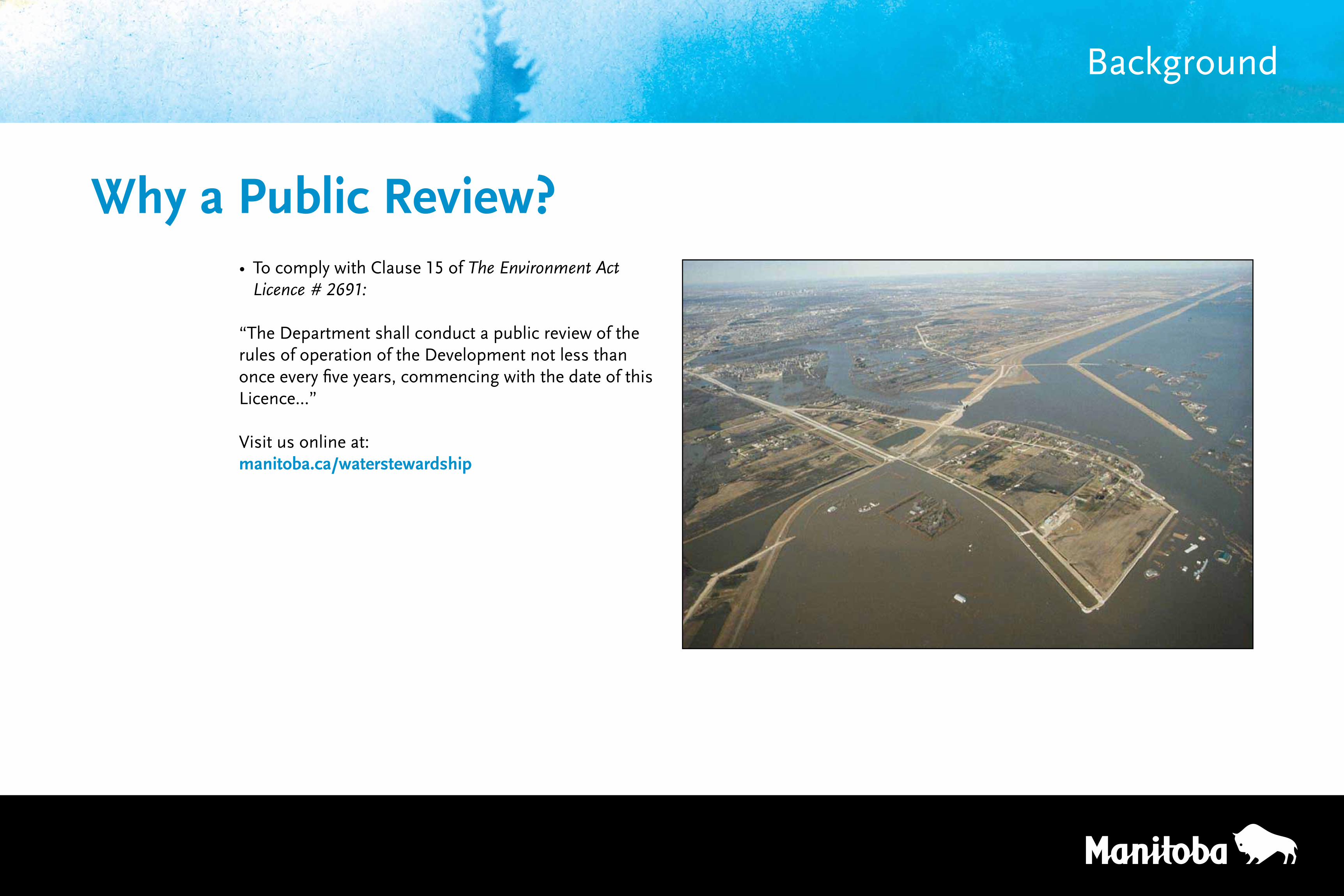
• To comply with Clause 15 of The Environment Act Licence # 2691:
“The Department shall conduct a public review of the rules of operation of the Development not less than once every five years, commencing with the date of this Licence...”
Visit us online at:manitoba.ca/waterstewardship
Why a Public Review?
Background
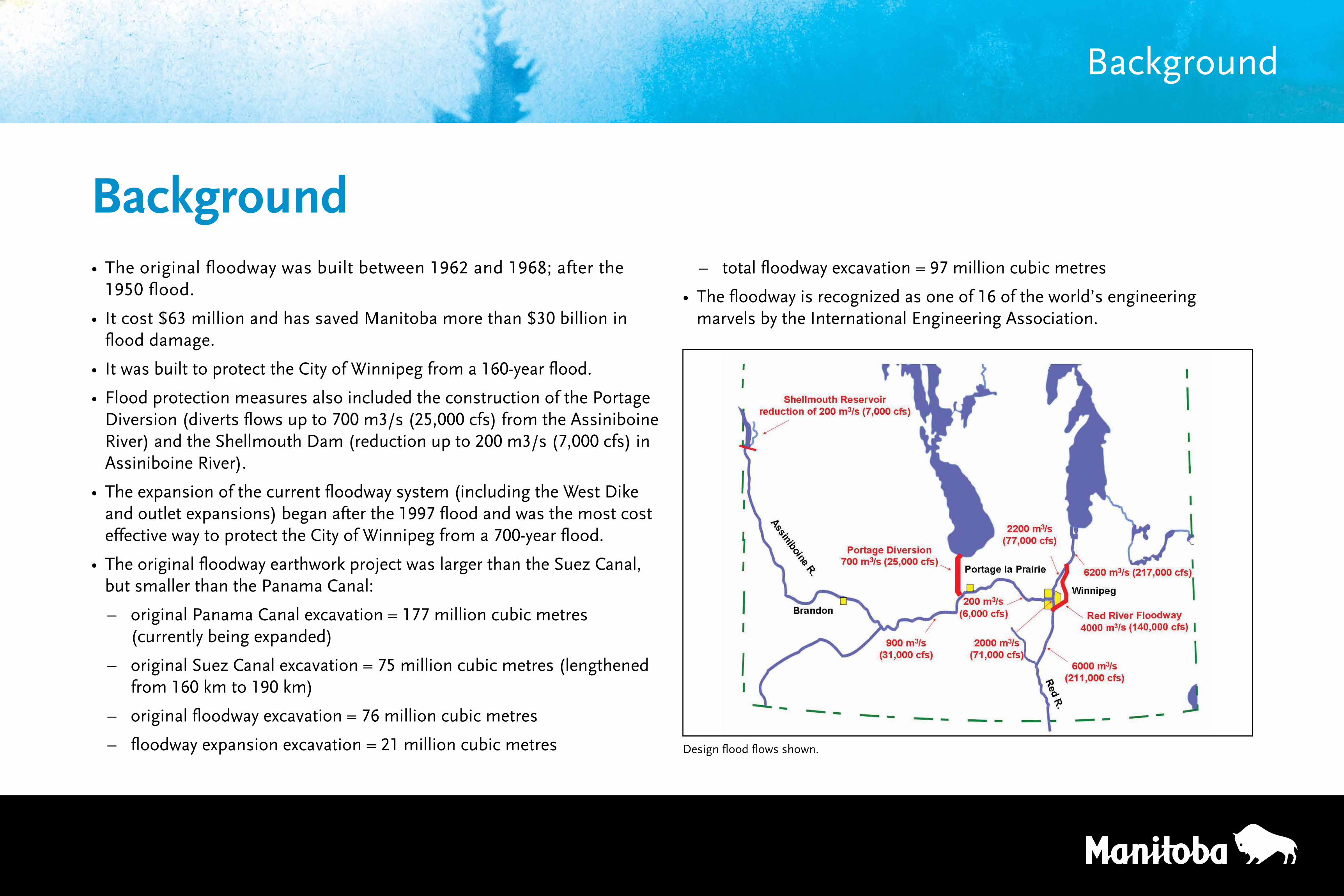
Background• The original floodway was built between 1962 and 1968; after the
1950 flood.
• It cost $63 million and has saved Manitoba more than $30 billion in flood damage.
• It was built to protect the City of Winnipeg from a 160-year flood.
• Flood protection measures also included the construction of the Portage Diversion (diverts flows up to 700 m3/s (25,000 cfs) from the Assiniboine River) and the Shellmouth Dam (reduction up to 200 m3/s (7,000 cfs) in Assiniboine River).
• The expansion of the current floodway system (including the West Dike and outlet expansions) began after the 1997 flood and was the most cost effective way to protect the City of Winnipeg from a 700-year flood.
• The original floodway earthwork project was larger than the Suez Canal, but smaller than the Panama Canal:
– original Panama Canal excavation = 177 million cubic metres (currently being expanded)
– original Suez Canal excavation = 75 million cubic metres (lengthened from 160 km to 190 km)
– original floodway excavation = 76 million cubic metres
– floodway expansion excavation = 21 million cubic metres
– total floodway excavation = 97 million cubic metres
• The floodway is recognized as one of 16 of the world’s engineering marvels by the International Engineering Association.
Background
Design flood flows shown.
Floodway outlet structure during 1997 flood
Floodway inlet control structure
Floodway Components
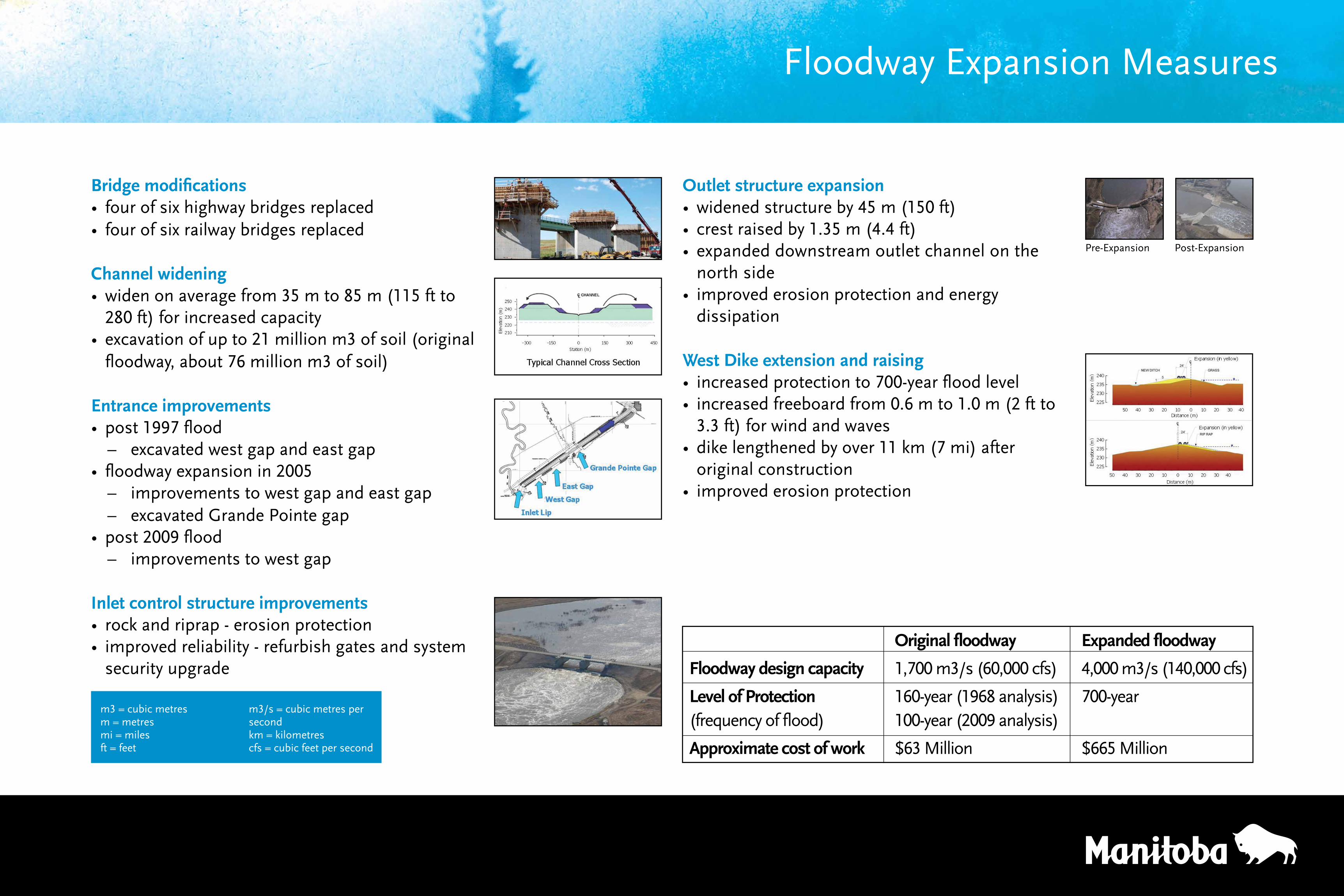
Original floodway Expanded floodway
Floodway design capacity 1,700 m3/s (60,000 cfs) 4,000 m3/s (140,000 cfs)
Level of Protection 160-year (1968 analysis) 700-year(frequencyofflood) 100-year(2009analysis)
Approximate cost of work $63 Million $665 Million
Bridge modifications• four of six highway bridges replaced• four of six railway bridges replaced
Channel widening• widen on average from 35 m to 85 m (115 ft to
280 ft) for increased capacity• excavation of up to 21 million m3 of soil (original
floodway, about 76 million m3 of soil)
Entrance improvements • post 1997 flood
– excavated west gap and east gap• floodway expansion in 2005
– improvements to west gap and east gap – excavated Grande Pointe gap
• post 2009 flood – improvements to west gap
Inlet control structure improvements• rock and riprap - erosion protection• improved reliability - refurbish gates and system
security upgrade
Outlet structure expansion• widened structure by 45 m (150 ft)• crest raised by 1.35 m (4.4 ft)• expanded downstream outlet channel on the
north side• improved erosion protection and energy
dissipation
West Dike extension and raising• increased protection to 700-year flood level• increased freeboard from 0.6 m to 1.0 m (2 ft to
3.3 ft) for wind and waves• dike lengthened by over 11 km (7 mi) after
original construction• improved erosion protection
m3 = cubic metresm = metresmi = milesft = feet
m3/s = cubic metres per secondkm = kilometrescfs = cubic feet per second
Pre-Expansion Post-Expansion
Floodway Expansion Measures
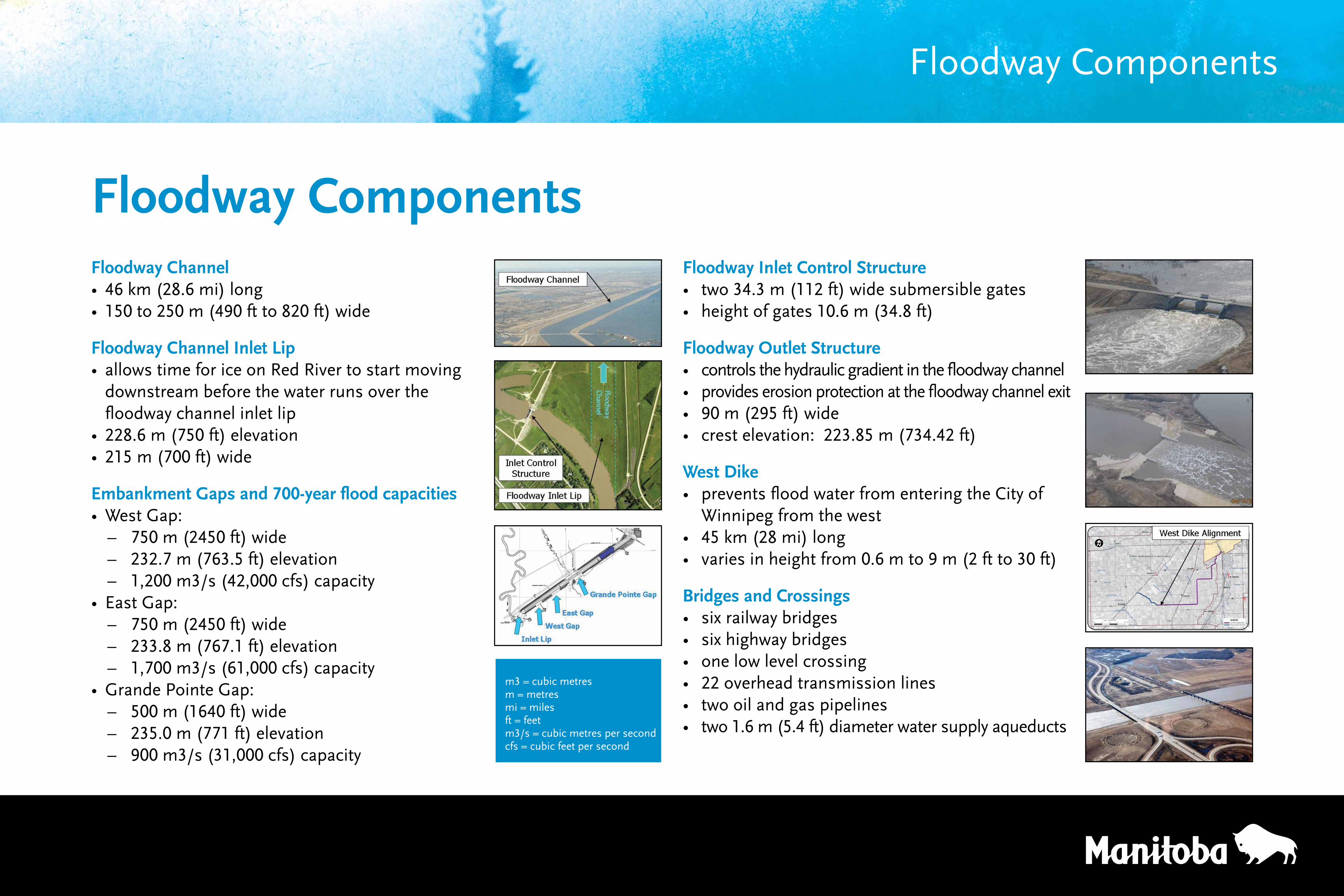
Floodway ComponentsFloodway Channel• 46 km (28.6 mi) long• 150 to 250 m (490 ft to 820 ft) wide
Floodway Channel Inlet Lip• allows time for ice on Red River to start moving
downstream before the water runs over the floodway channel inlet lip
• 228.6 m (750 ft) elevation• 215 m (700 ft) wide
Embankment Gaps and 700-year flood capacities• West Gap:
– 750 m (2450 ft) wide – 232.7 m (763.5 ft) elevation – 1,200 m3/s (42,000 cfs) capacity
• East Gap: – 750 m (2450 ft) wide – 233.8 m (767.1 ft) elevation – 1,700 m3/s (61,000 cfs) capacity
• Grande Pointe Gap: – 500 m (1640 ft) wide – 235.0 m (771 ft) elevation – 900 m3/s (31,000 cfs) capacity
Floodway Inlet Control Structure• two34.3m(112ft)widesubmersiblegates• heightofgates10.6m(34.8ft)
Floodway Outlet Structure• controlsthehydraulicgradientinthefloodwaychannel• provides erosion protection at the floodway channel exit• 90m(295ft)wide• crestelevation:223.85m(734.42ft)
West Dike • preventsfloodwaterfromenteringtheCityof Winnipeg from the west• 45km(28mi)long• variesinheightfrom0.6mto9m(2ftto30ft)
Bridges and Crossings• sixrailwaybridges• sixhighwaybridges• onelowlevelcrossing• 22overheadtransmissionlines• twooilandgaspipelines• two1.6m(5.4ft)diameterwatersupplyaqueducts
m3 = cubic metresm = metresmi = milesft = feetm3/s = cubic metres per secondcfs = cubic feet per second
Floodway Components
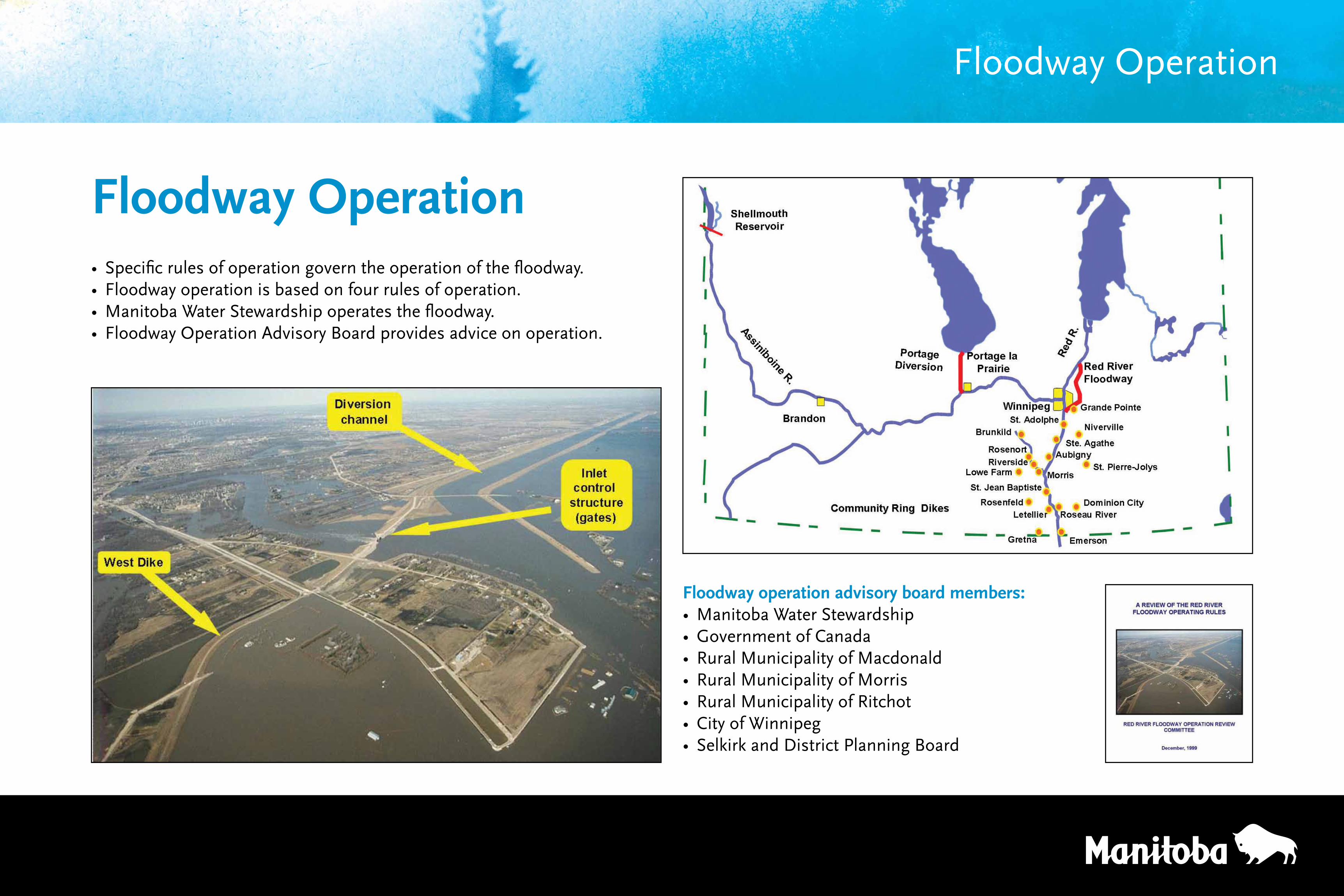
• Specific rules of operation govern the operation of the floodway.• Floodway operation is based on four rules of operation.• Manitoba Water Stewardship operates the floodway.• Floodway Operation Advisory Board provides advice on operation.
Floodway Operation
Floodway operation advisory board members:• Manitoba Water Stewardship• Government of Canada• Rural Municipality of Macdonald• Rural Municipality of Morris• Rural Municipality of Ritchot• City of Winnipeg• Selkirk and District Planning Board
Floodway Operation
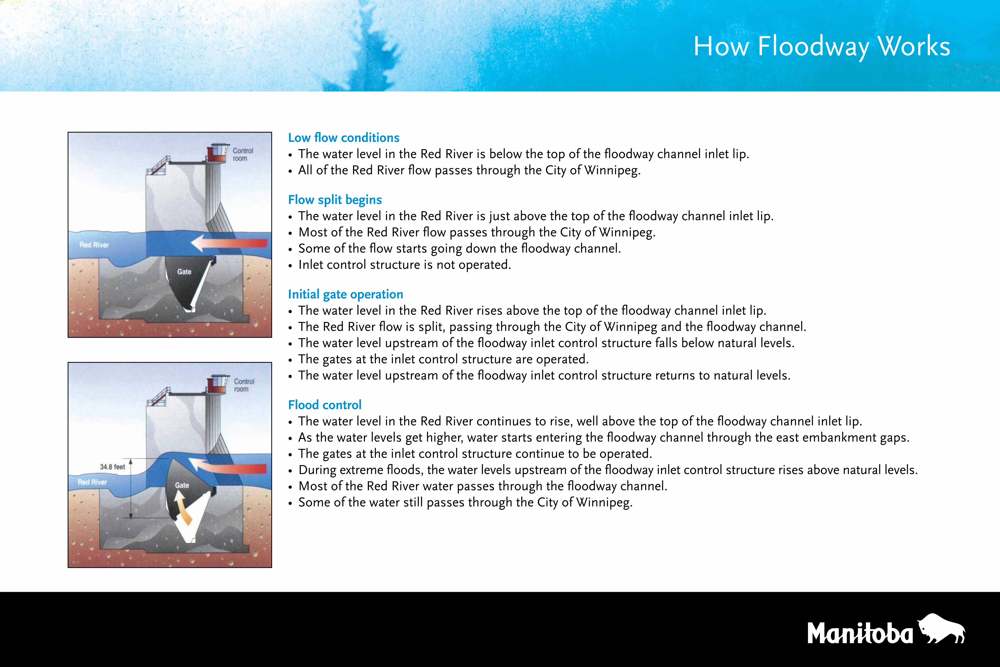
Low flow conditions• The water level in the Red River is below the top of the floodway channel inlet lip.• All of the Red River flow passes through the City of Winnipeg.
Flow split begins• The water level in the Red River is just above the top of the floodway channel inlet lip.• Most of the Red River flow passes through the City of Winnipeg.• Some of the flow starts going down the floodway channel.• Inlet control structure is not operated.
Initial gate operation• The water level in the Red River rises above the top of the floodway channel inlet lip.• The Red River flow is split, passing through the City of Winnipeg and the floodway channel.• The water level upstream of the floodway inlet control structure falls below natural levels.• The gates at the inlet control structure are operated.• The water level upstream of the floodway inlet control structure returns to natural levels.
Flood control• The water level in the Red River continues to rise, well above the top of the floodway channel inlet lip.• As the water levels get higher, water starts entering the floodway channel through the east embankment gaps.• The gates at the inlet control structure continue to be operated.• During extreme floods, the water levels upstream of the floodway inlet control structure rises above natural levels.• Most of the Red River water passes through the floodway channel.• Some of the water still passes through the City of Winnipeg.
How Floodway Works
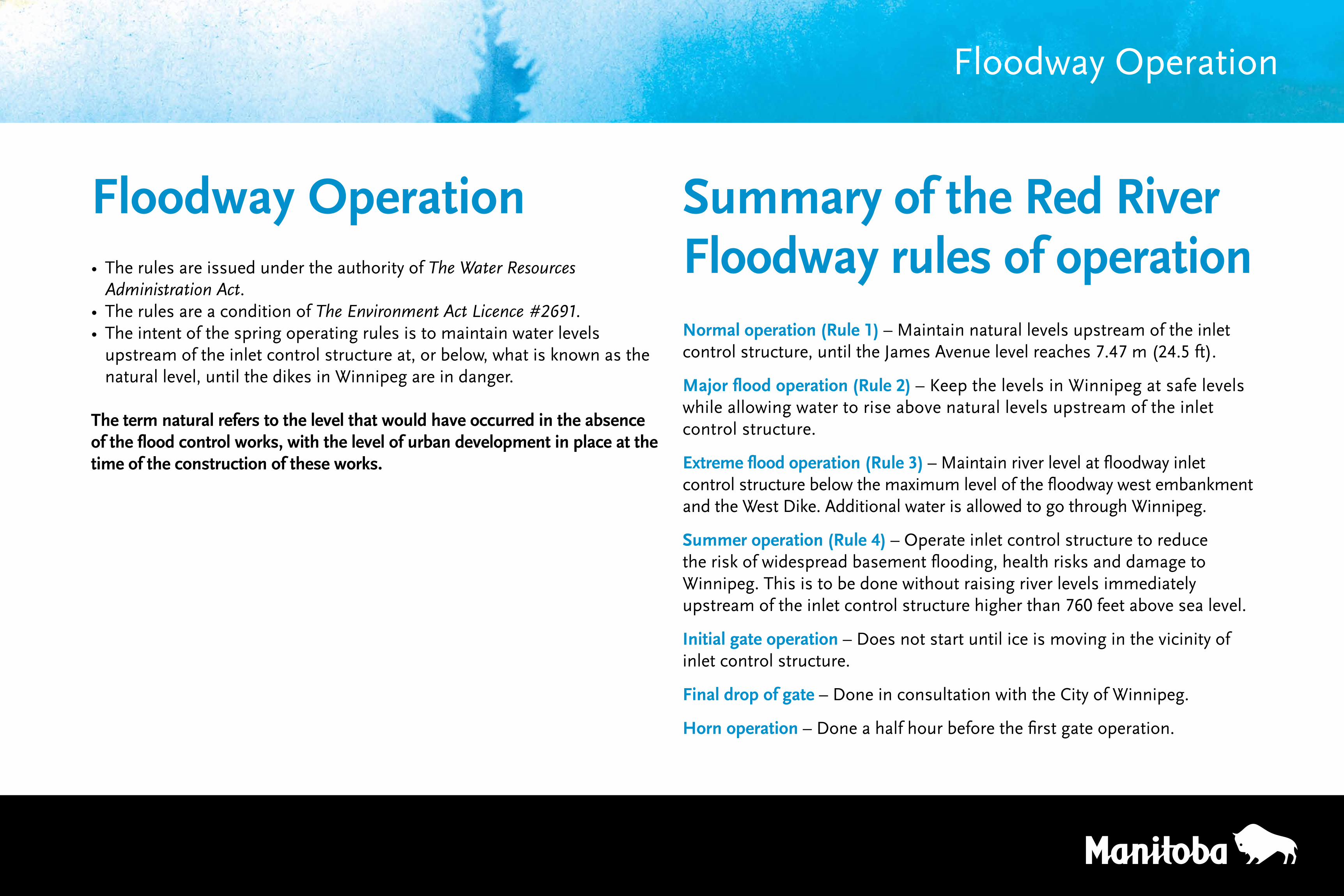
• The rules are issued under the authority of The Water Resources Administration Act.
• The rules are a condition of The Environment Act Licence #2691.• The intent of the spring operating rules is to maintain water levels
upstream of the inlet control structure at, or below, what is known as the natural level, until the dikes in Winnipeg are in danger.
The term natural refers to the level that would have occurred in the absence of the flood control works, with the level of urban development in place at the time of the construction of these works.
Floodway Operation
Floodway Operation Summary of the Red River Floodway rules of operationNormal operation (Rule 1) – Maintain natural levels upstream of the inlet control structure, until the James Avenue level reaches 7.47 m (24.5 ft).
Major flood operation (Rule 2) – Keep the levels in Winnipeg at safe levels while allowing water to rise above natural levels upstream of the inlet control structure.
Extreme flood operation (Rule 3) – Maintain river level at floodway inlet control structure below the maximum level of the floodway west embankment and the West Dike. Additional water is allowed to go through Winnipeg.
Summer operation (Rule 4) – Operate inlet control structure to reduce the risk of widespread basement flooding, health risks and damage to Winnipeg. This is to be done without raising river levels immediately upstream of the inlet control structure higher than 760 feet above sea level.
Initial gate operation – Does not start until ice is moving in the vicinity of inlet control structure.
Final drop of gate – Done in consultation with the City of Winnipeg.
Horn operation – Done a half hour before the first gate operation.
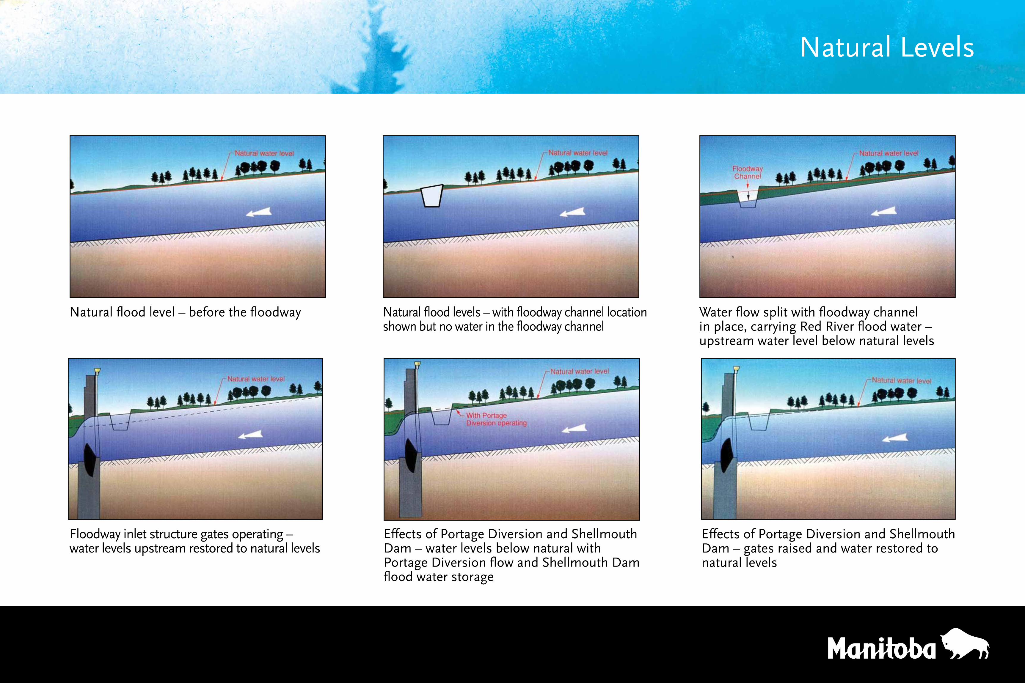
Natural flood level – before the floodway Natural flood levels – with floodway channel location shown but no water in the floodway channel
Floodway inlet structure gates operating – water levels upstream restored to natural levels
Effects of Portage Diversion and Shellmouth Dam – water levels below natural with Portage Diversion flow and Shellmouth Dam flood water storage
Water flow split with floodway channel in place, carrying Red River flood water – upstream water level below natural levels
Effects of Portage Diversion and Shellmouth Dam – gates raised and water restored to natural levels
Natural Levels
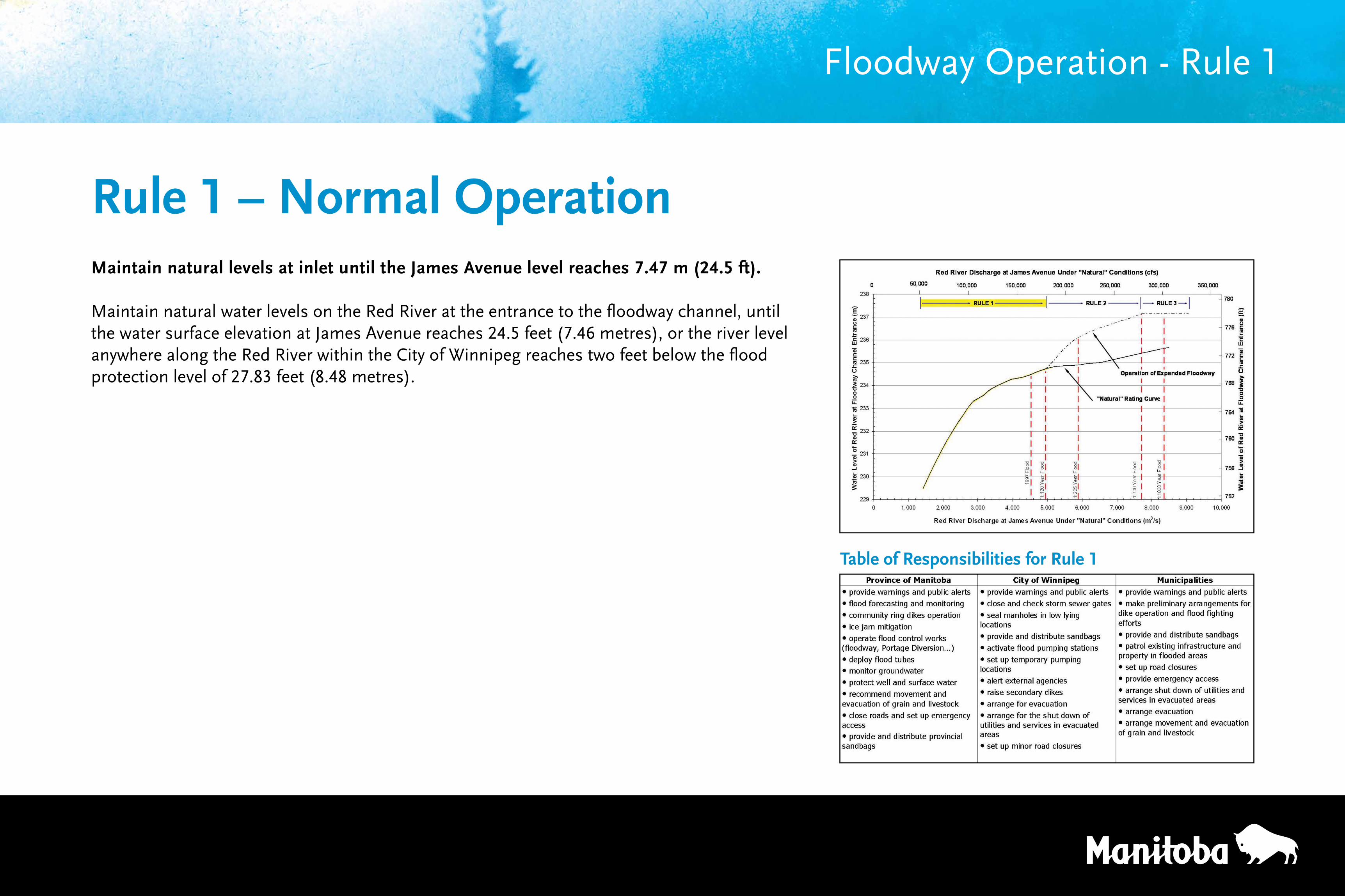
Maintain natural levels at inlet until the James Avenue level reaches 7.47 m (24.5 ft).
Maintain natural water levels on the Red River at the entrance to the floodway channel, until the water surface elevation at James Avenue reaches 24.5 feet (7.46 metres), or the river level anywhere along the Red River within the City of Winnipeg reaches two feet below the flood protection level of 27.83 feet (8.48 metres).
Floodway Operation - Rule 1
Rule 1 – Normal Operation
Table of Responsibilities for Rule 1
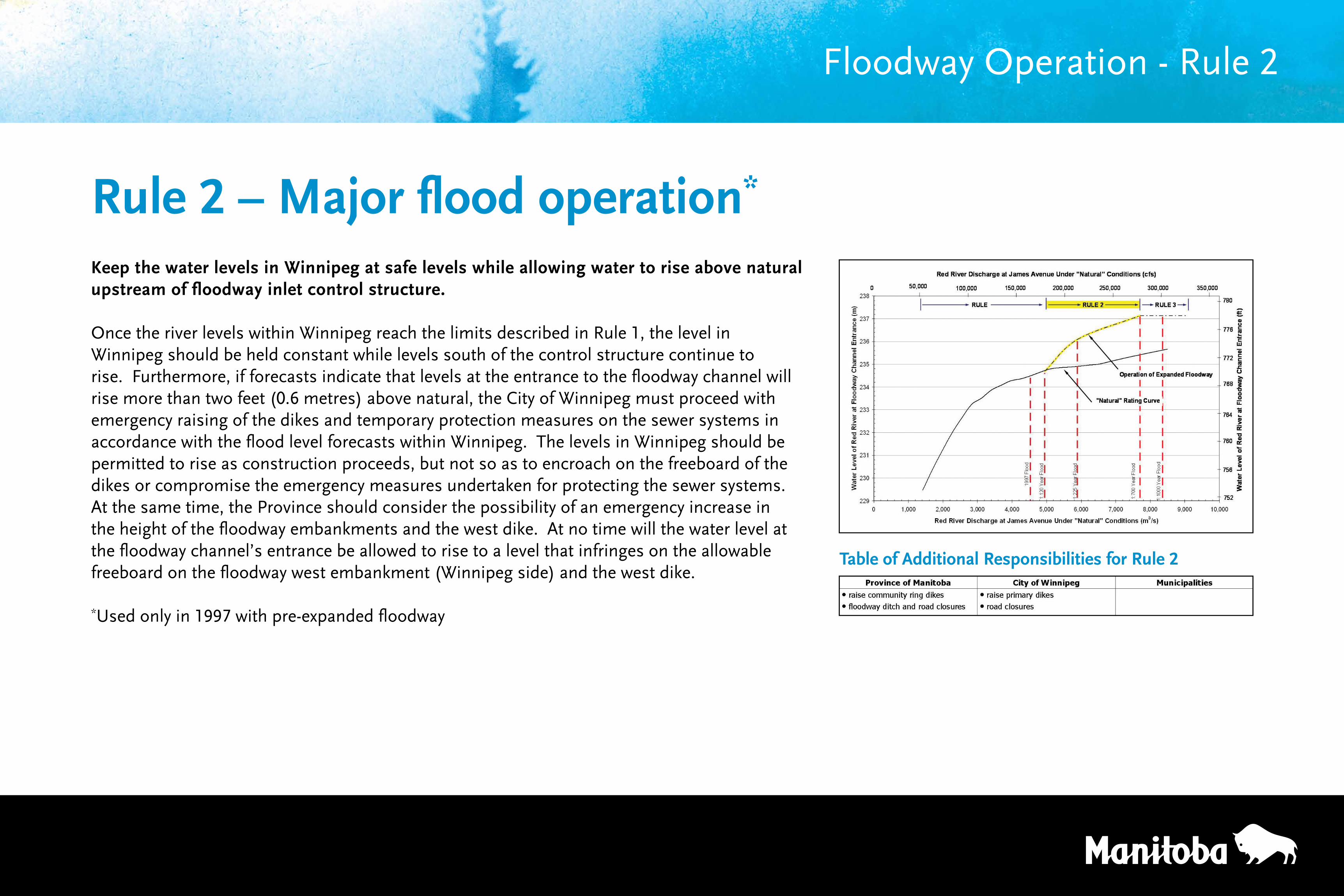
Keep the water levels in Winnipeg at safe levels while allowing water to rise above natural upstream of floodway inlet control structure.
Once the river levels within Winnipeg reach the limits described in Rule 1, the level in Winnipeg should be held constant while levels south of the control structure continue to rise. Furthermore, if forecasts indicate that levels at the entrance to the floodway channel will rise more than two feet (0.6 metres) above natural, the City of Winnipeg must proceed with emergency raising of the dikes and temporary protection measures on the sewer systems in accordance with the flood level forecasts within Winnipeg. The levels in Winnipeg should be permitted to rise as construction proceeds, but not so as to encroach on the freeboard of the dikes or compromise the emergency measures undertaken for protecting the sewer systems. At the same time, the Province should consider the possibility of an emergency increase in the height of the floodway embankments and the west dike. At no time will the water level at the floodway channel’s entrance be allowed to rise to a level that infringes on the allowable freeboard on the floodway west embankment (Winnipeg side) and the west dike.
*Used only in 1997 with pre-expanded floodway
Floodway Operation - Rule 2
Rule 2 – Major flood operation*
Table of Additional Responsibilities for Rule 2
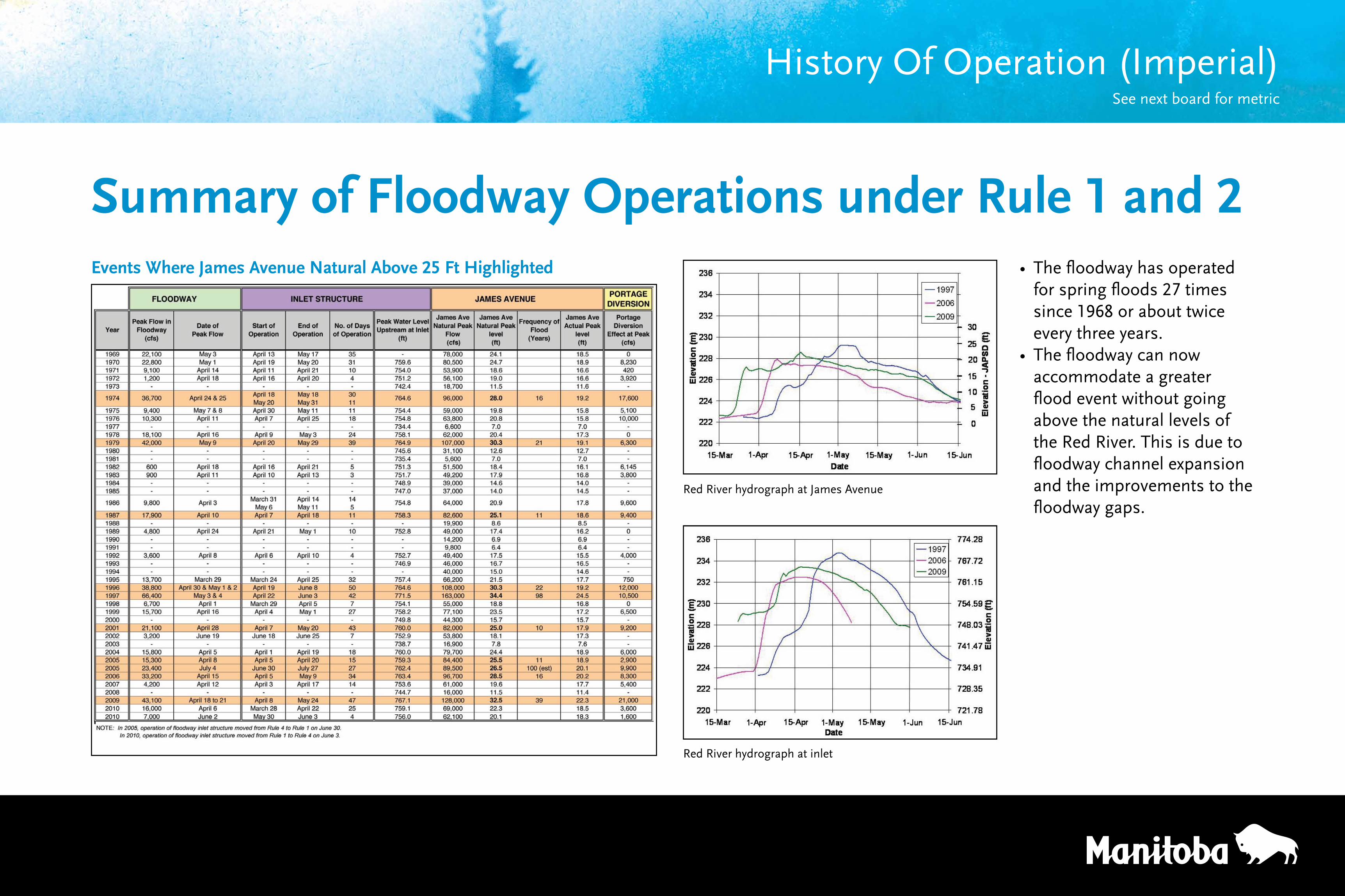
Summary of Floodway Operations under Rule 1 and 2• The floodway has operated
for spring floods 27 times since 1968 or about twice every three years.
• The floodway can now accommodate a greater flood event without going above the natural levels of the Red River. This is due to floodway channel expansion and the improvements to the floodway gaps.
Events Where James Avenue Natural Above 25 Ft Highlighted
Red River hydrograph at James Avenue
Red River hydrograph at inlet
History Of Operation (Imperial)See next board for metric
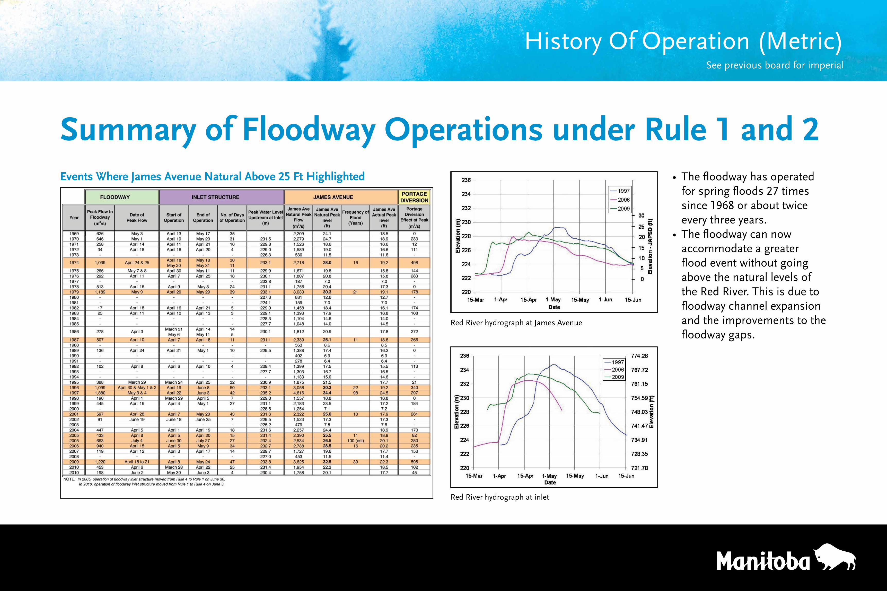
Summary of Floodway Operations under Rule 1 and 2• The floodway has operated
for spring floods 27 times since 1968 or about twice every three years.
• The floodway can now accommodate a greater flood event without going above the natural levels of the Red River. This is due to floodway channel expansion and the improvements to the floodway gaps.
Red River hydrograph at James Avenue
Red River hydrograph at inlet
History Of Operation (Metric) See previous board for imperial
Events Where James Avenue Natural Above 25 Ft Highlighted
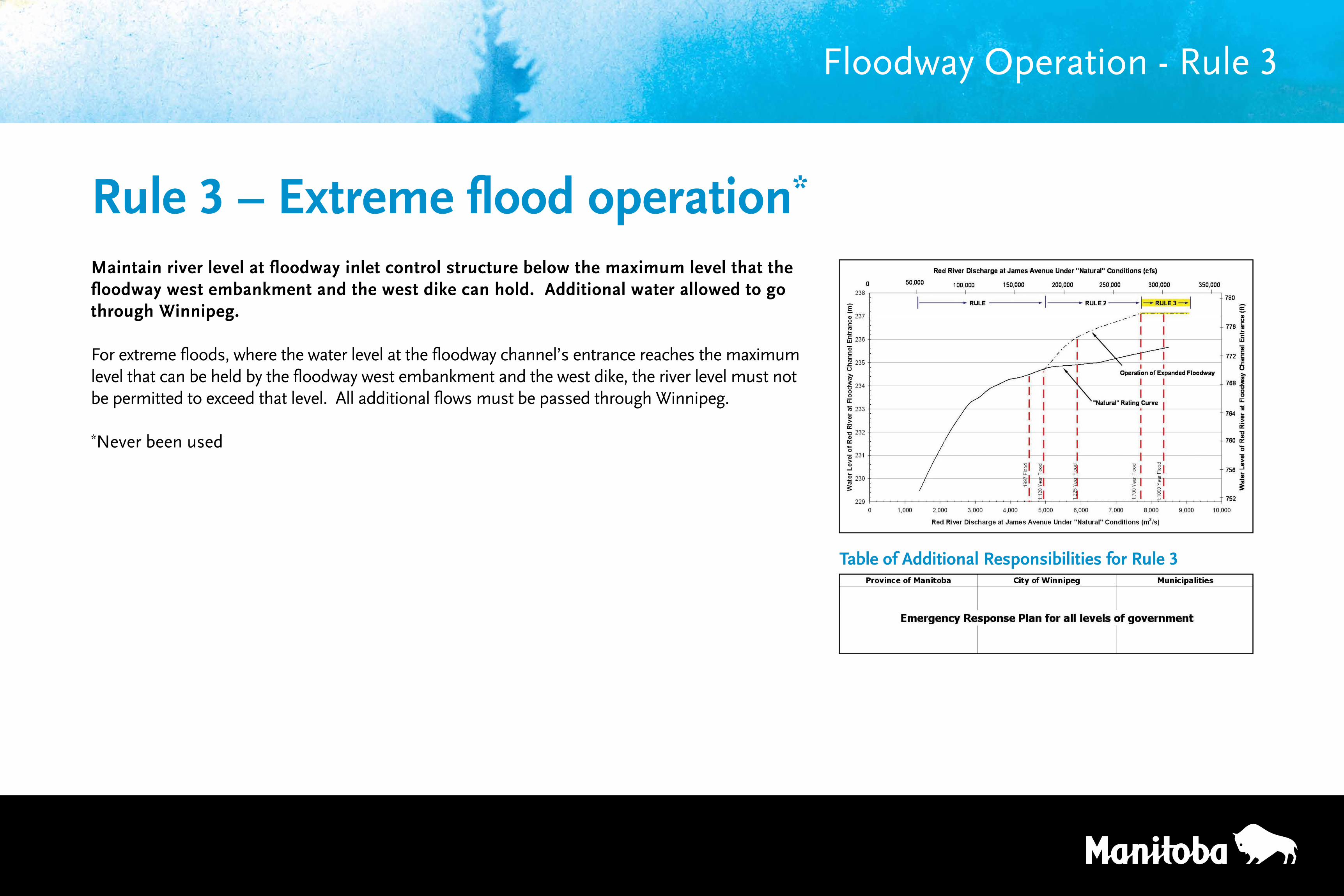
Maintain river level at floodway inlet control structure below the maximum level that the floodway west embankment and the west dike can hold. Additional water allowed to go through Winnipeg.
For extreme floods, where the water level at the floodway channel’s entrance reaches the maximum level that can be held by the floodway west embankment and the west dike, the river level must not be permitted to exceed that level. All additional flows must be passed through Winnipeg.
*Never been used
Floodway Operation - Rule 3
Rule 3 – Extreme flood operation*
Table of Additional Responsibilities for Rule 3
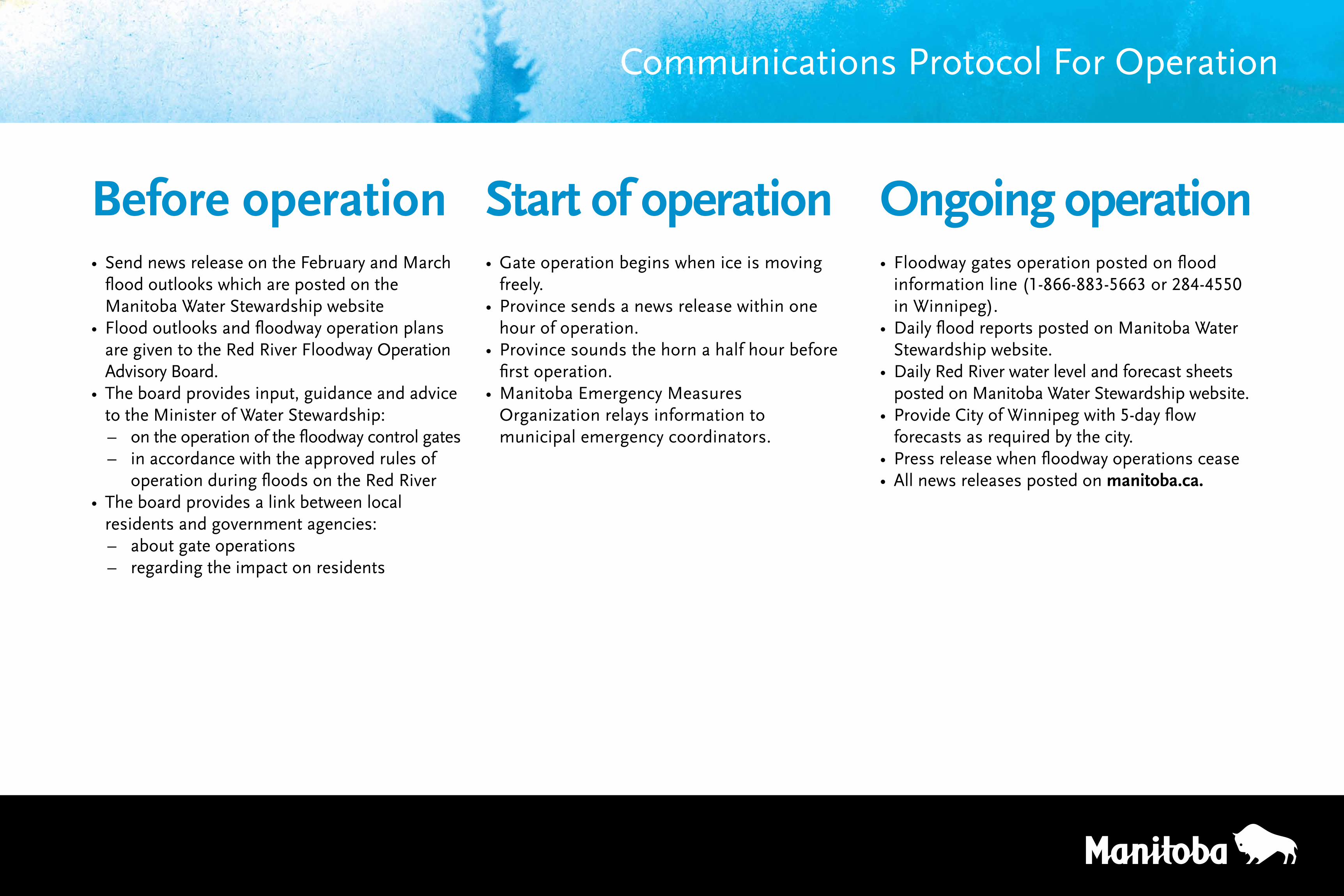
Communications Protocol For Operation
Before operation • Send news release on the February and March
flood outlooks which are posted on the Manitoba Water Stewardship website
• Flood outlooks and floodway operation plans are given to the Red River Floodway Operation Advisory Board.
• The board provides input, guidance and advice to the Minister of Water Stewardship:
– on the operation of the floodway control gates – in accordance with the approved rules of
operation during floods on the Red River • The board provides a link between local
residents and government agencies: – about gate operations – regarding the impact on residents
Start of operation• Gate operation begins when ice is moving
freely. • Province sends a news release within one
hour of operation.• Province sounds the horn a half hour before
first operation.• Manitoba Emergency Measures
Organization relays information to municipal emergency coordinators.
Ongoing operation• Floodway gates operation posted on flood
information line (1-866-883-5663 or 284-4550 in Winnipeg).
• Daily flood reports posted on Manitoba Water Stewardship website.
• Daily Red River water level and forecast sheets posted on Manitoba Water Stewardship website.
• Provide City of Winnipeg with 5-day flow forecastsasrequiredbythecity.
• Press release when floodway operations cease• All news releases posted on manitoba.ca.
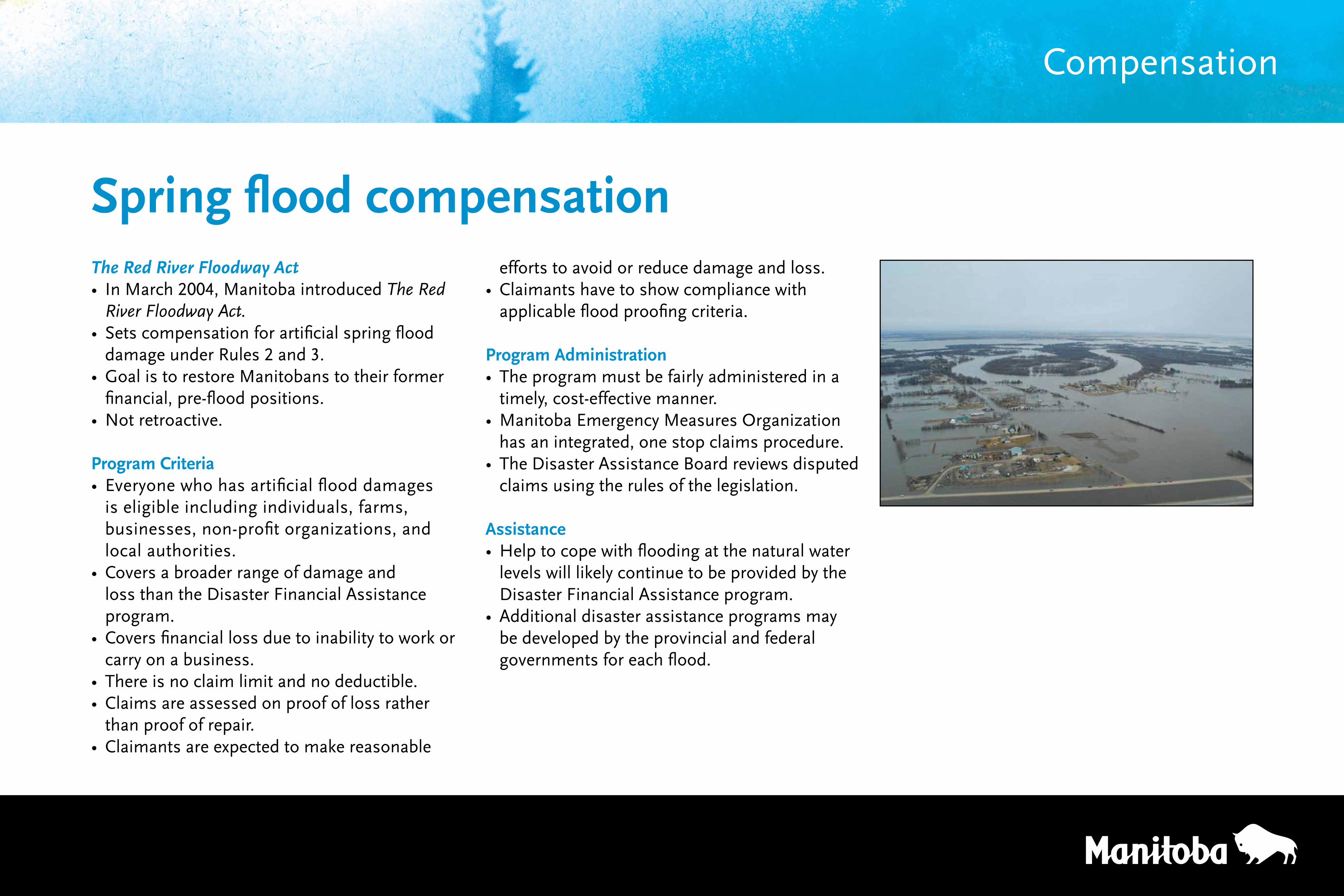
The Red River Floodway Act• In March 2004, Manitoba introduced The Red
River Floodway Act.• Sets compensation for artificial spring flood
damage under Rules 2 and 3.• Goal is to restore Manitobans to their former
financial, pre-flood positions.• Not retroactive.
Program Criteria• Everyone who has artificial flood damages
is eligible including individuals, farms, businesses, non-profit organizations, and local authorities.
• Covers a broader range of damage and loss than the Disaster Financial Assistance program.
• Covers financial loss due to inability to work or carry on a business.
• There is no claim limit and no deductible.• Claims are assessed on proof of loss rather
than proof of repair.• Claimants are expected to make reasonable
Spring flood compensationefforts to avoid or reduce damage and loss.
• Claimants have to show compliance with applicable flood proofing criteria.
Program Administration• The program must be fairly administered in a
timely, cost-effective manner.• Manitoba Emergency Measures Organization
has an integrated, one stop claims procedure.• The Disaster Assistance Board reviews disputed
claims using the rules of the legislation.
Assistance• Help to cope with flooding at the natural water
levels will likely continue to be provided by the Disaster Financial Assistance program.
• Additional disaster assistance programs may be developed by the provincial and federal governments for each flood.
Compensation
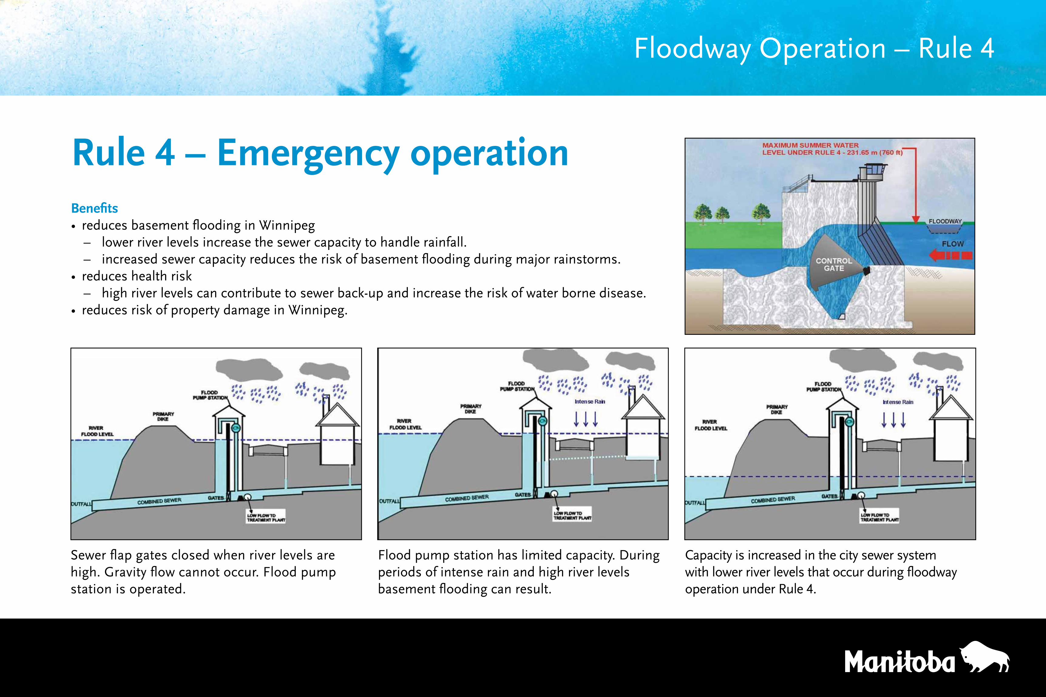
Benefits• reduces basement flooding in Winnipeg
– lower river levels increase the sewer capacity to handle rainfall. – increased sewer capacity reduces the risk of basement flooding during major rainstorms.
• reduces health risk – high river levels can contribute to sewer back-up and increase the risk of water borne disease.
• reduces risk of property damage in Winnipeg.
Rule 4 – Emergency operation
Floodway Operation – Rule 4
Sewer flap gates closed when river levels are high. Gravity flow cannot occur. Flood pump station is operated.
Flood pump station has limited capacity. During periods of intense rain and high river levels basement flooding can result.
Capacity is increased in the city sewer system with lower river levels that occur during floodway operation under Rule 4.
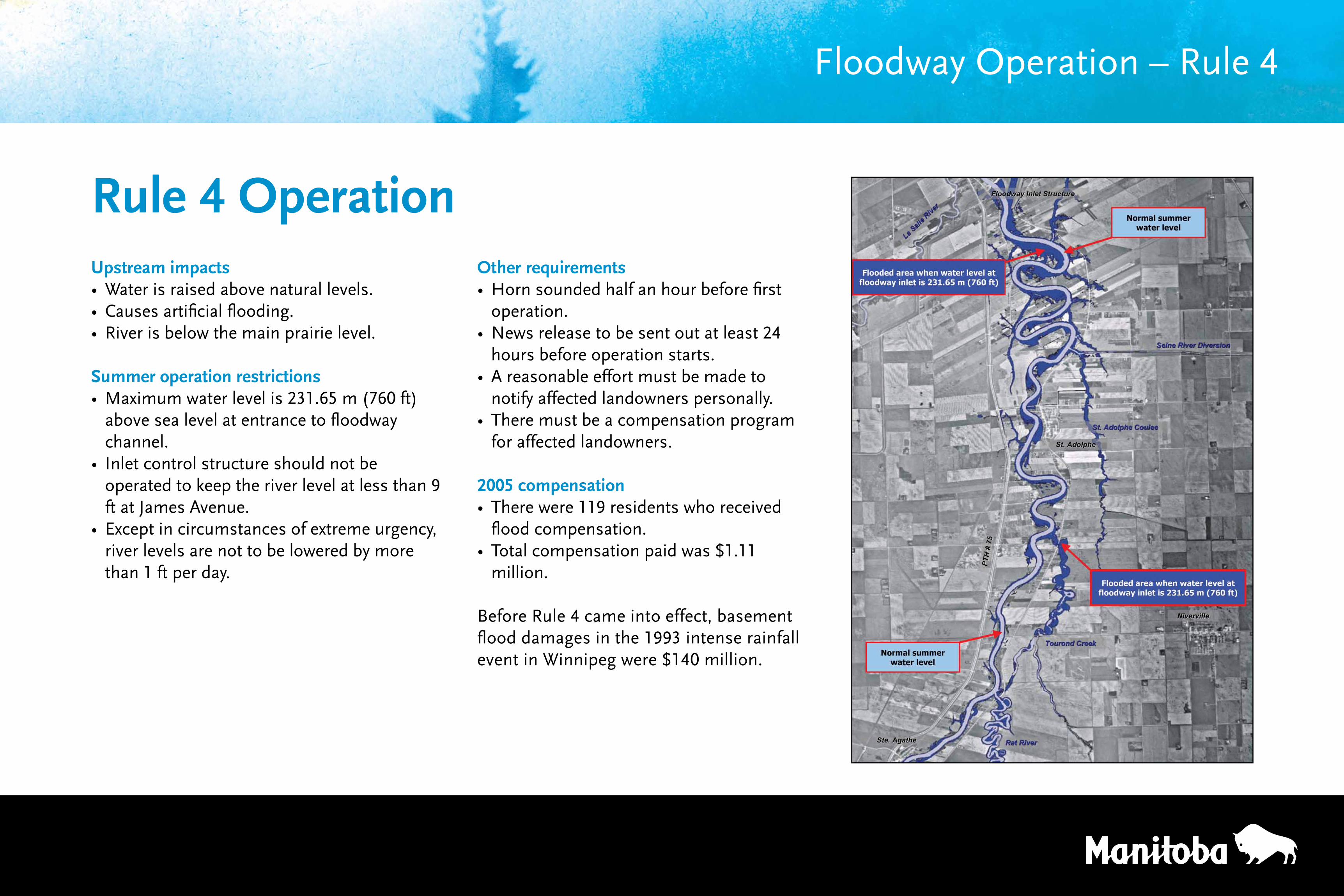
Upstream impacts• Water is raised above natural levels.• Causes artificial flooding. • River is below the main prairie level.
Summer operation restrictions• Maximum water level is 231.65 m (760 ft)
above sea level at entrance to floodway channel.
• Inlet control structure should not be operated to keep the river level at less than 9 ft at James Avenue.
• Except in circumstances of extreme urgency, river levels are not to be lowered by more than 1 ft per day.
Rule 4 Operation
Floodway Operation – Rule 4
Other requirements• Horn sounded half an hour before first
operation.• News release to be sent out at least 24
hours before operation starts.• A reasonable effort must be made to
notify affected landowners personally.• There must be a compensation program
for affected landowners.
2005 compensation• There were 119 residents who received
flood compensation.• Total compensation paid was $1.11
million.
Before Rule 4 came into effect, basement flood damages in the 1993 intense rainfall event in Winnipeg were $140 million.
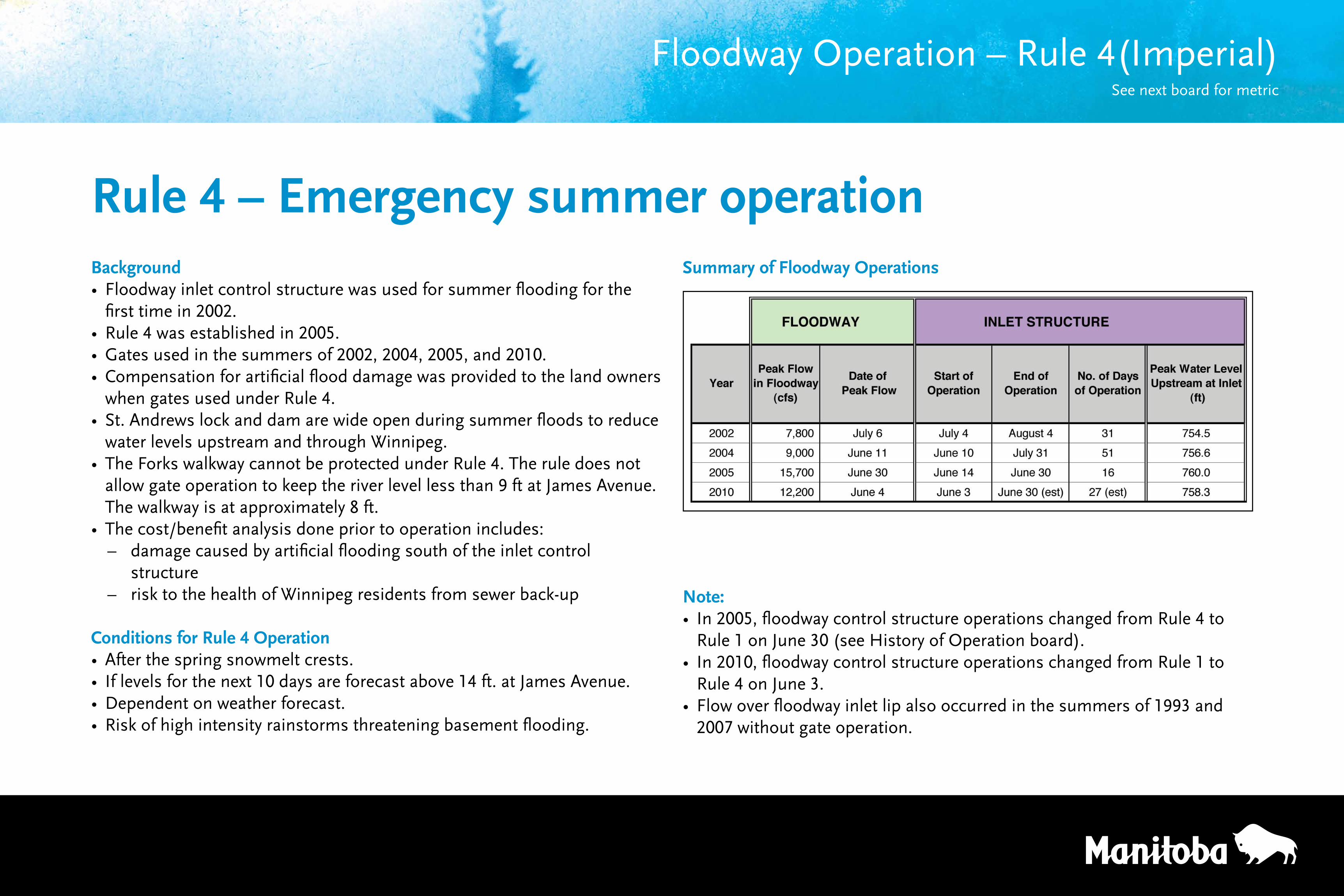
Background• Floodway inlet control structure was used for summer flooding for the
first time in 2002.• Rule 4 was established in 2005.• Gates used in the summers of 2002, 2004, 2005, and 2010.• Compensation for artificial flood damage was provided to the land owners
when gates used under Rule 4.• St. Andrews lock and dam are wide open during summer floods to reduce
water levels upstream and through Winnipeg.• The Forks walkway cannot be protected under Rule 4. The rule does not
allow gate operation to keep the river level less than 9 ft at James Avenue. The walkway is at approximately 8 ft.
• The cost/benefit analysis done prior to operation includes: – damage caused by artificial flooding south of the inlet control
structure – risk to the health of Winnipeg residents from sewer back-up
Conditions for Rule 4 Operation• After the spring snowmelt crests.• If levels for the next 10 days are forecast above 14 ft. at James Avenue.• Dependent on weather forecast.• Risk of high intensity rainstorms threatening basement flooding.
Floodway Operation – Rule 4(Imperial)See next board for metric
Rule 4 – Emergency summer operationSummary of Floodway Operations
Note: • In 2005, floodway control structure operations changed from Rule 4 to
Rule 1 on June 30 (see History of Operation board).• In 2010, floodway control structure operations changed from Rule 1 to
Rule 4 on June 3.• Flow over floodway inlet lip also occurred in the summers of 1993 and
2007 without gate operation.
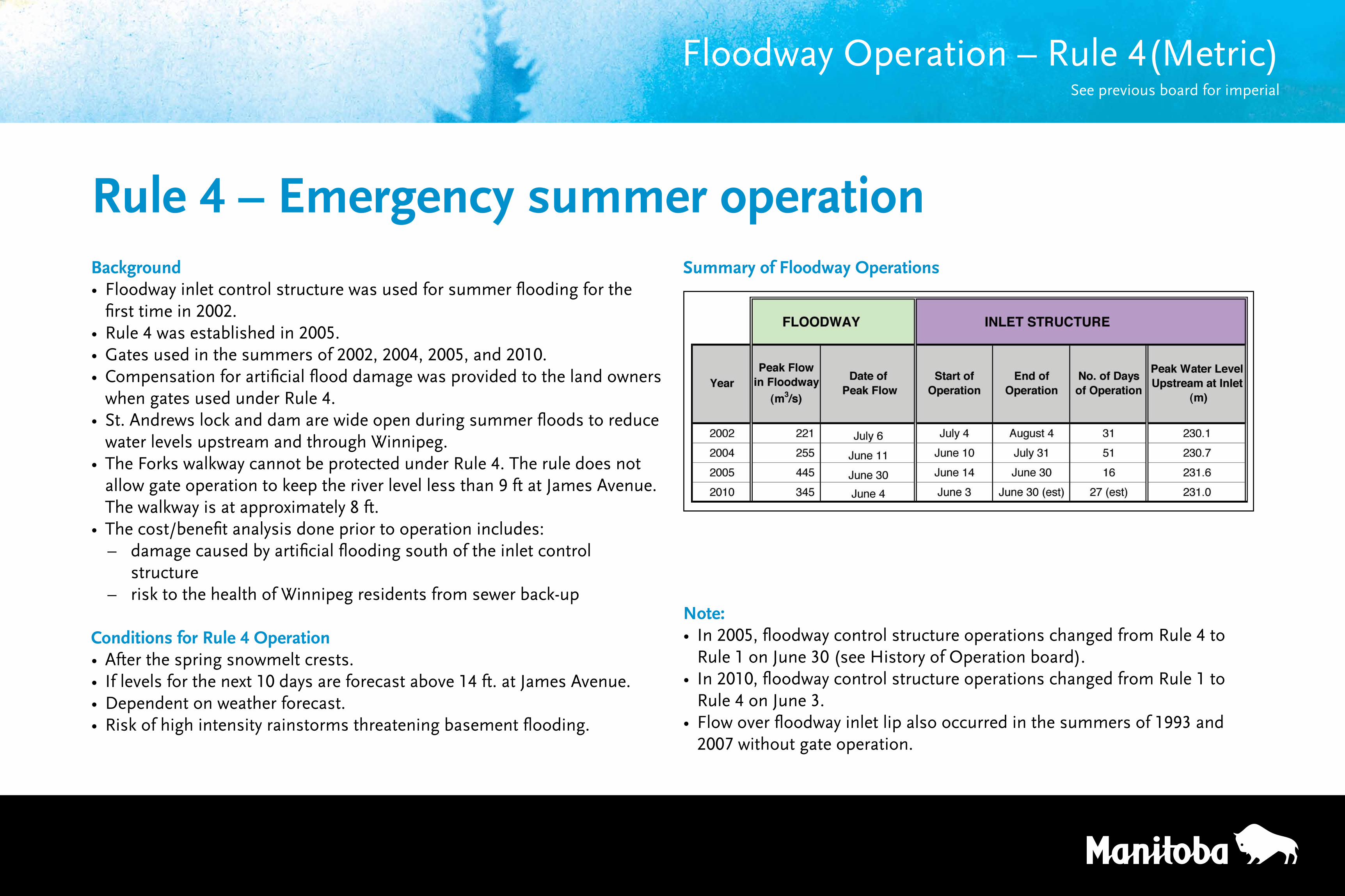
Background• Floodway inlet control structure was used for summer flooding for the
first time in 2002.• Rule 4 was established in 2005.• Gates used in the summers of 2002, 2004, 2005, and 2010.• Compensation for artificial flood damage was provided to the land owners
when gates used under Rule 4.• St. Andrews lock and dam are wide open during summer floods to reduce
water levels upstream and through Winnipeg.• The Forks walkway cannot be protected under Rule 4. The rule does not
allow gate operation to keep the river level less than 9 ft at James Avenue. The walkway is at approximately 8 ft.
• The cost/benefit analysis done prior to operation includes: – damage caused by artificial flooding south of the inlet control
structure – risk to the health of Winnipeg residents from sewer back-up
Conditions for Rule 4 Operation• After the spring snowmelt crests.• If levels for the next 10 days are forecast above 14 ft. at James Avenue.• Dependent on weather forecast.• Risk of high intensity rainstorms threatening basement flooding.
Rule 4 – Emergency summer operation
Note: • In 2005, floodway control structure operations changed from Rule 4 to
Rule 1 on June 30 (see History of Operation board).• In 2010, floodway control structure operations changed from Rule 1 to
Rule 4 on June 3.• Flow over floodway inlet lip also occurred in the summers of 1993 and
2007 without gate operation.
Floodway Operation – Rule 4(Metric)See previous board for imperial
Summary of Floodway Operations
Provincial flood outlook and forecast• The spring flood outlooks are issued the third
week of February and the third week of March.• City of Winnipeg flood outlooks are sent out as
needed.• Daily flood forecasts are widely distributed.
Environment Canada’s role • Manage the hydrometric gauging network. • Publish and archive hydrometric data.• Provide real-time hydrometric data.• Forecast the weather.
The City of Winnipeg Act• Regulates development within the floodway
fringe, which is the flood prone area outside the main flow path.
• Province designates flow areas along the rivers that are needed to convey the design flood flows through the city.
• No development that could impede the river flow is allowed in the designated flow area.
The Diking Commissioner Act• Ensures the primary dikes in Winnipeg are
maintained.• Requiresthatnewprimarydikesbebuiltto
provincial standards.
Supporting Regulations Programs and Activities
m = metresft = feet
The Water Resources Administration Act• Controls development in the designated flood
area south of Winnipeg (to the 1997 level plus 0.6 m (2 ft)).
• Allows operation and maintenance of community ring dikes, floodway, and other provincial flood control structures.
The Manitoba Floodway Authority Act• Allows floodway expansion.• Establishes responsibility for floodway
maintenance.
The Red River Floodway Act• Sets compensation for spring artificial flooding
(Rules 2 and 3).• Requirespreparationofanoperationreport
after each spring operation.
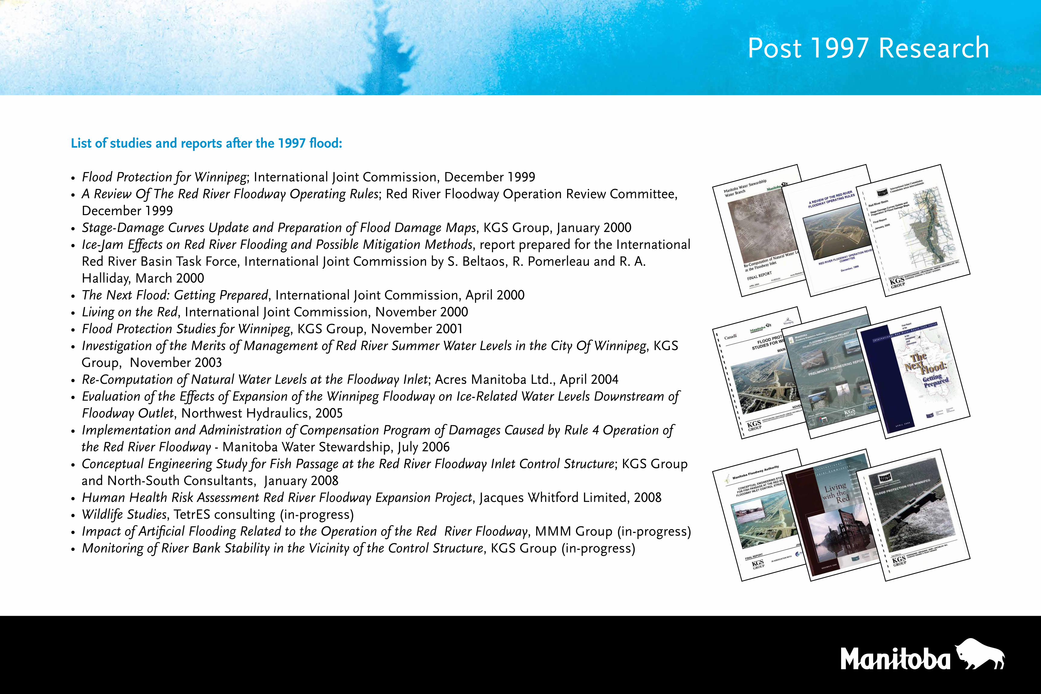
Post 1997 Research
List of studies and reports after the 1997 flood:
• Flood Protection for Winnipeg; International Joint Commission, December 1999• A Review Of The Red River Floodway Operating Rules; Red River Floodway Operation Review Committee,
December 1999• Stage-Damage Curves Update and Preparation of Flood Damage Maps, KGS Group, January 2000• Ice-Jam Effects on Red River Flooding and Possible Mitigation Methods, report prepared for the International
Red River Basin Task Force, International Joint Commission by S. Beltaos, R. Pomerleau and R. A. Halliday, March 2000
• The Next Flood: Getting Prepared, International Joint Commission, April 2000• Living on the Red, International Joint Commission, November 2000• Flood Protection Studies for Winnipeg, KGS Group, November 2001• Investigation of the Merits of Management of Red River Summer Water Levels in the City Of Winnipeg, KGS
Group, November 2003• Re-Computation of Natural Water Levels at the Floodway Inlet; Acres Manitoba Ltd., April 2004• Evaluation of the Effects of Expansion of the Winnipeg Floodway on Ice-Related Water Levels Downstream of
Floodway Outlet, Northwest Hydraulics, 2005• Implementation and Administration of Compensation Program of Damages Caused by Rule 4 Operation of
the Red River Floodway - Manitoba Water Stewardship, July 2006• Conceptual Engineering Study for Fish Passage at the Red River Floodway Inlet Control Structure; KGS Group
and North-South Consultants, January 2008• Human Health Risk Assessment Red River Floodway Expansion Project,JacquesWhitfordLimited,2008• Wildlife Studies, TetrES consulting (in-progress)• Impact of Artificial Flooding Related to the Operation of the Red River Floodway, MMM Group (in-progress)• Monitoring of River Bank Stability in the Vicinity of the Control Structure, KGS Group (in-progress)
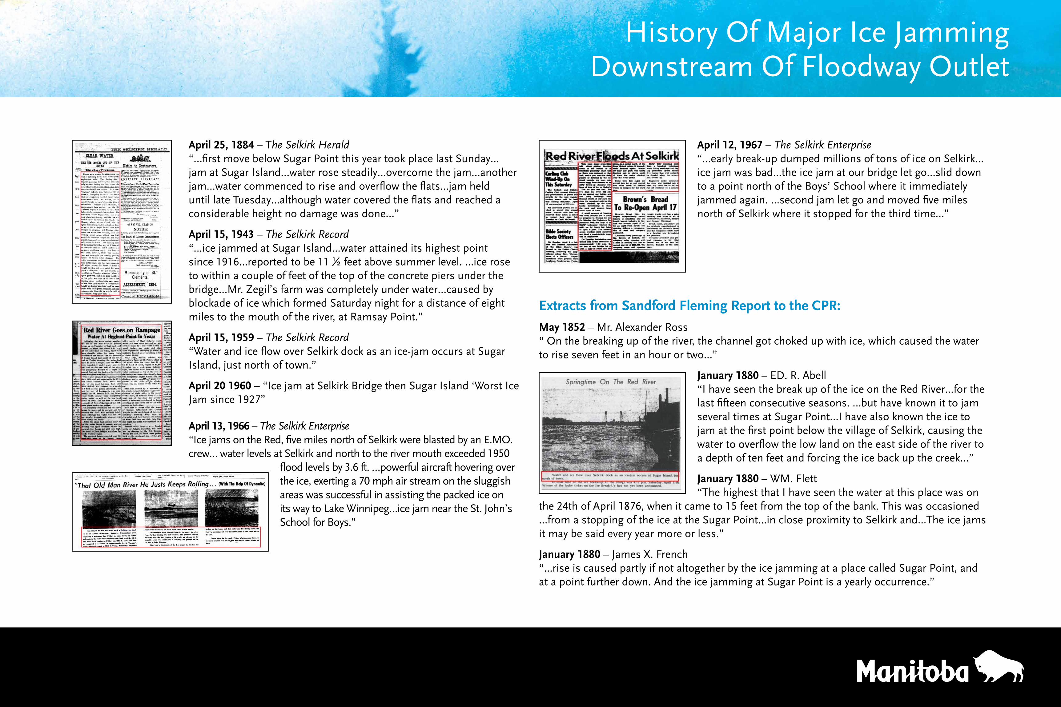
April 12, 1967 – The Selkirk Enterprise“…early break-up dumped millions of tons of ice on Selkirk…ice jam was bad…the ice jam at our bridge let go…slid down to a point north of the Boys’ School where it immediately jammed again. …second jam let go and moved five miles north of Selkirk where it stopped for the third time…”
Extracts from Sandford Fleming Report to the CPR:
May 1852 – Mr. Alexander Ross“ On the breaking up of the river, the channel got choked up with ice, which caused the water to rise seven feet in an hour or two...”
January 1880 – ED. R. Abell“I have seen the break up of the ice on the Red River…for the last fifteen consecutive seasons. …but have known it to jam several times at Sugar Point…I have also known the ice to jam at the first point below the village of Selkirk, causing the water to overflow the low land on the east side of the river to a depth of ten feet and forcing the ice back up the creek…”
January 1880 – WM. Flett“The highest that I have seen the water at this place was on
the 24th of April 1876, when it came to 15 feet from the top of the bank. This was occasioned …from a stopping of the ice at the Sugar Point…in close proximity to Selkirk and…The ice jams it may be said every year more or less.”
January 1880 – James X. French“…rise is caused partly if not altogether by the ice jamming at a place called Sugar Point, and at a point further down. And the ice jamming at Sugar Point is a yearly occurrence.”
History Of Major Ice JammingDownstream Of Floodway Outlet
April 25, 1884 – The Selkirk Herald“…first move below Sugar Point this year took place last Sunday…jam at Sugar Island…water rose steadily…overcome the jam…another jam…water commenced to rise and overflow the flats…jam held until late Tuesday…although water covered the flats and reached a considerable height no damage was done…”
April 15, 1943 – The Selkirk Record“…ice jammed at Sugar Island…water attained its highest point since 1916…reported to be 11 ½ feet above summer level. …ice rose to within a couple of feet of the top of the concrete piers under the bridge…Mr. Zegil’s farm was completely under water…caused by blockade of ice which formed Saturday night for a distance of eight miles to the mouth of the river, at Ramsay Point.”
April 15, 1959 – The Selkirk Record“Water and ice flow over Selkirk dock as an ice-jam occurs at Sugar Island, just north of town.”
April 20 1960 – “Ice jam at Selkirk Bridge then Sugar Island ‘Worst Ice Jam since 1927”
April 13, 1966 – The Selkirk Enterprise“Ice jams on the Red, five miles north of Selkirk were blasted by an E.MO. crew… water levels at Selkirk and north to the river mouth exceeded 1950
flood levels by 3.6 ft. …powerful aircraft hovering over the ice, exerting a 70 mph air stream on the sluggish areas was successful in assisting the packed ice on its way to Lake Winnipeg…ice jam near the St. John’s School for Boys.”
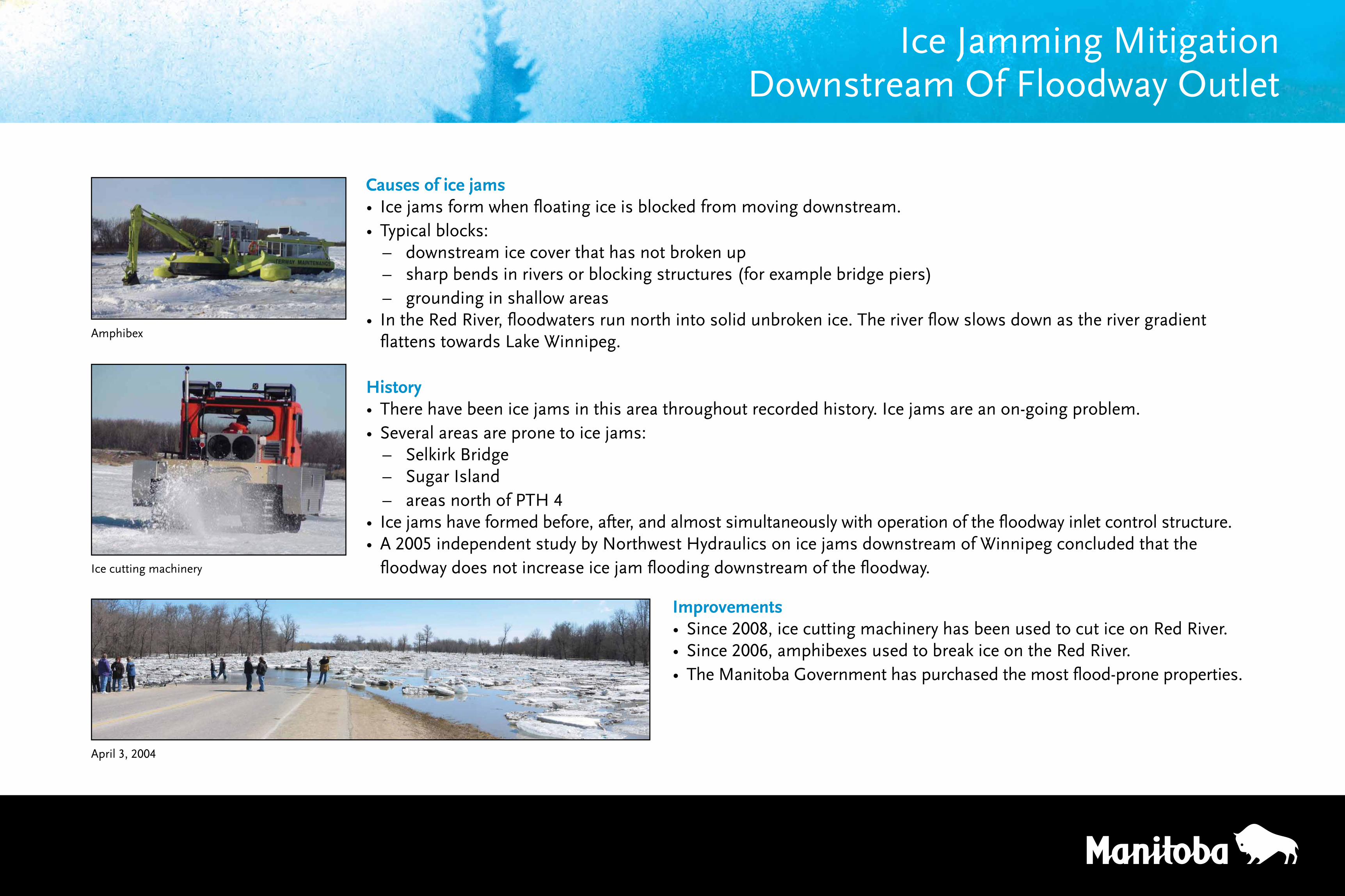
Causes of ice jams• Ice jams form when floating ice is blocked from moving downstream.• Typical blocks:
– downstream ice cover that has not broken up – sharp bends in rivers or blocking structures (for example bridge piers) – grounding in shallow areas
• In the Red River, floodwaters run north into solid unbroken ice. The river flow slows down as the river gradient flattens towards Lake Winnipeg.
History• There have been ice jams in this area throughout recorded history. Ice jams are an on-going problem.• Several areas are prone to ice jams:
– Selkirk Bridge – Sugar Island – areas north of PTH 4
• Ice jams have formed before, after, and almost simultaneously with operation of the floodway inlet control structure.• A 2005 independent study by Northwest Hydraulics on ice jams downstream of Winnipeg concluded that the
floodway does not increase ice jam flooding downstream of the floodway.
Ice Jamming MitigationDownstream Of Floodway Outlet
Improvements• Since 2008, ice cutting machinery has been used to cut ice on Red River.• Since 2006, amphibexes used to break ice on the Red River.• The Manitoba Government has purchased the most flood-prone properties.
Amphibex
Ice cutting machinery
April 3, 2004
Number of reported ice jams in U.S. Army’s Cold Regions Research and Engineering Laboratory database for Red River in the United States.
Start Day of Floodway Operation
Recent Ice JammingDownstream Of Floodway Outlet
From Section 8.1.4 of the Clean Environment Commission report on Floodway Expansion…
• “ The Commission accepts the argument that floodway operations do not exacerbate ice jams downstream of the floodway outlet. The floodway does not increase flows downstream of the outlet except at very high flows, when ice has already been cleared from the river channel, and thus cannot have an impact on the ice regime downstream.”
Recent Ice Jams• Moresevereicejamsarecurrentlyreportedmoreoften.
• River ice is breaking up earlier in the year (as evidenced by the earlier dates of initial floodway operation)
– ice has less time to melt and deteriorate by warming temperatures – ice is thicker and stronger
• Flood waters are occurring earlier in the year – ice is stronger and more resistant to breakup – ice jams are more severe
Average discharge in Red River at Lockport
m3/s = cubic metres per second

If you would like to comment on the rules of operation for the Red River Floodway please use one of our forms to provide written comments.
Thank You! We welcome yourcomments and suggestions
Additional written comments will be accepted until September 1, 2010 at:
Manitoba Water Stewardship Box 14, 200 Saulteaux CrescentWinnipeg, MB R3J 3W3 ATTN: Floodway Rules of Operation ReviewEmail: [email protected]
Recommended