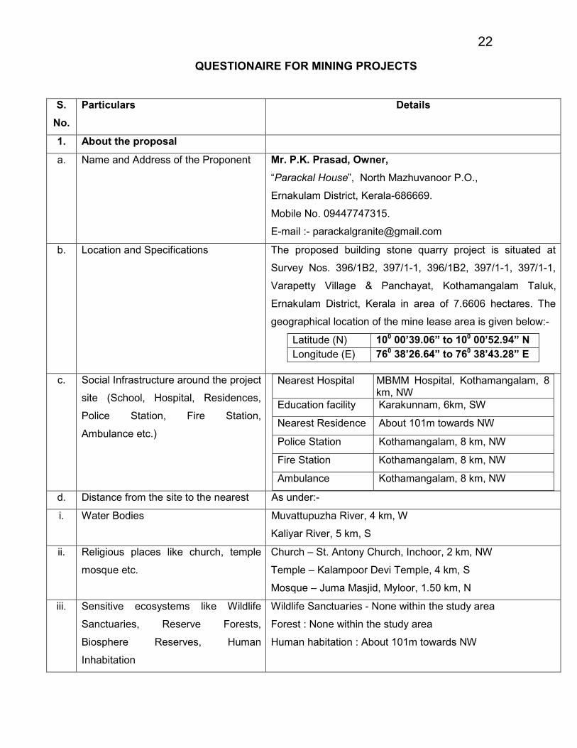
22
QUESTIONAIRE FOR MINING PROJECTS
S.
No.
Particulars Details
1. About the proposal
a. Name and Address of the Proponent Mr. P.K. Prasad, Owner,
“Parackal House”, North Mazhuvanoor P.O.,
Ernakulam District, Kerala-686669.
Mobile No. 09447747315.
E-mail :- [email protected]
b. Location and Specifications
The proposed building stone quarry project is situated at
Survey Nos. 396/1B2, 397/1-1, 396/1B2, 397/1-1, 397/1-1,
Varapetty Village & Panchayat, Kothamangalam Taluk,
Ernakulam District, Kerala in area of 7.6606 hectares. The
geographical location of the mine lease area is given below:-
Latitude (N) 100 00’39.06” to 100 00’52.94” N
Longitude (E) 760 38’26.64” to 760 38’43.28” E
c. Social Infrastructure around the project
site (School, Hospital, Residences,
Police Station, Fire Station,
Ambulance etc.)
Nearest Hospital MBMM Hospital, Kothamangalam, 8 km, NW
Education facility Karakunnam, 6km, SW
Nearest Residence About 101m towards NW
Police Station Kothamangalam, 8 km, NW
Fire Station Kothamangalam, 8 km, NW
Ambulance Kothamangalam, 8 km, NW
d. Distance from the site to the nearest As under:-
i. Water Bodies Muvattupuzha River, 4 km, W
Kaliyar River, 5 km, S
ii. Religious places like church, temple
mosque etc.
Church – St. Antony Church, Inchoor, 2 km, NW
Temple – Kalampoor Devi Temple, 4 km, S
Mosque – Juma Masjid, Myloor, 1.50 km, N
iii. Sensitive ecosystems like Wildlife
Sanctuaries, Reserve Forests,
Biosphere Reserves, Human
Inhabitation
Wildlife Sanctuaries - None within the study area
Forest : None within the study area
Human habitation : About 101m towards NW

23
iv. Any electrical installations/ micro
Wave station/ Defense establishments
etc.
HT & LT Line --- available within 500m
Mobile tower – Kalamboor, 4 km, S
Defense Establishment – None within the area
a. Storage/ Safety of explosives Within the complex
b. Fire and safety precautions Within the complex
c. First Aid Within the complex
d. No. of laborers to be employed at a
time and their safety
24 persons
e. Access road and width to the plot 7 m., tarred road
f. Whether public or private & Ownership Private owned land
2. About the Mining Area
a. Total Reserve Mineable – 38,17,833 MT
Geological – 62,86,162 MT
b. Contour Map Ref. Annexure No. 6 (Page No. 84)
c. Sectional map showing overburdens
(Average)
Ref. Annexure No. 7 (Page No. 85)
d. Geology of the area (Secondary data) Ref. Environment Management Plan – Land Environment
(Page No. 215-261)
e. Hydrology indicating water bodies and
ground water conditions (secondary
data)
Ref. Environment Management Plan – Water Environment
(Page No. 215-261)
f. 500m radius map showing the
infrastructure
Ref. Annexure No. A (Page No. 256
g. Land use pattern As under:-
Sr. No.
Land Use Category Pre-Operational (Ha.)
Operational for next five years (Ha.)
Post Operational for life of mine (Ha.)
1 Top Soil Dump Nil
0.4800 0.4800
2 Over burden Nil
3 Excavation (Voids Only)
0.7406 5.9113
6.7064 ( 4.3245 ha. Reclaimed by plantation & 2.3819 ha.
Convert into pond)
4 Road 0.1419 0.1551 Nil

24
5 Built Up Area Nil Nil Nil
6 Drainage Nil 0.0730 0.073
7 Green belt Nil 0.4012 0.4012
8 Undisturbed Area 6.7781 0.6400 0.00
Total 7.6606 7.6606 7.6606
Note :- 7.5 m barrier zone (0.8485 ha.) left outside also, which is own land. It will be used for green belt and drainage, also.
h. Baseline data of the environmental quality
parameters
Ref. E.M.P. – Baseline Environment Data
(Page No. 215-261)
i. Biodiversity of the area specifying endemic
and endangered species.
Ref. E.M.P. – Baseline Environment Data
(Page No. 215-261)
3. About the Mining Activities
a. Drawings indicating different facilities
including Reduced Level (RL)
Ref. Annexure No. 8 (Page No. 86)
b. Details of method of working with phasing
of activities, height and width of benches
The proposed mining operations will be carried out by
open cast semi-mechanized method. The salient features
of proposed mining method are:-
� The height and width of the bench will be maintained
at 5 m and 6 m respectively.
� The mining will be done from top to bottom by slicing
of 2.5 m thick.
� The exploitation of mineral is being done up to
40 m. MSL in conceptual phase.
� Considering the stability of rocks the final slope or say
ultimate pit slope is proposed 45° from vertical.
� Haul road will be developed up to point of loading.
� Transportation of the mineral from pit-mouth to
destination will be by tippers /trucks (15T capacity).
c. Details of drilling, blasting explosives Ref. PFR Section 3.(v) (Page No. 34-36)
d. Transportation of material with route Ref. PFR Section 3.(vi) (Page No. 37-39 )
e. Details of over burden (OB) removal and
stacking
Ref. PFR Section 6.(ix) (Page No. 47)
f. Plan for managing storm water Ref. Environment Management Plan ( Page No. 215-261)

25
g. Plan for power supply and water supply Power: - The total power requirement will be 75 kW,
which will be drawn from diesel engine.
Water: - The water required will be sourced from the well
water/ storm water pond.
h. Plan for labour and safety in the mining
area
Ref. Environment Management Plan ( Page No. 215-261)
i. Plan for managing dust, noise, silt and
other pollutants.
Ref. Environment Management Plan ( Page No. 215-261)
4. About the post mine plans
a. Plan for green belt and fencing Ref. Environment Management Plan ( Page No. 215-261)
b. Periodic monitoring of environmental
quality and management
Ref. Environment Management Plan ( Page No. 215-261)
c. Mine Closure Plan – Demolition of
structure, removal of deleterious material
and restoration of land for sustainable
practices
Ref. Page No. 246 of the application
5. About the Social Obligations
a. Mitigation measures to reduce hazardous
conditions and hardship to local
inhabitants
Ref. Environment Management Plan ( Page No. 215-261)
b. Addressing concerns of local inhabitants
like health, water, employment,
resettlement/ rehabilitation
Ref. Environment Management Plan ( Page No. 215-261)
c. Compensation for loss of land, crops and
other adverse impacts on account of
mining
No R & R issues;
Environment Management Plan ( Page No. 215-261)
d. Specific measures for Corporate Social
Responsibility with success indicators
Environment Management Plan ( Page No. 215-261)
*****************

PROJECT : Masonry Stone Mine (Quarry project) PRE - FEASIBILTY REPORT
APPLICANT : Mr. P. K. PRASAD 26
ENVIRONMENTAL ENGINEERS & CONSULTANTS PVT. LTD. Owner
October, 2016 Mr. P. K. PRASAD
QUARRY PROJECT OF
Mr. P. K. PRASAD
PROJECT FEASIBILITY REPORT
( PFR )
PROJECT SITE AT
SURVEY NOS. 396/1B2, 397/1-1, 396/1B2, 397/1-1, 397/1-1,
VARAPETTY VILLAGE & PANCHAYAT, KOTHAMANGALAM
TALUK, ERNAKULAM DISTRICT, KERALA

PROJECT : Masonry Stone Mine (Quarry project) PRE - FEASIBILTY REPORT
APPLICANT : Mr. P. K. PRASAD 27
ENVIRONMENTAL ENGINEERS & CONSULTANTS PVT. LTD. Owner
October, 2016 Mr. P. K. Prasad
INDEX S. No. Contents Page No.
1.0 EXECUTIVE SUMMARY 29
2.0 INTRODUCTION OF THE PROJECT / BACKGROUND INFORMATION 31
2.(i) Identification of project and project proponent 31
2.(ii) Brief description of the Nature of the project 31
2.(iii) Need for the project and its importance to the Country and or Region 32
2.(iv) Demand – Supply Gap 32
2.(v) Imports Vs. Indigenous Production 32
2.(vi) Export Possibility 32
2.(vii) Domestic / Export Markets 33
2.(viii) Employment generation (Direct & Indirect) due to the project 33
3.0 PROJECT DESCRIPTION 33
3.(i) Type of project including interlinked and interdependent projects 33
3.(ii) Location (map showing General Location, Specific Location & Project boundary &
Project site layout) with coordinates
33
3.(iii) Details of Alternate sites considered and the basis of selecting the proposed site,
particularly the environmental considerations
34
3.(iv) Size or magnitude of operation 34
3.(v) Project description with process details (a schematic diagram / flow chart showing
the project layout, components of the project etc should be given)
34
3.(vi) Raw material required along with estimated quantity, likely source, marketing area of final products, mode of transport of raw materials and financial provisions
37
3.(vii) Resource optimization / recycling and reuse envisaged in the project 40
3.(viii) Availability of water its source, energy / power requirement & source 40
3.(ix) Quantity of wastes to be generated (liquid and solid) and scheme for their
management / disposal
41
4.0 SITE ANALYSIS 42
4.(i) Connectivity 42
4.(ii) Land form, land use and land ownership 42
4.(iii) Topography (along with map) 43
4.(iv) Existing land use pattern (agriculture, non-agriculture, forest, water bodies (including area under CRZ)), shortest distances from the periphery of project.
43
4.(v) Existing Infrastructure 44
4.(vi) Soil Classification 44
4.(vii) Climatic Data 44
4.(viii) Social Infrastructure Available 44
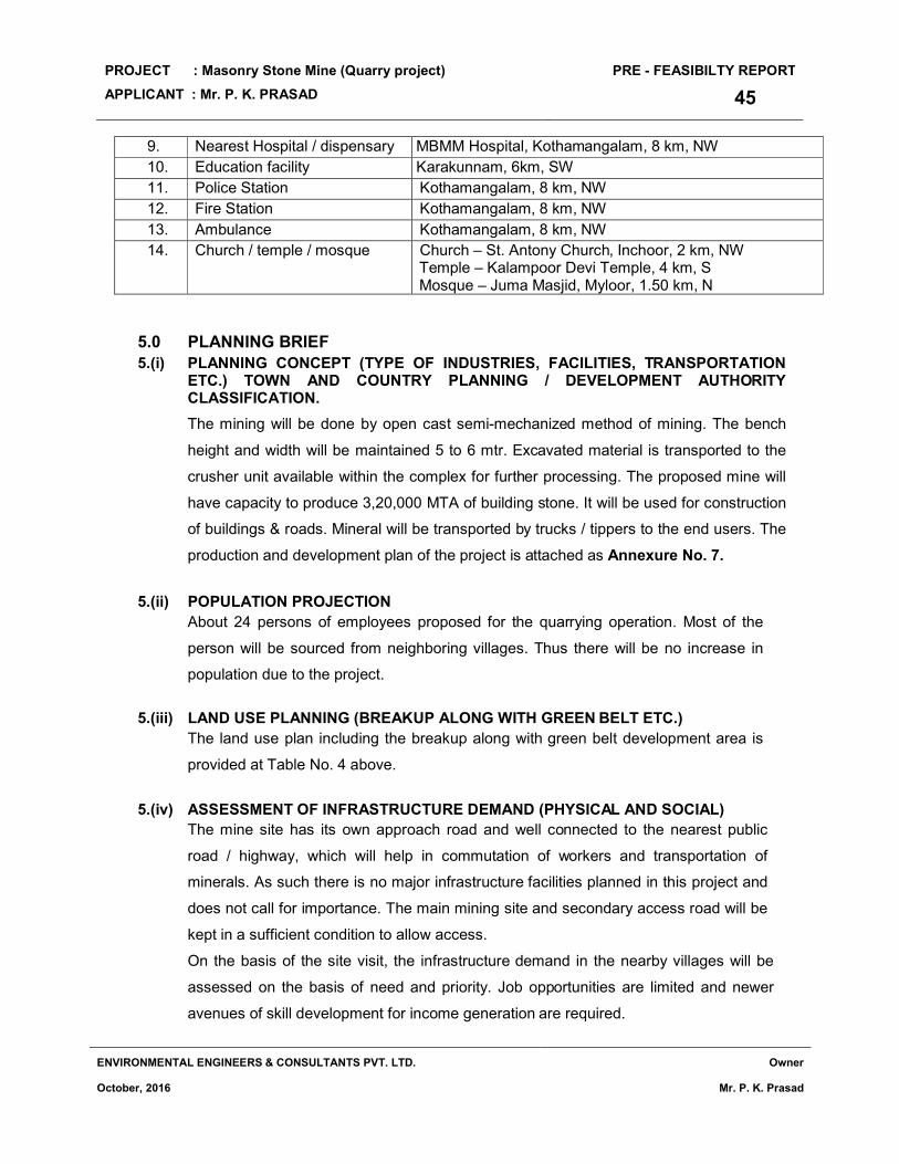
5.0 PLANNING BRIEF 45
5.(i) Planning Concept (Type of industries, facilities, transportation etc.) Town & Country Planning / Development Authority Classification
45
5.(ii) Population Projection 45
5.(iii) Land Use Planning (Break-up along with green belt etc.) 45
5.(iv) Assessment of Infrastructure Demand (Physical & Social) 45

PROJECT : Masonry Stone Mine (Quarry project) PRE - FEASIBILTY REPORT
APPLICANT : Mr. P. K. PRASAD 28
ENVIRONMENTAL ENGINEERS & CONSULTANTS PVT. LTD. Owner
October, 2016 Mr. P. K. Prasad
5.(v) Amenities / Facilities 46
6.0 PROPOSED INFRASTRUCTURE 46
6.(i) Industrial Area (Processing Area) 46
6.(ii) Residential Area (Non-processing area) 46
6.(iii) Green belt 46
6.(iv) Social Infrastructure 46
6.(v) Connectivity (Traffic & Transportation Road / Rail etc.) 46
6.(vi) Drinking Water Management (Source & Supply of water) 47
6.(vii) Sewerage system 47
6.(viii) Industrial Waste Management 47
6.(ix) Solid Waste Management 47
6.(x) Power Requirement & Supply / Source 47
7.0 Rehabilitation and Resettlement (R & R Plan) 47
7.(i) Policy to be adopted (Central / State) in respect of the project affected persons including home oustees, land oustees and landless
47
8.0 PROJECT SCHEDULE AND COST ESTIMATES 48
8.(i) Likely date of start of production and likely date of completion (time schedule for the project will be given)
48
8.(ii) Estimated project cost along with analysis of economic viability of project 48
9.0 ANALYSIS OF PROPOSAL 48
9.(i) Financial and Social Benefits with special emphasis on the benefits to the local people including tribal population
48
LIST OF ANNEXURES
Annexure No. Particulars
1. Copy of Letter of Intent ( LOI ) / Mine Lease
2. Photographs of the Site
3. Route Map showing location of the project site
4. Google map showing location of the project site
5. Key map of the project site
6. Topographical Contour Map
7. Production & Development Plan
8. Surface cum Geological Plan
LIST OF TABLES
Table No. Particulars
1. List of employees
2. Size or magnitude of operation
3. List of equipments used
4. Year wise production details
5. Land use of lease area
6. Social infrastructure around the project site
7. Expected time schedule for the project
8. Estimated project cost and economic viability

PROJECT : Masonry Stone Mine (Quarry project) PRE - FEASIBILTY REPORT
APPLICANT : Mr. P. K. PRASAD 29
ENVIRONMENTAL ENGINEERS & CONSULTANTS PVT. LTD. Owner
October, 2016 Mr. P. K. Prasad
1.0 EXECUTIVE SUMMARY
The building Stone Quarry (Minor Mineral) project of Mr. P. K. Prasad is situated at
Survey Nos. 396/1B2, 397/1-1, 396/1B2, 397/1-1, 397/1-1, Varapetty Village &
Panchayat, Kothamangalam Taluk, Ernakulam District, Kerala in area 7.6606 hectares.
The project proponent possess Letter of Intent (LOI ) for the proposed mining & Mine
Leases for existing quarry project issued by Mining & Geology Department, Govt. of
Kerala and copy of the same is attached as Annexure No. 1.
Mining projects of minor minerals with area less than 50 ha. of mining lease are
categorized as category 'B'. As per O.M. dated 24/12/2013 by Ministry of Environment &
Forests, Govt. of India, all projects with mining area less than 25 hectares is classified as
Category B2.
The Eco-friendly Mining Plan prepared by an Indian Bureau of Mine (IBM) approved
Recognized Qualified Person (RQP) has been approved by Mining & Geology
Department, Govt. of Kerala. This Mining plan is based on the requirements under the
Kerala Minor Mineral Concession Rules, 2015.
The land for the proposed quarry is a private owned land and the land is possessed in
the name of Mr. P. K. Prasad. The targeted production of mine will be 3,20,000 MTA.
The estimated project cost will be about Rs. 10 Crores. The expected life of mine
estimated will be about 12 years. The mining operation will be carried out by opencast
semi-mechanized method as per the approved Mining Plan.
1.1 SALIENT FEATURES & ENVIRONMENTAL SETTING OF THE PROJECT
Particulars Details
Geographical Location Latitude (N) 100 00’39.06” to 100 00’52.94” N
Longitude (E) 760 38’26.64” to 760 38’43.28” E
Total Mine Lease area 7.6606 hectare
Total area owned by the proponent 12.14 hectare
Current status of the quarry Existing Quarry Project
Local name of the project area Kakattor
Project Site Toposheet No. 58 B/12
Production 3,20,000 MTA
Geological Reserves 62,86,162 MT
Mineable Reserves 38,17,833 MT
Life of Mine 12 years
Estimated project cost Rs. 10 Crores
Man Power 24 Persons
Highest and lowest elevation 90m and 45m MSL
Land use Private owned land with rocky area

PROJECT : Masonry Stone Mine (Quarry project) PRE - FEASIBILTY REPORT
APPLICANT : Mr. P. K. PRASAD 30
ENVIRONMENTAL ENGINEERS & CONSULTANTS PVT. LTD. Owner
October, 2016 Mr. P. K. Prasad
Nearest habitation About 101m towards NW
Nearest Town Kothamangalam, 8 km, NW
Stone Crusher / M sand Available within the complex
Width of access road to the site 7m wide tarred road
Nearest Airport Kochi Intl. Airport, about 65 km, NW
Nearest Highway NH-49 (Kochi-Dhanushkodi road), 5 km, W
Nearest Railway Station Aluva Railway Station, about 45 km, NW
Power supply The total power requirement will be 75 kW for compressors which will be operated by Diesel Engine.
Water and its Source
The total water requirement is about 15 KLD in which 1 KLD is for domestic purpose which would be sourced from open well, 12 KLD for dust suppression in mine as well as ancillary unit and 2 KLD for plantation purposes and will be sourced from storm water pond
Nearest Hospital / dispensary MBMM Hospital, Kothamangalam, 8 km, NW
Education facility Karakunnam, 6km, SW
Police Station Kothamangalam, 8 km, NW
Fire Station Kothamangalam, 8 km, NW
Ambulance Kothamangalam, 8 km, NW
Church / temple / mosque Church – St. Antony Church, Inchoor, 2 km, NW Temple – Kalampoor Devi Temple, 4 km, S Mosque – Juma Masjid, Myloor, 1.50 km, N
Electrical installation like transformer
/HT or LT line
HT & LT Line – available within 500m
Mobile Towers Kalamboor, 4 km, S
Ecological sensitive zone (National
Park, Sanctuary, Habitat for Migratory
Birds, Tiger Reserve)
None within the study area (Thettakkad Bird Sanctuary, 20 km, NE)
Interstate Boundary None within the study area
Critically Polluted Area as identified
by CPCB
None within the study area
Defense installations None within the study area
Archeological Features None within the study area
Nearest Forests None within the study area
Nearest streams/ rivers/ water bodies
(from mine boundary)
Muvattupuzha River, 4 km, W
Kaliyar River, 5 km, S
HLWG Report status Not falling in ESA

PROJECT : Masonry Stone Mine (Quarry project) PRE - FEASIBILTY REPORT
APPLICANT : Mr. P. K. PRASAD 31
ENVIRONMENTAL ENGINEERS & CONSULTANTS PVT. LTD. Owner
October, 2016 Mr. P. K. Prasad
1.2 PRODUCTION & RESERVE
The estimated annual mining production will be 3,20,000 MTA and the mineable reserve
for the project is 38,17,833 MT. It is expected to employ about 24 persons in the mining
operation. The mined material will be transported to crusher located near the complex.
1.3 TOP SOIL & OVER BURDEN
A total quantity of 29,220 cu. m. of topsoil is proposed to be removed during the mining
operations. The topsoil excavated from the quarry will be dumped / stacked separately at
pre-determined place and subsequently will be utilized in spreading over reclaimed
areas for plantation as part of eco-restoration.
About 52,415 cu. m. of overburden (OB) will be generated throughout the mine life. This
waste will be utilized within the pit for lying of haul roads. At the end use, OB can be
reutilized as soil base for plantation.
2.0 INTRODUCTION OF THE PROJECT / BACKGROUND INFORMATION 2.(i) IDENTIFICATION OF PROJECT AND PROJECT PROPONENT
The project is for obtaining Environment clearance for building stone mining project
(Minor Mineral Quarry). The quarry project is proposed by Mr. P. K. Prasad as Owner.
The lease area is private own land at Survey Nos. 396/1B2, 397/1-1, 396/1B2, 397/1-1,
397/1-1, Varapetty Village & Panchayat, Kothamangalam Taluk, Ernakulam District,
Kerala in area of 7.6606 hectares. The project proponent posses LOI for the proposed
quarry & leases for existing quarry issued by Mining & Geology Department, Govt. of
Kerala and copy of the same are attached at Annexure No. 1.
Name and
address of the
Applicant
: Mr. P.K. Prasad, Owner, “Parackal House”, North Mazhuvanoor P.O., Ernakulam District, Kerala-686669. Mobile No. 09447747315. E-mail :- [email protected]
2.(ii) BRIEF DESCRIPTION OF NATURE OF THE PROJECT
Mr. P. K. Prasad proposes a building stone mine for dealing in mining and trading of
mineral. The main objective of the project is to carry the business of prospecting,
exploring, operating and working on quarries. The main market for mineral is in
Ernakulam District and other nearby districts in Kerala which are utilized it in
construction works of buildings and roads.

PROJECT : Masonry Stone Mine (Quarry project) PRE - FEASIBILTY REPORT
APPLICANT : Mr. P. K. PRASAD 32
ENVIRONMENTAL ENGINEERS & CONSULTANTS PVT. LTD. Owner
October, 2016 Mr. P. K. Prasad
2.(iii) NEED FOR THE PROJECT AND ITS IMPORTANCE TO THE COUNTRY AND OR
REGION
The major need of building stone is due to its high compressive strength and durability
(among the hardest, dimensional & structural stones), it can effectively withstand the
vagaries of nature. The mineral-rich colors and the hardness & density, makes it useful
for many applications. The proposed mining project will fulfill its end uses in buildings and
construction of roads, paving and many other exterior projects. It is also known as the
maintenance-free stone.
The main market for mineral is in Ernakulam & other nearby districts which are utilized in
construction works of buildings and roads.
The mining and associated activities in the mineral bearing areas bring about gains in
gross domestic product, i.e. there is though a minor contribution by the proposed project
but will add to gains in G.D.P. (Gross Domestic Product). A total of 24 persons will be
employed in the mine. It will create employment (though marginally) for local population.
Applicant will pay royalty to Govt. of Kerala for the mineral produced from the mine,
direct and indirect taxes will be paid thereby contributing to the regional revenue. The
public revenue will further be put for infrastructural development and other sectors like
health, education and social welfare.
2.(iv) DEMAND – SUPPLY GAP
Masonry / Building Stone are an important component for the construction /
developmental work for all infrastructure development and building construction and
road construction activities. Demand of building stone shall be fulfilled by various end
users. During last few years, due to sudden increase in real estate activities and in
other infrastructural development activities, the demand of the building stone has further
enhanced the demand of building stone in the area. Therefore, there is a large
requirement of building stone in the project vicinity to meet the demand supply chain.
2.(v) IMPORTS VS. INDIGENOUS PRODUCTION
Building stone product is an indigenous production. Therefore, this product is neither
exported nor imported.
2.(vi) EXPORT POSSIBILITY
The building stone is an indigenous product and hence there are no possibilities of
export.

PROJECT : Masonry Stone Mine (Quarry project) PRE - FEASIBILTY REPORT
APPLICANT : Mr. P. K. PRASAD 33
ENVIRONMENTAL ENGINEERS & CONSULTANTS PVT. LTD. Owner
October, 2016 Mr. P. K. Prasad
2.(vii) DOMESTIC / EXPORT MARKETS
The rock produced from the quarry will be sent to the Crusher unit available within the
complex attached to the quarry. The aggregate produced will be sold to the contractors
and to the consumers which are finally consumed locally for road (PWD & Panchayat
roads, State Highway & National Highway) & building construction works. Fine Material
will be sold to the hollow block / solid block manufactures.
2.(viii) EMPLOYMENT GENERATION (DIRECT AND INDIRECT) DUE TO THE PROJECT
The total numbers of employees including skilled, semi skilled and un-skilled workers
for the quarry project is expected to be about 24 persons in which includes workers
for mine. The details of the employees / workers including their position in the
organization are also given below:-
Table 1: List of Employees and their Designations
Sr. No. NAME OF THE POST NOS.
1 Mines Manager / Asst. Mines Manager 1
2 Mines foreman 1
3 Other workers 22
TOTAL 24
3.0 PROJECT DESCRIPTION
3.(i) TYPE OF PROJECT INCLUDING INTERLINKED AND INTERDEPENDENT
PROJECTS.
This is a semi mechanized open cast stone mining project. Mineral will be used in the
construction works. Building construction and other infrastructural facilities are the areas,
where the material will be consumed. The quarry will be linked with a crusher unit
available within the complex. The fine mineral is sold to the vendors who manufacture
hollow block / solid block and hence they are interdependent projects attached to the
mining project.
3.(ii) LOCATION (MAP SHOWING GENERAL LOCATION, SPECIFIC LOCATION,
PROJECT BOUNDARY AND PROJECT SITE LAYOUT) WITH COORDINATES
The proposed building stone quarry is in private owned land at Survey Nos. 396/1B2,
397/1-1, 396/1B2, 397/1-1, 397/1-1, Varapetty Village & Panchayat, Kothamangalam
Taluk, Ernakulam District, Kerala for area 7.6606 hectares. The geographical location
of the mine with respect to the boundary pillars of the lease area (extreme most points)
is given below:-

PROJECT : Masonry Stone Mine (Quarry project) PRE - FEASIBILTY REPORT
APPLICANT : Mr. P. K. PRASAD 34
ENVIRONMENTAL ENGINEERS & CONSULTANTS PVT. LTD. Owner
October, 2016 Mr. P. K. Prasad
Latitude (N) 100 00’39.06” to 100 00’52.94” N
Longitude (E) 760 38’26.64” to 760 38’43.28” E
The photographs of the site will be taken from different locations and directions are
provided at Annexure No. 2. The route map showing location of the lease area is
provided at Annexure No. 3. The google map superimposed with project boundary
showing location of the lease area is provided at Annexure No. 4. The Key map of
the project site showing the location of quarry site is attached at Annexure No. 5.
The project site with boundary pillars and GPS Coordinates of the boundary pillars
are provided in Contour drawing attached at Annexure No. 6.
3.(iii) DETAILS OF ALTERNATE SITES CONSIDERED AND THE BASIS OF
SELECTING THE PROPOSED SITE, PARTICULARLY THE ENVIRONMENTAL
CONSIDERATIONS.
Quarrying activities are carried out based on local geology and availability of granite
building stone. The proposed site is a building stone quarry and mineral specific
hence no alternate site was examined. Moreover, the land is a private owned land
and hence no alternate site considered.
3.(iv) SIZE OR MAGNITUDE OF OPERATION
The size and magnitude of the lease area is as given below:-
Table 2 : Size or Magnitude of operation
Sr. No. Particulars Details
1. Lease Area 7.6606 hectares
2. Mineable Reserve 38,17,833 MT
3. Annual Production 3,20,000 MTA
4. Mine Waste Top Soil (29,220 cu. m.) ; OB (52,415 cu. m)
5. Life of Mine About 12 years
6. Total Man Power (Nos.) About 24 persons
3.(v) PROJECT DESCRIPTION WITH PROCESS DETAILS (A SCHEMATIC DIAGRAM/
FLOW CHART SHOWING THE PROJECT LAYOUT, COMPONENTS OF THE
PROJECT ETC.).
The proposed mining operations will be carried out by open cast semi-mechanized
method. The process flow diagram given below depicts the mining process:-

PROJECT : Masonry Stone Mine (Quarry project) PRE - FEASIBILTY REPORT
APPLICANT : Mr. P. K. PRASAD 35
ENVIRONMENTAL ENGINEERS & CONSULTANTS PVT. LTD. Owner
October, 2016 Mr. P. K. Prasad
DESCRIPTION OF MINING OPERATIONS ( MANUFACTURING PROCESS)
PROPOSED METHOD OF MINING
It is proposed to undertake Open Cast Semi-Mechanized Mining which includes blasting,
loading, transportation of rubble and dispatch to the crusher. The surface cum geological
plan showing the mining steps is attached.
OPEN CAST MINING
In the open cast mining, the bench height and width will be maintained at 5 to 6 m
respectively. Excavated material is transported to the crusher unit located near the
complex for further processing.
SALIENT FEATURES OF MINING METHOD
The salient features of proposed mining method are given below.
• The height and width of the bench will be maintained at 5 m and 6 m respectively.
• The mining will be done from top to bottom by slicing of 2.5 m thick.
• The exploitation of mineral is being done from 90 m to 40m MSL in conceptual phase.
• Considering the stability of rocks the final slope or say ultimate pit slope is proposed 45°
from vertical.
• Haul road will be developed up to point of loading.
Cutting & Clearing of Shrubs / Trees
Removal & Stacking of Top soil & Overburden
Excavation by Drilling & Blasting
Rock Breaking & Transportation to Crusher
Crushing in Crusher
Segregation & Stacking
Dispatch to the end user

PROJECT : Masonry Stone Mine (Quarry project) PRE - FEASIBILTY REPORT
APPLICANT : Mr. P. K. PRASAD 36
ENVIRONMENTAL ENGINEERS & CONSULTANTS PVT. LTD. Owner
October, 2016 Mr. P. K. Prasad
• Transportation of the mineral from pit-mouth to crusher and then to the destination /
market will be by tippers / trucks (15T capacity).
EXTENT OF MECHANIZATION
The details of equipments proposed to be used in mining operation are listed below:-
Table 3 : List of equipments used
Sr. No. Machine Type Required No. of M/c Size/Capacity
1. Back Hoe 2 0.9 m3
2. Rock Breaker 1 --
3. Tippers/Trucks 2 15T
4. Jack hammer 3 32 mm
5. DG set 1 125 kVA
DRILLING
The excavation of mineral is proposed by excavators. The mineral is fractured and easily
exploitable by rock breakers and excavators. The hard strata are proposed to excavate
after drilling and blasting.
BLASTING
The controlled blasting is proposed by adopting all the safety measures as per Minor
Mineral Regulation Act, 1961 (MMR) and with the permission of Director General of
Mines & Safety (DGMS).
In this area for fragmentation of granite the blasting will be conducted. Multiple blast
holes of 1.0 to 1.5 m depth will be drilled with the help of 32 mm drill rod, Jack Hammer
and Air Compressor of 100 cfm capacity.
It is estimated about 250g of explosives per hole is required. About 58 holes per blast
are proposed. Therefore, the requirement of explosives will be about 14.5 kg/ blast/day.
EXPLOSIVE USED
Only class 2 and class 6 explosive is proposed for use as given below:-
Booster (20%) Slurry explosive
Explosive
(Column charge) (80%)
Nitrate Fuel oil (NFO).
The NFO mixture can be readily produced at a site by
mixing nitrate (94.5 %) with diesel oil (5.5 %).
Initiator Electric detonators
STORAGE OF EXPLOSIVE
The magazine (explosive storage area) exists within the complex.

PROJECT : Masonry Stone Mine (Quarry project) PRE - FEASIBILTY REPORT
APPLICANT : Mr. P. K. PRASAD 37
ENVIRONMENTAL ENGINEERS & CONSULTANTS PVT. LTD. Owner
October, 2016 Mr. P. K. Prasad
3.(vi) RAW MATERIAL REQUIRED ALONG WITH ESTIMATED QUANTITY, LIKELY SOURCE, MARKETING AREA OF FINAL PRODUCT/S, MODE OF TRANSPORT OF
RAW MATERIAL AND FINISHED PRODUCT
No raw material will be required for mining of Masonry / building stone. The final
product will be sent to consumer based on their demand. The mode of transportation
of raw material and finished product will be by road only. Tippers/ trucks will be used
for transportation to the end users.
MINERAL RESERVES
The mineable reserves are arrived after deducting the reserves locked in mines safety
(blocked reserve) slope along with boundary in compliance with mineral concession
rules. The quantity of such kind of reserves is arrived as follows.
BLOCKED RESERVE MINEABLE RESERVE
SECTION A-A'
BENCH M2 M DENSITY TON BENCH M2 M DENSITY TON
75 0 169 2.5 0 75 15 169 2.5 6337.5
70 34 169 2.5 14365 70 55 169 2.5 23237.5
65 69 169 2.5 29152.5 65 92 169 2.5 38870
60 103 169 2.5 43517.5 60 132 169 2.5 55770
55 169 169 2.5 71402.5 55 108 169 2.5 45630
Sub Total 158437.5 Sub Total 169845
BLOCKED RESERVE MINEABLE RESERVE
SECTION B-B'
BENCH M2 M DENSITY TON BENCH M2 M DENSITY TON
80 0 65 2.5 0 80 660 65 2.5 107250
75 25 65 2.5 4062.5 75 790 65 2.5 128375
70 200 65 2.5 32500 70 754 65 2.5 122525
65 329 65 2.5 53462.5 65 573 65 2.5 93112.5
60 426 65 2.5 69225 60 510 65 2.5 82875
55 523 65 2.5 84987.5 55 440 65 2.5 71500
50 577 65 2.5 93762.5 50 419 65 2.5 68087.5
45 602 65 2.5 97825 45 441 65 2.5 71662.5
40 652 65 2.5 105950 40 391 65 2.5 63537.5
Sub Total 541775 Sub Total 808925

PROJECT : Masonry Stone Mine (Quarry project) PRE - FEASIBILTY REPORT
APPLICANT : Mr. P. K. PRASAD 38
ENVIRONMENTAL ENGINEERS & CONSULTANTS PVT. LTD. Owner
October, 2016 Mr. P. K. Prasad
SECTION C-C'
BENCH M2 M DENSITY TON BENCH M2 M DENSITY TON
85 0 85 2.5 0 85 113 85 2.5 24012.5
80 29 85 2.5 6162.5 80 148 85 2.5 31450
75 58 85 2.5 12325 75 191 85 2.5 40587.5
70 86 85 2.5 18275 70 233 85 2.5 49512.5
65 116 85 2.5 24650 65 270 85 2.5 57375
60 144 85 2.5 30600 60 303 85 2.5 64387.5
55 174 85 2.5 36975 55 332 85 2.5 70550
50 203 85 2.5 43137.5 50 368 85 2.5 78200
45 231 85 2.5 49087.5 45 412 85 2.5 87550
40 327 85 2.5 69487.5 40 317 85 2.5 67362.5
Sub Total 290700 Sub Total 570987.5
SECTION D-D'
BENCH M2 M DENSITY TON BENCH M2 M DENSITY TON
80 0 135 2.5 0 80 449 135 2.5 151537.5
75 26 135 2.5 8775 75 568 135 2.5 191700
70 53 135 2.5 17887.5 70 629 135 2.5 212287.5
65 122 135 2.5 41175 65 697 135 2.5 235237.5
60 271 135 2.5 91462.5 60 599 135 2.5 202162.5
55 380 135 2.5 128250 55 546 135 2.5 184275
50 487 135 2.5 164362.5 50 495 135 2.5 167062.5
45 539 135 2.5 181912.5 45 443 135 2.5 149512.5
40 590 135 2.5 199125 40 392 135 2.5 132300
Sub Total 832950 Sub Total 1626075
BLOCKED RESERVE MINEABLE RESERVE
SECTION E-E'
BENCH M2 M DENSITY TON BENCH M2 M DENSITY TON
65 28 100 2.5 7000 65 339 100 2.5 84750
60 55 100 2.5 13750 60 390 100 2.5 97500
55 82 100 2.5 20500 55 449 100 2.5 112250
50 110 100 2.5 27500 50 519 100 2.5 129750
45 164 100 2.5 41000 45 463 100 2.5 115750
40 210 100 2.5 52500 40 408 100 2.5 102000
Sub Total 162250 Sub Total 642000
Grand Total 1986113 Grand Total 3817833

PROJECT : Masonry Stone Mine (Quarry project) PRE - FEASIBILTY REPORT
APPLICANT : Mr. P. K. PRASAD 39
ENVIRONMENTAL ENGINEERS & CONSULTANTS PVT. LTD. Owner
October, 2016 Mr. P. K. Prasad
Summarize Reserves (in MT)
Geological reserve (A) 62,86,162
Mineral reserve blocked in 7.5 m buffer zone (B) 1,72,875
Mineral reserve already excavated(C) 3,09,341
Mineral reserve blocked in benches (D) 19,86,113
Mineral reserve = A- (B+C+D) i.e. (6286162 - 2468329) 38,17,833
YEAR WISE PRODUCTION DETAILS
The applicant is proposed to produce building stone working for period of about 12 years
with a production of 3,20,000 MTA. The details of year wise production of the project is
given in Table below.:-
Table 4 : Year wise production of building stone
Year Bench Minerals (MT)
I 90-75 3,20,000
II 75 3,20,000
III 75-70 3,20,000
IV 70-65 3,20,000
V 65-60 3,20,000
VI 60 3,20,000
VII 60-55 3,20,000
VIII 55 3,20,000
IX 55-50 3,20,000
X 50-45 3,20,000
XI 45-40 3,20,000
XII 40 2,97,833
TOTAL 38,17,833
MINERAL TRANSPORTATION
Loading of mineral from the quarry will be done by excavator and will be sent to the
crushing unit near the complex. Trucks / Tippers of 15 MT will be used for
transportation of mineral from mine site to the crusher. It is expected that 71 trips will
be required on daily basis. For this, movement of truck per hour will be 8-9 only.
Thus, the impact due to movement of trucks from mine will be marginal and well
within the carrying capacity of the roads.

PROJECT : Masonry Stone Mine (Quarry project) PRE - FEASIBILTY REPORT
APPLICANT : Mr. P. K. PRASAD 40
ENVIRONMENTAL ENGINEERS & CONSULTANTS PVT. LTD. Owner
October, 2016 Mr. P. K. Prasad
3.(vii) RESOURCE OPTIMIZATION/ RECYCLING AND REUSE ENVISAGED IN THE
PROJECT
Mineral will be utilized and sent for use to different end users for road and building
construction works. It is estimated that around 29,220 cu. m. of top soil will be
generated from the proposed project site, which will be properly stacked and will be
utilized for eco-restoration over the reclaimed areas in the post mine closure phase.
Also it is estimated that around 52,415 cu. m. of over burden is generated which will
be utilized in developing internal roads and at the end use the same will be used as
soil base for reclamation.
It is proposed to construct a storm water collection pond and de-siltation unit in the
lowest contour of the plot. The water requirement for sprinkling on sources of dust
emission, roads and for landscaping purposes can be met from the stored rain water
pond and thereby conserve the fresh water.
3.(viii) AVAILABILITY OF WATER ITS SOURCE, ENERGY / POWER REQUIREMENT
AND SOURCE
WATER
The total water requirement for the proposed mining activity is 15 KLD. The detailed
breakup of the same is given below:-
S. No. Particulars Quantity (KLD) Source
1. Domestic purpose (mine and ancillary) 1 Open well
2. Dust Suppression / Water sprinkling at mine
and ancillary units
12 Storm water pond
of 10,000 KL 3. Green belt / Plantation 2
Total 15
The water required will be sourced from the storm water reservoir. However, the
drinking water will be sourced from the open well and which will be treated /
disinfected before consumption. It is proposed to collect the storm water into the
Holding/ Siltation Tank by constructing appropriate channels all around the foot of hill
(garland drains). The channels will be constructed with intermediate check dams/silt
traps to prevent soil erosion. The sizing of the channels will be 1m x 1m.
The daily water balance diagram of the unit is given below:-

PROJECT : Masonry Stone Mine (Quarry project) PRE - FEASIBILTY REPORT
APPLICANT : Mr. P. K. PRASAD 41
ENVIRONMENTAL ENGINEERS & CONSULTANTS PVT. LTD. Owner
October, 2016 Mr. P. K. Prasad
POWER
The total power requirement will be 75 kW for compressors which will be operated by
Diesel Engine. The source of electricity for domestic consumption within the quarry
site is from the supply of Kerala State Electricity Board (KSEB).
3.(ix) QUANTITY OF WASTES TO BE GENERATED (LIQUID AND SOLID) AND SCHEME
FOR THEIR MANAGEMENT / DISPOSAL.
SOLID WASTE: It is estimated that around 29,220 cu. m. of top soil and 52,415 cu.
m. of over burden (OB) will be generated from the proposed mining operation and
which will be properly stacked.
LIQUID WASTE:
Domestic Sewage : The sewage to a tune of 0.80 KLD generated from the mine office.
3.(x) SCHEMATIC REPRESENTATION OF THE FEASIBILITY DRAWING WHICH GIVE
INFORMATION OF EIA PURPOSE.
Not Applicable

PROJECT : Masonry Stone Mine (Quarry project) PRE - FEASIBILTY REPORT
APPLICANT : Mr. P. K. PRASAD 42
ENVIRONMENTAL ENGINEERS & CONSULTANTS PVT. LTD. Owner
October, 2016 Mr. P. K. Prasad
4.0 SITE ANALYSIS
4.(i) CONNECTIVITY
S. No. Particulars Distance & Direction
1. Nearest town Kothamangalam, 8 km, NW
2. Connecting Road 7m wide road
3. Nearest Airport Kochi Intl. Airport, about 65 km, NW
4. Nearest Highway NH-49 (Kochi-Dhanushkodi road), 5 km, W
5. Nearest Railway Station Aluva Railway Station, about 45 km, NW
4.(ii) LAND FORM, LAND USE AND LAND OWNERSHIP
LANDFORM
The proposed building stone mine is covering an area of 7.6606 ha. The lease area
is private own land. The lease area is devoid of any transmission lines, streams /
nallahs, forests, habitation, etc.
LAND USE
The land use pattern of the existing and proposed mining project is given below:
Table 5 : Land Use Details of project area
Sr. No.
Land Use Category
Pre-Operational
(Ha.)
Operational for next five years
(Ha.)
Post Operational for life of
mine (Ha.)
1 Top Soil Dump Nil 0.4800 0.4800
2 Over burden Nil
3 Excavation (Voids Only)
0.7406 5.9113
6.7064 ( 4.3245 ha. Reclaimed by plantation & 2.3819 ha. Convert into pond)
4 Road 0.1419 0.1551 Nil
5 Built Up Area Nil Nil Nil
6 Drainage Nil 0.0730 0.073
7 Green belt Nil 0.4012 0.4012
8 Undisturbed Area 6.7781 0.6400 0.00
Total 7.6606 7.6606 7.6606
Note :- 7.5 m barrier zone (0.8485 ha.) left outside also, which is own land. It will be used for green belt and drainage.
LAND OWNERSHIP
The land as per revenue records is a private own land and the site is rocky land with
rubber tree plantation and other native species.

PROJECT : Masonry Stone Mine (Quarry project) PRE - FEASIBILTY REPORT
APPLICANT : Mr. P. K. PRASAD 43
ENVIRONMENTAL ENGINEERS & CONSULTANTS PVT. LTD. Owner
October, 2016 Mr. P. K. Prasad
4.(iii) TOPOGRAPHY (ALONG WITH MAP)
Part of the proposed land is rocky area and there is no vegetation in that area. The
remaining land in the proposed land is mostly covered with native trees, shrubs,
herbs, grass, climbers, bushes etc. The topography of the lease area is hilly terrain.
The highest elevation of the lease area is 90 m MSL and lowest is 45 m MSL. As the
proposed area is hill rock, the drainage of lease area is towards NW. No habitants
are located in the lease area. The topographical contour map of the project site is
attached at Annexure No. 6.
4.(iv) EXISTING LAND USE PATTERN (AGRICULTURE, NON-AGRICULTURE,
FOREST, WATER BODIES (INCLUDING AREA UNDER CRZ)), SHORTEST
DISTANCES FROM THE PERIPHERY OF THE PROJECT TO THE PERIPHERY
OF THE FORESTS, NATIONAL PARK, WILD LIFE SANCTUARY, ECO
SENSITIVE AREAS, WATER BODIES (DISTANCE FROM THE HFL OF THE
RIVER), CRZ IN CASE OF NOTIFIED INDUSTRIAL AREA.
Land Use Pattern:
The lease area is situated at Survey Nos. 396/1B2, 397/1-1, 396/1B2, 397/1-1,
397/1-1, Varapetty Village & Panchayat, Kothamangalam Taluk, Ernakulam District,
Kerala in area of 7.6606 hectares. The land use pattern of site is provided at Table
No. 5 above.
DISTANCES FROM THE PERIPHERY OF THE PROJECT TO THE PERIPHERY OF
THE FORESTS, NATIONAL PARK, WILD LIFE SANCTUARY, ECO SENSITIVE
AREAS, WATER BODIES, NOTIFIED INDUSTRIAL AREAS, CRZ AREA ETC.
Particulars Name & Distance to quarry site
Ecological sensitive zone (National Park, Sanctuary,
Habitat for Migratory Birds, Tiger Reserve)
None within the study area
Critically Polluted Area as identified by CPCB None within the study area
Defense installations None within the study area
Archeological Features None within the study area
Nearest Forests None within the study area
Nearest streams/ rivers/ water bodies Muvattupuzha River, 4 km, W
Kaliyar River, 5 km, S
Notified Industrial Area None within the study area
CRZ Area Not in CRZ Area

PROJECT : Masonry Stone Mine (Quarry project) PRE - FEASIBILTY REPORT
APPLICANT : Mr. P. K. PRASAD 44
ENVIRONMENTAL ENGINEERS & CONSULTANTS PVT. LTD. Owner
October, 2016 Mr. P. K. Prasad
4.(v) EXISTING INFRASTRUCTURE
The existing infrastructure around the project site includes tarred roads, electricity
supply from Kerala Electricity Board, water supply from Kerala Water Authority /
Panchayat supply, storm water drains along the roads.
4.(vi) SOIL CLASSIFICATION
Main rock type in the study area is charnockite granite. At places where they are
exposed, the charnockite granite is medium to coarse grained with dark grey quartz.
4.(vii) CLIMATIC DATA
Based on the Climate Zone Map of India by Bureau of Energy Efficiency (BEE),
Ernakulam district experiences warm humid type of climate. Further, the climatological
data was referred from the nearest IMD Station and from CGWB district booklet.
The district has more or less the same climatic conditions prevalent elsewhere in the
State viz. dry season from December to February and hot season from March to
May, the South-West monsoon from June to September and the North East monsoon
from October to December. The average temperature is 32°C and the average
relative humidity is 75% recorded. The normal rainfall of the district is 3359 mm. Out
of this, major rainfall contribution is from SW monsoon followed by the NE. The South
West monsoon is usually very heavy and nearly 73.5% of the rainfall is received
during this season. NE monsoon contributes nearly 16.4% and March to May
summer rain contributes nearly 9.9% and the balance 0.2% is accounted for January
and February months.
(Source: Central Ground Water Information Booklet )
4.(viii) SOCIAL INFRASTRUCTURE AVAILABLE
Table 6 : Social Infrastructure Details
S. No. Particulars Name, Distance & Direction from the quarry site
1. Land use Private own Land with rocky land
2. Nearest habitation About 101m towards NW
3. Nearest Town Kothamangalam, 8 km, NW
4. Width of access road to site 7m wide road
5. Nearest Airport Kochi Intl. Airport, about 65 km, NW
6. Nearest Highway NH-49 (Kochi-Dhanushkodi road), 5 km, W
7. Nearest Railway Station Aluva Railway Station, about 45 km, NW
8. Power supply The total power requirement will be 75 kW for compressors which will be operated by Diesel Engine.
PROJECT : Masonry Stone Mine (Quarry project) PRE - FEASIBILTY REPORT
APPLICANT : Mr. P. K. PRASAD 45
ENVIRONMENTAL ENGINEERS & CONSULTANTS PVT. LTD. Owner
October, 2016 Mr. P. K. Prasad
9. Nearest Hospital / dispensary MBMM Hospital, Kothamangalam, 8 km, NW
10. Education facility Karakunnam, 6km, SW
11. Police Station Kothamangalam, 8 km, NW
12. Fire Station Kothamangalam, 8 km, NW
13. Ambulance Kothamangalam, 8 km, NW
14. Church / temple / mosque Church – St. Antony Church, Inchoor, 2 km, NW Temple – Kalampoor Devi Temple, 4 km, S Mosque – Juma Masjid, Myloor, 1.50 km, N
5.0 PLANNING BRIEF
5.(i) PLANNING CONCEPT (TYPE OF INDUSTRIES, FACILITIES, TRANSPORTATION ETC.) TOWN AND COUNTRY PLANNING / DEVELOPMENT AUTHORITY CLASSIFICATION.
The mining will be done by open cast semi-mechanized method of mining. The bench
height and width will be maintained 5 to 6 mtr. Excavated material is transported to the
crusher unit available within the complex for further processing. The proposed mine will
have capacity to produce 3,20,000 MTA of building stone. It will be used for construction
of buildings & roads. Mineral will be transported by trucks / tippers to the end users. The
production and development plan of the project is attached as Annexure No. 7.
5.(ii) POPULATION PROJECTION
About 24 persons of employees proposed for the quarrying operation. Most of the
person will be sourced from neighboring villages. Thus there will be no increase in
population due to the project.
5.(iii) LAND USE PLANNING (BREAKUP ALONG WITH GREEN BELT ETC.)
The land use plan including the breakup along with green belt development area is
provided at Table No. 4 above.
5.(iv) ASSESSMENT OF INFRASTRUCTURE DEMAND (PHYSICAL AND SOCIAL)
The mine site has its own approach road and well connected to the nearest public
road / highway, which will help in commutation of workers and transportation of
minerals. As such there is no major infrastructure facilities planned in this project and
does not call for importance. The main mining site and secondary access road will be
kept in a sufficient condition to allow access.
On the basis of the site visit, the infrastructure demand in the nearby villages will be
assessed on the basis of need and priority. Job opportunities are limited and newer
avenues of skill development for income generation are required.

PROJECT : Masonry Stone Mine (Quarry project) PRE - FEASIBILTY REPORT
APPLICANT : Mr. P. K. PRASAD 46
ENVIRONMENTAL ENGINEERS & CONSULTANTS PVT. LTD. Owner
October, 2016 Mr. P. K. Prasad
5.(v) AMENITIES/ FACILITIES
Following facilities are provided for the smooth working of the mine:-
� Mine office / Site office
� Magazine area for storage of explosive
� Parking area for vehicles
� Storm water collection pond
� Canteen / Mess for workers
� Accommodation for workers
� First aid room
� Store facility
� Toilet facility
� Drinking water facilities
� Rest shelters: Rest shelter room is provided to take lunch and rest for the mine workers.
6.0 PROPOSED INFRASTRUCTURE
6.(i) INDUSTRIAL AREA (PROCESSING AREA)
The project site area is not located in an industrial area. The project is a mining project
and is site specific.
6.(ii) RESIDENTIAL AREA (NON PROCESSING AREA)
As the local person will be given priority in employment, no permanent residential area /
housing is proposed only labour sheds are provided within the complex.
6.(iii) GREEN BELT
The year wise programme of eco-restoration for the life of mine will be made and
about 5,900 trees will be planted in an area of 5.927 ha. The details of eco
restoration and green belt development plan are provided in Environment
Management Plan (EMP) attached with this report.
6.(iv) SOCIAL INFRASTRUCTURE
The Social Infrastructure facility available around the site is provided at Table No. 6.
6.(v) CONNECTIVITY (TRAFFIC AND TRANSPORTATION ROAD / RAIL / METRO /
WATER WAYS ETC.) The site is very well connected by road network to the mine, district headquarter and to
the nearest towns. The area is self sufficient to cater the needs of the project.

PROJECT : Masonry Stone Mine (Quarry project) PRE - FEASIBILTY REPORT
APPLICANT : Mr. P. K. PRASAD 47
ENVIRONMENTAL ENGINEERS & CONSULTANTS PVT. LTD. Owner
October, 2016 Mr. P. K. Prasad
6.(vi) DRINKING WATER MANAGEMENT (SOURCE AND SUPPLY OF WATER)
The water required for the project will be sourced from the storm water reservoir and
from well. The drinking water to a tune of 1 KLD will be sourced from the open well
which will be treated / disinfected before consumption.
6.(vii) SEWERAGE SYSTEM
The sewage to a tune of 0.80 KL will be generated daily from the mine office will be
diverted to the septic tank followed by soak pit.
6.(viii) INDUSTRIAL WASTE MANAGEMENT
There will be no industrial waste generation due to proposed project.
6.(ix) SOLID WASTE MANAGEMENT
(i) Topsoil Management
A total quantity of 29,220 cu. m. of topsoil is proposed to be removed during the mining
operations. The topsoil excavated from the quarry will be dumped / stacked separately at
pre-determined place and subsequently will be utilized in spreading over reclaimed
areas for plantation as part of eco-restoration. Precautions will be taken to limit the
height of the topsoil dump / stacked to 5 to 6 meters in order to preserve its fertility and
shelf life. It will be suitably protected from soil erosion and infertility by planting fodder
grass and leguminous plants during temporary storage.
(ii) Overburden Management
About 52,415 cu. m of overburden (OB) will be generated throughout the mine life. This
waste will be utilized within the pit for lying of haul roads. At the end use, OB can be
reutilized as soil base for plantation.
6.(x) POWER REQUIREMENT AND SUPPLY / SOURCE
The total power requirement will be 75 kW for compressors which will be operated by
Diesel Engine. The domestic supply will be met from the supply of Kerala State
Electricity Board (KSEB).
7.0 REHABILITATION AND RESETTLEMENT (R & R PLAN)
7.(i) POLICY TO BE ADOPTED (CENTRAL/ STATE) IN RESPECT OF THE PROJECT
AFFECTED PERSONS INCLUDING HOME OUSTEES, LAND OUSTEES AND
LANDLESS LABOUR (A BRIEF OUTLINE TO BE GIVEN)
The proposed site is private own land and hence there is no rehabilitation and
resettlement. It is a small quarry project and there is no habitation in the lease area,
therefore rehabilitation & resettlement plan is not required / applicable for this project.

PROJECT : Masonry Stone Mine (Quarry project) PRE - FEASIBILTY REPORT
APPLICANT : Mr. P. K. PRASAD 48
ENVIRONMENTAL ENGINEERS & CONSULTANTS PVT. LTD. Owner
October, 2016 Mr. P. K. Prasad
8.0 PROJECT SCHEDULE AND COST ESTIMATES
8.(i) LIKELY DATE OF START OF PRODUCTION AND LIKELY DATE OF COMPLETION
(TIME SCHEDULE FOR THE PROJECT WILL BE GIVEN).
Table 7 : Expected Time Schedule for the Project
S. No. Particulars Time Schedule (in month)* Remark If any
1st 2nd 3rd 4th 5th
1. Environmental Clearance
2. Consent To Establish Project Establishment Period
3. Consent To Operate Production Start Period
*Time line may vary; subjected to rules & regulation / & other unforeseen circumstances
8.(ii) ESTIMATED PROJECT COST ALONG WITH ANALYSIS IN TERMS OF ECONOMIC
VIABILITY OF THE PROJECT
The proposed project cost will be about Rs. 10 Crores .
Table 8 : Estimated Project Cost and Economic Viability
S. No. Particulars Details
1. Quarrying Cost Rs. 200 /- Per Ton
2. Transportation with Crushing cost Rs. 250/- Per Ton
3. Royalty & Other Expenses Rs. 100/- Per Ton
4. Total Cost of Production Rs. 550/- Per Ton
5. Selling Price Rs. 650/- Per Ton
6. Gross Profit Rs. 100/- Per Ton
7. Gross Profit / Annum ( 3,20,000 Tons x Rs. 100/- ) Rs. 3,20,00,000/- Per Annum
9.0 ANALYSIS OF PROPOSAL
9.(i) FINANCIAL AND SOCIAL BENEFITS WITH SPECIAL EMPHASIS ON THE
BENEFITS TO THE LOCAL PEOPLE INCLUDING TRIBAL POPULATION, IF ANY, IN
THE AREA.
No tribal population is residing in the study area. There will be social benefits from the
mining operations. The core benefit of the proposed quarry project is the availability of
Masonry building stone for construction industries. A detailed study on social status of
the project site surroundings & need base study on proposed CSR activities were carried
out and the details are provided in attached Environment Management Plan.


SITE PHOTOGRAPHS – QUARRY SITE
OF Mr. P.K. PRASAD
Annexure No. 2
08 / 10 / 2016
79
08 / 10 / 2016

SITE PHOTOGRAPHS – QUARRY SITE
OF Mr. P.K. PRASAD
08 / 10 / 2016
80
08 / 10 / 2016

ROUTE MAP – QUARRY SITE OF Mr. P.K. PRASAD
Annexure No. 3
81

GOOGLE MAP – QUARRY SITE OF Mr. P.K. PRASAD
Annexure No. 4
82

KEY MAP – QUARRY SITE OF Mr. P.K. PRASADAnnexure No. 5
83
5


Year Bench Minerals (MT)
I 90-75 3,20,000
II 75 3,20,000
III 75-70 3,20,000
IV 70-65 3,20,000
V 65-60 3,20,000

Recommended