0
Putting the Palaeolithic into Worcestershire's HER: creating an evidence base and toolkit Final Report and Assessment
Find out more online at www.worcestershire.gov.uk/archaeology
Worcestershire Archive and Archaeology Service Providing specialist information and advice to the public, local authorities and developers
Oliver Russell & Nicholas Daffern 2014
www.worcestershire.gov.uk
NHPP identification number: 4G1.401
WAAS Project Reference: P3951
Title: Putting the Palaeolithic into Worcestershire's HER and the creation of a professional toolkit
Author(s):, Oliver Russell (Historic Environment Record Manager, WCC), Nick Daffern (Senior Project Manager,
Wardell-Armstrong Archaeology. Previously - Senior Environmental Archaeologist, WCC)
Reviser(s): Andrew Shaw (Southampton University), Richard Bryant (Earth Heritage Trust), Emma Hancox (Historic
Environment Policy and Advisory Manager, WCC)
Derivation: Completion of EH funded project
Origination Date: 26-02-2014
Date of last revision: 07-05-2014
Version: 3.1
Status: Final
Circulation: NHPP Project Board and Archive and Archaeology Service, WCC
Required Action:
File Name/Location: \\corpservs\data\UData\U160 ACS\U013 Archaeology Service\03 Field
Section\Projects\Proposed\P3951 NHPP Shotton Revisited\04 Proposal\FinalReport_v3.1.docx
Approval:
Archive and Archaeology Service,
Worcestershire County Council,
The Hive, Sawmill Walk,
The Butts
Worcester
WR1 3PD
Putting the Palaeolithic into Worcestershire's
HER: creating an evidence base and toolkit
Final Report and Assessment
NHPP 4G1: Pleistocene and Early Holocene
Archaeology
6396: Palaeolithic and Mesolithic HER Enhancement (4G1.401)
Worcestershire County Council Archive and Archaeology Service
2
Contents
Summary ......................................................................................................................... 4
Background ..................................................................................................................... 5
Review of Methodology ................................................................................................... 5
Stage 1 – Enhancement of the Palaeolithic in the HER ............................................... 5
Literature Review ...................................................................................................... 5
Validating Existing Datasets and Incorporating datasets from new sources and sites
................................................................................................................................. 5
Stage 2 – Production of Toolkit .................................................................................... 8
Stage 3 – Dissemination .............................................................................................. 8
Results ............................................................................................................................ 8
Reassessment of Artefact Collections .......................................................................... 8
HER Enhancement .................................................................................................... 11
Toolkit ............................................................................................................................ 13
Discussion ..................................................................................................................... 13
Review of Costs ............................................................................................................. 14
Original Budget .......................................................................................................... 14
Stage 1 ................................................................................................................... 14
Stage 2 ................................................................................................................... 15
Stage 3 ................................................................................................................... 15
Variation Budget ........................................................................................................ 15
Overall Project Costs ................................................................................................. 15
Review of Risk Management ......................................................................................... 15
Future Work ................................................................................................................... 16
Worcestershire ........................................................................................................... 16
Regionally/Nationally .................................................................................................. 18
Acknowledgements........................................................................................................ 19
Appendices .................................................................................................................... 20
1. Project Bibliography ............................................................................................. 20
2. Lithics report ........................................................................................................ 26
3. Example HER entry ............................................................................................. 27
4. Guidance for Planning and the Palaeolithic in Worcestershire ............................ 28
5. Areas of Potential Map ........................................................................................ 30
6. Artefact Recognition Sheet – Courtesy of the National Ice Age Network ............. 31
7. Artefact Illustrations and Photographs ................................................................. 43

Worcestershire County Council Archive and Archaeology Service
3
Worcestershire County Council Archive and Archaeology Service
4
Summary Worcestershire, like the majority of the West Midlands, is not considered a focal point for the study of Palaeolithic archaeological remains, with much of the focus occurring in the East and South-East of the country. Despite this, discoveries of Palaeolithic artefactual and palaeoenvironmental remains within the county and the wider West Midlands have shown that the area has the potential to be productive and assist in national and international research aims for the period. Research on the Palaeolithic is carried out by Quaternary scientists or archaeologists with specialist knowledge of Quaternary science. The reports are difficult for non-specialists to assess, with the result that Palaeolithic archaeology is poorly represented and as such is poorly protected through the usual planning process. This project aimed to take this specialist information, up-date it based on recent evidence and new interpretations, and place within the Historic Environment Record in a way in which it can be interpreted and used by non-specialists. The project has also shown that Worcestershire has real potential to contribute,
nationally as well as regionally, to our understanding of hominin development, migration
and landscape interaction, whereas previously the region was not considered a focal
point for Palaeolithic study. The project has proven that with a relatively small budget, a
considerable dataset can be produced through the reassessment and reinterpretation of
existing resources.
Worcestershire County Council Archive and Archaeology Service
5
Background The distribution and potential of Palaeolithic remains within Worcestershire is relatively poorly understood due to the considerable lack of data and only through regular updating of archaeological and non-archaeological (geological/ geographical etc) datasets can predictive models and distributions hope to be created. Indeed, as Lang and Buteux (2007, 19) state, whilst " the Shotton Project did not directly address general research goals in Lower and Middle Palaeolithic studies…it provided the necessary foundation to make such research possible" but "maintaining the research initiative of the Shotton Project is a major issue" with the "effective incorporation of archaeological and palaeoenvironmental data into the regions SMR's or …HER's" being central. As an unfunded addition to the Shotton project Worcestershire HER staff worked with Quaternary scientists and archaeologists to classify the river terraces into dated groups, making the geology more accessible to non-specialists (Buteux, Keen and Lang 2005, 42-50). In addition some new sites were added onto the HER. This was recognised as a simple but effective approach to the problem of making Palaeolithic data accessible to a non-specialist audience, but lack of funds had meant that this work was not fully integrated into the HER and so had not realised its full potential. This project was set up to remedy this.
Review of Methodology This section covers any deviations and/or issues with the original methodology set out in the Project Design. This includes a detailed overview of how the data was incorporated in the HER.
Stage 1 – Enhancement of the Palaeolithic in the HER
Literature Review
This was carried out as planned using a wide variety of journals, publications and online resources, making use of keyword search functionality on the website to pick up potentially relevant sites. The complete bibliography for the project can be found in Appendix 1. In addition to the ‘standard’ archaeological sources, Quaternary science and geological journals and publications were reviewed as these are frequently overlooked by archaeologists and the data sets are rarely deposited with Historic Environment Records. However, having a Quaternary specialist on the project team allowed us to make use of this data and include it in the HER enhancement.
Validating Existing Datasets and Incorporating datasets from new sources and sites
The project design stated that the project would use the updated 2011 BGS dataset rather than the 2005 dataset used within the Shotton Project, but due to its availability, the 2013 BGS data was used in the final project. This probably had little effect on the results as very little reassessment of the geology of the region has been undertaken and the geology mapping has remained much the same. The assessment of artefactual collections was undertaken as planned by Dr Andrew Shaw, who had access to the large Whitehead Collection at the British Museum and smaller collections held within local museums. The Project Design stated that there were approximately 171 artefacts within the Whitehead Collection to be reassessed; however just over 250 objects were assessed by Dr Shaw, 229 of which were identified
Worcestershire County Council Archive and Archaeology Service
6
as being of Palaeolithic date. There were a further 53 objects assessed from the local collections, 12 of which were deemed to be of Palaeolithic date. This made a total of 304 objects examined, 241 (79.3%) of which were dated to the Palaeolithic. The complete lithics report by Dr Andrew Shaw is included as Appendix 2 Along with Whitehead's artefactual collection it has long been known that there was in existence a faunal collection and catalogue, but it was not known whether the collection was accessible or where the catalogue could be found, and therefore it was not originally included in the project design. However, during the work at the British Museum a photocopy of Whitehead's catalogue was produced, which unexpectedly gave the project access to over 2000 faunal remains. A variation was successfully requested from English Heritage to incorporate this dataset into the GIS so that it could be considered within the project. A breakdown of the faunal remains can be seen in the results section of this report. As planned, Marine Isotope Stages were used for the dating of the project results. At a recent NHPP seminar it was questioned whether or not we should be using MIS for our dating, as the current data available does not provide that level of accuracy (Wenban-Smith, F.F., pers comm). This may be true of residual or reworked artefacts but in-situ deposits containing artefactual, faunal and/or palaeoenvironmental remains can commonly be placed into a more tightly focused time span through the identification of biostratigraphical indicator species and/or the application of radiometric dating techniques. The dates for the MIS boundaries are those that are shown in Lisiecki, L. E., & M. E. Raymo (2005). In light of this project having an HER enhancement focus we believe that it is essential to incorporate Marine Isotope Stages. This chronological framework has widely been used in Quaternary Science publications for many years and the majority of the geological, climatic and environmental data, in which the archaeological record sits, will be presented in this refined format. This is particularly apparent in the recent works of Penkman et al (2011) and McMillan et al (2013) whose aminostratigraphic and lithostratigraphic frameworks for the British Quaternary are presented in Marine Isotope Stages. Also, by using Marine Isotope Stages, a better context for activity can be achieved. For example, the middle Palaeolithic, a c150,000 year period, is grouped together seemingly giving the impression of constancy when in reality this period is characterised by vast climatic and environmental variations including the Wolstonian stage glaciations and the Ipswichian interglacial. The climatic and environmental context would appear to be a better chronological framework than that of slight, heavily-debated morphological variations in artefacts which may reflect short trends, whilst in the wider world, reference is made to thousands of years with glacial and interglacials seemingly being given lip-service. Within the scope of the current project, because of the lack of more refined dating techniques, we have broadly dated most records to MIS ranges which reflect the more traditional (Upper, Middle and Lower) tripartite dating. This means that broadly dated material is still represented without making assumptions as to which stage it belongs yet ensures that the HER is ‘future proofed’ allowing for future refinements in dating and easy incorporation of new datasets from Quaternary Science sources. Each MIS has its own 'Theme' record within the HER, which details the national and regional conditions at that time and what faunal remains are to be expected from each
Worcestershire County Council Archive and Archaeology Service
7
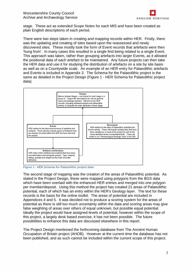
stage. These act as extended Scope Notes for each MIS and have been created as plain English descriptions of each period. There were two steps taken in creating and mapping records within HER. Firstly, there was the updating and creating of sites based upon the reassessed and newly discovered sites. These mostly took the form of Event records that artefacts were then 'hung from'. In many cases this resulted in a single find being related to a single Event. This approach was taken, rather than grouping artefacts into larger Events, as it allowed the positional data of each artefact to be maintained. Any future projects can then take the HER data and use it for studying the distribution of artefacts on a site by site basis as well as on a Countywide scale. An example of an HER entry for Palaeolithic artefacts and Events is included in Appendix 3. The Schema for the Palaeolithic project is the same as detailed in the Project Design (Figure 1 - HER Schema for Palaeolithic project data)
Figure 1 - HER Schema for Palaeolithic project data
The second stage of mapping was the creation of the areas of Palaeolithic potential. As stated in the Project Design, these were mapped using polygons from the BGS data which have been overlaid with the enhanced HER entries and merged into one polygon per member/deposit. Using this method the project has created 21 areas of Palaeolithic potential, each of which has an entry within the HER's Geology layer. The text for these records is the basis for the online toolkit. The areas of potential are included in Appendices 4 and 5. It was decided not to produce a scoring system for the areas of potential as there is still too much uncertainty within the data and scoring areas may give false weighting of areas over others of equal unknown, but possible equal potential. Ideally the project would have assigned levels of potential, however within the scope of this project, a largely desk based exercise, it has not been possible. The future possibilities to enhance this data are discussed elsewhere in this report. The Project Design mentioned the forthcoming database from The Ancient Human Occupation of Britain project (AHOB). However at the current time the database has not been published, and as such cannot be included within the current scope of this project.
Worcestershire County Council Archive and Archaeology Service
8
Once published, this can be considered as part of the ongoing enhancement of the HER and will possibly inform an update to the results of this project.
Stage 2 – Production of Toolkit The methodology for the production of the toolkit has been carried out as described in the Project Design. See the results section for further details on the completed toolkit.
Stage 3 – Dissemination The toolkit and training sessions will predominantly take the form of online resources, which allows the greatest exposure of the material and also allows the materials to be updated easily. The toolkit will be linked directly to the relevant records on the Heritage Gateway website, allowing access to the full HER records for each area of potential. Worcestershire HER maintains its Heritage Gateway dataset monthly, therefore it will never be more than 1 month out-of-date if edits are made to the master HER. The project was presented in November 2013 at the Worcestershire Archive and Archaeology Annual Dayschool. It is still envisaged that the project will be disseminated via the HER Forum Online, and that at a suitable time will be presented at a national or regional HER meeting.
Results
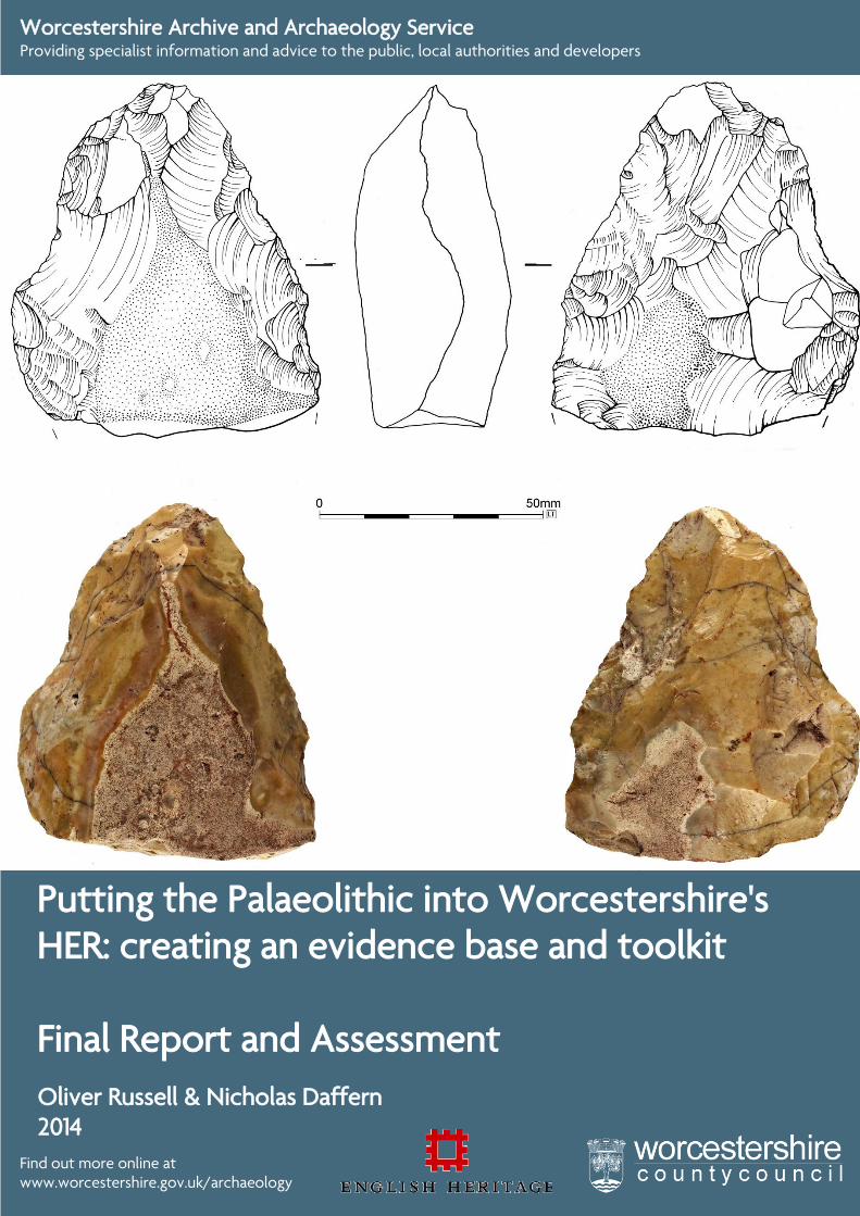
Reassessment of Artefact Collections A major part of this project was the reassessment of various collections of artefacts, most notably the Whitehead collection held within the British Museum. Over 251 stone objects were assessed from the Whitehead collection and a further 53 from various local Worcestershire collections. This assessment work was carried out by an external specialist, Dr Andrew Shaw, who provided a complete report on the identification and assessment of the material. The assessment assigned 79.3% of the artefacts to the Palaeolithic, with several artefacts being of particular interest, five of which were illustrated for the project. The artefacts have been dated within the traditional tripartite system, however these were then been given the equivalent MIS ranges to fit into the newly enhanced dating abilities of the HER. These five artefacts are possibly 5 of the oldest, if not the oldest, artefacts in Worcestershire. Further information and the reasons for their being illustrated are set out below: Pershore/Allesborough handaxe (Appendix 10, Figure 5) – This handaxe is morphologically (probably due to later rolling/abrasion) and geologically unusual. It is thought to be Lower Palaeolithic in date probably MIS 11 – 9 (D Hurst, R Jackson, A Shaw 2013). Unfortunately, as it was a stray surface find during fieldwalking, it cannot be assigned to a particular context but the Pershore Sand and Gravel Member which lies to the north-east and south-west, is probably the most likely origin. Geologically, the handaxe is unusual with a recent assessment indicating either a south-west (Cornwall) or north-east (Yorkshire) origin (Nick Ashton pers comm.), possibly supporting the theories of researchers such as Paul Pettitt who propose that the Severn-Avon corridor was utilised as seasonal migration route from south-west to north-east Britain. Ashton under Hill/Bredon Hill handaxe (Appendix 10,Figure 6) – This artefact has been assigned a Lower/ Middle Palaeolithic date but it does exhibit features suggesting that it may be Late Middle Palaeolithic in date, possibly making it later than the other artefacts
Worcestershire County Council Archive and Archaeology Service
9
selected. Morphologically it was different from the other artefacts selected for illustration, being smaller than the other handaxes and, to non-artefact specialists at least, different to the preconceptions of what a Palaeolithic hand-axe ‘should be like’. This perceived difference stimulated much discussion as to why it was smaller and how it would have been utilised and it is hoped that members of the public and other professionals will be similarly stimulated. It was in a very good condition and its colouration was somewhat different than other selected artefacts illustrating the range of materials utilised. Moseley Farm, Hallow handaxe (Appendix 10, Figure 7) – Provisionally identified as Early Middle Palaeolithic, and given the hiatus in anthropogenic activity for the majority of the Middle Palaeolithic it is thought to be MIS 7, possibly MIS 8 in date. Artefacts from this period are nationally rare and would be a first in the West Midlands (Andy Shaw 2013.). As such, it would be an extremely good example of the potential east/west, Levallois/handaxe divide in Britain. The artefact is in extremely fresh condition and is not directly associated with a mapped superficial deposit hinting at the possibility of an undisturbed, valley side deposit. Old Hills/Madresfield (Appendix 10, Figure 8) – Morphologically, it is thought to be Lower Palaeolithic in date probably MIS 11 – 9 (A Shaw 2013). Unfortunately, as it was a stray surface find during fieldwalking, it cannot be assigned to a particular context but the Bushley Green and Spring Hill Sand and Gravel Members lie to the east of the findspot. Queenshill/Upton-upon-Severn (Appendix 10, Figure 9) - Morphologically, it is thought to be Lower Palaeolithic in date probably MIS 11 – 9 (A Shaw 2013) and as such may be the oldest artefact from Worcestershire. Unfortunately, as it was a stray surface find during fieldwalking, it cannot be assigned to a particular context but the Bushley Green and Spring Hill Sand and Gravel Members lie to the east and south of the findspot. Aesthetics also played a part in the decision making process when choosing the artefacts to illustrate. Individuals (both archaeologists and public) were asked which of the available artefacts were the most interesting, most attractive or fulfilled their perception of what a Palaeolithic artefact looks like. This was of great importance as if something is not recognisable as a tool or does not stir some form of emotion or interest, then engagement with the subject is less likely. The report acknowledges that even though Worcestershire has a relatively small collection of Palaeolithic artefacts it is indeed highly significant. Here are some of the observations from the report (Shaw 2013):
The collection reflects the fact that few investigators have actively sought to recover material within the County and when they have, it has been biased towards reject heaps in gravel quarries.
The assemblages and artefacts give some indication of the first recorded human presence in the region.
The reassessment potentially identified the first Early Middle Palaeolithic artefact from the West Midlands (Moseley Farm/Park) although the dating of this must currently remain uncertain as it has not been directly assigned to a particular superficial deposit. Despite this uncertainty, the condition of the artefact suggests it may have been derived from a previously undisturbed, in-situ context.
There is potential for Worcestershire to contribute to ongoing, in particular, whether there are west/east divides and/or different entry routes for different hominin species. In the Early Middle Palaeolithic, Levallois assemblages are
Worcestershire County Council Archive and Archaeology Service
10
found in the Thames Valley whilst handaxes are found in the West of the UK. Whilst in the Upper Palaeolithic, Aurignacian scrapers, associated with modern humans, have a westerly distribution with the Aston Mill artefact being one of the most easterly examples (Dinnis 2012, 4).
The artefacts selected for illustration were chosen based primarily on their significance. Unfortunately, due to the difficulty of arranging a loan (insurance, time constraints etc) from the British Museum, examples like the Aurignacian scraper were unavailable for high-res photography and/or illustration.
The collection has potential to be of greater use for both research and strategic planning, especially within the Carrant Brook, if it is combined with some further fieldwork and study of Whitehead's notebooks for spatial data.
As already noted, most of Worcestershire's Palaeolithic material was collected by a single individual, P.R. Whitehead. Whitehead's collection comprises over 90% of the record and is from a single river valley. This demonstrates that when actively sought, nationally significant Palaeolithic deposits have been shown to be present in Worcestershire and that the potential for further deposits elsewhere in the County is high.
Although the faunal remains were not reassessed, or even viewed, during this project, the complete catalogue was digitised and mapped in GIS. During this process it became apparent that there were several important remains. The sheer quantity of faunal remains informally collected by Whitehead and his contacts is frankly staggering and, considering the majority comes from just two locations, Aston Mill and Beckford, demonstrates the massive potential of Worcestershire’s aggregates. It also amply illustrates the quantity and quality of material held by museums, both locally and nationally, which have never formally been investigated or subject to modern scientific analysis. It is highly likely that many of the gaps in knowledge and/or questions posed by research frameworks could be addressed by re-evaluation and re-interpretation of the material already within our possession. The concentration and distribution of artefacts recovered from the Carrant Brook area has been the subject of debate, ie, is the distribution real or is it merely due to the area being the focus of Whitehead’s research? Whilst the latter is most certainly true, the environment and landscape of a wide, open floodplain marking the confluence of two major river systems within the high ground of Bredon Hill and the Cotswolds, would have been a fertile habitat for wildlife and an incredibly attractive hunting ground. Potential evidence for the exploitation of fauna by early humans is afforded by the bone fragment recorded by Whitehead as being “butchered and gnawed”. Whilst this fragment has not been reassessed, the use of the word butchered by Whitehead, a phrase not used elsewhere, is tantalising. Given his knowledge of prehistoric and Palaeolithic archaeology, it is likely that he used this phrase purposefully. The provenance of these remains is not in question as the organics overlying the Lias Clay in this area have variously been radiocarbon dated to between 32 – 26,000BP and the recovery of bison and reindeer remains from the same context support the Devensian date. If this evidence does show signs of human agency, then it is likely to be the earliest evidence for butchery in Worcestershire (possibly the West Midlands although this would have to be confirmed). The presence of hippopotamus remains at Aston Mill and those at Stourbridge (Boulton 1917) and Gloucester (Schreve 2009) highlights the potential for Ipswichian (MIS 5e)
Worcestershire County Council Archive and Archaeology Service
11
deposits, containing significant faunal and palaeoenvironmental remains, lying undisturbed and uninvestigated in the Avon and Severn Valleys, away from the recognised locations at Eckington and Cropthorne. Pleistocene fauna, such as hippos, mammoths and lions, are one of the strongest resources available for engagement with the public. Examples such as the hippo remains gnawed by hyaena and reindeer gnawed by wolf, illustrate that the past was an active place regardless of human presence. Visualising exotic fauna has proven to be one of the most captivating elements when discussing the subject during outreach.
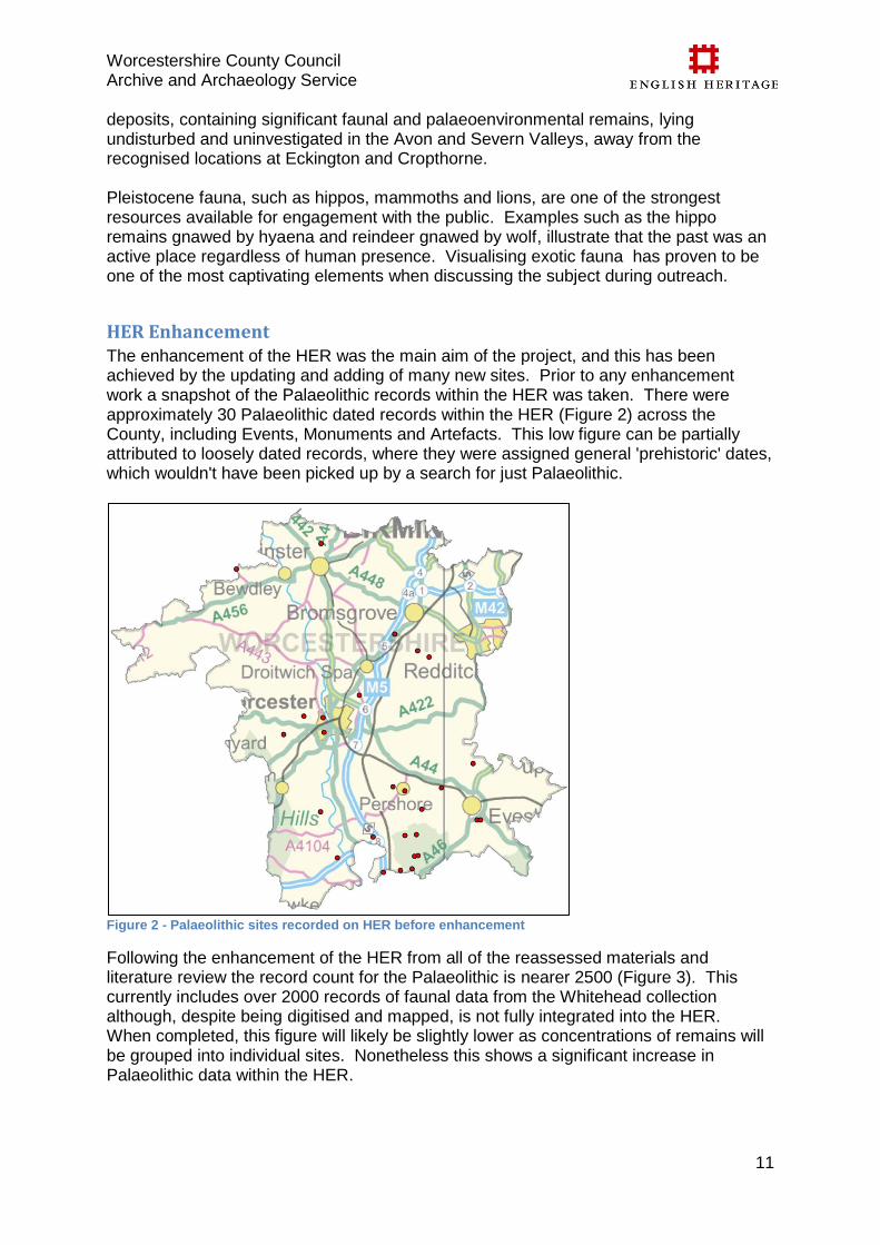
HER Enhancement The enhancement of the HER was the main aim of the project, and this has been achieved by the updating and adding of many new sites. Prior to any enhancement work a snapshot of the Palaeolithic records within the HER was taken. There were approximately 30 Palaeolithic dated records within the HER (Figure 2) across the County, including Events, Monuments and Artefacts. This low figure can be partially attributed to loosely dated records, where they were assigned general 'prehistoric' dates, which wouldn't have been picked up by a search for just Palaeolithic.
Figure 2 - Palaeolithic sites recorded on HER before enhancement
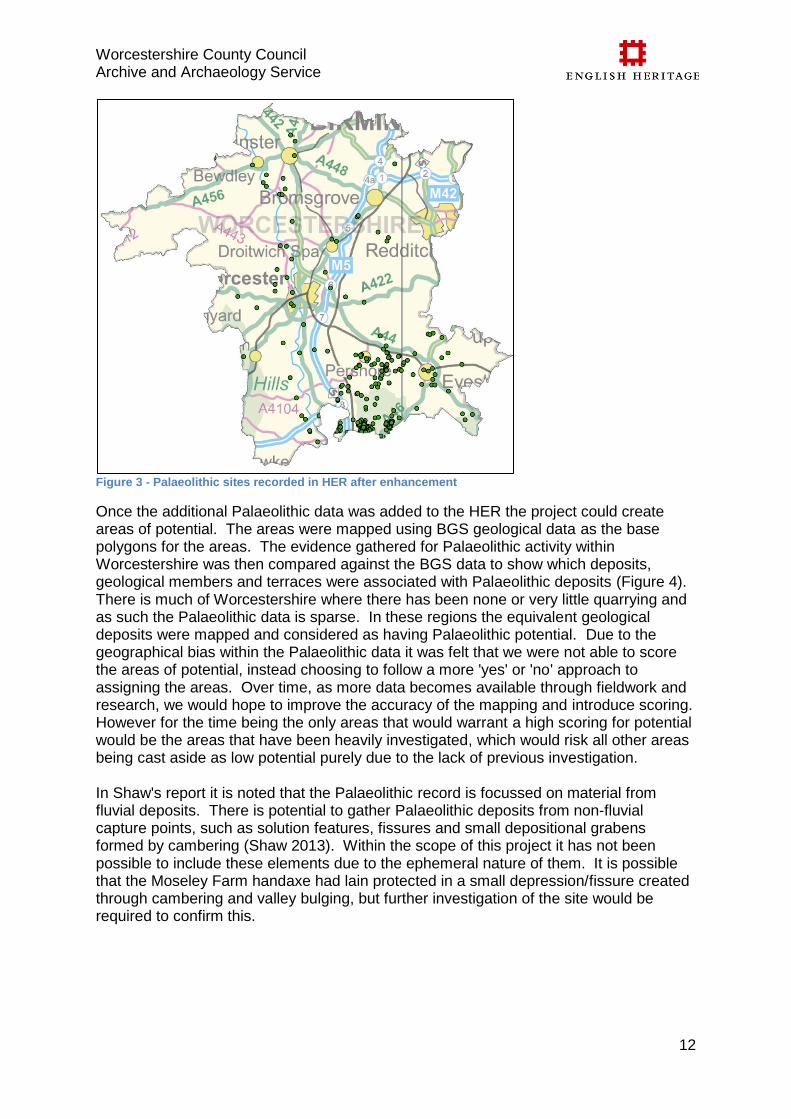
Following the enhancement of the HER from all of the reassessed materials and literature review the record count for the Palaeolithic is nearer 2500 (Figure 3). This currently includes over 2000 records of faunal data from the Whitehead collection although, despite being digitised and mapped, is not fully integrated into the HER. When completed, this figure will likely be slightly lower as concentrations of remains will be grouped into individual sites. Nonetheless this shows a significant increase in Palaeolithic data within the HER.
Worcestershire County Council Archive and Archaeology Service
12
Figure 3 - Palaeolithic sites recorded in HER after enhancement
Once the additional Palaeolithic data was added to the HER the project could create areas of potential. The areas were mapped using BGS geological data as the base polygons for the areas. The evidence gathered for Palaeolithic activity within Worcestershire was then compared against the BGS data to show which deposits, geological members and terraces were associated with Palaeolithic deposits (Figure 4). There is much of Worcestershire where there has been none or very little quarrying and as such the Palaeolithic data is sparse. In these regions the equivalent geological deposits were mapped and considered as having Palaeolithic potential. Due to the geographical bias within the Palaeolithic data it was felt that we were not able to score the areas of potential, instead choosing to follow a more 'yes' or 'no' approach to assigning the areas. Over time, as more data becomes available through fieldwork and research, we would hope to improve the accuracy of the mapping and introduce scoring. However for the time being the only areas that would warrant a high scoring for potential would be the areas that have been heavily investigated, which would risk all other areas being cast aside as low potential purely due to the lack of previous investigation. In Shaw's report it is noted that the Palaeolithic record is focussed on material from fluvial deposits. There is potential to gather Palaeolithic deposits from non-fluvial capture points, such as solution features, fissures and small depositional grabens formed by cambering (Shaw 2013). Within the scope of this project it has not been possible to include these elements due to the ephemeral nature of them. It is possible that the Moseley Farm handaxe had lain protected in a small depression/fissure created through cambering and valley bulging, but further investigation of the site would be required to confirm this.
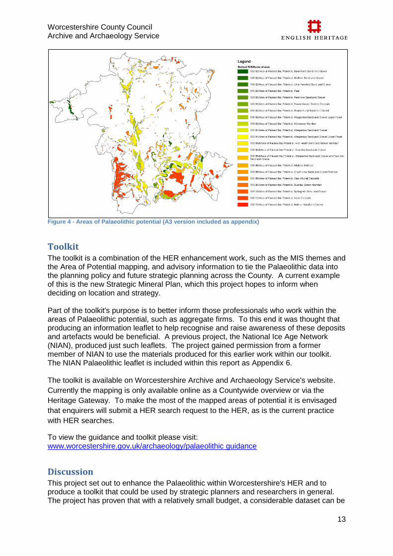
Worcestershire County Council Archive and Archaeology Service
13
Figure 4 - Areas of Palaeolithic potential (A3 version included as appendix)
Toolkit The toolkit is a combination of the HER enhancement work, such as the MIS themes and the Area of Potential mapping, and advisory information to tie the Palaeolithic data into the planning policy and future strategic planning across the County. A current example of this is the new Strategic Mineral Plan, which this project hopes to inform when deciding on location and strategy. Part of the toolkit's purpose is to better inform those professionals who work within the areas of Palaeolithic potential, such as aggregate firms. To this end it was thought that producing an information leaflet to help recognise and raise awareness of these deposits and artefacts would be beneficial. A previous project, the National Ice Age Network (NIAN), produced just such leaflets. The project gained permission from a former member of NIAN to use the materials produced for this earlier work within our toolkit. The NIAN Palaeolithic leaflet is included within this report as Appendix 6. The toolkit is available on Worcestershire Archive and Archaeology Service's website.
Currently the mapping is only available online as a Countywide overview or via the
Heritage Gateway. To make the most of the mapped areas of potential it is envisaged
that enquirers will submit a HER search request to the HER, as is the current practice
with HER searches.
To view the guidance and toolkit please visit: www.worcestershire.gov.uk/archaeology/palaeolithic guidance
Discussion This project set out to enhance the Palaeolithic within Worcestershire's HER and to produce a toolkit that could be used by strategic planners and researchers in general. The project has proven that with a relatively small budget, a considerable dataset can be
Worcestershire County Council Archive and Archaeology Service
14
produced through the reassessment and reinterpretation of existing resources. Given the relative simplicity of the method, rolling out/replication of this project could occur in other regions and for other periods although it should be noted that specialist support for reviewing Quaternary datasets may be necessary given the unfamiliarity of the techniques and evidence. The project has also shown that Worcestershire has real potential to contribute, nationally as well as regionally, to our understanding of hominin development, migration and landscape interaction, whereas previously the region was not considered a focal point for Palaeolithic study. This is reinforced by Dr Shaw in his report "….. it demonstrates that nationally important Palaeolithic sites and collections are present in the county which, if accompanied by further investigations, have the potential to materially contribute to our understanding of the Palaeolithic occupation of the British Isles." . The project has also demonstrated that the Severn and Avon has high potential for the recovery of nationally significant geoarchaeological, palaeoenvironmental and faunal datasets with the potential to improve, refine and advance our understanding of past human-environment interactions.
Review of Costs
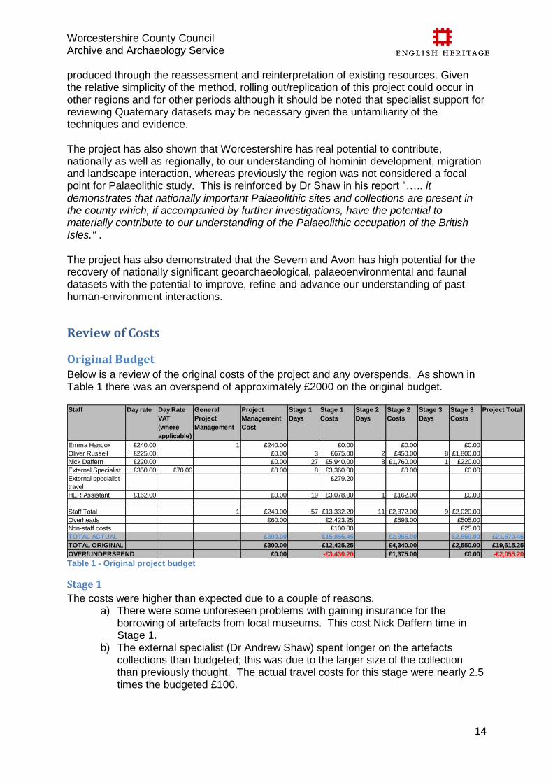
Original Budget Below is a review of the original costs of the project and any overspends. As shown in Table 1 there was an overspend of approximately £2000 on the original budget.
Table 1 - Original project budget
Stage 1
The costs were higher than expected due to a couple of reasons. a) There were some unforeseen problems with gaining insurance for the
borrowing of artefacts from local museums. This cost Nick Daffern time in Stage 1.
b) The external specialist (Dr Andrew Shaw) spent longer on the artefacts collections than budgeted; this was due to the larger size of the collection than previously thought. The actual travel costs for this stage were nearly 2.5 times the budgeted £100.
Staff Day rate Day Rate
VAT
(where
applicable)
General
Project
Management
Project
Management
Cost
Stage 1
Days
Stage 1
Costs
Stage 2
Days
Stage 2
Costs
Stage 3
Days
Stage 3
Costs
Project Total
Emma Hancox £240.00 1 £240.00 £0.00 £0.00 £0.00
Oliver Russell £225.00 £0.00 3 £675.00 2 £450.00 8 £1,800.00
Nick Daffern £220.00 £0.00 27 £5,940.00 8 £1,760.00 1 £220.00
External Specialist £350.00 £70.00 £0.00 8 £3,360.00 £0.00 £0.00
External specialist
travel
£279.20
HER Assistant £162.00 £0.00 19 £3,078.00 1 £162.00 £0.00
Staff Total 1 £240.00 57 £13,332.20 11 £2,372.00 9 £2,020.00
Overheads £60.00 £2,423.25 £593.00 £505.00
Non-staff costs £100.00 £25.00
TOTAL ACTUAL £300.00 £15,855.45 £2,965.00 £2,550.00 £21,670.45
TOTAL ORIGINAL £300.00 £12,425.25 £4,340.00 £2,550.00 £19,615.25
OVER/UNDERSPEND £0.00 -£3,430.20 £1,375.00 £0.00 -£2,055.20
Worcestershire County Council Archive and Archaeology Service
15
Stage 2
The production of the synthetic text for the toolkit did not take as long as originally planned, which allowed Nick Daffern to make up the time lost in point a) above.
Stage 3
This stage is coming in on budget, with a couple of task being planned to be completed after this report, including disseminating the results via HER Forum and producing a short paper on the methodology and results.
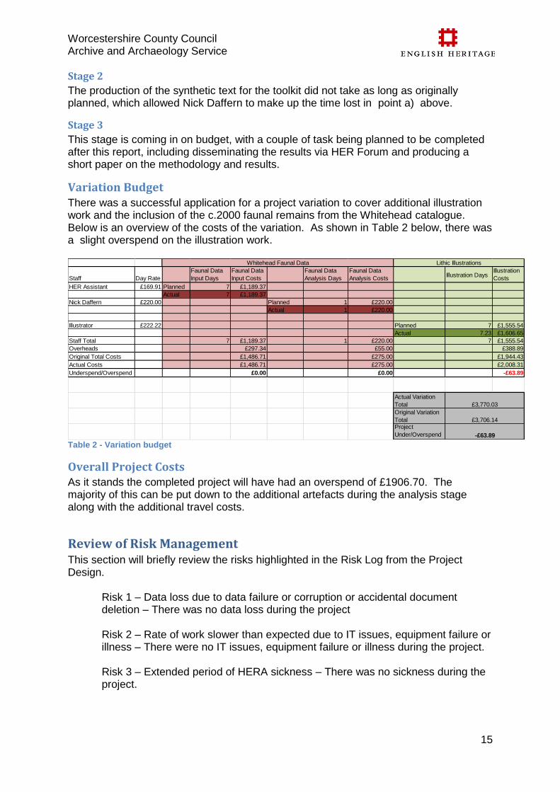
Variation Budget There was a successful application for a project variation to cover additional illustration work and the inclusion of the c.2000 faunal remains from the Whitehead catalogue. Below is an overview of the costs of the variation. As shown in Table 2 below, there was a slight overspend on the illustration work.
Table 2 - Variation budget
Overall Project Costs As it stands the completed project will have had an overspend of £1906.70. The majority of this can be put down to the additional artefacts during the analysis stage along with the additional travel costs.
Review of Risk Management This section will briefly review the risks highlighted in the Risk Log from the Project Design.
Risk 1 – Data loss due to data failure or corruption or accidental document deletion – There was no data loss during the project Risk 2 – Rate of work slower than expected due to IT issues, equipment failure or illness – There were no IT issues, equipment failure or illness during the project. Risk 3 – Extended period of HERA sickness – There was no sickness during the project.
Staff Day Rate
Faunal Data
Input Days
Faunal Data
Input Costs
Faunal Data
Analysis Days
Faunal Data
Analysis CostsIllustration Days
Illustration
Costs
HER Assistant £169.91 Planned 7 £1,189.37
Actual 7 £1,189.37
Nick Daffern £220.00 Planned 1 £220.00
Actual 1 £220.00
Illustrator £222.22 Planned 7 £1,555.54
Actual 7.23 £1,606.65
Staff Total 7 £1,189.37 1 £220.00 7 £1,555.54
Overheads £297.34 £55.00 £388.89
Original Total Costs £1,486.71 £275.00 £1,944.43
Actual Costs £1,486.71 £275.00 £2,008.31
Underspend/Overspend £0.00 £0.00 -£63.89
Actual Variation
Total
Original Variation
TotalProject
Under/Overspend -£63.89
Whitehead Faunal Data
£3,770.03
£3,706.14
Lithic Illustrations
Worcestershire County Council Archive and Archaeology Service
16
Risk 4 – Extended period of Project Leader sickness – There was no sickness during the project. Risk 5 – Extended period of absence of project specialist – During the majority of the project (until Jan 2014) all specialists were present. In January 2014 Nick Daffern left WAAS, however he has committed to contributing to the final report in his own time. Risk 6 – Resignation of HERA – No HERAs resigned during the project. Risk 7 – Resignation of Project Leader – Project Leader did not resign. Risk 8 – Resignation of Project Specialist – Nick Daffern did resign at the end of 2013, however he has committed himself to work with the project team on the completing of the report.
Risks that were not originally raised:
1 – Problem associated with the borrowing of artefacts, most notably gaining insurance for the items. Future projects should check this situation in the Project Design stage. 2 – Specialist overrun due to larger collections – Dr Andrew Shaw overran by 2 days on the reanalysis of the lithic material. This is due to the available collection being larger than originally believed. Future projects should be aware of this and allow for a greater contingency. 3 – Overspend on travel costs – The original budget under calculated the travel costs for the specialist (Dr Shaw). Future projects should allow for greater travel costs, especially when traveling at short notice on rail as there is less flexibility on costs.
The general analysis of the risks is that we managed to control them within our own team and the more certain areas of the project, however we did not allow for the variability of travel costs and the potential for the artefact collection to be almost 1.5 times larger than expected.
Future Work
Worcestershire The end of this project does not signify the end of enhancing the Palaeolithic within Worcestershire's HER. As further research, large scale development and ongoing analysis takes place within the region the newly created resource will be maintained and updated through the usual process of HER enhancement. As an update to the toolkit, an interactive GIS based website could be developed, allowing online investigation of areas of interest without the need to consult the HER in every case. This would require further funding, through a second stage project or a new related project. Following this project there is scope for further study and assessment of the materials and sites. One major aspect that would benefit from further work is the large collection of faunal remains within the Natural History Museum that form part of the Whitehead
Worcestershire County Council Archive and Archaeology Service
17
collection. Without personally knowing P. Whitehead it is unknown how confident he was in his identifications of faunal remains; however it appears he had an extremely high level of ability and knowledge in this area so it is not necessary to doubt his identifications, but reassessment of these remains by a suitable faunal specialist would be valuable to confirm the nature of the archive and to place it in context in light of recent findings. As discussed in the results section there appear to be quite a few notable objects and remains with diagnostic markings in the collection, such as the earliest evidence for butchery within Worcestershire. Having these reassessed would allow for the confirmation of this and other important features. As suggested by Dr Shaw, the data currently held could benefit from fieldwork investigations, including coring and scientific dating of deposits. This could be included as planning conditions for new areas of quarrying within areas of Palaeolithic potential. A particular area requiring reassessment is the Holt Heath Member. This member is believed to be composite, representing multiple phases of deposition. Thus the dating of this unit has proven problematic in the past (Dawson and Bryant 1987, Maddy et al 1995) and deposition is currently dated to between MIS 5d – MIS 2/ LGM(Last Glacial Maximum). The Upton Warren Beds contained within the Holt Heath Member have been dated to between 80 – 57ka by amino acid dating (Bowen et al 1989; 2002) and 42ka by radiocarbon dating (Coope et al 1961) thus indicating the Member was accumulating prior to and after their formation. Despite this dating, the Member is often characterised as containing a significant proportion of Irish Sea basin erratics derived from the Devensian Stockport Glacigenic Formation (McMillan et al 2011) thought to have been deposited during the Dimlington Stadial (22 – 13ka). Obviously this is in opposition to the dating from Upton Warren and therefore a clearer understanding of the timing and conditions of the Holt Heath Member’s deposition is required. It is suggested that sub-division of the unit occurs eg Holt Heath 1, Holt Heath 2 etc depending on phase of deposition or a new nomenclature is applied. It is preliminarily suggested that there are two or three divisions consisting of the lower/oldest member deposited somewhere between MIS 5d - early 4 overlying the Ipswichian faunal beds at Stourbridge, possibly a middle member deposited during MIS 4 - 3 (although this middle may have to be combined with the lower, it also includes the Upton Warren Beds) and finally an upper, youngest member deposited during the Dimlington Stadial of MIS2 containing the Irish Sea erratics. Selection of suitable material from the Whitehead and Upton Warren archives is likely to produce material suitable for radiometric dating and/or other analytical techniques that were previously unavailable. Unfortunately, due to the difficulty of arranging a loan (insurance, time constraints etc) from the British Museum, examples like the Aurignacian scraper were unavailable for high-res photography and/or illustration. This is something that should be considered for further work as the confirmed identification of a scraper of this date is nationally significant. Due to its significance, the preparation of a short journal article confirming the identification of the Aurignacian should be considered as concerns regarding the provenance and identification of the artefact have rightly been raised (Dinnis 2012). As part of the preparation of this article, the reassessment of Whiteheads notes should be undertaken to try and confirm the exact location and nature of the context from which it
Worcestershire County Council Archive and Archaeology Service
18
was recovered, something that was unfortunately not achievable under the remit of the present work. Interaction with quarry companies to allow suitably trained and inducted professionals and volunteers access to active extraction sites to scan the reject heaps for Palaeolithic artefacts and create relationships with the companies similar to the one that Whitehead maintained. This may lead to access for brief recording of faces and collection of material that would previously have been lost. Walkover surveys in areas where surface finds have been recorded such as Madresfield and Hallow) but also in the former quarry areas and fossil bed locations ie Kemerton Lakes, Eckington to identify if any of the sections of old workings or associated drainage channels are extant or if stray material has been exposed.
Regionally/Nationally This project has shown that the region's Palaeolithic remains have the potential to be of national importance; therefore a future project rolling out this methodology to the West Midlands Region would seem appropriate. The Palaeolithic section of The Archaeology of the West Midlands (Garwood 2011) points out that the region has been traditionally neglected when it comes to Palaeolithic research. When work has been carried out in recent years, most notably by P. Whitehead and R. Waite, it has concentrated on the Severn/Avon confluence in Worcestershire and Wolvey in Warwickshire. The region would benefit hugely from systematic research-led programmes of artefact recovery and site investigations. This project has in part covered many of the regional aims set out in this publication:
"…….further evaluation of museum and private collections……"
"…….Palaeolithic archaeology should be brought more effectively into the domain of developer-funded archaeology and the planning process….."
"……'predictive modelling' of sites and finds"
"…...there is a need to establish protocols for dealing with this evidence……"
"Existing lithic artefacts collections in museums should be re-evaluated……." Through the work of this project, and the potential regional roll-out of the methodology, it should be possible to produce enhanced datasets that can inform an updated research framework for the West Midlands that better reflect the regions potential. During the recent NHPP seminar with the other Mesolithic and Palaeolithic projects it became apparent that many of the HERs were realising the limitations of the current thesauri for indexing Palaeolithic sites and deposits. This project chose to use the current thesauri terms in the interest of inputting the data rapidly, however we would agree that a re-think of terms would benefit HERs in the future and enhance their ability to record these sites. As suggested in the seminar, all NHPP projects working on this activity should discuss and collaborate on new and revised terms that are more fitting this period. It is envisaged that this will occur sometime after this project has completed as all other NHPP projects are on a later timescale. However we can collaborate with the other projects and update our data when thesauri have been agreed.

Worcestershire County Council Archive and Archaeology Service
19
As the other NHPP projects come to completion it is hoped, that where applicable, national collaboration can be sought to produce consistent national guidance for the identification and recording of Palaeolithic deposits and sites.
Acknowledgements We would like to thank the project team and board who helped make this project
possible, in particular, Andrew Shaw for his analysis of the lithics collection, Andie
Webley for the huge amounts of HER data inputting that was undertaken, Laura
Templeton for the artefact illustration work and Jonathon Brusby for the artefact
photography.
Worcestershire County Council Archive and Archaeology Service
Appendices
1. Project Bibliography This bibliography includes all sources that were checked during literature review. Many of these are not referenced within the body of this report, however they have been sourced within the relevant HER records. Ambrose, K, Moorlock, B S P and Cannell, B, 1985,The geology of sheet SO84, Keyworth: British Geological Survey Barclay, W J, Brandon, A, Ellison, R A and Moorlock,B S P, 1992, A middle Pleistocene palaeovalley-fill west of the Malvern Hills, Journal of the Geological Society, London, Vol 149, 75 – 92 Beckensale, R P and Richardson, L, 1964, Recent findings on the physical development of the lower Severn valley, Geographical Journal 130: 87-105 Boulton, W S, 1917, Mammalian remains in the glacial gravels at Stourbridge, Proceedings of the Birmingham Natural History and Philosophical Society, 14, 107 - 112 Bowen, D Q, Hughes, S, Sykes, G A and Miller, G H, 1989, Land-sea correlations in the Pleistocene based on isoleucine epimerization in non-marine molluscs, Nature, Vol 340, 49 - 51 Bowen, D Q, 1999, A revised correlation of Quaternary deposits in the British Isles, Special Report of the Geological Society of London, No 23 Bowen, D Q, 2000, Revised aminostratigraphy for land-sea correlations from the northeastern North Atlantic margin, in Goodfriend, G A, Collins, M J, Fogel, M L, Macko, S A, Wehmiller, J F (eds), Perspectives in amino acid protein geochemistry, Oxford: Oxford University Press, 253 - 262 Bridgland, D R, Maddy, D, Bates, M, 2004, River terrace sequences: templates for Quaternary geochronology and marine-terrestrial correlation, Journal of Quaternary Science, 19, 203 - 218 Briggs, D J, 1975, Origin, depositional environment and age of the Cheltenham Sand and gravel and related deposits, Proceedings of the Geologists' Association. Vol.86, 333-348 Briggs, D J, Coope, G R and Gilbertson, D D, 1975, Late Pleistocene terrace deposits from Beckford, Worcestershire, Geological Journal, 10, 1 - 16 Brown, A.G., 1982. Late Quaternary Palaeohydrology, Palaeoecology and Floodplain development of the Lower River Severn. Unpublished PhD thesis, University of Southampton
Worcestershire County Council Archive and Archaeology Service
Brown, A G, 1984, The Flandrian vegetational history of Hartlebury Common, Worcestershire, Proceedings of the Birmingham Natural History Society, 25 (2), 89-98 Buteux, S T E, Keen, D H, and Lang, A T O, 2005, Resource Assessment – The Shotton Project, University of Birmingham Coope, G R, 1962, A pleistocene coleopterous fauna with arctic affinities from Fladbury, Worcestershire, Quarterly Journal of the Geological Society of London, 118, 103 -123 Coope, GR and Kenward H, K, Evidence from coleopteran assemblages for a short but intense cold interlude during the latter part of the MIS 11 interglacial from Quinton, West Midlands, UK,Quaternary Science Reviews, Vol 26,pp. 3276 - 3285 Coope, G R, Shotton, F W and Strachan, I, 1961, A Late Pleistocene flora and fauna from Upton Warren, Worcestershire, Philosophical Transactions of the Royal Society B, 151, 70 - 86 Coope, G R, Gibbard, P L, Hall, A R, Preece, R C, Robinson, J E and Sutcliffe, A J, 1997, Climatic and environmental reconstructions based on fossil assemblages from Middle Devensian (Weichselian) deposits of the river Thames at South Kensington, Central London, UK, Quaternary Science Reviews, 16, 1163–1195 Climatic and environmental reconstructions based on fossil assemblages from Middle Devensian (Weichselian) deposits of the river Thames at South Kensington, Central London, UK. Quaternary Science Reviews, 16, 1163–1195 Cross, P and Hodgson, J M, 1975, New evidence for the glacial diversion of the River Teme near Ludlow, Salop, Proceedings of the Geologists' Association, 86, 313-331 Dawson, M R, 1985, Environmental reconstruction of a Late Devensian terrace sequence, Earth Surface Processes and Landforms, 10, 237 - 246 Dawson, M R, 1988, Diamict deposits of pre-Late Devensian age underlying the Severn Main terrace at Stourport, Worcestershire: their origins and stratigraphic implications, Proceedings of the geologists Association, 92, 125 - 132 Dawson, M R, 1989, Chelmarsh, in Keen, D H (eds), The Pleistocene of the West Midlands: Field Guide, 80 - 85, Cambridge: Quaternary Research Association Dinnis, R, 2012, The archaeology of Britain's first modern humans, Antiquity, 86, 333, 627 - 641 English Nature. 1982. Wilden Marsh Nature Reserve Borehole Logs Field, M H, Gibbard, P L, and Brandon, A, 1997, The first record of Larix from the British Pleistocene, Geological Magazine, 134, 3, 317 - 322 Garwood, P, 2011, The earlier prehistory of west midlands, in Watt, S. (eds), The Archaeology of the West Midlands: A Framework for Research, Oxbow Books, 9 - 24 Goodwin, M, Maddy, D and Lewis, S G, 1997, Pleistocene deposits at Gibbet Hill, (Stewponey Pit), Stourbridge, Staffordshire, in Lewis, S G, and Maddy, D (eds) The
Worcestershire County Council Archive and Archaeology Service
Quaternary of the South Midlands and the Welsh Marches: Field Guide, London: Quaternary Research Association, 91 - 94 Grinsell, L V, 1960, A Palaeolithic implement from Beckford, Worcestershire, The Antiquaries Journal, 40, 67-68 Hey, R W, 1958, High level gravels, in and near the lower Severn Valley, Geological Magazine, 95, 161 - 168 Hughes, S A, 1987, The Aminostratigraphy of British non-marine deposits, Unpublished Ph.D. Thesis, University of Wales. Jackson, R, Mann, A and Roberts, T, 2011, Evaluating and enhancing the geoarchaeological resource of the Lower Severn Valley, WHEAS report, 1819 Huntsmans Quarry, Kemerton, unpublished Jacobs Babtie, 2005 Wilden Marsh and Meadows SSSI Cultural Heritage Desk-Based Assessment: Worcestershire HER Number WSM34765, unpublished report, Jacobs Babtie, Leeds Keen, D H (eds), 1989, The Quaternary of the South Midlands and the Welsh Marches: Field Guide, London: Quaternary Research Association Keen, D H and Bridgland, D R, 1986, An interglacial fauna from Avon No 3 Terrace at Eckington, Worcestershire, Proceedings of the Geological Association of London, 97, 303 - 307 Lang, A T O and Keen, D H, 2003, A further andesite handaxe from Waverley Wood Quarry, Warwickshire, Lithics, 24 Lisiecki, L. E., and M. E. Raymo, 2005, A Pliocene-Pleistocene stack of 57 globally distributed benthic d
18O records, Paleoceanography, 20, PA1003,
doi:10.1029/2004PA001071 Maddy, D, 2002, Geologie en Mijnbouw/Netherlands Journal of Geosciences, 81, 329 - 338 Maddy, D and Lewis, S G, 2005, Glaciation and the Pleistocene development of the Lower River Severn, UK, in Lewis C A and Richards A E (eds) The glaciations of Wales and adjacent areas, Almeley, Herefordshire: Logaston press, 73 - 84 Maddy, D, Keen, D H, Bridgland, D R, Green, C P, 1991, A revised model for the Pleistocene development of the River Avon, Warwickshire, Journal of the Geological Society of London, 148, 473 - 484 Maddy, D, Green, C P, Lewis, S G and Bowen, D Q, 1995, Pleistocene geology of the Lower Severn Valley, UK, Quaternary Science Reviews, 14, 209 - 222 Maddy, D, Lewis S, Keen D, 1999 Pleistocene palaeomeanders of the River Avon, Warwickshire, Proceedings of the Geologists' Association, 110 (2), 163-172
Worcestershire County Council Archive and Archaeology Service
Maddy, D, 1999, English Midlands, in Bowen, D Q (eds) A revised correlation of Quaternary deposits in the British Isles, Special Report of the Geological Society of London, No 23, 28 - 44 Maddy, D Lewis, S G, Goodwin, M and Risdon, S, 1997, Roger Constants Pit, Stourport, Worcestershire in Lewis, S G, and Maddy, D (eds) The Quaternary of the South Midlands and the Welsh Marches: Field Guide, London: Quaternary Research Association McMillan, A A, Hamblin, R J O, Merritt, J W, 2011, A lithostratigraphical framework for onshore Quaternary and Neogene (Tertiary) superficial deposits of Great Britain and the Isle of Man, Nottingham, UK, British Geological Survey Moorlock, B S P, Barron, A J M, Ambrose, K and Cannell, B, 1985, Geology of sheet SO85, Keyworth: British Geological Survey Murton, J B, Baker, A, Bowen, D Q, Caseldine, C J, Coope, G R, Currant, A P, Evans, J G, , Field, M H, Green, C P, Hatton, J, Ito, M, Jones, R L, Keen, D H, Kerney, M P, McEwan, R, McGregor, D F M, Parish, D, Robinson, J E, Schreve, D and Smart, P L, 2001, A late Middle Pleistocene temperate-periglacial-temperate sequence (OIS 7 - 5e) near Marsworth, Buckinghamshire, UK, Quaternary Science Reviews, 20, 1787 - 1825 Penkman, K E H, Preece, R C, Bridgland, D R, Keen, D H, Meijer, T, Parfitt, S A, White, T S and Collins, M J, 2011, A chronological framework for the British Quaternary based on Bithynia opercula, Nature, 476, 446-449 Pettitt, P.B, & White, M.J, 2012, The British Palaeolithic: Human Societies at the Edge of the Pleistocene World. London: Routledge Phillips, F M, Bowen, D Q, and Elmore, D, 1994, Surface exposure dating of glacial features in Great Britain using cosmogenic chlorine-36:Preliminary Results, Abstract, VM. Goldshmidt Geochemical Conference, Edinburgh Richardson, L 1929, Geology of the country around Moreton-in-Marsh, Memoir of the Geological Survey of Great Britain De Rouffignac, C, Bowen, D Q, Coope, G R, Keen, D H, Lister, A M, Maddy, Robinson, J E, Sykes, G A and Walker, M J C, 1995, Late Middle Pleistocene interglacial deposits at Upper Strensham, Worcestershire, England, Journal of Quaternary Science, 10, 1, 15 - 31 Saville, A and Shotton, F W 1976, A Palaeolithic implement from Hanley Castle, Worcestershire, Transactions of the Worcestershire Archaeological Society, 5 Schreve, D C, 2009, A new record of Pleistocene hippopotamus from River Severn terrace deposits, Gloucester, UK—palaeoenvironmental setting and stratigraphical significance, Proceedings of the Geologists Association, 120, 58 - 64 Shaw, A, 2013, Putting the Palaeolithic into Worcestershire's HER – Whitehead Collection and Stray Finds, University College London
Worcestershire County Council Archive and Archaeology Service
Shotton, F W and Williams, R G, 1973, Birmingham University radiocarbon dates VI, Radiocarbon, Vol 15, No 1 Shotton, F W, Williams, R G and Johnson, A S, 1974, Birmingham University radiocarbon dates VIII, Radiocarbon, Vol 16, No 3 Shotton, F W, Williams, R G and Johnson, A S, 1975, Birmingham University radiocarbon dates IX, Radiocarbon, Vol 17, No 3 Shotton, F W, 1960, Large Scale Patterned Ground in the Valley of the Worcestershire Avon, Geological magazine, 97 (5), 404 - 408 Shotton, F W, 1967, Age of the Irish Sea Glaciation of the Midlands, Nature, 215, 136–137 Shotton, F W and Coope, G R, 1983 Exposures in the Power House Terrace of the River Stour at Wilden, Worcestershire, England, Proc. Geol. Ass., 94 (1), 33-44 Shotton, F W, Keen, D H, Coope, G R, Currant, A P, Gibbard, P L, Alton, M, Peglar, S M and Robinson, J E, 1993, The Pleistocene deposits at Waverley Wood Pit, Warwickshire, England, Journal of Quaternary Science, 8, 293 - 325 Strickland, H E, 1835, An account of land and freshwater shells found associated with the bones of land quadrupeds beneath deluvial gravels, at Cropthorne in Worcestershire, Proceedings of the Geological Society of London, 2, 111- 112 Bellamy, P, Hurst, J D, and Pearson, E, 2001, Kemerton, Worcestershire: Investigations by the Time Team, September/October 1998, Terrain Archaeology Report,5032.1 Tomlinson, M E, 1925, River terraces of the lower valley of the Warwickshire Avon, Quarterly Journal of the Geological Society of London, 81, 137 - 163 Tomlinson, M E, 1941, Pleistocene gravels of the Cotswold sub-edge plain from Mickleton to the Frome Valley, Quarterly Journal of the Geological Society of London, 96, 385 - 421 Whitehead, P F, 1988, Lower Palaeolithic artefacts from the Lower Valley of the Warwickshire Avon, in Macrae, R J and Moloney, N (eds), Non-flint stone tools and the palaeolithic occupation of Britain, BAR 189, 103 – 121 Whitehead, P F, 1989, Development and sequence of deposition of the Avon Valley River Terraces, and, Quaternary Malacofauna of the Warwickshire-Worcestershire Avon, in Keen, D H (eds), The Quaternary of the South Midlands and the Welsh Marches: Field Guide, London: Quaternary Research Association, 37 - 50 Williams, G J, 1968, The buried channel and superficial deposits of the lower Usk and their corellation with similar features in the lower Severn, Proceedings of the Geological Association of London, 79, 325 - 348 Williams, R G and Johnson, A S, 1976, Birmingham University radiocarbon dates X, Radiocarbon, Vol 18, No 3
Worcestershire County Council Archive and Archaeology Service
Wills, J, L, 1938, The Pleistocene development of the Severn from Bridgnorth to the sea, Quarterly Journal of the Geological Society of London, 94, 161 - 242 Winnington-Ingram, A H, 1879, On some superficial deposits in the neighbourhood of Evesham, Quarterly Journal of the Geological Society of London, 35, 678 Worcestershire Museums 1968, 1968 Catalogue of Pleistocene Mammalian Remains stores at the Worcester City Museum, unpublished document Worssam, B C, Ellsion, R A and Moorlock, B S P, 1989, Geology of the Country Around Tewkesbury, Memoir of the British Geological Survey, Sheet 216 (England and Wales), London: HMSO Wymer, J, 1999, The Lower Palaeolithic Occupation of Britain, Salisbury: Wessex Archaeology and English Heritage

Worcestershire County Council Archive and Archaeology Service
2. Lithics report
PUTTING THE PALAEOLITHIC INTO WORCESTERSHIRE’S HER
A.D. Shaw 1
PUTTING THE PALAEOLITHIC INTO WORCESTERSHIRE’S HER
WHITEHEAD COLLECTION & STRAY FINDS
Andrew Shaw
September 2013
PUTTING THE PALAEOLITHIC INTO WORCESTERSHIRE’S HER
A.D. Shaw 2
ABSTRACT
This report provides a review of previously unassessed Palaeolithic artefacts from
Worcestershire. It forms part of the English Heritage support project, ‘Putting the
Palaeolithic into Worcestershire’s HER: creating an evidence based toolkit’. It
provides contextual information for the artefacts, a techno-typological review and age
attribution of both individual artefacts and assemblages, and discusses of the nature,
current value and future potential of the datasets. The assessment allows this
material to be incorporated in the Worcestershire County Councils HER and provides
addition information relevant for future planning policy. In addition, it demonstrates
that nationally important Palaeolithic sites and collections are present in the county
which, if accompanied by further investigations, have the potential to materially
contribute to our understanding of the Palaeolithic occupation of the British Isles.
PUTTING THE PALAEOLITHIC INTO WORCESTERSHIRE’S HER
A.D. Shaw 3
CONTENTS
1.0 INTRODUCTION
2.0 BACKGROUND
2.1 Archaeological Background
2.2 Geological Background
2.3 Lithic Assemblages
3.0 Method of Analysis
4.0 BECKFORD PRIORY GRAVEL PIT, BECKFORD, WORCESTERSHIRE
5.0 ASTON MILL GRAVEL PIT, KEMERTON, WORCESTERSHIRE
6.0 TWYNING ‘TERRACE 4’, TWYNING, GLOUCESTERSHIRE
7.0 TWYNING ‘TERRACE 2’, TWYNING, GLOUCESTERSHIRE
8.0 INDIVIDUAL FINDS
8.1 Bredon’s Hardwick, Bredon, Worcestershire
8.2 Lower Moore, Wyre Piddle, Worcestershire
8.3 Allesborough, Pershore, Worcestershire
8.4 ?Eckington, Eckington, Worcestershire
8.5 Henwick, Worcester, Worcestershire
8.6 Madresfield Park, Madresfield, Worcestershire
8.7 Queens Hill, Upton-upon-Severn, Worcestershire
8.8 Ashton under Hill, Aston under Hill, Worcestershire
8.9 Conderton, Overbury, Worcestershire
8.10 Twyning, Twyning, Gloucestershire
8.11 Moseley Park, Hallow, Worcestershire
9.0 DISCUSSION
References
Acknowledgements
PUTTING THE PALAEOLITHIC INTO WORCESTERSHIRE’S HER
A.D. Shaw 4
FIGURES
Figure 4.1 Location of plan of Beckford Priory Gravel Pit illustrating
maximum extent of workings.
Figure 4.2. Section of deposits exposed in Beckford Priory Gravel Pit, May
1971 (from Briggs et al. 1975).
Figure 4.3. Sections of fossiliferous deposits exposed in Beckford Priory
Gravel Pit, July 1971, SO 982 363 (from Briggs et al. 1975)
Figure 5.1 Location of plan of Aston Mill Gravel Pit illustrating maximum
extent of workings.
Figure 6.1 Location of plan of gravel pits at Twyning illustrating
maximum extent of workings.
Figure 6.2. Generalised section of deposits exposed at Twyning ‘Terrace
4’, January 1973 (from Whitehead 1988)
APPENDIX: METHODOLOGY
PUTTING THE PALAEOLITHIC INTO WORCESTERSHIRE’S HER
A.D. Shaw 5
1.0 INTRODUCTION
1.1 This report provides a review of previously unassessed Palaeolithic
artefacts from Worcestershire. It forms part of the English Heritage support
project, ‘Putting the Palaeolithic into Worcestershire’s HER: creating an
evidence based toolkit’. This programme aims to take specialist information
relating to the Palaeolithic record of Worcestershire, up-date it based on
recent evidence and new interpretations, and place it within the Historic
Environment Record (HER) in such a way that it can be interpreted, and
used by non-specialists.
1.2 A major aspect of the project is to validate existing datasets and incorporate
datasets from new sources and sites. Previous investigations carried out as
part of the Aggregate Levy Sustainability Fund project ‘Shotton Project:
Midlands Palaeolithic Network’ recorded 159 Lower and Middle artefacts
from Worcestershire (Buteaux et al. 2005; Lang & Keen 2005). This did not,
however, include a full assessment of the largest collection of Palaeolithic
artefacts from the county, the Whitehead Collection (n=207), nor did it
include unassessed Palaeolithic artefacts recovered by members of the
public in recent times. Therefore, a key element of the project is to provide a
specialist analysis of these artefacts.
1.3 This report outlines the results of this assessment. It provides contextual
information for the material, a techno-typological review and age attribution
of both individual artefacts and assemblages, and a discussion of the
nature, current value and future potential of the datasets.
1.4 The analysis was carried by Dr Andrew Shaw (University College London).
PUTTING THE PALAEOLITHIC INTO WORCESTERSHIRE’S HER
A.D. Shaw 6
2.0 BACKGROUND
2.1 Archaeological Background
2.1.1 The investigation of Palaeolithic material from Worcestershire has a
significant history, extending back to the discovery of a handaxe from
Worcester in 1920s (Smith 1922). This was followed by the discovery of
other artefacts (most frequently handaxes) associated with Pleistocene
terrace deposits of the rivers Severn and the Warwickshire/Worcestershire
Avon, and its tributary the Carrant Brook (e.g. Burkitt 1934; Smith 1958;
Grinsall 1960).
2.1.2 However, by the late 1960s the number of Palaeolithic artefacts from
Worcester totalled less than 10 (Roe 1968). These numbers were
dramatically increased as a result of investigations carried out by P.R.
Whitehead during the 1970s until the early 1990s. Whitehead recovered
significant numbers of Palaeolithic artefacts associated with deposits of the
River Avon and the Carrant Brook (Whitehead 1977, 1988 & 1992). He also
recovered extensive mammalian faunal collections and a raft of other
paleontological datasets including molluscs, coleoptera and ostracods
(Whitehead 1977 1989a, 1989b, 1989 c & 1992).
2.1.3 Since the early 1990s there has been little systematic research into the
Palaeolithic of Worcestershire, with the majority of artefactual finds being
individual chance discoveries.
2.1.4 Recent research into the Palaeolithic of the Midlands generally has
focussed on its pre-Anglian Pleistocene record (>474 kya >Marine Isotope
Stage 12), in particular that from Waverley Wood in Warwickshire (Shotton
et al. 1993, Land & Keen 2005). Unfortunately, Worcestershire has had little
to contribute to this debate as no pre-Angilian arcaheology has been
recovered from the county; although being situated between two major pre-
Anglian drainage systems — the rivers Mathon and Bytham — the potential
still remains.
2.1.5 Arguably, this wider regional focus on the period prior to MIS 12 has been
detrimental to study of the Palaeolithic in Worcestershire, as its sizeable,
and nationally important, mid-late Devensian (~60–26 kya; MIS 4–2)
artefactual and palaeoenvironmental record has been largely overlooked.
2.1.6 Furthermore, as in Britain as whole, investigation of the Palaeolithic in
PUTTING THE PALAEOLITHIC INTO WORCESTERSHIRE’S HER
A.D. Shaw 7
Worcestershire has been exclusively focussed on fluvially archives. No
consideration has been given to potential capture away from rivers where
the artefactual material is often better preserved.
2.1.7 Worcestershire’s Palaeolithic record can be divided into five temporal units:
pre MIS 12 (>~474 kya), MIS 12–8 (~474–244 kya), MIS 7–6 (244–130 kya)
MIS 5 (~130–71 kya) and MIS 4–3 (~71–24 kya).
2.1.8 The period prior to MIS 12 is associated with the first human populations to
occupy Britain (Parfitt et al. 2005 & 2010) No deposits, or associated
archaeology, relating to this period have thus far been identified in
Worcestershire (although reworked material in later deposits may belong to
this period). However, as the county if located between two major pre-
Anglian drainage systems — the Mathon and Bytham — there is potential
for such deposits and associated archaeology to be identified.
2.1.9 Extensive glacio-fluvial archives attributable to MIS 12 – MIS 9 are present
along the Rivers Severn and AvonIn some instances they are associated
with palaeoenvironemental datasets (e.g. Bushley Green and Pershore,
Bridgland et al. 1986; Whitehead 1989a) and have strong
chronostartigraphic constraints (see below). However, none have been
categorically demonstrated to have produced Palaeolithic archaeology
(although some surface finds and reworked material from later deposits may
be of this age).
2.1.10 Similarly, there are significant fluvial deposits of the Severn and Avon which
are dated to MIS 7–MIS 6. These are also frequently well dated, and some
are associated paleontological material (e.g. Ailstone, Maddy et al. 1991).
Furthermore, deposits of this age have produced Palaeolithic artefacts (e.g.
Whitehead 1992). Unfortunately, these are all fluvially derived and could
have been produced at any time during, or prior to, the formation of the
deposits that they are incorporation into.
2.1.1 In Britain there is only one locality that is potentially associated with a
human presence during MIS 5 (Wenban-Smith et al. 2010). This is a period
when human populations in Britain are thought to have been extremely
lower, with a human absence during much of the period (Ashton & Lewis
2002). Deposits of this age exist within Worcestershire, but have not
produced archaeology.
PUTTING THE PALAEOLITHIC INTO WORCESTERSHIRE’S HER
A.D. Shaw 8
2.1.12 Currently the most archaeologically productive Pleistocene deposits in the
county date to the mid–late Devensian (MIS 4–3). Monitoring of sand and
gravel extraction along the Carrant Brook by P.R. Whitehead (Whitehead
1977 &1989) resulted in the accumulation of significant archaeological and
faunal datasets. However, these finds have not been subjected to detailed
study.
2.2 Geological Background
2.2.1 Recent research into the Pleistocene record of the county has focussed on
a reassessment of the fluvial deposits associated with the rivers Severn and
the Warwickshire/Worcestershire Avon (Maddy et al. 1991 & 1995; Maddy &
Lewis 2005).
2.2.2 As these sediment bodies are associated with significant paleontological
datasets including vertebrate fauna, molluscs, coleoptera and ostracods,
many of possess robust age constraints (e.g. Penkman et al. 2013).
2.2.3 These investigations have been focussed on deposits which accumulated
between MIS 9 and MIS 6. Consequently, they provide a good
chronologically framework for any associated artefacts. Unfortunately, the
vast majority of extant Palaeolithic artefacts from Worcester come from
deposits which post-date this age bracket.
2.2.4 This focus on earlier deposits has meant that the depositional mode of
Pleistocene sediments post-dating MIS 6 is relatively poorly understood and
their ages poorly constrained. It should, however, be emphasized that these
aggradations possess the same potential (if not better) for providing robust
age estimates than the pre-MIS 6 deposits.
2.2.4 In particular, dating of Devensian deposits (MIS 4–2) is currently reliant on a
small number of historic C14 dates which should be treated with a high
degree of caution. This is particularly unfortunate as they have produced the
most significant Palaeolithic datasets. Consequently, improving our
understanding of the mode of deposition and geochronological resolution of
these units should be a high priority for the future.
PUTTING THE PALAEOLITHIC INTO WORCESTERSHIRE’S HER
A.D. Shaw 9
2.3 Lithic Assemblages
2.3.1 The lithic assemblages considered herein fall into two categories, those
from the Whitehead Collection (curated in the British Museum, Franks
House) and individual finds in the possession of museums and institutions
in Worcestershire (Worcester City Museum, Almonry Museum, Evesham
and Worcester County Council Archive and Archaeology Service).
2.3.2 The Whitehead Collection consists of 207 artefacts and 14 pieces of
unworked natural. They were collected by P.R. Whitehead between 1972
and 1989 from sand and gravel quarries in south Worcestershire, and just
across the modern county boundary in north Gloucester. These gravel pits
were all located along the Warwickshire/Worcestershire Avon and its
tributary the Carrant Brook. The collection contains material from the
following localities:
Beckford Priory Gravel Pit, Beckford, Worcestershire
Aston Mill Gravel Pit, Kemerton, Worcestershire
Twyning ‘Terrace 4’ Twyning, Gloucestershire
Twyning ‘Terrace 4’ Twyning, Gloucestershire
Bredon’s Hardwick, Bredon, Worcestershire
Lower Moore, Wyre Piddle, Worcestershire
2.3.3 The individual finds are both recent and historical discoveries and comprise
10 Palaeolithic artefacts and 19 later prehistoric pieces. The Palaeolithic
artefacts were recovered from the following findspots:
Allesborough, Pershore, Worcestershire
?Eckington, Eckington, Worcestershire
Henwick, Worcester, Worcestershire
Madresfield Park, Madresfield, Worcestershire
Queens Hill, Upton-upon-Severn, Worcestershire
Ashton under Hill, Aston under Hill, Worcestershire
Conderton, Overbury, Worcestershire
Twyning, Twyning, Gloucestershire
Moseley Park, Hallow, Worcestershire
PUTTING THE PALAEOLITHIC INTO WORCESTERSHIRE’S HER
A.D. Shaw 10
3.0 METHOD OF ANALYSIS
3.1 The methodology employed to study the Palaeolithic material from
Worcestershire is intended to disentangle taphonomic factors affecting the
composition of the curated assemblages, before advancing a techno-
typological overview and an age attribution. In addition, the data has the
potential to allow for more detailed recreation technological actions that
have contributed to the formation of an assemblage.
3.2 The detailed methodology employed is provided in the Appendix: detailed
observations were recorded for all Palaeolithic artefacts and the information
stored within two excel databases (one for the Whitehead Collection and
one for finds in the possession of other museums and institutions). Each is
split into eight sheets to cover the eight primary classes of artefact — non-
Levallois debitage, Levallois products, non-Levallois flake cores, laminar
cores, Levallois cores, handaxes, retouched pieces and natural. All
artefacts were photographed and these images are provided in two
separate files.
PUTTING THE PALAEOLITHIC INTO WORCESTERSHIRE’S HER
A.D. Shaw 11
4.0 Beckford Priory Gravel Pit, Beckford, Worcestershire (SO 984 363)
4.1 Background
4.1.1 The village of Beckford is located to the south of Bredon Hill, five miles
north-east of Tewkesbury on the Worcestershire-Gloucestershire border. It
is located directly to north of the Carrant Brook, a tributary of the
Warwickshire/Worcestershire Avon.
4.1.2 Palaeolithic artefacts have been associated with sand and gravel pits at
Beckford since at least the late 1950s (Grinsell 1960). These were
discovered amongst gravel from a pit located east of Beckford (SO 979
360); aggregate has been extracted from this area since at least the 1880s
(OS County Series 1:2500, 1884).
4.1.3 The largest and most significant collection of artefacts from the locality was
recovered by P.F. Whitehead from 1973 and to 1984. These are from
Beckford Priory Gravel Pit located east of the village of Beckford (see
Figure 4.1). In addition, this pit has produced deposits rich plant,
coleopteran and molluscan remains, and extensive vertebrate remains
(Briggs et al. 1975, Whitehead 1977, 45).
4.1.4 The geological deposits along the north bank of the Carrant Brook around
Beckford village consist of well bedded water worn gravel overlain by cross-
bedded sands which, away from the river, are replaced by roughly stratified
gravel. This appears to reflect a transition from fluvial deposition along the
Carrant Brook to geliflucted material deposited along the footslopes of
Bredon Hill (Briggs et al. 1975, 4). The deposits are uniformly overlain by
brown silty, clay loam consisting mainly of weathering products from the
underlying Pleistocene deposits and the Lias Clay bedrock. This is
interpreted as resulting from a combination of gelifluction and aeolian
deposition (Briggs et al. 1975, 4).
4.1.5 The Pleistocene deposits to the east of Beckford are mapped by the British
Geological Survey as belonging to the local equivalent of the Wasperton
Sand and Gravel, Upper Facet of the Warwickshire/Worcestershire Avon
(BGS 1:50,000 Geology Digimap). The Wasperton Member as a whole is
thought to have been deposited between MIS 5a and MIS 2 (Maddy et al.
1991; Maddy and Lewis 2005, 79; Penkman et al. 2013, 124–127).
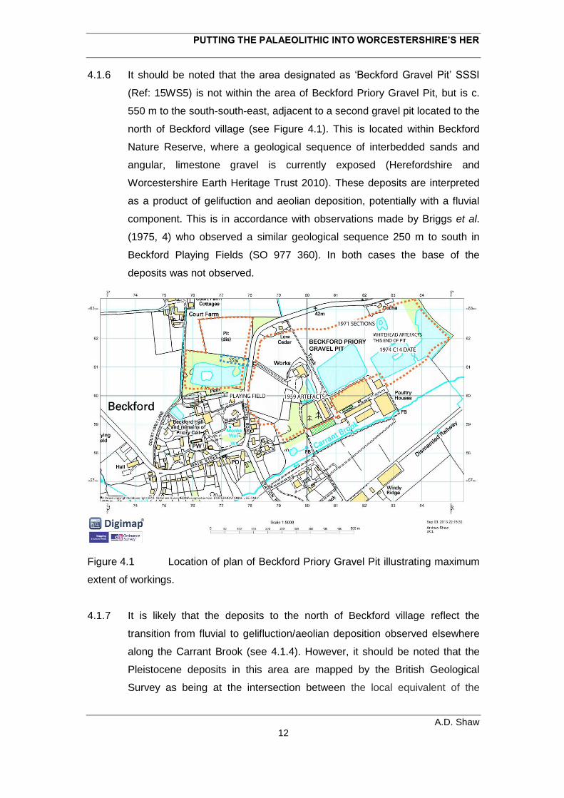
PUTTING THE PALAEOLITHIC INTO WORCESTERSHIRE’S HER
A.D. Shaw 12
4.1.6 It should be noted that the area designated as ‘Beckford Gravel Pit’ SSSI
(Ref: 15WS5) is not within the area of Beckford Priory Gravel Pit, but is c.
550 m to the south-south-east, adjacent to a second gravel pit located to the
north of Beckford village (see Figure 4.1). This is located within Beckford
Nature Reserve, where a geological sequence of interbedded sands and
angular, limestone gravel is currently exposed (Herefordshire and
Worcestershire Earth Heritage Trust 2010). These deposits are interpreted
as a product of gelifuction and aeolian deposition, potentially with a fluvial
component. This is in accordance with observations made by Briggs et al.
(1975, 4) who observed a similar geological sequence 250 m to south in
Beckford Playing Fields (SO 977 360). In both cases the base of the
deposits was not observed.
Figure 4.1 Location of plan of Beckford Priory Gravel Pit illustrating maximum
extent of workings.
4.1.7 It is likely that the deposits to the north of Beckford village reflect the
transition from fluvial to gelifluction/aeolian deposition observed elsewhere
along the Carrant Brook (see 4.1.4). However, it should be noted that the
Pleistocene deposits in this area are mapped by the British Geological
Survey as being at the intersection between the local equivalent of the
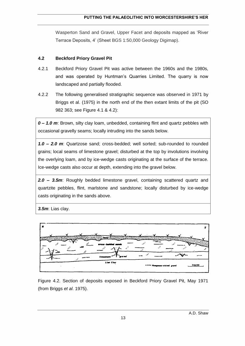
PUTTING THE PALAEOLITHIC INTO WORCESTERSHIRE’S HER
A.D. Shaw 13
Wasperton Sand and Gravel, Upper Facet and deposits mapped as ‘River
Terrace Deposits, 4’ (Sheet BGS 1:50,000 Geology Digimap).
4.2 Beckford Priory Gravel Pit
4.2.1 Beckford Priory Gravel Pit was active between the 1960s and the 1980s,
and was operated by Huntman’s Quarries Limited. The quarry is now
landscaped and partially flooded.
4.2.2 The following generalised stratigraphic sequence was observed in 1971 by
Briggs et al. (1975) in the north end of the then extant limits of the pit (SO
982 363; see Figure 4.1 & 4.2):
0 – 1.0 m: Brown, silty clay loam, unbedded, containing flint and quartz pebbles with
occasional gravelly seams; locally intruding into the sands below.
1.0 – 2.0 m: Quartzose sand; cross-bedded; well sorted; sub-rounded to rounded
grains; local seams of limestone gravel; disturbed at the top by involutions involving
the overlying loam, and by ice-wedge casts originating at the surface of the terrace.
Ice-wedge casts also occur at depth, extending into the gravel below.
2.0 – 3.5m: Roughly bedded limestone gravel, containing scattered quartz and
quartzite pebbles, flint, marlstone and sandstone; locally disturbed by ice-wedge
casts originating in the sands above.
3.5m: Lias clay.
Figure 4.2. Section of deposits exposed in Beckford Priory Gravel Pit, May 1971
(from Briggs et al. 1975).
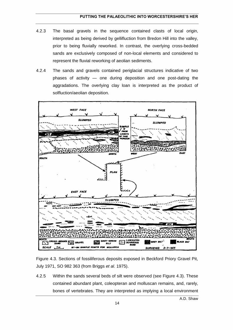
PUTTING THE PALAEOLITHIC INTO WORCESTERSHIRE’S HER
A.D. Shaw 14
4.2.3 The basal gravels in the sequence contained clasts of local origin,
interpreted as being derived by gellifluction from Bredon Hill into the valley,
prior to being fluvially reworked. In contrast, the overlying cross-bedded
sands are exclusively composed of non-local elements and considered to
represent the fluvial reworking of aeolian sediments.
4.2.4 The sands and gravels contained periglacial structures indicative of two
phases of activity — one during deposition and one post-dating the
aggradations. The overlying clay loan is interpreted as the product of
solfluction/aeolian deposition.
Figure 4.3. Sections of fossiliferous deposits exposed in Beckford Priory Gravel Pit,
July 1971, SO 982 363 (from Briggs et al. 1975).
4.2.5 Within the sands several beds of silt were observed (see Figure 4.3). These
contained abundant plant, coleopteran and molluscan remains, and, rarely,
bones of vertebrates. They are interpreted as implying a local environment
PUTTING THE PALAEOLITHIC INTO WORCESTERSHIRE’S HER
A.D. Shaw 15
comprised of open, dry land, crossed by small stream and containing small,
temporary, ponds. The climate represented by the fauna and sediments is
suggested to be indicative of one of general aridity, with a larger annual
temperature range than in the area today — mean summer temperatures
below 10°C, with temperatures of at least -6 to -8°C during ice wedge cast
formation (Briggs et al. 1975).
4.1.5 The deposits at Beckford Prior Pit have produced a mammalian faunal
assemblage consisting of Mammuthus primigenius (woolly mammoth),,
Coelodonta antiquitatis (woolly rhinoceros), Equus ferus (horse), Bison
(Bison) priscus, Ovibos moschatus (musk ox), Rangifer tarandus (reindeer)
and Microtus gregalis, (narrow headed vole) (Whitehead 1977, 45). These
species are typically associated with Devensian deposit (71–20 kya; Current
& Jacobi 2001).
4.2.6 A C14 date was obtained from plant macrofossils found within the silt
deposits. This produced an age estimate of 27,650±250 years B.P. (Birm.
293) (Briggs et al. 1975). Furthermore, a second date was obtained from
organic deposits situated directly above Lias Clay and overlain by 4 m of
limestone gravel. The sample was collected in 1974 by Whitehead from a
locality (SO 9840 3616) 150m south east of the deposits studied by Briggs
et al. and produced an age estimate of 27,300 ± 500 years BP (Birm. 595;
Williams & Johnson 1976, 249).
4.2.7 These historic C14 age estimates should be treated with caution, as ranges
obtained during the same period by the same laboratory for deposits from
Upton Warren, Worcestershire have been shown to represent a minimum
age estimate (Boismier & Green 2012, 73). Consequently, this may also be
the case for Beckford. The dates do, however, imply that both the gravels
and overlying sands at Beckford were deposited prior to ~26,000 BP.
4.2.8 The lithic artefacts recovered by Whitehead were obtained from the eastern
end of Beckford Priory Gravel Pit (SO 984 363 / SO 9834 3625), c. 80m
east of the sections recorded by Briggs et al. (1975). They were obtained
both from exposed sections, modern surfaces and reject heaps.
4.2.9 During these investigations a copy of P.R. Whitehead’s artefact and faunal
catalogue was identified in the archives of the British Museum, Franks
House. This two volume manuscript contains contextual and locational
PUTTING THE PALAEOLITHIC INTO WORCESTERSHIRE’S HER
A.D. Shaw 16
information (accompanied with six or eight figure OS grid references) for the
artefacts and fauna recovered by Whitehead from Beckford Priory Gravel
Pit. This has the potential to enable the specific location and context from
which material was recovered to be identified, and thus any spatial and
detailed stratigraphic patterning to be reconstructed.
4.3 The Beckford Priory Lithic Assemblage
4.3.1. 85 artefacts from Beckford Priory Gravel Pit have been analysed. All are
from the Whitehead Collection, and all but one is stored in the British
Museum, Franks House. The single exception is a handaxe held in the
collections of Almonry Museum, Evesham.
4.3.2 The artefacts belong to seven broad techno-typological groupings:
handaxes, Levallois cores and products, bifacial points, laminar cores and
products, non-Levallois and non-laminar cores and flakes. A brief
discussion of each these categories are presented.
Handaxes
4.3.3 The handaxe assemblage consists of eighteen pieces which subdivide into
two taphonomically distinct groups. The first (n=14) exhibits moderate/heavy
fluvial abrasion, heavy patination and, frequently, moderate to heavy
staining. The second consists of three examples which are heavily
patinated, but only lightly abraded and unstained, or only lightly so. The
former have clearly undergone significant fluvial displacement, whilst the
latter have been subject to less reworking.
4.3.4 Techno-typologically the assemblage can be subdivided into two groups;
those which could be Lower Palaeolithic or Middle Palaeolithic in age, and
those with late Middle Palaeolithic features. The latter are associated with
the reoccupation of Britain by Neanderthals during early MIS 3 (~58 kya). It
is perhaps significant that the three lightly abraded handaxes all fall within
this potentially late Middle Palaeolithic grouping.
4.3.5 Seven pieces exhibit features which could be indicative of a Middle
Palaeolithic age attribution (cf. Boëda 2001; Cliquet et al. 2001, Halliwell &
Scott 2011, White 2012). These features include several phases of shaping;
PUTTING THE PALAEOLITHIC INTO WORCESTERSHIRE’S HER
A.D. Shaw 17
retouch (or use-damage) to the butt; retouched or utilised portions opposed
to a modified, blunted edge and planoconvexity resulting from using an
initial flake blank (or as is frequently the case with Beckford, tabular frost
shattered blanks). It should be emphasized, however, that these features in
isolation cannot be taken to indicate that a handaxe is definitively Middle
Palaeolithic in age. Furthermore, whilst the characteristics of the Beckford
examples are suggestive of an early Middle Palaeolithic date, none can be
definitively ascribed to this period (e.g. there are no typo-technologically
distinctive Bout Coupés; cf. White & Jacobi 2002).
4.3.6 Whilst the majority of the handaxes currently lack a secure stratigraphic
context, four are thought to be from the base of the Beckford gravels. They
are clearly fluvially reworked and could be Lower or Middle Palaeolithic in
date.
4.3.7 In summary, the handaxe assemblage includes fluvially derived examples,
many of which are likely to have been reworked into the Beckford
exposures from earlier deposits. However, it also contains examples which
may be late Middle Palaeolithic in date. Significantly, this latter group
contains three examples which have not undergone extensive fluvial
reworking.
Levallois
4.3.9 The assemblage contains six Levallois cores and one product. Four cores
are unabraded or only lightly so, whilst two have clearly undergone some
degree of fluvial transport. The product, a Levallois flake, is unabraded.
4.3.10 Three cores exhibit all the technological features which are used to define a
Levallois core (Boëda 1995), one being a classic example. The remaining
three cores are simple prepared examples which reflect the exploitation of
natural convexities to exploit a flaking surface with only minimal preparation
of the striking platform and/or flaking surface (Scott 2011). As a group, they
tend to reflect single phases of preparation and exploitation, probably due to
the suboptimal characteristics of the blanks — flakes, split cobbles and
small, flat nodules.
4.3.11 A single Levallois artefact is associated with a specific stratigraphic context.
This is a roughly prepared and unexploited Levallois core recovered from
PUTTING THE PALAEOLITHIC INTO WORCESTERSHIRE’S HER
A.D. Shaw 18
the base of the gravel. Such a context is supported by the fact that the piece
is moderately fluvially abraded.
4.3.12 The Levallois assemblage from Beckford includes fluvalliy reworked
material and relatively fresh examples. The latter suggests a Middle
Palaeolithic presence which has been minimally reworked. Unfortunately,
the specific context of this material is currently unknown.
4.3.13 The Levallois assemblage may be associated with the possible late Middle
Palaeolithic handaxes from the site. Although Levallois flaking is uncommon
(but not unknown) from late Middle Palaeolithic sites it Britain, it is common
amongst contemporary continental sites (White & Jacobi 2002).
Non-Levallois and Non-Blade Cores
4.3.14 The collection contains seven non-Levallois and non-blade cores. They are
unabraded, suggesting that they have not undergone significant fluvial
transport.
4.3.15 Two have associated stratigraphic information, both being recovered from
the base of the Beckford gravels.
4.3.16 Five are the product of diacoidal flaking. This is often (although by no
means exclusively) associated with late Middle Palaeolithic handaxes (Cook
& Jacobi 1998). Significantly, one of these cores reflects the reuse of a
handaxe.
Bifacial Points
4.3.17 A most significant component of the Beckford lithic assemblage is a
fragment of a fully bifacial leaf point. These rare and enigmatic artefacts are
thought to date to 36–38,000 BP (Jacobi et al. 2006) and may represent the
final presence of the Neanderthals in Britain
4.3.18 The Beckford leaf points is a tip fragment from fully bifacial leaf point
produced on a thin flake or tabular blank. It show signs of limited fluvial
abrasion, is moderately edge damaged, heavily patinated and slightly
stained.
4.3.19 In addition, the collection contains is a second bifacial retouched point. This
PUTTING THE PALAEOLITHIC INTO WORCESTERSHIRE’S HER
A.D. Shaw 19
consists of a mesial fragment of a partially bifacially thinned point on a
thermal fragment. This piece is difficult to classify; it may be chronologically
associated with the leaf point.
4.3.20 Both artefacts were recovered out of context amongst rejects
Blade Production
4.3.21 Seven laminar cores and eight laminar products are present amongst the
lithic assemblage.
4,3.22 Their condition is broadly analogous — unabraded, or only slightly so, edge
damaged, heavily patinated and little, or no staining. This suggests that
these pieces have not been subject to fluvial transport.
4.3.23 The material is technologically consistent. It mostly reflects the reduction of
blade cores through bipolar and unipolar working using a soft hammer.
Blade production was initiated though cresting and there is some evidence
of platform rejuvenation through the removal of a core tablet. One bladelet
core fragment is also present.
4.3.24 Two pieces of laminar debitage are retouched, however, they do not
constitute typologically diagnostic forms.
4.3.24 although most lack contextual information, it is perhaps significant that one
of the blade cores was obtained from the top of the Beckford gravels. This
suggests that it was recovered from a different context to the handaxes and
Levallois cores (see above)
4.3.25 The techno-typological characteristics of the laminar material suggest that it
dates to the Upper Palaeolithic. The fact that material was recovered from
the upper part of the gravel implies that it is early Upper Palaeolithic in date
(38,000 – 26,000 BP).
Flakes
4.3.26 There are 40 flakes in the collection, most of which have produced using a
hard hammer; two are the product of discoidal flaking.
4.3.27 Most of the hard hammer flakes and are probably Palaeolithic. The
exception is one possible Mesolithic example which seems to relate to the
PUTTING THE PALAEOLITHIC INTO WORCESTERSHIRE’S HER
A.D. Shaw 20
preparation of the flaking surface of a bladelet core.
4.3.28 Ten flakes reflect significant fluvial transport, one of which was recovered
from the base of the gravel. The remainder are lightly abraded or
unabraded. Twelve of these are associated with stratigraphic information; all
come from the base of the Beckford gravels.
4.3.30 Six of these artefacts are retouched, reflecting the imposition of scraper
edges or bifacial thinning
4.4 Discussion
4.4.1 The Beckford lithic assemblage can be tentatively divided into five groups :
1. Heavily abraded Lower Palaeolithic artefacts (including handaxes) which
have been reworked into the Beckford fluvial deposits from earlier
sediment bodies.
2. A late Middle Palaeolithic handaxe assemblage which has undergone
various degrees of fluvial reworking.
3. A late Middle Palaeolithic Levallois assemblage, some of which has been
fluvially reworked, whilst a portion has only been subject to little, if any,
fluvial transport. Some, or all, of this material may be related to Middle
Palaeolithic handaxes.
4. An early Upper Palaeolithic leaf point fragment which has been fluvially
reworked.
5. An early Upper Palaeolithic laminar assemblage (?from the surface of
the upper gravels) which has not been subject to fluvial transport.
4.4.2 The Beckford lithic assemblage is potentially of national importance as it
clearly contains material relating to the final Neanderthal and first modern
human occupations of the Britain. Such assemblages are extremely rare.
4.4.3 The juxtaposition of late Middle Palaeolithic handaxes, a leaf point and an
early upper Palaeolithic laminar assemblage adds to the potential value of
the collection to advance of understanding of the late Middle
Palaeolithic/early Upper Palaeolithic occupation both in the West Midlands
and Britain as a whole. Currently, understanding of the chronological
relationship between different techno-typolical entities during this critical
PUTTING THE PALAEOLITHIC INTO WORCESTERSHIRE’S HER
A.D. Shaw 21
period is limited (see Jacobi & Higham 2011).
4.4.4 Furthermore, the fact that the material is broadly associated with
mammalian faunal material and multiple palaeoenvironmental proxies
provides the collection with enhanced potential. It could materially contribute
to our understanding of the environmental context associated with this
period.
4.4.5 The value of the Beckford Priory Pit assemblage is currently severely limited
by a lack of contextual integrity. Thus it is currently difficult to relate the
various elements of the extant lithic assemblage to each other, the
stratigraphic sequence, the extensive mammalian faunal assemblage, or
the other palaeonenvironmental datasets.
4.4.6 The Whitehead artefact catalogue has the potential to begin to address this
issue, and can be used to plot where within Beckford Priory Pit particular
artefact groupings occurred. This will greatly enhance our understanding of
the extant collection — it could potentially allow meaningful behavioural
reconstructions to be drawn. In addition this will be of great value to future
management of the extant deposits.
4.4.7 The degree of any human involvement with the fauna is also currently
unknown. This could potentially be resolved through reanalysis of the extant
fauna (identification of cut mark, percussion marks etc.). A large proportion
of the mammal assemblage is currently stored in the Natural History
Museum.
4.4.8 The current value of the Beckford material is also limited by a lack of
chronological resolution. Addressing this issue is a high priority for the
future. This could potentially be achieved through C14 dating of both of any
existing and newly acquired organic remains, and the extant fauna (with a
particular focus on any pieces which exhibit human modification), in
conjunction with OSL dating of sand and silt fractions in the extant sediment
bodies present in Beckford Priory Pit
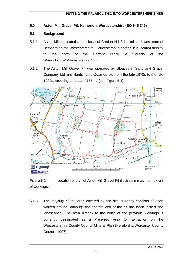
PUTTING THE PALAEOLITHIC INTO WORCESTERSHIRE’S HER
A.D. Shaw 22
5.0 Aston Mill Gravel Pit, Kemerton, Worcestershire (SO 945 349)
5.1 Background
5.1.1 Aston Mill is located at the base of Bredon Hill 3 km miles downstream of
Beckford on the Worcestershire-Gloucestershire border. It is located directly
to the north of the Carrant Brook, a tributary of the
Warwickshire/Worcestershire Avon.
5.1.2 The Aston Mill Gravel Pit was operated by Gloucester Sand and Gravel
Company Ltd and Huntsman’s Quarries Ltd from the late 1970s to the late
1980s, covering an area of 155 ha (see Figure 5.1).
Figure 5.1 Location of plan of Aston Mill Gravel Pit illustrating maximum extent
of workings.
5.1.3 The majority of the area covered by the site currently consists of open
worked ground, although the eastern end of the pit has been infilled and
landscaped. The area directly to the north of the previous workings is
currently designated as a Preferred Area for Extraction on the
Worcestershire County Council Mineral Plan (Hereford & Worcester County
Council, 1997).
PUTTING THE PALAEOLITHIC INTO WORCESTERSHIRE’S HER
A.D. Shaw 23
5.1.4 The deposits quarried at Aston Mill are mapped by the British Geological
Survey as the equivalent of the Wasperton Sand and Gravel, Upper Facet
of the Avon (BGS 1:50,000 Geology Digimap). The Wasperton Member as
a whole is thought to have been deposited between MIS 5a and MIS 2
(Maddy et al. 1991; Maddy and Lewis 2005, 79; Penkman et al. 2013, 124–
127).
5.1.5 The specific geological sequence encountered at Aston Mills has been
described by Dawson (1987). It consists of 2.00–3.00 m sands and gravels,
underlain by Lias clay bedrock and overlain by 0.75–1.0 m of silty brown
loam. As such, it is broadly analogous to that observed at Beckford Priory
Gravel Pit (see 4.0)
5.1.6 As at Beckford, the basal deposits consist of clast supported gravels,
primarily of local origin. This is overlain by cross bedded sands. However,
Dawson (1987, 272) observed that at Aston Mills the two deposits
interdigitate towards the valley sides, suggesting a degree of
contemporaneity between the two deposits. The gravels are thus suggested
to represent active channel zones, whilst the sands reflect aeolian derived
sediments deposited, or reworked, during high flood events in areas
adjacent to these zones.
5.1.7 The gravels at Aston Mill have produced a mammalian faunal assemblage
consisting of Mammuthus primigenius (woolly mammoth), Coelodonta
antiquitatis (woolly rhino), Equus ferus (horse), Bison priscus (bison),
Ovibos moschatus (musk ox) and Rangifer tarandus (reindeer), whilst
channel; silts produced a large number of elements from Bison priscus, with
a smaller component of Rangifer tarandus (Whitehead 1977, 45). As at
Beckford these species are typical of those found during the Devensian in
Britain (71–20 kya).
5.1.8 Several radiocarbon dates have been obtained from plant material
preserved within deposits at Aston Mill. Two samples were recovered in
1972 from a silt pocket on the Lias clay which was overlain by ~2m of gravel
and ~1m of loam (SO 9453 3505). These produced age estimates of 29,500
+170/-1400 and >18,800 (Birm. 504 & 505; Shotton et al. 1975, 286). A
further sample collected in 1973 from silt at the base of ~5.5 m of gravel,
overlain ~1m of loam (SO 9415 3553) produced a value of 31,900 +860/-
PUTTING THE PALAEOLITHIC INTO WORCESTERSHIRE’S HER
A.D. Shaw 24
780. Additionally, a sample collected from third locality in 1971 (SO 944
355) produced an age estimate of 26,000 ±300 on material from grey blue
silty ‘marl’ (Birm 282; Shotton et al. 1974, 286)
5.1.9 As with the historic radio-carbon age estimates from Beckford (see above),
those from Aston Mill should be treated with a high degree of caution, and
considered as minimum age estimates. However, they do imply that the
basal gravels at Aston Mill were deposited prior to the onset of the last
glacial maximum after ~26,000 BP.
5.1.10 The lithic artefacts collected from Aston Mill Pit were recovered by P.F.
Whitehead between 1973 and 1988. These were covered from localities
spread across the 155 ha area of the workings.
5.1.11 During this assessment a copy of Whitehead’s artefact and faunal catalogue
was identified in the archives of the British Museum, Franks House. It
should be noted that this two volume manuscript contains contextual and
spatial information (accompanied with six or eight figure OS grid references)
for the artefacts and fauna recovered from Aston Mill Gravel Pit. This has
the potential to identify specific locations and contexts from which material
was recovered, and thus any spatial and detailed contextual patterning to
the artefactual and faunal groupings.
5.2 The Lithic Assemblage
Introduction
5.2.1 A total of 103 artefacts from Aston Mill Gravel Pit have been assessed. All
are from the Whitehead Collection, and all but one is stored in the British
Museum, Franks House. The single exception is a handaxe held in the
collections of Almonry Museum, Evesham.
5.2.3 The artefacts belong to seven broad techno-typological groupings:
handaxes, Levallois cores and products, blade cores and laminar products,
non-Levallois and non-blade cores and flakes. A brief discussion of each
these categories are presented.
Handaxes
PUTTING THE PALAEOLITHIC INTO WORCESTERSHIRE’S HER
A.D. Shaw 25
5.2.4 There are 24 handaxes from Aston Mill. As with the Beckford examples,
they can be subdivide into two broad condition states. The majority (n=19)
are moderately/heavily abraded, heavily edge damaged, heavily patinated
and generally heavily stained, whilst five examples are unabraded, and tend
to be less stained. The former have been subject to significant fluvial
transport, in contrast to latter which have undergone less reworking. The
first grouping includes two quartzite handaxes.
5.2.5 Techno-typologically the assemblage can be subdivided into two groups;
those which could be Lower Palaeolithic or Middle Palaeolithic in age, and
those with late Middle Palaeolithic features. The latter (n=3) are potentially
associated with the reoccupation of Britain by Neanderthals during early
MIS 3 (~58 kya). However, as at Beckford, although some of the Aston Mill
handaxes exhibit these later Middle Palaeolithic features, none can be
definitively ascribed to this period.
5.2.6 Interestingly whilst all of the Lower Palaeolithic and Lower/Middle
Palaeolithic examples exhibit some degree of abrasion, the only unabraded
example exhibits Middle Palaeolithic features. This may suggest that
relatively undisturbed late Middle Palaeolithic activity can be discerned
within the Aston Mill Pleistocene deposits. Unfortunately, all the Aston Mill
handaxes currently lack detailed provenace.
5.2.7 In summary, the handaxe assemblage is very similar to that from Beckford
and includes fluvially derived examples, many of which are likely to have
been reworked from earlier deposits. It also contains examples which may
be late Middle Palaeolithic in date, one example of which does not exhibit
evidence of significant fluvial transport.
Levallois
5.2.9 Levallois material is present in the Aston Mill collection; five cores, along
with one definite and one possible product.
5.2.10 Two of the cores display all of the technological features classically
assigned to a Levallois core, whilst the remaining three are simple prepared
examples which reflect the exploitation of natural convexities to exploit a
flaking surface with only minimal preparation of the striking platform and/or
flaking surface. As at Beckford, the presence of the latter seems to reflect
PUTTING THE PALAEOLITHIC INTO WORCESTERSHIRE’S HER
A.D. Shaw 26
the application of the Levallois concept to suboptimal raw material, which in
two out of the three cases involved the exploitation of frost shattered clasts.
5.2.11 The definite Levallois product is a flake, whilst the possible example could
actually represent a failed attempt to produce a diminutive, non-classic
handaxe. Notably, this is the only ‘Levallois’ piece which exhibits significant
fluvial abrasion. The remainder is either fresh or only slightly rolled. They
tend to be unstained, but is edge damaged and heavily patinated. This
suggests that they have undergone only limited fluvial displacement and
constitute a relatively undisturbed collection.
5.2.12 The Levallois material may be broadly chronologically associated with the
possible late Middle Palaeolithic handaxes from the site. Although Levallois
flaking is uncommon (but not unknown) from late Middle Palaeolithic sites in
Britain, it is common amongst contemporary continental sites (White &
Jacobi 2002).
Non-Levallois and Non-Blade Cores
5.2.13 The non-Levallois and non-blade cores include two moderately/heavily
abraded migrating cores and two moderately abraded discoidal cores. The
latter could potentially be Middle Palaeolithic. One of each was recovered
from the basal gravels exposed at the site.
Blade Production
5.2.14 Eight laminar cores and six products are present in the collection. All are
unabraded/only slightly abraded, and tend to be edge damaged, heavily
patinated, but display little staining. They do not appear to have undergone
significant fluvial transport.
5.2.15 The cores are broadly analogous with those from Beckford and reflect
bipolar and unipolar reduction. They are worked using a soft hammer with
blade production initiated through lateral cresting and the imposition of a
facetted platform. They tend to be geared towards blade production,
although two bladelet cores are also present.
5.2.16 One of the blade products has been retouched to produce a shouldered
scraper. It is a crested piece with a burin removal along one lateral which is
PUTTING THE PALAEOLITHIC INTO WORCESTERSHIRE’S HER
A.D. Shaw 27
truncated by steep retouch. This form characteristic of the Aurignacian in
Britain, which is thought to date to ~32,000 BP (Jacobi & Higham 2011).
5.2.17 The techno-typological characteristics suggest that the laminar material
from Aston Mills broadly dates to the Upper Palaeolithic. Unfortunately,
none of these artefacts possess detailed contextual information.
Consequently, it is currently impossible to assess the degree of association
between the Aurignacian shouldered scraper and the other laminar pieces.
Flakes
5.2.18 Most of the 45 flakes in the collection are likely to be Palaeolithic. The
exception is a mint condition, unpatinated hard hammer example which is
probably later prehistoric.
5.2.19 A proportion have clearly undergone significant fluvial transport being at
least moderately abraded (n=15). Most of these are hard hammer flakes,
although a single soft hammer flake resulting from handaxe manufacture
was recognised. Their specific stratigraphic provenance is currently
unknown.
5.2.20 The remaining flakes are either lightly abraded or unabraded. The majority
are produced using a hard hammer, although three soft hammer handaxe
manufacture flakes are present. Interestingly, one of latter is burnt at the
distal end. Six of these flakes are from the base of the gravels (including
one of the handaxe manufacturing flakes), whilst one is attributed to the
upper portion of the gravel.
5.2.21 None of the flakes display unequivocal retouch.
5.3 Discussion
5.3.1 The Aston Mill lithic assemblage is from a broadly analogous context and
contains a remarkably similar typo-technological range of artefacts to that
from Beckford Priory Pit.
5.3.2 As with Beckford material, it is broadly associated with an extensive
mammalian faunal which could materially contribute to our understanding of
the environmental context associated with the archaeology.
PUTTING THE PALAEOLITHIC INTO WORCESTERSHIRE’S HER
A.D. Shaw 28
5.3.3 In addition, it is important to assess whether there is any human
involvement in this faunal assemblage, particularly with the intriguing large
collection of bison recovered from channel silts. A reassessment of the
extant fauna to identify any cut mark, percussion marks etc. is therefore a
priority. The bulk of this material is currently stored in the Natural History
Museum.
5.3.4 The Aston Mill lithic assemblage can be divided into five groups:
1. Heavily abraded Lower Palaeolithic artefacts (including handaxes)
which have been reworked from earlier deposits.
2. A potential late Middle Palaeolithic handaxe assemblage which has
undergone various degrees of fluvial reworking.
3. A late Middle Palaeolithic Levallois assemblage that may be
chronologically related to the Middle Palaeolithic handaxes.
4. An Aurignacian shouldered scraper.
5. An Upper Palaeolithic blade assemblage.
5.3.5 As with the Beckford assemblage, it is potentially of national importance as
it clearly contains material relating to the final Neanderthal and first modern
human occupations of the Britain.
5.3.6 Unlike at Beckford, however, it includes an typo-technologically diagnostic
Aurignacian component. Although, this consists of just a single definitive
artefact, it is of national importance. The Aurigancian is thought to represent
the earliest anatomically modern human presence in the British Isles
(Jacobi & Higham 2011), however, there are currently just twelve sites of
this date in the country. Many consist of a single artefact and are from cave
deposits which have long since been removed.
5.3.7 Aston Mill is therefore important as not only is it an open air site, but it has
also produced other broadly Upper Palaeolithic pieces. This raises the
possibility that a larger Aurignacian assemblage is present in the area.
5.3.8 Although this possibility cannot currently be addressed through the extant
collection, the spatial data in the Whitehead notebooks may be able to
establish whether there is clustering to this material. This may also establish
whether there are findspots in areas where deposits are still extant.
PUTTING THE PALAEOLITHIC INTO WORCESTERSHIRE’S HER
A.D. Shaw 29
5.3.9 This highlights the fact that, like Beckford, the value of the extant
assemblage is currently severely limited by a lack of contextual integrity.
This issue prevents relationships being established between various
elements of the lithic assemblage, the stratigraphic sequence, and the
extensive mammalian faunal assemblage.
5.3.10 The Whitehead catalogue may be able to help to begin to rectify this
problem by allowing the distribution of particular artefact groupings to be
plotted and related to specific areas of the 155 ha of former workings.
5.3.11 This will also enhance the ability to direct mitigation works should extraction
commence in the Preferred Area for Extraction highlight to the immediate
north of the old workings on the Worcestershire County Council Mineral
Plan (Herford & Worcester County Council, 1997).
5.3.12 In addition, the fact that archaeological material relating to similar temporal
periods are present within both the Wasperton Sands and Gravels at Aston
Mill and Beckford, suggests that similar potential exists in any area which
these deposits are present along the Carrant Brook. This is an important
consideration for future planning policy.
5.3.13 Like Beckford, the archaeology from Aston Mills currently lacks a local
chronological framework. Although there exist several historic C14 dates
from organic remains in the basal gravels, their usefulness is limited, both in
terms of their accuracy and how they reflect the deposition of different
geological units across the gravel pit.
5.3.14 A programme of targeted dating is therefore a high priority. This could
potentially include C14 dating of both existing and newly acquired organic
remains, and the extant fauna (with a particular focus on any pieces which
exhibit human modification), in conjunction with OSL dating of sand and silt
fractions in any extant sediment bodies.
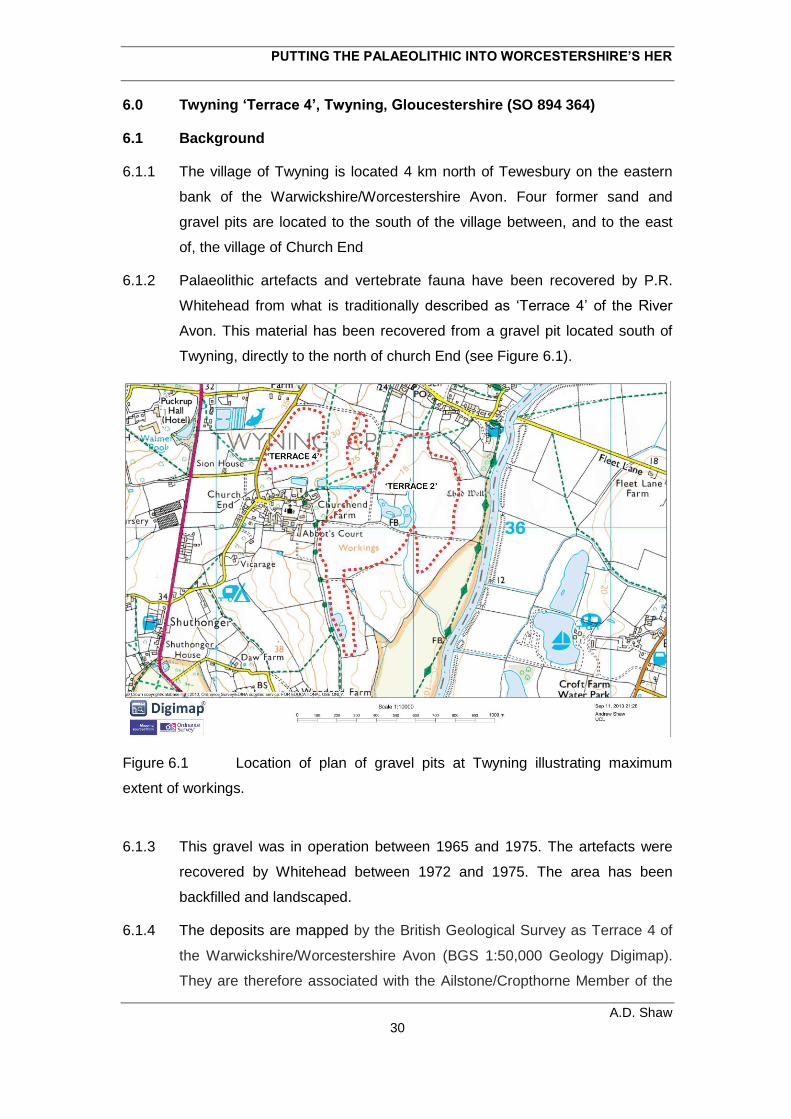
PUTTING THE PALAEOLITHIC INTO WORCESTERSHIRE’S HER
A.D. Shaw 30
6.0 Twyning ‘Terrace 4’, Twyning, Gloucestershire (SO 894 364)
6.1 Background
6.1.1 The village of Twyning is located 4 km north of Tewesbury on the eastern
bank of the Warwickshire/Worcestershire Avon. Four former sand and
gravel pits are located to the south of the village between, and to the east
of, the village of Church End
6.1.2 Palaeolithic artefacts and vertebrate fauna have been recovered by P.R.
Whitehead from what is traditionally described as ‘Terrace 4’ of the River
Avon. This material has been recovered from a gravel pit located south of
Twyning, directly to the north of church End (see Figure 6.1).
Figure 6.1 Location of plan of gravel pits at Twyning illustrating maximum
extent of workings.
6.1.3 This gravel was in operation between 1965 and 1975. The artefacts were
recovered by Whitehead between 1972 and 1975. The area has been
backfilled and landscaped.
6.1.4 The deposits are mapped by the British Geological Survey as Terrace 4 of
the Warwickshire/Worcestershire Avon (BGS 1:50,000 Geology Digimap).
They are therefore associated with the Ailstone/Cropthorne Member of the
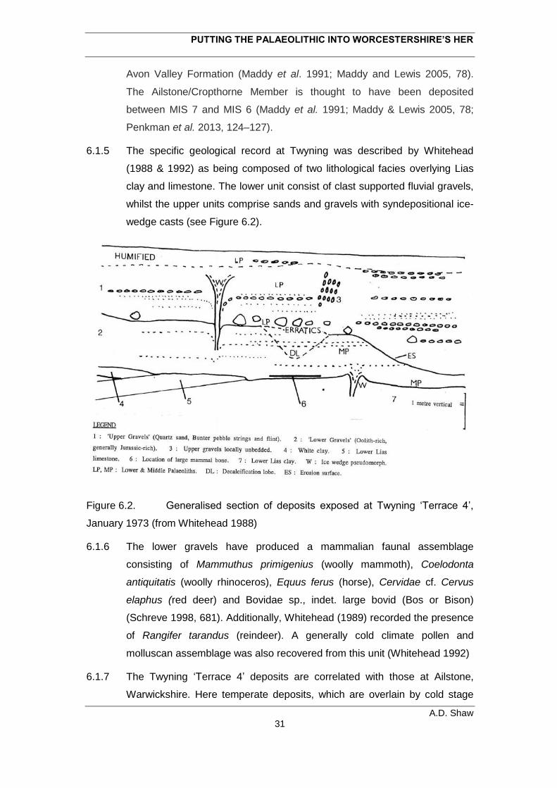
PUTTING THE PALAEOLITHIC INTO WORCESTERSHIRE’S HER
A.D. Shaw 31
Avon Valley Formation (Maddy et al. 1991; Maddy and Lewis 2005, 78).
The Ailstone/Cropthorne Member is thought to have been deposited
between MIS 7 and MIS 6 (Maddy et al. 1991; Maddy & Lewis 2005, 78;
Penkman et al. 2013, 124–127).
6.1.5 The specific geological record at Twyning was described by Whitehead
(1988 & 1992) as being composed of two lithological facies overlying Lias
clay and limestone. The lower unit consist of clast supported fluvial gravels,
whilst the upper units comprise sands and gravels with syndepositional ice-
wedge casts (see Figure 6.2).
Figure 6.2. Generalised section of deposits exposed at Twyning ‘Terrace 4’,
January 1973 (from Whitehead 1988)
6.1.6 The lower gravels have produced a mammalian faunal assemblage
consisting of Mammuthus primigenius (woolly mammoth), Coelodonta
antiquitatis (woolly rhinoceros), Equus ferus (horse), Cervidae cf. Cervus
elaphus (red deer) and Bovidae sp., indet. large bovid (Bos or Bison)
(Schreve 1998, 681). Additionally, Whitehead (1989) recorded the presence
of Rangifer tarandus (reindeer). A generally cold climate pollen and
molluscan assemblage was also recovered from this unit (Whitehead 1992)
6.1.7 The Twyning ‘Terrace 4’ deposits are correlated with those at Ailstone,
Warwickshire. Here temperate deposits, which are overlain by cold stage
PUTTING THE PALAEOLITHIC INTO WORCESTERSHIRE’S HER
A.D. Shaw 32
gravels, have been correlated MIS 7 (Maddy et al. 1991; Penkman et al.
2013, 124–127). The lack of any underlying temperate deposits at Twyning
has been suggested to indicate that the deposits can be correlated with MIS
6 (Schreve 1998, 688).
6.1.8 Dating these deposits is, however, complicated by a number of factors.
Although the presence of syndepositional ice-wedge casts strongly supports
the suggestion that the sequence belongs to a cold climate interval,
Whitehead (1989) recorded a fresh valve of Corbicula fluminalis found in
situ in the upper sands and gravels, indicating a temperate climinate.
Furthermore, recent work has suggested that Corbicula fluminalis
disappears from the British record after MIS 7, and is not present during the
last interglacial — MIS 5e (Penkman et al. 2013). Currently, therefore, a
broad MIS 7–MIS attribution is preferred for the Twyning ‘Terrace 4’
exposures.
6.2 The Lithic Assemblage
6.2.1 20 artefacts from Twyning ‘Terrace 4’ have been recorded. All are from the
Whitehead Collection stored in the British Museum, Franks House.
6.2.2 The collection consists of ten hard flakes, two cores and eight handaxes.
The material is all fluvially derived being heavily rolled, heavily edge
damaged and, generally, heavily patinated and stained.
6.2.3 The flakes are all flint; ten are hard hammer removals and one is a soft
hammer flake associated with handaxe manufacture. The two cores are
simply flaked, one being a discoidal and on a flint blank, the other being a
quartzite nodule flaked following migrating platforms.
6.2.4 Seven of the handaxes are on flint blanks, whilst one is produced through
the minimal working of a split quartzite cobble. Most have been thinned
using a soft hammer.
6.2.5 In summary the small lithic assemblage examined from Twyning ‘Terrace 4’
displays evidence for simply core working and handaxe production. All the
material is typo-technologically consistent with a Lower Palaeolithic
attribution.
PUTTING THE PALAEOLITHIC INTO WORCESTERSHIRE’S HER
A.D. Shaw 33
6.3 Discussion
6.2.1 The Twyning ‘Terrace 4’ artefacts are techno-typologically Lower
Palaeolithic and are clearly the product of significant fluvial reworking.
6.2.2 Consequently, they could have been produced any time prior to, or during,
the deposition of the fluvial deposits with which they are associated. This
would suggest that they were manufacture during, or prior to, MIS 7/MIS 6.
6.2.3 It has been suggested that it is difficult to envisage how this material could
have been reworked from earlier deposits due to the fact that there are no
remnants of earlier terrace deposits in the vicinity of Twyning (Lang & Keen
2005, 77). This assertion is unwarranted. Earlier terrace deposits are
located just 2.5 km upsteam in the area to the south of Upper Strensham
(Pershore Member). These deposits are themselves adjacent to deposits
equivalent to those at Twyning (Cropthorne Member). Consequently, there
exists a clear mechanism for how material could be reworked from earlier
terrace deposits into the Twyning ‘Terrace 4’ sequence.
PUTTING THE PALAEOLITHIC INTO WORCESTERSHIRE’S HER
A.D. Shaw 34
7.0 Twyning ‘Terrace 2’, Twyning, Gloucestershire (SO 895 357)
7.1 Background
7.1.1 Palaeolithic artefacts have also been recovered from deposits at Twyning
that were previously assigned to ‘Terrace 2’ of the
Warwickshire/Worcesterhire Avon. The material was recovered by P.R.
Whitehead from the southern half of a large gravel pit located south of
Twyning and east of the village of Church End (see Figure 7.1).
7.1.2 Gravel and sands were extracted in this area between 1965 and 1975. The
artefacts were recovered by Whitehead between 1972 and 1975. The area
is currently open worked ground.
7.1.3 The deposits are mapped by the British Geological Survey as Wasperton
Sand and Gravel, Upper Facet of the Warwickshire/Worcestershire Avon
(BGS 1:50,000 Geology Digimap). The Wasperton Member as a whole is
thought to have been deposited between MIS 5a and MIS 2 (Maddy et al.
1991; Maddy &Lewis 2005, 79; Penkman et al. 2013, 124–127).
7.1.4 The specific geological sequence in the area of Twyning ‘Terrace 2’
consists of orange/pink level bedded quartzose sand overlying cross
bedded sands and gravel (Whitehead 1992, see Figure 7.1).
7.1.5 a C14 date was obtained from orgain silts underlying the gravels which
produced an age estimate of 36 600 +2050/-1640 (Williams & Johnson
1976, 250). As with other historic C14 dates discussed previous, this should
be treated with caution.
7.2 The Lithic Assemblage
7.2.1 The Whitehead Collection in the British Museum, Franks House contains
four artefacts from this locality; one flaked flake, two cores and a handaxe.
They are techno-typologically Lower Palaeolithic. All are on quartzite
blanks, are clearly fluvially derived.
7.3 Discussion
7.3.1 The small — probably selected — collection of quartzite artefacts from
Twyning ‘Terrace 2’ consist have undergone considerable fluvial reworking

PUTTING THE PALAEOLITHIC INTO WORCESTERSHIRE’S HER
A.D. Shaw 35
and are likely to ultimately derive from fluvial deposits which predate those
into which they were finally incorporated.
PUTTING THE PALAEOLITHIC INTO WORCESTERSHIRE’S HER
A.D. Shaw 36
8.0 Individual Finds
8.1 Bredon’s Hardwick, Bredon, Worcestershire (SO 908 356)
8.1.1 The Whitehead collection in the British Museum contains one heavily
fluvially rolled hard hammer flake from Bredon’s Hardwick. This was
recovered from a sand and gravel pit located west of village on Bredon’s
Hardwicke on the east bank of the River Avon (Figure xxx). The area of the
former gravel pit is now worked out and landscaped.
8.1.2 The fluvial deposits in this area are mapped by the British Geological
Survey as Bretford Sand and Gravel Member of the
Warwickshire/Worcestershire Avon (Sheet BGS 1:50,000 Geology
Digimap). This suggests that they post-date the Last Glacial Maximum
(Maddy & Lewis 2005, 80). However, Whitehead believed the flake came
from ‘Terrace 2’ of the Avon making it part of the Wasperton Sand and
Gravel Member, which is thought to have been deposited between MIS 5a
and MIS 2 (Maddy et al. 1991; Maddy &Lewis 2005, 79; Penkman et al.
2013, 124–127).
8.2 Lower Moore, Wyre Piddle, Worcestershire (SO 978 467)
8.2.1 A fluvially derived handaxe fragment from Lower Moore was identified
amongst the Whitehead Collection. This was collected in 1981 from
amongst gravel extracted from a pit located south of the village of Lower
Moore on the north bank of the River Avon.
8.2.2 These sands and gravels are mapped by the British Geological Survey
(BGS 1:50,000 Geology Digimap) as part of the Wasperton Sand and
Gravel Member, which is thought to have been deposited between MIS 5a
and MIS 2 (Maddy et al. 1991; Maddy and Lewis 2005, 79; Penkman et al.
2013, 124–127). The handaxe is likely to have been reworked into these
deposits.
8.3 Allesborough, Pershore, Worcestershire (SO 9308 4640)
8.3.1 The collection from Worcester City Museum includes an unusual handaxe
on a fine grained volcanic clast. Such raw material was probably brought
into the region in form of a glacial eratic. The handaxe is extremely heavily
PUTTING THE PALAEOLITHIC INTO WORCESTERSHIRE’S HER
A.D. Shaw 37
abraded and exhibits significant modern edge damage at the butt and tip. It
is typo-technologically Lower Palaeolithic.
8.3.2 The artefact was recovered as a chance find from a ploughed field. The field
is adjacent to area mapped by the British Geological as New Inn Sands and
Gravel Member of the River Avon. This deposit is thought to have
accumulated from MIS 5 to 5b (Maddy et al. 1991, Penkman et al. 2013,
124–127). This potentially provides a minimum age estimate for the
handaxe. However, if it does originate from these deposits, it is likely to
have been reworked into them from earlier exposures.
8.4 ?Eckington, Eckington, Worcestershire (?SO SO 909 407/ SO 909 417)
8.4.1 Amongst the material from Almonry Museum, Evesham is an extremely
fluvially rolled handaxe on a split quartzite cobble. This was recovered by
Whitehead in 1993 from what is described as the surface of ‘Terrrace 3’ on
the east of the River Avon at Eckington. However, the grid references given
for the discovery (one on the pieces itself and one in Whitehead’s
catalogue; Whitehead Catalogue Vol. 2, 84) places it to the west of the
Avon, north of Lower Strensham.
8.4.2 ‘Terrace 3’ is now considered to equate to the New Inn Member of the Avon
Valley Formation (Maddy et al. 1991). Deposits of this formation are
mapped by the British Geological Survey (BGS 1:50,000 Geology Digimap)
around the village of Eckington, but not around Lower Stensham. The
gravels of the New Inn Formation are thought to have been deposited
during MIS 5 (Maddy et al. 1991, Penkman et al. 2013, 124–127). However,
if indeed the handaxe does ultimately derive from these deposits, it is likely
to have been incorporated into them from earlier sediments.
8.5 Henwick, Worcester, Worcestershire (?SO 833 560)
8.5.1 The Worcester City Museum collection contains a single fluvially rolled
cordate handaxe with the broad provenance to Henwick, Worcester. Its
condition demonstrates that it is derived from a fluvial deposit.
8.5.2 Historic maps (OS County Series 1:2500, 1928 and 1940) show several
sand and gravel pits were active in this area of Worcester (SO 833 560)
PUTTING THE PALAEOLITHIC INTO WORCESTERSHIRE’S HER
A.D. Shaw 38
from the 1920s and through the 1940s. The deposits in this area are
mapped by the British Geological Survey as belonging to the Holt Heath
Member of the Severn Valley Formation (BGS 1:50,000 Geology Digimap).
The majority of these sediments are thought to be deposited by outwash
from the late Devensian (MIS 2) ice sheet. The handaxe is likely to have
been incorporated into these from earlier deposits.
8.6 Madresfield Park, Madresfield, Worcestershire (SO 82200 48213)
8.6.1 The Palaeolithic artefacts from institutions in Worcestershire includes a
moderately rolled quartzite handaxe from Madresfield. This is currently in
possession of Worcestershire Archive and Archaeological Service.
8.6.2 It is typo-technologically Lower Palaeolithic and was recovered from the
modern land surface, directly to the south of Madresfield Brook. The area is
mapped by the British Geological Survey as alluvium of the Madressfield
Brook; the underlying solid geology is Sidmouth Mudstone (BGS 1:50,000
Geology Digimap).
8.6.3 The level of abrasion indicates that the handaxe has been fluvially
reworked, possibly within the deposits of Madresfield Brook. However, no
obvious upstream Pleistocene source for the artefact is apparent.
8.6.4 The nearest mapped Pleistocene deposits are located 1 km to the east.
These comprise deposits of the Bushley Green Member of the Severn
Valley Formation, which are thought to have been deposited between MIS 9
and MIS 8 (Bridgland et al. 1986; Penkman et al. 2013, 124–127). 800 m to
the north of these deposits is an outcrop of the Spring Hill Member, thought
to correlate with MIS 10 (Maddy et al. 1995).
8.7 Queens Hill, Upton-upon-Severn, Worcestershire (SO 8555 3679)
8.7.1 Recent chance discoveries include a small bifacially worked artefact from
Queens Hill, Upton-upon-Severn. Although moderate abrasion, extensive
edge damage and frost pitting make a more specific identification of this
piece difficult, it is likely to be Lower or Middle Palaeolithic.
8.7.2 Discovered by a metal detecting and reported to Portable Antiquities
Scheme, it is currently in the possession of Worcestershire Archive and
PUTTING THE PALAEOLITHIC INTO WORCESTERSHIRE’S HER
A.D. Shaw 39
Archaeology Service. It was recovered from a field 250 m north of Bushley
Brook, to the south of Heath Hill.
8.7.3 The underlying geology is Branscombe Mudstone (BGS 1:50,000 Geology
Digimap) and no Pleistocene deposits are mapped in the immediate area.
However, patches of deposits mapped as Spring Hill Sands and Gravel
Formation of the Severn Valley Formation are present on hills 500 m to the
north east (Heath Hill) and 800 m to the north east (Queen Hill).
Consequently, it is possible it could ultimately derive from equivalent
deposits. The Spring Hill Member is thought to correlate with MIS 10
(Maddy et al. 1995).
8.8 Ashton under Hill, Aston under Hill, Worcestershire
8.8.1 The Almonry Museum collection contains a small pointed handaxe found in
the vicinity of Ashton under Hill, a village located on the north bank of the
Carrant Brook, 2.75 km upstream from Beckford.
8.8.2 It exhibits secondary retouch seemingly geared to shaping both lateral
edges and the tip. Techno-typologically it is similar to the possible late
Middle Palaeolithic handaxes from Beckford and Aston Mill.
8.8.3 No unequivocal Pleistocene deposits are mapped in the immediate area of
Ashton under Hill, the nearest (an exposure of the Wasperton Sand and
Gravel, Upper Facet) being located 1.2 km to the south east (BGS 1:50,000
Geology Digimap As no exact provenance is available for the handaxe, it
could originate from these deposits. As the same broad sequence produced
the Beckford and Aston Mill artefact, the find may further extend the area of
known archaeologically productive deposits within the valley of the Carrant
Brook.
8.9 Conderton, Overbury, Worcestershire
8.9.1 The Worcester City Museum collection contains a handaxe tip which is
broadly provenanced of Conderton, a village located 2 km north of the
Carrant Brook. It is moderately abraded.
8.9.2 If from the environs of the village itself, it could be derived from ‘Head’
deposits on the slopes of Bredon Hill (BGS 1:50,000 Geology Digimap).
PUTTING THE PALAEOLITHIC INTO WORCESTERSHIRE’S HER
A.D. Shaw 40
This would be interesting as it would suggest it has been derived by
gelifluction from a non-fluvial capture point on the southern flanks of Bredon
Hill. However, if it is from within the parish of Conderton it could be from the
Wasperton Sand and Gravel, Upper Facet found along the north bank of the
Carrant Brook ~1 km south of Conderton village. The condition of the piece
tends to support the latter explanation.
8.10 Twyning, Twyning, Gloucestershire (SO 8965 3660)
8.10.1 The Whitehead Collection contains a handaxe from due south of Twyning
village. It was recovered from an area between Pleistocene deposits of the
Ailstone/Cropthorne Member and Wasperton Sand and Gravel, Upper Facet
of the Avon Valley Formation (BGS 1:50,000 Geology Digimap).
8.10.2 Whitehead observed that it was recovered from deposits ‘soliflucted’ over
the top of ‘Terrace 2’ i.e. the Wasperton Sand and Gravel, Upper Facet
(markings on artefacts and Whitehead Notebook Vol. 1, 22).
8.10.3 The handaxe is in a different condition than any recovered from the terrace
gravels in this area (see 6.0 and 7.0) being unabraded and only lightly edge
damaged. Its context, and the fact that it does not appear to have been
fluvuially transported, suggests that it post-dates the deposition of the
Wasperton Sand and Gravel, Upper Facet. Unfortunately, the Wasperton
Sands and Gravel are currently dates en mass to between MIS 5a and MIS
2 (Maddy et al. 1991; Maddy &Lewis 2005, 79; Penkman et al. 2013, 124–
127). This, along with the fact that it is Palaeolithic handaxe, suggests that it
post-dates MIS 5a and is unlikely to date later than MIS 3. This would
suggest that is late Middle Palaeolithic in date.
8.10.4 The handaxe itself is not typo-technological diagnostic; produced on
thermally fractured cherty flint clast, it is worked using a soft hammer and
displays some evidence of secondary modification of the edges. It may
have been abandoned due the fact that an attempt to further work the tip
has struck a flaw in the flint.
8.10.5 This artefact demonstrates that deposits overlying the regions Pleistocene
terraces have the potential to preserve Palaeolithic material that is not
fluvially derived.
PUTTING THE PALAEOLITHIC INTO WORCESTERSHIRE’S HER
A.D. Shaw 41
8.11 Moseley Park, Hallow, Worcestershire (SO 8112 5933)
8.11.1 Amongst the material curated in Worcester City Museum is a pointed
handaxe with secondary working on one face, one lateral edge and the tip.
Its tip is extensively thinned whilst the butt has been left thick and heavy.
Notably, beyond being edge damaged and slightly patinated, it is in
extremely fresh condition. It was recovered from a field east of Moseley
village in 1970 after potato spinning.
8.11.2 The findspot is located on the edge of an area mapped by the British
Geological as belonging to the Kidderminster Station Member of the Severn
Valley Formation (BGS 1:50,000 Geology Digimap). These deposits are
thought to have accumulated during MIS 7 and MIS 6.
8.11.3 The Moseley Park handaxe is significant as its condition indicates that it has
not undergone significant reworking. Consequently, it is possible that the
artefact may be broadly contemporary with the Kidderminster Station
Member; although the possibility that it associated with later deposits
overlying the terrace (as at Twyning; see 7.9) should not be ruled out.
8.11.4 If it were to be established that artefact is contemporary with these deposits,
the handaxe could be of great significance. Firstly, sites of this age are
rarely encountered in Britain and it would represent the first findspot of this
age in the West Midlands. Secondly, the Early Middle Palaeolithic record of
Britain is dominated by sites from the Thames Valley. These are
characterised by Levallois flaking with handaxes being largely absent (Scott
2011). It has, however, been suggested that sites from the west of England
display an opposite trend with handaxes being present but little Levallois
material (Scott & Ashton 2011). Such pattern could reflect different
populations and different route ways into Britain during the Early Middle
Palaeolithic. This suggestion is tentative, being based on a very small
dataset. Consequently, Moseley Park may be able to contribute to this
debate. Finally, as the handaxe does not appear to have undergone
significant transport, artefacts may exist at Moseley Park with the potential
to provide ethnographic scale reconstructions of human behaviour.
8.11.5 Historical mapping demonstrates that the findspot is adjacent to a hollow
(OS County Series 1:2500, 1887), which still extant today. Its form is
PUTTING THE PALAEOLITHIC INTO WORCESTERSHIRE’S HER
A.D. Shaw 42
suggestive of a small brick pit. The feature provides a potential mechanism
by which the handaxe could have been brought to the surface and an
opportunity for assessing the geological sequence at the site.
8.11.6 In order to establish the full significance of this discovery further work is
required. Most notably the local geological sequence needs investigating,
the stratigraphic provenance of any further artefacts needs establishing and
ages for the associated Pleistocene deposits provided.
PUTTING THE PALAEOLITHIC INTO WORCESTERSHIRE’S HER
A.D. Shaw 43
9.0 DISCUSSION
9.1 This review of previously unassessed Palaeolithic material from
Worcestershire demonstrates that the county possess a relatively small, but
highly significant corpus of existing findspots.
9.2 During this overview three key topics have emerged:
1. Lower Palaeolithic archaeology from fluvial archives.
2. The potential for Early Middle Palaeolithic archaeology.
3. The Late Middle Palaeolithic and Early Upper Palaeolithic in the
Carrant Valley.
9.3 This study reflects that the Lower Palaeolithic of Worcestershire is currently
characterised by small collections and single artefacts (most frequently
handaxes) from high energy fluvial sands and gravels of the Rivers Severn
and Avon. All these artefacts have clearly undergone significant fluvial
transport which, in many cases, is likely to have involved reworking from
older to younger terrace formations.
9.4 This pattern probably reflects the fact that few investigators have actively
sought to recover Palaeolithic artefacts from sites in the county, whilst when
they have it has involved the recovery of material from reject heaps in
gravel quarries (e.g. see Whitehead Notebooks Vol. 1 & 2).
9.5 The assemblages and artefacts assessed here give some indication of the
first recorded human presence in the region. There is good evidence that
humans were active in the region by at least MIS 6 (Twyning ‘Terrace 4’)
and possibly (although by no means unequivocally) as early as MIS 9
(?Madresfield Park and ?Queens Hill). Excluding the pre-MIS 12
discoveries in Warwickshire, this is reflective of West Midlands record as a
whole (Lang & Keen 2005).
9.6 Unfortunately these datasets are not expansive, nor detailed enough, to
allow the reconstruction temporally significant or fine grained patterns of
early human technological decision making or landscape-use
9.7 Fine grained interglacial deposits are fairly common in Pleistocene fluvial
deposits of the Severn and Avon (particularly so in the case of the latter)
and it is these which are likely to contain less disturbed Palaeolithic material
that could potentially allow early human behaviour to reconstructed on an
PUTTING THE PALAEOLITHIC INTO WORCESTERSHIRE’S HER
A.D. Shaw 44
ethnographic scale.
9.8 A further potential source of less derived Lower (and indeed Middle)
Palaeolithic material is the surfaces of, and deposits located
stratigraphically above fluvial gravels. The handaxe from ‘solifluction’ at
Twyning clearly demonstrates this potential.
9.9 As with Britain as a whole, the Palaeolithic record from Worcestershire is
squarely focussed on material from fluvial archives. However, non-fluvial
capture points such as solution features, fissures and small depositional
grabens formed by cambering have all been shown to be repositories of
Pleistocene sediments, palaeoenvironemnetal datasets and, frequently,
Palaeolithic archaeology. The potential of any such depositional features in
Worcestershire should, therefore, be considered.
9.10 Significantly, this reassessment has potentially identified the first Early
Middle Palaeolithic artefact from the West Midlands (Moseley Park).
Although requiring further investigation, this tentative attribution could be
extremely significant. No other artefacts have clearly been assigned to this
period from West Midlands, whilst its condition suggests it may have been
associated with a larger, relatively undisturbed assemblage.
9.11 The potential presence of handaxe in deposits attributable to MIS7/6 is, in
itself, significant as it suggests that the site has the potential to contribute to
ongoing debates concerning the nature of the Early Middle Palaeolithic
occupation in Britain. In particular, the question of whether a west/east
divide exists between assemblages dominated by handaxe and those with
large amounts of Levallois material, and whether this reflects the
demographic histories of population occupying the British Isle during this
period.
9.12 This reassessment has demonstrated that Worcestershire, and the Carrant
Brook in particular, is associated with a rich mid-late Devensian (MIS 4–2)
archaeological and paleontological record. Since its recovery in the late
1970s and early 1980s, and subsequent move to the British Museum and
Natural History Museum, the material has been largely overlooked.
However, it clearly has the potential to provide important insights into the
archaeology and behavioural repertoires of the last Neanderthals and the
first modern humans in Britain.
PUTTING THE PALAEOLITHIC INTO WORCESTERSHIRE’S HER
A.D. Shaw 45
9.13 The collection has a whole has suffered from perceived lack of contextual
integrity. However, the use of the spatial data in Whitehead’s notebooks, in
conjunction with limited new fieldwork would provide significant added
value, both in terms of its research potential and its ability to help guide
future planning policy within the Carrant Brook and throughout the county. It
is therefore, highly recommended that the material is subject to further
investigation. This should include:
1. Integration of the spatial data in the Whitehead notebooks into a
GIS to provide increased contextual integrity for both the extant
archaeological and palaeontological material.
2. A reassessment of the mammalian fauna in order to assess the
degree of human involvement in its accumulation. Particular attention
should be paid to the intriguing accumulation of bison remains from Aston
Mill.
3 Improved chronological resolution through a programme of dating.
This could include C14 dating of both of any existing and newly acquired
organic remains, and the extant fauna (with a particular focus on any pieces
which exhibit human modification), in conjuction with OSL dating of sand
and silt fractions in the extant sediment bodies in Beckford and Aston Mill
8.14 Most of material assessed as part of these investigations was collected by a
single individual — P.R. Whitehead — one of the few Palaeolithic
investigators to have been active in Worcestershire. These collections are
from a single river valley and comprise over 90% of Palaeolithic record of
Worcestershire. Consequently, Whitehead’s collection demonstrates that
when actively sought, nationally significant collections of Palaeolithic
material have been shown to be present in Worcestershire.
8.15 Ultimately, therefore, the story of Palaeolithic research in
Worcestershire reflects the fact if you don’t look for it you won’t find it, but
when you do it is there.
PUTTING THE PALAEOLITHIC INTO WORCESTERSHIRE’S HER
A.D. Shaw 46
REFERENCES
Ashton, N. and Lewis, S., 2002. Deserted Britain: declining populations in the British
Late Middle Pliestocene. Antiquity 76, 388-296.
Boëda, E., 1995. Levallois; A volumetric recontruction, methods, a technique. In:
Dibble, H. L. and Bar-Yosef, O. Eds.), The Definition and Interpretation of Levallois
Technology. Prehistory Press, Madison.
Boëda, E., 2001. Détermination des unités techno-fonctionnelles de pièces bifaciales
provenant de la couche acheuléenne C'3 base du site de Barbas. In: D.Cliquet (Ed.),
Les industries á outils bifaciaux du Paléolithique Moyen d'Europe occidentale.
Études et Recherches Archéologiques de l'Uiversité de Liège, Liège.
Boismier, W. A. and Green, F. M. L., 2012. Discussion. In: Boismier, W. A., Gamble,
C., and Coward, F. Eds.), Neanderthals Among the Mammoths: Excavations at
Lynford Quarry, Norfolk. English Herritage, Swindon.
Bridgland, D. R., Keen, D. H., and Maddy, D., 1986. A reinvestigation of the Bushley
Green Terrace typesite, Hereford and Worcester. Quaternary Newsletter 50, 1–6.
Buteaux, S. T. E., Keen, D. H., and Lang, A. T. O., 2005. Resource Assessment: the
Shotton Project. University of Birmingham / English Herritage.
Cliquet, D., Ladjadj, J., Lautridou, J.-P., Leportier, J., Lorren, P., Michel, D., Pruvost,
P., Rivard, J.-J., and Vilgrain, G., 2001. Le Paléolithique moyen à outils bifaciaux en
Normandie: état des connaissances. In: D.Cliquet (Ed.), Les industries á outils
bifaciaux du Paléolithique Moyen d'Europe occidentale. Études et Recherches
Archéologiques de l'Uiversité de Liège, Liège.
Currant, A. P. and Jacobi, R. M., 2001. A formal mammalian biostratigraphy for the
Late Pleistocene of Britain. Quaternary Science Reviews 20, 1707-1716.
Dawson, M., 1987. Sedimentological aspects of periglacial terrace aggradations: a
case study from the English Midlands. In: Boardman, J. (Ed.), Periglacial provcesses
and landforms in Britian and Ireland. Cambridge University Press, Cambridge.
Grinsell, L. V., 1960. Notes: a Palaeolithic implement from Beckford, Worcestershire.
Antiquaries Journal 40, 67–68.
Halliwell, G. and Scott, B., 2011. A Late Middle Palaeolithic-type handaxe from East
Kent. Lithics: The Journal of the Lithic Studies Society 32, 62–64.
Hereford and Worcester County Council, 1997. Local Mineral Plan.
PUTTING THE PALAEOLITHIC INTO WORCESTERSHIRE’S HER
A.D. Shaw 47
Herefordshire and Worcestershire Earth Heritage Trust, 2010. The Geology of
Beckford Nature Reserve (Beckford Gravel Pit).
Jacobi, R. and Higham, T., 2011. The British Earlier Upper Palaeolithic: Settlement
and Chronology. In: Ashton, N. M., Lewis, S. G., and Stringer, C. B. Eds.), The
Ancient Human Occupation of Britain. Elsevier, Amsterdam.
Lang, A. T. O. and Keen, D. H., 2005. 'At the Edge of the World ...' Hominid
Colonisation and the Lower Palaeolithic of the West Midlands. Proceedings of the
Prehistoric Society 71, 85–106.
Maddy, D., Keen, D. H., Bridgland, D. R., and Green, C. P., 1991. A revised model
for the Pleistocene development of the River Avon. Journal of the Geological Society
of London 148, 473–484.
Maddy, D., Green, C. P., Lewis, S. G., and Bowen, D. Q., 1995. Pleistocene of the
Lower Severn Valley, UK. Quaternary Science Reviews 14, 209–222.
Maddy, D. and Lewis, S. G., 2005. The lower Severn valley. In: Lewis, C. A. and
Richards, A. E. Eds.), Glaciations of Wales and adjacent areas. Logaston Pres, Little
Logaston.
Parfitt, S. A., Barendregt, R. W., Breda, M., Candy, I., Collins, M. J., Coope, G. R.,
Durbridge, P., Field, M. H., Lee, J. R., Lister, A. M., Mutch, R., Penkman, K. E. H.,
Preece, R. C., Rose, J., Stringer, C. B., Symmons, R., Whittaker, J. E., Wymer, J. J.,
and Stuart, A. J., 2005. The earliest record of human activity in northern Europe.
Nature 438, 1008-1012.
Parfitt, S. A., Ashton, N. M., Lewis, S. G., Abel, R. L., Coope, G. R., Field, M. H.,
Gale, R., Hoare, P. G., Larkin, N. R., Lewis, M. D., Karloukovski, V., Maher, B. A.,
Peglar, S. M., Preece, R. C., Whittaker, J. E., and Stringer, C. B., 2010. Early
Pleistocene human occupation at the edge of the boreal zone in northwest Europe.
Nature 466, 229-233.
Penkman, K. E. H., Preece, R. C., Bridgland, D. R., Keen, D. H., Meijer, T., Parfitt, S.
A., White, T. S., and Collins, M. J., 2013. An aminostraigraphy for the Bbritish
Quaternary base on Bithynia opercula. Quaternary Science Reviews 61, 111–134.
Roe, D., 1968. A Gazeteer of British Lower and Middle Palaeolithic Sites. Council for
British Archaeology Research Report 8, London.
Schreve, D. C., 1998. Mammalian biostratigraphy of the later Middle Pleistocene in
PUTTING THE PALAEOLITHIC INTO WORCESTERSHIRE’S HER
A.D. Shaw 48
Britain. Unpublished Ph.D thesis, University of London.
Scott, B., 2011. Becoming Neanderthals: the Earlier British Middle Palaeolithic.
Oxbow Books, Oxford.
Scott, B. and Ashton, N., 2011. The Early Middle Palaeolithic: The European
Context. In: Ashton, N. M., Lewis, S. G., and Stringer, C. B. Eds.), The Ancient
Human Occupation of Britain. Elsevier, Amsterdam
Shotton, F. W., Williams, R. E. G., and Johnson, A. S., 1974. Birmingham Univesity
Radiocarbon Dates VIII. Radiocarbon 16, 285–303.
Shotton, F. W., Williams, R. E. G., and Johnson, A. S., 1975. Birmingham Univesity
Radiocarbon Dates IX. Radiocarbon 17, 255–275.
Shotton, F. W., Keen, D. H., Coope, G. R., Currant, A. P., Gibbard, P. L., Aalto, M.,
Peglar, S. M., and Robinson, J. E., 1993. Pleistocene deposits of Waverley Wood
Farm Pit, Warwickshire, England. Journal of Quaternary Science 8, 293–325.
Smith, R., 1922. Flint implements of special interest. Archaeologia 72, 25–40.
Smith, C. N. S., 1958. A catalogue of the prehistoric finds from Worcestershire.
Transactions of the Worcester Archaeological Society 34, 1–27.
Wenban-Smith, F. F., Bates, M. R., and Schwenninger, J.-L., 2010. Early Devensian
(MIS 5d–5b) occupation at Dartford, southeast England. Journal of Quaternary
Science 25, 1193–1199.
White, M. J., 2012. The lithic assemblage. In: Boismier, W. A., Gamble, C., and
Coward, F. Eds.), Neanderthals Among Mammoths; Excavations at Lynford Quarry,
Norfolk. English Herritage, Swindon.
White, M. J. and Jacobi, R. M., 2002. Two sides to every story: Bout Coupé
handaxes revisited. Oxford Journal of Archaeology 21, 109-133.
Whitehead, P. F., 1977. Vertebrate fauna from the Carrant main terrace. In: Shotton,
F. W. (Ed.),The English Midlands. INQUA Excursion Guide A2, 10th INQUA
CONGRESS, Birmingham.
Whitehead, P. F., 1988. Lower Palaeolithic artefacts from the lower valley of the
Warwickshire Avon. In: Macrae, R. J. and Moloney, N. Eds.), Non-flint stone tools
and the Palaeolithic occupation of Britain. British Archaeological Reports
International Series 189, Oxford.
Whitehead, P. F., 1989a. Development and sequence deposition of the Avon Valley
PUTTING THE PALAEOLITHIC INTO WORCESTERSHIRE’S HER
A.D. Shaw 49
river-terraces. In: Keen, D. H. (Ed.), The Pleistocene of the West midlands: Field
Guide. QRA, Cambridge.
Whitehead, P. F., 1989b. The Qauternary malacofauna of the Warwickshire-
Worcestershire Avon. In: Keen, D. H. (Ed.), The Pleistocene of the West midlands:
Field Guide. QRA, Cambridge.
Whitehead, P. F., 1989c. Changing environments and Caleoptera faunas ffrom
Aston Mill, Worcestershire, England. Entemologists Monthly Magazine 125, 187–
198.
Whitehead, P. F., 1992. Terraces of the River Avon at Twyning, Gloucestershire:their
stratigraphy, climate and biota. Quaternary Newsletter 67, 3–28.
Williams, R. E. G. and Johnson, A. S., 1976. Birmingham Univesity Radiocarbon
Dates X. Radiocarbon 18, 249–267.
ACKNOWLEDGEMENTS
The author would like to thanks Nivk Ashton and Beccy Scott (The British Museum)
and Nick Daffern (Worcestershire Archive and Archaeology Service) for their help
with enabling the assessment of the lithic assemblages.
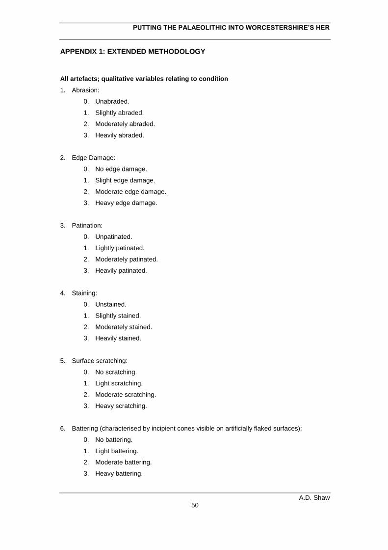
PUTTING THE PALAEOLITHIC INTO WORCESTERSHIRE’S HER
A.D. Shaw 50
APPENDIX 1: EXTENDED METHODOLOGY
All artefacts; qualitative variables relating to condition
1. Abrasion:
0. Unabraded.
1. Slightly abraded.
2. Moderately abraded.
3. Heavily abraded.
2. Edge Damage:
0. No edge damage.
1. Slight edge damage.
2. Moderate edge damage.
3. Heavy edge damage.
3. Patination:
0. Unpatinated.
1. Lightly patinated.
2. Moderately patinated.
3. Heavily patinated.
4. Staining:
0. Unstained.
1. Slightly stained.
2. Moderately stained.
3. Heavily stained.
5. Surface scratching:
0. No scratching.
1. Light scratching.
2. Moderate scratching.
3. Heavy scratching.
6. Battering (characterised by incipient cones visible on artificially flaked surfaces):
0. No battering.
1. Light battering.
2. Moderate battering.
3. Heavy battering.
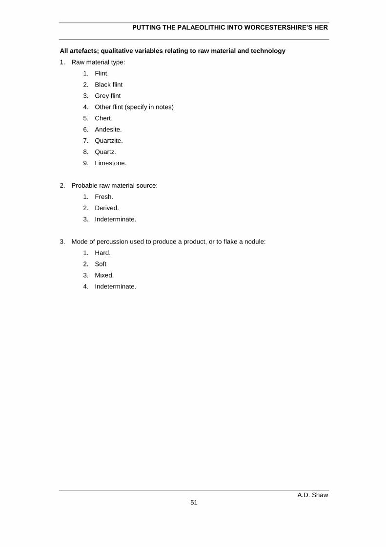
PUTTING THE PALAEOLITHIC INTO WORCESTERSHIRE’S HER
A.D. Shaw 51
All artefacts; qualitative variables relating to raw material and technology
1. Raw material type:
1. Flint.
2. Black flint
3. Grey flint
4. Other flint (specify in notes)
5. Chert.
6. Andesite.
7. Quartzite.
8. Quartz.
9. Limestone.
2. Probable raw material source:
1. Fresh.
2. Derived.
3. Indeterminate.
3. Mode of percussion used to produce a product, or to flake a nodule:
1. Hard.
2. Soft
3. Mixed.
4. Indeterminate.
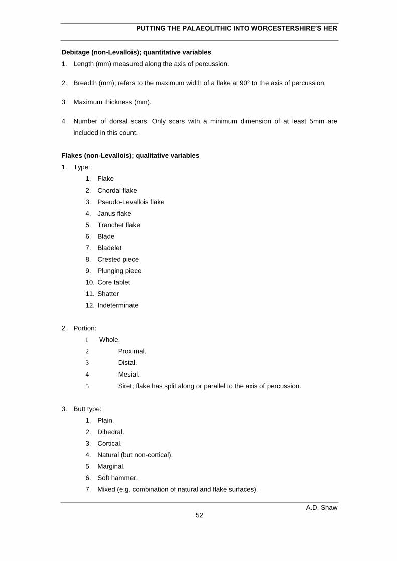
PUTTING THE PALAEOLITHIC INTO WORCESTERSHIRE’S HER
A.D. Shaw 52
Debitage (non-Levallois); quantitative variables
1. Length (mm) measured along the axis of percussion.
2. Breadth (mm); refers to the maximum width of a flake at 90° to the axis of percussion.
3. Maximum thickness (mm).
4. Number of dorsal scars. Only scars with a minimum dimension of at least 5mm are
included in this count.
Flakes (non-Levallois); qualitative variables
1. Type:
1. Flake
2. Chordal flake
3. Pseudo-Levallois flake
4. Janus flake
5. Tranchet flake
6. Blade
7. Bladelet
8. Crested piece
9. Plunging piece
10. Core tablet
11. Shatter
12. Indeterminate
2. Portion:
1 Whole.
2 Proximal.
3 Distal.
4 Mesial.
5 Siret; flake has split along or parallel to the axis of percussion.
3. Butt type:
1. Plain.
2. Dihedral.
3. Cortical.
4. Natural (but non-cortical).
5. Marginal.
6. Soft hammer.
7. Mixed (e.g. combination of natural and flake surfaces).
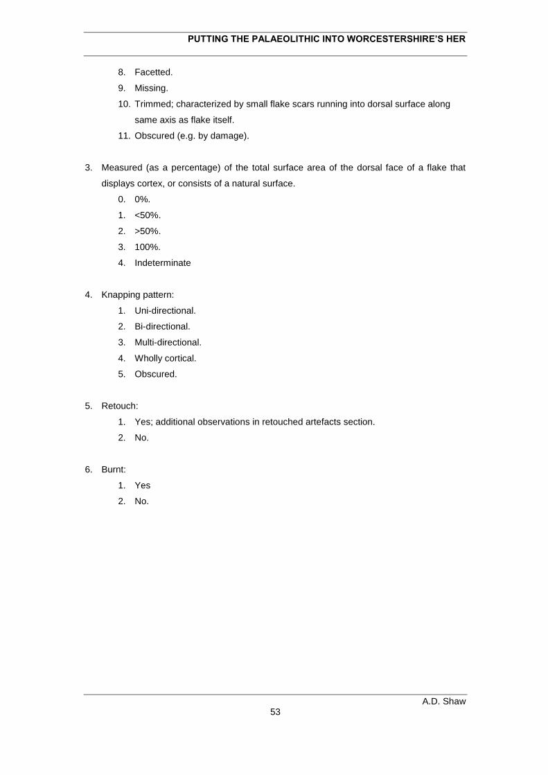
PUTTING THE PALAEOLITHIC INTO WORCESTERSHIRE’S HER
A.D. Shaw 53
8. Facetted.
9. Missing.
10. Trimmed; characterized by small flake scars running into dorsal surface along
same axis as flake itself.
11. Obscured (e.g. by damage).
3. Measured (as a percentage) of the total surface area of the dorsal face of a flake that
displays cortex, or consists of a natural surface.
0. 0%.
1. <50%.
2. >50%.
3. 100%.
4. Indeterminate
4. Knapping pattern:
1. Uni-directional.
2. Bi-directional.
3. Multi-directional.
4. Wholly cortical.
5. Obscured.
5. Retouch:
1. Yes; additional observations in retouched artefacts section.
2. No.
6. Burnt:
1. Yes
2. No.
PUTTING THE PALAEOLITHIC INTO WORCESTERSHIRE’S HER
A.D. Shaw 54
Levallois products; quantitative variables
1. Length (mm) measured along the axis of percussion.
2. Breadth (mm); refers to the maximum width at 90° to the axis of percussion.
3. Maximum thickness (mm).
4. Number of dorsal scars with a minimum dimension of at least 5 mm.
5. Number of preceding Levallois removals.
Levallois products; qualitative variables
1. Confidence of being a deliberately detached Levallois endproduct:
1. Definite.
2. Probable.
3. Possible.
2. Type of Levallois product in morphological terms:
1. Flake.
2. Point.
3. Blade.
4. Debordant flake (lateral edge of core removed).
5. Overshot.
6. Debordant and overshot.
7. Indeterminate; partial endproduct which cannot be classified.
3. Portion:
1. Whole.
2. Proximal.
3. Distal.
4. Mesial.
5. Siret; product has split along or parallel to the axis of percussion.
4. Butt type:
1. Plain.
2. Dihedral.
3. Cortical.
4. Natural (but non-cortical).
5. Marginal.
6. Soft hammer.
7. Mixed (e.g. combination of natural and flake surfaces).
PUTTING THE PALAEOLITHIC INTO WORCESTERSHIRE’S HER
A.D. Shaw 55
8. Facetted.
9. Missing.
10. Trimmed; small flake scars running into dorsal surface along same axis as the
product itself.
11. Chapeau de Gendarme.
12. Obscured (e.g. by damage).
5. Measure (as a percentage) of the total surface area of the dorsal face of a Levallois
product which displays cortex, or consists of a natural surface:
0. 0%.
1. <50%.
2. >50%.
3. 100%.
6. Method of preparation:
1. Unipolar.
2. Bipolar.
3. Convergent unipolar.
4. Centripetal.
5. Unidirectional lateral.
6. Bipolar lateral i.e. preparatory scars run in from both edges.
7. Unipolar from distal.
8. Indeterminate; fragmentary, or the flaking surface is obscured.
7. Method of exploitation:
1. Lineal.
2. Single removal.
3. Unipolar recurrent.
4. Bipolar recurrent.
5. Centripetal recurrent.
6. Indeterminate
8. Evidence of repreparation of the flaking surface preceding the removal of the last flake.
This is displayed in the form of smaller, less invasive scars cutting an obvious large,
invasive Levallois removal:
1. Yes.
2. No.
9. Retouch:
1. Yes; additional observations in retouched artefacts section.
2. No.
PUTTING THE PALAEOLITHIC INTO WORCESTERSHIRE’S HER
A.D. Shaw 56
Cores (non-Levallois and non-laminar); quantitative variables
1. Maximum dimension (mm).
2. Weight (grams).
3. Total number of core episodes.
4. Total number of removals; this only includes scars with a minimum dimension of 5 mm.
Cores (non-Levallois and non-laminar); qualitative variables 1. Characterisation of overall core-reduction method:
1. Migrating platform.
2 Single platform unprepared.
3. Bipolar unprepared.
4. Discoidal.
5. Indeterminate.
3. Portion:
1. Whole.
2. Fragment.
3. Blank type. This is inferred from distribution of cortex/natural fracture surface, or relict
ventral/dorsal. The following categories were recognised:
1. Nodule
2. Flake.
3. Thermal/frost flake.
4. Indeterminate.
4. Measure (as a percentage) of the total surface area of core which displays evidence of
cortex or retains other evidence of a natural surface:
0. 0%.
1. >0-25%.
2. >25-50%.
3. >50-75%.
4. >75%.
5. Blank form retained:
1. Yes.
2. No.
PUTTING THE PALAEOLITHIC INTO WORCESTERSHIRE’S HER
A.D. Shaw 57
5. Number of removals per core episode
6. Retouch:
1. Yes; additional observations in retouched artefacts section (see section 3.3.10).
2. No.
7. Burnt?:
1. Yes
2. No.
PUTTING THE PALAEOLITHIC INTO WORCESTERSHIRE’S HER
A.D. Shaw 58
Laminar cores; quantitative variables
1. Length (mm) measured along the axis of percussion.
2. Breadth (mm); refers to the maximum width of a flake at 90° to the axis of percussion.
3. Maximum thickness (mm).
4. Weight (grams).
5. Number of preparatory scars visible on the striking platform surface with a minimum
dimension of at least 5 mm (if there are multiple platforms record individually).
6. Number of removals from final debitage surface.
8. Dimensions of final laminar products:
1. Length (mm).
2. Breadth (mm).
Laminar cores; qualitative variables
1. Type:
1. Single platform laminar.
2. Single platform laminar/flake
3. Opposed platform laminar.
4. Opposed platform laminar/flake.
5. Tangential platform laminar.
6. Tangential platform laminar/flake.
7. Bladelet core; exhibits laminar scars <30 mm in maximum length (describe).
2. Blank type:
1. Nodule
2. Flake.
3. Thermal/frost flake.
4. Indeterminate.
3. Measure (as a percentage) of the total surface area of striking platform which displays
evidence of cortex or retains other evidence of a natural surface:
0. 0%.
1. >0-25%.
2. >25-50%.
PUTTING THE PALAEOLITHIC INTO WORCESTERSHIRE’S HER
A.D. Shaw 59
3. >50-75%.
4. >75%.
4. Measure (as a percentage) of the total surface area of the debitage surface which
displays evidence of cortex or retains other evidence of a natural surface:
0. 0%.
1. >0-25%.
2. >25-50%.
3. >50-75%.
4. >75%.
5. Blank form retained:
1. Yes.
2. No
6. Method of preparation of striking platform (multiple platforms record individually):
1. Unprepared cortical.
2. Unprepared natural.
3. Single removal.
4. Multiple removals.
5. Facetted.
6. Trimmed.
7. Obscured (e.g. by damage).
7 Remnant distal ends of large scars on striking platform(s):
1. Yes.
2. No.
7. Retouch:
3. Yes; additional observations in retouched artefacts section (see section 3.3.10).
4. No.
8. Burnt?:
3. Yes
4. No.
PUTTING THE PALAEOLITHIC INTO WORCESTERSHIRE’S HER
A.D. Shaw 60
Levallois cores and simple prepared cores; quantitative variables
1. Length (mm).
2. Breadth (mm).
3. Maximum thickness (mm).
4. Weight (grams).
5. Number of preparatory scars visible on the striking platform surface with a minimum
dimension of at least 5 mm.
6. Number of preparatory scars visible on the flaking surface with a minimum dimension of
at least 5 mm.
7. Number of definite Levallois products detached from the final flaking surface.
8. Dimensions of final Levallois products:
1. Length (mm).
2. Breadth (mm).
Levallois cores and simple prepared cores; qualitative variables
1. Type:
1. Levallois.
2. Simple prepared.
2. Blank type:
1. Nodule
2. Flake.
3. Thermal/frost flake.
4. Shattered nodule.
5. Indeterminate.
3. Measure (as a percentage) of the total area of the core’s striking platform surface which
displays evidence of cortex or retains other evidence of a natural surface:
0. 0%.
1. >0-25%.
2. >25-50%.
3. >50-75%.
4. >75%.
PUTTING THE PALAEOLITHIC INTO WORCESTERSHIRE’S HER
A.D. Shaw 61
4. Position of cortex on striking platform surface:
0. None.
1. One edge only.
2. More than one edge.
3. All over.
4. Central.
5. Central and one edge.
6. Central and more than one edge.
5. Blank form retained:
1. Yes.
2. No
6. Remnant distal ends of large scars on striking platform:
1. Yes.
2. No.
7. Method of preparation of final flaking surface (after Boëda 1986; 1995):
1. Unipolar.
2. Bipolar.
3. Convergent unipolar.
4. Centripetal.
5. Unidirectional lateral.
6. Bipolar lateral.
7. Unipolar from distal.
8. Indeterminate i.e. it is a core fragment or the flaking surface is obscured.
8. Method of exploitation of final flaking surface:
0. Unexploited.
1. Lineal.
2. Unipolar recurrent.
3. Bipolar recurrent.
4. Centripetal recurrent.
5. Re-prepared but unexploited
6. Failed final removal.
7. Indeterminate.
9. Evidence of an earlier flaking surface:
1. Yes.
2. No.
PUTTING THE PALAEOLITHIC INTO WORCESTERSHIRE’S HER
A.D. Shaw 62
10. Morphological description of Levallois products from final flaking surface:
0. Unexploited
1. Flake.
2. Point.
3. Blade.
4. Debordant flake - has removed one or both lateral core edges.
5. Overshot distal end.
6. Debordant and overshot.
7. Failed removal(s).
11. Retouch:
1. Yes; additional observations in retouched artefacts section.
2. No.
PUTTING THE PALAEOLITHIC INTO WORCESTERSHIRE’S HER
A.D. Shaw 63
Handaxes; quantitative variables
1. Length (mm).
2. Breadth (mm).
3. Maximum thickness (mm) measured perpendicular to the long axis of the handaxe.
4. Weight.
5. T1 (mm).Thickness of the handaxe at one fifth of the length from tip.
6. T2 (mm). Thickness of the handaxe at one fifth of the length from butt.
7. B1 (mm). The width of the handaxe at one fifth of length from the tip.
8. B2 (mm). The width of the handaxe at one fifth of length from the butt.
9. L1 (mm). The length of the handaxe measure from the point of maximum width.
10. Total number of scars with a minimum dimension of at least 5 mm, summed for both
faces of the handaxe.
Handaxes; qualitative variables
1. Portion:
1. Whole.
2. Tip.
3. Butt.
4. Other Portion.
2. Measure (as a percentage) of the total surface area of the handaxe which displays
evidence of cortex or retains other evidence of a natural surface.
0. 0%.
1. >0-25%.
2. >25-50%.
3. >50-75%.
4. >75%
3. Position of cortex or natural surface:
0. None.
1. Butt only.
PUTTING THE PALAEOLITHIC INTO WORCESTERSHIRE’S HER
A.D. Shaw 64
2. Butt and edges.
3. Butt and face.
4. Edges only.
5. On face.
6. All over.
7. Butt and one edge.
8. Face and one edge.
9. One edge.
4. Measure (as a percentage) of the total area of the piece which can be classed as
displaying evidence of the original flake surface (only for handaxes on flake blanks).
0. 0%.
1. >0-25%.
2. >25-50%.
3. >50-75%.
4. >75%.
5. N/A.
5. Evidence of blank dimensions:
0. None.
1. In one dimension.
2. In two dimensions.
6. Blank type:
1. Nodule
2. Flake.
3. Thermal/frost flake.
4. Shattered nodule.
5. Indeterminate.
7. Edge position:
1. All round.
2. All edges sharp, dull butt.
3. Most edges sharp, dull butt.
4. One sharp edge, dull butt.
5. Irregular.
6. Most edges sharp, sharp butt.
7. One sharp edge, sharp butt.
8. Tip only.
PUTTING THE PALAEOLITHIC INTO WORCESTERSHIRE’S HER
A.D. Shaw 65
9. Butt working:
0. Unworked.
1. Partially worked.
2. Fully worked.
10. Pattern of primary flaking:
1. Fully alternate.
2. One side then other.
3. Unifacial.
4. Alternate edges.
5. Inderminate.
11. Location of secondary flaking:
1. Butt.
2. Tip.
3. One lateral edge.
4. Both lateral edges.
5. Continuous except proximal edge/butt.
6. Continuous except other portion of edge (specify in notes).
7. Continuous.
8. N/A.
12. Extent of secondary flaking:
0. N/A.
1. Marginal.
2. Minimally invasive.
3. Semi-invasive.
4. Invasive.
13. Location of retouch/resharpening:
0. N/A.
1. Proximal/butt.
2. Distal/tip.
3. One lateral edge.
4. Both lateral edges.
5. Continuous except proximal edge/butt.
6. Continuous except other portion of edge (specified in notes).
7. Continuous.
PUTTING THE PALAEOLITHIC INTO WORCESTERSHIRE’S HER
A.D. Shaw 66
14. Distribution of retouch/resharpening:
0. N/A.
1. Continuous.
2. Discontinuous.
3. Isolated removal.
4. Isolated tranchet removal.
15. Type of retouch
0. N/A.
1. Scraper
2. Blunting
3. Retouched notch
4. Isolated removal.
5. Isolated tranchet removal.
PUTTING THE PALAEOLITHIC INTO WORCESTERSHIRE’S HER
A.D. Shaw 67
Retouched pieces; qualitative variables
1. Position of retouch:
1. Direct; retouch is located on the dorsal face, or the surface with the greatest
volume above the secant plane.
2. Inverse; retouch is located on the ventral face, or the surface with the least
volume below the secant plane.
3. Alternate; retouch is located on the same edge of both faces.
4. Bifacial; retouch is directed into both faces from the same edge.
5. Crossed; retouch is directed into both faces to form a steep backed edge.
2. Location of retouch:
1. Proximal/butt.
2. Distal/tip.
3. One lateral edge.
4. Both lateral edges.
5. Continuous except proximal edge/butt.
6. Continuous except other portion of edge (specified in notes).
7. Continuous.
3. Distribution of retouch:
1. Continuous.
2. Discontinuous.
3. Partial.
4. Isolated removal.
5. Burin removal.
6. “Burin like” removal.
4. Form of retouched edge:
1. Rectilinear.
2. Convex.
3. Concave.
4. Retouched notch.
5. Denticulate.
6. Flaked flake.
7. Backing.
8. Prehensile thinning.
9. Burin removal.
5. Extent of retouch:
PUTTING THE PALAEOLITHIC INTO WORCESTERSHIRE’S HER
A.D. Shaw 68
1. Marginal.
2. Minimally invasive.
3. Semi-invasive.
4. Invasive.
6. Angle of retouch:
1. Abrupt (approaching 90°).
2. Semi-abrupt (~45°).
3. Low (thinning).
7. Regularity of retouched edge:
1. Regular.
2. Irregular.
3. Single removal.
4. Obscured by damage that cuts across the retouch.
8. Morphology of retouch:
1. Scaly.
2. Stepped.
3. Sub-Parallel.
4. Parallel.
5. Single removal.
9. Typological descriptions of flake tools are also given. These are mostly based on Bordes
(1961).

Worcestershire County Council Archive and Archaeology Service
3. Example HER entry
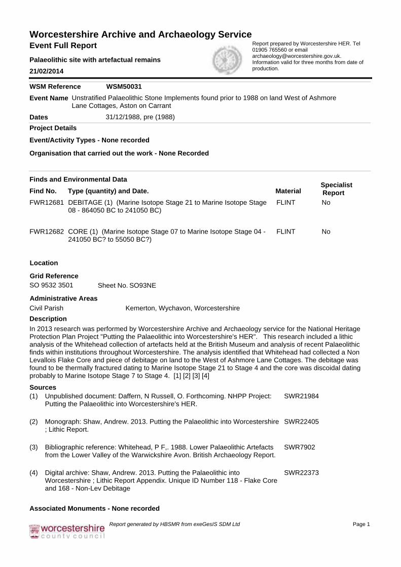
Event Full Report
Palaeolithic site with artefactual remains
21/02/2014
Report prepared by Worcestershire HER. Tel 01905 765560 or email [email protected]. Information valid for three months from date of production.
Worcestershire Archive and Archaeology Service
Project Details
Location
In 2013 research was performed by Worcestershire Archive and Archaeology service for the National Heritage Protection Plan Project "Putting the Palaeolithic into Worcestershire's HER". This research included a lithic analysis of the Whitehead collection of artefacts held at the British Museum and analysis of recent Palaeolithic finds within institutions throughout Worcestershire. The analysis identified that Whitehead had collected a Non Levallois Flake Core and piece of debitage on land to the West of Ashmore Lane Cottages. The debitage was found to be thermally fractured dating to Marine Isotope Stage 21 to Stage 4 and the core was discoidal dating probably to Marine Isotope Stage 7 to Stage 4. [1] [2] [3] [4]
Unstratified Palaeolithic Stone Implements found prior to 1988 on land West of Ashmore Lane Cottages, Aston on Carrant
Event Name
WSM Reference WSM50031
31/12/1988, pre (1988)
Grid Reference
SO93NE
Description
Sources
Associated Monuments - None recorded
Administrative Areas
Dates
Event/Activity Types - None recorded
Finds and Environmental Data
Find No. Type (quantity) and Date. Material
SO 9532 3501 Sheet No.
Organisation that carried out the work - None Recorded
Specialist
Report
Civil Parish Kemerton, Wychavon, Worcestershire
Unpublished document: Daffern, N Russell, O. Forthcoming. NHPP Project: Putting the Palaeolithic into Worcestershire's HER.
(1) SWR21984
Monograph: Shaw, Andrew. 2013. Putting the Palaeolithic into Worcestershire ; Lithic Report.
(2) SWR22405
Bibliographic reference: Whitehead, P F,. 1988. Lower Palaeolithic Artefacts from the Lower Valley of the Warwickshire Avon. British Archaeology Report.
(3) SWR7902
Digital archive: Shaw, Andrew. 2013. Putting the Palaeolithic into Worcestershire ; Lithic Report Appendix. Unique ID Number 118 - Flake Core and 168 - Non-Lev Debitage
(4) SWR22373
DEBITAGE (1) (Marine Isotope Stage 21 to Marine Isotope Stage 08 - 864050 BC to 241050 BC)
FLINTFWR12681 No
CORE (1) (Marine Isotope Stage 07 to Marine Isotope Stage 04 - 241050 BC? to 55050 BC?)
FLINTFWR12682 No
Page 1Report generated by HBSMR from exeGesIS SDM Ltd

Unstratified Palaeolithic Stone Implements found prior to 1988 on land West of Ashmore Lane Cottages, Aston on Carrant
Name:
Report prepared by Worcestershire HER. Tel 01905 765560 or email [email protected]. Information valid for three months from date of production.
WSM Reference WSM50031
Page 2Report generated by HBSMR from exeGesIS SDM Ltd
Event Full Report
Palaeolithic site with faunal remains
21/02/2014
Report prepared by Worcestershire HER. Tel 01905 765560 or email [email protected]. Information valid for three months from date of production.
Worcestershire Archive and Archaeology Service
Project Details
Location
In 2013 research was performed by Worcestershire Archive and Archaeology service for the National Heritage Protection Plan Project "Putting the Palaeolithic into Worcestershire's HER". This research included a literature search which highlighted Palaeolithic evidence thus far unrecorded within the HER. It identified that Richardson had recorded faunal remains of Cervus tarandus, Bos primigenius, Rhinoceros tichorhinus and Elephas primigenius on land at Aston Mill. The remains are dated to Marine Isotope Stage 3 to Stage 2. [1] [2][3]
The actual date the remains were discovered, and the discovery method, is unknown. Prior date set to date of publication in Richardson. [1][2] [3] [4]
Unstratified Palaeolithic faunal remains found prior to 1929 on land North of Aston on Carrant, Aston Mill
Event Name
WSM Reference WSM49735
31/12/1929, pre (1929)
Grid Reference
SO93NW
Description
Sources
Associated Monuments - None recorded
Administrative Areas
Dates
Event/Activity Types - None recorded
Finds and Environmental Data
Find No. Type (quantity) and Date. Material
SO 9448 3519 Sheet No.
Organisation that carried out the work - None Recorded
Specialist
Report
Civil Parish Kemerton, Wychavon, Worcestershire
Unpublished document: Daffern, N Russell, O. Forthcoming. NHPP Project: Putting the Palaeolithic into Worcestershire's HER.
(1) SWR21984
Bibliographic reference: Richardson, L. 1929. Geology of the country around Moreton-in-Marsh. Memoir of the Geological Survey of Great Britain.
(2) SWR22171
Bibliographic reference: Briggs, D J. 1975. Origin, depositional environment and age of the Cheltenham Sand and gravel and related deposits.
(3) SWR22172
Personal Comment: Webley, A. 2012 onwards. Personal comment on updating/creating HER record.
(4) SWR21669
ANIMAL REMAINS (Unknown) (Marine Isotope Stage 03 - 55050 BC to 27050 BC)
BONEFWR12567 No
Page 1Report generated by HBSMR from exeGesIS SDM Ltd

Worcestershire County Council Archive and Archaeology Service
4. Guidance for Planning and the Palaeolithic in Worcestershire
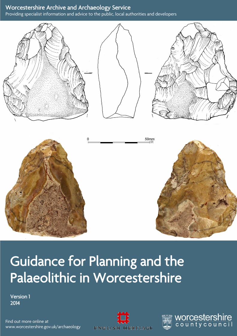
0
Guidance for Planning and the Palaeolithic in Worcestershire
Find out more online at www.worcestershire.gov.uk/archaeology
Worcestershire Archive and Archaeology Service Providing specialist information and advice to the public, local authorities and developers
Version 1 2014
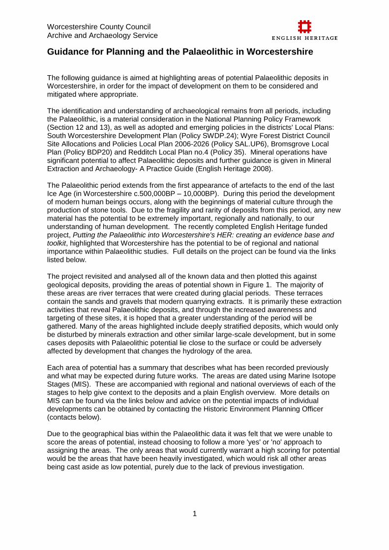
Worcestershire County Council Archive and Archaeology Service
1
Guidance for Planning and the Palaeolithic in Worcestershire
The following guidance is aimed at highlighting areas of potential Palaeolithic deposits in Worcestershire, in order for the impact of development on them to be considered and mitigated where appropriate. The identification and understanding of archaeological remains from all periods, including the Palaeolithic, is a material consideration in the National Planning Policy Framework (Section 12 and 13), as well as adopted and emerging policies in the districts' Local Plans: South Worcestershire Development Plan (Policy SWDP.24); Wyre Forest District Council Site Allocations and Policies Local Plan 2006-2026 (Policy SAL.UP6), Bromsgrove Local Plan (Policy BDP20) and Redditch Local Plan no.4 (Policy 35). Mineral operations have significant potential to affect Palaeolithic deposits and further guidance is given in Mineral Extraction and Archaeology- A Practice Guide (English Heritage 2008). The Palaeolithic period extends from the first appearance of artefacts to the end of the last Ice Age (in Worcestershire c.500,000BP – 10,000BP). During this period the development of modern human beings occurs, along with the beginnings of material culture through the production of stone tools. Due to the fragility and rarity of deposits from this period, any new material has the potential to be extremely important, regionally and nationally, to our understanding of human development. The recently completed English Heritage funded project, Putting the Palaeolithic into Worcestershire's HER: creating an evidence base and toolkit, highlighted that Worcestershire has the potential to be of regional and national importance within Palaeolithic studies. Full details on the project can be found via the links listed below.
The project revisited and analysed all of the known data and then plotted this against
geological deposits, providing the areas of potential shown in Figure 1. The majority of these areas are river terraces that were created during glacial periods. These terraces contain the sands and gravels that modern quarrying extracts. It is primarily these extraction activities that reveal Palaeolithic deposits, and through the increased awareness and targeting of these sites, it is hoped that a greater understanding of the period will be gathered. Many of the areas highlighted include deeply stratified deposits, which would only be disturbed by minerals extraction and other similar large-scale development, but in some cases deposits with Palaeolithic potential lie close to the surface or could be adversely affected by development that changes the hydrology of the area. Each area of potential has a summary that describes what has been recorded previously and what may be expected during future works. The areas are dated using Marine Isotope Stages (MIS). These are accompanied with regional and national overviews of each of the stages to help give context to the deposits and a plain English overview. More details on MIS can be found via the links below and advice on the potential impacts of individual developments can be obtained by contacting the Historic Environment Planning Officer (contacts below). Due to the geographical bias within the Palaeolithic data it was felt that we were unable to score the areas of potential, instead choosing to follow a more 'yes' or 'no' approach to assigning the areas. The only areas that would currently warrant a high scoring for potential would be the areas that have been heavily investigated, which would risk all other areas being cast aside as low potential, purely due to the lack of previous investigation.
Worcestershire County Council Archive and Archaeology Service
2
Links Palaeolithic Project and Guidance Webpage – www.worcestershire.gov.uk/archaeology/palaeolithicguidance Project Report (contains full project bibliography)- http://public.worcestershire.gov.uk/sites/archaeology/Reports/SWR21984.pdf Worcestershire Mineral Plan - http://www.worcestershire.gov.uk/cms/minerals-and-waste-policy/emerging-minerals-local-plan.aspx Heritage Gateway – http://www.heritagegateway.org.uk/gateway Contacts Worcestershire Historic Environment Record and Advisory Team Worcestershire Archive & Archaeology Service The Hive Sawmill Walk The Butts Worcester WR1 3PD Tel: 01905 765560 Email: [email protected] Website: www.worcestershire.gov.uk/waas
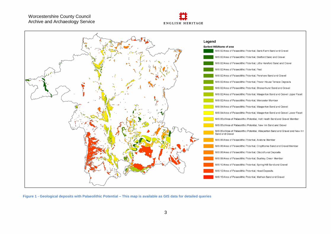
Worcestershire County Council Archive and Archaeology Service
3
Figure 1 - Geological deposits with Palaeolithic Potential – This map is available as GIS data for detailed queries
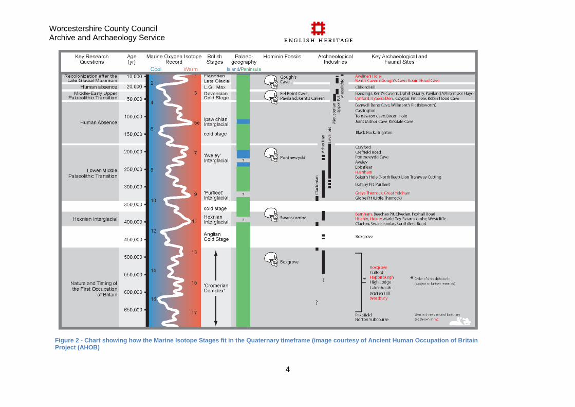
Worcestershire County Council Archive and Archaeology Service
4
Figure 2 - Chart showing how the Marine Isotope Stages fit in the Quaternary timeframe (image courtesy of Ancient Human Occupation of Britain Project (AHOB)
Worcestershire County Council Archive and Archaeology Service
5
Areas of Palaeolithic Potential in Worcestershire
Bank Farm Sand and Gravel
Marine Isotope Stage 2
Middle to Late Devensian gravels from other locations have proven potential for the
recovery of artefactual, faunal and palaeoenvironmental remains (Wasperton and
Bretford Sand and Gravel). Identification of deposits suitable for research is essential for
the Teme Palaeovalley Formation as it is currently undefined in the BGS Lexicon and is
poorly understood. There is potential that these deposits may mask earlier drainage
systems associated with the pre-Anglian Mathon system, especially in the north-west of
the county
http://www.heritagegateway.org.uk/Gateway/Results_Single.aspx?uid=MWR49427&res
ourceID=1035
Bretford Sand and Gravel
Marine Isotope Stage 2
These gravels represent the latest phase of the Devensian. Evidence has been
recovered from gravels at Bredon's Hardwick and in the Carrant Brook environs.
http://www.heritagegateway.org.uk/Gateway/Results_Single.aspx?uid=MWR49429&res
ourceID=1035
Little Hereford Sand and Gravel
Marine Isotope Stage 2
Middle to Late Devensian gravels from other locations have proven potential for the
recovery of artefactual, faunal and palaeoenvironmental remains (Wasperton and
Bretford Sand and Gravel). Identification of deposits suitable for research is essential for
the Teme Palaeovalley Formation as it is currently undefined in the BGS Lexicon and is
poorly understood. There is potential that these deposits may mask earlier drainage
systems associated with the pre-Anglian Mathon system, especially in the north-west of
the county
http://www.heritagegateway.org.uk/Gateway/Results_Single.aspx?uid=MWR49435&res
ourceID=1035
Worcestershire County Council Archive and Archaeology Service
6
Peat
Marine Isotope Stage 2
Peat has been mapped by BGS but no dating can be assigned to the deposit. Peat is
likely to be Holocene in date but there is potential for Late Glacial material to be present
at the base of the sequences. Palaeoenvironmental potential for these deposits is high
http://www.heritagegateway.org.uk/Gateway/Results_Single.aspx?uid=MWR49438&res
ourceID=1035
Pershore Sand and Gravel
Marine Isotope Stage 2
Locally overlies organic deposits of the Allesborough Beds (also known as the Pershore
Fossil Bed) which contains temperate flora and fauna assigned to MIS 9. There is also
potential for reworked artefacts within or associated with these deposits as is evidenced
by the presence of an MIS 9 (or earlier) handaxe from Allesborough
http://www.heritagegateway.org.uk/Gateway/Results_Single.aspx?uid=MWR49439&res
ourceID=1035
Power House Terrace Deposits
Marine Isotope Stage 2
Unknown potential for palaeoenvironmental, artefactual, human and faunal remains.
Given extensive presence of material from similarly dated deposits at Beckford, Aston
Mill etc indicates potential
http://www.heritagegateway.org.uk/Gateway/Results_Single.aspx?uid=MWR49440&res
ourceID=1035
Shakenhurst Sand and Gravel
Marine Isotope Stage 2
Middle to Late Devensian gravels from other locations have proven potential for the
recovery of artefactual, faunal and palaeoenvironmental remains (Wasperton and
Bretford Sand and Gravel). Identification of deposits suitable for research is essential for
the Teme Palaeovalley Formation as it is currently undefined in the BGS Lexicon and is
poorly understood. There is potential that these deposits may mask earlier drainage
systems associated with the pre-Anglian Mathon system, especially in the north-west of
the county
http://www.heritagegateway.org.uk/Gateway/Results_Single.aspx?uid=MWR49441&res
ourceID=1035
Worcestershire County Council Archive and Archaeology Service
7
Wasperton Sand and Gravel Upper Facet
Marine Isotope Stage 2
Yields abundant faunal and artefactual remains including extensive Neanderthal and
early Homo sapien artefacts. Locally overlies and contains the channel-filling organics of
the Fladbury Beds
http://www.heritagegateway.org.uk/Gateway/Results_Single.aspx?uid=MWR49446&res
ourceID=1035
Worcester Member
Marine Isotope Stage 2
Unknown potential for palaeoenvironmental, artefactual, human and faunal remains.
Given extensive presence of material from similarly dated deposits at Beckford, Aston
Mill etc indicates potential
http://www.heritagegateway.org.uk/Gateway/Results_Single.aspx?uid=MWR49447&res
ourceID=1035
Wasperton Sand and Gravel
Marine Isotope Stage 4 to Marine Isotope Stage 2
Yields abundant faunal and artefactual remains including extensive Neanderthal and
early Homo sapien artefacts. Locally overlies and contains the channel-filling organics of
the Fladbury Beds
http://www.heritagegateway.org.uk/Gateway/Results_Single.aspx?uid=MWR49443&res
ourceID=1035
Wasperton Sand and Gravel Lower Facet
Marine Isotope Stage 4
Yields abundant faunal and artefactual remains including extensive Neanderthal and
early Homo sapien artefacts. Locally overlies and contains the channel-filling organics of
the Fladbury Beds
http://www.heritagegateway.org.uk/Gateway/Results_Single.aspx?uid=MWR49445&res
ourceID=1035
Worcestershire County Council Archive and Archaeology Service
8
Holt Heath Sand and Gravel Member
Marine Isotope Stage 5d to Marine Isotope Stage 2
Stourbridge beds containing Ipswichian (MIS 5e) fauna including hippo at base of Holt
Heath in Stour Valley, unknown whether this presence occurs elsewhere in the Severn
system. Interbedded organic beds occur within the Holt heath gravels elsewhere,
particularly noteworthy being Upton Warren where Devensian faunal and
palaeoenvironmental remains were recovered. Chronology of deposition of the Holt
Heath Member is poorly understood but Luminescence Dating has been successful,
therefore refining the chronology of this member is a priority.
http://www.heritagegateway.org.uk/Gateway/Results_Single.aspx?uid=MWR49434&res
ourceID=1035
New Inn Sand and Gravel
Marine Isotope Stage 5d to Marine Isotope Stage 5b
Locally overlies regionally and nationally significant Ipswichian organic deposits
including the channel filling Eckington Beds. Contains reworked Ipswichian faunal
remains.
http://www.heritagegateway.org.uk/Gateway/Results_Single.aspx?uid=MWR49437&res
ourceID=1035
Wasperton Sand and Gravel and New Inn Sand and Gravel
Marine Isotope Stage 5d to Marine Isotope Stage 4
Yields abundant faunal and artefactual remains including extensive Neanderthal and
early Homo sapien artefacts. Locally overlies and contains the channel-filling organics of
the Fladbury Beds. Also is likely to contain reworked Ipswichian faunal remains.
http://www.heritagegateway.org.uk/Gateway/Results_Single.aspx?uid=MWR49444&res
ourceID=1035
Ailstone Member
Marine Isotope Stage 6
The Ailstone Member correlates with the Cropthorne Sand and Gravel. Locally overlies
channel filling lag-gravels and fossiliferous sands of the Ailstone Bed (dated to MIS 7)
that yield environmental remains, particular molluscan remains including the bivalve
Corbicula
http://www.heritagegateway.org.uk/Gateway/Results_Single.aspx?uid=MWR49425&res
ourceID=1035
Worcestershire County Council Archive and Archaeology Service
9
Cropthorne Sand and Gravel Member
Marine Isotope Stage 6
The Cropthorne Sand and Gravel correlates with the Ailstone Member. This member
locally overlies channel filling lag-gravels and fossiliferous sands of the Ailstone Bed
(dated to MIS 7) that yield environmental remains, particular molluscan remains
including the bivalve Corbicula
http://www.heritagegateway.org.uk/Gateway/Results_Single.aspx?uid=MWR49431&res
ourceID=1035
Glaciofluvial Deposits
Marine Isotope Stage 6 to Marine Isotope Stage 2
Potential presence of deposits with geological significance ie proves presence/extent of
Saalian and Devensian glaciation. These deposits may also be suitable for radiometric
and/or Luminescence dating. May also contain palaeoenvironmental remains associated
with glacial environments, particularly during deglaciation/glacial retreat. Limited
potential for unstratified/reworked artefactual remains.
http://www.heritagegateway.org.uk/Gateway/Results_Single.aspx?uid=MWR49432&res
ourceID=1035
Bushley Green Member
Marine Isotope Stage 8
Gravels overlie the Hill House Beds (formerly Bushley Green Beds). These are
comprised of up to 1.5m of sand and gravel containing molluscs of cool temperate
climate. The bed is dated to MIS 9. There is also potential for reworked artefacts within
or associated with these deposits as is evidenced by the presence of MIS 11 or 9 (or
earlier) handaxes from Madresfield and Queenshill/Upton on Severn.
http://www.heritagegateway.org.uk/Gateway/Results_Single.aspx?uid=MWR49430&res
ourceID=1035
Spring Hill Sand and Gravel
Marine Isotope Stage 10
There is potential for reworked artefacts within or associated with these deposits as is
evidenced by the presence of MIS 11 or 9 (or earlier) handaxes from Madresfield and
Queenshill/Upton on Severn.
http://www.heritagegateway.org.uk/Gateway/Results_Single.aspx?uid=MWR49442&res
ourceID=1035
Worcestershire County Council Archive and Archaeology Service
10
Head Deposits
Marine Isotope Stage 12 to Marine Isotope Stage 2
Head deposits may conceal and preserve earlier land surfaces and may also contain
unstratified/reworked artefactual remains.
http://www.heritagegateway.org.uk/Gateway/Results_Single.aspx?uid=MWR49433&res
ourceID=1035
Mathon Sand and Gravel
Marine Isotope Stage 15 to Marine Isotope Stage 13
Comprises pre-glacial fluvial sands and gravels infilling a palaeochannel, associated
with the Bray's Silt Bed, a 1m thick bed of silt containing palaeoenvironmental remains
indicative of an interglacial environment. Pre-Anglian deposits containing
palaeoenvironmental evidence in the West Midlands (and to a lesser extent, nationally)
are very rare and therefore identifying the extent of these deposits is of regional and
national importance. Pre-Anglian environmental remains are unknown from
Worcestershire but identifying former courses/tributaries of the Mathon would provide a
source for this material. The poorly understood Mathon system needs further
investigation as mapping its course will be key in understanding the hydrological history
of the West Midlands. Hominin and artefactual remains are known from Pre-Anglian
deposits (Happisburgh, Pakefield, Boxgrove, Waverley Wood) but none have been
identified in this area of the country and given the potential for a non-Thames or non-
Bytham migration route into Britain via the Mathon, investigation of these deposits is of
national significance.
http://www.heritagegateway.org.uk/Gateway/Results_Single.aspx?uid=MWR49436&res
ourceID=1035
Worcestershire County Council Archive and Archaeology Service
11
Marine Isotope Stage 2 – 29,000-14,000 years ago
Nationally (Pettitt and White 2012): Glacial ice began to accumulate again around 32,000 BP with maximum extent of the British-Irish Ice Sheet being reached between 27,000 - 24,000 BP. Modelling of ice thickness in Scotland and Ireland suggests the thickest ice could have been 900 - 1,600m thick with thicknesses below 100m in marginal areas. Global sea level was c114- 35m below present day with most of the North Sea and the English Channel being dry. Insects suggest extensive snowfall (Atkinson et al 1987) and all areas which were free of ice witnessed severe periglacial conditions. During the Last Glacial Maximum (LGM), the aggrading, braided, gravelly rivers flowed through treeless, arctic landscapes. Short improvements in the climate occur from 21,000 BP onwards with NW England being deglaciated between 19,000 - 17,000 BP. Rapid warming occurred during the Windermere Interstadial (14, 700 - 12,900 BP) with summer temperatures rising by more than 7˚C per century and winter temperatures rose by 20˚C overall. Currant and Jacobi (2011) state that the following mammals were present during the Dimlington Stadial (26 - 13 ka): Primates
Anatomically modern humans (homo sapiens) Lagomorpha
Arctic hare (Lepus arcticus) Carnivora
Fox (Vulpini)
Brown bear (Ursus arctos) Proboscidea
Woolly mammoth (Mammuthus primigenius) Artiodactyla
Reindeer (Rangifer tarandus) Bovidae
Musk ox (Ovibos moschatus)
Worcestershire: Climate/landscape - Worcestershire would most probably have been either a polar desert or, more likely, tundra at this time (or possibly transitioning between the two biomes). Plant, insect and molluscan remains from deposits at Beckford Priory dating to 27,000 years BP (before present) support this indicating cold, open, tundra-like conditions.
Worcestershire County Council Archive and Archaeology Service
12
Fauna - The recovery of a bison sacrum from gravels at Broadway dated to approximately 24,500 years ago, a species found elsewhere in the UK, indicates full arctic/sub-arctic conditions. Key Sites -
Aston Mill
Broadway
Beckford
Stourport
Wilden Marsh Key Deposits - Where available links to the BGS have been provided Avon
Bretford Sand and Gravel Member (1st Terrace) http://www.bgs.ac.uk/Lexicon/lexicon.cfm?pub=BRET
Wasperton Sand and Gravel Member (2nd Terrace) http://www.bgs.ac.uk/Lexicon/lexicon.cfm?pub=WAT
Severn
Power House Sand and Gravel Member (1st Terrace) http://www.bgs.ac.uk/Lexicon/lexicon.cfm?pub=PSTT
Worcester Sand and Gravel Member (2nd Terrace) http://www.bgs.ac.uk/Lexicon/lexicon.cfm?pub=WORT
Malvern Hills/Herefordshire
Rudford Member (Glynch Valley) http://www.bgs.ac.uk/Lexicon/lexicon.cfm?pub=RDFD
Ham Green Member (Cradley Valley) not yet classified
Worcestershire County Council Archive and Archaeology Service
13
Marine Isotope Stage 3 – 57,000-29,000 years ago (Lisiecki & Raymo 2005)
Nationally (Pettitt and White 2012): All molluscan and insect faunas indicate an open, treeless environment, with taxa characteristic of rich grassland and local patches of marsh, acid heath and bare, sandy ground (Pettitt and White 2012, 300). Coope (2002) suggested the warmest months averaged just 10˚C with coldest months experiencing lows of - 20˚C to -27˚C. Trees including pine, oak, alder and hazel may have survived in sheltered locations such as southern flanks of hills and gorges as indicated by pollen evidence found at Cresswell Crags, Wookey Hole amd Kent's Cavern. Poor soil conditions, the poor climate and/ or intense grazing may have inhibited tree growth in the exposed floodplains (Pettitt and White 2012, 315). Cold, open tundra persists until climatic deterioration occurs leading to the Last Glacial Maximum in MIS 2 (Hopkinson 2007). Climatically, MIS3 stands out from other warm episodes as it was relatively cold and extremely unstable. MIS 3 was neither an interglacial nor a glacial but a series of alternating warm and cold events occurring over millenial timescales. Pettitt and White (2012, 318) produced the following which is a list of mammalian fauna present in MIS 3 Britain: Insectivora
Shrew (Soricidae) Lagomorpha
Steppe pika (Ochotona pusilla)
Arctic hare (Lepus arcticus) Rodentia
Field mouse (Apodemus sylvaticus)
Northern water vole (Arvicola amphibius)
Field vole (Microtus agrestis)
Narrow-headed vole (Microtus gregalis)
Vole
Snow vole (Chionomys nivalis)
Northern vole
Bank vole (Myodes glareolus)
Norway lemming (Lemmus lemmus)
Lemming (Lemmus)
Collared lemming (Dicrostonyx)
Re-cheeked souslik (Spermophilus erythrogenys) Carnivora
Lion (Panthera leo)
Wild cat (Felis silvestris)
Spotted hyaena (Crocuta crocuta)
Wolf (Canis lupus)
Sabre tooth tiger (Smilodon)
Red fox (Vulpes vulpes)
Arctic fox (Vulpes lagopus)
Worcestershire County Council Archive and Archaeology Service
14
Brown bear (Ursus arctos)
Cave bear (Ursus spelaeus)
Stoat (Mustela erminea)
Weasel (Mustela)
Polecat (Mustela putorius)
Large polecat
Marten (Martes)
Wolverine (Gulo gulo) Proboscidea
Woolly mammoth (Mammuthus primigenius) Perissodactyla
Wild horse (Equus ferus)
Woolly rhinoceros (Coelodonta antiquitatis) Artiodactyla
Giant deer (Megaloceros giganteus)
Red deer (Cervus elaphus)
Reindeer (Rangifer tarandus)
Aurochs (Bos primigenius)
Bison (Bison bison) Worcestershire: Climate/Landscape - At Fladbury, peat which had accumulated in a shallow pool of standing water on the flood-plain was dated to 38,000 years BP. Evidence indicated that the pools were surrounded by sedges and willow (probably dwarf willow, Salix herbacea) whilst away from the pool the country was barren and sandy with a thin cover of vegetation. Molluscan remains recovered from the Wasperton Sand and Gravel Member at Salford Priors indicated cold stage conditions in a slightly vegetated periglacial river. Fauna - This stage contains abundant evidence for the types and variety of animals that were present in Worcestershire during the Devensian. At Cropthorne, bison, auroch, deer, bear and wolf. At Twyning (Gloucs) lenses of peat in gravel contained remains of woolly mammoth, woolly rhinoceros, Irish elk, horse and bison dated to 36,000 years BP. These were underlain by sand deposits contain remains of wolf, reindeer, steppe bison and field vole. Faunal remains recovered from Aston Mill included reindeer, auroch/bison, woolly rhino and woolly mammoth. Key Archaeological Area –
Aston Mill
Cropthorne
Fladbury
Holt Heath Key Deposits - Where available links to the BGS have been provided
Worcestershire County Council Archive and Archaeology Service
15
Avon
Fladbury Bed
Wasperton Sand and Gravel Member (2nd Terrace) http://www.bgs.ac.uk/Lexicon/lexicon.cfm?pub=WAT
Severn
Holt Heath Sand and Gravel Member (3rd Terrace) http://www.bgs.ac.uk/lexicon/lexicon.cfm?pub=HHSG
Upton Warren Bed Malvern Hills/Herefordshire
Staunton Member (Glynch Valley) http://www.bgs.ac.uk/lexicon/lexicon.cfm?pub=STAU
Bullingham Member (Wye Valley)
Marden and Moreton on Lugg Members (Lugg Valley)
Worcestershire County Council Archive and Archaeology Service
16
Marine Isotope Stage 4 – 71,000-57,000 years ago (Lisiecki & Raymo 2005)
Nationally (Pettitt and White 2012): This stage saw a major growth of continental ice and fluctuations in sea level, with levels 100m below modern sea level. Cold/ Arctic open tundra environments covered much of mainland Britain. Worcestershire: Climate/Landscape - The climate reflected in the environmental remains recovered from Upton Warren indicates temperate conditions although 1 or more species with arctic affinities are present. Mean temperature for the warmest month is estimated to be between 16 to 18˚C and the mean temperature for the coldest month is estimated to be between -1 to - 11˚C. Fauna - Fauna remains from Upton Warren included: Proboscidea
Woolly mammoth (Mammuthus primigenius) Perissodactyla
Woolly rhinoceros (Coelodonta antiquitatis)
Horse (Equus ferus caballus) Artiodactyla
Steppe bison (Bison priscus)
Reindeer (Rangifer tarandus) Rodentia
Extinct lemming
Vole (Microtus) Anura
Common frog (Rana temporaria) Gasterosteiformes
Three-spined stickleback (Gasterosteus aculeatus) Key Sites -
Fladbury
Upton Warren Key Deposits - Where available links to the BGS have been provided Avon
Fladbury Bed
Wasperton Sand and Gravel Member (2nd Terrace) http://www.bgs.ac.uk/lexicon/lexicon.cfm?pub=WAT

Worcestershire County Council Archive and Archaeology Service
17
Severn
Holt Heath Sand and Gravel Member (3rd Terrace) http://www.bgs.ac.uk/lexicon/lexicon.cfm?pub=HHSG
Upton Warren Bed
Worcestershire County Council Archive and Archaeology Service
18
Marine Isotope Stage 5a – 85,000-71,000 years ago (Lisiecki & Raymo 2005)
Nationally: No national overview Worcestershire: Climate/Landscape - No known evidence from Worcestershire Fauna - No known evidence from Worcestershire Key Sites -
Fladbury
Upton Warren Key Deposits - Where available links to the BGS have been provided Avon
Fladbury Bed
Wasperton Sand and Gravel Member (2nd Terrace) http://www.bgs.ac.uk/lexicon/lexicon.cfm?pub=WAT
Severn
Holt Heath Sand and Gravel Member (3rd Terrace) http://www.bgs.ac.uk/lexicon/lexicon.cfm?pub=HHSG
Upton Warren Bed
Worcestershire County Council Archive and Archaeology Service
19
Marine Isotope Stage 5b – 93,000-85,000 years ago (Lisiecki & Raymo 2005)
Nationally: No national overview Worcestershire: Climate/Landscape - Molluscan remains from Beckford indicated a tall-herb mire recovered from a deep (>9.58m) loamy hillwash. Fauna - No known evidence from Worcestershire Key Sites - Not identified within Worcestershire Key Deposits - Where available links to the BGS have been provided Avon - no deposits identified Severn - appears absent, possibly identifed within:
Holt Heath Sand and Gravel (3rd Member) http://www.bgs.ac.uk/lexicon/lexicon.cfm?pub=HHSG
Malvern Hills/Herefordshire - appears absent, possible identified within:
Bullingham Member (Wye Valley)
Marden and Moreton on Lugg Members (Lugg Valley)
Staunton Member (Glynch Valley) http://www.bgs.ac.uk/lexicon/lexicon.cfm?pub=STAU
Worcestershire County Council Archive and Archaeology Service
20
Marine Isotope Stage 5c – 106,000-93,000 years ago (Lisiecki & Raymo 2005)
Nationally: No national overview Worcestershire: Climate/Landscape - No known evidence from Worcestershire Fauna - No known evidence from Worcestershire Key Sites - Not identified within Worcestershire Key Deposits - Where available links to the BGS have been provided Avon - no deposits identified Severn - appears absent, possibly identified within:
Holt Heath Sand and Gravel (3rd Member) http://www.bgs.ac.uk/lexicon/lexicon.cfm?pub=HHSG
Malvern Hills/Herefordshire - appears absent, possible identified within:
Bullingham Member (Wye Valley)
Marden and Moreton on Lugg Members (Lugg Valley)
Staunton Member (Glynch Valley) http://www.bgs.ac.uk/lexicon/lexicon.cfm?pub=STAU
Worcestershire County Council Archive and Archaeology Service
21
Marine Isotope Stage 5d – 115,000-106,000 years ago (Lisiecki & Raymo 2005)
Nationally: No national overview Worcestershire: Climate/landscape - At Beckford, molluscan remains of terrestrial species indicated a tall-herb mire. Evidence recovered from Rectors Pit, Cropthorne indicated open, poorly vegetated conditions with the absence of other taxa suggesting a severe climate. This severe climate is indicated by the presence of tundra polygons/ patterned ground created by ice wedges through thermal contraction. The mean annual temperature thought to be required to form ice wedges is between -8˚c to -6˚c. Fauna - No known evidence from Worcestershire Key Sites -
Abbots Salford
Beckford Key Deposits - Where available links to the BGS have been provided Avon
New Inn Sand and Gravel Member (3rd Terrace) http://www.bgs.ac.uk/lexicon/lexicon.cfm?pub=NIT
Severn - appears absent, possibly identifed within:
Holt Heath Sand and Gravel (3rd Member) http://www.bgs.ac.uk/lexicon/lexicon.cfm?pub=HHSG
Malvern Hills/Herefordshire - appears absent, possible identified within:
Bullingham Member (Wye Valley)
Marden and Moreton on Lugg Members (Lugg Valley)
Staunton Member (Glynch Valley) http://www.bgs.ac.uk/lexicon/lexicon.cfm?pub=STAU
Worcestershire County Council Archive and Archaeology Service
22
Marine Isotope Stage 5e – 130,000-115,000 years ago (Lisiecki & Raymo 2005)
Nationally: The Ipswichian was one of the warmest episodes of the last half million years with mean July temperatures 4˚C above those of southern Britian today (Coope 2000) whilst mean January temperatures of 1 to 2˚ C indicate that winters were mild. The landscape was a mosaic of dense, decideous forest (oak, maple, ash, hazel) and open, grassland habitats. Typical fauna identified in Britain include: Proboscidea
Straight-tusked elephant (Elephas antiquus) Artiodactyla
Fallow deer (Dama dama)
Giant deer (Megaloceros giganteus)
Wild boar (Sus scrofa)
Red deer (Cervus elaphus)
Auroch (Bos primigenius)
Hippopotamus (Hippopotamus amphibius) Perissodactyla
Narrow-nosed rhinoceros (Stephanorhinus hemiotechus) Rodentia
Wood mouse (Apodemus sylvaticus) Worcestershire: Climate/Landscape - Evidence from the New Inn Sand and Gravel Member indicated temperate, interglacial conditions. The assmeblage was dominated by species typical of large rivers with quiet water conditions and weed-rich habitats. Evidence from Wick indicated an open steppe environment, this is likely to indicate another 'phase' of the stage when the climate and landscape were changing. Fauna - At Eckington, rich assemblages of molluscan and mammalian remains have been recovered including hippopotamus, mammoth, giant deer and bison. Hippopotamus remains have also been recovered from Bengeworth and Stourbridge. Also recovered from Stourbridge have been woolly mammoth, rhinoceros tichorhinus, horse, steppe bison and deer. Lion, spotted hyena and brown bear are also known to have been present in Britain during this stage. Key Sites –
Bengeworth
Cropthorne
Worcestershire County Council Archive and Archaeology Service
23
Eckington
Eckington railway cutting
Kemerton Lakes (Bredon Quarry)
New Inn road cutting
Stourbridge Key Deposits - Where available links to the BGS have been provided Avon
New Inn Sand and Gravel Member (3rd Terrace) http://www.bgs.ac.uk/lexicon/lexicon.cfm?pub=NIT
Severn - appears absent, possibly identified within:
Stourbridge Fossil Bed
Worcestershire County Council Archive and Archaeology Service
24
Marine Isotope Stage 6 – 191,000-130,000 years ago (Lisiecki & Raymo 2005)
Nationally: This stage was one of the more severe glaciations of the past 500,000 years with around 50,000 years of sustained cold although evidence in the UK for glaciers is problematic/difficult to identify. Flora and fauna indicate cold open conditions with mean July temperatures around 10˚C and January temperatures of - 20˚C. Fauna identifed include: Artiodactyla
Musk ox (Ovibos moschatus)
Bison (Bison bison)
Reindeer (Rangifer tarandus) Rodentia
Lemming (Lemmus)
Northern vole Proboscidea
Woolly mammoth (Mammuthus primigenius) Perissodactyla
Woolly rhinoceros (Coelodonta antiquitatis)
Horse (Equus ferus caballus) Carnivora
Brown bear (Ursus arctos) Worcestershire: Climate/Landscape - Cool climate indicated by fluvially deposited sands and gravel. Fauna -No known evidence from Worcestershire Key Sites - None noted Key Deposits - Where available links to the BGS have been provided Avon
Cropthorne Sand and Gravel Member (4th Terrace, same as Strensham?) http://www.bgs.ac.uk/lexicon/lexicon.cfm?pub=CRTD
Strensham Sand and Gravel Member (4th Terrace, same as Cropthorne?) http://www.bgs.ac.uk/lexicon/lexicon.cfm?pub=STRSG
Severn
Kidderminster Station Sand and Gravel Member (4th Terrace)
Worcestershire County Council Archive and Archaeology Service
25
http://www.bgs.ac.uk/lexicon/lexicon.cfm?pub=KRT
Ridgeacre Formation, Stourport Diamict Malvern Hills/Herefordshire
Colwall Member (Cradley Valley)
Hampton Member (Wye Valley)
Kingsfield Member (Lugg Valley)
Redmarley Member (Glynch Valley) http://www.bgs.ac.uk/lexicon/lexicon.cfm?pub=RMLY
Worcestershire County Council Archive and Archaeology Service
26
Marine Isotope Stage 7 – 243,000-191,000 years ago (Lisiecki & Raymo 2005)
Nationally (Pettitt and White 2012): On a national level, MIS 7 comprised three warm phases (7e, 7c and 7a) which were interrupted by two cold stages (7d and 7b). The channels and floodplain pools which have been investigated were heavily vegetated with the water being slow flowing or still and poorly oxygenated. It appears only marginal floodplain pools and cut-offs are represented in the archaeological record. Wetland plants such as sedges, rushes, bulrush, watercress and wild mustards grew on the water margins whilst floodplain consisted of marshy, herbaceous rich grassland and/or open meadow-like conditions shaded by weedy vegetation. On the valley sides dry, herb-rich grassland existed similar to that found in southern England today. Trees and tall shrubs were present with most of the modern British deciduous and coniferous trees being present occurring as dense woodland, small clumps or even individual trees depending on the location. This woodland would have grown in the valley sides and the wider, drier landscape as opposed to the valley floors as indicated by the lack of insects associated with trees recovered from these floodplain sites. Pettitt and White (2012, 227) produced the following which is a list of mammalian fauna present in MIS 7 Britain: Insectivora
Hedgehog (Erinaceinae)
Common shrew (Sorex araneus)
Pygmy shrew (Sorex minutus)
Water shrew (Sorex palustris)
White-toothed shrew (Crocidurinae) Lagomorpha
Steppe pika (Ochotona pusilla)
Hare (Lepus) Chiroptera
Barbastelle bat (Barbastella barbastellus) Rodentia
Beaver (Castor canadensis)
Squirrel (Sciuridae)
Ground squirrel
Dwarf hamster (Phodopus campbelli)
Collared lemming (Dicrostonyx)
Norway lemming (Lemmus lemmus)
Bank vole (Myodes glareolus)
Water vole (Arvicola amphibius)
Common vole (Microtus arvalis)
Narrow-skulled vole (Microtus gregalis)
Northern vole
Extinct small mouse
Wood mouse (Apodemus sylvaticus) Carnivora
Worcestershire County Council Archive and Archaeology Service
27
Wolf (Canis lupus)
Fox (Vulpini)
Brown bear (Ursus arctos)
Polecat (Mustela putorius)
Weasel (Mustela)
Badger (Meles meles)
Clawless otter (Aonyx capensis)
Hyaena (Hyaenidae)
Jungle cat (Felis chaus)
Wild cat (Felis silvestris)
Lion (Panthera leo)
Leopard (Panthera pardus) Proboscidea
Straight-tusked elephant (Elephas antiquus)
Woolly mammoth (Mammuthus primigenius)
Steppe mammoth (Mammuthus armeniacus) Perissodactyla
Horese
Narrow-nosed rhinoceros (Stephanorhinus hemiotechus)
Merck's rhinoceros (Stephanorhinus kirchbergensis)
Woolly rhinoceros (Coelodonta antiquitatis) Artiodactyla
Wild boar (Sus scrofa)
Giant deer (Megaloceros giganteus)
Fallow deer (Dama dama)
Red deer (Cervus elaphus)
Roe deer (Capreolus capreolus)
Aurochs (Bos primigenius)
Bison (Bison bison)
Musk ox (Ovibos moschatus) Worcestershire: Climate/Landscape - At Strensham, deposits accumulated in a shallow floodplain pool with much aquatic vegetation and rich animal life of molluscs, ostracods and insects. Pool was surrounded by an extensive marshy meadow. Wider landscape on drirer ground consisted of heath with scattered stands of coniferous and decideous trees. Deposit was formed during a temperate interglacial (Strensham temperate episode). Schreve (1997) argues that Strensham can be assigned to later in MIS7 (7a) although Bridgland argues for an earlier MIS7 date (7e or 7c). At Pershore and Ailstone, faunal remains were also indicative of a temperate climate. Fauna - At Strensham, remains of 6 mammoths (one individual, a female, died close or in the pool because skeleton shows minimal disarticulation) and a red deer antler were found in clay lens 3.90m beneath ground surface. Red deer was also found in the palaeochannel deposits incised into the 5
th Avon terrace at Pershore.
Key Sites
Worcestershire County Council Archive and Archaeology Service
28
Ailstone (Warks.)
Pershore
Strensham Key Deposits - Where available links to the BGS have been provided Avon
Ailstone Fossil Bed
Strensham Fossil Bed Severn - None recorded
Worcestershire County Council Archive and Archaeology Service
29
Marine Isotope Stage 8 – 300,000-243,000 years ago (Lisiecki & Raymo 2005)
Nationally: MIS 8 appears to have been less severe than other middle Pleistocene glaciations, similar to MIS 4 but lasted much longer (c50,000 years). Pettitt and White (2012, 65 - 67) produced the following which is a list of mammalian fauna found thus far in British MIS 8 deposits: Primates
Hominin Carnivora
Lion (Panthera leo) Proboscidea
Straight-tusked elephant (Elephas antiquus)
Woolly mammoth (Mammuthus primigenius) Perissodactyla
Horse (Equus ferus caballus)
Woolly rhinoceros (Coelodonta antiquitatis) Artiodactyla
Red deer (Cervus elaphus)
Aurochs (Bos primigenius)
Bison (Bison bison) Worcestershire: Climate/Landscape - No known evidence from Worcestershire Fauna - No known evidence from Worcestershire Key Sites
Bushley Green (Gloucs) Key Deposits - Where available links to the BGS have been provided Avon
Pershore Sand and Gravel Member (5th Terrace) http://www.bgs.ac.uk/lexicon/lexicon.cfm?pub=PERT
Severn
Bushley Green Sand and Gravel Member (5th Terrace) http://www.bgs.ac.uk/lexicon/lexicon.cfm?pub=BGT
Malvern Hills/Herefordshire
Heath Member (Glynch Valley)
Worcestershire County Council Archive and Archaeology Service
30
Holme Lacey Member (Wye Valley)
Walls Member (Lugg Valley)
Worcestershire County Council Archive and Archaeology Service
31
Marine Isotope Stage 9 – 337,000-300,000 years ago (Lisiecki & Raymo 2005)
Nationally: Pettitt and White (2012, 65 -67) produced the following which is a list of mammalian faua found thus far in British MIS 9 deposits: Insectivora • Bicoloured shrew (Crocidura leucodon) • Eurasian shrew (Sorex araneus) • Pygmy shrew (Sorex minutus) Primates • Macaque (Macaca) • hominin Chiroptera • Serotine bat (Eptesicus serotinus) Rodentia • Squirrel (Sciuridae) • European beaver (Castor fiber) • Bank vole (Myodes glareolus) • Water vole (Arvicola amphibius) • Common vole (Microtus arvalis) • Wood mouse (Apodemus sylvaticus) Cetacea • Bottle-nosed dolphin (Tursiops) Carnivora • Wolf (Canis lupus) • Fox (Vulpini) • Brown bear (Ursus arctos) • Polecat (Mustela putorius) • Badger (Meles meles) • Otter (Lutrinae) • Spotted hyaena (Crocuta crocuta) Proboscidea • Straight-tusked elephant (Elephas antiquus) Perissodactyla • Horse (Equus ferus caballus) • Narrow-nosed rhinoceros (Stephanorhinus hemiotechus) • Merck's rhinoceros (Stephanorhinus kirchbergensis ) Artiodactyla • Pig (Sus) • Giant deer (Megaloceros giganteus) • Fallow deer (Dama dama) • Red deer (Cervus elaphus)
Worcestershire County Council Archive and Archaeology Service
32
• Roe deer (Capreolus capreolus) • Aurochs (Bos primigenius) • Bison (Bison bison) Worcestershire: Climate/Landscape - Cool - temperate conditions have been indicated by fauna recovered from the Allesborough, Hill House and Bushley Green Beds Fauna - No known evidence from Worcestershire Key Sites - • Allesborough/Pershore • Bushley Green (Gloucs) • Hill House Beds aka Bushley Green Beds Key Deposits – Where available line to the BGS have been provided Avon • Allesborough/Pershore Fossil Bed Severn • Hill House Fossil Beds
Worcestershire County Council Archive and Archaeology Service
33
Marine Isotope Stage 10 – 374,00-337,000 years ago (Lisiecki & Raymo 2005)
Nationally (Pettitt and White 2012): Pettitt and White (2012, 65 -67) produced the following which is a list of mammalian fauna found thus far in British MIS 10 deposits: Primates
Hominin Rodentia
Common vole (Microtus arvalis) Artiodactyla
Musk ox (Ovibos moschatus) Worcestershire: Climate/Landscape - No known evidence from Worcestershire Fauna - No known evidence from Worcestershire Key Sites - None Identified Key Deposits - Where available links to the BGS have been provided Avon
Wolston Formation http://www.bgs.ac.uk/lexicon/lexicon.cfm?pub=WOLS
Severn
Spring Hill Sand and Gravel Member (6th Terrace) http://www.bgs.ac.uk/Lexicon/lexicon.cfm?pub=SPHT
Ridgeacre Formation?
Worcestershire County Council Archive and Archaeology Service
34
Marine Isotope Stage 11 – 427,000-374,000 years ago (Lisiecki & Raymo 2005)
Nationally (Pettitt and White 2012): The Hoxnian period in Britain can be summarised as a classic interglacial vegetation succession, beginning and ending with an open grassland phase, the middle sees the rise of birch-pine coniferous forest, then by fully temperate deciduous oak woodland at its peak which is subsequently replaced by boreal forests as soils degrade and climate deteriorates. Pettitt and White (2012, 65 -67) produced the following which is a list of mammalian faua found thus far in British MIS 11 deposits: Insectivora
White-toothed shrew (Crocidurinae)
Eurasian shrew (Sorex araneus)
Pygmy shrew (Sorex minutus)
Water shrew (Sorex palustris)
Russian desman (Desmana moschata)
Common mole (Talpa europaea)
Extinct small mole sp Primates
Macaque (Macaca)
Hominin Lagomorpha
Rabbit (Lepus curpaeums) Chiroptera
Longed-eared bat (Plecotus auritus) Rodentia
European beaver (Castor fiber)
Giant beaver (Castoroides)
Norway lemming (Lemmus lemmus)
Bank vole (Myodes glareolus)
Water vole (Arvicola amphibius)
Field vole (Microtus agrestis)
Common vole (Microtus arvalis)
Northern vole
European pine vole (Microtus subterraneus)
Wood mouse (Apodemus sylvaticus)
Garden dormouse (Eliomys quercinus) Cetacea
Bottle-nosed dolphin (Tursiops) Carnivora
Wolf (Canis lupus)
Cave bear (Ursus spelaeus)
Worcestershire County Council Archive and Archaeology Service
35
Bear (Ursidae) sp
Stoat (Mustela erminea)
Marten (Martes)
Otter (Lutrinae)
Lynx
Wild cat (Felis silvestris)
Lion (Panthera leo) Proboscidea
Straight-tusked elephant (Elephas antiquus) Perissodactyla
Horse (Equus ferus caballus)
European ass (Equus hydruntinus)
Narrow-nosed rhinoceros (Stephanorhinus hemiotechus)
Merck's rhinoceros (Stephanorhinus kirchbergensis) Artiodactyla
Pig (Sus)
Giant deer (Megaloceros giganteus)
Fallow deer (Dama dama)
Red deer (Cervus elaphus)
Roe deer (Capreolus capreolus)
Aurochs (Bos primigenius)
Bison (Bison bison) Worcestershire: Climate/Landscape - At Quinton, pollen and insects indicated the Hoxnian interglacial and a part of the preceeding and succeeding cold stages. The Quinton Cold Interlude is represented here in the coleopteran remains, an intense cold interlude with mean July temperatures dropping by c5˚c and mean January and February temperatures dropping by c10˚c. The Cradley Bed contained temperate molluscs and pollen of sub-arctic scrub with Hippophae (late Anglian) to early temperate betula, oak and elm woodland (early Hoxnian) Fauna - No known evidence from Worcestershire Key Deposits - Where available links to the BGS have been provided Avon - None recorded Severn
Quinton Formation http://www.bgs.ac.uk/lexicon/lexicon.cfm?pub=QUIP
Malvern Hills/Herefordshire

Worcestershire County Council Archive and Archaeology Service
36
Cradley Bed (Cradley Valley) http://www.bgs.ac.uk/lexicon/lexicon.cfm?pub=CRSI

Worcestershire County Council Archive and Archaeology Service
37
Marine Isotope Stage 12 – 478,000-424,000 years ago (Lisiecki & Raymo 2005)
Nationally (Pettitt and White 2012):
The most extreme glaciation to have occurred in the last 2 million years. with ice up to
1,000 metres thick advancing as far south as London and destroying the River Bytham
drainage system and diverted the Thames futher south to its present course. An ice
sheet occupied much of the North Sea, damming it to the north and forming a glacial
lake.
Pettitt and White (2012, 65 -67) produced the following list of mammalian fauna found
thus far in British MIS 12 deposits:
Primates
Hominin Rodentia
Common vole (Microtus arvalis) Carnivora
Lion (Panthera leo) Proboscidea
Straight-tusked elephant (Elephas antiquus)
Woolly mammoth (Mammuthus primigenius) Perissodactyla
Woolly rhinoceros (Coelodonta antiquitatis) Artiodactyla
Red deer (Cervus elaphus)
Reindeer (Rangifer tarandus)
Worcestershire:
Climate/Landscape - Worcestershire would most likely have been a polar desert during
this period although transitions to tundra /sub-arctic conditions are likely to have
occurred during warmer phases of this stage, particularly at the stages climax. This
warming at the stages climax is indicated in the Cradley Beds which contained
temperate molluscs and pollen of sub-arctic scrub with Hippophae (late Anglian) to early
temperate betula, oak and elm woodland (early Hoxnian).
Fauna - No known evidence from Worcestershire
Key Deposits -
Where available links to the BGS have been provided
Avon

Worcestershire County Council Archive and Archaeology Service
38
Wolston Formation
http://www.bgs.ac.uk/lexicon/lexicon.cfm?pub=WOLS
Severn
Nurseries Formation
http://www.bgs.ac.uk/lexicon/lexicon.cfm?pub=NURS
Malvern Hills/Herefordshire
Risbury Formation
Worcestershire County Council Archive and Archaeology Service
39
Marine Isotope Stage 13 – 533,000-478,000 years ago (Lisiecki & Raymo 2005)
Nationally (Pettitt and White 2012): MIS 13 consists of three periods, two pronounced warm peaks (13c and 13a) separated by a short cold interval. Evidence from sites in Herfordshire, Warwickshire and Suffolk, Norfolk indicate boreal forest (pine, spruce, fir, birch) with areas of open grassland, marsh and reed swamp with a cool temperate climate similar to modern southern Scandanavia. Boxgrove, West Sussex is the best source of palaeoenvironmental evidence for this period with c.99 species of fish, birds, mammals, reptiles and amphibians, including hominins, the latter only present at the end of the interglacial. The landscape evolved from open grassland to a rich mosaic of grassland, woodland and scrub to a colder climate, boreal forest environment as the climate deteriorated. Summer temperatures were similar or slightly higher than those in southern England today but winters were potentially significantly colder. Pettitt and White (2012, 65 -67) produced the following which is a list of mammalian faua found thus far in British MIS 13 deposits: Insectivora
Hedgehog (Erinaceinae)
Pygmy shrew (Sorex minutus)
Extinct shrew sp
Water shrew (Sorex palustris)
Common mole (Talpa europaea)
Extinct small mole Primates
Hominin Lagomorpha
Mountain hare (Lepus timidus)
Rabbit (Lepus curpaeums) Chiroptera
Longed-eared bat (Plecotus auritus)
Whiskered bat (Myotis mystacinus)
Bechstein's bat (Myotis bechsteinii) Rodentia
Squirrel (Sciuridae) Carnivora
Wolf (Canis lupus)
Extinct Bear (Ursidae) sp
Stoat (Mustela erminea)?
Mink (Mustela lutreola)
Weasel (Mustela)?
Badger (Meles meles)
Wild cat (Felis silvestris)
Worcestershire County Council Archive and Archaeology Service
40
Lion (Panthera leo)
Spotted hyaena (Crocuta crocuta) Proboscidea
Straight-tusked elephant (Elephas antiquus) Perissodactyla
Horse (Equus ferus caballus)
Extinct rhinoceros (Stephanorhinus hundsheimensis) sp Artiodactyla
Fallow deer (Dama dama)
Red deer (Cervus elaphus)
Roe deer (Capreolus capreolus)
Bison (Bison bison) Worcestershire: Climate/Landscape - No known evidence from Worcestershire Fauna - No known evidence from Worcestershire Key Sites
Brays Pit, Mathon (Hereforshire)
Waverley Wood (Warwickshire) Key Deposits - Where available links to the BGS have been provided Avon
Baginton Formation http://www.bgs.ac.uk/lexicon/lexicon.cfm?pub=BGSG Severn
Humber Sand and Gravel Formation
Mathon Valley Sand and Gravel Formation http://www.bgs.ac.uk/lexicon/lexicon.cfm?pub=MASG
Malvern Hills/Herefordshire
Humber Sand and Gravel Formation
Mathon Valley Sand and Gravel Formation http://www.bgs.ac.uk/lexicon/lexicon.cfm?pub=MASG
Worcestershire County Council Archive and Archaeology Service
41
Marine Isotope Stage 14 – 563,000-533,000 years ago (Lisiecki & Raymo 2005)
No data currently available
Marine Isotope Stage 15 – 621,000-563,000 years ago (Lisiecki & Raymo 2005)
No data currently available
Marine Isotope Stage 16 – 676,000-621,000 years ago (Lisiecki & Raymo 2005)
No data currently available
Worcestershire County Council Archive and Archaeology Service
42
Marine Isotope Stage 17 – 712,000-676,000 years ago (Lisiecki & Raymo 2005)
Nationally: Evidence from Pakefield (May be MIS 17 or 19) included plants and animals still found in southern Britain today, indicating a broadly similar climate, but the presence of a few frost-sensitive species, such as hippos, water chestnut, floating water fern, Potugese Crowberry and certain beetles, indicated that summers were rather warmer and winters rather milder than now. Geochemical studies imply cool wet winters and warm dry summers, showing similarities to the Mediterranean climates of southern Europe today. The plants and insects (mainly beetles) and other fossil remains indicate the presence of marshy areas on the floodplain with reed beds and alder swamp fringing a slow-flowing meandering river. There were abundant water plants including white water lilies and water soldier, and freshwater fishes such as pike, tench and rudd, all native to the region today. Temperate broadleaved woodland comprising oak, hornbeam, elm, maple and other trees and shrubs grew on drier ground. More open areas of grasses and herbs formed a mosaic with the woodland vegetation or grew preferentially on the river floodplain, or both. Fauna: Rodentia
Vole (Microtus)
Mice (Mus)
European hamster (Cricetus cricetus)
Beaver (Castor)
Extinct Giant beaver (Castoroides) Artiodactyla
Wild boar (Sus scrofa)
Fallow deer (Dama dama)
Roe deer (Capreolus capreolus)
Three species of extinct Giant deer (Megaloceros giganteus) ("Irish elk")
Giant moose
Extinct bison Perissodactyla
Two species of horse
Extinct rhinoceros (Stephanorhinus hundsheimensis) Proboscidea
Straight-tusked elephant (Elephas antiquus)
Steppe mammoth (Mammuthus armeniacus) Carnivora
Lion (Panthera leo)
Spotted hyeana
Wolf (Canis lupus)
Bear (Ursidae)
Worcestershire County Council Archive and Archaeology Service
43
Sabretooth cat Worcestershire: Climate/Landscape - No known evidence from Worcestershire Fauna - No known evidence from Worcestershire Key Sites - None recorded Key Deposits - Where available links to the BGS have been provided Avon - None recorded Severn - None recorded

Worcestershire County Council Archive and Archaeology Service
44
Marine Isotope Stage 18 – 761,000-712,000 years ago (Lisiecki & Raymo 2005)
No data available
Worcestershire County Council Archive and Archaeology Service
45
Marine Isotope Stage 19 – 790,000-761,000 years ago (Lisiecki & Raymo 2005)
Nationally: Evidence from Pakefield (May be MIS 17 or 19) included plants and animals still found in southern Britain today, indicating a broadly similar climate, but the presence of a few frost-sensitive species, such as hippos, water chestnut, floating water fern, Potugese Crowberry and certain beetles, indicated that summers were rather warmer and winters rather milder than now. Geochemical studies imply cool wet winters and warm dry summers, showing similarities to the Mediterranean climates of southern Europe today. The plants and insects (mainly beetles) and other fossil remains indicate the presence of marshy areas on the floodplain with reed beds and alder swamp fringing a slow-flowing meandering river. There were abundant water plants including white water lilies and water soldier, and freshwater fishes such as pike, tench and rudd, all native to the region today. Temperate broadleaved woodland comprising oak, hornbeam, elm, maple and other trees and shrubs grew on drier ground. More open areas of grasses and herbs formed a mosaic with the woodland vegetation or grew preferentially on the river floodplain, or both. Fauna included: Rodentia
Vole (Microtus)
Mice (Mus)
European hamster (Cricetus cricetus)
Beaver (Castor)
Extinct Giant beaver (Castoroides) Artiodactyla
Wild boar (Sus scrofa)
Fallow deer (Dama dama)
Roe deer (Capreolus capreolus)
Three species of extinct Giant deer (Megaloceros giganteus) ("Irish elk")
A giant moose
An extinct bison Perissodactyla
Two species of horse
Extinct rhinoceros (Stephanorhinus hundsheimensis) Proboscidea
Straight-tusked elephant (Elephas antiquus)
Steppe mammoth (Mammuthus armeniacus) Carnivora
Lion (Panthera leo)
Spotted hyeana
Wolf (Canis lupus)
Bear (Ursidae)

Worcestershire County Council Archive and Archaeology Service
46
Sabretooth cat Worcestershire: Climate/Landscape - No known evidence from Worcestershire Fauna - No known evidence from Worcestershire Key Sites - None recorded Key Deposits - None in the region

Worcestershire County Council Archive and Archaeology Service
47
Marine Isotope Stage 20 – 814,000-790,000 years ago (Lisiecki & Raymo 2005)
No data available
Worcestershire County Council Archive and Archaeology Service
48
Marine Isotope Stage 21 – 866,000-814,000 years ago
Nationally: Happisburgh Site 3, Norfolk Worcestershire: Climate/Landscape - No known evidence from Worcestershire Fauna - No known evidence from Worcestershire Key Sites - None recorded Key Deposits - None in the region

Worcestershire County Council Archive and Archaeology Service
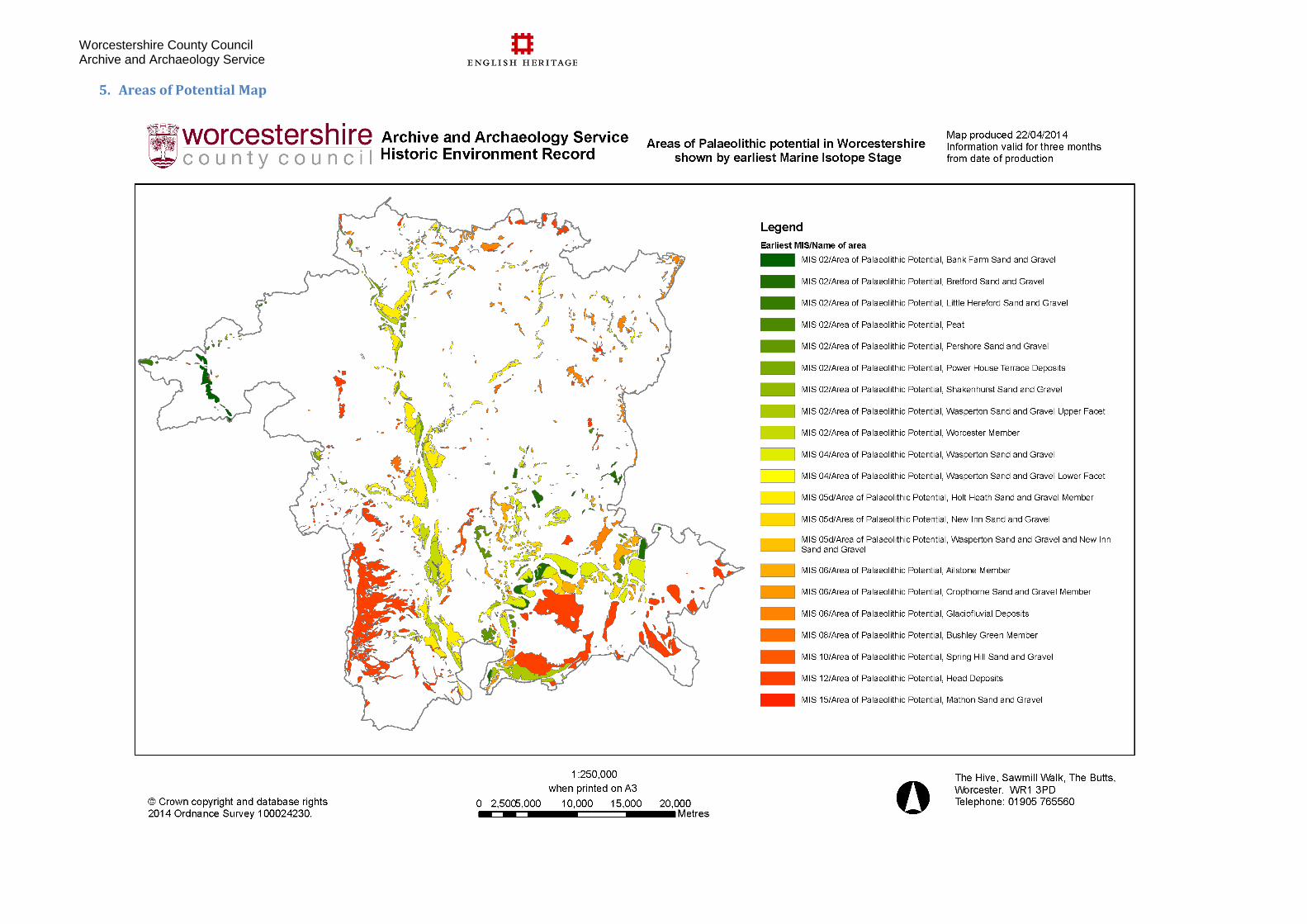
Worcestershire County Council Archive and Archaeology Service
5. Areas of Potential Map
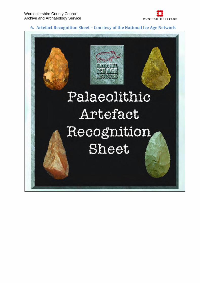
Worcestershire County Council Archive and Archaeology Service
6. Artefact Recognition Sheet – Courtesy of the National Ice Age Network
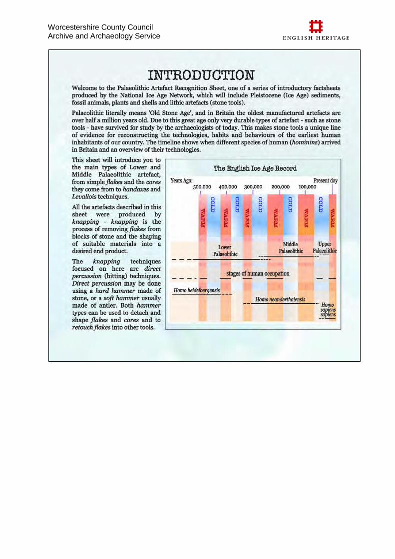
Worcestershire County Council Archive and Archaeology Service
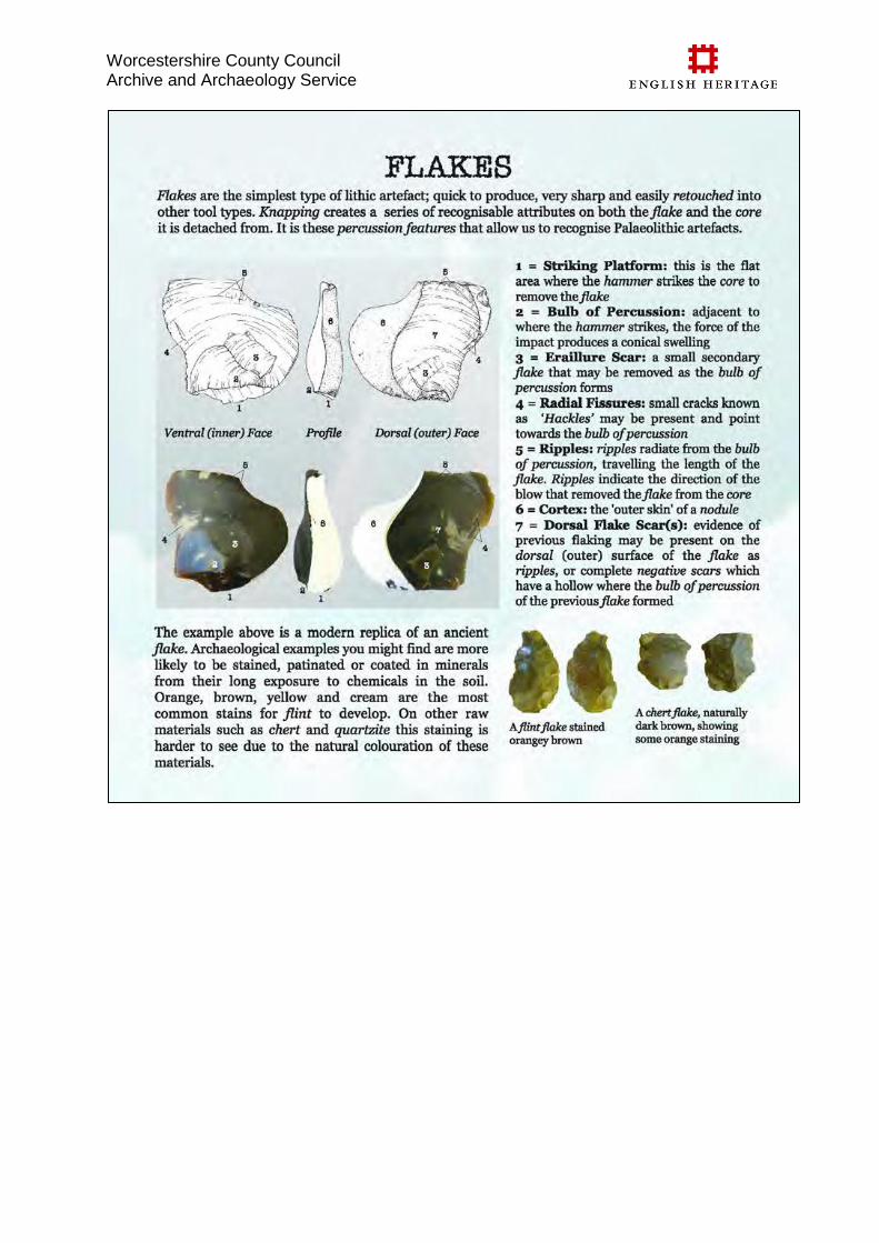
Worcestershire County Council Archive and Archaeology Service
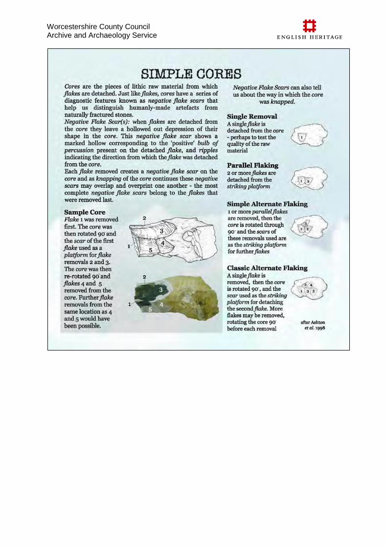
Worcestershire County Council Archive and Archaeology Service
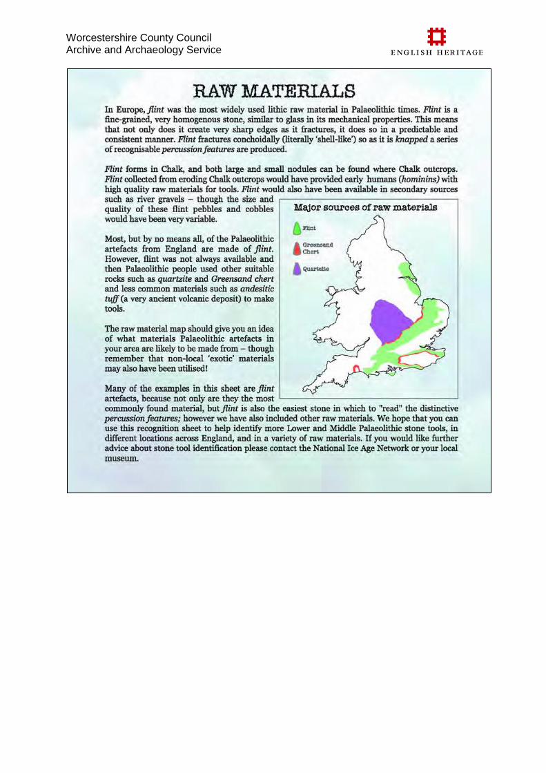
Worcestershire County Council Archive and Archaeology Service
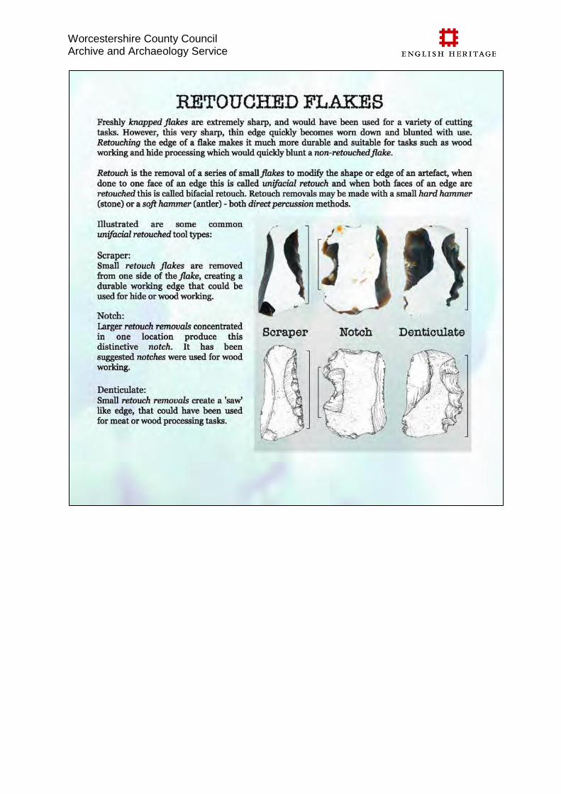
Worcestershire County Council Archive and Archaeology Service
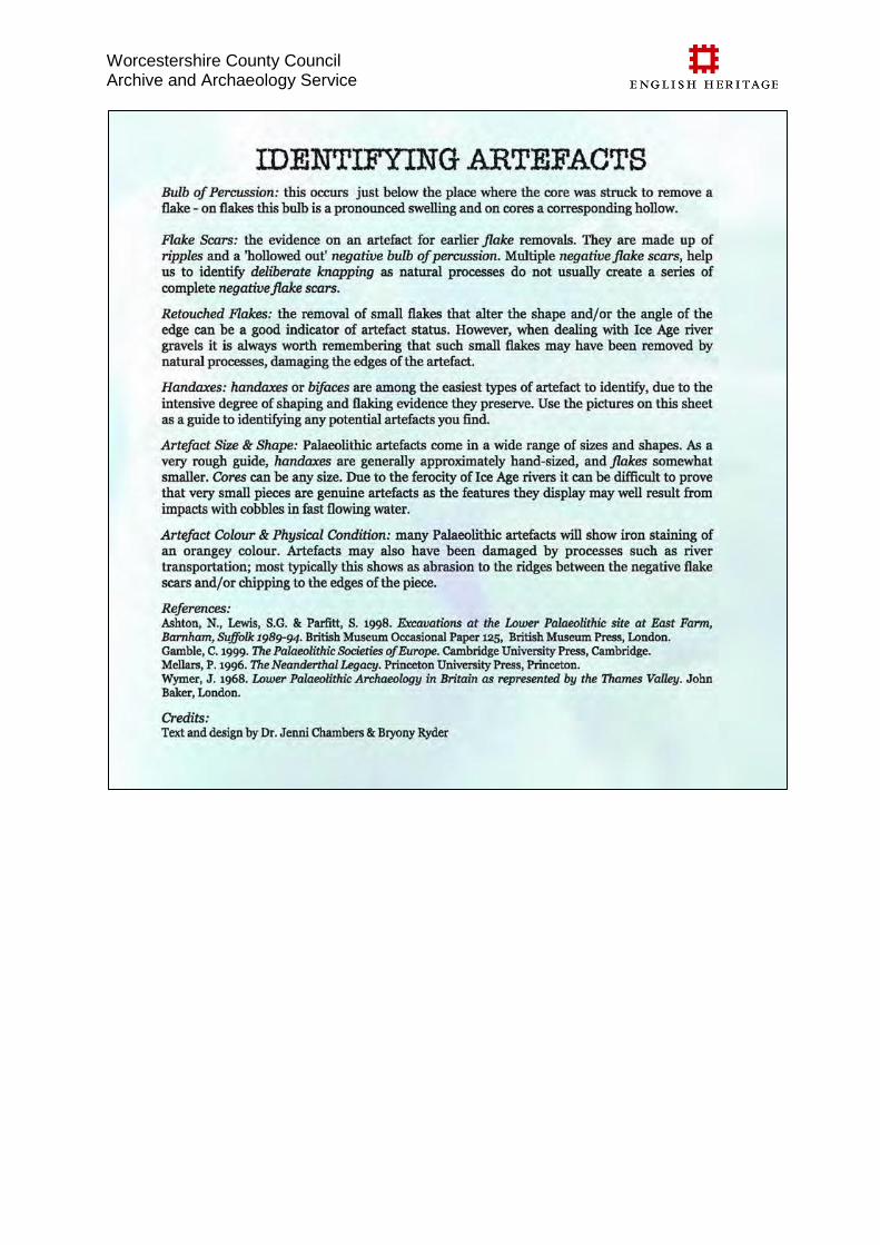
Worcestershire County Council Archive and Archaeology Service
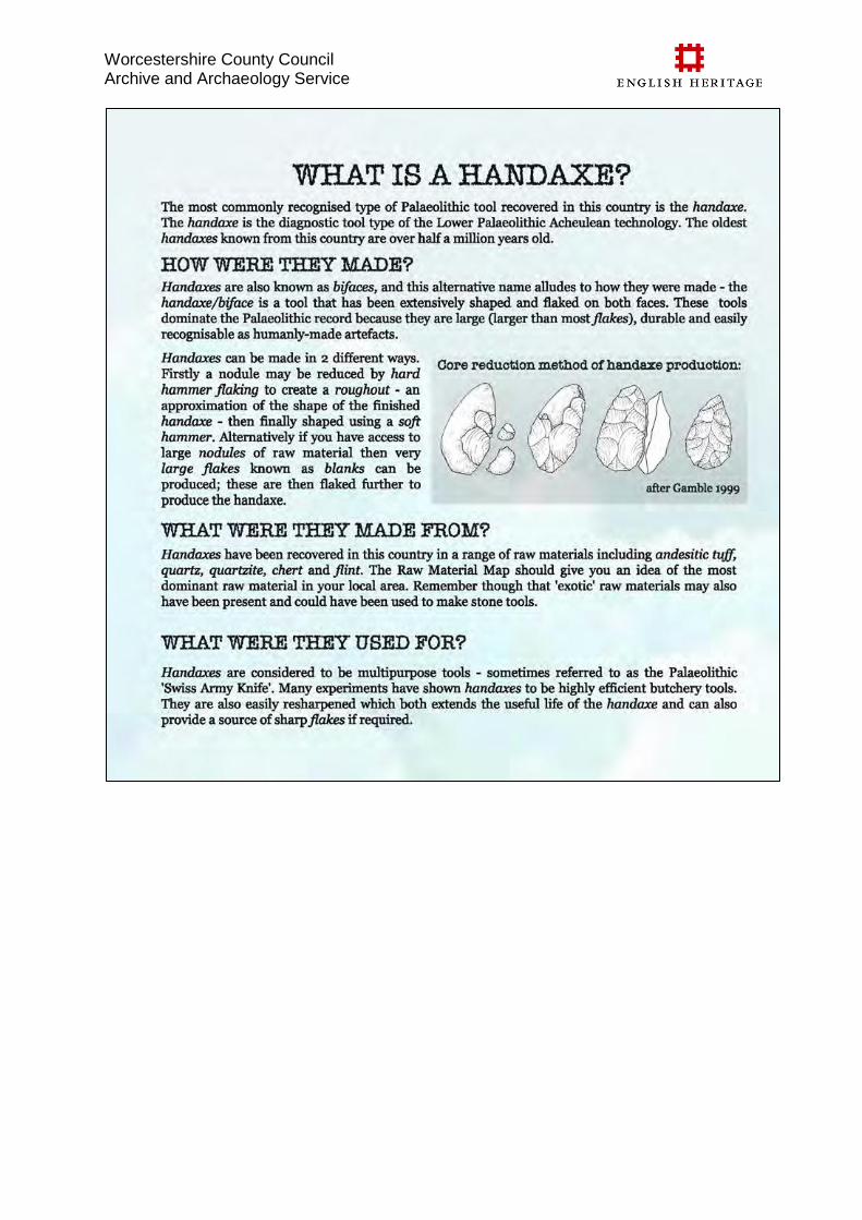
Worcestershire County Council Archive and Archaeology Service
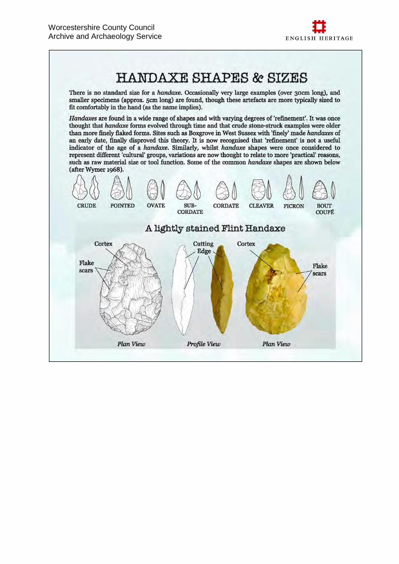
Worcestershire County Council Archive and Archaeology Service
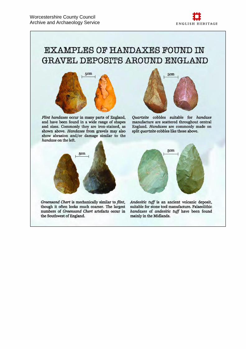
Worcestershire County Council Archive and Archaeology Service
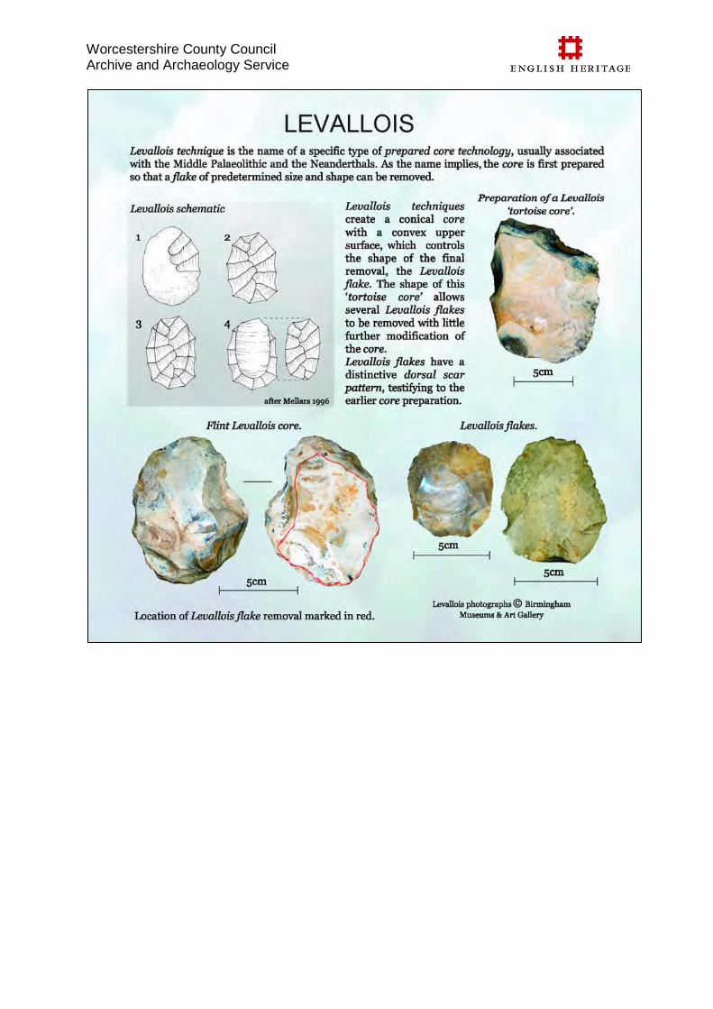
Worcestershire County Council Archive and Archaeology Service
Worcestershire County Council Archive and Archaeology Service
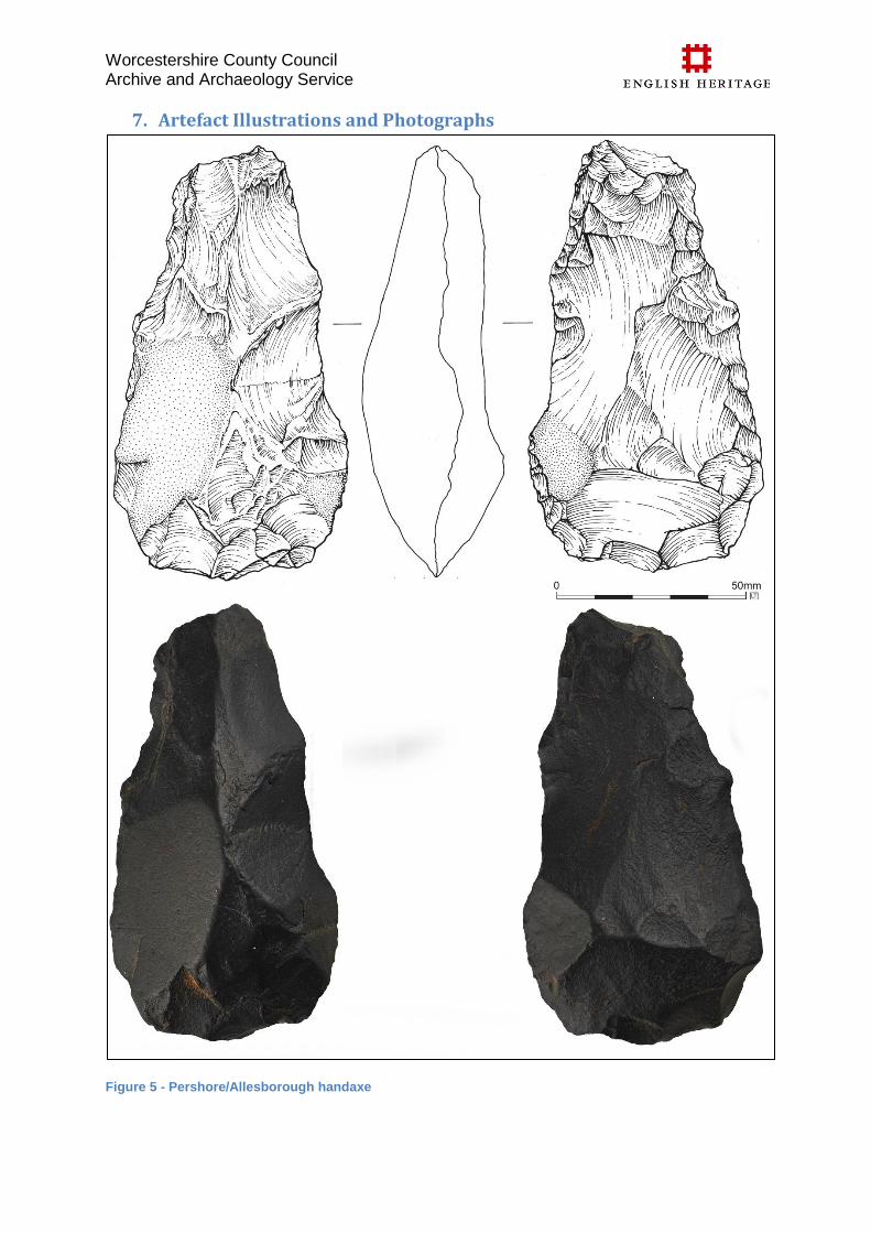
Worcestershire County Council Archive and Archaeology Service
7. Artefact Illustrations and Photographs
Figure 5 - Pershore/Allesborough handaxe
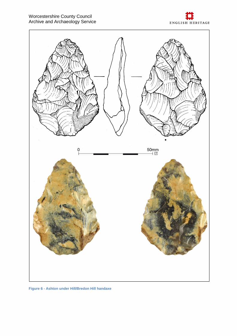
Worcestershire County Council Archive and Archaeology Service
Figure 6 - Ashton under Hill/Bredon Hill handaxe
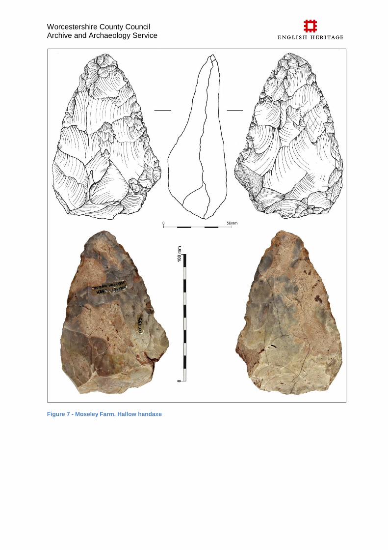
Worcestershire County Council Archive and Archaeology Service
Figure 7 - Moseley Farm, Hallow handaxe
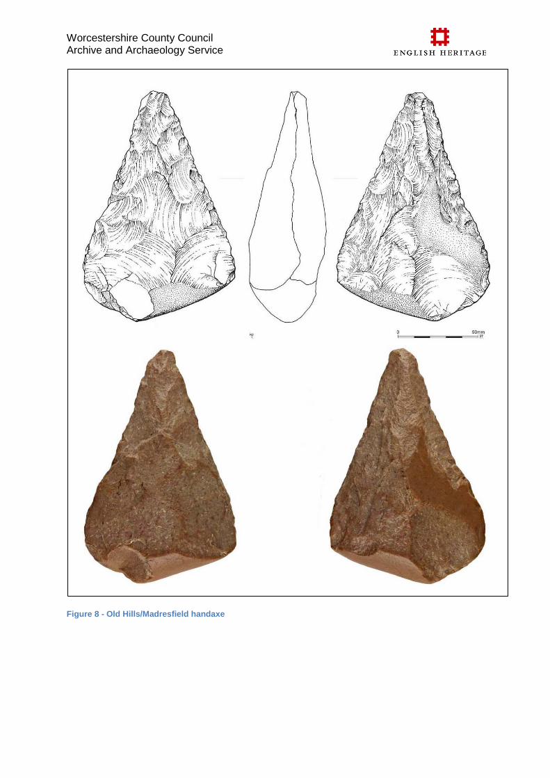
Worcestershire County Council Archive and Archaeology Service
Figure 8 - Old Hills/Madresfield handaxe
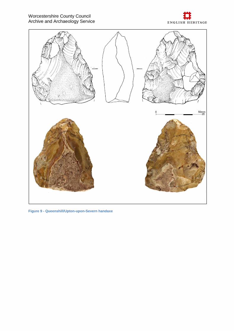
Worcestershire County Council Archive and Archaeology Service
Figure 9 - Queenshill/Upton-upon-Severn handaxe
Recommended