1
Prism Resources Inc.
Huampar Project Technical Report
Huarochirí, Lima, Peru
July, 2016

2
Prism Resources Inc.
Huampar Project Technical Report
Huarochirí, Lima, Peru
July 2016
Prepared For:
Prism Resources Inc.
Suite 214-3450 West 41st Avenue
Vancouver, BC
V6N 3E6
Prepared By:
Sean Butler, P.Geo.
Report Date: July 8, 2016
Effective Date June 1, 2016

3
Document Control Information
Prism Resources Inc.
Huampar Silver Project
Huarochirí, Lima, Peru
July 2016
Technical Report
REVISION
No. DATE
Final 08/07/2016
Revision Tracking
Revision: Prepared By: Reviewed By: Issued For: Approved By: Date: Signature:
03 Sean Butler M Collins RC M Collins
04 Sean Butler M Collins DraftFV M Collins 22/02/16
05 Sean Butler M Collins FV M Collins 01/06/16
06 M Collins Sean Butler FV M Collins 08/07/16
Issued for: Review and Comment (RC), Information Only (IO), Implementation (IM), Final Version (FV).
Photo 1-1 Cover photo is inside the Huampar mill building as seen in January 2016

4
CERTIFICATE
CERTIFICATE OF AUTHOR
I Sean P. Butler, P.Geo., do hereby certify that:
1. I am currently employed as a Senior Geology Consultant by Mining Plus Canada Consulting Ltd.,
Suite 440 - 580 Hornby St., Vancouver, BC, V6C 3B6.
2. This certificate applies to the Technical Report titled “Prism Resources Inc., Huampar Project
Technical Report, Huarochirí, Lima, Peru, July 2016” with effective date June 1st, 2016. (the
“Technical Report”)
3. I am a graduate with a Bachelor of Science, in Geology from the University of British Columbia
in 1982.
4. My professional affiliation is member of the Association of Professional Engineers and
Geoscientists of British Columbia, Canada, Professional Geoscientist (No. 19,233).
5. I have been professionally active in the mining industry for approximately 25 years since
graduation from university. I have worked extensively exploring for both base and precious
metals from early stage programs up to advanced underground exploration and mining.
6. I visited the Huampar property on January 18, 2016.
7. I am responsible for all parts of the Technical Report.
8. I am independent of Prism Resources Inc. applying all of the tests in section 1.5 of NI 43-101 and
am independent of the vending company Trevali Mining Corporation applying all of the tests in
section 1.5 of NI 43-101.
9. I have no prior involvement with the property that is the subject of this Technical Report.
10. I have read NI 43-101 and Form 43-101-F1, and the Technical Report has been prepared in
compliance with that instrument and form.
11. As of the effective date of the Technical Report, to the best of the my knowledge, information
and belief, this Technical Report contains all scientific and technical information that is required
to be disclosed to make the Technical Report not misleading.
12. I have read the definition of a "qualified person" set out in National lnstrument 43-101 and
certify that by reason of my education, affiliation with a professional association and past relevant
work experience, I fulfil the requirements to be a "qualified person" for the purposes of Nl 43-
101.
13. I consent to the filing of the Technical Report with any stock exchange and other regulatory
authority and any publication by them for regulatory purposes, including electronic publication in
the public company files on their websites accessible by the public, of the Technical Report.
Dated July 8th, 2016.
Signed and Sealed
Sean P. Butler, P.Geo.

5
1 EXECUTIVE SUMMARY
Mining Plus Peru S.A.C. has been commissioned by Prism Resources Inc. (Prism) to prepare an independent
NI 43-101 compliant report for the Huampar polymetallic project located in the Lima Department of Peru.
This report is prepared in return for fees based upon agreed commercial rates and the payment of these fees
is in no way contingent on the results of this report.
In particular this report is a review of all work completed in the preceding five years from the effective date,
an overview of the geological and mining potential of the deposit and recommendations for future work on
the deposit.
The Huampar polymetallic metal mine is a past producer that operated from 1956 to 1991 and also in the
late 1990s to 2000. Historical mining has generally been above the lowest gravity drained level, the 412 level.
This report outlines the recommended targeting of exploration diamond drill holes at targets below the 412
level in this brownfield project area.
The historical resource/reserve estimates reported on this project have not been validated. The historical
resource estimates are characterized as a historical estimate and require further technical work to be
upgrade to a Current Resource.
The Huampar Project is located approximately 80 km NE (line of sight) from Lima Peru, in the southern
portion of the Central Peruvian Polymetallic Belt. The project sits at altitudes between 4,000 and 4,500m
ASL. Access to the property is via the Carretera Central, the principal highway servicing the central Andes,
then unpaved secondary roads, a distance of about 160 kilometres by road from Lima.
The Project consists of multiple polymetallic veins on about 1,880 hectares (Ha) of concessions that contain
a past producing 100-250 tonne per day (tpd) mine, later ramped up to 450 tpd, which was developed to a
maximum vertical depth of 450m below the surface, a processing plant and camp facilities both of which
require refurbishment, and a (Historic Reserve) remnant reserve estimate completed by MRDI consultants in
1999.
The owner of the Huampar Project is Nueva Condor S.A. which is 100% owned by Carlos Loret de Mola.
Trevali Mining Corporation (Trevali) reported the acquisition of Huampar on May 18, 2011. Prism has
signed the legally binding memorandum of understanding (MOU) with Trevali whereby Trevali will transfer
100% of the outstanding shares of its Peruvian subsidiary Nueva Condor S.A., 100% owner and holder of the
Huampar property and associated mining rights for $500,000 worth of common shares in Prism. The
number of these common shares will be based on the share price of a financing to occur concurrently with
the close of the purchase of Huampar. In addition Trevali will have the right to maintain their percentage
ownership in Prism Resources on a pro-rata basis through participation in further financings in Prism.
The Huampar Project is located in the well-known Central Peruvian Polymetallic Belt of the Central Andes.
The deposit is hosted exclusively in a volcanic sequence of rocks and consists of a series of polymetallic
veins, with silver being the element of primary economic importance. Gold, zinc and lead all have lesser, but
roughly equal economic importance. The veins outcrop on surface and have been previously mined to 450m
below the surface.

6
There has been no modern exploration work completed such as geophysics or drilling as the veins are
evident on surface, and historic mining generally started from vein outcrops. The technical work completed
since the Trevali acquisition includes check underground sampling, surface geochemical sampling and some
surface satellite based Aster and lineaments work. The majority of this work was completed in 2011 and
2012. The potential for substantial resources is possible, both on known vein systems and potentially
undiscovered veins.
Modern mining of several polymetallic veins began in 1956 and continued until 1991 when national electrical
power shortages forced the mine to close. Production initially commenced at 250 tonnes per day (tpd) and
processed approximately 2.5 million tonnes of ore with an average grade of 1.6 g/t Au, 185 g/t Ag, 3.8% Pb
and 5.0% Zn. During this production period the reported recoveries are high and clean penalty free
concentrates were produced. Mining continued intermittently from 1997 to early 2000 at approximately
400 tpd. Mining operations closed in 2000 due to the lack of development headings and low commodity
prices.
The processing plant remains intact as does the camp and offices, but they all require updating, rehabilitation
and reconstruction in the case of the camp. Scoping level estimates have been made to refurbish the
processing plant most recently in 2010. The underground has experienced mild water inundation and some
rock falls. Pumping of the water and rehabilitation work will be required to create access for underground
diamond drilling and to review the status of the development drives and older stopes in mineralized material.

7
Table 1-1 Recommended Exploration Budget
The recommended next step in the project is conduct a auger sampling program on the historic tailings
while continuing with data compilation and drill planning for phases 2 and 3 of the exploration program.
Phase 2 of the exploration program consists of drilling of two diamond drill holes from surface to determine
if the vein continues below the lowest gravity drained level. If this is successful the third and final exploration
phase is extensive follow up drilling of the vein in preparation of a mineral resource estimate. This would
include rehabilitating the camp and reviewing the mill for updating costs.
Phase 1 Activity unit Cost/unit Item Cost
Auger drilling in old tailings material 15,000$
Assayinging auger samples 100 $30 3,000$
Logistics, food accom, transport 7,000$
Data Compilation 15,000$
Target Validation and Drill planning for Phase 2 10,000$
Permitting 10,000$
Community agreement 20,000$
Road Upgrade 12,000$
Contingency 10% 9,200$
101,200$
Phase 2 Activity unit Cost/unit Item Cost
Drill Pad construction 8,000$
Diamond Drilling (all in) 1,350 m $195/m 263,250$
Contingency 10% 26,325$
289,575$
Phase 3 Activity unit Cost/unit Item Cost
Camp upgrades and expansion 100,000$
Diamond Drilling all in 35,000 m $195/m 6,825,000$
Underground rehabilitation 50,000$
Mill Review 15,000$
Underground chip sample program
for confirmation of previous samples
25,000$
Mine Model Development 30,000$
Contingency 10% 704,500$
7,749,500$
8,039,075$ Total Phase 1, 2 and 3
Huampar Project Budget
Total Phase 3
Total Phase 2
Total Phase 1

8
CONTENTS
CERTIFICATE .................................................................................................................................. 4
1 EXECUTIVE SUMMARY ......................................................................................................... 5
2 INTRODUCTION ................................................................................................................... 11
2.1 Issuer and Terms of Reference ...................................................................................... 11
2.2 Sources of Information ................................................................................................... 11
2.3 Site Visit ........................................................................................................................... 11
2.4 Units of Measurement ..................................................................................................... 12
2.5 List of Abbreviations ....................................................................................................... 13
3 RELIANCE ON OTHER EXPERTS ...................................................................................... 14
4 PROPERTY, DESCRIPTION AND LOCATION ................................................................. 15
4.1 Concessions ...................................................................................................................... 15
4.1.1 Ownership History ........................................................................................................................................... 15
4.1.2 Requirements to hold Concessions ............................................................................................................. 15
4.2 Location ............................................................................................................................ 16
4.3 Concessions ...................................................................................................................... 17
4.4 Agreements ...................................................................................................................... 20
4.5 Royalties ........................................................................................................................... 21
4.6 Environmental ................................................................................................................. 21
4.7 Permitting ........................................................................................................................ 21
4.8 Social ................................................................................................................................. 22
5 ACCESSIBILITY, CLIMATE, LOCAL RESOURCES, INFRASTRUCTURE AND
PHYSIOGRAPHY .......................................................................................................................... 23
5.1 Access ............................................................................................................................... 23
5.2 Climate ............................................................................................................................. 23
5.3 Local Resources ............................................................................................................... 23
5.4 Infrastructure ................................................................................................................... 24
5.5 Physiography .................................................................................................................... 27
6 HISTORY ................................................................................................................................. 28
6.1 Mine History ..................................................................................................................... 28
6.2 Exploration by owners previous to Trevali ................................................................... 30
6.3 Exploration by Trevali ..................................................................................................... 30
6.4 Previous mineral resources and reserves...................................................................... 30
6.5 Historic Mine Production................................................................................................ 31
7 GEOLOGICAL SETTING AND MINERALISATION ......................................................... 33
7.1 Regional Geology ............................................................................................................. 33
7.2 Geology ............................................................................................................................. 33
7.3 Mineralization .................................................................................................................. 35

9
8 DEPOSIT TYPES .................................................................................................................... 37
9 EXPLORATION...................................................................................................................... 38
10 DRILLING ................................................................................................................................ 39
11 SAMPLE PREPARATION, ANALYSES AND SECURITY ................................................. 40
12 DATA VERIFICATION .......................................................................................................... 41
13 MINERAL PROCESSING AND METALLURGICAL TESTING ........................................ 42
14 MINERAL RESOURCE ESTIMATES .................................................................................... 43
15 MINERAL RESERVE ESTIMATES ........................................................................................ 44
16 MINING METHODS ............................................................................................................... 45
17 RECOVERY METHODS ......................................................................................................... 46
18 PROJECT INFRASTRUCTURE ............................................................................................. 47
19 MARKET STUDIES AND CONTRACTS ............................................................................. 48
20 ENVIRONMENTAL STUDIES, PERMITTING AND SOCIAL OR COMMUNITY IMPACT
49
21 CAPITAL AND OPERATING COSTS ................................................................................. 50
22 ECONOMIC ANALYSIS ........................................................................................................ 51
23 ADJACENT PROPERTIES ..................................................................................................... 52
24 OTHER RELEVANT DATA AND INFORMATION ........................................................... 53
25 INTERPRETATION AND CONCLUSIONS ....................................................................... 54
26 RECOMMENDATIONS ......................................................................................................... 56
27 REFERENCES .......................................................................................................................... 58
APPENDIX – TITLE SEARCH...................................................................................................... 59

10
FIGURES & TABLES Table of Figures
Figure 4-1 Huampar Project Location in Relation to select mines in the Central Peruvian Polymetallic Belt . 17
Figure 4-2 Concession Plan, UTM in PSAD56 Zone 18 South (Source Trevali) ..................................................... 18
Figure 5-1 Plan of Underground Workings, Finlandia Vein ........................................................................................... 24
Figure 6-1 Longitudinal section and plan of the Finlandia mine, after the RPA, 1997a report ............................. 29
Figure 7-1 Geological Map (source INGEMMET, Map 24K) ......................................................................................... 34
Figure 7-2 Geological Map Legend (source INGEMMET, Map 24K) ........................................................................... 34
Figure 8-1 Epithermal Deposit Model (from Corbett, 2005)........................................................................................ 37
Table of Tables
Table 1-1 Recommended Exploration Budget .................................................................................................................... 7
Table 4-1 List of Concessions ............................................................................................................................................. 19
Table 6-1 MRDI Mineral Reserve Estimate in1999 on Huampar Mine including (Finlandia Vein, Condor Pasa
Vein and other veins* ............................................................................................................................................................. 31
Table 6-2 Historic Production 1983 to 1991 (source Roscoe Postle Associates, 1997b) .................................... 32
Table 13-1 Metallurgical Recovery Summary of Historic Mining ................................................................................. 42
Table 26-1 Recommended Budgets ..................................................................................................................................... 57
Table of Photos
Photo 1-1 Cover photo is inside the Huampar mill building as seen in January 2016 ............................................. 3
Photo 2-1 Overall view of the camp, mill, tailings and support infrastructure ......................................................... 12
Photo 5-1 Site Overview 2010 (Source Trevali files) .................................................................................................... 25
Photo 5-2 Plant and laboratory overview 2010 (Source Trevali files) ...................................................................... 26
Photo 5-3 Mine feed grizzly with the mill building in the background and some of the tailings beyond in
January, 2016 ............................................................................................................................................................................. 26
Photo 5-4 View of the waste piles and workings in the valley north of the mill showing the surface
expression of the Finlandia vein and waste dumps .......................................................................................................... 27
Photo 7-1 Sequence of volcanic interbeds of multiple orientations ............................................................................ 33
Photo 25-1 Portal of the 412 level near the mill in January 2016 ................................................................................ 54

11
2 INTRODUCTION
2.1 Issuer and Terms of Reference
Mining Plus Peru S.A.C. has been commissioned by Prism Resources Inc. (Prism) to prepare an NI 43-101
compliant report for the Huampar polymetallic project located in the Lima province of Peru. This report is
prepared in return for fees based upon agreed commercial rates and the payment of these fees is in no way
contingent on the results of this report.
2.2 Sources of Information
In addition to the site visit undertaken to the Huampar Project the author of this report has relied on
information provided by Trevali Mining Corporation (Trevali), discussions with Prism staff, and a number of
studies completed by other internationally recognized independent consulting and engineering groups. A
listing of the principal sources of information is included in Section 27 of this report.
The author has made all reasonable enquiries to establish the completeness and authenticity of the
information provided and identified, and a final draft of this report was provided to Prism along with a
written request to identify any material errors or omissions prior to final submission.
2.3 Site Visit
Mr Sean Butler, P.Geo. visited the Huampar site on the 18th of January, 2016 accompanied by Jhon Human
geologist representing Prism Resources. During this visit, the author reviewed the general location of the
surface outcrop of the major veins and the surface layout of the underground mine access, process mill and
camp.
During the visit the portal to the major (and lowest surface accessible elevation) 412 mine level was seen,
near the process plant and mills, plus the camp. Tailings from previous operations are seen in several areas
indicating a long history of mining and processing in several locations. A visit to the Finlandia vein on surface
accessed by a narrow poorly maintained road near the Colqui vein in the next valley north from the mill was
made to observe the surface outcrop.
The visit allowed the author to observe the significant infrastructure and confirm historic production reports
as indicated by the extensive tailings and moderate amount of waste rock.
No visit was made underground due to logistics and apparent flooding in the access portal. Reports of caving
elsewhere limited the possibility of inspecting underground workings. No samples were collected due to the
lack of recent data to compare it to and verify The extensive existing infrastructure, long history of mining,
extensive surface waste dumps and large tailings piles confirm the historic mining and allow the potential
below the historic mine to be assumed. The author concluded that samples at this time would not change
the project recommendations or confirm by comparison any existing sample data high above the target area
to be used in a near future resource estimate.

12
Photo 2-1 Overall view of the camp, mill, tailings and support infrastructure
2.4 Units of Measurement
All monetary dollars expressed in this report are in United States dollars (“US$”). Quantities are generally
stated in SI units, including metric tonnes (tonnes (t), kilograms (kg) or grams (g) for weight; kilometres (km),
metres (m), centimetres (cm) and millimetres (mm) for distance; square kilometres (km²) or hectares (ha)
for area; and grams per tonne (g/t) for gold and silver grades (g/t Au, g/t Ag). Precious metal grades may also
be expressed in parts per billion (ppb), and quantities may be reported in troy ounces.

13
2.5 List of Abbreviations
a annum MC Merrill Crowe
Au gold MVA megavolt ampere
Ag silver m2 square metre
ALS ALS Global, a laboratory company m3 cubic metre
ARD Acid Rock Drainage µ micron
°C degree Celsius MASL metres above sea level
C$ Canadian dollars µg microgram
cfm cubic feet per minute m3/h cubic metres per hour
CIRA Certificate of Non-Archaeological Remains mi mile
cm centimetre min minute
cm2 square centimetre µm micrometre
COG cut-off grade mm millimetre
CuSO4 copper sulfate MOU Memorandum of Understanding
d day MP Mining Plus
dia diameter mph miles per hour
dmt dry metric tonne MRDI Mineral Resource Development Inc.
dwt dead-weight ton Mt Mega (million) tonnes
EIA Environmental Impact Application MVA megavolt-amperes
ENE East North East MW megawatt
°F degree Fahrenheit MWh megawatt-hour
ft foot NI National Instrument
ft2 square foot oz Troy ounce (31.1035g)
ft3 cubic foot oz/st opt ounce per short ton
ft/s foot per second Pb Lead
g gram ppb part per billion
G giga (billion) ppm part per million
Gal Imperial gallon pH measure of alkalinity / acidity based
gpm (see usgpm below) on negative logarithm of hydrogen-ion conc.
g/t gram per tonne PSAD56 Provisional South American Datum 1956
ha hectare psia pound per square inch absolute
hp horsepower psig pound per square inch gauge
hr hour QA/QC Quality Assurance Quality Control
Hz hertz RL relative elevation
INGEMMET Instituto Geológico Minero y Metalúrgico ROM run of mine
in inch RPA Roscoe Postle and Associates
in2 square inch rpm rotations per minute
J joule s second
k kilo (thousand) SA Sociedad Anónima
kcal kilocalorie SEDAR System for Electronic Document Analysis and Retrieval
kg kilogram st short ton
km kilometre stpa short ton per year
km2 square kilometre stpd short ton per day
km/h kilometre per hour t metric tonne
kPa kilopascal tpa metric tonne per year
kt kilotonnes tpd metric tonne per day
kVA kilovolt-amperes TMF tailings management facility
kW kilowatt UTM Universal Transverse Mercator
kWh kilowatt-hour US$ United States dollar
L litre usg United States gallon
lb pound usgpm US gallon per minute
LHOS longhole open stoping wmt wet metric tonne
L/s litres per second wt% weight percent
LOM Life of Mine yd3 cubic yard
m metre yr year
M mega (million); molar Zn Zinc

14
3 RELIANCE ON OTHER EXPERTS
The author has relied on Prism’s Peruvian lawyers Estudio Echecopar, member firm of Baker & McKenzie
International for their opinion on the title for the Huampar mineral concessions. They reviewed the
concession list and other parts of section 4 of this report in particular section 4.4 Agreements, in the week
of February 8, 2016. They provided clarification of the requirements of concession holders to hold mineral
titles in Peru. This concession information compares well to the information provided previously by Trevali.
This report has been prepared on the understanding that the properties are, or will be, lawfully accessible
for evaluation, development, mining and processing.
The title search document by Estudio Echecopar of February 18, 2016 is included in the Appendix at the end
of this report. The lawyer on May 31, 2016 confirmed that the titles were all still in good standing and no
changes to title had occurred. The individual maps of each concession in the Title Search are not included.
15
4 PROPERTY, DESCRIPTION AND LOCATION
4.1 Concessions
The property is comprised of 43 mineral concessions for an aggregate total area of approximately 1,880
hectares. Annual concession maintenance payments and the associated annual penalties for 2016 total
approximately US$42,700.
Peru uses a system of 100 hectare blocks in a regularized grid defined in the PSAD56 UTM coordinates.
Concessions are one or more contiguous 100 hectare blocks that are applied for and issued by the Ministry
of Energy and Mines (Instituto Geológico Minero y Metalúrgico -INGEMMET). Historic concessions have
multiple different orientations and sizes as seen in Figure 4-2.
4.1.1 Ownership History
Carlos Loret de Mola and family have 100% ownership of the concessions through various corporate and
personal entities. Trevali Mining has made an agreement with the Loret de Mola family. This agreement was
revised by Prism between itself and both the Loret de Mola family and Trevali in late 2015 as summarized
below in section 4.4.
4.1.2 Requirements to hold Concessions
Mining concessions are granted for an indefinite term, provided that their holders: (i) timely pay an annual
Mining Good Standing Fee (Derecho de Vigencia) of US$3.00 per hectare by June 30 of each year; and, (ii)
meet certain targets of minimum annual production per year by the end of the 6th or 10th year as of the
granting of the mining concession.
If the annual production target is not reached within the abovementioned periods, onwards holders shall pay
an annual Mining Penalty (Penalidad Minera) for each year in default.
Please take into consideration that mining concessions granted prior to October 10, 2008 shall reach the
minimum annual production target by the end of the 15th year (in 2023) as of their granting; otherwise, they
shall be cancelled by the INGEMMET, unless their holder:
proves that such noncompliance is the result of a cause not attributable to him or force majeure
duly documented and approved by the competent authority; or,
certifies that their holder paid the mining penalty for such year and invested in mining activities or in
basic infrastructure of public use an amount equivalent to at least 10 times the amount of the
corresponding mining penalty (i.e. invested an amount equivalent to at least one Peruvian Tax Unit
per hectare).
If one of the above conditions is met, the mining concession shall not be cancelled and the holder shall
continue paying the mining penalty for such concession. Should failure to comply with the minimum annual
production continue until the 20th year (in 2028) as of the granting of the mining concession, such
concession shall automatically be cancelled without exception.

16
As of January 1, 2023, the cancellation rules detailed above would apply to mining concessions granted
before October 10, 2008. If those mining concessions did not comply with the minimum production target
during the previous 15 years, including 2023, they shall be cancelled in 2024 unless the holder meets one of
the two exceptions listed above, in which case the rules detailed in the paragraph above would also apply.
Annual payments for Nueva Condor and the Trevali/Glencore concessions to be transferred:
Nueva Condor
Concessions and the penalty is USD$40,753
Beneficiation Plant Concession S/- 1,935.50 (Peru Soles)
Exploration projects require a government issued start-up authorization, which imply the previous
obtainment of certain permits and authorization such as an environmental assessment study, Certificate of
Non-Archaeological Remains (CIRA) among others. In order to carry out mining activities, concessionaires
must additionally obtain the right to use the corresponding surface land from the landowner. Surface lands
might be owned by a private owner, the Peruvian Government or the local community, which in this case for
surface rights covering the Nueva Condor claims it is the Comunidad Campesina de Huanza.
4.2 Location
The Huampar project is located approximately 80 kilometres north-east of Lima, Peru in the southern
portion of the Central Peruvian Polymetallic Belt in the district of Huanza, province of Huarochirí,
department of Lima. Access to the property is via the Carretera Central, the principal highway servicing the
central Andes from Lima, then secondary roads a total distance of about 160 to 180 kilometres by road from
Lima depending on the route.

17
Figure 4-1 Huampar Project Location in Relation to select mines in the Central Peruvian Polymetallic
Belt
The latitude and longitude of 11° 33’ 53” South and 76° 27’’ 5” West (WGS84 datum) is located within the
concessions in the area close to the surface expression of the Finlandia vein. The location of 341730 E and
8721125 N UTM in PSAD56 datum zone 18 South is the alternative description in most commonly locally
used.
4.3 Concessions
Figure 4-2 and Table 4-1 below delineate and detail the concessions that are included in the project area:

18
Figure 4-2 Concession Plan, UTM in PSAD56 Zone 18 South (Source Trevali)

19
Table 4-1 List of Concessions
N° Code Name
Hectares
(for
taxation)
Available
area
(hectares)
Titleholder Mining Public Registry
1 11000276Y01 COLQUI 4.2 4.18 Inversiones Mineras Alto de Santa Eulalia S.A.
2 11003384X01 SANTA MARTA 8.0 7.99 Inversiones Mineras Alto de Santa Eulalia S.A.
3 11003394X01 CRISTO POBRE 12.0 11.98 Inversiones Mineras Alto de Santa Eulalia S.A.
4 11004815X01 SORPRESA 10.0 9.98 Inversiones Mineras Alto de Santa Eulalia S.A.
5 11008606X01 COLQUI DOS 30.0 29.95 Inversiones Mineras Alto de Santa Eulalia S.A.
6 11008607X01 COLQUI 3 15.0 14.98 Inversiones Mineras Alto de Santa Eulalia S.A.
7 11008608X01 COLQUI 4 9.0 8.99 Inversiones Mineras Alto de Santa Eulalia S.A.
8 11008610X01 COLQUI N° 6 4.0 4.00 Inversiones Mineras Alto de Santa Eulalia S.A.
9 11008611X01 COLQUI N° 7 80.0 80.00 Inversiones Mineras Alto de Santa Eulalia S.A.
10 11008609X01 COLQUI-5 40.0 40.00 Inversiones Mineras Alto de Santa Eulalia S.A.
11 11008613X01 COLQUI N° 8 24.0 24.00 Inversiones Mineras Alto de Santa Eulalia S.A.
12 11008614X01 COLQUI N° 9 18.0 18.00 Inversiones Mineras Alto de Santa Eulalia S.A.
13 11008615X01 COLQUI N° 10 24.0 24.00 Inversiones Mineras Alto de Santa Eulalia S.A.
14 11001320Y01 COLQUI QUINCE DIECISEIS 10.0 9.98 Inversiones Mineras Alto de Santa Eulalia S.A.
15 11001603Y01 DON JUAN 2-23 20.0 19.97 Inversiones Mineras Alto de Santa Eulalia S.A.
16 11008774X01 COLQUI ONCE-VEINTITRES 10.0 9.98 Inversiones Mineras Alto de Santa Eulalia S.A.
17 11008783X01 COLQUITRECE VEINTIUNO 6.0 5.99 Inversiones Mineras Alto de Santa Eulalia S.A.
18 11008784X01 LUCCA NUMERO DOS VEINTIUNO 6.0 5.99 Inversiones Mineras Alto de Santa Eulalia S.A.
19 11008838X01 COLQUI DOCE VIENTIUNO 6.0 5.99 Inversiones Mineras Alto de Santa Eulalia S.A.
20 11008839X01 COLQUI CATORCE – VEINTITRES 8.0 7.99 Inversiones Mineras Alto de Santa Eulalia S.A.
21 11009005X01 GENERAL BADOGLIO 2-23 12.0 11.98 Inversiones Mineras Alto de Santa Eulalia S.A.
22 11009003X01 PISA NUMERO DOS QUINCE 12.0 11.98 Inversiones Mineras Alto de Santa Eulalia S.A.
23 11009007X01 LUCCA NUMERO TRES DIECISIETE 6.0 5.99 Inversiones Mineras Alto de Santa Eulalia S.A.
24 11010439X01 MARIA VEINTIOCHO 12.0 11.57 Inversiones Mineras Alto de Santa Eulalia S.A.
25 11013480X01 FERNANDO IGNACIO 2.0 2.00 Inversiones Mineras Alto de Santa Eulalia S.A.
26 11013481X01 EDUARDO 44.0 43.93 Inversiones Mineras Alto de Santa Eulalia S.A.
27 11017134X01 LUCHO SABE MUCHO 90.0 90.00 Inversiones Mineras Alto de Santa Eulalia S.A.
28 11013482X01 CARLOS HERNANDO 80.0 79.87 Inversiones Mineras Alto de Santa Eulalia S.A.
29 11019269X01 ACOBAMBA 285.0 285.00 Inversiones Mineras Alto de Santa Eulalia S.A.
30 11020603X01 ACOBAMBA PRIMERA 24.0 24.00 Inversiones Mineras Alto de Santa Eulalia S.A.
31 11020604X01 ACOBAMBA SEGUNDA 4.0 4.00 Inversiones Mineras Alto de Santa Eulalia S.A.
32 11020605X01 ACOBAMBA TERCERA 3.0 3.00 Inversiones Mineras Alto de Santa Eulalia S.A.
33 11024165X01 AURELIO 1 1.2 1.24 Inversiones Mineras Alto de Santa Eulalia S.A.
34 11024166X01 AURELIO 2 6.7 6.66 Inversiones Mineras Alto de Santa Eulalia S.A.
35 11024167X01 AURELIO 3 24.0 24.00 Inversiones Mineras Alto de Santa Eulalia S.A.
36 11024168X01 AURELIO 4 12.0 12.00 Inversiones Mineras Alto de Santa Eulalia S.A.
37 11024171X01 USHO 1 8.0 8.00 Inversiones Mineras Alto de Santa Eulalia S.A.
38 11024172X01 USHO 2 5.0 5.00 Inversiones Mineras Alto de Santa Eulalia S.A.
39 11024173X01 USHO 3 10.0 10.00 Inversiones Mineras Alto de Santa Eulalia S.A.
40 11024170X01 USHO 8.0 8.00 Inversiones Mineras Alto de Santa Eulalia S.A.
41 11021236X01 CONDOR PASA DE CARANACO 270.0 269.94 Inversiones Mineras Alto de Santa Eulalia S.A.
42 10066801WILLY
279.4 279.41Not registered - INGEMMET: Eduardo Aurelio
Loret de Mola de Lavalle
43 10066901HUALLAYO CARHUINCO
230.4 230.38Not registered - INGEMMET: Carlos Hernando
Loret de Mola de Lavalle
1772.9 1771.89
44 P0200122 PETROCOLQUI 108.0 108.0 Inversiones Mineras Alto de Santa Eulalia S.A.
1880.9 1879.9
Total hectares
Processing Concession
Total hectares (including Processing Concession)
Huampar Peru - Mining Concessions

20
4.4 Agreements
On May 18, 2011 Trevali signed a memorandum of understanding with Nassau-registered Nueva Condor Inc.
(NCI) wherein NCI agreed to grant to Trevali the exclusive option to acquire all the outstanding shares of
its Peruvian subsidiary Nueva Condor S.A., 100% owner and holder of the Huampar property and associated
mining rights (the "Option"). Trevali paid $50,000 upon signing the memorandum of understanding.
On April 4, 2014 the memorandum of understanding was superseded and replaced by a definitive Stock
Purchase Agreement (the "SPA") by which the registered owner of 100% of the shares of Nueva Condor
S.A. transferred all of his shares to Trevali.
Pursuant to the terms of the SPA, the price for the Nueva Condor shares includes: (i) the issuance of
900,000 Trevali common shares, (ii) a cash payment of $350,000 to be paid in monthly instalments of $5,000
as from the date of execution of the memorandum of understanding, (iii) an amount in cash equivalent to 5%
of the recognized value of the credits listed on Schedule 3 of the SPA and (iv) a 3% net smelter royalty, of
which 2% may be purchased in 1% tranches for 4 years as from January 3, 2012 for payments of US$1.5
million and $2 million.
Payments detailed in (i) and (iii) above, and a $100,000 annual advance payment (deductible from the net
smelter royalty payments), will be due upon the seller’s compliance with the covenants set forth in the SPA.
To date the seller has not fully complied with the above referred to covenants, therefore payment of the
agreed consideration is still not due.
Prism have signed an MOU with Trevali and the Loret de Mola family and announced on November 25,
2015. The terms are:
Trevali will transfer 100% of the outstanding shares of its Peruvian subsidiary Nueva Condor S.A., which is
the 100% owner and holder of the Huampar property and associated mining rights for a consideration of
$500,000 to be satisfied by the issuance of common shares in Prism and subject to adjustment based on the
concurrent financing price described below. In addition the vendors will have the right to maintain their
percentage ownership in Prism on a pro-rata basis. As a result of the transaction Mark Cruise will join the
board of Prism Resources Inc. As a condition of the transaction Prism is required to raise a minimum of
CAD$400,000 to top up its cash position to enable completion of a NI43-101 technical report and carry out
a work program ahead of a drilling program.
The terms of the binding TERM SHEET with Nueva Condor include the following:
2,900,000 Prism common shares to Carlos Loret de Mola and two other individuals.
3% NSR of which 2% may be purchased in 1% tranches at any stage for payments of US$1.5 and
US$2 million respectively within a period of two years from the approval date.
Annual payments of US$100,000 commencing on the second anniversary of the agreement which
payments will be deductible from any NSR payments made to Nueva Condor.
Furthermore Prism has retained the services of key Nueva Condor personnel for a monthly retainer fee of
US$5,000 of which this fee will be capped at US$240,000 over a period of 4 years.

21
4.5 Royalties
A royalty, as noted above, of a 3% Net Smelter Royalty (NSR) applies to the Nuevo Condor concessions of
which 2% may be purchased in 1% tranches at any stage for payments of US$1.5 and US$2 million
respectively within a period of two years from the approval date.
4.6 Environmental
MRDI (1999) noted that the level of impact resulting from previous and current operations is low in
comparison to other Peruvian operations. The author noted on his visit that the area of disturbance is
moderate and localized to the surface extent of the veins and plant areas. The extent of potential clean-up is
significant and will depend on the interpretation of the regulators as to how detailed the rehabilitation
required will be.
Concerns include the tailings impoundment is not up to the current code, potential ARD and water drainage
issues and the need for civil engineering rehabilitation.
The site has been mined from multiple different portals plus stopes broken to surface over a three to four
kilometre strike and had processing of the resulting mined material at multiple locations. The largest tailings
are proximal to the existing mill, but historic tailings were observed in the northern valley to evidence some
processing there in the past.
4.7 Permitting
Invasive exploration work (drilling, machine trenching, tunnelling and similar) require government issued
permits. An exploration plan and the proper level of Level I EIA (Environmental Impact Application) must be
submitted to and approved by the government. Finally, the government must issue a Start-Up Authorization
for the invasive projects to begin. Phase 1 of the proposed budget (See 25 Budget and Recommendations)
does not require further permitting. Phase 2 and 3 of the Huampar project will require new studies and
permits.
Permitting requires archaeology/environmental/community studies which can occur concurrently with phase
1 and take six to 12 weeks. If the submitted studies are deemed acceptable by the relevant government
departments, approval can be expected with 30-60 days. If the land is owned by a community such as by
Comunidad Campesina de Huanza at Huampar, they must also ratify a surface access and use agreement by a
2/3rds community majority (see section 4.10 below). Water rights must be acquired through the controlling
government entity in that area. Water rights are not an issue for exploration scale programs but may require
a negotiated process if a development project reaches a scale that impacts local infrastructure. A
reactivation of the historic mine would be expected to fall below this threshold.
Any surface disturbance requires reclamation, including contouring, closure of workings, removal of
structures and revegetation. Permitting in a timely manner is a moderate risk but given capacity building in
the Peruvian government and the paucity of new exploration and development projects in Peru, it is not
significant.
22
4.8 Social
Trevali currently maintains a guard hut on the project to control access. No communities live on the site or
nearby. The nearest community, Comunidad Campesina de Huanza, centred in Huanza, is about 15
kilometres away. The project will likely be a camp based operation with the staff coming into work on a
rotational basis.
Community agreements have not been negotiated at this time. These agreements will need to be negotiated
before any mechanical exploration or mining begins. The local communities have historically had good
relations with mining operations at Huampar. Trevali Mining Corporation operates the Santander Mine
which is the closest active mining operation to Huampar and maintains a positive working relationship and
social license with local communities.
Peruvian Law prevents Prism from entering any negotiation with local communities until such time as they
have legal title to the relevant mining claims. There is no reason to believe that agreement with be
unreasonably withheld by Comunidad Campesina de Huanza.
The process for negotiating and signing a community agreement requires discussion with community leaders,
presentation at a community meeting and ratification by a 2/3 majority of the adult Communidad residents.
Depending on the timing of regularly held monthly meetings this process generally takes between six and 12
weeks and can occur concurrently with other study work required for permitting (See 4.7 Permits).
In any part of the world, community license plays a key role in resource development and is a risk that must
be mitigated through the negotiation of well thought out community agreements and the consistent
implementation of the same.

23
5 ACCESSIBILITY, CLIMATE, LOCAL RESOURCES,
INFRASTRUCTURE AND PHYSIOGRAPHY
5.1 Access
Huampar property is about 180 kilometres from Lima and accessed via the Carretera Central (Central
Highway) the main road into the Central Highlands of Peru from Lima. Total drive time is about four to five
hours of which the final access is along progressively less well maintained unpaved roads, including the last
approximate five kilometres to the mine site and camp which will require heavy equipment to improve the
road before major work commences. There numerous roads and trails are found that offer access across the
property for exploration.
There are two alternative routes. The first is to drive up the Central Highway to the top end of Route 116
just beyond Casapalca, a distance of about 130 kilometres. Then continue driving along the unpaved Route
116 to the turn off to the mine access road before Huanza. This final access road is about 15 kilometres in
length of which the first approximately ten kilometres was improved for the construction of the dam at
Conay.
The alternative route is up the Central Highway to just beyond the community of Chosica, about 40
kilometres outside of Lima and onto Route 116. Route 116 for about 110 kilometres to the turnoff, is
generally unpaved from near Chosica to the mine site just beyond Huanza and has some very narrow
sections. It is possible for large vehicles to access this way but for future construction and mine operations it
is recommended to access the project through Casapalca.
5.2 Climate
The climate of the region is typical of the Central Peruvian Andes in which the seasons are divided into a wet
season from November to April and has frequent hail and snowfalls above 5,000 meters with temperatures
ranging from 0 to 20°C. Total wet season precipitation approximates 650 mm. The rest of the year is
reasonably dry with sporadic and sudden rain squalls. Temperatures range from -5 to 15°C. The wind is
generally from a northerly direction.
Exploration and mine operation activities can be carried out throughout the year at Huampar.
5.3 Local Resources
The project is close to Lima and regular access to the site is possible in a day by truck. The village of Huanza
is nearby and some basic supplies as well as man power can be acquired there. Casapalca is approximately
two hours drive away and has more services and man power related to mining. Any supplies for ongoing
mine operations not available locally are available in the international mining centre of Lima.
Water flows year round in the local streams and supplies for drilling and mining are possible. Many of the
local lakes have small dams and weirs to save any water from the wet season. These were conceivably

24
developed to support the locals to allow year round water and acts as reservoirs in the dry season for the
hydroelectric project and ultimately the drinking water of Lima as well.
5.4 Infrastructure
The property is in the Andes and accessible by largely unpaved roads from Lima. The historical operations
and existing infrastructure indicate the property can support mining, processing as well as waste and tailings
disposal. The existing plant is a broad gently sloping valley that is not typical of many in the area that are
often steep sided and very narrow at the bottom.
The existing processing plant has a rated capacity of about 350 to 400 tonnes/day and appears to be
maintained and reports in 2010 indicate would not require significant work to resume production then. The
plant could potentially be scaled up to by installing an additional crusher and more flotation cells. The photo
on this report cover is of the inside of the mill. The approximate 100 person camp is in a poor state of
repair and it is recommended that the majority of structures be demolished and new facilities constructed
rather than attempting to re-habilitate the many existing buildings. Several have been rudimentally maintained
and are presently used by the site security staff.
The current tailings impoundments are not up to present national regulation standards. Tailings will most
likely have to be moved to a new storage impoundment that will require engineering, permitting and
construction. There are potential sites available. The onsite tailings are in several locations, significant in size
and indicate a long history of mining in the area.
Figure 5-1 Plan of Underground Workings, Finlandia Vein
The mine workings are flooded below the 412 level, which was the main underground haulage way which is
about one kilometre long from the Finlandia vein to the mill site. A significant amount of water was

25
discharging during the site visit in the rainy season. Water removable will be a challenge at this mine below
the existing gravity drained workings on the 412 level, though assuming the project economics are
favourable, water pumping should be manageable. It is a large site encompassing several valleys with sufficient
room for expansion.
In-situ infrastructure includes:
• Offices and shops are in place but require rehabilitation.
• Roads to site and access roads of about five kilometres to the camp and about ten kilometres
over to Colqui are in poor condition and will require significant improvements. The roads will be
suitable for 20t concentrate trucks following rehabilitation and the roads beyond that were
recently used for the construction of the significant 90 MW hydroelectric plant and dams.
• Electrical power is by a generator presently. Poles to the national electrical grid exist however
the wire is missing. Buenaventura Engineering has recently constructed a 90 megawatt hydro-
electric plant close to the Condor Pasa mine and the village of Huanza. This location is adjacent
to the national electrical grid. If excess power in the local grid was available it would significantly
de-risk the project. Several local power lines were observed on the site visit in the main valley of
Huanza.
• The plant is currently rated at 350-400 tpd and is in reasonable condition, however major rebuild
and over-haul would be required to expand to 800-1000 tpd.
• The camp (600-man up to 1991 then 200-man most recently) is in poor condition and should be
replaced for mine operations or advanced exploration.
• The current tailings areas are not to code. A new tailings impoundment will be required if
production resumes.
Photo 5-1 Site Overview 2010 (Source Trevali files)
In addition to the existing mill, camp and tailings in the southern valley, there is extensive development along
strike of the vein system. The mine workings have been accessed from multiple portals along a three to four
kilometre length with numerous stope breakthroughs visible. There are also former camp and processing
facility foundations in the northern valley along with small tailings piles and waste dumps in multiple locations.

26
Photo 5-2 Plant and laboratory overview 2010 (Source Trevali files)
Photo 5-3 Mine feed grizzly with the mill building in the background and some of the tailings beyond in
January, 2016

27
Photo 5-4 View of the waste piles and workings in the valley north of the mill showing the surface
expression of the Finlandia vein and waste dumps
The nearest significant airport is in Lima. The unpaved access road from near Casapalca crosses the
Ferrocarril Central Andino railroad near the turn off from the Central Highway above Casapalca,
approximately two hours drive from site. This may be an alternative shipping point for concentrate.
5.5 Physiography
The topography of the area is characterized by steep, rugged ridges and peaks ranging up to over 5,000
metres above sea level. The valleys are often quite narrow at the base and have a fast flowing river or creek.
The vegetation is generally sparse and low and the local animals are small and rare. Some llama and cattle
grazing was observed in the area during the property visit.

28
6 HISTORY
6.1 Mine History
Mining of polymetallic veins in the Huanza area of Lima Department dates back into the Spanish colonial era
and possibly early. Much of this section depends on the work of and is sourced from Roscoe Postle
Associates Inc., 1997a and1997b.
Modern mining of several polymetallic veins in the Huampar project began in 1956 by El Grupo Huampar,
and continued until 1991 when national electrical power shortages forced mine closure. Production initially
commenced at 250 tpd and approximately 2.5 million tonnes of mineralized material was processed with an
average grade of 1.6 g/t Au, 185 g/t (5.4 oz/ton) Ag, 3.8% Pb and 5.0% Zn.
Mining continued intermittently from 1997 to early 2000 at approximately 400 tpd and advanced studies
examined the feasibility of increasing expansion to 800 to 1,000 tpd. Mining operations closed in 2000 due to
the lack of development headings and low commodity prices.
Historic production focused on the Finlandia (Finlandia, Suecia, San Juan veins and their associated splays),
and Condor Pasa vein systems predominantly as well as the Aurelio and Colqui veins of this project area.

29
Figure 6-1 Longitudinal section and plan of the Finlandia mine, after the RPA, 1997a report

30
6.2 Exploration by owners previous to Trevali
Previous exploration was limited to drifting on exposed veins and underground cross-cuts designed to test
for (successfully) and intersect sub-parallel structures. An Historic Resource was derived from this work
and is discussed in section 6.4 below. There was no exploration modelling in the modern sense of
geophysics, geochemistry, etc. (Source Trevali Summary Report)
6.3 Exploration by Trevali
Trevali Mining took over the project in 2010 and began exploration by modern methods in early 2011. This
work included a remote sensing review of the region focused on the Huampar past producing property. This
review included Aster satellite data and visual interpretation of the satellite imagery. A significant historic
data electronic compilation program of known underground chip samples and existing historic underground
and surface workings was done in late 2010 and early 2011. This electronic data compilation is now available
for Prism to review, edit and plan the next steps and was briefly reviewed by this author.
There was systematic surface channel chip line collection of samples from several veins, in particular the
Finlandia vein along strike from sections which have been mined historically. Sampling of the tailings and
waste dumps was also completed at the same time as the surface geological mapping of the veins and geology
across the project area. The surface mapping work detailed localized geological units that have been defined
locally for mapping and interpretation of the site geology.
A metallurgical sample was collected in 2013 on surface from the Finlandia vein for testing but it was never
sent for processing. The sample is still stored on site.
A proposed drill program was developed and permits for the drill program were applied for by the
company’s Peru subsidiary. In 2011 the price of gold and silver decreased and Trevali’s focus changed to the
development of base metals projects which diverted the funding away from the Huampar silver and gold
project.
Trevali expenditures on exploration related activities total about US $400,000 mostly occurring in 2011 and
2012 according to a summary provided by Trevali. This excludes the costs of site security, agreement
payments to the underlying owners and property carrying costs.
6.4 Previous mineral resources and reserves
All resource and reserve estimates were defined prior to the establishment of NI 43-101 standards and
therefore are categorized as Historic Reserves. They have been developed by reputable professionals in a
systematic fashion consistent using the industry standards when they were prepared and are included here
for reference to indicate the properties potential. These values should not be considered current and should
not be relied on.
31
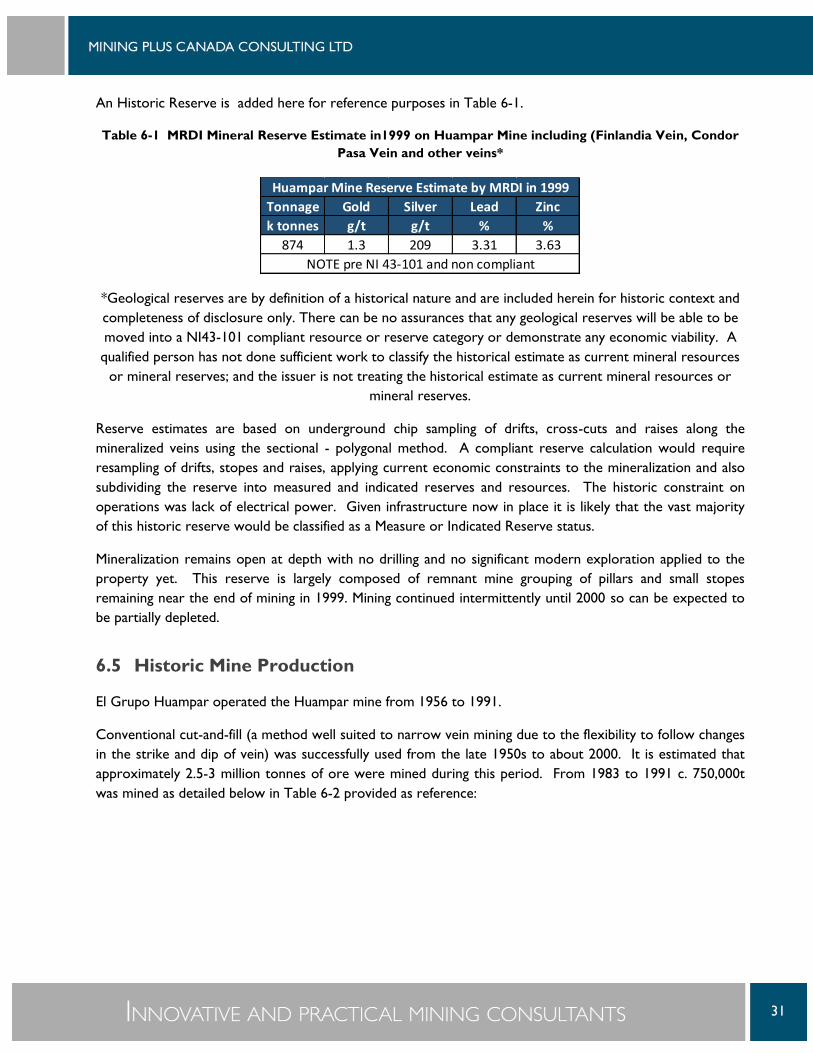
An Historic Reserve is added here for reference purposes in Table 6-1.
Table 6-1 MRDI Mineral Reserve Estimate in1999 on Huampar Mine including (Finlandia Vein, Condor
Pasa Vein and other veins*
*Geological reserves are by definition of a historical nature and are included herein for historic context and
completeness of disclosure only. There can be no assurances that any geological reserves will be able to be
moved into a NI43-101 compliant resource or reserve category or demonstrate any economic viability. A
qualified person has not done sufficient work to classify the historical estimate as current mineral resources
or mineral reserves; and the issuer is not treating the historical estimate as current mineral resources or
mineral reserves.
Reserve estimates are based on underground chip sampling of drifts, cross-cuts and raises along the
mineralized veins using the sectional - polygonal method. A compliant reserve calculation would require
resampling of drifts, stopes and raises, applying current economic constraints to the mineralization and also
subdividing the reserve into measured and indicated reserves and resources. The historic constraint on
operations was lack of electrical power. Given infrastructure now in place it is likely that the vast majority
of this historic reserve would be classified as a Measure or Indicated Reserve status.
Mineralization remains open at depth with no drilling and no significant modern exploration applied to the
property yet. This reserve is largely composed of remnant mine grouping of pillars and small stopes
remaining near the end of mining in 1999. Mining continued intermittently until 2000 so can be expected to
be partially depleted.
6.5 Historic Mine Production
El Grupo Huampar operated the Huampar mine from 1956 to 1991.
Conventional cut-and-fill (a method well suited to narrow vein mining due to the flexibility to follow changes
in the strike and dip of vein) was successfully used from the late 1950s to about 2000. It is estimated that
approximately 2.5-3 million tonnes of ore were mined during this period. From 1983 to 1991 c. 750,000t
was mined as detailed below in Table 6-2 provided as reference:
Tonnage Gold Silver Lead Zinc
k tonnes g/t g/t % %
874 1.3 209 3.31 3.63
Huampar Mine Reserve Estimate by MRDI in 1999
NOTE pre NI 43-101 and non compliant

32
Table 6-2 Historic Production 1983 to 1991 (source Roscoe Postle Associates, 1997b)
The lowest major level, the 412 level, of the existing workings is mainly the bottom due to the mine since to
go deeper requires active pumping to this the lowest gravity draining level. There is a short sub-level below
412, developed off an internal shaft that was actively pumped for a while.
YEAR Tonnes Au g/t Ag g/t Pb% Zn% Cu%
1983 37,782 2.7 229 2.07 2.33 0.31
1984 112,496 1.02 135 2.59 2.75 0.28
1985 109,696 1.4 163 2.85 2.93 0.40
1986 101,616 2.28 147 2.78 3.11 0.21
1987 97,848 1.89 130 2.62 3.11 0.21
1988 74,410 2.27 153 2.49 2.84 0.16
1989 90,710 2.44 123 1.87 2.24 0.15
1990 79,270 2.66 110 2.19 2.34 Na
1991 44,820 0.17 128 2.19 2.75 Na
TOTAL 748,649 1.87 142 2.44 2.73 0.21
Note Gold was not routinely assayed in 1991 – zero value assigned where no data.

33
7 GEOLOGICAL SETTING AND MINERALISATION
7.1 Regional Geology
The property is located in the Western Andes and is predominantly comprised of a two kilometre thick
package of lower to mid-Tertiary andesitic volcanics and associated feeder porphyritic intrusions of the
Calipuy Formation. Of particular note is the fact the volcanic package is underlain by an estimated one
kilometre thick sequence of Cretaceous limestones of the Jumasha Formation which are locally intensely
altered to the south of the Condor Pasa Mine.
Landsat photography indicates that the property is transected by a large scale ENE trending fracture zone.
All mineralization discovered to date is hosted in ENE trending structures of significant strike length (greater
than one kilometre) and possibly with considerable depth potential.
The property is located in the south-central portion of the Central Peruvian Polymetallic Belt and is
underlain by a moderately folded, 200-metre-to-1-kilometre thick package of andesitic volcanic rocks of the
Calipuy formation. Underlying the volcanics is an approximately one kilometre thick package of strongly
folded and faulted carbonates and clastic sediments. Included in this package are the Jumasha, Chulec and
Santa Formation limestones, proven host sequences throughout Peru, at many mines within the greater
Huampar district including Felicidad and Poderosa mines.
7.2 Geology
Photo 7-1 Sequence of volcanic interbeds of multiple orientations

34
Figure 7-1 Geological Map (source INGEMMET, Map 24K)
Figure 7-2 Geological Map Legend (source INGEMMET, Map 24K)
Era System
Plutonic Hipabisal
Recent
Pleistocene
Upper
Mid
Lower
Upper
Jurassic/Triassic Uper/Lower
Permian Upper
Devonian Lower
Intrusive Rocks
Cen
oo
zoic
Mes
ozo
icPa
leo
z
oic
Tertiary
Quaternary
LowerCretaceous
Stratigraphic Units
Occidental Oriental

35
The region is dominated by andesitic volcanic sequences. These include predominantly tuffs and massive
flows interbedded that are variable in colour, texture and thickness. As well some dacitic bands are found in
this pile. Minor siliceous and calcareous sedimentary interbeds are found below this volcanic sequence.
The property is transected by several large scale (plus-5-km long) ENE-trending fracture zones. Structurally
controlled mineralization is primarily hosted within sub-vertical, ENE-trending vein-fault systems. Mineralized
veins typically have significant strike lengths (plus-1-km) and considerable depth potential (plus-800m).
There is also a late stage group of porphyritic dykes often following ENE trending fractures that are parallel
to the mineralized veins.
Large areas of the valley bottoms are covered in very young alluvial deposits.
7.3 Mineralization
The district contains numerous styles of mineralization many of which have been mined since at least Spanish
colonial time. These include high-grade polymetallic (precious and base metal) vein systems (Huampar,
Constancia-Coricancha, Casapalca and Morococha), polymetallic carbonate replacement and skarn deposits
(Poderosa, Felicidad, Casapalca, and Morococha) and copper porphyries (Toromocho).
Previous exploration was limited to drifting on exposed veins and expansion of existing underground cross-
cuts designed to test for and intersect (successfully) sub-parallel structures. No exploration in the modern
sense has occurred on the property (geophysics, geochemistry, drilling).
The principal Finlandia system is comprised of at least five major veins of variable widths ranging from 0.2-to-
2.5 metres and averaging approximately 1-metre wide over an aggregate distance of approximately 5-
kilometres strike length. The Aurelio vein system, approximately 2 km north of Finlandia, is a gold and silver-
rich vein system with an average width of 1 metre and a length of approximately 400 metres. The Condor
Paso vein system is located some 6 km south of the Finlandia and is traceable for 2-km strike. All vein
systems remain open for expansion.
Widths vary ranging from 0.2 to 2 m and average approximately 0.8 to 1 m thick for an aggregate distance of
5 kilometres along strike.
Polymetallic precious and base metal mineralization is hosted in steeply dipping lateral and vertically
extensive epithermal-mesothermal fault systems. Veins show multiple (at least five) stages of mineralization
with variable sulphide mineral assemblages and gangue textures (coliform to coarse euhedral quartz).
Principle minerals include coarse crystalline galena and sphalerite ± chalcopyrite and tetrahedrite. Gangue
minerals are dominantly quartz ± pyrite, siderite with lesser amounts of barite, muscovite and cinnabar. Gold
occurs as fine disseminations of free gold within both sulphides and quartz.
Mineralization was exploited using a combination of cut and fill and shrinkage mining methods from surface
to depths ranging from 50-to-450 metres. Similar polymetallic mines in the district contain vertically
continuous economic mineralization over intervals of 500-to-1000 metres suggesting good-to-excellent
additional expansion potential at depth.

36
It is considered likely that thicker, higher grade intervals represent ore-shoots, however there is presently
insufficient data to ascertain as to whether they are predictable or continue beyond the existing workings.
Ore bodies are poly-metallic mineralized vein-filled faults ranging from about 0.4 to 2 metres wide hosted
dominantly within the Casapalca volcanics. Typically in Peru these structures can have very large vertical
(about one kilometre) and horizontal (2+Km) extents. Vein structures on the property are near vertical
with approximately E-W strikes. These are vein structures probably related to wrench (more likely) or
normal faulting. The structures pinch and swell along there extents and have splays and intersections, along
with zones of weaker and stronger mineralization. Vein mineralized zones are quartz veins with
approximately 15% sulfide minerals; sphalerite, galena, pyrite, trace chalcopyrite and some arsenopyrite.
The principal vein, the Finlandia has already been mined out for about 1.5 Km along strike and about 500m
vertically above the 412 level workings. There is moderate-strong exploration potential below the lowest
working of the Finlandia structure. Can probably safely assume mineralization continues another about 100-
200m down dip, along the majority of the strike length. There are several other veins within the mine
claims including the Condor Pasa, Colqui, Sueccia, Aurelio, Corpancho and San Juan veins. The author was
not able to visit these structures due to access and time constraints, however they represent a good
exploration potential on the property.

37
8 DEPOSIT TYPES
The deposit type that has historically been mined is a series of intermediate sulfidation epithermal
polymetallic veins in shears. These systems can frequently have long vertical and horizontal continuity.
Epithermal systems may be classified as high, intermediate, and low sulfidation styles. They are characterised
by the sulfidation state of the hypogene sulfide mineral assemblage, and show general relations in volcano-
tectonic setting, precious and base metal content, igneous rock association, proximal hypogene alteration,
and sulfide abundance (Sillitoe and Hedenquist, 2003). Ore in all occurrences of this type form under
epizonal conditions, which is generally within 2 kilometres of the paleo-surface. Veins in epithermal systems
often display textures indicative of repetitive and sustained open-space filling, and boiling.
Figure 8-1 Epithermal Deposit Model (from Corbett, 2005)
The intermediate sulfidation terminology is where the hydrothermal fluids evolve from high to low
sulfidation (Corbett, 2005).
Vertical zonations in metal content occur in some low and intermediate sulfidation state systems. In systems
displaying such zoning, gold, silver, mercury and tellurium are relatively enriched in the upper portions of the
system, and base metal contents occur in higher concentrations at deeper levels in the system.
There is a potential at depth for replacement style mineralization in the underlying carbonate minerals but
the focus of this present program is the depth extension of the previously mined vein systems within the
volcanics. This replacement style target is not the focus of this report.

38
9 EXPLORATION
Prior to Trevali taking control in 2010 no methodical mineral exploration; drilling, geochemical sampling,
geophysics or three dimentional modelling etc. had been undertaken. Exploration was previously
underground drifting and development along veins from surface exposures and following them underground
and occasionally cross-cutting out to find parallel structures (Trevali Technical Team, 2010).
After 2010, systematic surface channel chip line collection of samples have been collected from several veins,
in particular the Finlandia vein along strike from sections which had been mined historically. Sampling of the
tailings and waste dumps was also completed at the same time as the surface geological mapping of the veins
and geology across the project area. The surface mapping work detailed localized geological units that have
been sued for mapping and interpretation of the local site geology.
A metallurgical sample was collected on surface from the Finlandia vein for testing but no final report has
been found by the author and it is unclear it the metallurgical program was completed.
A satellite based data compilation of the geology of the property was also completed by Trevali.
An electronic data compilation of historic work, mostly historic underground chip samples, was recently
prepared. Further data is apparently available to add.
Trevali expenditures on exploration related activities total in excess of US $400,000 mostly occurring in
2011 and 2012 according to a summary provided by Trevali. This excludes the costs of site security,
agreement payments to the underlying owners and property carrying costs.

39
10 DRILLING
No drilling has been completed on the Huampar property that is recorded in the literature or that MP is
aware of.
The RPA provided map in Figure 6-1 indicates a number of drill holes. The author assumes these are
proposed and not completed, since no further record was found.

40
11 SAMPLE PREPARATION, ANALYSES AND SECURITY
The pre-Trevali historic sampling does not meet modern sampling standards.
The fact historic mining included reconciliation and payments were made by the smelters have confirmed the
presence of significant recovered metal values, but would not confirm the quality assurance and quality
control sampling program of the historic sampling.
No recent exploration or modern techniques other than limited surface and underground chip samples have
been collected. Trevali has collected these samples but these are not extensive enough to perform any
statistic review of resource signficance at this point.
The samples collected by Trevali have not been seen or the detailed process used reviewed by MP. Trevali
used the independent and internationally accredited laboratory in Lima operated by ALS for some of the
sampling. Standards and blanks were inserted into the data stream at regular intervals. There is not much
detail in the QA/QC meta data but the data is assumed to be reasonable with respect to its relevance as an
early exploration tool.

41
12 DATA VERIFICATION
No data was verified by MP. The historic underground chip sample data lacks survey control, QA/QC
control and is not accessible for review at this time. There is a limited amount of surface and underground
chip sampling that does meet current industry standards but the location was not specifically relevant to the
area of the proposed exploration below the existing mine.
MP did not collect any samples for reference to historic sampling due to no samples of significant quantity to
compare them to. The underground workings were not accessible at the time of the visit to collect a sample
for comparison.
The existing mine infrastructure points to the potential of areas located below the historic mine workings
for potential targets for resource development. The area below the 412 level was mined in a very limited
fashion with water pumping issues caused by a lack of electrical power in the early 1990s and then limited
generator power in the late 1990s and early 2000s.
The historic mine data, (sampling noted above and production data in section 6.5), suggests that the area
below the 412 level represents a valid exploration target but notes that confirmation sampling at the time of
the visit was not feasible because of flooding and ground support issues on the 412 level.

42
13 MINERAL PROCESSING AND METALLURGICAL
TESTING
The report author is not aware of recent metallurgical studies, but a sample was collected in 2013 by Trevali
with no report found. It was verbally confirmed that the sample was not sent out for metallurgical testing.
The mine operated for many years and mineral processing is described as straight forward. Huampar
produced three concentrates - a gravity concentrate to recover gold, a lead-silver flotation concentrate and
a zinc flotation concentrate. The most recently available metallurgical recovery data may be summarized as
follows in Table 13-1 (Roscoe Postle Associates, 1997b).
Historic mill feed is reported to have a moderate work index of 12-to-14. Historical metallurgical recoveries
were excellent, producing quality concentrates in part due to the coarse nature of the mineralization and
low pyrite content.
Table 13-1 Metallurgical Recovery Summary of Historic Mining
The mill is presently on care and maintenance for the past fifteen years. Rehabilitation will be required but
the major components are present. Condition of individual recovery components is beyond the scope of the
report author and not covered in this report.
Au g/t Ag g/t Pb% Zn% ROM - 67,734 t mined 2.28 115 2.89 4.18
Pb Concentrate 26.5 2236 54 7.29
Zn Concentrate 0.9 31 0.27 58
Gravity Concentrate 146 1335 67 4.2
Plant Recoveries 91.84% 93.50% 96.70% 94.20%
Source: Trevali website 2016

43
14 MINERAL RESOURCE ESTIMATES
This is an early stage exploration project, albeit within an historical mining camp with a long history of
economic mining, without any modern analytical or data analysis techniques applied. A mineral resource
estimate is not in the scope of this report.
The last know reserve estimate on the Huampar deposit was completed by MRDI in 1999 (see Table 6-1)
and is an Historic Reserve and therefore is not discussed in this section of the report.

44
15 MINERAL RESERVE ESTIMATES
This is an early stage exploration brownfields project and a mineral reserve estimate is not in the scope of
this report.

45
16 MINING METHODS
Mining methods for future work are not part of this study.

46
17 RECOVERY METHODS
Recovery methods are not part of this study.

47
18 PROJECT INFRASTRUCTURE
This is an early stage exploration project and the project infrastructure is not part of this study.

48
19 MARKET STUDIES AND CONTRACTS
This is an early stage exploration project. No market studies were undertaken in the report.

49
20 ENVIRONMENTAL STUDIES, PERMITTING AND
SOCIAL OR COMMUNITY IMPACT
This is an early stage exploration project. No environmental, social or permitting work has been undertaken
for this report

50
21 CAPITAL AND OPERATING COSTS
This is an early stage exploration project. No capital and operating studies were undertaken in the report.

51
22 ECONOMIC ANALYSIS
This is an early stage brown field exploration project. No economic analysis was undertaken in the report.

52
23 ADJACENT PROPERTIES
Black Tusk Resources has the Huanza property to the south (MacDonald, 2011). Limited work is described
on the property. The company was dissolved in 2012 according to SEDAR news releases and the author has
not confirmed which company has the project now.
Glencore, through the Peruvian subsidiary Los Quenales S.A., has the property to the north and east. Very
limited description what work is completed is available.
Exploration on both properties is based on similar regional geology and vein mineralogy to the Huampar
project.

53
24 OTHER RELEVANT DATA AND INFORMATION
MP is not aware of any other data not disclosed that is relevant to the project.

54
25 INTERPRETATION AND CONCLUSIONS
Huampar is largely developed on the Finlandia polymetallic vein and sub-parallel
Huampar is a past producing mine with a significant history of production approaching 40 years of operation,
much of it continuous. Production has historically continued generally by working on levels, almost all
developed at vein surface outcrops, by following the veins and drawing ore from above.
The 412 level, the portal at the mill (see Photo 25-1), is the lowest surface level and presently drains water
by gravity. Very limited production and development was pushed below the 412 level due to water inflow
and electrical power shortages to drain this area. Mine production on the 412 level was successful with some
wide sections of good grades and there is no reason to suggest that the vein was truncated below this level
only that pumping added significantly to the cost and complexity of mining.
Photo 25-1 Portal of the 412 level near the mill in January 2016
The recommended area of exploration is to drill from surface to the area below the best historic grade and
width zones within the Finlandia vein and below the 412 level. To complete this a full data compilation,
adding to the existing data compilation started by Trevali should be done to determine the historic areas of
the grade and width from the previous sampling. The lack of QA/QC standards and lack of access to chip
sample locations represents a significant risk to any resource development in areas with historic sampling.
The long history of successful mining and the fact that vertical development below the lowest level was
mainly related to water pumping issues points to a high probability of the zone continuing below the 412

55
level, allowing the author to conclude this a project meriting further exploration. Possible risks to the
success of this exploration and development program include the possibility that the Historic Reserve has
been mined out and the potential extensions do not prove viable after exploration. Additionally the rate of
flooding in the lower mine may increase in volume with depth and render any newly identified resources as
potentially uneconomic.

56
26 RECOMMENDATIONS
Building on the existing Trevali geological and historic information data compilation and develop a detailed
longitudinal section of historic grade and width.
The first phase of a new exploration program will be to auger drill the historic tailings while continuing with
data compilation, drill targeting and community and environmental studies, agreements and permits. In Phase
2 the focus is to drill the Finlandia vein under the lowest existing workings, which are largely the 412 level
with a small internally accessed sub-level(s). The drilling will likely be from surface on a moderately steep
slope, based on the preliminary data seen so far. A trail for access will be required. Man portable drills such
as a Hydrocore 4000 drill or similar are best for a project such as this due to the ability to get into the
collaring area with minimal development. The holes based on modelling done in Surpac software, is
estimated to be 650 to 700 meters in length per hole with 2 holes from one platform to be adequate to
determine the vertical continuity of mineralization below the existing workings for an initial determination.
The proposed exploration is phased with the second and third phases based on positive results of the
previous phases.

57
Table 26-1 Recommended Budgets
Once continuity below the 412 level is confirmed through the drilling of the holes, Phase 3 should begin with
two or three drills and drill out the resource so that a mineral resource estimate can be completed. Some of
this may be done from underground, but this is best determined after Phase 1 confirmation since
underground rehabilitation is required and this cost is largely undetermined at this point.
Have the mill reviewed by a metallurgist or former mill manager for rehabilitation costs to operate the mill.
Once the underground workings are opened up a systematic chip sample twinning comparison between the
old samples and modern values using standards and blanks should be completed on the lowest mine level to
allow a modern resource estimate to be completed using the existing sample data.
Phase 1 Activity unit Cost/unit Item Cost
Auger drilling in old tailings material 15,000$
Assayinging auger samples 100 $30 3,000$
Logistics, food accom, transport 7,000$
Data Compilation 15,000$
Target Validation and Drill planning for Phase 2 10,000$
Permitting 10,000$
Community agreement 20,000$
Road Upgrade 12,000$
Contingency 10% 9,200$
101,200$
Phase 2 Activity unit Cost/unit Item Cost
Drill Pad construction 8,000$
Diamond Drilling (all in) 1,350 m $195/m 263,250$
Contingency 10% 26,325$
289,575$
Phase 3 Activity unit Cost/unit Item Cost
Camp upgrades and expansion 100,000$
Diamond Drilling all in 35,000 m $195/m 6,825,000$
Underground rehabilitation 50,000$
Mill Review 15,000$
Underground chip sample program
for confirmation of previous samples
25,000$
Mine Model Development 30,000$
Contingency 10% 704,500$
7,749,500$
8,039,075$ Total Phase 1, 2 and 3
Huampar Project Budget
Total Phase 3
Total Phase 2
Total Phase 1

58
27 REFERENCES
Corbett, G., 2004, Epithermal and Porphyry Gold – Geological Models, Pacrim 2004, Adelaide, Australia,
Australasian Institute of Mining and Metallurgy, 2004.
Corbett, G., 2005, Epithermal Au-Ag Deposit Types - Implications for Exploration, Proexplo Conference
Lima, Peru, May 2005.
INGEMMET, Regional geology map 24K, Matucana Quadrangle, 1:100,000 scale.
MacDonald, G., 2011, Geological Evaluation of the Huanza Property for Black Tusk Minerals Inc., February
2011.
Marinov, D., 2013, Huampar Property, Summary of Work Completed memo, April 2, 2013.
McNeil, D., 2011a, Huampar Data Compilation memo, March 7, 2011.
McNeil, D., 2011b, Huampar Subsurface Data Compilation and Analysis memo, June 7, 2011.
MRDI, 1999, Nueva Condor Mine, Expansion review and Evaluation, June 21, 1999.
Royas, E., 2010, Informer Visita, Nueva Condor S.A., Planta Concentradora, April 13, 2010.
Roscoe Postle Associates Inc., 1997a, Report on three exploration properties in central and northern Peru
for OroPeru Resources Inc., May 30, 1997.
Roscoe Postle Associates Inc., 1997b, Report on the Nueva Condor Property, Peru for OroPeru Resources
Inc., September 10, 1997.
Sillitoe, R.H. and J.W. Hedenquist. 2003, Linkages between volcanotectonic settings, ore-fluid compositions,
and epithermal precious-metal deposits. In Volcanic, Geothermal, and oreforming fluids: Rulers and
witnesses of processes within the Earth, Simmons, S.F. and I.Graham, eds. Society of Economic Geologist,
Special Publication Number 10, p. 315 –343.
Trevali Technical Team, 2010, Trevali Property Submission Report, Huampar Property Review MEMO, May
20, 2010.
Prism Resources website: http://www.prismresourcesinc.com/
SEDAR website: http://sedar.com
Trevali website: http://www.trevali.com
59
APPENDIX – TITLE SEARCH
60
61
62

63

64

65
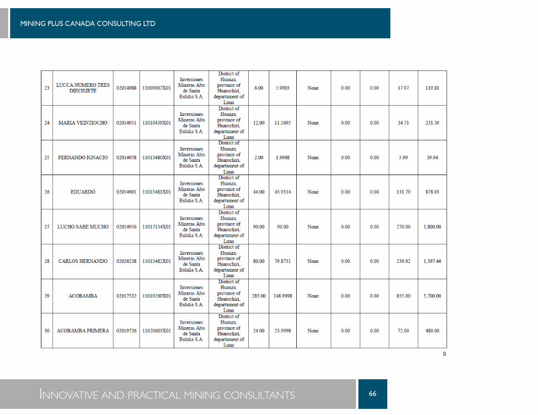
66

67

68
Recommended