© B
oro
bu
du
r H
eri
tage c
on
serv
ati
on
Off
ice (
BC
O)
>>
The Global Magazine of Leica Geosystems | 3
Preserving Indonesia's heritageby Katherine Lehmuller
Borobudur, a masterpiece of 9th century Bud-
dhist architecture, is one of the most famous
Buddhist temples. It is located in Magelang, on
the island of Java in Indonesia, on a remote hill-
top surrounded by volcanoes, one of which is
still active. This massive 29-metre-high (95-feet)
temple consists of nine stacked platform lev-
els, six of them square and three circular, and is
crowned by a central stupa, or dome, surround-
ed by nearly 3,000 panels and 500 Buddha stat-
ues. It is also aligned with three other temples.
The structure is built without the use of any
cement or mortar. Some claim it to be one of the
Wonders of the World.
Built in the 9th century, Borobudur was used until
abandoned in the 1400s. When it was rediscovered
in 1815, it had been buried under volcanic ash and
heavy jungle growth. Poorly executed excavations
done at this time exposed the temple to elements
and led to its decay. In the 1970s, the Indonesian
Government and UNESCO took interest in this amaz-
ing monument and began renovating it, disassem-
bling and carefully cleaning stones and building a
major draining system as well.
Borobudur is still used for a Buddhist pilgrimage
once a year and anyone visiting the monument must
walk up the nine platform levels to reach the top.
These levels represent the consecutive stages that
a Buddhist trying to achieve enlightenment must go
through in order to attain Nirvana.
Deterioration at Borobudur These pilgrimages, the complex’s immense populari-
ty as a tourist attraction, vandalism and weak regu-
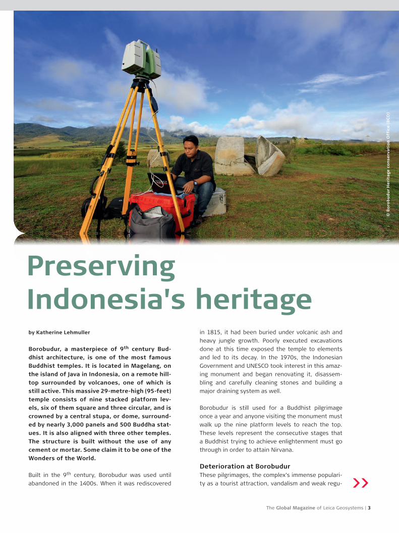
Preserving the Borobudur temple for future generations using a Leica ScanStation.
© B
oro
bu
du
r H
eri
tage c
on
serv
ati
on
Off
ice (
BC
O)
4 | Reporter 73
receiving the scanner, BCO made tremendous pro-
gress documenting sites with far more detail and
collecting data quickly. Brahmantara, coordinator at
the Photogrammetry and 3D Laser Scanning section
for Borobudur Heritage Conservation Office, Minis-
try of Education and Culture, explains, “Working with
the Leica Geosystems HDS scanner helped us tre-
mendously. It’s more quick, more fast and provides
detailed data. We’ve had much success with Leica
Geosystems products and upgraded to the Leica
ScanStation C10, to collect even quicker and receive
even more detailed and accurate data. When collect-
ing data manually, we required more manpower, so
it took longer to analyse data and make drawings.
Now, with the new Leica ScanStation C10, we need
fewer people and also have more time to analyse and
make our conclusions.”
BCO’s goal was to complete and refine the cultur-
al heritage site’s database. Detailed digital doc-
umentation, such as for the site’s spatial data, its
dimensions and elevation as well as documenting the
surrounding landscape and its contours, could help
preserve and help maintain the site for many gener-
ations to come. The 3D scans delivered by the Leica
lations of encroaching property development have all
taken a toll on Borobudur, adding to its deterioration.
A recent volcanic eruption also threated the temple
and covered it with destructive acidic ashes. In order
to preserve Borobudur for future generations, the
historical site needed to be properly documented
and a highly detailed digital rendering made.
3D laser scanners play an important part in mapping
and documenting cultural heritage. When deteriora-
tion or unexpected natural disasters, such as floods,
volcanic eruptions, earthquakes or vandalism, occur,
reconstruction of historic structures based on the
scanner’s delivered point clouds can be accurately
done. Borobudur Heritage Conservation Office BCO,
working for the Indonesia Ministry of Culture and
Education, decided to undertake this vast project
employing the Leica ScanStation C10 using Cyclone
software to document the temple complex.
Documenting changes IIn 2005, BCO received its first HDS scanner, the Lei-
ca HDS3000, from UNESCO. Before this, they used
manual methods to acquire data and carry out doc-
umentation of Indonesia’s cultural heritage. After
© B
oro
bu
du
r H
eri
tage c
on
serv
ati
on
Off
ice (
BC
O)
© B
oro
bu
du
r H
eri
tage c
on
serv
ati
on
Off
ice (
BC
O)
The Global Magazine of Leica Geosystems | 5
ScanStation C10 would serve as a reference point,
helping to monitor Borobudur for any occurring
changes caused by regional property development.
Another task requiring use of the laser scanner was
to assess the stability of the building site itself and
also of threatening slope inclinations of the com-
plex’s surrounding hills, which could change at any
time due to natural disasters.
Challenging environmentsScanning the Borobudur complex is a vast and com-
plex task presenting many challenges. For instance,
many of the objects to scan are difficult to reach,
such as prehistoric caves or temples located on hill-
sides. Steep terrain, access to electricity and severe
weather conditions, such as the Monsoon or rainy
season, were challenging scanning tasks to say the
least. Since BCO has worked with Leica Geosystems
equipment for 10 years, they knew these laser scan-
ners were highly durable and able to work under the
extreme conditions that such an immense project
required.
The Leica ScanStation C10 is not only scanning the
Borobudur complex but also digitally documents
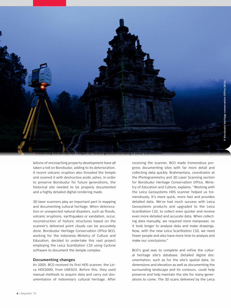
The famous Indonesian Temple, Gedong Songo, with
its nine different temple complexes built on the beau-
tiful hillside of Ungaran Mountain, was also scanned
using Leica Geosystems products. Difficult setups on
steep inclining landscapes proved no problem for the
Leica ScanStation C10.
Brahmantara explains, “We could still manage to
get coordinates with good accuracy and output of
the drawing with good dimensions. Another project,
scanning the clock tower Jam Gadang in Bukittinggi,
which was damaged by a severe earthquake, enabled
us to decide how to restore and stabilise the building
based on the data we collected.”
Other projects
numerous other historical forts, prehistoric caves,
ancient pundek (stair-like) terraces in highly detailed
accuracy – and all with great success. The scanner
was also applied to assist other related cultural insti-
tutions to document and collect data of prehistoric
bas-relief art.
A loss of our cultural heritage would be unthinka-
ble. With the help of the Leica ScanStation C10, our
world’s precious cultural heritage sites, such as the
monumental complex of Borobudur, could be docu-
mented in precise detail. Now should any unforeseen
damage, great or small, happen from environmen-
tal change or other unpredictable instabilities, high-
ly detailed 3D laser documentation can protect the
past and preserve the future for many generations
to come.
About the author:
Katherine Lehmuller received her Bachelor of Fine Arts
from Tufts University, NY, and works as a content edi-
tor for Leica Geosystems AG, Heerbrugg, Switzerland.
Recommended