The Paint Creek Trail is located in northeast Oakland County and connects the suburban Detroit communities of Rochester, Rochester Hills, Oakland Township, Orion Township, and Lake Orion. The trail follows the former Penn Central Railroad up the Paint Creek Valley as it meanders through highlands, prairies, and wetlands. The compacted limestone surface provides a solid, but natural, surface for year round non-motorized uses. The Paint Creek Trail ends at the Rochester River Walk, which provides an essential linkage between the Paint Creek and Clinton River Trails.
The Paint Creek Trail is owned and managed by the Paint Creek Trailways Commission and was the first Rail-to-Trail in the State of Michigan. Open to the public since 1983, the Paint Creek Trail receives over 100,000 visitors annually.
Hiking Michigan is dedicated to promoting nature activities, hiking, and assisting all people in getting out into the beautiful parks and trail systems in order to see what southeastern Michigan has to offer. The goal is to show people the wonderful things that nature can teach them about improving their lives and health, all while having a great time doing so. Hiking Michigan leads nature hikes, teaches classes to young people, and gives talks to various groups on many outdoor aspects in southeastern Michigan.
www.HikingMichigan.com586.446.7656
In Oakland County, there are over 1,400 natural lakes and the headwaters of five major rivers: the Clinton, Huron, Rouge, Shiawassee, and Flint Rivers.
• The Huron River Water Trail flows to the west through some of Oakland County’s finest natural areas. The slow moving current provides ample opportunity to enjoy the wildlife from a canoe or kayak. The river winds through State and HCMA parks, as well as Downtown Milford.
• The Clinton River Water Trail begins in Auburn Hills and meanders to the east offering a very remote feeling for being so close to major metropolitan areas.
• The Shiawassee River Heritage Water Trail is a slow moving, shallow, warm water stream. It affords a wilderness experience crossing long stretches of undeveloped land. The river trail contains important wetlands and connects historic sites in the 7-mile stretch from Downtown Holly to Downtown Fenton.
The development of Oakland County’s trail system continues to expand our citizens’ access to the abundant natural and man-made features that make Oakland County a premier place to live, work, and play. The county has been blessed with over 1,400 lakes,
more than any other county in the state, is home to the headwaters of five major river systems, and has over 89,000 acres of park and recreation lands. From our cosmopolitan cities and historic town centers to our rural and natural countryside, we have it all. This diversity has offered us many choices and the freedom to live in a setting which matches our desired lifestyle.
The trail network also promotes physical fitness by providing close-to-home opportunities for exercise plus an alternative means of transportation. Transportation and obesity related health care costs are critical issues facing our society.
I look forward to continuing to work with members of the Oakland County Trails, Water, & Lands Alliance to implement the vision of an Oakland County Trail Network.
L. Brooks Patterson,
Oakland County Executive
For Free Distribution only
2013-2014 E d i t i o n
Connecting the beautiful and interesting places in northwest Oakland County.
In April 2012, the Oakland County Trails Advisory Council (OTAC) merged with the Oakland County Natural Areas Advisory Group to become the Oakland County Trails, Water, & Lands Alliance (TWLA). Represented by a vast variety of stakeholders, this newly formed group is supported by Oakland County Planning & Economic Development Services along with Oakland County Parks & Recreation. TWLA is working toward becoming an informed, coordinated, collaborative body that supports initiatives related to Oakland County’s Green Infrastructure Network.
For over 30 years, Oakland County Planning has collaborated with trail groups, local communities, special interest groups, businesses, and park entities to expand and coordinate a network of trails and pathways. There are 121 miles of completed trails, 24 miles in the planning, design, and development stage, and 123 miles under consideration in the overall primary County Concept Trail Loop.
The Michigan Department of Natural Resources (DNR) is committed to the conservation, protection, management, use, and enjoyment of the state’s natural resources for current and future generations. In Oakland County, the DNR provides trails for hiking, biking, cross-country skiing, horseback riding, paddle sports, and snowmobiling in the following park and recreation areas:
• Bald Mountain State Recreation Area
• Holly State Recreation Area
• Ortonville State Recreation Area
• Pontiac Lake State Recreation Area
• Proud Lake State Recreation Area
• Polly Ann Trail
• Seven Lakes State Park
• Highland State Recreation Area
The Oakland County Parks and Recreation Commission (OCPRC) has been committed to providing outstanding recreation and improving the quality of life for Oakland County residents since 1966. OCPRC supports the Oakland County Trails, Water, & Lands Alliance and the vision of an interconnected system of trails and pathways throughout Oakland County and Southeast Michigan. Some of OCPRC’s long-term goals include expansion of park trails and improving non-motorized connectivity to its 13 parks.
Hike, bike, skate, ski, or ride on 64 miles of trails in some of the most scenic landscapes in Oakland County.
The Road Commission for Oakland County (RCOC) supports the movement of people throughout the county by non-motorized means as a way to promote healthier living and reducing the number of trips required on the road system. RCOC also wants to create the best possible non-motorized network by contributing technical expertise to the location and design of the pathway system. This will create fewer conflicts with the motorized network and result in the safest possible trails for all users.
The Michigan Mountain Biking Association (MMBA) is a 501 (c)(3) non-profit comprised of local International Mountain Biking Association (IMBA) chapters located throughout Michigan. The mission of the MMBA is to promote responsible mountain biking and to work toward the goals of common land access and natural resource protection through interaction with policy makers, the cycling industry, race promoters, mountain bikers, and other trail users. MMBA also publishes an online Michigan Mountain Bike Trail Guide with trail conditions, maps, technical skill level ratings, and a mountain biking forum.
Local IMBA chapters include:• Holly/Flint
• Clinton River Area Mountain Bike Association
• Motor City Mountain Biking Association
Cop
yrig
ht B
ryan
Mitc
hell.
com
Michigan Trails and Greenways Alliance (MTGA) is a statewide, nonprofit organization dedicated to the creation of an interconnected, statewide system of multi-use trails and greenways for recreation, health, transportation, economic development, and environmental/cultural preservation purposes. MTGA works at both the state and local levels by assisting public and private interests in trail and greenway planning, funding, development, and maintenance. MTGA also builds public support for trail and greenway development through events, education, information, and advocacy activities.
Over 30 miles of paved trails and 16 miles of rustic trails await you in three Metroparks in Oakland County. Located in both Oakland and Macomb Counties, Stony Creek Metropark has 8.3 miles of paved trail, including a 6-mile loop winding through woods and along the scenic Stony Creek Lake, and connections to the Macomb Orchard and Clinton River Trails. Stony Creek Metropark also features 14 miles of mountain bike trail. Near the center of the county, an 8-mile paved trail at Indian Springs Metropark winds through areas of restored prairie, wetlands, and towering trees. The 13 miles of trail at Kensington Metropark includes an 8-mile loop around Kent Lake, and connecting routes to Milford to the north, and Island Lake State Recreation Area and the Huron Valley Trail to the south. Heading east from the park, a 2-mile rustic trail provides a connection to Proud Lake State Recreation Area.
Oakland County has long been an area of intense equestrian interest. Horseback riding appeals to all age groups and levels of physical ability. There are many miles of horse friendly trails in state recreation areas, county parks, and along rural dirt roads. The Oakland Equestrian Coalition, founded in 2003, represents a wide variety of equestrian interests and is committed to:
• Educating local units of government and citizens about equestrian concerns in Oakland County
• Preserving existing equestrian facilities and trails in Oakland County and promoting the growth of further equestrian opportunities
• Developing new equestrian opportunities in Oakland County, including safe access to the entire Oakland County Greenways system of multi-use trails as exemplified by these access tunnels
The League of Michigan Bicyclists (LMB) is a non-profit, tax exempt, statewide organization with more than 2,000 members working to improve conditions for bicycling in Michigan. LMB supports many programs and projects and cooperates with state and local agencies and other like-minded groups toward this goal.
Woodward Avenue (M-1) is a designated National Scenic Byway. This historic corridor stretches 27 miles from Detroit to Pontiac and was once a trail used by Native Americans. Today, various communities and organizations are studying options for making Woodward Avenue more bike and pedestrian friendly. These options include public transit, bike lanes, and sidewalks, as well as bike routes within the greater Woodward Avenue Corridor.
The Oakland County Business Roundtable provides advice to the County Executive and the Oakland County Trails, Water, & Lands Alliance on business, economic, and land development matters in order to ensure the preservation of the County’s quality of life and economic vitality for the benefit of its citizens, communities, and businesses. The Roundtable normally works within four areas: Transportation, Workforce and Education, Quality of Life, and Economic Development.
thank you to the Following PathFinDers
thank you to the Following trail trekkers
HighlandEquestrians.org
PAINT CREEK TRAILWAYSCOMMISSION
OCPR Commissioners in photo, from left to right: John A. Scott, John P. McCulloch, A. David Baumhart III, Gary R. McGillivray, Christine Long, Robert Kostin, J. David VanderVeen, Gerald A. Fisher, Pecky D. Lewis, Eric S. Wilson.
a sPecial thanks to the Following trail blazers
Beginning at the southern end of scenic Kensington Metropark, the 8.6-mile Milford Trail leads hikers and bikers past the Huron River, through densely wooded areas, over gently rolling hills, and across the Milford Dam to Hubbell Pond Park. The trail continues to wind past the YMCA and the Milford Library into the historic Village of Milford. Once in the Village, you will find many family-owned shops and a variety of restaurants.
The respective portions of the Milford Trail are owned and managed by the Huron-Clinton Metropolitan Authority, Milford Township, and the Village of Milford. The Milford Trail now links to the western extension of the Huron Valley Trail, just south of Kensington Metropark and I-96.
Established in 1948, the Oakland County Sheriff's Office Mounted Unit is one of the oldest horse patrol units in the country. The Mounted Unit provides patrol coverage on select trails and parks within Oakland County. With their prominent perch on horseback, the mounted deputies provide a visible patrol force as well as a friendly attraction for the thousands of Oakland County's annual park and trail visitors. In addition, the Sheriff's Mountain Bike Patrol Unit is available for special trail events.
GET OUTand play
The Oakland County Water Resources Commissioner’s Office supports the county’s vast natural resources focusing on keeping pollution from lakes and streams. Trail users can help by keeping an eye out for any pollution sources. If you witness any pollution sources, please report it immediately. A 24-hour Pollution Hotline is available to report any activity you believe may be causing pollution: 248.858.0931.
V
Milford Downtown Development Authori ty
Polly ann trail14.5miles
www.PollyAnnTrailway.org248.969.8660
surfacecrushed limestone
Paint creek trail8.9miles
2 * ç I
www.PaintCreekTrail.org248.651.9260
surfacecrushed limestone
Oakland County is home to 14.5 miles of this 35 mile linear park traversing some of the most beautiful rural landscapes and historic villages in northern Oakland County. Its southernmost entrance is in Orion Township on Joslyn Road, just south of Waldon Road. The trail continues north and northeast through Oxford Township, Village of Oxford, Addison Township, and Village of Leonard before reaching the Lapeer County border where it continues north for another 20 miles.
Motorized vehicles are not permitted on the trail.
lakes community trail3.5miles
www.WixomGov.org248.624.2850
surfaceasphalt
clinton river trail16miles
2 * ç O
www.ClintonRiverTrail.org
surfacevaries by community
The Lakes Community Trail is a linear connection between the four communities of Commerce, Wolverine Lake, Walled Lake, and Wixom. The trail links municipal parks within each community and serves as a multi-use, non-motorized trail. Hiking, biking, cross-country skiing, and in-line skating can all be enjoyed while traversing this portion of southwest Oakland County. The Lakes Community Trail also serves as an important link between the Huron Valley Trail and the West Bloomfield Trail.
The Clinton River Trail is the eastern gateway for the Oak Routes Trail Network. This 16-mile recreational rail-trail roughly parallels and frequently crosses the Clinton River. Gently graded, the trail traverses the Cities of Rochester, Rochester Hills, Auburn Hills, Pontiac, and Sylvan Lake. Along the way, it spans a unique diversity of environments as it transitions from quaint downtowns to more isolated areas with an ‘up-north’ feel. A hub in the county’s trail network, it connects to the West Bloomfield, Paint Creek, and Macomb Orchard trails. Amenities range from parks, scenic overlooks, outdoor dining spots, and ice cream shops to water fountains, restrooms, and bike stores. Mountain biking trails, velodrome, and canoe/kayak put-in points are all directly accessible from the trail.
A temporary sidewalk route in Pontiac bypasses the only incomplete section of trail.
west bloomFielD trail6.8miles
www.WestBloomfieldParks.org248.451.1900
surfacecrushed limestone
heaDwaters trails16miles
2 * ç O
www.HeadwatersTrailsInc.org
The West Bloomfield Trail was once part of the interurban railroad in Oakland County. Opened in 1992, the West Bloomfield Trail stretches 6.8 miles through the communities of West Bloomfield, Orchard Lake, Keego Harbor, and Sylvan Lake. The 162-acre West Bloomfield Woods Nature Preserve anchors the central trailhead; Sylvan Manor Park, a small neighborhood park, serves as the eastern trailhead. Sylvan Manor Park is also used as a western trailhead for the Clinton River Trail, enabling users to continue to the northeast toward Pontiac. Traveling along the trail, visitors experience a sense of being in the north woods of Michigan and, just as quickly, they are transported back to reality as the trail passes through urban housing tracts, and business and commercial districts. Along the trail, eighteen nature interpretive sites give visitors the opportunity to see various habitats without putting undue pressure on the ecosystems and sensitive wildlife species.
Headwaters Trails Inc. is a non-profit group dedicated to the construction of a non-motorized trail network in the headwaters region of northwest Oakland County. Just outside of historic downtown Holly, the Shiawassee River Water Heritage canoe/kayak trail is now open to paddlers. Several miles of trails and pathways are currently in the planning stage. The pathways will span the Townships of Groveland, Holly, Rose, and Springfield, and the Village of Holly.
Headwaters Trails Inc. operates with the support of a variety of public, private, and business sources interested in promoting local trails and recreational activities.
I
248.634.3513
huron valley trail10.5miles
2 * ç
www.SouthLyonMI.org248.437.2240
surfaceasphalt
The 10.5-mile Huron Valley Trail extends along the former Grand Trunk Railroad from the City of South Lyon, through Lyon Township and into Milford Township. An extension to the west leads trail users into Island Lake State Recreation Area, where it crosses under I-96 to connect to the Milford Trail through Kensington Metropark. The segment through Lyon and Milford Townships is relatively flat with very gentle grades, while the extension to Island Lake offers some challenging hills.
The Huron Valley Trail provides access to McHattie & Volunteer Parks, Downtown South Lyon, James F. Atchison Memorial Park, Lyon Oaks County Park, Kensington Metropark, and Island Lake State Recreation Area. Vehicle parking and access to the trail is available at all of these parks. The Huron Valley Trail provides connections to over 25 miles of adjoining trails.
oaklanD county
www.AdvantageOakland.com 248.858.0720
water trailsmilForD trail8.6miles
2 * ç
www.MeetMeInMilford.com248.684.9719
surfaceasphalt
i-275 & m-5 metro trails6.3 miles
www.Michigan.gov/MDOT517.373.2090
surfaceasphalt
The I-275 Metro Trail ranks as one of a few trails in the United States that is located in a freeway right-of-way. The Michigan Department of Transportation (MDOT) facility, which extends from Monroe County to the City of Novi in southern Oakland County, serves as a spine for the non-motorized network in the western part of the Detroit metropolitan area. MDOT has been rehabilitating many sections of the trail and includes the replacement of bridge structures, surface reconstruction, and trail widening. Rehabilitation of the trail in Oakland County, from 8 Mile Road to Meadowbrook Road, is complete.
MDOT is also constructing a new multi-use path along M-5 in the City of Novi and Commerce Township. The new trail, to be known as the M-5 Metro Trail, is considered to be an extension of the I-275 Metro Trail. Connections between the two trails will be made in the coming years.
huron-clinton metroParks
2 * ç O
www.Metroparks.com
I
800.47.PARKS
DePartment oF natural resources
www.Michigan.gov/DNR
oaklanD county Parks & recreation
2 * ç O
www.DestinationOakland.com
I
888.OC.PARKS
trails, water, & lanDs alliance
www.OakGov.com/Trails248.975.4267
oaklanD county sheriFF’s oFFice
* I
www.OakGov.com/Sheriff248.858.5000
league oF michigan bicyclists
www.LMB.org888.642.4537
business rounDtable
www.AdvantageOakland.com/Expand/BRT
roaD commission For oaklanD county
www.RCOCWeb.org248.858.4804
southeastern michigan’s hiking michigan
water resources commissioner’s oFFice
www.OakGov.com/Water248.858.0958
wooDwarD avenue corriDor
www.WoodwardAvenue.org248.288.2004
michigan mountain biking association
* ç
www.MMBA.org
michigan trails & greenways alliance
www.MichiganTrails.org517.485.6022
oaklanD equestrian coalition
I
www.OaklandEquestrians.org248.624.1409
aDDitional maP sPonsors
2 * ç I
www.OakGov.com/Trails
Park or TrailMap Grid Location Hi
king
Biki
ng
X-Co
untr
y Sk
iing
Padd
le S
port
s
Hors
ebac
k Ri
ding
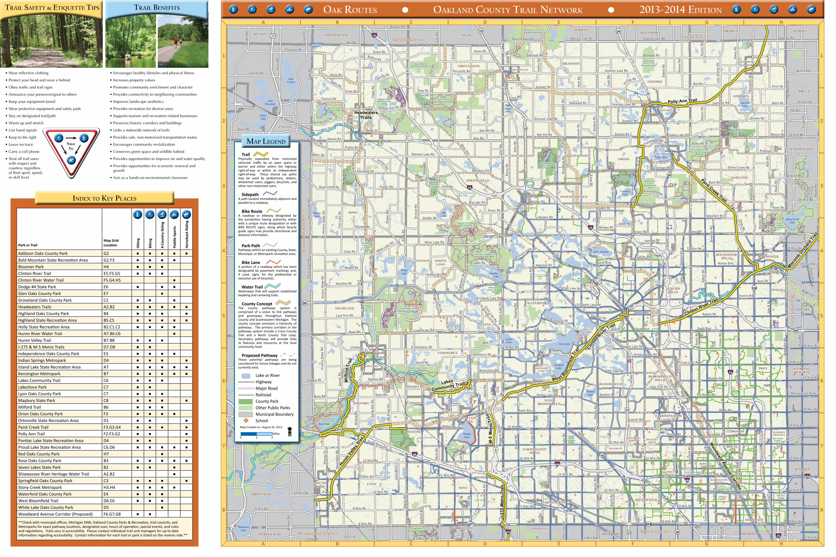
Addison Oaks County Park G2 ▪ ▪ ▪ ▪ ▪Bald Mountain State Recreation Area G2.F3 ▪ ▪ ▪ ▪Bloomer Park H4 ▪ ▪ ▪Clinton River Trail E5.F5.G5 ▪ ▪ ▪Clinton River Water Trail F5.G4.H5 ▪Dodge #4 State Park E6 ▪ ▪ ▪Glen Oaks County Park E7 ▪Groveland Oaks County Park C2 ▪ ▪ ▪Headwaters Trails A2.B2 ▪ ▪ ▪ ▪ ▪Highland Oaks County Park B4 ▪ ▪ ▪ ▪Highland State Recreation Area B5.C5 ▪ ▪ ▪ ▪ ▪Holly State Recreation Area B2.C1.C2 ▪ ▪ ▪ ▪Huron River Water Trail A7.B6.C6 ▪Huron Valley Trail B7.B8 ▪ ▪ ▪I-275 & M-5 Metro Trails D7.D8 ▪ ▪Independence Oaks County Park E3 ▪ ▪ ▪ ▪Indian Springs Metropark D4 ▪ ▪ ▪ ▪Island Lake State Recreation Area A7 ▪ ▪ ▪ ▪ ▪Kensington Metropark B7 ▪ ▪ ▪ ▪ ▪Lakes Community Trail C6 ▪ ▪ ▪Lakeshore Park C7 ▪ ▪Lyon Oaks County Park C7 ▪ ▪ ▪Maybury State Park C8 ▪ ▪ ▪ ▪Milford Trail B6 ▪ ▪ ▪Orion Oaks County Park F3 ▪ ▪ ▪ ▪Ortonville State Recreation Area D1 ▪ ▪ ▪Paint Creek Trail F3.G3.G4 ▪ ▪ ▪ ▪Polly Ann Trail F2.F3.G2 ▪ ▪ ▪Pontiac Lake State Recreation Area D4 ▪ ▪ ▪Proud Lake State Recreation Area C6.D6 ▪ ▪ ▪ ▪ ▪Red Oaks County Park H7 ▪Rose Oaks County Park B3 ▪ ▪ ▪ ▪ ▪Seven Lakes State Park B2 ▪ ▪ ▪Shiawassee River Heritage Water Trail A2.B2 ▪Springfield Oaks County Park C3 ▪ ▪ ▪ ▪Stony Creek Metropark H3.H4 ▪ ▪ ▪ ▪Waterford Oaks County Park E4 ▪ ▪ ▪West Bloomfield Trail D6.E6 ▪ ▪ ▪White Lake Oaks County Park D5 ▪Woodward Avenue Corridor (Proposed) F6.G7.G8 ▪ ▪**Check with municipal offices, Michigan DNR, Oakland County Parks & Recreation, trail councils, and Metroparks for exact pathway locations, designated uses, hours of operation, special events, and rules and regulations. Trails vary in accessibility. Please contact individual trail unit managers for up to date information regarding accessibility. Contact information for each trail or park is listed on the reverse side.**
• Wear reflective clothing
• Protect your head and wear a helmet
• Obey traffic and trail signs
• Announce your presence/signal to others
• Keep your equipment tuned
• Wear protective equipment and safety pads
• Stay on designated trail/path
• Warm up and stretch
• Use hand signals
• Keep to the right
• Leave no trace
• Carry a cell phone
• Treat all trail users with respect and courtesy regardless of their sport, speed, or skill level
• Encourages healthy lifestyles and physical fitness
• Increases property values
• Promotes community enrichment and character
• Provides connectivity to neighboring communities
• Improves landscape aesthetics
• Provides recreation for diverse users
• Supports tourism and recreation related businesses
• Preserves historic corridors and buildings
• Links a statewide network of trails
• Provides safe, non-motorized transportation routes
• Encourages community revitalization
• Conserves green space and wildlife habitat
• Provides opportunities to improve air and water quality
• Provides opportunities for economic renewal and growth
• Acts as a hands-on environmental classroom
10 Mile Rd
MILFORD
OXFORD
ORTONVILLE
HOLLY
CLARKSTON
LAKEANGELUS
KEEGOHARBOR
ORCHARDLAKE
SYLVANLAKE
WOLVERINELAKE
HUNTINGTONWOODS
PLEASANTRIDGE
HAZELPARK
OAKPARK
BEVERLYHILLS
BINGHAMFARMS
FRANKLIN
LATHRUPVILLAGE
DETROITREDFORD
GRAND BLANC
LEONARD
LAKE ORION
NORTHVILLE
WALLEDLAKE
FARMINGTON
CLAWSON
MILFORD
BLOOMFIELDHILLS
SOUTHLYON
BERKLEY
ROCHESTER
BIRMINGHAM
HOLLY
MADISONHEIGHTS
FERNDALE
NORTHFIELD
ALMONTMETAMORA DRYDEN
SALEM
FENTON
HADLEY
MUNDY
ROYALOAK
WIXOM
AUBURNHILLS
STERLINGHEIGHTS
WESTBLOOMFIELD
ATLAS
WASHINGTON
BLOOMFIELD
LIVONIA
COMMERCE
INDEPENDENCE
FARMINGTONHILLS
SHELBY
ROCHESTERHILLS
GREEN OAK
HARTLAND
BRIGHTON
TYRONESPRINGFIELD
WHITELAKE
GROVELAND
WATERFORD
PONTIAC
BRANDON
BRUCE
HIGHLAND
SOUTHFIELD
ADDISON
OAKLAND
WARREN
OXFORD
LYON
ORION
ROSE
NOVI
TROY
M-5
Met
ro T
rail
Milf
ord
Trai
l
LAKESHOREPARK
CATALPA OAKSCOUNTY PARK
HIGHLANDOAKS
COUNTYPARK
Woodward Avenue Corridor
HeadwatersTrails
Polly Ann Trail
Paint Creek Trail
Macom
b Orc
hard
Tra
il
Huron
Vall
ey T
rail
Lakes
Community TrailWest B
loom
field
Tra
il
Clinton River Trail
ISLAND LAKE STATERECREATION AREA
MAYBURYSTATE PARK
DETROIT ZOO
GLENOAKS
COUNTYPARK
RED OAKSCOUNTY
PARK
PROUD LAKE STATERECREATION AREA
LYON OAKSCOUNTY
PARK
KENSINGTONMETROPARK
DODGEPARKNO. 10
HIGHLAND STATERECREATION AREA
PONTIAC LAKE STATERECREATION AREA
WHITE LAKEOAKS COUNTY
PARK
WATERFORDOAKS COUNTY
PARK
STONYCREEK
METROPARK
ORION OAKSCOUNTY PARK BALD
MOUNTAINSTATE
RECREATIONAREA
INDEPENDENCEOAKS COUNTY
PARK
INDIAN SPRINGSMETROPARK
SPRINGFIELDOAKS
COUNTYPARK
ROSEOAKS
COUNTYPARK
SEVEN LAKESSTATE PARK
HOLLY STATERECREATION
AREA
GROVELANDOAKS
COUNTYPARK
HOLLY STATERECREATION AREA
HOLLY STATERECREATION AREA
ORTONVILLE STATERECREATION AREA
HORSESHOELAKE STATE
WILDLIFE AREA
BALD MOUNTAINSTATE RECREATION
AREA
ADDISON OAKSCOUNTY PARK
I-275
Met
ro T
rail
Clinto
n Rive
r Trail
LakeFenton
SilverLake
LakePonemah
CopneconicLake
TipsicoLake
BigLake
BaldEagleLake
Lake Orion
VoorheisLake
Stony CreekLake
LakevilleLake
OrchardLake
Lake Angelus
Cass Lake
UnionLake
Pontiac Lake
WhiteLake
Kent Lake
WhitmoreLake
WalledLake
WalnutLake
DODGEPARKNO. 4
13 Mile Rd
8 Mile Rd
Maple Rd
Har
vey
Lake
Rd
Deq
uind
re R
d
Dixie Hwy
Lahs
er R
d
10 Mile Rd
Clarkston Rd
Oakwood Rd
South Blvd
Fish
Lak
e R
d
John
R R
d
Orion Rd
Grand River Ave
Roc
hest
er R
d
Drahner Rd
Mid
dleb
elt R
d
Ada
ms
Rd
Pontiac Trl
Grange Hall Rd
Waldon Rd
Sash
abaw
Rd
Hag
gert
y R
d
Auburn Rd
Nov
i Rd
Hic
kory
Rid
ge R
d
Gunn Rd
Walton Blvd
Long Lake Rd
Coat
s R
d
Dra
ke R
d
Opdy
ke R
d
Rattalee Lake Rd
Avon Rd
Bal
dwin
Rd
9 Mile Rd
Granger Rd
Josl
yn R
d
Alle
n R
d
Inks
ter
Rd
Hal
sted
Rd
Silverbell Rd
Hol
ly R
d
Oak Hill Rd
Lake
Geo
rge
Rd
Buell Rd
Taft
Rd
Dutton Rd
Davison Lake Rd
Joss
man
Rd
Ray Rd
Tienken Rd
Lakeville Rd
Wattles Rd
Walnut Lake Rd
Nap
ier
Rd
Sout
hfie
ld R
d
White Lake Rd
Old
Pla
nk R
d
Bir
d R
d
Perry
St
E Commerce Rd
Duc
k La
ke R
d
Tips
ico
Lak
e R
d
12 Mile Rd
Snell Rd
Sleeth Rd
Orm
ond
Rd
Clyde Rd
Hur
d R
d
Berg R
d
Bec
k R
d
Lone Pine Rd
Pin
e K
nob
Rd
Romeo Rd
Ben
stei
n R
d
Ford
Rd
Gale Rd
Ree
se R
d
Cam
pbel
l Rd
Wel
ch R
d
Union Lake Rd
Middle Rd
Cooley Lake Rd
Hamlin Rd
Del
ano
Rd
Farm
ingt
on R
d
Mea
dow
broo
k R
d
L a hring Rd
Clark Rd
Hatchery Rd
Air
port
Rd
Hill
er R
d
Wise Rd
Parker Rd
Quarton Rd
Lincoln St
Catalpa Dr
Gar
ner
Rd
Tegg
erdi
ne R
d
Shel
don
Rd
Dawson Rd
Eve
rgre
en R
d
Glengary Rd
Mar
tind
ale
Rd
Pontiac Lake Rd
Kier Rd
Stoney Creek Rd
Brewer Rd
Hos
pita
l Rd
Seymour Lake Rd
Ind ianwood Rd
Rood Rd
Davisburg Rd
Buno Rd
Hic
kory
Rid
ge R
d
Big Lake Rd
Bre
wst
er R
d
Willow Rd
Maybee Rd
Lone Tree Rd
Frick Rd
Livingston Rd
Wix
om R
d
Sout
h H
ill R
d
Hos
ner
Rd
Belford Rd
Sherwood RdGlass Rd
Bal
dwin
Ave
Scot
ia R
d
Hag
erm
an R
d
Kurtz Rd
Square Lake Rd
Joss
man
Rd
Rose Center Rd
Normandy Rd
Bogie Lake R
d
Perryville Rd
Hav
en R
d
Bee
ch R
d
Commerce S t
Collier Rd
Fenton Rd
Chub
b R
d Hilt
on R
d
Gag
e R
d
Dec
ker
Rd
Had
ley
Rd
Oxfo
rd R
d
Bar
ron
Rd
Wardlow Rd
Shaffer Rd
Beverly Rd
Elli
s R
d
Munger Rd
Du
nlap Rd
Miller Rd
Shiawassee Rd
Foster Rd
Auburn Ave
Richardson Rd
Chrysler Dr
Dix
boro
Rd
Elizabeth Lake Rd
Rowe Rd
Baker Rd
Croo
ks R
d
Tinsman Rd
Sand
s R
d
W illiam
s Lake Rd
Golf Dr
Van
Rd
Morgan Rd
Mai
n St
Pepp
er R
d
Dar
tmou
th R
d
Eat
on R
d
Sawmill Lake Rd
Auten Rd
Grass Lake Rd
Maple St
Charms Rd
Faga
n R
d
Hensell Rd
Eag
le R
d
Hummer Lake Rd
Buc
khor
n La
ke R
d
Lincoln Rd
Greenshield Rd
Rus
h R
d
Tripp Rd
Ray Rd
Judah Rd
Oxbo
w L
ake
Rd
Bea
ch R
d
Cass Eliza beth Rd
Pie
rce
St
Hix
on R
d
Gar
field
Rd
Thay
er R
d
Pont
iac
St
Voorheis Rd
Predmore Rd
Eston R
d
Bordman Rd
Harmon Rd
Squi
rrel
Rd
Chur
ch S
t
Live
rnoi
s R
d
Silver Lake Rd
Dix
on R
d
Pin
ecre
st D
r
Lincoln Ave
11 Mile Rd
White Lake Rd
Hic
kory
Rid
ge R
d
Roc
hest
er R
d
Farm
ingt
on R
d
Sash
abaw
Rd
Inks
ter
Rd
Roc
hest
er R
d
Gal
e R
d
Milf
ord
Rd
Deq
uind
re R
d
Dequindre R
d
Buno Rd
Squi
rrel
Rd
Square Lake Rd
Pont
iac T
rl
Hal
sted
Rd
Hos
ner
Rd
12 Mile Rd
Tips
ico
Lak
e R
d
Holl y Rd
Lind
en R
d
Torr
ey R
d
Center Rd
White Lake Rd
Owen Rd
Lahring Rd
Thompson Rd
Fent
on R
d
Fent
on R
d
Baldwin Rd
Houser Rd
Evans Rd
Addis Rd
Elliot Rd
Oak Hill Rd
Davison Lake Rd
Mack Rd
36 Mile Rd
34 Mile Rd
32 Mile RdStanton Rd
Fish
er R
d
Inwood Rd
28 Mile Rd
25 Mile Rd
Bal
dwin
Rd
Waldon Rd
Brown Rd
Maybee Rd
Milf
ord
Rd
Elizabeth Lake Rd
Cres
cent
Lak
e R
d
Bagley St
Walton Blvd
Shelby Rd
24 Mile Rd
19 Mile Rd
18 Mile Rd
17 Mile Rd
Long Lake Rd
Metropolitan Pkwy
15 Mile Rd
14 Mile Rd
12 Mile Rd
Big Beaver Rd
14 Mile Rd
11 Mile Rd
Woodw
ard Ave
Gre
enfie
ld R
d
Hickory Grove Rd
9 Mile Rd
7 Mile Rd
Curr
ie R
d
John
s R
d
7 Mile Rd 7 Mile Rd
8 Mile Rd
10 Mile Rd
9 Mile Rd
Northwestern Hwy
Mer
rim
an R
dOr
char
d La
ke R
d
Cool
idge
Hw
y
12 Mile Rd
11 Mile Rd
8 Mile Rd
10 Mile Rd
9 Mile Rd
7 Mile Rd
Deq
uind
re S
t
Wyo
min
g St
Davisburg Rd
Grange Hall Rd
Oakwood Rd
Josl
yn A
ve
Univers
ity Dr
South Blvd
Rus
hton
Rd
7 Mile Rd
9 Mile Rd
Gill
Rd
Seymour Lake Rd
Taft Rd
Stobart Rd
Indian Lake Rd
Maple Rd
Mou
nd R
d
11 Mile Rd
Rya
n R
d
S Co
mm
erce
Rd
Commerce Rd
Will
iam
s La
ke R
d23
24
24
59
24
15
1
102
10
150
39
5
59
75
96
696
696
75
275
10
7515 24
59
75
696
7524
TrailPhysically separated from motorized vehicular traffic by an open space or barrier and either within the highway right-of-way or within an independent right-of-way. These shared use paths may be used by pedestrians, skaters, wheelchair users, joggers, bicyclists, and other non-motorized users.
SidepathA path located immediately adjacent and parallel to a roadway.
Bike RouteA roadway or bikeway designated by the jurisdiction having authority, either with a unique route designation or with BIKE ROUTE signs, along which bicycle guide signs may provide directional and distance information.
Park PathPathways within an existing County, State, Municipal, or Metropark recreation area.
Bike LaneA portion of a roadway which has been designated by pavement markings and, if used, signs, for the preferential or exclusive use of bicyclists.
Water TrailWaterways that will support established kayaking and canoeing trails.
County ConceptThe county pathways system is comprised of a vision to link pathways and greenways throughout Oakland County and Southeastern Michigan. The county concept envisions a hierarchy of pathways. The primary corridors in the pathways system include a Cross County Trail and a North County Trail Loop. Secondary pathways will provide links to features and resources at the local community level.
Proposed PathwayThese potential pathways are being considered for future linkages and do not currently exist.
Lake or RiverHighwayMajor RoadRailroadCounty ParkOther Public ParksMunicipal BoundarySchool
Map Created on: August 24, 2012
V
trail beneFitstrail saFety & etiquette tiPs
inDex to key Places
oak routes • oaklanD county trail network • 2013-2014 eDition
maP legenD
2*ç O I
8
7
6
5
4
3
2
1
A B C D E F G H
A B C D E F G H
8
7
6
5
4
3
2
1
0 1 2Miles
* ç
I
Yield
To
wayne countywashtenaw county
liv
ing
sto
n c
ou
nt
y
genesee countylaPeer county
ma
co
mb c
ou
nt
y
2*ç O I 2*ç O I
Recommended