111
107
101
102
118
102
102
103
107
73
7
2
2
7
1 357
333
318
207
306
354
213
212
253322
215
214 277
202
349
328
EasternPassage
HerringCove
Halifax
Dartmouth
UpperTantallon
Bedford
PortersLake
LowerSackville
Waverley
BeaverBank
FallRiver
MountUniacke
Porters
Lake
Shubenacadie
Grand Lake
PortersLake
Bedford Basin
Halifax
Harbour
A t l a n t i c
O ce a n
St. MargaretsBay
Hants County
Halifax County
Halifax County
Lunenburg County
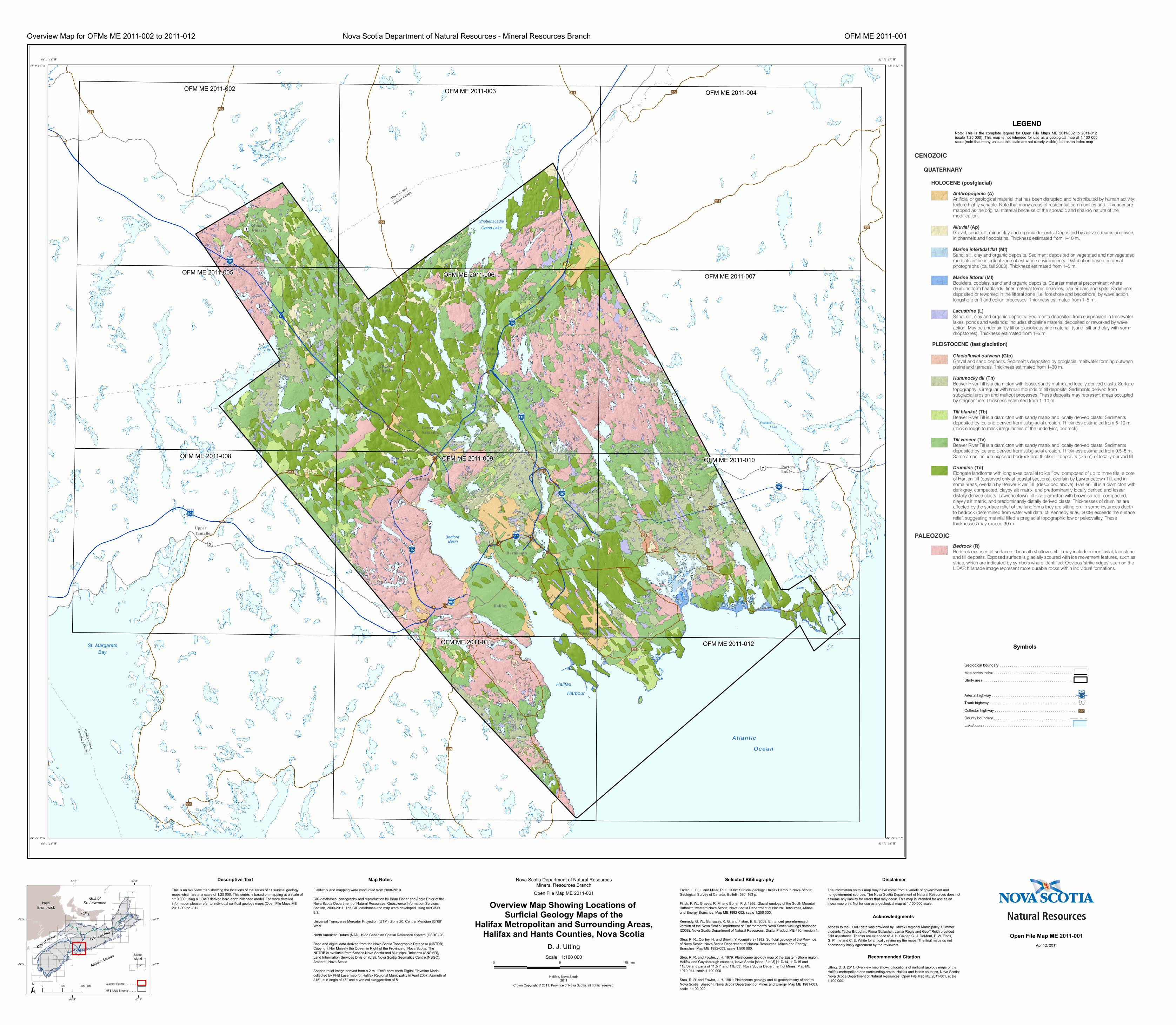
OFM ME 2011-002 OFM ME 2011-003 OFM ME 2011-004
OFM ME 2011-005 OFM ME 2011-006 OFM ME 2011-007
OFM ME 2011-008 OFM ME 2011-009 OFM ME 2011-010
OFM ME 2011-011 OFM ME 2011-012
Nova Scotia Department of Natural ResourcesMineral Resources Branch
0 5 10 km
Open File Map ME 2011-001
Overview Map Showing Locations of Surficial Geology Maps of the
Halifax Metropolitan and Surrounding Areas,Halifax and Hants Counties, Nova Scotia
Gulf ofSt. Lawrence
Bay of FundyNova Scotia
Atlantic Ocean SableIsland
NewBrunswick
P.E.I.
60°W
60°W
64°W
64°W
46°N 46°N
44°N 44°N
± 0 100 200 km
D. J. UttingScale 1:100 000
Crown Copyright © 2011, Province of Nova Scotia, all rights reserved.
Halifax, Nova Scotia2011
Nova Scotia Department of Natural Resources - Mineral Resources BranchOverview Map for OFMs ME 2011-002 to 2011-012 OFM ME 2011-001
Symbols
This is an overview map showing the locations of the series of 11 surficial geologymaps which are at a scale of 1:25 000. This series is based on mapping at a scale of1:10 000 using a LiDAR derived bare-earth hillshade model. For more detailedinformation please refer to individual surifical geology maps (Open File Maps ME2011-002 to -012).
Fieldwork and mapping were conducted from 2008-2010.
GIS databases, cartography and reproduction by Brian Fisher and Angie Ehler of theNova Scotia Department of Natural Resources, Geoscience Information ServicesSection, 2009-2011. The GIS databases and map were developed using ArcGIS®9.3.
Universal Transverse Mercator Projection (UTM), Zone 20, Central Meridian 63°00'West.
North American Datum (NAD) 1983 Canadian Spatial Reference System (CSRS) 98.
Base and digital data derived from the Nova Scotia Topographic Database (NSTDB),Copyright Her Majesty the Queen in Right of the Province of Nova Scotia. TheNSTDB is available from Service Nova Scotia and Municipal Relations (SNSMR),Land Information Services Division (LIS), Nova Scotia Geomatics Centre (NSGC),Amherst, Nova Scotia.
Shaded relief image derived from a 2 m LiDAR bare-earth Digital Elevation Model,collected by PHB Lasermap for Halifax Regional Municipality in April 2007. Azimuth of315°, sun angle of 45° and a vertical exaggeration of 5.
Utting, D. J. 2011: Overview map showing locations of surficial geology maps of theHalifax metropolitan and surrounding areas, Halifax and Hants counties, Nova Scotia;Nova Scotia Department of Natural Resources, Open File Map ME 2011-001, scale1:100 000.
Map NotesDescriptive Text
The information on this map may have come from a variety of government andnongovernment sources. The Nova Scotia Department of Natural Resources does notassume any liability for errors that may occur. This map is intended for use as anindex map only. Not for use as a geological map at 1:100 000 scale.
DisclaimerSelected Bibliography
Access to the LiDAR data was provided by Halifax Regional Municipality. Summerstudents Teaka Broughm, Fiona Gallacher, Jamar Regis and Geoff Reith providedfield assistance. Thanks are extended to J. H. Calder, G. J. DeMont, P. W. Finck,G. Prime and C. E. White for critically reviewing the maps. The final maps do notnecessarily imply agreement by the reviewers.
Acknowledgments
Recommended Citation
Fader, G. B. J. and Miller, R. O. 2008: Surficial geology, Halifax Harbour, Nova Scotia;Geological Survey of Canada, Bulletin 590, 163 p.
Finck, P. W., Graves, R. M. and Boner, F. J. 1992: Glacial geology of the South MountainBatholith, western Nova Scotia; Nova Scotia Department of Natural Resources, Minesand Energy Branches, Map ME 1992-002, scale 1:250 000.
Kennedy, G. W., Garroway, K. G. and Fisher, B. E. 2009: Enhanced georeferencedversion of the Nova Scotia Department of Environment's Nova Scotia well logs database(2008); Nova Scotia Department of Natural Resources, Digital Product ME 430, version 1.
Stea, R. R., Conley, H. and Brown, Y. (compilers) 1992: Surficial geology of the Provinceof Nova Scotia; Nova Scotia Department of Natural Resources, Mines and EnergyBranches, Map ME 1992-003, scale 1:500 000.
Stea, R. R. and Fowler, J. H. 1979: Pleistocene geology map of the Eastern Shore region,Halifax and Guysborough counties, Nova Scotia [sheet 3 of 3] [11D/14, 11D/15 and11E/02 and parts of 11D/11 and 11E/03]; Nova Scotia Department of Mines, Map ME1979-014, scale 1:100 000.
Stea, R. R. and Fowler, J. H. 1981: Pleistocene geology and till geochemistry of centralNova Scotia [Sheet 4]; Nova Scotia Department of Mines and Energy, Map ME 1981-001,scale 1:100 000.
Current Extent . . . . . . .
NTS Map Sheets . . . . .
64° 1' 48'' W
45° 0' 39'' N
64° 1' 14'' W
44° 29' 6'' N
63° 13' 30'' W
44° 29' 21'' N
63° 13' 37'' W
45° 0' 55'' N
Apr 12, 2011
Open File Map ME 2011-001
Note: This is the complete legend for Open File Maps ME 2011-002 to 2011-012(scale 1:25 000). This map is not intended for use as a geological map at 1:100 000scale (note that many units at this scale are not clearly visible), but as an index map
LEGEND
Anthropogenic
Alluvial
(A)
(Ap)
Marine intertidal flat
Marine littoral
Lacustrine
Glaciofluvial outwash
Hummocky till
Till blanket
Till veneer
Drumlins
Bedrock
Artificial or geological material that has been disrupted and redistributed by human activity; texture highly variable. Note that many areas of residential communities and till veneer are mapped as the original material because of the sporadic and shallow nature of the modification.
Gravel, sand, silt, minor clay and organic deposits. Deposited by active streams and rivers in channels and floodplains. Thickness estimated from 1–10 m.
Sand, silt, clay and organic deposits. Sediment deposited on vegetated and nonvegetated mudflats in the intertidal zone of estuarine environments. Distribution based on aerial photographs (ca. fall 2003). Thickness estimated from 1–5 m.
Boulders, cobbles, sand and organic deposits. Coarser material predominant where drumlins form headlands; finer material forms beaches, barrier bars and spits. Sediments deposited or reworked in the littoral zone (i.e. foreshore and backshore) by wave action, longshore drift and eolian processes. Thickness estimated from 1–5 m.
Sand, silt, clay and organic deposits. Sediments deposited from suspension in freshwater lakes, ponds and wetlands; includes shoreline material deposited or reworked by wave action. May be underlain by till or glaciolacustrine material (sand, silt and clay with some dropstones). Thickness estimated from 1–5 m.
Gravel and sand deposits. Sediments deposited by proglacial meltwater forming outwash plains and terraces. Thickness estimated from 1–30 m.
Beaver River Till is a diamicton with loose, sandy matrix and locally derived clasts. Surface topography is irregular with small mounds of till deposits. Sediments derived from subglacial erosion and meltout processes. These deposits may represent areas occupied by stagnant ice. Thickness estimated from 1–10 m.
Beaver River Till is a diamicton with sandy matrix and locally derived clasts. Sediments deposited by ice and derived from subglacial erosion. Thickness estimated from 5–10 m (thick enough to mask irregularities of the underlying bedrock).
Beaver River Till is a diamicton with sandy matrix and locally derived clasts. Sediments deposited by ice and derived from subglacial erosion. Thickness estimated from 0.5–5 m. Some areas include exposed bedrock and thicker till deposits (>5 m) of locally derived till.
Elongate landforms with long axes parallel to ice flow, composed of up to three tills: a core of Hartlen Till (observed only at coastal sections), overlain by Lawrencetown Till, and in some areas, overlain by Beaver River Till (described above). Hartlen Till is a diamicton with dark grey, compacted, clayey silt matrix, and predominantly locally derived and lesser distally derived clasts. Lawrencetown Till is a diamicton with brownish-red, compacted, clayey silt matrix, and predominantly distally derived clasts. Thicknesses of drumlins are affected by the surface relief of the landforms they are sitting on. In some instances depth to bedrock (determined from water well data, cf. Kennedy ., 2009) exceeds the surface relief, suggesting material filled a preglacial topographic low or paleovalley. These thicknesses may exceed 30 m.
Bedrock exposed at surface or beneath shallow soil. It may include minor fluvial, lacustrine and till deposits. Exposed surface is glacially scoured with ice movement features, such as striae, which are indicated by symbols where identified. Obvious 'strike ridges' seen on the LiDAR hillshade image represent more durable rocks within individual formations.
(Mf)
(Ml)
(L)
(Gfp)
(Th)
(Tb)
(Tv)
(Td)
(R)
et al
PLEISTOCENE (last glaciation)
PALEOZOIC
CENOZOIC
QUATERNARY
HOLOCENE (postglacial)
Geological boundary . . . . . . . . . . . . . . . . . . . . . . . . . . . . . .
Map series index . . . . . . . . . . . . . . . . . . . . . . . . . . . . . . . . . . . . . .
Study area . . . . . . . . . . . . . . . . . . . . . . . . . . . . . . . . . . . . . . . . . . .
Arterial highway . . . . . . . . . . . . . . . . . . . . . . . . . . . . . . . . . . . . . . . . .
Trunk highway . . . . . . . . . . . . . . . . . . . . . . . . . . . . . . . . . . . . . . . . .
Collector highway . . . . . . . . . . . . . . . . . . . . . . . . . . . . . . . . . . . . . . .
County boundary . . . . . . . . . . . . . . . . . . . . . . . . . . . . . . . . . . . .
Lake/ocean . . . . . . . . . . . . . . . . . . . . . . . . . . . . . . . . . . . . . . . . . .
4
102
333
Recommended