Northumberland Level 2 Strategic Flood Risk Assessment
Final
October 2015
47070326
Prepared for: Northumberland County Council
UNITED KINGDOM & IRELAND
Northumberland County Council — Level 2 Strategic Flood Risk Assessment
FINAL October 2015
1
REVISION SCHEDULE
Rev Date Details Prepared by Reviewed by Approved by
1 October 2014 Draft Srimali Dixon
Senior Assistant Engineer
Catherine Minor
Assistant Engineer
Ruth Goodall
Technical Director
Ruth Goodall
Technical Director
2 May 2015 Final– Inclusion of NWL, NCC and EA comments
Srimali Dixon
Engineer
Catherine Minor
Assistant Engineer
Ruth Goodall
Technical Director
Ruth Goodall
Technical Director
3 July 2015 Final Rizal Roney
Engineer
Catherine Minor
Assistant Engineer
Jaime Ball
Principal Engineer
Jaime Ball
Principal Engineer
4 October 2015 Final Catherine Minor
Assistant Engineer
Jaime Ball
Principal Engineer
Simon Keys
Associate
URS Infrastructure & Environment UK Limited Cedar House 2nd Floor, Building IV III Acre Princeton Drive Teesdale Business Park Stockton on Tees TS17 6FB Tel: 0191 230 7700
Northumberland County Council — Level 2 Strategic Flood Risk Assessment
FINAL October 2015
2
Limitations
URS Infrastructure & Environment UK Limited (“URS”) has prepared this Report for the sole use of Northumberland County Council (“Client”) in accordance with the Agreement under which our services were performed 47070326 and February 2014. No other warranty, expressed or implied, is made as to the professional advice included in this Report or any other services provided by URS. This Report is confidential and may not be disclosed by the Client nor relied upon by any other party without the prior and express written agreement of URS.
The conclusions and recommendations contained in this Report are based upon information provided by others and upon the assumption that all relevant information has been provided by those parties from whom it has been requested and that such information is accurate. Information obtained by URS has not been independently verified by URS, unless otherwise stated in the Report.
The methodology adopted and the sources of information used by URS in providing its services are outlined in this Report. The work described in this Report was undertaken between May 2014 and October 2015 and is based on the conditions encountered and the information available during the said period of time. The scope of this Report and the services are accordingly factually limited by these circumstances.
Where assessments of works or costs identified in this Report are made, such assessments are based upon the information available at the time and where appropriate are subject to further investigations or information which may become available.
URS disclaim any undertaking or obligation to advise any person of any change in any matter affecting the Report, which may come or be brought to URS’ attention after the date of the Report.
Certain statements made in the Report that are not historical facts may constitute estimates, projections or other forward-looking statements and even though they are based on reasonable assumptions as of the date of the Report, such forward-looking statements by their nature involve risks and uncertainties that could cause actual results to differ materially from the results predicted. URS specifically does not guarantee or warrant any estimate or projections contained in this Report.
Unless otherwise stated in this Report, the assessments made assume that the sites and facilities will continue to be used for their current purpose without significant changes.
Since January 2015 URS Infrastructure & Environment UK Limited is now known as AECOM Infrastructure & Environment UK Limited.
Copyright
© This Report is the copyright of URS Infrastructure & Environment UK Limited. Any unauthorised reproduction or usage by any person other than the addressee is strictly prohibited.
Northumberland County Council — Level 2 Strategic Flood Risk Assessment
FINAL October 2015
3
TABLE OF CONTENTS ABBREVIATIONS.......................................................................... 5 GLOSSARY .................................................................................. 7 1 INTRODUCTION........................................................... 9 1.1 Planning Context......................................................... 9
1.2 SFRA Overview ........................................................... 9 1.3 Aims of the Level 2 SFRA............................................ 9 1.4 Level 2 SFRA Objectives ............................................10
1.5 Scope of Level 2 SFRA ...............................................10 1.6 Study Area..................................................................11 2 SEQUENTIAL APPROACH TO SITE ALLOCATION .....14
2.1 Flood Zone Definition .................................................14 2.2 Development Vulnerability .........................................14 2.3 Sequential Test ..........................................................16
2.4 Exception Test ...........................................................17 3 LEVEL 2 SFRA METHODOLOGY ................................20 3.1 Overview ....................................................................20
3.2 Stakeholders ..............................................................20 3.3 Information/Data Collected.........................................20 3.4 Flooding from Rivers..................................................21
3.5 Flooding from the Land ..............................................21 3.6 Flooding from Groundwater .......................................24 3.7 Flooding from Sewers ................................................24
3.8 Flooding from Reservoirs, Canals and Other Artificial Sources ......................................................................24
3.9 Tidal Flooding ............................................................25
3.10 Consideration of Climate Change...............................26 4 LEVEL 2 STRATEGIC FLOOD RISK ASSESSMENT ....28 4.2 Core Strategy Delivery Area – South East : Amble .....30
4.3 Core Strategy Delivery Area – South East: Blyth........37 4.4 Core Strategy Delivery Area – South East : Cramlington
...................................................................................51
4.5 Core Strategy Delivery Area – Central: Hexham .........59 4.6 Core Strategy Delivery Area – Central: Prudhoe ........75 4.7 Core Strategy Delivery Area – Central: Ponteland......83
4.8 Core Strategy Delivery Area – North: Belford.............96 4.9 Core Strategy Delivery Area – North: Wooler ........... 104 4.10 Core Strategy Delivery Area – West: Haltwhistle...... 114
Northumberland County Council — Level 2 Strategic Flood Risk Assessment
FINAL October 2015
4
4.11 Core Strategy Delivery Area – West: Haydon Bridge 122 4.12 Core Strategy Delivery Area – West: Bellingham ..... 130
5 SITE-SPECIFIC FLOOD RISK ASSESSMENTS.......... 139 5.1 Overview .................................................................. 139 5.2 Detailed/Site-Specific Flood Risk Assessment......... 139
5.3 Site Vulnerability and Site Layout ............................ 140 5.4 Building Design........................................................ 140 5.5 Surface Water Management ..................................... 141
5.6 Climate Change ........................................................ 142 6 MITIGATION MEETING THE NPPF EXCEPTION TEST –
RESIDUAL RISK MITIGATION................................... 144
6.1 Residual Risks ......................................................... 144 6.2 Flood Resilience and Resistance Measures ............. 144 6.3 Emergency Access and Egress................................ 145
6.4 Flood Warning and Evacuation Plans ...................... 146 7 USER FRIENDLY GUIDE TO LEVEL 2 SFRA ............. 147 7.1 Planning Practice Guidance for Level 2 SFRAs........ 147
8 CONCLUSIONS AND RECOMMENDATIONS............. 151
Northumberland County Council — Level 2 Strategic Flood Risk Assessment
FINAL October 2015
5
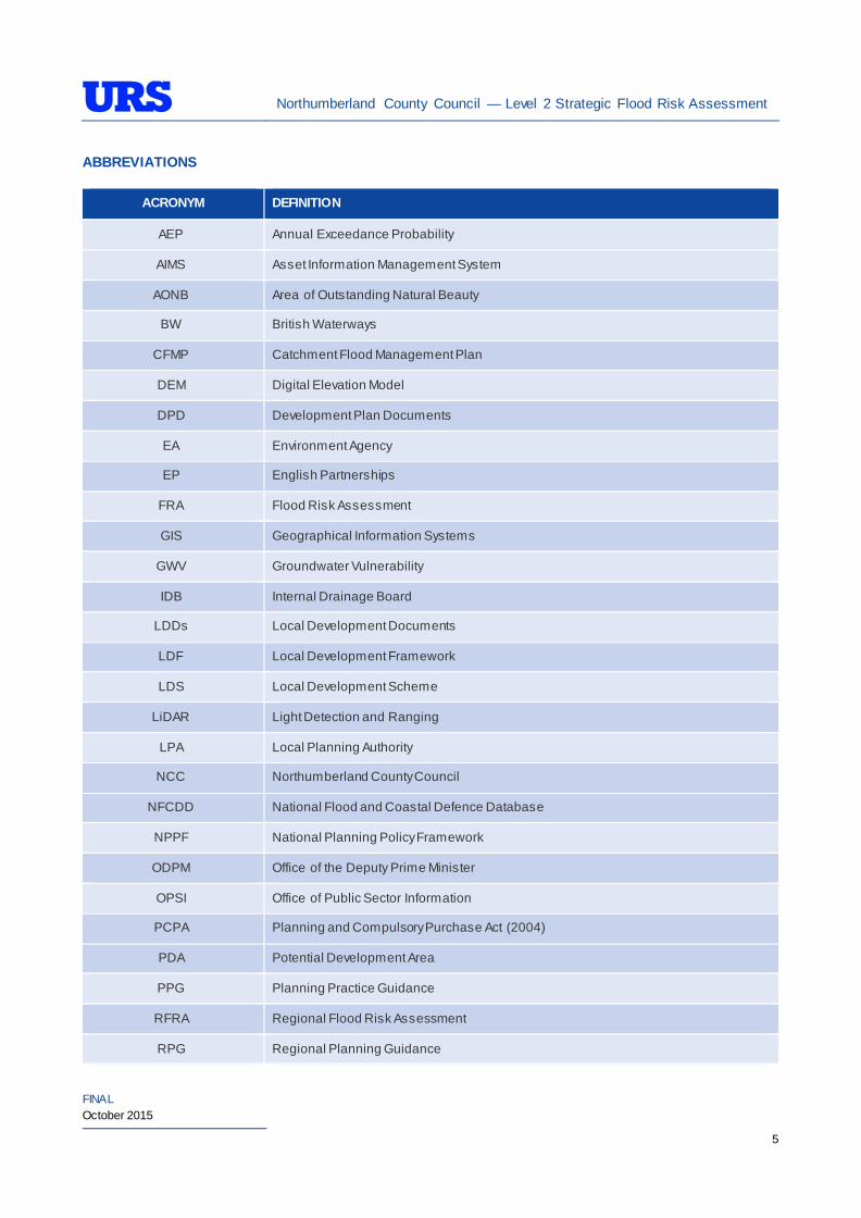
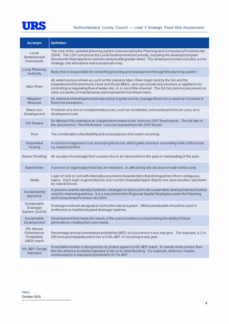
ABBREVIATIONS
ACRONYM DEFINITION
AEP Annual Exceedance Probability
AIMS Asset Information Management System
AONB Area of Outstanding Natural Beauty
BW British Waterways
CFMP Catchment Flood Management Plan
DEM Digital Elevation Model
DPD Development Plan Documents
EA Environment Agency
EP English Partnerships
FRA Flood Risk Assessment
GIS Geographical Information Systems
GWV Groundwater Vulnerability
IDB Internal Drainage Board
LDDs Local Development Documents
LDF Local Development Framework
LDS Local Development Scheme
LiDAR Light Detection and Ranging
LPA Local Planning Authority
NCC Northumberland County Council
NFCDD National Flood and Coastal Defence Database
NPPF National Planning Policy Framework
ODPM Office of the Deputy Prime Minister
OPSI Office of Public Sector Information
PCPA Planning and Compulsory Purchase Act (2004)
PDA Potential Development Area
PPG Planning Practice Guidance
RFRA Regional Flood Risk Assessment
RPG Regional Planning Guidance
Northumberland County Council — Level 2 Strategic Flood Risk Assessment
FINAL October 2015
6
ACRONYM DEFINITION
RSS Regional Spatial Strategy
SAR Synthetic Aperture Radar
SA Sustainability Assessment
SFRA Strategic Flood Risk Assessment
SHLAA Strategic Housing Land Availability Assessment
SOS Standard of Service (specifically relating to the performance of water infrastructure)
SPG Supplementary Planning Guidance
SPZ Source Protection Zone
SSSI Site of Special Scientific Interest
SW Scott Wilson (now URS)
URS URS Infrastructure & Environment
Northumberland County Council — Level 2 Strategic Flood Risk Assessment
FINAL October 2015
7
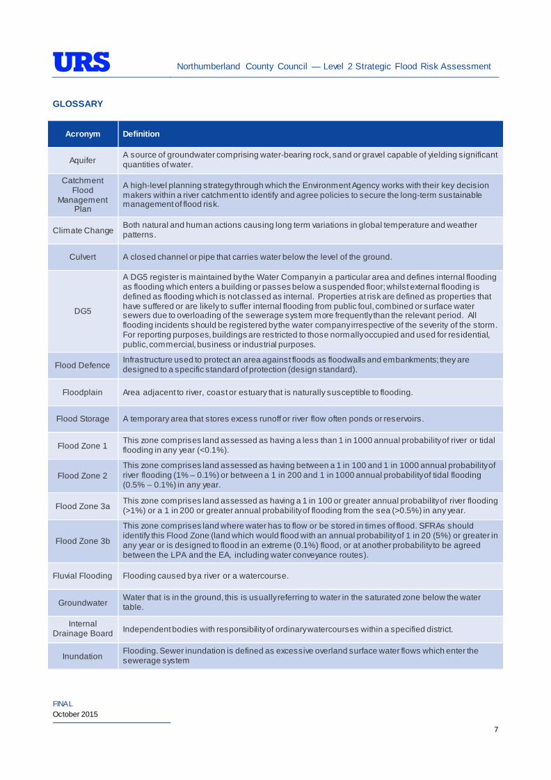
GLOSSARY
Acronym Definition
Aquifer A source of groundwater comprising water-bearing rock, sand or gravel capable of yielding significant quantities of water.
Catchment Flood
Management Plan
A high-level planning strategy through which the Environment Agency works with their key decision makers within a river catchment to identify and agree policies to secure the long-term sustainable management of flood risk.
Climate Change Both natural and human actions causing long term variations in global temperature and weather patterns.
Culvert A closed channel or pipe that carries water below the level of the ground.
DG5
A DG5 register is maintained by the Water Company in a particular area and defines internal flooding as flooding which enters a building or passes below a suspended floor; whilst external flooding is defined as flooding which is not classed as internal. Properties at risk are defined as properties that have suffered or are likely to suffer internal flooding from public foul, combined or surface water sewers due to overloading of the sewerage system more frequently than the relevant period. All flooding incidents should be registered by the water company irrespective of the severity of the storm. For reporting purposes, buildings are restricted to those normally occupied and used for residential, public, commercial, business or industrial purposes.
Flood Defence Infrastructure used to protect an area against floods as floodwalls and embankments; they are designed to a specific standard of protection (design standard).
Floodplain Area adjacent to river, coast or estuary that is naturally susceptible to flooding.
Flood Storage A temporary area that stores excess runoff or river flow often ponds or reservoirs.
Flood Zone 1 This zone comprises land assessed as having a less than 1 in 1000 annual probability of river or tidal flooding in any year (<0.1%).
Flood Zone 2 This zone comprises land assessed as having between a 1 in 100 and 1 in 1000 annual probability of river flooding (1% – 0.1%) or between a 1 in 200 and 1 in 1000 annual probability of tidal flooding (0.5% – 0.1%) in any year.
Flood Zone 3a This zone comprises land assessed as having a 1 in 100 or greater annual probability of river flooding (>1%) or a 1 in 200 or greater annual probability of flooding from the sea (>0.5%) in any year.
Flood Zone 3b This zone comprises land where water has to flow or be stored in times of flood. SFRAs should identify this Flood Zone (land which would flood with an annual probability of 1 in 20 (5%) or greater in any year or is designed to flood in an extreme (0.1%) flood, or at another probability to be agreed between the LPA and the EA, including water conveyance routes).
Fluvial Flooding Flooding caused by a river or a watercourse.
Groundwater Water that is in the ground, this is usually referring to water in the saturated zone below the water table.
Internal Drainage Board Independent bodies with responsibility of ordinary watercourses within a specified district.
Inundation Flooding. Sewer inundation is defined as excessive overland surface water flows which enter the sewerage system
Northumberland County Council — Level 2 Strategic Flood Risk Assessment
FINAL October 2015
8
Acronym Definition
Local Development Framework
The core of the updated planning system (introduced by the Planning and Compulsory Purchase Act 2004). The LDF comprises the Local Development Documents, including the development plan documents that expand on policies and provide greater detail. The development plan includes a core strategy, site allocations and a proposals map.
Local Planning Authority Body that is responsible for controlling planning and development through the planning system.
Main River All watercourses shown as such on the statutory Main River maps held by the EA and the Department of Environment, Food and Rural Affairs, and can include any structure or appliance for controlling or regulating flow of water into, in or out of the channel. The EA has permissive powers to carry out works of maintenance and improvement on these rivers.
Mitigation Measure
An element of development design which may be used to manage flood risk or avoid an increase in flood risk elsewhere.
Mixed-use Development
Provision of a mix of complementary uses, such as residential, community and leisure uses, on a development site.
Pitt Review Sir Michael Pitt undertook an independent review of the Summer 2007 flood events. The full title of the document is ‘The Pitt Review: Lessons learned from the 2007 floods’
Risk The combination of probability and consequence of an event occurring.
Sequential Testing
A risk based approach in to assessing flood risk, which gives priority in ascending order of flood risk, i.e. lowest risk first.
Sewer Flooding An escape of sewerage from a sewer due to an obstruction in the pipe or overloading of the pipe.
Stakeholder A person or organisation that has an interest in, or affected by the decisions made within a site.
Strata Layer of rock or soil with internally consistent characteristics that distinguishes it from contiguous layers. Each layer is generally one of a number of parallel layers that lie one upon another, laid down by natural forces.
Sustainability Appraisal
A process used to identify if policies, strategies or plans promote sustainable development and further used for improving policies. It is a requirement for Regional Spatial Strategies under the Planning and Compulsory Purchase Act 2004.
Sustainable Drainage
System (SuDS) Drainage methods designed to mimic the natural system. Where practicable should be used in preference to traditional piped drainage systems.
Sustainable Development
Development that meets the needs of the present without compromising the ability of future generations meeting their own needs.
X% Annual Exceedance Probability
(AEP) event
Percentage annual exceedance probability (AEP) of occurrence in any one year. For example, a 1 in 200 annual probability event has a 0.5% AEP of occurring in any year.
X% AEP Design Standard
Flood defence that is designed for to protect against a X% AEP event. In events more severe than this the defence would be expected to fail or to allow flooding. For example, defences may be constructed to a standard of protection of 1% AEP.
Northumberland County Council — Level 2 Strategic Flood Risk Assessment
FINAL October 2015
9
1 INTRODUCTION
1.1 Planning Context
The National Planning Policy Framework i (NPPF) and accompanying Planning Practice Guidance for Flood Risk and Coastal Changeii (PPG) emphasise the responsibility of Local Planning Authorities (LPAs) to ensure that flood risk is understood and managed effectively in their areas using a risk-based approach throughout all stages of the planning process. The NPPF requires LPAs to undertake Strategic Flood Risk Assessments (SFRAs) to support the preparation of their Local Plan.
The NPPF was published in March 2012 and replaces the Planning Policy Statement 25 (PPS25) Development and Flood Risk iii. The accompanying NPPF Technical Guidanceiv also published in March 2012 retained reference to the PPS25 Practice Guidancev , but this too has now been superseded by the revised Planning Practice Guidance (PPG) published as an on-line resource in 2014. This Level 2 SFRA has been prepared in accordance with the principles set out in the NPPF and latest supporting PPG.
The NPPF and supporting guidance require LPAs to undertake SFRAs and to use their findings, and those of other studies, to inform strategic land use planning. This includes the application of the Sequential Test which seeks to steer development towards areas of lowest flood risk prior to consideration of areas of greater risk.
1.2 SFRA Overview
Scott Wilson, now part of URS Infrastructure & Environment UK Limited (URS), was commissioned by Northumberland County Council (NCC), to undertake an SFRA for the newly formed Northumberland unitary authority area in May 2009. As part of the commission, URS completed a Level 1 SFRA for NCC.
The Final Level 1 SFRA was published in October 2010 and the recommendations that were made have been used to inform the Sustainability Appraisal (SA), whilst formulating the policies and proposals laid out in the Core Strategy.
At the time when NCC undertook consultation on the Northumberland Local Plan: Core Strategy, Preferred Options for Housing, Employment and Green Belt, preferred broad locations for development in and within proximity of Main Towns and Service Centres were identified. The Level 2 SFRA, therefore assesses these preferred locations, as well as alternative and additional areas. Since then, the Council has published a Full Draft Plan, which reverts from identifying preferred broad locations in and within proximity of Main Towns and Service Centres. Instead the Plan identifies strategic sites for development which are central to the delivery of the Core Strategy. In addition, the Full Draft Plan identifies a number of areas which will require Green Belt removal. Notwithstanding this, it is understood that those preferred broad locations for development, corresponding to those assessed in the Core Strategy, Preferred Options for Housing, Employment and Green Belt document, may be taken forward and form part of the forthcoming Delivery DPD/ Neighbourhood Plans and that the assessments in this SFRA Level 2 document will inform that process.
1.3 Aims of the Level 2 SFRA
A Level 2 SFRA is primarily based upon fluvial and coastal (where applicable) Flood Zones. However, the PPG also makes reference to other sources of flooding.
In general, a Level 2 SFRA provides increased scope from a Level 1 SFRA. In accordance with the PPG, the increased scope is required in locations where the Sequential Test identifies that development pressures exist and where sites are located in areas that are at medium or
Northumberland County Council — Level 2 Strategic Flood Risk Assessment
FINAL October 2015
10
high flood risk (i.e. Flood Zone 2 or Flood Zone 3 respectively), and there are no other suitable alternative areas for development. This takes into account the flood vulnerability category of the intended use and subsequently identifies where more detailed information is required.
Following completion of a Level 2 SFRA, the sequential approach to site allocation can be reconsidered by the LPA for PDAs within Flood Zone 2 and Flood Zone 3 (PPG). In order to satisfy the requirements of the Exception Test to be incorporated into the Local Development Documents (LDDs), the Level 2 SFRA will ensure that policies and practices are considered for development sites located in areas of flood risk.
1.4 Level 2 SFRA Objectives
As identified in the Environment Agency (EA) SFRA Guidance to support the National Planning Policy Framework v i , the main objectives of this Level 2 SFRA are:
• An appraisal of the current condition of flood defence infrastructure and of likely future flood management policy with regard to its maintenance and upgrade (see below);
• An appraisal of the probability and consequences of overtopping or failure of flood risk management infrastructure, including an appropriate allowance for climate change (see below);
• Definition and mapping of the functional floodplain in locations where this is required;
• Production of maps showing the distribution of flood risk across all flood zones from all sources of flooding taking climate change into account;
• Provision of advice on appropriate policies for sites which could satisfy the first part of the Exception Test (sustainability benefits to the community that outweigh flood risk), and on the requirements that would be necessary for a site-specific flood risk assessment supporting a planning application for a particular application to pass the second part of the Exception Test;
• Provision of advice on the preparation of site-specific flood risk assessments for sites of varying risk across the flood zones, including information about the use of sustainable drainage techniques; and
• Meaningful recommendations to inform policy, development control and technical issues.
1.5 Scope of Level 2 SFRA
Following discussions with NCC and in accordance with NPPF and PPG, the following scope has been agreed for the Level 2 SFRA.
Level 2 assessments have been undertaken within tables in Section 4 of this report for the potential development areas listed in Table 1 1. The potential development areas which are primarily susceptible to either fluvial or tidal flood risk have been filtered from the data provided by NCC following their recent Core Strategy consultation.
The assessments in Section 4 determine the flood risk issues relative to the following sources of flooding considering the vulnerability classification of the proposed land uses at the potential development areas:
• Rivers/Sea (Fluvial/ Tidal);
• Surface Water Runoff from Land (Pluvial);
• Groundwater;
• Sewers; and

Northumberland County Council — Level 2 Strategic Flood Risk Assessment
FINAL October 2015
11
• Other Artificial Sources (Reservoirs and Canals).
In addition to the potential development areas, a number of Strategic Housing Land Availability Assessment (SHLAA) sites have been identified as either located within or bordering a Flood Zone. The sites have been assessed through the SHLAA process and the site yield information within the SHLAA reflects the fact that part of these sites fall within a Flood Zone. The commentary which accompanies the SHLAA assessments indicates that development would be excluded from the part of the site affected by flooding. Therefore, through consultation with NCC it was agreed that these sites do not need to be assessed as part of the Level 2 SFRA.
It does not mean that the sites excluded from this assessment are therefore safe from flooding. There are other sources of flood risk to consider and if the development site is adjacent to the existing flood extents, climate change may result in an increase in extents and therefore increase the flood risk to the proposed development site.
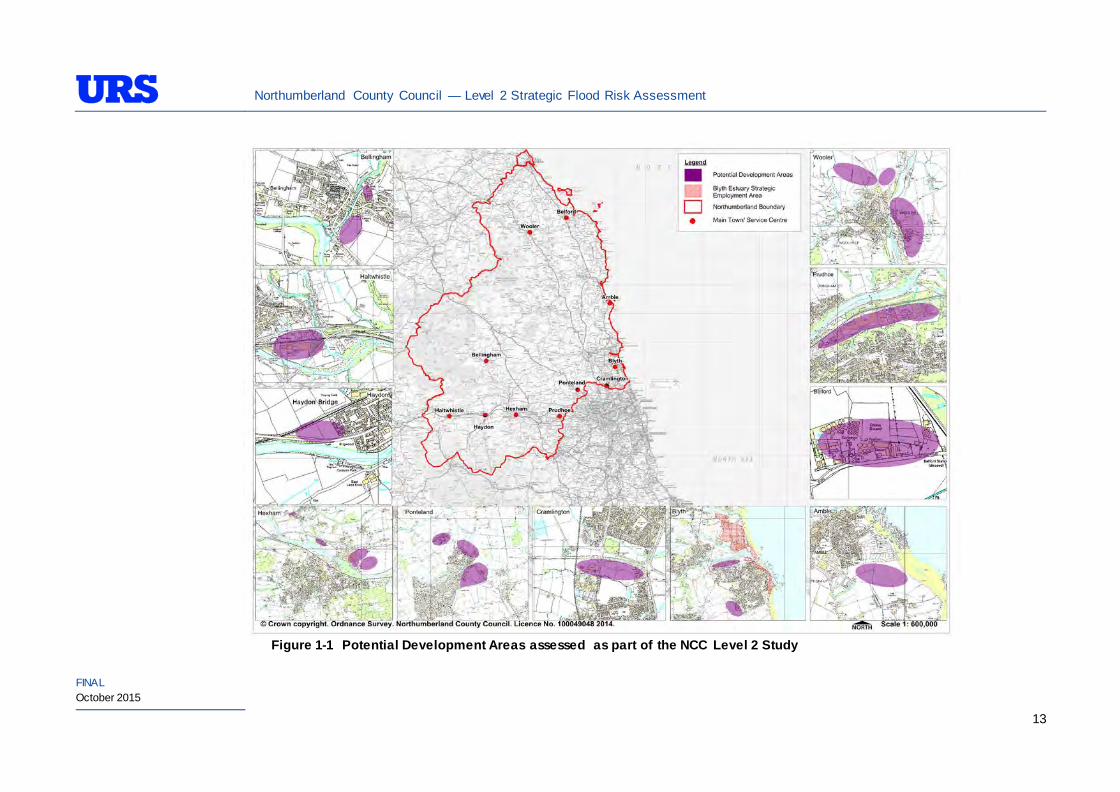
1.6 Study Area
The Level 2 SFRA assess a number of Potential Development Areas (PDAs) within the NCC administrative boundary, which are located in main towns and villages of the Core Strategy Delivery Areas (CSDAs), as detailed in Table 1-1 and illustrated in Figure 1-1
Table 1-1: Core Strategy Delivery Area – Potential Development Areas
Core Strategy Delivery Area (Main Town/ Service Centre)
Potential Development Area Name
Capacity (Housing sites
(hsg), employment
land (ha)
Area (Ha) Table No.
Core Strategy Delivery
Area – South East : Amble South East 740 (hsg) 53 4.1
Core Strategy Delivery
Area – South East : Blyth
C02 Riverside Park and
C03 Riverside Park,
Coniston Road
10.212 (ha) 10.212
4.2
Blyth Estuary Strategic Employment Area 208 (ha) 208
South West of Blyth 1,127 (hsg) 56.01
Core Strategy Delivery
Area – Central:
Cramlington
C10 Northumberland
Business Park 14.619 (ha) 14.619 4.3
Core Strategy Delivery
Area – Central: Hexham
East Hexham 8 (ha) 8
4.4 North Hexham 2 (ha) 2
E20 Former Bunker 1.373 (ha) 1.373
E08 Egger 7.675 (ha) 7.672
E15 Acomb 0.277 (ha) 0.277

Northumberland County Council — Level 2 Strategic Flood Risk Assessment
FINAL October 2015
12
Core Strategy Delivery Area (Main Town/ Service Centre)
Potential Development Area Name
Capacity (Housing sites
(hsg), employment
land (ha)
Area (Ha) Table No.
Core Strategy Delivery
Area – Central: Prudhoe
E12 Prudhoe plus land
held for expansion at E12
Low Prudhoe
6.594 (ha) 6.954 4.5
Core Strategy Delivery
Area – Central: Ponteland
North West of Ponteland 300 (hsg) 31
4.6 East of Ponteland 700 (hsg) 30
South East of Ponteland 600 (hsg), 3 ha 107
Ponteland Bypass 5km (length)
Core Strategy Delivery
Area – North: Belford B01 Belford 0.776 (ha) 0.776 4.7
Core Strategy Delivery
Area – North: Wooler
East of Wooler 380 (hsg) 35
4.8 North East of Wooler 200 (hsg) 9
North West of Wooler 380 (hsg) 22
Core Strategy Delivery
Area – West: Haltwhistle E03 Hadrian 1.449 (ha) 1.449 4.9
Core Strategy Delivery Area – West: Haydon Bridge
West of Haydon Bridge 80 (hsg) 2.20 4.10
Core Strategy Delivery
Area – West: Bellingham
South of Bellingham 65 (hsg) 2.9 4.11
E02 Foundry Road 0.223 (ha) 0.223
Northumberland County Council — Level 2 Strategic Flood Risk Assessment
FINAL October 2015
13
Figure 1-1 Potential Development Areas assessed as part of the NCC Level 2 Study
Northumberland County Council — Level 2 Strategic Flood Risk Assessment
FINAL October 2015
14
2 SEQUENTIAL APPROACH TO SITE ALLOCATION
2.1 Flood Zone Definition
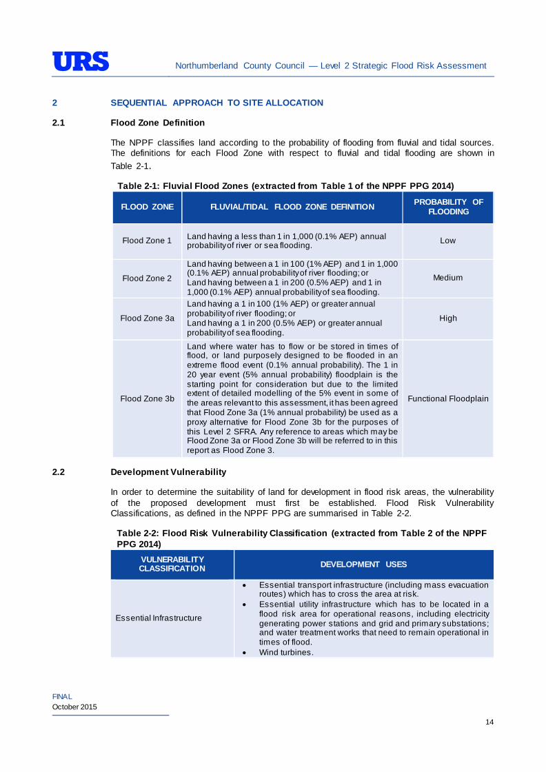
The NPPF classifies land according to the probability of flooding from fluvial and tidal sources. The definitions for each Flood Zone with respect to fluvial and tidal flooding are shown in Table 2-1.
Table 2-1: Fluvial Flood Zones (extracted from Table 1 of the NPPF PPG 2014)
FLOOD ZONE FLUVIAL/TIDAL FLOOD ZONE DEFINITION PROBABILITY OF FLOODING
Flood Zone 1 Land having a less than 1 in 1,000 (0.1% AEP) annual probability of river or sea flooding. Low
Flood Zone 2
Land having between a 1 in 100 (1% AEP) and 1 in 1,000 (0.1% AEP) annual probability of river flooding; or Land having between a 1 in 200 (0.5% AEP) and 1 in 1,000 (0.1% AEP) annual probability of sea flooding.
Medium
Flood Zone 3a
Land having a 1 in 100 (1% AEP) or greater annual probability of river flooding; or Land having a 1 in 200 (0.5% AEP) or greater annual probability of sea flooding.
High
Flood Zone 3b
Land where water has to flow or be stored in times of flood, or land purposely designed to be flooded in an extreme flood event (0.1% annual probability). The 1 in 20 year event (5% annual probability) floodplain is the starting point for consideration but due to the limited extent of detailed modelling of the 5% event in some of the areas relevant to this assessment, it has been agreed that Flood Zone 3a (1% annual probability) be used as a proxy alternative for Flood Zone 3b for the purposes of this Level 2 SFRA. Any reference to areas which may be Flood Zone 3a or Flood Zone 3b will be referred to in this report as Flood Zone 3.
Functional Floodplain
2.2 Development Vulnerability
In order to determine the suitability of land for development in flood risk areas, the vulnerability of the proposed development must first be established. Flood Risk Vulnerability Classifications, as defined in the NPPF PPG are summarised in Table 2-2.
Table 2-2: Flood Risk Vulnerability Classification (extracted from Table 2 of the NPPF PPG 2014)
VULNERABILITY CLASSIFICATION DEVELOPMENT USES
Essential Infrastructure
• Essential transport infrastructure (including mass evacuation routes) which has to cross the area at risk.
• Essential utility infrastructure which has to be located in a flood risk area for operational reasons, including electricity generating power stations and grid and primary substations; and water treatment works that need to remain operational in times of flood.
• Wind turbines.
Northumberland County Council — Level 2 Strategic Flood Risk Assessment
FINAL October 2015
15
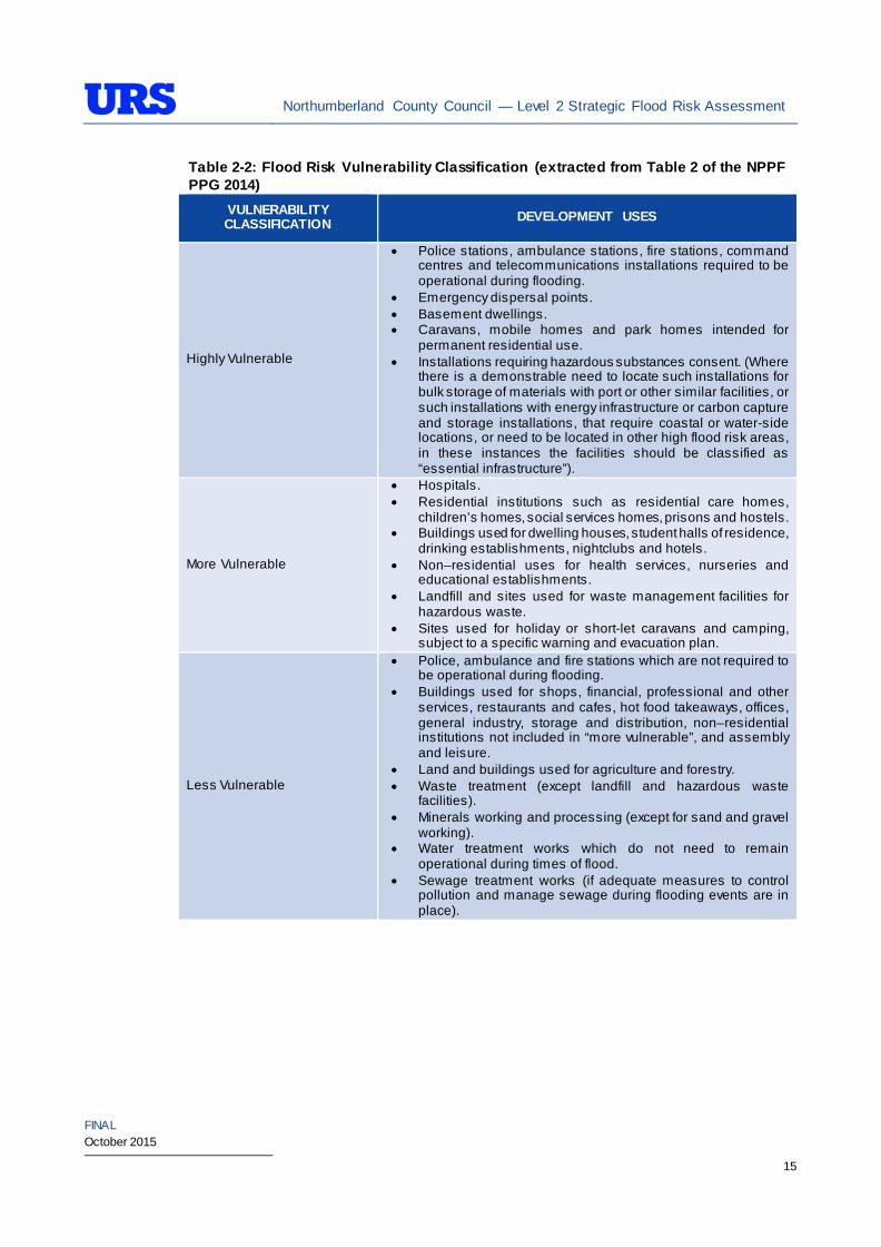
Table 2-2: Flood Risk Vulnerability Classification (extracted from Table 2 of the NPPF PPG 2014)
VULNERABILITY CLASSIFICATION DEVELOPMENT USES
Highly Vulnerable
• Police stations, ambulance stations, fire stations, command centres and telecommunications installations required to be operational during flooding.
• Emergency dispersal points. • Basement dwellings. • Caravans, mobile homes and park homes intended for
permanent residential use. • Installations requiring hazardous substances consent. (Where
there is a demonstrable need to locate such installations for bulk storage of materials with port or other similar facilities, or such installations with energy infrastructure or carbon capture and storage installations, that require coastal or water-side locations, or need to be located in other high flood risk areas, in these instances the facilities should be classified as “essential infrastructure”).
More Vulnerable
• Hospitals. • Residential institutions such as residential care homes,
children’s homes, social services homes, prisons and hostels. • Buildings used for dwelling houses, student halls of residence,
drinking establishments, nightclubs and hotels. • Non–residential uses for health services, nurseries and
educational establishments. • Landfill and sites used for waste management facilities for
hazardous waste. • Sites used for holiday or short-let caravans and camping,
subject to a specific warning and evacuation plan.
Less Vulnerable
• Police, ambulance and fire stations which are not required to be operational during flooding.
• Buildings used for shops, financial, professional and other services, restaurants and cafes, hot food takeaways, offices, general industry, storage and distribution, non–residential institutions not included in “more vulnerable”, and assembly and leisure.
• Land and buildings used for agriculture and forestry. • Waste treatment (except landfill and hazardous waste
facilities). • Minerals working and processing (except for sand and gravel
working). • Water treatment works which do not need to remain
operational during times of flood. • Sewage treatment works (if adequate measures to control
pollution and manage sewage during flooding events are in place).
Northumberland County Council — Level 2 Strategic Flood Risk Assessment
FINAL October 2015
16
Table 2-2: Flood Risk Vulnerability Classification (extracted from Table 2 of the NPPF PPG 2014)
VULNERABILITY CLASSIFICATION DEVELOPMENT USES
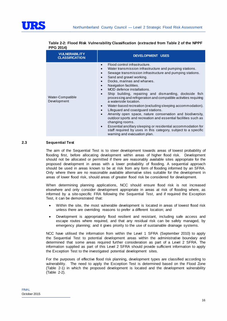
Water-Compatible Development
• Flood control infrastructure. • Water transmission infrastructure and pumping stations. • Sewage transmission infrastructure and pumping stations. • Sand and gravel working. • Docks, marinas and wharves. • Navigation facilities. • MOD defence installations. • Ship building, repairing and dismantling, dockside fish
processing and refrigeration and compatible activities requiring a waterside location.
• Water-based recreation (excluding sleeping accommodation). • Lifeguard and coastguard stations. • Amenity open space, nature conservation and biodiversity,
outdoor sports and recreation and essential facilities such as changing rooms.
• Essential ancillary sleeping or residential accommodation for staff required by uses in this category, subject to a specific warning and evacuation plan.
2.3 Sequential Test
The aim of the Sequential Test is to steer development towards areas of lowest probability of flooding first, before allocating development within areas of higher flood risk. Development should not be allocated or permitted if there are reasonably available sites appropriate for the proposed development in areas with a lower probability of flooding. A sequential approach should be used in areas known to be at risk from any form of flooding informed by an SFRA. Only where there are no reasonable available alternative sites suitable for the development in areas of lower flood risk, should areas of greater flood risk be considered for development.
When determining planning applications, NCC should ensure flood risk is not increased elsewhere and only consider development appropriate in areas at risk of flooding where, as informed by a site-specific FRA following the Sequential Test, and if required the Exception Test, it can be demonstrated that:
• Within the site, the most vulnerable development is located in areas of lowest flood risk unless there are overriding reasons to prefer a different location; and
• Development is appropriately flood resilient and resistant, including safe access and escape routes where required, and that any residual risk can be safely managed, by emergency planning; and it gives priority to the use of sustainable drainage systems.
NCC have utilised the information from within the Level 1 SFRA (September 2010) to apply the Sequential Test to potential development areas within the administrative boundary and determined that some areas required further consideration as part of a Level 2 SFRA. The information supplied as part of this Level 2 SFRA should provide sufficient information to apply the Exception Test to the investigated potential development sites.
For the purposes of effective flood risk planning, development types are classified according to vulnerability. The need to apply the Exception Test is determined based on the Flood Zone (Table 2-1) in which the proposed development is located and the development vulnerability (Table 2-2).
Northumberland County Council — Level 2 Strategic Flood Risk Assessment
FINAL October 2015
17
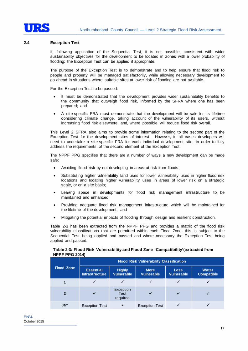
2.4 Exception Test
If, following application of the Sequential Test, it is not possible, consistent with wider sustainability objectives for the development to be located in zones with a lower probability of flooding; the Exception Test can be applied if appropriate.
The purpose of the Exception Test is to demonstrate and to help ensure that flood risk to people and property will be managed satisfactorily, while allowing necessary development to go ahead in situations where suitable sites at lower risk of flooding are not available.
For the Exception Test to be passed:
• It must be demonstrated that the development provides wider sustainability benefits to the community that outweigh flood risk, informed by the SFRA where one has been prepared; and
• A site-specific FRA must demonstrate that the development will be safe for its lifetime considering climate change, taking account of the vulnerability of its users, without increasing flood risk elsewhere, and, where possible, will reduce flood risk overall.
This Level 2 SFRA also aims to provide some information relating to the second part of the Exception Test for the development sites of interest. However, in all cases developers will need to undertake a site-specific FRA for each individual development site, in order to fully address the requirements of the second element of the Exception Test.
The NPPF PPG specifies that there are a number of ways a new development can be made safe:
• Avoiding flood risk by not developing in areas at risk from floods;
• Substituting higher vulnerability land uses for lower vulnerability uses in higher flood risk locations and locating higher vulnerability uses in areas of lower risk on a strategic scale, or on a site basis;
• Leaving space in developments for flood risk management infrastructure to be maintained and enhanced;
• Providing adequate flood risk management infrastructure which will be maintained for the lifetime of the development; and
• Mitigating the potential impacts of flooding through design and resilient construction.
Table 2-3 has been extracted from the NPPF PPG and provides a matrix of the flood risk vulnerability classifications that are permitted within each Flood Zone, this is subject to the Sequential Test being applied and passed and where necessary the Exception Test being applied and passed.
Table 2-3: Flood Risk Vulnerability and Flood Zone ‘Compatibility’(extracted from NPPF PPG 2014)
Flood Zone
Flood Risk Vulnerability Classification
Essential Infrastructure
Highly Vulnerable
More Vulnerable
Less Vulnerable
Water Compatible
1
2 Exception
Test required
3a† Exception Test Exception Test
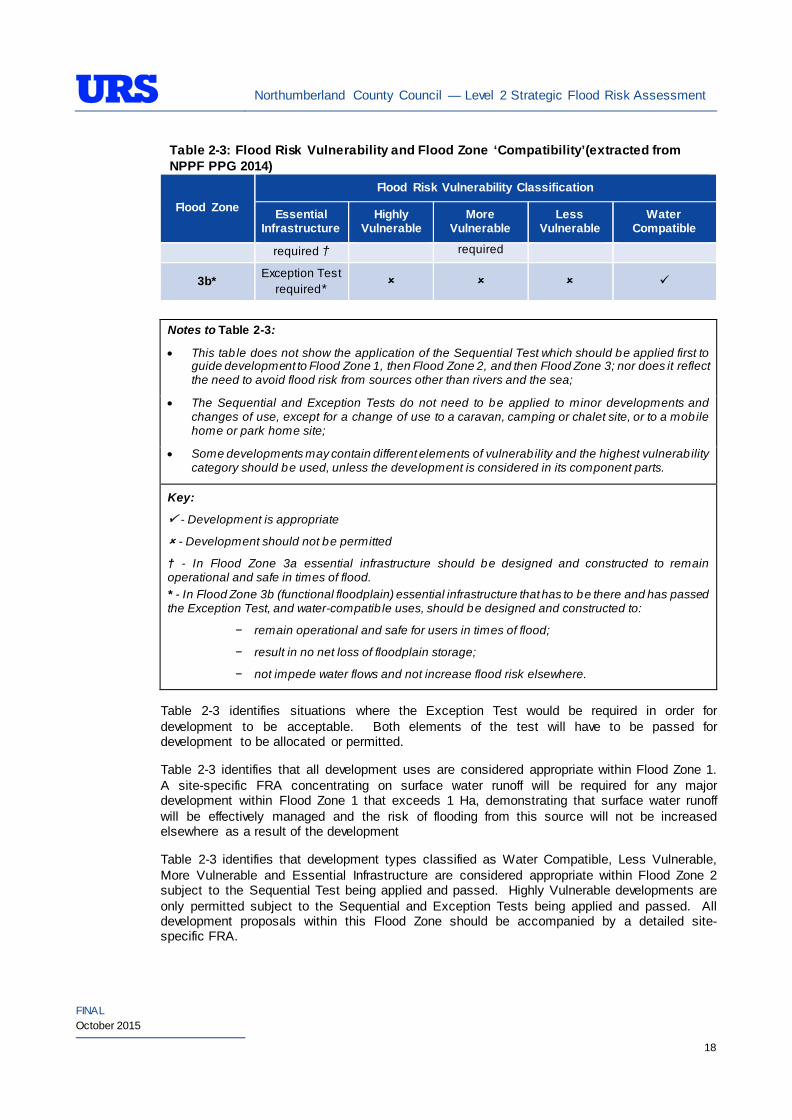
Northumberland County Council — Level 2 Strategic Flood Risk Assessment
FINAL October 2015
18
Table 2-3: Flood Risk Vulnerability and Flood Zone ‘Compatibility’(extracted from NPPF PPG 2014)
Flood Zone Flood Risk Vulnerability Classification
Essential Infrastructure
Highly Vulnerable
More Vulnerable
Less Vulnerable
Water Compatible
required † required
3b* Exception Test required*
Notes to Table 2-3:
• This tab le does not show the application of the Sequential Test which should be applied first to guide development to Flood Zone 1, then Flood Zone 2, and then Flood Zone 3; nor does it reflect the need to avoid flood risk from sources other than rivers and the sea;
• The Sequential and Exception Tests do not need to be applied to minor developments and changes of use, except for a change of use to a caravan, camping or chalet site, or to a mobile home or park home site;
• Some developments may contain different elements of vulnerability and the highest vulnerability category should be used, unless the development is considered in its component parts.
Key:
- Development is appropriate
- Development should not be permitted
† - In Flood Zone 3a essential infrastructure should be designed and constructed to remain operational and safe in times of flood. * - In Flood Zone 3b (functional floodplain) essential infrastructure that has to be there and has passed the Exception Test, and water-compatib le uses, should be designed and constructed to:
− remain operational and safe for users in times of flood;
− result in no net loss of floodplain storage;
− not impede water flows and not increase flood risk elsewhere.
Table 2-3 identifies situations where the Exception Test would be required in order for development to be acceptable. Both elements of the test will have to be passed for development to be allocated or permitted.
Table 2-3 identifies that all development uses are considered appropriate within Flood Zone 1. A site-specific FRA concentrating on surface water runoff will be required for any major development within Flood Zone 1 that exceeds 1 Ha, demonstrating that surface water runoff will be effectively managed and the risk of flooding from this source will not be increased elsewhere as a result of the development
Table 2-3 identifies that development types classified as Water Compatible, Less Vulnerable, More Vulnerable and Essential Infrastructure are considered appropriate within Flood Zone 2 subject to the Sequential Test being applied and passed. Highly Vulnerable developments are only permitted subject to the Sequential and Exception Tests being applied and passed. All development proposals within this Flood Zone should be accompanied by a detailed site-specific FRA.
Northumberland County Council — Level 2 Strategic Flood Risk Assessment
FINAL October 2015
19
Policy aims for Flood Zone 2 are such that developers and NCC should seek opportunities to reduce the overall level of risk in the area through the layout and form of the development and the appropriate application of Sustainable Drainage System (SuDS).
Table 2-3 identifies that development types classified as Water Compatible and Less Vulnerable are permitted within Flood Zone 3a subject to the Sequential Test being applied and passed. Highly Vulnerable land uses should not be permitted. More Vulnerable and Essential Infrastructure uses should only be permitted in this zone subject to the Sequential Test, sequential approach and Exception Test being applied and passed. Essential Infrastructure permitted in this zone should be designed and constructed to remain operational and safe for users in times of flood. All development proposals in this zone should be accompanied by a detailed site-specific FRA.
Policy aims within Flood Zone 3a are such that developers and NCC should seek opportunities to:
• Relocate existing development to land in zones with a lower probability of flooding;
• Reduce the overall level of flood risk in the area through the layout and form of the development, and the appropriate application of sustainable drainage techniques; and
• Create space for flooding to occur by restoring functional floodplain and flood flow paths and by identifying, allocating and safeguarding open space for flood storage.
Table 2-3 identifies that development types classified as Water Compatible is permitted within Flood Zone 3b subject to the Sequential Test being passed, and that Essential Infrastructure is permitted within this zone subject to the Exception Test also being applied and passed.
Any permitted development within Flood Zone 3b should be designed and constructed to:
• Remain operational and safe for users in times of flood;
• Result in no net loss of floodplain storage;
• Not impede water flows; and
• Not increase flood risk elsewhere.
All development proposals in this zone should be accompanied by a detailed site-specific FRA.
Policy aims in Flood Zone 3b are such that developers and NCC should seek opportunities to:
• Reduce the overall level of flood risk in the area through the layout and form of the development and the appropriate application of SuDS; and
• Relocate existing development to land with a lower probability of flooding.
Northumberland County Council — Level 2 Strategic Flood Risk Assessment
FINAL October 2015
20
3 LEVEL 2 SFRA METHODOLOGY
3.1 Overview
As outlined in Section 1.3, the main purpose of the Level 2 SFRA is to increase the scope undertaken for the Level 1 SFRA and provide sufficient information for the application of the Exception Test. This information is presented in concise, tabular format for each CSDA that summarises flood risk information and makes recommendations for the future development of each area.
3.2 Stakeholders
The key stakeholders that were contacted to provide data/information for the SFRA were:
• NCC;
• Environment Agency (EA), North East Region, North East Area; and
• Northumbrian Water Ltd (NW).
3.3 Information/Data Collected
A large quantity of data was collected for the Level 2 SFRA and a full list of data is included in Appendix A.
Key datasets are summarised below:
Environment Agency Data
The following data was obtained directly from the EA (North East Region, North East Area):
• EA Modelled Flood outlines;
• EA Groundwater Vulnerability Map;
• EA Areas Benefiting from Defences Outlines;
• EA updated Flood Maps for Surface Water (uFMfSW) Outlines;
• GIS Layer of detailed river network;
• National Flood and Coastal Defence Database (NFCDD);
• Historic flooding;
• Hydraulic models and flood levels by return period for areas covered in the Level 2 SFRA if available; and
• LiDAR data (via the EA Geomatics) for areas covered in the Level 2 SFRA.
Northumberland County Council Data/Information
In addition to the EA datasets the following data was obtained from NCC:
• Ordnance Survey (OS) maps (Mastermap, Streetview, 1:10,000, 1:50,000 and 1:250,000 scale);
• GIS layers for preferred, alternative and additional housing and employment potential development areas and SHLAA sites in each CSDA;
• County Boundary/District Boundaries (former); and
• SFRAs - All previously completed SFRAs (draft or final).
Northumberland County Council — Level 2 Strategic Flood Risk Assessment
FINAL October 2015
21
Northumbrian Water Limited
NW provided a number of datasets for use in the SFRA, including:
• 100m2 DG5 sewer flooding data; and
• Asset Records.
3.4 Flooding from Rivers
EA Flood Map has been used to identify the risk of fluvial (river) flooding at each of the areas:
The EA’s Flood Map and outputs from existing hydraulic models have been used to map Flood Zone 2, Flood Zone 3a and Flood Zone 3b (functional floodplain). For several watercourses within the study area, the EA hold detailed modelled flood outlines for the 1 in 25 year (4% AEP) or 1 in 20 year (5% AEP) flood events. Where this is the case, this data has been used to map the functional floodplain. Broad-scale models are not available for the functional floodplain and therefore where the 1 in 25 year or 1 in 20 year modelled flood outline is not available, Flood Zone 3a has been considered as a proxy to represent the functional floodplain until such a time that more detailed information is available, from such as an EA Strategic Flood Risk Mapping (SFRM) study or a site-specific FRA. This is not to say that the entire area used as a proxy is functional floodplain, moreover that the boundary of the functional floodplain falls somewhere within that area as recommended by the EA.
The EA update the national flood maps on a quarterly basis and would inform the Lead Local Flood Authority of any updates in their administrative area.
The EA NFCDD and AIMS datasets have been used to identify the presence of flood defences and the associated standard of protection (SoP) for each area.
For each area, maps showing the spatial distribution of the fluvial flood risk are presented in Section 4. Where applicable, detailed hazard mapping that allows planners and developers to apply the NPPF sequential approach within an area has been provided. This can inform site layouts and phasing, the vulnerability of proposed development and potential mitigation measures that can be incorporated into the site.
3.5 Flooding from the Land
The Pitt Review into the summer 2007 flooding in the UK identified the importance in quantifying the risk of flooding from land, or ‘surface water’ flooding. In response to the Pitt Review, the EA released Areas Susceptible to Surface Water Flooding (AStSWF) Maps in 2008/9. The AStSWF Maps were the first iteration (1st generation) maps used to quantify surface water flood risk on a national scale.
Accompanying guidance document published with the AStSWF Maps state that these maps have been produced using a simplified method where a single rainfall event has been used to analyse the surface water flooding. The method also excludes any underground sewerage and drainage systems, smaller over ground drainage systems and buildings. Therefore, the maps only provide a general indication of areas that are more likely to overwhelm from surface water flooding.
In 2010, the EA released the national Flood Map for Surface Water (FMfSW). The FMfSW gives an indication of the broad areas likely to be at risk of surface water flooding. The maps build upon the 1st generation data as they consider two different storm events (over a shorter duration) and the influence of buildings and include an allowance for losses to the sewer system. The FMfSW picks out natural drainage channels, rivers, low areas in floodplains, and flow paths between buildings. The maps only indicate flooding caused by local rainfall and do
Northumberland County Council — Level 2 Strategic Flood Risk Assessment
FINAL October 2015
22
not show flooding that occurs from overflowing watercourses, drainage systems or public sewers caused by catchment-wide rainfall events or river flow.
The EA has more recently undertaken further modelling of surface water flood risk at a national scale (October 2013) producing maps referred to as the updated Flood Map for Surface Water (uFMfSW) identifying areas at risk during three annual exceedance probability (AEP) events:
• 1 in 30 year (>=3.33% AEP) – High Risk,
• 1 in 100 year (>=1% AEP) – Medium Risk, and
• 1 in 1000 year (>=0.1% AEP) – Low Risk.
These now provide the EA and NCC (as the Lead Local Flood Authority (LLFA)) and the public access to information on surface water flood risk that is consistent across England and Wales.
The uFMfSW modelling methodology represents a significant improvement on previous mapping, (namely the AStSWF and FMfSW datasets), for example:
• Increased model resolution to 2m grid providing a more detailed representation of ground levels;
• Representation of varying infiltration rates taking into account the land use and soil type;
• Representation of buildings and flow routes along roads and manual editing of the model for structural features such as subways, flyovers etc;
• Use of 3 storm scenarios;
• Incorporation of appropriate local mapping, knowledge and flood incident records; and
• Local validation by LLFAs where flood records were available.
As such, they are considered the most appropriate dataset available to inform the assessment of surface water flood risk at the development sites as part of this Level 2 SFRA to assist NCC in their duties relating to management of surface water flood risk.
However, it should be noted that this national mapping has the following limitations:
• Use of a single drainage rate for all urban areas;
• It does not show the susceptibility of individual properties to surface water flooding;
• The mapping has significant limitations in flat catchments;
• No explicit modelling of the interaction between the surface water network, the sewer systems and watercourses;
• In a number of areas, modelling has not been validated due to a lack of surface water flood records; and
• As with all models, the uFMfSW is affected by a lack of, or inaccuracies, in available data.
The uFMfSW for Northumberland were provided to NCC as GIS layers by the EA in July 2014 for use in this Level 2 SFRA. The extents of the risk bands above are presented for each site where available in the summary tables in Section 4. Within these extents, the hazard classifications detailed below are also presented in the summary tables.
Northumberland County Council — Level 2 Strategic Flood Risk Assessment
FINAL October 2015
23
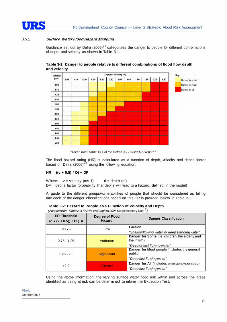
3.5.1 Surface Water Flood Hazard Mapping
Guidance set out by Defra (2005)v ii categorises the danger to people for different combinations of depth and velocity as shown in Table 3-1.
Table 3-1: Danger to people relative to different combinations of flood flow depth and velocity
*Taken from Table 13.1 of the Defra/EA FD2320/TR2 reportvii.
The flood hazard rating (HR) is calculated as a function of depth, velocity and debris factor based on Defra (2006)v iii using the following equation:
HR = ((v + 0.5) * D) + DF
Where: v = velocity (ms-1) d = depth (m) DF = debris factor (probability that debris will lead to a hazard, defined in the model)
A guide to the different groups/vulnerabilities of people that should be considered as falling into each of the danger classifications based on this HR is provided below in Table 3-2.
Table 3-2: Hazard to People as a Function of Velocity and Depth (Adapted from Table 2 of EA/HR Wallingford 2008 Supplementary Noteix)
HR Threshold (d x (v + 0.5)) + DF) =
Degree of Flood Hazard Danger Classification
<0.75 Low Caution “Shallow flowing water or deep standing water”
0.75 - 1.25 Moderate Danger for Some (i.e. children, the elderly and the infirm) “Deep or fast flowing water”
1.25 - 2.0 Significant Danger for Most people (includes the general public) “Deep fast flowing water”
>2.0 Extreme Danger for All (includes emergency services) “Deep fast flowing water”
Using the above information, the varying surface water flood risk within and across the areas identified as being at risk can be determined to inform the Exception Test.
Northumberland County Council — Level 2 Strategic Flood Risk Assessment
FINAL October 2015
24
3.6 Flooding from Groundwater
EA Groundwater Vulnerability Maps obtained during Level 1 SFRA show the study area to be mostly underlain by a minor aquifer of varying vulnerability. British Geological Survey (BGS) mapping shows the area to be mostly underlain by carboniferous limestone, igneous rocks and sandstones which have limited permeability. Large parts of the bedrock covering the study area is overlain by relatively impermeable glacial till, further reducing the likelihood of groundwater flooding.
Groundwater flooding is often very localised in nature and a minor number of flooding events have been recorded in Spittal, near Berwick and Darras Hall in Ponteland. In the mid 1990’s several properties had to be evacuated following a collapse of a nearby mine and subsequent built up of water in Spittal. Following discussions with the EA, consideration should be given to potential minewater intrusion in the former coal mining settlements on the coast.
The Department for Food and Rural Affairs (DEFRA) Strategy for Flood and Coastal Erosion Risk Management study (2004) did not show any recorded instances of groundwater flooding in the study area. This does not mean that groundwater flooding has not occurred, or that it will not occur in the future, purely that no incidents have been specifically recorded in the EA records.
The available datasets have been used to qualitatively determine the risk of groundwater flooding at each CSDA and to identify the suitability of infiltration SuDS.
3.7 Flooding from Sewers
During the Level 1 SFRA, NW provided the DG5 data based on wider drainage areas. This data set indicated the risk of sewer flooding as ‘High’, ‘Medium’ and ‘Low’ based on the reported number of incidents for individual drainage areas.
As part of the Level 2 SFRA, NW provided further DG5 data based on 100 square metre grid squares. The new data set uses 100m2 grid squares to flag up areas where NW have properties on their DG5 sewer flooding registers (1 in 10, 2 in 10 and 1 in 20-year). In comparison to the Level 1 SFRA data, the new data enables the identification of localised areas at risk of hydraulic sewer flooding within each drainage catchment area. Therefore, the new dataset has been used in the Level 2 SFRA to assess sewer flooding risk.
The DG5 register defines internal flooding as flooding which enters a building or passes below a suspended floor; whilst external flooding is defined as flooding which is not classed as internal. Properties at risk are defined as properties that have suffered or are likely to suffer internal flooding from public foul, combined or surface water sewers due to overloading of the sewerage system more frequently than the relevant period. The water company irrespective of the severity of the storm should register all flooding incidents. For reporting purposes, buildings are restricted to those normally occupied and used for residential, public, commercial, business or industrial purposes.
3.8 Flooding from Reservoirs, Canals and Other Artificial Sources
The locations of reservoirs and artificial flood sources have been identified using EA and Ordnance Survey data.
There are several reservoirs within the study area and within the river catchments upstream of the development sites that fall under the Reservoirs Act (1975) (i.e. greater than 25,000 m3 capacity), including Kielder Water, Catcleugh Reservoir and Fontburn Reservoir. In addition, there are numerous smaller reservoirs and lakes within the study area.
Northumberland County Council — Level 2 Strategic Flood Risk Assessment
FINAL October 2015
25
The EA has produced Reservoir Inundation Mapping (RIM) to broadly quantify the areas at residual risk of flooding from bodies falling under the Reservoirs Act. This dataset has been accessed on the EA website and used to determine residual risk for the sites considered in the Level 2 SFRA.
The Flood and Water Management Act 2010 updates the Reservoirs Act (1975) reflecting a more risk based approach to reservoir regulation, with several of the key changes outlined below:
• Reducing the capacity at which a reservoir will be regulated from 25,000m³ to 10,000m³;
• Ensuring that only those reservoirs assessed as a higher risk are subject to regulation;
• All undertakers with reservoirs over 10,000m³ must register their reservoirs with the EA;
• Inspecting engineers must provide a report on their inspection within 6 months;
• All undertakers must prepare a reservoir flood plan; and
• All incidents at reservoirs must be reported.
3.9 Tidal Flooding
Northumberland has a long and varied coastline and consequently, some settlements at the coast are at risk of tidal flooding from the North Sea and/or estuary flooding. There is a history of tidal flooding in some parts of the study area.
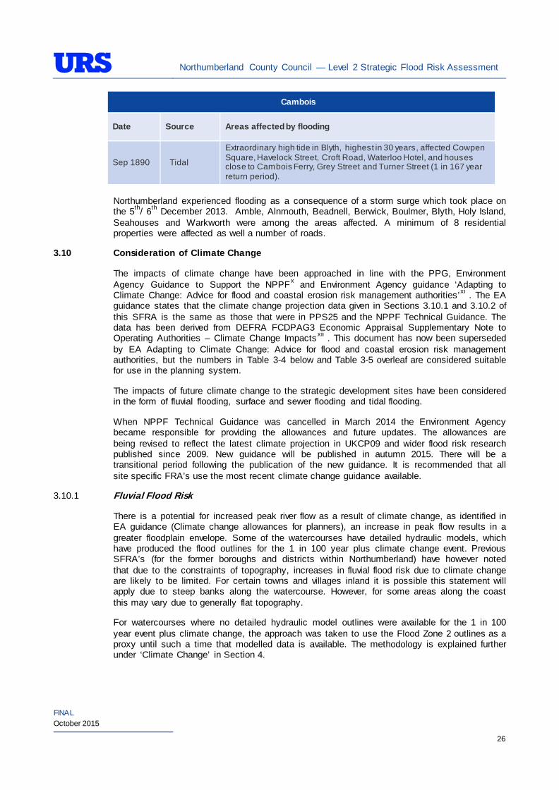
Data provided by the EA (CFMP, SMP2, ANECDOTAL EA DATA) notes that historically there has been a history of tidal flooding in Blyth and Cambois settlements. The following table summarises historic events recorded for these areas.
Table 3-3: Historical tidal flooding (Including extracts from EA CFMPs)
Blyth
Date Source Areas affected by flooding
Dec 1876 Tidal Waves flowing into streets of Blyth.
Sep 1890 Tidal Extraordinary high tide in Blyth, highest in 30 years, affected Cowpen Square, Havelock Street, Croft Road, Waterloo Hotel, and houses close to Cambois Ferry, Grey Street and Turner Street (1 in 167 yr return period).
Dec 1921 Tidal
In Blyth flood water flowing through the gratings covering the sewers, affected Park Road, Havelock Street, Croft Road, Regent Street, Turner Street, Cowpen Street and Cowpen Square (1 in 63 yr return period).
Feb 1924 Tidal Flooding in Blyth with overflow down Regent Street almost as far as Travellers Rest Hotel also affected business premises east of the Arcade and Turner Street (1 in 28 yr return period).
Jan 1953 Tidal Floods up to 1m (3 feet) deep caused by high tides land gales up to 82mph. Affected Golden Fleece, Regent Street, Waterloo Road, Havelock Street and Bondicar Terrace in Blyth.
Nov 1954 Tidal Serious flooding in Blyth at High Ferry (1 in 38 yr return period).
Northumberland County Council — Level 2 Strategic Flood Risk Assessment
FINAL October 2015
26
Cambois
Date Source Areas affected by flooding
Sep 1890 Tidal
Extraordinary high tide in Blyth, highest in 30 years, affected Cowpen Square, Havelock Street, Croft Road, Waterloo Hotel, and houses close to Cambois Ferry, Grey Street and Turner Street (1 in 167 year return period).
Northumberland experienced flooding as a consequence of a storm surge which took place on the 5th/ 6th December 2013. Amble, Alnmouth, Beadnell, Berwick, Boulmer, Blyth, Holy Island, Seahouses and Warkworth were among the areas affected. A minimum of 8 residential properties were affected as well a number of roads.
3.10 Consideration of Climate Change
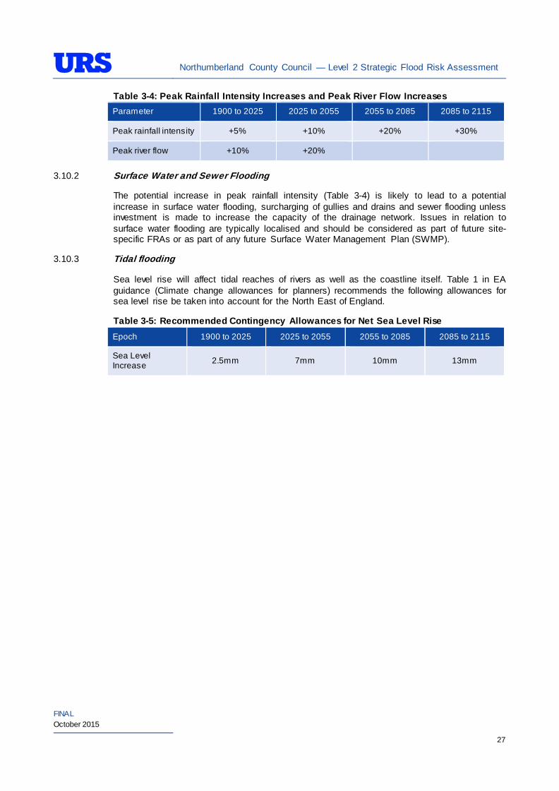
The impacts of climate change have been approached in line with the PPG, Environment Agency Guidance to Support the NPPFx and Environment Agency guidance ‘Adapting to Climate Change: Advice for flood and coastal erosion risk management authorities’xi . The EA guidance states that the climate change projection data given in Sections 3.10.1 and 3.10.2 of this SFRA is the same as those that were in PPS25 and the NPPF Technical Guidance. The data has been derived from DEFRA FCDPAG3 Economic Appraisal Supplementary Note to Operating Authorities – Climate Change Impacts xii . This document has now been superseded by EA Adapting to Climate Change: Advice for flood and coastal erosion risk management authorities, but the numbers in Table 3-4 below and Table 3-5 overleaf are considered suitable for use in the planning system.
The impacts of future climate change to the strategic development sites have been considered in the form of fluvial flooding, surface and sewer flooding and tidal flooding.
When NPPF Technical Guidance was cancelled in March 2014 the Environment Agency became responsible for providing the allowances and future updates. The allowances are being revised to reflect the latest climate projection in UKCP09 and wider flood risk research published since 2009. New guidance will be published in autumn 2015. There will be a transitional period following the publication of the new guidance. It is recommended that all site specific FRA’s use the most recent climate change guidance available.
3.10.1 Fluvial Flood Risk
There is a potential for increased peak river flow as a result of climate change, as identified in EA guidance (Climate change allowances for planners), an increase in peak flow results in a greater floodplain envelope. Some of the watercourses have detailed hydraulic models, which have produced the flood outlines for the 1 in 100 year plus climate change event. Previous SFRA’s (for the former boroughs and districts within Northumberland) have however noted that due to the constraints of topography, increases in fluvial flood risk due to climate change are likely to be limited. For certain towns and villages inland it is possible this statement will apply due to steep banks along the watercourse. However, for some areas along the coast this may vary due to generally flat topography.
For watercourses where no detailed hydraulic model outlines were available for the 1 in 100 year event plus climate change, the approach was taken to use the Flood Zone 2 outlines as a proxy until such a time that modelled data is available. The methodology is explained further under ‘Climate Change’ in Section 4.
Northumberland County Council — Level 2 Strategic Flood Risk Assessment
FINAL October 2015
27
Table 3-4: Peak Rainfall Intensity Increases and Peak River Flow Increases Parameter 1900 to 2025 2025 to 2055 2055 to 2085 2085 to 2115
Peak rainfall intensity +5% +10% +20% +30%
Peak river flow +10% +20%
3.10.2 Surface Water and Sewer Flooding
The potential increase in peak rainfall intensity (Table 3-4) is likely to lead to a potential increase in surface water flooding, surcharging of gullies and drains and sewer flooding unless investment is made to increase the capacity of the drainage network. Issues in relation to surface water flooding are typically localised and should be considered as part of future site-specific FRAs or as part of any future Surface Water Management Plan (SWMP).
3.10.3 Tidal flooding
Sea level rise will affect tidal reaches of rivers as well as the coastline itself. Table 1 in EA guidance (Climate change allowances for planners) recommends the following allowances for sea level rise be taken into account for the North East of England.
Table 3-5: Recommended Contingency Allowances for Net Sea Level Rise Epoch 1900 to 2025 2025 to 2055 2055 to 2085 2085 to 2115
Sea Level Increase 2.5mm 7mm 10mm 13mm
Northumberland County Council — Level 2 Strategic Flood Risk Assessment
FINAL October 2015
28
4 LEVEL 2 STRATEGIC FLOOD RISK ASSESSMENT
4.1.1 Introduction
As part of the work on the Northumberland Core Strategy, the Council is at the early stages in the evidence base gathering process. Therefore, following completion of the Level 1 SFRA, NCC has identified a limited number of locations to be further evaluated in the Level 2 SFRA. These locations are named as Potential Development Areas (PDAs) and have been identified as particular locations at flood risk in the Level 1 SFRA. The PDAs comprise those locations that were identified in the Level 1 SFRA and through further work to fall in Flood Zone 2 and 3. The locations that were identified that fall in Flood Zone 1 have not been considered for further evaluation, as these would not be subjected to the sequential test under the NPPF. Appendix B shows the location of all of the PDAs.
The aim of the Level 2 SFRA is to assist in informing whether or not these PDAs should be considered for further evaluation as part of the work on the Core Strategy. It should be noted that these PDAs may not be the areas, which appear in the final Core Strategy.
The PDAs considered in the SFRA Level 2 assessment include:
• Amble (South East) Core Strategy Delivery Area: South East PDA;
• Blyth (South East) Core Strategy Delivery Area: C02 Riverside Park and C03 Riverside Park, Coniston Road;
• Cramlington (Central) Core Strategy Delivery Area: C10 Northumberland Business Park;
• Hexham (Central) Core Strategy Delivery Area: East Hexham, North Hexham, E20 Former Bunker, E08 Egger and E15 Acomb;
• Prudhoe (Central) Core Strategy Delivery Area: E12 Prudhoe plus land held for expansion at E12 Low Prudhoe;
• Ponteland (Central) Core Strategy Delivery Area: North West of Ponteland, East of Ponteland, South East of Ponteland and Ponteland Bypass;
• Belford (North) Core Strategy Delivery Area: E01 Belford;
• Wooler (North) Core Strategy Delivery Area: East of Wooler, North East of Wooler and North West of Wooler;
• Haltwhistle (West) Core Strategy Delivery Area: E03 Hadrian;
• Haydon Bridge (West) Core Strategy Delivery Area: West of Haydon Bridge; and
• Bellingham (West) Core Strategy Delivery Area: South of Bellingham and E02 Foundry Road.
PDAs which fall into Flood Zone 1 have not been taken forward for assessment in the Level 2 SFRA. Appendix B shows the location of all the PDAs and Appendix C includes a high level assessment of fluvial/ tidal, surface water and artificial (reservoir) flooding for all potential development locations.
The following section evaluates the PDA’s against the following categories:
• Existing use and topography;
• Proposed use and vulnerability;
Northumberland County Council — Level 2 Strategic Flood Risk Assessment
FINAL October 2015
29
• Sources of flooding (rivers/sea, surface water, groundwater, sewers and artificial sources);
• Flood defence infrastructure;
• Residual flood risks;
• Climate change;
• SuDS applicability;
• Recommendations and policies; and
• Site specific FRA guidance.
Northumberland County Council — Level 2 Strategic Flood Risk Assessment
FINAL October 2015
30
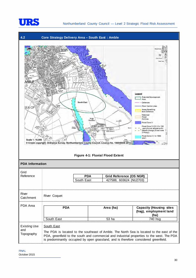
4.2 Core Strategy Delivery Area – South East : Amble
Figure 4-1: Fluvial Flood Extent
PDA Information
Grid Reference
PDA Grid Reference (OS NGR)
South East 427588, 603624 (NU2703)
River Catchment River Coquet
PDA Area PDA Area (ha) Capacity (Housing sites
(hsg), employment land (ha)
South East 53 ha 740 hsg
Existing Use and Topography
South East
The PDA is located to the southeast of Amble. The North Sea is located to the east of the PDA, greenfield to the south and commercial and industrial properties to the west. The PDA is predominantly occupied by open grassland, and is therefore considered greenfield.
Northumberland County Council — Level 2 Strategic Flood Risk Assessment
FINAL October 2015
31
4.2 Core Strategy Delivery Area – South East : Amble The PDA topography slopes in a northeast direction from approximately 19.6mAOD in the southwest corner to 15.4 mAOD in the northeast corner.
Proposed Use and Vulnerability Classification
The table below summarises the proposed uses of the PDA, provided by NCC (July 2014).
PDA Proposed Use Status South East Housing Alternative area
The table below illustrates a matrix of ‘Vulnerability Classification’ based on Table 2 in the National Planning Policy Framework (NPPF) against ‘Flood Zone Compatibility’.
Proposed use NPPF Vulnerability
Classification
Flood Zone 1
Flood Zone 2
Flood Zone 3a
Flood Zone 3b
Residential More vulnerable*
Exception Test
required
Key
- Acceptable
- Not Acceptable
*Based on Planning Practice Guidance (PPG) Table 2: Flood Risk Vulnerability Classif ication.
Should further definition of the proposed uses be made at a later date, then identification of their individual vulnerability classifications should be re-visited.
Sources of Flood Risk
Rivers/Sea The PDA is located to the west of the North Sea and north of an unnamed watercourse and Hauxley Nature Reserve.
The Environment Agency’s (EA’s) Flood Maps present the extent of Flood Zones.
South East
The EA’s Flood Maps indicate that the majority of the PDA is in Flood Zone 1. An area in the centre of the PDA is indicated to be in Flood Zone 2. The majority of the PDA is therefore not at risk of significant flooding.
The flood maps indicate that the flooding is fluvial and the PDA is at risk of flooding from an unnamed watercourse which runs in a southerly direction through Hauxley into a watercourse which feeds Hauxley Nature Reserve.
The PDA is not located with a Flood Warning Area.
The Alnwick District SFRA Level 2 assesses flood risk in Amble – High Hauxley (Referenced C1b). The SFRA states that water levels are estimated at 0.15m AOD in a 0.1% AEP (1 in 1000 year) although localised flooding problems from excessive surface water runoff and under capacity of sewer networks have been recorded in the nearby area.
The above information should also be taken into account when allocating development in the wider Amble area.
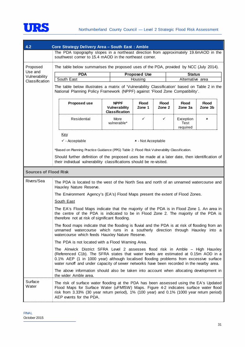
Surface Water
The risk of surface water flooding at the PDA has been assessed using the EA’s Updated Flood Maps for Surface Water (uFMfSW) Maps. Figure 4-2 indicates surface water flood risk from 3.33% (30 year return period), 1% (100 year) and 0.1% (1000 year return period) AEP events for the PDA.
Northumberland County Council — Level 2 Strategic Flood Risk Assessment
FINAL October 2015
32
4.2 Core Strategy Delivery Area – South East : Amble An area to the east of the PDA has been identified as being at high risk, some areas along the pathway of the unnamed watercourse have also been identified as high risk. Some lower risk surface water flooding has been identified to the west of the area.
Figure 4-2: updated Flood Maps for Surface Water – Extent
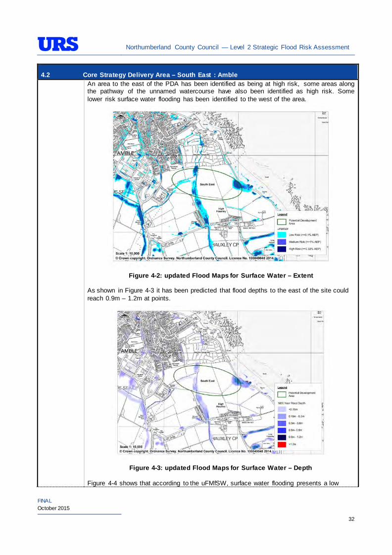
As shown in Figure 4-3 it has been predicted that flood depths to the east of the site could reach 0.9m – 1.2m at points.
Figure 4-3: updated Flood Maps for Surface Water – Depth
Figure 4-4 shows that according to the uFMfSW, surface water flooding presents a low
Northumberland County Council — Level 2 Strategic Flood Risk Assessment
FINAL October 2015
33
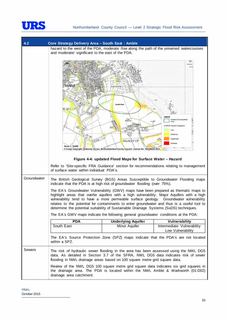
4.2 Core Strategy Delivery Area – South East : Amble hazard to the west of the PDA, moderate /low along the path of the unnamed watercourses and moderate/ significant to the east of the PDA.
Figure 4-4: updated Flood Maps for Surface Water – Hazard
Refer to ‘Site-specific FRA Guidance’ section for recommendations relating to management of surface water within individual PDA’s.
Groundwater The British Geological Survey (BGS) Areas Susceptible to Groundwater Flooding maps indicate that the PDA is at high risk of groundwater flooding (over 75%).
The EA’s Groundwater Vulnerability (GWV) maps have been prepared as thematic maps to highlight areas that overlie aquifers with a high vulnerability. Major Aquifers with a high vulnerability tend to have a more permeable surface geology. Groundwater vulnerability relates to the potential for contaminants to enter groundwater and thus is a useful tool to determine the potential suitability of Sustainable Drainage Systems (SuDS) techniques.
The EA’s GWV maps indicate the following general groundwater conditions at the PDA:
PDA Underlying Aquifer Vulnerability South East Minor Aquifer Intermediate Vulnerability
Low Vulnerability
The EA’s Source Protection Zone (SPZ) maps indicate that the PDA’s are not located within a SPZ.
Sewers The risk of hydraulic sewer flooding in the area has been assessed using the NWL DG5 data. As detailed in Section 3.7 of the SFRA, NWL DG5 data indicates risk of sewer flooding in NWL drainage areas based on 100 square metre grid square data.
Review of the NWL DG5 100 square metre grid square data indicates six grid squares in the drainage area. The PDA is located within the NWL Amble & Warkworth (01-D02) drainage area catchment.
Northumberland County Council — Level 2 Strategic Flood Risk Assessment
FINAL October 2015
34
4.2 Core Strategy Delivery Area – South East : Amble Future developments should take measures as far as is practicable to reduce the flood risk arising from the development to the PDA itself and downstream properties. A site-specific FRA should identify the drainage strategy to mitigate sewer flooding risk.
Artificial Sources
There are no canals, reservoirs or other artificial water sources that may provide a flood risk in the vicinity of the PDA – as such there is not considered to be a significant risk to the PDA.
Flood Defence Infrastructure
The Environment Agency Asset Information Management System (AIMS) now supersedes NFCDD, although the NFCDD data provides more detailed information of defences in the area. Both the AIMS and NFCDD data have been included within this SFRA for completeness. It is advised that the developer consults with the Environment Agency to obtain the most up to date information relating to flood defence infrastructure.
Information provided by the Environment Agency and obtained from AIMS does not identify any fluvial defences in the immediate area.
The Northumbria Flood Action Plan however states that a sea wall is in place to protect properties further north that are at risk of flooding from the North Sea.
Residual Flood Risks
It is recommended that the development allocation process within the PDA follows the principles of the NPPF sequential approach.
Climate Change
During the Level 1 SFRA, where modelled Flood Zone 3 plus climate change outlines were available these were used for mapping. For those areas where detailed Flood Zone 3 plus climate change outlines were not available, the Flood Zone 2 outline was used as a proxy until more detailed information becomes available (i.e. an EA hydraulic modelling study or hydraulic modelling study undertaken for a site-specific FRA).
For the Amble area, as modelled outlines were unavailable, Flood Zone 2 was used as a proxy to map the potential outline of Flood Zone 3 plus climate change. Therefore, it is recommended that as a part of area-specific FRAs detailed modelling is undertaken to confirm the extent of the Flood Zone 3 plus climate change, should any development be proposed within the area covered by the proxy outline.
During the Level 1 SFRA, it was determined that there are no modelled outlines of Flood Zone 2 plus climate change for the whole of Northumberland. The Flood Zone 2 plus climate change flood event would be greater than the existing Flood Zone 2 outlines. As there are limitations on data, and extensive uncertainties, in deriving the floodplain for such an extreme event, it is not practical to use a proxy dataset or make assumptions to produce the Flood Zone 2 plus climate change outline. It is therefore recommended that as part of any future detailed site-specific FRAs the extent of Flood Zone 2 plus climate change is determined, should this be critical to the layout of the development. Consultation with the EA should be undertaken to determine a suitable methodology for undertaking this assessment (i.e. detailed modelling, or applying an agreed buffer to Flood Zone 2).
SuDS Applicability
The SuDS map produced as part of Level 1 SFRA indicated that attenuation systems are applicable for this area. However, further site investigations are necessary to confirm the local ground conditions and determine the appropriate SuDS technique as part of any future site specific FRA.
Prospective developers should work closely with EA, Local Planning Authority (LPA) and Lead Local Flood
Northumberland County Council — Level 2 Strategic Flood Risk Assessment
FINAL October 2015
35
4.2 Core Strategy Delivery Area – South East : Amble Authority (LLFA) to manage surface water run-off as near to its source as possible. For the PDA described above, given the ground conditions attenuation SuDS are likely to be an appropriate technique to manage surface water at the site level.
The developer should investigate the use of source control attenuation systems such as green roof, rainwater harvesting systems and site control attenuation systems such as swales, ponds and detention basins as appropriate. It should be noted that a wide range of attenuation SuDS techniques are available which can be adopted depending upon the available space to manage surface water. A site-specific FRA should assess the most suitable SuDS system to manage surface water for the development based on the guidance and advice provided within the Level 2 SFRA and PPG
For the wider area of Amble, there are potential opportunities for the LPA to incorporate SuDS in the master plan to manage surface water whilst improving local water quality, biodiversity, and amenity.
Recommendations
• If development pressures create a need to develop within areas that are at risk of flooding (i.e., Flood Zone 2 and Flood Zone 3), they should incorporate appropriate mitigation measures which must not increase the risk of flooding to surrounding areas. Careful liaison with the EA will be necessary during the design and planning process and it cannot be assumed that the EA will not object to development in these areas;
• Any sites which contain or are adjacent to rivers should be designed so as to allow access to the channel for maintenance purposes. This maintenance liability lies with the landowner in the first instance however the Environment Agency / Lead Local Flood Authority have powers to undertake work where deemed necessary.
• Developers should liaise with the Local Planning Authority to ensure that appropriate SuDS have been proposed for the site; and
• Self-contained basements will not be permitted within Flood Zone 3. Basements may be accepted if free access is available to floors above the 1% AEP flood level. If basements are included as part of a scheme then they should adhere to British Standard 8102.
Policies
• Where applicable roll back development from the unnamed watercourse outside of Flood Zone 3a to create ‘blue corridors’ which provide public open space and recreation areas near the watercourse and coast and enhance green infrastructure;
• It should be possible for new development in this area to be designed to take this fluvial flood risk into account and would not result in displacing Flood Zone 3 extents elsewhere;
• Mixed use (mixed vulnerability) development should follow the principles of the NPPF sequential approach across the wider area. For example, proposed residential development should be steered to the lower risk areas, with the remaining ‘less vulnerable’ land uses being located on the (relatively) higher risk areas. This approach can also be applied within buildings, for example commercial development located at ground floor level and residential development above ground floor level in flood risk areas. However, access and egress must still be made available for the residential uses;
• Surface water/pluvial flood risk should also inform the site layout, such that ‘highly vulnerable’ development is avoided in locations that are shown at the greatest risk of pluvial flooding; and
• As the PDA is greenfield, future developments within the area potentially can increase surface water runoff. SuDS should be considered at all stages of the planning and design of new developments to reduce runoff rates and volumes from the developed site, thus reducing the resultant flood risk posed to the site and adjacent/downstream areas. Development should, where reasonably possible, aim to reduce surface water runoff to less than greenfield run off. If this is not possible then greenfield runoff
Northumberland County Council — Level 2 Strategic Flood Risk Assessment
FINAL October 2015
36
4.2 Core Strategy Delivery Area – South East : Amble rates should be achieved by the proposed mitigation measures.
Site-Specific FRA Guidance
• A site-specific FRA will be required for any development proposed within the site that falls entirely or partly within Flood Zone 2 and Flood Zone 3. For individual plots within the site that do fall within Flood Zone 1, an FRA will be required for any development in excess of 1 ha. The FRA will need to consider surface water management;
• If no models are available then the Lead Local Flood Authority may require a model as part of a planning application;
• If development within areas designated as Flood Zone 3 including an allowance for climate change is justifiable, appropriate mitigation and resilience measures should be incorporated both on an individual property-level (such as flood resilient construction) and at a strategic level (such as strategic SuDS);
• The FRA should demonstrate that consideration has been given to the site layout with regards to flood risk from all sources, in line with the recommendations above (sequential approach to site layout).
• The rates and volumes of post-development surface water runoff should be controlled using suitable and adequate SuDS techniques. Where possible, the developer should retrofit drainage solutions to the site with wider benefits to other local areas at risk;
• The suitability of infiltration SuDS should be informed by site-specific ground investigation (GI) works;
• The risks identified above should be adequately investigated and assessed as part of the FRA and mitigation measures implemented accordingly. In such situations, the developer is generally required to provide resources and funds to undertake more complex modelling/assessments to determine the risk on the development. In addition, the developer is generally responsible for funding any flood risk management works, including defences and mitigation works;
• A site-specific FRA should consider provision of site access and egress, taking into account any emergency planning requirements of NCC and the Environment Agency. This is a particularly pertinent issue for areas, where access roads are at risk of flooding; and
• Developments should aim to mimic existing drainage regimes as closely as possible, and reduce discharge off site where possible. As the site is greenfield, greenfield runoff rates should be retained.
• The EA will be publishing new climate change guidance in autumn 2015. The most recent climate change guidance should be used to inform site specific FRA’s.
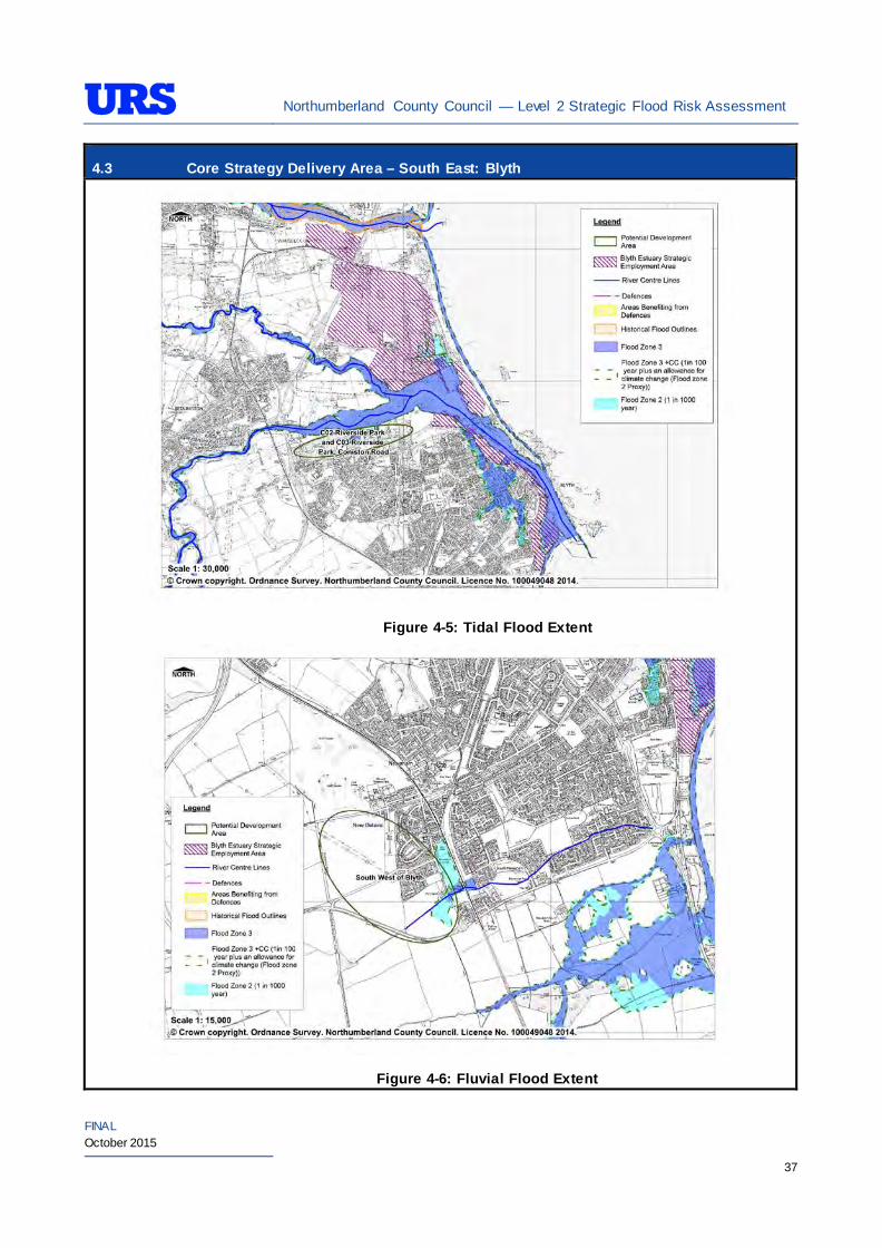
Northumberland County Council — Level 2 Strategic Flood Risk Assessment
FINAL October 2015
37
4.3 Core Strategy Delivery Area – South East: Blyth
Figure 4-5: Tidal Flood Extent
Figure 4-6: Fluvial Flood Extent
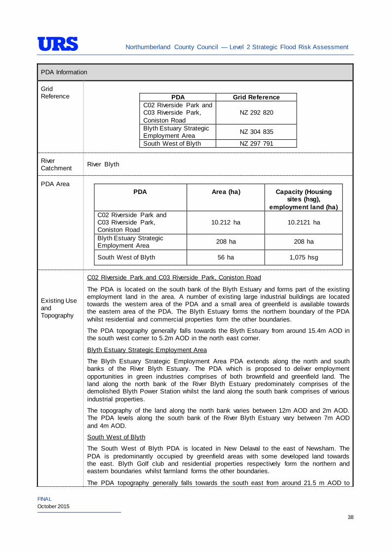
Northumberland County Council — Level 2 Strategic Flood Risk Assessment
FINAL October 2015
38
PDA Information
Grid Reference
PDA Grid Reference C02 Riverside Park and C03 Riverside Park, Coniston Road
NZ 292 820
Blyth Estuary Strategic Employment Area NZ 304 835
South West of Blyth NZ 297 791
River Catchment River Blyth
PDA Area
PDA Area (ha) Capacity (Housing sites (hsg),
employment land (ha) C02 Riverside Park and C03 Riverside Park, Coniston Road
10.212 ha 10.2121 ha
Blyth Estuary Strategic Employment Area 208 ha 208 ha
South West of Blyth 56 ha 1,075 hsg
Existing Use and Topography
C02 Riverside Park and C03 Riverside Park, Coniston Road
The PDA is located on the south bank of the Blyth Estuary and forms part of the existing employment land in the area. A number of existing large industrial buildings are located towards the western area of the PDA and a small area of greenfield is available towards the eastern area of the PDA. The Blyth Estuary forms the northern boundary of the PDA whilst residential and commercial properties form the other boundaries.
The PDA topography generally falls towards the Blyth Estuary from around 15.4m AOD in the south west corner to 5.2m AOD in the north east corner.
Blyth Estuary Strategic Employment Area
The Blyth Estuary Strategic Employment Area PDA extends along the north and south banks of the River Blyth Estuary. The PDA which is proposed to deliver employment opportunities in green industries comprises of both brownfield and greenfield land. The land along the north bank of the River Blyth Estuary predominately comprises of the demolished Blyth Power Station whilst the land along the south bank comprises of various industrial properties.
The topography of the land along the north bank varies between 12m AOD and 2m AOD. The PDA levels along the south bank of the River Blyth Estuary vary between 7m AOD and 4m AOD.
South West of Blyth
The South West of Blyth PDA is located in New Delaval to the east of Newsham. The PDA is predominantly occupied by greenfield areas with some developed land towards the east. Blyth Golf club and residential properties respectively form the northern and eastern boundaries whilst farmland forms the other boundaries.
The PDA topography generally falls towards the south east from around 21.5 m AOD to
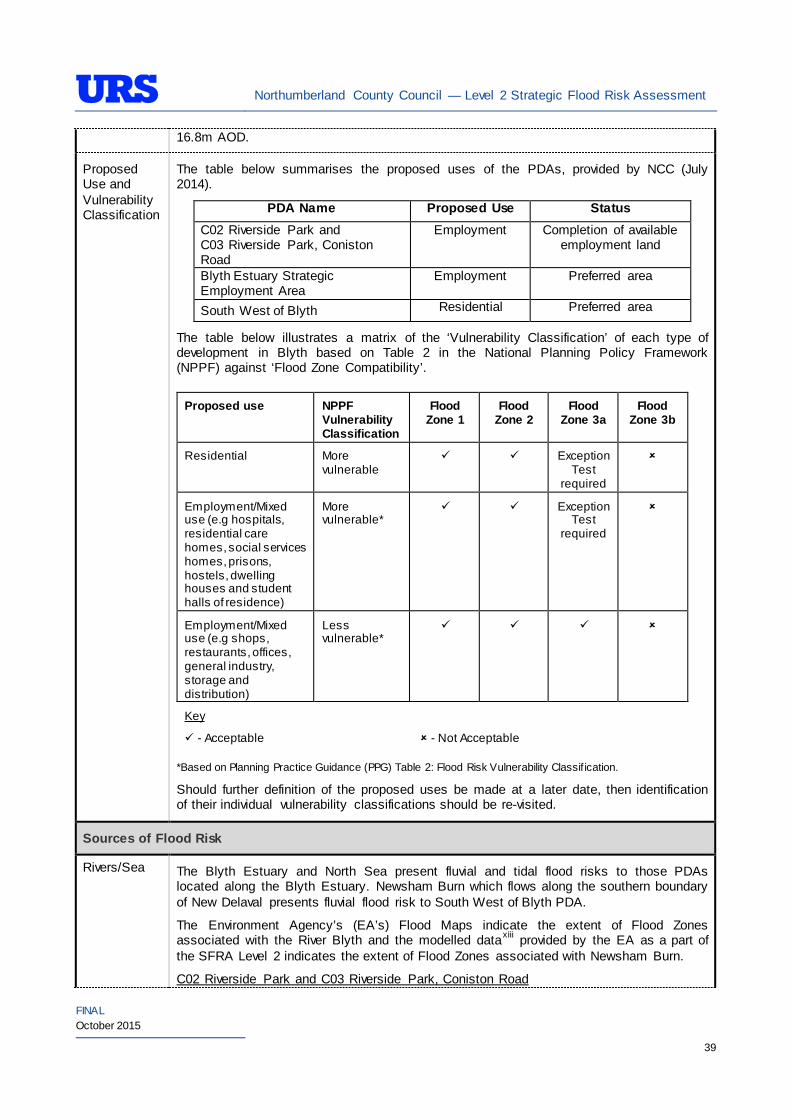
Northumberland County Council — Level 2 Strategic Flood Risk Assessment
FINAL October 2015
39
16.8m AOD.
Proposed Use and Vulnerability Classification
The table below summarises the proposed uses of the PDAs, provided by NCC (July 2014).
PDA Name Proposed Use Status C02 Riverside Park and C03 Riverside Park, Coniston Road
Employment Completion of available employment land
Blyth Estuary Strategic Employment Area
Employment Preferred area
South West of Blyth Residential Preferred area
The table below illustrates a matrix of the ‘Vulnerability Classification’ of each type of development in Blyth based on Table 2 in the National Planning Policy Framework (NPPF) against ‘Flood Zone Compatibility’.
Proposed use NPPF Vulnerability Classification
Flood Zone 1
Flood Zone 2
Flood Zone 3a
Flood Zone 3b
Residential More vulnerable
Exception Test
required
Employment/Mixed use (e.g hospitals, residential care homes, social services homes, prisons, hostels, dwelling houses and student halls of residence)
More vulnerable*
Exception Test
required
Employment/Mixed use (e.g shops, restaurants, offices, general industry, storage and distribution)
Less vulnerable*
Key
- Acceptable
- Not Acceptable
*Based on Planning Practice Guidance (PPG) Table 2: Flood Risk Vulnerability Classif ication.
Should further definition of the proposed uses be made at a later date, then identification of their individual vulnerability classifications should be re-visited.
Sources of Flood Risk
Rivers/Sea The Blyth Estuary and North Sea present fluvial and tidal flood risks to those PDAs located along the Blyth Estuary. Newsham Burn which flows along the southern boundary of New Delaval presents fluvial flood risk to South West of Blyth PDA.
The Environment Agency’s (EA’s) Flood Maps indicate the extent of Flood Zones associated with the River Blyth and the modelled dataxiii provided by the EA as a part of the SFRA Level 2 indicates the extent of Flood Zones associated with Newsham Burn.
C02 Riverside Park and C03 Riverside Park, Coniston Road

Northumberland County Council — Level 2 Strategic Flood Risk Assessment
FINAL October 2015
40
The EA’s Flood Map (Figure 4-5) indicates that the majority of the PDA is in Flood Zone 1. A small area in the north of the PDA is indicated to be in Flood Zone 2 and Flood Zone 3. The majority of the PDA is therefore not at risk of significant flooding.
Blyth Estuary Strategic Employment Area
The EA’s Flood Map (Figure 4-5) indicates that the majority of the PDA is in Flood Zone 1. A small area along the north and south bank of the Blyth Estuary indicated to be in Flood Zone 2 and Flood Zone 3. The majority of the PDA is therefore not at risk of significant flooding.
South West of Blyth
Newsham Burn Flood Zone Improvement Study, 2010 indicates the extent of Flood Zones within this PDA. The Flood Maps (Figure 4-6) indicate that the majority of the PDA is in Flood Zone 1. A small area in the south east of the PDA is indicated to be risk of flooding from Newsham Burn and the extent of flood risk includes both Flood Zone 2 and Flood Zone 3.
The EA completed a Flood Alleviation Scheme for Newsham Burn in December 2011 and the flood zones may therefore have been reduced as a result. However, the EA have advised that there will be no further update to the flood extent in the near future.
In addition to the available Flood Maps, the EA has completed the Blyth Tidal Projection Model in July 2010 to derive new sea level estimates for the Blyth and Cambois areas. The study has derived the following model outlines for 0.5% (1 in 200 year return period) and 0.1% (1 in 1000 year return period) AEP events.
• 0.5% AEP = 4.06m AOD
• 0.1% AEP = 4.28m AOD
Land within the Blyth Estuary Strategic Employment Area PDA is located within the EA’s ‘North Sea at Blyth’ Flood Warning Area.
The table below summarises the policy plan identified for Blyth shoreline from the Northumberland Shoreline Management Plan 2.
Management Area Policy Unit Policy Plan
2025 2055 2105 Northumberland SMP2 Comment
MA21 Spital Point to Blyth East Pier
21.6 Blyth East Pier HTL* HTL HTL This is a key feature in controlling the plan shape of the Policy Development Zone
MA22 Blyth Harbour 22.1 Blyth Harbour HTL HTL HTL
Check compatibility w ith CFMP and Blyth Flood Risk Review
MA23
Blyth West Pier to Seaton Sluice
23.1 Blyth West Pier to Beach Gardens
HTL HTL HTL Prevent breaching into South Harbour
23.2 Beach Gardens to Promenade HTL HTL MR**
Realignment at the end of the promenade w ill be needed in the longer term in response to rising sea levels
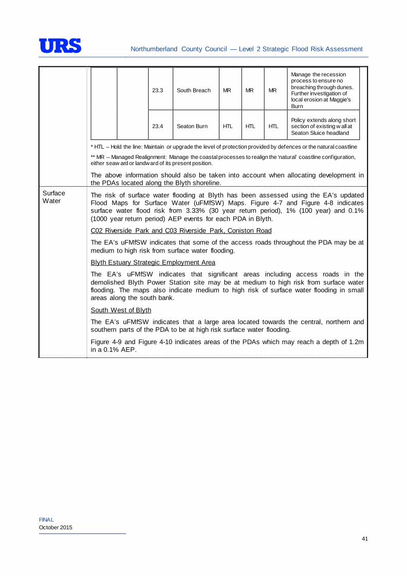
Northumberland County Council — Level 2 Strategic Flood Risk Assessment
FINAL October 2015
41
23.3 South Breach MR MR MR
Manage the recession process to ensure no breaching through dunes. Further investigation of local erosion at Maggie’s Burn
23.4 Seaton Burn HTL HTL HTL Policy extends along short section of existing w all at Seaton Sluice headland
* HTL – Hold the line: Maintain or upgrade the level of protection provided by defences or the natural coastline
** MR – Managed Realignment: Manage the coastal processes to realign the ‘natural’ coastline configuration, either seaw ard or landward of its present position.
The above information should also be taken into account when allocating development in the PDAs located along the Blyth shoreline.
Surface Water
The risk of surface water flooding at Blyth has been assessed using the EA’s updated Flood Maps for Surface Water (uFMfSW) Maps. Figure 4-7 and Figure 4-8 indicates surface water flood risk from 3.33% (30 year return period), 1% (100 year) and 0.1% (1000 year return period) AEP events for each PDA in Blyth.
C02 Riverside Park and C03 Riverside Park, Coniston Road
The EA’s uFMfSW indicates that some of the access roads throughout the PDA may be at medium to high risk from surface water flooding.
Blyth Estuary Strategic Employment Area
The EA’s uFMfSW indicates that significant areas including access roads in the demolished Blyth Power Station site may be at medium to high risk from surface water flooding. The maps also indicate medium to high risk of surface water flooding in small areas along the south bank.
South West of Blyth
The EA’s uFMfSW indicates that a large area located towards the central, northern and southern parts of the PDA to be at high risk surface water flooding.
Figure 4-9 and Figure 4-10 indicates areas of the PDAs which may reach a depth of 1.2m in a 0.1% AEP.
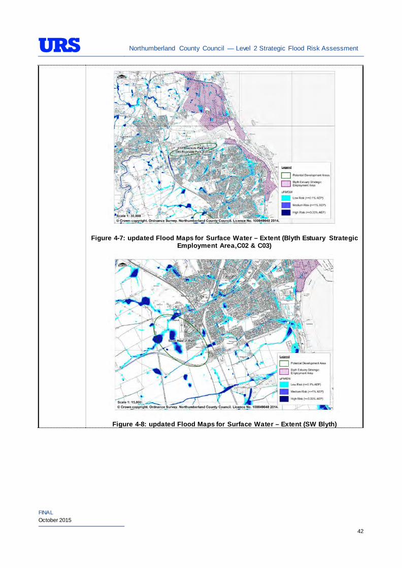
Northumberland County Council — Level 2 Strategic Flood Risk Assessment
FINAL October 2015
42
Figure 4-7: updated Flood Maps for Surface Water – Extent (Blyth Estuary Strategic
Employment Area,C02 & C03)
Figure 4-8: updated Flood Maps for Surface Water – Extent (SW Blyth)
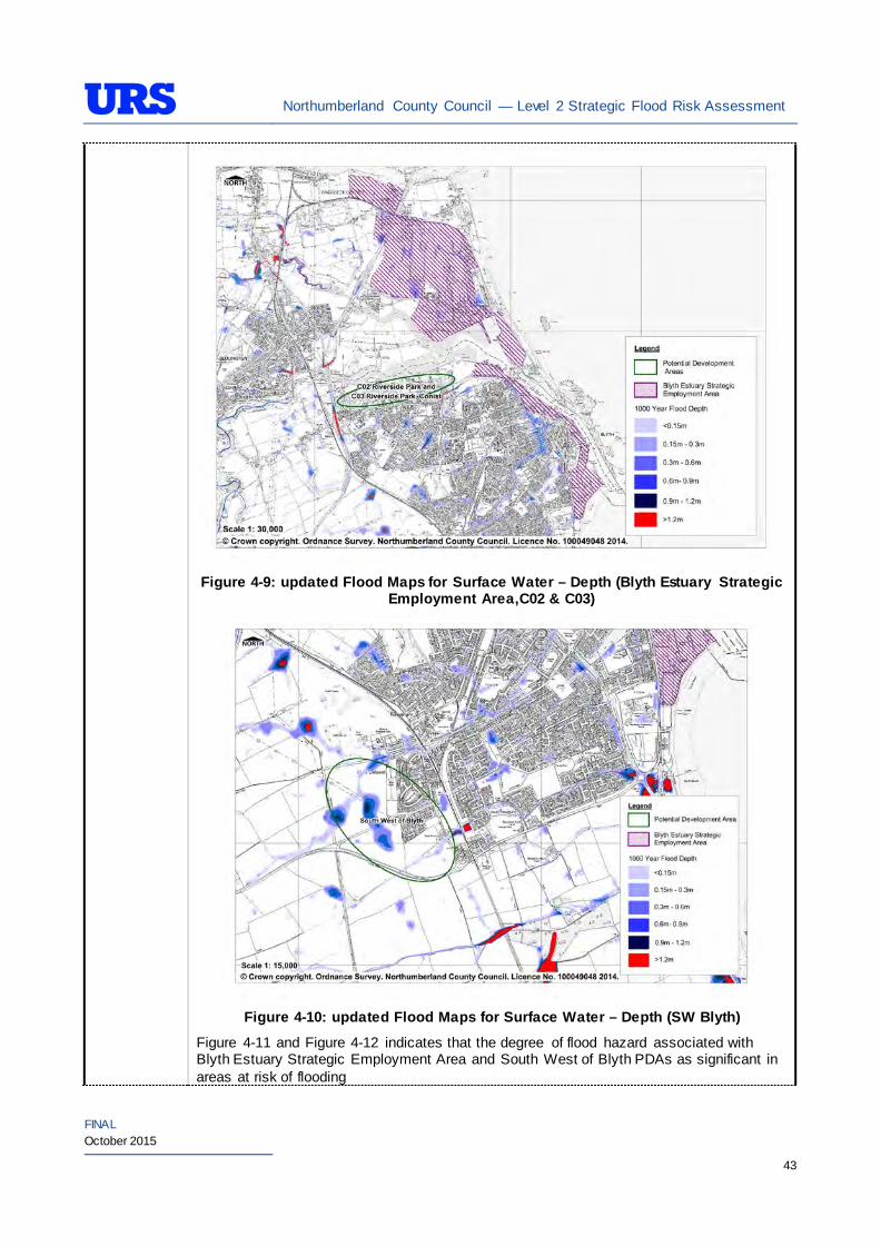
Northumberland County Council — Level 2 Strategic Flood Risk Assessment
FINAL October 2015
43
Figure 4-9: updated Flood Maps for Surface Water – Depth (Blyth Estuary Strategic
Employment Area,C02 & C03)
Figure 4-10: updated Flood Maps for Surface Water – Depth (SW Blyth)
Figure 4-11 and Figure 4-12 indicates that the degree of flood hazard associated with Blyth Estuary Strategic Employment Area and South West of Blyth PDAs as significant in areas at risk of flooding
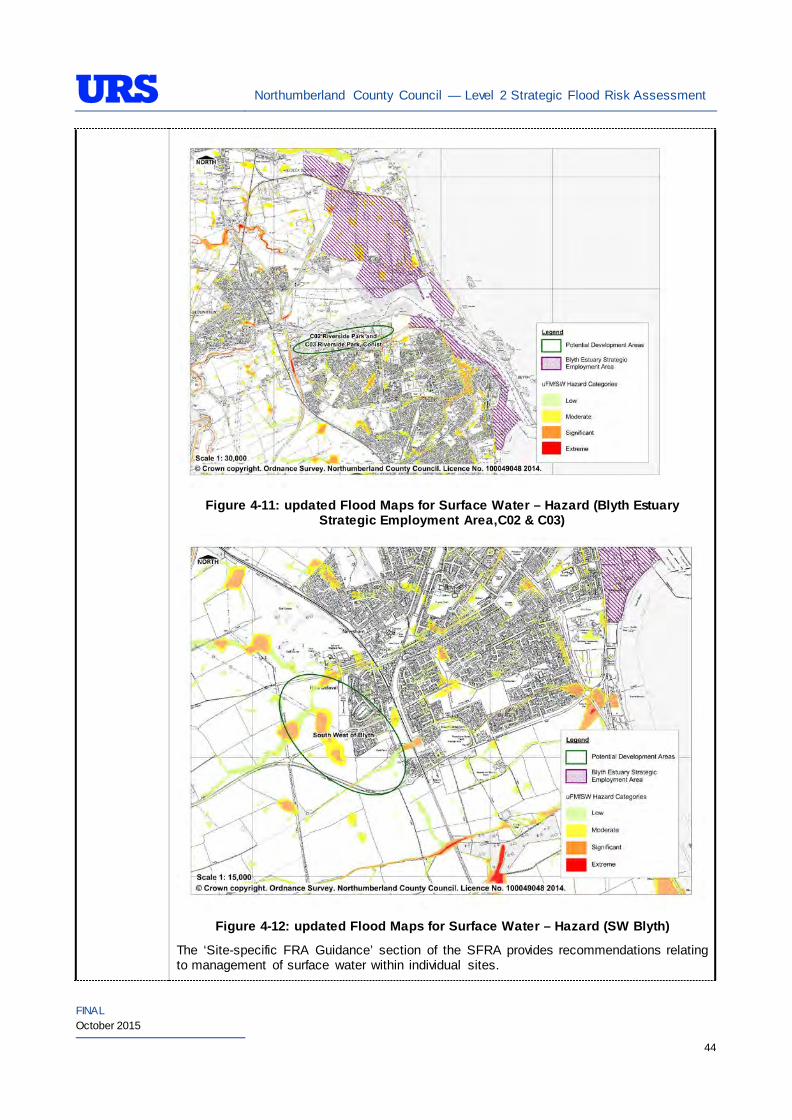
Northumberland County Council — Level 2 Strategic Flood Risk Assessment
FINAL October 2015
44
Figure 4-11: updated Flood Maps for Surface Water – Hazard (Blyth Estuary
Strategic Employment Area,C02 & C03)
Figure 4-12: updated Flood Maps for Surface Water – Hazard (SW Blyth)
The ‘Site-specific FRA Guidance’ section of the SFRA provides recommendations relating to management of surface water within individual sites.
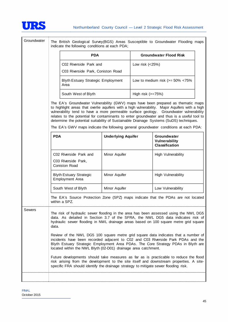
Northumberland County Council — Level 2 Strategic Flood Risk Assessment
FINAL October 2015
45
Groundwater The British Geological Survey(BGS) Areas Susceptible to Groundwater Flooding maps indicate the following conditions at each PDA;
PDA Groundwater Flood Risk
C02 Riverside Park and
C03 Riverside Park, Coniston Road
Low risk (<25%)
Blyth Estuary Strategic Employment Area
Low to medium risk (>= 50% <75%
South West of Blyth High risk (>=75%)
The EA’s Groundwater Vulnerability (GWV) maps have been prepared as thematic maps to highlight areas that overlie aquifers with a high vulnerability. Major Aquifers with a high vulnerability tend to have a more permeable surface geology. Groundwater vulnerability relates to the potential for contaminants to enter groundwater and thus is a useful tool to determine the potential suitability of Sustainable Drainage Systems (SuDS) techniques.
The EA’s GWV maps indicate the following general groundwater conditions at each PDA:
PDA Underlying Aquifer Groundwater Vulnerability Classification
C02 Riverside Park and
C03 Riverside Park, Coniston Road
Minor Aquifer High Vulnerability
Blyth Estuary Strategic Employment Area
Minor Aquifer High Vulnerability
South West of Blyth Minor Aquifer Low Vulnerability
The EA’s Source Protection Zone (SPZ) maps indicate that the PDAs are not located within a SPZ.
Sewers The risk of hydraulic sewer flooding in the area has been assessed using the NWL DG5 data. As detailed in Section 3.7 of the SFRA, the NWL DG5 data indicates risk of hydraulic sewer flooding in NWL drainage areas based on 100 square metre grid square data. Review of the NWL DG5 100 square metre grid square data indicates that a number of incidents have been recorded adjacent to C02 and C03 Riverside Park PDAs and the Blyth Estuary Strategic Employment Area PDAs. The Core Strategy PDAs in Blyth are located within the NWL Blyth (02-D01) drainage area catchment. Future developments should take measures as far as is practicable to reduce the flood risk arising from the development to the site itself and downstream properties. A site-specific FRA should identify the drainage strategy to mitigate sewer flooding risk.
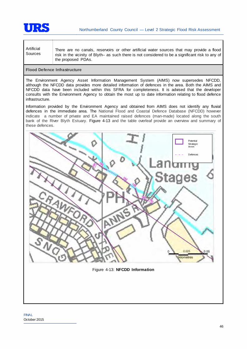
Northumberland County Council — Level 2 Strategic Flood Risk Assessment
FINAL October 2015
46
Artificial Sources
There are no canals, reservoirs or other artificial water sources that may provide a flood risk in the vicinity of Blyth– as such there is not considered to be a significant risk to any of the proposed PDAs.
Flood Defence Infrastructure
The Environment Agency Asset Information Management System (AIMS) now supersedes NFCDD, although the NFCDD data provides more detailed information of defences in the area. Both the AIMS and NFCDD data have been included within this SFRA for completeness. It is advised that the developer consults with the Environment Agency to obtain the most up to date information relating to flood defence infrastructure.
Information provided by the Environment Agency and obtained from AIMS does not identify any fluvial defences in the immediate area. The National Flood and Coastal Defence Database (NFCDD) however indicate a number of private and EA maintained raised defences (man-made) located along the south bank of the River Blyth Estuary. Figure 4-13 and the table overleaf provide an overview and summary of these defences.
Figure 4-13: NFCDD Information
Defences
Potential Strategic Areas
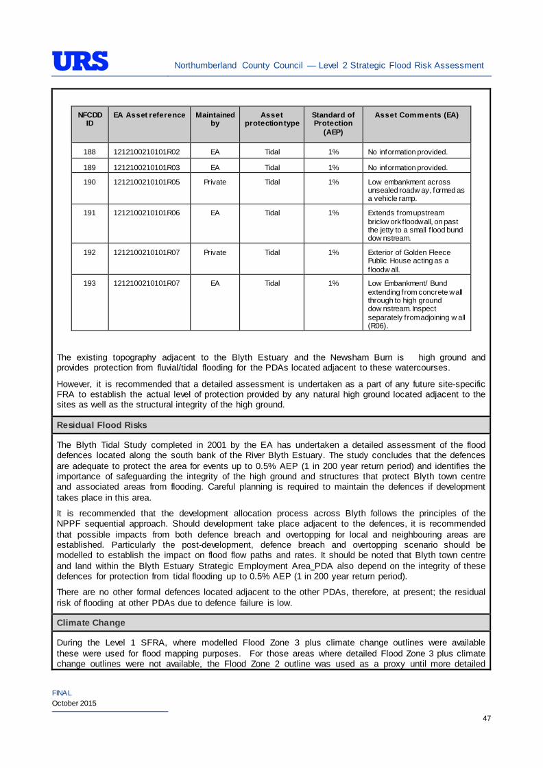
Northumberland County Council — Level 2 Strategic Flood Risk Assessment
FINAL October 2015
47
NFCDD ID
EA Asset reference Maintained by
Asset protection type
Standard of Protection
(AEP)
Asset Comments (EA)
188 1212100210101R02 EA Tidal 1% No information provided.
189 1212100210101R03 EA Tidal 1% No information provided.
190 1212100210101R05 Private Tidal 1% Low embankment across unsealed roadw ay, formed as a vehicle ramp.
191 1212100210101R06 EA Tidal 1% Extends from upstream brickw ork f loodwall, on past the jetty to a small f lood bund dow nstream.
192 1212100210101R07 Private Tidal 1% Exterior of Golden Fleece Public House acting as a f loodw all.
193 1212100210101R07 EA Tidal 1% Low Embankment/ Bund extending from concrete wall through to high ground dow nstream. Inspect separately from adjoining w all (R06).
The existing topography adjacent to the Blyth Estuary and the Newsham Burn is high ground and provides protection from fluvial/tidal flooding for the PDAs located adjacent to these watercourses.
However, it is recommended that a detailed assessment is undertaken as a part of any future site-specific FRA to establish the actual level of protection provided by any natural high ground located adjacent to the sites as well as the structural integrity of the high ground.
Residual Flood Risks
The Blyth Tidal Study completed in 2001 by the EA has undertaken a detailed assessment of the flood defences located along the south bank of the River Blyth Estuary. The study concludes that the defences are adequate to protect the area for events up to 0.5% AEP (1 in 200 year return period) and identifies the importance of safeguarding the integrity of the high ground and structures that protect Blyth town centre and associated areas from flooding. Careful planning is required to maintain the defences if development takes place in this area.
It is recommended that the development allocation process across Blyth follows the principles of the NPPF sequential approach. Should development take place adjacent to the defences, it is recommended that possible impacts from both defence breach and overtopping for local and neighbouring areas are established. Particularly the post-development, defence breach and overtopping scenario should be modelled to establish the impact on flood flow paths and rates. It should be noted that Blyth town centre and land within the Blyth Estuary Strategic Employment Area PDA also depend on the integrity of these defences for protection from tidal flooding up to 0.5% AEP (1 in 200 year return period).
There are no other formal defences located adjacent to the other PDAs, therefore, at present; the residual risk of flooding at other PDAs due to defence failure is low.
Climate Change
During the Level 1 SFRA, where modelled Flood Zone 3 plus climate change outlines were available these were used for flood mapping purposes. For those areas where detailed Flood Zone 3 plus climate change outlines were not available, the Flood Zone 2 outline was used as a proxy until more detailed
Northumberland County Council — Level 2 Strategic Flood Risk Assessment
FINAL October 2015
48
information becomes available (i.e. an Environment Agency hydraulic modelling study or hydraulic modelling study undertaken for a site-specific FRA).
For Blyth, as modelled outlines were unavailable, Flood Zone 2 was used as a proxy to map the potential outline of Flood Zone 3 plus climate change. Therefore, it is recommended that as a part of site-specific FRAs, impact of climate change should be predicted by calculating the potential by calculating the potential sea level rise from the data provided by the NPPF, should any development be proposed within the area covered by the proxy outline for the Blyth estuary area. The predicted level can then be related to topographic data to delineate the extents. For West of Blyth site Flood Zone 3 plus climate change extent should be determined as a part of site-specific FRA and where necessary detailed modelling should be undertaken to confirm the extent. It should be noted that the 200 year tidal flood plus climate change may cover an area greater that Flood Zone 2 shows. Therefore some areas of Flood Zone 1 which may be close enough to the coast, or low enough, may be affected by climate change and therefore potentially at risk. This can apply to fluvial flooding too.
During the Level 1 SFRA, it was determined that there are no modelled outlines of Flood Zone 2 plus climate change for the whole of Northumberland. The Flood Zone 2 plus climate change flood event would be greater than the existing Flood Zone 2 outlines. As there are limitations on data, and extensive uncertainties, in deriving the floodplain for such an extreme event, it is not practical to use a proxy dataset or make assumptions to produce the Flood Zone 2 plus climate change outline. It is therefore recommended that as part of any future detailed site-specific FRAs the extent of the Flood Zone 2 plus climate change is determined, should this be critical to the layout of the development. Consultation with the EA should be undertaken to determine a suitable methodology for undertaking this assessment (i.e. detailed modelling, or applying an agreed buffer to Flood Zone 2).
SUDS Applicability
The SuDS map produced as part of Level 1 SFRA indicated that attenuation systems are applicable for this area. However, further site investigations are necessary to confirm the local ground conditions and determine the appropriate SuDS technique as part of any future site specific FRA.
Prospective developers should work closely with the Environment Agency, the Local Planning Authority (LPA) and Lead Local Flood Authority (LLFA) to manage surface water run-off as near to its source as possible. For the PDAs described above, given the ground conditions attenuation SuDS are likely to be an appropriate technique to manage surface water at individual site level.
The developer should investigate the use of source control attenuation systems such as green roof, rainwater harvesting systems and site control attenuation systems such as swales, ponds and detention basins as appropriate. It should be noted that a wide range of attenuation SuDS techniques are available which can be adopted depending upon the available space to manage surface water. A site-specific FRA should assess the most suitable SuDS system to manage surface water for the development based on the guidance and advice provided within the Level 2 SFRA and the NPPF.
For the wider area of Blyth, there are potential opportunities for the LPA to incorporate SuDS in the master plan to manage surface water whilst improving local water quality, biodiversity, and amenity.
Recommendations
• If development pressures create a need to develop within areas that are at risk of flooding (i.e., Flood Zone 2 and Flood Zone 3), they should incorporate appropriate mitigation measures which must not increase the risk of flooding to surrounding areas. Detailed liaison with the Environment Agency will be necessary during the design and planning process and it cannot be assumed that the Environment Agency will not object to development in these areas;
• The risk at this location is principally attributed to surface water and groundwater and as a result proposed development should mitigate against this risk;
• Self-contained basements will not be permitted within Flood Zone 3. Basements may be accepted if free access is available to floors above the 1% AEP flood level. If basements are included as part of a
Northumberland County Council — Level 2 Strategic Flood Risk Assessment
FINAL October 2015
49
scheme then they should adhere to British Standard 8102; and • For South West Blyth any new discharge to the Newsham Burn should be attenuated so as to prevent
any detrimental impacts downstream. There is currently flooding predicted on the upper parts of Newsham Burn and EA works have reduced the impact lower down the watercourse. Consultation should be undertaken with the EA and Local Planning Authority to agree an appropriate discharge rate to Newsham Burn. Some development has commenced at this location and surface water discharges to Meggie’s Burn, 1km to the south of Newsham Burn.
Policies
• Where applicable roll back development from the Blyth Estuary, Newsham Burn and coastal areas outside of Flood Zone 3a to create ‘blue corridors’ which provide public open space and recreation areas near the Blyth Estuary and coast and enhance green infrastructure. Development should not encroach within 5m of the Blyth Estuary, which is the Environment Agency by-law distance for Main Rivers. This would be beneficial both in terms of flood risk and maintenance access;
• Development allocation across the wider area should follow the principles of the NPPF sequential approach. For example, proposed residential development should be steered to the lower risk areas, with the remaining ‘less vulnerable’ land uses being located on the (relatively) higher risk areas;
• Surface water/pluvial flood risk should also inform the site layout, such that ‘highly vulnerable’ development is avoided in locations that are shown at the greatest risk of pluvial flooding;
• As the PDAs comprise of a mixture of greenfield and brownfield land, future developments within the PDAs potentially can increase surface water runoff. SuDS should be considered at all stages of the planning and design of new developments to reduce runoff rates and volumes from the developed sites, thus reducing the resultant flood risk posed to the sites and adjacent/downstream areas;
• The South West of Blyth site should aim to mimic existing drainage regimes as closely as possible, and reduce discharge off site. Any new discharge to the Newsham Burn will have to be attenuated so as to prevent any impacts downstream through detailed investigations. There is currently flooding predicted on the upper parts of the Newsham Burn and the EA recent works have reduced the impacts lower down the watercourse. Any increase in discharge to the watercourse will increase risk and negate the work that has been completed; and
• Brownfield sites within the area should aim to reduce the runoff by 50% and greenfield should aim to retain greenfield runoff rates.
Site-Specific FRA Guidance
• A site-specific FRA will be required for any development proposed within areas that falls entirely or partly within Flood Zone 2 and Flood Zone 3. For areas that fall within Flood Zone 1, an FRA will be required for any development in excess of 1 ha. The FRA will need to consider surface water management;
• Maximum fluvial/tidal flood levels should be informed by the most up-to-date versions of the Environment Agency’s hydraulic models of the River Blyth, Newsham Burn and or any future coastal studies;
• If development within areas designated as Flood Zone 3 including an allowance for climate change is justifiable, appropriate mitigation and resilience measures should be incorporated both on an individual property-level (such as flood resilient construction) and at a strategic level (such as strategic SuDS);
• The FRA should demonstrate that consideration has been given to the site layout with regards to flood risk from all sources, in line with the recommendations above (sequential approach to site layout);
• The FRA should demonstrate that action has been taken to reduce surface water flood risk to the PDA and surrounding area;
Northumberland County Council — Level 2 Strategic Flood Risk Assessment
FINAL October 2015
50
• The rates and volumes of post-development surface water runoff should be controlled using suitable and adequate SuDS techniques. Where possible, the developers should retrofit drainage solutions to the site with wider benefits to other local areas at risk;
• The suitability of infiltration should be informed by site-specific ground investigation (GI) works;
• The residual risks identified above should be adequately investigated and assessed as part of the FRA and mitigation measures implemented accordingly. In such situations, the developer is generally required to provide resources and funds to undertake more complex modelling/assessments to determine the residual risk to the development arising from events that overtop or breach the defences. In addition, the developer is generally responsible for funding any flood risk management works, including defences and mitigation works;
• A site-specific FRA should consider provision of site access and egress, taking into account any emergency planning requirements of NCC and the Environment Agency. This is a particularly pertinent issue for areas, where access roads are at risk of flooding;
• Any sites which contain or are adjacent to Main Rivers must be designed so as to allow access to the channel for maintenance purposes. This maintenance liability lies with the landowner in the first instance however the Environment Agency have powers to undertake work where deemed necessary. Whether these sites are subject to routine EA maintenance, or not, there must be an access route available; and
• Developments should aim to mimic existing drainage regimes as closely as possible, and reduce discharge off site where possible. Development on brownfield land should aim to reduce the runoff by 50% and greenfield runoff rates should be retained on previously undeveloped land.
• The EA will be publishing new climate change guidance in autumn 2015. The most recent climate change guidance should be used to inform site specific FRA’s.
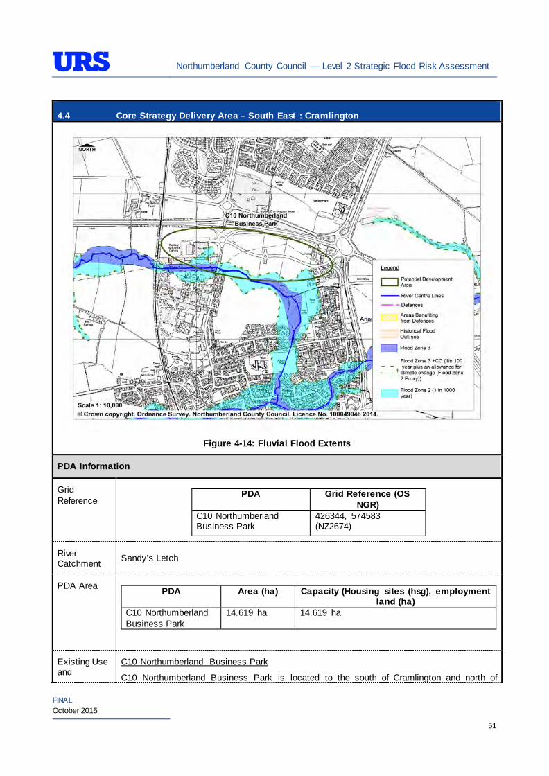
Northumberland County Council — Level 2 Strategic Flood Risk Assessment
FINAL October 2015
51
4.4 Core Strategy Delivery Area – South East : Cramlington
Figure 4-14: Fluvial Flood Extents
PDA Information
Grid Reference
PDA Grid Reference (OS NGR)
C10 Northumberland Business Park
426344, 574583 (NZ2674)
River Catchment Sandy’s Letch
PDA Area PDA Area (ha) Capacity (Housing sites (hsg), employment
land (ha) C10 Northumberland Business Park
14.619 ha 14.619 ha
Existing Use and
C10 Northumberland Business Park
C10 Northumberland Business Park is located to the south of Cramlington and north of
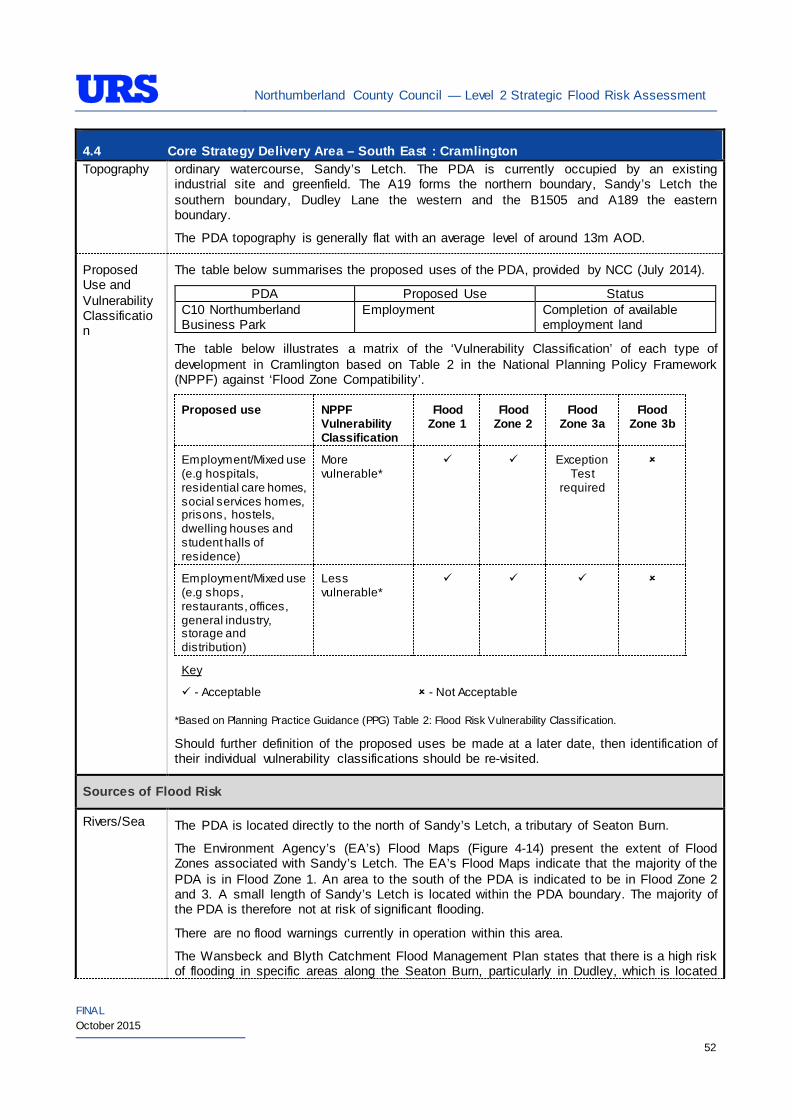
Northumberland County Council — Level 2 Strategic Flood Risk Assessment
FINAL October 2015
52
4.4 Core Strategy Delivery Area – South East : Cramlington Topography ordinary watercourse, Sandy’s Letch. The PDA is currently occupied by an existing
industrial site and greenfield. The A19 forms the northern boundary, Sandy’s Letch the southern boundary, Dudley Lane the western and the B1505 and A189 the eastern boundary.
The PDA topography is generally flat with an average level of around 13m AOD.
Proposed Use and Vulnerability Classification
The table below summarises the proposed uses of the PDA, provided by NCC (July 2014).
PDA Proposed Use Status C10 Northumberland Business Park
Employment Completion of available employment land
The table below illustrates a matrix of the ‘Vulnerability Classification’ of each type of development in Cramlington based on Table 2 in the National Planning Policy Framework (NPPF) against ‘Flood Zone Compatibility’.
Proposed use NPPF Vulnerability Classification
Flood Zone 1
Flood Zone 2
Flood Zone 3a
Flood Zone 3b
Employment/Mixed use (e.g hospitals, residential care homes, social services homes, prisons, hostels, dwelling houses and student halls of residence)
More vulnerable*
Exception Test
required
Employment/Mixed use (e.g shops, restaurants, offices, general industry, storage and distribution)
Less vulnerable*
Key
- Acceptable
- Not Acceptable
*Based on Planning Practice Guidance (PPG) Table 2: Flood Risk Vulnerability Classif ication.
Should further definition of the proposed uses be made at a later date, then identification of their individual vulnerability classifications should be re-visited.
Sources of Flood Risk
Rivers/Sea The PDA is located directly to the north of Sandy’s Letch, a tributary of Seaton Burn.
The Environment Agency’s (EA’s) Flood Maps (Figure 4-14) present the extent of Flood Zones associated with Sandy’s Letch. The EA’s Flood Maps indicate that the majority of the PDA is in Flood Zone 1. An area to the south of the PDA is indicated to be in Flood Zone 2 and 3. A small length of Sandy’s Letch is located within the PDA boundary. The majority of the PDA is therefore not at risk of significant flooding.
There are no flood warnings currently in operation within this area.
The Wansbeck and Blyth Catchment Flood Management Plan states that there is a high risk of flooding in specific areas along the Seaton Burn, particularly in Dudley, which is located
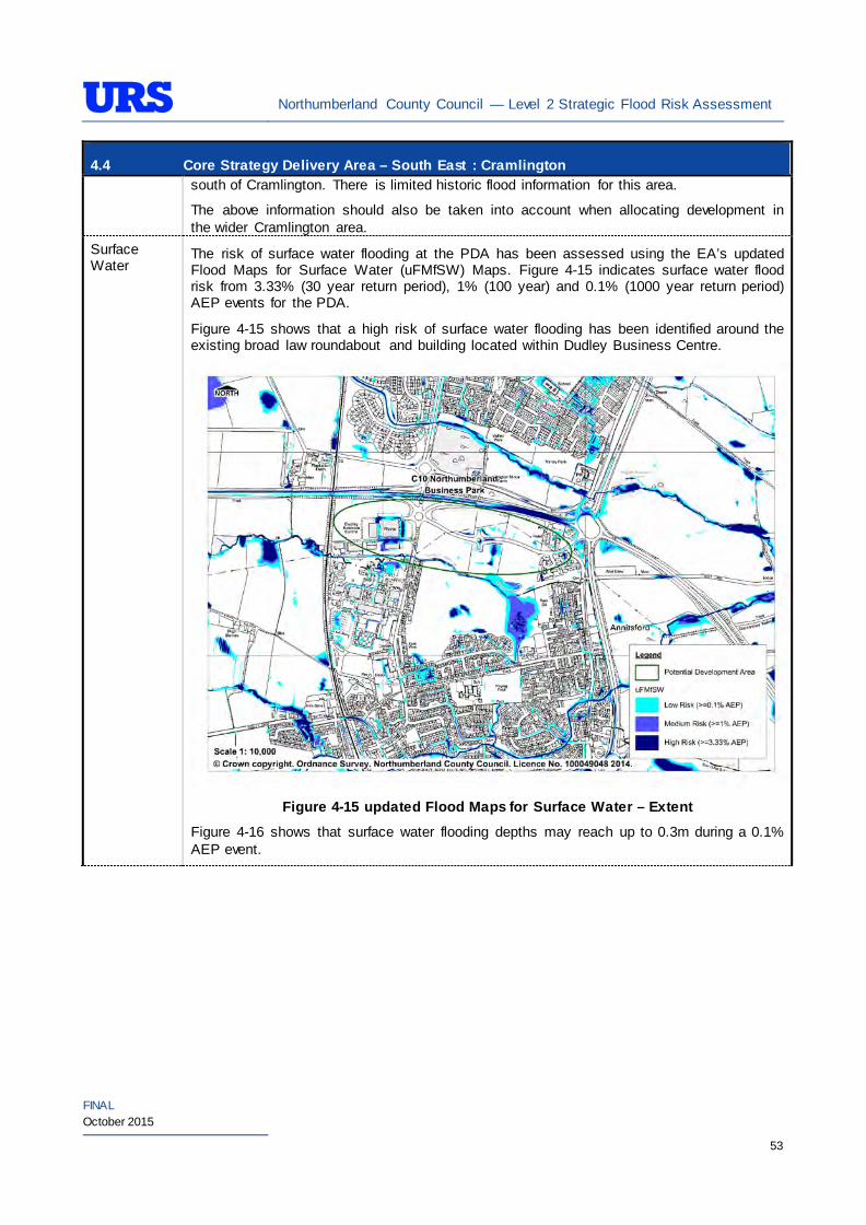
Northumberland County Council — Level 2 Strategic Flood Risk Assessment
FINAL October 2015
53
4.4 Core Strategy Delivery Area – South East : Cramlington south of Cramlington. There is limited historic flood information for this area.
The above information should also be taken into account when allocating development in the wider Cramlington area.
Surface Water
The risk of surface water flooding at the PDA has been assessed using the EA’s updated Flood Maps for Surface Water (uFMfSW) Maps. Figure 4-15 indicates surface water flood risk from 3.33% (30 year return period), 1% (100 year) and 0.1% (1000 year return period) AEP events for the PDA.
Figure 4-15 shows that a high risk of surface water flooding has been identified around the existing broad law roundabout and building located within Dudley Business Centre.
Figure 4-15 updated Flood Maps for Surface Water – Extent
Figure 4-16 shows that surface water flooding depths may reach up to 0.3m during a 0.1% AEP event.
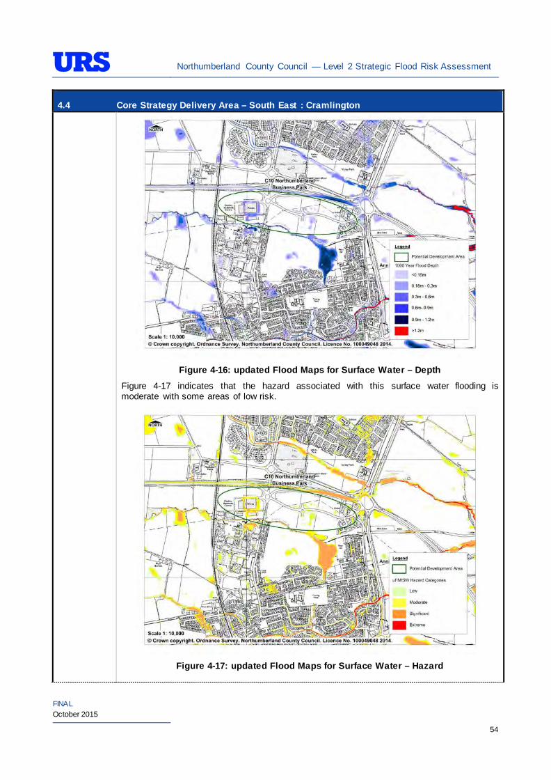
Northumberland County Council — Level 2 Strategic Flood Risk Assessment
FINAL October 2015
54
4.4 Core Strategy Delivery Area – South East : Cramlington
Figure 4-16: updated Flood Maps for Surface Water – Depth
Figure 4-17 indicates that the hazard associated with this surface water flooding is moderate with some areas of low risk.
Figure 4-17: updated Flood Maps for Surface Water – Hazard
Northumberland County Council — Level 2 Strategic Flood Risk Assessment
FINAL October 2015
55
4.4 Core Strategy Delivery Area – South East : Cramlington Refer to ‘Site-specific FRA Guidance’ section for recommendations relating to management of surface water within individual sites.
Groundwater The British Geological Survey (BGS) Areas Susceptible to Groundwater Flooding map indicates that the PDA is at high risk of groundwater flooding.
The EA’s Groundwater Vulnerability (GWV) maps have been prepared as a thematic map to highlight areas that overlie aquifers with a high vulnerability. Major Aquifers with a high vulnerability tend to have a more permeable surface geology. Groundwater vulnerability relates to the potential for contaminants to enter groundwater and thus is a useful tool to determine the potential suitability of Sustainable Drainage Systems (SuDS) techniques.
The EA’s GWV maps indicate the following general groundwater conditions at the PDA:
PDA Underlying Aquifer Vulnerability C10 Northumberland Business Park
Minor Aquifer
Low Vulnerability
The EA’s Source Protection Zone (SPZ) maps indicate that the PDA is not located within a SPZ.
The site is predominantly located in an area identified as being at high risk of groundwater flooding (over 75% in the Environment Agency Areas Susceptible to Groundwater Flooding map (AStGF)).
Sewers The risk of hydraulic sewer flooding in the area has been assessed using the NWL DG5 data. As detailed in Section 3.7 of the SFRA, the NWL DG5 data indicates risk of sewer flooding in NWL drainage areas based on 100 square metre grid square data.
Review of the NWL DG5 100 square metre grid square data indicates 2 grid squares in the drainage area. The Core Strategy Delivery Area in Cramlington is located within the NWL Seaton Valley (05-D01) drainage area catchment.
Future developments should take measures as far as is practicable to reduce the flood risk arising from the development to the site itself and downstream properties. A site-specific FRA should identify the drainage strategy to mitigate sewer flooding risk.
Artificial Sources
There are no canals, reservoirs or other artificial water sources that may provide a flood risk in the vicinity of these PDAs - as such there is not considered to be a significant risk to any proposed sites.
Flood Defence Infrastructure
The Environment Agency Asset Information Management System (AIMS) now supersedes NFCDD, although the NFCDD data provides more detailed information of defences in the area. Both the AIMS and NFCDD data have been included within this SFRA for completeness. It is advised that the developer consults with the Environment Agency to obtain the most up to date information relating to flood defence infrastructure.
The AIMS does not identify any fluvial defences in the immediate area.
The NFCDD however indicates the presence of natural defences, such as high ground along the banks of Sandy’s Letch. This high ground provides 50% AEP level of protection. The asset has been given an asset rating by the EA of 3.
Northumberland County Council — Level 2 Strategic Flood Risk Assessment
FINAL October 2015
56
4.4 Core Strategy Delivery Area – South East : Cramlington Residual Flood Risks
It is recommended that development allocation process across the PDA follow the principles of the NPPF sequential approach. As parts of the PDA are located in low-lying fluvial areas with a higher vulnerability to flood from defence breach and overtop, it is also recommended that detailed assessments are undertaken as a part of site-specific FRA to establish the standard of protection provided by the defences and identify necessary mitigation measures to be undertaken.
Climate Change
During the Level 1 SFRA, where modelled Flood Zone 3 plus climate change outlines were available these were used for mapping. For those areas where detailed Flood Zone 3 plus climate change outlines were not available, the Flood Zone 2 outline was used as a proxy until more detailed information becomes available (i.e. an EA hydraulic modelling study or hydraulic modelling study undertaken for a site-specific FRA). It should be noted that the 200 year tidal flood plus climate change may cover an area greater that Flood Zone 2 shows. Therefore some areas of Flood Zone 1 which may be close enough to the coast, or low enough, may be affected by climate change and therefore potentially at risk. This can apply to fluvial flooding too.
For the Cramlington area, as modelled outlines were unavailable, Flood Zone 2 was used as a proxy to map the potential outline of Flood Zone 3 plus climate change. Therefore, it is recommended that as a part of site-specific FRAs detailed modelling is undertaken to confirm the extent of the Flood Zone 3 plus climate change, should any development be proposed within the area covered by the proxy outline.
During the Level 1 SFRA, it was determined that there are no modelled outlines of Flood Zone 2 plus climate change for the whole of Northumberland. The Flood Zone 2 plus climate change flood event would be greater than the existing Flood Zone 2 outlines. As there are limitations on data, and extensive uncertainties, in deriving the floodplain for such an extreme event, it is not practical to use a proxy dataset or make assumptions to produce the Flood Zone 2 plus climate change outline. It is therefore recommended that as part of any future detailed site-specific FRAs the extent of Flood Zone 2 plus climate change is determined, should this be critical to the layout of the development. Consultation with the EA should be undertaken to determine a suitable methodology for undertaking this assessment (i.e. detailed modelling, or applying an agreed buffer to Flood Zone 2).
SuDS Applicability
The SuDS map produced as part of Level 1 SFRA indicated that attenuation systems are applicable for this area. However, further site investigations are necessary to confirm the local ground conditions and determine the appropriate SuDS technique as part of any future site specific FRA.
Prospective developers should work closely with the EA, LPA and LLFA to manage surface water run-off as near to its source as possible. For the site described above, given the ground conditions attenuation SuDS are likely to be an appropriate technique to manage surface water at individual site level.
The developer should investigate the use of source control attenuation systems such as green roof, rainwater harvesting systems and site control attenuation systems such as swales, ponds and detention basins as appropriate. It should be noted that a wide range of attenuation SuDS techniques are available which can be adopted depending upon the available space to manage surface water. A site-specific FRA should assess the most suitable SuDS system to manage surface water for the development based on the guidance and advice provided within the Level 2 SFRA and the NPPF.
Recommendations
• If development pressures create a need to develop within areas that are at risk of flooding (i.e., Flood Zone 2 and Flood Zone 3), they should incorporate appropriate mitigation measures which must not increase the risk of flooding to surrounding areas. Careful liaison with the EA will be necessary during
Northumberland County Council — Level 2 Strategic Flood Risk Assessment
FINAL October 2015
57
4.4 Core Strategy Delivery Area – South East : Cramlington the design and planning process and it cannot be assumed that the EA will not object to development in these areas; and
• Self-contained basements will not be permitted within Flood Zone 3. Basements may be accepted if access is available to floors above the 1% AEP flood level. If basements are included as part of a scheme then they should adhere to British Standard 8102.
Policies
• Where applicable roll back development from the watercourse outside of Flood Zone 3a to create ‘blue corridors’ which provide public open space and recreation areas near the watercourse and enhance green infrastructure. Development should not encroach within 5m of the watercourse, which is the Environment Agency by-law distance for Main Rivers. This would be beneficial both in terms of flood risk and maintenance access;
• Mixed use (mixed vulnerability) development should follow the principles of the NPPF sequential approach across the wider area. For example, proposed residential development should be steered to the lower risk areas, with the remaining ‘less vulnerable’ land uses being located on the (relatively) higher risk areas. This approach can also be applied within buildings, for example commercial development located at ground floor level and residential development above ground floor level in flood risk areas. However, access and egress must still be made available for the residential uses;
• Surface water/pluvial flood risk should also inform the site layout, such that ‘highly vulnerable’ development is avoided in locations that are shown at the greatest risk of pluvial flooding; and
• As the PDA comprises of a mixture of greenfield and brownfield land, future developments within the PDA potentially can increase surface water runoff. SuDS should be considered at all stages of the planning and design of new developments to reduce runoff rates and volumes from the developed site, thus reducing the resultant flood risk posed to the site and adjacent/downstream areas. Development should, where reasonably possible, aim to reduce surface water runoff to less than greenfield run off. If this is not possible then greenfield runoff rates should be achieved by the proposed mitigation measures.
Site-Specific FRA Guidance
• A site-specific FRA will be required for any development proposed within the site that falls entirely or partly within Flood Zone 2 and Flood Zone 3. For individual plots within the site that do fall within Flood Zone 1, an FRA will be required for any development in excess of 1 ha. The FRA will need to consider surface water management;
• Maximum fluvial flood levels at the site should be informed by the most up-to-date versions of the EA’s hydraulic models of Sandy’s Letch or, or any future fluvial studies. If no models are available then the Lead Local Flood Authority may require a model as part of a planning application;
• If development within areas designated as Flood Zone 3 including an allowance for climate change is justifiable, appropriate mitigation and resilience measures should be incorporated both on an individual property-level (such as flood resilient construction) and at a strategic level (such as strategic SuDS);
• The FRA should demonstrate that consideration has been given to the site layout with regards to flood risk from all sources, in line with the recommendations above (sequential approach to site layout);
• The rates and volumes of post-development surface water runoff should be controlled using suitable and adequate SuDS techniques. Where possible, the developer should retrofit drainage solutions to the site with wider benefits to other local areas at risk;
• The suitability of infiltration SuDS should be informed by site-specific ground investigation (GI) works;
• The residual risks identified above should be adequately investigated and assessed as part of the FRA
Northumberland County Council — Level 2 Strategic Flood Risk Assessment
FINAL October 2015
58
4.4 Core Strategy Delivery Area – South East : Cramlington and mitigation measures implemented accordingly. In such situations, the developer is generally required to provide resources and funds to undertake more complex modelling/assessments to determine the residual risk on the development arising from events that overtop or breach the defences. In addition, the developer is generally responsible for funding any flood risk management works, including defences and mitigation works;
• A site-specific FRA should consider provision of site access and egress, taking into account any emergency planning requirements of NCC and the Environment Agency. This is a particularly pertinent issue for areas, where access roads are at risk of flooding;
• Any sites which contain or are adjacent to Main Rivers must be designed so as to allow access to the channel for maintenance purposes. This maintenance liability lies with the landowner in the first instance however the Environment Agency have powers to undertake work where deemed necessary. Whether these sites are subject to routine EA maintenance, or not, there must be an access route available; and
• Developments should aim to mimic existing drainage regimes as closely as possible, and reduce discharge off site where possible. Development on brownfield land should aim to reduce the runoff by 50% and greenfield rates should be retained on previously undeveloped sites.
• The EA will be publishing new climate change guidance in autumn 2015. The most recent climate change guidance should be used to inform site specific FRA’s.
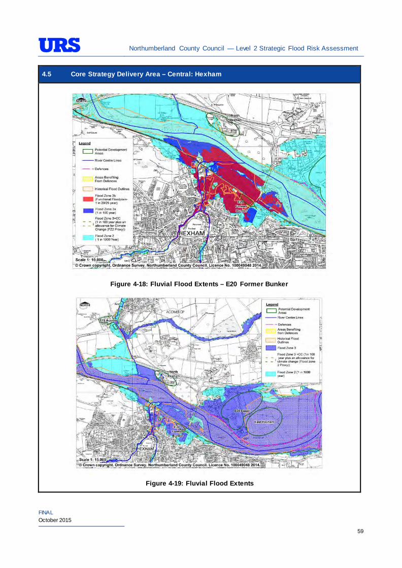
Northumberland County Council — Level 2 Strategic Flood Risk Assessment
FINAL October 2015
59
4.5 Core Strategy Delivery Area – Central: Hexham
Figure 4-18: Fluvial Flood Extents – E20 Former Bunker
Figure 4-19: Fluvial Flood Extents
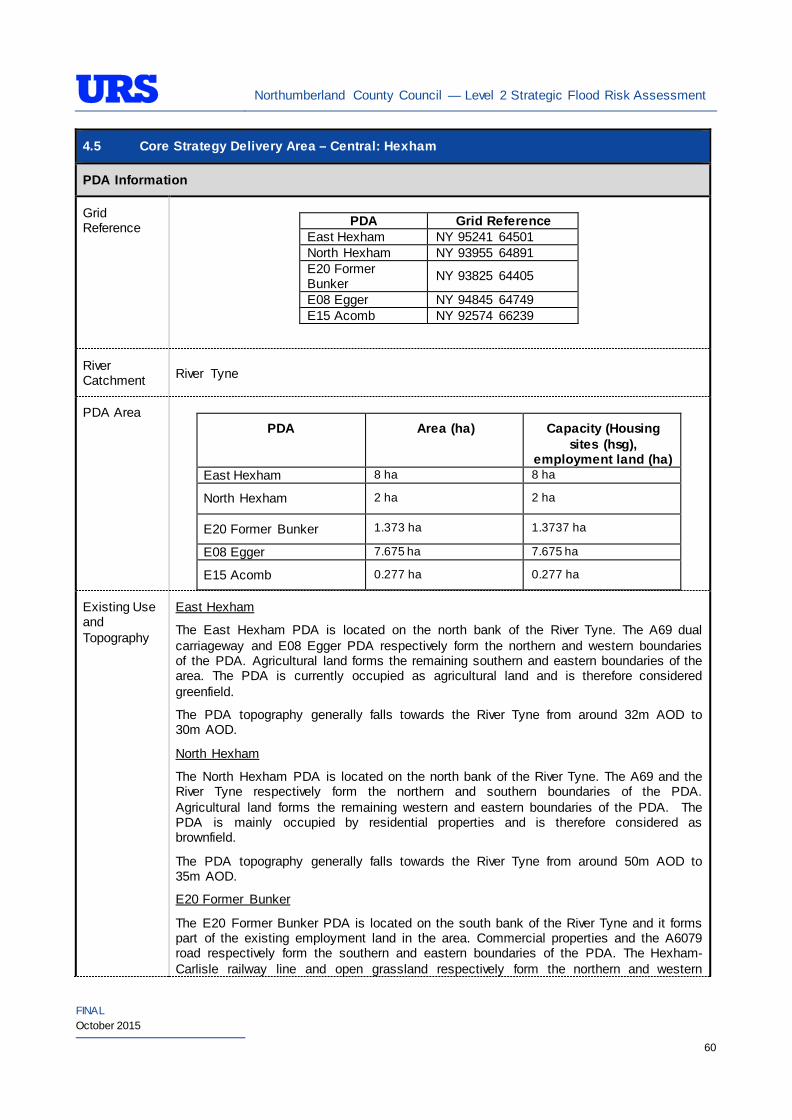
Northumberland County Council — Level 2 Strategic Flood Risk Assessment
FINAL October 2015
60
4.5 Core Strategy Delivery Area – Central: Hexham
PDA Information
Grid Reference
PDA Grid Reference
East Hexham NY 95241 64501 North Hexham NY 93955 64891 E20 Former Bunker NY 93825 64405
E08 Egger NY 94845 64749 E15 Acomb NY 92574 66239
River Catchment River Tyne
PDA Area
PDA Area (ha) Capacity (Housing sites (hsg),
employment land (ha) East Hexham 8 ha 8 ha
North Hexham 2 ha 2 ha
E20 Former Bunker 1.373 ha 1.3737 ha
E08 Egger 7.675 ha 7.675 ha
E15 Acomb 0.277 ha 0.277 ha
Existing Use and Topography
East Hexham
The East Hexham PDA is located on the north bank of the River Tyne. The A69 dual carriageway and E08 Egger PDA respectively form the northern and western boundaries of the PDA. Agricultural land forms the remaining southern and eastern boundaries of the area. The PDA is currently occupied as agricultural land and is therefore considered greenfield.
The PDA topography generally falls towards the River Tyne from around 32m AOD to 30m AOD.
North Hexham
The North Hexham PDA is located on the north bank of the River Tyne. The A69 and the River Tyne respectively form the northern and southern boundaries of the PDA. Agricultural land forms the remaining western and eastern boundaries of the PDA. The PDA is mainly occupied by residential properties and is therefore considered as brownfield.
The PDA topography generally falls towards the River Tyne from around 50m AOD to 35m AOD.
E20 Former Bunker
The E20 Former Bunker PDA is located on the south bank of the River Tyne and it forms part of the existing employment land in the area. Commercial properties and the A6079 road respectively form the southern and eastern boundaries of the PDA. The Hexham- Carlisle railway line and open grassland respectively form the northern and western
Northumberland County Council — Level 2 Strategic Flood Risk Assessment
FINAL October 2015
61
4.5 Core Strategy Delivery Area – Central: Hexham boundaries of the PDA. The PDA predominately consists of open grassland and is therefore considered greenfield.
The PDA topography generally appears to be flat with levels around 34m AOD.
E08 Egger
The E08 Egger PDA is located on the north bank of the River Tyne and it forms part of the existing employment land in the area. The River Tyne and Ferry Road respectively form the western and northern boundaries of the PDA whilst farmland forms the southern and eastern boundaries of the PDA.
The PDA topography generally falls towards the River Tyne from around 32m AOD to 31m AOD
E15 Acomb
The PDA is located on the western fringe of Acomb and it forms part of the existing employment land in the area. The A6079 road and Howford Lane respectively form the eastern and northern boundaries whilst the remaining boundaries of the PDA are formed by farmland. The majority of the PDA comprises of large commercial/industrial buildings and is therefore considered brownfield.
The topography of the PDA gradually slopes towards the local watercourses from around 47m AOD to 44m AOD.
Proposed Use and Vulnerability Classification
The table below summarises the proposed uses of the PDAs, provided by NCC (July 2014).
PDA Proposed Use Status East Hexham Employment Preferred area North Hexham Employment Alternative area
E20 Former Bunker Employment Completion of available employment land
E08 Egger Employment Held for expansion
E15 Acomb Employment Completion of available employment land
The table below illustrates a matrix of ‘Vulnerability Classification’ based on Table 2 in the National Planning Policy Framework (NPPF) against ‘Flood Zone Compatibility’.
Proposed use NPPF Vulnerability Classification
Flood Zone 1
Flood Zone 2
Flood Zone 3a
Flood Zone 3b
Employment /Mixed use (e.g hospitals, residential care homes, social services homes, prisons, hostels, dwelling houses and student halls of residence)
More vulnerable*
Exception Test
required
Employment /Mixed use (e.g shops, restaurants, offices, general industry, storage and distribution)
Less vulnerable*
Northumberland County Council — Level 2 Strategic Flood Risk Assessment
FINAL October 2015
62
4.5 Core Strategy Delivery Area – Central: Hexham Key
- Acceptable
- Not Acceptable
*Based on Planning Practice Guidance (PPG) Table 2: Flood Risk Vulnerability Classif ication.
Should further definition of the proposed uses be made at a later date, then identification of their individual vulnerability classifications should be re-visited.
Sources of Flood Risk
Rivers The River Tyne presents the main fluvial flood risk to majority of the PDAs in Hexham. A number of minor watercourses in the area including Cockshaw Burn, Halgut Burn and Red Burn also present fluvial flood risk to some of the PDAs.
The Environment Agency’s (EA’s) Flood Maps show the extent of Flood Zones associated with these watercourses.
East Hexham
The EA’s Flood Maps (Figure 4-19) indicate that the entire PDA is in Flood Zone 3. The Flood Maps also indicate that a significant area of the main access route in the area to be within Flood Zones 2 and 3. The PDA is therefore considered to be at risk of significant flooding.
The PDA is partially located within the EA’s ‘River Tyne at Hexham’ Flood Warning Area.
North Hexham
The EA’s Flood Maps (Figure 4-19) indicate that the majority of the PDA is in Flood Zone 1. The Flood Maps also indicate that a significant area in the south of the PDA and a part of the main access road of the PDA to be within Flood Zones 2 and 3.
The PDA is partially located within the EA’s ‘River Tyne at Hexham’ Flood Warning Area.
E20 Former Bunker
The EA’s Flood Maps (Figure 4-18) indicate that the PDA is at risk of fluvial flooding from the River Tyne, Cockshaw Burn and Halgut Burn. The Flood Maps indicate that the entire PDA is in Flood Zone 3. The Flood Maps also indicate that a significant area of the main access route in the area to be within Flood Zones 2 and 3. The PDA is therefore considered to be at risk of significant flooding.
The PDA is located within the EA’s ‘River Tyne at Hexham’ Flood Warning Area.
E08 Egger
The EA’s Flood Maps (Figure 4-19) indicate that the entire PDA is in Flood Zone 3. The Flood Maps also indicate that a significant area of the main access route in the area to be within Flood Zones 2 and 3. The PDA is therefore considered to be at risk of significant flooding.
The PDA is located within the EA’s ‘River Tyne at Hexham’ Flood Warning Area.
E15 Acomb
The EA’s Flood Maps (Figure 4-19) indicate that the majority of the PDA is in Flood Zone 1. Red Burn which is a tributary of the River Tyne poses flood risk to the PDA. A small area in the south-eastern corner of the PDA is indicated to be in Flood Zone 2 and Flood Zone 3. The majority of the PDA is therefore not at risk of significant flooding.
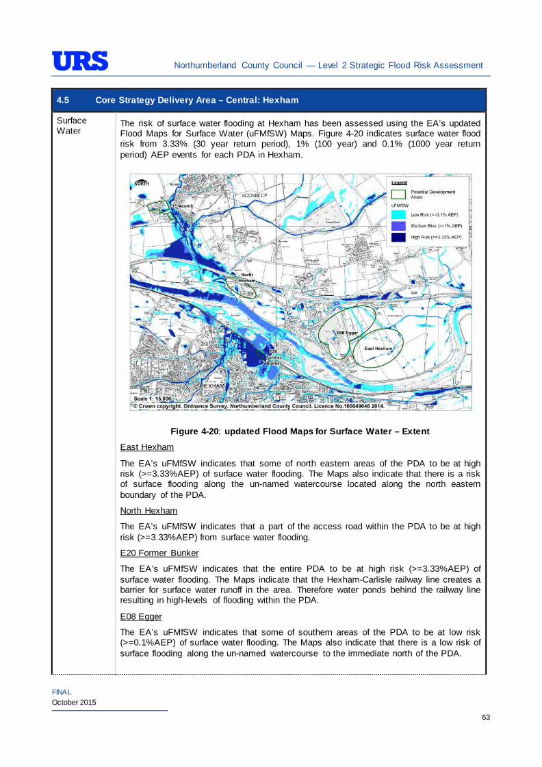
Northumberland County Council — Level 2 Strategic Flood Risk Assessment
FINAL October 2015
63
4.5 Core Strategy Delivery Area – Central: Hexham Surface Water
The risk of surface water flooding at Hexham has been assessed using the EA’s updated Flood Maps for Surface Water (uFMfSW) Maps. Figure 4-20 indicates surface water flood risk from 3.33% (30 year return period), 1% (100 year) and 0.1% (1000 year return period) AEP events for each PDA in Hexham.
Figure 4-20: updated Flood Maps for Surface Water – Extent
East Hexham
The EA’s uFMfSW indicates that some of north eastern areas of the PDA to be at high risk (>=3.33%AEP) of surface water flooding. The Maps also indicate that there is a risk of surface flooding along the un-named watercourse located along the north eastern boundary of the PDA.
North Hexham
The EA’s uFMfSW indicates that a part of the access road within the PDA to be at high risk (>=3.33%AEP) from surface water flooding.
E20 Former Bunker
The EA’s uFMfSW indicates that the entire PDA to be at high risk (>=3.33%AEP) of surface water flooding. The Maps indicate that the Hexham-Carlisle railway line creates a barrier for surface water runoff in the area. Therefore water ponds behind the railway line resulting in high-levels of flooding within the PDA.
E08 Egger
The EA’s uFMfSW indicates that some of southern areas of the PDA to be at low risk (>=0.1%AEP) of surface water flooding. The Maps also indicate that there is a low risk of surface flooding along the un-named watercourse to the immediate north of the PDA.
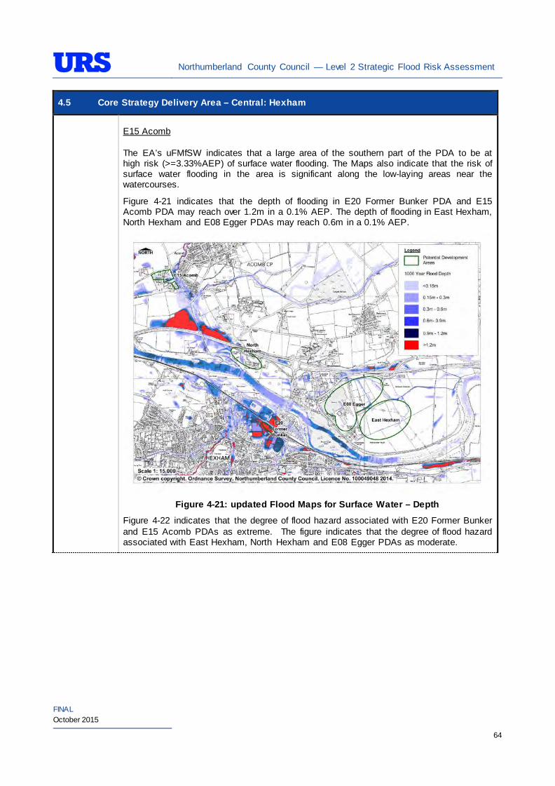
Northumberland County Council — Level 2 Strategic Flood Risk Assessment
FINAL October 2015
64
4.5 Core Strategy Delivery Area – Central: Hexham E15 Acomb The EA’s uFMfSW indicates that a large area of the southern part of the PDA to be at high risk (>=3.33%AEP) of surface water flooding. The Maps also indicate that the risk of surface water flooding in the area is significant along the low-laying areas near the watercourses.
Figure 4-21 indicates that the depth of flooding in E20 Former Bunker PDA and E15 Acomb PDA may reach over 1.2m in a 0.1% AEP. The depth of flooding in East Hexham, North Hexham and E08 Egger PDAs may reach 0.6m in a 0.1% AEP.
Figure 4-21: updated Flood Maps for Surface Water – Depth
Figure 4-22 indicates that the degree of flood hazard associated with E20 Former Bunker and E15 Acomb PDAs as extreme. The figure indicates that the degree of flood hazard associated with East Hexham, North Hexham and E08 Egger PDAs as moderate.
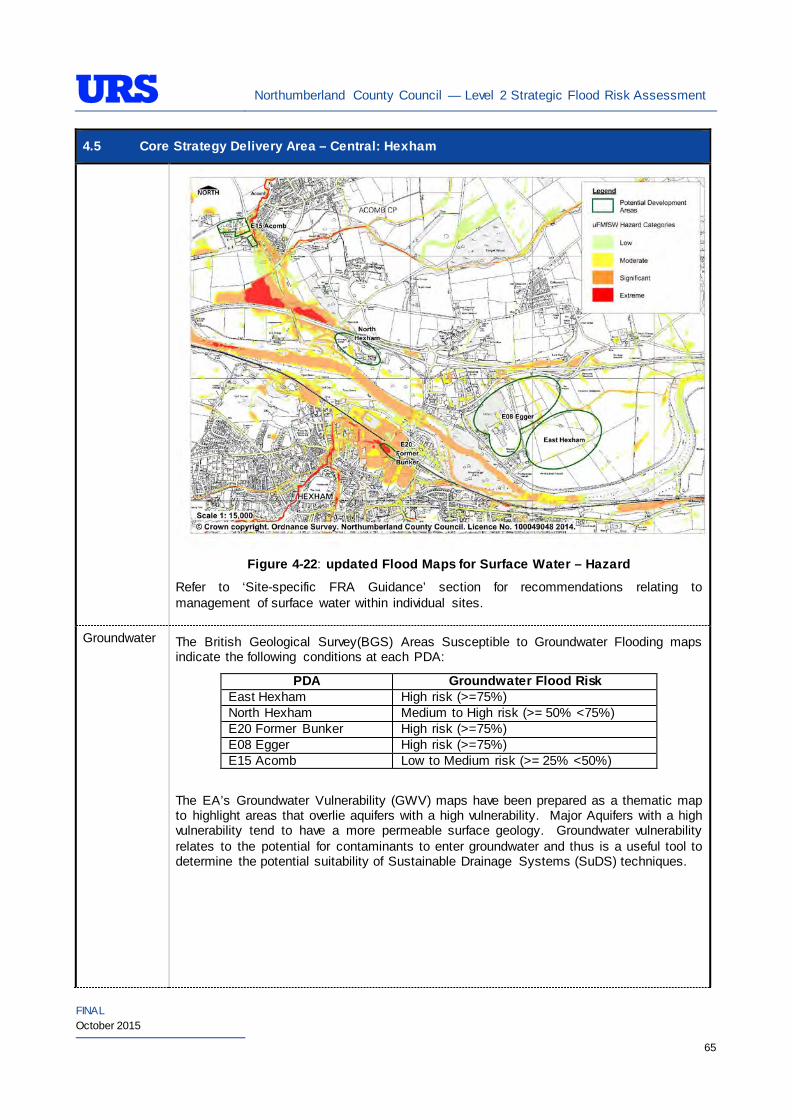
Northumberland County Council — Level 2 Strategic Flood Risk Assessment
FINAL October 2015
65
4.5 Core Strategy Delivery Area – Central: Hexham
Figure 4-22: updated Flood Maps for Surface Water – Hazard
Refer to ‘Site-specific FRA Guidance’ section for recommendations relating to management of surface water within individual sites.
Groundwater The British Geological Survey(BGS) Areas Susceptible to Groundwater Flooding maps indicate the following conditions at each PDA:
PDA Groundwater Flood Risk East Hexham High risk (>=75%) North Hexham Medium to High risk (>= 50% <75%) E20 Former Bunker High risk (>=75%) E08 Egger High risk (>=75%) E15 Acomb Low to Medium risk (>= 25% <50%)
The EA’s Groundwater Vulnerability (GWV) maps have been prepared as a thematic map to highlight areas that overlie aquifers with a high vulnerability. Major Aquifers with a high vulnerability tend to have a more permeable surface geology. Groundwater vulnerability relates to the potential for contaminants to enter groundwater and thus is a useful tool to determine the potential suitability of Sustainable Drainage Systems (SuDS) techniques.
Northumberland County Council — Level 2 Strategic Flood Risk Assessment
FINAL October 2015
66
4.5 Core Strategy Delivery Area – Central: Hexham
The EA’s GWV maps indicate the following general groundwater conditions at each PDA:
PDA Underlying Aquifer Vulnerability East Hexham Minor Aquifer Intermediate Vulnerability North Hexham Minor Aquifer Intermediate Vulnerability E20 Former Bunker Minor Aquifer High Vulnerability E08 Egger Minor Aquifer Intermediate Vulnerability E15 Acomb Minor Aquifer Intermediate Vulnerability
The EA’s Source Protection Zone (SPZ) maps indicate that the PDAs are not located within a SPZ.
Sewers The risk of hydraulic sewer flooding in the area has been assessed using the NWL DG5 data. As detailed in Section 3.7 of the SFRA, the NWL DG5 data indicates risk of hydraulic sewer flooding in NWL drainage areas based on 100 square meter grid square data.
Review of the NWL DG5 100 square metre grid square data indicates that no incidents have been reported to the adjacent of the PDAs. The Core Strategy Delivery PDAs in Hexham are located within the NWL Hexham (03-D03) drainage area catchment.
Future developments should take measures as far as is practicable to reduce the flood risk arising from the development to the site itself and downstream properties. A site-specific FRA should identify the drainage strategy to mitigate sewer flooding risk.
Artificial Sources
There are no reservoirs in the immediate vicinity of the area. However, a number of impounding resources structures are located upstream of the area. These include Kielder and Catcleugh reservoirs, which are located in the upper North Tyne catchment. A review of the Environment Agency’s Reservoir Flood Maps indicates that all of the PDAs described above are to be at residual flood risk in the event of a reservoir breach in the upstream catchment of the River North Tyne. However, the probability of flooding due to breach of the reservoirs occurring is very low.
Residual risk from reservoir breach should be considered as part of any site-specific FRA as although the probability of such an incident occurring are very low the potential consequences may be severe.
There are no canals or other artificial water sources that may provide a flood risk in the vicinity of the area.
Flood Defence Infrastructure
The Environment Agency Asset Information Management System (AIMS) now supersedes NFCDD, although the NFCDD data provides more detailed information of defences in the area. Both the AIMS and NFCDD data have been included within this SFRA for completeness. It is advised that the developer consults with the Environment Agency to obtain the most up to date information relating to flood defence infrastructure.
Information received from the Environment Agency and obtained from AIMS does not identify any fluvial defences in the immediate area. The NFCDD however indicates the presence of flood defences within the area.
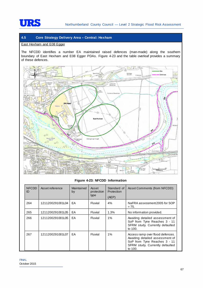
Northumberland County Council — Level 2 Strategic Flood Risk Assessment
FINAL October 2015
67
4.5 Core Strategy Delivery Area – Central: Hexham East Hexham and E08 Egger The NFCDD identifies a number EA maintained raised defences (man-made) along the southern boundary of East Hexham and E08 Egger PDAs. Figure 4-23 and the table overleaf provides a summary of these defences.
Figure 4-23: NFCDD Information
NFCDD ID
Asset reference Maintained by
Asset protection type
Standard of Protection
(AEP)
Asset Comments (from NFCDD)
264 1211200291001L04 EA Fluvial 4% NaFRA assessment 2005 for SOP = 75.
265 1211200291001L05 EA Fluvial 1.3% No information provided.
266 1211200291001L05 EA Fluvial 1% Awaiting detailed assessment of SoP from Tyne Reaches 3 - 11 SFRM study. Currently defaulted to 100.
267 1211200291001L07 EA Fluvial 1% Access ramp over flood defences. Awaiting detailed assessment of SoP from Tyne Reaches 3 - 11 SFRM study. Currently defaulted to 100.

Northumberland County Council — Level 2 Strategic Flood Risk Assessment
FINAL October 2015
68
4.5 Core Strategy Delivery Area – Central: Hexham 268 1211200291001L08 EA Fluvial 1% Awaiting detailed assessment of
SoP from Tyne Reaches 3 - 11 SFRM study. Currently defaulted to 100.
E20 Former Bunker
The EA has confirmed that the Hexham – Carlisle railway embankment which borders the northern boundary provides protection from flooding up to 1% AEP event for the area from the River Tyne. The areas that benefit from protection by the railway embankment are identified on the map above with the Areas Benefiting from Defences (ABD) outline. The ABD outline has been identified from modelling work that had been completed as part of the River Tyne Reaches 3-11 Mapping Study, 2008 by JBA Consulting.
The EA completed work on Cockshaw Burn in 2008 as part of the Hexham Flood Alleviation Scheme (FAS). The scheme consisted of a number of measures to increase the Standard of Protection (SoP) provided to the area. As part of the Flood Alleviation Scheme, defences along Cockshaw Burn were upgraded to provide protection up to 1 in 200 year (0.5% AEP) return period events. The derelict Wydon Burn reservoir was acquired from NWL to provide additional floodwater storage area for extreme events. A new culvert was also introduced to carry additional flow through Burn Lane into Tyne Green Park; there it flows back into Cockshaw Burn before being discharged into the River Tyne. It is understood that the EA believe that all these measures have increased the SoP provided and should significantly reduce the fluvial flood risk in the area from Cockshaw Burn.
General overview of the area
In addition, there is natural high ground along the River Tyne and the other watercourses which provides protection from fluvial flooding for those PDAs located adjacent to the watercourses. However, it is recommended that a detailed assessment is undertaken as a part of any future site-specific FRA to establish the level of protection provided by any natural high ground located adjacent to the site. Furthermore, it is recommended that any future developments adjacent to watercourses protect these natural high grounds through careful planning.
Residual Flood Risks East Hexham and E08 Egger
The area is defended by the EA maintained defences located immediately south of the area. However currently there is no information available on residual risk from defence breach and overtopping. As part of the decision-making process to determine potential development opportunities of the area, it is recommended that a detailed assessment is undertaken by the NCC to analyse defence breach and overtopping scenarios. The assessment should also consider the extent of residual risks to access routes in the area, given that a significant area of the main access road is in flood risk. Development allocation in the area should only be considered if it can be demonstrated that residual risks to the area and access routes can be safely managed without exacerbating flood risk to neighbouring area. If the level of residual risk is high in the area, flood resistance and resilience measures should not be used to justify developments.
One of the key concerns for these PDAs is that the majority of the main access routes into the area are located within Flood Zones. The EA has raised concerns regarding the area, as the flood risk is significant with access and egress being a greater concern.
The PDA has been considered in the Level 2 assessment purely to inform on implications should the area be considered in the future for additional employment land. If NCC wishes to promote the area for allocations in the future, further work should be undertaken as detailed above to address residual risk.
E20 Former Bunker
Northumberland County Council — Level 2 Strategic Flood Risk Assessment
FINAL October 2015
69
4.5 Core Strategy Delivery Area – Central: Hexham The Hexham Velocity Depth Study, April 2012 by JBA Consulting investigated the residual risk of flooding from the River Tyne, Cockshaw Burn and Halgut Burn to those properties and businesses to the south of the Hexham-Carlisle railway. This study focused on revising the definition of residual flood risk in Hexham following the completion of the Hexham FAS in 2008; which upgraded parts of the Cockshaw Burn channel, enhanced defence levels and inline structures and improved trash screens (increasing conveyance). As part of the study JBA developed an integrated 1D-2D ESTRY-TUFLOW model of the Cockshaw and Halgut Burns and the River Tyne with their associated floodplain and generated a number of outputs. These included:
• An ESTRY-TUFLOW model of Hexham covering the Cockshaw Burn, Halgut Burn and River Tyne;
• Animation of flood progression in the 1% AEP event in Hexham; • Maxima pdf mapping of flood depth, flood velocity and flood hazard for the 1% AEP event for a
defended and undefended situation; • Time step pdf mapping of depth, velocity and hazard for the 1% AEP event defended situation • Flood outlines for the 5%, 1.33%, 1% and 0.1% AEP event for a defended and undefended
situation; • Flood extent pdf mapping for the 5%, 1.33%, 1%, and 0.1% AEP event for a defended and
undefended situation; and • Areas benefitting from defence and other relevant NFCDD outputs.
The study concludes that the flood risk to properties and businesses to the south of the Hexham-Carlisle railway including the E20 Former Bunker PDA is relatively low in the defended 1% AEP event. This is due to the effectiveness of the Hexham FAS in reducing flooding from the Cockshaw and Halgut Burns. Furthermore, flooding from the River Tyne is also low due to the railway embankment, however there is potential for flood water to flow across the floodplain to the south causing some flooding within the PDA.
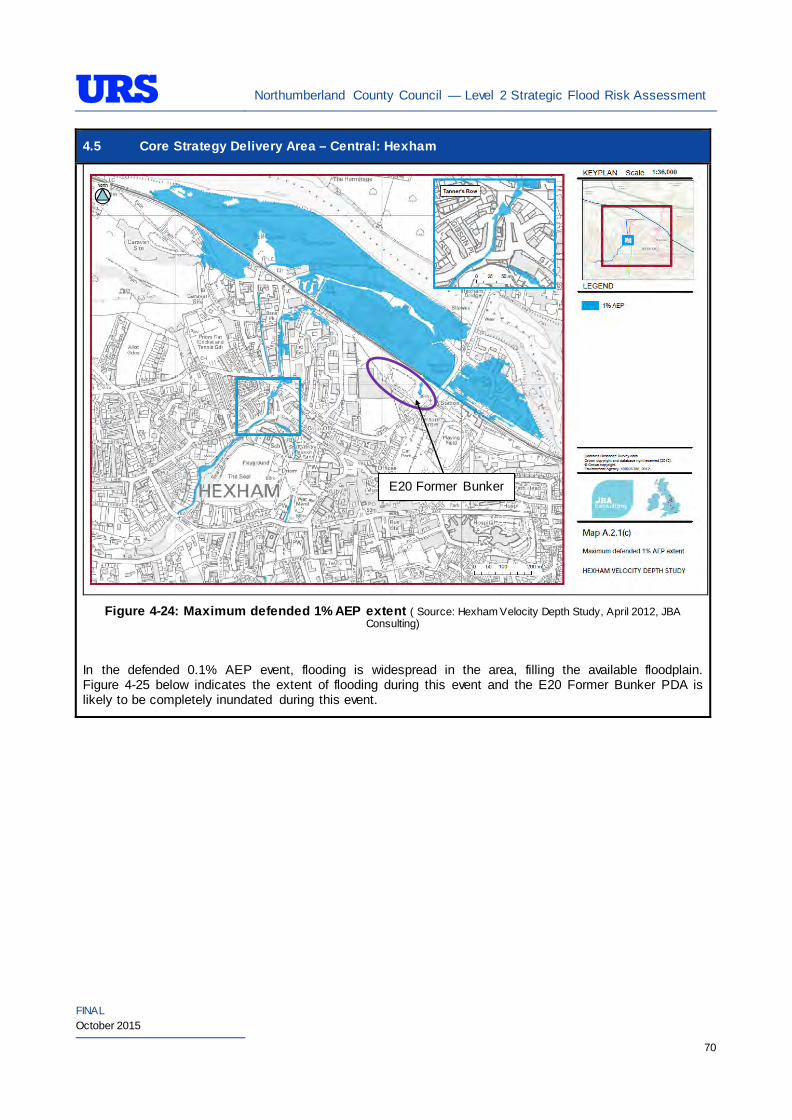
Northumberland County Council — Level 2 Strategic Flood Risk Assessment
FINAL October 2015
70
4.5 Core Strategy Delivery Area – Central: Hexham
Figure 4-24: Maximum defended 1% AEP extent ( Source: Hexham Velocity Depth Study, April 2012, JBA
Consulting)
In the defended 0.1% AEP event, flooding is widespread in the area, filling the available floodplain. Figure 4-25 below indicates the extent of flooding during this event and the E20 Former Bunker PDA is likely to be completely inundated during this event.
E20 Former Bunker
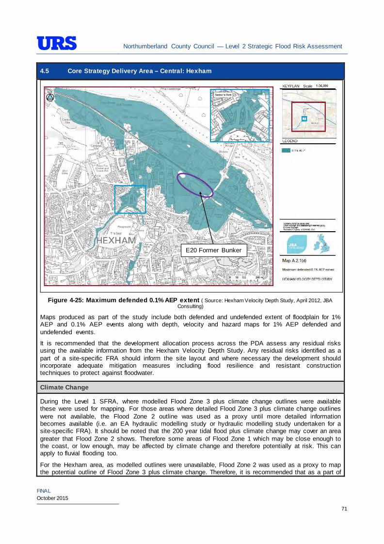
Northumberland County Council — Level 2 Strategic Flood Risk Assessment
FINAL October 2015
71
4.5 Core Strategy Delivery Area – Central: Hexham
Figure 4-25: Maximum defended 0.1% AEP extent ( Source: Hexham Velocity Depth Study, April 2012, JBA
Consulting)
Maps produced as part of the study include both defended and undefended extent of floodplain for 1% AEP and 0.1% AEP events along with depth, velocity and hazard maps for 1% AEP defended and undefended events.
It is recommended that the development allocation process across the PDA assess any residual risks using the available information from the Hexham Velocity Depth Study. Any residual risks identified as a part of a site-specific FRA should inform the site layout and where necessary the development should incorporate adequate mitigation measures including flood resilience and resistant construction techniques to protect against floodwater.
Climate Change
During the Level 1 SFRA, where modelled Flood Zone 3 plus climate change outlines were available these were used for mapping. For those areas where detailed Flood Zone 3 plus climate change outlines were not available, the Flood Zone 2 outline was used as a proxy until more detailed information becomes available (i.e. an EA hydraulic modelling study or hydraulic modelling study undertaken for a site-specific FRA). It should be noted that the 200 year tidal flood plus climate change may cover an area greater that Flood Zone 2 shows. Therefore some areas of Flood Zone 1 which may be close enough to the coast, or low enough, may be affected by climate change and therefore potentially at risk. This can apply to fluvial flooding too.
For the Hexham area, as modelled outlines were unavailable, Flood Zone 2 was used as a proxy to map the potential outline of Flood Zone 3 plus climate change. Therefore, it is recommended that as a part of
E20 Former Bunker
Northumberland County Council — Level 2 Strategic Flood Risk Assessment
FINAL October 2015
72
4.5 Core Strategy Delivery Area – Central: Hexham site-specific FRAs detailed modelling is undertaken to confirm the extent of the Flood Zone 3 plus climate change, should any development be proposed within the area covered by the proxy outline.
During the Level 1 SFRA, it was determined that there are no modelled outlines of Flood Zone 2 plus climate change for the whole of Northumberland. The Flood Zone 2 plus climate change flood event would be greater than the existing Flood Zone 2 outlines. As there are limitations on data, and extensive uncertainties, in deriving the floodplain for such an extreme event, it is not practical to use a proxy dataset or make assumptions to produce the Flood Zone 2 plus climate change outline. It is therefore recommended that as part of any future detailed site-specific FRAs the extent of Flood Zone 2 plus climate change is determined, should this be critical to the layout of the development. Consultation with the EA should be undertaken to determine a suitable methodology for undertaking this assessment (i.e. detailed modelling, or applying an agreed buffer to Flood Zone 2).
SUDS Applicability
The SuDS map produced as part of Level 1 SFRA indicated that attenuation systems are applicable for this area. However, further site investigations are necessary to confirm the local ground conditions and determine the appropriate SuDS technique as part of any future site specific FRA.
Prospective developers should work closely with the EA, LPA and LLFA to manage surface water run-off as near to its source as possible. For the PDAs described above, given the ground conditions attenuation SuDS are likely to be an appropriate technique to manage surface water at individual site level.
The developer should investigate the use of source control attenuation systems such as green roof, rainwater harvesting systems and site control attenuation systems such as swales, ponds and detention basins as appropriate. It should be noted that a wide range of attenuation SuDS techniques are available which can be adopted depending upon the available space to manage surface water. A site-specific FRA should assess the most suitable SuDS system to manage surface water for the development based on the guidance and advice provided within the Level 2 SFRA and the NPPF.
For the wider area of Hexham, there are potential opportunities for the LPA to incorporate SuDS in the master plan to manage surface water whilst improving local water quality, biodiversity, and amenity.
Recommendations
• If development pressures create a need to develop the areas that are at risk of flooding (i.e., Flood Zone 2 and Flood Zone 3), they should incorporate appropriate mitigation measures which must not increase the risk of flooding to surrounding areas. Careful liaison with the EA will be necessary during the design and planning process;
• East Hexham and E08 Egger PDAs are at high risk of flooding and are only protected due to flood defences. An FRA would need to consider the risks from all sources of flooding, safe access, flood resilience, and breaching/ overtopping of the defence. The area is historically floodplain and so any future development would most likely be unsustainable; and
• Self-contained basements will not be permitted within Flood Zone 3. Basements may be accepted if access is available to floors above the 1% AEP flood level. If basements are included as part of a scheme then they should adhere to British Standard 8102.
Policies
East Hexham and E08 Egger • If NCC wishes to promote the area for allocations in the future, a detailed assessment to analyse
defence breach and overtop scenarios should be undertaken. Development allocation in the area should only be considered if it can be demonstrated that residual risks to the area and access routes can be safely managed without exacerbating flood risk to neighbouring area. If the level of residual
Northumberland County Council — Level 2 Strategic Flood Risk Assessment
FINAL October 2015
73
4.5 Core Strategy Delivery Area – Central: Hexham risk is high in the area, flood resistance and resilience measures should not be used to justify developments. A strategic decision should be made based on the findings of the detailed assessment inform the development potential of the area; and
• At this stage, further recommendations and policies cannot be provided for the area without a clear understanding on the residual risk. Therefore, it is advised to revisit this section following completion of the detailed assessment to provide appropriate recommendations and policies for the area.
E20 Former Bunker, North Hexham and E15 Acomb
• Where applicable roll back development from the River Tyne and other watercourses to outside of Flood Zone 3a to create ‘blue corridors’ which provide public open space and recreation areas near the River Tyne and enhance green infrastructure. Development should not encroach within 5m of the River Tyne, which is the EA by-law distance for Main Rivers. This would be beneficial both in terms of flood risk and maintenance access;
• Mixed use (mixed vulnerability) development should follow the principles of the NPPF sequential approach across the wider area. For example, proposed residential development should be steered to the lower risk areas, with the remaining ‘less vulnerable’ land uses being located on the (relatively) higher risk areas. This approach can also be applied within buildings, for example commercial development located at ground floor level and residential development above ground floor level in flood risk areas. However, access and egress must still be made available for the residential uses;
• Surface water/pluvial flood risk should also inform the site layout, such that ‘highly vulnerable’ development is avoided in locations that are shown at the greatest risk of pluvial flooding; and
• As the sites comprise of a mixture of greenfield and brownfield land, future developments within the sites potentially can increase surface water runoff. SuDS should be considered at all stages of the planning and design of new developments to reduce runoff rates and volumes from the developed sites, thus reducing the resultant flood risk posed to the sites and adjacent/downstream areas. Development should, where reasonably possible, aim to reduce surface water runoff to less than greenfield run off. If this is not possible then greenfield runoff rates should be achieved by the proposed mitigation measures.
Site-Specific FRA Guidance East Hexham and E08 Egger
• As stated in the recommendations and policies sections, it is difficult to provide advice on potential development opportunities of the area without further information on residual risk. Therefore, it is advised to revisit this section following completion of the detailed assessment to provide guidance of site-specific FRA.
E20 Former Bunker, North Hexham and E15 Acomb
• A site-specific FRA will be required for any development proposed within areas that falls entirely or partly within Flood Zone 2 and Flood Zone 3. For areas that fall within Flood Zone 1, an FRA will be required for any development in excess of 1 ha. The FRA will need to consider surface water management;
• Maximum fluvial/tidal flood levels at the area should be informed by the most up-to-date versions of the EA’s hydraulic models of the River Tyne, Cockshaw Burn, Halgut Burn and Red Burn studies;
• If development within areas designated as Flood Zone 3 including an allowance for climate change is justifiable, appropriate mitigation and resilience measures should be incorporated both on an individual property-level (such as flood resilient construction) and at a strategic level (such as strategic SuDS);
• The FRA should demonstrate that consideration has been given to the site layout with regards to
Northumberland County Council — Level 2 Strategic Flood Risk Assessment
FINAL October 2015
74
4.5 Core Strategy Delivery Area – Central: Hexham flood risk from all sources, in line with the recommendations above (sequential approach to site layout);
• The rates and volumes of post-development surface water runoff should be controlled using suitable and adequate SuDS techniques. Where possible, the developers should retrofit drainage solutions to the site with wider benefits to other local areas at risk;
• The suitability of infiltration should be informed by site-specific ground investigation (GI) works;
• The residual risks identified above should be adequately investigated and assessed as part of the FRA and mitigation measures implemented accordingly. In such situations, the developer is generally required to provide resources and funds to undertake more complex modelling/assessments to determine the residual risk to the development arising from events that overtop or breach the defences. In addition, the developer is generally responsible for funding any flood risk management works, including defences and mitigation works;
• A site-specific FRA should consider provision of site access and egress, taking into account any emergency planning requirements of NCC and the Environment Agency. This is a particularly pertinent issue for areas, where access roads are at risk of flooding;
• Any sites which contain or are adjacent to Main Rivers must be designed so as to allow access to the channel for maintenance purposes. This maintenance liability lies with the landowner in the first instance however the Environment Agency have powers to undertake work where deemed necessary. Whether these sites are subject to routine EA maintenance, or not, there must be an access route available; and
• Developments should aim to mimic existing drainage regimes as closely as possible, and reduce discharge off site where possible. Development on brownfield land should aim to reduce the runoff by 50% and sites on greenfield should aim to retain greenfield runoff rates.
• The EA will be publishing new climate change guidance in autumn 2015. The most recent climate change guidance should be used to inform site specific FRA’s.
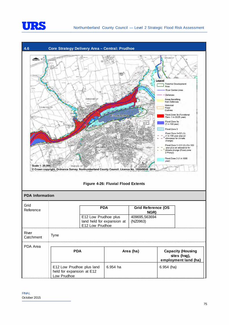
Northumberland County Council — Level 2 Strategic Flood Risk Assessment
FINAL October 2015
75
4.6 Core Strategy Delivery Area – Central: Prudhoe
Figure 4-26: Fluvial Flood Extents
PDA Information
Grid Reference
PDA Grid Reference (OS
NGR) E12 Low Prudhoe plus land held for expansion at E12 Low Prudhoe
409695,563694 (NZ0963)
River Catchment Tyne
PDA Area
PDA Area (ha) Capacity (Housing sites (hsg),
employment land (ha)
E12 Low Prudhoe plus land held for expansion at E12 Low Prudhoe
6.954 ha 6.954 (ha)
Northumberland County Council — Level 2 Strategic Flood Risk Assessment
FINAL October 2015
76
4.6 Core Strategy Delivery Area – Central: Prudhoe Existing Use and Topography
E12 Low Prudhoe plus land held for expansion at E12
The E12 Low Prudhoe PDA is located to the north of Prudhoe and is bounded to the north immediately by a railway line and then the River Tyne, to the south by Princess Way (A695), Eastwoods Road to the east and then greenfield to the west. The PDA is currently occupied by an existing industrial site and is therefore considered brownfield.
The PDA topography is generally flat with an average level of around 109m AOD.
Proposed Use and Vulnerability Classification
The table below summarise the proposed uses of the PDA, provided by NCC (July 2014).
PDA Proposed Use Status
E12 Low Prudhoe plus land held for expansion at E12 Low Prudhoe
Employment Completion of available employment land plus land held for expansion
The table below illustrates a matrix of ‘Vulnerability Classification’ based on Table 2 in the National Planning Policy Framework (NPPF) against ‘Flood Zone Compatibility’.
Proposed use NPPF Vulnerability Classification
Flood Zone 1
Flood Zone 2
Flood Zone 3a
Flood Zone 3b
Employment/Mixed use (e.g hospitals, residential care homes, social services homes, prisons, hostels, dwelling houses and student halls of residence)
More vulnerable*
Exception Test
required
Employment/Mixed use (e.g shops, restaurants, offices, general industry, storage and distribution)
Less vulnerable*
Key
- Acceptable
- Not Acceptable
*Based on Planning Practice Guidance (PPG) Table 2: Flood Risk Vulnerability Classif ication.
Should further definition of the proposed uses be made at a later date, then identification of their individual vulnerability classifications should be re-visited.
Sources of Flood Risk
Rivers/Sea The PDA is located to the south of the River Tyne (Figure 4-26).
The Environment Agency’s (EA’s) Flood Maps present the extent of Flood Zones associated with the River Tyne. The EA’s Flood Maps indicate that the majority of the PDA is in Flood Zone 3. An area to the east and west of the PDA is indicated to be in Flood 2, a small area to the far east and far west is indicated to be in Flood Zone 1. The majority of the PDA is therefore at risk from flooding.
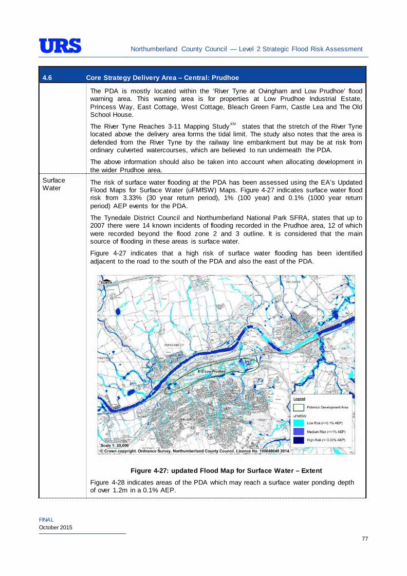
Northumberland County Council — Level 2 Strategic Flood Risk Assessment
FINAL October 2015
77
4.6 Core Strategy Delivery Area – Central: Prudhoe The PDA is mostly located within the ‘River Tyne at Ovingham and Low Prudhoe’ flood warning area. This warning area is for properties at Low Prudhoe Industrial Estate, Princess Way, East Cottage, West Cottage, Bleach Green Farm, Castle Lea and The Old School House.
The River Tyne Reaches 3-11 Mapping Study xiv states that the stretch of the River Tyne located above the delivery area forms the tidal limit. The study also notes that the area is defended from the River Tyne by the railway line embankment but may be at risk from ordinary culverted watercourses, which are believed to run underneath the PDA.
The above information should also be taken into account when allocating development in the wider Prudhoe area.
Surface Water
The risk of surface water flooding at the PDA has been assessed using the EA’s Updated Flood Maps for Surface Water (uFMfSW) Maps. Figure 4-27 indicates surface water flood risk from 3.33% (30 year return period), 1% (100 year) and 0.1% (1000 year return period) AEP events for the PDA.
The Tynedale District Council and Northumberland National Park SFRA, states that up to 2007 there were 14 known incidents of flooding recorded in the Prudhoe area, 12 of which were recorded beyond the flood zone 2 and 3 outline. It is considered that the main source of flooding in these areas is surface water.
Figure 4-27 indicates that a high risk of surface water flooding has been identified adjacent to the road to the south of the PDA and also the east of the PDA.
Figure 4-27: updated Flood Map for Surface Water – Extent
Figure 4-28 indicates areas of the PDA which may reach a surface water ponding depth of over 1.2m in a 0.1% AEP.
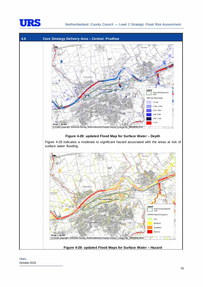
Northumberland County Council — Level 2 Strategic Flood Risk Assessment
FINAL October 2015
78
4.6 Core Strategy Delivery Area – Central: Prudhoe
Figure 4-28: updated Flood Map for Surface Water – Depth
Figure 4-29 indicates a moderate to significant hazard associated with the areas at risk of surface water flooding.
Figure 4-29: updated Flood Maps for Surface Water – Hazard
Northumberland County Council — Level 2 Strategic Flood Risk Assessment
FINAL October 2015
79
4.6 Core Strategy Delivery Area – Central: Prudhoe Refer to ‘Site-specific FRA Guidance’ section for recommendations relating to management of surface water within individual sites.
Groundwater The British Geological Survey (BGS) Areas Susceptible to Groundwater flooding map indicates that the area is at low to medium risk of groundwater flooding (25% > 50%).
The EA’s Groundwater Vulnerability (GWV) maps have been prepared as a thematic map to highlight areas that overlie aquifers with a high vulnerability. Major Aquifers with a high vulnerability tend to have a more permeable surface geology. Groundwater vulnerability relates to the potential for contaminants to enter groundwater and thus is a useful tool to determine the potential suitability of Sustainable Drainage Systems (SuDS) techniques.
The EA’s GWV maps indicate the following general groundwater conditions at the PDA:
PDA Underlying Aquifer Vulnerability E12 Low Prudhoe plus land held for expansion at E12 Low Prudhoe
Minor Aquifer
High Vulnerability
The EA’s Source Protection Zone (SPZ) maps indicate that the PDA is not located within a SPZ.
Sewers The risk of hydraulic sewer flooding in the area has been assessed using the NWL DG5 data. As detailed in Section 3.7 of the SFRA, the NWL DG5 data indicates risk of hydraulic sewer flooding in NWL drainage areas based on 100 square metre grid square data.
Review of the NWL DG5 100 square metre grid square data indicates 2 grid squares within the PDA and a further 4 to the south of the PDA. The Core Strategy Delivery Area PDA in Prudhoe is located within the NWL Prudhoe (05-D55) drainage area catchment.
Future developments should take measures as far as is practicable to reduce the flood risk arising from the development to the site itself and downstream properties. A site-specific FRA should identify the drainage strategy to mitigate sewer flooding risk.
Artificial Sources
There are no reservoirs in the immediate vicinity of the area. However, a number of impounding resources are located upstream. These include Kielder and Catcleugh reservoirs, which are located in the upper North Tyne catchment. A review of the EA’s Reservoir Flood Maps indicates that the entire PDA described above is to be at residual flood risk in the event of a reservoir breach in the upstream catchment of the River North Tyne. However, the probability of flooding due to breach of the reservoirs is very low.
Residual risk from reservoir breach should be considered as part of any site-specific FRA as although the probability of such an incident occurring are very low the potential consequences may be severe.
There are no canals or other artificial water sources that may provide a flood risk in the vicinity of the area.
Flood Defence Infrastructure
The Environment Agency Asset Information Management System (AIMS) now supersedes NFCDD, although the NFCDD data provides more detailed information of defences in the area. Both the AIMS and NFCDD data have been included within this SFRA for completeness. It is advised that the developer consults with the Environment Agency to obtain the most up to date information relating to flood defence
Northumberland County Council — Level 2 Strategic Flood Risk Assessment
FINAL October 2015
80
4.6 Core Strategy Delivery Area – Central: Prudhoe infrastructure.
Information received from the Environment Agency and obtained from AIMS does not identify any fluvial defences in the immediate area. The NFCDD however indicates that there are formal defences located to the south of Prudhoe, on the banks of the River Tyne. The defences are high ground and have been assigned a condition rating of 3 by the EA.
The Tynedale District Council and Northumberland National Park Strategic Flood Risk Assessment states that the defences have a SOP up to a 1% AEP fluvial flood event. The PDA benefits from these defences.
The JBA River Tyne Reaches 3-11 Mapping Studyxiv states that Low Prudhoe is defended by the railway embankment upto a 1% AEP event. The study also indicates that the PDA may still be at risk from ordinary watercourses that run within the PDA. The study also states that 100 year water levels may reach upto 13.63m AOD.
Residual Flood Risks
The area is defended by the railway line embankment located immediately north of the area. The River Tyne Reaches 3-11 Flood Risk Mapping Study states that the railway line embankment provides the defence and that there are no obvious routes through the embankment at these locations. A residual flood risk may be associated with the ordinary watercourses which are culverted as they run through the PDA.
As part of the decision-making process to determine potential development opportunities of the area, it is recommended that a detailed assessment is undertaken by the NCC to analyse defence breach and overtop scenarios and also the flood risk associated with the ordinary watercourses.
It is recommended that development allocation process across the PDAs follow the principles of the NPPF sequential approach. As the PDAs are located in low-lying fluvial areas with a higher vulnerability to flood from defence breach and overtop, it is also recommended that detailed assessments are undertaken as a part of site-specific FRA to establish the standard of protection provided by the defences and identify necessary mitigation measures to be undertaken. Further investigation may need to be undertaken to understand the flood risk associated with the ordinary watercourses.
Climate Change
During the Level 1 SFRA, where modelled Flood Zone 3 plus climate change outlines were available these were used for mapping. For those areas where detailed Flood Zone 3 plus climate change outlines were not available, the Flood Zone 2 outline was used as a proxy until more detailed information becomes available (i.e. an EA hydraulic modelling study or hydraulic modelling study undertaken for a site-specific FRA). It should be noted that the 200 year tidal flood plus climate change may cover an area greater that Flood Zone 2 shows. Therefore some areas of Flood Zone 1 which may be close enough to the coast, or low enough, may be affected by climate change and therefore potentially at risk. This can apply to fluvial flooding too.
For Prudhoe, a modelled outline for Flood Zone 3 plus climate change is available from The River Tyne Reaches 3-11 Flood Risk Mapping Study. The extent of the Flood Zone 3 plus climate change is smaller than the Flood Zone 2 extent and not much larger than the existing Flood Zone 3 extent. It is recommended that as part of a site-specific FRA the Flood Zone 3 plus climate change extent and depth is taken into account. The study anticipates that water levels for 1% AEP event could reach 13.64m AOD and when including climate change, levels could increase to 14.25m AOD.
During the Level 1 SFRA, it was determined that there are no modelled outlines of Flood Zone 2 plus climate change for the whole of Northumberland. The Flood Zone 2 plus climate change flood event would be greater than the existing Flood Zone 2 outlines. As there are limitations on data, and extensive uncertainties, in deriving the floodplain for such an extreme event, it is not practical to use a proxy dataset or make assumptions to produce the Flood Zone 2 plus climate change outline. It is therefore
Northumberland County Council — Level 2 Strategic Flood Risk Assessment
FINAL October 2015
81
4.6 Core Strategy Delivery Area – Central: Prudhoe recommended that as part of any future detailed site-specific FRAs the extent of Flood Zone 2 plus climate change is determined, should this be critical to the layout of the development. Consultation with the EA should be undertaken to determine a suitable methodology for undertaking this assessment (i.e. detailed modelling, or applying an agreed buffer to Flood Zone 2).
SuDS Applicability
The SuDS map produced as part of Level 1 SFRA indicated that attenuation systems are applicable for this area. However, further site investigations are necessary to confirm the local ground conditions and determine the appropriate SuDS technique as part of any future site specific FRA.
Prospective developers should work closely with the EA, LPA and LLFA to manage surface water run-off as near to its source as possible. For the site described above, given the ground conditions attenuation SuDS are likely to be an appropriate technique to manage surface water at individual site level.
The developer should investigate the use of source control attenuation systems such as green roof, rainwater harvesting systems and site control attenuation systems such as swales, ponds and detention basins as appropriate. It should be noted that a wide range of attenuation SuDS techniques are available which can be adopted depending upon the available space to manage surface water. A site-specific FRA should assess the most suitable SuDS system to manage surface water for the development based on the guidance and advice provided within the Level 2 SFRA and the NPPF.
Recommendations
• If development pressures create a need to develop the areas of the site that are at risk of flooding (i.e., Flood Zone 2 and Flood Zone 3) – they should incorporate appropriate mitigation measures which must not increase the risk of flooding to surrounding areas. Detailed liaison with the EA will be necessary during the design and planning process; and
• Water from the ordinary watercourse and surface water may become trapped behind the embankment. Any development involving earthworks and changing ground levels will need to be assessed to ensure that the proposed development does not increase flood risk elsewhere in the area through obstructing/ diverting flow routes.
Policies
• Where applicable roll back development from River Tyne to outside Flood Zone 3a to create ‘blue corridors’ which provide public open space and recreation areas near the rivers and enhance green infrastructure. Development should not encroach within 5m of the watercourses, which is the EA by-law distance for Main Rivers. This would be beneficial both in terms of flood risk and maintenance access;
• Mixed use (mixed vulnerability) development should follow the principles of the NPPF sequential approach across the site. For example, proposed residential development should be steered to the lower risk areas across the site, with the remaining ‘less vulnerable’ land uses being located on the (relatively) higher risk areas of the site. This approach can also be applied within buildings, for example commercial development located at ground floor level and residential development above ground floor level in flood risk areas. However, access and egress must still be made available for the residential uses;
• Surface water/pluvial flood risk should also inform the site layout, such that ‘highly vulnerable’ development is avoided in locations that are shown at the greatest risk of pluvial flooding; and
• As the PDA is predominately brownfield , it is unlikely that future developments within the site will increase surface water runoff. However, SuDS should be considered at all stages of the planning and design of new developments to reduce runoff rates and volumes from the proposed development, thus reducing the resultant flood risk posed to the site and adjacent/downstream areas. Development
Northumberland County Council — Level 2 Strategic Flood Risk Assessment
FINAL October 2015
82
4.6 Core Strategy Delivery Area – Central: Prudhoe should, where reasonably possible, aim to reduce surface water runoff to less than greenfield runoff. If this is not possible then greenfield runoff rates should be achieved by the proposed mitigation measures.
Site-Specific FRA Guidance
• A site-specific FRA will be required for any development proposed within the PDA that falls entirely or partly within Flood Zone 2 and Flood Zone 3. For individual plots within the PDA that do fall within Flood Zone 1, an FRA will be required for any development in excess of 1 ha. The FRA will need to consider surface water management;
• Maximum fluvial flood levels at individual plots should be informed by the most up-to-date versions of the EA’s hydraulic models of River Tyne, or any future fluvial modelling studies. If no models are available then the Lead Local Flood Authority may require a model as part of a planning application;
• If development within areas designated as Flood Zone 3 including an allowance for climate change is justifiable, appropriate mitigation and resilience measures should be incorporated both on an individual property-level (such as flood resilient construction) and at a strategic level (such as strategic SuDS);
• The FRA should demonstrate that consideration has been given to the site layout with regards to flood risk from all sources, in line with the recommendations above (sequential approach to site layout);
• The rates and volumes of post-development surface water runoff should be controlled using suitable and adequate SuDS techniques. Where possible, the developer should retrofit drainage solutions to the site with wider benefits to other local areas at risk;
• The suitability of infiltration SuDS should be informed by site-specific ground investigation (GI) works;
• The residual risks identified above should be adequately investigated and assessed as part of the FRA and mitigation measures implemented accordingly. In such situations, the developer is generally required to provide resources and funds to undertake more complex modelling/assessments to determine the residual risk on the development arising from events that overtop or breach the defences. In addition, the developer is generally responsible for funding any flood risk management works, including defences and mitigation works;
• A site-specific FRA should consider provision of site access and egress, taking into account any emergency planning requirements of NCC and the Environment Agency. This is a particularly pertinent issue for areas, where access roads are at risk of flooding;
• Any sites which contain or are adjacent to Main Rivers must be designed so as to allow access to the channel for maintenance purposes. This maintenance liability lies with the landowner in the first instance however the Environment Agency have powers to undertake work where deemed necessary. Whether these sites are subject to routine EA maintenance, or not, there must be an access route available; and
• Developments should aim to mimic existing drainage regimes as closely as possible, and reduce discharge off site where possible. Development on brownfield land should aim to reduce the runoff by 50%.
• The EA will be publishing new climate change guidance in autumn 2015. The most recent climate change guidance should be used to inform site specific FRA’s.
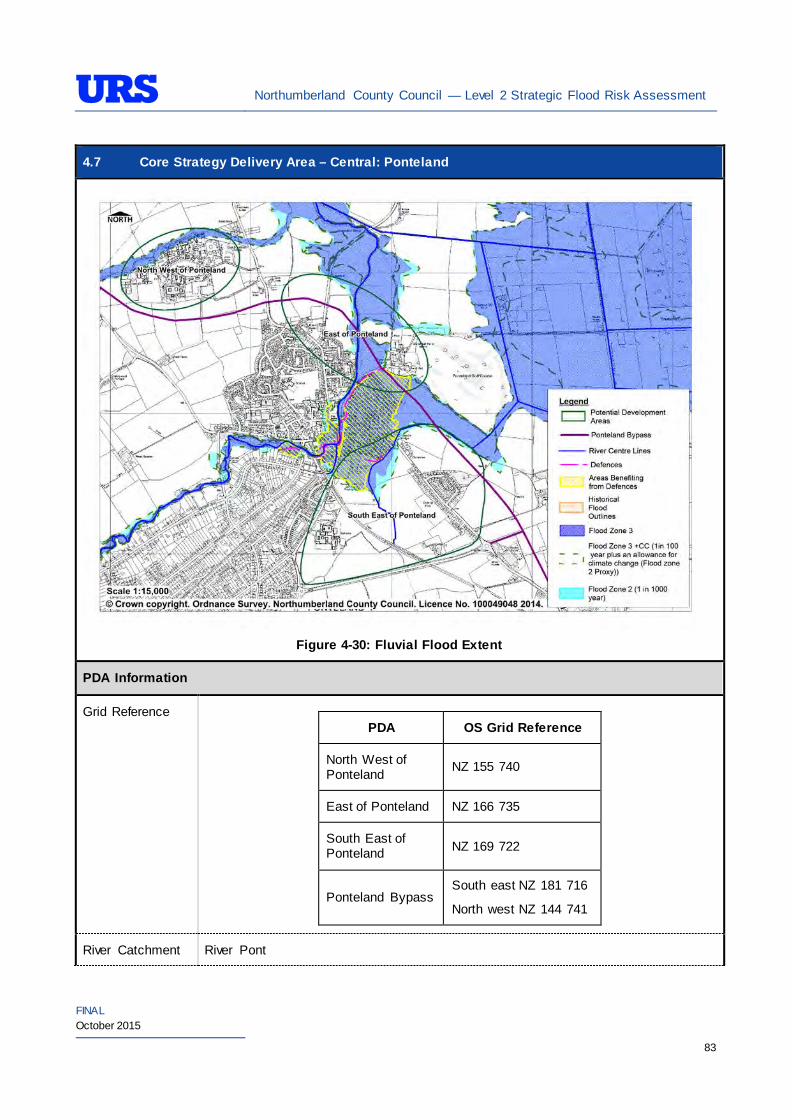
Northumberland County Council — Level 2 Strategic Flood Risk Assessment
FINAL October 2015
83
4.7 Core Strategy Delivery Area – Central: Ponteland
Figure 4-30: Fluvial Flood Extent
PDA Information
Grid Reference
PDA OS Grid Reference
North West of Ponteland NZ 155 740
East of Ponteland NZ 166 735
South East of Ponteland NZ 169 722
Ponteland Bypass South east NZ 181 716
North west NZ 144 741
River Catchment River Pont
Northumberland County Council — Level 2 Strategic Flood Risk Assessment
FINAL October 2015
84
4.7 Core Strategy Delivery Area – Central: Ponteland
PDA Area
PDA Area (ha) Capacity (Housing sites (hsg),
employment land (ha)
North West of Ponteland 31 ha 300 (hsg)
East of Ponteland 30 ha 700 (hsg)
South East of Ponteland 107 ha 600 (hsg); 3 (ha)
The approximate length of Ponteland Bypass is 5km.
Existing Use and Topography
North West of Ponteland
The North West of Ponteland PDA is located on the south bank of Small Burn. Agricultural land forms the southern and western boundaries of the PDA. Small Burn and North Road respectively form the northern and eastern boundaries of the PDA. The PDA is currently occupied as the Northumbria Police Force Headquarters and is therefore considered brownfield.
The PDA topography generally falls towards the Small Burn from around 63m AOD in the south-western corner to around 58m AOD in the north-eastern corner.
East of Ponteland
The East of Ponteland PDA is located to the northeast of Ponteland town centre and the River Pont flows through the PDA. Residential properties form the western boundary of the PDA whilst the other boundaries are formed by agricultural land. The PDA predominantly comprises of agricultural land and is therefore considered greenfield.
The PDA topography generally falls towards the centre of the PDA from around 57m AOD to around 54m AOD with higher grounds to the north and south.
South East of Ponteland
The South East of Ponteland PDA is located to the southeast of Ponteland town centre and Fairney Burn flows through the PDA. The PDA boundaries are formed by B6545, Cheviot View and Callerton Lane roads respectively from south, east and west. There is a public footpath which runs through the centre of the PDA from south east to north west. The PDA predominantly comprises of agricultural land and is therefore considered greenfield.
The PDA topography generally falls towards the centre of the PDA from around 57m AOD to around 54m AOD with higher grounds to the east and west.
Ponteland Bypass
The approximate line of Ponteland Bypass runs north west of Ponteland, around the northern boundary of the main urban area. This is the protected route of the Ponteland Bypass as identified in the Castle Morpeth Local Plan. The Ponteland Bypass runs to the south of North West of Ponteland PDA, through the centre of East of Ponteland PDA and through the north east of South East of Ponteland. The elevation of the road is between 70mAOD and 54m AOD.
Northumberland County Council — Level 2 Strategic Flood Risk Assessment
FINAL October 2015
85
4.7 Core Strategy Delivery Area – Central: Ponteland
Proposed Use and Vulnerability Classification
The table below summarises the proposed uses of the PDAs, provided by NCC (July 2014).
PDA Proposed Use Status
North West of Ponteland Residential Preferred
East of Ponteland Residential Alternative
South East of Ponteland Residential/Employment/ Community Uses Preferred
Ponteland Bypass Road -
The table below illustrates a matrix of ‘Vulnerability Classification’ based on Table 2 in the National Planning Policy Framework (NPPF) against ‘Flood Zone Compatibility’.
Proposed use NPPF Vulnerability Classification
Flood Zone 1
Flood Zone 2
Flood Zone 3a
Flood Zone 3b
Residential More vulnerable Exception Test
required
Employment/Mixed use (e.g hospitals, residential care homes, social services homes, prisons, hostels, dwelling houses and student halls of residence)
More vulnerable*
Exception Test
required
Employment/Mixed use (e.g shops, restaurants, offices, general industry, storage and distribution)
Less vulnerable*
Essential transport infrastructure
Essential Infrastructure
Exception Test
required
Exception Test
required
Key
- Acceptable
- Not Acceptable
*Based on Planning Practice Guidance (PPG) Table 2: Flood Risk Vulnerability Classif ication.
Should further definition of the proposed uses be made at a later date, then identification of their individual vulnerability classifications should be re-visited.
Sources of Flood Risk
Rivers The River Pont presents the main fluvial flood risk to the majority of the PDAs in Ponteland. A number of minor watercourses in the area including Small Burn, Fairney Burn and unnamed watercourses also present fluvial flood risk to some of the PDAs.
Northumberland County Council — Level 2 Strategic Flood Risk Assessment
FINAL October 2015
86
4.7 Core Strategy Delivery Area – Central: Ponteland
North West of Ponteland
The Environment Agency’s (EA’s) Flood Maps (Figure 4-30) indicate that the majority of the PDA is in Flood Zone 1. Small Burn which is a tributary of the River Pont poses flood risk to the PDA. A small area along the northern boundary of PDA is indicated to be in Flood Zone 2 and Flood Zone 3. The majority of the PDA is therefore not at risk of significant flooding.
East of Ponteland
The EA’s Flood Maps (Figure 4-30) indicate that the River Pont which flows through the centre of the PDA poses significant flood risk. A large area of the central part of the PDA is therefore indicated to be in Flood Zone 2 and Flood Zone 3. Western and eastern areas of the PDA, away from the River Pont, indicated to be in Flood Zone 1. The majority of the PDA is therefore considered to be at risk of significant flooding.
South East of Ponteland
The EA’s Flood Maps (Figure 4-30) indicate that the River Pont and Fairney Burn which flows through the centre of the PDA pose significant flood risk. A large area of the northern part of the PDA is therefore indicated to be in Flood Zone 2 and Flood Zone 3. Western, southern and eastern areas of the PDA indicated to be in Flood Zone 1. The majority of the PDA is therefore not at risk of significant flooding.
The PDA is partially located within the Environment Agency’s ‘River Pont at Ponteland’ Flood Warning Area.
Ponteland Bypass
The proposed bypass route crosses the Main Rivers, River Pont and Fairney Burn. The bypass also crosses a smaller watercourse called Small Burn and a field drain. The bypass crosses through Flood Zone 3 along the Small Burn river corridor and the distance between the River Pont and Fairney Burn which is approximately 1km in length. The area at flood risk between the River Pont and Fairney Burn is located within the ‘River Pont at Ponteland’ Flood Warning Area. Through consultation with the Environment Agency that there are four known historic flood events in the area. They are as follows: 15/01/1977 – The River Pont in Ponteland was high but no property was flooded. Prestwick Carr was badly flooded with water extending nearly to the area flooded in 1947. 15/01/1978 – Eland Haugh, Fairney Edge and Riverside areas of Ponteland flooded 6/11/2000 – 147 commercial and domestic properties flooded in Ponteland. The new defences were overtopped in places, but much of the flooding was due to Callerton Burn and poor drainage on Eland Haugh Industrial Estate. 07/09/2008 – 21 properties flooded from a combination of river and surface water runoff
Surface Water
The risk of surface water flooding at the PDAs in Ponteland has been assessed using the EA’s Updated Flood Maps for Surface Water (uFMfSW) Maps. Figure 4-31 indicates surface water flood risk from 3.33% (30 year return period), 1% (100 year) and 0.1% (1000 year return period) AEP events for each PDA.
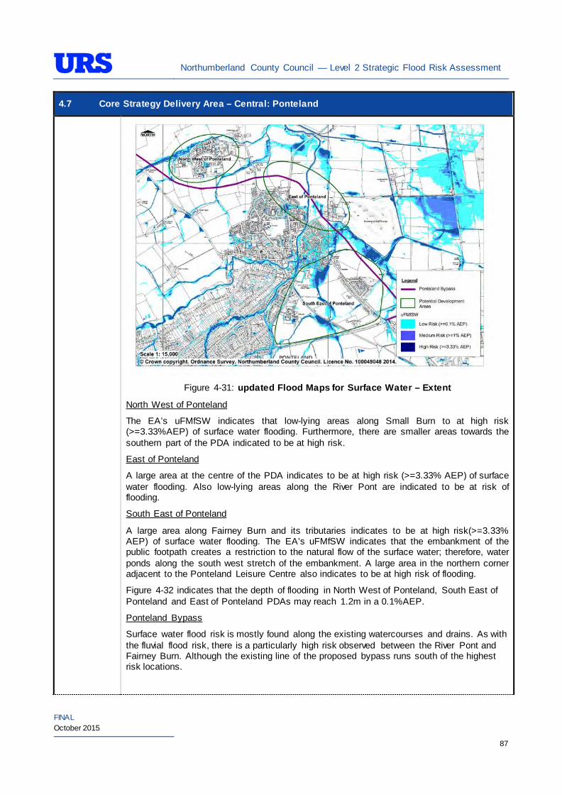
Northumberland County Council — Level 2 Strategic Flood Risk Assessment
FINAL October 2015
87
4.7 Core Strategy Delivery Area – Central: Ponteland
Figure 4-31: updated Flood Maps for Surface Water – Extent
North West of Ponteland
The EA’s uFMfSW indicates that low-lying areas along Small Burn to at high risk (>=3.33%AEP) of surface water flooding. Furthermore, there are smaller areas towards the southern part of the PDA indicated to be at high risk.
East of Ponteland
A large area at the centre of the PDA indicates to be at high risk (>=3.33% AEP) of surface water flooding. Also low-lying areas along the River Pont are indicated to be at risk of flooding.
South East of Ponteland
A large area along Fairney Burn and its tributaries indicates to be at high risk(>=3.33% AEP) of surface water flooding. The EA’s uFMfSW indicates that the embankment of the public footpath creates a restriction to the natural flow of the surface water; therefore, water ponds along the south west stretch of the embankment. A large area in the northern corner adjacent to the Ponteland Leisure Centre also indicates to be at high risk of flooding.
Figure 4-32 indicates that the depth of flooding in North West of Ponteland, South East of Ponteland and East of Ponteland PDAs may reach 1.2m in a 0.1%AEP.
Ponteland Bypass
Surface water flood risk is mostly found along the existing watercourses and drains. As with the fluvial flood risk, there is a particularly high risk observed between the River Pont and Fairney Burn. Although the existing line of the proposed bypass runs south of the highest risk locations.

Northumberland County Council — Level 2 Strategic Flood Risk Assessment
FINAL October 2015
88
4.7 Core Strategy Delivery Area – Central: Ponteland
Figure 4-32: updated Flood Maps for Surface Water – Depth
Figure 4-33 indicates that the degree of flood hazard associated with high risk areas within the South East of Ponteland PDA as significant. The degree of flood hazard associated with North West of Ponteland and East of Ponteland PDAs indicate to be mostly moderate except the areas located within the limits of the watercourses. The Ponteland Bypass line is located in a significant risk category only where the bypass crosses an existing watercourse.
Figure 4-33: updated Flood Maps for Surface Water – Hazard

Northumberland County Council — Level 2 Strategic Flood Risk Assessment
FINAL October 2015
89
4.7 Core Strategy Delivery Area – Central: Ponteland The ‘Site-specific FRA Guidance’ section of the SFRA provides recommendations relating to management of surface water within individual sites.
Groundwater The British Geological Survey (BGS) Areas Susceptible to Groundwater Flooding maps indicate the following conditions at each PDA:
PDA Groundwater Flood Risk
North West of Ponteland High risk (>=75%)
East of Ponteland Medium to high risk (>= 50% <75%)
South East of Ponteland High risk (>=75%)
Ponteland Bypass Medium / high risk (>= 50% <75%/ >75%)
The EA records indicate that there are instances of groundwater flooding reported in Darras Hill estate adjacent to the PDAs in Ponteland. The EA’s Groundwater Vulnerability (GWV) maps have been prepared as a thematic map to highlight areas that overlie aquifers with a high vulnerability. Major Aquifers with a high vulnerability tend to have a more permeable surface geology. Groundwater vulnerability relates to the potential for contaminants to enter groundwater and thus is a useful tool to determine the potential suitability of Sustainable Drainage Systems (SuDS) techniques.
The EA’s GWV maps indicate the following general groundwater conditions at each PDA:
PDA Underlying Aquifer Vulnerability
North West of Ponteland Minor Aquifer Low Vulnerability
East of Ponteland Minor Aquifer High/Low Vulnerability
South East of Ponteland Minor Aquifer Low Vulnerability
Ponteland Bypass
Minor Aquifer Low Vulnerability (with one small pocket high vulnerability where it passes East of Ponteland)
The EA’s Source Protection Zone (SPZ) maps indicate that the PDAs are not located within a SPZ.
Sewers The risk of hydraulic sewer flooding in the area has been assessed using the NWL DG5 data. As detailed in Section 3.7 of the SFRA, the NWL DG5 data indicates risk of hydraulic sewer flooding in NWL drainage areas based on 100 square metre grid square data.
Review of the NWL DG5 100 square metre grid square data indicates that no incidents have been reported within the PDAs. The Core Strategy Delivery PDAs in Ponteland are located within the NWL Ponteland (05-D29) drainage area catchment.
Future developments should take measures as far as is practicable to reduce the flood risk
Northumberland County Council — Level 2 Strategic Flood Risk Assessment
FINAL October 2015
90
4.7 Core Strategy Delivery Area – Central: Ponteland arising from the development to the PDA itself and downstream properties. A site-specific FRA should identify the drainage strategy to mitigate sewer flooding risk.
Artificial Sources
There are no canals, reservoirs or other artificial water sources that may provide a flood risk in the vicinity of Ponteland– as such there is not considered to be a significant risk to any proposed PDAs.
Flood Defence Infrastructure
The Environment Agency Asset Information Management System (AIMS) now supersedes NFCDD, although the NFCDD data provides more detailed information of defences in the area. Both the AIMS and NFCDD data have been included within this SFRA for completeness. It is advised that the developer consults with the Environment Agency to obtain the most up to date information relating to flood defence infrastructure.
Information obtained from AIMS identifies a number of fluvial flood defences along the River Pont and Fairney Burn in Ponteland.
East of Ponteland
The East of Ponteland PDA has a number of defences including natural high ground along the River Pont. The main defence within the PDA boundary is a section of the raised bank on the east bank of the river Pont. The NFCDD indicates this defence which provides a Standard of Protection (SoP) up to 1% AEP.
South East of Ponteland
The South East of Ponteland PDA has a flood bank along Fairney Burn which provides protection for those properties located at Fainey Edge within the PDA. The Ponteland Flood Visualisation: Main Phase Study, January 2011 by JBA Consulting indicates that this defence is likely to provide protection up to 0.5% AEP. However, the properties behind the defence may be flooded at a lower return period due to overtopping of the River Pont at the Waitrose Supermarket ramp. Refer to residual flood risk section below for further information.
Ponteland Bypass
The section of Ponteland Bypass that runs through the East of Ponteland PDA benefits from the same defences, there are no other defences along the length of the proposed bypass.
General overview of the area
In addition, there is natural high ground along the River Pont and the other watercourses in Ponteland which provides protection from fluvial flooding for those PDAs located adjacent to the watercourses. However, it is recommended that a detailed assessment is undertaken as a part of any future site-specific FRA to establish the level of protection provided by any natural high ground located adjacent to the PDAs. Furthermore, it is recommended that any future developments adjacent to watercourses whilst complying with the EA by law distance protect these natural high grounds through careful planning. Residual Flood Risks
East of Ponteland, South East of Ponteland and Ponteland Bypass
The Ponteland Flood Visualisation: Main Phase Study, January 2011 by JBA Consulting produced visualisations of the evolution of depth, velocity and flood hazard through a 100-year return period event. A linked 1d-2d hydrodynamic model has been created of the River Pont and Fairney Burn through Ponteland. The study defined the 100-year event based on an updated hydrological assessment.
The revised 100-year flow generated through the study was lower than used in previous studies and the predicted flood extent was not as great as initially expected. The flood extent is also very sensitive to assumptions affecting 1d channel conveyance and hydrograph shape or peak. Some output has also been
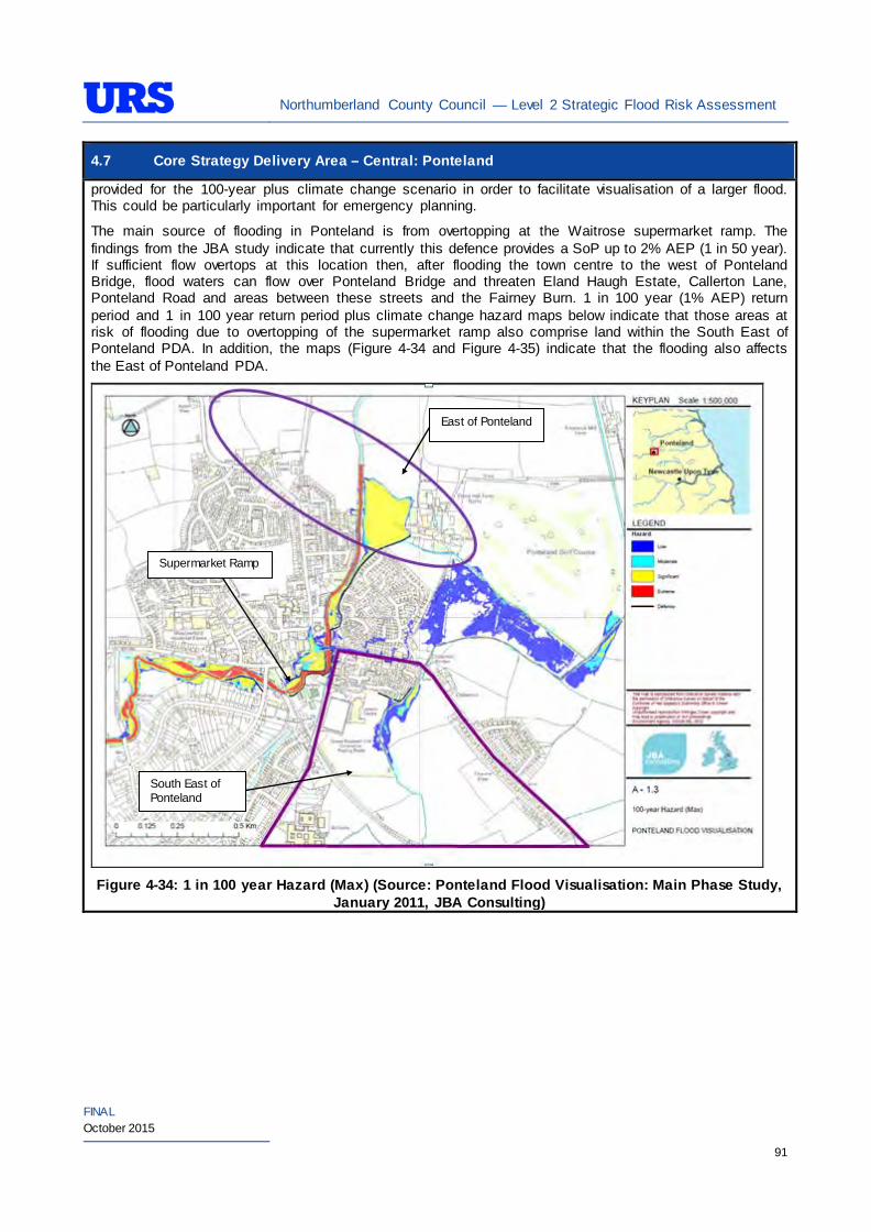
Northumberland County Council — Level 2 Strategic Flood Risk Assessment
FINAL October 2015
91
4.7 Core Strategy Delivery Area – Central: Ponteland provided for the 100-year plus climate change scenario in order to facilitate visualisation of a larger flood. This could be particularly important for emergency planning.
The main source of flooding in Ponteland is from overtopping at the Waitrose supermarket ramp. The findings from the JBA study indicate that currently this defence provides a SoP up to 2% AEP (1 in 50 year). If sufficient flow overtops at this location then, after flooding the town centre to the west of Ponteland Bridge, flood waters can flow over Ponteland Bridge and threaten Eland Haugh Estate, Callerton Lane, Ponteland Road and areas between these streets and the Fairney Burn. 1 in 100 year (1% AEP) return period and 1 in 100 year return period plus climate change hazard maps below indicate that those areas at risk of flooding due to overtopping of the supermarket ramp also comprise land within the South East of Ponteland PDA. In addition, the maps (Figure 4-34 and Figure 4-35) indicate that the flooding also affects the East of Ponteland PDA.
Figure 4-34: 1 in 100 year Hazard (Max) (Source: Ponteland Flood Visualisation: Main Phase Study,
January 2011, JBA Consulting)
East of Ponteland
South East of Ponteland
Supermarket Ramp
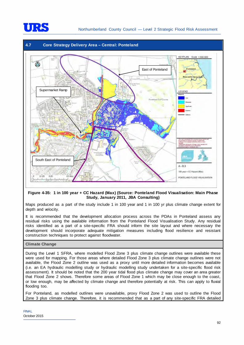
Northumberland County Council — Level 2 Strategic Flood Risk Assessment
FINAL October 2015
92
4.7 Core Strategy Delivery Area – Central: Ponteland
Figure 4-35: 1 in 100 year + CC Hazard (Max) (Source: Ponteland Flood Visualisation: Main Phase
Study, January 2011, JBA Consulting)
Maps produced as a part of the study include 1 in 100 year and 1 in 100 yr plus climate change extent for depth and velocity.
It is recommended that the development allocation process across the PDAs in Ponteland assess any residual risks using the available information from the Ponteland Flood Visualisation Study. Any residual risks identified as a part of a site-specific FRA should inform the site layout and where necessary the development should incorporate adequate mitigation measures including flood resilience and resistant construction techniques to protect against floodwater.
Climate Change
During the Level 1 SFRA, where modelled Flood Zone 3 plus climate change outlines were available these were used for mapping. For those areas where detailed Flood Zone 3 plus climate change outlines were not available, the Flood Zone 2 outline was used as a proxy until more detailed information becomes available (i.e. an EA hydraulic modelling study or hydraulic modelling study undertaken for a site-specific flood risk assessment). It should be noted that the 200 year tidal flood plus climate change may cover an area greater that Flood Zone 2 shows. Therefore some areas of Flood Zone 1 which may be close enough to the coast, or low enough, may be affected by climate change and therefore potentially at risk. This can apply to fluvial flooding too.
For Ponteland, as modelled outlines were unavailable, proxy Flood Zone 2 was used to outline the Flood Zone 3 plus climate change. Therefore, it is recommended that as a part of any site-specific FRA detailed
East of Ponteland
South East of Ponteland
Supermarket Ramp
Northumberland County Council — Level 2 Strategic Flood Risk Assessment
FINAL October 2015
93
4.7 Core Strategy Delivery Area – Central: Ponteland modelling is undertaken for the North West of Ponteland PDA to confirm the extent of the Flood Zone 3 plus climate change. With regards to East of Ponteland and South East of Ponteland PDAs, as described in residual risks section, the Ponteland Flood Visualisation: Main Phase Study completed in January 2011 has determined modelled outline for Flood Zone 3 plus climate change. Therefore, the development allocation process across these PDAs should take the modelled outline in to consideration.
During the Level 1 SFRA, it was determined that there are no modelled outlines of Flood Zone 2 plus climate change for the whole of Northumberland. The Flood Zone 2 plus climate change flood event would be greater than the existing Flood Zone 2 outlines. As there are limitations on data, and extensive uncertainties, in deriving the floodplain for such an extreme event, it is not practical to use a proxy dataset or make assumptions to produce the Flood Zone 2 plus climate change outline. It is therefore recommended that a detailed Site-Specific FRA that examines the location and extent of the Flood Zone 2 plus climate change support any proposed development adjacent to the existing Flood Zone 2.
SuDS Applicability
The SuDS map produced as part of Level 1 SFRA indicated that attenuation systems are applicable for this area. However, further site investigations are necessary to confirm the local ground conditions and determine the appropriate SuDS technique as part of any future site specific FRA.
Prospective developers should work closely with the EA, LPA and LLFA to manage surface water run-off as near to its source as possible. For the PDAs described above, given the ground conditions attenuation SuDS are likely to be an appropriate technique to manage surface water at individual site level. The developer should investigate the use of source control attenuation systems such as green roof, rainwater harvesting systems and site control attenuation systems such as swales, ponds and detention basins as appropriate. It should be noted that a wide range of attenuation SuDS techniques are available which can be adopted depending upon the available space to manage surface water. A site-specific FRA should assess the most suitable SuDS system to manage surface water for the development based on the guidance and advice provided within the Level 2 SFRA and the NPPF.
Recommendations
• It is evident that development pressures will create a need to develop the areas that are at risk of flooding (i.e., Flood Zones 2 and 3) with an associated high hazard – as such any such development should incorporate appropriate mitigation measures which must not increase the risk of flooding to surrounding areas. Careful liaison with the EA will be necessary during the design and planning process;
• For Ponteland Bypass should aim to limit runoff to greenfield rates and attenuate surface water upto 1% AEP (1 in 100 year) plus 20% climate change;
• Careful surface water management is required is the South East Ponteland PDA to prevent any issues downstream on the Fairney Burn. It would be preferable if the development proposed a reduction in existing surface water run-off to result in a reduction in discharge to the watercourse and provide a betterment; and
• Self-contained basements will not be permitted within Flood Zone 3. Basements may be accepted if free access is available to floors above the 1% AEP flood level. If basements are included as part of a scheme then they should adhere to British Standard 8102.
Policies
• Where applicable roll back development from the River Pont, Fairney Burn and Small Burn watercourses to outside Flood Zone 3a to create ‘blue corridors’ which provide public open space and recreation areas near watercourses and enhance green infrastructure. Development should not encroach within 5m of the River Pont, Small Burn and Fairney Burn, which is the EA by-law distance for
Northumberland County Council — Level 2 Strategic Flood Risk Assessment
FINAL October 2015
94
4.7 Core Strategy Delivery Area – Central: Ponteland Main Rivers. This would be beneficial both in terms of flood risk and maintenance access;
• Mixed-use (mixed vulnerability) development that follows the principles of the NPPF sequential approach should be applied within the area. For example, the proposed residential building uses should firstly be situated in Flood Zone 1. The remaining ‘less vulnerable’ uses should be located within Flood Zone 1, then Flood Zone 2 and only when justifiable, Flood Zone 3. This approach can also be applied within buildings, for example, commercial development located at ground floor level and residential development above ground floor level in flood risk areas. However, access and egress must still be made available for residential uses;
• The Ponteland Bypass crosses a number of watercourse and crosses Flood Zone 3, therefore the sequential and exception test must be carried out to identify whether there are any suitable alternative sites, and if not how flood risk will be managed on and off the site. Only essential infrastructure developments that have met the requirements of the exception test are allowed in the functional floodplain.
• Development on or near Main Rivers must apply to the Environment Agency for a flood defences consent;
• The Environment Agency must be consulted early on in the design process if structures are going to cross above an existing watercourse;
• Surface water flood risk should also inform the site layout, such that ‘highly vulnerable’ development is avoided in locations that are shown at the greatest risk of pluvial flooding; and
• For those sites which are primarily greenfield, development has the potential to significantly increase surface water runoff. SuDS should be considered at all stages of the planning and design of new developments to reduce runoff rates and volumes from the developed sites, thus reducing the resultant flood risk posed to the sites and adjacent/downstream areas. Development should, where reasonably possible, aim to reduce surface water runoff to less than greenfield run off. If this is not possible then greenfield runoff rates should be achieved by the proposed mitigation measures.
Site-Specific FRA Guidance
• A site-specific FRA will be required for any development proposed within the area that falls entirely or partly within Flood Zone 2 and/or Flood Zone 3. For areas that fall within Flood Zone 1, a site-specific FRA will be required for any development in excess of 1 ha. The FRA will need to consider surface water management;
• Maximum fluvial flood levels at the area should be informed by the most up-to-date versions of the Environment Agency’s hydraulic models of the River Pont, Small Burn and Fairney Burn;
• If development within areas designated as Flood Zone 3 including an allowance for climate change is justifiable, appropriate mitigation and resilience measures should be incorporated both on an individual property-level (such as flood resilient construction) and at a strategic level (such as strategic SuDS);
• The FRA should demonstrate that consideration has been given to the site layout with regards to flood risk from all sources, in line with the recommendations above (sequential approach to site layout);
• For essential infrastructure located in Flood Zone 3, the FRA must prove that the sequential and exception have been completed;
• The rates and volumes of post-development surface water runoff should be controlled using suitable and adequate SuDS techniques. Where possible, the developers should retrofit drainage solutions to the site with wider benefits to other local areas at risk;
• The suitability of infiltration SuDS should be informed by site-specific ground investigation (GI) works;
• The residual risks identified above should be adequately investigated and assessed as part of the FRA and mitigation measures implemented accordingly;
Northumberland County Council — Level 2 Strategic Flood Risk Assessment
FINAL October 2015
95
4.7 Core Strategy Delivery Area – Central: Ponteland • A site-specific FRA should consider provision of site access and egress, taking into account any
emergency planning requirements of NCC and the Environment Agency. This is a particularly pertinent issue for those areas in the valley, where access roads are at risk of flooding;
• Any sites which contain or are adjacent to Main Rivers must be designed so as to allow access to the channel for maintenance purposes. This maintenance liability lies with the landowner in the first instance however the Environment Agency have powers to undertake work where deemed necessary. Whether these sites are subject to routine EA maintenance, or not, there must be an access route available; and
• Developments should aim to mimic existing drainage regimes as closely as possible, and reduce discharge off site where possible. Development on brownfield land should aim to reduce the runoff by 50%.
• The EA will be publishing new climate change guidance in autumn 2015. The most recent climate change guidance should be used to inform site specific FRA’s.
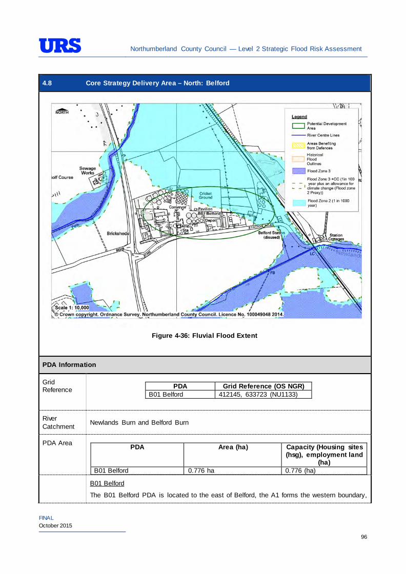
Northumberland County Council — Level 2 Strategic Flood Risk Assessment
FINAL October 2015
96
4.8 Core Strategy Delivery Area – North: Belford
Figure 4-36: Fluvial Flood Extent
PDA Information
Grid Reference
PDA Grid Reference (OS NGR)
B01 Belford 412145, 633723 (NU1133)
River Catchment Newlands Burn and Belford Burn
PDA Area PDA Area (ha) Capacity (Housing sites
(hsg), employment land (ha)
B01 Belford 0.776 ha 0.776 (ha)
B01 Belford
The B01 Belford PDA is located to the east of Belford, the A1 forms the western boundary,
Northumberland County Council — Level 2 Strategic Flood Risk Assessment
FINAL October 2015
97
4.8 Core Strategy Delivery Area – North: Belford Existing Use and Topography
Station road (B1342) the southern boundary, greenfield to the north and railway track to the east. Newlands Burn is located approximately 270m to the south of the PDA and Belford Burn is located approximately 250m to the northwest.
The PDA topography appears to be slope in a northerly direction with a level of around 38m AOD in the south and 34m AOD in the north.
Proposed Use and Vulnerability Classification
The table below summarises the proposed uses of the PDA, provided by NCC (July 2014).
PDA Proposed Use Status B01 Belford Employment Completion of available
employment land
The table below illustrates a matrix of ‘Vulnerability Classification’ based on Table 2 in the National Planning Policy Framework (NPPF) against ‘Flood Zone Compatibility’.
Proposed use NPPF Vulnerability Classification
Flood Zone 1
Flood Zone 2
Flood Zone 3a
Flood Zone 3b
Employment/Mixed use (e.g hospitals, residential care homes, social services homes, prisons, hostels, dwelling houses and student halls of residence)
More vulnerable*
Exception Test
required
Employment/Mixed use (e.g shops, restaurants, offices, general industry, storage and distribution)
Less vulnerable*
Key
- Acceptable
- Not Acceptable
*Based on Planning Practice Guidance (PPG) Table 2: Flood Risk Vulnerability Classif ication.
Should further definition of the proposed uses be made at a later date, then identification of their individual vulnerability classifications should be re-visited.
Sources of Flood Risk
Rivers/Sea The PDA is located to the north Newlands Burn and to the south of Belford Burn
The Environment Agency’s (EA’s) Flood Maps present the extent of Flood Zones associated with Belford Burn and Newlands Burn. The EA’s Flood Maps indicate that the southwest of the PDA is in Flood Zone 1. An area to the northeast of the PDA is indicated to be in Flood Zone 2.
The northeast of the PDA is located in the EA flood warning area called ‘Coastal Rivers in North Northumberland’ described as ‘Coastal rivers in Berwick and Alnwick Districts including the River Aln and Waren Burn.
The Environment Agency North East Northumberland Catchment Flood Management
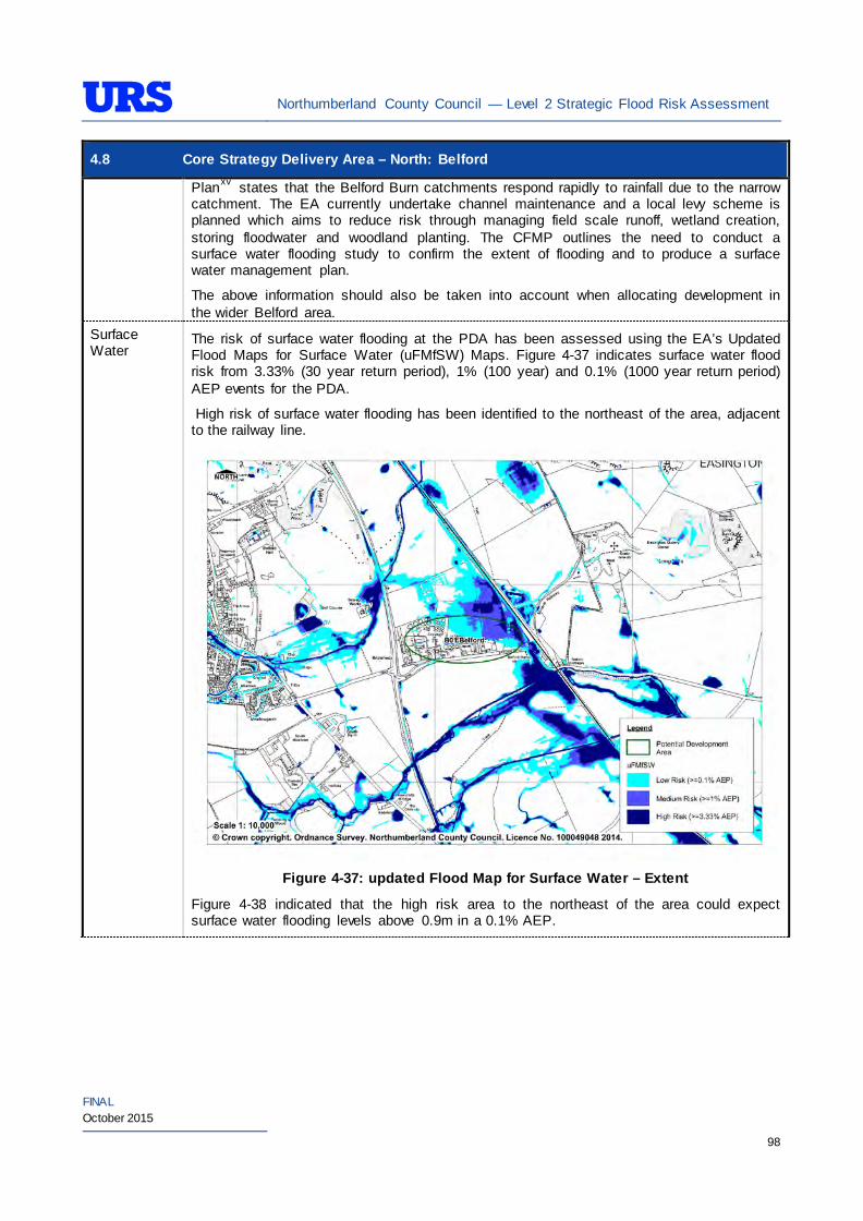
Northumberland County Council — Level 2 Strategic Flood Risk Assessment
FINAL October 2015
98
4.8 Core Strategy Delivery Area – North: Belford Planxv states that the Belford Burn catchments respond rapidly to rainfall due to the narrow catchment. The EA currently undertake channel maintenance and a local levy scheme is planned which aims to reduce risk through managing field scale runoff, wetland creation, storing floodwater and woodland planting. The CFMP outlines the need to conduct a surface water flooding study to confirm the extent of flooding and to produce a surface water management plan.
The above information should also be taken into account when allocating development in the wider Belford area.
Surface Water
The risk of surface water flooding at the PDA has been assessed using the EA’s Updated Flood Maps for Surface Water (uFMfSW) Maps. Figure 4-37 indicates surface water flood risk from 3.33% (30 year return period), 1% (100 year) and 0.1% (1000 year return period) AEP events for the PDA.
High risk of surface water flooding has been identified to the northeast of the area, adjacent to the railway line.
Figure 4-37: updated Flood Map for Surface Water – Extent
Figure 4-38 indicated that the high risk area to the northeast of the area could expect surface water flooding levels above 0.9m in a 0.1% AEP.
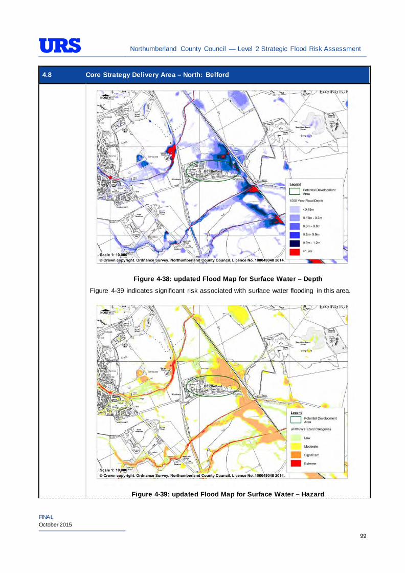
Northumberland County Council — Level 2 Strategic Flood Risk Assessment
FINAL October 2015
99
4.8 Core Strategy Delivery Area – North: Belford
Figure 4-38: updated Flood Map for Surface Water – Depth
Figure 4-39 indicates significant risk associated with surface water flooding in this area.
Figure 4-39: updated Flood Map for Surface Water – Hazard
Northumberland County Council — Level 2 Strategic Flood Risk Assessment
FINAL October 2015
100
4.8 Core Strategy Delivery Area – North: Belford
The ‘Site-specific FRA Guidance’ section of the SFRA provides recommendations relating to management of surface water within individual sites.
Groundwater The British Geological Survey (BGS) areas susceptible to groundwater flooding map indicates that the area is at high risk (over 75%) of groundwater flooding.
The EA’s Groundwater Vulnerability(GWV) maps have been prepared as a thematic map to highlight areas that overlie aquifers with a high vulnerability. Major Aquifers with a high vulnerability tend to have a more permeable surface geology. Groundwater vulnerability relates to the potential for contaminants to enter groundwater and thus is a useful tool to determine the potential suitability of Sustainable Drainage Systems (SuDS) techniques.
The EA’s GWV maps indicate the following general groundwater conditions at the PDA:
PDA Underlying Aquifer Vulnerability B01 Belford Minor Aquifer
Intermediate Vulnerability(centre, south and west) High Vulnerability (north and east)
The EA’s Source Protection Zone (SPZ) maps indicate that the PDA is not located within a SPZ.
Sewers The risk of hydraulic sewer flooding in the area has been assessed using the NWL DG5 data. As detailed in Section 3.7 of the SFRA, the NWL DG5 data indicates risk of hydraulic sewer flooding in NWL drainage areas based on 100 square metre grid square data.
Review of the NWL DG5 100 square metre grid square data indicates there are no grid squares in the drainage area. The Core Strategy Delivery Area PDA in Belford is located within the NWL Belford Industrial Estate (01-D50) drainage area catchment.
Future developments should take measures as far as is practicable to reduce the flood risk arising from the development to the PDA itself and downstream properties. A site-specific FRA should identify the drainage strategy to mitigate sewer flooding risk.
Artificial Sources
There are no canals, reservoirs or other artificial water sources that may provide a flood risk in the vicinity of these PDAs.
Flood Defence Infrastructure
The Environment Agency Asset Information Management System (AIMS) now supersedes NFCDD, although the NFCDD data provides more detailed information of defences in the area. Both the AIMS and NFCDD data have been included within this SFRA for completeness. It is advised that the developer consults with the Environment Agency to obtain the most up to date information relating to flood defence infrastructure.
Information obtained from AIMS shows that fluvial defence in the form of high ground exists along the left and right bank of Belford Burns.
The NFCDD meanwhile identifies high ground along both Belford and Newlands Burns. It also states that these fluvial defences provide a 50% AEP level of defence.
High ground has been identified as a fluvial defence along both Newlands and Belford Burns. EA information states that these defences provide a 50% AEP level of defence.
Northumberland County Council — Level 2 Strategic Flood Risk Assessment
FINAL October 2015
101
4.8 Core Strategy Delivery Area – North: Belford Residual Flood Risks
It is recommended that the development allocation process across the PDAs follow the principles of the NPPF sequential approach. As the PDAs are located in low-lying fluvial areas with a higher vulnerability to flood from defence breach and overtop, it is also recommended that detailed assessments are undertaken as a part of site-specific FRA to establish the standard of protection provided by the defences and identify necessary mitigation measures to be undertaken.
Climate Change
During the Level 1 SFRA, where modelled Flood Zone 3 plus climate change outlines were available these were used for flood mapping. For those areas where detailed Flood Zone 3 plus climate change outlines were not available, the Flood Zone 2 outline was used as a proxy until more detailed information becomes available (i.e. an EA hydraulic modelling study or hydraulic modelling study undertaken for a site-specific FRA). It should be noted that the 200 year tidal flood plus climate change may cover an area greater that Flood Zone 2 shows. Therefore some areas of Flood Zone 1 which may be close enough to the coast, or low enough, may be affected by climate change and therefore potentially at risk. This can apply to fluvial flooding too.
For the Belford area, as modelled outlines were unavailable, Flood Zone 2 was used as a proxy to map the potential outline of Flood Zone 3 plus climate change. Therefore, it is recommended that as a part of site-specific FRAs detailed modelling is undertaken to confirm the extent of the Flood Zone 3 plus climate change, should any development be proposed within the area covered by the proxy outline.
It has been determined that there are no modelled outlines of Flood Zone 2 plus climate change for the whole of Northumberland. The Flood Zone 2 plus climate change flood event would be greater than the existing Flood Zone 2 outlines. As there are limitations on data, and extensive uncertainties, in deriving the floodplain for such an extreme event, it is not practical to use a proxy dataset or make assumptions to produce the Flood Zone 2 plus climate change outline. It is therefore recommended that as part of any future detailed site-specific FRAs the extent of Flood Zone 2 plus climate change is determined, should this be critical to the layout of the development. Consultation with the EA should be undertaken to determine a suitable methodology for undertaking this assessment (i.e. detailed modelling, or applying an agreed buffer to Flood Zone 2).
SuDS Applicability
The SuDS map produced as part of Level 1 SFRA indicated that attenuation systems are applicable for this area. However, further site investigations are necessary to confirm the local ground conditions and determine the appropriate SuDS technique as part of any future site specific FRA.
Prospective developers should work closely with the EA, LPA and LLFA to manage surface water run-off as near to its source as possible. For the PDA described above, given the ground conditions attenuation SuDS are likely to be an appropriate technique to manage surface water at individual site level.
The developer should investigate the use of source control attenuation systems such as green roof, rainwater harvesting systems and site control attenuation systems such as swales, ponds and detention basins as appropriate. It should be noted that a wide range of attenuation SuDS techniques are available which can be adopted depending upon the available space to manage surface water. A site-specific FRA should assess the most suitable SuDS system to manage surface water for the development based on the guidance and advice provided within the Level 2 SFRA and the NPPF.
Recommendations
• If development pressures create a need to develop the areas of the PDA that are at risk of flooding (i.e.,
Northumberland County Council — Level 2 Strategic Flood Risk Assessment
FINAL October 2015
102
4.8 Core Strategy Delivery Area – North: Belford Flood Zone 2 and Flood Zone 3) – they should incorporate appropriate mitigation measures which must not increase the risk of flooding to surrounding areas. Careful liaison with the EA will be necessary during the design and planning process.
Policies
• Where applicable roll back development from Belford Burn and Newlands Burn to outside Flood Zone 3a to create ‘blue corridors’ which provide public open space and recreation areas near the rivers and enhance green infrastructure. Development should not encroach within 5m of the watercourses, which is the EA by-law distance for Main Rivers. This would be beneficial both in terms of flood risk and maintenance access;
• Mixed use (mixed vulnerability) development should follow the principles of the NPPF sequential approach across the PDA. For example, proposed residential development should be steered to the lower risk areas across the PDA, with the remaining ‘less vulnerable’ land uses being located on the (relatively) higher risk areas of the PDA. This approach can also be applied within buildings, for example commercial development located at ground floor level and residential development above ground floor level in flood risk areas. However, access and egress must still be made available for the residential uses;
• Surface water/pluvial flood risk should also inform the site layout, such that ‘highly vulnerable’ development is avoided in locations that are shown at the greatest risk of pluvial flooding; and
• As the PDA is predominately brownfield, it is unlikely that future developments within the PDA will increase surface water runoff. However, SuDS should be considered at all stages of the planning and design of new developments to reduce runoff rates and volumes from the proposed development, thus reducing the resultant flood risk posed to the PDA and adjacent/downstream areas. Development should, where reasonably possible, aim to reduce surface water runoff to less than greenfield runoff. If this is not possible then greenfield runoff rates should be achieved by the proposed mitigation measures.
Site-Specific FRA Guidance
• A site-specific FRA will be required for any development proposed within the Belford area that falls entirely or partly within Flood Zone 2 and Flood Zone 3. For individual plots within the PDA that do fall within Flood Zone 1, an FRA will be required for any development in excess of 1 ha. The FRA will need to consider surface water management;
• Maximum fluvial flood levels at the site should be informed by the most up-to-date versions of the EA’s hydraulic models of Belford Burn, or any future fluvial studies. If no models are available then the Lead Local Flood Authority may require a model as part of a planning application;
• If development within areas designated as Flood Zone 3 including an allowance for climate change is justifiable, appropriate mitigation and resilience measures should be incorporated both on an individual property-level (such as flood resilient construction) and at a strategic level (such as strategic SuDS);
• The FRA should demonstrate that consideration has been given to the site layout with regards to flood risk from all sources, in line with the recommendations above (sequential approach to site layout);
• The rates and volumes of post-development surface water runoff should be controlled using suitable and adequate SuDS techniques. Where possible, the developer should retrofit drainage solutions to the site with wider benefits to other local areas at risk;
• The suitability of infiltration SuDS should be informed by site-specific ground investigation (GI) works;
• The residual risks identified above should be adequately investigated and assessed as part of the FRA and mitigation measures implemented accordingly. In such situations, the developer is generally
Northumberland County Council — Level 2 Strategic Flood Risk Assessment
FINAL October 2015
103
4.8 Core Strategy Delivery Area – North: Belford required to provide resources and funds to undertake more complex modelling/assessments to determine the residual risk on the development arising from events that overtop or breach the defences. In addition, the developer is generally responsible for funding any flood risk management works, including defences and mitigation works;
• A site-specific FRA should consider provision of site access and egress, taking into account any emergency planning requirements of NCC and the Environment Agency. This is a particularly pertinent issue for areas, where access roads are at risk of flooding; and
• The effect of climate change should be considered in a site specific FRA, it is possible that the extent of Flood Zone 3 could increase.
• The EA will be publishing new climate change guidance in autumn 2015. The most recent climate change guidance should be used to inform site specific FRA’s.
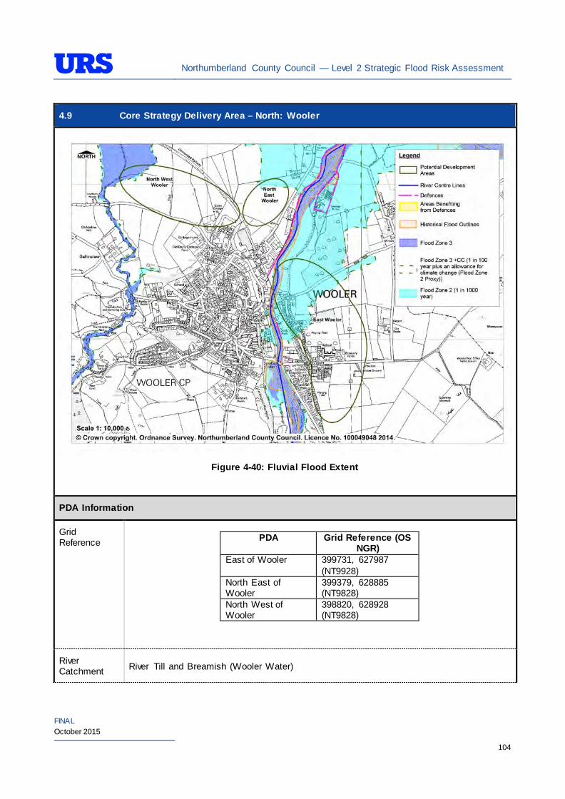
Northumberland County Council — Level 2 Strategic Flood Risk Assessment
FINAL October 2015
104
4.9 Core Strategy Delivery Area – North: Wooler
Figure 4-40: Fluvial Flood Extent
PDA Information
Grid Reference
PDA Grid Reference (OS
NGR) East of Wooler 399731, 627987
(NT9928) North East of Wooler
399379, 628885 (NT9828)
North West of Wooler
398820, 628928 (NT9828)
River Catchment River Till and Breamish (Wooler Water)
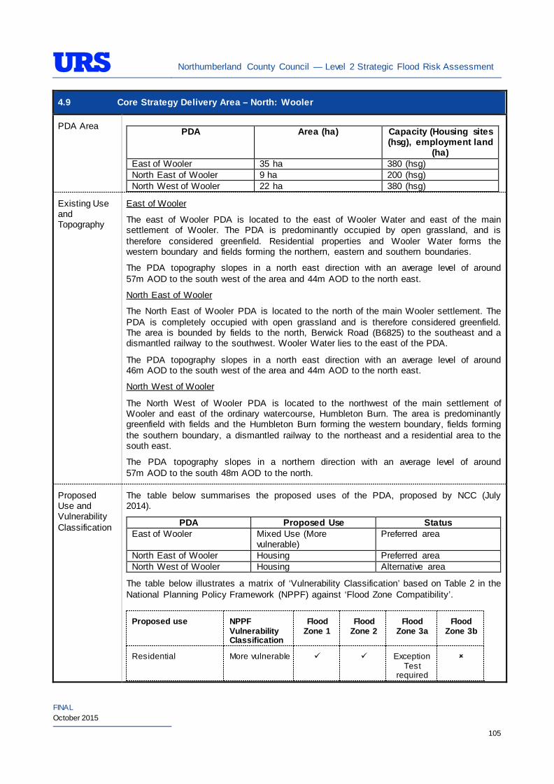
Northumberland County Council — Level 2 Strategic Flood Risk Assessment
FINAL October 2015
105
4.9 Core Strategy Delivery Area – North: Wooler
PDA Area PDA Area (ha) Capacity (Housing sites
(hsg), employment land (ha)
East of Wooler 35 ha 380 (hsg) North East of Wooler 9 ha 200 (hsg) North West of Wooler 22 ha 380 (hsg)
Existing Use and Topography
East of Wooler
The east of Wooler PDA is located to the east of Wooler Water and east of the main settlement of Wooler. The PDA is predominantly occupied by open grassland, and is therefore considered greenfield. Residential properties and Wooler Water forms the western boundary and fields forming the northern, eastern and southern boundaries.
The PDA topography slopes in a north east direction with an average level of around 57m AOD to the south west of the area and 44m AOD to the north east.
North East of Wooler
The North East of Wooler PDA is located to the north of the main Wooler settlement. The PDA is completely occupied with open grassland and is therefore considered greenfield. The area is bounded by fields to the north, Berwick Road (B6825) to the southeast and a dismantled railway to the southwest. Wooler Water lies to the east of the PDA.
The PDA topography slopes in a north east direction with an average level of around 46m AOD to the south west of the area and 44m AOD to the north east.
North West of Wooler
The North West of Wooler PDA is located to the northwest of the main settlement of Wooler and east of the ordinary watercourse, Humbleton Burn. The area is predominantly greenfield with fields and the Humbleton Burn forming the western boundary, fields forming the southern boundary, a dismantled railway to the northeast and a residential area to the south east.
The PDA topography slopes in a northern direction with an average level of around 57m AOD to the south 48m AOD to the north.
Proposed Use and Vulnerability Classification
The table below summarises the proposed uses of the PDA, proposed by NCC (July 2014).
PDA Proposed Use Status East of Wooler Mixed Use (More
vulnerable) Preferred area
North East of Wooler Housing Preferred area North West of Wooler Housing Alternative area
The table below illustrates a matrix of ‘Vulnerability Classification’ based on Table 2 in the National Planning Policy Framework (NPPF) against ‘Flood Zone Compatibility’.
Proposed use NPPF Vulnerability Classification
Flood Zone 1
Flood Zone 2
Flood Zone 3a
Flood Zone 3b
Residential More vulnerable Exception Test
required
Northumberland County Council — Level 2 Strategic Flood Risk Assessment
FINAL October 2015
106
4.9 Core Strategy Delivery Area – North: Wooler Employment/Mixed use (e.g hospitals, residential care homes, social services homes, prisons, hostels, dwelling houses and student halls of residence)
More vulnerable*
Exception Test
required
Employment/Mixed use (e.g shops, restaurants, offices, general industry, storage and distribution)
Less vulnerable*
Key
- Acceptable
- Not Acceptable
*Based on Planning Practice Guidance (PPG) Table 2: Flood Risk Vulnerability Classif ication.
Should further definition of the proposed uses be made at a later date, then identification of their individual vulnerability classifications should be re-visited.
Sources of Flood Risk
Rivers/Sea All PDAs are located between the Main River of Wooler Water, a tributary of the River Till and the Ordinary Watercourse of Humbleton Burn.
The Environment Agency’s (EA’s) Flood Maps present the extent of Flood Zones associated with Wooler Water and the Humbleton Burn. Fluvial flood risk to NSC Wooler E Hsg and NSC Wooler N Hsg is associated with Wooler Water whilst fluvial flood risk to NSC Wooler Hsg is associated with Humbleton Burn.
East of Wooler
The EA’s Flood Maps (Figure 4-40) indicate that the majority of the PDA is in Flood Zone 1. An area to the northwest of the PDA is indicated to be in Flood Zone 2 and a small area in the northwest is indicated to be in Flood Zone 3. A small length of Wooler Water is located within the PDA boundary. The majority of the PDA is therefore not at risk of significant flooding.
The area along the north-western border of the PDA is located within the EA’s ‘Wooler Water at Wooler’ Flood Warning Area. The warning descriptions states that properties and low lying areas around South Road, Weetwood Avenue, Berwick Road, Turvelaws and Farm Cottages are at risk.
North East of Wooler
The EA’s Flood Maps (Figure 4-40) indicate that the majority of the PDA is in Flood Zone 1. An area to the northeast of the PDA is indicated to be in Flood Zone 2. The majority of the PDA is therefore not at risk of significant flooding
North West of Wooler
The EA’s Flood Maps (Figure 4-40) indicate that the majority of the PDA is in Flood Zone 1. An area to the northwest is indicated to be in Flood Zone 2 and 3.
The Environment Agency Till and Breamish Catchment Flood Management Plan xv istates
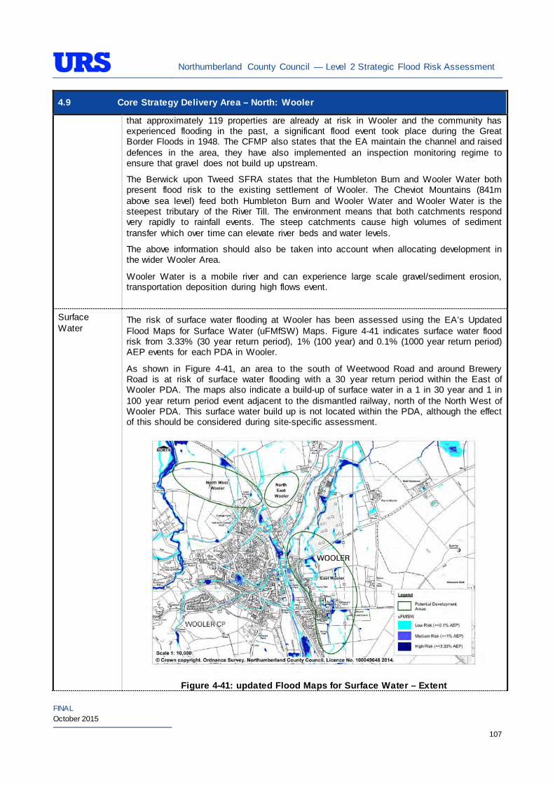
Northumberland County Council — Level 2 Strategic Flood Risk Assessment
FINAL October 2015
107
4.9 Core Strategy Delivery Area – North: Wooler that approximately 119 properties are already at risk in Wooler and the community has experienced flooding in the past, a significant flood event took place during the Great Border Floods in 1948. The CFMP also states that the EA maintain the channel and raised defences in the area, they have also implemented an inspection monitoring regime to ensure that gravel does not build up upstream.
The Berwick upon Tweed SFRA states that the Humbleton Burn and Wooler Water both present flood risk to the existing settlement of Wooler. The Cheviot Mountains (841m above sea level) feed both Humbleton Burn and Wooler Water and Wooler Water is the steepest tributary of the River Till. The environment means that both catchments respond very rapidly to rainfall events. The steep catchments cause high volumes of sediment transfer which over time can elevate river beds and water levels.
The above information should also be taken into account when allocating development in the wider Wooler Area.
Wooler Water is a mobile river and can experience large scale gravel/sediment erosion, transportation deposition during high flows event.
Surface Water
The risk of surface water flooding at Wooler has been assessed using the EA’s Updated Flood Maps for Surface Water (uFMfSW) Maps. Figure 4-41 indicates surface water flood risk from 3.33% (30 year return period), 1% (100 year) and 0.1% (1000 year return period) AEP events for each PDA in Wooler.
As shown in Figure 4-41, an area to the south of Weetwood Road and around Brewery Road is at risk of surface water flooding with a 30 year return period within the East of Wooler PDA. The maps also indicate a build-up of surface water in a 1 in 30 year and 1 in 100 year return period event adjacent to the dismantled railway, north of the North West of Wooler PDA. This surface water build up is not located within the PDA, although the effect of this should be considered during site-specific assessment.
Figure 4-41: updated Flood Maps for Surface Water – Extent
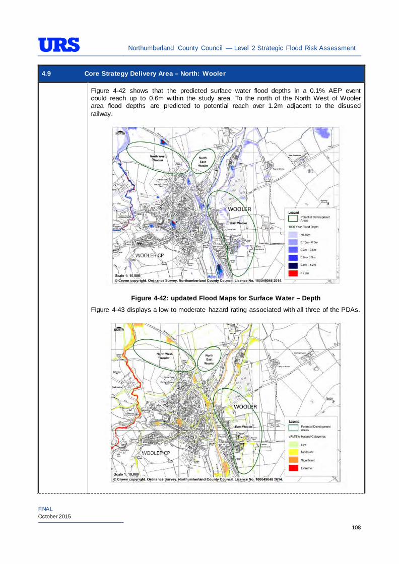
Northumberland County Council — Level 2 Strategic Flood Risk Assessment
FINAL October 2015
108
4.9 Core Strategy Delivery Area – North: Wooler
Figure 4-42 shows that the predicted surface water flood depths in a 0.1% AEP event could reach up to 0.6m within the study area. To the north of the North West of Wooler area flood depths are predicted to potential reach over 1.2m adjacent to the disused railway.
Figure 4-42: updated Flood Maps for Surface Water – Depth
Figure 4-43 displays a low to moderate hazard rating associated with all three of the PDAs.
Northumberland County Council — Level 2 Strategic Flood Risk Assessment
FINAL October 2015
109
4.9 Core Strategy Delivery Area – North: Wooler Figure 4-43: updated Flood Maps for Surface Water – Hazard
The ‘Site-specific FRA Guidance’ section of the SFRA provides recommendations relating to management of surface water within individual PDAs.
Groundwater The British Geological Survey(BGS) Areas Susceptible to Groundwater Flooding maps indicate the following conditions at each PDA;
PDA Groundwater Flood Risk East of Wooler No data available North East of Wooler High risk (>=75%) North West of Wooler High risk (>=75%)
The EA’s Groundwater Vulnerability (GWV) maps have been prepared as a thematic map to highlight areas that overlie aquifers with a high vulnerability. Major Aquifers with a high vulnerability tend to have a more permeable surface geology. Groundwater vulnerability relates to the potential for contaminants to enter groundwater and thus is a useful tool to determine the potential suitability of Sustainable Drainage Systems (SuDS) techniques.
The EA’s GWV maps indicate the following general groundwater conditions at each PDA:
PDA Underlying Aquifer Vulnerability East of Wooler Minor Aquifer
Major Aquifer Intermediate Vulnerability
North East of Wooler Minor Aquifer Intermediate Vulnerability North West of Wooler Minor Aquifer Intermediate Vulnerability
High Vulnerability
The EA’s Source Protection Zone (SPZ) maps indicate that the PDAs are not located within a SPZ.
Sewers The risk of hydraulic sewer flooding in the area has been assessed using the NWL DG5 data. As detailed in Section 3.7 of the SFRA, the NWL DG5 data indicates risk of hydraulic sewer flooding in NWL drainage areas based on 100 square metre grid square data.
Review of the NWL DG5 100 square metre grid square data indicates that no incidents have been reported in the drainage area. The Core Strategy Delivery Area PDAs in Wooler are located within the NWL Wooler (01-D36) drainage area catchment.
Future developments should take measures as far as is practicable to reduce the flood risk arising from the development to the site itself and downstream properties. A site-specific FRA should identify the drainage strategy to mitigate sewer flooding risk.
Artificial Sources
There are no canals, reservoirs or other artificial water sources that may provide a flood risk in the vicinity of these PDAs.
Flood Defence Infrastructure
The Environment Agency Asset Information Management System (AIMS) now supersedes NFCDD, although the NFCDD data provides more detailed information of defences in the area. Both the AIMS and NFCDD data have been included within this SFRA for completeness. It is advised that the developer consults with the Environment Agency to obtain the most up to date information relating to flood defence infrastructure.
Information obtained from AIMS identified a number of fluvial protection defences along Wooler Water. The
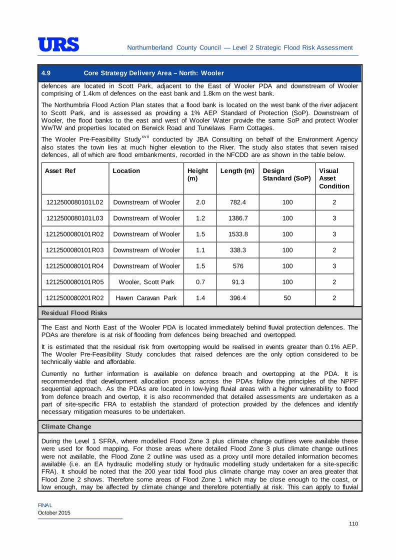
Northumberland County Council — Level 2 Strategic Flood Risk Assessment
FINAL October 2015
110
4.9 Core Strategy Delivery Area – North: Wooler defences are located in Scott Park, adjacent to the East of Wooler PDA and downstream of Wooler comprising of 1.4km of defences on the east bank and 1.8km on the west bank.
The Northumbria Flood Action Plan states that a flood bank is located on the west bank of the river adjacent to Scott Park, and is assessed as providing a 1% AEP Standard of Protection (SoP). Downstream of Wooler, the flood banks to the east and west of Wooler Water provide the same SoP and protect Wooler WwTW and properties located on Berwick Road and Turvelaws Farm Cottages.
The Wooler Pre-Feasibility Study xv ii conducted by JBA Consulting on behalf of the Environment Agency also states the town lies at much higher elevation to the River. The study also states that seven raised defences, all of which are flood embankments, recorded in the NFCDD are as shown in the table below.
Asset Ref Location Height (m)
Length (m) Design Standard (SoP)
Visual Asset Condition
1212500080101L02 Downstream of Wooler 2.0 782.4 100 2
1212500080101L03 Downstream of Wooler 1.2 1386.7 100 3
1212500080101R02 Downstream of Wooler 1.5 1533.8 100 3
1212500080101R03 Downstream of Wooler 1.1 338.3 100 2
1212500080101R04 Downstream of Wooler 1.5 576 100 3
1212500080101R05 Wooler, Scott Park 0.7 91.3 100 2
1212500080201R02 Haven Caravan Park 1.4 396.4 50 2
Residual Flood Risks
The East and North East of the Wooler PDA is located immediately behind fluvial protection defences. The PDAs are therefore is at risk of flooding from defences being breached and overtopped.
It is estimated that the residual risk from overtopping would be realised in events greater than 0.1% AEP. The Wooler Pre-Feasibility Study concludes that raised defences are the only option considered to be technically viable and affordable.
Currently no further information is available on defence breach and overtopping at the PDA. It is recommended that development allocation process across the PDAs follow the principles of the NPPF sequential approach. As the PDAs are located in low-lying fluvial areas with a higher vulnerability to flood from defence breach and overtop, it is also recommended that detailed assessments are undertaken as a part of site-specific FRA to establish the standard of protection provided by the defences and identify necessary mitigation measures to be undertaken.
Climate Change
During the Level 1 SFRA, where modelled Flood Zone 3 plus climate change outlines were available these were used for flood mapping. For those areas where detailed Flood Zone 3 plus climate change outlines were not available, the Flood Zone 2 outline was used as a proxy until more detailed information becomes available (i.e. an EA hydraulic modelling study or hydraulic modelling study undertaken for a site-specific FRA). It should be noted that the 200 year tidal flood plus climate change may cover an area greater that Flood Zone 2 shows. Therefore some areas of Flood Zone 1 which may be close enough to the coast, or low enough, may be affected by climate change and therefore potentially at risk. This can apply to fluvial
Northumberland County Council — Level 2 Strategic Flood Risk Assessment
FINAL October 2015
111
4.9 Core Strategy Delivery Area – North: Wooler flooding too.
For the Wooler area, as modelled outlines were unavailable, Flood Zone 2 was used as a proxy to map the potential outline of Flood Zone 3 plus climate change. Therefore, it is recommended that as a part of site-specific FRAs detailed modelling is undertaken to confirm the extent of the Flood Zone 3 plus climate change, should any development be proposed within the area covered by the proxy outline.
During the Level 1 SFRA, it was determined that there are no modelled outlines of Flood Zone 2 plus climate change for the whole of Northumberland. The Flood Zone 2 plus climate change flood event would be greater than the existing Flood Zone 2 outlines. As there are limitations on data, and extensive uncertainties, in deriving the floodplain for such an extreme event, it is not practical to use a proxy dataset or make assumptions to produce the Flood Zone 2 plus climate change outline. It is therefore recommended that as part of any future detailed site-specific FRAs the extent of Flood Zone 2 plus climate change is determined, should this be critical to the layout of the development. Consultation with the EA should be undertaken to determine a suitable methodology for undertaking this assessment (i.e. detailed modelling, or applying an agreed buffer to Flood Zone 2).
SuDS Applicability
The SuDS map produced as part of Level 1 SFRA indicated that attenuation systems are applicable for this area. However, further site investigations are necessary to confirm the local ground conditions and determine the appropriate SuDS technique as part of any future site specific FRA.
Prospective developers should work closely with the EA, LPA and LLFA to manage surface water run-off as near to its source as possible. For the PDAs described above, given the ground conditions attenuation SuDS are likely to be an appropriate technique to manage surface water at individual site level.
The developer should investigate the use of source control attenuation systems such as green roof, rainwater harvesting systems and site control attenuation systems such as swales, ponds and detention basins as appropriate. It should be noted that a wide range of attenuation SuDS techniques are available which can be adopted depending upon the available space to manage surface water. A site-specific FRA should assess the most suitable SuDS system to manage surface water for the development based on the guidance and advice provided within the Level 2 SFRA and the NPPF.
Recommendations
• If development pressures create a need to develop the areas of the PDA that are at risk of flooding (i.e. Flood Zone 2 and Flood Zone 3) – they should incorporate appropriate mitigation measures which must not increase the risk of flooding to surrounding areas. Careful liaison with the EA will be necessary during the design and planning process; and
• Self-contained basements will not be permitted within Flood Zone 3. Basements may be accepted if free access is available to floors above the 1% AEP flood level. If basements are included as part of a scheme then they should adhere to British Standard 8102.
Policies
• Where applicable roll back development from Wooler Water and the Humbleton Burn to outside Flood Zone 3a to create ‘blue corridors’ which provide public open space and recreation areas near the rivers and enhance green infrastructure. Development should not encroach within 5m of the watercourses, which is the EA by-law distance for Main Rivers. This would be beneficial both in terms of flood risk and maintenance access;
• Mixed use (mixed vulnerability) development should follow the principles of the NPPF sequential
Northumberland County Council — Level 2 Strategic Flood Risk Assessment
FINAL October 2015
112
4.9 Core Strategy Delivery Area – North: Wooler approach across the PDA. For example, proposed residential development should be steered to the lower risk areas across the PDA, with the remaining ‘less vulnerable’ land uses being located on the (relatively) higher risk areas of the PDA. This approach can also be applied within buildings, for example commercial development located at ground floor level and residential development above ground floor level in flood risk areas. However, access and egress must still be made available for the residential uses;
• Surface water/pluvial flood risk should also inform the site layout, such that ‘highly vulnerable’ development is avoided in locations that are shown at the greatest risk of pluvial flooding; and
• As the PDAs are primarily greenfield, development has the potential to significantly increase surface water runoff. Therefore, to ensure sustainability, SuDS should be implemented to reduce runoff rates and volumes from the developed sites, thus reducing the resultant flood risk posed to the sites and adjacent/downstream areas. Development should, where reasonably possible, aim to reduce surface water runoff to less that greenfield run off. If this is not possible then greenfield runoff rates should be met.
Site-Specific FRA Guidance
• A site-specific FRA will be required for any development proposed within the Wooler Area that falls entirely or partly within Flood Zone 2 and Flood Zone 3. For sites that do fall within Flood Zone 1, an FRA will be required for any development in excess of 1 ha. The FRA will need to consider surface water management;
• A site specific FRA should assess risk associated with Wooler Water being a mobile river which can experience large scale gravel/sediment erosion, transportation deposition during high flows event;
• Maximum fluvial flood levels at the sites should be informed by the most up-to-date versions of the EA’s hydraulic models of the Wooler Burn and Humbleton Burn, or any future fluvial studies. If no models are available then the Lead Local Flood Authority may require a model as part of a planning application;
• If development within areas designated as Flood Zone 3 including an allowance for climate change is justifiable, appropriate mitigation and resilience measures should be incorporated both on an individual property-level (such as flood resilient construction) and at a strategic level (such as strategic SuDS);
• The FRA should demonstrate that consideration has been given to the site layout with regards to flood risk from all sources, in line with the recommendations above (sequential approach to site layout);
• The rates and volumes of post-development surface water runoff should be controlled using suitable and adequate SuDS techniques. Where possible, the developer should retrofit drainage solutions to the site with wider benefits to other local areas at risk;
• The suitability of infiltration SuDS should be informed by site-specific ground investigation (GI) works;
• The residual risks identified above should be adequately investigated and assessed as part of the FRA and mitigation measures implemented accordingly. In such situations, the developer is generally required to provide resources and funds to undertake more complex modelling/assessments to determine the residual risk on the development arising from events that overtop or breach the defences. In addition, the developer is generally responsible for funding any flood risk management works, including defences and mitigation works;
• A site-specific FRA should consider provision of site access and egress, taking into account any emergency planning requirements of NCC and the Environment Agency. This is a particularly pertinent issue for areas, where access roads are at risk of flooding;
• Any sites which contain or are adjacent to Main Rivers must be designed so as to allow access to the channel for maintenance purposes. This maintenance liability lies with the landowner in the first instance however the Environment Agency have powers to undertake work where deemed necessary. Whether these sites are subject to routine EA maintenance, or not, there must be an access route
Northumberland County Council — Level 2 Strategic Flood Risk Assessment
FINAL October 2015
113
4.9 Core Strategy Delivery Area – North: Wooler available; and
• Developments should aim to mimic existing drainage regimes as closely as possible, and reduce discharge off site where possible. Development on brownfield land should aim to reduce the runoff by 50% and greenfield rates where land was previously undeveloped.
• The EA will be publishing new climate change guidance in autumn 2015. The most recent climate change guidance should be used to inform site specific FRA’s.
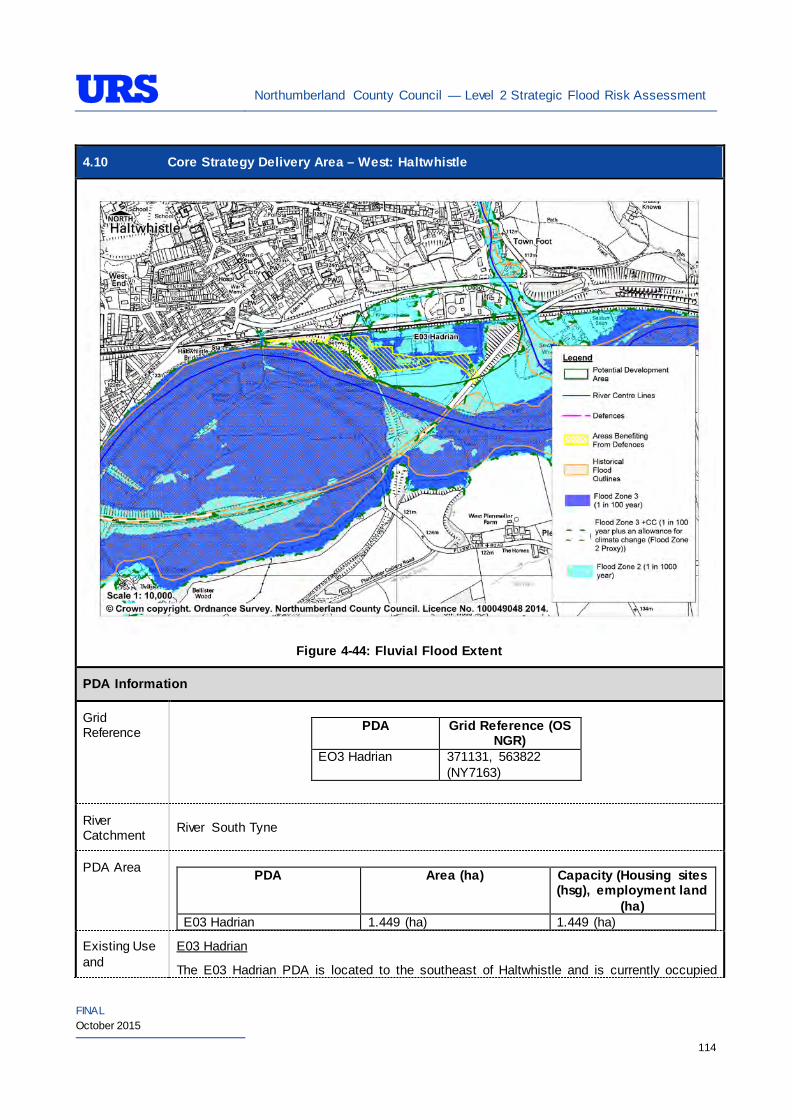
Northumberland County Council — Level 2 Strategic Flood Risk Assessment
FINAL October 2015
114
4.10 Core Strategy Delivery Area – West: Haltwhistle
Figure 4-44: Fluvial Flood Extent
PDA Information
Grid Reference
PDA Grid Reference (OS
NGR) EO3 Hadrian 371131, 563822
(NY7163)
River Catchment River South Tyne
PDA Area PDA Area (ha) Capacity (Housing sites
(hsg), employment land (ha)
E03 Hadrian 1.449 (ha) 1.449 (ha)
Existing Use and
E03 Hadrian
The E03 Hadrian PDA is located to the southeast of Haltwhistle and is currently occupied
Northumberland County Council — Level 2 Strategic Flood Risk Assessment
FINAL October 2015
115
4.10 Core Strategy Delivery Area – West: Haltwhistle Topography by an existing industrial site. Haltwhistle Burn and the A69 forms the eastern boundary,
River South Tyne forms the southern boundary, West Road forms the northern boundary and a subway forms the western boundary. A railway line runs across the centre of the PDA. The Haltwhistle Burn flood zone 3 is not shown in Figure 4-44.
The PDA topography is generally flat with an average level of around 109m AOD.
Proposed Use and Vulnerability Classification
The table below summarises the proposed uses of the PDA, proposed by NCC (July 2014).
PDA Proposed Use Status E03 Hadrian Employment Completion of available
employment land
The table below illustrates a matrix of ‘Vulnerability Classification in Planning Practice Guidance to the NPPF’ for proposed developments against ‘Flood Zone Compatibility’.
Proposed use NPPF Vulnerability Classification
Flood Zone 1
Flood Zone 2
Flood Zone 3a
Flood Zone 3b
Residential More vulnerable Exception Test
required
Employment/Mixed use (e.g hospitals, residential care homes, social services homes, prisons, hostels, dwelling houses and student halls of residence)
More vulnerable*
Exception Test
required
Employment/Mixed use (e.g shops, restaurants, offices, general industry, storage and distribution)
Less vulnerable*
*Based on Planning Practice Guidance (PPG) Table 2: Flood Risk Vulnerability Classif ication.
Should further definition of the proposed uses be made at a later date, then identification of their individual vulnerability classifications should be re-visited.
Sources of Flood Risk
Rivers/Sea The PDA is located the west of Haltwhistle Burn and to the north of the River South Tyne.
The EA’s Flood Maps (Figure 4-44) present the extent of Flood Zones associated with the River South Tyne and Haltwhistle Burn. The EA’s Flood Maps indicate that the majority of the PDA is in Flood Zone 2. An area to the east and west of the PDA is indicated to be in Flood 3, a small area to the northeast is indicated to be in Flood Zone 1. A small length of Haltwhistle Burn is located within the PDA boundary. The majority of the PDA is therefore at risk from flooding.
The PDA is mostly located within the ‘River South Tyne at Haltwhistle’ flood warning area. This warning area is for properties around Castle Glen, Station Court Seldom Seen, Hadrian Varnish Works, Albion Works and Bellister Lodge.
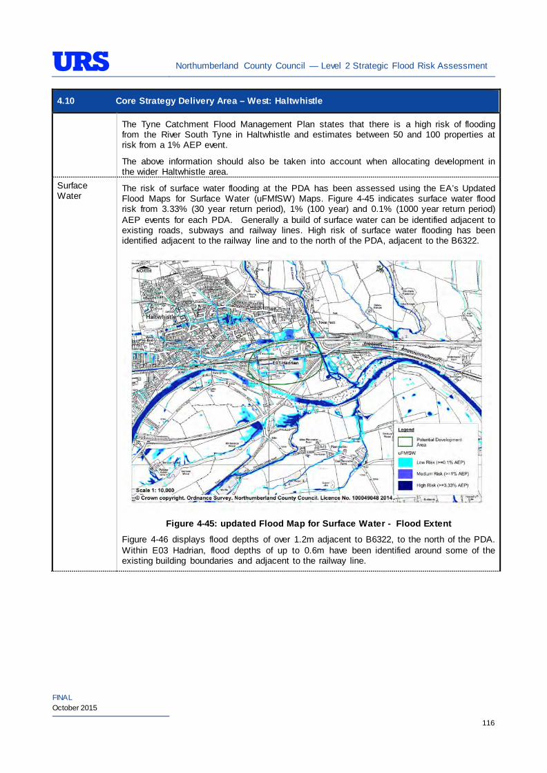
Northumberland County Council — Level 2 Strategic Flood Risk Assessment
FINAL October 2015
116
4.10 Core Strategy Delivery Area – West: Haltwhistle
The Tyne Catchment Flood Management Plan states that there is a high risk of flooding from the River South Tyne in Haltwhistle and estimates between 50 and 100 properties at risk from a 1% AEP event.
The above information should also be taken into account when allocating development in the wider Haltwhistle area.
Surface Water
The risk of surface water flooding at the PDA has been assessed using the EA’s Updated Flood Maps for Surface Water (uFMfSW) Maps. Figure 4-45 indicates surface water flood risk from 3.33% (30 year return period), 1% (100 year) and 0.1% (1000 year return period) AEP events for each PDA. Generally a build of surface water can be identified adjacent to existing roads, subways and railway lines. High risk of surface water flooding has been identified adjacent to the railway line and to the north of the PDA, adjacent to the B6322.
Figure 4-45: updated Flood Map for Surface Water - Flood Extent
Figure 4-46 displays flood depths of over 1.2m adjacent to B6322, to the north of the PDA. Within E03 Hadrian, flood depths of up to 0.6m have been identified around some of the existing building boundaries and adjacent to the railway line.
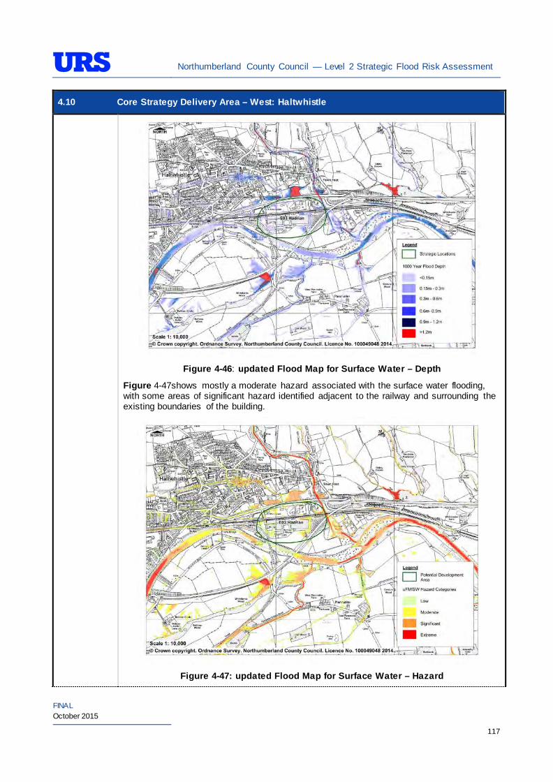
Northumberland County Council — Level 2 Strategic Flood Risk Assessment
FINAL October 2015
117
4.10 Core Strategy Delivery Area – West: Haltwhistle
Figure 4-46: updated Flood Map for Surface Water – Depth
Figure 4-47shows mostly a moderate hazard associated with the surface water flooding, with some areas of significant hazard identified adjacent to the railway and surrounding the existing boundaries of the building.
Figure 4-47: updated Flood Map for Surface Water – Hazard

Northumberland County Council — Level 2 Strategic Flood Risk Assessment
FINAL October 2015
118
4.10 Core Strategy Delivery Area – West: Haltwhistle The Tynedale District Council and Northumberland National Park Strategic Flood Risk Assessment states that, up to 2007, there have been 11 historically recorded incidents of flooding in the Haltwhistle area that fall outside of Flood Zone 2 and 3 and are therefore probably related to surface water flooding.
The ‘Site-specific FRA Guidance’ section of the SFRA provides recommendations relating to management of surface water within individual sites.
Groundwater The British Geological Survey (BGS) Areas Susceptible to Groundwater Flooding Maps indicates that the area is at high risk of groundwater flooding.
The Environment Agency’s groundwater vulnerability maps have been presented in a thematic map to highlight areas that overlie aquifers with a high vulnerability. Major Aquifers with a high vulnerability tend to have a more permeable surface geology. Groundwater vulnerability relates to the potential for contamination to groundwater and thus is a useful tool to determine the potential suitability of Sustainable Drainage Systems (SuDS) techniques.
The EA’s GWV maps indicate the following general groundwater conditions at the PDA:
PDA Underlying Aquifer Vulnerability E03 Hadrian Minor Aquifer
High Vulnerability
The EA’s Source Protection Zone (SPZ) maps indicate that the PDA is not located within a SPZ.
Environment Agency AStGFW states that the PDA is at high susceptibility of groundwater flooding (over 75%).
Sewers The risk of hydraulic sewer flooding in the area has been assessed using the NWL DG5 data. As detailed in Section 3.7 of the SFRA, the NWL DG5 data indicates risk of hydraulic sewer flooding in NWL drainage areas based on 100 square metre grid square data.
Review of the NWL DG5 100 square metre grid square data indicates 2 grid squares in the drainage area. The Core Strategy Delivery Area PDA in Haltwhistle is located within the NWL Haltwhistle (03-D14) drainage area catchment.
Future developments should take measures as far as is practicable to reduce the flood risk arising from the development to the site itself and downstream properties. A site-specific FRA should identify the drainage strategy to mitigate sewer flooding risk.
Artificial Sources
There are no canals, reservoirs or other artificial water sources that may provide a flood risk in the vicinity of Haltwhistle – as such there is not considered to be a significant risk to the PDA.
Flood Defence Infrastructure
The Environment Agency Asset Information Management System (AIMS) now supersedes NFCDD, although the NFCDD data provides more detailed information of defences in the area. Both the AIMS and NFCDD data have been included within this SFRA for completeness. It is advised that the developer consults with the Environment Agency to obtain the most up to date information relating to flood defence infrastructure.
Information obtained from AIMS shows fluvial flood defences exists along the River South Tyne and
Northumberland County Council — Level 2 Strategic Flood Risk Assessment
FINAL October 2015
119
4.10 Core Strategy Delivery Area – West: Haltwhistle Haltwhistle Burn. The PDA is defended against fluvial flooding by a combination of embankment, flood defence wall and natural high ground.
The Tynedale District Council and Northumberland National Park Strategic Flood Risk Assessment states that the defences have a SOP up to a 1% AEP fluvial flood event.
Residual Flood Risks
It is recommended that development allocation process across the PDAs follow the principles of the NPPF sequential approach. As the PDAs are located in low-lying fluvial areas with a higher vulnerability to flood from defence breach and overtopping, it is also recommended that detailed assessments are undertaken as a part of site-specific FRA to establish the standard of protection provided by the defences and identify necessary mitigation measures to be undertaken.
Climate Change
During the Level 1 SFRA, where modelled Flood Zone 3 plus climate change outlines were available these were used for mapping. For those areas where detailed Flood Zone 3 plus climate change outlines were not available, the Flood Zone 2 outline was used as a proxy until more detailed information becomes available (i.e. an EA hydraulic modelling study or hydraulic modelling study undertaken for a site-specific FRA). It should be noted that the 200 year tidal flood plus climate change may cover an area greater that Flood Zone 2 shows. Therefore some areas of Flood Zone 1 which may be close enough to the coast, or low enough, may be affected by climate change and therefore potentially at risk. This can apply to fluvial flooding too.
For the Haltwhistle area, as modelled outlines were unavailable, Flood Zone 2 was used as a proxy to map the potential outline of Flood Zone 3 plus climate change. Therefore, it is recommended that as a part of site-specific FRAs detailed modelling is undertaken to confirm the extent of the Flood Zone 3 plus climate change, should any development be proposed within the area covered by the proxy outline.
During the Level 1 SFRA, it was determined that there are no modelled outlines of Flood Zone 2 plus climate change for the whole of Northumberland. The Flood Zone 2 plus climate change flood event would be greater than the existing Flood Zone 2 outlines. As there are limitations on data, and extensive uncertainties, in deriving the floodplain for such an extreme event, it is not practical to use a proxy dataset or make assumptions to produce the Flood Zone 2 plus climate change outline. It is therefore recommended that as part of any future detailed site-specific FRAs the extent of Flood Zone 2 plus climate change is determined, should this be critical to the layout of the development. Consultation with the EA should be undertaken to determine a suitable methodology for undertaking this assessment (i.e. detailed modelling, or applying an agreed buffer to Flood Zone 2).
SuDS Applicability
The SuDS map produced as part of Level 1 SFRA indicated that attenuation systems are applicable for this area. However, further site investigations are necessary to confirm the local ground conditions and determine the appropriate SuDS technique as part of any future site specific FRA.
Prospective developers should work closely with the EA, LPA and LLFA to manage surface water run-off as near to its source as possible. For the PDA described above, given the ground conditions attenuation SuDS are likely to be an appropriate technique to manage surface water.
The developer should investigate the use of source control attenuation systems such as green roof, rainwater harvesting systems and site control attenuation systems such as swales, ponds and detention basins as appropriate. It should be noted that a wide range of attenuation SuDS techniques are available which can be adopted depending upon the available space to manage surface water. A site-specific FRA should assess the most suitable SuDS system to manage surface water for the development based on the guidance and advice provided within the Level 2 SFRA and the NPPF.
Northumberland County Council — Level 2 Strategic Flood Risk Assessment
FINAL October 2015
120
4.10 Core Strategy Delivery Area – West: Haltwhistle Recommendations
• If development pressures create a need to develop within areas that are at risk of flooding (i.e., Flood Zone 2 and Flood Zone 3), they should incorporate appropriate mitigation measures which must not increase the risk of flooding to surrounding areas. Detailed liaison with the Environment Agency will be necessary during the design and planning process and it cannot be assumed that the Environment Agency will not object to development in these areas; and
• Self-contained basements will not be permitted within Flood Zone 3. Basements may be accepted if free access is available to floors above the 1% AEP flood level. If basements are included as part of a scheme then they should adhere to British Standard 8102.
Policies
• Where applicable roll back development from the River South Tyne outside of Flood Zone 3a to create ‘blue corridors’ which provide public open space and recreation areas near the River South Tyne to enhance green infrastructure. Development should not encroach within 5m of the South Tyne or Haltwhistle Burn, which is the Environment Agency by-law distance for Main Rivers. This would be beneficial both in terms of flood risk and maintenance access;
• Mixed use (mixed vulnerability) development should follow the principles of the NPPF sequential approach across the wider area. For example, proposed residential development should be steered to the lower risk areas, with the remaining ‘less vulnerable’ land uses being located on the (relatively) higher risk areas. This approach can also be applied within buildings, for example commercial development located at ground floor level and residential development above ground floor level in flood risk areas. However, access and egress must still be made available for the residential uses;
• Surface water/pluvial flood risk should also inform the site layout, such that ‘highly vulnerable’ development is avoided in locations that are shown at the greatest risk of pluvial flooding; and
• As the PDAs comprise of a mixture of greenfield and brownfield land, future developments within the PDAs potentially can increase surface water runoff. SuDS should be considered at all stages of the planning and design of new developments to reduce runoff rates and volumes from the developed sites, thus reducing the resultant flood risk posed to the sites and adjacent/downstream areas. Development should, where reasonably possible, aim to reduce surface water runoff to less than greenfield run off. If this is not possible then greenfield runoff rates should be achieved by the proposed mitigation measures.
Site-Specific FRA Guidance
• A site-specific FRA will be required for any development proposed within the Haltwhistle area that falls entirely or partly within Flood Zone 2 and Flood Zone 3. For PDAs that do fall within Flood Zone 1, an FRA will be required for any development in excess of 1 ha. The FRA will need to consider surface water management;
• Maximum fluvial flood levels at the sites should be informed by the most up-to-date versions of the EA’s hydraulic models of the Haltwhistle Burn and South Tyne, or any future fluvial studies. If no models are available then the Lead Local Flood Authority may require a model as part of a planning application;
• If development within areas designated as Flood Zone 3 including an allowance for climate change is justifiable, appropriate mitigation and resilience measures should be incorporated both on an individual property-level (such as flood resilient construction) and at a strategic level (such as strategic SuDS);
• The FRA should demonstrate that consideration has been given to the site layout with regards to flood risk from all sources, in line with the recommendations above (sequential approach to site layout);
• The rates and volumes of post-development surface water runoff should be controlled using suitable
Northumberland County Council — Level 2 Strategic Flood Risk Assessment
FINAL October 2015
121
4.10 Core Strategy Delivery Area – West: Haltwhistle and adequate SuDS techniques. Where possible, the developer should retrofit drainage solutions to the site with wider benefits to other local areas at risk;
• The suitability of infiltration SuDS should be informed by site-specific ground investigation (GI) works;
• The residual risks identified above should be adequately investigated and assessed as part of the FRA and mitigation measures implemented accordingly. In such situations, the developer is generally required to provide resources and funds to undertake more complex modelling/assessments to determine the residual risk on the development arising from events that overtop or breach the defences. In addition, the developer is generally responsible for funding any flood risk management works, including defences and mitigation works;
• A site-specific FRA should consider provision of site access and egress, taking into account any emergency planning requirements of NCC and the Environment Agency. This is a particularly pertinent issue for areas, where access roads are at risk of flooding;
• Any sites which contain or are adjacent to Main Rivers must be designed so as to allow access to the channel for maintenance purposes. This maintenance liability lies with the landowner in the first instance however the Environment Agency have powers to undertake work where deemed necessary. Whether these sites are subject to routine EA maintenance, or not, there must be an access route available; and
• Developments should aim to mimic existing drainage regimes as closely as possible, and reduce discharge off site where possible. Development on brownfield land should aim to reduce the runoff by 50% or greenfield runoff rates if the land was previously undeveloped.
• The EA will be publishing new climate change guidance in autumn 2015. The most recent climate change guidance should be used to inform site specific FRA’s.
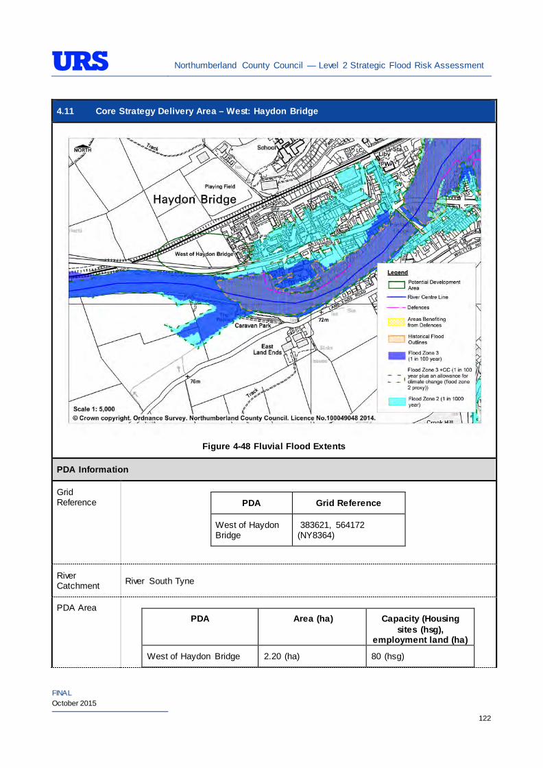
Northumberland County Council — Level 2 Strategic Flood Risk Assessment
FINAL October 2015
122
4.11 Core Strategy Delivery Area – West: Haydon Bridge
Figure 4-48 Fluvial Flood Extents
PDA Information
Grid Reference
PDA Grid Reference
West of Haydon Bridge
383621, 564172 (NY8364)
River Catchment River South Tyne
PDA Area
PDA Area (ha) Capacity (Housing sites (hsg),
employment land (ha)
West of Haydon Bridge 2.20 (ha) 80 (hsg)
Northumberland County Council — Level 2 Strategic Flood Risk Assessment
FINAL October 2015
123
4.11 Core Strategy Delivery Area – West: Haydon Bridge
Existing Use and Topography
West of Haydon Bridge
The West of Haydon Bridge PDA is located on the north bank of the River South Tyne. Western and southern boundaries of the PDA are formed by Ratcliffe Road, directly beyond which is the River South Tyne. Northern and eastern boundaries are respectively formed by railway line and residential properties. The PDA is predominately occupied by open grassland, and is therefore considered greenfield.
The PDA topography generally falls towards the River South Tyne from around 68m AOD to around 66m AOD.
Proposed Use and Vulnerability Classification
The table below summarise the proposed uses of the PDAs, provided by NCC (July 2014).
PDA Proposed Use Status West of Haydon Bridge Residential Preferred area
The table below illustrates a matrix of ‘Vulnerability Classification’ based on Table 2 in the National Planning Policy Framework (NPPF) against ‘Flood Zone Compatibility’.
Proposed use NPPF Vulnerability Classification
Flood Zone 1
Flood Zone 2
Flood Zone 3a
Flood Zone 3b
Residential More vulnerable Exception Test
required
Key
- Acceptable
- Not Acceptable
*Based on Planning Practice Guidance (PPG) Table 2: Flood Risk Vulnerability Classif ication.
Should further definition of the proposed uses be made at a later date, then identification of their individual vulnerability classifications should be re-visited.
Sources of Flood Risk
Rivers The River South Tyne presents the main fluvial flood risk to majority of the PDA.
The Environment Agency’s (EA’s) Flood Maps (Figure 4-48) show the extent of Flood Zones associated with the river.
The EA’s Flood Maps indicate that the western area of the PDA is in Flood Zone 1. The Flood Maps also indicate that a significant area in the east of the PDA and the main access route are within Flood Zone 2. The PDA is therefore considered to be at risk of significant flooding.
Surface Water The risk of surface water flooding at the PDA has been assessed using the EA’s updated Flood Maps for Surface Water (uFMfSW) Maps. Figure 4-49 indicates surface water flood risk from 3.33% (30 year return period), 1% (100 year) and 0.1% (1000 year return period) AEP events for the PDA.
The EA’s uFMfSW (Figure 4-49, Figure 4-50 and Figure 4-51) indicates that there is no risk of surface water flooding in the PDA except for a low risk along the railwayline.
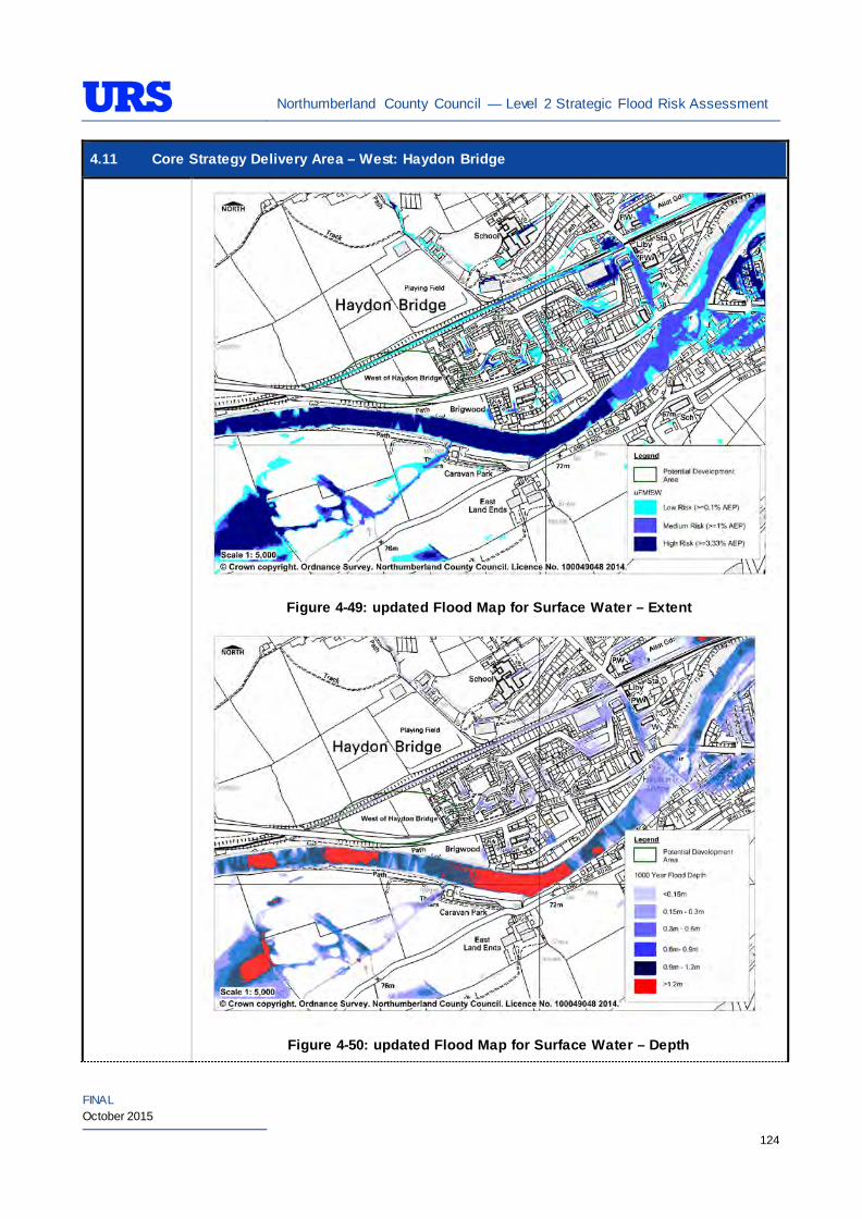
Northumberland County Council — Level 2 Strategic Flood Risk Assessment
FINAL October 2015
124
4.11 Core Strategy Delivery Area – West: Haydon Bridge
Figure 4-49: updated Flood Map for Surface Water – Extent
Figure 4-50: updated Flood Map for Surface Water – Depth
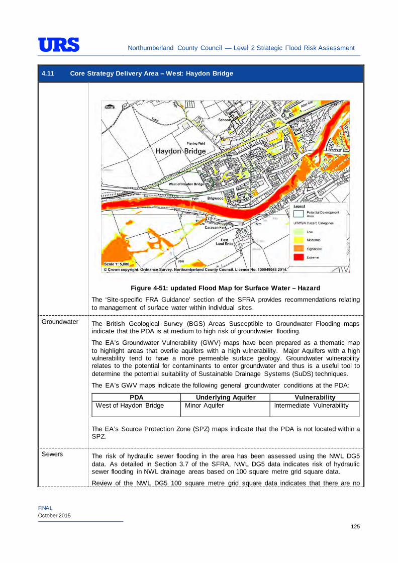
Northumberland County Council — Level 2 Strategic Flood Risk Assessment
FINAL October 2015
125
4.11 Core Strategy Delivery Area – West: Haydon Bridge
Figure 4-51: updated Flood Map for Surface Water – Hazard
The ‘Site-specific FRA Guidance’ section of the SFRA provides recommendations relating to management of surface water within individual sites.
Groundwater The British Geological Survey (BGS) Areas Susceptible to Groundwater Flooding maps indicate that the PDA is at medium to high risk of groundwater flooding.
The EA’s Groundwater Vulnerability (GWV) maps have been prepared as a thematic map to highlight areas that overlie aquifers with a high vulnerability. Major Aquifers with a high vulnerability tend to have a more permeable surface geology. Groundwater vulnerability relates to the potential for contaminants to enter groundwater and thus is a useful tool to determine the potential suitability of Sustainable Drainage Systems (SuDS) techniques.
The EA’s GWV maps indicate the following general groundwater conditions at the PDA:
PDA Underlying Aquifer Vulnerability West of Haydon Bridge Minor Aquifer
Intermediate Vulnerability
The EA’s Source Protection Zone (SPZ) maps indicate that the PDA is not located within a SPZ.
Sewers The risk of hydraulic sewer flooding in the area has been assessed using the NWL DG5 data. As detailed in Section 3.7 of the SFRA, NWL DG5 data indicates risk of hydraulic sewer flooding in NWL drainage areas based on 100 square metre grid square data.
Review of the NWL DG5 100 square metre grid square data indicates that there are no
Northumberland County Council — Level 2 Strategic Flood Risk Assessment
FINAL October 2015
126
4.11 Core Strategy Delivery Area – West: Haydon Bridge grid squares in the vicinity of the PDA.
Future developments should take measures as far as is practicable to reduce the flood risk arising from the development to the site itself and downstream properties. A site-specific FRA should identify the drainage strategy to mitigate sewer flooding risk.
Artificial Sources
There are no canals, reservoirs or other artificial water sources that may provide a flood risk in the vicinity of Haydon Bridge– as such there is not considered to be a significant risk to the PDA.
Flood Defence Infrastructure
The Environment Agency Asset Information Management System (AIMS) now supersedes NFCDD, although the NFCDD data provides more detailed information of defences in the area. Both the AIMS and NFCDD data have been included, where applicable, within this SFRA for completeness. It is advised that the developer consults with the Environment Agency to obtain the most up to date information relating to flood defence infrastructure.
Information obtained from AIMS identifies a number of fluvial flood defences along the River South Tyne in Haydon Bridge.
Directly south of the PDA, the ground along the north bank of the River South Tyne are naturally higher. However, the NCDD indicates that the Standard of Protection afforded is up to 2% AEP, which is not adequate to provide protection to the PDA.
Residual Flood Risks
As a part of the EA’s Strategic Flood Risk Mapping work a depth velocity study has been completed for Haydon Bridgexv iii. The study has modelled 1% AEP event for the reach of the river where the PDA is located. The modelling work has taken the adjacent flood defences into account and has produced maps for 1 hour intervals up to 34 hours for depth, velocity and hazard scenarios.
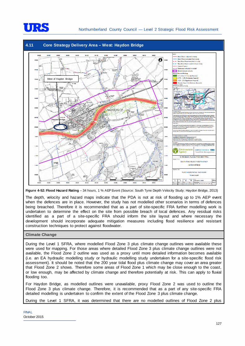
Northumberland County Council — Level 2 Strategic Flood Risk Assessment
FINAL October 2015
127
4.11 Core Strategy Delivery Area – West: Haydon Bridge
Figure 4-52: Flood Hazard Rating – 34 hours, 1 % AEP Event (Source: South Tyne Depth Velocity Study: Haydon Bridge, 2013)
The depth, velocity and hazard maps indicate that the PDA is not at risk of flooding up to 1% AEP event when the defences are in place. However, the study has not modelled other scenarios in terms of defences being breached. Therefore it is recommended that as a part of site-specific FRA further modelling work is undertaken to determine the effect on the site from possible breach of local defences. Any residual risks identified as a part of a site-specific FRA should inform the site layout and where necessary the development should incorporate adequate mitigation measures including flood resilience and resistant construction techniques to protect against floodwater.
Climate Change
During the Level 1 SFRA, where modelled Flood Zone 3 plus climate change outlines were available these were used for mapping. For those areas where detailed Flood Zone 3 plus climate change outlines were not available, the Flood Zone 2 outline was used as a proxy until more detailed information becomes available (i.e. an EA hydraulic modelling study or hydraulic modelling study undertaken for a site-specific flood risk assessment). It should be noted that the 200 year tidal flood plus climate change may cover an area greater that Flood Zone 2 shows. Therefore some areas of Flood Zone 1 which may be close enough to the coast, or low enough, may be affected by climate change and therefore potentially at risk. This can apply to fluvial flooding too.
For Haydon Bridge, as modelled outlines were unavailable, proxy Flood Zone 2 was used to outline the Flood Zone 3 plus climate change. Therefore, it is recommended that as a part of any site-specific FRA detailed modelling is undertaken to confirm the extent of the Flood Zone 3 plus climate change.
During the Level 1 SFRA, it was determined that there are no modelled outlines of Flood Zone 2 plus
West of Haydon Bridge
Northumberland County Council — Level 2 Strategic Flood Risk Assessment
FINAL October 2015
128
4.11 Core Strategy Delivery Area – West: Haydon Bridge climate change for the whole of Northumberland. The Flood Zone 2 plus climate change flood event would be greater than the existing Flood Zone 2 outlines. As there are limitations on data, and extensive uncertainties, in deriving the floodplain for such an extreme event, it is not practical to use a proxy dataset or make assumptions to produce the Flood Zone 2 plus climate change outline. It is therefore recommended that a detailed Site-Specific FRA that examines the location and extent of the Flood Zone 2 plus climate change support any proposed development adjacent to the existing Flood Zone 2.
SuDS Applicability
The SuDS map produced as part of Level 1 SFRA indicated that attenuation systems are applicable for this area. However, further site investigations are necessary to confirm the local ground conditions and determine the appropriate SuDS technique as part of any future site specific FRA.
Prospective developers should work closely with the EA, LPA and LLFA to manage surface water run-off as near to its source as possible. For the West of Haydon Bridge PDA, given the ground conditions attenuation SuDS are likely to be an appropriate technique to manage surface water at individual site level. The developer should investigate the use of source control attenuation systems such as green roof, rainwater harvesting systems and site control attenuation systems such as swales, ponds and detention basins as appropriate. It should be noted that a wide range of attenuation SuDS techniques are available which can be adopted depending upon the available space to manage surface water. A site-specific FRA should assess the most suitable SuDS system to manage surface water for the development based on the guidance and advice provided within the Level 2 SFRA and the NPPF.
Recommendations
• If development pressures create a need to develop within areas that are at risk of flooding (i.e., Flood Zone 2 and Flood Zone 3), they should incorporate appropriate mitigation measures which must not increase the risk of flooding to surrounding areas. Careful liaison with the Environment Agency will be necessary during the design and planning process and it cannot be assumed that the EA will not object to development in these areas; and
• Self-contained basements will not be permitted within Flood Zone 3. Basements may be accepted if free access is available to floors above the 1% AEP flood level. If basements are included as part of a scheme then they should adhere to British Standard 8102.
Policies
• Where applicable roll back development from the River South Tyne (valley) to outside Flood Zone 3a to create ‘blue corridors’ which provide public open space and recreation areas near watercourses and enhance green infrastructure. Development should not encroach within 5m of the River South Tyne, which is the EA by-law distance for Main Rivers. This would be beneficial both in terms of flood risk and maintenance access;
• Mixed-use (mixed vulnerability) development that follows the principles of the NPPF sequential approach should be applied within the area. For example, the proposed residential building uses should firstly be situated in Flood Zone 1. The remaining ‘less vulnerable’ uses should be located within Flood Zone 1, then Flood Zone 2 and only when justifiable, Flood Zone 3. This approach can also be applied within buildings, for example, commercial development located at ground floor level and residential development above ground floor level in flood risk areas. However, access and egress must still be made available for residential uses;
• Surface water flood risk should also inform the site layout, such that ‘highly vulnerable’ development is avoided in locations that are shown at the greatest risk of pluvial flooding; and
• As the PDA primarily greenfield, development has the potential to significantly increase surface water
Northumberland County Council — Level 2 Strategic Flood Risk Assessment
FINAL October 2015
129
4.11 Core Strategy Delivery Area – West: Haydon Bridge runoff. SuDS should be considered at all stages of the planning and design of new developments to reduce runoff rates and volumes from the developed PDA, thus reducing the resultant flood risk posed to the PDA and adjacent/downstream areas. Development should, where reasonably possible, aim to reduce surface water runoff to less than greenfield run off. If this is not possible then greenfield runoff rates should be achieved by the proposed mitigation measures.
Site-Specific FRA Guidance
• A site-specific FRA will be required for any development proposed within the area that falls entirely or partly within Flood Zone 2 and/or Flood Zone 3. For areas that fall within Flood Zone 1, a site-specific FRA will be required for any development in excess of 1 ha. The FRA will need to consider surface water management;
• Maximum fluvial flood levels at the area should be informed by the most up-to-date versions of the Environment Agency’s hydraulic models of the River South Tyne;
• If development within areas designated as Flood Zone 3 including an allowance for climate change is justifiable, appropriate mitigation and resilience measures should be incorporated both on an individual property-level (such as flood resilient construction) and at a strategic level (such as strategic SuDS);
• The FRA should demonstrate that consideration has been given to the site layout with regards to flood risk from all sources, in line with the recommendations above (sequential approach to site layout);
• The rates and volumes of post-development surface water runoff should be controlled using suitable and adequate SuDS techniques. Where possible, the developers should retrofit drainage solutions to the site with wider benefits to other local areas at risk;
• The suitability of infiltration SuDS should be informed by site-specific ground investigation (GI) works;
• The residual risks identified above should be adequately investigated and assessed as part of the FRA and mitigation measures implemented accordingly;
• A site-specific FRA should consider provision of site access and egress, taking into account any emergency planning requirements of NCC and the Environment Agency. This is a particularly pertinent issue for those areas in the valley, where access roads are at risk of flooding;
• Any sites which contain or are adjacent to Main Rivers must be designed so as to allow access to the channel for maintenance purposes. This maintenance liability lies with the landowner in the first instance however the Environment Agency have powers to undertake work where deemed necessary. Whether these sites are subject to routine EA maintenance, or not, there must be an access route available; and
• Developments should aim to mimic existing drainage regimes as closely as possible, and reduce discharge off site where possible. Development on brownfield land should aim to reduce the runoff by 50% or greenfield rates on previously undeveloped sites.
• The EA will be publishing new climate change guidance in autumn 2015. The most recent climate change guidance should be used to inform site specific FRA’s.
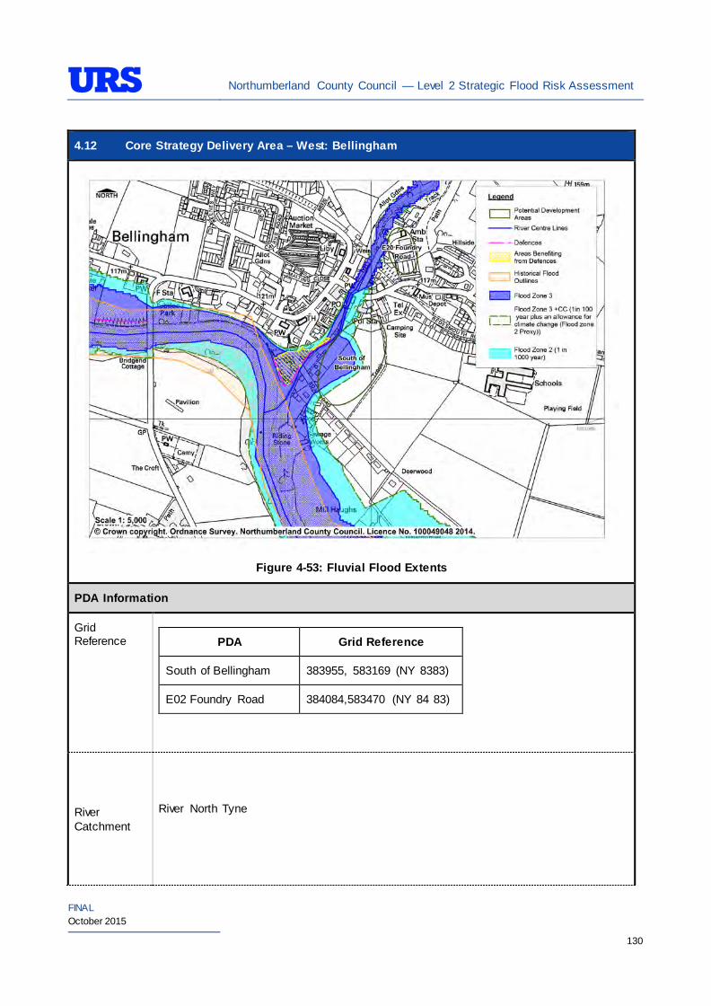
Northumberland County Council — Level 2 Strategic Flood Risk Assessment
FINAL October 2015
130
4.12 Core Strategy Delivery Area – West: Bellingham
Figure 4-53: Fluvial Flood Extents
PDA Information
Grid Reference
PDA Grid Reference
South of Bellingham 383955, 583169 (NY 8383)
E02 Foundry Road 384084,583470 (NY 84 83)
River Catchment
River North Tyne
Northumberland County Council — Level 2 Strategic Flood Risk Assessment
FINAL October 2015
131
4.12 Core Strategy Delivery Area – West: Bellingham
PDA Area
PDA Area (ha) Capacity (Housing sites (hsg),
employment land (ha)
South of Bellingham 2.9 ha 65 hsg
E02 Foundry Road 0.223 ha 0.223 ha
Existing Use and Topography
South of Bellingham
South of Bellingham PDA is located immediately east to the confluence of the River North Tyne and Hareshaw Burn. Agricultural land forms the northern and eastern boundaries of the PDA. Western boundary of the PDA is formed by Hareshaw Burn whilst the southern boundary of the PDA is formed by Boat Road, and the River North Tyne is immediately south of Boat Road. The PDA is currently occupied as a caravan park and is therefore considered greenfield.
The PDA topography generally falls towards Hareshaw Burn from around 119m AOD to around 116m AOD.
E02 Foundry Road
E02 Foundry Road PDA is located on the east bank of Hareshaw Burn. Eastern and southern boundaries of the PDA are formed by residential developments. Northern boundary of the PDA is formed by a caravan park whilst the western boundary of the PDA is formed by Hareshaw Burn. The PDA is part of the existing employment allocation in the area. The PDA contains a number of commercial properties and is therefore considered brownfield.
The PDA topography generally falls towards Hareshaw Burn from around 114m AOD to around 110m AOD.
Proposed Use and Vulnerability Classification
The table below summarises the proposed uses of the PDAs, provided by NCC (July 2014).
PDA Proposed Use Status
South of Bellingham Residential Alternative area
E02 Foundry Road Employment Completion of available employment land
The table below illustrates a matrix of ‘Vulnerability Classification’ based on Table 2 in the National Planning Policy Framework (NPPF) against ‘Flood Zone Compatibility’.
Proposed use NPPF Vulnerability Classification
Flood Zone 1
Flood Zone 2
Flood Zone 3a
Flood Zone 3b
Residential More vulnerable
Exception Test
required
Employment/Mixed use (e.g hospitals, residential care homes, social services
More vulnerable*
Exception Test
required
Northumberland County Council — Level 2 Strategic Flood Risk Assessment
FINAL October 2015
132
4.12 Core Strategy Delivery Area – West: Bellingham homes, prisons, hostels, dwelling houses and student halls of residence)
Employment/Mixed use (e.g shops, restaurants, offices, general industry, storage and distribution)
Less vulnerable*
Key
- Acceptable
- Not Acceptable
*Based on Planning Practice Guidance (PPG) Table 2: Flood Risk Vulnerability Classif ication.
Should further definition of the proposed uses be made at a later date, then identification of their individual vulnerability classifications should be re-visited.
Sources of Flood Risk
Rivers The River North Tyne and Hareshaw Burn presents the main fluvial flood risk to the PDAs in Bellingham. South of Bellingham
The Environment Agency’s (EA’s) Flood Maps indicate that the Hareshaw Burn which is a tributary of the River North Tyne poses flood risk to the PDA. Approximately 40% of the land along the western boundary of PDA is indicated to be in Flood Zone 2 and Flood Zone 3. The remaining land within the PDA is indicated to be in Flood Zone 1. The PDA is located immediately north of the confluence between the River North Tyne and the Hareshaw Burn, therefore the risk of flooding at the PDA is considered to be significant.
The western area of the PDA in Flood Zone 2 and Flood Zone 3 is indicated to be within the EA’s ‘River North Tyne at Bellingham’ Flood Warning Area. E20 Foundry Road The EA’s Flood Maps indicate that the entire PDA is located within Flood Zone 1. However, the Flood Maps indicate that a section of the western boundary of the PDA is located immediately adjacent to the Flood Zones.
Surface Water
The risk of surface water flooding at the PDA has been assessed using the EA’s Updated Flood Maps for Surface Water (uFMfSW) Maps. The map below indicates surface water flood risk from 3.33% (30 year return period), 1% (100 year) and 0.1% (1000 year return period) AEP events for the PDA.
Figure 4-54, Figure 4-55 and Figure 4-56 indicates that there is a low risk of surface water flooding in both PDAs. However, the area immediately south of the E02 Foundry Road PDA is indicated to be at high risk of surface water flooding.

Northumberland County Council — Level 2 Strategic Flood Risk Assessment
FINAL October 2015
133
4.12 Core Strategy Delivery Area – West: Bellingham
Figure 4-54: updated Flood Map for Surface Water – Extent
Figure 4-55: updated Flood Map for Surface Water – Depth
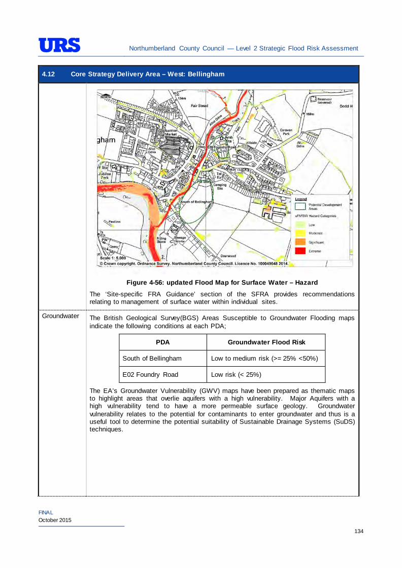
Northumberland County Council — Level 2 Strategic Flood Risk Assessment
FINAL October 2015
134
4.12 Core Strategy Delivery Area – West: Bellingham
Figure 4-56: updated Flood Map for Surface Water – Hazard
The ‘Site-specific FRA Guidance’ section of the SFRA provides recommendations relating to management of surface water within individual sites.
Groundwater The British Geological Survey(BGS) Areas Susceptible to Groundwater Flooding maps indicate the following conditions at each PDA;
PDA Groundwater Flood Risk
South of Bellingham Low to medium risk (>= 25% <50%)
E02 Foundry Road Low risk (< 25%)
The EA’s Groundwater Vulnerability (GWV) maps have been prepared as thematic maps to highlight areas that overlie aquifers with a high vulnerability. Major Aquifers with a high vulnerability tend to have a more permeable surface geology. Groundwater vulnerability relates to the potential for contaminants to enter groundwater and thus is a useful tool to determine the potential suitability of Sustainable Drainage Systems (SuDS) techniques.
Northumberland County Council — Level 2 Strategic Flood Risk Assessment
FINAL October 2015
135
4.12 Core Strategy Delivery Area – West: Bellingham
The EA’s GWV maps indicate the following general groundwater conditions at each PDA:
PDA Underlying Aquifer Vulnerability
South of Bellingham Minor Aquifer High Vulnerability
E02 Foundry Road Minor Aquifer Low Vulnerability
The EA’s Source Protection Zone (SPZ) maps indicate that the PDAs are not located within a SPZ.
Sewers The risk of hydraulic sewer flooding in the area has been assessed using the NWL DG5 data. As detailed in Section 3.7 of the SFRA, the NWL DG5 data indicates risk of hydraulic sewer flooding in NWL drainage areas based on 100 square metre grid square data.
Review of the NWL DG5 100 square metre grid square data indicates that an incident has been reported to the east of the PDAs. The PDAs are located within the NWL Bellingham (03-D35) drainage area catchment.
Future developments should take measures as far as is practicable to reduce the flood risk arising from the development to the PDA itself and downstream properties. A site-specific FRA should identify the drainage strategy to mitigate sewer flooding risk.
Artificial Sources
Kielder Water reservoir is located approximately 20 km north west of Bellingham. The Environment Agency’s reservoir inundation maps indicate that both PDAs in Bellingham to be at risk of flooding due to breach of the reservoir. However, the probability of flooding due to breach of the reservoir is very low.
Flood Defence Infrastructure
The Environment Agency Asset Information Management System (AIMS) now supersedes NFCDD, although the NFCDD data provides more detailed information of defences in the area. Both the AIMS and NFCDD data have been included within this SFRA for completeness. It is advised that the developer consults with the Environment Agency to obtain the most up to date information relating to flood defence infrastructure.
The AIMS identifies a number of fluvial flood defences along the River North Tyne and Hareshaw Burn in Bellingham. These flood defences are in the form of embankment and flood defence wall.
The banks of these watercourses are also naturally high. According to the NCDD, the natural high ground along the east bank of the Hareshaw Burn provides defence against fluvial flooding with a Standard of Protection up to 50% AEP (1 in 2 year) at South of Bellingham PDA.
No formal defences are however found adjacent to the E20 Foundry Road PDA.
Residual Flood Risks
The South of Bellingham PDA is protected from the natural high ground along the east bank of the Hareshaw Burn up to 50% AEP. Therefore, there is a potential risk of flooding from defences being
Northumberland County Council — Level 2 Strategic Flood Risk Assessment
FINAL October 2015
136
4.12 Core Strategy Delivery Area – West: Bellingham breached and overtopped in low-laying areas of the PDA adjacent to the watercourse.
It is recommended that development allocation across the PDA follow the principles of the NPPF sequential approach. As the PDA is located in low-lying fluvial areas with a higher vulnerability to flood from defence breach and overtopping, it is also recommended that detailed assessments are undertaken as a part of site-specific FRA to establish the risk of flooding from a breach or overtopping of the flood defences and identify necessary mitigation measures to be undertaken.
Climate Change
During the Level 1 SFRA, where modelled Flood Zone 3 plus climate change outlines were available these were used for mapping. For those areas where detailed Flood Zone 3 plus climate change outlines were not available, the Flood Zone 2 outline was used as a proxy until more detailed information becomes available (i.e. an EA hydraulic modelling study or hydraulic modelling study undertaken for a site-specific flood risk assessment). It should be noted that the 200 year tidal flood plus climate change may cover an area greater that Flood Zone 2 shows. Therefore some areas of Flood Zone 1 which may be close enough to the coast, or low enough, may be affected by climate change and therefore potentially at risk. This can apply to fluvial flooding too.
For Bellingham, as modelled outlines were unavailable, proxy Flood Zone 2 was used to outline the Flood Zone 3 plus climate change. Therefore, it is recommended that as a part of any site-specific FRA detailed modelling is undertaken to confirm the extent of the Flood Zone 3 plus climate change.
During the Level 1 SFRA, it was determined that there are no modelled outlines of Flood Zone 2 plus climate change for the whole of Northumberland. The Flood Zone 2 plus climate change flood event would be greater than the existing Flood Zone 2 outlines. As there are limitations on data, and extensive uncertainties, in deriving the floodplain for such an extreme event, it is not practical to use a proxy dataset or make assumptions to produce the Flood Zone 2 plus climate change outline. It is therefore recommended that a detailed site-specific FRA that examines the location and extent of the Flood Zone 2 plus climate change support any proposed development adjacent to the existing Flood Zone 2.
SuDS Applicability
The SuDS map produced as part of Level 1 SFRA indicated that attenuation systems are applicable for this area. However, further site investigations are necessary to confirm the local ground conditions and determine the appropriate SuDS technique as part of any future site specific FRA.
Prospective developers should work closely with the EA, LPA and LLFA to manage surface water run-off as near to its source as possible. For the PDAs described above, given the ground conditions attenuation SuDS are likely to be an appropriate technique to manage surface water at individual site level. The developer should investigate the use of source control attenuation systems such as green roof, rainwater harvesting systems and site control attenuation systems such as swales, ponds and detention basins as appropriate. It should be noted that a wide range of attenuation SuDS techniques are available which can be adopted depending upon the available space to manage surface water. A site-specific FRA should assess the most suitable SuDS system to manage surface water for the development based on the guidance and advice provided within the Level 2 SFRA and the NPPF.
Recommendations
• If development pressures create a need to develop within areas that are at risk of flooding (i.e., Flood Zone 2 and Flood Zone 3), they should incorporate appropriate mitigation measures which must not increase the risk of flooding to surrounding areas. Careful liaison with the Environment Agency will be necessary during the design and planning process and it cannot be assumed that the Environment Agency will not object to development in these areas.
Northumberland County Council — Level 2 Strategic Flood Risk Assessment
FINAL October 2015
137
4.12 Core Strategy Delivery Area – West: Bellingham
Policies
• Where applicable roll back development from the River North Tyne and Hareshaw Burn watercourses to outside Flood Zone 3a to create ‘blue corridors’ which provide public open space and recreation areas near watercourses and enhance green infrastructure. Development should not encroach within 5m of the River North Tyne and Hareshaw Burn, which is the EA by-law distance for Main Rivers. This would be beneficial both in terms of flood risk and maintenance access;
• Mixed-use (mixed vulnerability) development that follows the principles of the NPPF sequential approach should be applied within the area. For example, the proposed residential building uses should firstly be situated in Flood Zone 1. The remaining ‘less vulnerable’ uses should be located within Flood Zone 1, then Flood Zone 2 and only when justifiable, Flood Zone 3. This approach can also be applied within buildings, for example, commercial development located at ground floor level and residential development above ground floor level in flood risk areas. However, access and egress must still be made available for residential uses;
• Surface water flood risk should also inform the site layout, such that ‘highly vulnerable’ development is avoided in locations that are shown at the greatest risk of pluvial flooding; and
• For those PDAs which are primarily greenfield, development has the potential to significantly increase surface water runoff. SuDS should be considered at all stages of the planning and design of new developments to reduce runoff rates and volumes from the developed PDAs, thus reducing the resultant flood risk posed to the PDAs and adjacent/downstream areas. Development should, where reasonably possible, aim to reduce surface water runoff to less than greenfield run off. If this is not possible then greenfield runoff rates should be achieved by the proposed mitigation measures.
Site-Specific FRA Guidance
• A site-specific FRA will be required for any development proposed within the area that falls entirely or partly within Flood Zone 2 and/or Flood Zone 3. For areas that fall within Flood Zone 1, a site-specific FRA will be required for any development in excess of 1 ha. The FRA will need to consider surface water management;
• Maximum fluvial flood levels at the area should be informed by the most up-to-date versions of the Environment Agency’s hydraulic models of the River North Tyne and Hareshaw Burn;
• If development within areas designated as Flood Zone 3 including an allowance for climate change is justifiable, appropriate mitigation and resilience measures should be incorporated both on an individual property-level (such as flood resilient construction) and at a strategic level (such as strategic SuDS);
• The FRA should demonstrate that consideration has been given to the site layout with regards to flood risk from all sources, in line with the recommendations above (sequential approach to site layout);
• The FRA should clearly outline the impacts of a fluvial flood and ensure that the proposed development does not cause detrimental impacts in the surrounding area;
• The FRA should consider compensatory flood plain storage here, although that may be difficult;
• The rates and volumes of post-development surface water runoff should be controlled using suitable and adequate SuDS techniques. Where possible, the developers should retrofit drainage solutions to the site with wider benefits to other local areas at risk;
• The suitability of infiltration SuDS should be informed by site-specific ground investigation (GI)
Northumberland County Council — Level 2 Strategic Flood Risk Assessment
FINAL October 2015
138
4.12 Core Strategy Delivery Area – West: Bellingham works;
• The residual risks identified above should be adequately investigated and assessed as part of the FRA and mitigation measures implemented accordingly;
• A site-specific FRA should consider provision of site access and egress, taking into account any emergency planning requirements of NCC and the Environment Agency. This is a particularly pertinent issue for those areas in the valley, where access roads are at risk of flooding;
• Any sites which contain or are adjacent to Main Rivers must be designed so as to allow access to the channel for maintenance purposes. This maintenance liability lies with the landowner in the first instance however the Environment Agency have powers to undertake work where deemed necessary. Whether these sites are subject to routine EA maintenance, or not, there must be an access route available; and
• Developments should aim to mimic existing drainage regimes as closely as possible, and reduce discharge off site where possible. Development on brownfield land should aim to reduce the runoff by 50% or greenfield rates for previously undeveloped land.
• The EA will be publishing new climate change guidance in autumn 2015. The most recent climate change guidance should be used to inform site specific FRA’s.
Northumberland County Council — Level 2 Strategic Flood Risk Assessment
FINAL October 2015
139
5 SITE-SPECIFIC FLOOD RISK ASSESSMENTS
5.1 Overview
This SFRA does not remove the responsibility of the developer of each site to consider Flood Risk in a detailed Flood Risk Assessment (using this SFRA as a guide). In accordance with the PPG:
“A site-specific flood risk assessment is carried out by (or on behalf of) a developer to assess the flood risk to and from a development site. Where necessary (see footnote 20 in the National Planning Policy Framework), the assessment should accompany a planning application submitted to the local planning authority. The assessment should demonstrate to the decision-maker how flood risk will be managed now and over the development’s lifetime, tak ing climate change into account, and with regard to the vulnerability of its users (see Table 2 – Flood Risk Vulnerability).
The objectives of a site-specific flood risk assessment are to establish:
• whether a proposed development is likely to be affected by current or future flooding from any source;
• whether it will increase flood risk elsewhere;
• whether the measures proposed to deal with these effects and risks are appropriate;
• the evidence for the local planning authority to apply (if necessary) the Sequential Test; and
• whether the development will be safe and pass the Exception Test, if applicable”.
Regardless of the presence of the SFRA for Northumberland, all developments may need to be subject to a FRA even if it is to use Flood Risk Standing Advice and complete the appropriate checklist , in accordance with footnote 20 in the NPPF. These will be reviewed either by NCC and also the EA depending upon the scale and nature of the proposed development (see policies and recommendations in Section 4).
On the 18th December Department for Communities and Local Government (DCLG) published a further consultation with proposals to make LLFAs statutory consultees for all major planning applications with surface water drainage implications in all flood zones. The same consultation proposes removing the Environment Agency’s statutory role for development on sites greater than 1 ha. Government implemented these changes on 6th April 2015.
5.2 Detailed/Site-Specific Flood Risk Assessment
Where the quality and/or quantity of information for any of the flood sources affecting a site is insufficient to enable a robust assessment of the flood risks, and/or where the vulnerability of the proposed development is high further investigation will be required. For example, it is generally considered inappropriate to base an FRA for a residential care home at risk of flooding from fluvial sources on Flood Zone maps alone. In such cases, the results of detailed hydraulic modelling are preferable to ensure details of flooding mechanisms and the onset of flooding is fully understood and that the proposed development incorporates appropriate mitigation measures.
Developers should also identify the residual risk as part of a site-specific FRA. Such assessment should be appropriate to the scale and nature of the proposed development and flood risk. Should the potential impact be unacceptable, mitigation should be provided.
Northumberland County Council — Level 2 Strategic Flood Risk Assessment
FINAL October 2015
140
At all stages, NCC and where necessary the EA and NWL should be consulted to ensure the site-specific FRA provides the necessary information to fulfil the requirements for planning applications.
5.3 Site Vulnerability and Site Layout
The sequential approach should be applied within development sites to locate the most vulnerable elements of a development in the lowest risk areas e.g. residential developments should be restricted to areas at low hazard and parking, open space or proposed landscaped areas can be placed on lower ground with a higher probability of flooding.
Structures such as (bus, bike) shelters, park benches and refuse bins (and associated storage areas) located in areas with a high flood risk should be flood resilient and be firmly attached to the ground.
5.4 Building Design
5.4.1 Finished Floor Levels
Where developing in flood risk areas is unavoidable, the most common method of mitigating flood risk to people, particularly with ‘more vulnerable’ (residential) land uses, is to ensure habitable floor levels are raised above the 1 in 100 annual probability plus climate change and 600mm freeboard level for the site if at risk of fluvial flood risk and 1 in 200 annual probability plus climate change and 600mm freeboard level for the site if at risk of tidal flooding.
For ‘Less Vulnerable’ commercial and industrial units, in the first instance the EA look for the standard 600mm freeboard for finished floor levels (FFLs). However, depending upon the type of proposal and local ground levels, in certain situations the EA may deviate from the standard requirement. For example, in situations where it is impractical to raise the FFLs to sufficiently meet the standard requirement. However, it is strongly recommended that internal access is provided to upper floors to provide safe refuge in a flood event (it is appreciated that this may not always be possible in heavily urbanised areas where commercial properties are to be located underneath privately owned residential accommodation).
Schools and hotels are classed as ‘more vulnerable’ land uses, however it may not be viable to raise FFLs. Therefore, internal access to higher floors must be provided to give safe refuge during times of flood.
Further consultation with the EA will be required during the undertaking of any site-specific FRA. For both ‘less and more vulnerable’ developments where internal access to higher floors is provided, the associated plans showing this should be included within any site-specific FRA.
In certain situations (e.g. for proposed extensions to buildings with a lower FFL or a conversion of existing historical structures with limited existing ceiling levels), it could prove impractical to raise the internal ground floor FFLs to sufficiently meet the general requirements. In these cases, the EA should be approached to discuss options for a reduction in the minimum internal ground floor FFLs, providing flood proofing (resilience) measures (Section 7.2) implemented up to the 1 in 100 annual probability plus climate change flood level. There are also circumstances where flood proofing (resilience) measures should be considered first.
It is also advised that local ground levels are profiled to minimise ponding and to channel surface water runoff away from any development.
Northumberland County Council — Level 2 Strategic Flood Risk Assessment
FINAL October 2015
141
5.5 Surface Water Management
In designing buildings flood risk management policies require that the developments are ‘safe’, do not increase flood risk elsewhere and where possible reduce flood risk overall.
PPG states that a Level 2 SFRA should identify the need (or not) for an SWMP. It may be prudent to undertake such studies for primary urban areas of Morpeth, Berwick, Belford, Ponteland, Hexham, Haltwhistle, Cramlington, Amble and Blyth as identified through the Level 1 SFRA, subject to further assessment of local information and need.
5.5.1 Sustainable Drainage Systems
In accordance with PPG to the NPPF and EA guidance, it is strongly recommend that suitable surface water mitigation measures are incorporated into any development plans in order to reduce and manage surface water flood risk to, and posed by the proposed development. This should ideally be achieved by incorporating SuDS.
SuDS designs should aim to reduce runoff by integrating stormwater controls throughout the site in small, discrete units. Through effective control of runoff at source, the need for large flow attenuation and flow control structures should be minimised.
SuDS can be broadly split into two types:
• Source Control - aims to control runoff at or close to the source e.g. green roofs, rainwater harvesting; and
• Site Control - is the management of runoff from several areas e.g. the use of ponds.
In order to identify the most suitable drainage solution, both source and site control measures should be assessed as part of any site-specific FRA. SuDS measures that may be suitable for use in NCC area are discussed in more detail below.
As part of any SuDS scheme, consideration should be given to the long-term maintenance of the SuDS to ensure that it remains functional for the lifetime of the development.
Table 5 1 has been reproduced from the SuDS Manual, CIRIA C697 and outlines typical SuDS options details typical SuDS components.
Table 5 1: Typical SuDS Components
COMPONENT DESCRIPTION
EXAMPLE
Filter Strips These are wide, gently sloping areas of grass or other dense vegetation that treat runoff from adjacent impermeable areas.
Swales Swales are broad, shallow channels covered by grass or other suitable vegetation. They are designed to convey and/or store runoff, and can infiltrate the water into the ground (if ground conditions allow).
Infiltration Basins Infiltration basins are depressions in the surface that are designed to store runoff and infiltrate the water to the ground. They may also be landscaped to provide aesthetic and amenity value.
Northumberland County Council — Level 2 Strategic Flood Risk Assessment
FINAL October 2015
142
COMPONENT DESCRIPTION
EXAMPLE
Wet ponds Wet ponds are basins that have a permanent pool of water for water quality treatment. They provide temporary storage for additional storm runoff above the permanent water level. Wet ponds may provide amenity and wildlife benefits.
Extended Detention Basins Extended detention basins are normally dry, though they may have small permanent pools at the inlet and outlet. They are designed to detain a certain volume of runoff as well as providing water quality treatment.
Constructed Wetlands Constructed wetlands are ponds with shallow areas and wetland vegetation to improve pollutant removal and enhance wildlife habitat.
Filter Drains and Perforated Pipes
Filter drains are trenches that are filled with permeable material. Surface water from the edge of paved areas flows into the trenches, is filtered and conveyed to other parts of the site. A slotted or perforated pipe may be built into the base of the trench to collect and convey the water.
Infiltration Devices Infiltration devices temporarily store runoff from a development and allow it to percolate into the ground.
Pervious Surfaces Pervious surfaces allow rainwater to infiltrate through the surface into an underlying storage layer, where water is stored before infiltration to the ground, reuse, or release to surface water.
Green Roofs Green roofs are systems which cover a building’s roof with vegetation. They are laid over a drainage layer, with other layers providing protection, waterproofing and insulation.
Rainwater Harvesting
From roofs into containers, which can be stored either above or below ground. The stored rainwater can then be re-used as and when required for every day non-potable uses such as washing machines and toilets.
Northumberland County Council Flood and Coastal Erosion Risk Management (FCERM) team is looking to develop a Local SuDS guidance document outlining the requirements for SuDS in Northumberland. The Local SuDS guidance will set out any requirements specific to Northumberland which will need to be considered when planning for SuDS, in addition to the National Standards. SuDS suitability should be considered at site level and techniques should extend beyond infiltration.
5.6 Climate Change
Technical Guidance to the NPPF and the PPG include for an increase in the peak rainfall intensity of up to 30%, as well as increase in peak flows in watercourses of up to 20% within 100 years. This will significantly affect smaller urban catchments, leading to rapid runoff into and subsequent increased flows within watercourses, surface water flooding, surcharging of gullies, drains and sewer flooding.
CFMPs have also considered flood risk for the next 50-100 years and have taken into account the flood risk drivers of climate change, urban development and changes in land use.
Northumberland County Council — Level 2 Strategic Flood Risk Assessment
FINAL October 2015
143
Catchment models and the Modelling and Decision Support Framework (MDSF) software were used in the CFMP to test sensitivity to the flood risk drivers across the catchments in the study area.
Sewer and surface water flooding are likely to become more frequent and widespread, unless investment in the network takes place, under urbanisation and climate change scenarios as the amount of impermeable surfaces and runoff increase, highlighting the importance of SuDS.
The location of future urban developments and flood defences within a catchment can heavily influence flood risk in the area and has the potential to further increase flood risk at areas downstream of such developments. Impacts include the lowering of the SoP offered by flood defences and the carrying capacity of culverts, drains, sewers and watercourse channels. This potentially leads to areas being at risk of flooding that were previously not at risk and highlights the increasing conflicts and pressures that are emerging between climate change scenarios and future development aspirations.
The NPPF sets out important objectives in order to tackle climate change, sea level rise and avoid flood risk. The purpose of design policies should be to ensure that developments are sustainable, durable and adaptable to natural hazards such as flooding. Following this guidance, it should be possible to mitigate against increased flood risk through incorporating ‘flood proofing’ measures such as raised finished floor levels into the development design, and/or development of compensatory storage and flood storage basins.
The Adaptation Strategies for Climate Change in the Urban Environment (ASCCUE) project is a study undertaken collaboratively by the University of Manchester, The University of Cardiff, University of Southampton and Oxford Brooks University. The project aimed to further the understanding of the impacts and risks of climate change on towns and cities through three ‘exposure units’ of human comfort, urban green space and the built environment. One of the aspects examined was surface water runoff during extreme rainfall events. With an increase in development, there comes an increase in the amount of impermeable areas thus leading to increased runoff during storm events. In one of the worst-case modelled scenarios, (large urban centre), an increase in rainfall of 56% by 2080, led to an increase in runoff of 82%. This highlights the increasing conflict and pressures that are emerging between climate change scenarios and future development aspirations.
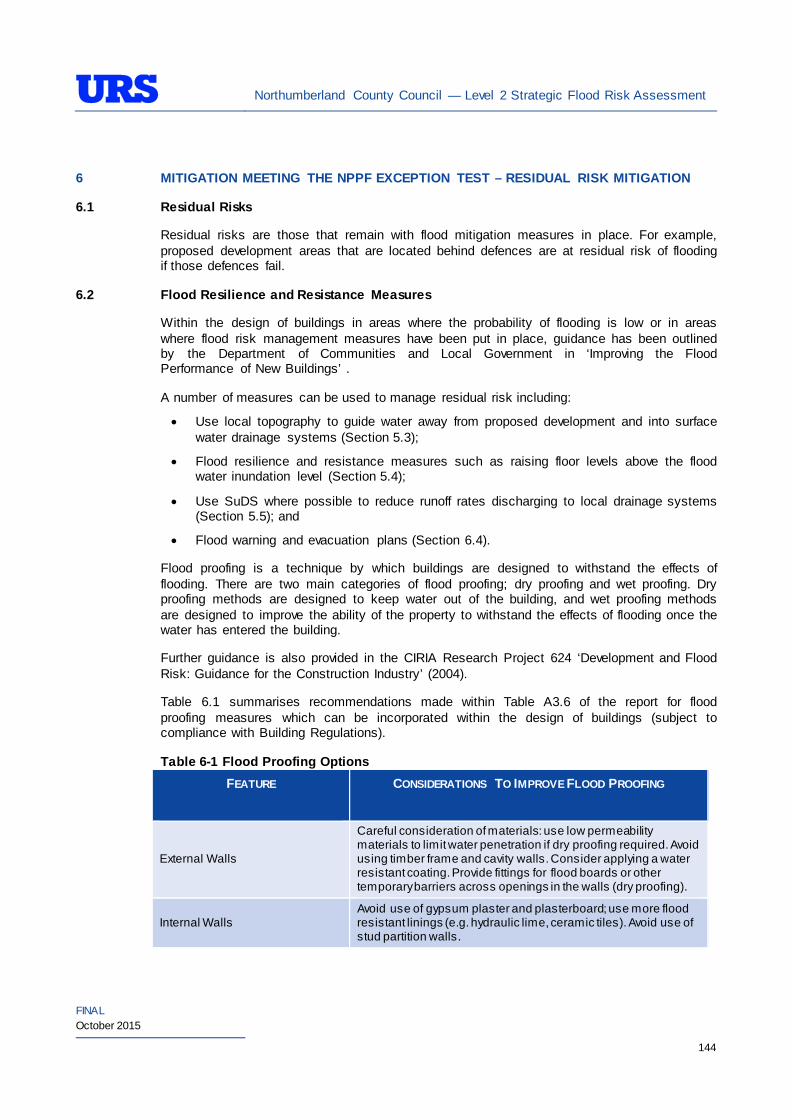
Northumberland County Council — Level 2 Strategic Flood Risk Assessment
FINAL October 2015
144
6 MITIGATION MEETING THE NPPF EXCEPTION TEST – RESIDUAL RISK MITIGATION
6.1 Residual Risks
Residual risks are those that remain with flood mitigation measures in place. For example, proposed development areas that are located behind defences are at residual risk of flooding if those defences fail.
6.2 Flood Resilience and Resistance Measures
Within the design of buildings in areas where the probability of flooding is low or in areas where flood risk management measures have been put in place, guidance has been outlined by the Department of Communities and Local Government in ‘Improving the Flood Performance of New Buildings’ .
A number of measures can be used to manage residual risk including:
• Use local topography to guide water away from proposed development and into surface water drainage systems (Section 5.3);
• Flood resilience and resistance measures such as raising floor levels above the flood water inundation level (Section 5.4);
• Use SuDS where possible to reduce runoff rates discharging to local drainage systems (Section 5.5); and
• Flood warning and evacuation plans (Section 6.4).
Flood proofing is a technique by which buildings are designed to withstand the effects of flooding. There are two main categories of flood proofing; dry proofing and wet proofing. Dry proofing methods are designed to keep water out of the building, and wet proofing methods are designed to improve the ability of the property to withstand the effects of flooding once the water has entered the building.
Further guidance is also provided in the CIRIA Research Project 624 ‘Development and Flood Risk: Guidance for the Construction Industry’ (2004).
Table 6.1 summarises recommendations made within Table A3.6 of the report for flood proofing measures which can be incorporated within the design of buildings (subject to compliance with Building Regulations).
Table 6-1 Flood Proofing Options FEATURE
CONSIDERATIONS TO IMPROVE FLOOD PROOFING
External Walls
Careful consideration of materials: use low permeability materials to limit water penetration if dry proofing required. Avoid using timber frame and cavity walls. Consider applying a water resistant coating. Provide fittings for flood boards or other temporary barriers across openings in the walls (dry proofing).
Internal Walls Avoid use of gypsum plaster and plasterboard; use more flood resistant linings (e.g. hydraulic lime, ceramic tiles). Avoid use of stud partition walls.
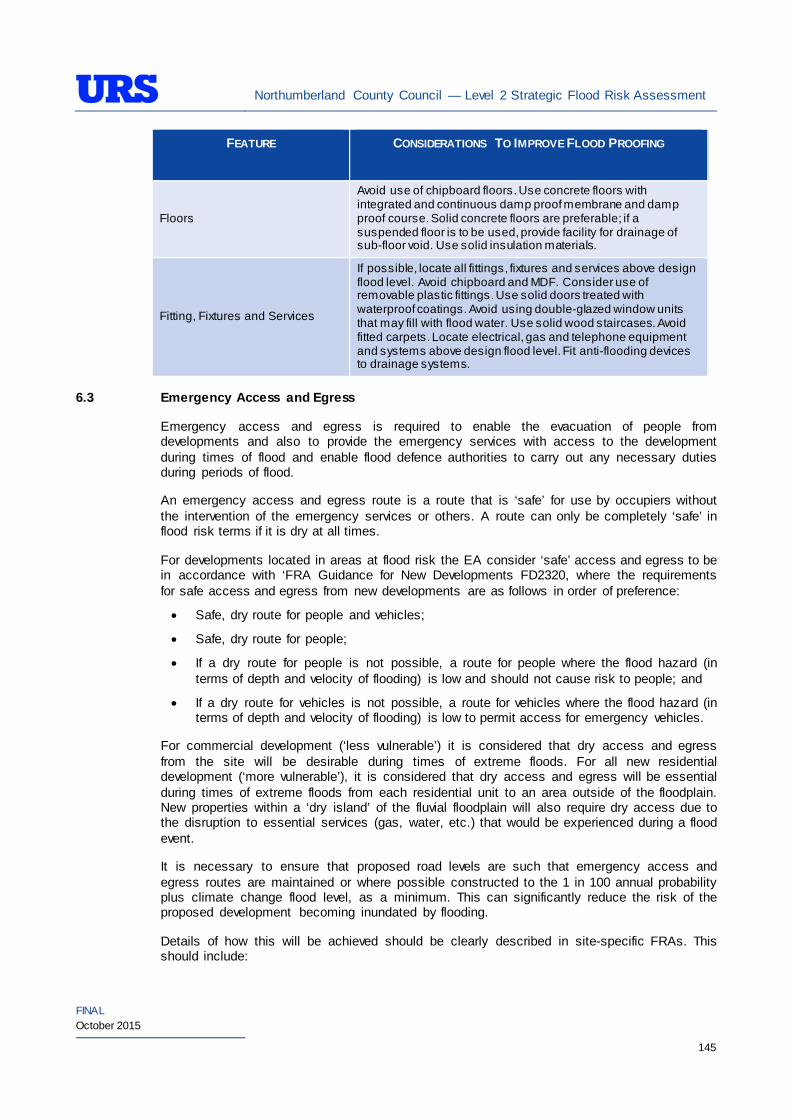
Northumberland County Council — Level 2 Strategic Flood Risk Assessment
FINAL October 2015
145
FEATURE
CONSIDERATIONS TO IMPROVE FLOOD PROOFING
Floors
Avoid use of chipboard floors. Use concrete floors with integrated and continuous damp proof membrane and damp proof course. Solid concrete floors are preferable; if a suspended floor is to be used, provide facility for drainage of sub-floor void. Use solid insulation materials.
Fitting, Fixtures and Services
If possible, locate all fittings, fixtures and services above design flood level. Avoid chipboard and MDF. Consider use of removable plastic fittings. Use solid doors treated with waterproof coatings. Avoid using double-glazed window units that may fill with flood water. Use solid wood staircases. Avoid fitted carpets. Locate electrical, gas and telephone equipment and systems above design flood level. Fit anti-flooding devices to drainage systems.
6.3 Emergency Access and Egress
Emergency access and egress is required to enable the evacuation of people from developments and also to provide the emergency services with access to the development during times of flood and enable flood defence authorities to carry out any necessary duties during periods of flood.
An emergency access and egress route is a route that is ‘safe’ for use by occupiers without the intervention of the emergency services or others. A route can only be completely ‘safe’ in flood risk terms if it is dry at all times.
For developments located in areas at flood risk the EA consider ‘safe’ access and egress to be in accordance with ‘FRA Guidance for New Developments FD2320, where the requirements for safe access and egress from new developments are as follows in order of preference:
• Safe, dry route for people and vehicles;
• Safe, dry route for people;
• If a dry route for people is not possible, a route for people where the flood hazard (in terms of depth and velocity of flooding) is low and should not cause risk to people; and
• If a dry route for vehicles is not possible, a route for vehicles where the flood hazard (in terms of depth and velocity of flooding) is low to permit access for emergency vehicles.
For commercial development (‘less vulnerable’) it is considered that dry access and egress from the site will be desirable during times of extreme floods. For all new residential development (‘more vulnerable’), it is considered that dry access and egress will be essential during times of extreme floods from each residential unit to an area outside of the floodplain. New properties within a ‘dry island’ of the fluvial floodplain will also require dry access due to the disruption to essential services (gas, water, etc.) that would be experienced during a flood event.
It is necessary to ensure that proposed road levels are such that emergency access and egress routes are maintained or where possible constructed to the 1 in 100 annual probability plus climate change flood level, as a minimum. This can significantly reduce the risk of the proposed development becoming inundated by flooding.
Details of how this will be achieved should be clearly described in site-specific FRAs. This should include:
Northumberland County Council — Level 2 Strategic Flood Risk Assessment
FINAL October 2015
146
• A review of any detailed river models (where available);
• A review of flood extents from broadscale modelling; and
• Comparison of flood extents/levels with local ground levels from topographical survey or digital elevation models.
6.4 Flood Warning and Evacuation Plans
Where developing in flood risk areas is unavoidable, it is recommended that the owners/occupiers sign up to the ‘Floodline Warnings Direct’ service operated by the EA where the area is designated to receive flood warnings (EAs website) as a method of mitigating flood risk to people. Where a particular site lies within an area not currently eligible to receive flood warnings, it can be registered with the local EA office as an ‘area of interest’ in order to receive such warnings. The flood warnings are able to be provided by the service via mobile, telephone, fax or pager.
More detailed information on the likely extent and time scale of these warnings can be obtained by request from the EA, by their ‘Quickdial’ recorded information service, or via their website.
For any proposed commercial or industrial developments within a designated floodplain, or those providing a service to vulnerable groups such as elderly care homes or hospitals, a system for monitoring flood warnings should be developed with designated responsible persons able to monitor and disseminate the warnings. This will provide more time to enable emergency access and egress of staff or residential occupants away from the local area, which may become flooded during a flood event (including routes for egress) prior to inundation.
They should also enable sufficient time to implement protection measures for any commercial goods or personal belongings on site through sealing all external doors to prevent flood inflow into such buildings as a precaution.
The exact nature of these emergency plans and procedures should be determined from the results obtained through the detailed FRAs for the individual sites and may be needed in conjunction with other mitigation measures. The need for, and feasibility of flood warning systems for a development should be discussed with the FRA.
Where there are exceptional circumstances in which development is allowed, which is reliant on evacuation NCC will assess whether the proposals are acceptable to their emergency planners and the local emergency services.
Northumberland County Council — Level 2 Strategic Flood Risk Assessment
FINAL October 2015
147
7 USER FRIENDLY GUIDE TO LEVEL 2 SFRA
7.1 Planning Practice Guidance for Level 2 SFRAs
It is important to be clear that a Level 2 SFRA is not a replacement for site-specific FRAs. Its purpose is strategic in nature to inform planning and policy decisions to the area in question within a LPA. There is no clear definition of the scale at which a Level 2 assessment should be undertaken in PPG. However, in other SFRAs across the country, a Level 2 SFRA has concentrated on individual towns and settlements or large development or regeneration areas within a Borough, District or City.
A Level 2 SFRA uses information gathered during a Level 1 SFRA and additional data where necessary, and concentrates on potential development areas to determine detailed information on the level of flood risk so that sufficient evidence can be provided for the Exception Test to be applied.
This continues the hierarchical approach to flood risk defined in PPG and provides LPAs with more information to ensure that development follows the sequential approach and, if applicable, to apply the Exception Test and determine possible site layouts and/or policies that ensure flood risk to new development is minimised.
To address the particular flood risk issues, as identified within the Level 1 SFRA study, that are specific to the administrative area of NCC, flow charts have been produced (Chart 7-1, Chart 7-2,Chart 7-3) which highlight what issues a Level 2 SFRA should address and the level of detail and items of work required for the study to comply with the PPG requirements.
The charts are based on the four main flood sources within the study area (as defined by the Level 1 SFRA). These include fluvial, tidal, sewer and drainage, pluvial and surface water, and artificial sources (including reservoirs).
These charts are not exhaustive as to the scope of a Level 2 SFRA. However, they are considered useful to understand what the general requirements are for a Level 2 SFRA in different circumstances so that, should the need arise, additional Level 2 studies can be specified and undertaken in the future, and updates to the Living Document Level 2 SFRA can be made when necessary.
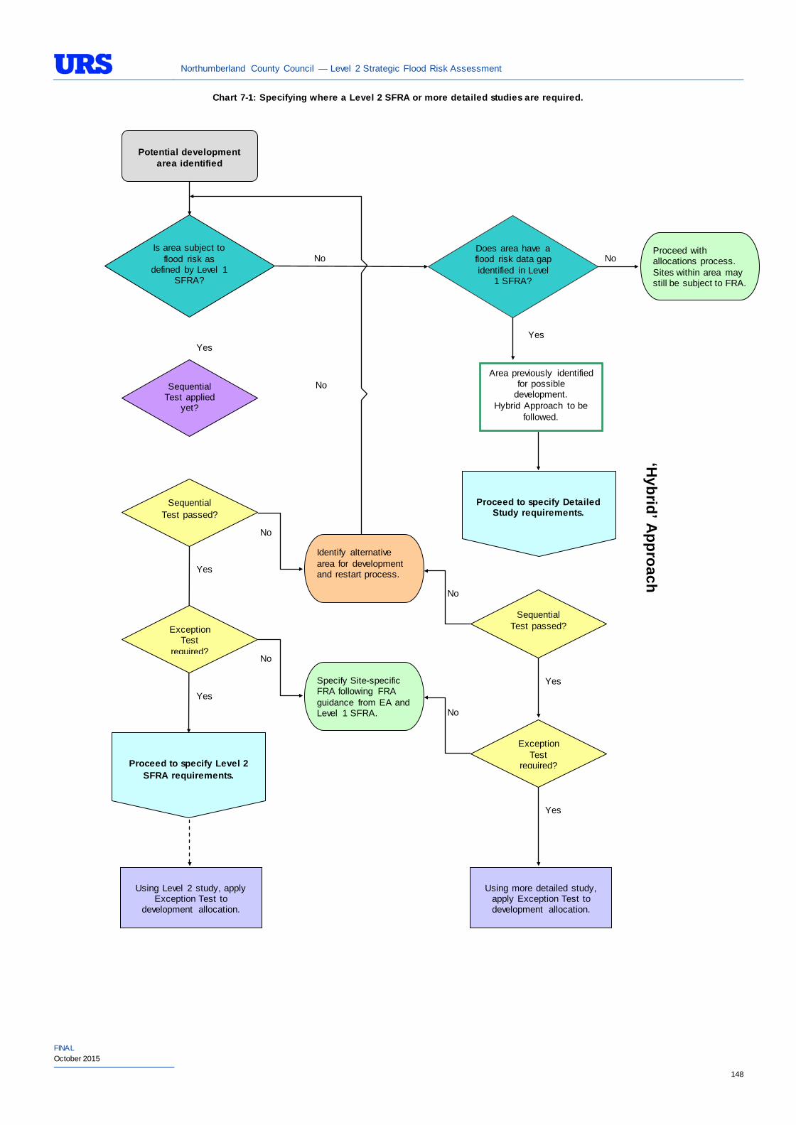
Northumberland County Council — Level 2 Strategic Flood Risk Assessment
FINAL October 2015
148
Chart 7-1: Specifying where a Level 2 SFRA or more detailed studies are required.
Potential development
area identified
Area previously identified for possible
development. Hybrid Approach to be
followed.
Is area subject to flood risk as
defined by Level 1 SFRA?
No
Yes
Does area have a flood risk data gap identified in Level
1 SFRA?
Yes
No Proceed with allocations process. Sites within area may still be subject to FRA.
Sequential Test applied
yet?
No
Sequential Test passed?
Yes
Proceed to specify Level 2 SFRA requirements.
Proceed to specify Detailed Study requirements.
No
Exception Test
required?
Yes
Using Level 2 study, apply
Exception Test to development allocation.
Using more detailed study,
apply Exception Test to development allocation.
Sequential Test passed?
Yes
No
Exception Test
required?
Yes
No
‘Hybrid’ A
pproach
Identify alternative area for development and restart process.
Specify Site-specific FRA following FRA guidance from EA and Level 1 SFRA. No
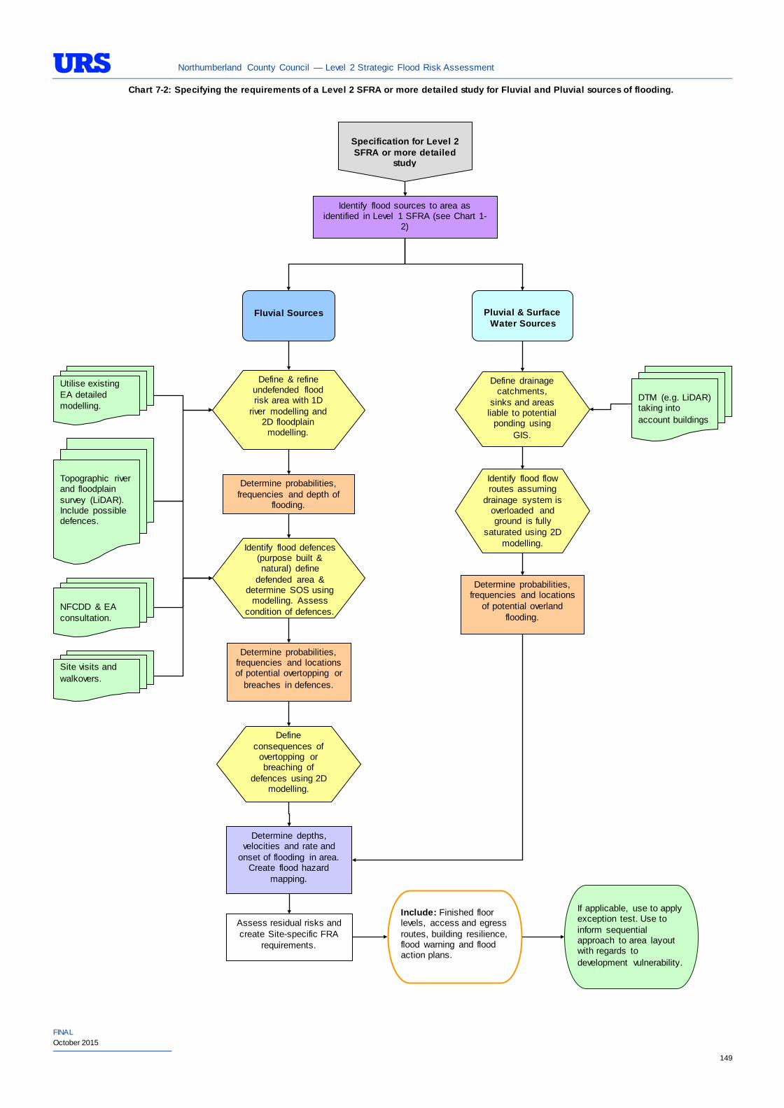
Northumberland County Council — Level 2 Strategic Flood Risk Assessment
FINAL October 2015
149
Specification for Level 2 SFRA or more detailed
study
Identify flood sources to area as identified in Level 1 SFRA (see Chart 1-
2)
Fluvial Sources
Pluvial & Surface
Water Sources
Define & refine undefended flood risk area with 1D
river modelling and 2D floodplain
modelling.
Utilise existing EA detailed modelling.
Topographic river and floodplain survey (LiDAR). Include possible defences.
Identify flood defences (purpose built & natural) define
defended area & determine SOS using
modelling. Assess condition of defences.
Determine probabilities, frequencies and depth of
flooding.
NFCDD & EA consultation.
Site visits and walkovers.
Determine probabilities, frequencies and locations of potential overtopping or
breaches in defences.
Define consequences of
overtopping or breaching of
defences using 2D modelling.
Determine depths, velocities and rate and
onset of flooding in area. Create flood hazard
mapping.
Define drainage catchments,
sinks and areas liable to potential
ponding using GIS.
DTM (e.g. LiDAR) taking into account buildings
Identify flood flow routes assuming
drainage system is overloaded and ground is fully
saturated using 2D modelling.
Determine probabilities, frequencies and locations
of potential overland flooding.
Assess residual risks and create Site-specific FRA
requirements.
Include: Finished floor levels, access and egress routes, building resilience, flood warning and flood action plans.
If applicable, use to apply exception test. Use to inform sequential approach to area layout with regards to development vulnerability.
Chart 7-2: Specifying the requirements of a Level 2 SFRA or more detailed study for Fluvial and Pluvial sources of flooding.
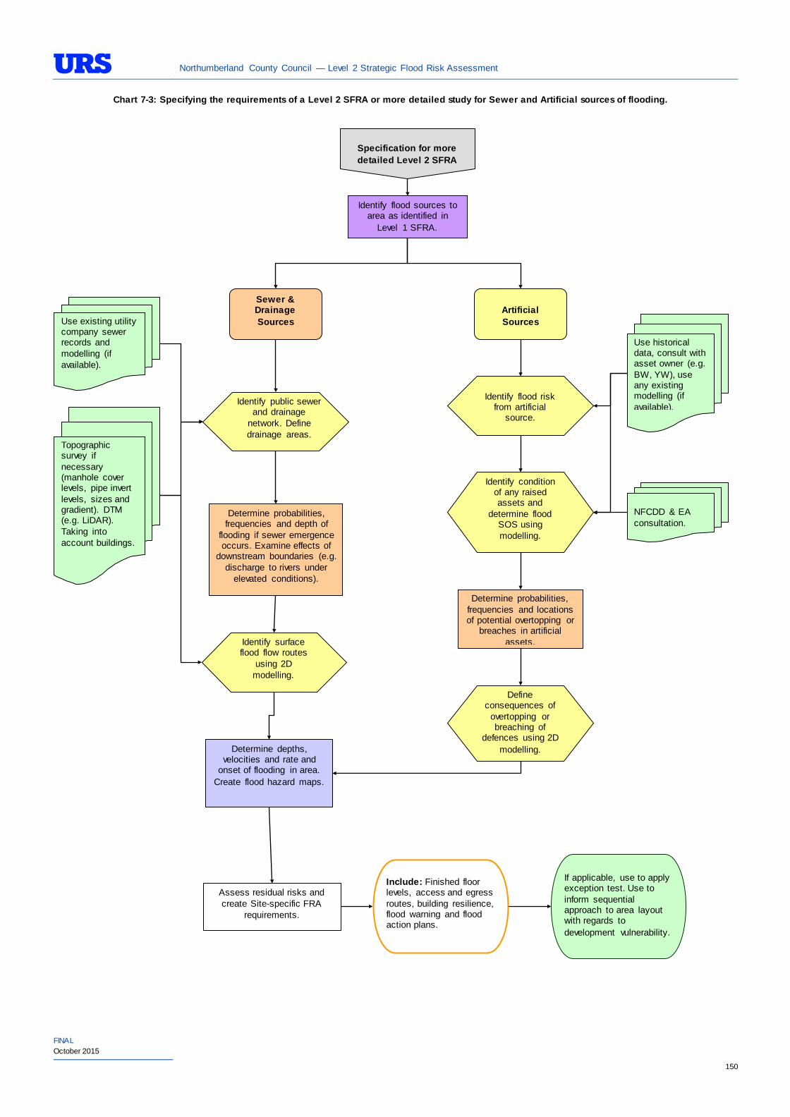
Northumberland County Council — Level 2 Strategic Flood Risk Assessment
FINAL October 2015
150
Specification for more detailed Level 2 SFRA
Identify flood sources to area as identified in
Level 1 SFRA.
Sewer & Drainage Sources
Artificial Sources
Determine depths, velocities and rate and
onset of flooding in area. Create flood hazard maps.
Identify public sewer and drainage
network. Define drainage areas.
Use existing utility company sewer records and modelling (if available).
Determine probabilities, frequencies and depth of
flooding if sewer emergence occurs. Examine effects of
downstream boundaries (e.g. discharge to rivers under
elevated conditions).
Identify surface flood flow routes
using 2D modelling.
Topographic survey if necessary (manhole cover levels, pipe invert levels, sizes and gradient). DTM (e.g. LiDAR). Taking into account buildings.
Identify flood risk
from artificial source.
Use historical data, consult with asset owner (e.g. BW, YW), use any existing modelling (if available).
Identify condition of any raised assets and
determine flood SOS using modelling.
Determine probabilities, frequencies and locations of potential overtopping or
breaches in artificial assets.
Define consequences of
overtopping or breaching of
defences using 2D modelling.
Assess residual risks and create Site-specific FRA
requirements.
Include: Finished floor levels, access and egress routes, building resilience, flood warning and flood action plans.
If applicable, use to apply exception test. Use to inform sequential approach to area layout with regards to development vulnerability.
NFCDD & EA consultation.
Chart 7-3: Specifying the requirements of a Level 2 SFRA or more detailed study for Sewer and Artificial sources of flooding.
Northumberland County Council — Level 2 Strategic Flood Risk Assessment
FINAL October 2015
151
8 CONCLUSIONS AND RECOMMENDATIONS
To ensure a holistic approach to flood risk management and make sure that flooding is taken into account at all stages of the planning process, the findings of this report should be incorporated into the emerging LDF for NCC and read in conjunction with the Level 1 SFRA. However, it should be noted that at the time of undertaking the Level 1 SFRA the EA data available to delineate functional floodplain in tidal areas and behind defences was limited. It was agreed with the EA that the limitations in data be updated at a later stage as appropriate in Level 2 SFRA (where necessary), EA Strategic Flood Risk Mapping (SFRM) study, or site-specific FRAs. The Level 2 SFRA therefore has been undertaken using the updated data to assess the PDAs considered in Section 4.
In accordance with the NPPF, a specific policy on flood risk should be included in the Final NCC Core Strategy to ensure that:
• Development is located in the lowest flood risk areas;
• New development is flood-proofed to a satisfactory degree and does not increase flood risk elsewhere; and
• Surface water is managed effectively on site.
Recommendations and policies have been presented for each of the individual areas within Northumberland in Section 4.
PPG states that a Level 2 SFRA should identify the need (or not) for an SWMP. It may be prudent to undertake such studies for primary urban areas of Morpeth, Berwick, Belford, Ponteland, Hexham, Haltwhistle, Cramlington, Amble and Blyth, subject to further assessment of local information and need.
The NCC SFRA has been completed in accordance with the NPPF, Technical Guidance to the NPPF and the current guidance outlined in the PPG. The SFRA has been developed by building heavily upon existing knowledge with respect to flood risk within the study area. These documents have an intended lifespan of 6-10 years. Therefore it should be noted that although up-to date at the time of production, the SFRA has a finite lifespan and should potentially be updated or revised as required by the LPA. As a result, it is recommended that the SFRA be adopted as a ‘Living’ document and should be reviewed regularly and, if necessary, updated with new flood risk or planning policy data.
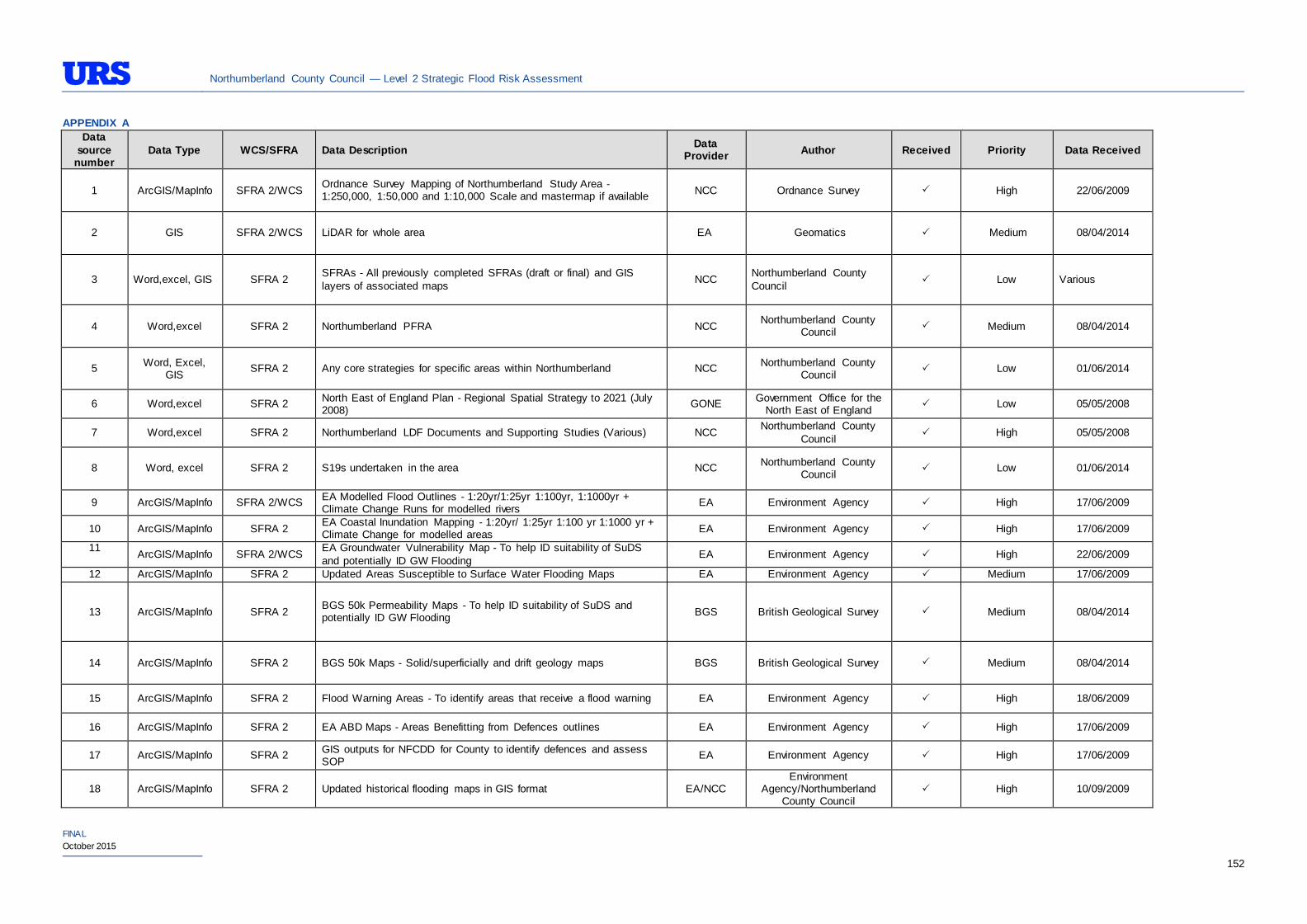
Northumberland County Council — Level 2 Strategic Flood Risk Assessment
FINAL October 2015
152
APPENDIX A Data
source number
Data Type WCS/SFRA Data Description Data Provider Author Received Priority Data Received
1 ArcGIS/MapInfo SFRA 2/WCS Ordnance Survey Mapping of Northumberland Study Area - 1:250,000, 1:50,000 and 1:10,000 Scale and mastermap if available NCC Ordnance Survey High 22/06/2009
2 GIS SFRA 2/WCS LiDAR for whole area EA Geomatics Medium 08/04/2014
3 Word,excel, GIS SFRA 2 SFRAs - All previously completed SFRAs (draft or final) and GIS layers of associated maps NCC Northumberland County
Council Low Various
4 Word,excel SFRA 2 Northumberland PFRA NCC Northumberland County Council Medium 08/04/2014
5 Word, Excel, GIS SFRA 2 Any core strategies for specific areas within Northumberland NCC Northumberland County
Council Low 01/06/2014
6 Word,excel SFRA 2 North East of England Plan - Regional Spatial Strategy to 2021 (July 2008) GONE Government Office for the
North East of England Low 05/05/2008
7 Word,excel SFRA 2 Northumberland LDF Documents and Supporting Studies (Various) NCC Northumberland County Council High 05/05/2008
8 Word, excel SFRA 2 S19s undertaken in the area NCC Northumberland County Council Low 01/06/2014
9 ArcGIS/MapInfo SFRA 2/WCS EA Modelled Flood Outlines - 1:20yr/1:25yr 1:100yr, 1:1000yr + Climate Change Runs for modelled rivers EA Environment Agency High 17/06/2009
10 ArcGIS/MapInfo SFRA 2 EA Coastal Inundation Mapping - 1:20yr/ 1:25yr 1:100 yr 1:1000 yr + Climate Change for modelled areas EA Environment Agency High 17/06/2009
11 ArcGIS/MapInfo SFRA 2/WCS EA Groundwater Vulnerability Map - To help ID suitability of SuDS
and potentially ID GW Flooding EA Environment Agency High 22/06/2009
12 ArcGIS/MapInfo SFRA 2 Updated Areas Susceptible to Surface Water Flooding Maps EA Environment Agency Medium 17/06/2009
13 ArcGIS/MapInfo SFRA 2 BGS 50k Permeability Maps - To help ID suitability of SuDS and potentially ID GW Flooding BGS British Geological Survey Medium 08/04/2014
14 ArcGIS/MapInfo SFRA 2 BGS 50k Maps - Solid/superficially and drift geology maps BGS British Geological Survey Medium 08/04/2014
15 ArcGIS/MapInfo SFRA 2 Flood Warning Areas - To identify areas that receive a flood warning EA Environment Agency High 18/06/2009
16 ArcGIS/MapInfo SFRA 2 EA ABD Maps - Areas Benefitting from Defences outlines EA Environment Agency High 17/06/2009
17 ArcGIS/MapInfo SFRA 2 GIS outputs for NFCDD for County to identify defences and assess SOP EA Environment Agency High 17/06/2009
18 ArcGIS/MapInfo SFRA 2 Updated historical flooding maps in GIS format EA/NCC Environment
Agency/Northumberland County Council
High 10/09/2009
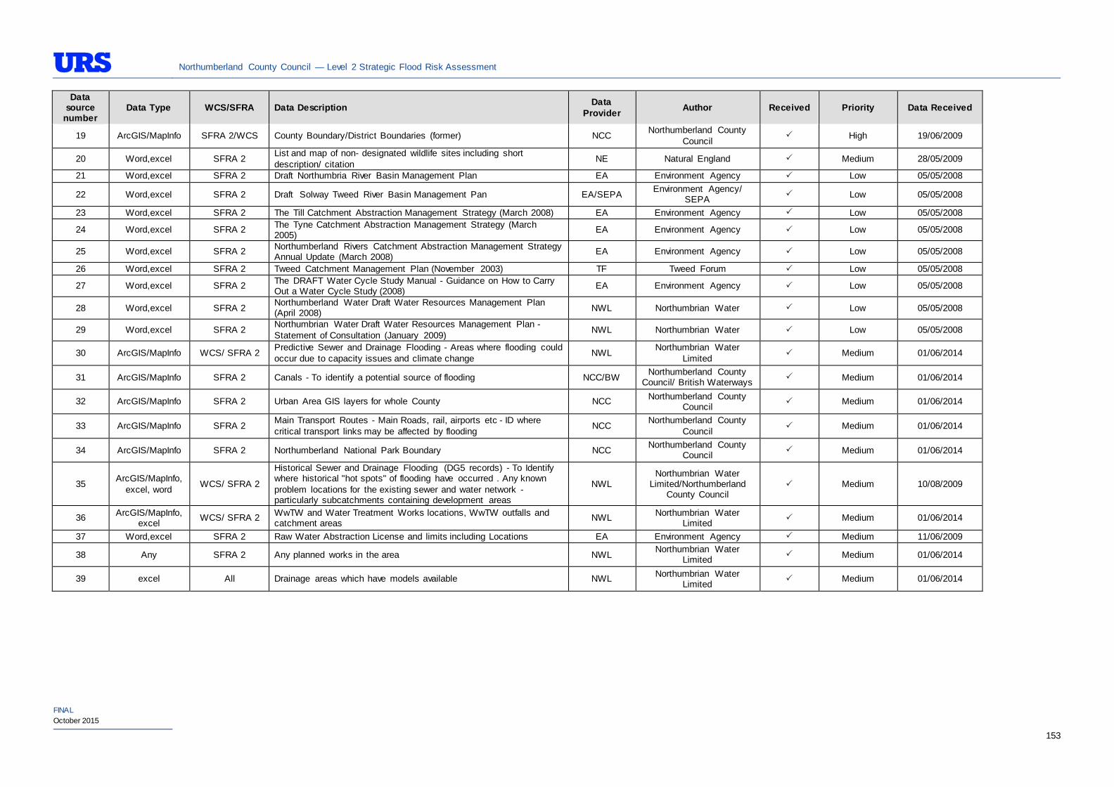
Northumberland County Council — Level 2 Strategic Flood Risk Assessment
FINAL October 2015
153
Data source
number Data Type WCS/SFRA Data Description Data
Provider Author Received Priority Data Received
19 ArcGIS/MapInfo SFRA 2/WCS County Boundary/District Boundaries (former) NCC Northumberland County Council
High 19/06/2009
20 Word,excel SFRA 2 List and map of non- designated wildlife sites including short description/ citation NE Natural England Medium 28/05/2009
21 Word,excel SFRA 2 Draft Northumbria River Basin Management Plan EA Environment Agency Low 05/05/2008
22 Word,excel SFRA 2 Draft Solway Tweed River Basin Management Pan EA/SEPA Environment Agency/ SEPA Low 05/05/2008
23 Word,excel SFRA 2 The Till Catchment Abstraction Management Strategy (March 2008) EA Environment Agency Low 05/05/2008
24 Word,excel SFRA 2 The Tyne Catchment Abstraction Management Strategy (March 2005) EA Environment Agency Low 05/05/2008
25 Word,excel SFRA 2 Northumberland Rivers Catchment Abstraction Management Strategy Annual Update (March 2008) EA Environment Agency Low 05/05/2008
26 Word,excel SFRA 2 Tweed Catchment Management Plan (November 2003) TF Tweed Forum Low 05/05/2008
27 Word,excel SFRA 2 The DRAFT Water Cycle Study Manual - Guidance on How to Carry Out a Water Cycle Study (2008) EA Environment Agency Low 05/05/2008
28 Word,excel SFRA 2 Northumberland Water Draft Water Resources Management Plan (April 2008) NWL Northumbrian Water Low 05/05/2008
29 Word,excel SFRA 2 Northumbrian Water Draft Water Resources Management Plan - Statement of Consultation (January 2009) NWL Northumbrian Water Low 05/05/2008
30 ArcGIS/MapInfo WCS/ SFRA 2 Predictive Sewer and Drainage Flooding - Areas where flooding could occur due to capacity issues and climate change NWL Northumbrian Water
Limited Medium 01/06/2014
31 ArcGIS/MapInfo SFRA 2 Canals - To identify a potential source of flooding NCC/BW Northumberland County Council/ British Waterways Medium 01/06/2014
32 ArcGIS/MapInfo SFRA 2 Urban Area GIS layers for whole County NCC Northumberland County Council Medium 01/06/2014
33 ArcGIS/MapInfo SFRA 2 Main Transport Routes - Main Roads, rail, airports etc - ID where critical transport links may be affected by flooding NCC Northumberland County
Council Medium 01/06/2014
34 ArcGIS/MapInfo SFRA 2 Northumberland National Park Boundary NCC Northumberland County Council Medium 01/06/2014
35 ArcGIS/MapInfo, excel, word WCS/ SFRA 2
Historical Sewer and Drainage Flooding (DG5 records) - To Identify where historical "hot spots" of flooding have occurred . Any known problem locations for the existing sewer and water network - particularly subcatchments containing development areas
NWL Northumbrian Water
Limited/Northumberland County Council
Medium 10/08/2009
36 ArcGIS/MapInfo, excel WCS/ SFRA 2 WwTW and Water Treatment Works locations, WwTW outfalls and
catchment areas NWL Northumbrian Water Limited Medium 01/06/2014
37 Word,excel SFRA 2 Raw Water Abstraction License and limits including Locations EA Environment Agency Medium 11/06/2009
38 Any SFRA 2 Any planned works in the area NWL Northumbrian Water Limited Medium 01/06/2014
39 excel All Drainage areas which have models available NWL Northumbrian Water Limited Medium 01/06/2014

Northumberland County Council — Level 2 Strategic Flood Risk Assessment
FINAL October 2015
APPENDIX B
As part of the work on the Northumberland Core Strategy, the Council is at the early stages in the evidence base gathering process. Therefore, following completion of the Level 1 SFRA, NCC has identified a limited number of locations to be further evaluated in the Level 2 SFRA. These locations are named as Potential Development Areas (PDAs) and have been identified as particular locations at flood risk in the Level 1 SFRA. This appendix shows the locations of all of the PDAs. The locations that were identified that fall in Flood Zone 1 have not been considered for further evaluation, as these would not be subjected to the sequential test under the NPPF. Please see Section 4 for further information on the PDAs that fall in Flood Zone 2 and 3 and which have been subject to assessment through the SFRA Level 2 assessment.
5ha
South (270)
North East (300)
A06, A13A15, A17, A18, A19
A03
North West
East of Swansfield Park (250)
Built up areas
0 0.6 1.20.3 Miles ´A l n w i c kA l n w i c k
© Crown copyright and database rights [2013] Ordnance Survey [100049048]© Local Government Information House Limited copyright and database rights [2013] [100049048]
Housing location alternatives
Employment location alternatives
A13
A15
A18
A17
A19A06Employment sites with capacity
and/or held for expansionMixed use location alternative
Alnwick
A08
South west (740)
West (740)
South east (740)
127
County Boundary
Built up areas
0 0.7 1.40.35 Miles ´A m b l eA m b l e
© Crown copyright and database rights [2013] Ordnance Survey [100049048]© Local Government Information House Limited copyright and database rights [2013] [100049048]
Housing location alternatives
Employment sites with capacity and/or held for expansion
Other large housing sites
Amble
High Hauxley
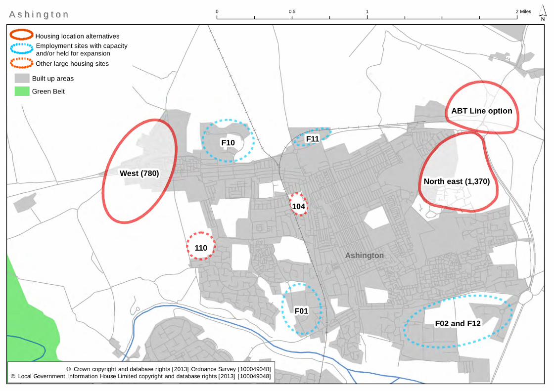
West (780)
F10
F01F02 and F12
North east (1,370)
ABT Line option
110
F11
104
Built up areas
Green Belt
0 1 20.5 Miles ´A s h i n g t o nA s h i n g t o n
© Crown copyright and database rights [2013] Ordnance Survey [100049048]© Local Government Information House Limited copyright and database rights [2013] [100049048]
Housing location alternativesEmployment sites with capacity and/or held for expansionOther large housing sites
Ashington
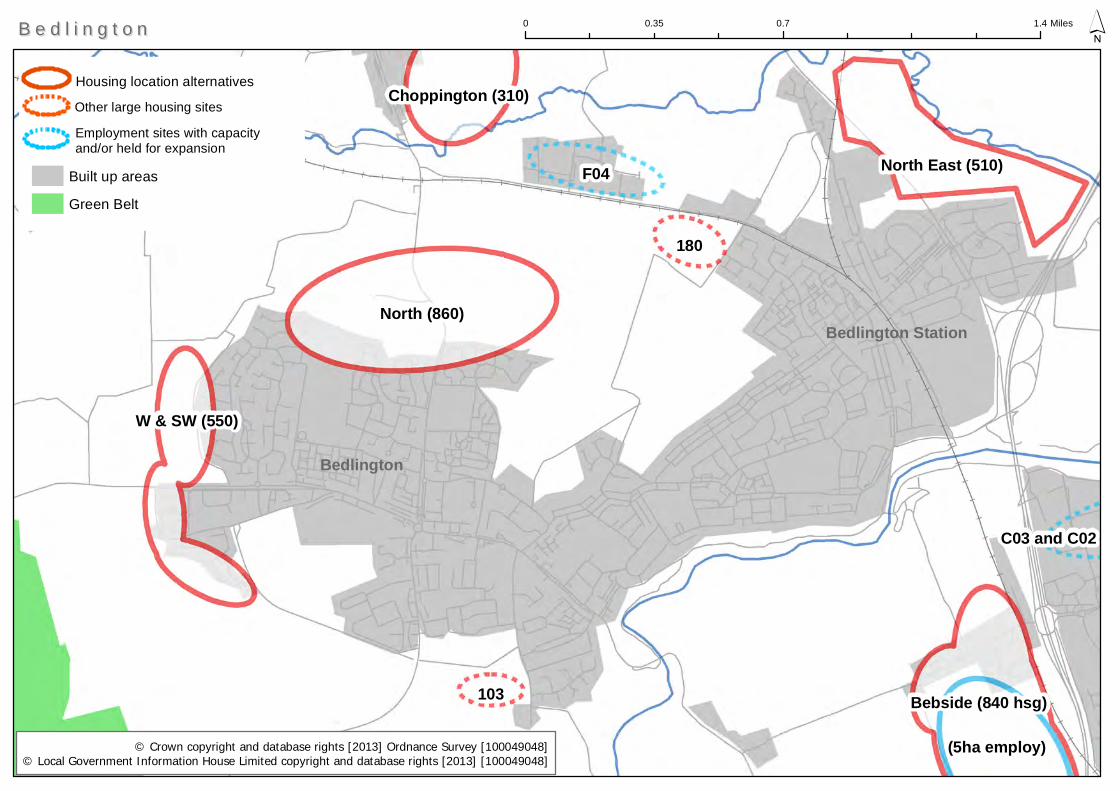
North (860)
F04
(5ha employ)
180
Bebside (840 hsg)
North East (510)
W & SW (550)
Choppington (310)
103
C03 and C02
Built up areas
Green Belt
Bedlington
0 0.7 1.40.35 Miles ´
Bedlington Station
B e d l i n g t o nB e d l i n g t o n
© Crown copyright and database rights [2013] Ordnance Survey [100049048]© Local Government Information House Limited copyright and database rights [2013] [100049048]
Housing location alternatives
Employment sites with capacity and/or held for expansion
Other large housing sites
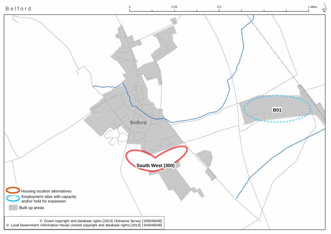
B01
South West (300)
Built up areas
0 0.5 10.25 Miles ´B e l f o r dB e l f o r d
© Crown copyright and database rights [2013] Ordnance Survey [100049048]© Local Government Information House Limited copyright and database rights [2013] [100049048]
Housing location alternativesEmployment sites with capacity and/or held for expansion
Belford
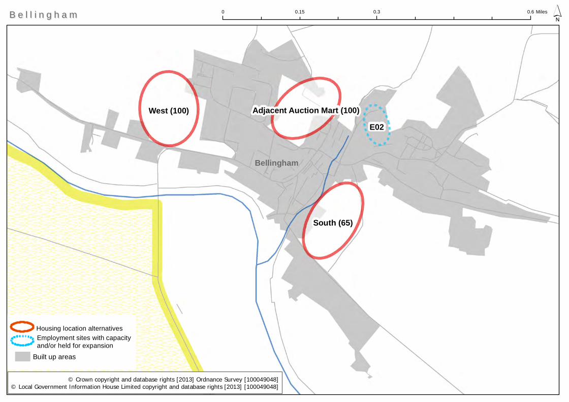
West (100)
South (65)
E02Adjacent Auction Mart (100)
Built up areas
0 0.3 0.60.15 Miles ´B e l l i n g h a mB e l l i n g h a m
© Crown copyright and database rights [2013] Ordnance Survey [100049048]© Local Government Information House Limited copyright and database rights [2013] [100049048]
Housing location alternativesEmployment sites with capacity and/or held for expansion
Bellingham
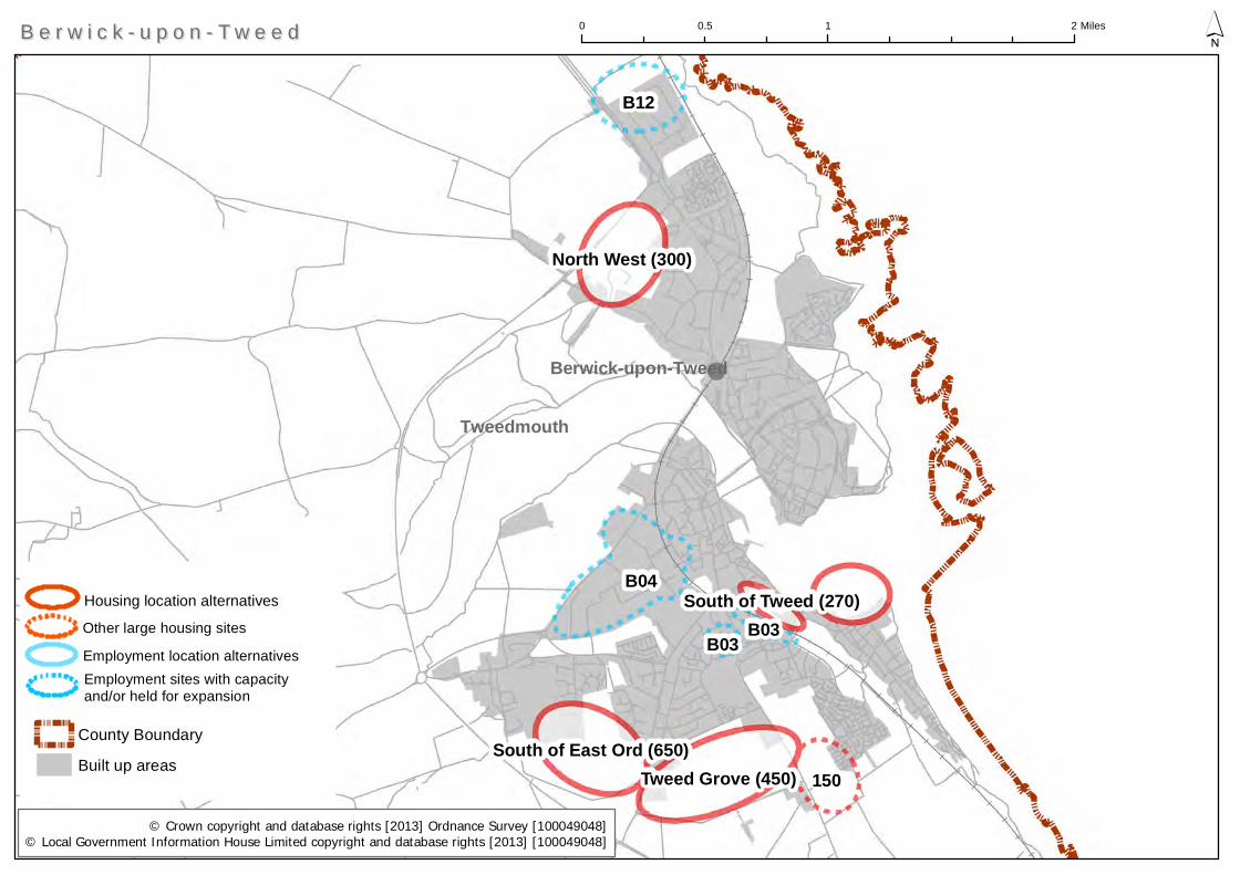
B04
B12
150Tweed Grove (450)
North West (300)
South of East Ord (650)
B03B03
South of Tweed (270)
County Boundary
Built up areas
Berwick-upon-Tweed
0 1 20.5 Miles ´
Tweedmouth
B e r w i c k - u p o n - T w e e dB e r w i c k - u p o n - T w e e d
© Crown copyright and database rights [2013] Ordnance Survey [100049048]© Local Government Information House Limited copyright and database rights [2013] [100049048]
Housing location alternatives
Employment location alternativesEmployment sites with capacity and/or held for expansion
Other large housing sites
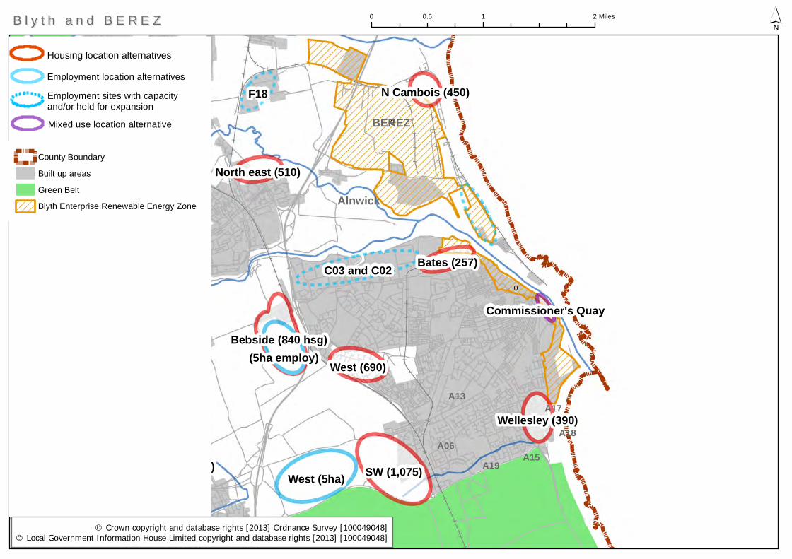
C24
C07, C11, C17-C22
SW (1,075)West (5ha)
North (860)
E Hartford (1,660)
C03 and C02
F18
Bebside (840 hsg)
West (690)(5ha employ)
F04
W & SW (550)
Wellesley (390)
Bates (257)
South east (250)
North east (510)
Choppington (310)
180
N Cambois (450)
103
South west (180)
Commissioner's Quay
0
0
County Boundary
Built up areas
Green Belt
Blyth Enterprise Renewable Energy Zone
0 1 20.5 Miles ´B l y t h a n d B E R E ZB l y t h a n d B E R E Z
© Crown copyright and database rights [2013] Ordnance Survey [100049048]© Local Government Information House Limited copyright and database rights [2013] [100049048]
Housing location alternatives
BEREZ
Employment location alternatives
A13
A15
A18
A17
A19A06
Employment sites with capacity and/or held for expansion
Mixed use location alternative
Alnwick
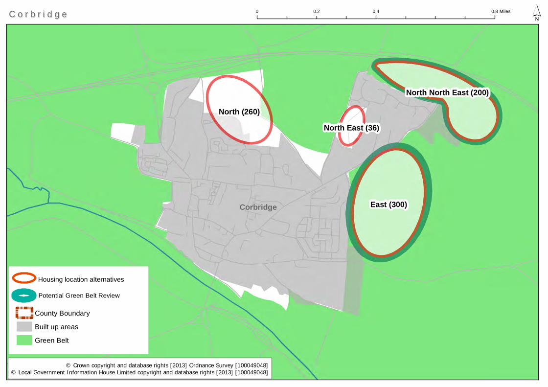
East (300)
North (260)
North North East (200)
North East (36)
County Boundary
Built up areas
Green Belt
0 0.4 0.80.2 Miles ´C o r b r i d g eC o r b r i d g e
© Crown copyright and database rights [2013] Ordnance Survey [100049048]© Local Government Information House Limited copyright and database rights [2013] [100049048]
Housing location alternatives
Potential Green Belt Review
Corbridge
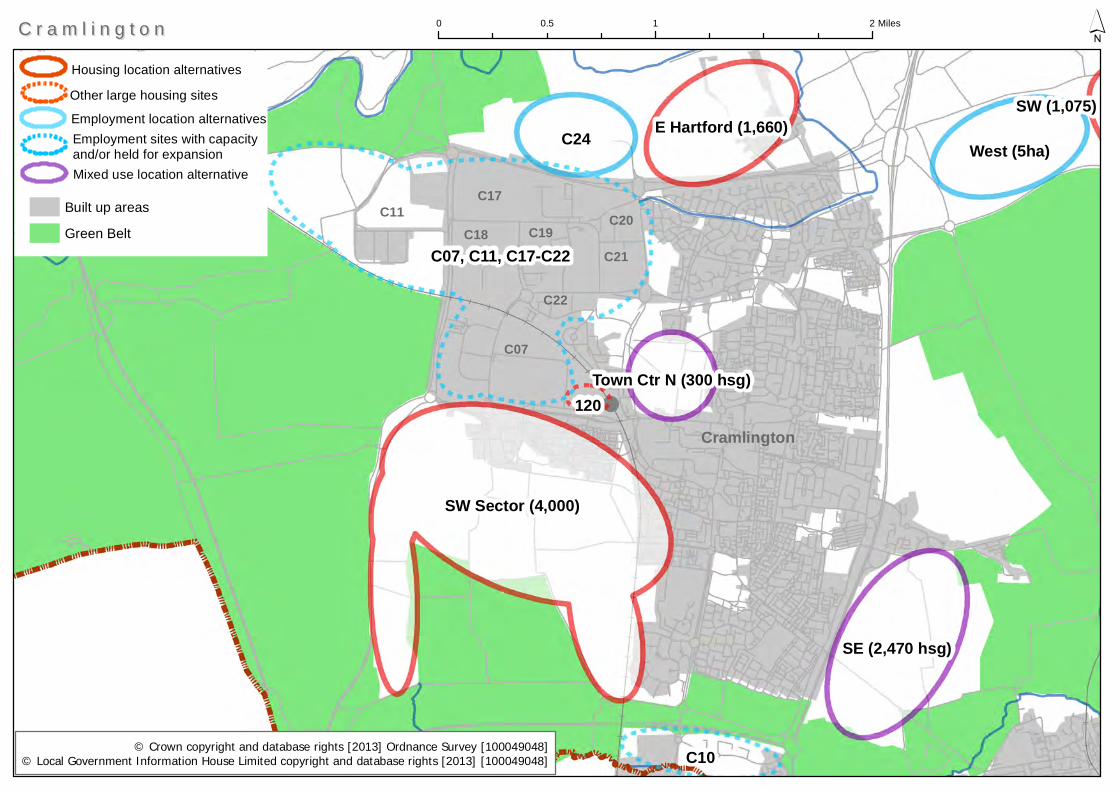
C07, C11, C17-C22
SW Sector (4,000)
C24
C10
West (5ha)
SE (2,470 hsg)
E Hartford (1,660)
Town Ctr N (300 hsg)120
SW (1,075)
Built up areas
Green Belt
0 1 20.5 Miles ´
Cramlington
C r a m l i n g t o nC r a m l i n g t o n
© Crown copyright and database rights [2013] Ordnance Survey [100049048]© Local Government Information House Limited copyright and database rights [2013] [100049048]
Housing location alternatives
Employment location alternatives
C17
C18 C19 C20
C21
C22
C07
C11
Other large housing sites
Employment sites with capacity and/or held for expansionMixed use location alternative
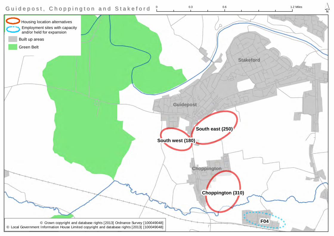
F04
South east (250)
Choppington (310)
South west (180)
Built up areas
Green Belt
Choppington
0 0.6 1.20.3 Miles ´G u i d e p o s t , C h o p p i n g t o n a n d S t a k e f o r dG u i d e p o s t , C h o p p i n g t o n a n d S t a k e f o r d
© Crown copyright and database rights [2013] Ordnance Survey [100049048]© Local Government Information House Limited copyright and database rights [2013] [100049048]
Housing location alternativesEmployment sites with capacity and/or held for expansion
Stakeford
Guidepost
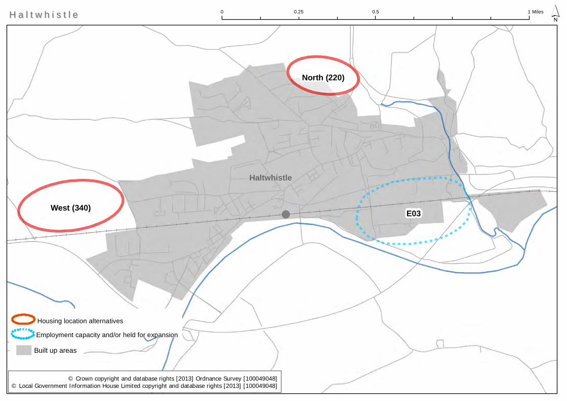
E03West (340)
North (220)
Built up areas
0 0.5 10.25 Miles ´
Haltwhistle
H a l t w h i s t l eH a l t w h i s t l e
© Crown copyright and database rights [2013] Ordnance Survey [100049048]© Local Government Information House Limited copyright and database rights [2013] [100049048]
Employment capacity and/or held for expansion
Housing location alternatives
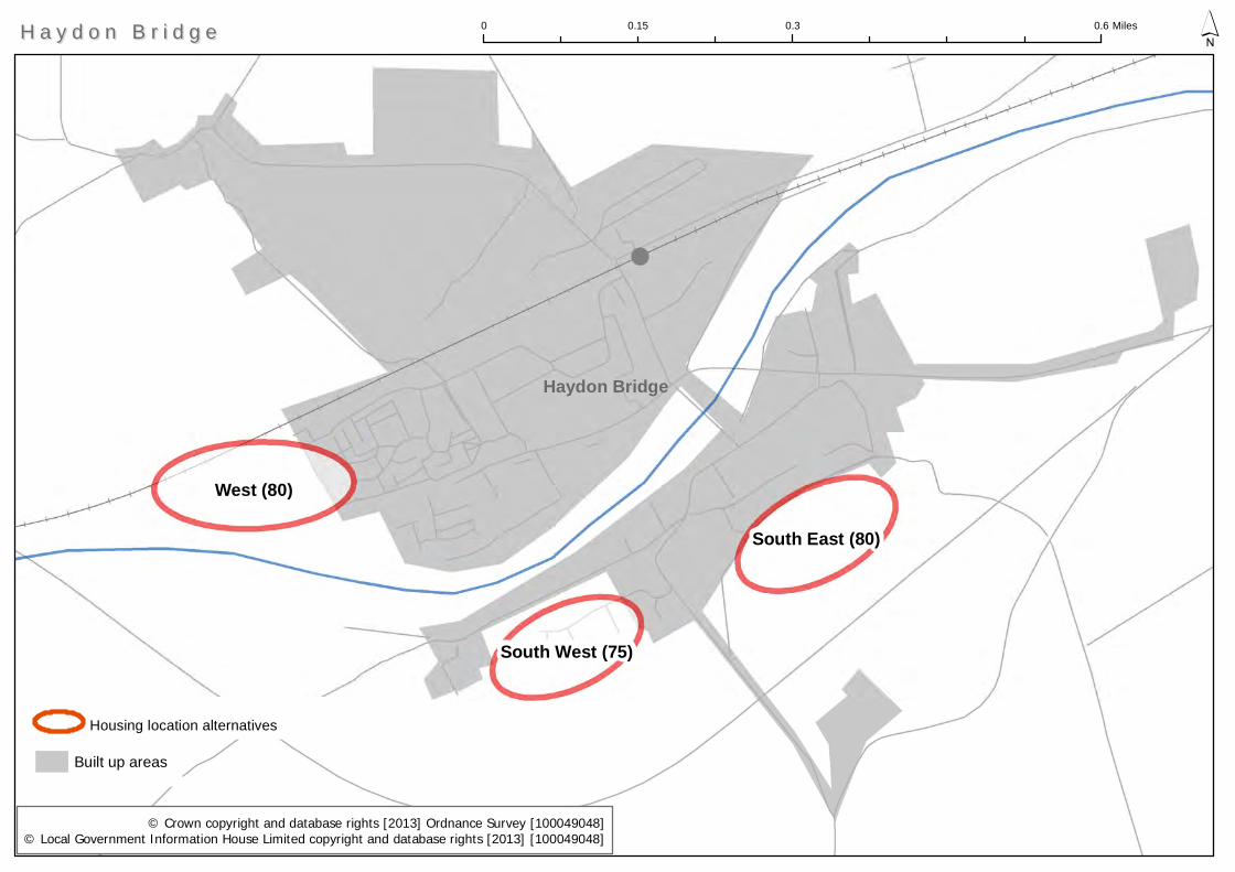
West (80)
South East (80)
South West (75)
Built up areas
0 0.3 0.60.15 Miles ´
Haydon Bridge
H a y d o n B r i d g eH a y d o n B r i d g e
© Crown copyright and database rights [2013] Ordnance Survey [100049048]© Local Government Information House Limited copyright and database rights [2013] [100049048]
Housing location alternatives
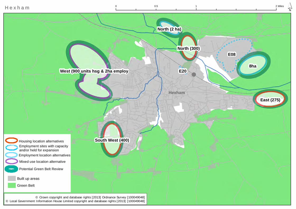
E08
8ha
East (275)
West (900 units hsg & 2ha employ
South West (400)
North (300)
North (2 ha)
E20
Built up areas
Green Belt
0 1 20.5 Miles ´H e x h a mH e x h a m
© Crown copyright and database rights [2013] Ordnance Survey [100049048]© Local Government Information House Limited copyright and database rights [2013] [100049048]
Housing location alternatives
Employment location alternatives
Employment sites with capacity and/or held for expansion
Mixed use location alternative
Hexham
Potential Green Belt Review
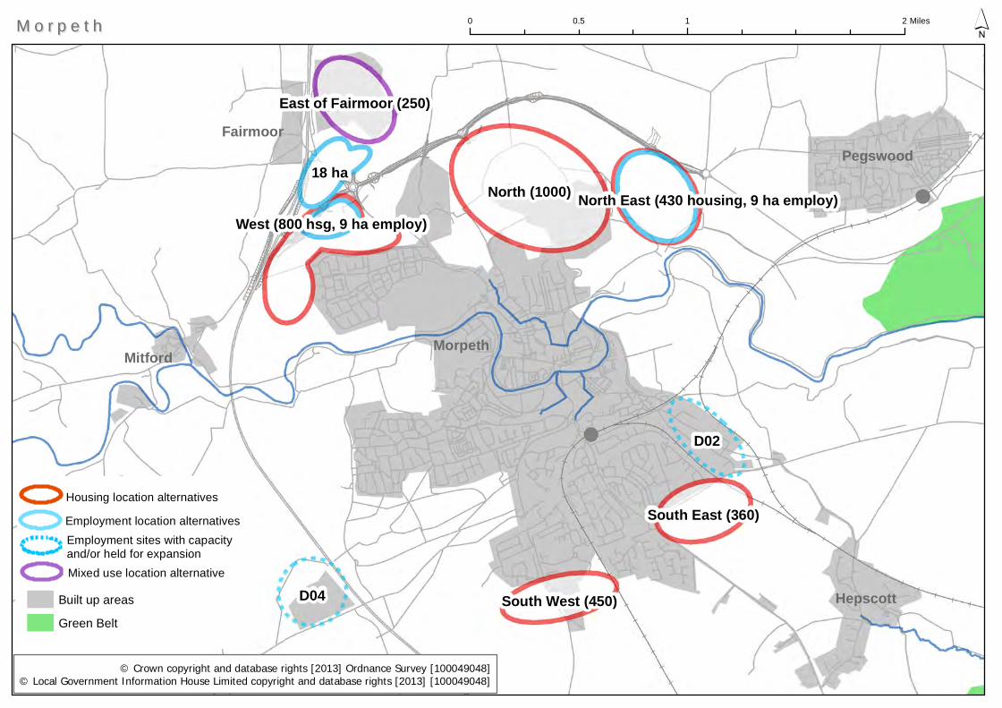
North (1000)
D04
D02
18 ha
South East (360)
South West (450)
East of Fairmoor (250)
North East (430 housing, 9 ha employ)West (800 hsg, 9 ha employ)
Built up areas
Green Belt
Pegswood
0 1 20.5 Miles ´
Mitford
M o r p e t hM o r p e t h
© Crown copyright and database rights [2013] Ordnance Survey [100049048]© Local Government Information House Limited copyright and database rights [2013] [100049048]
Housing location alternatives
Employment location alternatives
Hepscott
Employment sites with capacity and/or held for expansionMixed use location alternative
Morpeth
Fairmoor
North east (1,370)
Central
ABT Line option NW (300)North (210)
SW (100)
County Boundary
Built up areas
0 0.7 1.40.35 Miles ´N e w b i g g i n b y t h e S e aN e w b i g g i n b y t h e S e a
© Crown copyright and database rights [2013] Ordnance Survey [100049048]© Local Government Information House Limited copyright and database rights [2013] [100049048]
Housing location alternatives
Ashington
Newbiggin by the Sea
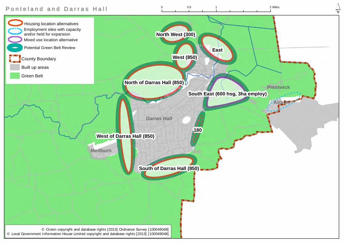
East
North of Darras Hall (850)
West (850)
West of Darras Hall (850)
South East (600 hsg, 3ha employ)
South of Darras Hall (850)
North West (300)
180
County Boundary
Built up areas
Green Belt
Darras Hall
0 1 20.5 Miles ´
Medburn
Airport
Prestwick
P o n t e l a n d a n d D a r r a s H a l lP o n t e l a n d a n d D a r r a s H a l l
© Crown copyright and database rights [2013] Ordnance Survey [100049048]© Local Government Information House Limited copyright and database rights [2013] [100049048]
Housing location alternativesEmployment sites with capacity and/or held for expansionMixed use location alternative
Potential Green Belt Review
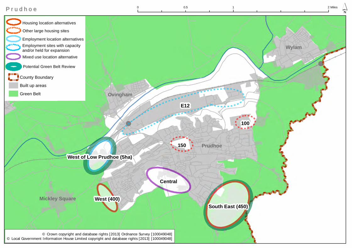
E12
Central
150
100
South East (450)West (400)
West of Low Prudhoe (5ha)
County Boundary
Built up areas
Green Belt
Mickley Square
0 1 20.5 Miles ´
Ovingham
Wylam
P r u d h o eP r u d h o e
© Crown copyright and database rights [2013] Ordnance Survey [100049048]© Local Government Information House Limited copyright and database rights [2013] [100049048]
Housing location alternatives
Employment location alternativesEmployment sites with capacity and/or held for expansionMixed use location alternative
Other large housing sites
Potential Green Belt Review
Prudhoe
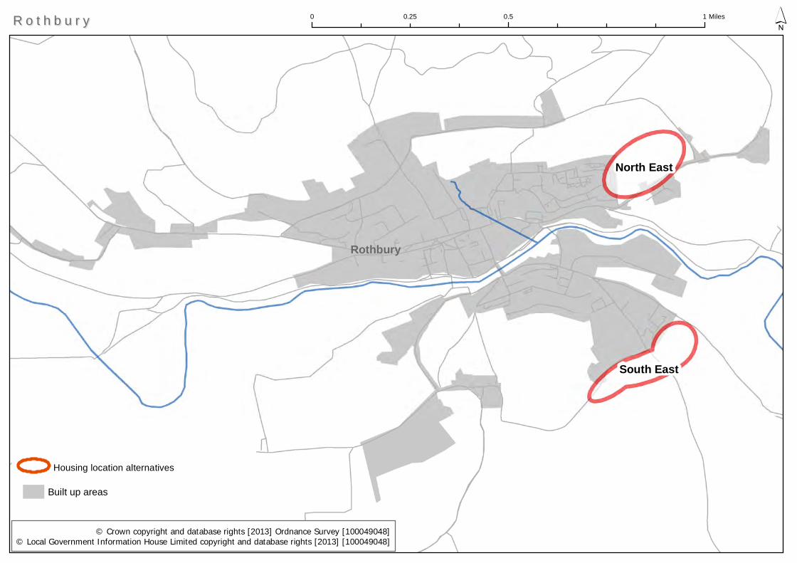
North East
South East
Built up areas
0 0.5 10.25 Miles ´
Rothbury
R o t h b u r y R o t h b u r y
© Crown copyright and database rights [2013] Ordnance Survey [100049048]© Local Government Information House Limited copyright and database rights [2013] [100049048]
Housing location alternatives

South East
South
North West (200)
B05
County Boundary
Built up areas
0 0.4 0.80.2 Miles ´S e a h o u s e sS e a h o u s e s
© Crown copyright and database rights [2013] Ordnance Survey [100049048]© Local Government Information House Limited copyright and database rights [2013] [100049048]
Housing location alternativesEmployment sites with capacity and/or held for expansion
Seahouses

NE of Holywell (900)C13
SE (2,470 hsg)
C12
North East (213)
N of A190 (200)
N of Wheatfields (430)
Wheatfields (190)
North west (160)
Wheatridge (285)
Built up areas
Green Belt
0 0.75 1.50.375 Miles ´
Seaton Delaval
S e a t o n V a l l e yS e a t o n V a l l e y
© Crown copyright and database rights [2013] Ordnance Survey [100049048]© Local Government Information House Limited copyright and database rights [2013] [100049048]
Housing location alternativesEmployment sites with capacity and/or held for expansion
New Hartley
Potential Green Belt Review
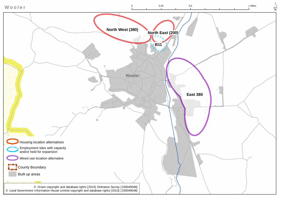
East 380
North West (380)
B11
North East (200)
County Boundary
Built up areas
Wooler
0 0.5 10.25 Miles ´W o o l e rW o o l e r
© Crown copyright and database rights [2013] Ordnance Survey [100049048]© Local Government Information House Limited copyright and database rights [2013] [100049048]
Housing location alternativesEmployment sites with capacity and/or held for expansion
Mixed use location alternative
Northumberland County Council — Level 2 Strategic Flood Risk Assessment
FINAL October 2015
APPENDIX C
This appendix includes a high level assessment of fluvial/ tidal, surface water and artificial (reservoir) flooding for all potential development locations. The following section evaluates the PDA’s against the following categories:
• Existing use and topography; • Proposed use and vulnerability; • Sources of flooding (rivers/sea, surface water, groundwater, sewers and artificial sources); • Flood defence infrastructure; • Residual flood risks; • Climate change; • SuDS applicability; • Recommendations and policies; and • Site Specific FRA guidance.
Please see section 4 for more details.
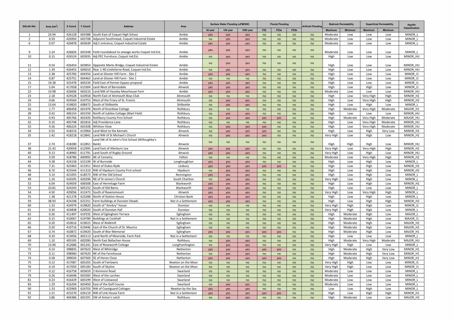
30 year 100 year 1000 year FZ2 FZ3a FZ3b Maximum Minimum Maximum Minimum
1 24.94 426128 603388 South-East of Coquet High School Amble yes yes yes no no no no Moderate Low Low Low MINOR_L
2 0.59 426950 603708 Adjacent Southmead, Coquet Industrial Estate Amble no yes yes no no no no Moderate Low Low Low MINOR_L
6 0.07 426878 603639 Adj E entrance, Coquet Industrial Estate Amble yes yes yes no no no no Moderate Low Low Low MINOR_L
9 2.24 426826 603348 Field roundabout to sewage works Coquet Ind.Est. Ambleyes yes yes no no no no
Moderate Low Low Low MINOR_L
10 0.15 426524 603935 Adj PEC Furniture, Coquet Ind.Est. Amble no yes yes no no no no High Low Low Low MINOR_HU
11 0.54 426454 603854 Opposite Marks Bridge, Coquet Industrial Estate Ambleno yes yes no no no no
High Low Low Low MINOR_HU
12 1.39 426453 604010 Rear 1-40 Lindisfarne Road, Coquet Ind.Est. Amble no yes yes no no no no High Low Low Low MINOR_HU
13 2.38 425783 604356 Land at Gloster Hill Farm - Site 2 Amble yes yes yes no no no no High Low Low Low MINOR_I1
14 0.87 425751 604463 Land at Gloster Hill Farm - Site 1 Amble no no no no no no no High Low Low Low MINOR_I1
15 19.38 425478 604234 Field East of former bypass proposal Amble yes yes yes no no no no High Low Low Low MINOR_I1
17 5.04 417658 613304 Land West of Barresdale Alnwick yes yes yes no no no no High Low High Low MINOR_I1
22 10.98 426606 603210 Land NW of Hauxley Moorhouse Farm Amble yes yes yes no no no no Moderate Low Low Low MINOR_HU
23 2.18 424528 610918 North-East of Alnmouth Boys Club Alnmouth no no no no no no no High Low Very High High MINOR_H2
24 0.66 424564 610753 West of the Friary of St. Francis Alnmouth no yes yes no no no no High Low Very High High MINOR_H2
25 13.64 419820 608472 South of Shilbottle Shilbottle no yes yes no no no no High Low High Low MINOR_L
26 1.77 406458 601976 North of Knocklaw Cottage Rothbury no no no no no no no High Moderate Very High Moderate MAJOR_H1
28 0.42 406154 601550 North of Jubilee Cottage (Mart Field) Rothbury no yes yes no no no no High Low Low Low MINOR_HU
31 0.93 405766 601920 Rothbury County First School Rothbury no yes yes yes yes no no High Moderate Very High Moderate MAJOR_HU
32 0.10 405748 601816 Adj Providence Lane Rothbury no no no no no no no High Low Very High Moderate MINOR_HU
33 4.56 406224 601928 Whitton View Rothbury no yes yes yes no no no High Low Very High Moderate MINOR_HU
34 0.55 418216 613964 Land West to the Kennels Alnwick no yes yes yes no no no High Low High Very Low MINOR_H2
35 1.42 418218 613841 Land NW of St Michael's Church Alnwick no yes yes yes no no no Very High Low High Low MINOR_H2
37 2.74 418280 612851
Land SW of St John's First School (Willoughby's
Bank) Alnwickno no no no no no no
High High High Low MINOR_HU
38 21.42 420058 612995 Land East of Allerburn Lea Alnwick yes yes yes no no no no Very High Low Very High High MINOR_H2
40 9.13 418960 611791 Land South of Rugby Ground Alnwick yes yes yes no no no no Very High Low High Low MINOR_HU
42 3.59 418786 600992 NE of Cemetry Felton no no no no no no no Moderate Low Very High High MINOR_H2
44 9.38 424158 615199 W of Burnside Longhoughton yes yes yes no no no no High Low High Low MINOR_L
45 7.31 423463 611911 West of Dukes Ryde Lesbury yes yes yes yes yes no no High Low High Low MINOR_H2
46 8.70 423544 611319 NW of Hipsburn County First school Hipsburn no yes yes no no no no High Low High Low MINOR_H2
48 3.14 421055 618573 NW of the Old School Rennington yes yes yes no no no no High Low High Low MINOR_L
49 1.16 416595 620296 NE of St James's Church South Charlton no yes yes no no no no Very High Low High Low MINOR_L
52 6.04 424659 606508 East of Hermitage Farm Warkworth yes yes yes no no no no High Low High Low MINOR_H2
53 10.81 424243 605152 South of Old Barns Warkworth yes yes yes no no no no High Low Low Low MINOR_L
54 4.50 420056 612473 South of Ravensmount Alnwick yes yes yes no no no no Very High Low Very High High MINOR_L
55 1.38 421278 623288 North of Station House Christon Bank yes yes yes no no no no High Low High Low MINOR_L
59 38.93 424248 622251 Farm buildings at Dunstan Steads Not in a Settlement yes yes yes no no no no High Low High High MINOR_H2
60 1.23 424979 619820 South of "Annbry" house Dunstan no no no no no no no Very High High High Low MINOR_I1
61 0.34 424838 620020 South of Dunstan Hall Dunstan no no no no no no no Very High High High Low MINOR_L
62 0.26 411407 619192 West of Eglingham Terrace Eglingham no no no no no no no High Moderate High Low MAJOR_L
63 0.15 410067 619789 Buildings at Cockhall Not in a Settlement no no no no no no no High Moderate High Low MAJOR_I1
65 0.20 410616 619615 West of Walkmill Eglingham no no no no no no no High Moderate High Low MAJOR_H2
66 0.20 410716 619446 East of the Church of St. Maurice Eglingham no no no no no no no High Moderate High Low MAJOR_H2
67 0.74 410872 619420 South of War Memorial Eglingham yes yes yes yes yes no no High Moderate High Low MAJOR_H1
68 0.33 413056 602113 Land North of Moorside, Farm Park Not in a Settlement no no no no no no no High Low Low Low MINOR_L
69 1.10 405595 602090 North East Ballachan House Rothbury no yes yes no no no no High Moderate Very High Moderate MAJOR_HU
70 13.96 412686 601241 East of Roseworth Cottage Longframlington no yes yes no no no no Very High High Low Low MINOR_L
72 0.14 398835 607623 West of Whitridge Netherton yes yes yes yes yes no no High Moderate High Very Low MINOR_H1
73 0.11 398960 607620 NE of the Farmhouse Netherton no yes yes no no no no High Moderate High Very Low MINOR_H1
74 0.58 399034 607569 SE of Heron Close Netherton yes yes yes yes yes no no High Moderate High Very Low MINOR_H1
75 0.12 417087 605203 South of Fairlawns Newton on the Moor no no no no no no no Very High High Low Low MINOR_I1
76 0.19 417050 605183 South of Skyline Newton on the Moor no no no no no no no Very High High Low Low MINOR_I1
77 0.12 416758 603659 2 Kenmore Road Swarland no no no no no no no Moderate Low Low Low MINOR_L
79 0.26 416648 603583 West of the Larches Swarland no no no no no no no Moderate Low Low Low MINOR_L
81 0.23 416429 603199 West of Lislewood Swarland no no no no no no no Moderate Low Low Low MINOR_L
83 1.29 416204 603450 East of the Golf Course Swarland no yes yes no no no no Moderate Low Low Low MINOR_L
90 1.33 423969 624703 NW of Coastguard Cottages Newton by the Sea yes yes yes no no no no Low Low High Low MINOR_L
91 2.21 423270 626119 NW of Link House Farm Not in a Settlement yes yes yes yes yes no no High Low High High MINOR_H1
92 3.86 404386 601591 SW of Anton's Letch Rothbury no yes yes no no no no High Moderate Low Low MAJOR_H3
Aquifer
Classification SHLAA Ref. Area (km
2) X Coord Y Coord Address Area
Surface Water Flooding (uFMfSW) Fluvial Flooding Artficial Flooding
Bedrock Permeability Superficial Permeability
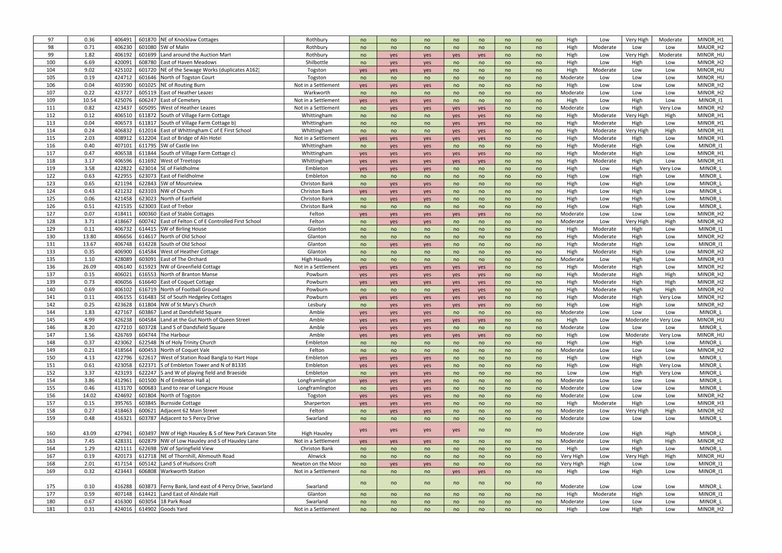
97 0.36 406491 601870 NE of Knocklaw Cottages Rothbury no no no no no no no High Low Very High Moderate MINOR_H1
98 0.71 406230 601080 SW of Malin Rothbury no no no no no no no High Moderate Low Low MAJOR_H2
99 1.82 406192 601699 Land around the Auction Mart Rothbury no yes yes yes yes no no High Low Very High Moderate MINOR_HU
100 6.69 420091 608780 East of Haven Meadows Shilbottle no yes yes no no no no High Low High Low MINOR_H2
104 9.02 425102 601720 NE of the Sewage Works (duplicates A162) Togston yes yes yes no no no no High Moderate Low Low MINOR_HU
105 0.19 424712 601646 North of Togston Court Togston no no no no no no no Moderate Low Low Low MINOR_HU
106 0.04 403590 601025 NE of Routing Burn Not in a Settlement yes yes yes no no no no High Low Low Low MINOR_H2
107 0.22 423727 605119 East of Heather Leazes Warkworth no no no no no no no Moderate Low Low Low MINOR_H2
109 10.54 425076 606247 East of Cemetery Not in a Settlement yes yes yes no no no no High Low High Low MINOR_I1
111 0.82 423437 605095 West of Heather Leazes Not in a Settlement no yes yes yes yes no no Moderate Low High Very Low MINOR_H2
112 0.12 406510 611872 South of Village Farm Cottage Whittingham no no no yes yes no no High Moderate Very High High MINOR_H1
113 0.04 406573 611817 South of Village Farm Cottage b) Whittingham no no no yes yes no no High Moderate High Low MINOR_H1
114 0.24 406832 612014 East of Whittingham C of E First School Whittingham no no no yes yes no no High Moderate Very High High MINOR_H1
115 2.03 408912 612204 East of Bridge of Aln Hotel Not in a Settlement yes yes yes yes yes no no High Moderate High Low MINOR_H1
116 0.40 407101 611795 SW of Castle Inn Whittingham no yes yes no no no no High Moderate High Low MINOR_I1
117 0.47 406538 611844 South of Village Farm Cottage c) Whittingham yes yes yes yes yes no no High Moderate High Low MINOR_H1
118 3.17 406596 611692 West of Treetops Whittingham yes yes yes yes yes no no High Moderate High Low MINOR_H1
119 3.58 422822 623014 SE of Fieldholme Embleton yes yes yes no no no no High Low High Very Low MINOR_L
122 0.63 422955 623073 East of Fieldholme Embleton no no no no no no no High Low High Low MINOR_L
123 0.65 421194 622843 SW of Mountview Christon Bank no yes yes no no no no High Low High Low MINOR_L
124 0.43 421232 623103 NW of Church Christon Bank yes yes yes no no no no High Low High Low MINOR_L
125 0.06 421458 623023 North of Eastfield Christon Bank no yes yes no no no no High Low High Low MINOR_L
126 0.51 421535 623003 East of Trebor Christon Bank no no no no no no no High Low High Low MINOR_L
127 0.07 418411 600360 East of Stable Cottages Felton yes yes yes yes yes no no Moderate Low Low Low MINOR_H2
128 3.71 418667 600742 East of Felton C of E Controlled First School Felton no yes yes no no no no Moderate Low Very High High MINOR_H2
129 0.11 406732 614415 SW of Birling House Glanton no no no no no no no High Moderate High Low MINOR_I1
130 13.80 406656 614617 North of Old School Glanton no no no no no no no High Moderate High Low MINOR_H2
131 13.67 406748 614228 South of Old School Glanton no yes yes no no no no High Moderate High Low MINOR_I1
133 0.35 406900 614584 West of Heather Cottage Glanton no no no no no no no High Moderate High Low MINOR_H2
135 1.10 428089 603091 East of The Orchard High Hauxley no no no no no no no Moderate Low High Low MINOR_H3
136 26.09 406140 615923 NW of Greenfield Cottage Not in a Settlement yes yes yes yes yes no no High Moderate High Low MINOR_H2
137 0.15 406021 616553 North of Branton Manse Powburn yes yes yes yes yes no no High Moderate High High MINOR_H2
139 0.73 406056 616640 East of Coquet Cottage Powburn yes yes yes yes yes no no High Moderate High High MINOR_H2
140 0.69 406102 616719 North of Football Ground Powburn no no no yes yes no no High Moderate High High MINOR_H2
141 0.11 406155 616483 SE of South Hedgeley Cottages Powburn yes yes yes yes yes no no High Moderate High Very Low MINOR_H2
142 0.25 423628 611804 NW of St Mary's Church Lesbury no yes yes yes yes no no High Low High Low MINOR_H2
144 1.83 427167 603867 Land at Dandsfield Square Amble yes yes yes no no no no Moderate Low Low Low MINOR_L
145 4.99 426238 604584 Land at the Gut North of Queen Street Amble yes yes yes yes yes no no High Low Moderate Very Low MINOR_HU
146 8.20 427210 603728 Land S of Dandsfield Square Amble yes yes yes no no no no Moderate Low Low Low MINOR_L
147 1.56 426769 604744 The Harbour Amble yes yes yes yes yes no no High Low Moderate Very Low MINOR_HU
148 0.37 423062 622548 N of Holy Trinity Church Embleton no no no no no no no High Low High Low MINOR_L
149 0.21 418564 600453 North of Coquet Vale Felton no no no no no no no Moderate Low Low Low MINOR_H2
150 4.13 422796 622617 West of Station Road Bangla to Hart Hope Embleton yes yes yes no no no no High Low High Low MINOR_L
151 0.61 423058 622371 S of Embleton Tower and N of B1339 Embleton yes yes yes no no no no High Low High Very Low MINOR_L
152 3.37 423193 622247 S and W of playing field and Braeside Embleton no yes yes no no no no Low Low High Very Low MINOR_L
154 3.86 412961 601500 N of Embleton Hall a) Longframlington yes yes yes no no no no Moderate Low Low Low MINOR_L
155 0.46 413170 600683 Land to rear of Longacre House Longframlington no yes yes no no no no Moderate Low Low Low MINOR_L
156 14.02 424692 601804 North of Togston Togston yes yes yes no no no no Moderate Low Low Low MINOR_H2
157 0.15 395765 603845 Burnside Cottage Sharperton yes yes yes no no no no High Moderate High Low MINOR_H3
158 0.27 418463 600621 Adjacent 62 Main Street Felton no yes yes no no no no Moderate Low Very High High MINOR_H2
159 0.48 416321 603787 Adjacent to 5 Percy Drive Swarland no no no no no no no Moderate Low Low Low MINOR_L
160 43.09 427941 603497 NW of High Hauxley & S of New Park Caravan Site High Hauxleyyes yes yes yes no no no
Moderate Low High High MINOR_L
163 7.45 428331 602879 NW of Low Hauxley and S of Hauxley Lane Not in a Settlement yes yes yes no no no no Moderate Low High High MINOR_H2
164 1.29 421111 622698 SW of Springfield View Christon Bank no no no no no no no High Low High Low MINOR_L
167 0.19 420173 612718 NE of Thornhill, Alnmouth Road Alnwick no no no no no no no Very High Low Very High High MINOR_HU
168 2.01 417154 605142 Land S of Hudsons Croft Newton on the Moor no yes yes no no no no Very High High Low Low MINOR_I1
169 0.32 423443 606808 Warkworth Station Not in a Settlement no no no yes yes no no High Low High Low MINOR_I1
175 0.10 416288 603873 Ferny Bank, land east of 4 Percy Drive, Swarland Swarlandno no no no no no no
Moderate Low Low Low MINOR_L
177 0.59 407148 614421 Land East of Alndale Hall Glanton no no no no no no no High Moderate High Low MINOR_I1
180 0.67 416300 603054 18 Park Road Swarland no no no no no no no Moderate Low Low Low MINOR_L
181 0.31 424016 614902 Goods Yard Not in a Settlement no no no no no no no High Low High Low MINOR_H2
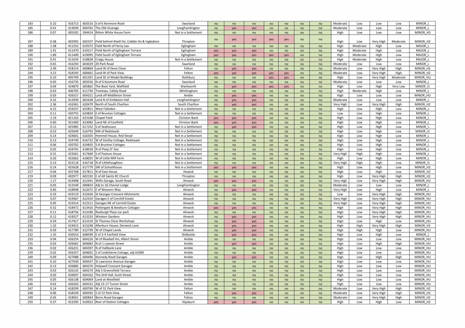
183 0.10 416713 603516 S of 6 Kenmore Road Swarland no no no no no no no Moderate Low Low Low MINOR_L
185 0.41 413039 600762 The Old Vicarage Longframlington no yes yes no no no no Moderate Low Low Low MINOR_L
186 0.07 405502 594414 Ritton White House Farm Not in a Settlement no no no no no no no High Low Low Low MINOR_H3
187 0.48 402902 602337 Field behind Alwill Ho, Cobble Ho & Ingledene Throptonno yes yes yes yes no no
High Low Very High Moderate MINOR_H2
188 1.38 411253 619372 Field North of Ferny Lea Eglingham no no no no no no no High Moderate High Low MAJOR_L
189 1.91 411470 619217 Field North of Eglingham Terrace Eglingham yes yes yes no no no no High Moderate High Low MAJOR_L
190 1.89 411449 619095 Field South of Eglingham Terrace Eglingham yes yes yes yes yes no no High Moderate High Low MAJOR_L
191 0.41 411634 618828 Craigs House Not in a Settlement no no no no no no no High Moderate High Low MAJOR_L
192 0.65 416293 603029 20 Park Road Swarland no no no no no no no Moderate Low Low Low MINOR_L
193 2.49 418214 600869 Land W of Dene Close Felton no yes yes no no no no Moderate Low Very High High MINOR_H2
194 3.15 418193 600661 Land W of Park View Felton yes yes yes yes yes no no Moderate Low Very High High MINOR_H2
195 0.10 405709 601591 Land SE of Model Buildings Rothbury no no no yes yes no no High Low Very High Moderate MINOR_HU
196 0.05 416735 603556 N of 6 Kenmore Road Swarland no no no no no no no Moderate Low Low Low MINOR_L
197 0.04 424879 605862 The Boat Yard, Wellfield Warkworth no yes yes yes yes no no High Low High Very Low MINOR_I1
198 0.63 406765 611750 Treetops, Callaly Road Whittingham no no no no no no no High Moderate High Low MINOR_L
199 0.03 426557 604321 Land off Middleton Street Amble no yes yes no no no no High Low Low Low MINOR_HU
200 0.32 412939 601628 Land N of Embleton Hall Longframlington no yes yes no no no no Moderate Low Low Low MINOR_L
202 2.36 416361 620479 North of South Charlton South Charlton no yes yes no no no no Very High Low Very High High MINOR_H2
203 0.22 419237 622811 West Fallodon Not in a Settlement no no no no no no no High Low High Low MINOR_L
204 0.11 420755 624834 E of Brunton Cottages Not in a Settlement no no no no no no no Low Low High Low MINOR_L
205 2.19 421163 623168 Chapel Field Christon Bank yes yes yes no no no no High Low High Low MINOR_L
206 0.60 421460 623082 Land NE of Eastfield Christon Bank yes yes yes no no no no High Low High Low MINOR_L
207 0.15 425985 617232 S of Seahouses Not in a Settlement no yes yes no no no no High Low High Low MINOR_L
208 0.23 425049 616793 NW of Redsteads Not in a Settlement no no no no no no no High Low High Low MINOR_I1
209 0.14 424601 616505 Hemmel House, Red Stead Not in a Settlement no no no no no no no High Low High Low MINOR_L
210 0.13 424749 616732 W of Smithy Cottage, Redsteads Not in a Settlement no no no no no no no High Low High Low MINOR_L
211 0.06 420702 624835 5-6 Brunton Cottages Not in a Settlement no no no no no no no High Low High Low MINOR_L
212 0.02 424741 618018 N of Peep O' Sea Not in a Settlement no no no no no no no High Low High Low MINOR_L
213 0.31 423561 617669 S of Pasture House Not in a Settlement no no no no no no no Very High High High Low MINOR_L
214 0.20 422662 618025 W of Little Mill Farm Not in a Settlement no no no no no no no High Low High Low MINOR_L
215 0.13 423118 616718 N of Littlehoughton Not in a Settlement no no no no no no no Very High High High Low MINOR_I1
216 0.14 425628 617779 SW of Schoolhouse Not in a Settlement yes yes yes no no no no High Low High Low MINOR_H2
217 0.04 425768 617811 N of East House Howick no no no no no no no High Low High Low MINOR_H2
219 0.09 402977 602192 E of All Saints RC Church Thropton no no no no no no no High Low Very High High MINOR_H2
220 1.27 419498 612441 Willis Garage, South Road Alnwick yes yes yes no no no no Very High Low Very High High MINOR_HU
221 0.05 412549 600833 Adj to 16 Cheviot Lodge Longframlington no no no no no no no Moderate Low Low Low MINOR_L
222 0.83 418948 612072 E of Weavers Way Alnwick no yes yes no no no no Very High Low High Low MINOR_L
223 0.33 419119 612626 St Georges Crescent Allotments Alnwick no no no no no no no Low Low Very High High MINOR_HU
224 0.07 419367 612419 Garages E of Cornhill Estate Alnwick no no no no no no no Very High Low Very High High MINOR_HU
225 0.05 419314 612511 Garages NE of Cornhill Estate Alnwick no no no no no no no Very High Low Very High High MINOR_HU
226 0.32 418472 613416 Pottergate & Bowburn Cottages Alnwick yes yes yes no no no no High Low Very High High MINOR_HU
227 0.11 418756 613186 Roxburgh Place car park Alnwick no no no no no no no High Low Very High High MINOR_HU
228 0.12 418327 613233 Windsor Gardens Alnwick no yes yes no no no no High Low Very High High MINOR_HU
229 0.29 417917 613159 St Thomas Close Workshops Alnwick no yes yes no no no no High Low High Low MINOR_HU
230 1.32 419415 613248 Allerburn House, Denwick Lane Alnwick no yes yes no no no no High High Very High High MINOR_H2
231 0.59 417789 612799 W of Chapel Lands Alnwick no yes yes no no no no High High High Low MINOR_HU
232 1.35 420553 608599 E of 3-4 Fairfield View Shilbottle no yes yes no no no no High Low High Low MINOR_L
233 0.04 426254 604226 W of Bluebell Inn, Albert Street Amble no no no no no no no High Low Low Low MINOR_HU
235 0.03 426662 604683 N of 1 Lawson Street Amble no yes yes no no no no High Low High High MINOR_HU
236 0.02 426231 604397 N of Hallbank Lane Amble no no no no no no no High Low Low Low MINOR_HU
239 0.02 426357 604001 S of Lindisfarne Cottage, adj A1068 Amble no no no no no no no High Low Low Low MINOR_HU
240 0.09 427088 604496 Kennedy Road Garages Amble no yes yes no no no no High Low High High MINOR_HU
241 0.10 427030 604437 St Lawrence Avenue Garages Amble no no no no no no no High Low Low Low MINOR_HU
242 0.13 426885 604370 Holywell Crescent Garages Amble no no no no no no no High Low Low Low MINOR_HU
243 0.03 426142 604274 Adj 3 Greensfield Terrace Amble no no no no no no no High Low Low Low MINOR_HU
244 0.03 426097 604162 The Drill Hall, Scott Street Amble no no no no no no no High Low Low Low MINOR_HU
245 0.05 426138 604069 Land at Westfield Amble no no no no no no no High Low Low Low MINOR_HU
246 0.02 426503 604531 Adj 15-17 Turner Street Amble no no no no no no no High Low Low Low MINOR_HU
247 0.14 418299 600769 W of 31 Park View Felton no no no no no no no Moderate Low Very High High MINOR_H2
248 0.06 418249 600592 S of 22 Park View Felton no yes yes no no no no Moderate Low Very High High MINOR_H3
249 0.45 418561 600843 Barns Road Garages Felton no no no no no no no Moderate Low Very High High MINOR_H2
250 0.37 423295 610922 Rear of Station Cottages Hipsburn yes yes yes no no no no High Low High Low MINOR_H2
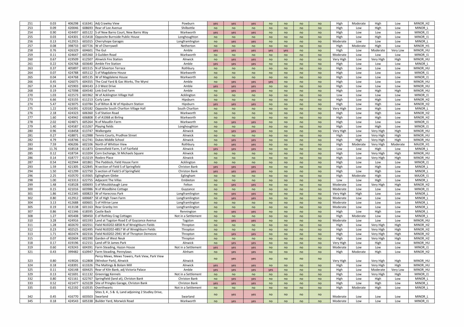
251 0.03 406298 616341 Adj Crawley View Powburn yes yes yes no no no no High Moderate High Low MINOR_H2
253 0.09 420046 608693 Rear of Lee Avenue Shilbottle no no no no no no no High Low High Low MINOR_L
254 0.90 424497 605122 S of New Barns Court, New Barns Way Warkworth yes yes yes no no no no High Low Low Low MINOR_I1
255 0.03 424301 615418 Opposite Burnside Public House Longhoughton no no no no no no no High Low High Low MINOR_I1
256 0.13 412915 601015 Cherryhope Garages Longframlington no yes yes no no no no Moderate Low Low Low MINOR_L
257 0.08 398733 607726 W of Cherrywell Netherton no no no no no no no High Moderate High Low MINOR_H1
258 0.76 426329 604601 The Gut Amble yes yes yes yes yes no no High Low Moderate Very Low MINOR_HU
259 0.11 424647 605360 3 Guilden Road Warkworth no no no no no no no Moderate Low Low Low MINOR_I1
260 0.67 419509 612507 Alnwick Fire Station Alnwick no yes yes no no no no Very High Low Very High High MINOR_HU
261 0.22 426768 603640 Amble Fire Station Amble yes yes yes no no no no High Low Low Low MINOR_L
263 0.37 405897 601515 N of Silverton Terrace Rothbury no no no no no no no High Low Low Low MINOR_HU
264 0.07 424788 605112 S of Magdalene House Warkworth no no no no no no no High Low Low Low MINOR_I1
265 0.04 424768 605135 W of Magdalene House Warkworth no no no no no no no High Low Low Low MINOR_I1
266 0.45 426075 604355 The Coal Yard & Gas Works, The Wynd Amble no yes yes yes no no no High Low Low Low MINOR_HU
267 0.24 425903 604143 2-3 West Drive Amble yes yes yes no no no no High Low Low Low MINOR_HU
268 0.19 427098 604540 Link End Farm Amble no yes yes no no no no High Low High High MINOR_HU
270 1.03 422573 601962 W of Acklington Village Hall Acklington no no no no no no no Low Low Low Low MINOR_I1
273 6.66 423155 611213 Curly Lane Hipsburn no no no no no no no High Low High Low MINOR_H2
274 5.47 423075 610784 S of Bilton & W of Hipsburn Station Hipsburn yes yes yes no no no no High Low High Low MINOR_H2
275 1.22 416391 620182 Opposite South Charlton Village Hall South Charlton no no no no no no no Very High Low High Low MINOR_L
276 2.18 424323 606360 S of Station Road Warkworth no no no no no no no High Low High Low MINOR_H2
277 1.60 424942 606808 E of A1068 at Birling Warkworth no no no no no no no High Low High Low MINOR_H2
278 2.02 424871 605264 N of Maudlin Farm Warkworth no yes yes no no no no High Low Low Low MINOR_I1
279 1.40 424587 615267 Playing fields Longhoughton no no no no no no no High Low High Low MINOR_I1
280 0.96 418458 613747 Walkergate Alnwick no yes yes no no no no Very High Low Very High High MINOR_HU
281 0.27 418871 612988 Tennis Courts, Prudhoe Street Alnwick no no no no no no no High Low Very High High MINOR_HU
282 4.79 418746 612741 Dukes Middle School Alnwick no yes yes no no no no High High Very High High MINOR_HU
283 7.59 406206 602106 North of Whitton View Rothbury no yes yes no no no no High Moderate Very High Moderate MAJOR_H1
284 11.76 418518 611873 Greensfield Farm, S of Fairfield Alnwick yes yes yes no no no no Low Low High Low MINOR_L
285 0.12 418734 613204 Corn Exchange, St Michaels Square Alnwick no no no no no no no High Low Very High High MINOR_HU
286 0.14 418777 613219 Roxbro Place Alnwick no no no no no no no High Low Very High High MINOR_HU
287 0.54 422944 601861 The Paddock, Field House Farm Acklington no no no no no no no High Low Low Low MINOR_I1
293 1.59 421305 622845 N section of Field S of Springfield Christon Bank yes yes yes no no no no High Low High Low MINOR_L
294 1.50 421299 622750 S section of Field S of Springfield Christon Bank yes yes yes no no no no High Low High Low MINOR_L
296 2.25 410570 619365 Eglingham Glebe Eglingham no no no no no no no High Moderate High Low MAJOR_I1
298 1.00 423313 622755 Adjacent The Villas Embleton no no no no no no no Low Low High Low MINOR_L
299 1.48 418528 600693 S of Mouldshaugh Lane Felton no yes yes no no no no Moderate Low Very High High MINOR_H2
300 0.15 421016 603986 N of Woodbine Cottage Guyzance no no no no no no no Moderate Low Low Low MINOR_I1
301 1.86 412345 600823 W of Harecross Park Longframlington no yes yes no no no no Very High High Low Low MINOR_L
302 0.80 412912 600687 SE of High Town Farm Longframlington no yes yes no no no no Moderate Low Low Low MINOR_L
304 3.13 412688 600601 S of Hillrise Lane Longframlington no no no no no no no Moderate Low Low Low MINOR_L
305 0.19 413138 601163 Rear Granby Inn Longframlington no no no no no no no Moderate Low Low Low MINOR_L
307 0.86 421346 618595 Castle Back Rennington no yes yes no no no no High Low High Low MINOR_L
308 1.27 405408 589450 E of Rothley Crag Cottages Not in a Settlement no no no no no no no High Moderate Low Low MINOR_L
310 3.28 424916 601593 Land at Togston Road E of Guyzance Avenue Togston no yes yes no no no no Moderate Low Low Low MINOR_HU
311 1.28 402670 602551 Field NU0202-6858 N of Wreighburn Fields Thropton no no no no no no no High Low Very High High MINOR_H2
312 0.23 402525 602495 Field NU0202-4857 W of Wreighburn Fields Thropton no no no no no no no High Low Very High High MINOR_H2
313 1.71 402474 602316 Field NU0202-2941 W of Thropton Demesne Thropton no yes yes no no no no High Low Very High High MINOR_H2
315 0.07 402604 602390 Garden of West Neuk Thropton no no no no no no no High Low Very High High MINOR_H2
318 0.17 419196 612151 Land off St James Park Alnwick no yes yes no no no no Very High Low High Low MINOR_HU
319 0.60 419243 604391 Farm Steading, Hazon House Not in a Settlement yes yes yes no no no no Moderate Low Low Low MINOR_I1
321 0.43 399482 610947 Farm Steading, Pennylaws Alnham no yes yes no no no no High Moderate High Low MINOR_H2
323 0.80 419026 612808
Percy Mews, Mews Towers, Park View, Park View
(Windsor Park), Alnwick Alnwickno yes yes no no no no
Very High Low Very High High MINOR_HU
324 0.18 418391 613326 The Maltings & Bolam Mill Alnwick yes yes yes no no no no High Low Very High High MINOR_HU
325 0.11 426148 604425 Rear of Kiln Bank, adj Victoria Palace Amble yes yes yes yes no no no High Low Moderate Very Low MINOR_HU
329 0.13 421691 611132 Greenrigg Kennels Not in a Settlement no no no no no no no High Low Very High High MINOR_I1
332 0.80 421161 622767 Springfield (land at), Christon Bank Christon Bank no yes yes no no no no High Low High Low MINOR_L
333 0.52 421477 623228 Site of Pringles Garage, Christon Bank Christon Bank yes yes yes no no no no High Low High Low MINOR_L
335 0.65 412192 610535 Overthwarts Not in a Settlement no no no no no no no High Moderate High Low MINOR_L
342 0.45 416770 603503
Sites 3, 4 , 5 & 6, Land adjoining 2 Studley Drive,
Swarland Swarlandno yes yes no no no no
Moderate Low Low Low MINOR_L
345 0.18 424543 605338 Builder Yard, Morwick Road Warkworth no yes yes no no no no Moderate Low Low Low MINOR_I1
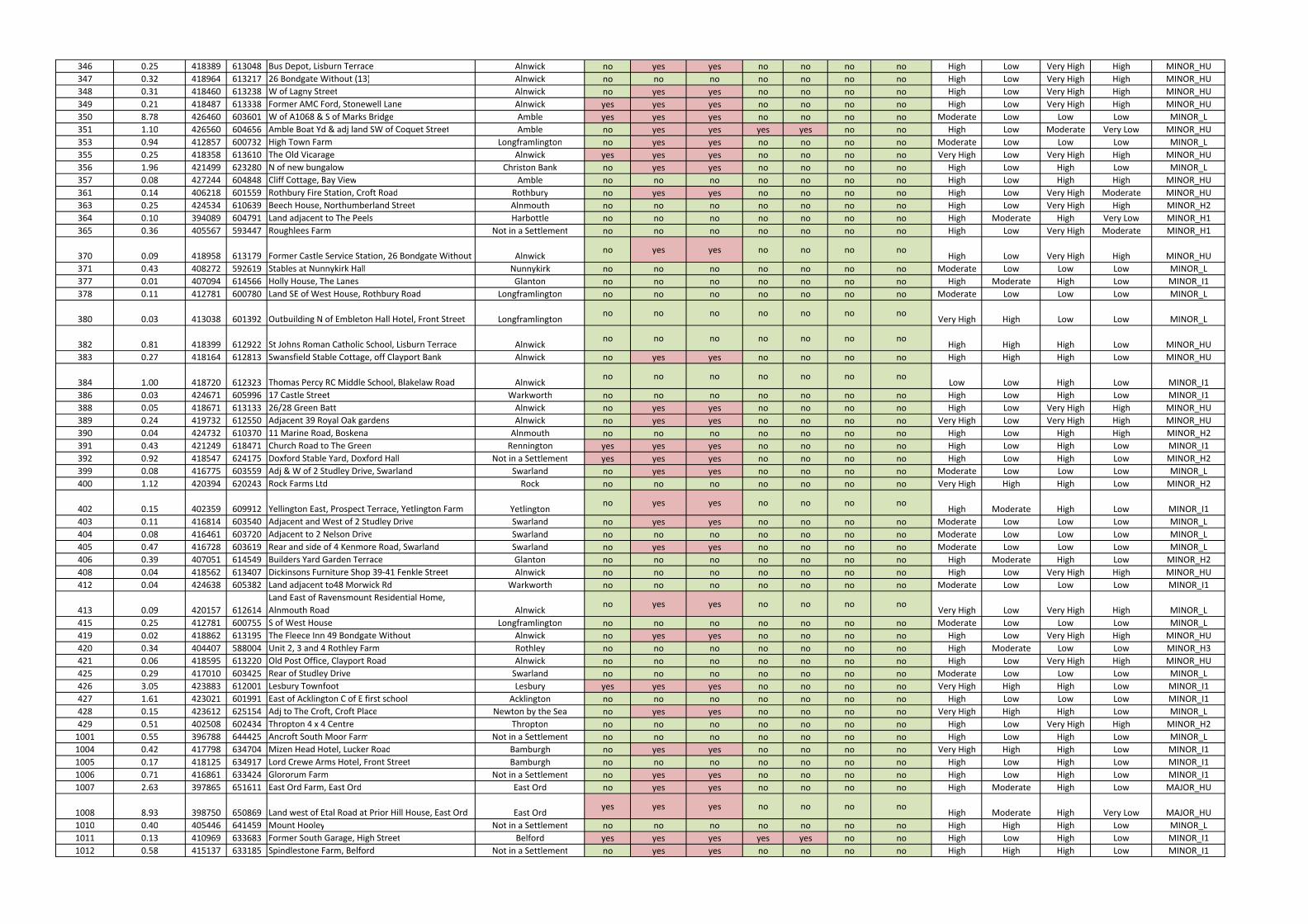
346 0.25 418389 613048 Bus Depot, Lisburn Terrace Alnwick no yes yes no no no no High Low Very High High MINOR_HU
347 0.32 418964 613217 26 Bondgate Without (13) Alnwick no no no no no no no High Low Very High High MINOR_HU
348 0.31 418460 613238 W of Lagny Street Alnwick no yes yes no no no no High Low Very High High MINOR_HU
349 0.21 418487 613338 Former AMC Ford, Stonewell Lane Alnwick yes yes yes no no no no High Low Very High High MINOR_HU
350 8.78 426460 603601 W of A1068 & S of Marks Bridge Amble yes yes yes no no no no Moderate Low Low Low MINOR_L
351 1.10 426560 604656 Amble Boat Yd & adj land SW of Coquet Street Amble no yes yes yes yes no no High Low Moderate Very Low MINOR_HU
353 0.94 412857 600732 High Town Farm Longframlington no yes yes no no no no Moderate Low Low Low MINOR_L
355 0.25 418358 613610 The Old Vicarage Alnwick yes yes yes no no no no Very High Low Very High High MINOR_HU
356 1.96 421499 623280 N of new bungalow Christon Bank no yes yes no no no no High Low High Low MINOR_L
357 0.08 427244 604848 Cliff Cottage, Bay View Amble no no no no no no no High Low High High MINOR_HU
361 0.14 406218 601559 Rothbury Fire Station, Croft Road Rothbury no yes yes no no no no High Low Very High Moderate MINOR_HU
363 0.25 424534 610639 Beech House, Northumberland Street Alnmouth no no no no no no no High Low Very High High MINOR_H2
364 0.10 394089 604791 Land adjacent to The Peels Harbottle no no no no no no no High Moderate High Very Low MINOR_H1
365 0.36 405567 593447 Roughlees Farm Not in a Settlement no no no no no no no High Low Very High Moderate MINOR_H1
370 0.09 418958 613179 Former Castle Service Station, 26 Bondgate Without Alnwickno yes yes no no no no
High Low Very High High MINOR_HU
371 0.43 408272 592619 Stables at Nunnykirk Hall Nunnykirk no no no no no no no Moderate Low Low Low MINOR_L
377 0.01 407094 614566 Holly House, The Lanes Glanton no no no no no no no High Moderate High Low MINOR_I1
378 0.11 412781 600780 Land SE of West House, Rothbury Road Longframlington no no no no no no no Moderate Low Low Low MINOR_L
380 0.03 413038 601392 Outbuilding N of Embleton Hall Hotel, Front Street Longframlingtonno no no no no no no
Very High High Low Low MINOR_L
382 0.81 418399 612922 St Johns Roman Catholic School, Lisburn Terrace Alnwickno no no no no no no
High High High Low MINOR_HU
383 0.27 418164 612813 Swansfield Stable Cottage, off Clayport Bank Alnwick no yes yes no no no no High High High Low MINOR_HU
384 1.00 418720 612323 Thomas Percy RC Middle School, Blakelaw Road Alnwickno no no no no no no
Low Low High Low MINOR_I1
386 0.03 424671 605996 17 Castle Street Warkworth no no no no no no no High Low High Low MINOR_I1
388 0.05 418671 613133 26/28 Green Batt Alnwick no yes yes no no no no High Low Very High High MINOR_HU
389 0.24 419732 612550 Adjacent 39 Royal Oak gardens Alnwick no yes yes no no no no Very High Low Very High High MINOR_HU
390 0.04 424732 610370 11 Marine Road, Boskena Alnmouth no no no no no no no High Low High High MINOR_H2
391 0.43 421249 618471 Church Road to The Green Rennington yes yes yes no no no no High Low High Low MINOR_I1
392 0.92 418547 624175 Doxford Stable Yard, Doxford Hall Not in a Settlement yes yes yes no no no no High Low High Low MINOR_H2
399 0.08 416775 603559 Adj & W of 2 Studley Drive, Swarland Swarland no yes yes no no no no Moderate Low Low Low MINOR_L
400 1.12 420394 620243 Rock Farms Ltd Rock no no no no no no no Very High High High Low MINOR_H2
402 0.15 402359 609912 Yellington East, Prospect Terrace, Yetlington Farm Yetlingtonno yes yes no no no no
High Moderate High Low MINOR_I1
403 0.11 416814 603540 Adjacent and West of 2 Studley Drive Swarland no yes yes no no no no Moderate Low Low Low MINOR_L
404 0.08 416461 603720 Adjacent to 2 Nelson Drive Swarland no no no no no no no Moderate Low Low Low MINOR_L
405 0.47 416728 603619 Rear and side of 4 Kenmore Road, Swarland Swarland no yes yes no no no no Moderate Low Low Low MINOR_L
406 0.39 407051 614549 Builders Yard Garden Terrace Glanton no no no no no no no High Moderate High Low MINOR_H2
408 0.04 418562 613407 Dickinsons Furniture Shop 39-41 Fenkle Street Alnwick no no no no no no no High Low Very High High MINOR_HU
412 0.04 424638 605382 Land adjacent to48 Morwick Rd Warkworth no no no no no no no Moderate Low Low Low MINOR_I1
413 0.09 420157 612614
Land East of Ravensmount Residential Home,
Alnmouth Road Alnwickno yes yes no no no no
Very High Low Very High High MINOR_L
415 0.25 412781 600755 S of West House Longframlington no no no no no no no Moderate Low Low Low MINOR_L
419 0.02 418862 613195 The Fleece Inn 49 Bondgate Without Alnwick no yes yes no no no no High Low Very High High MINOR_HU
420 0.34 404407 588004 Unit 2, 3 and 4 Rothley Farm Rothley no no no no no no no High Moderate Low Low MINOR_H3
421 0.06 418595 613220 Old Post Office, Clayport Road Alnwick no no no no no no no High Low Very High High MINOR_HU
425 0.29 417010 603425 Rear of Studley Drive Swarland no no no no no no no Moderate Low Low Low MINOR_L
426 3.05 423883 612001 Lesbury Townfoot Lesbury yes yes yes no no no no Very High High High Low MINOR_I1
427 1.61 423021 601991 East of Acklington C of E first school Acklington no no no no no no no High Low Low Low MINOR_I1
428 0.15 423612 625154 Adj to The Croft, Croft Place Newton by the Sea no yes yes no no no no Very High High High Low MINOR_L
429 0.51 402508 602434 Thropton 4 x 4 Centre Thropton no no no no no no no High Low Very High High MINOR_H2
1001 0.55 396788 644425 Ancroft South Moor Farm Not in a Settlement no no no no no no no High Low High Low MINOR_L
1004 0.42 417798 634704 Mizen Head Hotel, Lucker Road Bamburgh no yes yes no no no no Very High High High Low MINOR_I1
1005 0.17 418125 634917 Lord Crewe Arms Hotel, Front Street Bamburgh no no no no no no no High Low High Low MINOR_I1
1006 0.71 416861 633424 Glororum Farm Not in a Settlement no yes yes no no no no High Low High Low MINOR_I1
1007 2.63 397865 651611 East Ord Farm, East Ord East Ord no yes yes no no no no High Moderate High Low MAJOR_HU
1008 8.93 398750 650869 Land west of Etal Road at Prior Hill House, East Ord East Ordyes yes yes no no no no
High Moderate High Very Low MAJOR_HU
1010 0.40 405446 641459 Mount Hooley Not in a Settlement no no no no no no no High High High Low MINOR_L
1011 0.13 410969 633683 Former South Garage, High Street Belford yes yes yes yes yes no no High Low High Low MINOR_I1
1012 0.58 415137 633185 Spindlestone Farm, Belford Not in a Settlement no yes yes no no no no High High High Low MINOR_I1
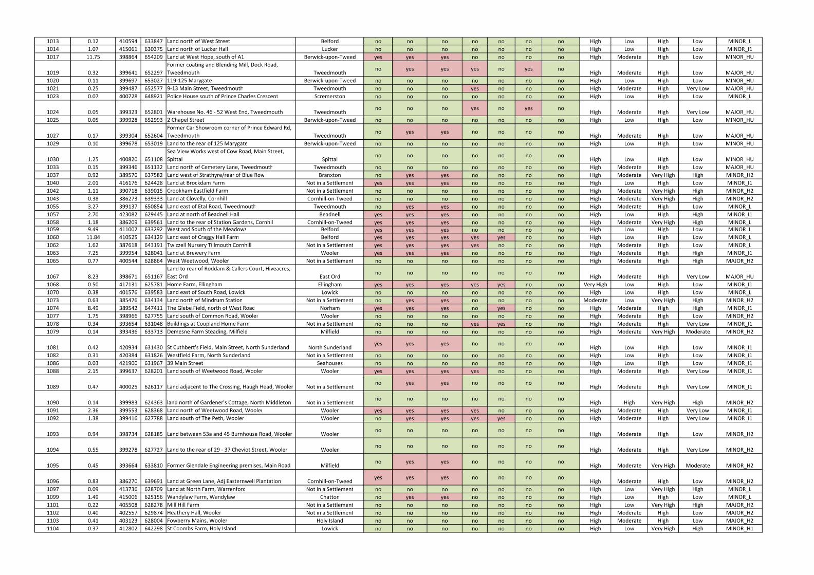
1013 0.12 410594 633847 Land north of West Street Belford no no no no no no no High Low High Low MINOR_L
1014 1.07 415061 630375 Land north of Lucker Hall Lucker no no no no no no no High Low High Low MINOR_I1
1017 11.75 398864 654209 Land at West Hope, south of A1 Berwick-upon-Tweed yes yes yes no no no no High Moderate High Low MINOR_HU
1019 0.32 399641 652297
Former coating and Blending Mill, Dock Road,
Tweedmouth Tweedmouthno yes yes yes no yes no
High Moderate High Low MAJOR_HU
1020 0.11 399697 653027 119-125 Marygate Berwick-upon-Tweed no no no no no no no High Low High Low MINOR_HU
1021 0.25 399487 652577 9-13 Main Street, Tweedmouth Tweedmouth no no no yes no no no High Moderate High Very Low MAJOR_HU
1023 0.07 400728 648921 Police House south of Prince Charles Crescent Scremerston no no no no no no no High Low High Low MINOR_L
1024 0.05 399323 652801 Warehouse No. 46 - 52 West End, Tweedmouth Tweedmouthno no no yes no yes no
High Moderate High Very Low MAJOR_HU
1025 0.05 399928 652993 2 Chapel Street Berwick-upon-Tweed no no no no no no no High Low High Low MINOR_HU
1027 0.17 399304 652604
Former Car Showroom corner of Prince Edward Rd,
Tweedmouth Tweedmouthno yes yes no no no no
High Moderate High Low MAJOR_HU
1029 0.10 399678 653019 Land to the rear of 125 Marygate Berwick-upon-Tweed no no no no no no no High Low High Low MINOR_HU
1030 1.25 400820 651108
Sea View Works west of Cow Road, Main Street,
Spittal Spittalno no no no no no no
High Low High Low MINOR_HU
1033 0.15 399346 651132 Land north of Cemetery Lane, Tweedmouth Tweedmouth no no no no no no no High Moderate High Low MAJOR_HU
1037 0.92 389570 637582 Land west of Strathyre/rear of Blue Row Branxton no yes yes no no no no High Moderate Very High High MINOR_H2
1040 2.01 416176 624428 Land at Brockdam Farm Not in a Settlement yes yes yes no no no no High Low High Low MINOR_I1
1042 1.11 390718 639015 Crookham Eastfield Farm Not in a Settlement no no no no no no no High Moderate Very High High MINOR_H2
1043 0.38 386273 639333 Land at Clovelly, Cornhill Cornhill-on-Tweed no no no no no no no High Moderate Very High High MINOR_H2
1055 3.27 399137 650854 Land east of Etal Road, Tweedmouth Tweedmouth no yes yes no no no no High Moderate High Low MINOR_L
1057 2.70 423082 629445 Land at north of Beadnell Hall Beadnell yes yes yes no no no no High Low High High MINOR_I1
1058 1.18 386209 639561 Land to the rear of Station Gardens, Cornhill Cornhill-on-Tweed yes yes yes no no no no High Moderate Very High High MINOR_L
1059 9.49 411002 633292 West and South of the Meadows Belford yes yes yes no no no no High Low High Low MINOR_L
1060 11.84 410525 634129 Land east of Craggy Hall Farm Belford yes yes yes yes yes no no High Low High Low MINOR_L
1062 1.62 387618 643191 Twizzell Nursery Tillmouth Cornhill Not in a Settlement yes yes yes yes no no no High Moderate High Low MINOR_L
1063 7.25 399954 628041 Land at Brewery Farm Wooler yes yes yes no no no no High Moderate High High MINOR_I1
1065 0.77 400544 628864 West Weetwood, Wooler Not in a Settlement no no no no no no no High Moderate High High MAJOR_H2
1067 8.23 398671 651167
Land to rear of Roddam & Callers Court, Hiveacres,
East Ord East Ordno no no no no no no
High Moderate High Very Low MAJOR_HU
1068 0.50 417131 625781 Home Farm, Ellingham Ellingham yes yes yes yes yes no no Very High Low High Low MINOR_I1
1070 0.38 401576 639583 Land east of South Road, Lowick Lowick no no no no no no no High Low High Low MINOR_L
1073 0.63 385476 634134 Land north of Mindrum Station Not in a Settlement no yes yes no no no no Moderate Low Very High High MINOR_H2
1074 8.49 389542 647411 The Glebe Field, north of West Road Norham yes yes yes no yes no no High Moderate High High MINOR_I1
1077 1.75 398966 627755 Land south of Common Road, Wooler Wooler no no no no no no no High Moderate High Low MINOR_H2
1078 0.34 393654 631048 Buildings at Coupland Home Farm Not in a Settlement no no no yes yes no no High Moderate High Very Low MINOR_I1
1079 0.14 393436 633713 Demesne Farm Steading, Milfield Milfield no no no no no no no High Moderate Very High Moderate MINOR_H2
1081 0.42 420934 631430 St Cuthbert's Field, Main Street, North Sunderland North Sunderlandyes yes yes no no no no
High Low High Low MINOR_I1
1082 0.31 420384 631826 Westfield Farm, North Sunderland Not in a Settlement no no no no no no no High Low High Low MINOR_I1
1086 0.03 421900 631967 39 Main Street Seahouses no no no no no no no High Low High Low MINOR_I1
1088 2.15 399637 628201 Land south of Weetwood Road, Wooler Wooler yes yes yes yes no no no High Moderate High Very Low MINOR_I1
1089 0.47 400025 626117 Land adjacent to The Crossing, Haugh Head, Wooler Not in a Settlementno yes yes no no no no
High Moderate High Very Low MINOR_I1
1090 0.14 399983 624363 land north of Gardener's Cottage, North Middleton Not in a Settlementno no no no no no no
High High Very High High MINOR_H2
1091 2.36 399553 628368 Land north of Weetwood Road, Wooler Wooler yes yes yes yes no no no High Moderate High Very Low MINOR_I1
1092 1.38 399416 627788 Land south of The Peth, Wooler Wooler no yes yes yes yes no no High Moderate High Very Low MINOR_I1
1093 0.94 398734 628185 Land between 53a and 45 Burnhouse Road, Wooler Woolerno no no no no no no
High Moderate High Low MINOR_H2
1094 0.55 399278 627727 Land to the rear of 29 - 37 Cheviot Street, Wooler Woolerno no no no no no no
High Moderate High Very Low MINOR_H2
1095 0.45 393664 633810 Former Glendale Engineering premises, Main Road Milfieldno yes yes no no no no
High Moderate Very High Moderate MINOR_H2
1096 0.83 386270 639691 Land at Green Lane, Adj Easternwell Plantation Cornhill-on-Tweedyes yes yes no no no no
High Moderate High Low MINOR_H2
1097 0.09 413736 628709 Land at North Farm, Warrenford Not in a Settlement no no no no no no no High Low Very High High MINOR_L
1099 1.49 415006 625156 Wandylaw Farm, Wandylaw Chatton no yes yes no no no no High Low High Low MINOR_L
1101 0.22 405508 628278 Mill Hill Farm Not in a Settlement no no no no no no no High Low Very High High MAJOR_H2
1102 0.40 402557 629874 Heathery Hall, Wooler Not in a Settlement no no no no no no no High Moderate High Low MAJOR_H2
1103 0.41 403123 628004 Fowberry Mains, Wooler Holy Island no no no no no no no High Moderate High Low MAJOR_H2
1104 0.37 412802 642298 St Coombs Farm, Holy Island Lowick no no no no no no no High Low Very High High MINOR_H1
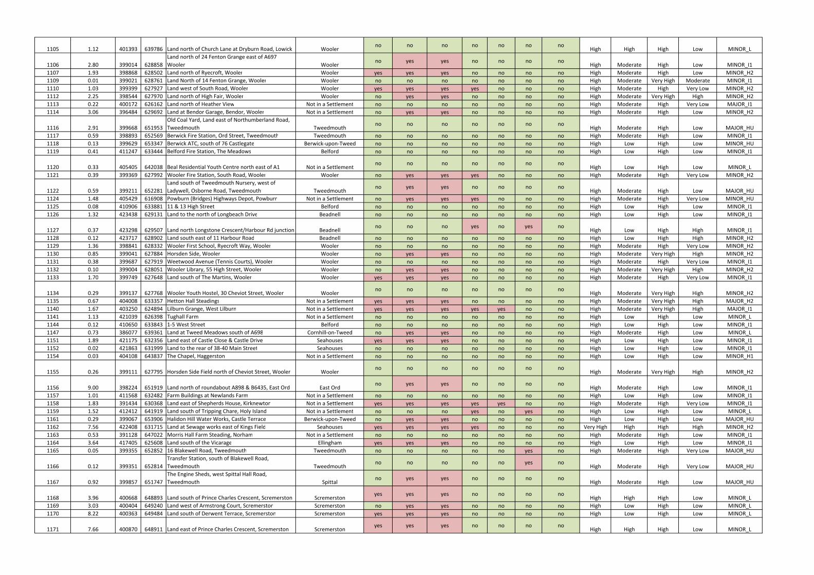
1105 1.12 401393 639786 Land north of Church Lane at Dryburn Road, Lowick Woolerno no no no no no no
High High High Low MINOR_L
1106 2.80 399014 628858
Land north of 24 Fenton Grange east of A697
Wooler Woolerno yes yes no no no no
High Moderate High Low MINOR_I1
1107 1.93 398868 628502 Land north of Ryecroft, Wooler Wooler yes yes yes no no no no High Moderate High Low MINOR_H2
1109 0.01 399021 628761 Land North of 14 Fenton Grange, Wooler Wooler no no no no no no no High Moderate Very High Moderate MINOR_I1
1110 1.03 399399 627927 Land west of South Road, Wooler Wooler yes yes yes yes no no no High Moderate High Very Low MINOR_H2
1112 2.25 398544 627970 Land north of High Fair, Wooler Wooler no yes yes no no no no High Moderate Very High High MINOR_H2
1113 0.22 400172 626162 Land north of Heather View Not in a Settlement no no no no no no no High Moderate High Very Low MAJOR_I1
1114 3.06 396484 629692 Land at Bendor Garage, Bendor, Wooler Not in a Settlement no yes yes no no no no High Moderate High Low MINOR_H2
1116 2.91 399668 651953
Old Coal Yard, Land east of Northumberland Road,
Tweedmouth Tweedmouthno no no no no no no
High Moderate High Low MAJOR_HU
1117 0.59 398893 652569 Berwick Fire Station, Ord Street, Tweedmouth Tweedmouth no no no no no no no High Moderate High Low MINOR_I1
1118 0.13 399629 653347 Berwick ATC, south of 76 Castlegate Berwick-upon-Tweed no no no no no no no High Low High Low MINOR_HU
1119 0.41 411247 633444 Belford Fire Station, The Meadows Belford no no no no no no no High Low High Low MINOR_I1
1120 0.33 405405 642038 Beal Residential Youth Centre north east of A1 Not in a Settlementno no no no no no no
High Low High Low MINOR_L
1121 0.39 399369 627992 Wooler Fire Station, South Road, Wooler Wooler no yes yes yes no no no High Moderate High Very Low MINOR_H2
1122 0.59 399211 652281
Land south of Tweedmouth Nursery, west of
Ladywell, Osborne Road, Tweedmouth Tweedmouthno yes yes no no no no
High Moderate High Low MAJOR_HU
1124 1.48 405429 616908 Powburn (Bridges) Highways Depot, Powburn Not in a Settlement no yes yes yes no no no High Moderate High Very Low MINOR_HU
1125 0.08 410906 633881 11 & 13 High Street Belford no no no no no no no High Low High Low MINOR_I1
1126 1.32 423438 629131 Land to the north of Longbeach Drive Beadnell no no no no no no no High Low High Low MINOR_I1
1127 0.37 423298 629507 Land north Longstone Crescent/Harbour Rd junction Beadnellno no no yes no yes no
High Low High High MINOR_I1
1128 0.12 423717 628902 Land south east of 11 Harbour Road Beadnell no no no no no no no High Low High High MINOR_H2
1129 1.36 398841 628332 Wooler First School, Ryecroft Way, Wooler Wooler no no no no no no no High Moderate High Very Low MINOR_H2
1130 0.85 399041 627884 Horsden Side, Wooler Wooler no yes yes no no no no High Moderate Very High High MINOR_H2
1131 0.38 399687 627919 Weetwood Avenue (Tennis Courts), Wooler Wooler no no no no no no no High Moderate High Very Low MINOR_I1
1132 0.10 399004 628051 Wooler Library, 55 High Street, Wooler Wooler no yes yes no no no no High Moderate Very High High MINOR_H2
1133 1.70 399749 627648 Land south of The Martins, Wooler Wooler yes yes yes no no no no High Moderate High Very Low MINOR_I1
1134 0.29 399137 627768 Wooler Youth Hostel, 30 Cheviot Street, Wooler Woolerno no no no no no no
High Moderate Very High High MINOR_H2
1135 0.67 404008 633357 Hetton Hall Steadings Not in a Settlement yes yes yes no no no no High Moderate Very High High MAJOR_H2
1140 1.67 403250 624894 Lilburn Grange, West Lilburn Not in a Settlement yes yes yes yes yes no no High Moderate Very High High MAJOR_I1
1141 1.13 421039 626398 Tughall Farm Not in a Settlement no no no no no no no High Low High Low MINOR_L
1144 0.12 410650 633843 1-5 West Street Belford no no no no no no no High Low High Low MINOR_I1
1147 0.73 386077 639361 Land at Tweed Meadows south of A698 Cornhill-on-Tweed no yes yes no no no no High Moderate High Low MINOR_L
1151 1.89 421175 632356 Land east of Castle Close & Castle Drive Seahouses yes yes yes no no no no High Low High Low MINOR_I1
1152 0.02 421863 631999 Land to the rear of 38-40 Main Street Seahouses no no no no no no no High Low High Low MINOR_I1
1154 0.03 404108 643837 The Chapel, Haggerston Not in a Settlement no no no no no no no High Low High Low MINOR_H1
1155 0.26 399111 627795 Horsden Side Field north of Cheviot Street, Wooler Woolerno no no no no no no
High Moderate Very High High MINOR_H2
1156 9.00 398224 651919 Land north of roundabout A898 & B6435, East Ord East Ordno yes yes no no no no
High Moderate High Low MINOR_I1
1157 1.01 411568 632482 Farm Buildings at Newlands Farm Not in a Settlement no no no no no no no High Low High Low MINOR_I1
1158 1.83 391434 630368 Land east of Shepherds House, Kirknewton Not in a Settlement yes yes yes yes yes no no High Moderate High Very Low MINOR_I1
1159 1.52 412412 641919 Land south of Tripping Chare, Holy Island Not in a Settlement no no no yes no yes no High Low High Low MINOR_L
1161 0.29 399067 653906 Halidon Hill Water Works, Castle Terrace Berwick-upon-Tweed no yes yes no no no no High Low High Low MAJOR_HU
1162 7.56 422408 631715 Land at Sewage works east of Kings Field Seahouses yes yes yes yes no no no Very High High High High MINOR_H2
1163 0.53 391128 647022 Morris Hall Farm Steading, Norham Not in a Settlement no no no no no no no High Moderate High Low MINOR_I1
1164 3.64 417405 625608 Land south of the Vicarage Ellingham yes yes yes no no no no High Low High Low MINOR_I1
1165 0.05 399355 652852 16 Blakewell Road, Tweedmouth Tweedmouth no no no no no yes no High Moderate High Very Low MAJOR_HU
1166 0.12 399351 652814
Transfer Station, south of Blakewell Road,
Tweedmouth Tweedmouthno no no no no yes no
High Moderate High Very Low MAJOR_HU
1167 0.92 399857 651747
The Engine Sheds, west Spittal Hall Road,
Tweedmouth Spittalno yes yes no no no no
High Moderate High Low MAJOR_HU
1168 3.96 400668 648893 Land south of Prince Charles Crescent, Scremerston Scremerstonyes yes yes no no no no
High High High Low MINOR_L
1169 3.03 400404 649240 Land west of Armstrong Court, Scremerston Scremerston no yes yes no no no no High Low High Low MINOR_L
1170 8.22 400363 649484 Land south of Derwent Terrace, Scremerston Scremerston yes yes yes no no no no High Low High Low MINOR_L
1171 7.66 400870 648911 Land east of Prince Charles Crescent, Scremerston Scremerstonyes yes yes no no no no
High High High Low MINOR_L
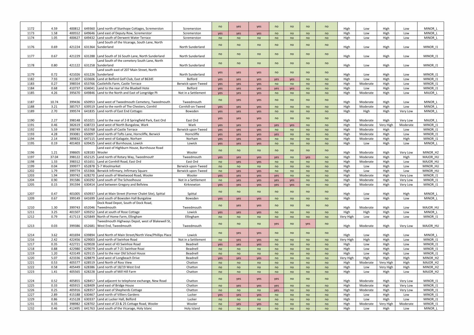
1172 4.59 400812 649360 Land north of Stanhope Cottages, Scremerston Scremerstonno yes yes no no no no
High Low High Low MINOR_L
1173 1.58 400552 649646 Land east of Deputy Row, Scremerston Scremerston yes yes yes no no no no High Low High Low MINOR_L
1174 1.05 400627 649432 Land south of Derwent Water Terrace Scremerston no no no no no no no High Low High Low MINOR_L
1176 0.69 421224 631364
Land South of the Vicarage, South Lane, North
Sunderland North Sunderlandno no no no no no no
High Low High Low MINOR_I1
1177 0.67 421229 631288 Land South of 16 South Lane, North Sunderland North Sunderlandno no no no no no no
High Low High Low MINOR_I1
1178 0.80 421122 631258
Land South of the cemetery South Lane, North
Sunderland North Sunderlandno no no no no no no
High Low High Low MINOR_I1
1179 0.72 421026 631226
Land south east of 207 Main Street, North
Sunderland North Sunderlandyes yes yes no no no no
High Low High Low MINOR_I1
1182 7.93 411307 633606 Land at Belford Golf Club, East of B6349 Belford yes yes yes yes yes no no High Low High Low MINOR_I1
1183 0.27 398554 653766 Castlehills Farm, Castle Terrace Berwick-upon-Tweed yes yes yes no no no no High Moderate High Low MINOR_I1
1184 0.68 410737 634041 Land to the rear of the Bluebell Hotel Belford yes yes yes yes yes no no High Low High Low MINOR_I1
1185 4.26 395670 649846 Land to the North and East of Longridge Pk Not in a Settlement yes yes yes no no no no High Moderate High Low MAJOR_L
1187 10.74 399436 650953 Land west of Tweedmouth Cemetery, Tweedmouth Tweedmouthno yes yes no no no no
High Moderate High Low MINOR_L
1188 3.21 385757 639519 Land to the north of The Chesters, Cornhill Cornhill-on-Tweed yes yes yes no no no no High Moderate High Low MINOR_L
1189 2.70 399574 641835 Land north of East End Cottages Bowsden yes yes yes no no no no High High High Very Low MINOR_L
1190 2.27 398148 651021 Land to the rear of 2-8 Springfield Park, East Ord East Ordyes yes yes no no no no
High Moderate High Very Low MAJOR_L
1191 0.46 382619 638723 Land west of North Bungalow, Wark Wark yes yes yes yes yes no no High Moderate Very High Moderate MINOR_I1
1192 5.59 398749 653768 Land south of Castle Terrace Berwick-upon-Tweed yes yes yes no no no no High Moderate High Low MINOR_I1
1193 4.28 393081 650097 Land north of Tofts Lane, Horncliffe, Berwick Horncliffe yes yes yes yes no no no High Moderate High Low MINOR_I1
1194 2.14 389832 647115 Land west of Galagate, Norham Norham yes yes yes no no no no High Moderate High High MINOR_I1
1195 0.19 401403 639425 Land west of Burnhouse, Lowick Lowick yes yes yes no no no no High Low High Low MINOR_L
1196 1.21 398605 628183
Land east of Highburn House, Burnhouse Road
Wooler Woolerno no no no no no no
High Moderate High Very Low MINOR_H2
1197 37.04 398122 652125 Land north of Rotary Way, Tweedmouth Tweedmouth yes yes yes yes no yes no High Moderate High High MAJOR_HU
1198 1.33 398312 651651 Land at Cornhill Road, East Ord East Ord no yes yes no no no no High Moderate High Low MAJOR_HU
1199 0.04 399977 652878 5-7 Woolmarket Berwick-upon-Tweed no no no no no no no High Low High Low MINOR_HU
1202 1.79 399774 653366 Berwick Infirmary, Infirmary Square Berwick-upon-Tweed no yes yes no no no no High Low High Low MINOR_HU
1203 1.94 399742 628270 Land south of Weetwood Road, Wooler Wooler yes yes yes yes no no no High Moderate High Very Low MINOR_I1
1204 0.90 391586 630292 Land south of The Schoolhouse Not in a Settlement no yes yes yes yes no no High Moderate High Very Low MINOR_I1
1205 0.15 391594 630414 Land between Gregory and Bellview Kirknewton yes yes yes yes yes no no High Moderate High Very Low MINOR_I1
1207 0.47 401005 650937 Land at Main Street (Former Chalet Site), Spittal Spittalno no no no no no no
High Low High High MINOR_L
1209 0.67 399149 641699 Land south of Bowsden Hall Bungalow Bowsden yes yes yes no no no no High Low High Low MINOR_L
1210 1.30 399743 652046
Dock Road Depot, South of Dock Road,
Tweedmouth Tweedmouthno yes yes no no no no
High Moderate High Low MAJOR_HU
1211 3.25 401507 639252 Land at south of Rose Cottage Lowick yes yes yes no no no no High High High Low MINOR_L
1212 0.79 417113 625849 North of Home Farm, Ellingham Ellingham no no no no no no no Very High Low High Low MINOR_I1
1213 0.03 399386 652681
Tweedmouth Highways Depot, west of Blakewell St,
West End, Tweedmouth Tweedmouthno no no yes no yes no
High Moderate High Very Low MAJOR_HU
1214 3.62 401694 639894 Land North of Main Street/North View/Phillips Place Lowickno yes yes no no no no
High Low High Low MINOR_L
1216 2.42 422456 629003 Land north of Swinhoe Road Not in a Settlement no yes yes no no no no Very High High High Low MINOR_I1
1217 0.35 422721 629028 Land west of 43 Swinhoe Road Beadnell yes yes yes no no no no High Low High Low MINOR_I1
1218 0.88 422980 629079 Land south of 7-21 Swinhoe Road Beadnell no no no no no no no High Low High Low MINOR_I1
1219 1.20 423149 629115 Land to the rear Old School House Beadnell no no no no no no no High Low High Low MINOR_I1
1220 5.07 423336 628879 Land west of Longbeach Drive Beadnell yes yes yes no no no no Very High High High High MINOR_H2
1221 0.53 405577 628519 Land North of Ross View Chatton no no no no no no no High Moderate Very High High MAJOR_H2
1222 0.58 405449 628386 Land north of 18/19 West End Chatton no no no no no no no High Low Very High High MINOR_H2
1223 1.41 405565 628228 Land south of Mill Hill Farm Chatton no no no no no no no High Low High Low MAJOR_H2
1224 0.52 405855 628457 Land adjacent to telephone exchange, New Road Chattonno yes yes yes no no no
High Moderate High Very Low MINOR_I1
1225 0.33 405915 628409 Land east of Bridge House Chatton no yes yes yes no no no High Moderate High Very Low MINOR_I1
1226 0.25 405916 628357 Land east of Shepherds Cottage Chatton no no no yes no no no High Moderate High Very Low MINOR_I1
1227 2.89 415188 630467 Land north of Villiers Gardens Lucker yes yes yes no no no no High Low High Low MINOR_I1
1229 0.86 415128 630337 Land at Lucker Hall, Belford Lucker no no no no no no no High Low High Low MINOR_I1
1231 0.35 398982 628702 Land east of 23 & 25 Cottage Road, Wooler Wooler no yes yes no no no no High Moderate Very High Moderate MINOR_I1
1232 0.46 412495 641763 Land south of the Vicarage, Holy Island Holy Island no no no no no no no High Low High Low MINOR_L
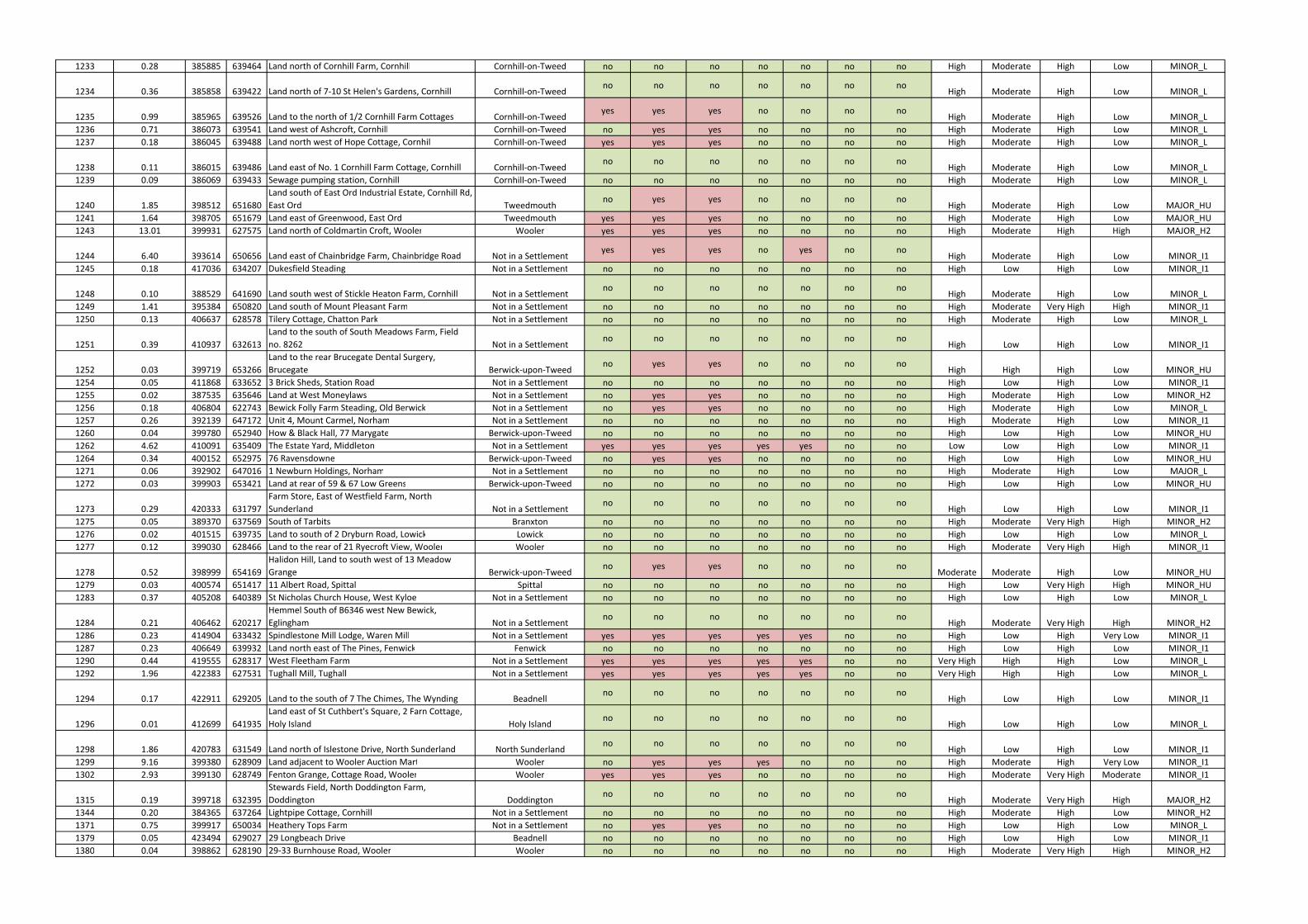
1233 0.28 385885 639464 Land north of Cornhill Farm, Cornhill Cornhill-on-Tweed no no no no no no no High Moderate High Low MINOR_L
1234 0.36 385858 639422 Land north of 7-10 St Helen's Gardens, Cornhill Cornhill-on-Tweedno no no no no no no
High Moderate High Low MINOR_L
1235 0.99 385965 639526 Land to the north of 1/2 Cornhill Farm Cottages Cornhill-on-Tweedyes yes yes no no no no
High Moderate High Low MINOR_L
1236 0.71 386073 639541 Land west of Ashcroft, Cornhill Cornhill-on-Tweed no yes yes no no no no High Moderate High Low MINOR_L
1237 0.18 386045 639488 Land north west of Hope Cottage, Cornhill Cornhill-on-Tweed yes yes yes no no no no High Moderate High Low MINOR_L
1238 0.11 386015 639486 Land east of No. 1 Cornhill Farm Cottage, Cornhill Cornhill-on-Tweedno no no no no no no
High Moderate High Low MINOR_L
1239 0.09 386069 639433 Sewage pumping station, Cornhill Cornhill-on-Tweed no no no no no no no High Moderate High Low MINOR_L
1240 1.85 398512 651680
Land south of East Ord Industrial Estate, Cornhill Rd,
East Ord Tweedmouthno yes yes no no no no
High Moderate High Low MAJOR_HU
1241 1.64 398705 651679 Land east of Greenwood, East Ord Tweedmouth yes yes yes no no no no High Moderate High Low MAJOR_HU
1243 13.01 399931 627575 Land north of Coldmartin Croft, Wooler Wooler yes yes yes no no no no High Moderate High High MAJOR_H2
1244 6.40 393614 650656 Land east of Chainbridge Farm, Chainbridge Road Not in a Settlementyes yes yes no yes no no
High Moderate High Low MINOR_I1
1245 0.18 417036 634207 Dukesfield Steading Not in a Settlement no no no no no no no High Low High Low MINOR_I1
1248 0.10 388529 641690 Land south west of Stickle Heaton Farm, Cornhill Not in a Settlementno no no no no no no
High Moderate High Low MINOR_L
1249 1.41 395384 650820 Land south of Mount Pleasant Farm Not in a Settlement no no no no no no no High Moderate Very High High MINOR_I1
1250 0.13 406637 628578 Tilery Cottage, Chatton Park Not in a Settlement no no no no no no no High Moderate High Low MINOR_L
1251 0.39 410937 632613
Land to the south of South Meadows Farm, Field
no. 8262 Not in a Settlementno no no no no no no
High Low High Low MINOR_I1
1252 0.03 399719 653266
Land to the rear Brucegate Dental Surgery,
Brucegate Berwick-upon-Tweedno yes yes no no no no
High High High Low MINOR_HU
1254 0.05 411868 633652 3 Brick Sheds, Station Road Not in a Settlement no no no no no no no High Low High Low MINOR_I1
1255 0.02 387535 635646 Land at West Moneylaws Not in a Settlement no yes yes no no no no High Moderate High Low MINOR_H2
1256 0.18 406804 622743 Bewick Folly Farm Steading, Old Berwick Not in a Settlement no yes yes no no no no High Moderate High Low MINOR_L
1257 0.26 392139 647172 Unit 4, Mount Carmel, Norham Not in a Settlement no no no no no no no High Moderate High Low MINOR_I1
1260 0.04 399780 652940 How & Black Hall, 77 Marygate Berwick-upon-Tweed no no no no no no no High Low High Low MINOR_HU
1262 4.62 410091 635409 The Estate Yard, Middleton Not in a Settlement yes yes yes yes yes no no Low Low High Low MINOR_I1
1264 0.34 400152 652975 76 Ravensdowne Berwick-upon-Tweed no yes yes no no no no High Low High Low MINOR_HU
1271 0.06 392902 647016 1 Newburn Holdings, Norham Not in a Settlement no no no no no no no High Moderate High Low MAJOR_L
1272 0.03 399903 653421 Land at rear of 59 & 67 Low Greens Berwick-upon-Tweed no no no no no no no High Low High Low MINOR_HU
1273 0.29 420333 631797
Farm Store, East of Westfield Farm, North
Sunderland Not in a Settlementno no no no no no no
High Low High Low MINOR_I1
1275 0.05 389370 637569 South of Tarbits Branxton no no no no no no no High Moderate Very High High MINOR_H2
1276 0.02 401515 639735 Land to south of 2 Dryburn Road, Lowick Lowick no no no no no no no High Low High Low MINOR_L
1277 0.12 399030 628466 Land to the rear of 21 Ryecroft View, Wooler Wooler no no no no no no no High Moderate Very High High MINOR_I1
1278 0.52 398999 654169
Halidon Hill, Land to south west of 13 Meadow
Grange Berwick-upon-Tweedno yes yes no no no no
Moderate Moderate High Low MINOR_HU
1279 0.03 400574 651417 11 Albert Road, Spittal Spittal no no no no no no no High Low Very High High MINOR_HU
1283 0.37 405208 640389 St Nicholas Church House, West Kyloe Not in a Settlement no no no no no no no High Low High Low MINOR_L
1284 0.21 406462 620217
Hemmel South of B6346 west New Bewick,
Eglingham Not in a Settlementno no no no no no no
High Moderate Very High High MINOR_H2
1286 0.23 414904 633432 Spindlestone Mill Lodge, Waren Mill Not in a Settlement yes yes yes yes yes no no High Low High Very Low MINOR_I1
1287 0.23 406649 639932 Land north east of The Pines, Fenwick Fenwick no no no no no no no High Low High Low MINOR_I1
1290 0.44 419555 628317 West Fleetham Farm Not in a Settlement yes yes yes yes yes no no Very High High High Low MINOR_L
1292 1.96 422383 627531 Tughall Mill, Tughall Not in a Settlement yes yes yes yes yes no no Very High High High Low MINOR_L
1294 0.17 422911 629205 Land to the south of 7 The Chimes, The Wynding Beadnellno no no no no no no
High Low High Low MINOR_I1
1296 0.01 412699 641935
Land east of St Cuthbert's Square, 2 Farn Cottage,
Holy Island Holy Islandno no no no no no no
High Low High Low MINOR_L
1298 1.86 420783 631549 Land north of Islestone Drive, North Sunderland North Sunderlandno no no no no no no
High Low High Low MINOR_I1
1299 9.16 399380 628909 Land adjacent to Wooler Auction Mart Wooler no yes yes yes no no no High Moderate High Very Low MINOR_I1
1302 2.93 399130 628749 Fenton Grange, Cottage Road, Wooler Wooler yes yes yes no no no no High Moderate Very High Moderate MINOR_I1
1315 0.19 399718 632395
Stewards Field, North Doddington Farm,
Doddington Doddingtonno no no no no no no
High Moderate Very High High MAJOR_H2
1344 0.20 384365 637264 Lightpipe Cottage, Cornhill Not in a Settlement no no no no no no no High Moderate High Low MINOR_H2
1371 0.75 399917 650034 Heathery Tops Farm Not in a Settlement no yes yes no no no no High Low High Low MINOR_L
1379 0.05 423494 629027 29 Longbeach Drive Beadnell no no no no no no no High Low High Low MINOR_I1
1380 0.04 398862 628190 29-33 Burnhouse Road, Wooler Wooler no no no no no no no High Moderate Very High High MINOR_H2
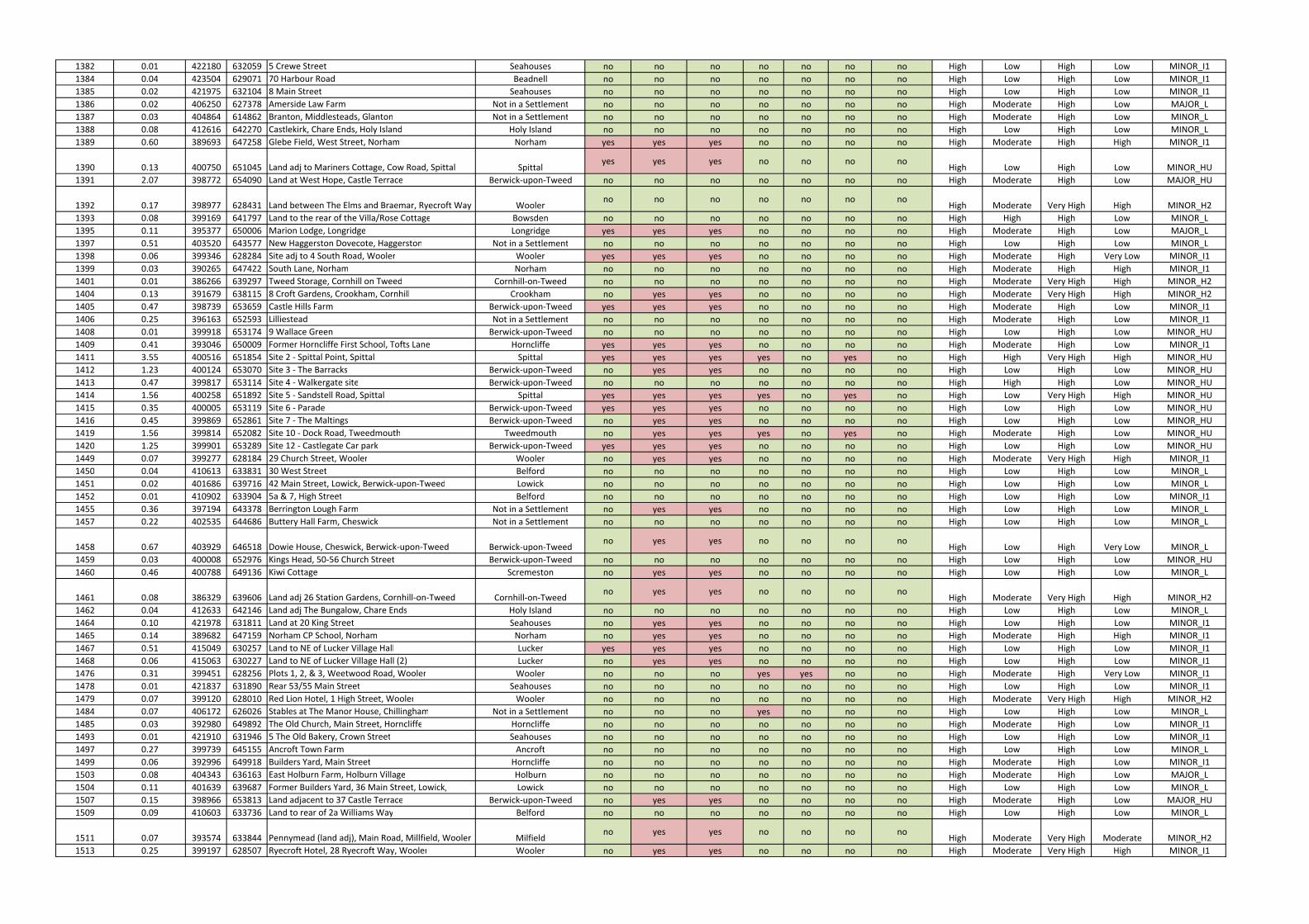
1382 0.01 422180 632059 5 Crewe Street Seahouses no no no no no no no High Low High Low MINOR_I1
1384 0.04 423504 629071 70 Harbour Road Beadnell no no no no no no no High Low High Low MINOR_I1
1385 0.02 421975 632104 8 Main Street Seahouses no no no no no no no High Low High Low MINOR_I1
1386 0.02 406250 627378 Amerside Law Farm Not in a Settlement no no no no no no no High Moderate High Low MAJOR_L
1387 0.03 404864 614862 Branton, Middlesteads, Glanton Not in a Settlement no no no no no no no High Moderate High Low MINOR_L
1388 0.08 412616 642270 Castlekirk, Chare Ends, Holy Island Holy Island no no no no no no no High Low High Low MINOR_L
1389 0.60 389693 647258 Glebe Field, West Street, Norham Norham yes yes yes no no no no High Moderate High High MINOR_I1
1390 0.13 400750 651045 Land adj to Mariners Cottage, Cow Road, Spittal Spittalyes yes yes no no no no
High Low High Low MINOR_HU
1391 2.07 398772 654090 Land at West Hope, Castle Terrace Berwick-upon-Tweed no no no no no no no High Moderate High Low MAJOR_HU
1392 0.17 398977 628431 Land between The Elms and Braemar, Ryecroft Way Woolerno no no no no no no
High Moderate Very High High MINOR_H2
1393 0.08 399169 641797 Land to the rear of the Villa/Rose Cottage Bowsden no no no no no no no High High High Low MINOR_L
1395 0.11 395377 650006 Marion Lodge, Longridge Longridge yes yes yes no no no no High Moderate High Low MAJOR_L
1397 0.51 403520 643577 New Haggerston Dovecote, Haggerston Not in a Settlement no no no no no no no High Low High Low MINOR_L
1398 0.06 399346 628284 Site adj to 4 South Road, Wooler Wooler yes yes yes no no no no High Moderate High Very Low MINOR_I1
1399 0.03 390265 647422 South Lane, Norham Norham no no no no no no no High Moderate High High MINOR_I1
1401 0.01 386266 639297 Tweed Storage, Cornhill on Tweed Cornhill-on-Tweed no no no no no no no High Moderate Very High High MINOR_H2
1404 0.13 391679 638115 8 Croft Gardens, Crookham, Cornhill Crookham no yes yes no no no no High Moderate Very High High MINOR_H2
1405 0.47 398739 653659 Castle Hills Farm Berwick-upon-Tweed yes yes yes no no no no High Moderate High Low MINOR_I1
1406 0.25 396163 652593 Lilliestead Not in a Settlement no no no no no no no High Moderate High Low MINOR_I1
1408 0.01 399918 653174 9 Wallace Green Berwick-upon-Tweed no no no no no no no High Low High Low MINOR_HU
1409 0.41 393046 650009 Former Horncliffe First School, Tofts Lane Horncliffe yes yes yes no no no no High Moderate High Low MINOR_I1
1411 3.55 400516 651854 Site 2 - Spittal Point, Spittal Spittal yes yes yes yes no yes no High High Very High High MINOR_HU
1412 1.23 400124 653070 Site 3 - The Barracks Berwick-upon-Tweed no yes yes no no no no High Low High Low MINOR_HU
1413 0.47 399817 653114 Site 4 - Walkergate site Berwick-upon-Tweed no no no no no no no High High High Low MINOR_HU
1414 1.56 400258 651892 Site 5 - Sandstell Road, Spittal Spittal yes yes yes yes no yes no High Low Very High High MINOR_HU
1415 0.35 400005 653119 Site 6 - Parade Berwick-upon-Tweed yes yes yes no no no no High Low High Low MINOR_HU
1416 0.45 399869 652861 Site 7 - The Maltings Berwick-upon-Tweed no yes yes no no no no High Low High Low MINOR_HU
1419 1.56 399814 652082 Site 10 - Dock Road, Tweedmouth Tweedmouth no yes yes yes no yes no High Moderate High Low MINOR_HU
1420 1.25 399901 653289 Site 12 - Castlegate Car park Berwick-upon-Tweed yes yes yes no no no no High Low High Low MINOR_HU
1449 0.07 399277 628184 29 Church Street, Wooler Wooler no yes yes no no no no High Moderate Very High High MINOR_I1
1450 0.04 410613 633831 30 West Street Belford no no no no no no no High Low High Low MINOR_L
1451 0.02 401686 639716 42 Main Street, Lowick, Berwick-upon-Tweed Lowick no no no no no no no High Low High Low MINOR_L
1452 0.01 410902 633904 5a & 7, High Street Belford no no no no no no no High Low High Low MINOR_I1
1455 0.36 397194 643378 Berrington Lough Farm Not in a Settlement no yes yes no no no no High Low High Low MINOR_L
1457 0.22 402535 644686 Buttery Hall Farm, Cheswick Not in a Settlement no no no no no no no High Low High Low MINOR_L
1458 0.67 403929 646518 Dowie House, Cheswick, Berwick-upon-Tweed Berwick-upon-Tweedno yes yes no no no no
High Low High Very Low MINOR_L
1459 0.03 400008 652976 Kings Head, 50-56 Church Street Berwick-upon-Tweed no no no no no no no High Low High Low MINOR_HU
1460 0.46 400788 649136 Kiwi Cottage Scremeston no yes yes no no no no High Low High Low MINOR_L
1461 0.08 386329 639606 Land adj 26 Station Gardens, Cornhill-on-Tweed Cornhill-on-Tweedno yes yes no no no no
High Moderate Very High High MINOR_H2
1462 0.04 412633 642146 Land adj The Bungalow, Chare Ends Holy Island no no no no no no no High Low High Low MINOR_L
1464 0.10 421978 631811 Land at 20 King Street Seahouses no yes yes no no no no High Low High Low MINOR_I1
1465 0.14 389682 647159 Norham CP School, Norham Norham no yes yes no no no no High Moderate High High MINOR_I1
1467 0.51 415049 630257 Land to NE of Lucker Village Hall Lucker yes yes yes no no no no High Low High Low MINOR_I1
1468 0.06 415063 630227 Land to NE of Lucker Village Hall (2) Lucker no yes yes no no no no High Low High Low MINOR_I1
1476 0.31 399451 628256 Plots 1, 2, & 3, Weetwood Road, Wooler Wooler no no no yes yes no no High Moderate High Very Low MINOR_I1
1478 0.01 421837 631890 Rear 53/55 Main Street Seahouses no no no no no no no High Low High Low MINOR_I1
1479 0.07 399120 628010 Red Lion Hotel, 1 High Street, Wooler Wooler no no no no no no no High Moderate Very High High MINOR_H2
1484 0.07 406172 626026 Stables at The Manor House, Chillingham Not in a Settlement no no no yes no no no High Low High Low MINOR_L
1485 0.03 392980 649892 The Old Church, Main Street, Horncliffe Horncliffe no no no no no no no High Moderate High Low MINOR_I1
1493 0.01 421910 631946 5 The Old Bakery, Crown Street Seahouses no no no no no no no High Low High Low MINOR_I1
1497 0.27 399739 645155 Ancroft Town Farm Ancroft no no no no no no no High Low High Low MINOR_L
1499 0.06 392996 649918 Builders Yard, Main Street Horncliffe no no no no no no no High Moderate High Low MINOR_I1
1503 0.08 404343 636163 East Holburn Farm, Holburn Village Holburn no no no no no no no High Moderate High Low MAJOR_L
1504 0.11 401639 639687 Former Builders Yard, 36 Main Street, Lowick, Lowick no no no no no no no High Low High Low MINOR_L
1507 0.15 398966 653813 Land adjacent to 37 Castle Terrace Berwick-upon-Tweed no yes yes no no no no High Moderate High Low MAJOR_HU
1509 0.09 410603 633736 Land to rear of 2a Williams Way Belford no no no no no no no High Low High Low MINOR_L
1511 0.07 393574 633844 Pennymead (land adj), Main Road, Millfield, Wooler Milfieldno yes yes no no no no
High Moderate Very High Moderate MINOR_H2
1513 0.25 399197 628507 Ryecroft Hotel, 28 Ryecroft Way, Wooler Wooler no yes yes no no no no High Moderate Very High High MINOR_I1
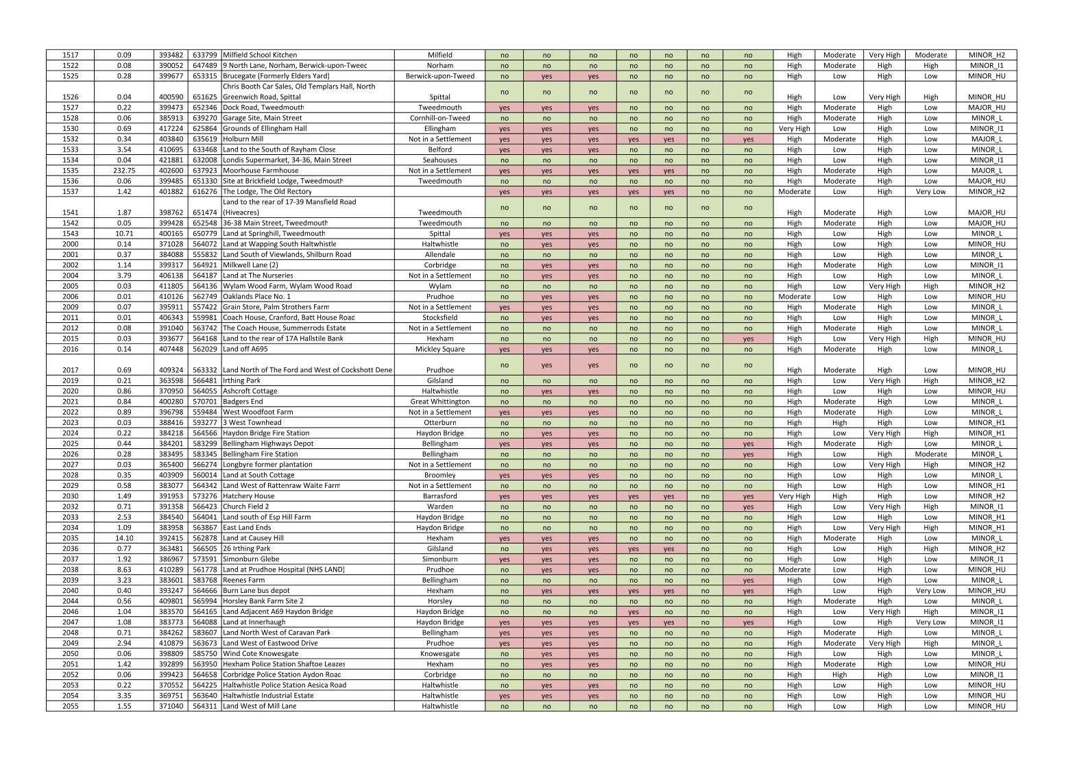
1517 0.09 393482 633799 Milfield School Kitchen Milfield no no no no no no no High Moderate Very High Moderate MINOR_H2
1522 0.08 390052 647489 9 North Lane, Norham, Berwick-upon-Tweed Norham no no no no no no no High Moderate High High MINOR_I1
1525 0.28 399677 653315 Brucegate (Formerly Elders Yard) Berwick-upon-Tweed no yes yes no no no no High Low High Low MINOR_HU
1526 0.04 400590 651625
Chris Booth Car Sales, Old Templars Hall, North
Greenwich Road, Spittal Spittalno no no no no no no
High Low Very High High MINOR_HU
1527 0.22 399473 652346 Dock Road, Tweedmouth Tweedmouth yes yes yes no no no no High Moderate High Low MAJOR_HU
1528 0.06 385913 639270 Garage Site, Main Street Cornhill-on-Tweed no no no no no no no High Moderate High Low MINOR_L
1530 0.69 417224 625864 Grounds of Ellingham Hall Ellingham yes yes yes no no no no Very High Low High Low MINOR_I1
1532 0.34 403840 635619 Holburn Mill Not in a Settlement yes yes yes yes yes no yes High Moderate High Low MAJOR_L
1533 3.54 410695 633468 Land to the South of Rayham Close Belford yes yes yes no no no no High Low High Low MINOR_L
1534 0.04 421881 632008 Londis Supermarket, 34-36, Main Street Seahouses no no no no no no no High Low High Low MINOR_I1
1535 232.75 402600 637923 Moorhouse Farmhouse Not in a Settlement yes yes yes yes yes no no High Moderate High Low MAJOR_L
1536 0.06 399485 651330 Site at Brickfield Lodge, Tweedmouth Tweedmouth no no no no no no no High Moderate High Low MAJOR_HU
1537 1.42 401882 616276 The Lodge, The Old Rectory yes yes yes yes yes no no Moderate Low High Very Low MINOR_H2
1541 1.87 398762 651474
Land to the rear of 17-39 Mansfield Road
(Hiveacres) Tweedmouthno no no no no no no
High Moderate High Low MAJOR_HU
1542 0.05 399428 652548 36-38 Main Street, Tweedmouth Tweedmouth no no no no no no no High Moderate High Low MAJOR_HU
1543 10.71 400165 650779 Land at Springhill, Tweedmouth Spittal yes yes yes no no no no High Low High Low MINOR_L
2000 0.14 371028 564072 Land at Wapping South Haltwhistle Haltwhistle no yes yes no no no no High Low High Low MINOR_HU
2001 0.37 384088 555832 Land South of Viewlands, Shilburn Road Allendale no no no no no no no High Low High Low MINOR_L
2002 1.14 399317 564921 Milkwell Lane (2) Corbridge no yes yes no no no no High Moderate High Low MINOR_I1
2004 3.79 406138 564187 Land at The Nurseries Not in a Settlement no yes yes no no no no High Low High Low MINOR_L
2005 0.03 411805 564136 Wylam Wood Farm, Wylam Wood Road Wylam no no no no no no no High Low Very High High MINOR_H2
2006 0.01 410126 562749 Oaklands Place No. 1 Prudhoe no yes yes no no no no Moderate Low High Low MINOR_HU
2009 0.07 395911 557422 Grain Store, Palm Strothers Farm Not in a Settlement yes yes yes no no no no High Moderate High Low MINOR_L
2011 0.01 406343 559981 Coach House, Cranford, Batt House Road Stocksfield no yes yes no no no no High Low High Low MINOR_L
2012 0.08 391040 563742 The Coach House, Summerrods Estate Not in a Settlement no no no no no no no High Moderate High Low MINOR_L
2015 0.03 393677 564168 Land to the rear of 17A Hallstile Bank Hexham no no no no no no yes High Low Very High High MINOR_HU
2016 0.14 407448 562029 Land off A695 Mickley Square yes yes yes no no no no High Moderate High Low MINOR_L
2017 0.69 409324 563332 Land North of The Ford and West of Cockshott Dene Prudhoeno yes yes no no no no
High Moderate High Low MINOR_HU
2019 0.21 363598 566481 Irthing Park Gilsland no no no no no no no High Low Very High High MINOR_H2
2020 0.86 370950 564055 Ashcroft Cottage Haltwhistle no yes yes no no no no High Low High Low MINOR_HU
2021 0.84 400280 570701 Badgers End Great Whittington no no no no no no no High Moderate High Low MINOR_L
2022 0.89 396798 559484 West Woodfoot Farm Not in a Settlement yes yes yes no no no no High Moderate High Low MINOR_L
2023 0.03 388416 593277 3 West Townhead Otterburn no no no no no no no High High High Low MINOR_H1
2024 0.22 384218 564566 Haydon Bridge Fire Station Haydon Bridge no yes yes no no no no High Low Very High High MINOR_H1
2025 0.44 384201 583299 Bellingham Highways Depot Bellingham yes yes yes no no no yes High Moderate High Low MINOR_L
2026 0.28 383495 583345 Bellingham Fire Station Bellingham no no no no no no yes High Low High Moderate MINOR_L
2027 0.03 365400 566274 Longbyre former plantation Not in a Settlement no no no no no no no High Low Very High High MINOR_H2
2028 0.35 403909 560014 Land at South Cottage Broomley yes yes yes no no no no High Low High Low MINOR_L
2029 0.58 383077 564342 Land West of Rattenraw Waite Farm Not in a Settlement no no no no no no no High Low High Low MINOR_H1
2030 1.49 391953 573276 Hatchery House Barrasford yes yes yes yes yes no yes Very High High High Low MINOR_H2
2032 0.71 391358 566423 Church Field 2 Warden no no no no no no yes High Low Very High High MINOR_I1
2033 2.53 384540 564041 Land south of Esp Hill Farm Haydon Bridge no no no no no no no High Low High Low MINOR_H1
2034 1.09 383958 563867 East Land Ends Haydon Bridge no no no no no no no High Low Very High High MINOR_H1
2035 14.10 392415 562878 Land at Causey Hill Hexham yes yes yes no no no no High Moderate High Low MINOR_L
2036 0.77 363481 566505 26 Irthing Park Gilsland no yes yes yes yes no no High Low High High MINOR_H2
2037 1.92 386967 573591 Simonburn Glebe Simonburn yes yes yes no no no no High Low High Low MINOR_I1
2038 8.63 410289 561778 Land at Prudhoe Hospital (NHS LAND) Prudhoe no yes yes no no no no Moderate Low High Low MINOR_HU
2039 3.23 383601 583768 Reenes Farm Bellingham no no no no no no yes High Low High Low MINOR_L
2040 0.40 393247 564666 Burn Lane bus depot Hexham no yes yes yes yes no yes High Low High Very Low MINOR_HU
2044 0.56 409801 565994 Horsley Bank Farm Site 2 Horsley no no no no no no no High Moderate High Low MINOR_L
2046 1.04 383570 564165 Land Adjacent A69 Haydon Bridge Haydon Bridge no no no yes no no no High Low Very High High MINOR_I1
2047 1.08 383773 564088 Land at Innerhaugh Haydon Bridge yes yes yes yes yes no yes High Low High Very Low MINOR_I1
2048 0.71 384262 583607 Land North West of Caravan Park Bellingham yes yes yes no no no no High Moderate High Low MINOR_L
2049 2.94 410879 563673 Land West of Eastwood Drive Prudhoe yes yes yes no no no no High Moderate Very High High MINOR_L
2050 0.06 398809 585750 Wind Cote Knowesgate Knowesgate no yes yes no no no no High Low High Low MINOR_L
2051 1.42 392899 563950 Hexham Police Station Shaftoe Leazes Hexham no yes yes no no no no High Moderate High Low MINOR_HU
2052 0.06 399423 564658 Corbridge Police Station Aydon Road Corbridge no no no no no no no High High High Low MINOR_I1
2053 0.22 370552 564225 Haltwhistle Police Station Aesica Road Haltwhistle no yes yes no no no no High Low High Low MINOR_HU
2054 3.35 369751 563640 Haltwhistle Industrial Estate Haltwhistle yes yes yes no no no no High Low High Low MINOR_HU
2055 1.55 371040 564311 Land West of Mill Lane Haltwhistle no no no no no no no High Low High Low MINOR_HU
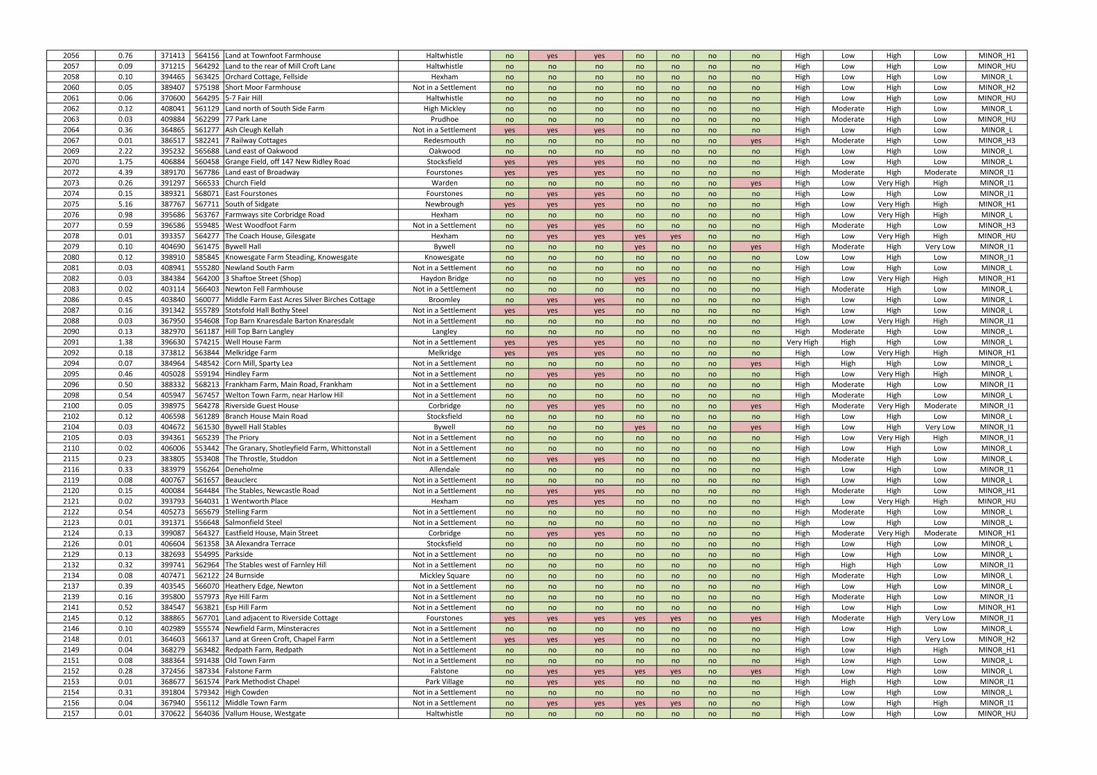
2056 0.76 371413 564156 Land at Townfoot Farmhouse Haltwhistle no yes yes no no no no High Low High Low MINOR_H1
2057 0.09 371215 564292 Land to the rear of Mill Croft Lane Haltwhistle no no no no no no no High Low High Low MINOR_HU
2058 0.10 394465 563425 Orchard Cottage, Fellside Hexham no no no no no no no High Low High Low MINOR_L
2060 0.05 389407 575198 Short Moor Farmhouse Not in a Settlement no no no no no no no High Low High Low MINOR_H2
2061 0.06 370600 564295 5-7 Fair Hill Haltwhistle no no no no no no no High Low High Low MINOR_HU
2062 0.12 408041 561129 Land north of South Side Farm High Mickley no no no no no no no High Moderate High Low MINOR_L
2063 0.03 409884 562299 77 Park Lane Prudhoe no no no no no no no High Moderate High Low MINOR_HU
2064 0.36 364865 561277 Ash Cleugh Kellah Not in a Settlement yes yes yes no no no no High Low High Low MINOR_L
2067 0.01 386517 582241 7 Railway Cottages Redesmouth no no no no no no yes High Moderate High Low MINOR_H3
2069 2.22 395232 565688 Land east of Oakwood Oakwood no no no no no no no High Low High Low MINOR_L
2070 1.75 406884 560458 Grange Field, off 147 New Ridley Road Stocksfield yes yes yes no no no no High Low High Low MINOR_L
2072 4.39 389170 567786 Land east of Broadway Fourstones yes yes yes no no no no High Moderate High Moderate MINOR_I1
2073 0.26 391297 566533 Church Field Warden no no no no no no yes High Low Very High High MINOR_I1
2074 0.15 389321 568071 East Fourstones Fourstones no yes yes no no no no High Low High Low MINOR_I1
2075 5.16 387767 567711 South of Sidgate Newbrough yes yes yes no no no no High Low Very High High MINOR_H1
2076 0.98 395686 563767 Farmways site Corbridge Road Hexham no no no no no no no High Low Very High High MINOR_L
2077 0.59 396586 559485 West Woodfoot Farm Not in a Settlement no yes yes no no no no High Moderate High Low MINOR_H3
2078 0.01 393357 564277 The Coach House, Gilesgate Hexham no yes yes yes yes no no High Low Very High High MINOR_HU
2079 0.10 404690 561475 Bywell Hall Bywell no no no yes no no yes High Moderate High Very Low MINOR_I1
2080 0.12 398910 585845 Knowesgate Farm Steading, Knowesgate Knowesgate no no no no no no no Low Low High Low MINOR_I1
2081 0.03 408941 555280 Newland South Farm Not in a Settlement no no no no no no no High Low High Low MINOR_L
2082 0.03 384384 564200 3 Shaftoe Street (Shop) Haydon Bridge no no no yes no no no High Low Very High High MINOR_H1
2083 0.02 403114 566403 Newton Fell Farmhouse Not in a Settlement no no no no no no no High Moderate High Low MINOR_L
2086 0.45 403840 560077 Middle Farm East Acres Silver Birches Cottage Broomley no yes yes no no no no High Low High Low MINOR_L
2087 0.16 391342 555789 Stotsfold Hall Bothy Steel Not in a Settlement yes yes yes no no no no High Low High Low MINOR_L
2088 0.03 367950 554608 Top Barn Knaresdale Barton Knaresdale Not in a Settlement no no no no no no no High Low Very High High MINOR_I1
2090 0.13 382970 561187 Hill Top Barn Langley Langley no no no no no no no High Moderate High Low MINOR_L
2091 1.38 396630 574215 Well House Farm Not in a Settlement yes yes yes no no no no Very High High High Low MINOR_L
2092 0.18 373812 563844 Melkridge Farm Melkridge yes yes yes no no no no High Low Very High High MINOR_H1
2094 0.07 384964 548542 Corn Mill, Sparty Lea Not in a Settlement no no no no no no yes High High High Low MINOR_L
2095 0.46 405028 559194 Hindley Farm Not in a Settlement no yes yes no no no no High Low Very High High MINOR_L
2096 0.50 388332 568213 Frankham Farm, Main Road, Frankham Not in a Settlement no no no no no no no High Moderate High Low MINOR_I1
2098 0.54 405947 567457 Welton Town Farm, near Harlow Hill Not in a Settlement no no no no no no no High Moderate High Low MINOR_L
2100 0.05 398975 564278 Riverside Guest House Corbridge no yes yes no no no yes High Moderate Very High Moderate MINOR_I1
2102 0.12 406598 561289 Branch House Main Road Stocksfield no no no no no no no High Low High Low MINOR_L
2104 0.03 404672 561530 Bywell Hall Stables Bywell no no no yes no no yes High Low High Very Low MINOR_I1
2105 0.03 394361 565239 The Priory Not in a Settlement no no no no no no no High Low Very High High MINOR_I1
2110 0.02 406006 553442 The Granary, Shotleyfield Farm, Whittonstall Not in a Settlement no no no no no no no High Low High Low MINOR_L
2115 0.23 383805 553408 The Throstle, Studdon Not in a Settlement no yes yes no no no no High Moderate High Low MINOR_L
2116 0.33 383979 556264 Deneholme Allendale no no no no no no no High Low High Low MINOR_I1
2119 0.08 400767 561657 Beauclerc Not in a Settlement no no no no no no no High Low High Low MINOR_L
2120 0.15 400084 564484 The Stables, Newcastle Road Not in a Settlement no yes yes no no no no High Moderate High Low MINOR_H1
2121 0.02 393793 564031 1 Wentworth Place Hexham no yes yes no no no no High Low Very High High MINOR_HU
2122 0.54 405273 565679 Stelling Farm Not in a Settlement no no no no no no no High Moderate High Low MINOR_L
2123 0.01 391371 556648 Salmonfield Steel Not in a Settlement no no no no no no no High Low High Low MINOR_L
2124 0.13 399087 564327 Eastfield House, Main Street Corbridge no yes yes no no no no High Moderate Very High Moderate MINOR_H1
2126 0.01 406604 561358 3A Alexandra Terrace Stocksfield no no no no no no no High Low High Low MINOR_L
2129 0.13 382693 554995 Parkside Not in a Settlement no no no no no no no High Low High Low MINOR_L
2132 0.32 399741 562964 The Stables west of Farnley Hill Not in a Settlement no no no no no no no High High High Low MINOR_I1
2134 0.08 407471 562122 24 Burnside Mickley Square no no no no no no no High Moderate High Low MINOR_L
2137 0.39 403545 566070 Heathery Edge, Newton Not in a Settlement no no no no no no no High Low High Low MINOR_L
2139 0.16 395800 557973 Rye Hill Farm Not in a Settlement no no no no no no no High Moderate High Low MINOR_I1
2141 0.52 384547 563821 Esp Hill Farm Not in a Settlement no no no no no no no High Low High Low MINOR_H1
2145 0.12 388865 567701 Land adjacent to Riverside Cottage Fourstones yes yes yes yes yes no yes High Moderate High Very Low MINOR_I1
2146 0.10 402989 555574 Newfield Farm, Minsteracres Not in a Settlement no no no no no no no High Low High Low MINOR_L
2148 0.01 364603 566137 Land at Green Croft, Chapel Farm Not in a Settlement yes yes yes no no no no High Low High Very Low MINOR_H2
2149 0.04 368279 563482 Redpath Farm, Redpath Not in a Settlement no no no no no no no High Low High High MINOR_H1
2151 0.08 388364 591438 Old Town Farm Not in a Settlement no no no no no no no High Low High Low MINOR_L
2152 0.28 372456 587334 Falstone Farm Falstone no yes yes yes yes no yes High Low High Low MINOR_L
2153 0.01 368677 561574 Park Methodist Chapel Park Village no yes yes no no no no High High High Low MINOR_I1
2154 0.31 391804 579342 High Cowden Not in a Settlement no no no no no no no High Low High Low MINOR_L
2156 0.04 367940 556112 Middle Town Farm Not in a Settlement no yes yes yes yes no no High Low High High MINOR_I1
2157 0.01 370622 564036 Vallum House, Westgate Haltwhistle no no no no no no no High Low High Low MINOR_HU
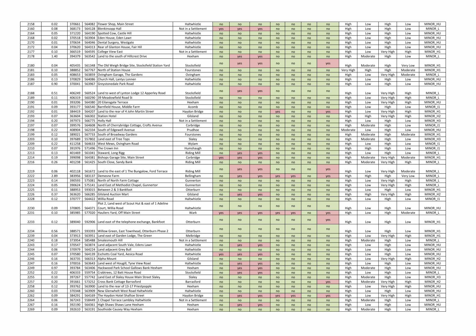
2158 0.02 370661 564082 Flower Shop, Main Street Haltwhistle no no no no no no no High Low High Low MINOR_HU
2160 0.08 368173 564128 Blenkinsopp Hall Not in a Settlement yes yes yes no no no no High Low High Low MINOR_L
2164 0.05 371220 564190 Spotted Cow, Castle Hill Haltwhistle no no no no no no no High Low High Low MINOR_HU
2168 0.02 370518 563904 Eden House, Eden Lawn Haltwhistle no no no no no no no High Low High Low MINOR_HU
2170 0.01 370634 564046 Dental Surgery, Westgate Haltwhistle no no no no no no no High Low High Low MINOR_HU
2172 0.04 370620 564313 Rear of Glanton House, Fair Hill Haltwhistle no no no no no no no High Low High Low MINOR_HU
2177 0.10 366519 564595 College View East Not in a Settlement no no no no no no no High Low Very High High MINOR_H1
2178 1.40 394379 563542 Land to the south of Hillcrest Drive Hexham no yes yes no no no no High Moderate High Low MINOR_L
2180 0.04 405435 561348 The Old Weigh Bridge Site, Stocksfield Station Yard Stocksfieldno yes yes no no no yes
High Moderate High Very Low MINOR_H1
2181 0.10 388852 567767 North of Station House Fourstones no no no no no no no Very High High High Moderate MINOR_H1
2183 0.05 408653 563859 Ovingham Garage, The Gardens Ovingham no no no no no no no High Low Very High Moderate MINOR_L
2186 0.13 370829 564086 Church Hall, Lantys Lonnen Haltwhistle no no no no no no no High Low High Low MINOR_HU
2187 0.90 370041 563967 Greystonedale Park Road Haltwhistle no no no no no no no High Low High Low MINOR_HU
2188 0.51 406249 560524 Land to west of Lynton Lodge 12 Apperley Road Stocksfieldno yes yes no no no no
High Low Very High High MINOR_L
2189 0.11 406319 560290 39 Meadowfield Road St Stocksfield no no no no no no no High Low Very High High MINOR_L
2190 0.01 393206 564380 20 Eilansgate Terrace Hexham no no no no no no no High Low Very High High MINOR_HU
2191 0.09 393177 566540 Barnfield House, Middle Farm Acomb no no no no no no no High Low High Low MINOR_I1
2192 0.01 384419 564207 Land to the rear of 4 John Martin Street Haydon Bridge no no no yes no no yes High Low Very High High MINOR_H1
2193 0.07 363604 566302 Station Hotel Gilsland no no no no no no no High High Very High High MINOR_H2
2194 0.20 397973 566775 Holly Hall Not in a Settlement no no no no no no no High Low High Low MINOR_H3
2197 0.07 399576 564608 North of Cherrybridge Cottage, Crofts Avenue Corbridge no no no no no no no High Moderate High Low MINOR_I1
2198 0.22 408904 562334 South of Edgewell Avenue Prudhoe no no no no no no no Moderate Low High Low MINOR_HU
2199 0.12 389021 567733 South of Broadway Gardens Fourstones no no no no no no no High Moderate High Moderate MINOR_H1
2203 0.10 397689 557802 Land east of Tree Tops Slaley no no no no no no no High Moderate High Low MINOR_H3
2209 0.22 411258 564633 West Mews, Ovingham Road Wylam no no no no no no no High Low High Low MINOR_I1
2210 0.07 391976 571496 The Crown Inn Humshaugh no no no no no no no High High High Low MINOR_I1
2213 0.13 401469 561041 Staward, Long Rigg Riding Mill no yes yes no no no no High Low High Low MINOR_L
2214 0.19 399098 564381 Bishops Garage Site, Main Street Corbridge yes yes yes no no no no High Moderate Very High Moderate MINOR_H1
2216 0.26 401238 561425 South Close, Sandy Bank Riding Mill no no no no no no no High Moderate Very High High MINOR_L
2219 0.06 402118 561672 Land to the east of 1 The Bungalow, Ford Terrace Riding Millno yes yes no no no yes
High Low Very High Moderate MINOR_L
2222 2.89 383956 583137 Demesne Farm Bellingham no yes yes yes yes no yes High High High Very Low MINOR_L
2223 0.14 390593 575081 North of North Farm Cottage Gunnerton no no no no no no no High Low Very High High MINOR_L
2224 0.05 390624 575141 Land East of Methodist Chapel, Gunnerton Gunnerton no no no no no no no High Low Very High High MINOR_L
2225 0.11 388953 593015 Between 2 & 3 Bankfoot Otterburn no no no no no no no High Low High Low MINOR_H1
2226 0.37 363620 566285 Gilsland Auction Mart Gilsland no yes yes no no no no High High Very High High MINOR_H2
2228 0.12 370777 564422 Willia Road Haltwhistle no no no no no no no High Low High Low MINOR_I1
2230 0.09 370805 564371
Plot 2, Land west of Scout Hut & east of 1 Adeline
Court, Willia Road Haltwhistleno no no no no no no
High Low High Low MINOR_HU
2231 0.10 385985 577020 Hauliers Yard, Off Main Street Wark yes yes yes yes yes no yes High Low High Moderate MINOR_L
2233 0.12 389040 592906 Land east of the telephone exchange, Bankfoot Otterburnno no no no no no yes
High Low High Low MINOR_H1
2234 0.56 388571 593393 Willow Green, East Townhead, Otterburn Phase 2 Otterburnno no no no no no no
High Low High Low MINOR_H1
2239 0.04 373913 563951 Land east of Garden Lodge, The Green Melkridge no no no no no no no High Low Very High High MINOR_H1
2240 0.18 373954 585488 Smalesmouth Hill Not in a Settlement no no no no no no no High Moderate High Low MINOR_L
2243 0.17 370547 563874 Land adjacent South Vale, Edens Lawn Haltwhistle no yes yes no no no no High Low High Low MINOR_HU
2244 0.06 370979 564224 Land adjacent Grey Bull Haltwhistle no no no no no no no High Low High Low MINOR_HU
2245 0.07 370580 564139 Eschotts Coal Yard, Aesica Road Haltwhistle yes yes yes no no no no High Low High Low MINOR_HU
2246 0.16 363735 566313 Alpha Mount Gilsland no no no no no no no High Low Very High High MINOR_H2
2247 0.16 370016 563643 Land west of Hougill, Tyne View Road Haltwhistle no yes yes no no no no High Low High Low MINOR_HU
2249 0.97 393784 563406 Hackwood Park School Gallows Bank Hexham Hexham no yes yes no no no no High Moderate High Low MINOR_HU
2252 0.22 406333 559754 Crabtrees, 12 Batt House Road Stocksfield no yes yes no no no no High Low High Low MINOR_L
2255 0.10 397267 557742 Land East of Slaley House Main Street Slaley Slaley no no no no no no no High Moderate High Low MINOR_H3
2257 0.20 391661 573252 Cross Bank Cottage Barrasford Barrasford no no no no no no yes High Moderate Very High High MINOR_H2
2258 0.12 393762 563900 Land to the rear of 13-17 Priestpopple Hexham no no no no no no no High Low Very High High MINOR_HU
2260 0.03 370348 563909 New Glenwhelt West Road Haltwhistle Haltwhistle no no no no no no no High Low High Low MINOR_HU
2262 0.09 384291 564169 The Haydon Hotel Shaftoe Street Haydon Bridge no yes yes yes yes no yes High Low Very High High MINOR_H1
2264 0.06 367243 558449 1 Chapel Terrace Lambley Haltwhistle Not in a Settlement no no no no no no no High Moderate High Low MINOR_L
2267 0.16 392190 564361 High Shaws Shaws Lane Hexham Hexham no yes yes no no no no High Low High Low MINOR_HU
2269 0.09 392610 563191 Southside Causey Way Hexham Hexham no no no no no no no High Moderate High Low MINOR_L
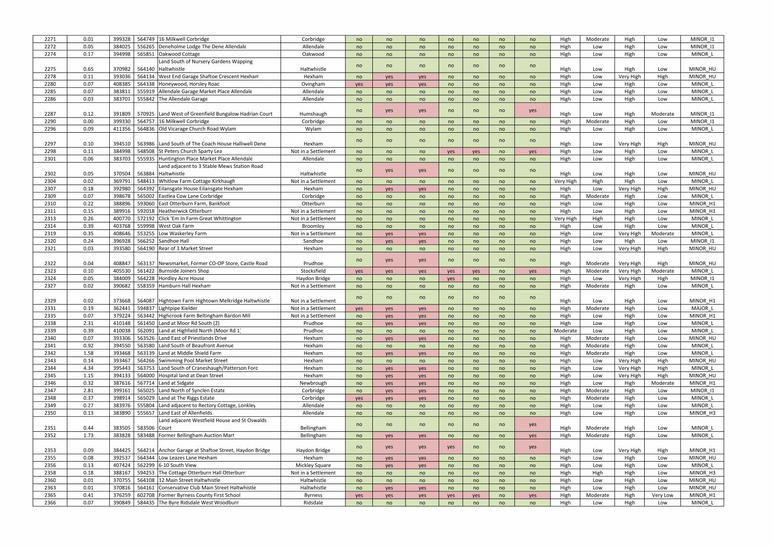
2271 0.01 399328 564749 16 Milkwell Corbridge Corbridge no no no no no no no High Moderate High Low MINOR_I1
2272 0.05 384025 556265 Deneholme Lodge The Dene Allendale Allendale no no no no no no no High Low High Low MINOR_I1
2274 0.17 394998 565851 Oakwood Cottage Oakwood no no no no no no no High Low High Low MINOR_L
2275 0.65 370982 564140
Land South of Nursery Gardens Wapping
Haltwhistle Haltwhistleno no no no no no no
High Low High Low MINOR_HU
2278 0.11 393036 564134 West End Garage Shaftoe Crescent Hexham Hexham no yes yes no no no no High Low Very High High MINOR_HU
2280 0.07 408385 564338 Honeywood, Horsley Road Ovingham yes yes yes no no no no High Low High Low MINOR_L
2285 0.07 383811 555919 Allendale Garage Market Place Allendale Allendale no no no no no no no High Low High Low MINOR_L
2286 0.03 383701 555842 The Allendale Garage Allendale no no no no no no no High Low High Low MINOR_L
2287 0.12 391809 570925 Land West of Greenfield Bungalow Hadrian Court Humshaughno yes yes no no no yes
High Low High Moderate MINOR_I1
2290 0.00 399330 564757 16 Milkwell Corbridge Corbridge no no no no no no no High Moderate High Low MINOR_I1
2296 0.09 411356 564836 Old Vicarage Church Road Wylam Wylam no no no no no no no High Low High Low MINOR_L
2297 0.10 394510 563986 Land South of The Coach House Halliwell Dene Hexhamno no no no no no no
High Low Very High High MINOR_HU
2298 0.11 384998 548508 St Peters Church Sparty Lea Not in a Settlement no no no yes yes no yes High Low High Low MINOR_L
2301 0.06 383703 555935 Huntington Place Market Place Allendale Allendale no no no no no no no High Low High Low MINOR_L
2302 0.05 370504 563884
Land adjacent to 3 Stable Mews Station Road
Haltwhistle Haltwhistleno yes yes no no no no
High Low High Low MINOR_HU
2304 0.02 369791 548413 Whitlow Farm Cottage Kirkhaugh Not in a Settlement no no no no no no no Very High High High Low MINOR_L
2307 0.18 392980 564392 Eilansgate House Eilansgate Hexham Hexham no yes yes no no no no High Low Very High High MINOR_HU
2309 0.07 398678 565002 Eastlea Cow Lane Corbridge Corbridge no no no no no no no High Moderate High Low MINOR_L
2310 0.22 388896 593060 East Otterburn Farm, Bankfoot Otterburn no no no no no no no High Low High Low MINOR_H1
2311 0.15 389916 592018 Heatherwick Otterburn Not in a Settlement no no no no no no no High Low High Low MINOR_H1
2313 0.26 400770 572192 Click 'Em In Farm Great Whittington Not in a Settlement no no no no no no no Very High High High Low MINOR_L
2314 0.39 403768 559998 West Oak Farm Broomley no no no no no no no High Low High Low MINOR_L
2319 0.35 408646 553255 Low Waskerley Farm Not in a Settlement no yes yes no no no no High Low Very High Moderate MINOR_L
2320 0.24 396928 566252 Sandhoe Hall Sandhoe no yes yes no no no no High Low High Low MINOR_I1
2321 0.03 393580 564190 Rear of 3 Market Street Hexham no no no no no no no High Low Very High High MINOR_HU
2322 0.04 408847 563137 Newsmarket, Former CO-OP Store, Castle Road Prudhoeno yes yes no no no no
High Moderate Very High High MINOR_HU
2323 0.10 405530 561422 Burnside Joiners Shop Stocksfield yes yes yes yes yes no yes High Moderate Very High Moderate MINOR_L
2324 0.05 384009 564228 Hordley Acre House Haydon Bridge no no no yes no no no High Low Very High High MINOR_I1
2327 0.02 390682 558359 Hamburn Hall Hexham Not in a Settlement no no no no no no no High Moderate High Low MINOR_L
2329 0.02 373668 564087 Hightown Farm Hightown Melkridge Haltwhistle Not in a Settlementno no no no no no no
High Low High Low MINOR_H1
2331 0.19 362441 594837 Lightpipe Kielder Not in a Settlement yes yes yes no no no no High Moderate High Low MAJOR_L
2335 0.07 379224 563442 Highcrook Farm Beltingham Bardon Mill Not in a Settlement no yes yes no no no no High Low High Low MINOR_H1
2338 2.31 410148 561450 Land at Moor Rd South (2) Prudhoe no yes yes no no no no High Low High Low MINOR_L
2339 0.39 410038 562091 Land at Highfield North (Moor Rd 1) Prudhoe no no no no no no no Moderate Low High Low MINOR_L
2340 0.07 393306 563526 Land East of Priestlands Drive Hexham no yes yes no no no no High Moderate High Low MINOR_HU
2341 0.92 394550 563580 Land South of Beaufront Avenue Hexham no no no no no no no High Moderate High Low MINOR_L
2342 1.58 393468 563139 Land at Middle Shield Farm Hexham no yes yes no no no no High Moderate High Low MINOR_L
2343 0.14 393467 564266 Swimming Pool Market Street Hexham no no no no no no no High Low Very High High MINOR_HU
2344 4.34 395443 563753 Land South of Craneshaugh/Patterson Ford Hexham no yes yes no no no no High Low Very High High MINOR_L
2345 1.15 394133 564000 Hospital land at Dean Street Hexham no yes yes no no no no High Low Very High High MINOR_HU
2346 0.32 387616 567714 Land at Sidgate Newbrough no yes yes no no no no High Low High Moderate MINOR_H1
2347 2.81 399161 565025 Land North of Synclen Estate Corbridge no yes yes no no no no High Moderate High Low MINOR_I1
2348 0.37 398914 565029 Land at The Riggs Estate Corbridge yes yes yes no no no no High Moderate High Low MINOR_L
2349 0.27 383976 555804 Land adjacent to Rectory Cottage, Lonkley Allendale no no no no no no no High Low High Low MINOR_L
2350 0.13 383890 555657 Land East of Allenfields Allendale no no no no no no no High Low High Low MINOR_H3
2351 0.44 383505 583506
Land adjacent Westfield House and St Oswalds
Court Bellinghamno no no no no no yes
High Moderate High Low MINOR_L
2352 1.73 383828 583488 Former Bellingham Auction Mart Bellingham no yes yes no no no yes High Moderate High Low MINOR_L
2353 0.09 384425 564214 Anchor Garage at Shaftoe Street, Haydon Bridge Haydon Bridgeno yes yes yes no no yes
High Low Very High High MINOR_H1
2355 0.08 392537 564344 Low Leazes Lane Hexham Hexham no yes yes no no no no High Low High Low MINOR_HU
2356 0.13 407424 562299 6-10 South View Mickley Square no yes yes no no no no High Low High Low MINOR_L
2358 0.18 388167 594253 The Cottage Otterburn Hall Otterburn Not in a Settlement no no no no no no no High High High Low MINOR_H3
2360 0.01 370755 564108 12 Main Street Haltwhistle Haltwhistle no no no no no no no High Low High Low MINOR_HU
2363 0.01 370816 564161 Conservative Club Main Street Haltwhistle Haltwhistle no yes yes no no no no High Low High Low MINOR_HU
2365 0.41 376259 602708 Former Byrness County First School Byrness yes yes yes yes yes no yes High Moderate High Very Low MINOR_H1
2366 0.07 390849 584435 The Byre Ridsdale West Woodburn Ridsdale no no no no no no no High Low High Low MINOR_L
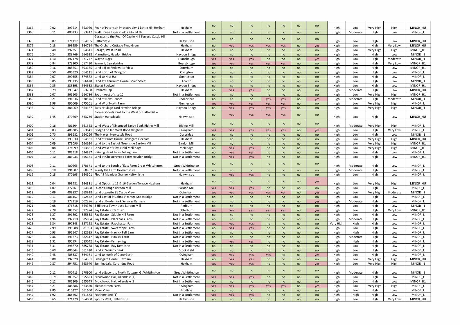
2367 0.02 393614 563960 Rear of Pattinson Photography 1 Battle Hill Hexham Hexhamno no no no no no no
High Low Very High High MINOR_HU
2368 0.11 400133 553917 Wall House Espershields Kiln Pit Hill Not in a Settlement no no no no no no no High Moderate High Low MINOR_L
2370 0.07 371117 564195
Garages to the Rear Of Castle Hill Terrace Castle Hill
Haltwhistle Haltwhistleno no no no no no no
High Low High Low MINOR_HU
2372 0.13 393259 564714 The Orchard Cottage Tyne Green Hexham no yes yes yes yes no yes High Low High Very Low MINOR_HU
2374 0.48 392351 564811 Garage, West Road Hexham no no no no no no no High Low Very High High MINOR_H1
2376 0.24 383769 564638 Maresfield, Haydon Bridge Haydon Bridge no no no no no no no High Low High Low MINOR_I1
2377 1.10 392178 571277 Wayne Riggs Humshaugh yes yes yes no no no yes High Low High Moderate MINOR_I1
2379 0.84 378200 557430 Sawmill, Bearsbridge Bearsbridge yes yes yes yes yes no no High Low High Very Low MINOR_H1
2380 0.16 388251 593175 Land adj to Redewater View Otterburn no no no no no no no High Low High Low MINOR_H1
2382 0.50 406320 564111 Land north of Ovington Ovington no no no no no no no High Low High Low MINOR_L
2384 0.07 390355 574872 Land to N of Hall Gunnerton no no no no no no no High Low High Low MINOR_L
2385 0.05 393235 566428 Land at Laburnum House, Main Street Acomb no no no no no no no High Low High Low MINOR_I1
2386 0.35 383398 564632 Site at Peelwell Haydon Bridge no no no no no no no High Low High Low MINOR_H1
2387 0.79 393047 563768 Orchard Gap Hexham no yes yes no no no no High Moderate High Low MINOR_HU
2388 0.07 366105 564786 South-west of site 10 Not in a Settlement no no no no no no no High Low Very High High MINOR_H1
2389 0.21 391636 570576 Land at New Houses Chollerford no no no yes yes no yes High Moderate High Moderate MINOR_I1
2390 1.98 390609 575201 Land W of North Farm Gunnerton yes yes yes yes yes no no High Low Very High High MINOR_L
2395 0.51 384069 564167 Taits Haulage Yard Haydon Bridge Haydon Bridge no yes yes yes yes no no High Low Very High High MINOR_I1
2399 1.45 370269 563736
Former Goods Yard to the West of Haltwhistle
Station Haltwhistle Haltwhistleno yes yes yes yes no no
High Low High Low MINOR_HU
2400 0.16 401504 561528 Land West of Kingmead Sandy Bank Riding Mill Riding Millno no no no no no no
High Moderate Very High High MINOR_L
2401 0.03 408385 563641 Bridge End Inn West Road Ovigham Ovingham yes yes yes yes yes no yes High Low High Very Low MINOR_L
2402 0.70 399682 564266 The Hayes, Newcastle Road Corbridge no no no no no no no High Low High Low MINOR_I1
2403 0.51 393030 564531 Land at Priors House Eilansgate Hexham Hexham no no no no no no no High Low Very High High MINOR_HU
2404 0.09 378096 564624 Land to the East of Greenside Bardon Mill Bardon Mill no no no no no no no High Low Very High High MINOR_H1
2405 0.08 374099 563861 Land West of Flatt Field Melkridge Melkridge no yes yes no no no no High Low Very High High MINOR_H1
2406 0.11 383518 584887 Haining Head Farm Bellingham Not in a Settlement no yes yes no no no no High Low High Low MINOR_L
2407 0.10 383033 565181 Land at ChesterWood Farm Haydon Bridge Not in a Settlement no yes yes no no no no High Low High Low MINOR_H1
2408 0.11 400665 570671 Land to the South of East Farm Great Whittington Great Whittingtonno no no no no no no
High Moderate High Low MINOR_L
2409 0.18 391807 560962 Windy Hill Farm Hexhamshire Not in a Settlement no no no no no no no High Moderate High Low MINOR_L
2412 0.15 370195 564301 Plot 48 Meadow Grange Haltwhistle Haltwhistle no yes yes no no no no High Low High Low MINOR_L
2415 0.04 393481 564381 Land Opposite 15 & 16 Garden Terrace Hexham Hexhamno no no no no no yes
High Low Very High High MINOR_HU
2416 1.07 377261 564658 Falcon Grange Bardon Mill Bardon Mill yes yes yes no no no no High Low High Low MINOR_L
2418 0.09 408837 563918 Land opposite 21 Castle View Ovingham yes yes yes yes yes no yes High Low Very High Moderate MINOR_I1
2419 0.11 406457 552472 Land East of St Johns Vicarage Snods Edge Not in a Settlement no no no no no no no High Low High Low MINOR_L
2420 0.19 377119 602296 Land at Border Park Services Byrness Not in a Settlement no no no no no no yes High Moderate High Low MINOR_L
2421 0.08 376718 564370 3 Hillcrest Tow House Bardon Mill Redburn no no no no no no no High Low High Low MINOR_I1
2422 7.28 388352 592974 Ray Estate, Otterburn Otterburn yes yes yes yes yes no yes High Low High Very Low MINOR_H1
2423 1.27 391892 585658 Ray Estate - Stiddle Hill Farm Not in a Settlement no no no no no no no High Low High Low MINOR_L
2424 1.96 397710 585894 Ray Estate - Blackhalls Farm Not in a Settlement no no no no no no no High Moderate High Low MINOR_L
2425 1.34 397843 587128 Ray Estate - Raechester Farm Not in a Settlement yes yes yes no no no no Very High High High Low MINOR_L
2426 2.99 395588 581903 Ray Estate - Sweethope Farm Not in a Settlement no yes yes no no no no High Low High Low MINOR_L
2427 0.93 395547 582635 Ray Estate - Hawick Fell Barn Not in a Settlement no no no no no no no High High High Low MINOR_L
2428 2.46 396273 582617 Ray Estate - Hawick Farm Not in a Settlement no no no no no no no High Moderate High Low MINOR_L
2429 1.31 395994 583642 Ray Estate - Ferneyrigg Not in a Settlement no yes yes no no no no High High High Low MINOR_L
2431 5.31 396870 585758 Ray Estate - Ray Demesne Not in a Settlement no no no no no no no High Low High Low MINOR_L
2433 3.60 406844 561420 Land at Whinny Bank Stocksfield no no no no no no no High Low High Low MINOR_L
2440 2.48 408337 564161 Land to north of Dene Garth Ovingham yes yes yes yes no no yes High Low High Low MINOR_L
2441 0.08 392920 564381 Eilansgate House, Hexham Hexham no yes yes no no no no High Low Very High High MINOR_HU
2442 0.87 394751 563940 Sunningdale, Corbridge Road Hexham yes yes yes no no no yes High Low Very High High MINOR_I1
2443 0.12 400413 570900 Land adjacent to North Cottage, Gt Whittington Great Whittingtonno no no no no no no
High Moderate High Low MINOR_I1
2445 12.78 383257 555823 Broadwood Hall, Allendale (1) Not in a Settlement yes yes yes no no no no High Low High Low MINOR_L
2446 0.12 383209 555643 Broadwood Hall, Allendale (2) Not in a Settlement no no no no no no no High Low High Low MINOR_H1
2447 8.21 408286 563850 Bleach Green Farm Ovingham yes yes yes yes yes no yes High Low Very High High MINOR_L
2448 2.85 410127 561660 Moor View Prudhoe no no no no no no no High Low High Low MINOR_L
2449 1.92 368662 561883 Featherstone (1) Not in a Settlement yes yes yes no no no no High High High Low MINOR_L
2453 0.65 371270 564060 Spouty Well, Haltwhistle Haltwhistle no no no no no no no High Low High Very Low MINOR_HU

2454 2.72 393373 563103 High Shield Cottage, Dipton Mill (1) Hexham yes yes yes no no no no High Moderate High Low MINOR_L
2455 0.69 393501 563004 High Shield Cottage, Dipton Mill (2) Hexham no yes yes no no no no High Moderate High Low MINOR_L
2456 3.35 402094 561226 Land at Broomhaugh Riding Mill yes yes yes no no no no High Moderate Very High High MINOR_L
2457 0.68 394220 565068 Land at Bridge End Hexham no yes yes no no no yes High Low Very High High MINOR_H1
2458 2.52 399659 565061 Land at Cragside, Deadridge Lane Corbridge no yes yes no no no no High High High Low MINOR_I1
2460 0.44 387461 593747 Otterburn First School (2) Not in a Settlement no no no no no no no High Low High Very Low MINOR_H1
2461 0.03 410028 562953 Oaklands House, Prudhoe (2) Prudhoe no yes yes no no no no High Moderate High Low MINOR_HU
2462 0.78 384255 556029 Allendale Highways Depot & HWRC Allendale no no no no no no no High High High Low MINOR_L
2463 26.78 405850 561312 Land at Stocksfield South of A695 Stocksfield yes yes yes yes yes no yes High Moderate High Very Low MINOR_L
2467 1.86 393033 566269 Garden House Lane Acomb yes yes yes no no no no High Low Very High High MINOR_I1
2468 0.26 393053 566391 Townfoot Farm Acomb no yes yes no no no no High Low High Low MINOR_I1
2469 0.43 393318 566606 White House Acomb no yes yes no no no no High Low High Low MINOR_I1
2470 20.93 409438 556217 Newlands Not in a Settlement yes yes yes yes yes no no High Low Very High Moderate MINOR_H2
2471 7.64 399004 565231 Milkwell Corbridge no yes yes no no no no Very High High Low Very Low MINOR_L
2472 0.38 388331 567900 Newbrough & Fourstones (1) Fourstones no no no no no no no Very High High High Moderate MINOR_H1
2473 2.09 388292 567790 Newbrough & Fourstones (2) Fourstones yes yes yes yes no no no High Low High Moderate MINOR_I1
2474 0.71 388238 567679 Newbrough & Fourstones (3) Fourstones yes yes yes yes yes no no Very High High High Moderate MINOR_I1
2475 0.82 388134 567733 Newbrough & Fourstones (4) Fourstones yes yes yes no no no no High Low High Moderate MINOR_H1
2476 1.71 388769 567976 Newbrough & Fourstones (5) Fourstones yes yes yes no no no no High Moderate High Low MINOR_I1
2477 2.40 388968 568001 Newbrough & Fourstones (6) Fourstones no no no no no no no Very High High High Low MINOR_I1
2478 4.40 389164 568178 Newbrough & Fourstones (7) Fourstones no no no no no no no High Low High Low MINOR_I1
2479 1.28 392616 566241 Former Colliery Site Acomb yes yes yes yes yes no yes High Low Very High High MINOR_I1
2480 0.80 410231 564604 Wylam Pumping Station Not in a Settlement yes yes yes yes yes no yes High Low High Very Low MINOR_I1
2481 1.01 383960 583582 North of Old School Bellingham no yes yes no no no yes Very High High High Low MINOR_L
2482 0.19 407319 567227 Whittle Dene Water Treatment Works Not in a Settlement no yes yes yes yes no yes High Moderate High Low MINOR_L
2483 0.58 377605 561508 Ridley Common Reservoir Not in a Settlement no no no no no no no High Low High Low MINOR_L
2484 0.05 387992 593291 Otterburn Water Treatment Works Not in a Settlement no no no no no no no High Low High Very Low MINOR_H1
2485 0.11 388841 592701 Otterburn Mill former Pumping Station Not in a Settlement no yes yes yes yes no yes High Low High Very Low MINOR_H3
2487 3.32 370765 586961 Yarrowmoor Operations Centre Not in a Settlement no yes yes no no no no High Moderate High Low MINOR_L
2489 0.15 393223 562335 Black House Water Treatment Works Not in a Settlement no no no no no no no High Low High Low MINOR_L
2490 1.06 412238 564864 Bythorne Farm, Wylam Not in a Settlement yes yes yes no yes no yes High Low High Very Low MINOR_I1
2491 0.20 383531 555740 Land at Bridge End, Allendale Allendale yes yes yes yes yes no yes High Low High Very Low MINOR_I1
2492 0.49 395625 563763 Red Lion Cottage, Corbridge Road Hexham yes yes yes no no no no High Low Very High High MINOR_L
2493 6.27 401059 561516 Land West of Sandy Lane Riding Mill yes yes yes no no no no High Low Very High High MINOR_L
2494 40.01 410500 562217 Prudhoe Hospital Site Prudhoe yes yes yes no no no no Moderate Low High Low MINOR_L
2497 0.16 393736 563914 Bus Station Site Hexham no yes yes no no no no High Low Very High High MINOR_HU
2498 1.01 395784 563768 Parkwell Hexham no yes yes no no no no High Low Very High High MINOR_L
2499 0.92 393993 564003 Loosing Hill / Torch Centre Hexham no yes yes no no no yes High Low Very High High MINOR_HU
2501 1.38 369952 563670 Composite SA226, 209, 192, 170, West End Haltwhistle no no no no no no no High Low High Low MINOR_HU
2502 0.38 370261 564509 Land at Elmfield Comb Hill Haltwhistle no no no no no no no High Low High Low MINOR_HU
2503 0.35 405341 561296 ED1.28 Stocksfield Stocksfield yes yes yes yes no no yes High Moderate High Very Low MINOR_H1
2504 1.53 399444 564874 Milkwell Lane (part) Corbridge no no no no no no no High Moderate High Low MINOR_I1
2508 1.65 411285 565018 Wylam Hills Cottage Wylam yes yes yes yes yes no no High Low High Low MINOR_L
2509 1.09 384166 556124
North of Allendale Middle School (Local Plan
Allocation LR8.5) Allendaleno no no no no no no
High Low High Low MINOR_L
2510 1.25 378027 564539 Ashcroft Farm Bardon Mill yes yes yes yes yes no no High High Very High High MINOR_H1
2512 3.67 370654 564528
Willia Road ( including saved former Local Plan
allocation 13.2) Haltwhistleno no no no no no no
High Low High Low MINOR_L
2513 0.63 397068 566376 Land at Sandhoe Not in a Settlement no no no no no no no High Low High Low MINOR_H3
2514 3.81 398511 565126 Land at Corchester Corbridge no yes yes no no no no High Low High Low MINOR_H1
2515 0.36 395122 565889 Land at Oakwood Oakwood no no no no no no no High Low High Low MINOR_L
2517 1.20 383053 556224 Thornley Gate, Allendale Not in a Settlement no no no no no no no High Low High Low MINOR_H1
2518 0.08 401149 582174 Kirkharle Village Kirkharle no no no no no no no High Moderate High Low MINOR_L
2519 0.74 400552 583135 Newhouses, Kirkharle Not in a Settlement no yes yes no no no no High Low High Low MINOR_L
2520 0.57 384393 583404 Briar Hill, Bellingham Bellingham no yes yes no no no no High Moderate High Low MINOR_L
2521 0.14 399029 564417 Princes St Garage, Corbridge Corbridge yes yes yes no no no no High Moderate Very High Moderate MINOR_H1
2522 0.10 392780 564437 Broadway Garage, Hexham Hexham no no no no no no no High Low Very High High MINOR_HU
2523 1.22 403424 551226 Redwell Hall Farm Not in a Settlement yes yes yes no no no yes High Low Very High Moderate MINOR_I1
2524 1.68 403472 552274 Birkenside Not in a Settlement yes yes yes no no no no High Moderate High Low MINOR_L
2526 1.23 402366 555329 South Drive Plantation, Minsteracres Not in a Settlement no no no no no no no High Low High Low MINOR_L
2527 0.67 402923 557941 Low Fotherley Not in a Settlement no no no no no no no High Low High Low MINOR_L
2528 2.71 390423 575074 The Demesne, Gunnerton Gunnerton yes yes yes yes yes no no High Low High Low MINOR_L
2529 0.55 390661 575074 Gunnerton North Farm Gunnerton no yes yes no no no no High Low Very High High MINOR_L
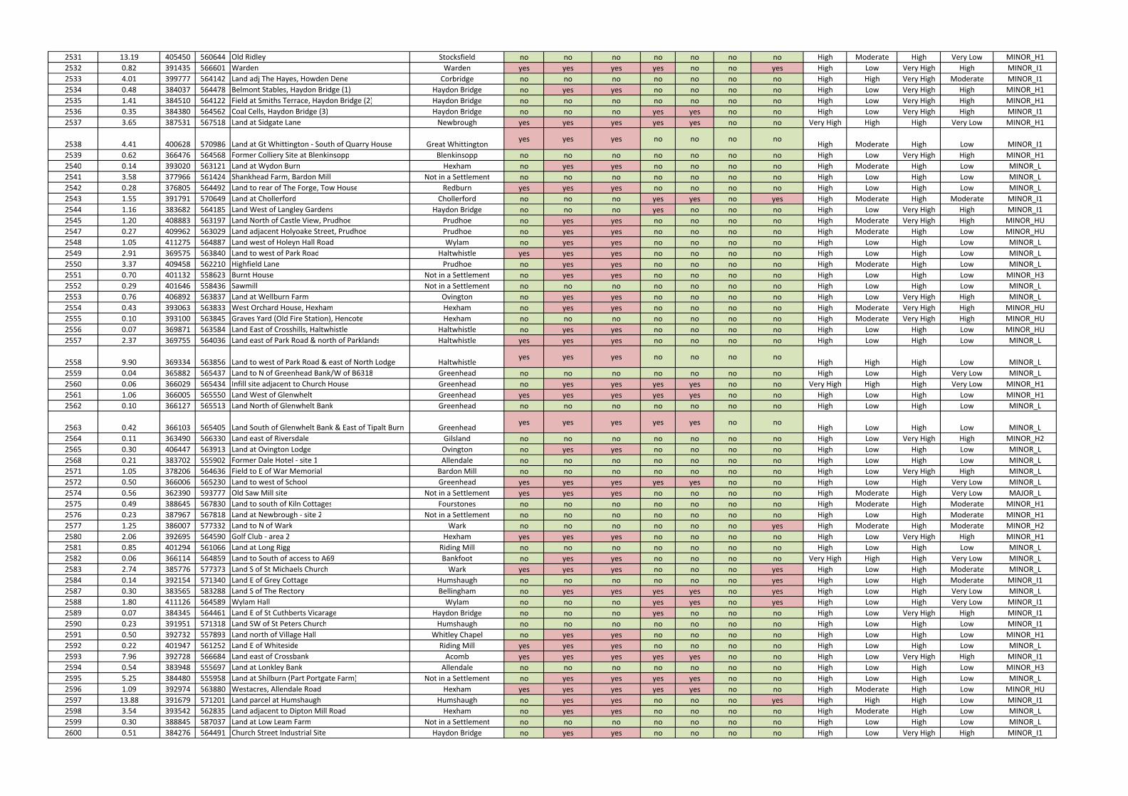
2531 13.19 405450 560644 Old Ridley Stocksfield no no no no no no no High Moderate High Very Low MINOR_H1
2532 0.82 391435 566601 Warden Warden yes yes yes yes no no yes High Low Very High High MINOR_I1
2533 4.01 399777 564142 Land adj The Hayes, Howden Dene Corbridge no no no no no no no High High Very High Moderate MINOR_I1
2534 0.48 384037 564478 Belmont Stables, Haydon Bridge (1) Haydon Bridge no yes yes no no no no High Low Very High High MINOR_H1
2535 1.41 384510 564122 Field at Smiths Terrace, Haydon Bridge (2) Haydon Bridge no no no no no no no High Low Very High High MINOR_H1
2536 0.35 384380 564562 Coal Cells, Haydon Bridge (3) Haydon Bridge no no no yes yes no no High Low Very High High MINOR_I1
2537 3.65 387531 567518 Land at Sidgate Lane Newbrough yes yes yes yes yes no no Very High High High Very Low MINOR_H1
2538 4.41 400628 570986 Land at Gt Whittington - South of Quarry House Great Whittingtonyes yes yes no no no no
High Moderate High Low MINOR_I1
2539 0.62 366476 564568 Former Colliery Site at Blenkinsopp Blenkinsopp no no no no no no no High Low Very High High MINOR_H1
2540 0.14 393020 563121 Land at Wydon Burn Hexham no yes yes no no no no High Moderate High Low MINOR_L
2541 3.58 377966 561424 Shankhead Farm, Bardon Mill Not in a Settlement no no no no no no no High Low High Low MINOR_L
2542 0.28 376805 564492 Land to rear of The Forge, Tow House Redburn yes yes yes no no no no High Low High Low MINOR_L
2543 1.55 391791 570649 Land at Chollerford Chollerford no no no yes yes no yes High Moderate High Moderate MINOR_I1
2544 1.16 383682 564185 Land West of Langley Gardens Haydon Bridge no no no yes no no no High Low Very High High MINOR_I1
2545 1.20 408883 563197 Land North of Castle View, Prudhoe Prudhoe no yes yes no no no no High Moderate Very High High MINOR_HU
2547 0.27 409962 563029 Land adjacent Holyoake Street, Prudhoe Prudhoe no yes yes no no no no High Moderate High Low MINOR_HU
2548 1.05 411275 564887 Land west of Holeyn Hall Road Wylam no yes yes no no no no High Low High Low MINOR_L
2549 2.91 369575 563840 Land to west of Park Road Haltwhistle yes yes yes no no no no High Low High Low MINOR_L
2550 3.37 409458 562210 Highfield Lane Prudhoe no yes yes no no no no High Moderate High Low MINOR_L
2551 0.70 401132 558623 Burnt House Not in a Settlement no yes yes no no no no High Low High Low MINOR_H3
2552 0.29 401646 558436 Sawmill Not in a Settlement no no no no no no no High Low High Low MINOR_L
2553 0.76 406892 563837 Land at Wellburn Farm Ovington no yes yes no no no no High Low Very High High MINOR_L
2554 0.43 393063 563833 West Orchard House, Hexham Hexham no yes yes no no no no High Moderate Very High High MINOR_HU
2555 0.10 393100 563845 Graves Yard (Old Fire Station), Hencote Hexham no no no no no no no High Moderate Very High High MINOR_HU
2556 0.07 369871 563584 Land East of Crosshills, Haltwhistle Haltwhistle no yes yes no no no no High Low High Low MINOR_HU
2557 2.37 369755 564036 Land east of Park Road & north of Parklands Haltwhistle yes yes yes no no no no High Low High Low MINOR_L
2558 9.90 369334 563856 Land to west of Park Road & east of North Lodge Haltwhistleyes yes yes no no no no
High High High Low MINOR_L
2559 0.04 365882 565437 Land to N of Greenhead Bank/W of B6318 Greenhead no no no no no no no High Low High Very Low MINOR_L
2560 0.06 366029 565434 Infill site adjacent to Church House Greenhead no yes yes yes yes no no Very High High High Very Low MINOR_H1
2561 1.06 366005 565550 Land West of Glenwhelt Greenhead yes yes yes yes yes no no High Low High Low MINOR_H1
2562 0.10 366127 565513 Land North of Glenwhelt Bank Greenhead no no no no no no no High Low High Low MINOR_L
2563 0.42 366103 565405 Land South of Glenwhelt Bank & East of Tipalt Burn Greenheadyes yes yes yes yes no no
High Low High Low MINOR_L
2564 0.11 363490 566330 Land east of Riversdale Gilsland no no no no no no no High Low Very High High MINOR_H2
2565 0.30 406447 563913 Land at Ovington Lodge Ovington no yes yes no no no no High Low High Low MINOR_L
2568 0.21 383702 555902 Former Dale Hotel - site 1 Allendale no no no no no no no High Low High Low MINOR_L
2571 1.05 378206 564636 Field to E of War Memorial Bardon Mill no no no no no no no High Low Very High High MINOR_L
2572 0.50 366006 565230 Land to west of School Greenhead yes yes yes yes yes no no High Low High Very Low MINOR_L
2574 0.56 362390 593777 Old Saw Mill site Not in a Settlement yes yes yes no no no no High Moderate High Very Low MAJOR_L
2575 0.49 388645 567830 Land to south of Kiln Cottages Fourstones no no no no no no no High Moderate High Moderate MINOR_H1
2576 0.23 387967 567818 Land at Newbrough - site 2 Not in a Settlement no no no no no no no High Low High Moderate MINOR_H1
2577 1.25 386007 577332 Land to N of Wark Wark no no no no no no yes High Moderate High Moderate MINOR_H2
2580 2.06 392695 564590 Golf Club - area 2 Hexham yes yes yes no no no no High Low Very High High MINOR_H1
2581 0.85 401294 561066 Land at Long Rigg Riding Mill no no no no no no no High Low High Low MINOR_L
2582 0.06 366114 564859 Land to South of access to A69 Bankfoot no yes yes no no no no Very High High High Very Low MINOR_L
2583 2.74 385776 577373 Land S of St Michaels Church Wark yes yes yes no no no yes High Low High Moderate MINOR_L
2584 0.14 392154 571340 Land E of Grey Cottage Humshaugh no no no no no no yes High Low High Moderate MINOR_I1
2587 0.30 383565 583288 Land S of The Rectory Bellingham no yes yes yes yes no yes High Low High Very Low MINOR_L
2588 1.80 411126 564589 Wylam Hall Wylam no no no yes yes no yes High Low High Very Low MINOR_I1
2589 0.07 384345 564461 Land E of St Cuthberts Vicarage Haydon Bridge no no no yes no no no High Low Very High High MINOR_I1
2590 0.23 391951 571318 Land SW of St Peters Church Humshaugh no no no no no no no High Low High Low MINOR_I1
2591 0.50 392732 557893 Land north of Village Hall Whitley Chapel no yes yes no no no no High Low High Low MINOR_H1
2592 0.22 401947 561252 Land E of Whiteside Riding Mill yes yes yes no no no no High Low High Low MINOR_L
2593 7.96 392728 566684 Land east of Crossbank Acomb yes yes yes yes yes no no High Low Very High High MINOR_I1
2594 0.54 383948 555697 Land at Lonkley Bank Allendale no no no no no no no High Low High Low MINOR_H3
2595 5.25 384480 555958 Land at Shilburn (Part Portgate Farm) Not in a Settlement no yes yes yes yes no no High Low High Low MINOR_L
2596 1.09 392974 563880 Westacres, Allendale Road Hexham yes yes yes yes yes no no High Moderate High Low MINOR_HU
2597 13.88 391679 571201 Land parcel at Humshaugh Humshaugh no yes yes no no no yes High High High Low MINOR_I1
2598 3.54 393542 562835 Land adjacent to Dipton Mill Road Hexham no yes yes no no no no High Moderate High Low MINOR_L
2599 0.30 388845 587037 Land at Low Leam Farm Not in a Settlement no no no no no no no High Low High Low MINOR_L
2600 0.51 384276 564491 Church Street Industrial Site Haydon Bridge no yes yes no no no no High Low Very High High MINOR_I1
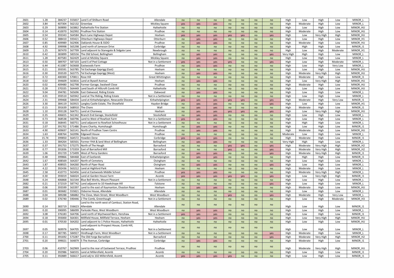
2601 1.28 384237 555837 Land S of Shilburn Road Allendale no no no no no no no High Low High Low MINOR_L
2602 3.84 407304 562132 Greenlaw Mickley Square yes yes yes no no no no High Moderate High Low MINOR_L
2603 0.29 369890 563862 Haltwhistle Fire Station Haltwhistle no no no no no no no High Low High Low MINOR_HU
2604 0.14 410070 562992 Prudhoe Fire Station Prudhoe no no no no no no no High Moderate High Low MINOR_HU
2605 0.54 393343 564584 Burn Lane Highways Depot Hexham yes yes yes yes yes no yes High Low Very High High MINOR_HU
2606 0.52 388410 593421 Otterburn Highways Depot Otterburn no yes yes no no no no High Low High Low MINOR_H1
2607 0.85 409989 562906 Oaklands House & SSDO Prudhoe no yes yes no no no no High Moderate High Low MINOR_HU
2608 4.92 399998 565298 Land north of Jameson Drive Corbridge no no no no no no no High High High Low MINOR_I1
2609 1.25 387470 567799 Land adjacent to Stanegate & Sidgate Lane Newbrough no no no no no no no High Low High Moderate MINOR_H1
2610 0.42 383899 583556 The Old School, Bellingham Bellingham no yes yes no no no yes Very High High High Low MINOR_L
2611 1.28 407583 562429 Land at Mickley Square Mickley Square no yes yes no no no no High Low High Low MINOR_L
2613 0.50 389707 587103 Land S of Peel Cottage Not in a Settlement yes yes yes yes no no yes High Low High Moderate MINOR_L
2614 6.44 411087 563668 Eastwoods Farm Prudhoe no yes yes no no no no High Low High Very Low MINOR_L
2615 0.21 393591 563785 Tel Exchange Gaprigg (East) Hexham no no no no no no no High Low High Low MINOR_HU
2616 0.30 393539 563775 Tel Exchange Gaprigg (West) Hexham no yes yes no no no no High Moderate Very High High MINOR_HU
2617 0.72 400300 570811 Rose Hill Great Whittington no no no no no no no High Moderate High Low MINOR_I1
2618 0.02 394609 563816 Land at Bywell Avenue Hexham no yes yes no no no no High Low Very High High MINOR_HU
2620 0.02 409480 562798 Former Garage, Swalwell Close Prudhoe no no no no no no no High Moderate High Low MINOR_HU
2621 0.28 370335 564449 Land South of Hillcroft Comb Hill Haltwhistle no no no no no no no High Low High Low MINOR_HU
2622 9.04 394781 565696 East Oakwood, Riding Estate Oakwood no yes yes no no no no High Low High Low MINOR_L
2623 4.01 393510 565942 Land at The Riding, Riding Estate Not in a Settlement no no no no no no no High Low High Low MINOR_L
2624 2.31 399468 584434 Land at Kirkwhelpington, Newcastle Diocese Kirkwhelpington yes yes yes yes yes no yes High Moderate High Very Low MINOR_I1
2626 3.30 384119 563915 Langley Castle Estate, The Showfield Haydon Bridge no yes yes no no no yes High Low High Low MINOR_H1
2627 0.15 391639 568910 The Chare Wall no yes yes no no no no High Moderate High Low MINOR_I1
2628 1.10 393128 564751 Land at Chareway Hexham no yes yes yes yes no yes High Low Very High High MINOR_HU
2629 0.35 406655 561342 Branch End Garage, Stocksfield Stocksfield no yes yes no no no no High Low High Low MINOR_L
2630 0.73 368538 560796 Land to West of Rowfoot Farm Not in a Settlement yes yes yes no no no no High Low High Low MINOR_L
2631 0.18 368445 560751 Land adjacent to Rowfoot Schoolhouse Not in a Settlement no no no no no no no High High High Low MINOR_L
2632 2.07 391702 571486 Evans Charity, Humshaugh Humshaugh no yes yes no no no no High Low High Low MINOR_I1
2633 4.90 409697 563141 North of Prudhoe Town Centre Prudhoe no yes yes no no no no High Moderate High Low MINOR_HU
2634 1.63 408764 562096 Edgewell House Prudhoe no no no no no no no Moderate Low High Low MINOR_L
2635 15.74 399850 564572 Howden Dene Corbridge yes yes yes no no no no High Moderate High Low MINOR_I1
2636 1.33 384264 583501 Former YHA & land West of Bellingham Bellingham no yes yes no no no no Very High High High Low MINOR_L
2637 0.37 391753 573275 North of The Heugh Barrasford no no no yes yes no yes High Moderate Very High High MINOR_H2
2638 0.77 391836 573359 East of Barrasford Mill Barrasford no no no yes no no yes High Moderate Very High High MINOR_H2
2639 1.06 391729 573499 West of Percy Gardens Barrasford no yes yes no no no yes High Moderate Very High High MINOR_I1
2641 0.48 399866 584468 East of Eastlands Kirkwhelpington no yes yes no no no no High High High Low MINOR_I1
2642 1.67 408569 564207 North of Cemetery Ovingham no no no no no no no High Low High Low MINOR_L
2643 1.87 408925 564260 North of Piper Road Ovingham no yes yes no no no yes High Low High Low MINOR_L
2644 4.22 392436 563212 Land at Highford Park Hexham no no no no no no no High Moderate High Low MINOR_L
2645 2.58 410773 563456 Land at Eastwoods Middle School Prudhoe yes yes yes no no no no High Moderate Very High High MINOR_L
2647 0.30 393019 566024 Land at Garden House Farm Acomb yes yes yes yes yes no yes High Low Very High High MINOR_I1
2648 0.24 406868 561544 Blue Bell Works, Mount Pleasant Not in a Settlement no no no no no no no High Low High Low MINOR_L
2682 0.21 372319 587742 Land adjacent to 10 Hawkshope Hill Falstone no no no no no no yes High Low High Low MINOR_L
2686 0.06 393599 563397 Land to the east of Kaymanton, Elvaston Road Hexham no yes yes no no no no High Moderate High Low MINOR_HU
2687 0.01 383682 555821 Osborne House, Allendale Allendale no no no no no no no High Low High Low MINOR_L
2688 0.04 389288 586882 The Close, Main Street, West Woodburn West Woodburn no no no yes no no yes High Moderate High Very Low MINOR_L
2689 0.02 376740 590446 2 The Comb, Greenhaugh Not in a Settlement no no no no no no no High Low High Moderate MINOR_H3
2690 0.14 383719 556623
Land to the north west of Cambuci, Station Road,
Allendale Allendaleno no no no no no no
High Low High Low MINOR_I1
2691 0.20 390095 586099 Parkside Place, West Woodburn West Woodburn no yes yes no no no no High Low High Low MINOR_L
2692 3.08 376183 564706 Land north of Wychwood Barn, Henshaw Not in a Settlement yes yes yes no no no no High Low High Low MINOR_I1
2694 0.18 393000 564301 Millfield House, Millfield Terrace, Hexham Hexham no yes yes no no no no High Low Very High High MINOR_HU
2695 0.01 370530 564202 Land adjacent to 1 Police Houses, Haltwhistle Haltwhistle no no no no no no no High Low High Low MINOR_HU
2697 0.05 369976 564705
Land adjacent to Prospect House, Comb Hill,
Haltwhistle Not in a Settlementno no no no no no no
High Low High Low MINOR_L
2698 0.17 387785 584927 Hindhaugh Farm, West Woodburn Not in a Settlement no no no no no no yes High Moderate High Low MINOR_L
2700 0.11 391692 573287 The Old Forge Barrasford Barrasford no no no no no no yes High Moderate Very High High MINOR_H2
2701 0.20 399021 564879 5 The Avenue, Corbridge Corbridge no yes yes no no no no High Moderate High Low MINOR_I1
2703 0.06 410767 562969 Land to the rear of Eastwood Terrace, Prudhoe Prudhoeno no no no no no no
High Moderate Very High High MINOR_HU
2704 0.20 392986 566555 Land at Millersfield, Acomb Acomb no no no no no no no High Low High Low MINOR_I1
2705 0.11 392889 566617 Land adj to 102 Millersfield, Acomb Acomb yes yes yes yes no no no High Low High Low MINOR_I1
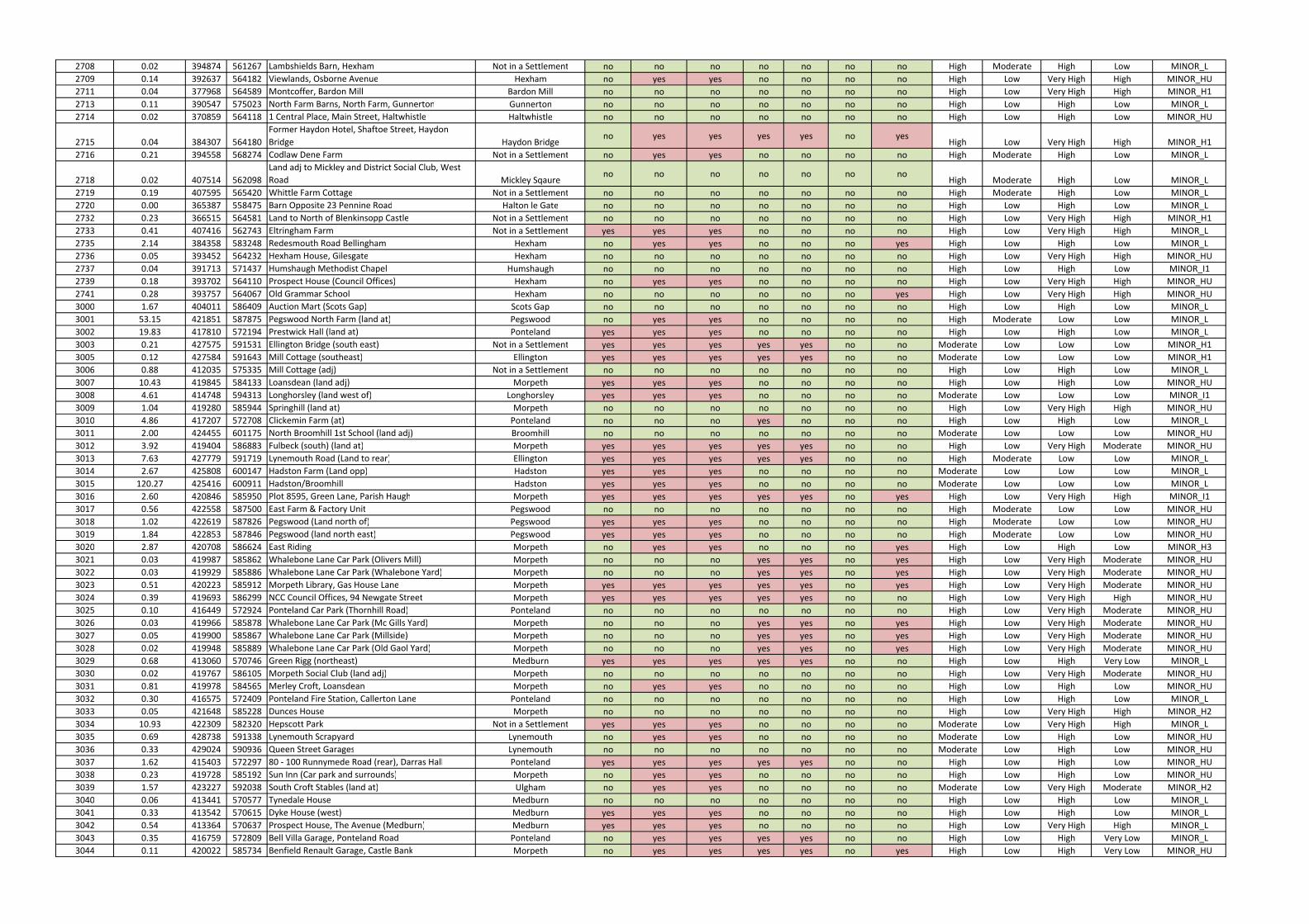
2708 0.02 394874 561267 Lambshields Barn, Hexham Not in a Settlement no no no no no no no High Moderate High Low MINOR_L
2709 0.14 392637 564182 Viewlands, Osborne Avenue Hexham no yes yes no no no no High Low Very High High MINOR_HU
2711 0.04 377968 564589 Montcoffer, Bardon Mill Bardon Mill no no no no no no no High Low Very High High MINOR_H1
2713 0.11 390547 575023 North Farm Barns, North Farm, Gunnerton Gunnerton no no no no no no no High Low High Low MINOR_L
2714 0.02 370859 564118 1 Central Place, Main Street, Haltwhistle Haltwhistle no no no no no no no High Low High Low MINOR_HU
2715 0.04 384307 564180
Former Haydon Hotel, Shaftoe Street, Haydon
Bridge Haydon Bridgeno yes yes yes yes no yes
High Low Very High High MINOR_H1
2716 0.21 394558 568274 Codlaw Dene Farm Not in a Settlement no yes yes no no no no High Moderate High Low MINOR_L
2718 0.02 407514 562098
Land adj to Mickley and District Social Club, West
Road Mickley Sqaureno no no no no no no
High Moderate High Low MINOR_L
2719 0.19 407595 565420 Whittle Farm Cottage Not in a Settlement no no no no no no no High Moderate High Low MINOR_L
2720 0.00 365387 558475 Barn Opposite 23 Pennine Road Halton le Gate no no no no no no no High Low High Low MINOR_L
2732 0.23 366515 564581 Land to North of Blenkinsopp Castle Not in a Settlement no no no no no no no High Low Very High High MINOR_H1
2733 0.41 407416 562743 Eltringham Farm Not in a Settlement yes yes yes no no no no High Low Very High High MINOR_L
2735 2.14 384358 583248 Redesmouth Road Bellingham Hexham no yes yes no no no yes High Low High Low MINOR_L
2736 0.05 393452 564232 Hexham House, Gilesgate Hexham no no no no no no no High Low Very High High MINOR_HU
2737 0.04 391713 571437 Humshaugh Methodist Chapel Humshaugh no no no no no no no High Low High Low MINOR_I1
2739 0.18 393702 564110 Prospect House (Council Offices) Hexham no yes yes no no no no High Low Very High High MINOR_HU
2741 0.28 393757 564067 Old Grammar School Hexham no no no no no no yes High Low Very High High MINOR_HU
3000 1.67 404011 586409 Auction Mart (Scots Gap) Scots Gap no no no no no no no High Low High Low MINOR_L
3001 53.15 421851 587875 Pegswood North Farm (land at) Pegswood no yes yes no no no no High Moderate Low Low MINOR_L
3002 19.83 417810 572194 Prestwick Hall (land at) Ponteland yes yes yes no no no no High Low High Low MINOR_L
3003 0.21 427575 591531 Ellington Bridge (south east) Not in a Settlement yes yes yes yes yes no no Moderate Low Low Low MINOR_H1
3005 0.12 427584 591643 Mill Cottage (southeast) Ellington yes yes yes yes yes no no Moderate Low Low Low MINOR_H1
3006 0.88 412035 575335 Mill Cottage (adj) Not in a Settlement no no no no no no no High Low High Low MINOR_L
3007 10.43 419845 584133 Loansdean (land adj) Morpeth yes yes yes no no no no High Low High Low MINOR_HU
3008 4.61 414748 594313 Longhorsley (land west of) Longhorsley yes yes yes no no no no Moderate Low Low Low MINOR_I1
3009 1.04 419280 585944 Springhill (land at) Morpeth no no no no no no no High Low Very High High MINOR_HU
3010 4.86 417207 572708 Clickemin Farm (at) Ponteland no no no yes no no no High Low High Low MINOR_L
3011 2.00 424455 601175 North Broomhill 1st School (land adj) Broomhill no no no no no no no Moderate Low Low Low MINOR_HU
3012 3.92 419404 586883 Fulbeck (south) (land at) Morpeth yes yes yes yes yes no no High Low Very High Moderate MINOR_HU
3013 7.63 427779 591719 Lynemouth Road (Land to rear) Ellington yes yes yes yes yes no no High Moderate Low Low MINOR_L
3014 2.67 425808 600147 Hadston Farm (Land opp) Hadston yes yes yes no no no no Moderate Low Low Low MINOR_L
3015 120.27 425416 600911 Hadston/Broomhill Hadston yes yes yes no no no no Moderate Low Low Low MINOR_L
3016 2.60 420846 585950 Plot 8595, Green Lane, Parish Haugh Morpeth yes yes yes yes yes no yes High Low Very High High MINOR_I1
3017 0.56 422558 587500 East Farm & Factory Unit Pegswood no no no no no no no High Moderate Low Low MINOR_HU
3018 1.02 422619 587826 Pegswood (Land north of) Pegswood yes yes yes no no no no High Moderate Low Low MINOR_HU
3019 1.84 422853 587846 Pegswood (land north east) Pegswood yes yes yes no no no no High Moderate Low Low MINOR_HU
3020 2.87 420708 586624 East Riding Morpeth no yes yes no no no yes High Low High Low MINOR_H3
3021 0.03 419987 585862 Whalebone Lane Car Park (Olivers Mill) Morpeth no no no yes yes no yes High Low Very High Moderate MINOR_HU
3022 0.03 419929 585886 Whalebone Lane Car Park (Whalebone Yard) Morpeth no no no yes yes no yes High Low Very High Moderate MINOR_HU
3023 0.51 420223 585912 Morpeth Library, Gas House Lane Morpeth yes yes yes yes yes no yes High Low Very High Moderate MINOR_HU
3024 0.39 419693 586299 NCC Council Offices, 94 Newgate Street Morpeth yes yes yes yes yes no no High Low Very High High MINOR_HU
3025 0.10 416449 572924 Ponteland Car Park (Thornhill Road) Ponteland no no no no no no no High Low Very High Moderate MINOR_HU
3026 0.03 419966 585878 Whalebone Lane Car Park (Mc Gills Yard) Morpeth no no no yes yes no yes High Low Very High Moderate MINOR_HU
3027 0.05 419900 585867 Whalebone Lane Car Park (Millside) Morpeth no no no yes yes no yes High Low Very High Moderate MINOR_HU
3028 0.02 419948 585889 Whalebone Lane Car Park (Old Gaol Yard) Morpeth no no no yes yes no yes High Low Very High Moderate MINOR_HU
3029 0.68 413060 570746 Green Rigg (northeast) Medburn yes yes yes yes yes no no High Low High Very Low MINOR_L
3030 0.02 419767 586105 Morpeth Social Club (land adj) Morpeth no no no no no no no High Low Very High Moderate MINOR_HU
3031 0.81 419978 584565 Merley Croft, Loansdean Morpeth no yes yes no no no no High Low High Low MINOR_HU
3032 0.30 416575 572409 Ponteland Fire Station, Callerton Lane Ponteland no no no no no no no High Low High Low MINOR_L
3033 0.05 421648 585228 Dunces House Morpeth no no no no no no no High Low Very High High MINOR_H2
3034 10.93 422309 582320 Hepscott Park Not in a Settlement yes yes yes no no no no Moderate Low Very High High MINOR_L
3035 0.69 428738 591338 Lynemouth Scrapyard Lynemouth no yes yes no no no no Moderate Low High Low MINOR_HU
3036 0.33 429024 590936 Queen Street Garages Lynemouth no no no no no no no Moderate Low High Low MINOR_HU
3037 1.62 415403 572297 80 - 100 Runnymede Road (rear), Darras Hall Ponteland yes yes yes yes yes no no High Low High Low MINOR_HU
3038 0.23 419728 585192 Sun Inn (Car park and surrounds) Morpeth no yes yes no no no no High Low High Low MINOR_HU
3039 1.57 423227 592038 South Croft Stables (land at) Ulgham no yes yes no no no no Moderate Low Very High Moderate MINOR_H2
3040 0.06 413441 570577 Tynedale House Medburn no no no no no no no High Low High Low MINOR_L
3041 0.33 413542 570615 Dyke House (west) Medburn yes yes yes no no no no High Low High Low MINOR_L
3042 0.54 413364 570637 Prospect House, The Avenue (Medburn) Medburn yes yes yes no no no no High Low Very High High MINOR_L
3043 0.35 416759 572809 Bell Villa Garage, Ponteland Road Ponteland no yes yes yes yes no no High Low High Very Low MINOR_L
3044 0.11 420022 585734 Benfield Renault Garage, Castle Bank Morpeth no yes yes yes yes no yes High Low High Very Low MINOR_HU
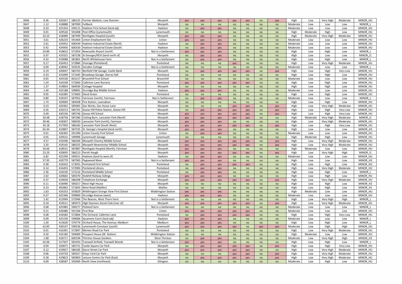
3046 0.36 420267 586155 Former Abattoir, Low Stanners Morpeth yes yes yes yes yes no yes High Low Very High Moderate MINOR_HU
3047 1.12 418888 587090 Fullbeck Morpeth no no no no no no no Moderate Low Low Low MINOR_L
3048 0.33 425354 599115 Hadston First School (land adj) Hadston no yes yes no no no no Moderate Low Low Low MINOR_HU
3049 0.01 429526 591008 Post Office (Lynemouth) Lynemouth no no no no no no no High Moderate High Low MINOR_HU
3050 10.10 418489 587499 Northgate Hospital (south) Morpeth yes yes yes no no no no High Moderate Very High Moderate MINOR_HU
3051 3.61 426224 591464 Linton Employment Site Linton yes yes yes no no no no Moderate Low Low Low MINOR_HU
3052 2.61 425052 600439 Hadston Industrial Estate (North) Hadston no yes yes no no no no Moderate Low Low Low MINOR_HU
3053 0.42 424956 600330 Hadston Industrial Estate (South) Hadston no yes yes no no no no Moderate Low Low Low MINOR_HU
3054 24.89 418652 571954 Newcastle Airport (north) Not in a Settlement yes yes yes no no no no High Low High Low MINOR_L
3055 6.97 419325 587238 St Georges/KEVI (land north of) Morpeth no yes yes no no no no High Low Low Low MINOR_I1
3056 0.32 419088 581801 North Whitehouse Farm Not in a Settlement no yes yes no no no no High Low High Low MINOR_L
3057 0.17 416453 572884 Vicarage (Ponteland) Ponteland no no no yes no no no High Low Very High Moderate MINOR_HU
3058 0.09 418942 593535 Earsdon Cottage Not in a Settlement no no no no no no no Moderate Low Low Low MINOR_L
3059 0.19 420047 585703 Benfield VW Garage, Castle Bank Morpeth no yes yes yes yes no yes High Low High Very Low MINOR_HU
3060 0.33 415099 571445 Broadway Garage, Darras Hall Ponteland no no no no no no no High Low High Low MINOR_HU
3061 0.65 424530 601217 Broomhill First School Broomhill no no no no no no no Moderate Low Low Low MINOR_HU
3062 1.54 416549 572660 Callerton Lane Nursery Ponteland yes yes yes yes yes no no High Low High Low MINOR_HU
3063 1.37 419854 584939 Cottage Hospital Morpeth no no no no no no no High Low High Low MINOR_HU
3064 1.40 425188 599891 Druridge Bay Middle School Hadston yes yes yes no no no no Moderate Low Low Low MINOR_HU
3065 0.05 416385 573465 Eland Green Ponteland no no no no no no no High Low High Low MINOR_HU
3066 0.80 418107 587952 Fairmoor (north), Fairmoor Not in Settlement no yes yes no no no no Moderate Low Low Low MINOR_L
3067 1.74 420069 584508 Fire Station, Loansdean Morpeth no no no no no no no High Low High Low MINOR_HU
3068 0.23 420362 585965 Gas Works, Gas House Lane Morpeth no no no yes yes no yes High Low Very High Moderate MINOR_HU
3069 0.56 420213 585701 Goose Hill Police Station, Goose Hill Morpeth no yes yes yes yes no yes High Low High Very Low MINOR_HU
3070 0.49 420156 585746 Goose Hill School Morpeth yes yes yes yes yes no yes High Low High Very Low MINOR_HU
3071 20.48 418758 587280 Cotting Burn, Lancaster Park (North) Morpeth yes yes yes yes yes no no High Moderate Very High Moderate MINOR_I1
3072 39.46 418367 586930 Lancaster Park (north), Fairmoor Morpeth yes yes yes no no no no High Low Very High Moderate MINOR_HU
3073 34.18 417959 586183 Lancaster Park (South West) Morpeth yes yes yes yes yes no yes High Low High Very Low MINOR_HU
3074 65.44 419897 587235 St. George's Hospital (land north) Morpeth yes yes yes no no no no High Low Low Low MINOR_H3
3075 0.61 426365 591390 Linton County First School Linton no yes yes no no no no Moderate Low Low Low MINOR_HU
3076 0.05 429531 590996 Lynemouth Garage Lynemouth no no no no no no no High Moderate High Low MINOR_HU
3077 4.57 419296 586396 Morpeth Chantry Middle School Morpeth yes yes yes yes yes no yes High Low Very High Moderate MINOR_HU
3078 3.20 419145 586325 Morpeth Newminster Middle School Morpeth yes yes yes yes yes no yes High Low Very High Moderate MINOR_HU
3079 34.66 418531 587887 Northgate Hospital (North), Fairmoor Morpeth yes yes yes no no no no High Moderate Low Low MINOR_HU
3080 23.29 420695 586213 Parish Haugh Morpeth yes yes yes yes yes no yes High Low Very High High MINOR_I1
3081 6.82 425299 599551 Hadston (land to west of) Hadston no yes yes no no no no Moderate Low Low Low MINOR_HU
3082 57.95 420779 587585 Pegswood Moor Not in a Settlement yes yes yes no no no no High Low Low Low MINOR_H3
3083 0.38 416502 573055 Ponteland First School Ponteland no yes yes yes yes no no High Low High Low MINOR_HU
3084 0.14 416455 572983 Ponteland Library Ponteland no yes yes no no no no High Low Very High Moderate MINOR_HU
3086 2.36 416530 572216 Ponteland Middle School Ponteland no yes yes no no no no High Low High Low MINOR_L
3087 2.02 420682 585470 Stobhill Railway Sidings Morpeth yes yes yes no no no no High Low High Low MINOR_HU
3088 0.37 419658 586208 Telephone Exchange Morpeth yes yes yes yes yes no yes High Low Very High Moderate MINOR_HU
3090 0.11 418496 585017 West High House Morpeth no no no no no no no High Low High Low MINOR_H2
3091 0.23 402862 571843 West Road (Matfen) Matfen no no no no no no no High Low High Low MINOR_H1
3092 1.63 424253 593829 Widdrington Grange View First School Widdrington Station yes yes yes no no no no High Moderate Low Low MINOR_HU
3093 0.57 425346 599869 Druridge Avenue (west) Hadston yes yes yes no no no no Moderate Low Low Low MINOR_HU
3094 1.42 413949 575946 The Beacon, West Thorn Farm Not in a Settlement no no no no no no no High Low Very High High MINOR_L
3095 0.24 419511 585973 High Stanners Social Club (rear of) Morpeth yes yes yes yes yes no yes High Low Very High Moderate MINOR_HU
3096 0.08 425985 590277 Potland Farm Not in a Settlement no no no no no no no Moderate Low Low Low MINOR_L
3097 0.21 426486 591184 First Row Linton yes yes yes yes yes no no Moderate Low Low Low MINOR_HU
3098 0.08 416582 572804 The Orchard, Callerton Lane Ponteland no yes yes yes yes no no High Low High Very Low MINOR_HU
3099 0.09 425230 599006 Sycamore Court (land adj) Hadston yes yes yes no no no no Moderate Low Low Low MINOR_L
3100 1.50 413620 570774 Orchard House, The Avenue, Medburn Medburn yes yes yes no no no no High Low High Low MINOR_L
3101 42.83 430147 590536 Lynemouth Conveyor (south) Lynemouth yes yes yes yes no yes yes Moderate Low High High MINOR_HU
3102 0.01 416391 572897 Merton Road Car Park Ponteland no no no no no no no High Low Very High Moderate MINOR_HU
3103 0.20 425185 594009 Prospect House (W. Station) Widdrington Station no no no no no no no High Moderate Low Low MINOR_HU
3104 1.68 418717 600194 Thirston House Gardens West Thirston no yes yes no no no no Moderate Low Very High High MINOR_H2
3105 42.06 417507 581933 Tranwell Airfield, Tranwell Woods Not in a Settlement yes yes yes no no no no High Low High Low MINOR_L
3106 0.04 420071 585751 Castle Square Car Park Morpeth no yes yes yes yes no yes High Low High Very Low MINOR_HU
3107 0.12 419927 586185 Dacre Street Car Park Morpeth yes yes yes yes yes no no High Low Very High Moderate MINOR_HU
3108 0.06 419729 585917 Greys Yard Car Park Morpeth no no no yes yes no yes High Low Very High Moderate MINOR_HU
3109 0.28 419823 585803 Leisure Centre Car Park (East) Morpeth no yes yes yes yes no yes High Low Very High Moderate MINOR_HU
3110 0.09 428587 592969 North View (northeast) Ellington no no no no no no no Moderate Low High Low MINOR_HU
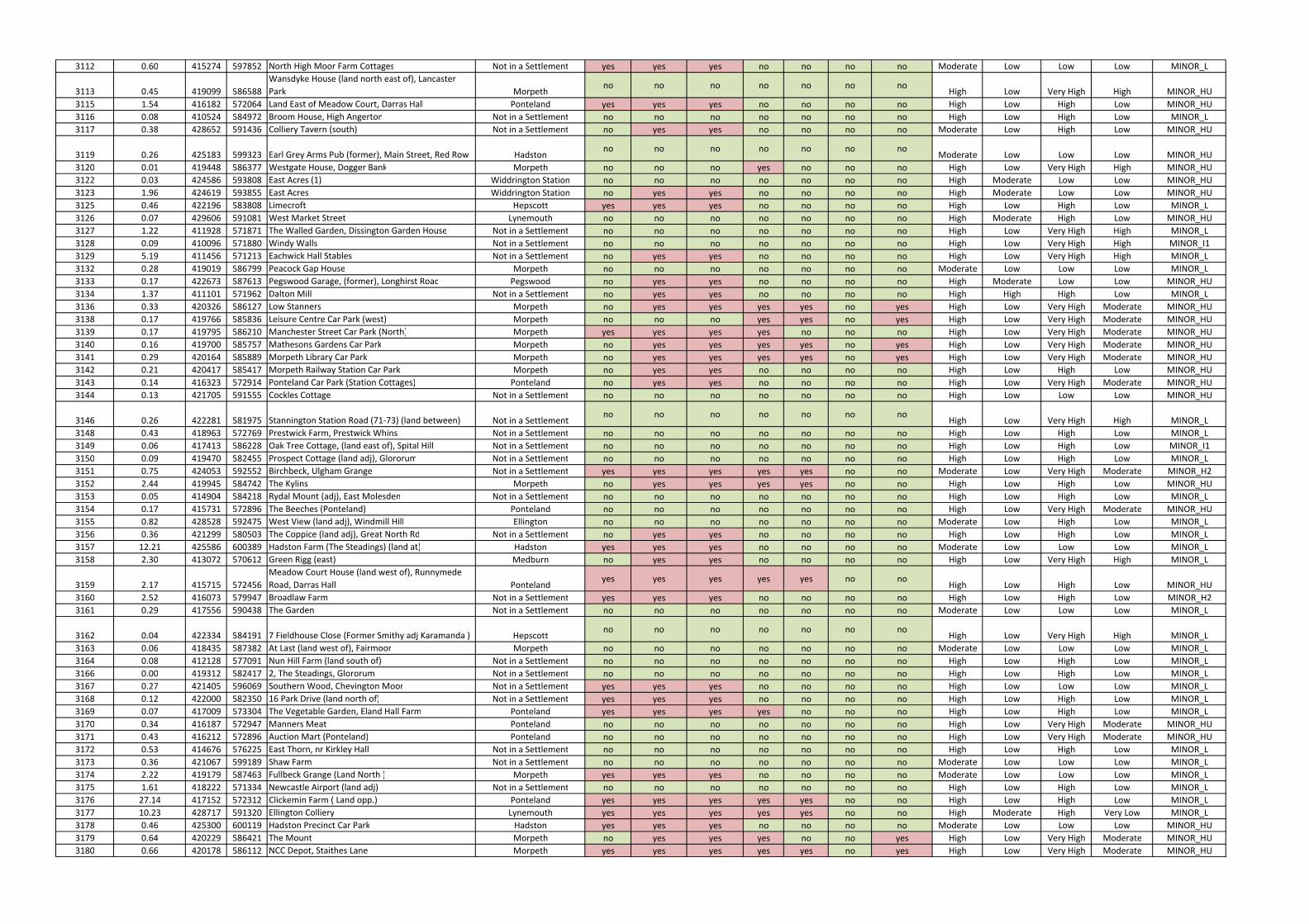
3112 0.60 415274 597852 North High Moor Farm Cottages Not in a Settlement yes yes yes no no no no Moderate Low Low Low MINOR_L
3113 0.45 419099 586588
Wansdyke House (land north east of), Lancaster
Park Morpethno no no no no no no
High Low Very High High MINOR_HU
3115 1.54 416182 572064 Land East of Meadow Court, Darras Hall Ponteland yes yes yes no no no no High Low High Low MINOR_HU
3116 0.08 410524 584972 Broom House, High Angerton Not in a Settlement no no no no no no no High Low High Low MINOR_L
3117 0.38 428652 591436 Colliery Tavern (south) Not in a Settlement no yes yes no no no no Moderate Low High Low MINOR_HU
3119 0.26 425183 599323 Earl Grey Arms Pub (former), Main Street, Red Row Hadstonno no no no no no no
Moderate Low Low Low MINOR_HU
3120 0.01 419448 586377 Westgate House, Dogger Bank Morpeth no no no yes no no no High Low Very High High MINOR_HU
3122 0.03 424586 593808 East Acres (1) Widdrington Station no no no no no no no High Moderate Low Low MINOR_HU
3123 1.96 424619 593855 East Acres Widdrington Station no yes yes no no no no High Moderate Low Low MINOR_HU
3125 0.46 422196 583808 Limecroft Hepscott yes yes yes no no no no High Low High Low MINOR_L
3126 0.07 429606 591081 West Market Street Lynemouth no no no no no no no High Moderate High Low MINOR_HU
3127 1.22 411928 571871 The Walled Garden, Dissington Garden House Not in a Settlement no no no no no no no High Low Very High High MINOR_L
3128 0.09 410096 571880 Windy Walls Not in a Settlement no no no no no no no High Low Very High High MINOR_I1
3129 5.19 411456 571213 Eachwick Hall Stables Not in a Settlement no yes yes no no no no High Low Very High High MINOR_L
3132 0.28 419019 586799 Peacock Gap House Morpeth no no no no no no no Moderate Low Low Low MINOR_L
3133 0.17 422673 587613 Pegswood Garage, (former), Longhirst Road Pegswood no yes yes no no no no High Moderate Low Low MINOR_HU
3134 1.37 411101 571962 Dalton Mill Not in a Settlement no yes yes no no no no High High High Low MINOR_L
3136 0.33 420326 586127 Low Stanners Morpeth no yes yes yes yes no yes High Low Very High Moderate MINOR_HU
3138 0.17 419766 585836 Leisure Centre Car Park (west) Morpeth no no no yes yes no yes High Low Very High Moderate MINOR_HU
3139 0.17 419795 586210 Manchester Street Car Park (North) Morpeth yes yes yes yes no no no High Low Very High Moderate MINOR_HU
3140 0.16 419700 585757 Mathesons Gardens Car Park Morpeth no yes yes yes yes no yes High Low Very High Moderate MINOR_HU
3141 0.29 420164 585889 Morpeth Library Car Park Morpeth no yes yes yes yes no yes High Low Very High Moderate MINOR_HU
3142 0.21 420417 585417 Morpeth Railway Station Car Park Morpeth no yes yes no no no no High Low High Low MINOR_HU
3143 0.14 416323 572914 Ponteland Car Park (Station Cottages) Ponteland no yes yes no no no no High Low Very High Moderate MINOR_HU
3144 0.13 421705 591555 Cockles Cottage Not in a Settlement no no no no no no no High Low Low Low MINOR_HU
3146 0.26 422281 581975 Stannington Station Road (71-73) (land between) Not in a Settlementno no no no no no no
High Low Very High High MINOR_L
3148 0.43 418963 572769 Prestwick Farm, Prestwick Whins Not in a Settlement no no no no no no no High Low High Low MINOR_L
3149 0.06 417413 586228 Oak Tree Cottage, (land east of), Spital Hill Not in a Settlement no no no no no no no High Low High Low MINOR_I1
3150 0.09 419470 582455 Prospect Cottage (land adj), Glororum Not in a Settlement no no no no no no no High Low High Low MINOR_L
3151 0.75 424053 592552 Birchbeck, Ulgham Grange Not in a Settlement yes yes yes yes yes no no Moderate Low Very High Moderate MINOR_H2
3152 2.44 419945 584742 The Kylins Morpeth no yes yes yes yes no no High Low High Low MINOR_HU
3153 0.05 414904 584218 Rydal Mount (adj), East Molesden Not in a Settlement no no no no no no no High Low High Low MINOR_L
3154 0.17 415731 572896 The Beeches (Ponteland) Ponteland no no no no no no no High Low Very High Moderate MINOR_HU
3155 0.82 428528 592475 West View (land adj), Windmill Hill Ellington no no no no no no no Moderate Low High Low MINOR_L
3156 0.36 421299 580503 The Coppice (land adj), Great North Rd Not in a Settlement no yes yes no no no no High Low High Low MINOR_L
3157 12.21 425586 600389 Hadston Farm (The Steadings) (land at) Hadston yes yes yes no no no no Moderate Low Low Low MINOR_L
3158 2.30 413072 570612 Green Rigg (east) Medburn no yes yes no no no no High Low Very High High MINOR_L
3159 2.17 415715 572456
Meadow Court House (land west of), Runnymede
Road, Darras Hall Pontelandyes yes yes yes yes no no
High Low High Low MINOR_HU
3160 2.52 416073 579947 Broadlaw Farm Not in a Settlement yes yes yes no no no no High Low High Low MINOR_H2
3161 0.29 417556 590438 The Garden Not in a Settlement no no no no no no no Moderate Low Low Low MINOR_L
3162 0.04 422334 584191 7 Fieldhouse Close (Former Smithy adj Karamanda ) Hepscottno no no no no no no
High Low Very High High MINOR_L
3163 0.06 418435 587382 At Last (land west of), Fairmoor Morpeth no no no no no no no Moderate Low Low Low MINOR_L
3164 0.08 412128 577091 Nun Hill Farm (land south of) Not in a Settlement no no no no no no no High Low High Low MINOR_L
3166 0.00 419312 582417 2, The Steadings, Glororum Not in a Settlement no no no no no no no High Low High Low MINOR_L
3167 0.27 421405 596069 Southern Wood, Chevington Moor Not in a Settlement yes yes yes no no no no High Low Low Low MINOR_L
3168 0.12 422000 582350 16 Park Drive (land north of) Not in a Settlement yes yes yes no no no no High Low High Low MINOR_L
3169 0.07 417009 573304 The Vegetable Garden, Eland Hall Farm Ponteland yes yes yes yes no no no High Low High Low MINOR_L
3170 0.34 416187 572947 Manners Meat Ponteland no no no no no no no High Low Very High Moderate MINOR_HU
3171 0.43 416212 572896 Auction Mart (Ponteland) Ponteland no no no no no no no High Low Very High Moderate MINOR_HU
3172 0.53 414676 576225 East Thorn, nr Kirkley Hall Not in a Settlement no no no no no no no High Low High Low MINOR_L
3173 0.36 421067 599189 Shaw Farm Not in a Settlement no no no no no no no Moderate Low Low Low MINOR_L
3174 2.22 419179 587463 Fullbeck Grange (Land North ) Morpeth yes yes yes no no no no Moderate Low Low Low MINOR_L
3175 1.61 418222 571334 Newcastle Airport (land adj) Not in a Settlement no no no no no no no High Low High Low MINOR_L
3176 27.14 417152 572312 Clickemin Farm ( Land opp.) Ponteland yes yes yes yes yes no no High Low High Low MINOR_L
3177 10.23 428717 591320 Ellington Colliery Lynemouth yes yes yes yes yes no no High Moderate High Very Low MINOR_L
3178 0.46 425300 600119 Hadston Precinct Car Park Hadston yes yes yes no no no no Moderate Low Low Low MINOR_HU
3179 0.64 420229 586421 The Mount Morpeth no yes yes yes no no yes High Low Very High Moderate MINOR_HU
3180 0.66 420178 586112 NCC Depot, Staithes Lane Morpeth yes yes yes yes yes no yes High Low Very High Moderate MINOR_HU
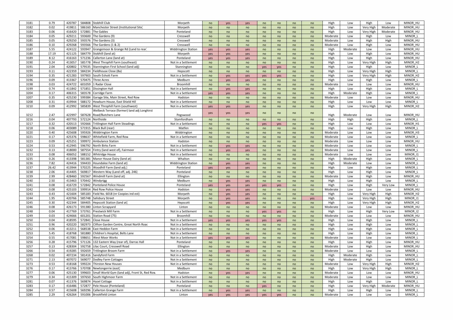
3181 0.79 420787 584808 Stobhill Club Morpeth no yes yes no no no no High Low High Low MINOR_HU
3182 0.02 419811 586160 Manchester Street (Institutional Site) Morpeth no no no no no no no High Low Very High Moderate MINOR_HU
3183 0.06 416420 572881 The Gables Ponteland no no no no no no no High Low Very High Moderate MINOR_HU
3184 0.05 429211 593600 The Gardens (9) Cresswell no no no no no no no Moderate Low High Low MINOR_L
3185 0.05 429250 593576 The Gardens (3) Cresswell no no no no no no no Moderate Low High High MINOR_HU
3186 0.10 429268 593566 The Gardens (1 & 2) Cresswell no no no no no no no Moderate Low High Low MINOR_HU
3187 5.55 424122 593947 Grangemoor & Grange Rd (Land to rear) Widdrington Station yes yes yes no no no no High Moderate Low Low MINOR_HU
3188 17.19 421125 584779 Stobhill (land at) Morpeth yes yes yes no no no no High Low High Low MINOR_HU
3189 8.12 416163 571236 Callerton Lane (land at) Ponteland yes yes yes no no no no High Low High Low MINOR_HU
3190 0.24 413057 585778 West Throphill Farm (southeast) Not in a Settlement no no no no no no no High Low Very High High MINOR_H2
3191 2.04 420802 579535 Stannington First School (land adj) Stannington no no no yes yes no no High Low High Low MINOR_L
3193 0.11 422359 584234 Fieldhouse Close (8a) Hepscott no no no no no no no High Low Very High High MINOR_L
3194 0.35 421283 597903 South Eshott Farm Not in a Settlement no yes yes yes yes no no High Low Very High High MINOR_H2
3196 0.09 413367 570475 Three Acres Medburn no yes yes no no no no High Low High Low MINOR_L
3198 0.03 424722 601059 1 Radar Close Broomhill no no no no no no no Moderate Low Low Low MINOR_HU
3199 0.74 411842 571851 Dissington Hall Not in a Settlement no yes yes no no no no High Low High Low MINOR_L
3204 0.17 406315 583578 Corridge Farm Not in a Settlement yes yes yes no no no no High Moderate High Low MINOR_L
3207 0.35 425230 599384 Garage Site, Main Street, Red Row Hadston no no no no no no no Moderate Low Low Low MINOR_HU
3208 0.31 419944 588172 Howburn House, East Shield Hill Not in a Settlement no no no no no no no High Low Low Low MINOR_L
3210 0.09 412992 585839 West Throphill Farm (southwest) Not in a Settlement yes yes yes no no no no High Low Very High High MINOR_H2
3212 2.47 422997 587628
Welbeck Terrace (former) land adj Longhirst
Road/Butchers Lane Pegswoodyes yes yes no no no no
High Moderate Low Low MINOR_HU
3216 0.04 407793 572124 Northside Stamfordham no no no no no no no High High High Low MINOR_L
3217 0.32 420513 592666 Tritlington Hall Farm Steadings Not in a Settlement no no no yes yes no no High Low Low Low MINOR_H1
3218 0.06 403089 571915 Black Bull (rear) Matfen no no no no no no no High Low High Low MINOR_L
3220 0.40 425608 595926 Widdrington Farm Widdrington no no no no no no no Moderate Low Low Low MINOR_H3
3221 0.17 425376 598637 Whitefield Farm, Red Row Not in a Settlement no no no no no no no Moderate Low Low Low MINOR_L
3223 0.09 425251 599972 Ambulance Station Hadston no no no no no no no Moderate Low Low Low MINOR_HU
3224 0.53 412945 596792 North Birks Farm Not in a Settlement no yes yes no no no no Moderate Low Low Low MINOR_L
3232 0.13 418000 587554 Fintry (land west of), Fairmoor Not in a Settlement no yes yes no no no no Moderate Low Low Low MINOR_L
3233 0.08 406052 588152 Whitridge House Not in a Settlement no no no no no no no Moderate Low Low Low MINOR_I1
3235 0.26 413398 581381 Manor House Dairy (land at) Whalton no no no no no no no High Moderate High Low MINOR_L
3236 7.82 424416 594433 Houndalee Farm (land at) Widdrington Station no yes yes no no no no High Moderate Low Low MINOR_L
3237 26.42 413944 570225 Woodhill Farm (land adj.) Ponteland yes yes yes no no no no High Low High Low MINOR_L
3238 2.06 414405 569817 Western Way (Land off, adj. 246) Ponteland no no no no no no no High Low High Low MINOR_L
3239 2.99 428460 592567 Windmill Farm (land at) Ellington no no no no no no no Moderate Low High Low MINOR_HU
3240 2.50 413463 570442 Windyrigg Medburn no yes yes no no no no High Low High Low MINOR_L
3241 0.08 416729 572842 Ponteland Police House Ponteland yes yes yes yes yes no no High Low High Very Low MINOR_L
3242 0.08 425103 599914 Red Row Police House Hadston no yes yes no no no no Moderate Low Low Low MINOR_HU
3243 0.43 421604 585183 Field No. 6018 (nr Coopies ind est) Morpeth no yes yes no no no no High Low Very High High MINOR_H2
3244 1.95 420766 585748 Salisbury Street Morpeth no yes yes no no no yes High Low Very High High MINOR_I1
3245 0.30 422344 584405 Hepscott Station (land at) Hepscott no yes yes no no no no High Low Very High High MINOR_H2
3246 0.08 426173 591380 Linton Scrapyard Linton no no no no no no no Moderate Low Low Low MINOR_HU
3248 0.04 417769 573761 Prestwick Mill Farm Not in a Settlement no no no yes yes no no High Low High Very Low MINOR_I2
3249 0.03 424666 601201 Station Road (75) Broomhill no no no no no no no Moderate Low Low Low MINOR_HU
3250 0.04 418595 572841 Close House Not in a Settlement yes yes yes yes yes no no High Low High Low MINOR_L
3251 0.96 420220 582973 Clifton Garden Centre, Great North Road Not in a Settlement no no no no no no no High Low High Low MINOR_L
3252 0.06 413211 568538 East Heddon Farm Not in a Settlement no no no no no no no High Low High Low MINOR_L
3253 5.45 418768 581880 Children's Hospital, Belts Lane Not in a Settlement no no no no no no no High Low High Low MINOR_L
3254 0.55 417081 598651 West Moor Works Not in a Settlement yes yes yes no no no no Moderate Low Low Low MINOR_L
3256 0.28 415796 571126 132 Eastern Way (rear of), Darras Hall Ponteland no no no no no no no High Low High Low MINOR_HU
3257 0.13 428304 592758 Lilac Court, Cresswell Road Ellington no no no no no no no Moderate Low High Low MINOR_HU
3266 0.54 419285 592659 Tritlington Broom Farm Not in a Settlement no yes yes no no no no Moderate Low Low Low MINOR_L
3268 0.02 407234 581416 Sandyford Farm Not in a Settlement no no no no no no no High Moderate High Low MINOR_L
3271 2.13 407072 569077 Dodley Farm Cottages Not in a Settlement no no no no no no no High Moderate High Low MINOR_L
3273 0.53 418168 599224 Thirston New Houses Not in a Settlement no no no no no no no Moderate Low Very High High MINOR_H2
3276 0.17 413766 570708 Newtongerrie (east) Medburn no no no no no no no High Low Very High High MINOR_L
3277 0.06 425130 599603 Small World Gym (land adj), Front St, Red Row Hadston no yes yes no no no no Moderate Low Low Low MINOR_HU
3279 0.34 415309 597650 South Highmoor Farm Not in a Settlement no no no no no no no Moderate Low Low Low MINOR_L
3281 0.07 411376 569874 Hazel Cottage Not in a Settlement no no no no no no no High Low High Low MINOR_L
3283 0.17 416486 572877 Pele House (Ponteland) Ponteland no no no yes no no no High Low Very High Moderate MINOR_HU
3284 0.57 415608 569296 Callerton Grange Farm Not in a Settlement no yes yes no no no no High Low High Low MINOR_L
3285 2.29 426264 591006 Brookfield Linton Linton yes yes yes yes yes no no Moderate Low Low Low MINOR_L
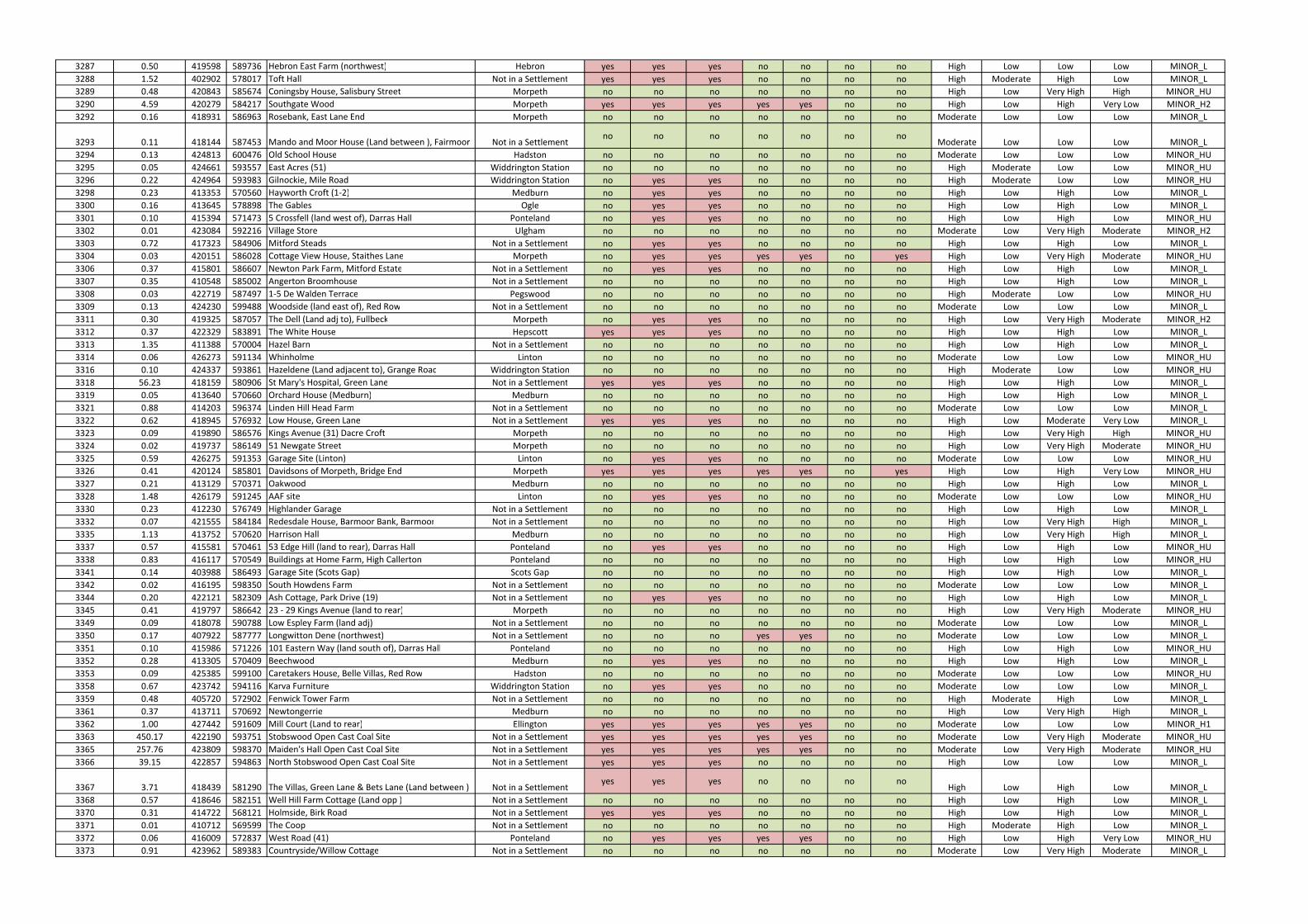
3287 0.50 419598 589736 Hebron East Farm (northwest) Hebron yes yes yes no no no no High Low Low Low MINOR_L
3288 1.52 402902 578017 Toft Hall Not in a Settlement yes yes yes no no no no High Moderate High Low MINOR_L
3289 0.48 420843 585674 Coningsby House, Salisbury Street Morpeth no no no no no no no High Low Very High High MINOR_HU
3290 4.59 420279 584217 Southgate Wood Morpeth yes yes yes yes yes no no High Low High Very Low MINOR_H2
3292 0.16 418931 586963 Rosebank, East Lane End Morpeth no no no no no no no Moderate Low Low Low MINOR_L
3293 0.11 418144 587453 Mando and Moor House (Land between ), Fairmoor Not in a Settlementno no no no no no no
Moderate Low Low Low MINOR_L
3294 0.13 424813 600476 Old School House Hadston no no no no no no no Moderate Low Low Low MINOR_HU
3295 0.05 424661 593557 East Acres (51) Widdrington Station no no no no no no no High Moderate Low Low MINOR_HU
3296 0.22 424964 593983 Gilnockie, Mile Road Widdrington Station no yes yes no no no no High Moderate Low Low MINOR_HU
3298 0.23 413353 570560 Hayworth Croft (1-2) Medburn no yes yes no no no no High Low High Low MINOR_L
3300 0.16 413645 578898 The Gables Ogle no yes yes no no no no High Low High Low MINOR_L
3301 0.10 415394 571473 5 Crossfell (land west of), Darras Hall Ponteland no yes yes no no no no High Low High Low MINOR_HU
3302 0.01 423084 592216 Village Store Ulgham no no no no no no no Moderate Low Very High Moderate MINOR_H2
3303 0.72 417323 584906 Mitford Steads Not in a Settlement no yes yes no no no no High Low High Low MINOR_L
3304 0.03 420151 586028 Cottage View House, Staithes Lane Morpeth no yes yes yes yes no yes High Low Very High Moderate MINOR_HU
3306 0.37 415801 586607 Newton Park Farm, Mitford Estate Not in a Settlement no yes yes no no no no High Low High Low MINOR_L
3307 0.35 410548 585002 Angerton Broomhouse Not in a Settlement no no no no no no no High Low High Low MINOR_L
3308 0.03 422719 587497 1-5 De Walden Terrace Pegswood no no no no no no no High Moderate Low Low MINOR_HU
3309 0.13 424230 599488 Woodside (land east of), Red Row Not in a Settlement no no no no no no no Moderate Low Low Low MINOR_L
3311 0.30 419325 587057 The Dell (Land adj to), Fullbeck Morpeth no yes yes no no no no High Low Very High Moderate MINOR_H2
3312 0.37 422329 583891 The White House Hepscott yes yes yes no no no no High Low High Low MINOR_L
3313 1.35 411388 570004 Hazel Barn Not in a Settlement no no no no no no no High Low High Low MINOR_L
3314 0.06 426273 591134 Whinholme Linton no no no no no no no Moderate Low Low Low MINOR_HU
3316 0.10 424337 593861 Hazeldene (Land adjacent to), Grange Road Widdrington Station no no no no no no no High Moderate Low Low MINOR_HU
3318 56.23 418159 580906 St Mary's Hospital, Green Lane Not in a Settlement yes yes yes no no no no High Low High Low MINOR_L
3319 0.05 413640 570660 Orchard House (Medburn) Medburn no no no no no no no High Low High Low MINOR_L
3321 0.88 414203 596374 Linden Hill Head Farm Not in a Settlement no no no no no no no Moderate Low Low Low MINOR_L
3322 0.62 418945 576932 Low House, Green Lane Not in a Settlement yes yes yes no no no no High Low Moderate Very Low MINOR_L
3323 0.09 419890 586576 Kings Avenue (31) Dacre Croft Morpeth no no no no no no no High Low Very High High MINOR_HU
3324 0.02 419737 586149 51 Newgate Street Morpeth no no no no no no no High Low Very High Moderate MINOR_HU
3325 0.59 426275 591353 Garage Site (Linton) Linton no yes yes no no no no Moderate Low Low Low MINOR_HU
3326 0.41 420124 585801 Davidsons of Morpeth, Bridge End Morpeth yes yes yes yes yes no yes High Low High Very Low MINOR_HU
3327 0.21 413129 570371 Oakwood Medburn no no no no no no no High Low High Low MINOR_L
3328 1.48 426179 591245 AAF site Linton no yes yes no no no no Moderate Low Low Low MINOR_HU
3330 0.23 412230 576749 Highlander Garage Not in a Settlement no no no no no no no High Low High Low MINOR_L
3332 0.07 421555 584184 Redesdale House, Barmoor Bank, Barmoor Not in a Settlement no no no no no no no High Low Very High High MINOR_L
3335 1.13 413752 570620 Harrison Hall Medburn no no no no no no no High Low Very High High MINOR_L
3337 0.57 415581 570461 53 Edge Hill (land to rear), Darras Hall Ponteland no yes yes no no no no High Low High Low MINOR_HU
3338 0.83 416117 570549 Buildings at Home Farm, High Callerton Ponteland no no no no no no no High Low High Low MINOR_HU
3341 0.14 403988 586493 Garage Site (Scots Gap) Scots Gap no no no no no no no High Low High Low MINOR_L
3342 0.02 416195 598350 South Howdens Farm Not in a Settlement no no no no no no no Moderate Low Low Low MINOR_L
3344 0.20 422121 582309 Ash Cottage, Park Drive (19) Not in a Settlement no yes yes no no no no High Low High Low MINOR_L
3345 0.41 419797 586642 23 - 29 Kings Avenue (land to rear) Morpeth no no no no no no no High Low Very High Moderate MINOR_HU
3349 0.09 418078 590788 Low Espley Farm (land adj) Not in a Settlement no no no no no no no Moderate Low Low Low MINOR_L
3350 0.17 407922 587777 Longwitton Dene (northwest) Not in a Settlement no no no yes yes no no Moderate Low Low Low MINOR_L
3351 0.10 415986 571226 101 Eastern Way (land south of), Darras Hall Ponteland no no no no no no no High Low High Low MINOR_HU
3352 0.28 413305 570409 Beechwood Medburn no yes yes no no no no High Low High Low MINOR_L
3353 0.09 425385 599100 Caretakers House, Belle Villas, Red Row Hadston no no no no no no no Moderate Low Low Low MINOR_HU
3358 0.67 423742 594116 Karva Furniture Widdrington Station no yes yes no no no no Moderate Low Low Low MINOR_L
3359 0.48 405720 572902 Fenwick Tower Farm Not in a Settlement no no no no no no no High Moderate High Low MINOR_L
3361 0.37 413711 570692 Newtongerrie Medburn no no no no no no no High Low Very High High MINOR_L
3362 1.00 427442 591609 Mill Court (Land to rear) Ellington yes yes yes yes yes no no Moderate Low Low Low MINOR_H1
3363 450.17 422190 593751 Stobswood Open Cast Coal Site Not in a Settlement yes yes yes yes yes no no Moderate Low Very High Moderate MINOR_HU
3365 257.76 423809 598370 Maiden's Hall Open Cast Coal Site Not in a Settlement yes yes yes yes yes no no Moderate Low Very High Moderate MINOR_HU
3366 39.15 422857 594863 North Stobswood Open Cast Coal Site Not in a Settlement yes yes yes no no no no High Low Low Low MINOR_L
3367 3.71 418439 581290 The Villas, Green Lane & Bets Lane (Land between ) Not in a Settlementyes yes yes no no no no
High Low High Low MINOR_L
3368 0.57 418646 582151 Well Hill Farm Cottage (Land opp ) Not in a Settlement no no no no no no no High Low High Low MINOR_L
3370 0.31 414722 568121 Holmside, Birk Road Not in a Settlement yes yes yes no no no no High Low High Low MINOR_L
3371 0.01 410712 569599 The Coop Not in a Settlement no no no no no no no High Moderate High Low MINOR_L
3372 0.06 416009 572837 West Road (41) Ponteland no yes yes yes yes no no High Low High Very Low MINOR_HU
3373 0.91 423962 589383 Countryside/Willow Cottage Not in a Settlement no no no no no no no Moderate Low Very High Moderate MINOR_L
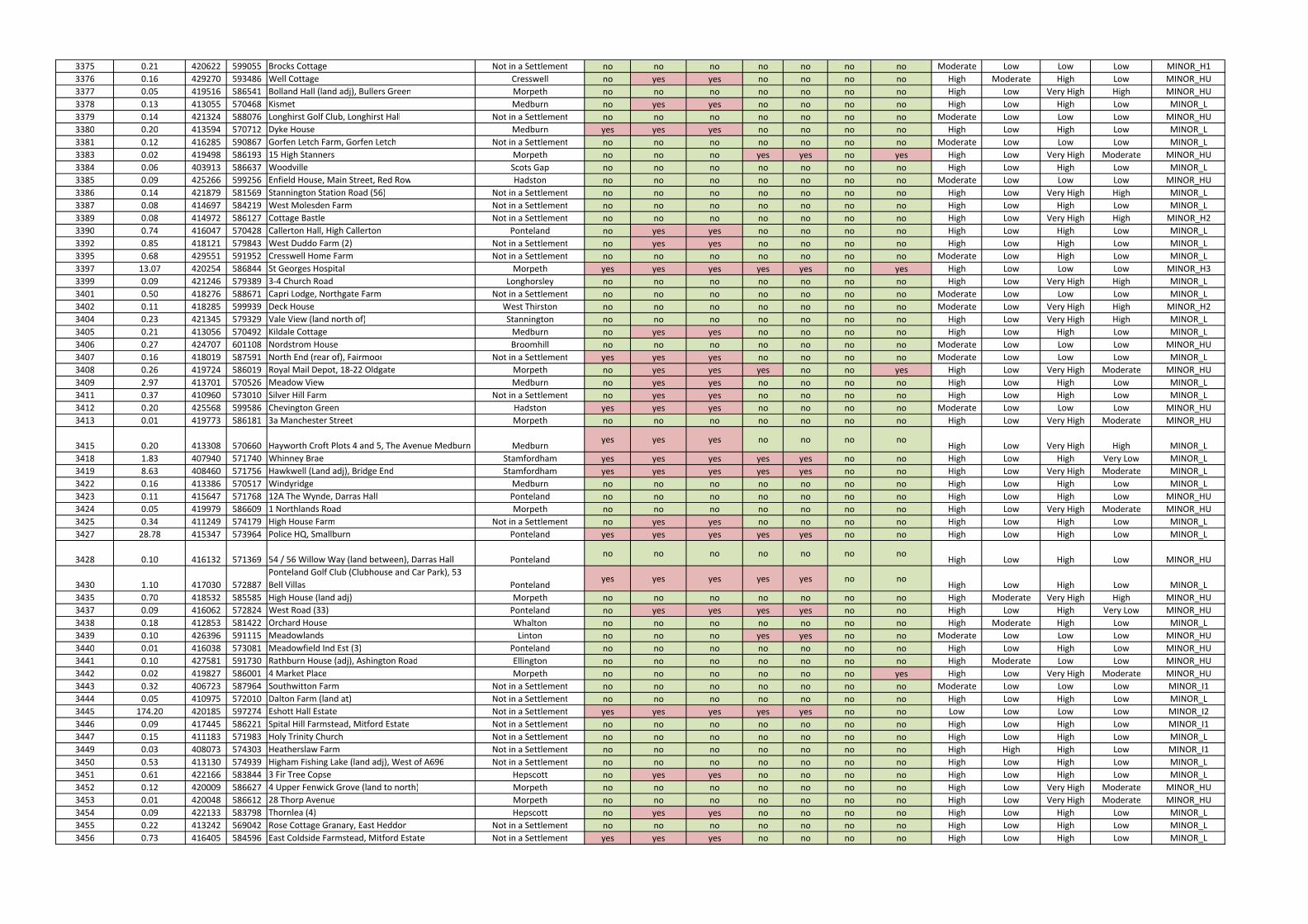
3375 0.21 420622 599055 Brocks Cottage Not in a Settlement no no no no no no no Moderate Low Low Low MINOR_H1
3376 0.16 429270 593486 Well Cottage Cresswell no yes yes no no no no High Moderate High Low MINOR_HU
3377 0.05 419516 586541 Bolland Hall (land adj), Bullers Green Morpeth no no no no no no no High Low Very High High MINOR_HU
3378 0.13 413055 570468 Kismet Medburn no yes yes no no no no High Low High Low MINOR_L
3379 0.14 421324 588076 Longhirst Golf Club, Longhirst Hall Not in a Settlement no no no no no no no Moderate Low Low Low MINOR_HU
3380 0.20 413594 570712 Dyke House Medburn yes yes yes no no no no High Low High Low MINOR_L
3381 0.12 416285 590867 Gorfen Letch Farm, Gorfen Letch Not in a Settlement no no no no no no no Moderate Low Low Low MINOR_L
3383 0.02 419498 586193 15 High Stanners Morpeth no no no yes yes no yes High Low Very High Moderate MINOR_HU
3384 0.06 403913 586637 Woodville Scots Gap no no no no no no no High Low High Low MINOR_L
3385 0.09 425266 599256 Enfield House, Main Street, Red Row Hadston no no no no no no no Moderate Low Low Low MINOR_HU
3386 0.14 421879 581569 Stannington Station Road (56) Not in a Settlement no no no no no no no High Low Very High High MINOR_L
3387 0.08 414697 584219 West Molesden Farm Not in a Settlement no no no no no no no High Low High Low MINOR_L
3389 0.08 414972 586127 Cottage Bastle Not in a Settlement no no no no no no no High Low Very High High MINOR_H2
3390 0.74 416047 570428 Callerton Hall, High Callerton Ponteland no yes yes no no no no High Low High Low MINOR_L
3392 0.85 418121 579843 West Duddo Farm (2) Not in a Settlement no yes yes no no no no High Low High Low MINOR_L
3395 0.68 429551 591952 Cresswell Home Farm Not in a Settlement no no no no no no no Moderate Low High Low MINOR_L
3397 13.07 420254 586844 St Georges Hospital Morpeth yes yes yes yes yes no yes High Low Low Low MINOR_H3
3399 0.09 421246 579389 3-4 Church Road Longhorsley no no no no no no no High Low Very High High MINOR_L
3401 0.50 418276 588671 Capri Lodge, Northgate Farm Not in a Settlement no no no no no no no Moderate Low Low Low MINOR_L
3402 0.11 418285 599939 Deck House West Thirston no no no no no no no Moderate Low Very High High MINOR_H2
3404 0.23 421345 579329 Vale View (land north of) Stannington no no no no no no no High Low Very High High MINOR_L
3405 0.21 413056 570492 Kildale Cottage Medburn no yes yes no no no no High Low High Low MINOR_L
3406 0.27 424707 601108 Nordstrom House Broomhill no no no no no no no Moderate Low Low Low MINOR_HU
3407 0.16 418019 587591 North End (rear of), Fairmoor Not in a Settlement yes yes yes no no no no Moderate Low Low Low MINOR_L
3408 0.26 419724 586019 Royal Mail Depot, 18-22 Oldgate Morpeth no yes yes yes no no yes High Low Very High Moderate MINOR_HU
3409 2.97 413701 570526 Meadow View Medburn no yes yes no no no no High Low High Low MINOR_L
3411 0.37 410960 573010 Silver Hill Farm Not in a Settlement no yes yes no no no no High Low High Low MINOR_L
3412 0.20 425568 599586 Chevington Green Hadston yes yes yes no no no no Moderate Low Low Low MINOR_HU
3413 0.01 419773 586181 3a Manchester Street Morpeth no no no no no no no High Low Very High Moderate MINOR_HU
3415 0.20 413308 570660 Hayworth Croft Plots 4 and 5, The Avenue Medburn Medburnyes yes yes no no no no
High Low Very High High MINOR_L
3418 1.83 407940 571740 Whinney Brae Stamfordham yes yes yes yes yes no no High Low High Very Low MINOR_L
3419 8.63 408460 571756 Hawkwell (Land adj), Bridge End Stamfordham yes yes yes yes yes no no High Low Very High Moderate MINOR_L
3422 0.16 413386 570517 Windyridge Medburn no no no no no no no High Low High Low MINOR_L
3423 0.11 415647 571768 12A The Wynde, Darras Hall Ponteland no no no no no no no High Low High Low MINOR_HU
3424 0.05 419979 586609 1 Northlands Road Morpeth no no no no no no no High Low Very High Moderate MINOR_HU
3425 0.34 411249 574179 High House Farm Not in a Settlement no yes yes no no no no High Low High Low MINOR_L
3427 28.78 415347 573964 Police HQ, Smallburn Ponteland yes yes yes yes yes no no High Low High Low MINOR_L
3428 0.10 416132 571369 54 / 56 Willow Way (land between), Darras Hall Pontelandno no no no no no no
High Low High Low MINOR_HU
3430 1.10 417030 572887
Ponteland Golf Club (Clubhouse and Car Park), 53
Bell Villas Pontelandyes yes yes yes yes no no
High Low High Low MINOR_L
3435 0.70 418532 585585 High House (land adj) Morpeth no no no no no no no High Moderate Very High High MINOR_HU
3437 0.09 416062 572824 West Road (33) Ponteland no yes yes yes yes no no High Low High Very Low MINOR_HU
3438 0.18 412853 581422 Orchard House Whalton no no no no no no no High Moderate High Low MINOR_L
3439 0.10 426396 591115 Meadowlands Linton no no no yes yes no no Moderate Low Low Low MINOR_HU
3440 0.01 416038 573081 Meadowfield Ind Est (3) Ponteland no no no no no no no High Low High Low MINOR_HU
3441 0.10 427581 591730 Rathburn House (adj), Ashington Road Ellington no no no no no no no High Moderate Low Low MINOR_HU
3442 0.02 419827 586001 4 Market Place Morpeth no no no no no no yes High Low Very High Moderate MINOR_HU
3443 0.32 406723 587964 Southwitton Farm Not in a Settlement no no no no no no no Moderate Low Low Low MINOR_I1
3444 0.05 410975 572010 Dalton Farm (land at) Not in a Settlement no no no no no no no High Low High Low MINOR_L
3445 174.20 420185 597274 Eshott Hall Estate Not in a Settlement yes yes yes yes yes no no Low Low Low Low MINOR_I2
3446 0.09 417445 586221 Spital Hill Farmstead, Mitford Estate Not in a Settlement no no no no no no no High Low High Low MINOR_I1
3447 0.15 411183 571983 Holy Trinity Church Not in a Settlement no no no no no no no High Low High Low MINOR_L
3449 0.03 408073 574303 Heatherslaw Farm Not in a Settlement no no no no no no no High High High Low MINOR_I1
3450 0.53 413130 574939 Higham Fishing Lake (land adj), West of A696 Not in a Settlement no no no no no no no High Low High Low MINOR_L
3451 0.61 422166 583844 3 Fir Tree Copse Hepscott no yes yes no no no no High Low High Low MINOR_L
3452 0.12 420009 586627 4 Upper Fenwick Grove (land to north) Morpeth no no no no no no no High Low Very High Moderate MINOR_HU
3453 0.01 420048 586612 28 Thorp Avenue Morpeth no no no no no no no High Low Very High Moderate MINOR_HU
3454 0.09 422133 583798 Thornlea (4) Hepscott no yes yes no no no no High Low High Low MINOR_L
3455 0.22 413242 569042 Rose Cottage Granary, East Heddon Not in a Settlement no no no no no no no High Low High Low MINOR_L
3456 0.73 416405 584596 East Coldside Farmstead, Mitford Estate Not in a Settlement yes yes yes no no no no High Low High Low MINOR_L
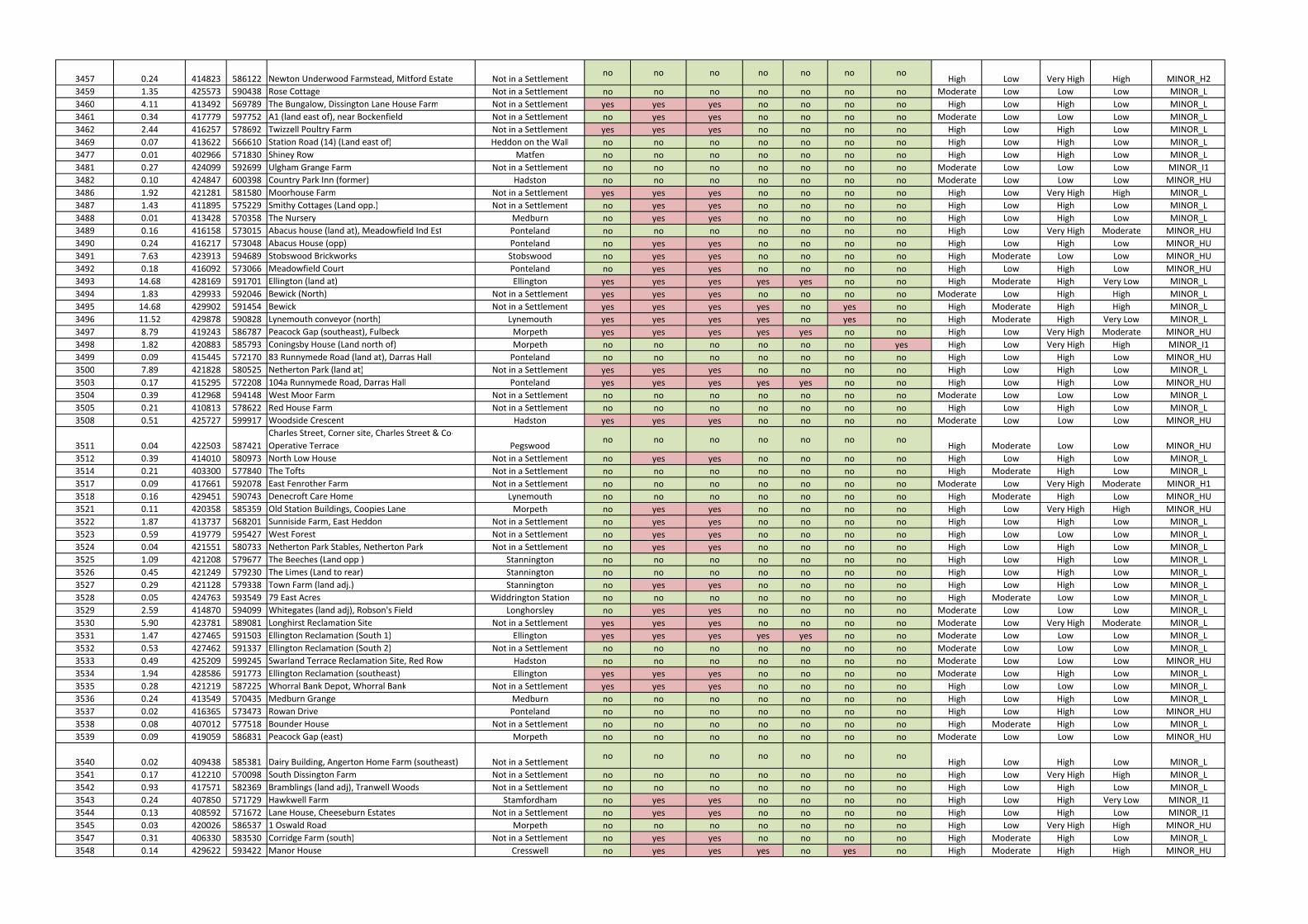
3457 0.24 414823 586122 Newton Underwood Farmstead, Mitford Estate Not in a Settlementno no no no no no no
High Low Very High High MINOR_H2
3459 1.35 425573 590438 Rose Cottage Not in a Settlement no no no no no no no Moderate Low Low Low MINOR_L
3460 4.11 413492 569789 The Bungalow, Dissington Lane House Farm Not in a Settlement yes yes yes no no no no High Low High Low MINOR_L
3461 0.34 417779 597752 A1 (land east of), near Bockenfield Not in a Settlement no yes yes no no no no Moderate Low Low Low MINOR_L
3462 2.44 416257 578692 Twizzell Poultry Farm Not in a Settlement yes yes yes no no no no High Low High Low MINOR_L
3469 0.07 413622 566610 Station Road (14) (Land east of) Heddon on the Wall no no no no no no no High Low High Low MINOR_L
3477 0.01 402966 571830 Shiney Row Matfen no no no no no no no High Low High Low MINOR_L
3481 0.27 424099 592699 Ulgham Grange Farm Not in a Settlement no no no no no no no Moderate Low Low Low MINOR_I1
3482 0.10 424847 600398 Country Park Inn (former) Hadston no no no no no no no Moderate Low Low Low MINOR_HU
3486 1.92 421281 581580 Moorhouse Farm Not in a Settlement yes yes yes no no no no High Low Very High High MINOR_L
3487 1.43 411895 575229 Smithy Cottages (Land opp.) Not in a Settlement no yes yes no no no no High Low High Low MINOR_L
3488 0.01 413428 570358 The Nursery Medburn no yes yes no no no no High Low High Low MINOR_L
3489 0.16 416158 573015 Abacus house (land at), Meadowfield Ind Est Ponteland no no no no no no no High Low Very High Moderate MINOR_HU
3490 0.24 416217 573048 Abacus House (opp) Ponteland no yes yes no no no no High Low High Low MINOR_HU
3491 7.63 423913 594689 Stobswood Brickworks Stobswood no yes yes no no no no High Moderate Low Low MINOR_HU
3492 0.18 416092 573066 Meadowfield Court Ponteland no yes yes no no no no High Low High Low MINOR_HU
3493 14.68 428169 591701 Ellington (land at) Ellington yes yes yes yes yes no no High Moderate High Very Low MINOR_L
3494 1.83 429933 592046 Bewick (North) Not in a Settlement yes yes yes no no no no Moderate Low High High MINOR_L
3495 14.68 429902 591454 Bewick Not in a Settlement yes yes yes yes no yes no High Moderate High High MINOR_L
3496 11.52 429878 590828 Lynemouth conveyor (north) Lynemouth yes yes yes yes no yes no High Moderate High Very Low MINOR_L
3497 8.79 419243 586787 Peacock Gap (southeast), Fulbeck Morpeth yes yes yes yes yes no no High Low Very High Moderate MINOR_HU
3498 1.82 420883 585793 Coningsby House (Land north of) Morpeth no no no no no no yes High Low Very High High MINOR_I1
3499 0.09 415445 572170 83 Runnymede Road (land at), Darras Hall Ponteland no no no no no no no High Low High Low MINOR_HU
3500 7.89 421828 580525 Netherton Park (land at) Not in a Settlement yes yes yes no no no no High Low High Low MINOR_L
3503 0.17 415295 572208 104a Runnymede Road, Darras Hall Ponteland yes yes yes yes yes no no High Low High Low MINOR_HU
3504 0.39 412968 594148 West Moor Farm Not in a Settlement no no no no no no no Moderate Low Low Low MINOR_L
3505 0.21 410813 578622 Red House Farm Not in a Settlement no no no no no no no High Low High Low MINOR_L
3508 0.51 425727 599917 Woodside Crescent Hadston yes yes yes no no no no Moderate Low Low Low MINOR_HU
3511 0.04 422503 587421
Charles Street, Corner site, Charles Street & Co-
Operative Terrace Pegswoodno no no no no no no
High Moderate Low Low MINOR_HU
3512 0.39 414010 580973 North Low House Not in a Settlement no yes yes no no no no High Low High Low MINOR_L
3514 0.21 403300 577840 The Tofts Not in a Settlement no no no no no no no High Moderate High Low MINOR_L
3517 0.09 417661 592078 East Fenrother Farm Not in a Settlement no no no no no no no Moderate Low Very High Moderate MINOR_H1
3518 0.16 429451 590743 Denecroft Care Home Lynemouth no no no no no no no High Moderate High Low MINOR_HU
3521 0.11 420358 585359 Old Station Buildings, Coopies Lane Morpeth no yes yes no no no no High Low Very High High MINOR_HU
3522 1.87 413737 568201 Sunniside Farm, East Heddon Not in a Settlement no yes yes no no no no High Low High Low MINOR_L
3523 0.59 419779 595427 West Forest Not in a Settlement no yes yes no no no no High Low Low Low MINOR_L
3524 0.04 421551 580733 Netherton Park Stables, Netherton Park Not in a Settlement no yes yes no no no no High Low High Low MINOR_L
3525 1.09 421208 579677 The Beeches (Land opp ) Stannington no no no no no no no High Low High Low MINOR_L
3526 0.45 421249 579230 The Limes (Land to rear) Stannington no no no no no no no High Low High Low MINOR_L
3527 0.29 421128 579338 Town Farm (land adj.) Stannington no yes yes no no no no High Low High Low MINOR_L
3528 0.05 424763 593549 79 East Acres Widdrington Station no no no no no no no High Moderate Low Low MINOR_L
3529 2.59 414870 594099 Whitegates (land adj), Robson's Field Longhorsley no yes yes no no no no Moderate Low Low Low MINOR_L
3530 5.90 423781 589081 Longhirst Reclamation Site Not in a Settlement yes yes yes no no no no Moderate Low Very High Moderate MINOR_L
3531 1.47 427465 591503 Ellington Reclamation (South 1) Ellington yes yes yes yes yes no no Moderate Low Low Low MINOR_L
3532 0.53 427462 591337 Ellington Reclamation (South 2) Not in a Settlement no no no no no no no Moderate Low Low Low MINOR_L
3533 0.49 425209 599245 Swarland Terrace Reclamation Site, Red Row Hadston no no no no no no no Moderate Low Low Low MINOR_HU
3534 1.94 428586 591773 Ellington Reclamation (southeast) Ellington yes yes yes no no no no Moderate Low High Low MINOR_L
3535 0.28 421219 587225 Whorral Bank Depot, Whorral Bank Not in a Settlement yes yes yes no no no no High Low Low Low MINOR_L
3536 0.24 413549 570435 Medburn Grange Medburn no no no no no no no High Low High Low MINOR_L
3537 0.02 416365 573473 Rowan Drive Ponteland no no no no no no no High Low High Low MINOR_HU
3538 0.08 407012 577518 Bounder House Not in a Settlement no no no no no no no High Moderate High Low MINOR_L
3539 0.09 419059 586831 Peacock Gap (east) Morpeth no no no no no no no Moderate Low Low Low MINOR_HU
3540 0.02 409438 585381 Dairy Building, Angerton Home Farm (southeast) Not in a Settlementno no no no no no no
High Low High Low MINOR_L
3541 0.17 412210 570098 South Dissington Farm Not in a Settlement no no no no no no no High Low Very High High MINOR_L
3542 0.93 417571 582369 Bramblings (land adj), Tranwell Woods Not in a Settlement no no no no no no no High Low High Low MINOR_L
3543 0.24 407850 571729 Hawkwell Farm Stamfordham no yes yes no no no no High Low High Very Low MINOR_I1
3544 0.13 408592 571672 Lane House, Cheeseburn Estates Not in a Settlement no yes yes no no no no High Low High Low MINOR_I1
3545 0.03 420026 586537 1 Oswald Road Morpeth no no no no no no no High Low Very High High MINOR_HU
3547 0.31 406330 583530 Corridge Farm (south) Not in a Settlement no yes yes no no no no High Moderate High Low MINOR_L
3548 0.14 429622 593422 Manor House Cresswell no yes yes yes no yes no High Moderate High High MINOR_HU
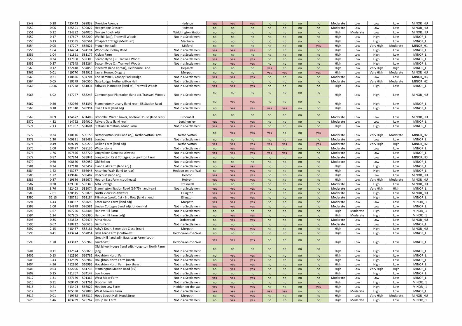
3549 0.28 425443 599838 Druridge Avenue Hadston yes yes yes no no no no Moderate Low Low Low MINOR_HU
3550 0.06 425591 599822 Hedgehope Crescent Hadston no no no no no no no Moderate Low Low Low MINOR_HU
3551 0.22 424292 594020 Grange Road (adj) Widdrington Station no no no no no no no High Moderate Low Low MINOR_HU
3552 0.17 417697 582209 Wellhill (adj), Tranwell Woods Not in a Settlement no no no no no no no High Low High Low MINOR_L
3553 0.13 413395 570561 Prospect Cottage (Medburn) Medburn no no no no no no no High Low High Low MINOR_L
3554 0.05 417207 586021 Plough Inn (adj) Mitford no no no no no no yes High Low Very High Moderate MINOR_H1
3555 1.64 414284 574194 Woodside, Belsay Road Not in a Settlement yes yes yes no no no no High Low High Low MINOR_L
3556 1.04 411861 581177 Kiplaw Farm Not in a Settlement no no no no no no no High Low High Low MINOR_L
3558 0.34 417908 582305 Seaton Ryde (3), Tranwell Woods Not in a Settlement yes yes yes no no no no High Low High Low MINOR_L
3559 0.37 417945 582264 Seaton Ryde (1), Tranwell Woods Not in a Settlement no yes yes no no no no High Low High Low MINOR_L
3560 0.12 422448 584053 Pinecroft (land at rear), Fieldhouse Lane Hepscott no no no yes no no no High Low Very High High MINOR_L
3562 0.01 419770 585911 Laurel House, Oldgate Morpeth no no no yes yes no yes High Low Very High Moderate MINOR_HU
3563 0.21 418826 594704 The Hemmell, Causey Park Bridge Not in a Settlement yes yes yes no no no no Moderate Low Low Low MINOR_H3
3564 0.05 410279 590550 Gate Lodge, Netherwitton Hall Not in a Settlement no no no no no no no Moderate Low Very High Moderate MINOR_H2
3565 10.36 417738 581834 Saltwick Plantation (land at), Tranwell Woods Not in a Settlement yes yes yes no no no no High Low High Low MINOR_L
3566 6.92 417727 583243 Commongate Plantation (land at), Tranwell Woods Not in a Settlementno no no no no no no
High Low High Low MINOR_HU
3567 0.50 422056 581397 Stannington Nursery (land rear), 58 Station Road Not in a Settlementno yes yes no no no no
High Low High Low MINOR_L
3568 0.10 421340 578994 Swan Farm (land adj) Not in a Settlement no yes yes yes yes no no High Low High Low MINOR_L
3569 0.09 424672 601408 Broomhill Water Tower, Beehive House (land rear) Broomhillno no no no no no no
Moderate Low Low Low MINOR_HU
3570 4.82 414792 594910 Reivers Gate (land rear) Longhorsley yes yes yes no no no no Moderate Low Low Low MINOR_L
3571 7.13 421067 581604 Station Plantation, Moor Farm Not in a Settlement yes yes yes no no no no High Low High Low MINOR_L
3572 0.34 410146 590156 Netherwitton Mill (land adj), Netherwitton Farm Netherwittonno yes yes yes no no yes
Moderate Low Very High Moderate MINOR_H2
3573 1.20 409311 589483 Longlea Not in a Settlement no no no no no no no Moderate Low Low Low MINOR_L
3574 0.49 409749 590270 Bellion Farm (land adj) Netherwitton yes yes yes yes yes no yes Moderate Low Very High High MINOR_H2
3575 2.00 408497 588136 Wittonstone Not in a Settlement no yes yes no no no no Moderate Low Low Low MINOR_L
3576 1.76 407876 587720 Longwitton Dene (southwest) Not in a Settlement yes yes yes yes yes no no Moderate Low Low Low MINOR_L
3577 0.87 407844 588841 Longwitton East Cottages, Longwitton Farm Not in a Settlement no no no no no no no Moderate Low Low Low MINOR_H3
3579 0.60 408630 589952 Old Bellion Not in a Settlement no no no no no no no Moderate Low Low Low MINOR_L
3581 0.24 417148 573457 Eland Hall Farm (land adj.) Not in a Settlement no yes yes no no no no High Low High Low MINOR_L
3584 1.42 413787 566648 Antonine Walk (land to rear) Heddon-on-the-Wall no yes yes no no no no High Low High Low MINOR_L
3585 1.72 419646 589487 Redcourt (land adj) Hebron yes yes yes no no no no High Low Low Low MINOR_HU
3586 0.87 419636 589677 Hebron East Farm (southeast) Hebron yes yes yes no no no no High Low Very High Moderate MINOR_HU
3587 0.20 429300 593340 Asta Cottage Cresswell no no no no no no no Moderate Low High Low MINOR_HU
3588 8.76 422403 582074 Stannington Station Road (69-75) (land rear), Not in a Settlement yes yes yes no no no no Moderate Low Very High High MINOR_L
3589 2.61 428545 592875 North View (southwest) Ellington yes yes yes no no no no Moderate Low High Low MINOR_HU
3590 32.13 428721 592184 Ellington (west), 1st - 3rd Row (land at end) Ellington yes yes yes no no no no Moderate Low High Low MINOR_L
3591 6.43 418987 587699 Kater Dene Farm (land adj) Morpeth yes yes yes no no no no Moderate Low Low Low MINOR_I1
3592 2.00 414979 596581 Linden Cottages (land adj), Linden Hall Not in a Settlement yes yes yes no no no no Moderate Low Low Low MINOR_L
3593 1.67 407766 568403 Harlow Hill Farm Not in a Settlement no no no no no no no High Moderate High Low MINOR_I1
3594 1.24 407905 568390 Harlow Hill Farm (adj) Not in a Settlement no yes yes no no no no High Moderate High Low MINOR_I1
3595 0.35 423822 594474 Alma House Stobswood no yes yes no no no no Moderate Low Low Low MINOR_HU
3596 0.67 410712 590618 Barns Farm Not in a Settlement no no no no no no no Moderate Low Low Low MINOR_L
3597 2.15 418467 585181 Athy's Dean, Simonside Close (rear) Morpeth no yes yes no no no no High Low High Low MINOR_HU
3598 0.41 413274 567054 Bays Leap Farm (southwest) Heddon-on-the-Wall no no no no no no no High Low High Low MINOR_L
3599 1.78 413812 566969
Great Hill (land adj), Bays Leap Farm (south
southeast) Heddon-on-the-Wallyes yes yes no no no no
High Low High Low MINOR_L
3601 0.11 412574 566820
Old School House (land adj), Houghton North Farm
(adj) Not in a Settlementno no no no no no no
High Low High Low MINOR_L
3602 0.13 412510 566782 Houghton North Farm Not in a Settlement no yes yes no no no no High Low High Low MINOR_L
3603 3.43 412539 566982 Houghton North Farm (north) Not in a Settlement no yes yes no no no no High Low High Low MINOR_L
3604 4.56 412690 566995 Houghton North Farm (northeast) Not in a Settlement yes yes yes no no no no High Low High Low MINOR_L
3605 0.63 422096 581738 Stannington Station Road (59) Not in a Settlement no yes yes no no no no High Low Very High High MINOR_L
3609 0.15 411767 574147 Low House Not in a Settlement no no no no no no no High Low High Low MINOR_L
3612 1.31 427189 591363 West Moor Farm Not in a Settlement yes yes yes no no no no Moderate Low Low Low MINOR_L
3615 0.31 409479 571761 Broomy Hall Not in a Settlement no no no no no no no High Low High Low MINOR_I1
3616 0.21 413494 566022 Heddon Low Farm Heddon-on-the-wall yes yes yes no no no yes High Low High Low MINOR_I1
3617 0.87 405398 572880 West Fenwick Farm Not in a Settlement yes yes yes yes yes no no High Moderate High Low MINOR_L
3619 0.01 419958 586312 Hood Street Hall, Hood Street Morpeth no yes yes no no no no High Low Very High Moderate MINOR_HU
3620 1.46 403739 575762 Lynup Hill Farm Not in a Settlement no yes yes no no no no High Moderate High Low MINOR_I1
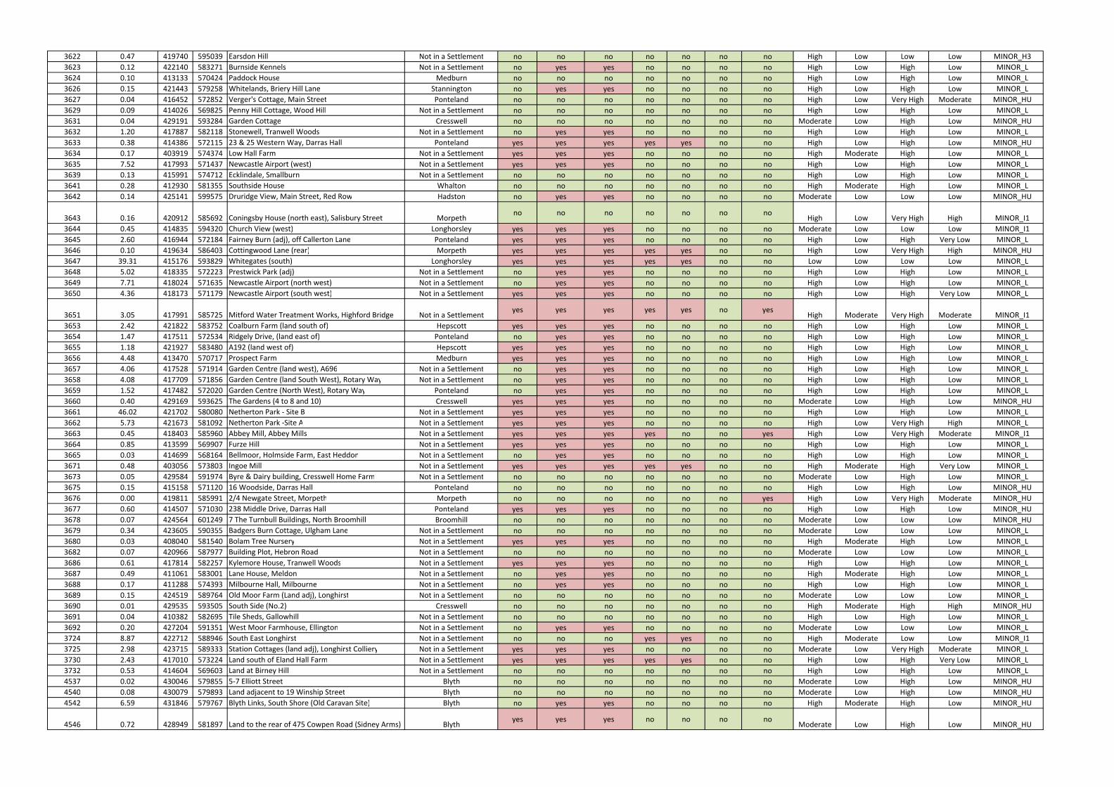
3622 0.47 419740 595039 Earsdon Hill Not in a Settlement no no no no no no no High Low Low Low MINOR_H3
3623 0.12 422140 583271 Burnside Kennels Not in a Settlement no yes yes no no no no High Low High Low MINOR_L
3624 0.10 413133 570424 Paddock House Medburn no no no no no no no High Low High Low MINOR_L
3626 0.15 421443 579258 Whitelands, Briery Hill Lane Stannington no yes yes no no no no High Low High Low MINOR_L
3627 0.04 416452 572852 Verger's Cottage, Main Street Ponteland no no no no no no no High Low Very High Moderate MINOR_HU
3629 0.09 414026 569825 Penny Hill Cottage, Wood Hill Not in a Settlement no no no no no no no High Low High Low MINOR_L
3631 0.04 429191 593284 Garden Cottage Cresswell no no no no no no no Moderate Low High Low MINOR_HU
3632 1.20 417887 582118 Stonewell, Tranwell Woods Not in a Settlement no yes yes no no no no High Low High Low MINOR_L
3633 0.38 414386 572115 23 & 25 Western Way, Darras Hall Ponteland yes yes yes yes yes no no High Low High Low MINOR_HU
3634 0.17 403919 574374 Low Hall Farm Not in a Settlement yes yes yes no no no no High Moderate High Low MINOR_L
3635 7.52 417993 571437 Newcastle Airport (west) Not in a Settlement yes yes yes no no no no High Low High Low MINOR_L
3639 0.13 415991 574712 Ecklindale, Smallburn Not in a Settlement no no no no no no no High Low High Low MINOR_L
3641 0.28 412930 581355 Southside House Whalton no no no no no no no High Moderate High Low MINOR_L
3642 0.14 425141 599575 Druridge View, Main Street, Red Row Hadston no yes yes no no no no Moderate Low Low Low MINOR_HU
3643 0.16 420912 585692 Coningsby House (north east), Salisbury Street Morpethno no no no no no no
High Low Very High High MINOR_I1
3644 0.45 414835 594320 Church View (west) Longhorsley yes yes yes no no no no Moderate Low Low Low MINOR_I1
3645 2.60 416944 572184 Fairney Burn (adj), off Callerton Lane Ponteland yes yes yes no no no no High Low High Very Low MINOR_L
3646 0.10 419634 586403 Cottingwood Lane (rear) Morpeth yes yes yes yes yes no no High Low Very High High MINOR_HU
3647 39.31 415176 593829 Whitegates (south) Longhorsley yes yes yes yes yes no no Low Low Low Low MINOR_L
3648 5.02 418335 572223 Prestwick Park (adj) Not in a Settlement no yes yes no no no no High Low High Low MINOR_L
3649 7.71 418024 571635 Newcastle Airport (north west) Not in a Settlement no yes yes no no no no High Low High Low MINOR_L
3650 4.36 418173 571179 Newcastle Airport (south west) Not in a Settlement yes yes yes no no no no High Low High Very Low MINOR_L
3651 3.05 417991 585725 Mitford Water Treatment Works, Highford Bridge Not in a Settlementyes yes yes yes yes no yes
High Moderate Very High Moderate MINOR_I1
3653 2.42 421822 583752 Coalburn Farm (land south of) Hepscott yes yes yes no no no no High Low High Low MINOR_L
3654 1.47 417511 572534 Ridgely Drive, (land east of) Ponteland no yes yes no no no no High Low High Low MINOR_L
3655 1.18 421927 583480 A192 (land west of) Hepscott yes yes yes no no no no High Low High Low MINOR_L
3656 4.48 413470 570717 Prospect Farm Medburn yes yes yes no no no no High Low High Low MINOR_L
3657 4.06 417528 571914 Garden Centre (land west), A696 Not in a Settlement no yes yes no no no no High Low High Low MINOR_L
3658 4.08 417709 571856 Garden Centre (land South West), Rotary Way Not in a Settlement no yes yes no no no no High Low High Low MINOR_L
3659 1.52 417482 572020 Garden Centre (North West), Rotary Way Ponteland no yes yes no no no no High Low High Low MINOR_L
3660 0.40 429169 593625 The Gardens (4 to 8 and 10) Cresswell yes yes yes no no no no Moderate Low High Low MINOR_HU
3661 46.02 421702 580080 Netherton Park - Site B Not in a Settlement yes yes yes no no no no High Low High Low MINOR_L
3662 5.73 421673 581092 Netherton Park -Site A Not in a Settlement yes yes yes no no no no High Low Very High High MINOR_L
3663 0.45 418403 585960 Abbey Mill, Abbey Mills Not in a Settlement yes yes yes yes no no yes High Low Very High Moderate MINOR_I1
3664 0.85 413599 569907 Furze Hill Not in a Settlement yes yes yes no no no no High Low High Low MINOR_L
3665 0.03 414699 568164 Bellmoor, Holmside Farm, East Heddon Not in a Settlement no yes yes no no no no High Low High Low MINOR_L
3671 0.48 403056 573803 Ingoe Mill Not in a Settlement yes yes yes yes yes no no High Moderate High Very Low MINOR_L
3673 0.05 429584 591974 Byre & Dairy building, Cresswell Home Farm Not in a Settlement no no no no no no no Moderate Low High Low MINOR_L
3675 0.15 415158 571120 16 Woodside, Darras Hall Ponteland no no no no no no no High Low High Low MINOR_HU
3676 0.00 419811 585991 2/4 Newgate Street, Morpeth Morpeth no no no no no no yes High Low Very High Moderate MINOR_HU
3677 0.60 414507 571030 238 Middle Drive, Darras Hall Ponteland yes yes yes no no no no High Low High Low MINOR_HU
3678 0.07 424564 601249 7 The Turnbull Buildings, North Broomhill Broomhill no no no no no no no Moderate Low Low Low MINOR_HU
3679 0.34 423605 590355 Badgers Burn Cottage, Ulgham Lane Not in a Settlement no no no no no no no Moderate Low Low Low MINOR_L
3680 0.03 408040 581540 Bolam Tree Nursery Not in a Settlement yes yes yes no no no no High Moderate High Low MINOR_L
3682 0.07 420966 587977 Building Plot, Hebron Road Not in a Settlement no no no no no no no Moderate Low Low Low MINOR_L
3686 0.61 417814 582257 Kylemore House, Tranwell Woods Not in a Settlement yes yes yes no no no no High Low High Low MINOR_L
3687 0.49 411061 583001 Lane House, Meldon Not in a Settlement no yes yes no no no no High Moderate High Low MINOR_L
3688 0.17 411288 574393 Milbourne Hall, Milbourne Not in a Settlement no yes yes no no no no High Low High Low MINOR_L
3689 0.15 424519 589764 Old Moor Farm (Land adj), Longhirst Not in a Settlement no no no no no no no Moderate Low Low Low MINOR_L
3690 0.01 429535 593505 South Side (No.2) Cresswell no no no no no no no High Moderate High High MINOR_HU
3691 0.04 410382 582695 Tile Sheds, Gallowhill Not in a Settlement no no no no no no no High Low High Low MINOR_L
3692 0.20 427204 591351 West Moor Farmhouse, Ellington Not in a Settlement no yes yes no no no no Moderate Low Low Low MINOR_L
3724 8.87 422712 588946 South East Longhirst Not in a Settlement no no no yes yes no no High Moderate Low Low MINOR_I1
3725 2.98 423715 589333 Station Cottages (land adj), Longhirst Colliery Not in a Settlement yes yes yes no no no no Moderate Low Very High Moderate MINOR_L
3730 2.43 417010 573224 Land south of Eland Hall Farm Not in a Settlement yes yes yes yes yes no no High Low High Very Low MINOR_L
3732 0.53 414604 569603 Land at Birney Hill Not in a Settlement no no no no no no no High Low High Low MINOR_L
4537 0.02 430046 579855 5-7 Elliott Street Blyth no no no no no no no Moderate Low High Low MINOR_HU
4540 0.08 430079 579893 Land adjacent to 19 Winship Street Blyth no no no no no no no Moderate Low High Low MINOR_HU
4542 6.59 431846 579767 Blyth Links, South Shore (Old Caravan Site) Blyth no yes yes no no no no High Moderate High Low MINOR_HU
4546 0.72 428949 581897 Land to the rear of 475 Cowpen Road (Sidney Arms) Blythyes yes yes no no no no
Moderate Low High Low MINOR_HU
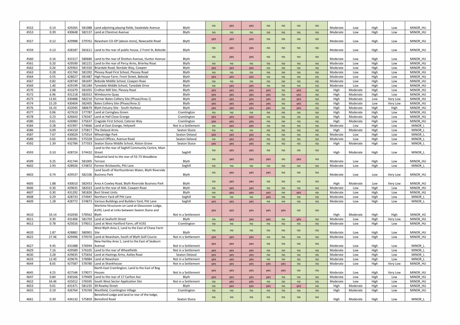
4552 0.14 429265 581088 Land adjoining playing fields, Swaledale Avenue Blythno yes yes no no no no
Moderate Low High Low MINOR_HU
4553 0.39 430648 582137 Land at Chestnut Avenue Blyth no no no no no no no Moderate Low High Low MINOR_HU
4557 0.12 429988 579761 Newsham CO-OP (above store), Newcastle Road Blythyes yes yes no no no no
Moderate Low High Low MINOR_HU
4559 0.13 428187 581611 Land to the rear of public house, 2 Front St, Bebside Blythno yes yes no no no no
Moderate Low High Low MINOR_HU
4560 0.16 431517 580680 Land to the rear of Shotton Avenue, Hunter Avenue Blythno yes yes no no no no
Moderate Low High Low MINOR_HU
4561 0.20 429590 581221 Land to the rear of Percy Arms, Brierley Road Blyth no no no no no no no Moderate Low High Low MINOR_HU
4562 0.26 429363 581550 Briardale Road, Nordale Way, Cowpen Blyth yes yes yes no no no no Moderate Low High Low MINOR_HU
4563 0.28 431760 581392 Plessey Road First School, Plessey Road Blyth no no no no no no no Moderate Low High Low MINOR_HU
4564 0.55 428027 581487 High House Farm, Front Street, Bebside Blyth yes yes yes no no no no Moderate Low High Low MINOR_HU
4567 0.82 428740 581697 Bebside Middle School, Cowpen Road Blyth no no no no no no no Moderate Low High Low MINOR_HU
4569 1.40 429199 581284 Tynedale Middle School, Tynedale Drive Blyth no yes yes no no no no Moderate Low High Low MINOR_HU
4570 2.08 431679 581055 Crofton Mill Site, Plessey Road Blyth yes yes yes yes no yes no High Moderate High Low MINOR_HU
4572 6.96 431218 582022 Wimbourne Quay Blyth yes yes yes yes no yes no High Moderate High Low MINOR_HU
4573 13.81 430488 582210 Former Bates Colliery Site (Phase/Area 1) Blyth yes yes yes yes no yes no High Moderate Low Very Low MINOR_HU
4574 15.29 430404 582405 Bates Colliery Site (Phase/Area 2) Blyth yes yes yes yes no yes no High Moderate Low Very Low MINOR_HU
4576 16.33 432045 580679 Blyth Estuary Site - South Harbour Blyth yes yes yes yes no yes no High Moderate High High MINOR_HU
4577 0.06 427610 577787 Land at Caringlass Green Cramlington no no no no no no no High Moderate High Low MINOR_HU
4578 0.23 426643 576347 Land at Hall Close Grange Cramlington yes yes yes no no no no High Moderate High Low MINOR_HU
4580 0.61 426983 575637 Cragside First School, Cateran Way Cramlington yes yes yes no no no no High Moderate High Low MINOR_HU
4584 0.28 431997 574666 Land at East Grange, Holywell Not in a Settlement no yes yes no no no no Moderate Low High Low MINOR_L
4586 0.09 434150 575817 The Delaval Arms Seaton Sluice no no no no no no no High Moderate High Low MINOR_L
4587 7.67 430029 575914 Wheatridge Park Seaton Delaval yes yes yes no no no no Moderate Low High Low MINOR_L
4589 0.65 430281 575328 Council Offices, Avenue Road Seaton Delaval no yes yes no no no no Moderate Low High Low MINOR_L
4592 1.39 432784 577353 Seaton Sluice Middle School, Alston Grove Seaton Sluice yes yes yes no no no no High Moderate High Low MINOR_L
4593 0.10 428724 574432
Land to the rear of Seghill Community Centre, Main
Street Seghillno yes yes no no no no
High Moderate High Low MINOR_L
4599 0.25 431744 581005
Industrial land to the rear of 55-73 Woodbine
Terrace Blythno yes yes yes no yes no
Moderate Low High Low MINOR_HU
4602 2.93 428926 574872 Former Brickworks, Pitt Lane Seghill no no no no no no no Moderate Low High Low MINOR_L
4603 0.74 429537 582106
Land South of Northumbrian Water, Blyth Riverside
Business Park Blythno yes yes yes no no no
Moderate Low Low Very Low MINOR_HU
4605 1.88 430010 582453 Area A Cowley Road, Blyth Riverside Business Park Blythno yes yes no no no no
High Moderate Low Very Low MINOR_HU
4606 0.30 429635 582023 Land to the rear of Aldi, Cowpen Road Blyth no yes yes no no no no Moderate Low High Low MINOR_HU
4607 0.30 431292 581826 Burt Street Units Blyth no yes yes yes no yes no Moderate Low High Low MINOR_HU
4608 0.29 428733 574947 Northern Yard off Pitt Lane Seghill no no no yes no no no Moderate Low High Low MINOR_L
4609 1.28 428772 574873 Various Buildings and Builders Yard, Pitt Lane Seghill yes yes yes no no no no Moderate Low High Low MINOR_L
4610 10.14 432030 578562
Wartime Structures on Land at Gloucester Lodge,
A193, Land at Links between Seaton Sluice and
Blyth Not in a Settlement
yes yes yes yes yes no no
High Moderate High High MINOR_H2
4611 0.30 431406 581703 Land at Seaforth Street Blyth no yes yes yes no yes no Moderate Low High Very Low MINOR_HU
4612 0.78 425016 579011 Land at West Hartford Farm, off A192 Cramlington no no no no no no no Moderate Low High Low MINOR_HU
4620 1.87 428882 580901
West Blyth Area 2, Land to the East of Chase Farm
Site Blythno no no no no no no
Moderate Low High Low MINOR_HU
4622 27.46 429496 579370 Land at Newsham, South of Blyth Golf Course Not in a Settlement yes yes yes no no no no Moderate Low High Low MINOR_HU
4627 9.45 431088 576944
New Hartley Area 1, Land to the East of Seaburn
Avenue Not in a Settlementyes yes yes no no no no
Moderate Low High Low MINOR_L
4629 7.16 429589 576105 Land to the rear of Wheatfields Not in a Settlement yes yes yes no no no no Moderate Low High Low MINOR_L
4630 3.28 429635 575654 Land at Hastings Arms, Astley Road Seaton Delaval yes yes yes no no no no Moderate Low High Low MINOR_L
4633 12.40 429676 578984 Land at Newsham Not in a Settlement yes yes yes no no no no Moderate Low High Low MINOR_L
4644 8.65 427587 578780 Land at Shankhouse Not in a Settlement yes yes yes yes yes no no Moderate Low High Very Low MINOR_HU
4645 4.25 427546 579077
North East Cramlington, Land to the East of Bog
Houses Not in a Settlementyes yes yes yes yes no no
Moderate Low High Very Low MINOR_HU
4647 0.84 430166 579409 Land to the rear of 17 Carlton Ave Blyth yes yes yes yes no no no Moderate Low High Low MINOR_HU
4652 34.46 425012 576595 South West Sector Application Site Not in a Settlement no yes yes no no no no Moderate Low High Low MINOR_HU
4653 0.01 431471 581235 30 Rowley Street Blyth no yes yes yes no yes no High Moderate High Low MINOR_HU
4655 0.19 426764 576769 Westfield, Cramlington Village Cramlington no no no no no no no High Moderate High Low MINOR_HU
4661 0.39 434132 575859
Beresford Lodge and land to rear of the lodge,
Beresford Road Seaton Sluiceno no no no no no no
High Moderate High Low MINOR_L

4663 0.45 430095 581441 Land around and including Malvins House Close Blythno no no no no no no
Moderate Low High Low MINOR_HU
4664 2.42 430216 576055 Wheatridge Park Phase 2 extension Seaton Delaval no yes yes no no no no Moderate Low High Low MINOR_L
4668 1.72 430941 579198 Newsham North Farm, South Newsham Road Blyth yes yes yes yes yes no no High Moderate High Low MINOR_L
4669 1.36 431923 579489 Link House Buildings and Land, Links Road Blyth yes yes yes yes yes no no High Moderate High Low MINOR_HU
4670 0.16 431285 579708
Land at South Beach Community Centre, South
Beach Blythno no no no no no no
High Moderate High Low MINOR_HU
4670 0.16 431285 579708
Land at South Beach Community Centre, South
Beach Blythno no no no no no no
High Moderate High Low MINOR_L
4671 1.13 430633 579420 Land Off Sandringham Drive Blyth no no no no no no no High Moderate High Low MINOR_L
4671 1.13 430633 579420 Land Off Sandringham Drive Blyth no no no no no no no Moderate Low High Low MINOR_L
4672 2.35 430228 579205 Land to the Northof Park Farm Cottages Blyth yes yes yes yes no no no Moderate Low High Low MINOR_L
4692 0.42 429648 575960 As New Motor Factors, 2 Double Row Seaton Delaval no no no no no no no Moderate Low High Low MINOR_L
4694 12.92 430074 578906 Land at South West Newsham Blyth yes yes yes yes yes no no High Moderate High Low MINOR_L
4696 0.62 429944 581825 Former Bates Staiths Railway Line adj Malvins Rd. Blythyes yes yes no no no no
Moderate Low High Low MINOR_HU
4697 3.69 428274 581210 Site B South of Bebside Rd, Front Street Bebside Blythno yes yes no no no no
Moderate Low High Low MINOR_HU
4698 1.95 428063 574460 Rose Park Estate Adjacent Seghill Hall Not in a Settlement yes yes yes yes yes no no Moderate Low High Low MINOR_L
4700 0.47 428810 574885 Land Adjacent Middle Farm, North of Talbot House Seghillno no no no no no no
Moderate Low High Low MINOR_L
4701 38.45 426165 577424 Land North of Station Road Cramlington yes yes yes no no no no High Moderate Very High High MINOR_HU
4702 1.49 426126 578298 Land to the West of Cheadle Avenue Cramlington yes yes yes no no no no Moderate Low High Very Low MINOR_HU
4703 124.15 424865 576286 Land at South West Sector Cramlington yes yes yes no no no no Moderate Low High Low MINOR_HU
4705 0.06 429739 579614 Land Adjacent to 44 Beatrice Avenue Blyth no no no no no no no Moderate Low High Low MINOR_HU
4706 0.64 429711 575887 Land at Double Row Seaton Delaval no no no no no no no Moderate Low High Low MINOR_L
4707 0.17 429877 575823 Doctor Surgery Site, Wheatridge Park Seaton Delaval no no no no no no no Moderate Low High Low MINOR_L
4712 4.28 431627 580532 Wensleydale Middle School, Dent Street Blyth yes yes yes yes no no no High Moderate High Low MINOR_HU
4713 0.57 427586 578706 Cramlington Fire Station, Shankhouse Cramlington yes yes yes yes yes no no Moderate Low High Very Low MINOR_HU
4714 0.21 430329 582014 Blyth Fire Station, Cowpen Road Blyth no yes yes no no no no Moderate Low High Low MINOR_HU
4715 2.46 429933 575016 Brickyard Field, Mares Close Not in a Settlement no no no no no no no Moderate Low High Low MINOR_L
4718 3.71 426844 581032 Land to the West of North Farm, Bebside Not in a Settlement no yes yes no no no no Moderate Low High Low MINOR_HU
4720 2.40 427626 581192 Land to South of Bebside Road, Bebside Not in a Settlement yes yes yes no no no no Moderate Low High Low MINOR_HU
4721 0.10 430852 581640
Car parking area of the Blyth Comrades Club, Wright
Street Blythno no no no no no no
Moderate Low High Low MINOR_HU
4722 29.20 431462 575058 Land at North Farm, Holywell Not in a Settlement yes yes yes no no no no Moderate Low High Low MINOR_L
4724 0.30 430823 575272 Seaton Terrace Nursery School, Fontburn Road Seaton Delavalno no no no no no no
Moderate Low High Low MINOR_L
4725 56.99 426251 579212
East Hartford Farm, Land to the West of East
Hartford Not in a Settlementyes yes yes no no no no
Moderate Low High Low MINOR_HU
4726 4.46 428105 581559
Site adjacent to (to the NE of) High House Farm,
Front Street, Bebside Blythyes yes yes no no no no
Moderate Low High Low MINOR_HU
4726 4.46 428105 581559
Site adjacent to (to the NE of) High House Farm,
Front Street, Bebside Blythyes yes yes no no no no
Moderate Low High Low MINOR_L
4730 6.15 426565 577822 Land to the rear of the Brockwell Centre Cramlington yes yes yes no no no no High Moderate Very High High MINOR_HU
4732 5.71 427609 581782 Site A West of Bebside Furnace Road, Bebside Not in a Settlement yes yes yes no no no no Moderate Low High Low MINOR_H1
4733 8.91 427880 582059 Site C East of Bebside Furnace Road, Bebside Not in a Settlement yes yes yes yes no no no Moderate Low Low Very Low MINOR_H3
4734 1.94 428023 581333 Area A South of Bebside Rd, Front Street, Bebside Not in a Settlementyes yes yes no no no no
Moderate Low High Low MINOR_HU
4735 10.09 429082 574226 Land South of Station Road Not in a Settlement yes yes yes yes no no no High Moderate High Low MINOR_L
4736 2.11 431990 581418 Commissioners Quay, West of Quay Road Blyth no yes yes yes no yes no High Moderate High High MINOR_HU
4737 0.38 431779 581675
Dun Cow Quay, Land South of Quayside, North of
Sussex Street Blythno no no yes no yes no
High Moderate High Low MINOR_HU
4741 1.41 427159 575082 Land between the A189 and B1505 Not in a Settlement no yes yes no no no no Moderate Low High Very Low MINOR_HU
4742 0.30 428659 575025 Land south west of Middle Farm Not in a Settlement yes yes yes yes yes no no Moderate Low High Very Low MINOR_L
4743 0.23 428489 574131
Land West of Birchwood Close, adjoining Backworth
Lane Not in a Settlementno no no no no no no
High Moderate High Low MINOR_L
4744 5.80 428156 574506 Land at Seghill Hall, North of Fox Lea Walk Not in a Settlement yes yes yes yes yes no no Moderate Low High Very Low MINOR_L
4749 1.36 427430 577668 Eastlea First School, Bowmont Drive Cramlington yes yes yes no no no no Moderate Low High Low MINOR_HU
4752 0.07 433879 576425 41 Collywell Bay Road Seaton Sluice no no no no no no no Moderate Low High Low MINOR_L
4753 0.42 429603 575778 Delaval House, Station Road Seaton Delaval no no no no no no no Moderate Low High Low MINOR_L
4754 0.09 426794 576799 13 Allensgreen Cramlington no no no no no no no High Moderate High Low MINOR_HU
4755 11.10 431784 580078 Wellesley Childrens Home, Links Road Blyth no yes yes no no no no High Moderate High Low MINOR_HU
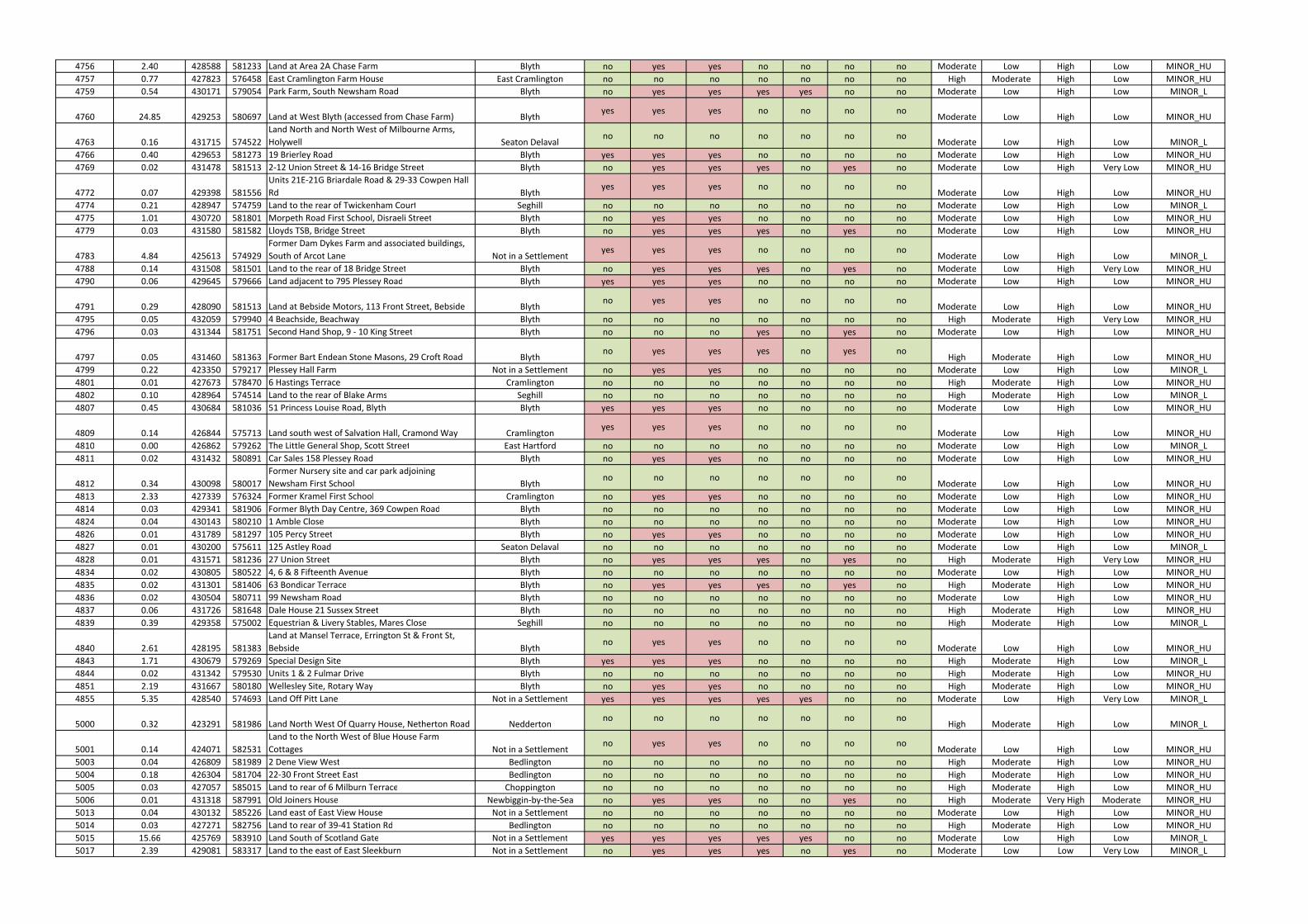
4756 2.40 428588 581233 Land at Area 2A Chase Farm Blyth no yes yes no no no no Moderate Low High Low MINOR_HU
4757 0.77 427823 576458 East Cramlington Farm House East Cramlington no no no no no no no High Moderate High Low MINOR_HU
4759 0.54 430171 579054 Park Farm, South Newsham Road Blyth no yes yes yes yes no no Moderate Low High Low MINOR_L
4760 24.85 429253 580697 Land at West Blyth (accessed from Chase Farm) Blythyes yes yes no no no no
Moderate Low High Low MINOR_HU
4763 0.16 431715 574522
Land North and North West of Milbourne Arms,
Holywell Seaton Delavalno no no no no no no
Moderate Low High Low MINOR_L
4766 0.40 429653 581273 19 Brierley Road Blyth yes yes yes no no no no Moderate Low High Low MINOR_HU
4769 0.02 431478 581513 2-12 Union Street & 14-16 Bridge Street Blyth no yes yes yes no yes no Moderate Low High Very Low MINOR_HU
4772 0.07 429398 581556
Units 21E-21G Briardale Road & 29-33 Cowpen Hall
Rd Blythyes yes yes no no no no
Moderate Low High Low MINOR_HU
4774 0.21 428947 574759 Land to the rear of Twickenham Court Seghill no no no no no no no Moderate Low High Low MINOR_L
4775 1.01 430720 581801 Morpeth Road First School, Disraeli Street Blyth no yes yes no no no no Moderate Low High Low MINOR_HU
4779 0.03 431580 581582 Lloyds TSB, Bridge Street Blyth no yes yes yes no yes no Moderate Low High Low MINOR_HU
4783 4.84 425613 574929
Former Dam Dykes Farm and associated buildings,
South of Arcot Lane Not in a Settlementyes yes yes no no no no
Moderate Low High Low MINOR_L
4788 0.14 431508 581501 Land to the rear of 18 Bridge Street Blyth no yes yes yes no yes no Moderate Low High Very Low MINOR_HU
4790 0.06 429645 579666 Land adjacent to 795 Plessey Road Blyth yes yes yes no no no no Moderate Low High Low MINOR_HU
4791 0.29 428090 581513 Land at Bebside Motors, 113 Front Street, Bebside Blythno yes yes no no no no
Moderate Low High Low MINOR_HU
4795 0.05 432059 579940 4 Beachside, Beachway Blyth no no no no no no no High Moderate High Very Low MINOR_HU
4796 0.03 431344 581751 Second Hand Shop, 9 - 10 King Street Blyth no no no yes no yes no Moderate Low High Low MINOR_HU
4797 0.05 431460 581363 Former Bart Endean Stone Masons, 29 Croft Road Blythno yes yes yes no yes no
High Moderate High Low MINOR_HU
4799 0.22 423350 579217 Plessey Hall Farm Not in a Settlement no yes yes no no no no Moderate Low High Low MINOR_L
4801 0.01 427673 578470 6 Hastings Terrace Cramlington no no no no no no no High Moderate High Low MINOR_HU
4802 0.10 428964 574514 Land to the rear of Blake Arms Seghill no no no no no no no High Moderate High Low MINOR_L
4807 0.45 430684 581036 51 Princess Louise Road, Blyth Blyth yes yes yes no no no no Moderate Low High Low MINOR_HU
4809 0.14 426844 575713 Land south west of Salvation Hall, Cramond Way Cramlingtonyes yes yes no no no no
Moderate Low High Low MINOR_HU
4810 0.00 426862 579262 The Little General Shop, Scott Street East Hartford no no no no no no no Moderate Low High Low MINOR_L
4811 0.02 431432 580891 Car Sales 158 Plessey Road Blyth no yes yes no no no no Moderate Low High Low MINOR_HU
4812 0.34 430098 580017
Former Nursery site and car park adjoining
Newsham First School Blythno no no no no no no
Moderate Low High Low MINOR_HU
4813 2.33 427339 576324 Former Kramel First School Cramlington no yes yes no no no no Moderate Low High Low MINOR_HU
4814 0.03 429341 581906 Former Blyth Day Centre, 369 Cowpen Road Blyth no no no no no no no Moderate Low High Low MINOR_HU
4824 0.04 430143 580210 1 Amble Close Blyth no no no no no no no Moderate Low High Low MINOR_HU
4826 0.01 431789 581297 105 Percy Street Blyth no yes yes no no no no Moderate Low High Low MINOR_HU
4827 0.01 430200 575611 125 Astley Road Seaton Delaval no no no no no no no Moderate Low High Low MINOR_L
4828 0.01 431571 581236 27 Union Street Blyth no yes yes yes no yes no High Moderate High Very Low MINOR_HU
4834 0.02 430805 580522 4, 6 & 8 Fifteenth Avenue Blyth no no no no no no no Moderate Low High Low MINOR_HU
4835 0.02 431301 581406 63 Bondicar Terrace Blyth no yes yes yes no yes no High Moderate High Low MINOR_HU
4836 0.02 430504 580711 99 Newsham Road Blyth no no no no no no no Moderate Low High Low MINOR_HU
4837 0.06 431726 581648 Dale House 21 Sussex Street Blyth no no no no no no no High Moderate High Low MINOR_HU
4839 0.39 429358 575002 Equestrian & Livery Stables, Mares Close Seghill no no no no no no no High Moderate High Low MINOR_L
4840 2.61 428195 581383
Land at Mansel Terrace, Errington St & Front St,
Bebside Blythno yes yes no no no no
Moderate Low High Low MINOR_HU
4843 1.71 430679 579269 Special Design Site Blyth yes yes yes no no no no High Moderate High Low MINOR_L
4844 0.02 431342 579530 Units 1 & 2 Fulmar Drive Blyth no no no no no no no High Moderate High Low MINOR_HU
4851 2.19 431667 580180 Wellesley Site, Rotary Way Blyth no yes yes no no no no High Moderate High Low MINOR_HU
4855 5.35 428540 574693 Land Off Pitt Lane Not in a Settlement yes yes yes yes yes no no Moderate Low High Very Low MINOR_L
5000 0.32 423291 581986 Land North West Of Quarry House, Netherton Road Neddertonno no no no no no no
High Moderate High Low MINOR_L
5001 0.14 424071 582531
Land to the North West of Blue House Farm
Cottages Not in a Settlementno yes yes no no no no
Moderate Low High Low MINOR_HU
5003 0.04 426809 581989 2 Dene View West Bedlington no no no no no no no High Moderate High Low MINOR_HU
5004 0.18 426304 581704 22-30 Front Street East Bedlington no no no no no no no High Moderate High Low MINOR_HU
5005 0.03 427057 585015 Land to rear of 6 Milburn Terrace Choppington no no no no no no no High Moderate High Low MINOR_HU
5006 0.01 431318 587991 Old Joiners House Newbiggin-by-the-Sea no yes yes no no yes no High Moderate Very High Moderate MINOR_HU
5013 0.04 430132 585226 Land east of East View House Not in a Settlement no no no no no no no Moderate Low High Low MINOR_HU
5014 0.03 427271 582756 Land to rear of 39-41 Station Rd Bedlington no no no no no no no High Moderate High Low MINOR_HU
5015 15.66 425769 583910 Land South of Scotland Gate Not in a Settlement yes yes yes yes yes no no Moderate Low High Low MINOR_L
5017 2.39 429081 583317 Land to the east of East Sleekburn Not in a Settlement no yes yes yes no yes no Moderate Low Low Very Low MINOR_L
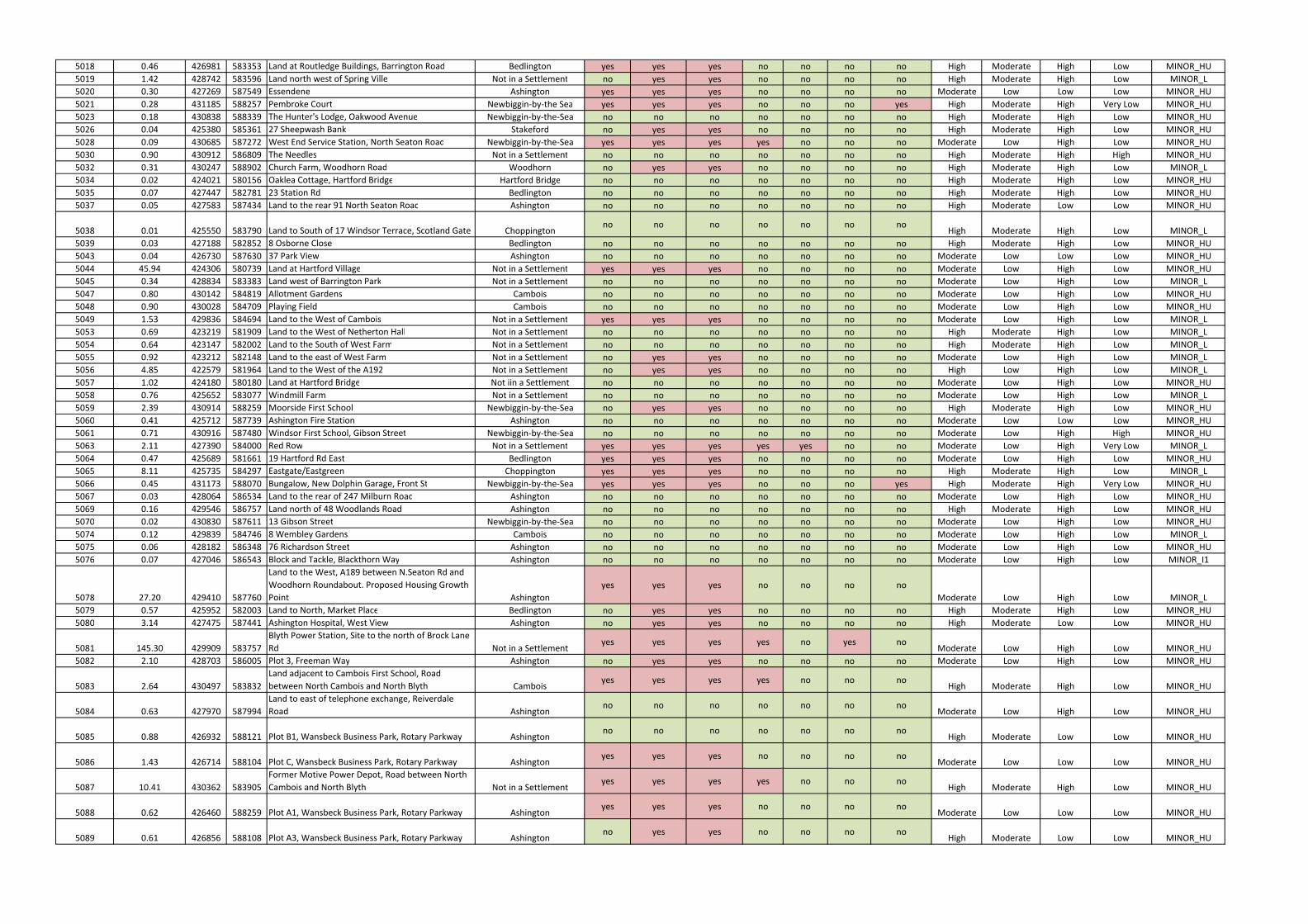
5018 0.46 426981 583353 Land at Routledge Buildings, Barrington Road Bedlington yes yes yes no no no no High Moderate High Low MINOR_HU
5019 1.42 428742 583596 Land north west of Spring Ville Not in a Settlement no yes yes no no no no High Moderate High Low MINOR_L
5020 0.30 427269 587549 Essendene Ashington yes yes yes no no no no Moderate Low Low Low MINOR_HU
5021 0.28 431185 588257 Pembroke Court Newbiggin-by-the Sea yes yes yes no no no yes High Moderate High Very Low MINOR_HU
5023 0.18 430838 588339 The Hunter's Lodge, Oakwood Avenue Newbiggin-by-the-Sea no no no no no no no High Moderate High Low MINOR_HU
5026 0.04 425380 585361 27 Sheepwash Bank Stakeford no yes yes no no no no High Moderate High Low MINOR_HU
5028 0.09 430685 587272 West End Service Station, North Seaton Road Newbiggin-by-the-Sea yes yes yes yes no no no Moderate Low High Low MINOR_HU
5030 0.90 430912 586809 The Needles Not in a Settlement no no no no no no no High Moderate High High MINOR_HU
5032 0.31 430247 588902 Church Farm, Woodhorn Road Woodhorn no yes yes no no no no High Moderate High Low MINOR_L
5034 0.02 424021 580156 Oaklea Cottage, Hartford Bridge Hartford Bridge no no no no no no no High Moderate High Low MINOR_HU
5035 0.07 427447 582781 23 Station Rd Bedlington no no no no no no no High Moderate High Low MINOR_HU
5037 0.05 427583 587434 Land to the rear 91 North Seaton Road Ashington no no no no no no no High Moderate Low Low MINOR_HU
5038 0.01 425550 583790 Land to South of 17 Windsor Terrace, Scotland Gate Choppingtonno no no no no no no
High Moderate High Low MINOR_L
5039 0.03 427188 582852 8 Osborne Close Bedlington no no no no no no no High Moderate High Low MINOR_HU
5043 0.04 426730 587630 37 Park View Ashington no no no no no no no Moderate Low Low Low MINOR_HU
5044 45.94 424306 580739 Land at Hartford Village Not in a Settlement yes yes yes no no no no Moderate Low High Low MINOR_HU
5045 0.34 428834 583383 Land west of Barrington Park Not in a Settlement no no no no no no no Moderate Low High Low MINOR_L
5047 0.80 430142 584819 Allotment Gardens Cambois no no no no no no no Moderate Low High Low MINOR_HU
5048 0.90 430028 584709 Playing Field Cambois no no no no no no no Moderate Low High Low MINOR_HU
5049 1.53 429836 584694 Land to the West of Cambois Not in a Settlement yes yes yes no no no no Moderate Low High Low MINOR_L
5053 0.69 423219 581909 Land to the West of Netherton Hall Not in a Settlement no no no no no no no High Moderate High Low MINOR_L
5054 0.64 423147 582002 Land to the South of West Farm Not in a Settlement no no no no no no no High Moderate High Low MINOR_L
5055 0.92 423212 582148 Land to the east of West Farm Not in a Settlement no yes yes no no no no Moderate Low High Low MINOR_L
5056 4.85 422579 581964 Land to the West of the A192 Not in a Settlement no yes yes no no no no High Low High Low MINOR_L
5057 1.02 424180 580180 Land at Hartford Bridge Not iin a Settlement no no no no no no no Moderate Low High Low MINOR_HU
5058 0.76 425652 583077 Windmill Farm Not in a Settlement no no no no no no no Moderate Low High Low MINOR_L
5059 2.39 430914 588259 Moorside First School Newbiggin-by-the-Sea no yes yes no no no no High Moderate High Low MINOR_HU
5060 0.41 425712 587739 Ashington Fire Station Ashington no no no no no no no Moderate Low Low Low MINOR_HU
5061 0.71 430916 587480 Windsor First School, Gibson Street Newbiggin-by-the-Sea no no no no no no no Moderate Low High High MINOR_HU
5063 2.11 427390 584000 Red Row Not in a Settlement yes yes yes yes yes no no Moderate Low High Very Low MINOR_L
5064 0.47 425689 581661 19 Hartford Rd East Bedlington yes yes yes no no no no Moderate Low High Low MINOR_HU
5065 8.11 425735 584297 Eastgate/Eastgreen Choppington yes yes yes no no no no High Moderate High Low MINOR_L
5066 0.45 431173 588070 Bungalow, New Dolphin Garage, Front St Newbiggin-by-the-Sea yes yes yes no no no yes High Moderate High Very Low MINOR_HU
5067 0.03 428064 586534 Land to the rear of 247 Milburn Road Ashington no no no no no no no Moderate Low High Low MINOR_HU
5069 0.16 429546 586757 Land north of 48 Woodlands Road Ashington no no no no no no no High Moderate High Low MINOR_HU
5070 0.02 430830 587611 13 Gibson Street Newbiggin-by-the-Sea no no no no no no no Moderate Low High Low MINOR_HU
5074 0.12 429839 584746 8 Wembley Gardens Cambois no no no no no no no Moderate Low High Low MINOR_L
5075 0.06 428182 586348 76 Richardson Street Ashington no no no no no no no Moderate Low High Low MINOR_HU
5076 0.07 427046 586543 Block and Tackle, Blackthorn Way Ashington no no no no no no no Moderate Low High Low MINOR_I1
5078 27.20 429410 587760
Land to the West, A189 between N.Seaton Rd and
Woodhorn Roundabout. Proposed Housing Growth
Point Ashington
yes yes yes no no no no
Moderate Low High Low MINOR_L
5079 0.57 425952 582003 Land to North, Market Place Bedlington no yes yes no no no no High Moderate High Low MINOR_HU
5080 3.14 427475 587441 Ashington Hospital, West View Ashington no yes yes no no no no High Moderate Low Low MINOR_HU
5081 145.30 429909 583757
Blyth Power Station, Site to the north of Brock Lane
Rd Not in a Settlementyes yes yes yes no yes no
Moderate Low High Low MINOR_HU
5082 2.10 428703 586005 Plot 3, Freeman Way Ashington no yes yes no no no no Moderate Low High Low MINOR_HU
5083 2.64 430497 583832
Land adjacent to Cambois First School, Road
between North Cambois and North Blyth Camboisyes yes yes yes no no no
High Moderate High Low MINOR_HU
5084 0.63 427970 587994
Land to east of telephone exchange, Reiverdale
Road Ashingtonno no no no no no no
Moderate Low High Low MINOR_HU
5085 0.88 426932 588121 Plot B1, Wansbeck Business Park, Rotary Parkway Ashingtonno no no no no no no
High Moderate Low Low MINOR_HU
5086 1.43 426714 588104 Plot C, Wansbeck Business Park, Rotary Parkway Ashingtonyes yes yes no no no no
Moderate Low Low Low MINOR_HU
5087 10.41 430362 583905
Former Motive Power Depot, Road between North
Cambois and North Blyth Not in a Settlementyes yes yes yes no no no
High Moderate High Low MINOR_HU
5088 0.62 426460 588259 Plot A1, Wansbeck Business Park, Rotary Parkway Ashingtonyes yes yes no no no no
Moderate Low Low Low MINOR_HU
5089 0.61 426856 588108 Plot A3, Wansbeck Business Park, Rotary Parkway Ashingtonno yes yes no no no no
High Moderate Low Low MINOR_HU
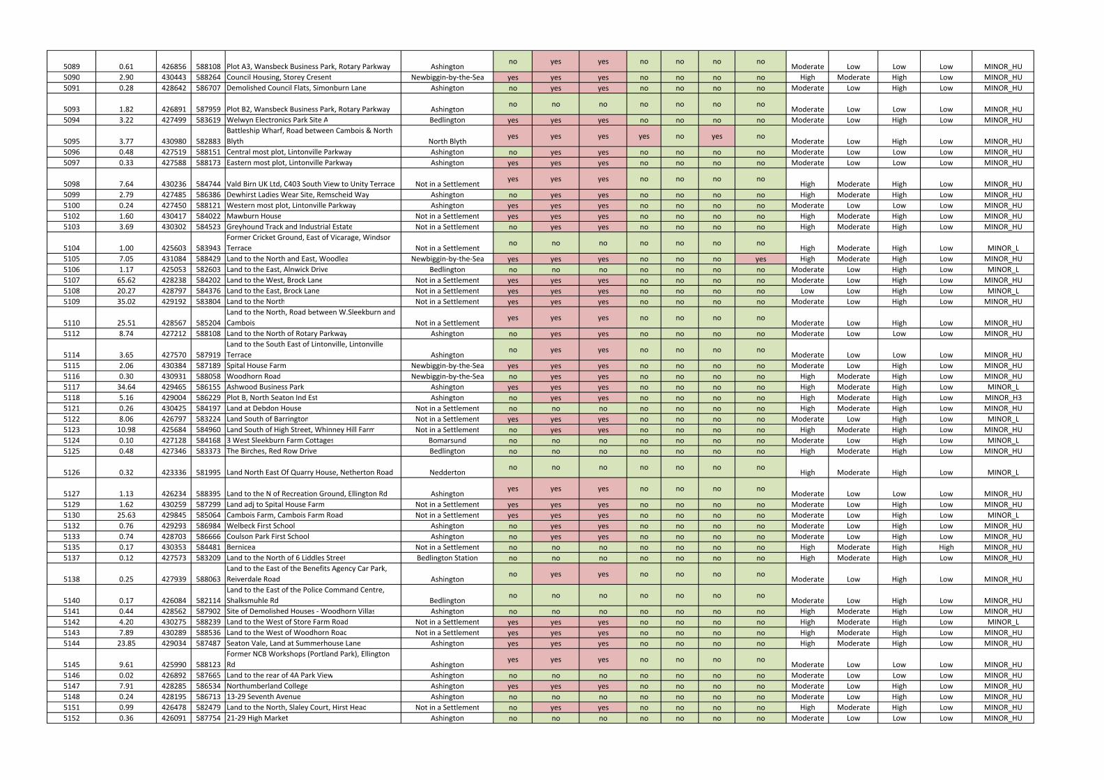
5089 0.61 426856 588108 Plot A3, Wansbeck Business Park, Rotary Parkway Ashingtonno yes yes no no no no
Moderate Low Low Low MINOR_HU
5090 2.90 430443 588264 Council Housing, Storey Cresent Newbiggin-by-the-Sea yes yes yes no no no no High Moderate High Low MINOR_HU
5091 0.28 428642 586707 Demolished Council Flats, Simonburn Lane Ashington no yes yes no no no no Moderate Low High Low MINOR_HU
5093 1.82 426891 587959 Plot B2, Wansbeck Business Park, Rotary Parkway Ashingtonno no no no no no no
Moderate Low Low Low MINOR_HU
5094 3.22 427499 583619 Welwyn Electronics Park Site A Bedlington yes yes yes no no no no Moderate Low High Low MINOR_HU
5095 3.77 430980 582883
Battleship Wharf, Road between Cambois & North
Blyth North Blythyes yes yes yes no yes no
Moderate Low High Low MINOR_HU
5096 0.48 427519 588151 Central most plot, Lintonville Parkway Ashington no yes yes no no no no Moderate Low Low Low MINOR_HU
5097 0.33 427588 588173 Eastern most plot, Lintonville Parkway Ashington yes yes yes no no no no Moderate Low Low Low MINOR_HU
5098 7.64 430236 584744 Vald Birn UK Ltd, C403 South View to Unity Terrace Not in a Settlementyes yes yes no no no no
High Moderate High Low MINOR_HU
5099 2.79 427485 586386 Dewhirst Ladies Wear Site, Remscheid Way Ashington no yes yes no no no no High Moderate High Low MINOR_HU
5100 0.24 427450 588121 Western most plot, Lintonville Parkway Ashington yes yes yes no no no no Moderate Low Low Low MINOR_HU
5102 1.60 430417 584022 Mawburn House Not in a Settlement yes yes yes no no no no High Moderate High Low MINOR_HU
5103 3.69 430302 584523 Greyhound Track and Industrial Estate Not in a Settlement no yes yes no no no no High Moderate High Low MINOR_HU
5104 1.00 425603 583943
Former Cricket Ground, East of Vicarage, Windsor
Terrace Not in a Settlementno no no no no no no
High Moderate High Low MINOR_L
5105 7.05 431084 588429 Land to the North and East, Woodlea Newbiggin-by-the-Sea yes yes yes no no no yes High Moderate High Low MINOR_HU
5106 1.17 425053 582603 Land to the East, Alnwick Drive Bedlington no no no no no no no Moderate Low High Low MINOR_L
5107 65.62 428238 584202 Land to the West, Brock Lane Not in a Settlement yes yes yes no no no no Moderate Low High Low MINOR_HU
5108 20.27 428797 584376 Land to the East, Brock Lane Not in a Settlement yes yes yes no no no no Low Low High Low MINOR_L
5109 35.02 429192 583804 Land to the North Not in a Settlement yes yes yes no no no no Moderate Low High Low MINOR_HU
5110 25.51 428567 585204
Land to the North, Road between W.Sleekburn and
Cambois Not in a Settlementyes yes yes no no no no
Moderate Low High Low MINOR_HU
5112 8.74 427212 588108 Land to the North of Rotary Parkway Ashington no yes yes no no no no Moderate Low Low Low MINOR_HU
5114 3.65 427570 587919
Land to the South East of Lintonville, Lintonville
Terrace Ashingtonno yes yes no no no no
Moderate Low Low Low MINOR_HU
5115 2.06 430384 587189 Spital House Farm Newbiggin-by-the-Sea yes yes yes no no no no Moderate Low High Low MINOR_HU
5116 0.30 430931 588058 Woodhorn Road Newbiggin-by-the-Sea no yes yes no no no no High Moderate High Low MINOR_HU
5117 34.64 429465 586155 Ashwood Business Park Ashington yes yes yes no no no no High Moderate High Low MINOR_L
5118 5.16 429004 586229 Plot B, North Seaton Ind Est Ashington no yes yes no no no no High Moderate High Low MINOR_H3
5121 0.26 430425 584197 Land at Debdon House Not in a Settlement no no no no no no no High Moderate High Low MINOR_HU
5122 8.06 426797 583224 Land South of Barrington Not in a Settlement yes yes yes no no no no Moderate Low High Low MINOR_L
5123 10.98 425684 584960 Land South of High Street, Whinney Hill Farm Not in a Settlement no yes yes no no no no High Moderate High Low MINOR_HU
5124 0.10 427128 584168 3 West Sleekburn Farm Cottages Bomarsund no no no no no no no Moderate Low High Low MINOR_L
5125 0.48 427346 583373 The Birches, Red Row Drive Bedlington no no no no no no no High Moderate High Low MINOR_HU
5126 0.32 423336 581995 Land North East Of Quarry House, Netherton Road Neddertonno no no no no no no
High Moderate High Low MINOR_L
5127 1.13 426234 588395 Land to the N of Recreation Ground, Ellington Rd Ashingtonyes yes yes no no no no
Moderate Low Low Low MINOR_HU
5129 1.62 430259 587299 Land adj to Spital House Farm Not in a Settlement yes yes yes no no no no Moderate Low High Low MINOR_HU
5130 25.63 429845 585064 Cambois Farm, Cambois Farm Road Not in a Settlement yes yes yes no no no no Moderate Low High Low MINOR_L
5132 0.76 429293 586984 Welbeck First School Ashington no yes yes no no no no Moderate Low High Low MINOR_HU
5133 0.74 428703 586666 Coulson Park First School Ashington no yes yes no no no no Moderate Low High Low MINOR_HU
5135 0.17 430353 584481 Bernicea Not in a Settlement no no no no no no no High Moderate High High MINOR_HU
5137 0.12 427573 583209 Land to the North of 6 Liddles Street Bedlington Station no no no no no no no High Moderate High Low MINOR_HU
5138 0.25 427939 588063
Land to the East of the Benefits Agency Car Park,
Reiverdale Road Ashingtonno yes yes no no no no
Moderate Low High Low MINOR_HU
5140 0.17 426084 582114
Land to the East of the Police Command Centre,
Shalksmuhle Rd Bedlingtonno no no no no no no
Moderate Low High Low MINOR_HU
5141 0.44 428562 587902 Site of Demolished Houses - Woodhorn Villas Ashington no no no no no no no High Moderate High Low MINOR_HU
5142 4.20 430275 588239 Land to the West of Store Farm Road Not in a Settlement yes yes yes no no no no High Moderate High Low MINOR_L
5143 7.89 430289 588536 Land to the West of Woodhorn Road Not in a Settlement yes yes yes no no no no High Moderate High Low MINOR_HU
5144 23.85 429034 587487 Seaton Vale, Land at Summerhouse Lane Ashington yes yes yes no no no no High Moderate High Low MINOR_HU
5145 9.61 425990 588123
Former NCB Workshops (Portland Park), Ellington
Rd Ashingtonyes yes yes no no no no
Moderate Low Low Low MINOR_HU
5146 0.02 426892 587665 Land to the rear of 4A Park View Ashington no no no no no no no Moderate Low Low Low MINOR_HU
5147 7.91 428285 586534 Northumberland College Ashington yes yes yes no no no no Moderate Low High Low MINOR_HU
5148 0.24 428195 586713 13-29 Seventh Avenue Ashington no no no no no no no Moderate Low High Low MINOR_HU
5151 0.99 426478 582479 Land to the North, Slaley Court, Hirst Head Not in a Settlement no yes yes no no no no High Moderate High Low MINOR_HU
5152 0.36 426091 587754 21-29 High Market Ashington no no no no no no no Moderate Low Low Low MINOR_HU
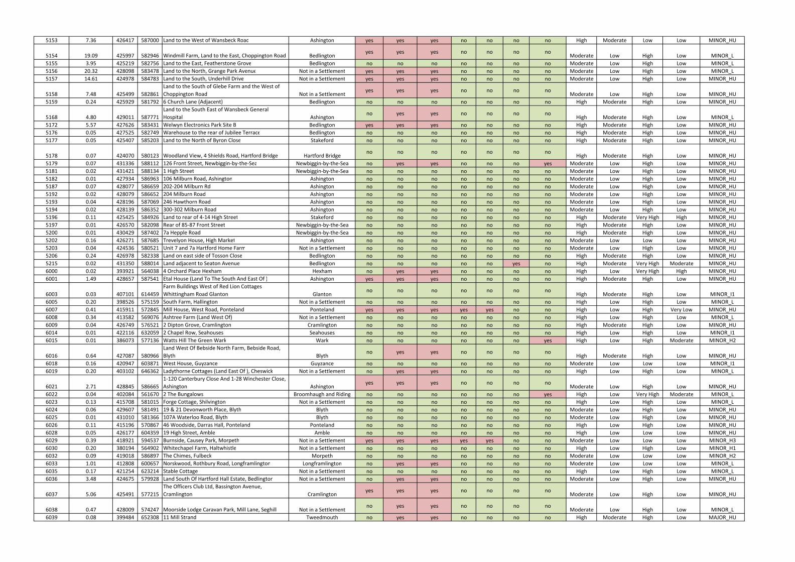
5153 7.36 426417 587000 Land to the West of Wansbeck Road Ashington yes yes yes no no no no High Moderate Low Low MINOR_HU
5154 19.09 425997 582946 Windmill Farm, Land to the East, Choppington Road Bedlingtonyes yes yes no no no no
Moderate Low High Low MINOR_L
5155 3.95 425219 582756 Land to the East, Featherstone Grove Bedlington no no no no no no no Moderate Low High Low MINOR_L
5156 20.32 428098 583478 Land to the North, Grange Park Avenue Not in a Settlement yes yes yes no no no no Moderate Low High Low MINOR_L
5157 14.61 424978 584783 Land to the South, Underhill Drive Not in a Settlement yes yes yes no no no no Moderate Low High Low MINOR_HU
5158 7.48 425499 582861
Land to the South of Glebe Farm and the West of
Choppington Road Not in a Settlementyes yes yes no no no no
Moderate Low High Low MINOR_HU
5159 0.24 425929 581792 6 Church Lane (Adjacent) Bedlington no no no no no no no High Moderate High Low MINOR_HU
5168 4.80 429011 587771
Land to the South East of Wansbeck General
Hospital Ashingtonno yes yes no no no no
High Moderate High Low MINOR_L
5172 5.57 427626 583431 Welwyn Electronics Park Site B Bedlington yes yes yes no no no no High Moderate High Low MINOR_HU
5176 0.05 427525 582749 Warehouse to the rear of Jubilee Terrace Bedlington no no no no no no no High Moderate High Low MINOR_HU
5177 0.05 425407 585203 Land to the North of Byron Close Stakeford no no no no no no no High Moderate High Low MINOR_HU
5178 0.07 424070 580123 Woodland View, 4 Shields Road, Hartford Bridge Hartford Bridgeno no no no no no no
High Moderate High Low MINOR_HU
5179 0.07 431336 588112 126 Front Street, Newbiggin-by-the-Sea Newbiggin-by-the-Sea no yes yes no no no yes Moderate Low High Low MINOR_HU
5181 0.02 431421 588134 1 High Street Newbiggin-by-the-Sea no no no no no no no Moderate Low High Low MINOR_HU
5182 0.01 427934 586963 106 Milburn Road, Ashington Ashington no no no no no no no Moderate Low High Low MINOR_HU
5187 0.07 428077 586659 202-204 Milburn Rd Ashington no no no no no no no Moderate Low High Low MINOR_HU
5192 0.02 428079 586652 204 Milburn Road Ashington no no no no no no no Moderate Low High Low MINOR_HU
5193 0.04 428196 587069 246 Hawthorn Road Ashington no no no no no no no Moderate Low High Low MINOR_HU
5194 0.02 428139 586352 300-302 Milburn Road Ashington no no no no no no no Moderate Low High Low MINOR_HU
5196 0.11 425425 584926 Land to rear of 4-14 High Street Stakeford no no no no no no no High Moderate Very High High MINOR_HU
5197 0.01 426570 582098 Rear of 85-87 Front Street Newbiggin-by-the-Sea no no no no no no no High Moderate High Low MINOR_HU
5200 0.01 430429 587402 7a Hepple Road Newbiggin-by-the-Sea no no no no no no no High Moderate High Low MINOR_HU
5202 0.16 426271 587685 Trevelyon House, High Market Ashington no no no no no no no Moderate Low Low Low MINOR_HU
5203 0.04 424536 580521 Unit 7 and 7a Hartford Home Farm Not in a Settlement no no no no no no no Moderate Low High Low MINOR_HU
5206 0.24 426978 582338 Land on east side of Tosson Close Bedlington no no no no no no no High Moderate High Low MINOR_HU
5215 0.02 431350 588014 Land adjacent to Seaton Avenue Bedlington no no no no no yes no High Moderate Very High Moderate MINOR_HU
6000 0.02 393921 564038 4 Orchard Place Hexham Hexham no yes yes no no no no High Low Very High High MINOR_HU
6001 1.49 428657 587541 Etal House (Land To The South And East Of ) Ashington yes yes yes no no no no High Moderate High Low MINOR_HU
6003 0.03 407101 614459
Farm Buildings West of Red Lion Cottages
Whittingham Road Glanton Glantonno no no no no no no
High Moderate High Low MINOR_I1
6005 0.20 398526 575159 South Farm, Hallington Not in a Settlement no no no no no no no High Low High Low MINOR_L
6007 0.41 415911 572845 Mill House, West Road, Ponteland Ponteland yes yes yes yes yes no no High Low High Very Low MINOR_HU
6008 0.34 413582 569076 Ashtree Farm (Land West Of) Not in a Settlement no no no no no no no High Low High Low MINOR_L
6009 0.04 426749 576521 2 Dipton Grove, Cramlington Cramlington no no no no no no no High Moderate High Low MINOR_HU
6014 0.01 422116 632059 2 Chapel Row, Seahouses Seahouses no no no no no no no High Low High Low MINOR_I1
6015 0.01 386073 577136 Watts Hill The Green Wark Wark no no no no no no yes High Low High Moderate MINOR_H2
6016 0.64 427087 580966
Land West Of Bebside North Farm, Bebside Road,
Blyth Blythno yes yes no no no no
High Moderate High Low MINOR_HU
6018 0.16 420947 603871 West House, Guyzance Guyzance no no no no no no no Moderate Low Low Low MINOR_I1
6019 0.20 403102 646362 Ladythorne Cottages (Land East Of ), Cheswick Not in a Settlement no yes yes no no no no High Low High Low MINOR_L
6021 2.71 428845 586665
1-120 Canterbury Close And 1-28 Winchester Close,
Ashington Ashingtonyes yes yes no no no no
Moderate Low High Low MINOR_HU
6022 0.04 402084 561670 2 The Bungalows Broomhaugh and Riding no no no no no no yes High Low Very High Moderate MINOR_L
6023 0.13 415708 581015 Forge Cottage, Shilvington Not in a Settlement no no no no no no no High Low High Low MINOR_L
6024 0.06 429607 581491 19 & 21 Devonworth Place, Blyth Blyth no no no no no no no Moderate Low High Low MINOR_HU
6025 0.01 431010 581366 107A Waterloo Road, Blyth Blyth no no no no no no no Moderate Low High Low MINOR_HU
6026 0.11 415196 570867 46 Woodside, Darras Hall, Ponteland Ponteland no no no no no no no High Low High Low MINOR_HU
6028 0.05 426177 604359 19 High Street, Amble Amble no no no no no no no High Low Low Low MINOR_HU
6029 0.39 418921 594537 Burnside, Causey Park, Morpeth Not in a Settlement yes yes yes yes yes no no Moderate Low Low Low MINOR_H3
6030 0.20 380194 564902 Whitechapel Farm, Haltwhistle Not in a Settlement no no no no no no no High Low High Low MINOR_H1
6032 0.09 419018 586897 The Chimes, Fulbeck Morpeth no no no no no no no Moderate Low Low Low MINOR_H2
6033 1.01 412808 600657 Norskwood, Rothbury Road, Longframlington Longframlington no yes yes no no no no Moderate Low Low Low MINOR_L
6035 0.17 421254 623214 Stable Cottage Not in a Settlement no no no no no no no High Low High Low MINOR_L
6036 3.48 424675 579928 Land South Of Hartford Hall Estate, Bedlington Not in a Settlement no yes yes no no no no Moderate Low High Low MINOR_HU
6037 5.06 425491 577215
The Officers Club Ltd, Bassington Avenue,
Cramlington Cramlingtonyes yes yes no no no no
Moderate Low High Low MINOR_HU
6038 0.47 428009 574247 Moorside Lodge Caravan Park, Mill Lane, Seghill Not in a Settlementno yes yes no no no no
Moderate Low High Low MINOR_L
6039 0.08 399484 652308 11 Mill Strand Tweedmouth no yes yes no no no no High Moderate High Low MAJOR_HU
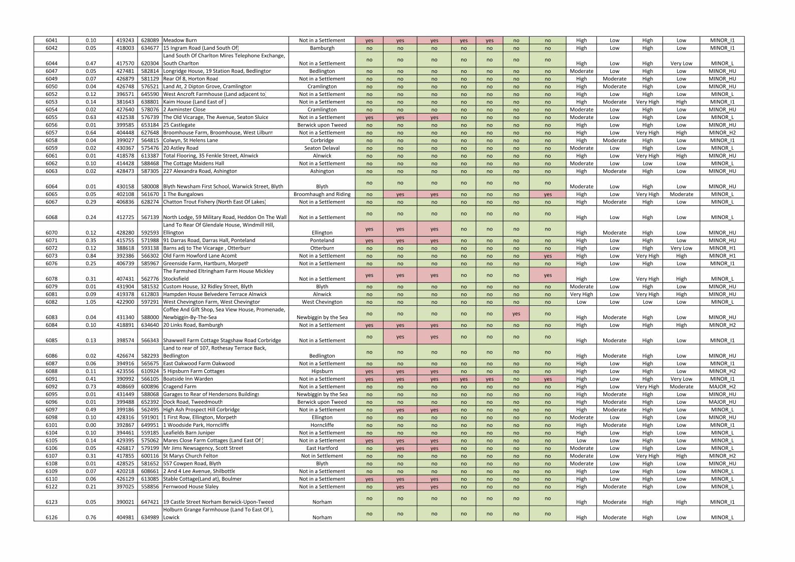
6041 0.10 419243 628089 Meadow Burn Not in a Settlement yes yes yes yes yes no no High Low High Low MINOR_I1
6042 0.05 418003 634677 15 Ingram Road (Land South Of) Bamburgh no no no no no no no High Low High Low MINOR_I1
6044 0.47 417570 620304
Land South Of Charlton Mires Telephone Exchange,
South Charlton Not in a Settlementno no no no no no no
High Low High Very Low MINOR_L
6047 0.05 427481 582814 Longridge House, 19 Station Road, Bedlington Bedlington no no no no no no no Moderate Low High Low MINOR_HU
6049 0.07 426879 581129 Rear Of 8, Horton Road Not in a Settlement no no no no no no no High Moderate High Low MINOR_HU
6050 0.04 426748 576521 Land At, 2 Dipton Grove, Cramlington Cramlington no no no no no no no High Moderate High Low MINOR_HU
6052 0.12 396571 645590 West Ancroft Farmhouse (Land adjacent to) Not in a Settlement no no no no no no no High Low High Low MINOR_L
6053 0.14 381643 638801 Kaim House (Land East of ) Not in a Settlement no no no no no no no High Moderate Very High High MINOR_I1
6054 0.02 427640 578076 2 Axminster Close Cramlington no no no no no no no Moderate Low High Low MINOR_HU
6055 0.63 432538 576739 The Old Vicarage, The Avenue, Seaton Sluice Not in a Settlement yes yes yes no no no no Moderate Low High Low MINOR_L
6056 0.01 399585 653184 25 Castlegate Berwick upon Tweed no no no no no no no High Low High Low MINOR_HU
6057 0.64 404448 627648 Broomhouse Farm, Broomhouse, West Lilburn Not in a Settlement no no no no no no no High Low Very High High MINOR_H2
6058 0.04 399027 564815 Colwyn, St Helens Lane Corbridge no no no no no no no High Moderate High Low MINOR_I1
6059 0.02 430367 575476 20 Astley Road Seaton Delaval no no no no no no no Moderate Low High Low MINOR_L
6061 0.01 418578 613387 Total Flooring, 35 Fenkle Street, Alnwick Alnwick no no no no no no no High Low Very High High MINOR_HU
6062 0.10 414428 588468 The Cottage Maidens Hall Not in a Settlement no no no no no no no Moderate Low Low Low MINOR_L
6063 0.02 428473 587305 227 Alexandra Road, Ashington Ashington no no no no no no no High Moderate High Low MINOR_HU
6064 0.01 430158 580008 Blyth Newsham First School, Warwick Street, Blyth Blythno no no no no no no
Moderate Low High Low MINOR_HU
6065 0.05 402108 561670 1 The Bungalows Broomhaugh and Riding no yes yes no no no yes High Low Very High Moderate MINOR_L
6067 0.29 406836 628274 Chatton Trout Fishery (North East Of Lakes) Not in a Settlement no no no no no no no High Moderate High Low MINOR_L
6068 0.24 412725 567139 North Lodge, 59 Military Road, Heddon On The Wall Not in a Settlementno no no no no no no
High Low High Low MINOR_L
6070 0.12 428280 592593
Land To Rear Of Glendale House, Windmill Hill,
Ellington Ellingtonyes yes yes no no no no
High Moderate High Low MINOR_HU
6071 0.35 415755 571988 91 Darras Road, Darras Hall, Ponteland Ponteland yes yes yes no no no no High Low High Low MINOR_HU
6072 0.12 388618 593138 Barns adj to The Vicarage , Otterburn Otterburn no no no no no no no High Low High Very Low MINOR_H1
6073 0.84 392386 566302 Old Farm Howford Lane Acomb Not in a Settlement no no no no no no yes High Low Very High High MINOR_H1
6076 0.25 406739 585967 Greenside Farm, Hartburn, Morpeth Not in a Settlement no no no no no no no High Low High Low MINOR_I1
6078 0.31 407431 562776
The Farmshed Eltringham Farm House Mickley
Stocksfield Not in a Settlementyes yes yes no no no yes
High Low Very High High MINOR_L
6079 0.01 431904 581532 Custom House, 32 Ridley Street, Blyth Blyth no no no no no no no Moderate Low High Low MINOR_HU
6081 0.09 419378 612803 Hampden House Belvedere Terrace Alnwick Alnwick no no no no no no no Very High Low Very High High MINOR_HU
6082 1.05 422900 597291 West Chevington Farm, West Chevington West Chevington no no no no no no no Low Low Low Low MINOR_L
6083 0.04 431340 588000
Coffee And Gift Shop, Sea View House, Promenade,
Newbiggin-By-The-Sea Newbiggin by the Seano no no no no yes no
High Moderate High Low MINOR_HU
6084 0.10 418891 634640 20 Links Road, Bamburgh Not in a Settlement yes yes yes no no no no High Low High High MINOR_H2
6085 0.13 398574 566343 Shawwell Farm Cottage Stagshaw Road Corbridge Not in a Settlementno yes yes no no no no
High Moderate High Low MINOR_I1
6086 0.02 426674 582293
Land to rear of 107, Rothesay Terrace Back,
Bedlington Bedlingtonno no no no no no no
High Moderate High Low MINOR_HU
6087 0.06 394916 565675 East Oakwood Farm Oakwood Not in a Settlement no no no no no no no High Low High Low MINOR_I1
6088 0.11 423556 610924 5 Hipsburn Farm Cottages Hipsburn yes yes yes no no no no High Low High Low MINOR_H2
6091 0.41 390992 566105 Boatside Inn Warden Not in a Settlement yes yes yes yes yes no yes High Low High Very Low MINOR_I1
6092 0.73 408669 600896 Cragend Farm Not in a Settlement no no no no no no no High Low Very High Moderate MAJOR_H2
6095 0.01 431449 588068 Garages to Rear of Hendersons Buildings Newbiggin by the Sea no no no no no no no High Moderate High Low MINOR_HU
6096 0.01 399488 652392 Dock Road, Tweedmouth Berwick upon Tweed no no no no no no no High Moderate High Low MAJOR_HU
6097 0.49 399186 562495 High Ash Prospect Hill Corbridge Not in a Settlement no yes yes no no no no High Moderate High Low MINOR_L
6098 0.10 428316 591901 1 First Row, Ellington, Morpeth Ellington no no no no no no no Moderate Low High Low MINOR_HU
6101 0.00 392867 649951 1 Woodside Park, Horncliffe Horncliffe no no no no no no no High Moderate High Low MINOR_I1
6104 0.10 394461 559185 Leafields Barn Juniper Not in a Settlement no no no no no no no High Low High Low MINOR_L
6105 0.14 429395 575062 Mares Close Farm Cottages (Land East Of ) Not in a Settlement yes yes yes no no no no Low Low High Low MINOR_L
6106 0.05 426817 579199 Mr Jims Newsagency, Scott Street East Hartford no yes yes no no no no Moderate Low High Low MINOR_L
6107 0.31 417855 600116 St Marys Church Felton Not in Settlement no no no no no no no Moderate Low Very High High MINOR_H2
6108 0.01 428525 581652 557 Cowpen Road, Blyth Blyth no no no no no no no Moderate Low High Low MINOR_HU
6109 0.07 420218 608661 2 And 4 Lee Avenue, Shilbottle Not in a Settlement no no no no no no no High Low High Low MINOR_L
6110 0.06 426129 613085 Stable Cottage(Land at), Boulmer Not in a Settlement yes yes yes no no no no High Low High Low MINOR_L
6122 0.21 397025 558856 Fernwood House Slaley Not in a Settlement no yes yes no no no no High Moderate High Low MINOR_L
6123 0.05 390021 647421 19 Castle Street Norham Berwick-Upon-Tweed Norhamno no no no no no no
High Moderate High High MINOR_I1
6126 0.76 404981 634989
Holburn Grange Farmhouse (Land To East Of ),
Lowick Norhamno no no no no no no
High Moderate High Low MINOR_L
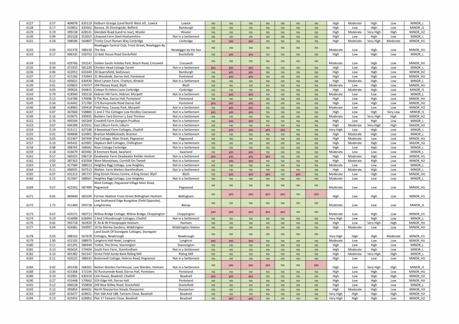
6127 0.57 404878 635119 Holburn Grange (Land North West of) , Lowick Lowick no no no no no no no High Moderate High Low MINOR_L
6128 0.17 410853 633562 Barona, 35 Dinningside, Belford Bamburgh no no no no no no no High Low High Low MINOR_I1
6129 0.19 399138 628141 Glendale Road (Land to rear), Wooler Wooler no no no no no no no High Moderate Very High High MINOR_H2
6130 0.09 391528 553053 Lilswood Farm Steel Hexhamshire Not in a Settlement no no no no no no no High Low High Low MINOR_L
6131 0.18 398596 564807 Trinity Court Roman Way Corbridge Corbridge no yes yes no no no no High Moderate Very High Moderate MINOR_H1
6132 0.05 431378 588130
Newbiggin Central Club, Front Street, Newbiggin-By-
The-Sea Newbiggin by the Seano no no no no no no
Moderate Low High Low MINOR_HU
6133 0.17 406335 559753 12 Batt House Road Stocksfield Stocksfield no yes yes no no no no High Low High Low MINOR_L
6134 0.03 429766 593147 Golden Sands Holiday Park, Beach Road, Cresswell Cresswellno no no no no no no
Moderate Low High Low MINOR_HU
6135 0.34 371925 581220 Chirdon Head Cottage Tarset Not in a Settlement yes yes yes no no no no High Low High Low MINOR_L
6136 0.06 422053 631640 20 Quarryfield, Seahouses Bamburgh no yes yes no no no no High Low High Low MINOR_H2
6137 0.17 415260 570943 31 Woodside, Darras Hall, Ponteland Ponteland no yes yes no no no no High Low High Low MINOR_HU
6138 0.21 405621 630430 West Lyham Farm, Chatton, Alnwick Not in a Settlement no no no no no no no High Moderate High Low MINOR_L
6139 0.01 429825 579757 594 Plessey Road, Blyth Blyth no no no no no no no Moderate Low High Low MINOR_HU
6140 0.05 399026 564815 Colwyn St Helens Lane Corbridge Corbridge no no no no no no no High Moderate High Low MINOR_I1
6143 0.79 418940 590118 Hebron Hill Farm, Hebron, Morpeth Not in a Settlement no yes yes no no no no Moderate Low Low Low MINOR_L
6144 0.12 414786 570996 6 The Rise, Darras Hall, Ponteland Ponteland no no no no no no no High Low High Low MINOR_HU
6145 0.34 414442 571760 173 Runnymede Road Darras Hall Ponteland yes yes yes no no no no High Low High Low MINOR_HU
6146 0.08 418963 594418 Field View, Causey Park, Morpeth Not in a Settlement no yes yes no no no no Moderate Low Low Low MINOR_H3
6147 0.07 367660 558884 1 and 2 The Cottages Low Herdley Coanwood Not in a Settlement yes yes yes no no no no High Low High Very Low MINOR_I1
6149 0.16 419675 599935 Builders Yard (former ), East Thirston Not in a Settlement no no no no no no no Moderate Low Very High High MINOR_H2
6152 0.70 405594 565269 Crookhill Farm Ovington Prudhoe Not in a Settlement no yes yes no no no no High Low High Low MINOR_L
6153 0.07 404289 623551 East Lilburn Farm, Lilburn Not in a Settlement no no no no no no no High Moderate Very High High MAJOR_H2
6154 0.19 415111 627188 4 Newstead Farm Cottages, Chathill Not in a Settlement no yes yes yes yes no no Very High Low High Low MINOR_L
6155 0.01 404848 614901 Branton Middlesteads, Branton Not in a Settlement no no no no no no no High Moderate High Low MINOR_L
6156 0.03 422467 587494 Fed Cottage, Main Street, Pegswood Pegswood no no no no no no no High Moderate Low Low MINOR_HU
6157 0.10 405432 623901 Hepburn Bell Cottages, Chillingham Not in a Settlement no no no no no no no High Moderate High Low MAJOR_H2
6158 0.08 398765 568562 Rose Cottage Corbridge Not in a Settlement no no no no no no no High Low High Low MINOR_L
6159 0.18 416679 603482 8 Kenmore Road, Swarland Swarland no yes yes no no no no Moderate Low Low Low MINOR_L
6161 0.57 360325 596719 Deadwater Farm Deadwater Kielder Hexham Not in a Settlement yes yes yes yes no no no High Moderate High Low MINOR_H1
6162 0.02 387303 635504 West Moneylaws, Cornhill-On-Tweed Not in a Settlement no yes yes no no no no High Moderate High Low MINOR_H2
6163 1.50 417584 588513 Heighley Rigg Cottage, Low Heighley Not in a Settlement no no no no no no no Moderate Low Low Low MINOR_L
6164 0.11 406035 567513 Welton Farm Welton Stamfordham Not in a Settlement no no no no no no no High Moderate High Low MINOR_L
6165 0.07 431313 581737 King Street Fitness Centre, 4 King Street, Blyth Blyth no yes yes yes no yes no Moderate Low High Low MINOR_HU
6166 0.15 417607 588561 Heighley Rigg Cottage, Low Heighley Not in a Settlement no no no no no no no Moderate Low Low Low MINOR_L
6169 0.07 422262 587489
West Cottage, Pegswood Village Main Road,
Pegswood Pegswoodno no no no no no no
Moderate Low Low Low MINOR_HU
6171 0.01 383840 583194 Former Abattoir Cross Street Bellingham Hexham Bellinghamno yes yes yes yes no yes
High Low High Low MINOR_H1
6172 1.72 411460 593718
Low Southward Edge Bungalow (Field Opposite),
Longhorsley Belsayno no no no no no no
Moderate Low Low Low MINOR_I1
6173 0.67 425571 583713 Willow Bridge Cottage, Willow Bridge, Choppington Choppingtonyes yes yes yes yes no no
Moderate Low High Low MINOR_H1
6174 0.19 414098 626994 2 And 3 Rosebrough Cottages, Chathill Not in a Settlement no no no no no no no Very High Low High Low MINOR_L
6176 0.02 393718 563920 9, 9a & 9b Priestpopple Hexham Hexham no no no no no no no High Low Very High High MINOR_HU
6177 0.04 424481 593997 14 De Merley Gardens, Widdrington Widdrington Station no no no no no no no High Moderate Low Low MINOR_HU
6178 0.03 388163 567678
Land South Of Stanegate Cottages, Stanegate
Cottages, Newbrough Newbroughno no no no no no no
Very High High High Moderate MINOR_H1
6179 1.90 422105 588975 Longhirst Hall Hotel, Longhirst Longhirst yes yes yes no no no no Moderate Low Low Low MINOR_HU
6180 0.11 421291 580449 Trefoil, The Drive, Stannington Stannington no no no no no no no High Low High Low MINOR_L
6181 0.13 405654 574494 South Fens Farm, Stamfordham Not in a Settlement no no no no no no no High Moderate High Low MINOR_L
6182 0.10 401382 561547 Grove Field Sandy Bank Riding Mill Riding Mill no no no no no no no High Moderate Very High High MINOR_L
6183 0.11 420225 588333 Butterwell Cottage, Hebron Road, Pegswood Not in a Settlement no no no no no no no High Low Low Low MINOR_HU
6184 0.02 391438 566501 Nether Warden Farmhouse, Low Warden, Hexham Not in a Settlementno yes yes yes no no yes
High Low Very High High MINOR_I1
6188 0.30 415368 572194 92 Runnymede Road, Darras Hall, Ponteland Ponteland no no no no no no no High Low High Low MINOR_HU
6189 0.10 422891 630154 Link House, Beadnell, Chathill Beadnell yes yes yes no no no no High Low High High MINOR_H2
6190 0.27 415448 570662 52A Edge Hill, Darras Hall Ponteland no no no no no no no High Low High Low MINOR_HU
6191 0.12 406528 559858 249 New Ridley Road, Stocksfield Stocksfield no no no no no no no High Low High Low MINOR_L
6192 0.12 395854 604031 North Sharperton Steads Sharperton Sharperton no no no no no no no High Moderate High Low MINOR_H3
6193 0.07 423477 628921 Plot 18A And 18B, Tamarin Close, Beadnell Beadnell no no no no no no no Very High High High High MINOR_H2
6194 0.13 423453 628901 Plot 17 Tamarin Close, Beadnell Beadnell no yes yes no no no no Very High High High Low MINOR_H2
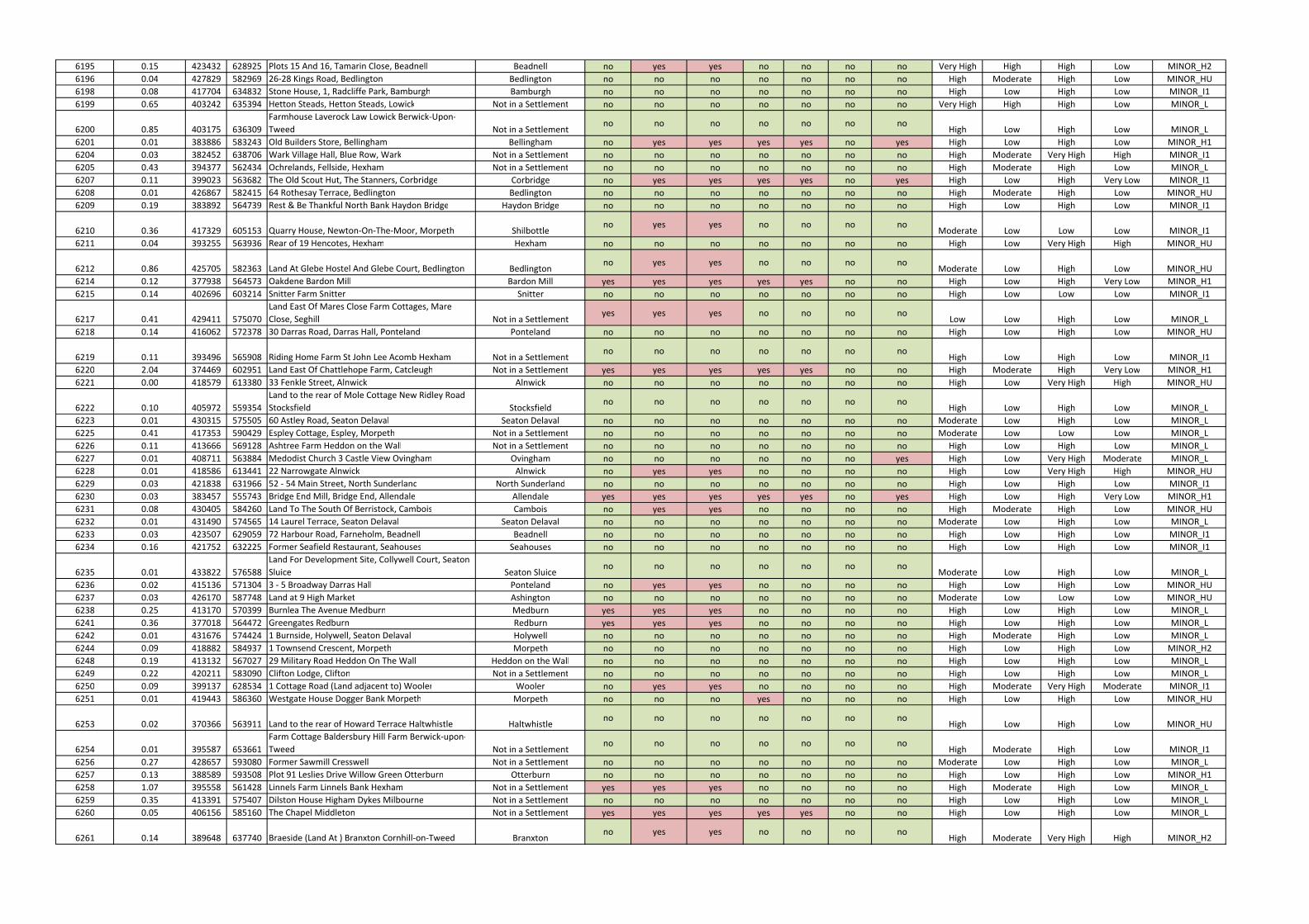
6195 0.15 423432 628925 Plots 15 And 16, Tamarin Close, Beadnell Beadnell no yes yes no no no no Very High High High Low MINOR_H2
6196 0.04 427829 582969 26-28 Kings Road, Bedlington Bedlington no no no no no no no High Moderate High Low MINOR_HU
6198 0.08 417704 634832 Stone House, 1, Radcliffe Park, Bamburgh Bamburgh no no no no no no no High Low High Low MINOR_I1
6199 0.65 403242 635394 Hetton Steads, Hetton Steads, Lowick Not in a Settlement no no no no no no no Very High High High Low MINOR_L
6200 0.85 403175 636309
Farmhouse Laverock Law Lowick Berwick-Upon-
Tweed Not in a Settlementno no no no no no no
High Low High Low MINOR_L
6201 0.01 383886 583243 Old Builders Store, Bellingham Bellingham no yes yes yes yes no yes High Low High Low MINOR_H1
6204 0.03 382452 638706 Wark Village Hall, Blue Row, Wark Not in a Settlement no no no no no no no High Moderate Very High High MINOR_I1
6205 0.43 394377 562434 Ochrelands, Fellside, Hexham Not in a Settlement no no no no no no no High Moderate High Low MINOR_L
6207 0.11 399023 563682 The Old Scout Hut, The Stanners, Corbridge Corbridge no yes yes yes yes no yes High Low High Very Low MINOR_I1
6208 0.01 426867 582415 64 Rothesay Terrace, Bedlington Bedlington no no no no no no no High Moderate High Low MINOR_HU
6209 0.19 383892 564739 Rest & Be Thankful North Bank Haydon Bridge Haydon Bridge no no no no no no no High Low High Low MINOR_I1
6210 0.36 417329 605153 Quarry House, Newton-On-The-Moor, Morpeth Shilbottleno yes yes no no no no
Moderate Low Low Low MINOR_I1
6211 0.04 393255 563936 Rear of 19 Hencotes, Hexham Hexham no no no no no no no High Low Very High High MINOR_HU
6212 0.86 425705 582363 Land At Glebe Hostel And Glebe Court, Bedlington Bedlingtonno yes yes no no no no
Moderate Low High Low MINOR_HU
6214 0.12 377938 564573 Oakdene Bardon Mill Bardon Mill yes yes yes yes yes no no High Low High Very Low MINOR_H1
6215 0.14 402696 603214 Snitter Farm Snitter Snitter no no no no no no no High Low Low Low MINOR_I1
6217 0.41 429411 575070
Land East Of Mares Close Farm Cottages, Mare
Close, Seghill Not in a Settlementyes yes yes no no no no
Low Low High Low MINOR_L
6218 0.14 416062 572378 30 Darras Road, Darras Hall, Ponteland Ponteland no no no no no no no High Low High Low MINOR_HU
6219 0.11 393496 565908 Riding Home Farm St John Lee Acomb Hexham Not in a Settlementno no no no no no no
High Low High Low MINOR_I1
6220 2.04 374469 602951 Land East Of Chattlehope Farm, Catcleugh Not in a Settlement yes yes yes yes yes no no High Moderate High Very Low MINOR_H1
6221 0.00 418579 613380 33 Fenkle Street, Alnwick Alnwick no no no no no no no High Low Very High High MINOR_HU
6222 0.10 405972 559354
Land to the rear of Mole Cottage New Ridley Road
Stocksfield Stocksfieldno no no no no no no
High Low High Low MINOR_L
6223 0.01 430315 575505 60 Astley Road, Seaton Delaval Seaton Delaval no no no no no no no Moderate Low High Low MINOR_L
6225 0.41 417353 590429 Espley Cottage, Espley, Morpeth Not in a Settlement no no no no no no no Moderate Low Low Low MINOR_L
6226 0.11 413666 569128 Ashtree Farm Heddon on the Wall Not in a Settlement no no no no no no no High Low High Low MINOR_L
6227 0.01 408711 563884 Medodist Church 3 Castle View Ovingham Ovingham no no no no no no yes High Low Very High Moderate MINOR_L
6228 0.01 418586 613441 22 Narrowgate Alnwick Alnwick no yes yes no no no no High Low Very High High MINOR_HU
6229 0.03 421838 631966 52 - 54 Main Street, North Sunderland North Sunderland no no no no no no no High Low High Low MINOR_I1
6230 0.03 383457 555743 Bridge End Mill, Bridge End, Allendale Allendale yes yes yes yes yes no yes High Low High Very Low MINOR_H1
6231 0.08 430405 584260 Land To The South Of Berristock, Cambois Cambois no yes yes no no no no High Moderate High Low MINOR_HU
6232 0.01 431490 574565 14 Laurel Terrace, Seaton Delaval Seaton Delaval no no no no no no no Moderate Low High Low MINOR_L
6233 0.03 423507 629059 72 Harbour Road, Farneholm, Beadnell Beadnell no no no no no no no High Low High Low MINOR_I1
6234 0.16 421752 632225 Former Seafield Restaurant, Seahouses Seahouses no no no no no no no High Low High Low MINOR_I1
6235 0.01 433822 576588
Land For Development Site, Collywell Court, Seaton
Sluice Seaton Sluiceno no no no no no no
Moderate Low High Low MINOR_L
6236 0.02 415136 571304 3 - 5 Broadway Darras Hall Ponteland no yes yes no no no no High Low High Low MINOR_HU
6237 0.03 426170 587748 Land at 9 High Market Ashington no no no no no no no Moderate Low Low Low MINOR_HU
6238 0.25 413170 570399 Burnlea The Avenue Medburn Medburn yes yes yes no no no no High Low High Low MINOR_L
6241 0.36 377018 564472 Greengates Redburn Redburn yes yes yes no no no no High Low High Low MINOR_L
6242 0.01 431676 574424 1 Burnside, Holywell, Seaton Delaval Holywell no no no no no no no High Moderate High Low MINOR_L
6244 0.09 418882 584937 1 Townsend Crescent, Morpeth Morpeth no no no no no no no High Low High Low MINOR_H2
6248 0.19 413132 567027 29 Military Road Heddon On The Wall Heddon on the Wall no no no no no no no High Low High Low MINOR_L
6249 0.22 420211 583090 Clifton Lodge, Clifton Not in a Settlement no no no no no no no High Low High Low MINOR_L
6250 0.09 399137 628534 1 Cottage Road (Land adjacent to) Wooler Wooler no yes yes no no no no High Moderate Very High Moderate MINOR_I1
6251 0.01 419443 586360 Westgate House Dogger Bank Morpeth Morpeth no no no yes no no no High Low High Low MINOR_HU
6253 0.02 370366 563911 Land to the rear of Howard Terrace Haltwhistle Haltwhistleno no no no no no no
High Low High Low MINOR_HU
6254 0.01 395587 653661
Farm Cottage Baldersbury Hill Farm Berwick-upon-
Tweed Not in a Settlementno no no no no no no
High Moderate High Low MINOR_I1
6256 0.27 428657 593080 Former Sawmill Cresswell Not in a Settlement no no no no no no no Moderate Low High Low MINOR_L
6257 0.13 388589 593508 Plot 91 Leslies Drive Willow Green Otterburn Otterburn no no no no no no no High Low High Low MINOR_H1
6258 1.07 395558 561428 Linnels Farm Linnels Bank Hexham Not in a Settlement yes yes yes no no no no High Moderate High Low MINOR_L
6259 0.35 413391 575407 Dilston House Higham Dykes Milbourne Not in a Settlement no no no no no no no High Low High Low MINOR_L
6260 0.05 406156 585160 The Chapel Middleton Not in a Settlement yes yes yes yes yes no no High Low High Low MINOR_L
6261 0.14 389648 637740 Braeside (Land At ) Branxton Cornhill-on-Tweed Branxtonno yes yes no no no no
High Moderate Very High High MINOR_H2
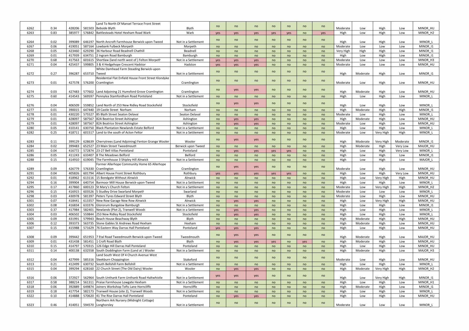
6262 0.34 428206 581503
Land To North Of Mansel Terrace Front Street
Bebside Blyth Blythno no no no no no no
Moderate Low High Low MINOR_HU
6263 0.83 385977 576842 Battlesteads Hotel Hexham Road Wark Wark yes yes yes yes yes no yes High Low High Low MINOR_H2
6264 0.02 399089 646197 North Ancroft Farmhouse Berwick-upon-Tweed Not in a Settlementno no no no no no no
High Low High Low MINOR_L
6267 0.06 419051 587164 Lowbank Fulbeck Morpeth Morpeth no no no no no no no Moderate Low Low Low MINOR_I1
6268 0.05 423460 629290 36 Harbour Road Beadnell Chathill Beadnell no no no no no no no Very High High High Low MINOR_I1
6269 0.01 417939 634751 2 Ingram Road Bamburgh Bamburgh no no no no no no no High Low High Low MINOR_I1
6270 0.68 417563 601615 Shortlaw (land north west of ) Felton Morpeth Not in a Settlement yes yes yes no no no no Moderate Low Low Low MINOR_H3
6271 0.04 425437 599805 3 & 4 Hedgehope Crescent Hadston Hadston yes yes yes no no no no Moderate Low Low Low MINOR_HU
6272 0.27 396287 653710
White Damhead Farm Steading Berwick-upon-
Tweed Not in a Settlementno no no no no no no
High Moderate High Low MINOR_I1
6273 0.01 427578 576200
Residential Flat Enfield House Front Street Klondyke
Cramlington Cramlingtonno no no no no no no
Moderate Low High Low MINOR_HU
6274 0.03 427483 577602 Land Adjoining 21 Humsford Grove Cramlington Cramlingtonno yes yes no no no no
High Moderate High Low MINOR_HU
6275 0.60 414543 569597 Pennylea Stamfordham Road Ponteland Not in a Settlement no no no no no no no High Low High Low MINOR_L
6276 0.04 406509 559852 Land North of 253 New Ridley Road Stocksfield Stocksfieldno yes yes no no no no
High Low High Low MINOR_L
6277 0.01 390015 647440 19 Castle Street Norham Norham no no no no no no no High Moderate High High MINOR_I1
6278 0.01 430220 575527 85 Blyth Street Seaton Delaval Seaton Delaval no no no no no no no Moderate Low High Low MINOR_L
6279 0.01 428097 587567 82A Beatrice Street Ashington Ashington no yes yes no no no no High Moderate High Low MINOR_HU
6279 0.01 428097 587567 82A Beatrice Street Ashington Ashington no yes yes no no no no Moderate Low High Low MINOR_HU
6280 0.05 410141 630750 Black Plantation Newlands Estate Belford Not in a Settlement no no no no no no no High Low High Low MINOR_L
6282 0.25 418711 601517 Land to the south of Acton Felton Not in a Settlement no no no no no no no Moderate Low Very High High MINOR_L
6283 0.11 399129 628639 Cherrytrees (Land Adjoining) Fenton Grange Wooler Woolerno yes yes no no no no
High Moderate Very High Moderate MINOR_I1
6284 0.02 399483 652527 23 Main Street Tweedmouth Berwick upon Tweed no no no no no no no High Moderate High Very Low MAJOR_HU
6285 0.04 416772 572874 23-27 Bell Villas Ponteland Ponteland no yes yes yes yes no no High Low High Very Low MINOR_L
6286 0.05 411243 633407 8 The Meadows Belford Belford no no no no no no no High Low High Low MINOR_I1
6288 0.15 414910 619045 The Farmhouse 3 Shipley Hill Alnwick Not in a Settlement no no no no no no no High Low High Low MAJOR_L
6289 0.09 426779 576330
Former Allerhope Community Home 65 Allerhope
Cramlington Cramlingtonno yes yes no no no no
Moderate Low High Low MINOR_HU
6291 0.04 405826 601794 Albert House Front Street Rothbury Rothbury yes yes yes yes yes no no High Low High Very Low MINOR_HU
6292 0.01 418962 613116 15 Bondgate Without Alnwick Alnwick no no no no no no no High Low Very High High MINOR_HU
6294 0.16 399904 640754 Barmoor Mill House Berwick-upon-Tweed Not in a Settlement no no no no no no no High Low High Low MINOR_L
6295 0.17 417860 600123 St Mary's Church Felton Not in a Settlement no no no no no no no Moderate Low Very High High MINOR_H2
6296 0.15 416915 603526 5 Studley Drive Swarland Morpeth Swarland no no no no no no no Moderate Low Low Low MINOR_L
6298 0.03 430978 581397 Peters Tyres Edward Street Blyth Blyth no no no no no no no Moderate Low High Low MINOR_HU
6301 0.07 418441 613357 New Row Garage New Row Alnwick Alnwick no yes yes no no no no High Low Very High High MINOR_HU
6302 0.08 416834 633376 Glororum Bungalow Bamburgh Not in a Settlement no no no no no no no High Low High Low MINOR_I1
6303 0.37 417984 582401 Newlands (Plot 2), Tranwell Woods Not in a Settlement no yes yes no no no no High Low High Low MINOR_L
6304 0.03 406502 559844 253 New Ridley Road Stocksfield Stocksfield no yes yes no no no no High Low High Low MINOR_L
6305 0.09 431991 579943 Beach House Beachway Blyth Blyth no no no no no no no High Moderate High High MINOR_HU
6306 0.12 393373 563735 Stone Gables St Andrews Road Hexham Hexham no no no no no no no High Moderate High Low MINOR_HU
6307 0.15 415988 571629 76 Eastern Way Darras Hall Ponteland Ponteland yes yes yes no no no no High Low High Low MINOR_HU
6308 0.09 399442 651953 7 Etal Road Tweedmouth Berwick-upon-Tweed Tweedmouthno yes yes no no no no
High Moderate High Low MAJOR_HU
6309 0.01 431438 581451 1 Croft Road Blyth Blyth no yes yes yes no yes no High Moderate High Low MINOR_HU
6310 0.15 414797 570315 126 Edge Hill Darras Hall Ponteland Ponteland no no no no no no no High Low High Low MINOR_HU
6311 0.14 400138 632558 South Doddington Farm (Land at ) Wooler Not in a Settlement no no no no no no no High Moderate High Low MAJOR_H3
6312 0.04 427999 585316
Land South West Of 4 Church Avenue West
Sleekburn Choppington Stakefordno no no no no no no
Moderate Low High Low MINOR_HU
6313 0.21 412499 630732 South Bellshill Farm Bellshill Not in a Settlement no no no no no no no High Low High Low MINOR_L
6315 0.04 399294 628160 22 Church Street (The Old Dairy) Wooler Wooler no yes yes no no no no High Moderate Very High High MINOR_H2
6316 0.06 372927 562964 South Unthank Farm Unthank Road Haltwhistle Not in a Settlementyes yes yes no no no no
High Low Very High High MINOR_I1
6317 0.58 388214 561311 Praise Farmhouse Lowgate Hexham Not in a Settlement no no no no no no no High Low High Low MINOR_H1
6318 0.06 392889 649874 Joiners Workshop Tofts Lane Horncliffe Horncliffe no no no no no no no High Moderate High Low MINOR_I1
6319 0.18 417754 582173 Tranwell House (site 2), Tranwell Woods Not in a Settlement no no no no no no no High Low High Low MINOR_L
6322 0.10 414888 570620 41 The Rise Darras Hall Ponteland Ponteland no yes yes no no no no High Low High Low MINOR_HU
6323 0.46 414051 594570
Northern Ark Nursery (Midnight Cottage)
Longhorsley Not in a Settlementno no no no no no no
Moderate Low Low Low MINOR_L
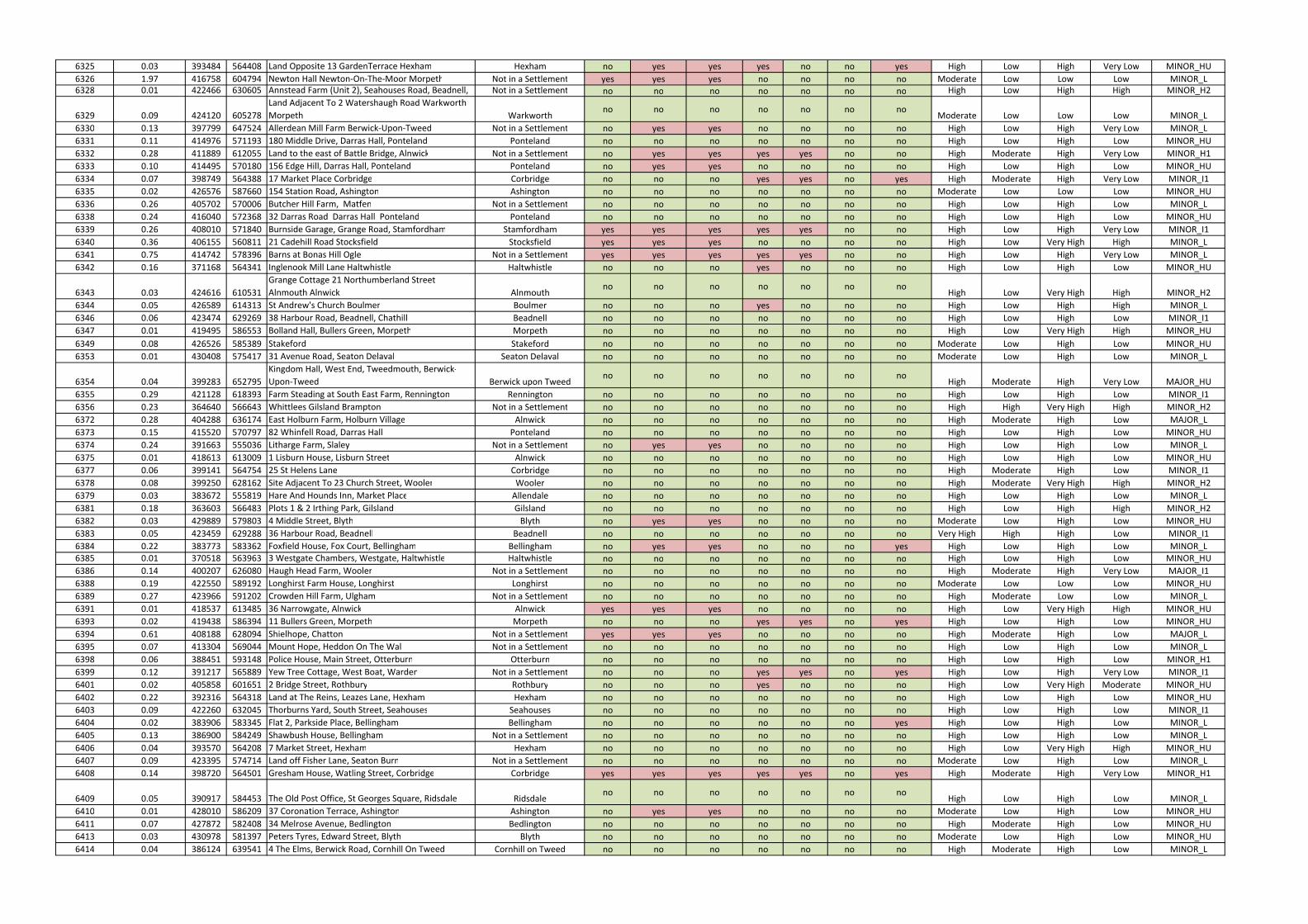
6325 0.03 393484 564408 Land Opposite 13 GardenTerrace Hexham Hexham no yes yes yes no no yes High Low High Very Low MINOR_HU
6326 1.97 416758 604794 Newton Hall Newton-On-The-Moor Morpeth Not in a Settlement yes yes yes no no no no Moderate Low Low Low MINOR_L
6328 0.01 422466 630605 Annstead Farm (Unit 2), Seahouses Road, Beadnell, Not in a Settlement no no no no no no no High Low High High MINOR_H2
6329 0.09 424120 605278
Land Adjacent To 2 Watershaugh Road Warkworth
Morpeth Warkworthno no no no no no no
Moderate Low Low Low MINOR_L
6330 0.13 397799 647524 Allerdean Mill Farm Berwick-Upon-Tweed Not in a Settlement no yes yes no no no no High Low High Very Low MINOR_L
6331 0.11 414976 571193 180 Middle Drive, Darras Hall, Ponteland Ponteland no no no no no no no High Low High Low MINOR_HU
6332 0.28 411889 612055 Land to the east of Battle Bridge, Alnwick Not in a Settlement no yes yes yes yes no no High Moderate High Very Low MINOR_H1
6333 0.10 414495 570180 156 Edge Hill, Darras Hall, Ponteland Ponteland no yes yes no no no no High Low High Low MINOR_HU
6334 0.07 398749 564388 17 Market Place Corbridge Corbridge no no no yes yes no yes High Moderate High Very Low MINOR_I1
6335 0.02 426576 587660 154 Station Road, Ashington Ashington no no no no no no no Moderate Low Low Low MINOR_HU
6336 0.26 405702 570006 Butcher Hill Farm, Matfen Not in a Settlement no no no no no no no High Low High Low MINOR_L
6338 0.24 416040 572368 32 Darras Road Darras Hall Ponteland Ponteland no no no no no no no High Low High Low MINOR_HU
6339 0.26 408010 571840 Burnside Garage, Grange Road, Stamfordham Stamfordham yes yes yes yes yes no no High Low High Very Low MINOR_I1
6340 0.36 406155 560811 21 Cadehill Road Stocksfield Stocksfield yes yes yes no no no no High Low Very High High MINOR_L
6341 0.75 414742 578396 Barns at Bonas Hill Ogle Not in a Settlement yes yes yes yes yes no no High Low High Very Low MINOR_L
6342 0.16 371168 564341 Inglenook Mill Lane Haltwhistle Haltwhistle no no no yes no no no High Low High Low MINOR_HU
6343 0.03 424616 610531
Grange Cottage 21 Northumberland Street
Alnmouth Alnwick Alnmouthno no no no no no no
High Low Very High High MINOR_H2
6344 0.05 426589 614313 St Andrew's Church Boulmer Boulmer no no no yes no no no High Low High High MINOR_L
6346 0.06 423474 629269 38 Harbour Road, Beadnell, Chathill Beadnell no no no no no no no High Low High Low MINOR_I1
6347 0.01 419495 586553 Bolland Hall, Bullers Green, Morpeth Morpeth no no no no no no no High Low Very High High MINOR_HU
6349 0.08 426526 585389 Stakeford Stakeford no no no no no no no Moderate Low High Low MINOR_HU
6353 0.01 430408 575417 31 Avenue Road, Seaton Delaval Seaton Delaval no no no no no no no Moderate Low High Low MINOR_L
6354 0.04 399283 652795
Kingdom Hall, West End, Tweedmouth, Berwick-
Upon-Tweed Berwick upon Tweedno no no no no no no
High Moderate High Very Low MAJOR_HU
6355 0.29 421128 618393 Farm Steading at South East Farm, Rennington Rennington no no no no no no no High Low High Low MINOR_I1
6356 0.23 364640 566643 Whittlees Gilsland Brampton Not in a Settlement no no no no no no no High High Very High High MINOR_H2
6372 0.28 404288 636174 East Holburn Farm, Holburn Village Alnwick no no no no no no no High Moderate High Low MAJOR_L
6373 0.15 415520 570797 82 Whinfell Road, Darras Hall Ponteland no no no no no no no High Low High Low MINOR_HU
6374 0.24 391663 555036 Litharge Farm, Slaley Not in a Settlement no yes yes no no no no High Low High Low MINOR_L
6375 0.01 418613 613009 1 Lisburn House, Lisburn Street Alnwick no no no no no no no High Low High Low MINOR_HU
6377 0.06 399141 564754 25 St Helens Lane Corbridge no no no no no no no High Moderate High Low MINOR_I1
6378 0.08 399250 628162 Site Adjacent To 23 Church Street, Wooler Wooler no no no no no no no High Moderate Very High High MINOR_H2
6379 0.03 383672 555819 Hare And Hounds Inn, Market Place Allendale no no no no no no no High Low High Low MINOR_L
6381 0.18 363603 566483 Plots 1 & 2 Irthing Park, Gilsland Gilsland no no no no no no no High Low High High MINOR_H2
6382 0.03 429889 579803 4 Middle Street, Blyth Blyth no yes yes no no no no Moderate Low High Low MINOR_HU
6383 0.05 423459 629288 36 Harbour Road, Beadnell Beadnell no no no no no no no Very High High High Low MINOR_I1
6384 0.22 383773 583362 Foxfield House, Fox Court, Bellingham Bellingham no yes yes no no no yes High Low High Low MINOR_L
6385 0.01 370518 563963 3 Westgate Chambers, Westgate, Haltwhistle Haltwhistle no no no no no no no High Low High Low MINOR_HU
6386 0.14 400207 626080 Haugh Head Farm, Wooler Not in a Settlement no no no no no no no High Moderate High Very Low MAJOR_I1
6388 0.19 422550 589192 Longhirst Farm House, Longhirst Longhirst no no no no no no no Moderate Low Low Low MINOR_HU
6389 0.27 423966 591202 Crowden Hill Farm, Ulgham Not in a Settlement no no no no no no no High Moderate Low Low MINOR_L
6391 0.01 418537 613485 36 Narrowgate, Alnwick Alnwick yes yes yes no no no no High Low Very High High MINOR_HU
6393 0.02 419438 586394 11 Bullers Green, Morpeth Morpeth no no no yes yes no yes High Low High Low MINOR_HU
6394 0.61 408188 628094 Shielhope, Chatton Not in a Settlement yes yes yes no no no no High Moderate High Low MAJOR_L
6395 0.07 413304 569044 Mount Hope, Heddon On The Wall Not in a Settlement no no no no no no no High Low High Low MINOR_L
6398 0.06 388451 593148 Police House, Main Street, Otterburn Otterburn no no no no no no no High Low High Low MINOR_H1
6399 0.12 391217 565889 Yew Tree Cottage, West Boat, Warden Not in a Settlement no no no yes yes no yes High Low High Very Low MINOR_I1
6401 0.02 405858 601651 2 Bridge Street, Rothbury Rothbury no no no yes no no no High Low Very High Moderate MINOR_HU
6402 0.22 392316 564318 Land at The Reins, Leazes Lane, Hexham Hexham no no no no no no no High Low High Low MINOR_HU
6403 0.09 422260 632045 Thorburns Yard, South Street, Seahouses Seahouses no no no no no no no High Low High Low MINOR_I1
6404 0.02 383906 583345 Flat 2, Parkside Place, Bellingham Bellingham no no no no no no yes High Low High Low MINOR_L
6405 0.13 386900 584249 Shawbush House, Bellingham Not in a Settlement no no no no no no no High Low High Low MINOR_L
6406 0.04 393570 564208 7 Market Street, Hexham Hexham no no no no no no no High Low Very High High MINOR_HU
6407 0.09 423395 574714 Land off Fisher Lane, Seaton Burn Not in a Settlement no no no no no no no Moderate Low High Low MINOR_L
6408 0.14 398720 564501 Gresham House, Watling Street, Corbridge Corbridge yes yes yes yes yes no yes High Moderate High Very Low MINOR_H1
6409 0.05 390917 584453 The Old Post Office, St Georges Square, Ridsdale Ridsdaleno no no no no no no
High Low High Low MINOR_L
6410 0.01 428010 586209 37 Coronation Terrace, Ashington Ashington no yes yes no no no no Moderate Low High Low MINOR_HU
6411 0.07 427872 582408 34 Melrose Avenue, Bedlington Bedlington no no no no no no no High Moderate High Low MINOR_HU
6413 0.03 430978 581397 Peters Tyres, Edward Street, Blyth Blyth no no no no no no no Moderate Low High Low MINOR_HU
6414 0.04 386124 639541 4 The Elms, Berwick Road, Cornhill On Tweed Cornhill on Tweed no no no no no no no High Moderate High Low MINOR_L
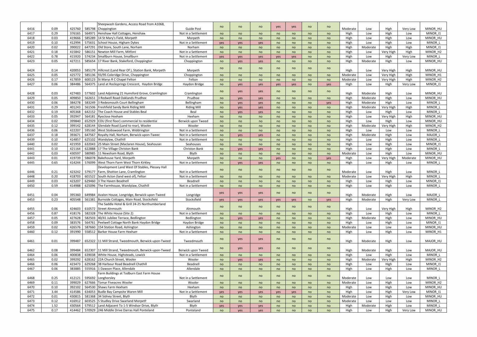
6416 0.09 425760 585798
Sheepwash Gardens, Access Road from A1068,
Choppington Guide Postno no no yes yes no no
Moderate Low High Very Low MINOR_HU
6417 0.29 376165 564971 Henshaw Hall Cottages, Henshaw Not in a Settlement no no no no no no no High Low High Low MINOR_I1
6418 0.03 419666 585289 14 St Mary's Field, Morpeth Morpeth no no no no no no no High Low High Low MINOR_HU
6419 0.10 412994 575631 School House, Higham Dykes Not in a Settlement yes yes yes no no no no High Low High Low MINOR_L
6420 0.02 390022 647291 Old Store, South Lane, Norham Norham no no no no no no no High Moderate High High MINOR_I1
6421 0.18 415842 586151 Newton Mill Farm, Mitford Not in a Settlement no no no no no no no High Low Very High High MINOR_H2
6422 0.78 415920 574234 Smallburn House, Smallburn Not in a Settlement yes yes yes yes yes no no High Low High Very Low MINOR_L
6423 0.05 427211 585654 17 River Bank, Stakeford, Choppington Choppington no yes yes no no no no High Moderate High Low MINOR_HU
6424 0.14 420053 585179 Hillcrest (Land Rear Of ), Station Bank, Morpeth Morpethno no no no no no no
High Low Very High High MINOR_HU
6425 0.05 425772 585136 93/95 Coleridge Drive, Choppington Choppington no no no no no no no Moderate Low Very High High MINOR_H1
6426 0.17 417859 600123 St Marys R C Chapel Felton Felton no no no no no no no Moderate Low Very High High MINOR_H2
6427 0.06 384486 564375 Land at Rocksprings Crescent, Haydon Bridge Haydon Bridge no yes yes yes yes no yes High Low High Very Low MINOR_I1
6428 0.03 427483 577602 Land Adjoining 21 Humsford Grove, Cramlington Cramlingtonno yes yes no no no no
High Moderate High Low MINOR_HU
6429 0.05 409850 562651 3 Redwell Road Oaklands Prudhoe Prudhoe no yes yes no no no no High Moderate High Low MINOR_HU
6430 0.06 384278 583249 3 Redesmouth Court Bellingham Bellingham no yes yes no no no yes High Moderate High Low MINOR_L
6431 0.29 401243 561506 Freshfield Sandy Bank Riding Mill Riding Mill no yes yes no no no no High Moderate Very High High MINOR_L
6432 0.19 405368 642152 The Coach House and Stables Beal Beal no yes yes no no no no High Low High Low MINOR_L
6433 0.05 392947 564181 Ryeclose Hexham Hexham no no no no no no no High Low Very High High MINOR_HU
6434 0.02 399840 652929 COU (first floor) commercial to residential Berwick upon Tweed no no no no no no no High Low High Low MINOR_HU
6435 0.12 399142 628144 Glendale Road (Land to rear), Wooler Wooler no no no no no no no High Moderate Very High High MINOR_H2
6436 0.06 422207 595160 West Stobswood Farm, Widdrington Not in a Settlement no no no no no no no High Low Low Low MINOR_L
6437 0.18 393671 647567 Royalty Hall, Norham, Berwick-upon-Tweed Not in a Settlement no yes yes no no no no High Moderate High Low MAJOR_L
6439 0.10 414857 625102 Wandylaw, Chathill Not in a Settlement no no no no no no no High Low High Low MINOR_L
6440 0.02 421959 632043 25 Main Street (Maclaren House), Seahouses Seahouses no no no no no no no High Low High Low MINOR_I1
6441 0.10 421164 622888 17 The Village Christon Bank Christon Bank no yes yes no no no no High Low High Low MINOR_L
6442 0.03 430597 580985 11 Newsham Road, Blyth Blyth no no no no no no no Moderate Low High Low MINOR_HU
6443 0.01 419739 586078 Bakehouse Yard, Morpeth Morpeth no no no yes no no yes High Low Very High Moderate MINOR_HU
6445 0.65 414244 576099 West Thorn Farm West Thorn Kirkley Not in a Settlement no yes yes no no no no High Low High Low MINOR_L
6446 0.21 423242 579177
Development Land West Of Stables, Plessey Hall
Farm, Shotton Lane, Cramlington Not in a Settlementno no no no no no no
Moderate Low High Low MINOR_L
6448 0.20 418703 601522 South Acton (land west of), Felton Not in a Settlement no no no no no no no Moderate Low Very High High MINOR_L
6449 0.03 423207 629460 3 The Haven Beadnell Beadnell no no no no no no no High Low High Low MINOR_I1
6450 0.59 414988 625096 The Farmhouse, Wandylaw, Chathill Not in a Settlement no no no no no no no High Low High Low MINOR_L
6451 0.04 395360 649984 Avalon House, Longridge, Berwick-upon-Tweed Longridgeyes yes yes no no no no
High Moderate High Low MAJOR_L
6453 0.23 405548 561381 Burnside Cottages, Main Road, Stocksfield Stocksfield yes yes yes yes yes no yes High Moderate High Very Low MINOR_L
6455 0.06 424603 610572
The Saddle Hotel & Grill 24-25 Northumberland
Street Alnmouth Alnmouthno no no no no no no
High Low Very High High MINOR_H2
6456 0.87 418176 582328 The White House (Site 2) Not in a Settlement no no no no no no no High Low High Low MINOR_L
6457 0.05 427628 582503 40/41 Jubilee Terrace, Bedlington Bedlington no yes yes no no no no High Moderate High Low MINOR_HU
6458 0.09 383576 564761 Peelwell Cottage North Bank Haydon Bridge Haydon Bridge no no no no no no no High Low High Low MINOR_I1
6459 0.02 426576 587660 154 Station Road, Ashington Ashington no no no no no no no Moderate Low Low Low MINOR_HU
6460 0.12 391990 558512 Barker House Farm Hexham Not in a Settlement no no no no no no no High Low High Low MINOR_H1
6461 0.01 399487 652322 11 Mill Strand, Tweedmouth, Berwick-upon-Tweed Tweedmouthno yes yes no no no no
High Moderate High Low MAJOR_HU
6462 0.08 399484 652307 11 Mill Strand, Tweedmouth, Berwick-upon-Tweed Berwick upon Tweedno yes yes no no no no
High Moderate High Low MAJOR_HU
6464 0.06 400838 639038 White House, Highsteads, Lowick Not in a Settlement no no no no no no no High Low High Low MINOR_L
6465 0.02 399292 628162 22A Church Street, Wooler Wooler no yes yes no no no no High Moderate Very High High MINOR_H2
6466 0.06 423473 629268 38 Harbour Road Beadnell Chathill Beadnell no no no no no no no High Low High Low MINOR_I1
6467 0.06 383885 555916 1 Dawson Place, Allendale Allendale no no no no no no no High Low High Low MINOR_L
6468 0.25 412121 595692
Farm Buildings at Todburn East Farm House
Longhorsley Not in a Settlementno no no no no no no
Moderate Low Low Low MINOR_L
6469 0.11 399029 627666 Tomar Fiveacres Wooler Wooler no no no no no no no Moderate Low High Low MINOR_H2
6470 0.10 392102 564530 Shaws Farm Hexham Hexham no no no no no no no High Low High Low MINOR_HU
6471 3.44 414586 634053 Budle Bay Campsite Waren Mill Not in a Settlement yes yes yes yes yes no no High Low High Very Low MINOR_I1
6472 0.01 430815 581368 34 Sidney Street, Blyth Blyth no no no no no no no Moderate Low High Low MINOR_HU
6473 0.12 416912 603525 5 Studley Drive Swarland Morpeth Swarland no no no no no no no Moderate Low Low Low MINOR_L
6474 1.52 430564 579512 Land Adjacent To 1-5 Windsor Drive, Blyth Blyth yes yes yes no no no no High Moderate High Low MINOR_L
6475 0.17 414462 570929 246 Middle Drive Darras Hall Ponteland Ponteland no yes yes no no no no High Low High Very Low MINOR_HU
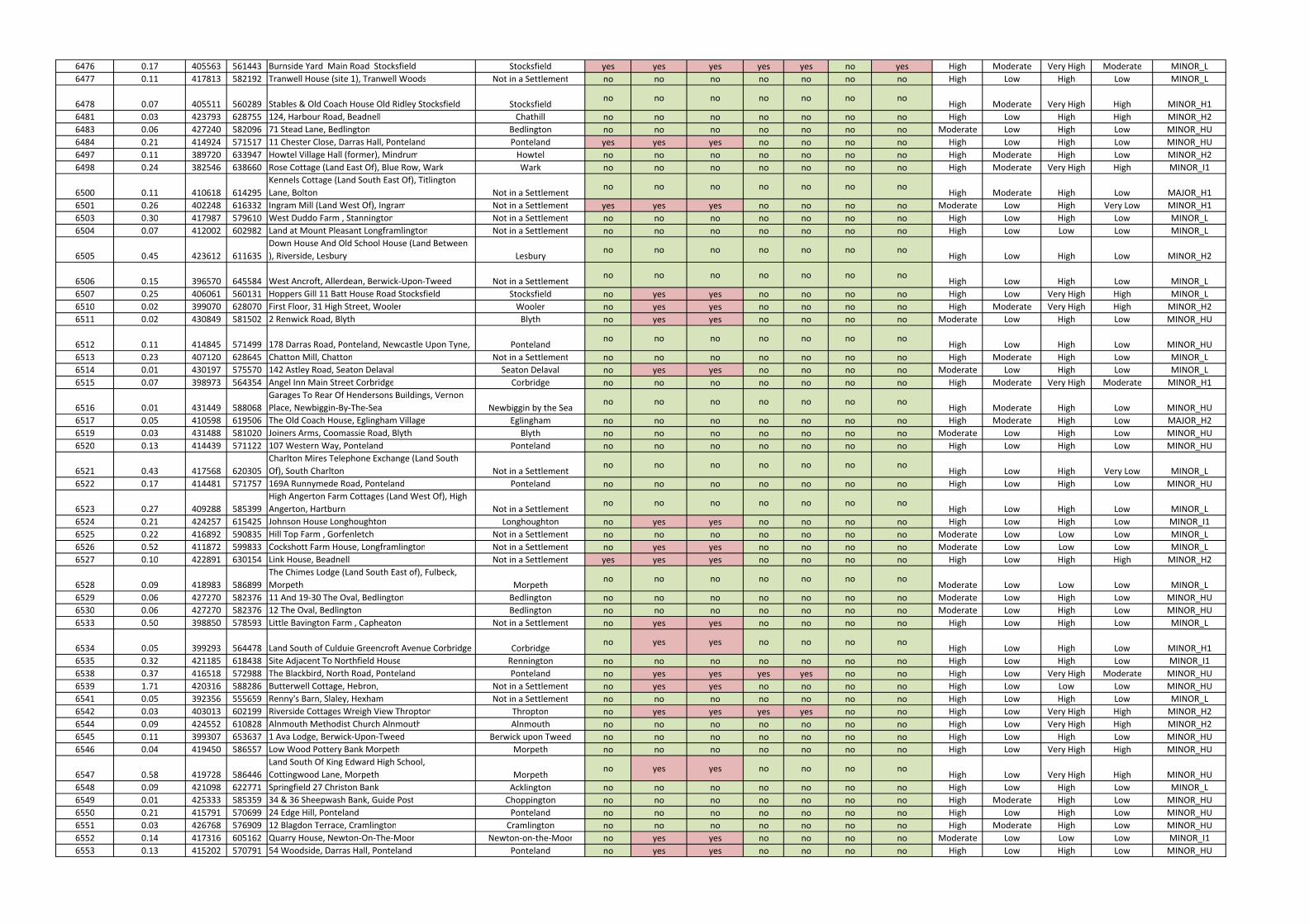
6476 0.17 405563 561443 Burnside Yard Main Road Stocksfield Stocksfield yes yes yes yes yes no yes High Moderate Very High Moderate MINOR_L
6477 0.11 417813 582192 Tranwell House (site 1), Tranwell Woods Not in a Settlement no no no no no no no High Low High Low MINOR_L
6478 0.07 405511 560289 Stables & Old Coach House Old Ridley Stocksfield Stocksfieldno no no no no no no
High Moderate Very High High MINOR_H1
6481 0.03 423793 628755 124, Harbour Road, Beadnell Chathill no no no no no no no High Low High High MINOR_H2
6483 0.06 427240 582096 71 Stead Lane, Bedlington Bedlington no no no no no no no Moderate Low High Low MINOR_HU
6484 0.21 414924 571517 11 Chester Close, Darras Hall, Ponteland Ponteland yes yes yes no no no no High Low High Low MINOR_HU
6497 0.11 389720 633947 Howtel Village Hall (former), Mindrum Howtel no no no no no no no High Moderate High Low MINOR_H2
6498 0.24 382546 638660 Rose Cottage (Land East Of), Blue Row, Wark Wark no no no no no no no High Moderate Very High High MINOR_I1
6500 0.11 410618 614295
Kennels Cottage (Land South East Of), Titlington
Lane, Bolton Not in a Settlementno no no no no no no
High Moderate High Low MAJOR_H1
6501 0.26 402248 616332 Ingram Mill (Land West Of), Ingram Not in a Settlement yes yes yes no no no no Moderate Low High Very Low MINOR_H1
6503 0.30 417987 579610 West Duddo Farm , Stannington Not in a Settlement no no no no no no no High Low High Low MINOR_L
6504 0.07 412002 602982 Land at Mount Pleasant Longframlington Not in a Settlement no no no no no no no High Low Low Low MINOR_L
6505 0.45 423612 611635
Down House And Old School House (Land Between
), Riverside, Lesbury Lesburyno no no no no no no
High Low High Low MINOR_H2
6506 0.15 396570 645584 West Ancroft, Allerdean, Berwick-Upon-Tweed Not in a Settlementno no no no no no no
High Low High Low MINOR_L
6507 0.25 406061 560131 Hoppers Gill 11 Batt House Road Stocksfield Stocksfield no yes yes no no no no High Low Very High High MINOR_L
6510 0.02 399070 628070 First Floor, 31 High Street, Wooler Wooler no yes yes no no no no High Moderate Very High High MINOR_H2
6511 0.02 430849 581502 2 Renwick Road, Blyth Blyth no yes yes no no no no Moderate Low High Low MINOR_HU
6512 0.11 414845 571499 178 Darras Road, Ponteland, Newcastle Upon Tyne, Pontelandno no no no no no no
High Low High Low MINOR_HU
6513 0.23 407120 628645 Chatton Mill, Chatton Not in a Settlement no no no no no no no High Moderate High Low MINOR_L
6514 0.01 430197 575570 142 Astley Road, Seaton Delaval Seaton Delaval no yes yes no no no no Moderate Low High Low MINOR_L
6515 0.07 398973 564354 Angel Inn Main Street Corbridge Corbridge no no no no no no no High Moderate Very High Moderate MINOR_H1
6516 0.01 431449 588068
Garages To Rear Of Hendersons Buildings, Vernon
Place, Newbiggin-By-The-Sea Newbiggin by the Seano no no no no no no
High Moderate High Low MINOR_HU
6517 0.05 410598 619506 The Old Coach House, Eglingham Village Eglingham no no no no no no no High Moderate High Low MAJOR_H2
6519 0.03 431488 581020 Joiners Arms, Coomassie Road, Blyth Blyth no no no no no no no Moderate Low High Low MINOR_HU
6520 0.13 414439 571122 107 Western Way, Ponteland Ponteland no no no no no no no High Low High Low MINOR_HU
6521 0.43 417568 620305
Charlton Mires Telephone Exchange (Land South
Of), South Charlton Not in a Settlementno no no no no no no
High Low High Very Low MINOR_L
6522 0.17 414481 571757 169A Runnymede Road, Ponteland Ponteland no no no no no no no High Low High Low MINOR_HU
6523 0.27 409288 585399
High Angerton Farm Cottages (Land West Of), High
Angerton, Hartburn Not in a Settlementno no no no no no no
High Low High Low MINOR_L
6524 0.21 424257 615425 Johnson House Longhoughton Longhoughton no yes yes no no no no High Low High Low MINOR_I1
6525 0.22 416892 590835 Hill Top Farm , Gorfenletch Not in a Settlement no no no no no no no Moderate Low Low Low MINOR_L
6526 0.52 411872 599833 Cockshott Farm House, Longframlington Not in a Settlement no yes yes no no no no Moderate Low Low Low MINOR_L
6527 0.10 422891 630154 Link House, Beadnell Not in a Settlement yes yes yes no no no no High Low High High MINOR_H2
6528 0.09 418983 586899
The Chimes Lodge (Land South East of), Fulbeck,
Morpeth Morpethno no no no no no no
Moderate Low Low Low MINOR_L
6529 0.06 427270 582376 11 And 19-30 The Oval, Bedlington Bedlington no no no no no no no Moderate Low High Low MINOR_HU
6530 0.06 427270 582376 12 The Oval, Bedlington Bedlington no no no no no no no Moderate Low High Low MINOR_HU
6533 0.50 398850 578593 Little Bavington Farm , Capheaton Not in a Settlement no yes yes no no no no High Low High Low MINOR_L
6534 0.05 399293 564478 Land South of Culduie Greencroft Avenue Corbridge Corbridgeno yes yes no no no no
High Low High Low MINOR_H1
6535 0.32 421185 618438 Site Adjacent To Northfield House Rennington no no no no no no no High Low High Low MINOR_I1
6538 0.37 416518 572988 The Blackbird, North Road, Ponteland Ponteland no yes yes yes yes no no High Low Very High Moderate MINOR_HU
6539 1.71 420316 588286 Butterwell Cottage, Hebron, Not in a Settlement no yes yes no no no no High Low Low Low MINOR_HU
6541 0.05 392356 555659 Renny's Barn, Slaley, Hexham Not in a Settlement no no no no no no no High Low High Low MINOR_L
6542 0.03 403013 602199 Riverside Cottages Wreigh View Thropton Thropton no yes yes yes yes no no High Low Very High High MINOR_H2
6544 0.09 424552 610828 Alnmouth Methodist Church Alnmouth Alnmouth no no no no no no no High Low Very High High MINOR_H2
6545 0.11 399307 653637 1 Ava Lodge, Berwick-Upon-Tweed Berwick upon Tweed no no no no no no no High Low High Low MINOR_HU
6546 0.04 419450 586557 Low Wood Pottery Bank Morpeth Morpeth no no no no no no no High Low Very High High MINOR_HU
6547 0.58 419728 586446
Land South Of King Edward High School,
Cottingwood Lane, Morpeth Morpethno yes yes no no no no
High Low Very High High MINOR_HU
6548 0.09 421098 622771 Springfield 27 Christon Bank Acklington no no no no no no no High Low High Low MINOR_L
6549 0.01 425333 585359 34 & 36 Sheepwash Bank, Guide Post Choppington no no no no no no no High Moderate High Low MINOR_HU
6550 0.21 415791 570699 24 Edge Hill, Ponteland Ponteland no no no no no no no High Low High Low MINOR_HU
6551 0.03 426768 576909 12 Blagdon Terrace, Cramlington Cramlington no no no no no no no High Moderate High Low MINOR_HU
6552 0.14 417316 605162 Quarry House, Newton-On-The-Moor Newton-on-the-Moor no yes yes no no no no Moderate Low Low Low MINOR_I1
6553 0.13 415202 570791 54 Woodside, Darras Hall, Ponteland Ponteland no yes yes no no no no High Low High Low MINOR_HU
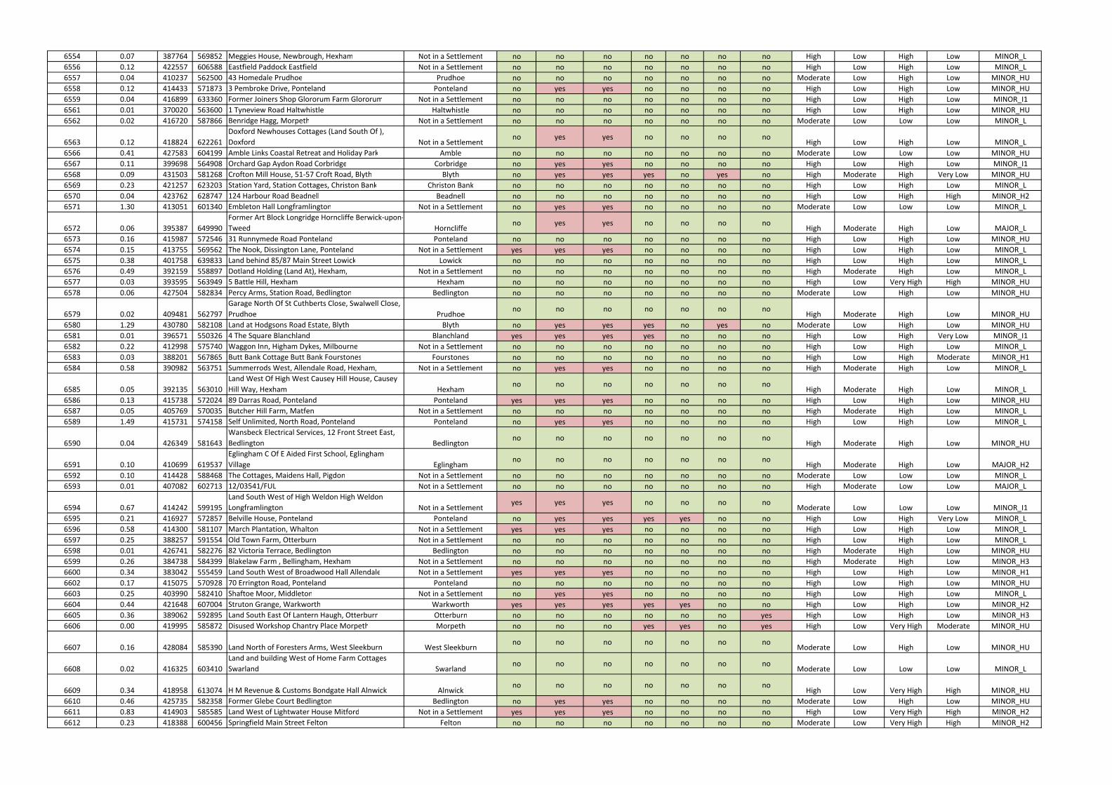
6554 0.07 387764 569852 Meggies House, Newbrough, Hexham Not in a Settlement no no no no no no no High Low High Low MINOR_L
6556 0.12 422557 606588 Eastfield Paddock Eastfield Not in a Settlement no no no no no no no High Low High Low MINOR_L
6557 0.04 410237 562500 43 Homedale Prudhoe Prudhoe no no no no no no no Moderate Low High Low MINOR_HU
6558 0.12 414433 571873 3 Pembroke Drive, Ponteland Ponteland no yes yes no no no no High Low High Low MINOR_HU
6559 0.04 416899 633360 Former Joiners Shop Glororum Farm Glororum Not in a Settlement no no no no no no no High Low High Low MINOR_I1
6561 0.01 370020 563600 1 Tyneview Road Haltwhistle Haltwhistle no no no no no no no High Low High Low MINOR_HU
6562 0.02 416720 587866 Benridge Hagg, Morpeth Not in a Settlement no no no no no no no Moderate Low Low Low MINOR_L
6563 0.12 418824 622261
Doxford Newhouses Cottages (Land South Of ),
Doxford Not in a Settlementno yes yes no no no no
High Low High Low MINOR_L
6566 0.41 427583 604199 Amble Links Coastal Retreat and Holiday Park Amble no no no no no no no Moderate Low Low Low MINOR_HU
6567 0.11 399698 564908 Orchard Gap Aydon Road Corbridge Corbridge no yes yes no no no no High Low High Low MINOR_I1
6568 0.09 431503 581268 Crofton Mill House, 51-57 Croft Road, Blyth Blyth no yes yes yes no yes no High Moderate High Very Low MINOR_HU
6569 0.23 421257 623203 Station Yard, Station Cottages, Christon Bank Christon Bank no no no no no no no High Low High Low MINOR_L
6570 0.04 423762 628747 124 Harbour Road Beadnell Beadnell no no no no no no no High Low High High MINOR_H2
6571 1.30 413051 601340 Embleton Hall Longframlington Not in a Settlement no yes yes no no no no Moderate Low Low Low MINOR_L
6572 0.06 395387 649990
Former Art Block Longridge Horncliffe Berwick-upon-
Tweed Horncliffeno yes yes no no no no
High Moderate High Low MAJOR_L
6573 0.16 415987 572546 31 Runnymede Road Ponteland Ponteland no no no no no no no High Low High Low MINOR_HU
6574 0.15 413755 569562 The Nook, Dissington Lane, Ponteland Not in a Settlement yes yes yes no no no no High Low High Low MINOR_L
6575 0.38 401758 639833 Land behind 85/87 Main Street Lowick Lowick no no no no no no no High Low High Low MINOR_L
6576 0.49 392159 558897 Dotland Holding (Land At), Hexham, Not in a Settlement no no no no no no no High Moderate High Low MINOR_L
6577 0.03 393595 563949 5 Battle Hill, Hexham Hexham no no no no no no no High Low Very High High MINOR_HU
6578 0.06 427504 582834 Percy Arms, Station Road, Bedlington Bedlington no no no no no no no Moderate Low High Low MINOR_HU
6579 0.02 409481 562797
Garage North Of St Cuthberts Close, Swalwell Close,
Prudhoe Prudhoeno no no no no no no
High Moderate High Low MINOR_HU
6580 1.29 430780 582108 Land at Hodgsons Road Estate, Blyth Blyth no yes yes yes no yes no Moderate Low High Low MINOR_HU
6581 0.01 396571 550326 4 The Square Blanchland Blanchland yes yes yes yes no no no High Low High Very Low MINOR_I1
6582 0.22 412998 575740 Waggon Inn, Higham Dykes, Milbourne Not in a Settlement no no no no no no no High Low High Low MINOR_L
6583 0.03 388201 567865 Butt Bank Cottage Butt Bank Fourstones Fourstones no no no no no no no High Low High Moderate MINOR_H1
6584 0.58 390982 563751 Summerrods West, Allendale Road, Hexham, Not in a Settlement no yes yes no no no no High Moderate High Low MINOR_L
6585 0.05 392135 563010
Land West Of High West Causey Hill House, Causey
Hill Way, Hexham Hexhamno no no no no no no
High Moderate High Low MINOR_L
6586 0.13 415738 572024 89 Darras Road, Ponteland Ponteland yes yes yes no no no no High Low High Low MINOR_HU
6587 0.05 405769 570035 Butcher Hill Farm, Matfen Not in a Settlement no no no no no no no High Moderate High Low MINOR_L
6589 1.49 415731 574158 Self Unlimited, North Road, Ponteland Ponteland no yes yes no no no no High Low High Low MINOR_L
6590 0.04 426349 581643
Wansbeck Electrical Services, 12 Front Street East,
Bedlington Bedlingtonno no no no no no no
High Moderate High Low MINOR_HU
6591 0.10 410699 619537
Eglingham C Of E Aided First School, Eglingham
Village Eglinghamno no no no no no no
High Moderate High Low MAJOR_H2
6592 0.10 414428 588468 The Cottages, Maidens Hall, Pigdon Not in a Settlement no no no no no no no Moderate Low Low Low MINOR_L
6593 0.01 407082 602713 12/03541/FUL Not in a Settlement no no no no no no no High Moderate Low Low MAJOR_L
6594 0.67 414242 599195
Land South West of High Weldon High Weldon
Longframlington Not in a Settlementyes yes yes no no no no
Moderate Low Low Low MINOR_I1
6595 0.21 416927 572857 Belville House, Ponteland Ponteland no yes yes yes yes no no High Low High Very Low MINOR_L
6596 0.58 414300 581107 March Plantation, Whalton Not in a Settlement yes yes yes no no no no High Low High Low MINOR_L
6597 0.25 388257 591554 Old Town Farm, Otterburn Not in a Settlement no no no no no no no High Low High Low MINOR_L
6598 0.01 426741 582276 82 Victoria Terrace, Bedlington Bedlington no no no no no no no High Moderate High Low MINOR_HU
6599 0.26 384738 584399 Blakelaw Farm , Bellingham, Hexham Not in a Settlement no no no no no no no High Moderate High Low MINOR_H3
6600 0.34 383042 555459 Land South West of Broadwood Hall Allendale Not in a Settlement yes yes yes no no no no High Low High Low MINOR_H1
6602 0.17 415075 570928 70 Errington Road, Ponteland Ponteland no no no no no no no High Low High Low MINOR_HU
6603 0.25 403990 582410 Shaftoe Moor, Middleton Not in a Settlement no yes yes no no no no High Low High Low MINOR_L
6604 0.44 421648 607004 Struton Grange, Warkworth Warkworth yes yes yes yes yes no no High Low High Low MINOR_H2
6605 0.36 389062 592895 Land South East Of Lantern Haugh, Otterburn Otterburn no no no no no no yes High Low High Low MINOR_H3
6606 0.00 419995 585872 Disused Workshop Chantry Place Morpeth Morpeth no no no yes yes no yes High Low Very High Moderate MINOR_HU
6607 0.16 428084 585390 Land North of Foresters Arms, West Sleekburn West Sleekburnno no no no no no no
Moderate Low High Low MINOR_HU
6608 0.02 416325 603410
Land and building West of Home Farm Cottages
Swarland Swarlandno no no no no no no
Moderate Low Low Low MINOR_L
6609 0.34 418958 613074 H M Revenue & Customs Bondgate Hall Alnwick Alnwickno no no no no no no
High Low Very High High MINOR_HU
6610 0.46 425735 582358 Former Glebe Court Bedlington Bedlington no yes yes no no no no Moderate Low High Low MINOR_HU
6611 0.83 414903 585585 Land West of Lightwater House Mitford Not in a Settlement yes yes yes no no no no High Low Very High High MINOR_H2
6612 0.23 418388 600456 Springfield Main Street Felton Felton no no no no no no no Moderate Low Very High High MINOR_H2

6613 0.02 423338 611615 Lesbury House, Lesbury Lesbury no no no no no no no High Low High Low MINOR_H2
6614 0.02 402837 602231 Former United Reformed Church Hall, Thropton Throptonno no no no no no no
High Low Very High High MINOR_H2
6615 0.05 428545 576056 Land West Of 5 Elizabeth Street, Cramlington Cramlington yes yes yes no no no no Moderate Low High Low MINOR_L
6616 0.02 418504 600351 1 Main Street, Felton Felton no no no no no no no Moderate Low Low Low MINOR_H2
6617 0.31 417855 600115 St Marys Church Felton Not in a Settlement no no no no no no no Moderate Low Very High High MINOR_H2
6618 0.01 423302 629156 57-58 Longstone Park, Beadnell Beadnell no no no no no no no High Low High Low MINOR_I1
6619 0.03 426890 587693 Base, 114 Station Road, Ashington Ashington no no no no no no no Moderate Low Low Low MINOR_HU
6620 0.39 399594 564250 Hallbank Newcastle Road, Corbridge Corbridge no yes yes no no no no High Low High Low MINOR_H1
6621 0.01 399134 564495 32 Princes Street Corbridge Corbridge no yes yes no no no no High Moderate Very High Moderate MINOR_H1
6622 0.03 394321 564769 1 Ferry Road, Bridge End, Hexham Hexham no yes yes yes yes no yes High Low High Very Low MINOR_I1
6623 0.13 377958 601266
Cottonshope Farm, Cottonshopeburnfoot,
Rochester Not in a Settlementno yes yes yes yes no yes
High Moderate High Very Low MINOR_L
6624 0.12 383909 582982 Halidon House Boat Road Bellingham Bellingham no no no no no no yes High Moderate High Moderate MINOR_H1
6627 0.26 419186 605746 High Hazon Farm, Acklington, Morpeth Not in a Settlement no no no no no no no Moderate Low Low Low MINOR_L
6628 0.03 426256 604384 The Manse, 45 High Street, Amble Amble no no no no no no no High Low Low Low MINOR_HU
6629 0.12 412139 610529 North and South Overthwarts, Alnwick Not in a Settlement no no no no no no no High Moderate High Low MINOR_L
6630 0.03 413102 601098 Salisbury House, Salisbury Place, Longframlington Longframlingtonno no no no no no no
Moderate Low Low Low MINOR_L
6632 0.37 392579 591244 Shepherds Cottage (land South of ) Raylees Elsdon Not in a Settlementyes yes yes no no no no
High Low High Low MINOR_L
6633 0.06 423442 625115 Sunridge, Newton by the Sea Not in a Settlement no no no no no no no Low Low High Low MINOR_L
6634 0.39 406881 601616 Thrum Mill, Rothbury Not in a Settlement no yes yes yes yes no yes High Moderate High Very Low MAJOR_H1
6635 0.04 406024 601484 Coquet View, Back Mount Terrace, Rothbury Rothbury no no no no no no no High Low Low Low MINOR_HU
6636 0.54 416219 603929 3 Percy Drive, Swarland Swarland no no no no no no no Moderate Low Low Low MINOR_L
6637 0.24 405961 601528 Aldersyde South Terrace Rothbury Rothbury no no no no no no no High Low Low Low MINOR_HU
6639 0.18 410788 633988
Old Tennis Courts, Blue Bell Hotel, Market Place,
Belford, Belfordno no no no no no no
High Low High Low MINOR_I1
6640 0.01 395669 629969
Low Akeld House (Station House), Akeld Road,
Wooler Not in a Settlementno yes yes no no no no
High Moderate High Low MINOR_I1
6644 0.01 391530 630199 East Kirknewton Farm Steading, Kirknewton Kirknewton yes yes yes yes yes no no High Moderate High Very Low MINOR_H3
6645 0.00 399235 627952 11, Peth Head, Wooler Wooler no no no no no no no High Moderate Very High High MINOR_H2
6646 0.01 399271 628113 10 Church Street, Wooler Wooler no no no no no no no High Moderate Very High High MINOR_H2
6647 0.08 415037 630164 Shepherds Cottage, Lucker, Belford Lucker no no no no no no no High Low High Low MINOR_I1
6649 6.29 414820 633717 Spindle Lodge, Spindlestone, Belford Not in a Settlement yes yes yes yes yes no no Low Low High Very Low MINOR_I1
6650 0.05 399100 628023 9 - 11 High Street, Wooler Wooler no no no no no no no High Moderate Very High High MINOR_H2
6651 0.58 402975 619017 Roddam Rigg House, Roddam, Alnwick Not in a Settlement no no no no no no no High High High Low MINOR_H2
6652 0.21 394390 651998 Low House, West Ord, Berwick-upon-Tweed Not in a Settlement no no no no no no no High Moderate High High MINOR_I1
6653 0.11 405707 628324 4 Church Hill, Chatton Chatton no no no no no no no High Moderate Very High High MAJOR_H2
6655 0.11 401469 641469 Lickar Lea, Bowsden, Berwick-upon-Tweed Not in a Settlement no no no no no no no High Low High Low MINOR_L
6656 0.11 389634 637699 Braeside (Unit 3), Branxton Branxton no no no no no no no High Moderate Very High High MINOR_H2
6657 0.01 399150 628078 2 High Street, Black Bull Hotel, Wooler Wooler no yes yes no no no no High Moderate Very High High MINOR_H2
6661 0.20 417362 625932 Ellingham Hall, Ellingham, Chathill Ellingham no no no no no no no Very High Low High Low MINOR_I1
6663 0.61 393531 633779 Land at The Garage, Milfield (Whitton Park) Milfield no yes yes no no no no High Moderate Very High Moderate MINOR_H2
6664 0.18 418218 634921 Armstrong House (land east of), Bamburgh Bamburgh no no no no no no no High Low High Low MINOR_I1
6667 1.27 393633 633705 School House (land to rear), Milfield Milfield no yes yes yes yes no no High Moderate High Very Low MINOR_H2
6669 0.11 394736 637809 Ford Village, Ford Ford yes yes yes no no no no High Moderate High Low MAJOR_L
6671 0.10 412621 641832 Holy Island The Manor, Holy Island Holy Island no no no no no no no High Low High Low MINOR_L
6672 2.81 417313 625814 Site at Ellingham Hall, Ellingham Ellingham yes yes yes yes yes no no High Low High Low MINOR_I1
6674 0.01 429303 586719 6 Meadowfield, Ashington Ashington no yes yes no no no no Moderate Low High Low MINOR_HU
6676 0.01 430903 581895 110 Salisbury Street, Blyth Blyth no yes yes no no no no Moderate Low High Low MINOR_HU
6677 0.03 430338 575380 36 Avenue Road, Seaton Delaval Seaton Delaval no no no no no no no Moderate Low High Low MINOR_L
6678 0.02 431802 581627 6 Plessey Road, Blyth Blyth no no no no no no no Moderate Low High Low MINOR_HU
6679 0.32 425626 574970 Dam Dykes Farm Cottages, Arcot Lane, Cramlington Cramlingtonno no no no no no no
Moderate Low High Low MINOR_L
6680 0.00 431100 580233
Land Including Electricity Substation East Of No. 3
Barras Avenue, Blyth Blythno no no no no no no
High Moderate High Low MINOR_HU
6682 0.30 427352 576247 Hastings Street, Cramlington Cramlington yes yes yes no no no no Moderate Low High Low MINOR_HU
6683 0.63 426816 579296 East Hartford School. Cramlington Cramlington no yes yes no no no no Moderate Low High Low MINOR_L
6684 0.59 431016 581214 Dinsdale House, Blyth Blyth no yes yes no no no no High Moderate High Low MINOR_HU
6685 0.01 431705 581626 Boathouse Garage, 65 Bridge Street, Blyth Blyth no no no no no no no Moderate Low High Low MINOR_HU
6686 0.11 431562 581165
Former Builders Yard And Office, 52 - 60 Union
Street, Blyth Blythno yes yes yes no yes no
High Moderate High Low MINOR_HU

6688 0.11 428261 592593 Fairfield, Windmill Hill, Ellington Ellington no yes yes no no no no High Moderate High Low MINOR_HU
6690 0.38 424967 599491 Red Rooster Farm, Main Street, Red Row Hadston yes yes yes no no no no Moderate Low Low Low MINOR_HU
6691 0.29 414803 570395 88 The Rise, Darras Hall, Ponteland Ponteland no no no no no no no High Low High Low MINOR_HU
6692 0.10 414827 578346 Bonas Hill Cottage Ogle Newcastle upon Tyne Not in a Settlement no no no no no no no High Low High Low MINOR_L
6693 0.13 415876 572262 15 Eastern Way Darras Hall Ponteland Ponteland no no no no no no no High Low High Low MINOR_HU
6694 0.15 413755 569563 The Nook Dissington Lane Ponteland Not in a Settlement yes yes yes no no no no High Low High Low MINOR_L
6695 0.39 414444 571062 111 - 115 Western Way, Darras Hall, Ponteland Ponteland no yes yes no no no no High Low High Low MINOR_HU
6698 0.12 420831 586611 Woodside, East Mill, Whorral Bank, Morpeth Not in a Settlement no yes yes yes no no yes High Low High Very Low MINOR_H2
6699 0.13 414941 571856 133 Runnymede Road, Darras Hall, Ponteland Ponteland yes yes yes no no no no High Low High Low MINOR_HU
6703 0.14 409346 585084 The Stables, Angerton Hall Not in a Settlement no no no no no no no High Low High Low MINOR_L
6704 0.10 415186 570501 84 Edge Hill (Plot 2 ), Darras Hall, Ponteland Ponteland no no no no no no no High Low High Low MINOR_HU
6705 0.14 415739 572125 62 Darras Road, Darras Hall, Ponteland Ponteland no no no no no no no High Low High Low MINOR_HU
6706 0.18 414819 571513 180 Darras Road, Darras Hall, Ponteland Ponteland no no no no no no no High Low High Low MINOR_HU
6708 0.28 418311 588587 Warreners House, Northgate, Morpeth Not in a Settlement no no no no no no no Moderate Low Low Low MINOR_L
6710 0.24 413280 569014
Rose Cottage & Mount Hope, East Heddon, Heddon
on the Wall Not in a Settlementno no no no no no no
High Low High Low MINOR_L
6711 0.13 414427 571476 220 Darras Road, Darras Hall, Ponteland Ponteland no no no no no no no High Low High Low MINOR_HU
6712 0.09 419685 599905 The Bungalow, East Thirston East Thirston no no no no no no no Moderate Low Very High High MINOR_H2
6713 0.40 410725 569637 Plough Inn, Eachwick Not in a Settlement no no no no no no no High Moderate High Low MINOR_L
6714 0.34 416295 572573 1 Runnymede Road, Darras Hall, Ponteland Ponteland no yes yes no no no no High Low High Low MINOR_HU
6716 0.21 414418 571567 65 Western Way, Darras Hall, Ponteland Ponteland no no no no no no no High Low High Low MINOR_HU
6717 0.25 416106 572298 35 Darras Road, Darras Hall, Ponteland Ponteland no yes yes no no no no High Low High Low MINOR_HU
6718 0.18 418001 582455 Newlands (Plot 1), Tranwell Woods Not in a Settlement no no no no no no no High Low High Low MINOR_L
6719 0.20 416265 573653 64 North Road, Ponteland Ponteland no no no no no no no High Low High Low MINOR_HU
6720 0.14 415114 570376 103 Edge Hill, Darras Hall, Ponteland, NE20 9JQ Pontelandno no no no no no no
High Low High Low MINOR_HU
6722 0.15 417660 587343 East Benridge Farm, Fairmoor Not in a Settlement yes yes yes no no no no Moderate Low Low Low MINOR_L
6723 0.35 410318 574414 Appley House, Milbourne Not in a Settlement no no no no no no no High Moderate High Low MINOR_I1
6724 0.97 418076 582655 Bromily, Gubeon Wood, Tranwell Woods Not in a Settlement no no no no no no no High Low High Low MINOR_L
6726 0.19 416138 572456 22 Darras Road Darras Hall Ponteland Ponteland no yes yes no no no no High Low High Low MINOR_HU
6727 0.54 415100 571865 119 Runnymede Road, Darras Hall, Ponteland Ponteland no no no no no no no High Low High Low MINOR_HU
6728 0.05 413406 568252 Allerburn farm, East Heddon, Heddon on the Wall Not in a Settlementno no no no no no no
High Low High Low MINOR_L
6730 1.26 409379 585418 Angerton Home Farm, High Angerton, Hartburn Not in a Settlementno no no no no no no
High Low High Low MINOR_L
6731 0.01 392309 605712 Land adjacent to Rivers Cabin Low Alwinton Not in a Settlement no no no yes yes no no High Moderate High Very Low MINOR_H1
6732 0.26 424598 610408
The Schooner Hotel 8 Northumberland Street
Alnmouth Alnmouthno no no yes no yes no
High Low Very High High MINOR_H2
6733 0.15 424670 605371 Lynhurst, Guilden Road, Warkworth Warkworth no yes yes no no no no Moderate Low Low Low MINOR_I1
6736 0.75 428209 586751
Former Northumberland College (Welbeck &
Hawthorn Annexe) & 30-36 Seventh Avenue,
Ashington Ashington
no yes yes no no no no
Moderate Low High Low MINOR_HU
6737 1.06 428656 587980
Site of the former Hirst Welfare, Moorhouse Land,
Ashington Ashingtonno yes yes no no no no
High Moderate High Low MINOR_HU
6738 0.67 399833 645212 Ancroft Town Farm (land opposite), Ancroft Ancroft yes yes yes no no no no High Low High Low MINOR_L
6740 0.47 417761 594906 Building Known As Cooks Hemmel Causey Park Not in a Settlementno no no no no no no
Moderate Low Low Low MINOR_L
6741 0.02 422434 593174 1-3 Ulgham Park Farm Cottages Ulgham Not in a Settlement no no no no no no no High Low Low Low MINOR_L
6742 0.88 424043 622289 Farm buildings at Dunstan Steads Not in a Settlement no no no no no no no High Low High Low MINOR_L
6949 1.13 430267 579113 Land at Park farm Cottages, Blyth Blyth yes yes yes yes yes no no Moderate Low High Low MINOR_L
0158B 0.27 418463 600621 Adjacent 62 Main Street Blyth no yes yes no no no no Moderate Low Very High High MINOR_H2
0300A 0.09 421002 603949 N of Woodbine Cottage Guyzance no no no no no no no Moderate Low Low Low MINOR_I1
0382B 0.81 418399 612922 St Johns Roman Catholic School, Lisburn Terrace Alnwickno no no no no no no
High Low High Low MINOR_HU
0388A 0.05 418671 613133 26/28 Green Batt Alnwick no yes yes no no no no High Low Very High High MINOR_HU
1042B 0.06 390840 638954 Crookham Eastfield Farm Not in a Settlement no yes yes no no no no High Moderate Very High High MINOR_H2
1286B 0.23 414904 633432 Spindlestone Mill Lodge, Waren Mill Not in a Settlement yes yes yes yes yes no no High Low High Very Low MINOR_I1
1292B 0.35 422385 627480 Tughall Mill, Tughall Not in a Settlement no yes yes yes yes no no High Low High Low MINOR_L
2502B 0.38 370261 564509 Land at Elmfield Comb Hill Haltwhistle no no no no no no no High Low High Low MINOR_HU
2632A 0.03 391811 571573 Evans Charity, Humshaugh Humshaugh no no no no no no no High Moderate High Low MINOR_I1
3283B 0.17 416486 572877 Pele House (Ponteland) Ponteland no no no yes no no no High Low Very High Moderate MINOR_HU
3289B 0.01 420869 585662 Coningsby House, Salisbury Street Morpeth no no no no no no no High Low Very High High MINOR_HU
3318B 0.70 418420 581068 St Mary's Hospital, Green Lane Not in a Settlement no yes yes no no no no High Low High Low MINOR_L

6039B 0.08 399484 652308 11 Mill Strand Tweedmouth no yes yes no no no no High Moderate High Low MAJOR_HU
6326A 1.97 416758 604794 Newton Hall Newton-On-The-Moor Morpeth Not in a Settlement yes yes yes no no no no Moderate Low Low Low MINOR_L
6732B 0.26 424598 610408
The Schooner Hotel 8 Northumberland Street
Alnmouth Alnmouthno no no yes no yes no
High Low Very High High MINOR_H2
Northumberland County Council — Level 2 Strategic Flood Risk Assessment
FINAL October 2015
REFERENCES
HMSO (1994) ‘Planning and Compulsory Purchase Act’, OPSI: London.
https://www.gov.uk/flood-risk-standing-advice-frsa-for-local-planning-authorities
Guidance for Local Planning Authorities in England for land use planning and other purposes (not emergency planning) v1 July 2009
Defra Strategy for Flood and Coastal Erosion Risk Management Groundwater Flooding Scoping Study (LDS 23) (May 2004)
Communities and Local Government (2007), ‘Improving the flood performance of new buildings’, Defra: London. https://www.gov.uk/government/organisations/environment-agency i Department for Communities and Local Government. 2012. National Planning Policy Framework . Available at:http://www.communities.gov.uk/documents/planningandbuilding/pdf/2116950. ii Department for Communities and Local Government. 2014. Planning Practice Guidance for Flood Risk and Coastal Change. Available at http://planningguidance.planningportal.gov.uk/blog/guidance/flood-risk-and-coastal-change/ iii Department for Communities and Local Government. 2010. ‘Planning Policy Statement 25: Development and Flood Risk, TSO: London. iv Department for Communities and Local Government. 2012. ‘Technical Guidance to the National Planning Policy Framework’. TSO: London. Available at: http://www.communities.gov.uk/publications/planningandbuilding/nppftechnicalguidance v Department for Communities and Local Government. 2009. ‘Planning Policy Statement 25: Development and Flood Risk Practice Guide’. TSO: London. Available at: http://www.communities.gov.uk/documents/planningandbuilding/pdf/pps25guideupdate.pdf vi Environment Agency, July 2013, Strategic Flood Risk Assessment, Guidance to support the National Planning Policy Framework, Flood Risk Standing Advice (FRSA) for local planning authorities, https://www.gov.uk/government/uploads/system/uploads/attachment_data/file/296970/LIT_8495_0264ac.pdf vii Defra and Environment Agency. October 2005. ‘Framework and Guidance for Assessing and Managing Flood Risk for New Development’, Flood Risk Assessment Guidance for New Development. FD2320 R&D Technical Report 2. Defra London. Table 13.1, Pg. 118. viii Defra and Environment Agency. March 2006. ‘Flood Risks to People – Methodology’. Flood Risks to People Phase 2. FD2321 R&D Technical Report 1. Defra London. Table 3.2 Pg. 8. ix Environment Agency and HR Wallingford. May 2008. ‘Supplementary Note on Flood Hazard Ratings and Thresholds for Development and Planning and Control Purpose’. Table 2, Pg. 4. x Climate change allowances for planners, Guidance to support the National Planning Policy Framework, Environment Agency, September 2013, https://www.gov.uk/government/uploads/system/uploads/attachment_data/file/296964/LIT_8496_5306da.pdf xi Adapting to Climate Change: Advice for flood and coastal erosion risk management authorities, Environment Agency, July 2011, https://www.gov.uk/government/uploads/system/uploads/attachment_data/file/296964/LIT_8496_5306da.pdf xii Department for Environment, Food and Rural Affairs FCDPAG3 Economic Appraisal Supplementary Note to Operating Authorities – Climate Change Impacts, October 2006. xiii JBA consulting, July 2010, Newsham Burn Flood Zone Improvement, Final Report. xiv Environment Agency – North east Region River Tyne Reaches 3-11 Mapping Study, JBA Consulting, 2008. xv Environment Agency, 2009, Northeast Northumberland: Catchment Flood Management Plan. xvi Environment Agency, 2009, River Till and Breamish: Catchment Flood Management Plan. xvii The Environment Agency Wooler Pre-Feasibility Study, JBA Consulting, 2007 xviii Environment Agency, 2013, South Tyne Depth Velocity Study: Haydon Bridge, Strategic Flood Risk Mapping, Capita Symonds URS.
Recommended