Earth-Centered Earth-Fixed A Geodetic Approach to Scalable
Visualization without Cartographic Distortion
Noel Zinn, Hydrometronics LLC
www.hydrometronics.com
Association of Petroleum Surveying & Geomatics
18 January 2013

Hydrometronics LLC 2

Hydrometronics LLC 3
EGM2008∙10,000 in ECEF

Hydrometronics LLC 4
Overview
• Cartography (2D) is distorted.
• Geodesy (3D) is not, but …
• … 3D visualization environment (VE) required,
• … and geoid also required.
• Coordinate Reference System (CRS) primer
• Earth-Centered Earth-Fixed (ECEF)
• Topocentric coordinates (a “flavor” of ECEF)
• Orthographic projection (topocentric in 2D)
• This presentation => www.hydrometronics.com

Hydrometronics LLC 5
Globular projection Orthographic projection
Stereographic projection Mercator projection
Cartography is distorted …

Hydrometronics LLC 6
ECEF in a VE
… but geodesy is not distorted

Hydrometronics LLC 7
Google Earth

Hydrometronics LLC 8 ESRI ArcGlobe

Hydrometronics LLC 9
Issues
• Plate-to-pore scalability is desired in earth
science software
• That software has heretofore used 2D projected
coordinates in the horizontal and 1D depth/time
in the vertical
• Projections have distortions of linear scale, area
and azimuth that increase with project size
• These distortions can be quantified and
managed on an appropriate map projection

Hydrometronics LLC 10
Issues • Earth science software is evolving toward
visualization environments (VEs) that:
– Operate in a 3D “cubical” CRS
– Excel at graphical manipulation
– Are geodetically unaware
• A pure 3D approach will:
– Exploit the native power of VEs
– Avoid the distortions (3D=>2D) of map projections
– Achieve plate-to-pore scalability
– Provide a new perspective on the data

Hydrometronics LLC 11
What are some VEs?
• Gocad (Paradigm, proprietary)
• Petrel, HueSpace (Schlumberger, proprietary)
• Matlab (The Mathworks, proprietary)
• ArcScene (ESRI, proprietary)
• VTK (Visualization Toolkit, open source)
• Mayavi (Python GUI front end to VTK, open source)
• iPod/Phone/Pad? Android? (some day, if not already!)

Hydrometronics LLC 12
Heritage Applications
Heritage earth-science applications with internal geodesy
support any projected coordinate system (2D horizontal + 1D
vertical), but with the usual, well-known mapping distortions
2D
1D
2D
1D 2D
1D
Hydrometronics LLC 13
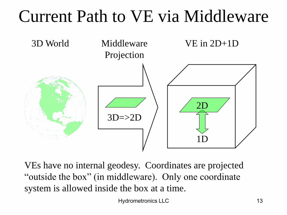
Current Path to VE via Middleware
3D World
VEs have no internal geodesy. Coordinates are projected
“outside the box” (in middleware). Only one coordinate
system is allowed inside the box at a time.
Middleware
Projection
3D=>2D
2D
1D
VE in 2D+1D

Hydrometronics LLC 14
Proposed Path to VE via ECEF
ECEF
3D World VE in true 3D
If ECEF coordinates are chosen in middleware, the VE
“sees” the world in 3D without any mapping distortions. If
ECEF coordinates in WGS84 are chosen, then projects
throughout the world will fit together seamlessly.

Hydrometronics LLC 15
EPSG Coordinate System Primer
1. Geographical 2D (lat/lon) and Geographical 3D
(lat/lon/height with respect to the ellipsoid)
2. Vertical (elevation or depth w.r.t. the geoid)
3. Projected (mapping of an ellipsoid onto a plane)
4. Engineering (local “flat earth”)
5. Geocentric Cartesian (Earth-Centered Earth-Fixed)
6. Compound (combinations of the above)

Hydrometronics LLC 16
Geographical CS: lat/lon/(height)
A graticule of curved
parallels and curved
meridians (latitudes
and longitudes)
intersect orthogonally
on the ellipsoid.
Height is measured
along the normal, the
straight line
perpendicular to the
ellipsoid surface.
Hydrometronics LLC 17
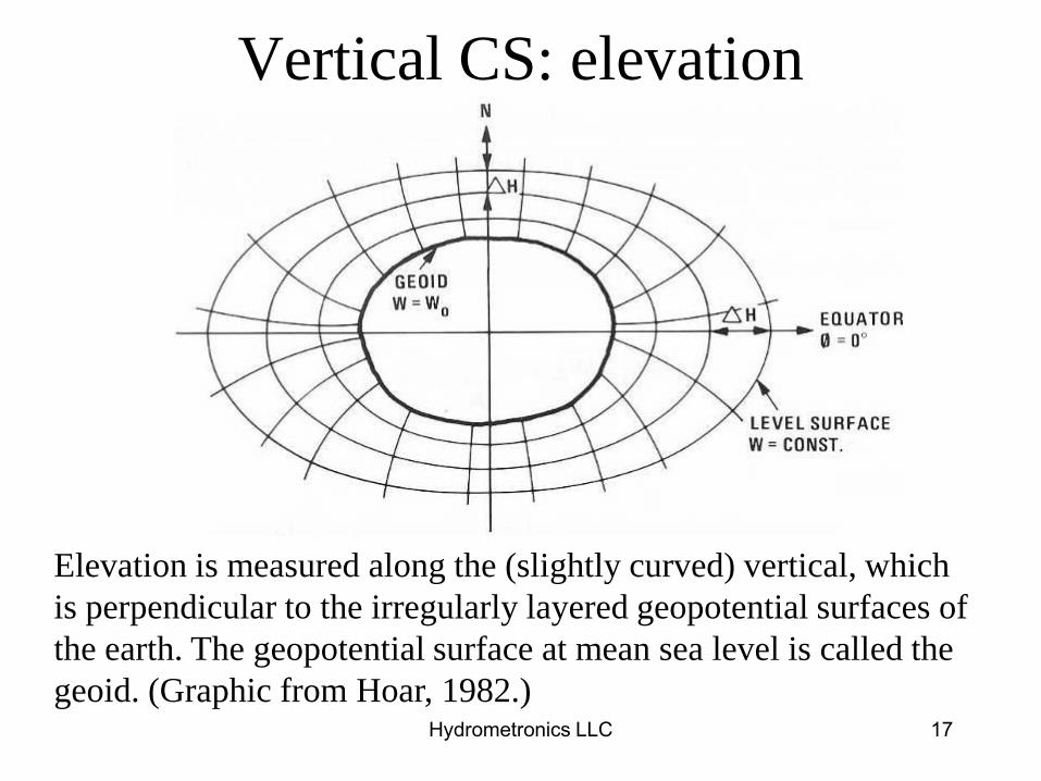
Vertical CS: elevation
Elevation is measured along the (slightly curved) vertical, which
is perpendicular to the irregularly layered geopotential surfaces of
the earth. The geopotential surface at mean sea level is called the
geoid. (Graphic from Hoar, 1982.)

Hydrometronics LLC 18
• Map projections of an ellipsoid onto a plane
preserve some properties and distort others
– Angle - and local shapes are shown correctly on
conformal projections
– Area - correct earth-surface area (e.g., Albers)
– Azimuth - can be shown correctly (e.g., azimuthal)
– Scale - can be preserved along particular lines
– Great Circles - can be straight lines (Gnomonic)
– Rhumb Lines - can be straight lines (Mercator)
• Rule of thumb: map distortion distance2
Projected CS: Northing/Easting

Hydrometronics LLC 19
Globular projection Orthographic projection
Stereographic projection Mercator projection
Projected CS Distorts
Rule of thumb: map distortion distance2

Hydrometronics LLC 20
Our project extracted from
a cubical, flat earth
Our project extracted
from an ellipsoidal earth
Engineering CRS (“Flat-Earth”)
Hydrometronics LLC 21
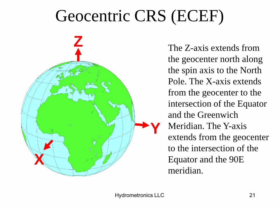
Geocentric CRS (ECEF)
The Z-axis extends from
the geocenter north along
the spin axis to the North
Pole. The X-axis extends
from the geocenter to the
intersection of the Equator
and the Greenwich
Meridian. The Y-axis
extends from the geocenter
to the intersection of the
Equator and the 90E
meridian. X
Z
Y

Hydrometronics LLC 22
Coordinate Conversion
• The mathematics of map projections
(3D=>2D) are complicated (especially TM)
and generally valid over limited extents
• The mathematics of converting Geographical
CS coordinates to ECEF Geocentric CS
(3D=>3D) are simple and valid the world over
Hydrometronics LLC 23
So, Why ECEF?
• ECEF is the geodetic CS native to a 3D VE
• ECEF in a 3D VE is a globe in your hands
• Given the proper perspective (turning the
globe), ECEF coordinates have no distortion
• ECEF is scalable from plates to pores
• No geodetic “smarts” are required in the VE

Hydrometronics LLC 24
North America in VE

Hydrometronics LLC 25
U.S.G.S. Coastline Culture
Excerpts in Geographical and ECEF
Geographical CS (height = 0)
longitude latitude
NaN NaN
-50.027484 0.957509
-50 0.99249
NaN NaN
-59.708179 8.277287
-59.773891 8.310143
-59.905313 8.462687
NaN NaN
-57.060949 5.791989
-57.117273 5.90229
-57.161863 6.066569
-57.272164 6.26605
-57.391853 6.308293
-57.546744 6.442062
Geocentric CS (ECEF)
X Y Z
NaN NaN NaN
4096874.92 -4887224.49 105871.03
4099176.47 -4885208.29 109738.48
NaN NaN NaN
3183867.68 -5450322.48 912137.99
3177350.79 -5453517.54 915733.77
3163599.63 -5458662.31 932424.41
NaN NaN NaN
3450502.62 -5325702.36 639376.55
3444590.92 -5328048.22 651510.81
3439416.28 -5329135.93 669578.81
3427869.60 -5333753.93 691511.19
3416444.41 -5340472.04 696154.65
3401113.29 -5348302.30 710856.40

Hydrometronics LLC 26
Translation & Rotation:
ECEF to Topocentric • A journey back to Projected CS because …
• … some users may prefer their data referenced to their
local area of interest
• ECEF can easily be translated and rotated to a
topocentric reference frame
• This conversion is conformal,
it preserves the distortion-free curvature of the earth,
and the computational burden is small
• VEs already do something similar to change the
viewing perspective

Hydrometronics LLC 27
EPSG Graphic of Topocentric

Hydrometronics LLC 28
GOM in Topocentric Coordinates
-1
-0.5
0
0.5
1
x 106
-1
-0.5
0
0.5
1
x 106
-15-10-50
x 104
East
GOM in Topocentric Coordinates
North
Vert
ical

Hydrometronics LLC 29
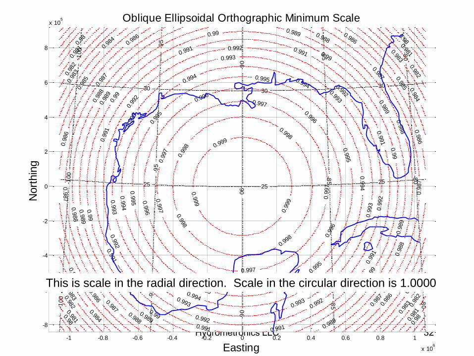
Topocentric to Orthographic
• Continuing the journey
• The orthographic projection is the view from space,
e.g. our view of the moon
• Topocentric without the W vertical coordinate
(3D=>2D) is the Orthographic projection
• The ellipsoidal Orthographic projection is a bona fide
map projection with quantifiable distortions
intermediate between our usual 2D+1D paradigm and
a new topocentric / ECEF 3D paradigm

Hydrometronics LLC 30
Orthographic Projection of the Moon

Hydrometronics LLC 31
Orthographic Projection of GOM
-1 -0.8 -0.6 -0.4 -0.2 0 0.2 0.4 0.6 0.8 1
x 106
-8
-6
-4
-2
0
2
4
6
8
x 105
20 2020
25 2525
30 3030
-100
-100
-100
-95
-95
-95
-90
-90
-90
-85
-85
-85
-80
-80
-80
Easting
Nort
hin
g
Graticule on Orthographic
Hydrometronics LLC 32 -1 -0.8 -0.6 -0.4 -0.2 0 0.2 0.4 0.6 0.8 1
x 106
-8
-6
-4
-2
0
2
4
6
8
x 105
20 2020
25 2525
30 3030
-100
-100
-100 -9
5-9
5-9
5
-90
-90
-90
-85
-85
-85
-80
-80
-80
0.98
0.98
0.98
0.98
0.981
0.98
10.981
0.98
10.982
0.98
2 0.982
0.98
2
0.983
0.98
30.983
0.98
3
0.984
0.98
4
0.9
84
0.98
4
0.9
85
0.98
5 0.985
0.98
5
0.986
0.986
0.9
86
0.986
0.9
86
0.98
6
0.987
0.9
87
0.98
70.987
0.9
87
0.98
7
0.988
0.9
88
0.98
8
0.988
0.9
88
0.9
88
0.989
0.9
89
0.98
9
0.989
0.989
0.9
89
0.989
0.99
0.9
9
0.99
0.99
0.99
0.9
9
0.99
0.991
0.9
91
0.9
91
0.991 0.991
0.9
91
0.99
1
0.991
0.99
2
0.992
0.992
0.9
92
0.992
0.992
0.9
92
0.99
3
0.993
0.993
0.9
93
0.9930.993
0.9
93
0.9940.994
0.9
94
0.994
0.994
0.9
94
0.99
5
0.995
0.9
95
0.99
5
0.995
0.9
95
0.996
0.996
0.9
96
0.996
0.9
96
0.9
97
0.997
0.9
97
0.997
0.9
97
0.99
8
0.998
0.998
0.998
0.999
0.9
99
0.9
99
Easting
Nort
hin
g
Oblique Ellipsoidal Orthographic Minimum Scale
This is scale in the radial direction. Scale in the circular direction is 1.0000

Hydrometronics LLC 33
Our Journey Schematically
Proj 2D+1D
Northing
Easting
Elevation
1 / Proj
Geog 2D+1D
Latitude
Longitude
Elevation
EGM
Geog 3D
Latitude
Longitude
Height
Geocen 3D
X
Y
Z
EC
EF
Topocen 3D
U
V
W
Orthographic
Northing
Easting
(Vertical)
U=E, V=N Δ + Θ
All the undistorted curvature
of the Earth in a 3D VE

Hydrometronics LLC 34
Our Journey Schematically
Proj 2D+1D
Northing
Easting
Elevation
1 / Proj
Geog 2D+1D
Latitude
Longitude
Elevation
EGM
Geog 3D
Latitude
Longitude
Height
Geocen 3D
X
Y
Z
EC
EF
Topocen 3D
U
V
W
Orthographic
Northing
Easting
(Vertical)
U=E, V=N Δ + Θ
All the undistorted curvature
of the Earth in a 3D VE
Hydrometronics LLC 35
Summarizing
• Cartography (2D) is distorted; geodesy (3D) is not
• Not all 3D presentations are ECEF (geodesy)
• Geodetically “unaware” visualization environments
(VE) present an opportunity
• Coordinate Reference System (CRS) primer
• Earth-Centered Earth-Fixed (ECEF)
• Topocentric coordinates (a “flavor” of ECEF)
• Orthographic coordinates (2D topocentric)

Hydrometronics LLC 36
Conclusion
• The real world is 3D
• New visualization environments are 3D
• Why incur the distortions of a 2D map
projection entering real-world data into a VE?
• ECEF, topocentric and orthographic
coordinates are a paradigm shift in the way
we view our data, a perspective that may
extract new information
• It’s time for ECEF!
Hydrometronics LLC 37
More Information
• This presentation can be downloaded at
www.hydrometronics.com
• There is a ECEF Group on LinkedIn
• Guidance Note 7-2 at www.epsg.org
• Wikipedia (search ECEF)
• World coastlines are available at www.ngdc.noaa.gov/mgg/shorelines/shorelines.html

Hydrometronics LLC 38
Extra Slides

Hydrometronics LLC 39
Mini Bio of Noel Zinn
• Noel Zinn began Hydrometronics LLC in 2010 as a technical software consultancy
• Geodesist for ExxonMobil in the Naughties
• Navigation Scientist for Western Geophysical in the Nineties
• Surveyor for NCS International in the Eighties
• Navigator for Delta Exploration (Singapore) in the Seventies
• Peace Corps Volunteer in India in the Sixties
• Studied at the University of California (Berkeley) and the University of Houston

Hydrometronics LLC 40
Geographical to ECEF Coordinates
Given the ellipsoid semi-major axis (a) and flattening
(f), and latitude (), longitude (), and height (h)
21
22 )sin1(
e
a
sincos)( hY
sin))1(( 2 heZ
coscos)( hX
faab 2222 )( abae

Hydrometronics LLC 41
ECEF to Geographical Coordinates
Given ellipsoid a and f, and X, Y and Z Cartesians
faab 2222 )( abae 2222 )(' bbae
21
22 )sin1(
e
a
2122 )( YXp )(tan 1
bp
aZ
32
321
cos
sin'tan
aep
beZ
)(tan 1
X
Y
)cos( ph

Hydrometronics LLC 42
U.S.G.S. Coastline Culture
Excerpts in ECEF and Topocentric
Topocentric
U-East V-North W-Up
NaN NaN NaN
4883291.81 -2534277.49 -3159278.92
4885208.29 -2529781.65 -3158620.16
NaN NaN NaN
4081936.14 -2375003.57 -2094765.47
4076073.08 -2374998.99 -2089176.88
4063424.20 -2367004.86 -2072737.89
NaN NaN NaN
4322880.24 -2475302.15 -2399575.74
4317465.71 -2468151.60 -2389219.87
4312558.56 -2455576.85 -2376097.067
4301989.21 -2442987.79 -2356979.39
4291904.18 -2444958.68 -2347406.64
4278165.68 -2440364.45 -2330009.96
Geocentric CRS (ECEF)
X Y Z
NaN NaN NaN
4096874.92 -4887224.49 105871.03
4099176.47 -4885208.29 109738.48
NaN NaN NaN
3183867.68 -5450322.48 912137.99
3177350.79 -5453517.54 915733.77
3163599.63 -5458662.31 932424.41
NaN NaN NaN
3450502.62 -5325702.36 639376.55
3444590.92 -5328048.22 651510.81
3439416.28 -5329135.93 669578.81
3427869.60 -5333753.93 691511.19
3416444.41 -5340472.04 696154.65
3401113.29 -5348302.30 710856.40

Hydrometronics LLC 43
U.S.G.S. Coastline Culture Excerpts
in Topocentric and Orthographic
Orthographic
Easting Northing
NaN NaN
4883291.81 -2534277.49
4885208.29 -2529781.65
NaN NaN
4081936.14 -2375003.57
4076073.08 -2374998.99
4063424.20 -2367004.86
NaN NaN
4322880.24 -2475302.15
4317465.71 -2468151.60
4312558.56 -2455576.85
4301989.21 -2442987.79
4291904.18 -2444958.68
4278165.68 -2440364.45
Topocentric
U-East V-North W-Up
NaN NaN NaN
4883291.81 -2534277.49 -3159278.92
4885208.29 -2529781.65 -3158620.16
NaN NaN NaN
4081936.14 -2375003.57 -2094765.47
4076073.08 -2374998.99 -2089176.88
4063424.20 -2367004.86 -2072737.89
NaN NaN NaN
4322880.24 -2475302.15 -2399575.74
4317465.71 -2468151.60 -2389219.87
4312558.56 -2455576.85 -2376097.067
4301989.21 -2442987.79 -2356979.39
4291904.18 -2444958.68 -2347406.64
4278165.68 -2440364.45 -2330009.96
Recommended

![Universality in the 2D Ising model and conformal …smirnov/papers/universality-j.pdfUniversality in the 2D Ising model 517 dent Ising proved [19] in his PhD thesis the absence of](https://img.pdfslide.us/doc/110x75/5e5ab8ecd0f0bc3b3956d704/universality-in-the-2d-ising-model-and-conformal-smirnovpapersuniversality-jpdf.jpg)