×
Log in
Upload File
Most Popular
Art & Photos
Automotive
Business
Career
Design
Education
Hi-Tech
+ Browse for More
Download pdf -
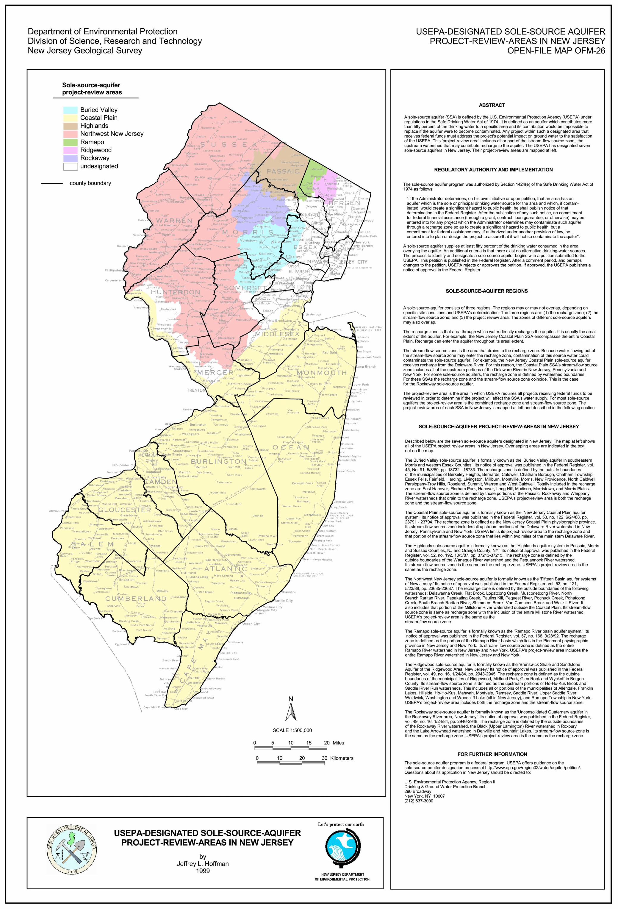
NJDEP - NJGS - Open-File Map OFM 26, USEPA-Designated Sole ... · New Brun wick at h iver. IDDLÉ£k mete 5 *tands Snght onrr.outn _ ang Branch Jamest.urg f*legns S,prln Pininsborc
Download pdf
Transcript
Page 1
Recommended
NJDEP - NJGS - TM 88-5, Seismic refraction and electrical resistivity
Documents
NJDEP - NJGS - Geology of Burlington County in Brief
Documents
NJDEP - NJGS - GSR 39 Ground-Water Quality in the Bedrock Aquifers of the Highlands and
Documents
A reJ u pi tandS l sohomepage.physics.uiowa.edu/~spangler/2952_10/Lec27.pdf · Recall basic facts about Saturn •Further from the Sun than Jupiter (a =9.54 au) •Systematically
Documents
NJDEP - NJGS - Geologic Map Series 88-3, Geologic Map Of ...NJDEP - NJGS - Geologic Map Series 88-3, Geologic Map Of The Mendham Quadrangle, Morris County, New Jersey Author: Richard
Documents
NJDEP - NJGS - New Jersey Rocks and Sediments, 1996 (rev ...Title: NJDEP - NJGS - New Jersey Rocks and Sediments, 1996 (rev. 1998, 2005) Author: John H. Dooley and David P. Harper
Documents
NJDEP - NJGS - Bulletin 60. Short Geologic Papers, 1951
Documents
NJDEP - NJGS - Open-File Map OFM 42, Surficial Geology of
Documents
NJDEP - NJGS - Open File Map OFM 27, Environmental …DEPARTMENT OF ENVIRONMENTAL PROTECTION DIVISION OF SCIENCE, RESEARCH AND TECHNOLOGY NEW JERSEY GEOLOGICAL SURVEY INTRODUCTION
Documents
NJDEP - NJGS - Open-File Map OFM 12, Abandoned Mines … · Title: NJDEP - NJGS - Open-File Map OFM 12, Abandoned Mines Of New Jersey Author: New Jersey Geological Survey Staff Keywords:
Documents
IS u An.d~y> Diane Are Prln,eS·Ses · 2019-10-28 · Authoruid KffPiO~• J,:.,;-tltn_n,qy b.l11td I~~ Yellow : PoitL Vbli °"• r,; ~"' oieo - _ oncl d>ooso irom ~-bto1111· ful
Documents
NJDEP - NJGS - Open-File Map OFM 24, Aquifers Of New · PDF fileMap unit only depicts Marshalltown Formation. ... and the Marcellus Shale ... NJDEP - NJGS - Open-File Map OFM 24,
Documents
NJDEP - NJGS - Geology of Mercer County in Brief
Documents
RE/MAX S TANDS FOR R EAL E STATE MAX IMUMS MAXIMUM Experience MAXIMUM Market Exposure MAXIMUM Service
Documents
STEEL TRUSS TYPE E (50 FT - 140 FT) - …mdotcf.state.mi.us/public/tands/Details_Web/sign-360-a.pdfChord splice column \ Right ... DESIGN DIVISION DIRECTOR, BUREAU OF FIELD SERVICES
Documents
FPS1xl EL/GG - Salamander Designs OLE ECTIVE LA TANDS ... FPS1XL/EL/GG E479586. T )S\L/PSSZ(]L )SVVTÄLSK *; ... Horizontal - 400, 600mm, 800mm, 1000mm, 1200mm
Documents
NJDEP - NJGS - Geology of Morris County in BriefTitle: NJDEP - NJGS - Geology of Morris County in Brief Author: Carol S. Lucy Created Date: 4/14/2009 10:35:01 AM
Documents
NJDEP - NJGS - Open-File Map OFM 28, Surficial Geology Of
Documents


![FPS1xl EL/GG - Salamander Designs OLE ECTIVE LA TANDS ... FPS1XL/EL/GG E479586. T )S\L/PSSZ(]L )SVVTÄLSK *; ... Horizontal - 400, 600mm, 800mm, 1000mm, 1200mm](https://img.pdfslide.us/doc/110x75/5b037bd77f8b9a0a548c3c02/fps1xl-elgg-salamander-designs-ole-ective-la-tands-fps1xlelgg-e479586.jpg)