t
t
t
t
t
t
t
t
t
t
t
t
t
t
t
t
t
t
t
t
t
t
t
t
t
t
t
t
t
t
t t
t
t
t
t
t
t
t
t
t
t
t
t
t
t t
t
t
t
tt
t
t
t
t
t
t
t
t
t
t
t t
t
t
t
t
t
t
t
t
t
t
t
t
tt
t
t
tt
t
t
t
t
t
tt
t
t
t
t
t
t
t
t
t
t
t
t
t
t
t
t
t
t
t
t
t
t
t
t
t
t
t
t
!n
!n
!n
!n
!n
!n
!n
!n
!n
!n
!n
!o
!o
!o
!o
4800-00
3904-00
2202-00
4803-00
3906-00
3004-00
3900-00
4802-004016-01
4800-04
3903-00
2203-00
3005-01
4801-00
3001-00
4703-05
4803-01
4000-61
4704-00
4703-02
3006-00
4800-01
2207-00
4802-02
4802-05
4703-00
2202-08
3004-05
2202-04
4703-01
4710-04
4802-07
2202-05
4801-04
4802-01
3006-05
2201-00
4800-06
4802-03
3006-01
3900-09
3906-05
3906-03
4802-04
4800-08
3001-03
2205-00
3906-08
4800-13
3904-03
4802-08
4710-00
4800-15
4800-09
3004-04
3906-01
3005-04
3903-03
2202-07
3900-01
2203-02
4016-09
4800-10
3001-06
4800-14
3906-02
3906-07
3906-10
3006-03
3006-04
3904-04
4800-07
2202-03
2202-02
4702-00
3001-02
4801-01
4800-11
3004-01
4016-05
3900-07
3006-09
4801-02
2202-06
4016-08
4802-06
3904-05
4801-03
4800-02
4016-06
3001-01
3900-08
3906-04
2203-01
3902-00
2202-09
4800-17
3001-04
4703-03
4703-04
4800-05
4000-60
3900-05
3903-04
3906-06
3900-02
4800-12
4710-02
3903-05
4800-03
4020-01
2202-11
3006-06
3906-09
3004-02
3004-03
3006-07
4016-07
4016-04
3904-01
4016-02
3900-03
4800-16
4016-03
2202-12
2202-01
3006-08
2201-01
3900-04 3907-003903-02
4000-00
2202-10
3904-02
3000-12
Oakdale
North Lyme
Fitchville
Chesterfield
Four Corners
Brockway Landing
Montville Center
S A L E M
L Y M E
M O N T V I L L E
B O Z R A HC O L C H E S T E R
E A S T L Y M E
L E B A N O N
Ladd Hill
Long Hill
Bear Hill
Mill Hill
Great Hill
Honey Hill
Ridge Hill
Sharp Hill
Lynch Hill
Scott Hill
Halls Hill
Brush Hill
Toad Hollow
Shippy Hill
Haines Hill
Grassy Hill
Morgan Hill
Pigeon Hill
Dolbia Hill
Chapel Hill
Cockle Hill
Bashon Hill
Pequot Ledge
Mount Archer
Konomoc Hill
Maynard Hill
Forsyth Hill
Buckley Hill
Beckwith Hill
Comstock Hill
Prospect Hill
Minnie Island
Chapman Ridge
Nickerson Hill
Barnville Hill
Candlewood LedgeCandlewood Ledge
Rattlesnake Ledges
Odd Pond
Fox Brook
Big Brook
Zemko Dam
Spot Pond
Post Pond
Mill Pond
Lodi Pond
Levy Pond
Kent Pond
Kent Pond
Pine Brook
Pine Brook
Neck Brook
Kahn BrookJudd Brook
Deep River
Deep River
Wedge Pond
Urban Pond
Upper Pond
Beaver Dam
Tadma Pond
Stula Pond
Smith Pond
Sharp Pond
Savin Lake
Paris Pond
Mazer Pond
Lucky PondLower Pond
Horse Pond
Hales Pond
Fairy Lake
Davis Pond
Cedar Lake
Dark Swamp
Tadma Brook
Round Brook
Polly Brook
Polly Brook
Muddy Brook
Hunts Brook
Hedge Brook
Gager Brook
Early Brook
Cabin Brook
Bogue Brook
Wagner Pond
Powers Lake
Parker Pond
Narwid Pond
Martin Pond
Lake Cuheca
Harvey Pond
Gilman Pond
Dodson Pond
Darrow Pond
Cotten Pond
Browns Pond
Amoeba Pond
Great Swamp
Yantic River
Yantic River
Sucker Brook
Nelkin Brook
Meadow Brook
Little Brook
Joshua Creek
Harris Brook
Goshen Brook
Fraser Brook
Beaver Brook
Beaver Brook
Austin Brook
Wheeler Pond
Urbanik Pond
Toupass Pond
Sherman Pond
Pizzini Pond
Oxoboxo Lake
Oakdale Pond
Morgans Pond
Machnik Pond
Lake Konomoc
Lake Hayward
Kellems Pond
Hibbard Pond
Hedlund Pond
Getzoff Pond
Gardner Lake
Darling Pond
Bingham Pond
Silver Falls
Dutton Swamp
Whittle Brook
Strongs Brook
Sherman Brook
Sherman Brook
Pheneys Brook
Pearson Brook
Oxoboxo Brook
Latimer Brook
Hemlock Brook
Gardner Brook
Standish Pond
Rockland Pond
Mitchell Pond
McDonald Pond
Ed Bills Pond
Dubinski Pond
Denisons Pond
Beckwith Pond
Chapman Falls
Standish Brook
McAlpine Brook
Governor Brook
Gillette Brook
Gillette Brook
Fourmile River
Driscoll Brook
Burnhams Brook
Brainard Brook
Red Cedar Lake
Papermill Pond
Cranberry Pond
Bond Reservoir
Ariewitzs Pond
Alexander Pond
McDonald Swamp
Eightmile River
Eightmile River
State Shad Pond
Scholfield Pond
New London Pond
Fitchville Pond
Blackwells Pond
Malt House Brook
Lakes Pond Brook
Cedar Pond Brook
Fish & Game Lake
Fire Street Pond
Byron Clark Pond
Barnes Reservoir
Whittlesey Swamp
Horse Pound Brook
Deep Hollow Brook
E.A. Whitford Dam
Silver Falls Pond
Shingle Mill Pond
Pecks Meadow Pond
Joshua Creek Pond
Witch Meadow Brook
Trading Cove Brook
Shingle Mill Brook
Roaring Brook No 2
McAlpine Brook Dam
Thousand Acre Pond
Fourmile Pond No 1
Willys Meadow Brook
William Buckler Dam
Mineral Spring Brook
Fish & Game Dam No 1
Deep River Reservoir
Stony Brook Reservoir
Pine Meadow Park Pond
Bogue Brook Reservoir
Cranberry Meadow Brook
East Branch Eightmile River
Gager FieldAirport
Gardner LakeAirport
Skis Landing AreaAirport
Devils Hopyard FieldAirport
Salem School
Bacon Academy
Oakdale School
Leonard J Tyl Middle
Montville High School
Fields Memorial School
Lyme Consolidated School
Dr Charles E Murphy School
Colchester Elementary School
William Johnston Middle School
300
200
400
100
500
600
400
300
400
200
300
500
500
100
500
500
300
200
500
400
200
500
400
300
400
300
300
400
200
500
200
300
400
400
600
300
400
400
400
400
40040
0
400
500
400
300
400
300
100
500
400
400
200
500
400
300
500
500
300500
400
400
400
100
300
300
100
500
400
400
400
400
300
400
500
100
400
400
400
300
300
300
400
400
400
300
300
100
200
400
300
200
300
400
400
500
400
300
300
600
500
400
200
500
400
600
300
400
500
300
400
400
200
500
400
400
300
400
500
300
100
200
300
400
500
400
500
300
400
300
300
300
300
400
200
300
200
300
400
200
300
300
100
400
400
300
400
100
400
400
400
300
500
400400
300
200
300
200
400
100
300
200
200
500
100
300
300
400
400
100
400
400
200
400
400
400
100
300
300
100
300
400
300
100
300
200
300
600
200
400
300
500500
500
400
500
400
400
500
500
200
400
400
500
400
500
400
300
300
100
400
500
200
300
500
400
300
200
400
300
200
400
400
400
400
200
200
300
500
400
200
400
100
500
500
300
200
400
500
400
500
400
400
300
400
300
300
100
200
200
400400
400
500
500
300
300
300
400
300
300
400
400
100
400
400
400
200
300
400
300
300
500
300
400
500
400
400
300
500
300
100
400
200
400
300
400
400
200
300
500
200
100
200
300
100
500
300
500
400
400
300
500
200
300
400
300
400
400
400
400
100
500
500
300
400
400
300
400400
State Hwy 85
State Hwy 82
State Hwy 2
West Rd
State Hwy 11
Norwich Ave
State Hwy 163
Route
163
State Hwy 354
I 395
Fire St
Bozrah St
Hartford New London Tpke
State Hwy 16
Hopy
ard R
d
South Rd
Route 82
Tater
Hill R
d
Hartford Rd
Norwich Colchester Rd
Forsyth Rd
Parum Rd
Route 85
Fitchville Rd
Norwich Salem Rd
Route 156 Gu
ngy R
d
Hamb
urg R
d
Chesterfield Rd
Plains
Norwich Rd
Haddam Tpke
Haddam Rd
Raymond Hill Rd
Middletown Rd
Bishop Rd
Devils
Hopy
ard Rd
Norwich
Tpke
State
Hwy 1
56
New London Rd
Butlertown Rd
Scott
Hill R
d
Wick
ham
Rd
Beaver Brook Rd
Oakdale Rd
Darling Rd
Turner Rd
McDonald Rd
Shore Dr
Hartford Tpke
CH Hill Rd
State Hwy 161
Tater Hill Road NO 1
Gager Rd
Witter R
d
Norwich Salem Tpke
Joshuatown Rd
Old Colchester Rd
Keen
y Rd
Chestnut Hill Rd
Cherr
y Ln
Hough Rd
Haywardville Rd
Bashon Hill Rd
Marvin Rd
Taylor Rd
Buckley Hill Rd
Norwich Colchester Tpke
Bulkeley Hill Rd
Clark Hill Rd
Lake Rd
Buckley Rd
Cabin Rd
Heilwield Rd
Chapel Hill Rd
Black Ash Rd
Wawecus Hill Rd
Carol
ine R
d
Giffor
d Ln
Holmes Rd
Beebe Rd
Salem Rd
Miles
Stan
dish R
d
Ridge Hill Rd
Clark Rd
Baker
Ln
Lake
Hayw
ard Rd
Lake Shore Dr
Round Hill Rd
Mitch
ell Rd
Salem Turnpike Rd
Geoffrey Rd
Brush Hill Rd
Ackley Rd
Oxoboxo Dam Rd
Grassy Hill Rd
Doyle
Rd
Geer Rd
Oxoboxo Brook Rd
Standish Rd
Brainard Rd
Stanavage Rd
Whistle Town Rd
Main St
Mitchell Hill Rd
Lebanon A
ve
Honey Hill Rd
Way Rd
Cato Corner Rd
Old Salem Rd
Pruett Pl
Sheepskin Hollow Rd
Early Rd
Rattlesnake Ledge Rd
Baker Rd
Kram
er Rd
Walden Rd
Governor John Davis Lodge Tpke
Route
161
Mount Archer Rd
Pease Rd
Foxtown Rd
Nelkin
Rd
Stockhouse Rd
Flanders Rd
Walnut Hill Rd
Warner Rd
Deep River Rd
Lynch Rd
Simpson Ln
Davidson Rd
Rathbun
Hill Rd
Pinebrook Rd
Music Vale Rd
Blue H
ill Rd
Mill Rd
Florid
a Rd
Douglas Ln
Bozra
h Rd
Town Rd
Prospect Hill Rd
Old Hartford Rd
Hedlund Rd
Mill Hill R
d
Sisso
n Rd
Moxle
y Rd
Daniel Peck Rd
Wall St
Noble
Hill R
d
Camp M
owee
n Rd
Mill Ln
Hunts
Broo
k Rd
Mount Parn
assus
Rd
Randall Rd
Tantum
orantu
m Rd
Millington Rd
Lakeside Dr
A P Gates Rd
Salem Tpke
Pires
Dr
Goshen Rd
Hagen Rd
Red School Rd
Dutton Rd
Triba
l Trl
Harris Rd
School Rd
Sharp Hill Rd
Fellows Rd
Oconnell Rd
Morgan Rd
White Birch
Rd
Jones Hill Rd
Gillettes Ln
Essex Tpke
Resevoir Rd
Schulman Veslak Rd
Ocon
nell R
oad E
xt
Elliot Dr
Babcock Rd
Wildwood Rd
Williams R
d
Cardinal Rd
Stanton Rd
Valley Dr
Spruc
e Ln
Hall Kilbourne Rd
Foxtown Cemetery Rd
Way Hill Rd
Lathrop Grv
Fores
t Dr
Linwood Cemetery Rd
Fargo
Rd
Lynn S
t
Mostowy Rd
Skinner Rd
Cirillo
Dr
Congdon Rd
Carrier Rd
Shadbush Dr
Oriole Rd
Mill St
Roger Foot Rd
Sullivan Rd
Joy Ln
Old Rod Rd
Gay Hill R
d
Oxoboxo Cross Rd
Alexander Rd
Clark Ln
Stonewall Rd
Cockle Hill Rd
Fedus Rd
Mill Lane Rd
Day Rd
Park A
ve
Ackle
y Cem
etery
Rd
Hi Lea Farm Rd
Jan Dr
Beck
with
Rd
Cottage Rd
4WD
Road
Skyline Dr
Oil M
ill Rd
Olmstead Rd
Daniel Dr
Dubois Rd
Industrial Dr
Maple Ave
Woodchuck Rd
Bozrah Street Ext
Lakes
Pond Rd
Broadway St
Van Cedarfield Rd
Carol Dr
Horse Pond Rd
Carli Blvd
Wahconah Dr
Joshu
a Ln
Church Rd
MacInto
sh Rd
Greentree Dr
Haug
hton R
d
Ridgewood Rd
Brockw
ay Fe
rry Rd
Thorn
ridge
Dr
Debi Cir
Town Farm Rd
Daisy Hill Dr
Chestnut Dr
Piekarz Rd
Oak Hill Rd
Lookout Dr
Fox Rd
Gilman Rd
Stula Ln
Old Hebron Rd
Colburn Dr
Sash
el Ln
Winterbe
rry Dr
Corrina Ln
Three Bridges Rd
Leita
o Dr
David Dr
Grabner Dr
Thomas Rd
Peter
s Rd
Heatherwood Dr
Alexander Dr
Ed Williams Rd
Shugrue Rd
Ventura Dr
Lync
h Hill R
d
Starw
ood T
rl
Hill Farms Rd
Lynn Ln
Fitch H
ill Rd
Upton
Rd
Florida Dr
Ortega Dr
Rene
Dr
Wood
bine R
d
Jodry St
Brownin
g Rd
Quinl
ey W
ay
Woodman Ave
Fairy Lake Rd
Hill Top Trl
Birch Ter
Laure
lwood
Dr
Salem Ridge Dr
Laurel Point Dr
Knickerbocker Ave
Maiville Dr
Oak R
dg
Brookside Dr
Faulkner Dr
Fawn Run
Helon Cone Rd
Honey Hill L
n
Evergreen Ln
Diane Ln Settle
rs Ln
Beck
with
Hill D
r
Enid Ln
Meadow Dr
Briarcliffe Rd
Maclyn D
r
Rosemarie Ln
Cherry Tree Rd
Goulart Dr
Tavern Ln
Fox Hollow Dr
Idaho
St
Robin
Randy
Ln
Sunset Hill Rd
Cranberry Dr
Shady Brook Ln
Massachusetts Rd
Diamond Hill Rd
Mary Ln
Rocco Dr
Lake View Ave
Cobb
le Wa
y
Esther L
n
Beech Pl
River Rd
Chapman Dr
Cragmere Rd
Maynard Rd
Salem Hollow Ln
Fores
t Way
East Ln
Courtney Ter
Sparrow Ct
Park Rd
Boat
Launc
h Acce
ss Rd
Pheasant Hill Rd
Mountain View Rd
Fett Rd
Darrows Ct
Elyse
Ln
Hillside Rd
Brush
Hill R
d
Ventu
ra Dr
I 395
Old Colchester Rd
Salem Tpke
Route 82
Scott
Hill R
d
Dutton Rd
Piekarz Rd
Caroline Rd
Mill Ln
Salem Rd
Mill Ln
Scott Hill Rd
Mill Ln
State Hwy 2
Lake
Rd
Lake Rd
Deep River Rd
New London Rd
Exit 5
Exit 21
Exit 4
Exit 22
Exit 24
Exit 77
Exit 18
Exit 23
Exit 6
Exit 20
Exit 21
Exit 23
§̈¦395
SV11
SV2
SV163
SV82
SV85
SV156
SV16
Jack Jackter Intermediate School
64 3
5
7
122
8
8
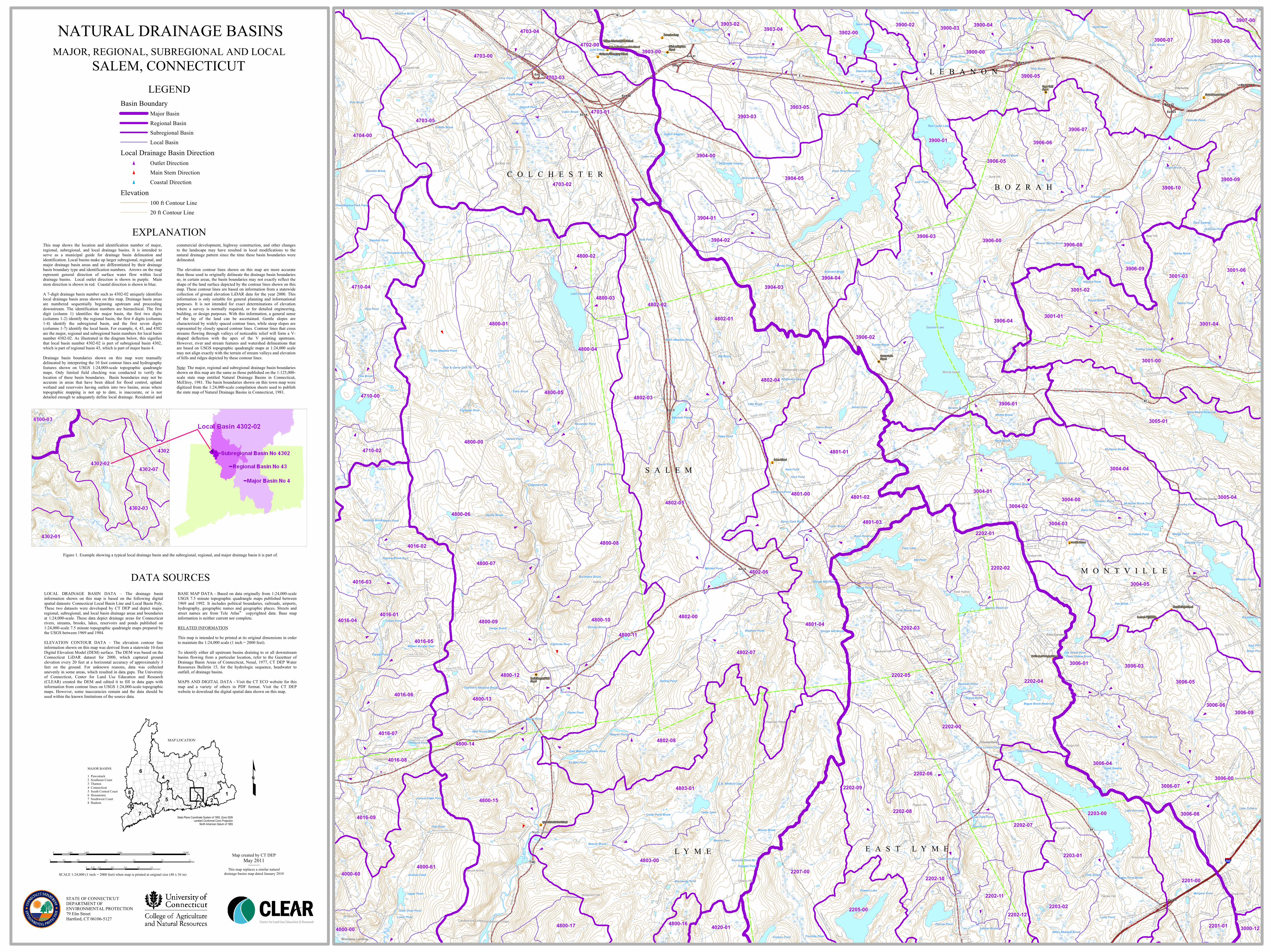
EXPLANATIONThis map shows the location and identification number of major,regional, subregional, and local drainage basins. It is intended toserve as a municipal guide for drainage basin delineation andidentification. Local basins make up larger subregional, regional, andmajor drainage basin areas and are differentiated by their drainagebasin boundary type and identification numbers. Arrows on the maprepresent general direction of surface water flow within localdrainage basins. Local outlet direction is shown in purple. Mainstem direction is shown in red. Coastal direction is shown in blue.A 7-digit drainage basin number such as 4302-02 uniquely identifieslocal drainage basin areas shown on this map. Drainage basin areasare numbered sequentially beginning upstream and proceedingdownstream. The identification numbers are hierarchical. The firstdigit (column 1) identifies the major basin, the first two digits(columns 1-2) identify the regional basin, the first 4 digits (columns1-4) identify the subregional basin, and the first seven digits(columns 1-7) identify the local basin. For example, 4, 43, and 4302are the major, regional and subregional basin numbers for local basinnumber 4302-02. As illustrated in the diagram below, this signifiesthat local basin number 4302-02 is part of subregional basin 4302,which is part of regional basin 43, which is part of major basin 4.
Drainage basin boundaries shown on this map were manuallydelineated by interpreting the 10 foot contour lines and hydrographyfeatures shown on USGS 1:24,000-scale topographic quadranglemaps. Only limited field checking was conducted to verify thelocation of these basin boundaries. Basin boundaries may not beaccurate in areas that have been diked for flood control, uplandwetland and reservoirs having outlets into two basins, areas wheretopographic mapping is not up to date, is inaccurate, or is notdetailed enough to adequately define local drainage. Residential and
commercial development, highway construction, and other changesto the landscape may have resulted in local modifications to thenatural drainage pattern since the time these basin boundaries weredelineated.The elevation contour lines shown on this map are more accuratethan those used to originally delineate the drainage basin boundariesso, in certain areas, the basin boundaries may not exactly reflect theshape of the land surface depicted by the contour lines shown on thismap. These contour lines are based on information from a statewidecollection of ground elevation LiDAR data for the year 2000. Thisinformation is only suitable for general planning and informationalpurposes. It is not intended for exact determinations of elevationwhere a survey is normally required, or for detailed engineering,building, or design purposes. With this information, a general senseof the lay of the land can be ascertained. Gentle slopes arecharacterized by widely spaced contour lines, while steep slopes arerepresented by closely spaced contour lines. Contour lines that crossstreams flowing through valleys of noticeable relief will form a V-shaped deflection with the apex of the V pointing upstream.However, river and stream features and watershed delineations thatare based on USGS topographic quadrangle maps at 1:24,000 scalemay not align exactly with the terrain of stream valleys and elevationof hills and ridges depicted by these contour lines.Note: The major, regional and subregional drainage basin boundariesshown on this map are the same as those published on the 1:125,000-scale state map entitled Natural Drainage Basins in Connecticut,McElroy, 1981. The basin boundaries shown on this town map weredigitized from the 1:24,000-scale compilation sheets used to publishthe state map of Natural Drainage Basins in Connecticut, 1981.
DATA SOURCESLOCAL DRAINAGE BASIN DATA – The drainage basininformation shown on this map is based on the following digitalspatial datasets: Connecticut Local Basin Line and Local Basin Poly.These two datasets were developed by CT DEP and depict major,regional, subregional, and local basin drainage areas and boundariesat 1:24,000-scale. These data depict drainage areas for Connecticutrivers, streams, brooks, lakes, reservoirs and ponds published on1:24,000-scale 7.5 minute topographic quadrangle maps prepared bythe USGS between 1969 and 1984.ELEVATION CONTOUR DATA – The elevation contour lineinformation shown on this map was derived from a statewide 10-footDigital Elevation Model (DEM) surface. The DEM was based on theConnecticut LiDAR dataset for 2000, which captured groundelevation every 20 feet at a horizontal accuracy of approximately 3feet on the ground. For unknown reasons, data was collectedunevenly in some areas, which resulted in data gaps. The Universityof Connecticut, Center for Land Use Education and Research(CLEAR) created the DEM and edited it to fill in data gaps withinformation from contour lines on USGS 1:24,000-scale topographicmaps. However, some inaccuracies remain and the data should beused within the known limitations of the source data.
BASE MAP DATA - Based on data originally from 1:24,000-scaleUSGS 7.5 minute topographic quadrangle maps published between1969 and 1992. It includes political boundaries, railroads, airports,hydrography, geographic names and geographic places. Streets andstreet names are from Tele Atlas® copyrighted data. Base mapinformation is neither current nor complete.RELATED INFORMATIONThis map is intended to be printed at its original dimensions in orderto maintain the 1:24,000 scale (1 inch = 2000 feet).
To identify either all upstream basins draining to or all downstreambasins flowing from a particular location, refer to the Gazetteer ofDrainage Basin Areas of Connecticut, Nosal, 1977, CT DEP WaterResources Bulletin 15, for the hydrologic sequence, headwater tooutfall, of drainage basins.MAPS AND DIGITAL DATA - Visit the CT ECO website for thismap and a variety of others in PDF format. Visit the CT DEPwebsite to download the digital spatial data shown on this map.
LEGENDBasin Boundary
Major BasinRegional BasinSubregional BasinLocal Basin
Local Drainage Basin Directiont Outlet Directiont Main Stem Directiont Coastal Direction
Elevation100 ft Contour Line20 ft Contour Line
Figure 1. Example showing a typical local drainage basin and the subregional, regional, and major drainage basin it is part of.
MAP LOCATION
State Plane Coordinate System of 1983, Zone 3526Lambert Conformal Conic Projection
North American Datum of 1983
MAJOR BASINS1 Pawcatuck2 Southeast Coast3 Thames4 Connecticut5 South Central Coast6 Housatonic7 Southwest Coast8 Hudson
£
NATURAL DRAINAGE BASINSMAJOR, REGIONAL, SUBREGIONAL AND LOCAL
SALEM, CONNECTICUT
SCALE 1:24,000 (1 inch = 2000 feet) when map is printed at original size (48 x 36 in)
STATE OF CONNECTICUTDEPARTMENT OF ENVIRONMENTAL PROTECTION79 Elm StreetHartford, CT 06106-5127
Map created by CT DEPMay 2011
This map replaces a similar naturaldrainage basins map dated January 2010
0 2,500 5,000 7,500 10,0001,250Feet
0 0.4 0.8 1.2 1.6 20.2Miles
0 0.3 0.6 0.9 1.2 1.50.15Kilometers
Recommended