Funded by the NSW Government under the NSW Water Safety
Black Spots Fund watersafety.nsw.gov.auA NSW Government water safety initiative
Coastal Public Safety Risk Assessment Munmorah State Conservation Area
June 2013
Coastal Public Safety Risk Assessment: Munmorah State Conservation Area
Page 2 of 76
© Surf Life Saving New South Wales, Belrose 2013 All Rights Reserved. Disclaimer While Surf Life Saving New South Wales endeavours to provide reliable analysis and believes the contents of this report to be accurate, it will not be liable for any claim by any party acting on such information. All rights are reserved and no part of this publication covered by copyright may be reproduced or copied in any form or by any means except with the written permission of Surf Life Saving New South Wales. We accept no duty of care or liability to you or any third party for any loss suffered in connection with the use of this document.
Coastal Public Safety Risk Assessment: Munmorah State Conservation Area
Page 3 of 76
Table of Contents
EXECUTIVE SUMMARY ..................................................................................................................................... 5
SUMMARY OF KEY RECOMMENDATIONS ........................................................................................................ 7
1. INTRODUCTION, SCOPE & CONTEXT .......................................................................................................... 11
1.1 INTRODUCTION ................................................................................................................................................ 11
1.2 SCOPE AND CONTEXT ........................................................................................................................................ 13
1.3 LIMITATIONS ................................................................................................................................................... 14
1.4 DEFINITION OF TERMS ...................................................................................................................................... 15
1.5 PROJECT TEAM ................................................................................................................................................ 17
2. ASSESSMENT METHODOLOGY ................................................................................................................... 18
2.1 INTRODUCTION ............................................................................................................................................... 18
2.2 SITE IDENTIFICATION ........................................................................................................................................ 18
2.3 SITE INSPECTION .............................................................................................................................................. 20
2.4 HAZARD IDENTIFICATION AND RISK ASSESSMENT ................................................................................................... 21
2.5 DATA ANALYSIS .............................................................................................................................................. 21
2.6 BEACH HAZARD RATINGS AND OVERVIEW............................................................................................................. 22
2.7 BEACH TYPES AND HAZARD RATINGS ................................................................................................................... 23
2.8 BEACH TYPE CHARACTERISTIC OVERVIEW AND HAZARDS ......................................................................................... 24
2.9 FACILITY VISITATION RATES (FVR) ...................................................................................................................... 26
2.10 FACILITIES ..................................................................................................................................................... 29
2.11 BEACH USAGE AND INCIDENT STATISTICS ............................................................................................................ 30
2.12 COMMUNICATION AND CONSULTATION ............................................................................................................. 39
3. RISK ASSESSMENT FINDINGS ...................................................................................................................... 41
3.1 ACTION PLANNING PRIORITY (INHERENT RISK)....................................................................................................... 41
3.1.1 Action Planning Priority Index .............................................................................................................. 41
3.1.2 Australian Beach Safety and Management Program ........................................................................ 42
3.1.3 Local Population Rating ....................................................................................................................... 43
3.1.4 Human/Activity Interaction Rating ...................................................................................................... 44
3.1.5 Access Rating ....................................................................................................................................... 45
3.1.6 Action Planning Priority Score .............................................................................................................. 46
3.2 OVERVIEW OF PRINCIPAL RISK TREATMENTS ......................................................................................................... 48
3.2.1 Introduction ......................................................................................................................................... 48
3.2.2 Hierarchy of Risk Treatments (Controls) .............................................................................................. 48
3.2.3 Education and Awareness Programmes .............................................................................................. 49
3.2.4 Safety Signage ..................................................................................................................................... 53
3.2.5 Emergency Marker System .................................................................................................................. 57
3.2.6 Access Infrastructure and Ongoing Capital Works/Maintenance Programmes .................................. 58
3.2.7 Public Rescue Equipment ..................................................................................................................... 60
3.2.8 System of Supervision .......................................................................................................................... 62
4. EMERGENCY RESPONSE ............................................................................................................................. 69
4.1 EMERGENCY COMMUNICATIONS/REPORTING (000) .............................................................................................. 69
4.2 EMERGENCY SERVICE RESPONSE ......................................................................................................................... 70
5.MONITOR AND REVIEW .............................................................................................................................. 75
6.REFERENCES ................................................................................................................................................ 76
Coastal Public Safety Risk Assessment: Munmorah State Conservation Area
Page 4 of 76
APPENDIX A: ACCESS AND SIGNAGE SCHEDULE
APPENDIX B: RISK REGISTER AND TREATMENT PLAN APPENDIX C: PUBLIC RESCUE EQUIPMENT APPENDIX D: COVERAGE MAPS APPENDIX E: SURVEY RESULTS
Coastal Public Safety Risk Assessment: Munmorah State Conservation Area
Page 5 of 76
Executive Summary This report contains findings and recommendations specific to current International and Australian standards, guidelines and best practice risk management processes. The report contains information specific to locations under the authority of the National Parks Wildlife Service (NPWS) - Office of Environment and Heritage, Lake Macquarie City Council, Wyong Shire Council, Crown Lands, and includes a privately owned area of land subject of a coastal development proposal. These locations include: 1. Catherine Hill Bay Rock Platform 2. Moonee Rock Platform 3. Moonee 4. Flat Island 5. Little/Ghosties 6. Timber 7. Bongon Head 8. Snapper Point
9. Bongon Beach 10. Frazer Park 11. Deadmans/Gravelly 12. Wybung Head 13. Little Birdie/Waterfall 14. Red Ochre Rock Platform 15. Birdie 16. Budgewoi
Activities/Facilities The area is predominantly administered by the NPWS and see’s year round public usage and recreational activity, namely hiking, swimming, surfing and rock-fishing. However, specific data relating to total public usage and user trends are limited. A number of facilities support coastal usage and activities including well maintained car parks and key beach access, two camping areas, public toilets/changing rooms, BBQ’s and picnic tables. Hazards/Risks Though outlined in more detail within the report and appendices, The Munmorah State Conservation Area (Munmorah SCA) has a number of consistent hazards due to the geography and high energy nature of the area. Based on the risk assessment in Appendix B, these are the hazards that have been rated with the greatest inherent risk for the Munmorah SCA: Strong ocean currents/rip currents: As a result of wave action and beach type Waves/waves overwashing: As a result of model wave height and exposure to ocean swells Inshore holes/deep water: As a result of coastal processes, wave action and beach type Slippery rocks: As a result of coastal geography/break walls and wave action Shallow sandbanks/shore dump: As a result of coastal process, wave action and beach type Submerged rocks: As a result of coastal geography and sand movement Stingers/sharks: As a result of marine life Cliffs/dangerous access: As a result of coastal geography Rock shelves/platforms: As a result of coastal geography Based on risk analysis of these hazards, it has been identified that they pose risk to the following types of recreational users: Strong ocean currents/rip currents: Swimmers, surf craft users, fishermen, rock platform users Waves/waves overwashing: Swimmers, surf craft users, fishermen, rock platform users Inshore holes/deep water: Swimmers, fishermen Slippery rocks: Fishermen, rock platform users Shallow sandbanks/shore dump: Swimmers, surf craft users Submerged rocks: Swimmers, surf craft users, fishermen Stingers/sharks: Swimmers, surf craft users Cliffs/dangerous access: Fishermen, surfers, walkers, sight seers Rock shelves/platforms: Surf craft users, fishermen, rock platform users
Coastal Public Safety Risk Assessment: Munmorah State Conservation Area
Page 6 of 76
This report recognises that there are many inherent risks associated with the NSW coastline and that in most instances these risks cannot be eliminated and can only be managed within the operational contexts of the Land Manager, taking into account all of their responsibilities and available resources. A key safety message outlined in the NPWS Visitor Safety Policy and Procedures states “The environment in parks will always present risks to visitors. Parks can be very remote and rugged places, weather can change quickly, rivers, lakes and the sea may be unpredictable and all the native animals are wild. Please visit parks but be aware of the risks and take responsibility for your own safety and the safety of any children in your care”. Existing Risk Treatments NPWS in partnership with a number of other organisations have implemented a number of effectives risk treatment initiatives within the area, these include:
o Safety signage o Public rescue equipment o System of supervision o Emergency phones o Education material
Coastal Public Safety Risk Assessment: Munmorah State Conservation Area
Page 7 of 76
Summary of Key Recommendations Please note:
o The below recommendations are provided as options for guidance only and will not be binding to the Land Manager
o The below recommendations are in no particular order in regards to prioritisation
o Further explanation to the recommendations should also be referenced and can be found on the corresponding pages
Recommendation 1 The National Parks and Wildlife Service should consider implementing the following treatment options Strategic Coordination: 1.1 Beach usage and incident data (drowning incidents, emergency callouts and lifeguard statistics) should be
used when making informed decisions about the implementation of risk treatments for coastal safety planning. (p.37)
1.2 Funding should be sought to design and implement a system for collecting quantitative data on coastal
usage which can be used to further inform decisions on coastal safety planning. (p.37)
1.3 As funding becomes available, the treatment options outlined in this report should be implemented using a staged/prioritisation approach, based on evidence. (p.47)
Education:
1.4 Existing education and awareness programmes within the Munmorah State Conservation Area should
continue to be implemented and reviewed. (p.51)
1.5 Education and awareness programmes should include standardised key safety messages which are recognised by the aquatic industry (Water Safety NSW website, ‘watersafety.nsw.gov.au’). (p.51)
1.6 Display safety information (e.g. posters) which promotes key water safety messages, at amenity blocks
and visitor information displays directly located around coastal beach access. (p.51) 1.7 Continue to promote and encourage rock fishermen to wear lifejackets. (p.51)
Signage:
1.8 Standardised water safety signage that aligns to Australian standards and best-practice ‘styleshould be
implemented at the locations listed in Appendix A. This may include the maintenance and upgrade of existing signage through planned works schedules, the consolidation of multiple existing signs into a single sign (less signs) or the removal of unnecessary signage. (p.56)
1.9 In partnership with peak water safety agencies, investigate the use of temporary road signage at the main vehicle entry points outlined in Appendix A during Bureau of Meteorology (BOM) issued dangerous surf warnings - warning the public of large/hazardous waves. (p.56)
Access: 1.10 Formal access tracks identified in Appendix A should continue to be regularly maintained through
ongoing infrastructure and capital works programmes. This will encourage formal access use (rather than informal), enhance the effectiveness of water safety signage and minimise the quantity of signage needed. (p.59)
1.11 Informal access tracks identified in Appendix A should be considered for redirection or consolidation, in order to promote/facilitate use of formal access. (p.59)
Coastal Public Safety Risk Assessment: Munmorah State Conservation Area
Page 8 of 76
Public Rescue Equipment: 1.12 Funding should be sought to supply all National Parks and Wildlife Service vehicles operating within the
Munmorah State Conservation Area to carry at least two throw sticks (i.e. inflatable floatation devices), in addition to life rings. (p.61)
Supervision and Surveillance: 1.13 The lifeguard service at Frazer Park currently provides coverage during the summer and autumn school
holiday periods. Funding should be sought to conduct a one off trial for an extension of the lifeguard service at this location to provide coverage during the spring school holiday period (including the Labour Day Public Holiday weekend) based on anecdotal user trends and data, with the extended service to be reviewed on completion of the trial. (p.68)
1.14 Funding should be sought to conduct a one off trial for a lifeguard service at Birdie Beach to provide coverage for the two week Christmas and New Year holiday period based upon anecdotal user trends and data, with the service to be reviewed on completion of the trial. (p.68)
1.15 The ‘Lifesaving Service Level Calculator’ should be used on a regular basis to measure the impact of
planned property development at South Catherine Hill Bay on beach and rock platform usage at Moonee Beach, Flat Island and Ghosties Beach. (p.68)
1.16 A closed circuit surveillance camera should be investigated to monitor coastal activity in the Flat Island
area. The camera footage should be able to be monitored or reviewed (as appropriate) by authorised personnel at the following locations: 1) Park office (or other NPWS site), 2) State Operations Centre at Surf Life Saving New South Wales (weekdays) and 3) Surf Life Saving Regional Communications Centre based at Avoca (weekends/public holidays). (p.68)
Emergency Response: 1.17 Appropriate joint emergency action procedures should be developed and implemented for all agencies
that respond to aquatic incidents in the Munmorah State Conservation Area. (p.74)
1.18 Existing emergency phones (and related systems) at Frazer Park and Freemans Camping Area should be upgraded to link to triple-zero (000) and provide effective information signage Appendix A. (p.74)
1.19 Surf Life Saving Support Services (Central Coast and Hunter Branch) should be issued gate access keys to
access Munmorah State Conservation Area for use in the event of an emergency (for identified gates). This should be implemented under an appropriately authorised and administered system. (p.74)
Monitor and Review:
1.20 In consultation with relevant stakeholders this document should be reviewed annually to measure the
effectiveness of any risk mitigation strategies and drowning prevention initiatives that have been implemented. (p.75)
1.21 All drowning prevention strategies should be documented and incorporated into the relevant strategic
and management plans. This will ensure consistency throughout the management area and a structured approach to maintenance. (p.75)
Coastal Public Safety Risk Assessment: Munmorah State Conservation Area
Page 9 of 76
Recommendation 2 Australian CoastSafe and Surf Life Saving New South Wales should consider implementing the following risk treatment options: Strategic Coordination: 2.1 Research currently being conducted by Melbourne University, University of Wollongong and Surf Life
Saving Australia into a risk classification for rocky coast should be commended and supported. Once this research is completed the calculations related to rocky coasts in this report should be reviewed. (p.23)
System of Supervision:
2.2 A closed circuit surveillance camera should be investigated to monitor coastal activity in the Flat Island
area. The camera footage should be able to be monitored or reviewed (as appropriate) by authorised personnel at the following locations: 1) Park office (or other NPWS site), 2) State Operations Centre at Surf Life Saving New South Wales (weekdays) and 3) Surf Life Saving Regional Communications Centre based at Avoca (weekends/public holidays). (p.68)
Emergency Response: 2.3 In conjunction with Marine Rescue NSW and NSW Office of Boating Safety (RMS) investigate UHF/VHF
radio coverage in the area and improvement opportunities for joint-operation communication. (p.74)
2.4 Install an additional repeater network within the Munmorah State Conservation Area to improve radio communication. (p.74)
2.5 An emergency response training scenario should be conducted with Central Coast and Hunter Branch
Duty Officers/Support Operations (SLS), lifeguard services and local emergency services once a year before the commencement of the surf life saving season. (p.74)
Recommendation 3 The Water Safety Advisory Committee should consider implementing the following risk treatment options: Strategic Coordination: 3.1 A review be commissioned to analyse the historical environmental conditions at the time of recorded
drowning deaths where the Bureau of Meteorology (BOM) is able to supply data. Such a report should identify the relevant trends and causal factors. (p.38)
3.2 Consideration should be given to the impact of scheduled development at Catherine Hill Bay (South) on beach usage and coastal safety. Prior to the commencement of development, a site specific coastal public safety risk assessment should be completed. (p.38)
Education: 3.3 Identify the relevant user groups and related resources/websites (including multilingual) that promote
rock fishing in the Munmorah State Conservation Area, and target safety messaging to those groups/resources. This research may also provide the opportunity for targeted education campaigns. (p.52)
3.4 A rock fisher survey project should be implemented to identify public user trends and demographics in the Munmorah State Conservation Area. (p.52)
Coastal Public Safety Risk Assessment: Munmorah State Conservation Area
Page 10 of 76
Emergency Marker Signage:
3.5 With guidance from the NSW Government - Ministry for Police and Emergency Services and Land and Property Information a state-aligned emergency marker program at all identified access locations should be implemented once such a programme is established. (p.57)
Public Rescue Equipment: 3.6 Explore the means to fund the expansion and continued maintenance of the ‘Angel Ring Project’ in
consultation with the Australian National Sports Fishing Association (NSW Branch) and the Recreational Fishing Alliance of NSW at the locations outlined in Appendix C. Final positioning should be determined by these rock fishing associations. (p.61)
Recommendation 4 Lake Macquarie City Council should consider implementing the following risk treatment options: Safety Signage: 4.1 In partnership with peak water safety agencies, investigate the use of temporary road signage at the main
vehicle entry points outlined in Appendix A during Bureau of Meteorology (BOM) issued dangerous surf warnings - warning the public of large/hazardous waves. (p.56)
Coastal Public Safety Risk Assessment: Munmorah State Conservation Area
Page 11 of 76
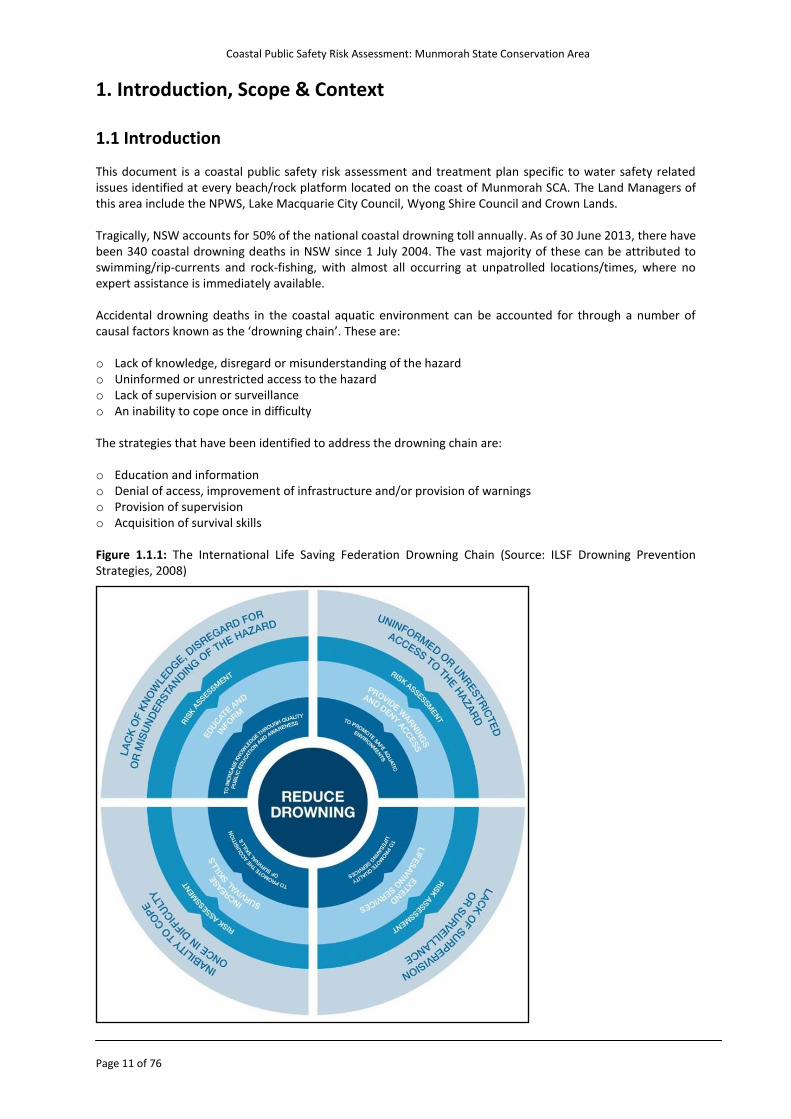
1. Introduction, Scope & Context 1.1 Introduction This document is a coastal public safety risk assessment and treatment plan specific to water safety related issues identified at every beach/rock platform located on the coast of Munmorah SCA. The Land Managers of this area include the NPWS, Lake Macquarie City Council, Wyong Shire Council and Crown Lands. Tragically, NSW accounts for 50% of the national coastal drowning toll annually. As of 30 June 2013, there have been 340 coastal drowning deaths in NSW since 1 July 2004. The vast majority of these can be attributed to swimming/rip-currents and rock-fishing, with almost all occurring at unpatrolled locations/times, where no expert assistance is immediately available. Accidental drowning deaths in the coastal aquatic environment can be accounted for through a number of causal factors known as the ‘drowning chain’. These are:
o Lack of knowledge, disregard or misunderstanding of the hazard o Uninformed or unrestricted access to the hazard o Lack of supervision or surveillance o An inability to cope once in difficulty The strategies that have been identified to address the drowning chain are:
o Education and information o Denial of access, improvement of infrastructure and/or provision of warnings o Provision of supervision o Acquisition of survival skills Figure 1.1.1: The International Life Saving Federation Drowning Chain (Source: ILSF Drowning Prevention Strategies, 2008)
Coastal Public Safety Risk Assessment: Munmorah State Conservation Area
Page 12 of 76
This report will be fundamental in addressing the coastal drowning issue in NSW both in the short, mid and long term. The report will do this by providing a sustainable and effective drowning prevention strategy with clear evidence/data, engagement of relevant stakeholders and the application of effective risk mitigation and drowning prevention initiatives where and when they are required. It is acknowledged that Land Managers have many competing priorities and limited resources. Land Managers should balance their water safety land management activities within the context of their broader role to provide services and facilities to meet the current and future needs of their local communities as a whole, all within a limited budget. This report recognises that there are many inherent risks associated with the NSW coastline and that in most instances these risks cannot be eliminated and can only be managed within the operational contexts of Land Managers, taking into account all of their responsibilities and available resources. This report also recognises that visitors to these coastal areas also have a personal responsibility for their own safety and those they are responsible for. The recommendations found in the report are representative of Australian CoastSafe’s opinion in relation to risk management at the locations assessed.
Coastal Public Safety Risk Assessment: Munmorah State Conservation Area
Page 13 of 76
1.2 Scope and Context Surf Life Saving New South Wales recently received funding as part of a NSW Government water safety initiative through the Water Safety Black Spot Fund to commence coastal public safety risk assessments on the NSW coastline (beaches and rock platforms). The program will be staged over several years with phase one to include the top ten drowning locations by (Local Government Area) in NSW. The report provides risk treatment recommendations about how to improve risk and safety management in line with current industry standards: o AS/NZS ISO 31000:2009 Risk management – Principles and Guidelines o AS2416 – 2010 Water Safety Signs and Beach Safety Flags o AS 2899(.1&.2) – 1986 Public Information Symbols Part 1 and 2 o ISO 7001:2007 Graphical symbols - Public information symbols o AS2342 – 1992 Development, Testing and Implementing of Information and Safety Symbols and Symbolic
Signs o ISO9001:2000 Quality Management Systems This coastal risk assessment and treatment plan has been prepared following an on-site risk assessment undertaken by Australian CoastSafe of Munmorah SCA which commenced on Monday 23rd July 2012 and concluded on Thursday 26th July 2012. The assessment covered all beach and rock platform locations (p.12) within the area. The assessment identifies hazards and the associated risks of the coastal environment, including but not limited to; signage, car parks, access tracks, service provision, geographical hazards, geological hazards, user groups, conflicting activities and usage. The report also identifies facilities and activities that encourage people to visit the location. The geographical scope of this assessment has been determined by the northern and southern boundaries of the Munmorah SCA. All accessible coastal environments within these boundaries have been included in this report. Aquatic areas which are excluded from this assessment include all bodies of water which are not ‘coastal’ in nature under SLSA definitions, and all hazards not directly associated with the use and immediate access to the coastal aquatic environment. While recreational and commercial boating may occur in these waters the detailed assessment of hazards and their treatments specific to boating activities falls outside the scope of this report. Boat ramps and bars at river mouths that fall within the assessed areas identified in Appendix D have been assessed within the framework of the coastal public safety risk assessment process. Information on boating safety can be found at www.maritime.nsw.gov.au The engagement of Land Managers and other key local stakeholders was also a vital part of this risk assessment. Australian CoastSafe assessed the following in detail: o Access locations, classifying these as formal or informal access tracks and recommending treatment
options. Signage that should be implemented, in conjunction with an audit of current signage Appendix A.
o Public rescue equipment that should be implemented, in conjunction with an audit of current public rescue equipment Appendix B.
o Hazards, their potential risks, risk groups, risk scores and treatment options Appendix C.
Other appendices include: o Coverage maps of assessed locations Appendix D.
o Survey Results Appendix E.
Coastal Public Safety Risk Assessment: Munmorah State Conservation Area
Page 14 of 76
At no time during the inspection was the water entered, they were performed from the land, along the edges of the water, along rocky outcrops, headlands, access tracks and car park access points. 1.3 Limitations The following are acknowledged as limitations of this coastal public safety risk assessment. o The absence of an industry agreed and recognised methodology for rating the hazardousness of rock
platforms. o Difficulty in gaining feedback from all identified stakeholders. o Limited timeframes allowed for stakeholders to provide feedback on consultative draft versions of the
report as a result of the project timeframes.
Coastal Public Safety Risk Assessment: Munmorah State Conservation Area
Page 15 of 76
1.4 Definition of Terms The following are definitions of key terms used within this report. Table 1.4.1: The following is a summary of the definition of key terms used within this report
ABSAMP Australian Beach Safety and Management Program
Attendance A snapshot of the on-beach and in-water attendance taken every two hours on a daily basis
ATV All-terrain vehicle
Coastal Waterway A coastal body of water e.g. river/creek opening
Consequence Outcome or impact of an event
Control An existing process, policy, device, practice or other action that acts to minimise negative risk or enhance positive opportunities
Emergency Action Plan A plan that outlines the procedures to be used in the event of an emergency
Frequency A measure of the number of occurrences per unit of time
First Aid A lifesaver/lifeguard treating either a minor or major first aid incident, which may require further assistance from NSW Ambulance e.g. broken bones or stings/bites
Formal Access Formal, well maintained access ways are effective in promoting and facilitating the use of a generally safer ‘track’, effectively exposing people to the relevant safety signage/information, reducing the quality of signage required and enhancing emergency reporting/location identification.
Geomorphology Is the scientific study of landforms and the processes that shape them
Hazards A source of potential harm
Hazard Symbols A graphical symbol used together with a safety colour and safety shape to form a safety sign
Informal Access Informal access ways may create higher risk through use (uneven ground/hazards), may expose people to dangerous locations (cliffs/sink-holes), may require duplicate/multiple signage (inefficient/costly) and may make emergency location reporting difficult (location awareness).
Inherent Risk The risk that an activity would pose if no controls or other mitigating factors were in place
IRB Inflatable Rescue Boat
Lifesaving Service An organised and structured service comprised of paid lifeguards and/or volunteer lifesavers and appropriate rescue and first aid equipment supported by a coordinated backup team
Likelihood Used as a general description of probability or frequency
Modal The conditions that occur most frequently, or more often than other conditions.
Monitor To check, supervise, observe critically or measure the progress of an activity,
Coastal Public Safety Risk Assessment: Munmorah State Conservation Area
Page 16 of 76
action or system on a regular basis in order to identify change from the performance level required or expected
Peak Water Safety Agencies
A peak body is defined as a state, territory or national non-profit organisation established to cater for the needs, interests and aspirations of its members. Members may include individuals or organisations, but they will all have a common interest. Peak bodies in the water safety sector may include agencies such as Surf Life Saving, Royal Life Saving, Surf Educators Australia, Austswim, Australian Professional Ocean Lifeguard Association, Surfing NSW and the Office of Boating Safety who represent the NSW Water Safety Advisory Council as a committee member.
Prevailing The conditions existing in a particular place or at a particular time
Probability A measure of the chance of occurrence expressed as a number
Preventative Action A lifesaver/lifeguard simply providing proactive direction or advice to beachgoers in a ‘preventative action’ for the beachgoer to avoid finding themselves in a position beyond their capability
Rescue A lifesaver/lifeguard rendering direct assistance to a beachgoer in difficulty in the water
Residual Risk Risk remaining after implementation of risk treatments
Rip Current Channelled currents of water flowing away from shore, typically extending from the shoreline, through the surf zone, and past the line of breaking waves
Risk Standards Australia defines risk as the effect of uncertainty on objects (AS/NZS 31000:2009)
Risk Analysis Systematic process to understand the nature of and to the level of risk
Risk Assessment Standards Australia defines a risk assessment as the overall process of risk identification, risk analysis and risk evaluation (AS/NZS 31000:2009)
Risk Evaluation Process of comparing the level of risk against criteria
Risk Identification The process of determining what, where, when, why and how something should happen
Risk Treatment Process of selection and implementation of measures to modify risk
Risk Management Standards Australia defines risk management as coordinated activities to direct and control an organisation with regard to risk (AS/NZS 31000:2009).
Risk Register A table summarising the identified risks, the location, why it has been identified as a risk, and what current treatments are in place to lessen the risk and an overall hazard rating.
RWC Rescue water craft (jet ski)
Risk Treatment Plan A table summarising how to deal with the identified risks, including a list of potential risk treatments, the risk treatments currently and any residual risk.
SCA State Conservation Area
Coastal Public Safety Risk Assessment: Munmorah State Conservation Area
Page 17 of 76
Stakeholders Those people and organisations who may affect, be affected, or perceive themselves to be affected by a decision, activity or risk
1.5 Project Team Adam Weir – Coastal Risk Manager Australian CoastSafe Surf Life Saving New South Wales Ph: 02-9471 8000 | F: 02-9471 8001 E: [email protected] W: www.coastsafe.org.au/blueprint Coastal Risk Officers: Stuart Massey, Coastal Risk Officer, 0406 353 344, [email protected] Luke Stigter, Coastal Risk Officer, 0409 075 620, [email protected]
Coastal Public Safety Risk Assessment: Munmorah State Conservation Area
Page 18 of 76
2. Assessment Methodology 2.1 Introduction The methodology included site identification, site inspection, hazard identification, data analysis, beach hazard ratings, beach identification, facility visitation ratings, facilities, beach usage, incident data, communication and consultation.
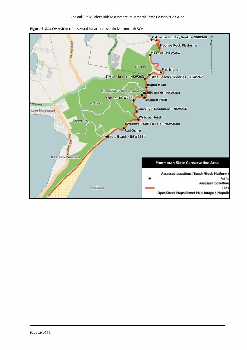
2.2 Site Identification The map on the next page provides an overview of the locations within the Munmorah SCA subject to the coastal risk assessment. Specific locations can be referenced in Appendix D. The area includes locations and/or facilities under the administration of: o NPWS
Munmorah State Conservation Area o Lake Macquarie City Council o Wyong Shire Council o Crown Lands The border of Lake Macquarie City Council and Wyong Shire Council is at the southern end of Little Beach/Ghosties The assessment identifies hazards and the associated risks of the coastal environment and is not limited to signage, car parks, access tracks, service provision, geographical hazards, geological hazards, user groups, conflicting activities and usage. The report also identifies facilities and activities that encourage people to visit the location. The geographical scope of this assessment has been determined by the northern and southern boundaries of the Munmorah SCA. All accessible coastal environments within these boundaries have been included in this report. Aquatic areas which are excluded from this assessment include all bodies of water which are not ‘coastal’ in nature under SLSA definitions, and all hazards not directly associated with the use and immediate access to the coastal aquatic environment.
Coastal Public Safety Risk Assessment: Munmorah State Conservation Area
Page 19 of 76
Figure 2.2.1: Overview of assessed locations within Munmorah SCA.
Coastal Public Safety Risk Assessment: Munmorah State Conservation Area
Page 20 of 76
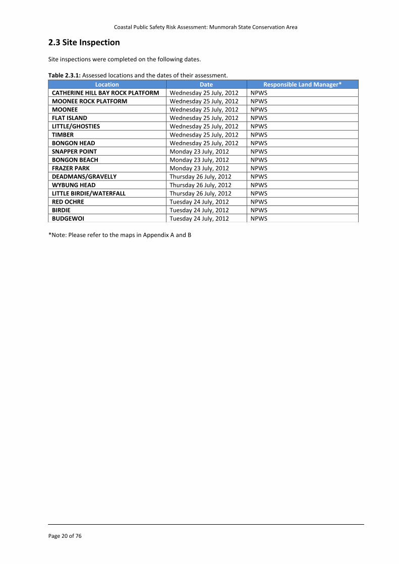
2.3 Site Inspection Site inspections were completed on the following dates. Table 2.3.1: Assessed locations and the dates of their assessment.
*Note: Please refer to the maps in Appendix A and B
Location Date Responsible Land Manager*
CATHERINE HILL BAY ROCK PLATFORM Wednesday 25 July, 2012 NPWS
MOONEE ROCK PLATFORM Wednesday 25 July, 2012 NPWS
MOONEE Wednesday 25 July, 2012 NPWS
FLAT ISLAND Wednesday 25 July, 2012 NPWS
LITTLE/GHOSTIES Wednesday 25 July, 2012 NPWS
TIMBER Wednesday 25 July, 2012 NPWS
BONGON HEAD Wednesday 25 July, 2012 NPWS
SNAPPER POINT Monday 23 July, 2012 NPWS
BONGON BEACH Monday 23 July, 2012 NPWS
FRAZER PARK Monday 23 July, 2012 NPWS
DEADMANS/GRAVELLY Thursday 26 July, 2012 NPWS
WYBUNG HEAD Thursday 26 July, 2012 NPWS
LITTLE BIRDIE/WATERFALL Thursday 26 July, 2012 NPWS
RED OCHRE Tuesday 24 July, 2012 NPWS
BIRDIE Tuesday 24 July, 2012 NPWS
BUDGEWOI Tuesday 24 July, 2012 NPWS
Coastal Public Safety Risk Assessment: Munmorah State Conservation Area
Page 21 of 76
2.4 Hazard Identification and Risk Assessment During the site inspection hazards were identified within the area inspected and assessed in terms of their individual risk to public safety (extreme, high, medium, low) using a risk assessment matrix Appendix B. The risk assessment matrix considers both the type of harm that could be sustained as a result of an individual hazard and the likelihood of this harm actually occurring. Hazards/Risks Though outlined in more detail within the report and appendices, the Munmorah SCA has a number of consistent hazards due to the geography and high energy nature of the area. Based on the risk assessment in Appendix B, these are the hazards that have been rated with the greatest inherent risk for the Munmorah SCA:
Strong ocean currents/rip currents: As a result of wave action and beach type Waves/waves overwashing: As a result of model wave height and exposure to ocean swells Inshore holes/deep water: As a result of coastal processes, wave action and beach type Slippery rocks: As a result of coastal geography/break walls and wave action Shallow sandbanks/shore dump: As a result of coastal process, wave action and beach type Submerged rocks: As a result of coastal geography and sand movement Stingers/sharks: As a result of marine life Cliffs/dangerous access: As a result of coastal geography Rock shelves/platforms: As a result of coastal geography Based on risk analysis of these hazards, it has been identified that they pose risk to the following types of recreational users:
Strong ocean currents/rip currents: Swimmers, surf craft users, fishermen, rock platform users Waves/waves overwashing: Swimmers, surf craft users, fishermen, rock platform users Inshore holes/deep water: Swimmers, fishermen Slippery rocks: Fishermen, rock platform users Shallow sandbanks/shore dump: Swimmers, surf craft users Submerged rocks: Swimmers, surf craft users, fishermen Stingers/sharks: Swimmers, surf craft users Cliffs/dangerous access: Fishermen, surfers, walkers, sight seers Rock shelves/platforms: Surf craft users, fishermen, rock platform users 2.5 Data Analysis Data relevant to this risk assessment has been considered in the production of the report. These include: o Australian Beach Safety and Management Program (ABSAMP) o Australian Bureau of Statistics – 2010 Census data o Australian Lifeguard Service Statistics o BeachSafe (2012) www.beachsafe.org.au o NSW Tourism Statistics o Rock Fishing Review - Bradstreet et al, (2012) – Research Review of Rock Fishing in New South Wales. Surf
Life Saving Australia: Sydney). o SLSA Incident Reporting Database (IRD)
Coastal Public Safety Risk Assessment: Munmorah State Conservation Area
Page 22 of 76
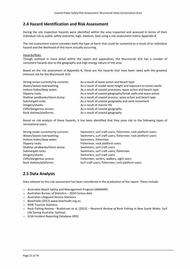
2.6 Beach Hazard Ratings and Overview The ABSAMP (Australian Beach Safety and Management Program) was developed by Professor Andrew Short from the University of Sydney Coastal Studies Unit in conjunction with Surf Life Saving Australia. The programme has identified coastal hazards that affect bathers and rates the safety of the beach on a scale of one to ten, where one (1) is the least hazardous and ten (10) is the most hazardous. The beach hazard ratings and definitions are provided in the following table.
Table 2.6.1: ABSAMP Beach Hazard Ratings
The beach hazard rating is calculated by determining the beach type and wave height. This can be done under either modal (average) or prevailing (current) conditions. The beach hazard rating is then calculated by using the following table: Table 2.6.2: Beach hazard rating calculation matrices for wave dominate beaches
Wave Height
Beach Type
< 0.5 (m)
0.5 (m) 1.0 (m) 1.5 (m) 2.0 (m) 2.5 (m) 3.0 (m) > 3.0 (m)
Dissipative 4 5 6 7 8 9 10 10
Long Shore Bar Trough
4 5 6 7 7 8 9 10
Rhythmic Bar Beach
4 5 6 6 7 8 9 10
Transverse Bar Rip
4 4 5 6 7 8 9 10
Low Tide Terrace 3 3 4 5 6 7 8 10
Reflective 2 3 4 5 6 7 8 10
The beach hazard ratings presented in this report relate to modal beach conditions and as such the hazard rating of a beach may increase when conditions alter e.g. with increasing wave height, winds, strong tides and high tide. Furthermore, a hazard rating is also applied to an average person and therefore depending upon an individual's own skill, understanding and competence in relation to a certain area the hazard may in fact be greater or less. The ABSAMP hazard ratings for the inspected areas of Munmorah SCA are detailed within the next section of the report.
Hazard Rating Details
1 - 3
Least Hazardous: Low danger posed by water depth and/or weak currents; however, supervision still required, in particular for children and poor swimmers.
4 - 6
Moderately Hazardous: The level of hazard depends on wave and weather conditions, with the possibility of strong rips and currents posing a moderate risk.
7 - 8
Highly Hazardous: Experience in strong surf, rips and currents required, with beaches in this category considered dangerous.
9 - 10
Extremely Hazardous: Identifies beaches that are considered extremely dangerous due to strong rips and currents, and large breakers.
Coastal Public Safety Risk Assessment: Munmorah State Conservation Area
Page 23 of 76
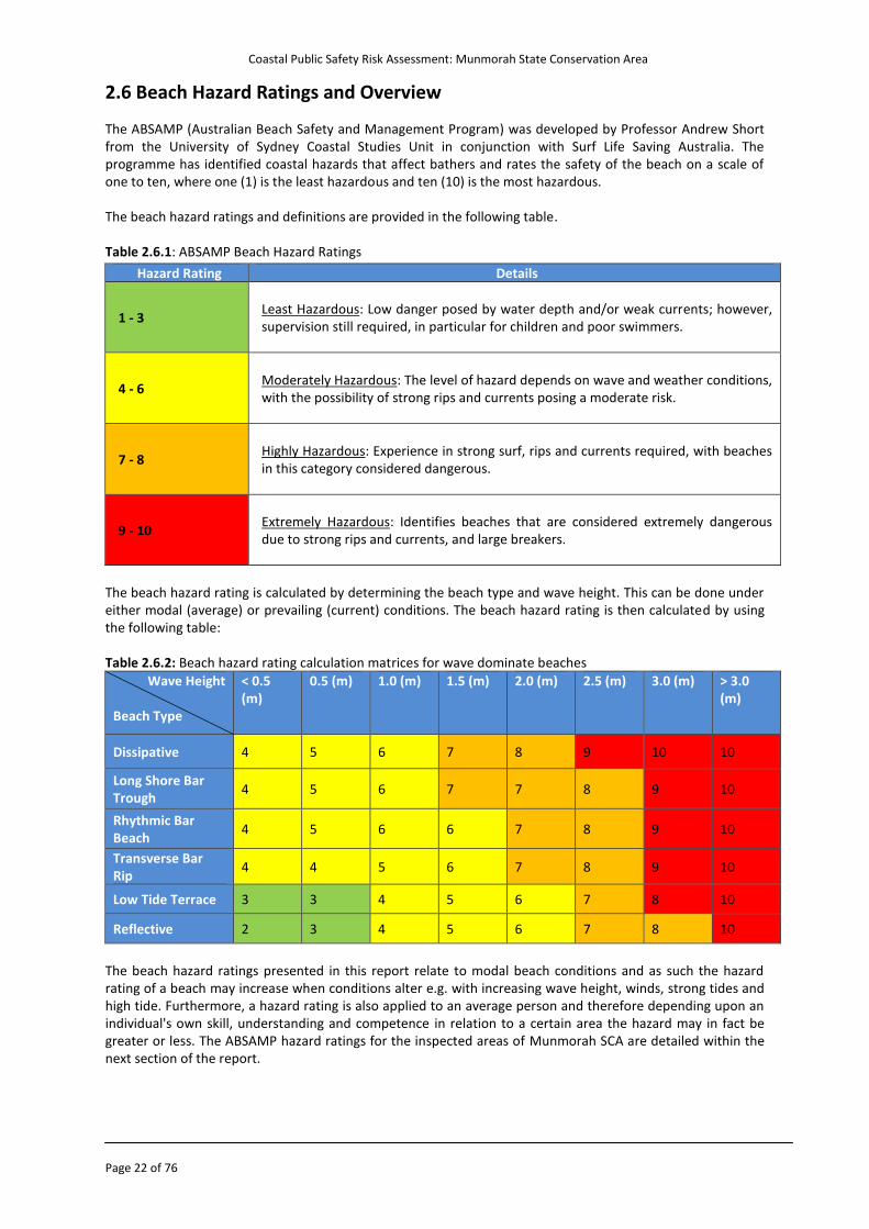
2.7 Beach Types and Hazard Ratings The ABSAMP Hazard Rating for the assessed locations is listed below. The table provides an ABSAMP rating and descriptive label/name type for each specific beach location. Table 2.7.1: Hazard Ratings – Munmorah State Conservation Area
Location Name ABSAMP no. Hazard Rating Beach Type
Catherine Hill Bay Rock Platform
nsw260RP 7* Rock Platform
Moonee Rock Platform nsw261RP 7* Rock Platform
Moonee nsw261 6 Transverse Bar and Rip
Little/Ghosties nsw262 6 Transverse Bar and Rip
Flat Island nsw262RP 6* Rock Platform
Timber nsw263 6 Transverse Bar and Rip
Bongon Head nsw264RPa 5* Rock Platform
Snapper Point nsw264RPb 5* Rock Platform
Bongon Beach nsw264 4 Reflective
Frazer Park nsw265 6 Rhythmic bar and beach
Deadmans/Gravelly nsw266 4 Reflective
Wybung Headland nsw266RP 4* Rock Platform
Little Birdie/Waterfall nsw267 4 Reflective
Red Ochre Rock Platform nsw267RP 6* Rock Platform
Birdie nsw268A 7 Transverse Bar and Rip
Budgewoi nsw268 7 Transverse Bar and Rip
* Munmorah SCA Rock Platform Ratings Currently there is no method of rating the hazardousness of the rocky coast, in an equivalent manner to the ABSAMP beach hazard rating system for sandy beaches. Research is currently underway; Dr. David Kennedy has utilised a grant from Melbourne University to pilot the methods for the development of a risk classification study on rocky coasts. The results from this pilot are being used for an Australian Research Council grant application. Prof. Colin Woodroffe (University of Wollongong) presented the methodology for this project at the NSW Coastal Conference in Kiama (November, 2012). As an interim method of providing an indication of the hazardousness of rock platforms the ABSAMP beach hazard ratings for the beaches on either side of the each rock platform have been averaged. Since the beaches on either side of a rock platform would be exposed to similar prevailing and modal wind, wave and weather conditions and these sandy beaches have a recognised and accepted method of rating the associated hazardousness taking the average of the beaches bordering a rock platform will provide an indication as to the potential hazard associated with the modal conditions affecting the rock platform. It is a limitation of the report that there is no available method of calculating the specific hazard rating of a rock platform. However, in order to allow the risk calculations used in this report to be processed an interim solution has been applied which takes into account the local conditions and geomorphology. Once the research being conducted by Dr. David Kennedy and Prof. Colin Woodroffe is completed then these calculations should be revisited.
Treatment Option 2.1 Research currently being conducted by Melbourne University, University of Wollongong and Surf Life Saving Australia into a risk classification for rocky coast should be commended and supported. Once this research is completed the calculations related to rocky coasts in this report should be reviewed.
Coastal Public Safety Risk Assessment: Munmorah State Conservation Area
Page 24 of 76
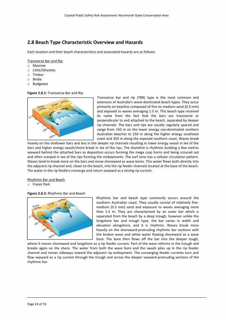
2.8 Beach Type Characteristic Overview and Hazards Each location and their beach characteristics and associated hazards are as follows: Transverse Bar and Rip o Moonee o Little/Ghosties o Timber o Birdie o Budgewoi
Figure 2.8.1: Transverse Bar and Rip
Transverse bar and rip (TBR) type is the most common and extensive of Australia’s wave-dominated beach types. They occur primarily on beaches composed of fine to medium sand (0.3 mm) and exposed to waves averaging 1.5 m. This beach type received its name from the fact that the bars are transverse or perpendicular to and attached to the beach, separated by deeper rip channels. The bars and rips are usually regularly spaced and range from 150 m on the lower energy sea-dominated northern Australian beaches to 250 m along the higher energy southeast coast and 350 m along the exposed southern coast. Waves break
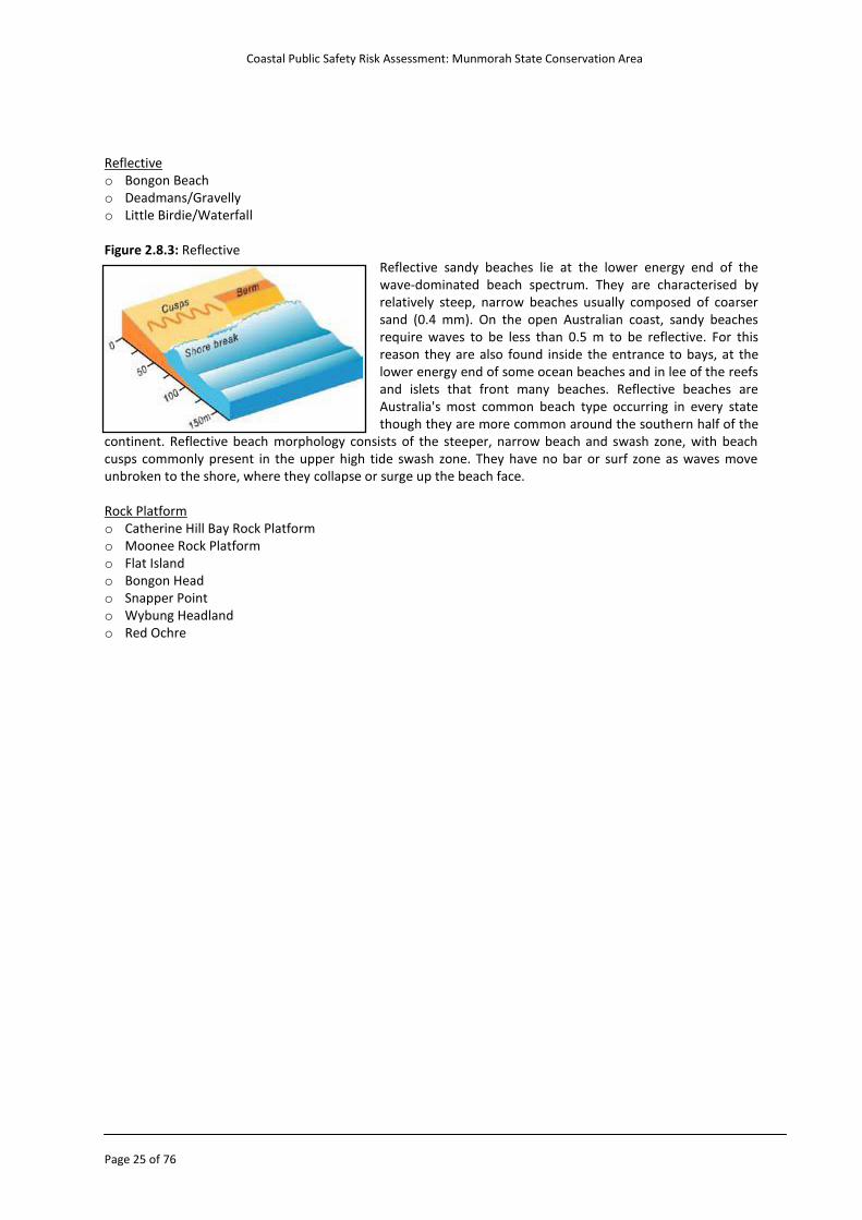
heavily on the shallower bars and less in the deeper rip channels resulting in lower energy swash in lee of the bars and higher energy swash/shore break in lee of the rips. The shoreline is rhythmic building a few metres seaward behind the attached bars as deposition occurs forming the mega cusp horns and being scoured out and often scarped in lee of the rips forming the embayments. The surf zone has a cellular circulation pattern. Waves tend to break more on the bars and move shoreward as wave bores. This water flows both directly into the adjacent rip channel and, closer to the beach, into the rip feeder channels located at the base of the beach. The water in the rip feeders converge and return seaward as a strong rip current. Rhythmic Bar and Beach o Frazer Park Figure 2.8.2: Rhythmic Bar and Beach
Rhythmic bar and beach type commonly occurs around the southern Australian coast. They usually consist of relatively fine-medium (0.3 mm) sand and exposure to waves averaging more than 1.5 m. They are characterised by an outer bar which is separated from the beach by a deep trough, however unlike the longshore bar and trough type, the bar varies in width and elevation alongshore, and it is rhythmic. Waves break more heavily on the shoreward-protruding rhythmic bar sections with the broken wave and white water flowing shoreward as a wave bore. The bore then flows off the bar into the deeper tough,
where it moves shoreward and longshore as a rip feeder current. Part of the wave reforms in the trough and breaks again on the shore. The water from both the wave bore and the swash piles up in the rip feeder channel and moves sideways toward the adjacent rip embayment. The converging feeder currents turn and flow seaward as a rip current through the trough and across the deeper seaward-protruding sections of the rhythmic bar.
Coastal Public Safety Risk Assessment: Munmorah State Conservation Area
Page 25 of 76
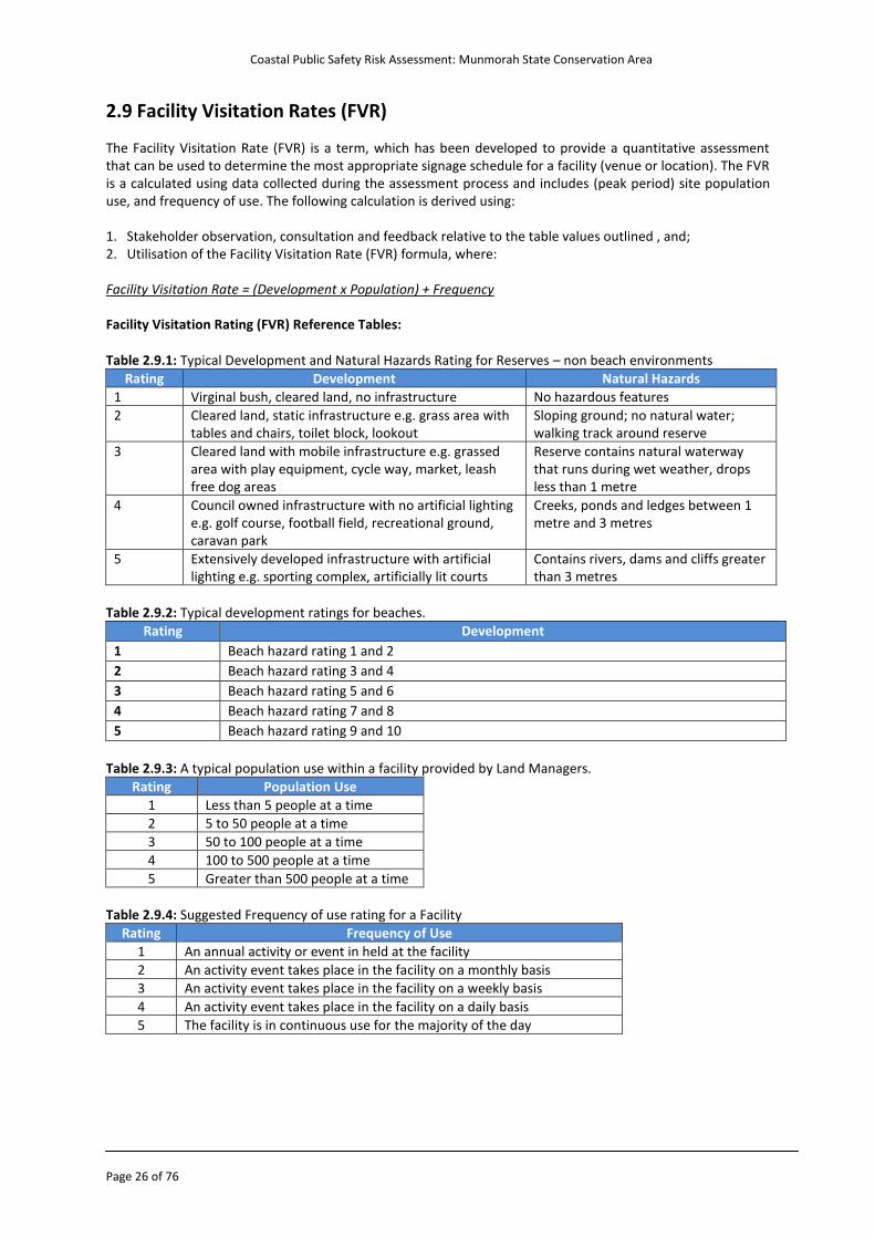
Reflective o Bongon Beach o Deadmans/Gravelly o Little Birdie/Waterfall Figure 2.8.3: Reflective
Reflective sandy beaches lie at the lower energy end of the wave-dominated beach spectrum. They are characterised by relatively steep, narrow beaches usually composed of coarser sand (0.4 mm). On the open Australian coast, sandy beaches require waves to be less than 0.5 m to be reflective. For this reason they are also found inside the entrance to bays, at the lower energy end of some ocean beaches and in lee of the reefs and islets that front many beaches. Reflective beaches are Australia's most common beach type occurring in every state though they are more common around the southern half of the
continent. Reflective beach morphology consists of the steeper, narrow beach and swash zone, with beach cusps commonly present in the upper high tide swash zone. They have no bar or surf zone as waves move unbroken to the shore, where they collapse or surge up the beach face. Rock Platform o Catherine Hill Bay Rock Platform o Moonee Rock Platform o Flat Island o Bongon Head o Snapper Point o Wybung Headland o Red Ochre
Coastal Public Safety Risk Assessment: Munmorah State Conservation Area
Page 26 of 76
2.9 Facility Visitation Rates (FVR) The Facility Visitation Rate (FVR) is a term, which has been developed to provide a quantitative assessment that can be used to determine the most appropriate signage schedule for a facility (venue or location). The FVR is a calculated using data collected during the assessment process and includes (peak period) site population use, and frequency of use. The following calculation is derived using: 1. Stakeholder observation, consultation and feedback relative to the table values outlined , and; 2. Utilisation of the Facility Visitation Rate (FVR) formula, where:
Facility Visitation Rate = (Development x Population) + Frequency Facility Visitation Rating (FVR) Reference Tables: Table 2.9.1: Typical Development and Natural Hazards Rating for Reserves – non beach environments
Rating Development Natural Hazards
1 Virginal bush, cleared land, no infrastructure No hazardous features
2 Cleared land, static infrastructure e.g. grass area with tables and chairs, toilet block, lookout
Sloping ground; no natural water; walking track around reserve
3 Cleared land with mobile infrastructure e.g. grassed area with play equipment, cycle way, market, leash free dog areas
Reserve contains natural waterway that runs during wet weather, drops less than 1 metre
4 Council owned infrastructure with no artificial lighting e.g. golf course, football field, recreational ground, caravan park
Creeks, ponds and ledges between 1 metre and 3 metres
5 Extensively developed infrastructure with artificial lighting e.g. sporting complex, artificially lit courts
Contains rivers, dams and cliffs greater than 3 metres
Table 2.9.2: Typical development ratings for beaches.
Rating Development
1 Beach hazard rating 1 and 2
2 Beach hazard rating 3 and 4
3 Beach hazard rating 5 and 6
4 Beach hazard rating 7 and 8
5 Beach hazard rating 9 and 10
Table 2.9.3: A typical population use within a facility provided by Land Managers.
Rating Population Use
1 Less than 5 people at a time
2 5 to 50 people at a time
3 50 to 100 people at a time
4 100 to 500 people at a time
5 Greater than 500 people at a time
Table 2.9.4: Suggested Frequency of use rating for a Facility
Rating Frequency of Use
1 An annual activity or event in held at the facility
2 An activity event takes place in the facility on a monthly basis
3 An activity event takes place in the facility on a weekly basis
4 An activity event takes place in the facility on a daily basis
5 The facility is in continuous use for the majority of the day
Coastal Public Safety Risk Assessment: Munmorah State Conservation Area
Page 27 of 76
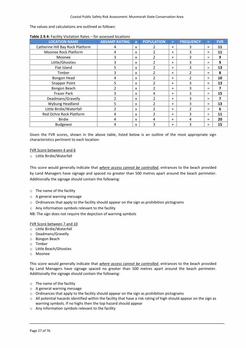
The values and calculations are outlined as follows: Table 2.9.4: Facility Visitation Rates – for assessed locations
LOCATION NAME ABSAMP RATING x POPULATION + FREQUENCY = FVR
Catherine Hill Bay Rock Platform 4 x 2 + 3 = 11
Moonee Rock Platform 4 x 2 + 3 = 11
Moonee 3 x 2 + 3 = 9
Little/Ghosties 3 x 2 + 3 = 9
Flat Island 5 x 2 + 3 = 13
Timber 3 x 2 + 2 = 8
Bongon Head 4 x 2 + 2 = 10
Snapper Point 5 x 2 + 3 = 13
Bongon Beach 2 x 2 + 3 = 7
Frazer Park 3 x 4 + 3 = 15
Deadmans/Gravelly 2 x 2 + 3 = 7
Wybung Headland 5 x 2 + 3 = 13
Little Birdie/Waterfall 2 x 2 + 2 = 6
Red Ochre Rock Platform 4 x 2 + 3 = 11
Birdie 4 x 4 + 4 = 20
Budgewoi 4 x 3 + 3 = 15
Given the FVR scores, shown in the above table, listed below is an outline of the most appropriate sign characteristics pertinent to each location:
FVR Score between 4 and 6
o Little Birdie/Waterfall
This score would generally indicate that where access cannot be controlled, entrances to the beach provided
by Land Managers have signage and spaced no greater than 500 metres apart around the beach perimeter.
Additionally the signage should contain the following:
o The name of the facility
o A general warning message
o Ordinances that apply to the facility should appear on the sign as prohibition pictograms
o Any information symbols relevant to the facility
NB: The sign does not require the depiction of warning symbols FVR Score between 7 and 10 o Little Birdie/Waterfall o Deadmans/Gravelly o Bongon Beach o Timber o Little Beach/Ghosties o Moonee This score would generally indicate that where access cannot be controlled, entrances to the beach provided by Land Managers have signage spaced no greater than 500 metres apart around the beach perimeter. Additionally the signage should contain the following: o The name of the facility o A general warning message o Ordinances that apply to the facility should appear on the sign as prohibition pictograms o All potential hazards identified within the facility that have a risk rating of high should appear on the sign as
warning symbols. If no highs then the top hazard should appear o Any information symbols relevant to the facility
Coastal Public Safety Risk Assessment: Munmorah State Conservation Area
Page 28 of 76
FVR Score between 11 and 15 o Catherine Hill Bay Rock Platform o Moonee Rock Platform o Moonee o Flat Island o Bongon Head o Snapper Point o Frazer Park o Wybung Headland o Red Ochre Rock Platform o Budgewoi This score would generally indicate that where access cannot be controlled, entrances to the beach provided by Land Managers have signage spaced no greater than 500 metres apart around the beach perimeter. Additionally the signage should contain the following: o The name of the facility o A general warning message o Ordinances that apply to the facility should appear on the sign as prohibition pictograms o All potential hazards identified within the facility that have a risk rating of high should appear on the sign as
warning symbols. If no highs then the top two hazards should appear o Any information symbols relevant to the facility FVR Score between 16 and 20 o Birdie This score would generally indicate that where access cannot be controlled, entrances to the beach provided by Land Managers have signage and spaced no greater than 250 metres apart around the beach perimeter. Additionally the signage should contain the following:
o The name of the facility o A general warning message o Ordinances that apply to the facility should appear on the sign as prohibition pictograms o All potential hazards identified within the facility that have a risk rating of high should appear on the sign as
warning symbols. If no highs then the top three hazards should appear o Any information symbols relevant to the facility FVR Score between 21 and 25 o No assessed area scored within this range
This score would generally indicate that where access cannot be controlled, entrances to the beach provided by Land Managers have signage spaced no greater than 100 metres apart around the beach perimeter. Additionally the signage should contain the following: o The name of the facility o A general warning message o Ordinances that apply to the facility should appear on the sign as prohibition pictograms o All potential hazards identified within the facility that have a risk rating of high should appear on the sign as
warning symbols. If no highs then the top four hazards should appear o Any information symbols relevant to the facility
Coastal Public Safety Risk Assessment: Munmorah State Conservation Area
Page 29 of 76
2.10 Facilities Facilities in the coastal risk management process are any item of infrastructure which is situated close to the beach/access points. These include but are not limited to: o Picnic areas o BBQ’s o Playgrounds o Benches o Showers/water taps o Amenities o Car parks o Caravan parks o Art infrastructure o Rubbish bins o Boat ramps o Marinas Why do we record facilities? Facilities are recorded because it is important for the Land Manager to recognise that by providing the above facilities it is expected that there will be an increase in people visiting these areas. This increase can correlate to the likelihood of a risk occurring in a coastal environment. Treatment plans identified in the report should be implemented in these areas to reduce the risk of a particular event occurring. Facilities as well as other local attractions are included in risk management and while these facilities or local attractions may, in isolation, increase the likelihood of a particular risk occurring, they may be offset by other factors such as the type of visitor who is going to a particular location. All factors relating to a risk are assessed as a whole and not in isolation when determining the level of risk. It is the level of risk and not the type of facilities (in isolation to other factors) that is used when determining if a risk treatment is required A breakdown of facilities at the assessed locations within the Munmorah SCA can be requested by the Land Managers if required.
Coastal Public Safety Risk Assessment: Munmorah State Conservation Area
Page 30 of 76
2.11 Beach Usage and Incident Statistics This section expands on beach usage and incident statistics such as general beach usage, lifeguard statistics, emergency callouts and drowning incidents. This data will be able to assist NPWS when making decisions about the implementation of risk mitigation strategies for coastal public safety. Visitation numbers and beach statistics Previously, NPWS used a number of formal systems to record the visitation levels within the Munmorah SCA which included Park Rangers stationed at vehicle entry points, and technology that had the capability of recording the number of cars entering the park. In recent times these systems are no longer in place and quantitative data is not easily accessible. The use of parking machines at Munmorah SCA can be utilised to estimate visitation numbers. This information may be available from the Regional Business Unit, NPWS in Gosford. This information was requested for inclusion in this report but was unavailable. In recent times, a research project was undertaken by Newcastle University to investigate the recreational activity in the Munmorah State Conservation Area. One of the findings in this report estimated that the Munmorah State Conservation has approximately 450,000 visitors on an annual basis. This information was requested for inclusion in this report but was unavailable. It is acknowledged that NPWS have implemented a system for capturing qualitative data. This is achieved by an external research provider ‘cold calling’ members of the public to find out how many times they would visit a national park and what activities are undertaken. It is recommended that when resources become available the NPWS should investigate a data collection method (quantitative) to record and identify park (particularly coastal) user trends and changes over time, in order to assist coastal safety planning (e.g. lifeguard service provision). Frazer Park: The following statistics have been recorded by the lifeguard service operating at Frazer Park. The service provides a supervised swimming area over the peak summer holidays and autumn school holidays.
Table 2.11.1: Australian Lifeguard Service statistics for 2009 to 2012 (SurfGuard, 2013)
Lifeguard Service Attendance Rescues Preventative Actions First Aid Treatments
Season 2011/12 23,845 30 961 34
Season 2010/11 23,145 10 2,473 247
Season 2009/10 17,889 4 1,809 27
Totals 64,879 44 5,243 308
Population General Although quantitative data is limited for direct national park usage, beach usage and visitors can also be determined by population figures and growth. The population in the Wyong and Lake Macquarie Local Government Areas, which surround Munmorah SCA is currently increasing as many of the suburbs within these areas are expanding. Population Statistics - Wyong This table shows that population in the Wyong LGA is 150,022. Population over the last 10 years has increased by approximately 19,000 (14.6% growth) people. Table 2.11.2: Wyong population data (ABS, 2011)
Wyong Local Government Area – Population
Year Males Females Total
2011 71,419 76,592 150,022
2006 66,317 71,435 137,752
2001 63,382 67,472 130,854 This table provides a breakdown of the population living in the coastal towns of the Wyong LGA within 15km south of the Munmorah SCA (Australian Bureau of Statistics 2011).
Coastal Public Safety Risk Assessment: Munmorah State Conservation Area
Page 31 of 76
Table 2.11.3: Population living in coastal suburbs within the Wyong LGA (ABS, 2011)
Beach Population Figures
Beach Suburb Population
Budgewoi 3,254
Toukley 4,139
Noraville 2,698
Canton Beach 1,076
Norah Head 1,086
Totals 12,253
Local population figures are expected to increase as the Wyong Shire Council is facilitating the development of a number of iconic development sites throughout the LGA. The council has identified 28 sites throughout the LGA with the ability to generate significant economic return and revitalise its town centres. Council identified sites at The Entrance, Wyong, Long Jetty, Toukley, Kanwal, Lake Haven and Warnervale as having potential to be a catalyst for economic growth and development confidence (Draft Development Control Plan – Wyong Shire Council). Population Statistics – Lake Macquarie This table shows that population in the Lake Macquarie LGA is 191,017. Population over the last 10 years has increased by approximately 12,000 (6.7% growth) people. Table 2.11.4: Lake Macquarie population data (ABS, 2011)
Lake Macquarie Local Government Area – Population
Year Males Females Total
2011 92,311 96,695 191,017
2006 89,637 93,510 185,153
2001 86,712 90,473 179,186
This table provides a breakdown of the population living in the coastal towns of the Lake Macquarie LGA within 15km north of the Munmorah SCA (Australian Bureau of Statistics 2011). Table 2.11.5: Population living in coastal suburbs within the Lake Macquarie LGA (ABS, 2011)
Beach Population Figures
Beach Suburb Population
Belmont South 1,204
Marks Point 1,731
Pelican 841
Blacksmiths 1,844
Swansea Heads 706
Swansea 4,835
Caves Beach 3,936
Nords Wharf 820
Summerland Point 2,358
Catherine Hill Bay 432
Chain Valley Bay 2,452
Totals 21,159
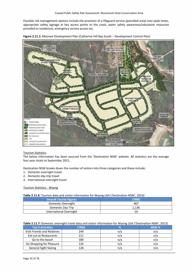
Moonee Development Plan: Plans for a property development (Rose Property Group Pty Ltd) are currently underway south of the current township at Catherine Hill Bay. The prosed development includes 550 lots. Such a development will have coastal risk implications that require consideration and planning. The increased recreational use of the area as a direct result of permanent residences, holiday visitation and general increases in visitation will result in the exposure of increased numbers of people to hazards and associated risks at relatively isolated locations (in the context of existing lifesaving and emergency services).The development may impact existing public access ways to the coast.
Coastal Public Safety Risk Assessment: Munmorah State Conservation Area
Page 32 of 76
Possible risk management options include the provision of a lifeguard service (patrolled area) over peak times, appropriate safety signage at key access points to the coast, water safety awareness/education resources provided to residences, emergency service access etc. Figure 2.11.1: Moonee Development Plan (Catherine Hill Bay South – Development Control Plan) Tourism Statistics The below information has been sourced from the ‘Destination NSW’ website. All statistics are the average four year totals to September 2011. Destination NSW breaks down the number of visitors into three categories and these include: 1. Domestic overnight travel 2. Domestic day trip travel 3. International overnight travel Tourism Statistics - Wyong Table 2.11.6: Tourism data and visitor information for Wyong LGA (‘Destination NSW’, 2013)
Overall Tourist Figures (‘000)
Domestic Overnight 467
Domestic Day Trip 1,136
International Overnight 10
Table 2.11.7: Domestic overnight travel data and visitor information for Wyong LGA (‘Destination NSW’, 2013)
Top 5 Activities (‘000) % NSW %
Visit Friends and Relatives 244 n/a n/a
Eat out at Restaurants 211 n/a n/a
Go to the beach 184 n/a n/a
Go Shopping for Pleasure 135 n/a n/a
General Sight Seeing 126 n/a n/a
Coastal Public Safety Risk Assessment: Munmorah State Conservation Area
Page 33 of 76
Origin (‘000) % NSW %
Regional NSW 427 29.7% 35.5%
Sydney 788 54.8% 26.6%
Victoria 39 2.7% 13.9%
Queensland 82 5.7% 13.3%
ACT 22 1.5% 4.2%
Other Interstate 80 5.5% 6.4%
Top 5 Accommodation (‘000) % NSW%
Friends or relatives 639 44.4% 39.1%
Caravan Park, Camping 302 21.0% 12.4%
Hotel/Motel 219 15.2% 23.4%
Rented 110 7.7% 9.9%
Own Property 103 7.1% 3.9%
Age Group (‘000) % NSW %
15 to 24 years 60 12.9% 14.5%
25 to 34 years 68 14.5% 14.0%
35 to 44 years 101 21.6% 21.5%
45 to 54 years 75 16.1% 19.0%
55 to 64 years 89 19.0% 16.6%
65 years and over 74 15.9% 14.4%
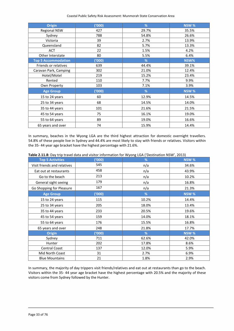
In summary, beaches in the Wyong LGA are the third highest attraction for domestic overnight travellers. 54.8% of these people live in Sydney and 44.4% are most likely to stay with friends or relatives. Visitors within the 35- 44 year age bracket have the highest percentage with 21.6%. Table 2.11.8: Day trip travel data and visitor information for Wyong LGA (‘Destination NSW’, 2013)
Top 5 Activities (‘000) % NSW %
Visit friends and relatives 545 n/a 34.6%
Eat out at restaurants 458 n/a 43.9%
Go to the beach 213 n/a 10.2%
General sight seeing 179 n/a 16.8%
Go Shopping for Pleasure 167 n/a 21.3%
Age Group (‘000) % NSW %
15 to 24 years 115 10.2% 14.4%
25 to 34 years 205 18.0% 13.4%
35 to 44 years 233 20.5% 19.6%
45 to 54 years 159 14.0% 18.1%
55 to 64 years 176 15.5% 16.8%
65 years and over 248 21.8% 17.7%
Origin (‘000) % NSW %
Sydney 711 62.6% 42.0%
Hunter 202 17.8% 8.6%
Central Coast 137 12.0% 5.9%
Mid North Coast 31 2.7% 6.9%
Blue Mountains 21 1.8% 2.9%
In summary, the majority of day trippers visit friends/relatives and eat out at restaurants than go to the beach. Visitors within the 35- 44 year age bracket have the highest percentage with 20.5% and the majority of these visitors come from Sydney followed by the Hunter.
Coastal Public Safety Risk Assessment: Munmorah State Conservation Area
Page 34 of 76
Table 2.11.9: International overnight travel data and visitor information for Wyong LGA (‘Destination NSW’ 2013)
Top 5 origin markets (‘000) % NSW %
New Zealand 3 26.3% 13.3%
United Kingdom 3 25.7% 13.3%
USA 1 10.7% 10.6%
Germany n/a n/a 3.8%
Scandinavia n/a n/a 1.9%
Age Group (‘000) % NSW %
15 to 24 years 2 17.0% 18.8%
25 to 34 years 2 22.6% 24.8%
35 to 44 years 1 12.1% 17.4%
45 to 54 years 2 16.9% 17.2%
55 to 64 years 2 19.6% 14.8%
65 years and over 1 11.8% 6.9%
Accommodation (‘000) % NSW %
Friends or relatives 110 61.2% 27.5%
Rented 43 24.0% 40.3%
Hotel/Motel 16 8.9% 10.2%
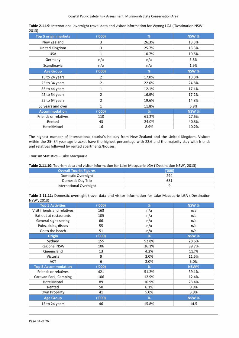
The highest number of international tourist’s holiday from New Zealand and the United Kingdom. Visitors within the 25- 34 year age bracket have the highest percentage with 22.6 and the majority stay with friends and relatives followed by rented apartments/houses. Tourism Statistics – Lake Macquarie Table 2.11.10: Tourism data and visitor information for Lake Macquarie LGA (‘Destination NSW’, 2013)
Overall Tourist Figures (‘000)
Domestic Overnight 294
Domestic Day Trip 681
International Overnight 9
Table 2.11.11: Domestic overnight travel data and visitor information for Lake Macquarie LGA (‘Destination NSW’, 2013)
Top 5 Activities (‘000) % NSW %
Visit friends and relatives 163 n/a n/a
Eat out at restaurants 105 n/a n/a
General sight-seeing 66 n/a n/a
Pubs, clubs, discos 55 n/a n/a
Go to the beach 51 n/a n/a
Origin (‘000) % NSW %
Sydney 155 52.8% 28.6%
Regional NSW 106 36.1% 39.7%
Queensland 13 4.3% 11.)%
Victoria 9 3.0% 11.5%
ACT 6 2.0% 5.0%
Top 5 Accommodation (‘000) % NSW%
Friends or relatives 421 51.2% 39.1%
Caravan Park, Camping 106 12.9% 12.4%
Hotel/Motel 89 10.9% 23.4%
Rented 50 6.1% 9.9%
Own Property 41 5.0% 3.9%
Age Group (‘000) % NSW %
15 to 24 years 46 15.8% 14.5
Coastal Public Safety Risk Assessment: Munmorah State Conservation Area
Page 35 of 76
25 to 34 years 34 11.4% 14.0%
35 to 44 years 55 18.8% 21.5%
45 to 54 years 56 18.9% 19.0%
55 to 64 years 52 17.6% 16.6%
65 years and over 52 17.7% 14.4%
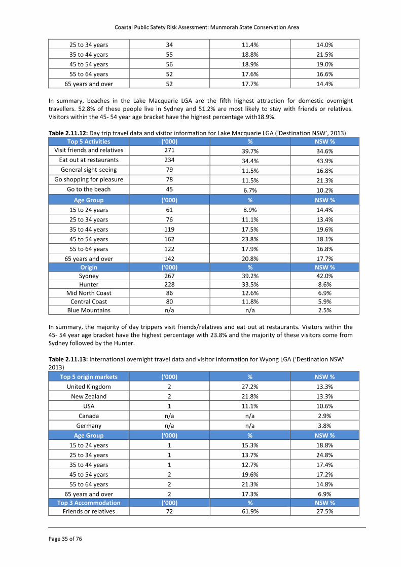
In summary, beaches in the Lake Macquarie LGA are the fifth highest attraction for domestic overnight travellers. 52.8% of these people live in Sydney and 51.2% are most likely to stay with friends or relatives. Visitors within the 45- 54 year age bracket have the highest percentage with18.9%. Table 2.11.12: Day trip travel data and visitor information for Lake Macquarie LGA (‘Destination NSW’, 2013)
Top 5 Activities (‘000) % NSW %
Visit friends and relatives 271 39.7% 34.6%
Eat out at restaurants 234 34.4% 43.9%
General sight-seeing 79 11.5% 16.8%
Go shopping for pleasure 78 11.5% 21.3%
Go to the beach 45 6.7% 10.2%
Age Group (‘000) % NSW %
15 to 24 years 61 8.9% 14.4%
25 to 34 years 76 11.1% 13.4%
35 to 44 years 119 17.5% 19.6%
45 to 54 years 162 23.8% 18.1%
55 to 64 years 122 17.9% 16.8%
65 years and over 142 20.8% 17.7%
Origin (‘000) % NSW %
Sydney 267 39.2% 42.0%
Hunter 228 33.5% 8.6%
Mid North Coast 86 12.6% 6.9%
Central Coast 80 11.8% 5.9%
Blue Mountains n/a n/a 2.5%
In summary, the majority of day trippers visit friends/relatives and eat out at restaurants. Visitors within the 45- 54 year age bracket have the highest percentage with 23.8% and the majority of these visitors come from Sydney followed by the Hunter. Table 2.11.13: International overnight travel data and visitor information for Wyong LGA (‘Destination NSW’ 2013)
Top 5 origin markets (‘000) % NSW %
United Kingdom 2 27.2% 13.3%
New Zealand 2 21.8% 13.3%
USA 1 11.1% 10.6%
Canada n/a n/a 2.9%
Germany n/a n/a 3.8%
Age Group (‘000) % NSW %
15 to 24 years 1 15.3% 18.8%
25 to 34 years 1 13.7% 24.8%
35 to 44 years 1 12.7% 17.4%
45 to 54 years 2 19.6% 17.2%
55 to 64 years 2 21.3% 14.8%
65 years and over 2 17.3% 6.9%
Top 3 Accommodation (‘000) % NSW %
Friends or relatives 72 61.9% 27.5%
Coastal Public Safety Risk Assessment: Munmorah State Conservation Area
Page 36 of 76
Rented 19 16.4% 40.3%
Educational Institution 6 4.9% 3.6%
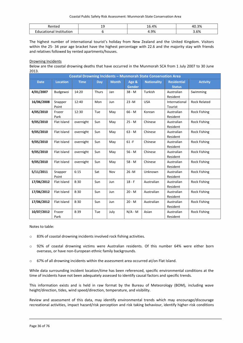
The highest number of international tourist’s holiday from New Zealand and the United Kingdom. Visitors within the 25- 34 year age bracket have the highest percentage with 22.6 and the majority stay with friends and relatives followed by rented apartments/houses. Drowning Incidents Below are the coastal drowning deaths that have occurred in the Munmorah SCA from 1 July 2007 to 30 June 2013.
Coastal Drowning Incidents – Munmorah State Conservation Area
Date Location Time Day Month Age &
Gender
Nationality Residential
Status
Activity
4/01/2007 Budgewoi 14:20 Thurs Jan 38 - M Turkish Australian
Resident
Swimming
16/06/2008 Snapper
Point
12:40 Mon Jun 23 -M USA International
Tourist
Rock Related
4/05/2010 Frazer
Park
12:30 Tue May 66 - M Korean Australian
Resident
Rock Fishing
9/05/2010 Flat Island overnight Sun May 25 - M Chinese Australian
Resident
Rock Fishing
9/05/2010 Flat Island overnight Sun May 63 - M Chinese Australian
Resident
Rock Fishing
9/05/2010 Flat Island overnight Sun May 61 -F Chinese Australian
Resident
Rock Fishing
9/05/2010 Flat Island overnight Sun May 56 - M Chinese Australian
Resident
Rock Fishing
9/05/2010 Flat Island overnight Sun May 58 - M Chinese Australian
Resident
Rock Fishing
5/11/2011 Snapper
Point
6:15 Sat Nov 26 -M Unknown Australian
Resident
Rock Fishing
17/06/2012 Flat Island 8:30 Sun Jun 18 - F Australian Australian
Resident
Rock Fishing
17/06/2012 Flat Island 8:30 Sun Jun 20 - M Australian Australian
Resident
Rock Fishing
17/06/2012 Flat Island 8:30 Sun Jun 20 - M Australian Australian
Resident
Rock Fishing
10/07/2012 Frazer
Park
8:39 Tue July N/A - M Asian Australian
Resident
Rock Fishing
Notes to table: o 83% of coastal drowning incidents involved rock fishing activities.
o 92% of coastal drowning victims were Australian residents. Of this number 64% were either born
overseas, or have non-European ethnic family backgrounds.
o 67% of all drowning incidents within the assessment area occurred at/on Flat Island. While data surrounding incident location/time has been referenced, specific environmental conditions at the time of incidents have not been adequately assessed to identify causal factors and specific trends. This information exists and is held in raw format by the Bureau of Meteorology (BOM), including wave height/direction, tides, wind speed/direction, temperature, and visibility. Review and assessment of this data, may identify environmental trends which may encourage/discourage recreational activities, impact hazard/risk perception and risk taking behaviour, identify higher-risk conditions
Coastal Public Safety Risk Assessment: Munmorah State Conservation Area
Page 37 of 76
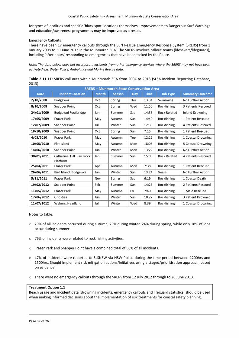
for types of localities and specific ‘black spot’ locations themselves. Improvements to Dangerous Surf Warnings and education/awareness programmes may be improved as a result. Emergency Callouts There have been 17 emergency callouts through the Surf Rescue Emergency Response System (SRERS) from 1 January 2008 to 30 June 2013 in the Munmorah SCA. The SRERS involves callout teams (lifesavers/lifeguards), including ‘after hours’ responding to emergencies that have been tasked by the Police.
Note: The data below does not incorporate incidents from other emergency services where the SRERS may not have been
activated e.g. Water Police, Ambulance and Marine Rescue data.
Table 2.11.11: SRERS call outs within Munmorah SCA from 2004 to 2013 (SLSA Incident Reporting Database, 2013)
SRERS – Munmorah State Conservation Area
Date Incident Location Month Season Day Time Job Type Summary Outcome
2/10/2008 Budgewoi Oct Spring Thu 13:34 Swimming No Further Action
8/10/2008 Snapper Point Oct Spring Wed 11:50 Rockfishing 3 Patients Rescued
24/01/2009 Budgewoi Footbridge Jan Summer Sat 14:56 Rock Related Inland Drowning
17/05/2009 Frazer Park May Autumn Sun 14:40 Rockfishing 1 Patient Rescued
12/07/2009 Snapper Point Jul Winter Sun 12:33 Rockfishing 4 Patients Rescued
18/10/2009 Snapper Point Oct Spring Sun 7:15 Rockfishing 1 Patient Rescued
4/05/2010 Frazer Park May Autumn Tue 12:26 Rockfishing 1 Coastal Drowning
10/05/2010 Flat Island May Autumn Mon 18:03 Rockfishing 5 Coastal Drowning
14/06/2010 Snapper Point Jun Winter Mon 13:22 Rockfishing No Further Action
30/01/2011 Catherine Hill Bay Rock
Platform
Jan Summer Sun 15:00 Rock Related 4 Patients Rescued
25/04/2011 Frazer Park Apr Autumn Mon 7:38 Rockfishing 1 Patient Rescued
26/06/2011 Bird Island, Budgewoi Jun Winter Sun 13:24 Vessel No Further Action
5/11/2011 Frazer Park Nov Spring Sat 6:19 Rockfishing 1 Coastal Death
19/02/2012 Snapper Point Feb Summer Sun 14:26 Rockfishing 2 Patients Rescued
11/05/2012 Frazer Park May Autumn Fri 7:40 Rockfishing 1 Male Rescued
17/06/2012 Ghosties Jun Winter Sun 10:27 Rockfishing 3 Patient Drowned
11/07/2012 Wybung Headland Jul Winter Wed 8:39 Rockfishing 1 Coastal Drowning
Notes to table: o 29% of all incidents occurred during autumn, 29% during winter, 24% during spring, while only 18% of jobs
occur during summer. o 76% of incidents were related to rock fishing activities. o Frazer Park and Snapper Point have a combined total of 58% of all incidents. o 47% of incidents were reported to SLSNSW via NSW Police during the time period between 1200hrs and
1500hrs. Should implement risk mitigation actions/initiatives using a staged/prioritisation approach, based on evidence.
o There were no emergency callouts through the SRERS from 12 July 2012 through to 28 June 2013.
Treatment Option 1.1 Beach usage and incident data (drowning incidents, emergency callouts and lifeguard statistics) should be used when making informed decisions about the implementation of risk treatments for coastal safety planning.
Coastal Public Safety Risk Assessment: Munmorah State Conservation Area
Page 38 of 76
Treatment Option 1.2 Funding should be sought to design and implement a system for collecting quantitative data on coastal usage which can be used to further inform decisions on coastal safety planning.
Treatment Option 3.1 A review be commissioned to analyse the historical environmental conditions at the time of recorded drowning deaths where the Bureau of Meteorology (BOM) is able to supply data. Such a report should identify the relevant trends and causal factors.
Treatment Option 3.2 Consideration should be given to the impact of scheduled development at Catherine Hill Bay (South) on beach usage and coastal safety. Prior to the commencement of development, a site specific coastal public safety risk assessment should be completed.
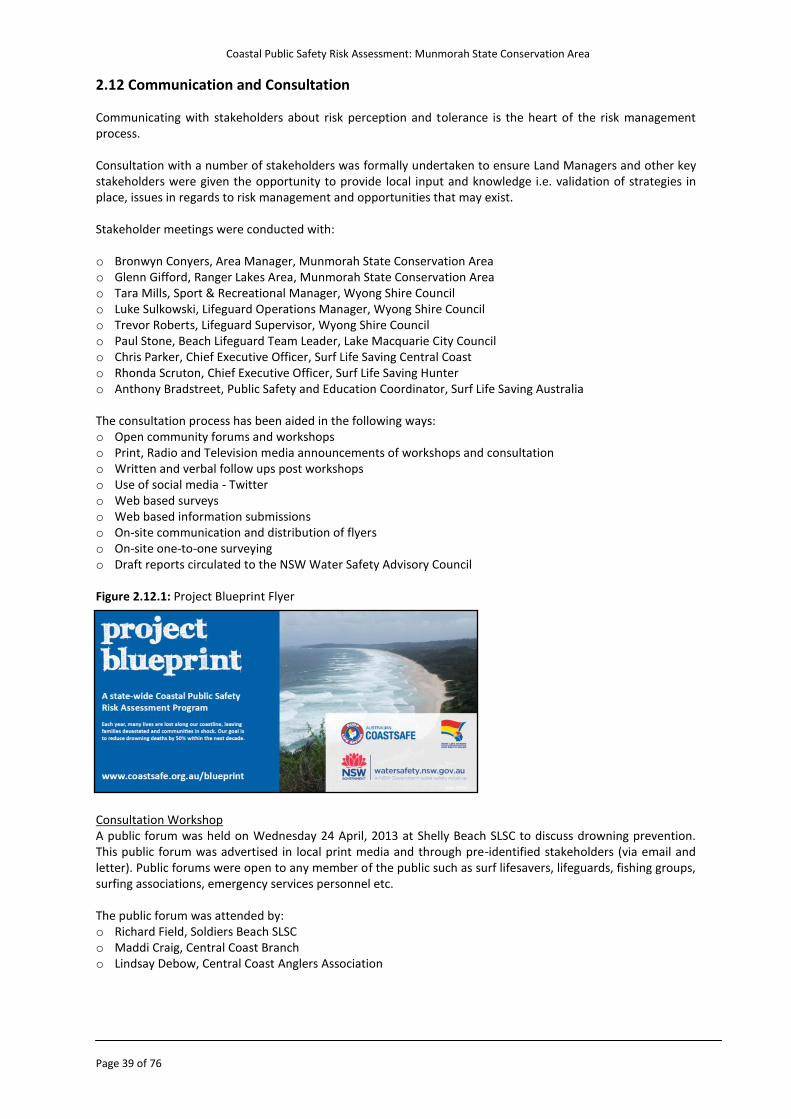
Coastal Public Safety Risk Assessment: Munmorah State Conservation Area
Page 39 of 76
2.12 Communication and Consultation Communicating with stakeholders about risk perception and tolerance is the heart of the risk management process. Consultation with a number of stakeholders was formally undertaken to ensure Land Managers and other key stakeholders were given the opportunity to provide local input and knowledge i.e. validation of strategies in place, issues in regards to risk management and opportunities that may exist. Stakeholder meetings were conducted with: o Bronwyn Conyers, Area Manager, Munmorah State Conservation Area o Glenn Gifford, Ranger Lakes Area, Munmorah State Conservation Area o Tara Mills, Sport & Recreational Manager, Wyong Shire Council o Luke Sulkowski, Lifeguard Operations Manager, Wyong Shire Council o Trevor Roberts, Lifeguard Supervisor, Wyong Shire Council o Paul Stone, Beach Lifeguard Team Leader, Lake Macquarie City Council o Chris Parker, Chief Executive Officer, Surf Life Saving Central Coast o Rhonda Scruton, Chief Executive Officer, Surf Life Saving Hunter o Anthony Bradstreet, Public Safety and Education Coordinator, Surf Life Saving Australia The consultation process has been aided in the following ways: o Open community forums and workshops o Print, Radio and Television media announcements of workshops and consultation o Written and verbal follow ups post workshops o Use of social media - Twitter o Web based surveys o Web based information submissions o On-site communication and distribution of flyers o On-site one-to-one surveying o Draft reports circulated to the NSW Water Safety Advisory Council Figure 2.12.1: Project Blueprint Flyer Consultation Workshop A public forum was held on Wednesday 24 April, 2013 at Shelly Beach SLSC to discuss drowning prevention. This public forum was advertised in local print media and through pre-identified stakeholders (via email and letter). Public forums were open to any member of the public such as surf lifesavers, lifeguards, fishing groups, surfing associations, emergency services personnel etc. The public forum was attended by: o Richard Field, Soldiers Beach SLSC o Maddi Craig, Central Coast Branch o Lindsay Debow, Central Coast Anglers Association
Coastal Public Safety Risk Assessment: Munmorah State Conservation Area
Page 40 of 76
Consultation Survey The consultation process has also involved the introduction of an online survey which has been useful to capture input from a wide range of key stakeholders, at local/regional level. Survey 1 The first survey was sent to both internal and external stakeholders. Questions focused on drowning identification and prevention. Survey Questions: o In your opinion, what are the (top three) factors contributing to drowning / coastal related incidents at this
location? o In your opinion, are there any particular risk factors at this location which may contribute to drowning at
this location? o If you believe age to be a contributing factor to drowning at this location, which age groups are most at
risk? o If you believe gender to be a contributing factor to drowning at this location, which gender is most at risk? o If you believe socio economic status to be a contributing factor to drowning at this location, which socio
economic groups are most at risk? o If you believe ethnicity to be a contributing factor to drowning at this location, which ethnic groups are
most at risk? o If you believe residency to be a contributing factor to drowning at this location, which residential groups
are most at risk? o Are there particular activities or types of behaviour that people engage in that you think places them at a
greater risk of drowning or other coastal related injury? o Are there any physical attributes or other factors relevant to the area that you think may place people at
greater risk of drowning or water related injury? (e.g. beach characteristics, parking/access points, tourism facilities on beach etc.)
o What are the current key strategies (top three) addressing the issue of drowning prevention / coastal safety? Please evaluate the effectiveness of these current strategies at this location?
o In your opinion, what key strategies (top 3) do you think should be implemented to address the issue of drowning / coastal related incidents at this location?
Survey 2 The second survey was sent to internal stakeholders only e.g. lifesavers and lifeguards. Questions focused on visitation numbers and incidents. Survey Questions: o To the best of your knowledge, what would be the maximum number of people at the location (on the
beach/rock platform/in water) at any one time? o To the best of your knowledge, how often would the visitation numbers identified in the previous question
occur at the location? o In your opinion, which of the following risk groups are present at the location? o To the best of your knowledge is there a lifesaving service at this location (i.e. Council Lifeguards or
Volunteer Surf Life Saving Club)? o To the best of your knowledge, how many incidents have occurred at this location in the past 5 years? o To the best of your knowledge, how many incidents have occurred at this location in the past 12 months? o How quickly can an emergency or lifesaving service respond to an emergency incident at this location (in
minutes)?
Coastal Public Safety Risk Assessment: Munmorah State Conservation Area
Page 41 of 76
3. Risk Assessment Findings 3.1 Action Planning Priority (Inherent Risk) 3.1.1 Action Planning Priority Index The Action Planning Priority Index can be viewed as the gross risk score for a beach. The index seeks to identify the risks associated with the broader coastal environment under assessment, rather than specific hazards and risks present at a particular location or site. The majority of information detailed in this section of the report will be identified through pre exiting data (where available), with new data sourced where gaps are present or the data is not reliable. The total score for the Action Planning Priority Index, displayed on pages 46 & 47, is intended to be used for the purpose of prioritising risk mitigation strategies provided for consideration in this report. The individual components of the Action Planning Priority Index should not be considered in isolation from the total scores outlined in table 3.1.6.2. The information is based on modal data for peak visitation during the busiest season(s). The Action Planning Priority Index uses the following risk identification information: 1. Australian Beach Safety & Management Program (ABSAMP Rating) 2. Local Population Rating (LPR) 3. Human/Activity Interaction Rating (HAIR) 4. Access Rating (AR)
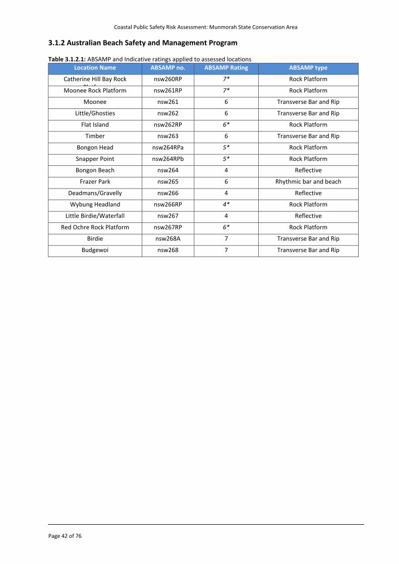
Coastal Public Safety Risk Assessment: Munmorah State Conservation Area
Page 42 of 76
3.1.2 Australian Beach Safety and Management Program Table 3.1.2.1: ABSAMP and Indicative ratings applied to assessed locations
Location Name ABSAMP no. ABSAMP Rating ABSAMP type
Catherine Hill Bay Rock Platform
nsw260RP 7* Rock Platform
Moonee Rock Platform nsw261RP 7* Rock Platform
Moonee nsw261 6 Transverse Bar and Rip
Little/Ghosties nsw262 6 Transverse Bar and Rip
Flat Island nsw262RP 6* Rock Platform
Timber nsw263 6 Transverse Bar and Rip
Bongon Head nsw264RPa 5* Rock Platform
Snapper Point nsw264RPb 5* Rock Platform
Bongon Beach nsw264 4 Reflective
Frazer Park nsw265 6 Rhythmic bar and beach
Deadmans/Gravelly nsw266 4 Reflective
Wybung Headland nsw266RP 4* Rock Platform
Little Birdie/Waterfall nsw267 4 Reflective
Red Ochre Rock Platform nsw267RP 6* Rock Platform
Birdie nsw268A 7 Transverse Bar and Rip
Budgewoi nsw268 7 Transverse Bar and Rip
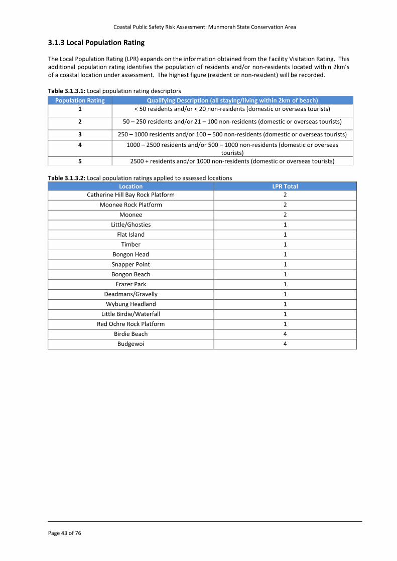
Coastal Public Safety Risk Assessment: Munmorah State Conservation Area
Page 43 of 76
3.1.3 Local Population Rating The Local Population Rating (LPR) expands on the information obtained from the Facility Visitation Rating. This additional population rating identifies the population of residents and/or non-residents located within 2km’s of a coastal location under assessment. The highest figure (resident or non-resident) will be recorded. Table 3.1.3.1: Local population rating descriptors
Table 3.1.3.2: Local population ratings applied to assessed locations
Location LPR Total
Catherine Hill Bay Rock Platform 2
Moonee Rock Platform 2
Moonee 2
Little/Ghosties 1
Flat Island 1
Timber 1
Bongon Head 1
Snapper Point 1
Bongon Beach 1
Frazer Park 1
Deadmans/Gravelly 1
Wybung Headland 1
Little Birdie/Waterfall 1
Red Ochre Rock Platform 1
Birdie Beach 4
Budgewoi 4
Population Rating Qualifying Description (all staying/living within 2km of beach)
1 < 50 residents and/or < 20 non-residents (domestic or overseas tourists)
2 50 – 250 residents and/or 21 – 100 non-residents (domestic or overseas tourists)
3 250 – 1000 residents and/or 100 – 500 non-residents (domestic or overseas tourists)
4 1000 – 2500 residents and/or 500 – 1000 non-residents (domestic or overseas tourists)
5 2500 + residents and/or 1000 non-residents (domestic or overseas tourists)
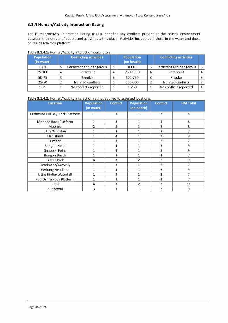
Coastal Public Safety Risk Assessment: Munmorah State Conservation Area
Page 44 of 76
3.1.4 Human/Activity Interaction Rating The Human/Activity Interaction Rating (HAIR) identifies any conflicts present at the coastal environment between the number of people and activities taking place. Activities include both those in the water and those on the beach/rock platform. Table 3.1.4.1: Human/Activity Interaction descriptors.
Population (in-water)
Conflicting activities Population (on beach)
Conflicting activities
100+ 5 Persistent and dangerous 5 1000+ 5 Persistent and dangerous 5
75-100 4 Persistent 4 750-1000 4 Persistent 4
50-75 3 Regular 3 500-750 3 Regular 3
25-50 2 Isolated conflicts 2 250-500 2 Isolated conflicts 2
1-25 1 No conflicts reported 1 1-250 1 No conflicts reported 1
Table 3.1.4.2: Human/Activity Interaction ratings applied to assessed locations.
Location Population (in water)
Conflict Population (on beach)
Conflict HAI Total
Catherine Hill Bay Rock Platform 1 3 1 3 8
Moonee Rock Platform 1 3 1 3 8
Moonee 2 3 1 2 8
Little/Ghosties 1 3 1 2 7
Flat Island 1 4 1 3 9
Timber 1 3 1 2 7
Bongon Head 1 4 1 3 9
Snapper Point 1 4 1 3 9
Bongon Beach 1 3 1 2 7
Frazer Park 4 3 2 2 11
Deadmans/Gravelly 1 3 1 2 7
Wybung Headland 1 4 1 3 9
Little Birdie/Waterfall 1 3 1 2 7
Red Ochre Rock Platform 1 3 1 2 7
Birdie 4 3 2 2 11
Budgewoi 3 3 1 2 9
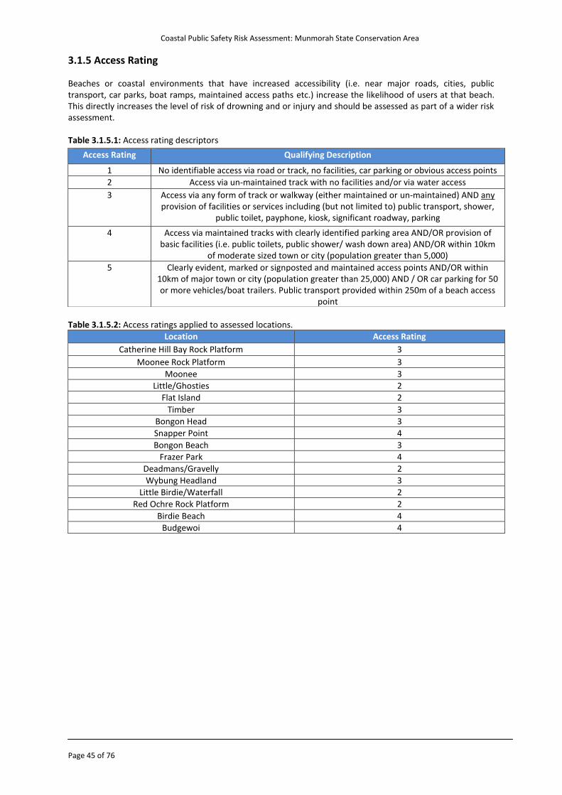
Coastal Public Safety Risk Assessment: Munmorah State Conservation Area
Page 45 of 76
3.1.5 Access Rating Beaches or coastal environments that have increased accessibility (i.e. near major roads, cities, public transport, car parks, boat ramps, maintained access paths etc.) increase the likelihood of users at that beach. This directly increases the level of risk of drowning and or injury and should be assessed as part of a wider risk assessment. Table 3.1.5.1: Access rating descriptors
Table 3.1.5.2: Access ratings applied to assessed locations.
Location Access Rating
Catherine Hill Bay Rock Platform 3
Moonee Rock Platform 3
Moonee 3
Little/Ghosties 2
Flat Island 2
Timber 3
Bongon Head 3
Snapper Point 4
Bongon Beach 3
Frazer Park 4
Deadmans/Gravelly 2
Wybung Headland 3
Little Birdie/Waterfall 2
Red Ochre Rock Platform 2
Birdie Beach 4
Budgewoi 4
Access Rating Qualifying Description
1 No identifiable access via road or track, no facilities, car parking or obvious access points
2 Access via un-maintained track with no facilities and/or via water access
3 Access via any form of track or walkway (either maintained or un-maintained) AND any provision of facilities or services including (but not limited to) public transport, shower,
public toilet, payphone, kiosk, significant roadway, parking
4 Access via maintained tracks with clearly identified parking area AND/OR provision of basic facilities (i.e. public toilets, public shower/ wash down area) AND/OR within 10km
of moderate sized town or city (population greater than 5,000)
5 Clearly evident, marked or signposted and maintained access points AND/OR within 10km of major town or city (population greater than 25,000) AND / OR car parking for 50 or more vehicles/boat trailers. Public transport provided within 250m of a beach access
point
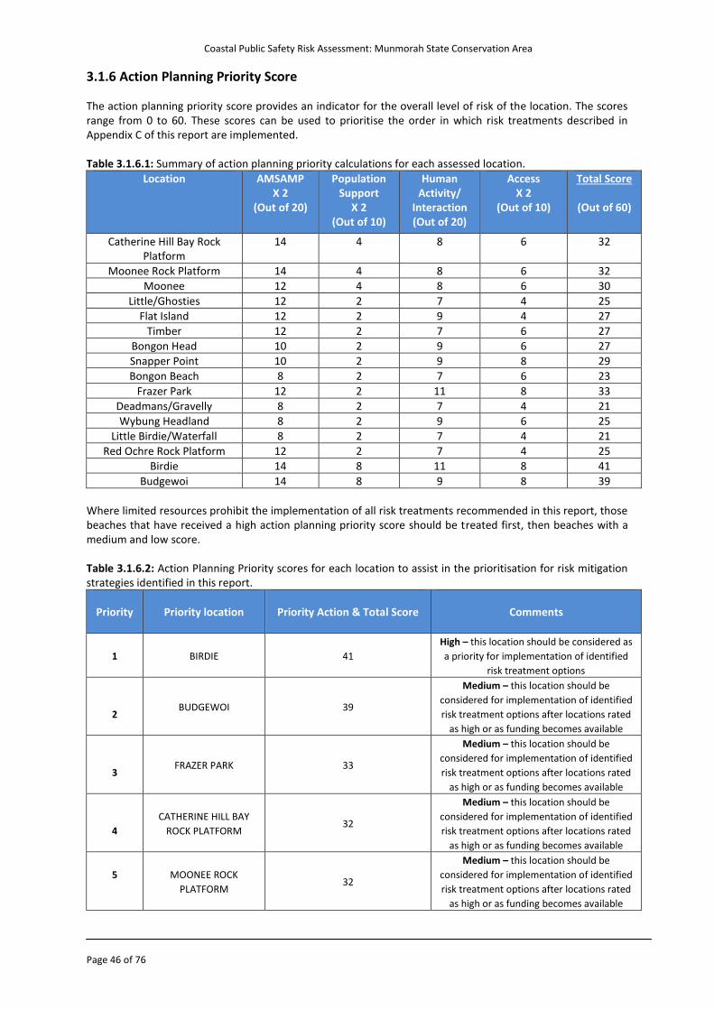
Coastal Public Safety Risk Assessment: Munmorah State Conservation Area
Page 46 of 76
3.1.6 Action Planning Priority Score The action planning priority score provides an indicator for the overall level of risk of the location. The scores range from 0 to 60. These scores can be used to prioritise the order in which risk treatments described in Appendix C of this report are implemented. Table 3.1.6.1: Summary of action planning priority calculations for each assessed location.
Location
AMSAMP X 2
(Out of 20)
Population Support
X 2 (Out of 10)
Human Activity/
Interaction (Out of 20)
Access X 2
(Out of 10)
Total Score
(Out of 60)
Catherine Hill Bay Rock Platform
14 4 8 6 32
Moonee Rock Platform 14 4 8 6 32
Moonee 12 4 8 6 30
Little/Ghosties 12 2 7 4 25
Flat Island 12 2 9 4 27
Timber 12 2 7 6 27
Bongon Head 10 2 9 6 27
Snapper Point 10 2 9 8 29
Bongon Beach 8 2 7 6 23
Frazer Park 12 2 11 8 33
Deadmans/Gravelly 8 2 7 4 21
Wybung Headland 8 2 9 6 25
Little Birdie/Waterfall 8 2 7 4 21
Red Ochre Rock Platform 12 2 7 4 25
Birdie 14 8 11 8 41
Budgewoi 14 8 9 8 39
Where limited resources prohibit the implementation of all risk treatments recommended in this report, those beaches that have received a high action planning priority score should be treated first, then beaches with a medium and low score. Table 3.1.6.2: Action Planning Priority scores for each location to assist in the prioritisation for risk mitigation strategies identified in this report.
Priority
Priority location
Priority Action & Total Score
Comments
1
BIRDIE 41
High – this location should be considered as
a priority for implementation of identified
risk treatment options
2
BUDGEWOI 39
Medium – this location should be
considered for implementation of identified
risk treatment options after locations rated
as high or as funding becomes available
3
FRAZER PARK 33
Medium – this location should be
considered for implementation of identified
risk treatment options after locations rated
as high or as funding becomes available
4
CATHERINE HILL BAY
ROCK PLATFORM 32
Medium – this location should be
considered for implementation of identified
risk treatment options after locations rated
as high or as funding becomes available
5 MOONEE ROCK
PLATFORM 32
Medium – this location should be
considered for implementation of identified
risk treatment options after locations rated
as high or as funding becomes available
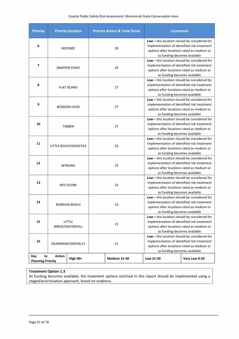
Coastal Public Safety Risk Assessment: Munmorah State Conservation Area
Page 47 of 76
Priority
Priority location
Priority Action & Total Score
Comments
6
MOONEE 30
Low – this location should be considered for
implementation of identified risk treatment
options after locations rated as medium or
as funding becomes available
7
SNAPPER POINT 29
Low – this location should be considered for
implementation of identified risk treatment
options after locations rated as medium or
as funding becomes available
8
FLAT ISLAND 27
Low – this location should be considered for
implementation of identified risk treatment
options after locations rated as medium or
as funding becomes available
9
BONGON HEAD 27
Low – this location should be considered for
implementation of identified risk treatment
options after locations rated as medium or
as funding becomes available
10
TIMBER 27
Low – this location should be considered for
implementation of identified risk treatment
options after locations rated as medium or
as funding becomes available
11
LITTLE BEACH/GHOSTIES 25
Low – this location should be considered for
implementation of identified risk treatment
options after locations rated as medium or
as funding becomes available
12
WYBUNG 25
Low – this location should be considered for
implementation of identified risk treatment
options after locations rated as medium or
as funding becomes available
13
RED OCHRE 25
Low – this location should be considered for
implementation of identified risk treatment
options after locations rated as medium or
as funding becomes available
14
BONGON BEACH 23
Low – this location should be considered for
implementation of identified risk treatment
options after locations rated as medium or
as funding becomes available
15 LITTLE
BIRDIE/WATERFALL 21
Low – this location should be considered for
implementation of identified risk treatment
options after locations rated as medium or
as funding becomes available
16
DEADMANS/GRAVELLY 21
Low – this location should be considered for
implementation of identified risk treatment
options after locations rated as medium or
as funding becomes available
Key to Action
Planning Priority High 40+ Medium 31-40 Low 21-30 Very Low 0-20
Treatment Option 1.3 As funding becomes available, the treatment options outlined in this report should be implemented using a staged/prioritisation approach, based on evidence.
Coastal Public Safety Risk Assessment: Munmorah State Conservation Area
Page 48 of 76
3.2 Overview of Principal Risk Treatments 3.2.1 Introduction There are a range of risk treatment options that can be considered in the context of coastal risk management. The selection of the most appropriate option involves balancing the financial, social and environmental impacts of implementing each against the benefits derived from each. These may include any combination of the following: o Spread (share) risk – insurance o Engineer (structural and technological) risk treatment – include modified practices o Regulatory and institutional – change through revised regulations and planning o Avoid – isolate the risk, move people away o Research to better understand o Educate and inform stakeholders 3.2.2 Hierarchy of Risk Treatments (Controls) In determining the most appropriate and cost effective option, it is important to consider the hierarchy of risk treatments (controls). The hierarchy is a sequence of options which offer a number of ways to approach the hazard control process. o Hard controls deal with the tangible such as:
Eliminate the hazard which in a coastal context is often difficult to achieve Isolate the hazard which in a coastal context can be difficult due to the dynamic nature of
environmental and weather conditions Use engineering controls such as design of access paths, installation of appropriate signage, and
revegetation Use administrative controls such as supervision, emergency action plans, other documented policies,
practices and procedures o Soft controls deal with human behaviour such as:
Use of effective leadership, management, trust, ethics, integrity, and building relationships Education
Outlined below are principal risk treatment solutions that expand upon those listed within the Risk Register and Treatment Plan in Appendix B. The solutions outlined endeavour to provide specific and detailed information relative to the beach locations; however due to the diverse nature of location characteristics, treatment options are at times mainly generic in nature. Land Managers in the Munmorah SCA should endeavour to adopt the most appropriate treatment options specific to their organisations capabilities and in consultation with all relevant stakeholders. The principal risk treatments are expanded on below.
Coastal Public Safety Risk Assessment: Munmorah State Conservation Area
Page 49 of 76
3.2.3 Education and Awareness Programmes Public education and awareness programmes are a fundamental component of any drowning prevention strategy, and target both the pre-arrival and early arrival periods (before a person/s are exposed to hazards). Key factors pertaining to effective education and awareness programmes include: o Consistency in safety messaging (elimination of confusing/unclear or dissipative information) o Consistency in the method of provision (ongoing information provided at regular locations/times) o Longevity in the provision of information (ongoing, not a one-off) During the course of the assessment and throughout the consultation process Australian CoastSafe were made aware of various education and awareness programmes that are currently, or have been previously in place to educate and inform the public. These initiatives include: o Surf safety information (e.g. flyers for swimming and rock fishing safety) distributed to visitors are available
at the park office, at visitor entry stations (when operating), or through local rangers. o Surf safety information displayed on promotional material regarding Munmorah State Conservation Area
e.g. website and brochures. o At times, local rangers provide lifejackets to rock fishermen o Educational DVDs for rock fishermen are provided at the park office. o Local media and promotional opportunities to deliver safety messages and communicate dangerous surf
warnings i.e. local newspapers, local radio and local television networks. NPWS should be commended for the proactive education/awareness initiatives employed currently. Public education and safety awareness programmes outlining known and commonly occurring hazards within the Munmorah SCA should continue to be implemented and reviewed. Educational Messages Land Managers should continue to provide public education/awareness programmes which include standardised key safety messages and align/reference to peak coastal water safety agency websites such as: NSW Water Safety Advisory Council: http://www.watersafety.nsw.gov.au/beach-safety/ Together with the following referenced websites of the NSW Water Safety Advisory Council for beach safety: o BeachSafe: www.beachsafe.org.au o Rip Currents: www.ripcurrents.com.au One such opportunity includes displaying posters which promote water safety at public amenity blocks and visitor information displays directly located around coastal beach access. The most suitable locations for these posters would be Frazer Park, the Freemans Camping Area and Birdie Beach. Rockfishing Websites During the course of the assessment, Australian CoastSafe were made aware that non English speaking websites (e.g. Korean, Chinese and Vietnamese etc.) exist amongst ethnic groups which promote rock fishing specifically in the Munmorah State Conservation Area. Further investigation of these websites could provide an opportunity to engage a targeted educational campaign to specific user groups. Personal Protective Equipment Water safety agencies actively promote the use of lifejackets for fisherman. Educational and awareness programmes in the Munmorah SCA should continue to be reviewed and developed to promote and encourage fisherman to wear lifejackets. Rock Fishing Survey As an example, Randwick City Council recently conducted an educational survey of rock fisherman, fishing at popular sites within the Randwick LGA. There is the opportunity for peak water safety organisations to conduct similar types of surveys in the Munmorah SCA. The results of this survey will assist peak water safety organisations and Land Managers in planning for coastal public safety.
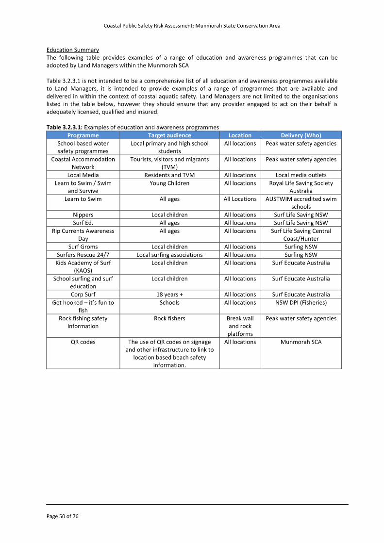
Coastal Public Safety Risk Assessment: Munmorah State Conservation Area
Page 50 of 76
Education Summary The following table provides examples of a range of education and awareness programmes that can be adopted by Land Managers within the Munmorah SCA Table 3.2.3.1 is not intended to be a comprehensive list of all education and awareness programmes available to Land Managers, it is intended to provide examples of a range of programmes that are available and delivered in within the context of coastal aquatic safety. Land Managers are not limited to the organisations listed in the table below, however they should ensure that any provider engaged to act on their behalf is adequately licensed, qualified and insured. Table 3.2.3.1: Examples of education and awareness programmes
Programme Target audience Location Delivery (Who)
School based water safety programmes
Local primary and high school students
All locations Peak water safety agencies
Coastal Accommodation Network
Tourists, visitors and migrants (TVM)
All locations Peak water safety agencies
Local Media Residents and TVM All locations Local media outlets
Learn to Swim / Swim and Survive
Young Children All locations Royal Life Saving Society Australia
Learn to Swim All ages All Locations AUSTWIM accredited swim schools
Nippers Local children All locations Surf Life Saving NSW
Surf Ed. All ages All locations Surf Life Saving NSW
Rip Currents Awareness Day
All ages All locations Surf Life Saving Central Coast/Hunter
Surf Groms Local children All locations Surfing NSW
Surfers Rescue 24/7 Local surfing associations All locations Surfing NSW
Kids Academy of Surf (KAOS)
Local children All locations Surf Educate Australia
School surfing and surf education
Local children All locations Surf Educate Australia
Corp Surf 18 years + All locations Surf Educate Australia
Get hooked – it’s fun to fish
Schools All locations NSW DPI (Fisheries)
Rock fishing safety information
Rock fishers
Break wall and rock platforms
Peak water safety agencies
QR codes
The use of QR codes on signage and other infrastructure to link to
location based beach safety information.
All locations Munmorah SCA
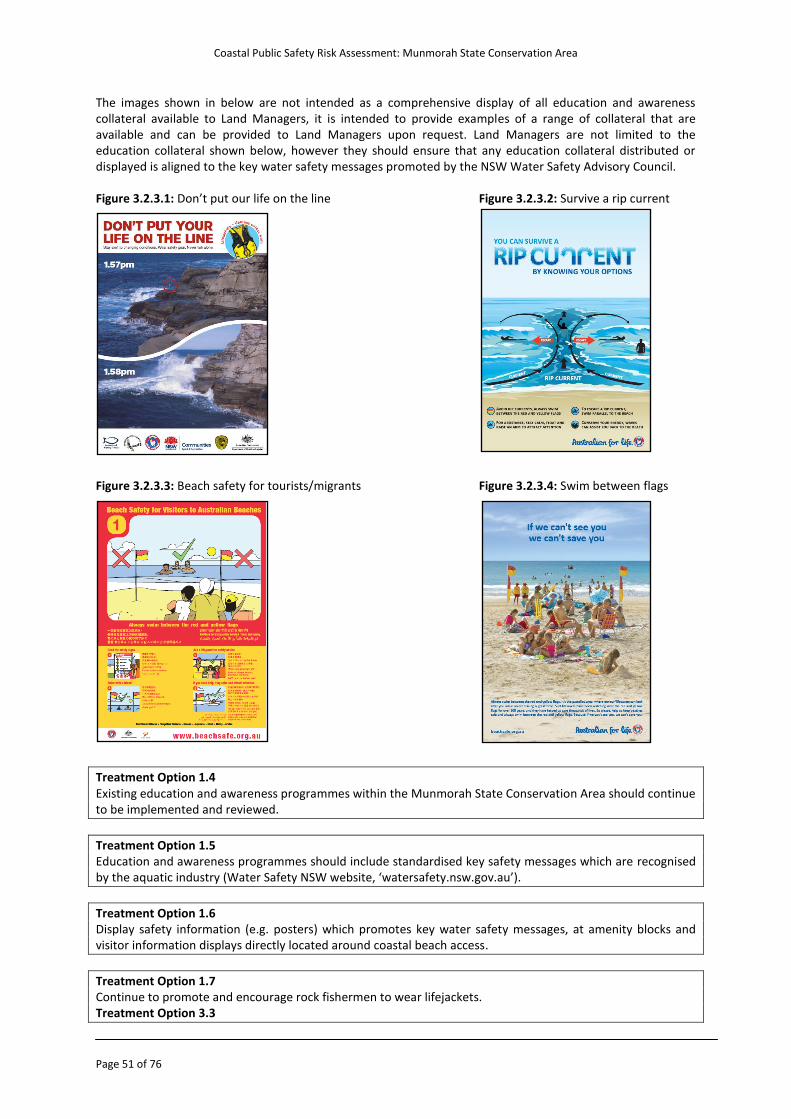
Coastal Public Safety Risk Assessment: Munmorah State Conservation Area
Page 51 of 76
The images shown in below are not intended as a comprehensive display of all education and awareness collateral available to Land Managers, it is intended to provide examples of a range of collateral that are available and can be provided to Land Managers upon request. Land Managers are not limited to the education collateral shown below, however they should ensure that any education collateral distributed or displayed is aligned to the key water safety messages promoted by the NSW Water Safety Advisory Council. Figure 3.2.3.1: Don’t put our life on the line Figure 3.2.3.2: Survive a rip current Figure 3.2.3.3: Beach safety for tourists/migrants Figure 3.2.3.4: Swim between flags
Treatment Option 1.4 Existing education and awareness programmes within the Munmorah State Conservation Area should continue to be implemented and reviewed.
Treatment Option 1.5 Education and awareness programmes should include standardised key safety messages which are recognised by the aquatic industry (Water Safety NSW website, ‘watersafety.nsw.gov.au’).
Treatment Option 1.6 Display safety information (e.g. posters) which promotes key water safety messages, at amenity blocks and visitor information displays directly located around coastal beach access.
Treatment Option 1.7 Continue to promote and encourage rock fishermen to wear lifejackets. Treatment Option 3.3
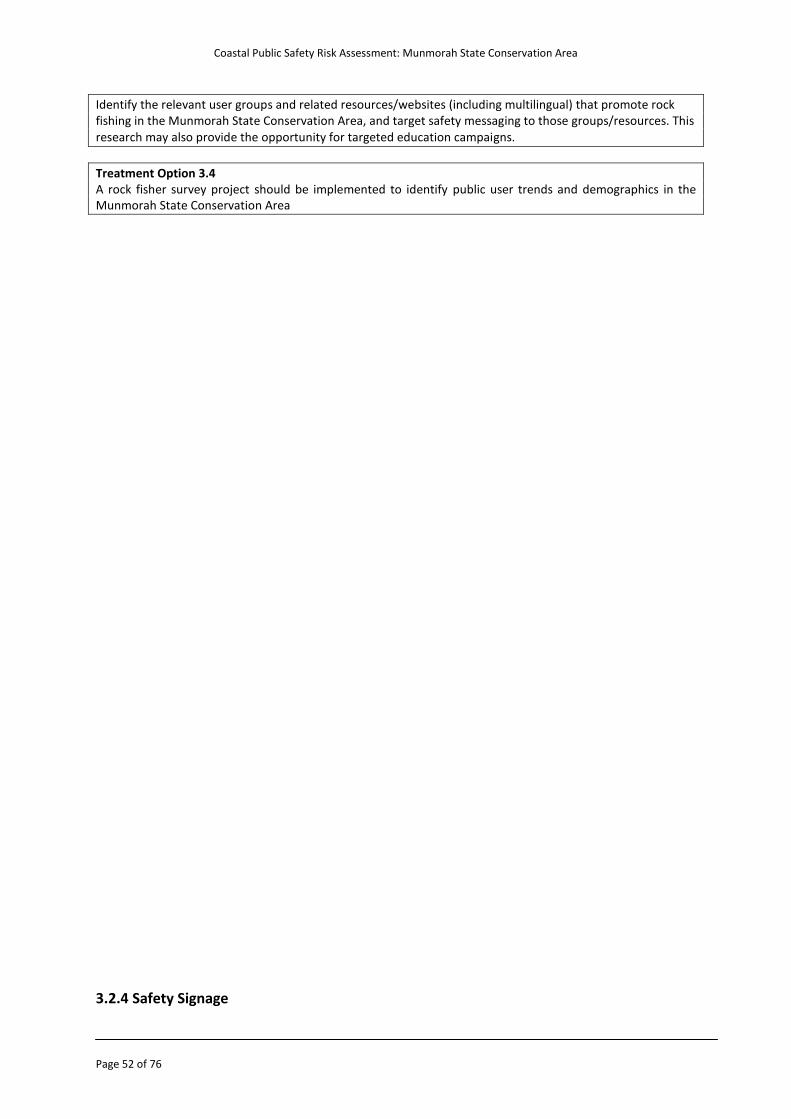
Coastal Public Safety Risk Assessment: Munmorah State Conservation Area
Page 52 of 76
Identify the relevant user groups and related resources/websites (including multilingual) that promote rock fishing in the Munmorah State Conservation Area, and target safety messaging to those groups/resources. This research may also provide the opportunity for targeted education campaigns.
Treatment Option 3.4 A rock fisher survey project should be implemented to identify public user trends and demographics in the Munmorah State Conservation Area
3.2.4 Safety Signage
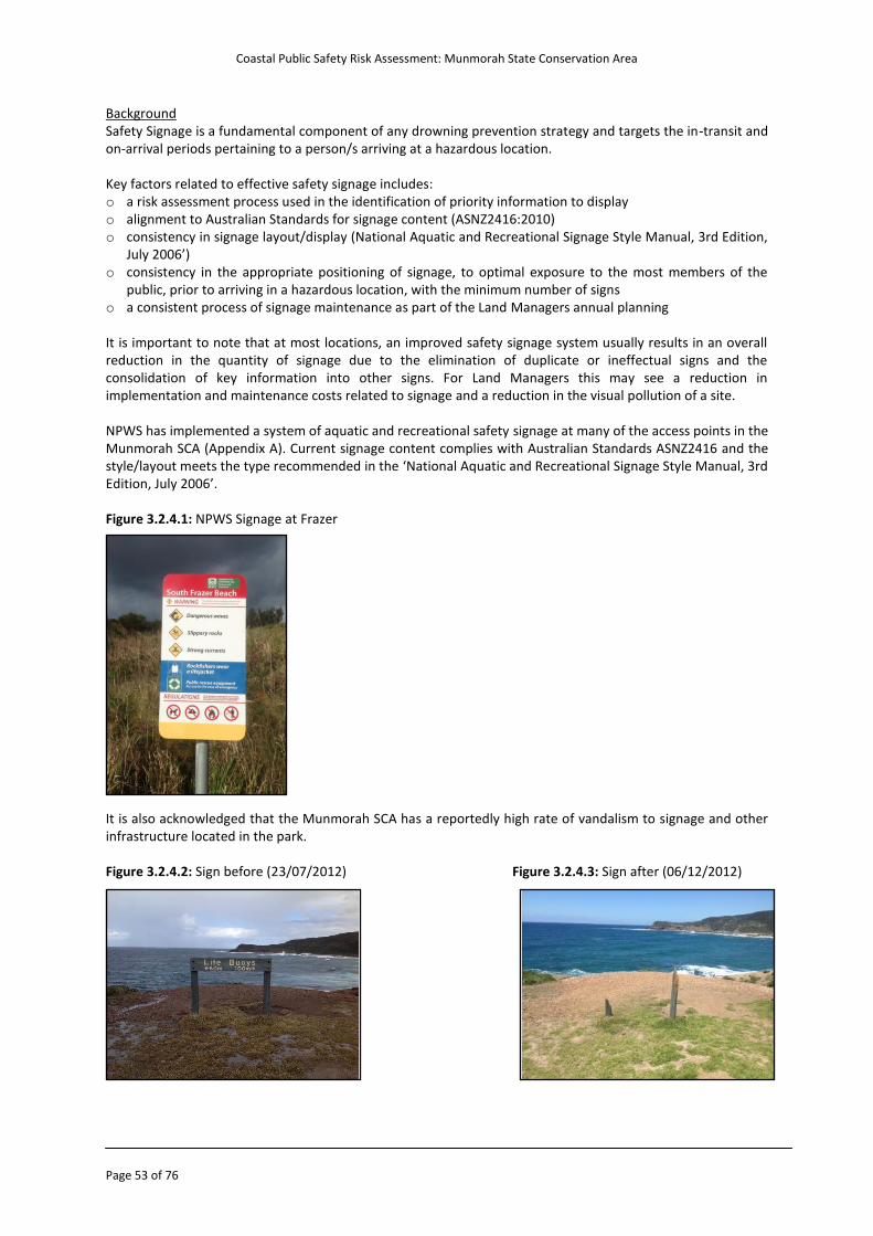
Coastal Public Safety Risk Assessment: Munmorah State Conservation Area
Page 53 of 76
Background Safety Signage is a fundamental component of any drowning prevention strategy and targets the in-transit and on-arrival periods pertaining to a person/s arriving at a hazardous location. Key factors related to effective safety signage includes: o a risk assessment process used in the identification of priority information to display o alignment to Australian Standards for signage content (ASNZ2416:2010) o consistency in signage layout/display (National Aquatic and Recreational Signage Style Manual, 3rd Edition,
July 2006’) o consistency in the appropriate positioning of signage, to optimal exposure to the most members of the
public, prior to arriving in a hazardous location, with the minimum number of signs o a consistent process of signage maintenance as part of the Land Managers annual planning It is important to note that at most locations, an improved safety signage system usually results in an overall reduction in the quantity of signage due to the elimination of duplicate or ineffectual signs and the consolidation of key information into other signs. For Land Managers this may see a reduction in implementation and maintenance costs related to signage and a reduction in the visual pollution of a site. NPWS has implemented a system of aquatic and recreational safety signage at many of the access points in the Munmorah SCA (Appendix A). Current signage content complies with Australian Standards ASNZ2416 and the style/layout meets the type recommended in the ‘National Aquatic and Recreational Signage Style Manual, 3rd Edition, July 2006’. Figure 3.2.4.1: NPWS Signage at Frazer It is also acknowledged that the Munmorah SCA has a reportedly high rate of vandalism to signage and other infrastructure located in the park. Figure 3.2.4.2: Sign before (23/07/2012) Figure 3.2.4.3: Sign after (06/12/2012)
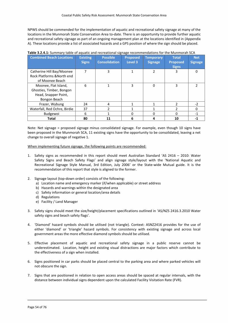
Coastal Public Safety Risk Assessment: Munmorah State Conservation Area
Page 54 of 76
NPWS should be commended for the implementation of aquatic and recreational safety signage at many of the locations in the Munmorah State Conservation Area to-date. There is an opportunity to provide further aquatic and recreational safety signage as part of an ongoing management plan at the locations identified in (Appendix A). These locations provide a list of associated hazards and a GPS position of where the sign should be placed. Table 3.2.4.1: Summary table of aquatic and recreational signage recommendations for the Munmorah SCA
Combined Beach Locations Existing Signs
Possible Consolidation
Proposed Level 3
Temporary Signage
Total Proposed
Signs
Net Signage
Catherine Hill Bay/Moonee Rock Platforms &North end
of Moonee Beach
7 3 1 2 3 0
Moonee, Flat Island, Ghosties, Timber, Bongon
Head, Snapper Point, Bongon Beach
6 1 3 0 3 2
Frazer, Wybung 24 4 1 1 2 -2
Waterfall, Red Ochre, Birdie 37 2 1 1 2 0
Budgewoi 6 1 0 0 0 -1
Total 80 11 6 4 10 -1
Note: Net signage = proposed signage minus consolidated signage. For example, even though 10 signs have been proposed in the Munmorah SCA, 11 existing signs have the opportunity to be consolidated, leaving a net change to overall signage of negative 1. When implementing future signage, the following points are recommended: 1. Safety signs as recommended in this report should meet Australian Standard ‘AS 2416 – 2010: Water
Safety Signs and Beach Safety Flags’ and align signage style/layout with the ‘National Aquatic and Recreational Signage Style Manual, 3rd Edition, July 2006’ or the State-wide Mutual guide. It is the recommendation of this report that style is aligned to the former.
2. Signage layout (top-down order) consists of the following:
a) Location name and emergency marker (if/when applicable) or street address b) Hazards and warnings within the designated area c) Safety information or general location/area details d) Regulations e) Facility / Land Manager
3. Safety signs should meet the size/height/placement specifications outlined in ‘AS/NZS 2416.3.2010 Water
safety signs and beach safety flags’. 4. ‘Diamond’ hazard symbols should be utilised (not triangle). Context: ASNZ2416 provides for the use of
either ‘diamond’ or ‘triangle’ hazard symbols. For consistency with existing signage and across local government areas the more effective diamond symbols should be utilised.
5. Effective placement of aquatic and recreational safety signage in a public reserve cannot be
underestimated. Location, height and existing visual distractions are major factors which contribute to the effectiveness of a sign when installed.
6. Signs positioned in car parks should be placed central to the parking area and where parked vehicles will
not obscure the sign.
7. Signs that are positioned in relation to open access areas should be spaced at regular intervals, with the distance between individual signs dependent upon the calculated Facility Visitation Rate (FVR).
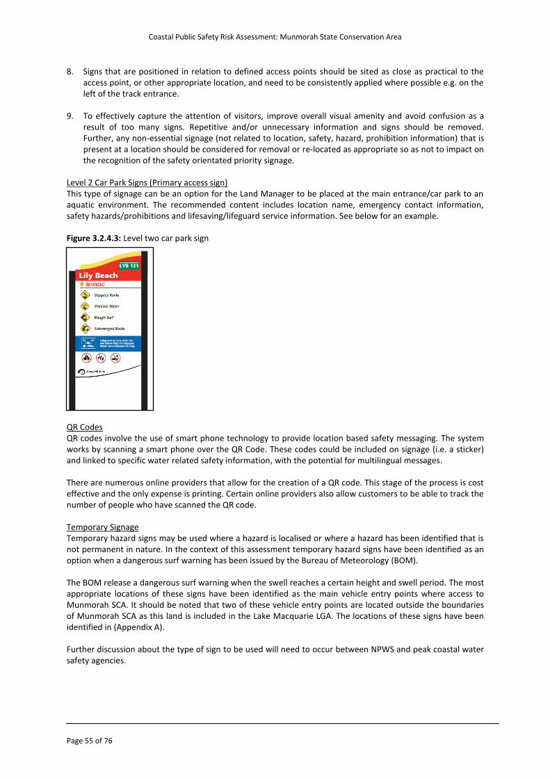
Coastal Public Safety Risk Assessment: Munmorah State Conservation Area
Page 55 of 76
8. Signs that are positioned in relation to defined access points should be sited as close as practical to the access point, or other appropriate location, and need to be consistently applied where possible e.g. on the left of the track entrance.
9. To effectively capture the attention of visitors, improve overall visual amenity and avoid confusion as a
result of too many signs. Repetitive and/or unnecessary information and signs should be removed. Further, any non-essential signage (not related to location, safety, hazard, prohibition information) that is present at a location should be considered for removal or re-located as appropriate so as not to impact on the recognition of the safety orientated priority signage.
Level 2 Car Park Signs (Primary access sign) This type of signage can be an option for the Land Manager to be placed at the main entrance/car park to an aquatic environment. The recommended content includes location name, emergency contact information, safety hazards/prohibitions and lifesaving/lifeguard service information. See below for an example. Figure 3.2.4.3: Level two car park sign QR Codes QR codes involve the use of smart phone technology to provide location based safety messaging. The system works by scanning a smart phone over the QR Code. These codes could be included on signage (i.e. a sticker) and linked to specific water related safety information, with the potential for multilingual messages.
There are numerous online providers that allow for the creation of a QR code. This stage of the process is cost effective and the only expense is printing. Certain online providers also allow customers to be able to track the number of people who have scanned the QR code. Temporary Signage Temporary hazard signs may be used where a hazard is localised or where a hazard has been identified that is not permanent in nature. In the context of this assessment temporary hazard signs have been identified as an option when a dangerous surf warning has been issued by the Bureau of Meteorology (BOM). The BOM release a dangerous surf warning when the swell reaches a certain height and swell period. The most appropriate locations of these signs have been identified as the main vehicle entry points where access to Munmorah SCA. It should be noted that two of these vehicle entry points are located outside the boundaries of Munmorah SCA as this land is included in the Lake Macquarie LGA. The locations of these signs have been identified in (Appendix A). Further discussion about the type of sign to be used will need to occur between NPWS and peak coastal water safety agencies.
Coastal Public Safety Risk Assessment: Munmorah State Conservation Area
Page 56 of 76
Treatment Option 1.8 Standardised water safety signage that aligns to Australian standards and best-practice ‘style’ should be implemented at the locations listed in Appendix A. This may include the maintenance and upgrade of existing signage through planned works schedules, the consolidation of multiple existing signs into a single sign (less signs) or the removal of unnecessary signage.
Treatment Option 1.9 & 4.1 In partnership with peak water safety agencies, investigate the use of temporary road signage at the main vehicle entry points outlined in Appendix A during Bureau of Meteorology (BOM) issued dangerous surf warnings - warning the public of large/hazardous waves.
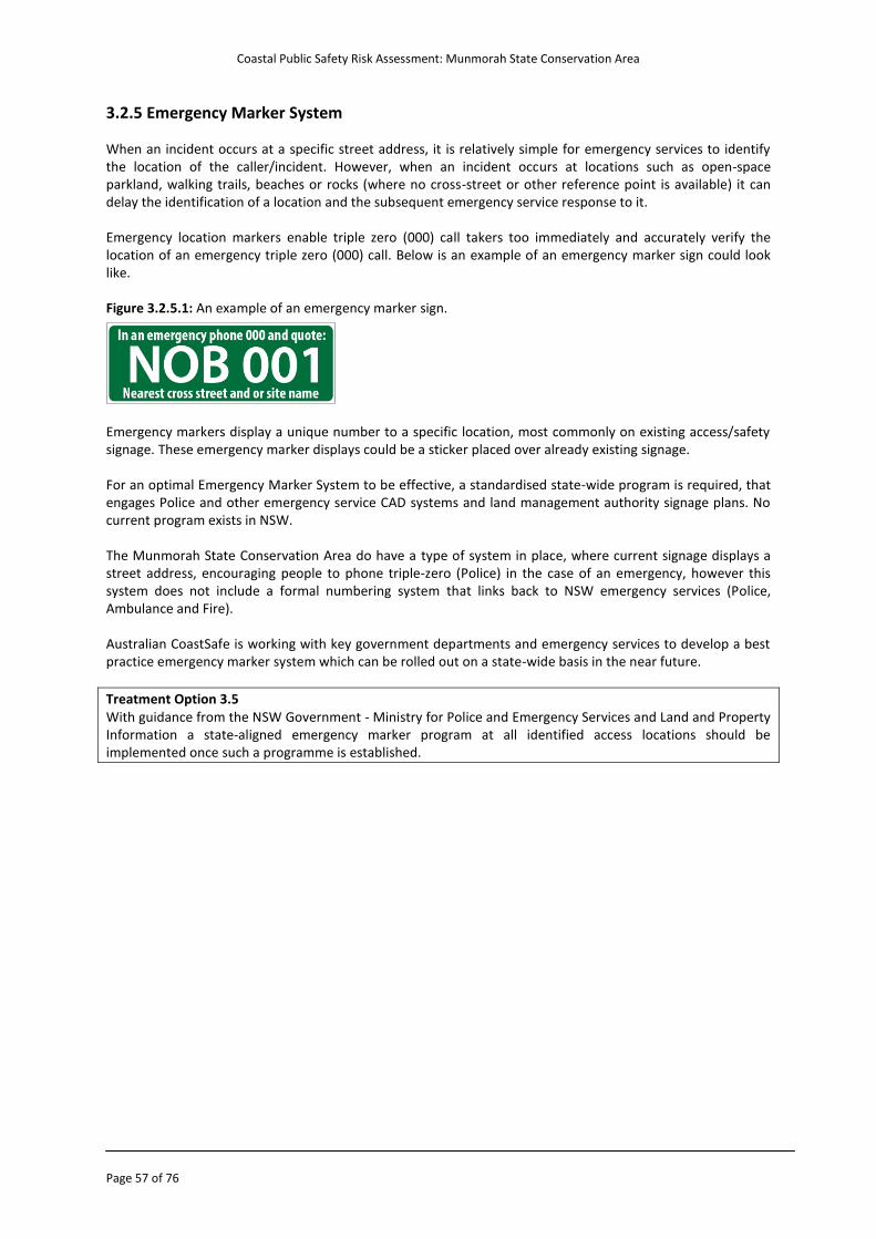
Coastal Public Safety Risk Assessment: Munmorah State Conservation Area
Page 57 of 76
3.2.5 Emergency Marker System When an incident occurs at a specific street address, it is relatively simple for emergency services to identify the location of the caller/incident. However, when an incident occurs at locations such as open-space parkland, walking trails, beaches or rocks (where no cross-street or other reference point is available) it can delay the identification of a location and the subsequent emergency service response to it. Emergency location markers enable triple zero (000) call takers too immediately and accurately verify the location of an emergency triple zero (000) call. Below is an example of an emergency marker sign could look like. Figure 3.2.5.1: An example of an emergency marker sign.
Emergency markers display a unique number to a specific location, most commonly on existing access/safety signage. These emergency marker displays could be a sticker placed over already existing signage. For an optimal Emergency Marker System to be effective, a standardised state-wide program is required, that engages Police and other emergency service CAD systems and land management authority signage plans. No current program exists in NSW. The Munmorah State Conservation Area do have a type of system in place, where current signage displays a street address, encouraging people to phone triple-zero (Police) in the case of an emergency, however this system does not include a formal numbering system that links back to NSW emergency services (Police, Ambulance and Fire). Australian CoastSafe is working with key government departments and emergency services to develop a best practice emergency marker system which can be rolled out on a state-wide basis in the near future. Treatment Option 3.5 With guidance from the NSW Government - Ministry for Police and Emergency Services and Land and Property Information a state-aligned emergency marker program at all identified access locations should be implemented once such a programme is established.
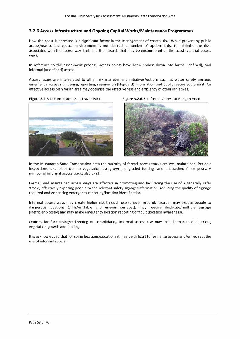
Coastal Public Safety Risk Assessment: Munmorah State Conservation Area
Page 58 of 76
3.2.6 Access Infrastructure and Ongoing Capital Works/Maintenance Programmes How the coast is accessed is a significant factor in the management of coastal risk. While preventing public access/use to the coastal environment is not desired, a number of options exist to minimise the risks associated with the access way itself and the hazards that may be encountered on the coast (via that access way). In reference to the assessment process, access points have been broken down into formal (defined), and informal (undefined) access. Access issues are interrelated to other risk management initiatives/options such as water safety signage, emergency access numbering/reporting, supervision (lifeguard) information and public rescue equipment. An effective access plan for an area may optimise the effectiveness and efficiency of other initiatives. Figure 3.2.6.1: Formal access at Frazer Park Figure 3.2.6.2: Informal Access at Bongon Head
In the Munmorah State Conservation area the majority of formal access tracks are well maintained. Periodic inspections take place due to vegetation overgrowth, degraded footings and unattached fence posts. A number of informal access tracks also exist.
Formal, well maintained access ways are effective in promoting and facilitating the use of a generally safer ‘track’, effectively exposing people to the relevant safety signage/information, reducing the quality of signage required and enhancing emergency reporting/location identification.
Informal access ways may create higher risk through use (uneven ground/hazards), may expose people to dangerous locations (cliffs/unstable and uneven surfaces), may require duplicate/multiple signage (inefficient/costly) and may make emergency location reporting difficult (location awareness).
Options for formalising/redirecting or consolidating informal access use may include man-made barriers, vegetation growth and fencing.
It is acknowledged that for some locations/situations it may be difficult to formalise access and/or redirect the use of informal access.
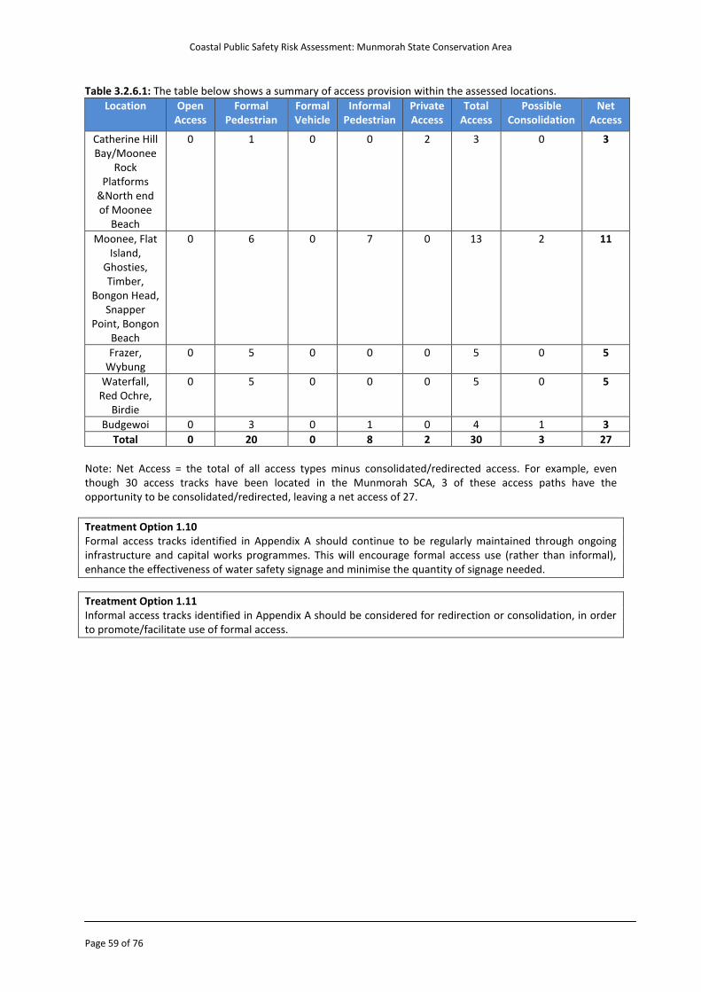
Coastal Public Safety Risk Assessment: Munmorah State Conservation Area
Page 59 of 76
Table 3.2.6.1: The table below shows a summary of access provision within the assessed locations.
Location Open Access
Formal Pedestrian
Formal Vehicle
Informal Pedestrian
Private Access
Total Access
Possible Consolidation
Net Access
Catherine Hill Bay/Moonee
Rock Platforms
&North end of Moonee
Beach
0 1 0 0 2 3 0 3
Moonee, Flat Island,
Ghosties, Timber,
Bongon Head, Snapper
Point, Bongon Beach
0 6 0 7 0 13 2 11
Frazer, Wybung
0 5 0 0 0 5 0 5
Waterfall, Red Ochre,
Birdie
0 5 0 0 0 5 0 5
Budgewoi 0 3 0 1 0 4 1 3
Total 0 20 0 8 2 30 3 27
Note: Net Access = the total of all access types minus consolidated/redirected access. For example, even though 30 access tracks have been located in the Munmorah SCA, 3 of these access paths have the opportunity to be consolidated/redirected, leaving a net access of 27.
Treatment Option 1.10 Formal access tracks identified in Appendix A should continue to be regularly maintained through ongoing infrastructure and capital works programmes. This will encourage formal access use (rather than informal), enhance the effectiveness of water safety signage and minimise the quantity of signage needed.
Treatment Option 1.11 Informal access tracks identified in Appendix A should be considered for redirection or consolidation, in order to promote/facilitate use of formal access.
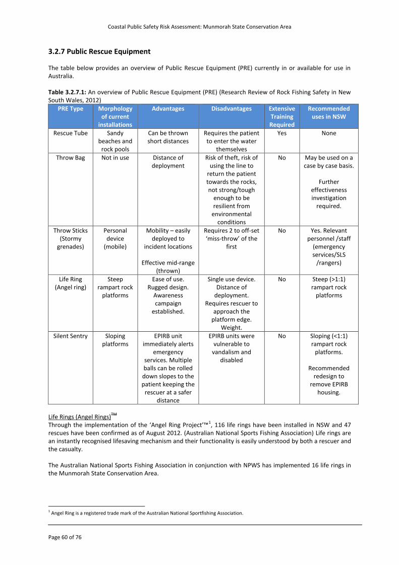
Coastal Public Safety Risk Assessment: Munmorah State Conservation Area
Page 60 of 76
3.2.7 Public Rescue Equipment The table below provides an overview of Public Rescue Equipment (PRE) currently in or available for use in Australia. Table 3.2.7.1: An overview of Public Rescue Equipment (PRE) (Research Review of Rock Fishing Safety in New South Wales, 2012)
PRE Type Morphology of current
installations
Advantages Disadvantages Extensive Training Required
Recommended uses in NSW
Rescue Tube Sandy beaches and
rock pools
Can be thrown short distances
Requires the patient to enter the water
themselves
Yes None
Throw Bag Not in use Distance of deployment
Risk of theft, risk of using the line to
return the patient towards the rocks, not strong/tough
enough to be resilient from
environmental conditions
No May be used on a case by case basis.
Further
effectiveness investigation
required.
Throw Sticks (Stormy
grenades)
Personal device
(mobile)
Mobility – easily deployed to
incident locations
Effective mid-range (thrown)
Requires 2 to off-set ‘miss-throw’ of the
first
No Yes. Relevant personnel /staff
(emergency services/SLS
/rangers)
Life Ring (Angel ring)
Steep rampart rock
platforms
Ease of use. Rugged design.
Awareness campaign
established.
Single use device. Distance of
deployment. Requires rescuer to
approach the platform edge.
Weight.
No Steep (>1:1) rampart rock
platforms
Silent Sentry Sloping platforms
EPIRB unit immediately alerts
emergency services. Multiple balls can be rolled down slopes to the patient keeping the
rescuer at a safer distance
EPIRB units were vulnerable to
vandalism and disabled
No Sloping (<1:1) rampart rock
platforms.
Recommended redesign to
remove EPIRB housing.
Life Rings (Angel Rings)
TM
Through the implementation of the ‘Angel Ring Project’™1, 116 life rings have been installed in NSW and 47
rescues have been confirmed as of August 2012. (Australian National Sports Fishing Association) Life rings are an instantly recognised lifesaving mechanism and their functionality is easily understood by both a rescuer and the casualty. The Australian National Sports Fishing Association in conjunction with NPWS has implemented 16 life rings in the Munmorah State Conservation Area.
1 Angel Ring is a registered trade mark of the Australian National Sportfishing Association.
Coastal Public Safety Risk Assessment: Munmorah State Conservation Area
Page 61 of 76
NPWS staff currently undertakes the ongoing maintenance and auditing of these life rings. An audit of life rings and whether this PRE is in its designated position takes place three times a week by Park Rangers and information is recorded in a log book. The maintenance of all life rings also occurs every 6 months or as required on a needs basis. When maintaining life rings, occupational health and safety procedures have been developed by the Munmorah SCA and are followed by Park Rangers. Park Rangers also carry life rings in their vehicles in the event that they are the first on scene in regards to a person who is in need of urgent assistance. NPWS (Head Office) have a state-wide policy regarding life rings which states “ANSA is responsible for the continued inspection and maintenance of all rings installed by ANSA in parks”. The NPWS should be commended for the implementation of public rescue equipment (life rings) in the Munmorah SCA and their proactive schedule of auditing, maintenance and safety procedures. The locations of proposed life rings are below, specific locations can be found in Appendix C. Table 3.2.7.2: The locations of proposed life rings.
Priority Location
1 Flat Island – Groper Hole
2 Flat Island – North side
3 Bongon Head
Life ring positioning should be undertaken in consultation with ANSA (NSW Branch). Throw Sticks (stormy grenades) The throw stick provides rapid flotation assistance to a person at risk of drowning. The use of the throw stick is a relatively simple process. By removing the device from its waterproof bag and throwing near the person, once contact is made with the water it inflates in seconds to a large horseshoe shape, keeping the victim afloat and their head above the water until further assistance arrives. At only 35cm in length, throw sticks can be easily stored and transported making this a very versatile rescue device. Throw sticks aid the rescuer by enabling them to remain further away from ‘danger areas’ (compared to life rings) but still position a life saving device near a casualty. Due to the variability of conditions on any given day (e.g. wind) a minimum of 2 throw sticks are recommended as optimal to carry, such that the first ‘throw’ of the first device (which can be less accurate) can be followed by a more accurate second device. There is the opportunity for NPWS vehicles operating within the Munmorah SCA to carry at least two throw sticks. Global Positioning Satellite (GPS) GPS technology is available to be used within public rescue equipment such as life rings. Recreational fishing bodies have already trialled certain tracking devices in some areas and should be consulted with in relation to this matter. This technology may be beneficial by the way of a daily audit that can record when a life ring has been washed away or stolen as part of an asset management system.
Treatment Option 1.12 Funding should be sought to supply all National Parks and Wildlife Service vehicles operating within the Munmorah State Conservation Area to carry at least two throw sticks (i.e. inflatable floatation devices), in addition to life rings.
Treatment Option 3.6 Explore the means to fund the expansion and continued maintenance of the ‘Angel Ring Project’ in consultation with the Australian National Sports Fishing Association (NSW Branch) and the Recreational Fishing Alliance of NSW at the locations outlined in Appendix C. Final positioning should be determined by these rock fishing associations.
Coastal Public Safety Risk Assessment: Munmorah State Conservation Area
Page 62 of 76
3.2.8 System of Supervision The supervision of aquatic coastal locations is often required to manage the risk of the location, whether due to prevailing water conditions, the proximity to large population bases or the attendance of the beach/coastal area due to its proximity or attractiveness. The primary decision to be made by the NPWS before establishing a lifesaving/lifeguard service is to determine which areas will be patrolled or unpatrolled. A patrolled beach is one at which a trained lifesaver and/or lifeguard is stationed during prescribed times and designated by the flying of red and yellow flags. A mobile lifesaver/lifeguard or lifeguard vehicle that periodically visits or checks a location may be effective as a proactive education initiative but should not be considered as providing a patrolled swimming location. The decision whether to provide supervision or not to provide supervision can be difficult to establish because of the following: o The provision of a service may encourage attendance at a non-suitable location, such as when the beach
topography and morphology create a highly hazardous location. This factor would be reflected in the ABSAMP beach hazard rating
o Deemed too cost prohibitive and therefore not provided by the responsible Land Manager o The patronage of the location is too low and the assessed risk level is minimal There are a range of aquatic supervisory services that should be considered, as it is not “one size fits all”. They include: o Full time comprehensive lifesaving/lifeguard service with appropriate levels of trained personnel, fixed and
portable facilities, equipment, craft, vehicles and links to central command and emergency services. o Seasonal lifesaving/lifeguard service with appropriate levels of trained personnel, portable facilities,
equipment, craft, vehicles and links to central command and emergency services. o Seasonal lifesaving/lifeguard Service with trained personnel, portable facilities, some equipment and craft,
and links to a command centre. o A flexible demand based service with trained personnel provision which allocates resources to where they
are most needed. o Surveillance cameras. o No service, but the provision of safety signs and controlled access. International Best Practice The International Life Saving Federation (ILSF) is the peak body for lifeguard and water safety organisations internationally. Lifeguard/lifesaving uniforms The ILSF recommends the colours for uniforms be red & yellow
2. Lifeguards/lifesavers throughout the world
are called upon to provide safety services at a range of water environments that include swimming pools, beaches, lakes, river front and other waterfronts. In providing these aquatic safety services, it is important that the people using these environments for aquatic activity can readily identify the lifeguards/lifesavers for: o Guidance on safety issues, and o Assistance in times of need
As such the lifeguards should be readily distinguishable against the many people and colours they may be wearing while in, on or around these aquatic environments. The red and yellow colours have been used by a number of International Lifesaving Member Federations for many years to such an extent and with much success that red and yellow has become synonymous with lifesavers and lifeguards in these countries. Red and yellow flags The use of red & yellow feathered flags is undertaken to provide the maximum visual effect to identify a designated swimming area. Munmorah SCA currently uses the feathered patrol flag on beaches which are patrolled.
2 Lifesaving Position Statement - LPS 05 - Lifesaver And Lifeguard Uniforms
Coastal Public Safety Risk Assessment: Munmorah State Conservation Area
Page 63 of 76
Lifesaving Service Level Calculator The following tables calculate the Lifesaving Service level scores for beaches in the Munmorah SCA (rock platforms have been excluded). The calculator takes into consideration the ABSAMP beach hazard ratings, visitation levels, frequency of use, residency of visitors, incident history, and remoteness of location to determine best practice lifesaving service levels.
The following lifesaving service level descriptors provide the recommended lifesaving service level for the scores/ratings. The scores are not absolute and are to be used as a guide in determining the actual levels. Table 3.2.8.2: lifesaving service level descriptors provide the recommended lifesaving service level for the scores/rating as calculated in the sections that follow.
Rating Lifesaving Service Level Description
</= 10 Warning signage e.g. Aquatic & Recreational Signage Style Guide
11-14 Emergency beacons and/or camera surveillance or swimming enclosure (where applicable)
Routine monitoring/surveillance patrols (land, sea, air) to also be considered
15-19 Lifesaving service = 1 x Lifeguard personnel during period assessed (refer to note 2)
20-25 Lifesaving service = 2 x Lifeguard personnel during period assessed
26-30 Lifesaving service = 3 x Lifeguard personnel during period assessed
31 and > Lifesaving service = more than 3 Lifeguard personnel during period assessed
Notes to table: Note 1: When visitations and frequencies are low yet rating is high, consideration should be given to some form of surveillance patrols or IT solutions to overcome variations of population/visitation numbers. Note 2: The option to have one lifeguard on a beach is only permissible under specific circumstances, these being: o The ABSAMP beach hazard rating is less than 4, or o Access to other rescue services is less than 5 minutes, direct communication with services is in place, and a
Rescue Water Craft is in place. Otherwise the minimum number of lifeguards at a given location would be two.
Where the number of people in the patrolled area is over 1,000 the lifesaving service provider should increase the number of lifesaving personnel in line with the following table. Table 3.2.8.3: Impact of beach attendance on lifesaving service levels
No. of People on Beach No. of additional lifeguards
1,000 - 5,000 2
5,000 - 10,000 4
> 10,000 6
Crowds can become in themselves hazardous as a result of difficulties of surveillance and heightened crowd interaction
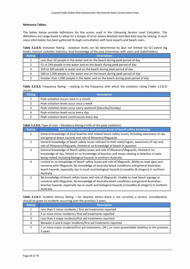
Coastal Public Safety Risk Assessment: Munmorah State Conservation Area
Page 64 of 76
Reference Tables: The tables below provide definitions for the scores used in the Lifesaving Service Level Calculator. The definitions are range based to allow for a margin of error where detailed recorded data may be lacking. In such cases information has been gathered through consultation with local experts and beach users. Table 3.2.8.4: Visitation Rating - visitation levels can be determined by (but not limited to) SLS patrol log books, tourism visitation statistics, local knowledge of the area (interviews with users and stakeholders)
Rating Description
1 Less than 50 people in the water and on the beach during peak period of day
2 51 to 249 people in the water and on the beach during peak period of day
3 250 to 500 people in water and on the beach during peak period of day
4 500 to 1,000 people in the water and on the beach during peak period of day
5 Greater than 1,000 people in the water and on the beach during peak period of day
Table 3.2.8.5: Frequency Rating – relating to the frequency with which the visitation rating (Table 3.2.8.3) occurs
Rating Description
1 Peak visitation occurs once in a month
2 Peak visitation levels occur once a week
3 Peak visitation levels occur every weekend (Saturday/Sunday)
4 Peak visitation levels occur every day
5 Peak visitation levels continuously every day
Table 3.2.8.6: Type of User – Residency Rating (>10% of the peak visitation)
Rating Beach visitor residency and assumed level of beach safety knowledge
1 General knowledge of local beaches and related beach safety issues, including awareness of rips and general beach hazards and role of lifesavers/lifeguards.
2 General knowledge of beach safety issues relevant to their state/region, awareness of rips and role of lifesavers/lifeguards, limited or no knowledge of beach in question
3 General knowledge of beach safety issues and role of lifesavers/lifeguards, limited or no knowledge of rips, limited or no knowledge of beaches and issues relating to beaches in state being visited, including biological hazards in northern Australia.
4 Limited or no knowledge of beach safety issues and role of lifeguards. Ability to read signs and converse with lifeguards. No knowledge of Australia beach conditions and general Australian beach hazards, especially rips in south and biological hazards (crocodiles & stingers) in northern Australia.
5 No knowledge of beach safety issues and role of lifeguards. Unable to read beach signage or converse with lifeguards. No knowledge of Australia beach conditions and general Australian beaches hazards, especially rips in south and biological hazards (crocodiles & stingers) in northern Australia.
Table 3.2.8.7: Incident History Rating – for beaches where there is not currently a service. Consideration should be given to incidents occurring over the previous 5 years.
Rating Description
1 Less than 5 minor incidents / first aid treatments reported
2 5 or more minor incidents / first aid treatments reported
3 Less than 3 major incidents/first aid treatments reported
4 Between 4 and 6 major incidents/first aid treatments reported
5 7 or more major incidents/first aid treatments, OR 1 or more preventable fatalities in the previous 5 years
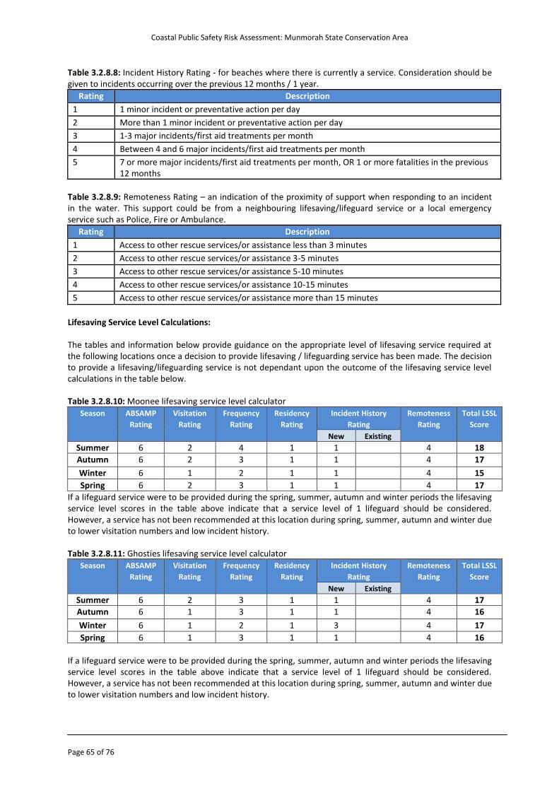
Coastal Public Safety Risk Assessment: Munmorah State Conservation Area
Page 65 of 76
Table 3.2.8.8: Incident History Rating - for beaches where there is currently a service. Consideration should be given to incidents occurring over the previous 12 months / 1 year.
Rating Description
1 1 minor incident or preventative action per day
2 More than 1 minor incident or preventative action per day
3 1-3 major incidents/first aid treatments per month
4 Between 4 and 6 major incidents/first aid treatments per month
5 7 or more major incidents/first aid treatments per month, OR 1 or more fatalities in the previous 12 months
Table 3.2.8.9: Remoteness Rating – an indication of the proximity of support when responding to an incident in the water. This support could be from a neighbouring lifesaving/lifeguard service or a local emergency service such as Police, Fire or Ambulance.
Rating Description
1 Access to other rescue services/or assistance less than 3 minutes
2 Access to other rescue services/or assistance 3-5 minutes
3 Access to other rescue services/or assistance 5-10 minutes
4 Access to other rescue services/or assistance 10-15 minutes
5 Access to other rescue services/or assistance more than 15 minutes
Lifesaving Service Level Calculations: The tables and information below provide guidance on the appropriate level of lifesaving service required at the following locations once a decision to provide lifesaving / lifeguarding service has been made. The decision to provide a lifesaving/lifeguarding service is not dependant upon the outcome of the lifesaving service level calculations in the table below. Table 3.2.8.10: Moonee lifesaving service level calculator
Season ABSAMP
Rating
Visitation
Rating
Frequency
Rating
Residency
Rating
Incident History
Rating
Remoteness
Rating
Total LSSL
Score
New Existing
Summer 6 2 4 1 1 4 18
Autumn 6 2 3 1 1 4 17
Winter 6 1 2 1 1 4 15
Spring 6 2 3 1 1 4 17
If a lifeguard service were to be provided during the spring, summer, autumn and winter periods the lifesaving service level scores in the table above indicate that a service level of 1 lifeguard should be considered. However, a service has not been recommended at this location during spring, summer, autumn and winter due to lower visitation numbers and low incident history. Table 3.2.8.11: Ghosties lifesaving service level calculator
Season ABSAMP
Rating
Visitation
Rating
Frequency
Rating
Residency
Rating
Incident History
Rating
Remoteness
Rating
Total LSSL
Score
New Existing
Summer 6 2 3 1 1 4 17
Autumn 6 1 3 1 1 4 16
Winter 6 1 2 1 3 4 17
Spring 6 1 3 1 1 4 16
If a lifeguard service were to be provided during the spring, summer, autumn and winter periods the lifesaving service level scores in the table above indicate that a service level of 1 lifeguard should be considered. However, a service has not been recommended at this location during spring, summer, autumn and winter due to lower visitation numbers and low incident history.
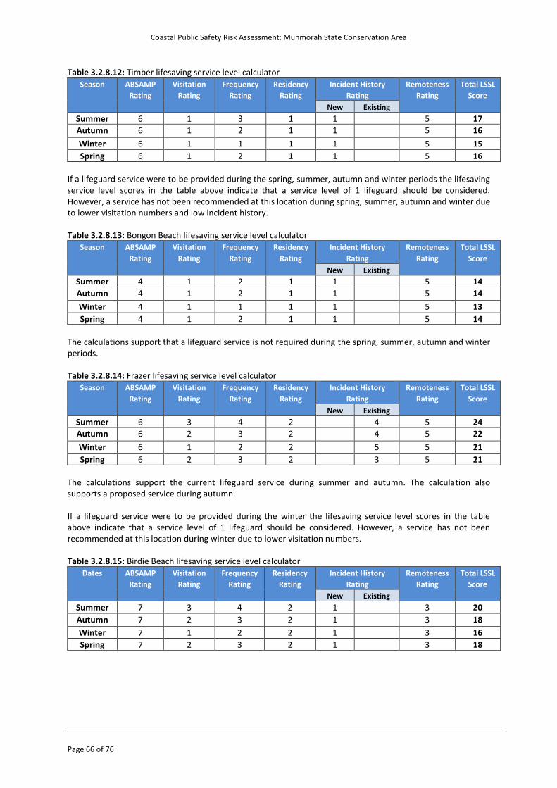
Coastal Public Safety Risk Assessment: Munmorah State Conservation Area
Page 66 of 76
Table 3.2.8.12: Timber lifesaving service level calculator
Season ABSAMP
Rating
Visitation
Rating
Frequency
Rating
Residency
Rating
Incident History
Rating
Remoteness
Rating
Total LSSL
Score
New Existing
Summer 6 1 3 1 1 5 17
Autumn 6 1 2 1 1 5 16
Winter 6 1 1 1 1 5 15
Spring 6 1 2 1 1 5 16
If a lifeguard service were to be provided during the spring, summer, autumn and winter periods the lifesaving service level scores in the table above indicate that a service level of 1 lifeguard should be considered. However, a service has not been recommended at this location during spring, summer, autumn and winter due to lower visitation numbers and low incident history. Table 3.2.8.13: Bongon Beach lifesaving service level calculator
Season ABSAMP
Rating
Visitation
Rating
Frequency
Rating
Residency
Rating
Incident History
Rating
Remoteness
Rating
Total LSSL
Score
New Existing
Summer 4 1 2 1 1 5 14
Autumn 4 1 2 1 1 5 14
Winter 4 1 1 1 1 5 13
Spring 4 1 2 1 1 5 14
The calculations support that a lifeguard service is not required during the spring, summer, autumn and winter periods. Table 3.2.8.14: Frazer lifesaving service level calculator
Season ABSAMP
Rating
Visitation
Rating
Frequency
Rating
Residency
Rating
Incident History
Rating
Remoteness
Rating
Total LSSL
Score
New Existing
Summer 6 3 4 2 4 5 24
Autumn 6 2 3 2 4 5 22
Winter 6 1 2 2 5 5 21
Spring 6 2 3 2 3 5 21
The calculations support the current lifeguard service during summer and autumn. The calculation also supports a proposed service during autumn. If a lifeguard service were to be provided during the winter the lifesaving service level scores in the table above indicate that a service level of 1 lifeguard should be considered. However, a service has not been recommended at this location during winter due to lower visitation numbers. Table 3.2.8.15: Birdie Beach lifesaving service level calculator
Dates ABSAMP
Rating
Visitation
Rating
Frequency
Rating
Residency
Rating
Incident History
Rating
Remoteness
Rating
Total LSSL
Score
New Existing
Summer 7 3 4 2 1 3 20
Autumn 7 2 3 2 1 3 18
Winter 7 1 2 2 1 3 16
Spring 7 2 3 2 1 3 18
Coastal Public Safety Risk Assessment: Munmorah State Conservation Area
Page 67 of 76
Lifeguard Services - Existing The Munmorah SCA provides a lifeguard service at Frazer Park. The following table summarises the dates and patrol hours from the previous 2012-2013 lifeguard season. Table 3.2.8.1: Paid Lifeguard Services in the Munmorah SCA
Beach Patrol Dates Days of Service Patrol Times
Frazer National Park 26/12/12 to 26/01/13 7 days 10am - 6pm
29/03/13 to 01/04/13 (Easter long weekend) 10am - 5pm
13/04/13 to 28/04/13 7 days 10am - 5pm
Proposed Lifeguard Services Frazer Park: The camp ground at Frazer Park can accommodate a maximum of 36 people (6 camping sites) at any one time. The Spring School Holidays, which includes the October Long Weekend, can also attract a high number of visitors. As emergency incident data highlights, the majority of rock fishing incidents occur during the autumn, winter and spring months. As Frazer Park is a central location in the National Park, lifeguards will be able to quickly respond to other incidents that may occur in the general area. Based on park visitation advice and anecdotal evidence the lifeguard service at Frazer Park should be expanded by two weeks to cover the Spring School Holidays for a single one year trial, after which a review is undertaken. Birdie Beach: The Freemans Camping area (Birdie Beach) has a maximum capacity of 234 people (31 camp sites and 8 caravan sites). Traditionally, days that attract large amounts of visitors to this beach are on Boxing Day and New Year’s Day. Lifeguards can also be used to deal with issues/conflicts that may occur between the nude bathers (northern end of the beach) and members of the public. Lifeguards at this location may also be able to respond to emergency callouts at Red Ochre and Wybung Headland. It is the advice of the NPWS that over the Christmas period at Birdie Beach an average of 120 people are in attendance at any one time. Based on visitation advice and anecdotal evidence, a lifeguard service at Birdie Beach should be implemented to cover the Christmas Holidays for a single one year trial, after which a review is undertaken with Australian CoastSafe. During consultation it was raised that Birdie Beach has been patrolled by Wyong Shire Council in the past. Surveillance Cameras Cameras can aid supervision through remote monitoring by appropriate authorised personal in regional/central locations. The effectiveness of camera surveillance relates to the consistency in monitoring, the training held by those persons monitoring and the response procedures in place to act on any identified issues (both proactive and reactive). There are a number of cost effective options for surveillance cameras and widespread precedent across NSW and Australia for remote camera surveillance by authorised agencies (SLS, Council etc.). Legality/privacy issues are important and have be resolved previously, primarily through controlled access restrictions (authorised personnel only).
There are currently no dedicated coastal safety surveillance cameras in the Munmorah SCA however It has been identified that a surveillance camera (closed circuit) monitoring the Flat Island area would aid proactive efforts by NPWS staff and SLS to monitor usage of hazardous areas / at hazardous times, and provide an opportunity to proactively engage rock fishermen prior to an incident occurring. Cameras can be monitored exclusively by the park office, the State Operations Centre at Surf Life Saving New South Wales (weekdays) and the Surf Life Saving Regional Communications Centre based at Avoca (weekends/public holidays).
Coastal Public Safety Risk Assessment: Munmorah State Conservation Area
Page 68 of 76
Treatment Option 1.13 The lifeguard service at Frazer Park currently provides coverage during the summer and autumn school holiday periods. Funding should be sought to conduct a one off trial for an extension of the lifeguard service at this location to provide coverage during the spring school holiday period (including the Labour Day Public Holiday weekend) based on anecdotal user trends and data, with the extended service to be reviewed on completion of the trial.
Treatment Option 1.14 Funding should be sought to conduct a one off trial for a lifeguard service at Birdie Beach to provide coverage for the two week Christmas and New Year holiday period based upon anecdotal user trends and data, with the service to be reviewed on completion of the trial.
Treatment Option 1.15 The ‘Lifesaving Service Level Calculator’ should be used on a regular basis to measure the impact of planned property development at South Catherine Hill Bay on beach and rock platform usage at Moonee Beach, Flat Island and Ghosties Beach.
Treatment Options 1.16 & 2.2 A closed circuit surveillance camera should be investigated to monitor coastal activity in the Flat Island area. The camera footage should be able to be monitored or reviewed (as appropriate) by authorised personnel at the following locations: 1) Park office (or other NPWS site), 2) State Operations Centre at Surf Life Saving New South Wales (weekdays) and 3) Surf Life Saving Regional Communications Centre based at Avoca (weekends/public holidays).
Coastal Public Safety Risk Assessment: Munmorah State Conservation Area
Page 69 of 76
4. Emergency Response Background The relatively high rate of critical emergency incidents in the Munmorah SCA in previous years makes ‘emergency response’ considerations very relevant to a drowning prevention strategy for the area. Emergency response considerations include but are not limited to: o Emergency communications/reporting (000) o Emergency service response o Location identification o Emergency service site access o Emergency service communications (internal and joint service) NPWS currently has in place formal procedures for park rangers and staff regarding emergency reporting and response. These should continue be reviewed and updated to reflect any changes/improvements as a result of this risk assessment. 4.1 Emergency Communications/Reporting (000) The ability of members of the public to request assistance in an emergency is an important component of a drowning prevention strategy. Triple-zero (000) remains and should be promoted as the sole method for reporting an emergency on all relevant signage/safety information and facilitated through any (specific) emergency communication devices. Due to the prevalence of mobile telephones across all demographics of society, additional emergency communications devices (beacons/radio phones/alarms) are less relevant where adequate mobile phone coverage exists. The Munmorah State Conservation Area has variable mobile phone coverage via the major network phone providers such as Telstra, Optus and Vodafone. Generally speaking, elevated locations (above sea level) and locations away from the face of cliffs/rocks have acceptable coverage. However, due to the variability of coverage some additional emergency communications devices are appropriately in place. Emergency Phones The Munmorah State Conservation Area currently has two Emergency Phones. These phones are stationed at Frazer Park and Freemans Camping Area at Birdie Beach. These devices are signed as ‘Emergency Phones’. When utilised these phones contact a 24/7 security company in Newcastle (Newcastle Security). The security company then decides what to do i.e. whether or not they call triple zero (000). At the time of producing this report, details/copies of any ‘Newcastle Security’ procedures related to the Emergency Phones were not available. Improvements to current Emergency Phones have been identified by linking them to triple-zero (000) rather than a security company, and also standardising safety information/signage at the phone location to improve public awareness of location and purpose. Emergency Response Beacons (ERB) Emergency Response Beacons can be positioned in high use / high risk areas. They are highly visible and once activated, link via radio to lifesaving services or park staff. The two main types of ERB are: Mobile: A movable unit which can be placed at a designated location for a limited period (usually daylight hours) before being removed for security/monitoring reasons. They usually complement an existing on-beach lifesaving service (nearby) or on-duty staff hours (non lifesaving).
Coastal Public Safety Risk Assessment: Munmorah State Conservation Area
Page 70 of 76
Fixed/permanent: A unit which is permanently or semi-permanently positioned (secured) at a location, and provides 24/7 capacity. Such an ERB should fit within a coordinated emergency communications system, whereby the unit is monitored 24/7 and complemented with specific procedures for emergencies by those monitoring the ERB. Fixed Emergency Response Beacons are generally only considered for use in a high risk location, where no or limited mobile/cell phone coverage exists and where a service can ensure, show and maintain 100% coverage/monitoring of the beacon and have in place a consistent process of equipment checking/testing (daily). More information about Emergency Response Beacons can be provided by Surf Life Saving New South Wales. 4.2 Emergency Service Response Emergency services and support organisations play a vital role in responding to coastal emergencies within the Munmorah SCA and the resources that may respond include: o Police (including Water Police) o Ambulance (including the Westpac Helicopter) o Lake Macquarie Council Lifeguard Service o Wyong Shire Council Lifeguard Service o Frazer Park Lifeguard Service o Surf Life Saving Hunter o Surf Life Saving Central Coast o State Emergency Service (SES) o Rural Fire Service o Marine Rescue NSW The Munmorah SCA has no on-site surf lifesaving club (nor is one appropriate), however a seasonal lifeguard service is provided at Frazer Beach (and additional services recommended – for Birdie Beach) which may enable immediate lifeguard response to incidents at their location and response to adjacent locations during on-duty hours. Outside those patrolled times the services identified above are available to respond via 000 (triple zero) Police. The map (on the next page) indicates the emergency service ‘bases’ (Police/Ambulance) and lifesaving / lifeguard services (excluding Frazer Park) relative to Munmorah SCA. Comparatively, the area is ‘isolated’ from immediate emergency service response; particularly in vehicle access is delayed after-hours by gate access. Optimal emergency response (outside of on-duty lifeguard service hours at Frazer Park) would include attendance of the Hunter Westpac Lifesaver Helicopter (14min response time), and lifesaving services (via water) from Catherine Hill Bay SLSC/Lake Macquarie Lifeguards (15mins) and The Lakes SLSC/Wyong Lifeguards (20mins). Additional Police/Ambulance/Marine Rescue asset response would have a slightly later arrival time (on average). Surf Rescue Emergency Response System The Surf Rescue Emergency Response System (NSW) was established in January 2008 and provides a single point of contact for emergency services when there is a need to utilise surf rescue assets in coastal incidents. The emergency number can be contacted 24/7 and operators (State Duty Officers) can task/notify any surf rescue asset in NSW. Emergency Action Plans Coastal emergencies can vary between land and water, and can be the result of natural processes or human action.
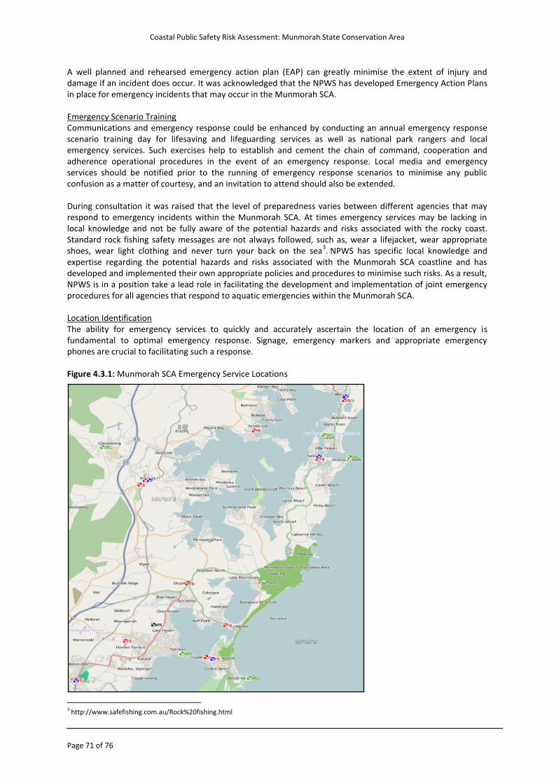
Coastal Public Safety Risk Assessment: Munmorah State Conservation Area
Page 71 of 76
A well planned and rehearsed emergency action plan (EAP) can greatly minimise the extent of injury and damage if an incident does occur. It was acknowledged that the NPWS has developed Emergency Action Plans in place for emergency incidents that may occur in the Munmorah SCA.
Emergency Scenario Training Communications and emergency response could be enhanced by conducting an annual emergency response scenario training day for lifesaving and lifeguarding services as well as national park rangers and local emergency services. Such exercises help to establish and cement the chain of command, cooperation and adherence operational procedures in the event of an emergency response. Local media and emergency services should be notified prior to the running of emergency response scenarios to minimise any public confusion as a matter of courtesy, and an invitation to attend should also be extended. During consultation it was raised that the level of preparedness varies between different agencies that may respond to emergency incidents within the Munmorah SCA. At times emergency services may be lacking in local knowledge and not be fully aware of the potential hazards and risks associated with the rocky coast. Standard rock fishing safety messages are not always followed, such as, wear a lifejacket, wear appropriate shoes, wear light clothing and never turn your back on the sea
3. NPWS has specific local knowledge and
expertise regarding the potential hazards and risks associated with the Munmorah SCA coastline and has developed and implemented their own appropriate policies and procedures to minimise such risks. As a result, NPWS is in a position take a lead role in facilitating the development and implementation of joint emergency procedures for all agencies that respond to aquatic emergencies within the Munmorah SCA. Location Identification The ability for emergency services to quickly and accurately ascertain the location of an emergency is fundamental to optimal emergency response. Signage, emergency markers and appropriate emergency phones are crucial to facilitating such a response. Figure 4.3.1: Munmorah SCA Emergency Service Locations
3 http://www.safefishing.com.au/Rock%20fishing.html
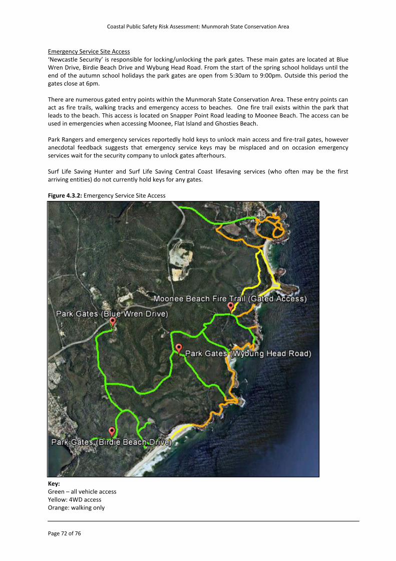
Coastal Public Safety Risk Assessment: Munmorah State Conservation Area
Page 72 of 76
Emergency Service Site Access ‘Newcastle Security’ is responsible for locking/unlocking the park gates. These main gates are located at Blue Wren Drive, Birdie Beach Drive and Wybung Head Road. From the start of the spring school holidays until the end of the autumn school holidays the park gates are open from 5:30am to 9:00pm. Outside this period the gates close at 6pm. There are numerous gated entry points within the Munmorah State Conservation Area. These entry points can act as fire trails, walking tracks and emergency access to beaches. One fire trail exists within the park that leads to the beach. This access is located on Snapper Point Road leading to Moonee Beach. The access can be used in emergencies when accessing Moonee, Flat Island and Ghosties Beach. Park Rangers and emergency services reportedly hold keys to unlock main access and fire-trail gates, however anecdotal feedback suggests that emergency service keys may be misplaced and on occasion emergency services wait for the security company to unlock gates afterhours. Surf Life Saving Hunter and Surf Life Saving Central Coast lifesaving services (who often may be the first arriving entities) do not currently hold keys for any gates. Figure 4.3.2: Emergency Service Site Access Key: Green – all vehicle access Yellow: 4WD access Orange: walking only
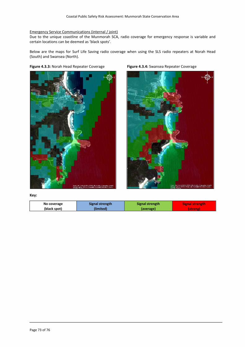
Coastal Public Safety Risk Assessment: Munmorah State Conservation Area
Page 73 of 76
Emergency Service Communications (internal / joint) Due to the unique coastline of the Munmorah SCA, radio coverage for emergency response is variable and certain locations can be deemed as ‘black spots’. Below are the maps for Surf Life Saving radio coverage when using the SLS radio repeaters at Norah Head (South) and Swansea (North). Figure 4.3.3: Norah Head Repeater Coverage Figure 4.3.4: Swansea Repeater Coverage
Key:
No coverage
(black spot)
Signal strength
(limited)
Signal strength
(average)
Signal strength
(strong)
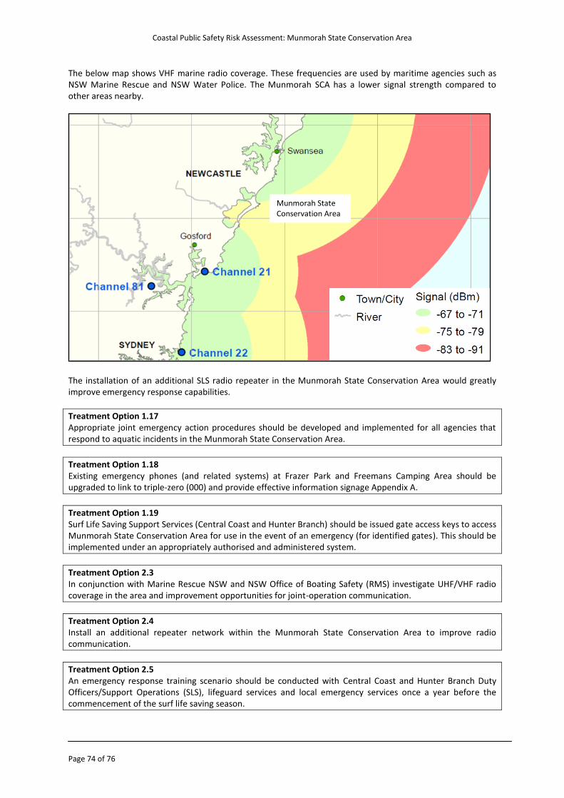
Coastal Public Safety Risk Assessment: Munmorah State Conservation Area
Page 74 of 76
The below map shows VHF marine radio coverage. These frequencies are used by maritime agencies such as NSW Marine Rescue and NSW Water Police. The Munmorah SCA has a lower signal strength compared to other areas nearby.
The installation of an additional SLS radio repeater in the Munmorah State Conservation Area would greatly improve emergency response capabilities.
Treatment Option 1.17 Appropriate joint emergency action procedures should be developed and implemented for all agencies that respond to aquatic incidents in the Munmorah State Conservation Area.
Treatment Option 1.18 Existing emergency phones (and related systems) at Frazer Park and Freemans Camping Area should be upgraded to link to triple-zero (000) and provide effective information signage Appendix A.
Treatment Option 1.19 Surf Life Saving Support Services (Central Coast and Hunter Branch) should be issued gate access keys to access Munmorah State Conservation Area for use in the event of an emergency (for identified gates). This should be implemented under an appropriately authorised and administered system.
Treatment Option 2.3 In conjunction with Marine Rescue NSW and NSW Office of Boating Safety (RMS) investigate UHF/VHF radio coverage in the area and improvement opportunities for joint-operation communication.
Treatment Option 2.4 Install an additional repeater network within the Munmorah State Conservation Area to improve radio communication.
Treatment Option 2.5 An emergency response training scenario should be conducted with Central Coast and Hunter Branch Duty Officers/Support Operations (SLS), lifeguard services and local emergency services once a year before the commencement of the surf life saving season.
Munmorah State Conservation Area
Coastal Public Safety Risk Assessment: Munmorah State Conservation Area
Page 75 of 76
5. Monitor and Review
This process ensures that risk treatment options are meeting their objectives, new hazards and risks are identified in a timely manner and evolving strategies are in line with community expectations. Land Managers should ensure that a there is a process of regular review of the effectiveness of any risk mitigation strategies that have been implemented. This should include a process for the collection of data regarding any incidents affecting public safety at the locations assessed as well as the use of public rescue equipment and emergency response phones. It is acknowledged that the NPWS already have a system of monitor and review built into the ‘NPWS Visitor Safety Regional Risk Register User Guide’. Land Managers may determine to further engage peak water safety organisations to assist with this task. The process should include the review of all incident data, access points, signage and public rescue equipment.
Treatment Option 1.20 In consultation with relevant stakeholders this document should be reviewed annually to measure the effectiveness of any risk mitigation strategies and drowning prevention initiatives that have been implemented.
Treatment Option 1.21 All drowning prevention strategies should be documented and incorporated into the relevant strategic and management plans. This will ensure consistency throughout the management area and a structured approach to maintenance.
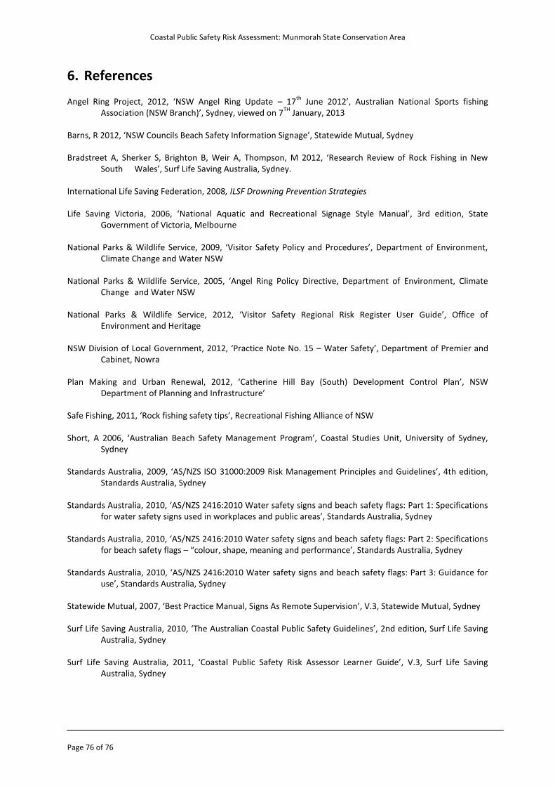
Coastal Public Safety Risk Assessment: Munmorah State Conservation Area
Page 76 of 76
6. References Angel Ring Project, 2012, ‘NSW Angel Ring Update – 17
th June 2012’, Australian National Sports fishing
Association (NSW Branch)’, Sydney, viewed on 7TH
January, 2013 Barns, R 2012, ‘NSW Councils Beach Safety Information Signage’, Statewide Mutual, Sydney Bradstreet A, Sherker S, Brighton B, Weir A, Thompson, M 2012, ‘Research Review of Rock Fishing in New South Wales’, Surf Life Saving Australia, Sydney. International Life Saving Federation, 2008, ILSF Drowning Prevention Strategies Life Saving Victoria, 2006, ‘National Aquatic and Recreational Signage Style Manual’, 3rd edition, State Government of Victoria, Melbourne National Parks & Wildlife Service, 2009, ‘Visitor Safety Policy and Procedures’, Department of Environment, Climate Change and Water NSW National Parks & Wildlife Service, 2005, ‘Angel Ring Policy Directive, Department of Environment, Climate Change and Water NSW National Parks & Wildlife Service, 2012, ‘Visitor Safety Regional Risk Register User Guide’, Office of Environment and Heritage NSW Division of Local Government, 2012, ‘Practice Note No. 15 – Water Safety’, Department of Premier and Cabinet, Nowra Plan Making and Urban Renewal, 2012, ‘Catherine Hill Bay (South) Development Control Plan’, NSW Department of Planning and Infrastructure’ Safe Fishing, 2011, ‘Rock fishing safety tips’, Recreational Fishing Alliance of NSW Short, A 2006, ‘Australian Beach Safety Management Program’, Coastal Studies Unit, University of Sydney, Sydney Standards Australia, 2009, ‘AS/NZS ISO 31000:2009 Risk Management Principles and Guidelines’, 4th edition, Standards Australia, Sydney Standards Australia, 2010, ‘AS/NZS 2416:2010 Water safety signs and beach safety flags: Part 1: Specifications for water safety signs used in workplaces and public areas’, Standards Australia, Sydney Standards Australia, 2010, ‘AS/NZS 2416:2010 Water safety signs and beach safety flags: Part 2: Specifications for beach safety flags – “colour, shape, meaning and performance’, Standards Australia, Sydney Standards Australia, 2010, ‘AS/NZS 2416:2010 Water safety signs and beach safety flags: Part 3: Guidance for use’, Standards Australia, Sydney Statewide Mutual, 2007, ‘Best Practice Manual, Signs As Remote Supervision’, V.3, Statewide Mutual, Sydney Surf Life Saving Australia, 2010, ‘The Australian Coastal Public Safety Guidelines’, 2nd edition, Surf Life Saving Australia, Sydney Surf Life Saving Australia, 2011, ‘Coastal Public Safety Risk Assessor Learner Guide’, V.3, Surf Life Saving Australia, Sydney
Recommended