Multi-disciplinary
interoperability challenges
Stefano Nativi
Italian National Research Council
and PIN -University of Florence
Seminar at UNIDATA
-----
Boulder (CO) USA, 10 Dec 2010
ESSILab
ESSI Lab [email protected]
Outline System of Systems approach and principles
Brokering SOA (B-SOA)
EuroGEOSS Operating Capacity
multi-disciplinary discovery and access brokers –
including semantic search;
Related research topics
Harmonizing netCDF-CF and ISO models -from ncML to
ncML-G+
Uncertainty-enabled data (and services)
ESSI Lab [email protected]
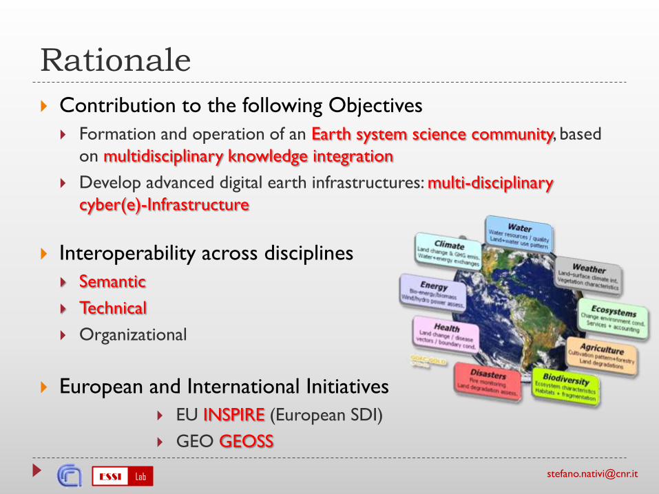
Rationale
Contribution to the following Objectives
Formation and operation of an Earth system science community, based
on multidisciplinary knowledge integration
Develop advanced digital earth infrastructures: multi-disciplinary
cyber(e)-Infrastructure
Interoperability across disciplines
Semantic
Technical
Organizational
European and International Initiatives
EU INSPIRE (European SDI)
GEO GEOSS
ESSI Lab [email protected]
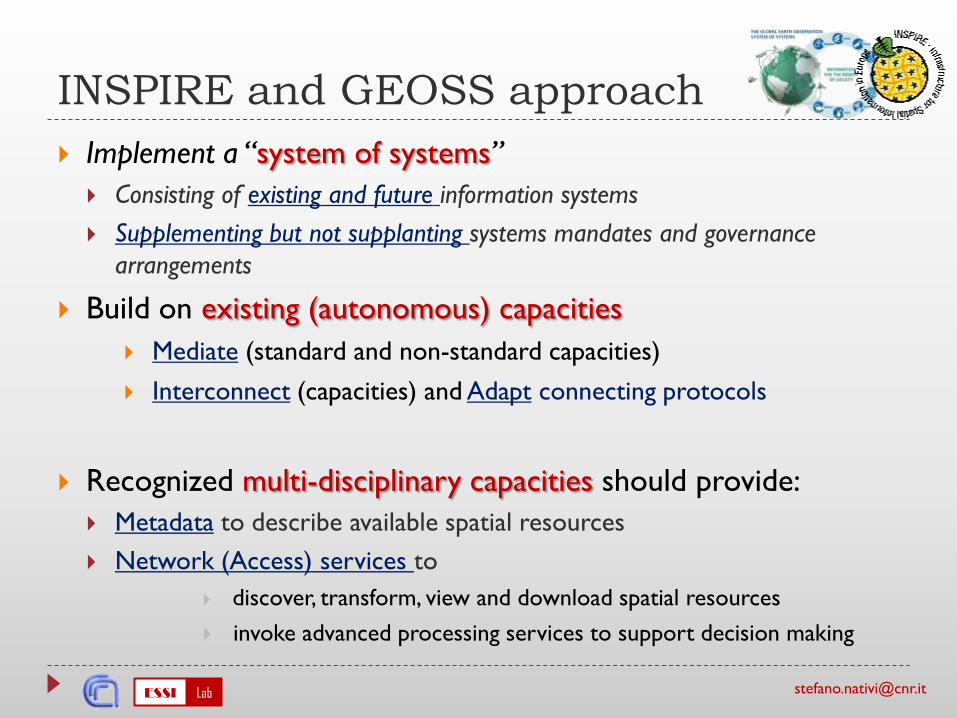
INSPIRE and GEOSS approach
Implement a “system of systems”
Consisting of existing and future information systems
Supplementing but not supplanting systems mandates and governance
arrangements
Build on existing (autonomous) capacities
Mediate (standard and non-standard capacities)
Interconnect (capacities) and Adapt connecting protocols
Recognized multi-disciplinary capacities should provide:
Metadata to describe available spatial resources
Network (Access) services to
discover, transform, view and download spatial resources
invoke advanced processing services to support decision making
ESSI Lab [email protected]
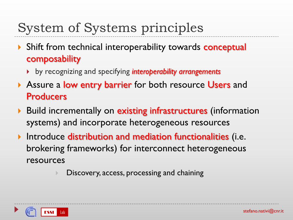
System of Systems principles
Shift from technical interoperability towards conceptual
composability
by recognizing and specifying interoperability arrangements
Assure a low entry barrier for both resource Users and
Producers
Build incrementally on existing infrastructures (information
systems) and incorporate heterogeneous resources
Introduce distribution and mediation functionalities (i.e.
brokering frameworks) for interconnect heterogeneous
resources
Discovery, access, processing and chaining
ESSI Lab [email protected]
Flexibility: different Interoperability
levels
• Different interoperability levels -at different Infrastructures level
ESSI Lab [email protected] Computing Infrastructure (s)
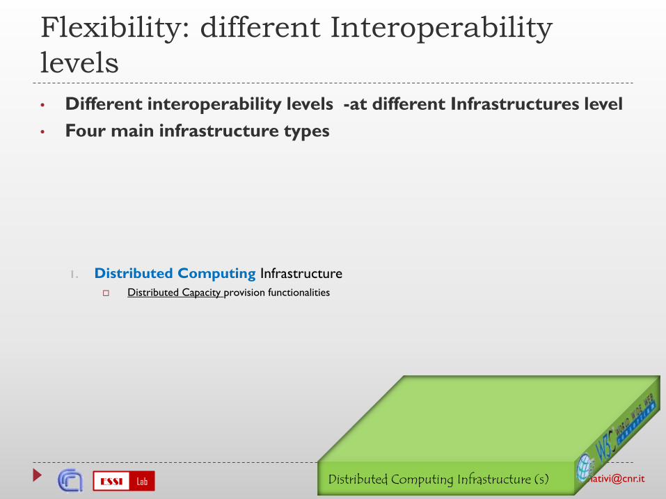
Flexibility: different Interoperability
levels
• Different interoperability levels -at different Infrastructures level
• Four main infrastructure types
1. Distributed Computing Infrastructure
Distributed Capacity provision functionalities
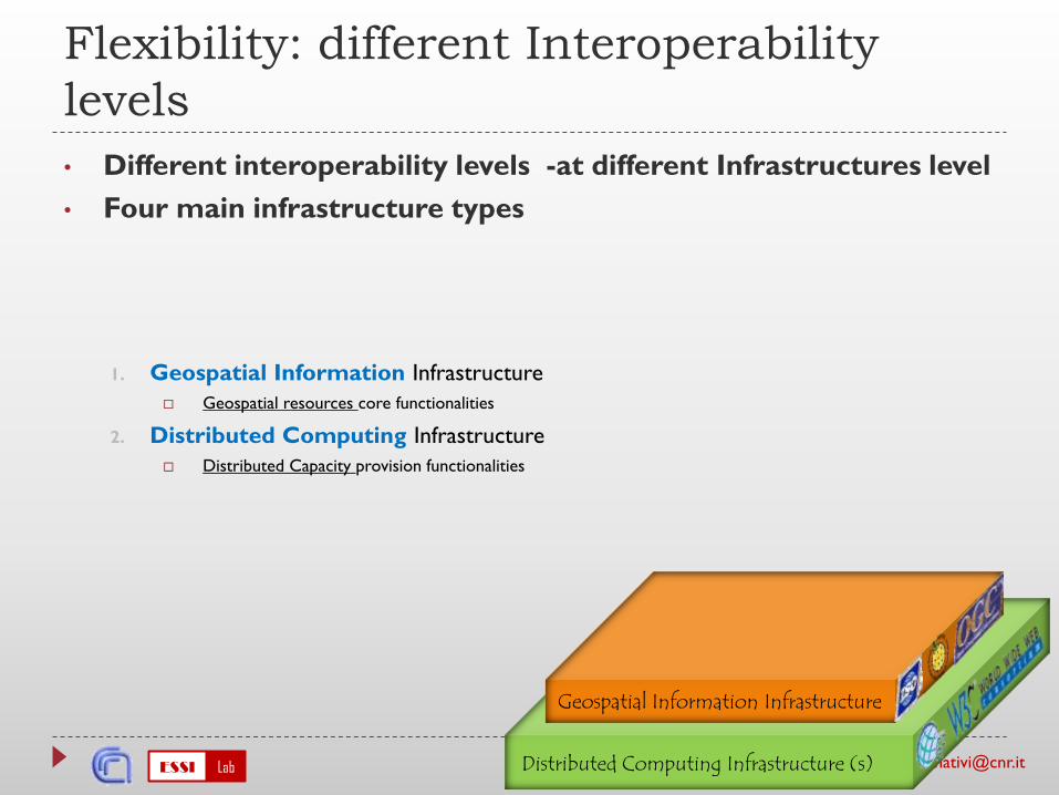
ESSI Lab [email protected] Computing Infrastructure (s)
Geospatial Information Infrastructure
Flexibility: different Interoperability
levels
• Different interoperability levels -at different Infrastructures level
• Four main infrastructure types
1. Geospatial Information Infrastructure
Geospatial resources core functionalities
2. Distributed Computing Infrastructure
Distributed Capacity provision functionalities
ESSI Lab [email protected] Computing Infrastructure (s)
Geospatial Information Infrastructure
Flexibility: different Interoperability
levels
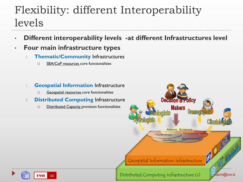
• Different interoperability levels -at different Infrastructures level
• Four main infrastructure types
1. Thematic/Community Infrastructures
SBA/CoP resources core functionalities
1. Geospatial Information Infrastructure
Geospatial resources core functionalities
2. Distributed Computing Infrastructure
Distributed Capacity provision functionalities
ESSI Lab [email protected] Computing Infrastructure (s)
Geospatial Information Infrastructure
Flexibility: different Interoperability
levels
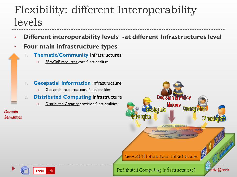
• Different interoperability levels -at different Infrastructures level
• Four main infrastructure types
1. Thematic/Community Infrastructures
SBA/CoP resources core functionalities
1. Geospatial Information Infrastructure
Geospatial resources core functionalities
2. Distributed Computing Infrastructure
Distributed Capacity provision functionalities
Domain
Semantics
ESSI Lab [email protected] Computing Infrastructure (s)
Geospatial Information Infrastructure
Digital Earth Infrastructure
Flexibility: different Interoperability
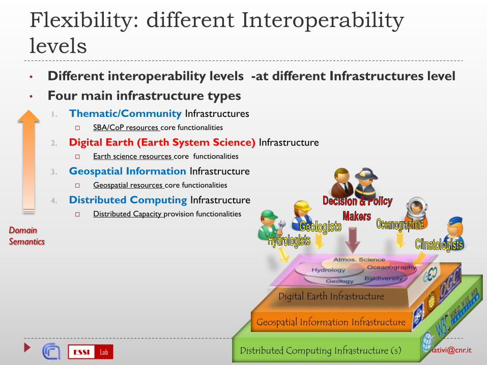
levels
• Different interoperability levels -at different Infrastructures level
• Four main infrastructure types
1. Thematic/Community Infrastructures
SBA/CoP resources core functionalities
2. Digital Earth (Earth System Science) Infrastructure
Earth science resources core functionalities
3. Geospatial Information Infrastructure
Geospatial resources core functionalities
4. Distributed Computing Infrastructure
Distributed Capacity provision functionalities
Domain
Semantics
ESSI Lab [email protected]
Flexibility: Interoperability
Arrangements
Interoperability Arrangements:
to shift from technical interoperability towards conceptual composability
They must be able to
align (and where necessary to harmonize) the heterogeneous system
conceptual models.
connect autonomous systems at different infrastructural levels
avoid tight coupling or strong integrations -only define how system
components interface with each other
ESSI Lab [email protected]
Interoperability Arrangements
implementation
Need:
to raise the level of abstraction and cope with systems
complexity
Solution:
Adapt SOA and MDA
Introduce brokering and mediation frameworks for
managing resources
e.g. discovery, access, processing and chaining
ESSI Lab [email protected]
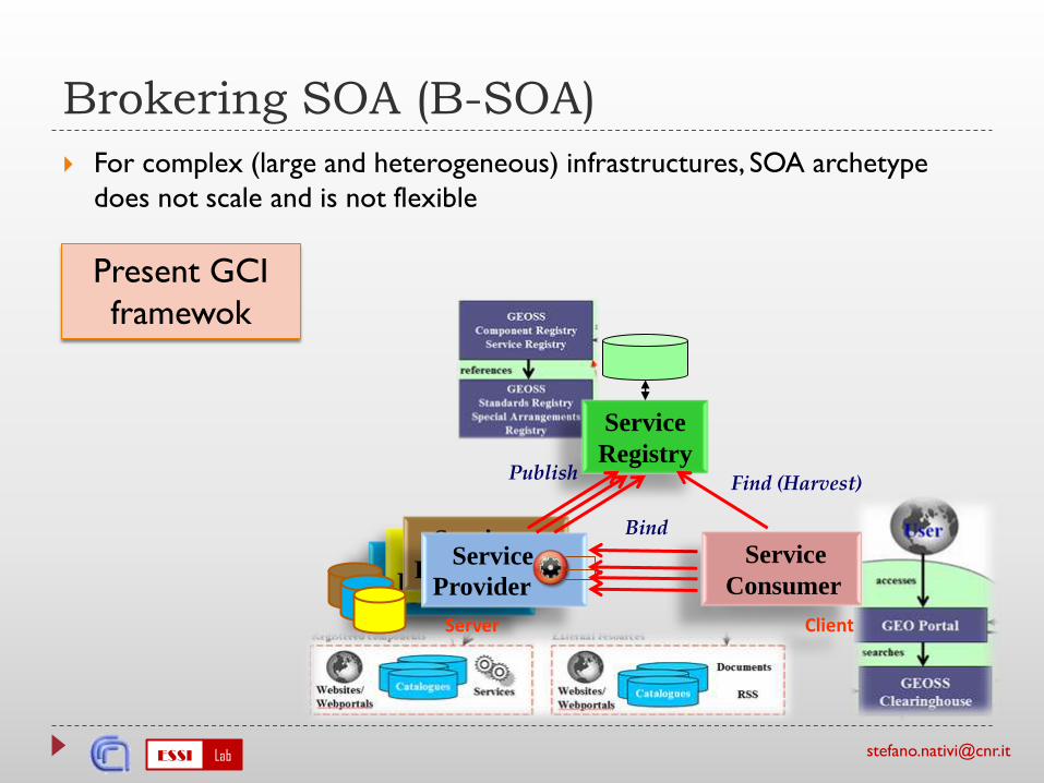
Brokering SOA (B-SOA)
For complex (large and heterogeneous) infrastructures, SOA archetype
does not scale and is not flexible
ESSI Lab [email protected]
Brokering SOA (B-SOA)
For complex (large and heterogeneous) infrastructures, SOA archetype
does not scale and is not flexible
Service
Provider
Service
Provider
Service
ProviderService
Provider
Server
Service
Consumer
Client
Service
RegistryPublish
Find (Harvest)
Bind
Present GCI
framewok

ESSI Lab [email protected]
Brokering SOA (B-SOA)
For complex (large and heterogeneous) infrastructures, SOA archetype
does not scale and is not flexible
(tens of thousands)
Service
Provider
Service
Provider
Service
ProviderService
Provider
Server
Service
Consumer
Client
Service
RegistryPublish
Find (Harvest)
Bind
Present GCI
framewok
(hundreds)
ESSI Lab [email protected]
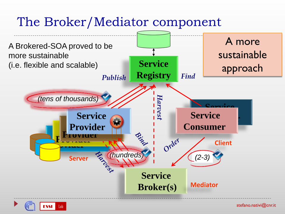
Service
Consumer
Service
Provider
Service
Provider
Service
Provider
The Broker/Mediator component
Service
Provider
Server
Service
Consumer
Client
Service
RegistryPublish Find
Service
Broker(s) Mediator
Ha
rvest
(2-3)
(tens of thousands)
(hundreds)
A more
sustainable
approach
A Brokered-SOA proved to be
more sustainable
(i.e. flexible and scalable)
ESSI Lab [email protected]
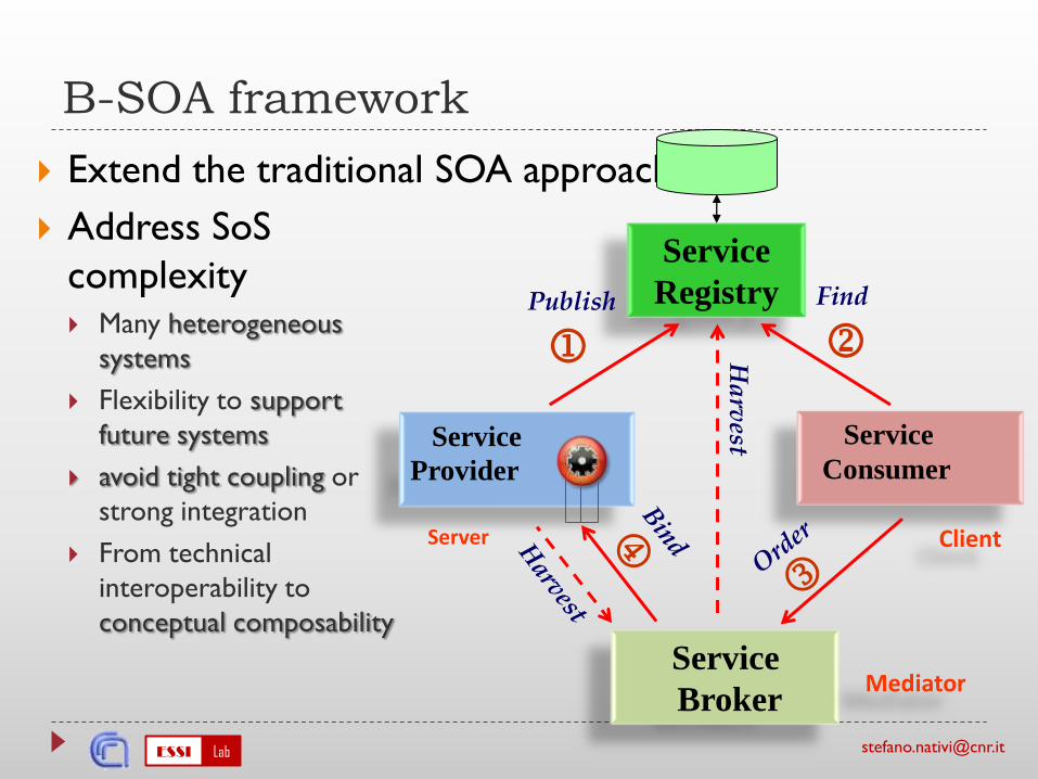
B-SOA framework
Extend the traditional SOA approach
Address SoS
complexity Many heterogeneous
systems
Flexibility to support
future systems
avoid tight coupling or
strong integration
From technical
interoperability to
conceptual composability
Service
Provider
Server
Service
Consumer
Client
Service
RegistryPublish
Find
Service
BrokerMediator
Ha
rvest
ESSI Lab [email protected]
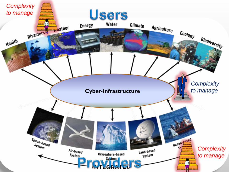
Cyber-Infrastructure
Complexity
to manage
Complexity
to manage
Complexity
to manage
ESSI Lab [email protected]
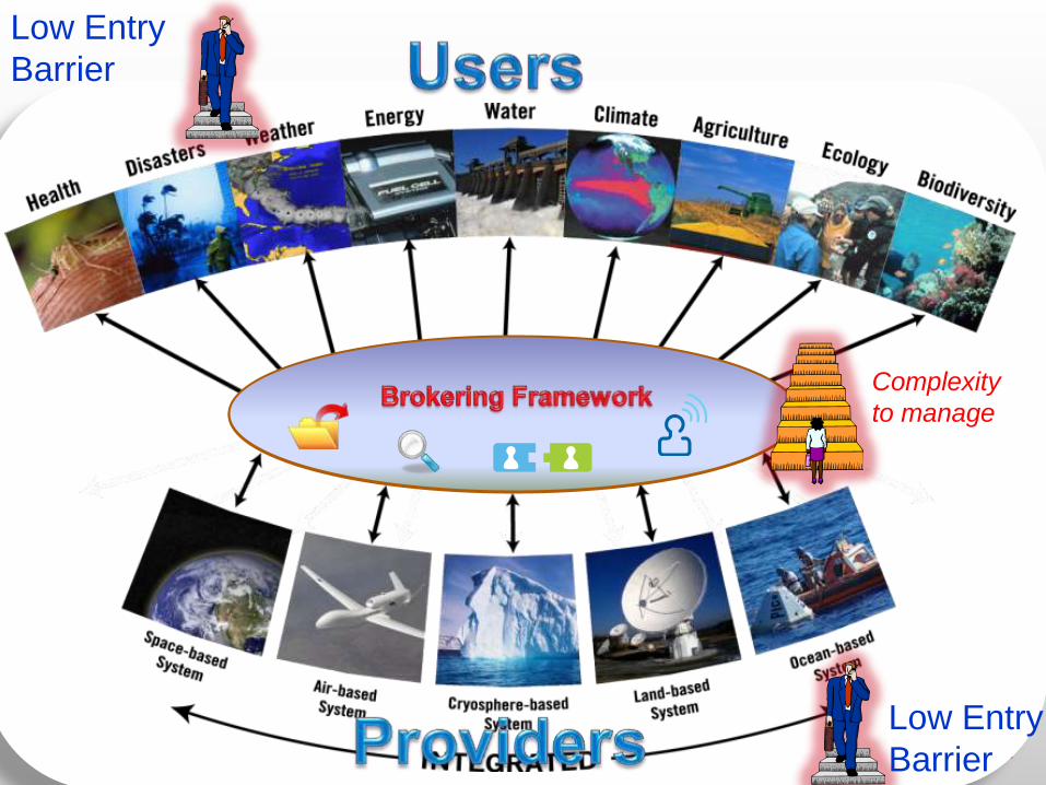
Cyber-Infrastructure
Low Entry
Barrier
Complexity
to manage
Low Entry
Barrier
ESSI Lab [email protected]
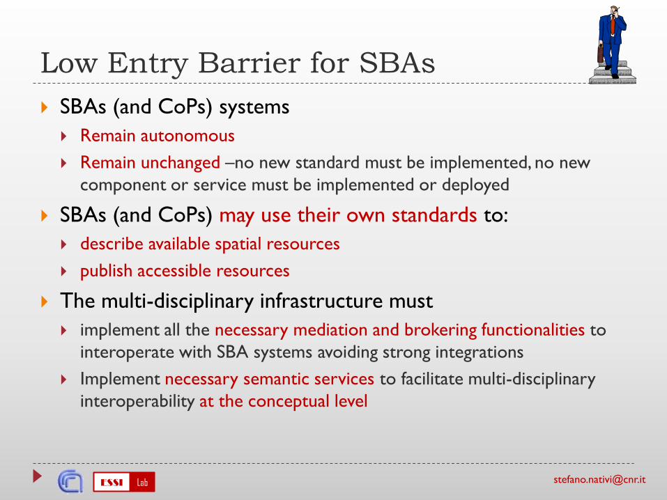
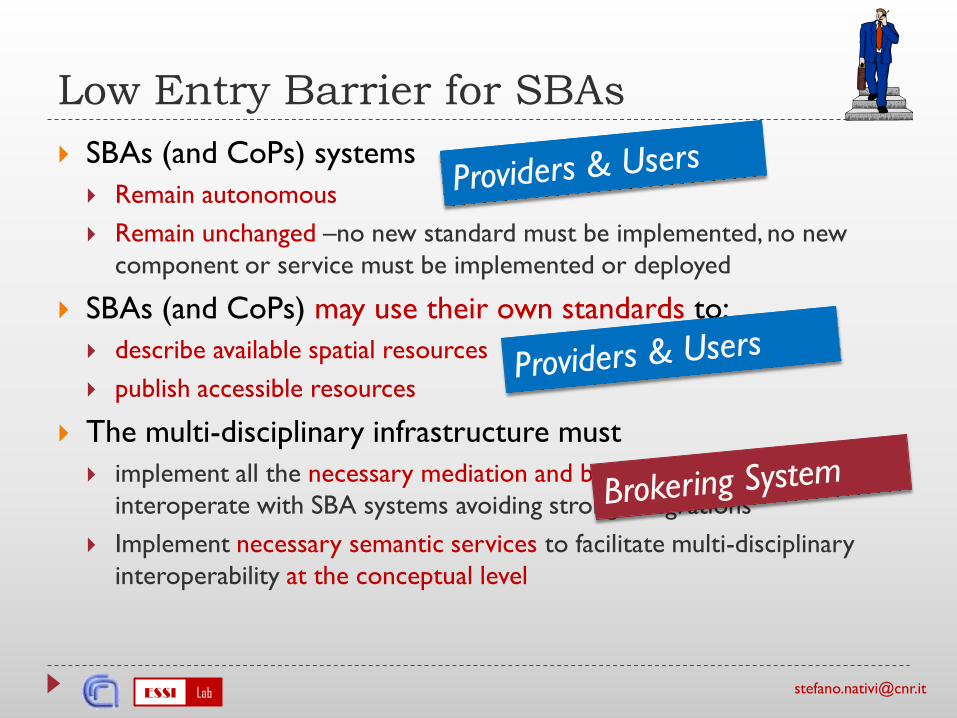
Low Entry Barrier for SBAs
SBAs (and CoPs) systems
Remain autonomous
Remain unchanged –no new standard must be implemented, no new
component or service must be implemented or deployed
SBAs (and CoPs) may use their own standards to:
describe available spatial resources
publish accessible resources
The multi-disciplinary infrastructure must
implement all the necessary mediation and brokering functionalities to
interoperate with SBA systems avoiding strong integrations
Implement necessary semantic services to facilitate multi-disciplinary
interoperability at the conceptual level
ESSI Lab [email protected]
Low Entry Barrier for SBAs
SBAs (and CoPs) systems
Remain autonomous
Remain unchanged –no new standard must be implemented, no new
component or service must be implemented or deployed
SBAs (and CoPs) may use their own standards to:
describe available spatial resources
publish accessible resources
The multi-disciplinary infrastructure must
implement all the necessary mediation and brokering functionalities to
interoperate with SBA systems avoiding strong integrations
Implement necessary semantic services to facilitate multi-disciplinary
interoperability at the conceptual level
The EuroGEOSS experience
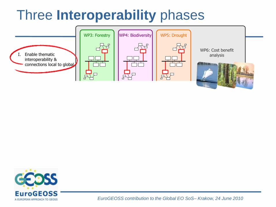
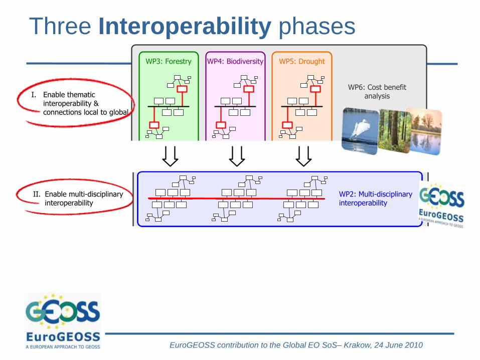
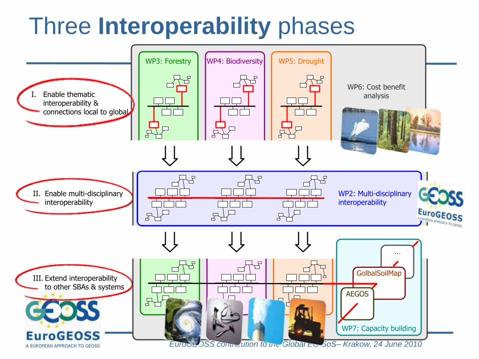
EuroGEOSS contribution to the Global EO SoS– Krakow, 24 June 2010
Three Interoperability phases
WP7: Capacity building
WP3: Forestry WP4: Biodiversity WP5: Drought
WP2: Multi-disciplinary interoperability
...
GolbalSoilMap
AEGOS
III. Extend interoperabilityto other SBAs & systems
I. Enable thematicinteroperability &connections local to global
II. Enable multi-disciplinaryinteroperability
WP6: Cost benefit analysis
EuroGEOSS Meeting – JRC Ispra – 4-6 oct 2010
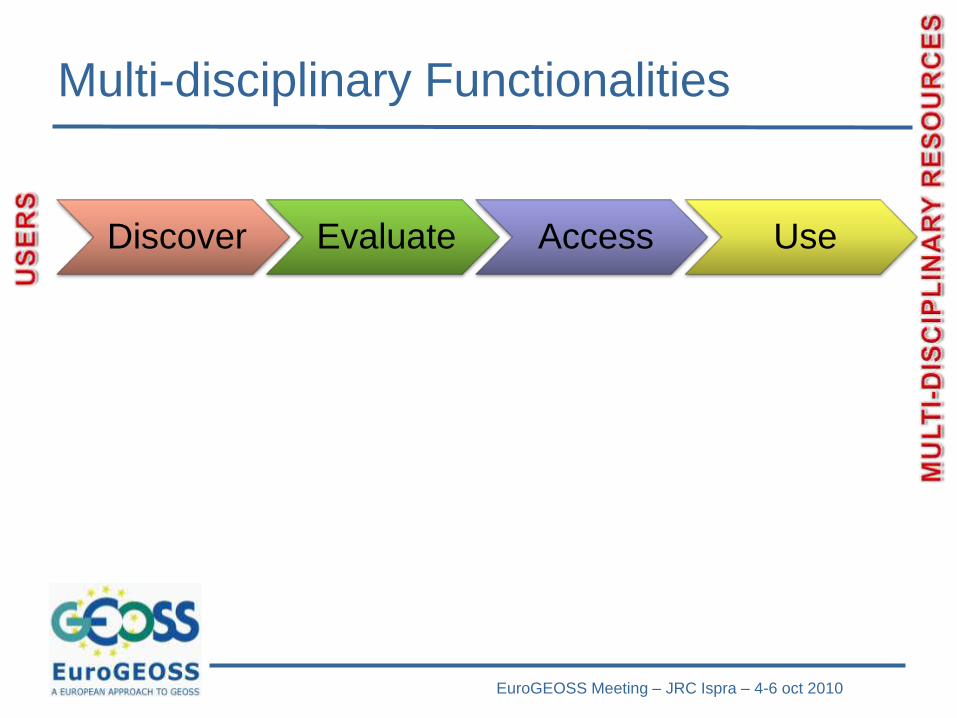
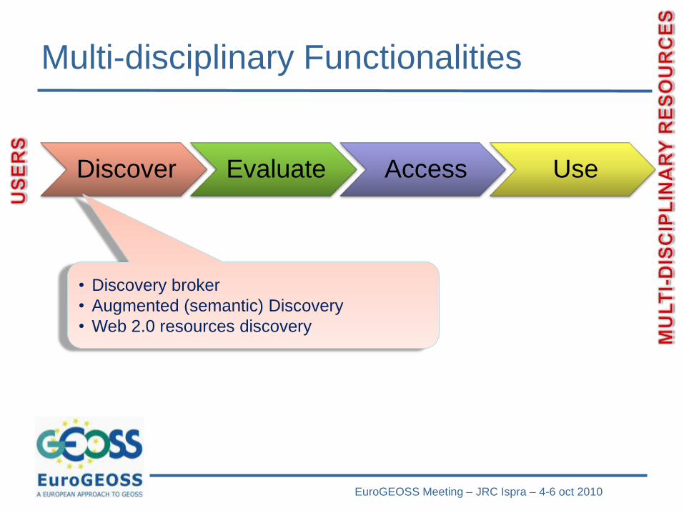
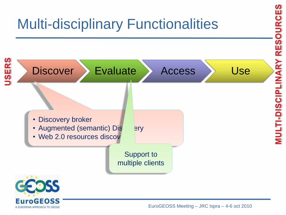
Multi-disciplinary Functionalities
Discover Evaluate Access Use
EuroGEOSS Meeting – JRC Ispra – 4-6 oct 2010
Multi-disciplinary Functionalities
Discover Evaluate Access Use
• Discovery broker
• Augmented (semantic) Discovery
• Web 2.0 resources discovery
EuroGEOSS Meeting – JRC Ispra – 4-6 oct 2010
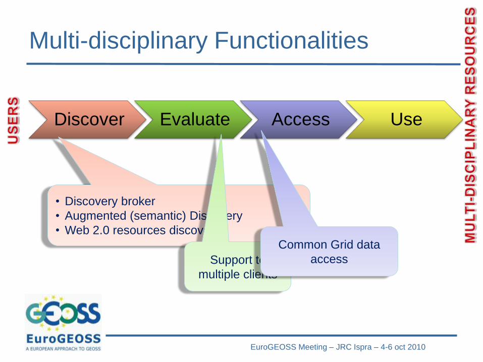
Multi-disciplinary Functionalities
Discover Evaluate Access Use
• Discovery broker
• Augmented (semantic) Discovery
• Web 2.0 resources discovery
Support to
multiple clients
EuroGEOSS Meeting – JRC Ispra – 4-6 oct 2010
Multi-disciplinary Functionalities
Discover Evaluate Access Use
• Discovery broker
• Augmented (semantic) Discovery
• Web 2.0 resources discovery
Support to
multiple clients
Common Grid data
access
EuroGEOSS Meeting – JRC Ispra – 4-6 oct 2010
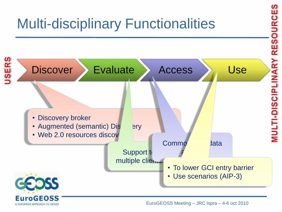
Multi-disciplinary Functionalities
Discover Evaluate Access Use
• Discovery broker
• Augmented (semantic) Discovery
• Web 2.0 resources discovery
Support to
multiple clients
Common Grid data
access
• To lower GCI entry barrier
• Use scenarios (AIP-3)
EuroGEOSS Meeting – JRC Ispra – 4-6 oct 2010
TO LOWER ENTRY BARRIER
FOR MULTI-DISCIPLINARY
CAPACITY
(edit Mask) Event – place - date
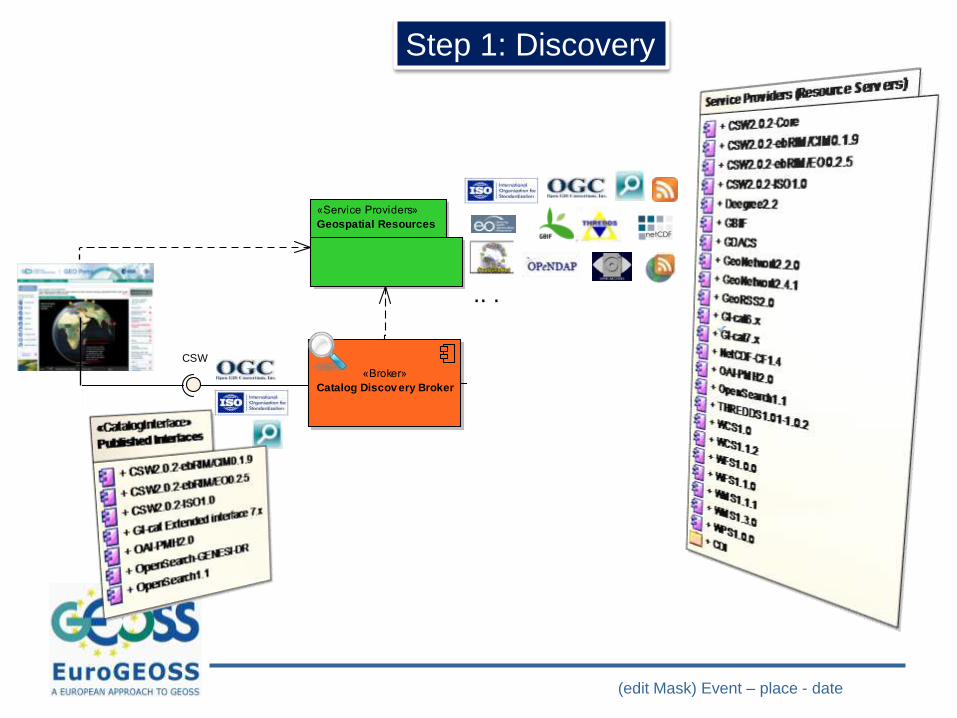
cmp General Picture
«Broker»
Catalog Discov ery Broker«Advanced Module»
Semantic Discov ery Broker
«Advanced Module»
Semantic engine
«Broker»
Geospatial Data Access
Broker
«Service Providers»
Geospatial Resources
«Advanced Module»
Adapters
«Service Providers»
Web 2.0 resources
«Semantic Resources»
Thesauri
«Service Providers»
Gazzetters
SPARQL
CSW OpenSearch
WFS
.. .
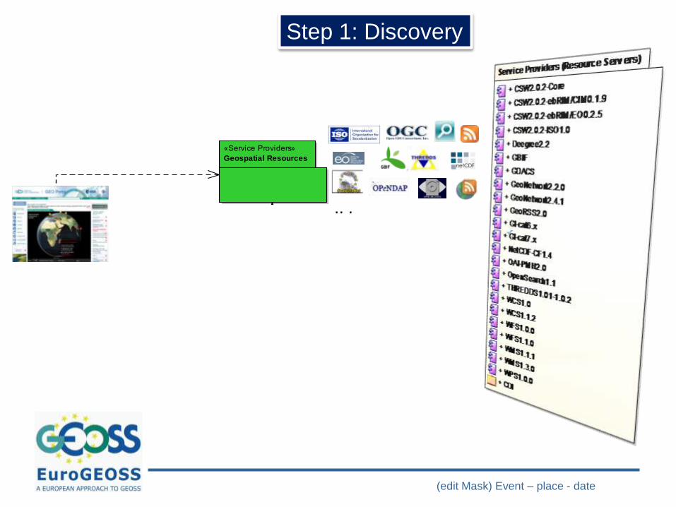
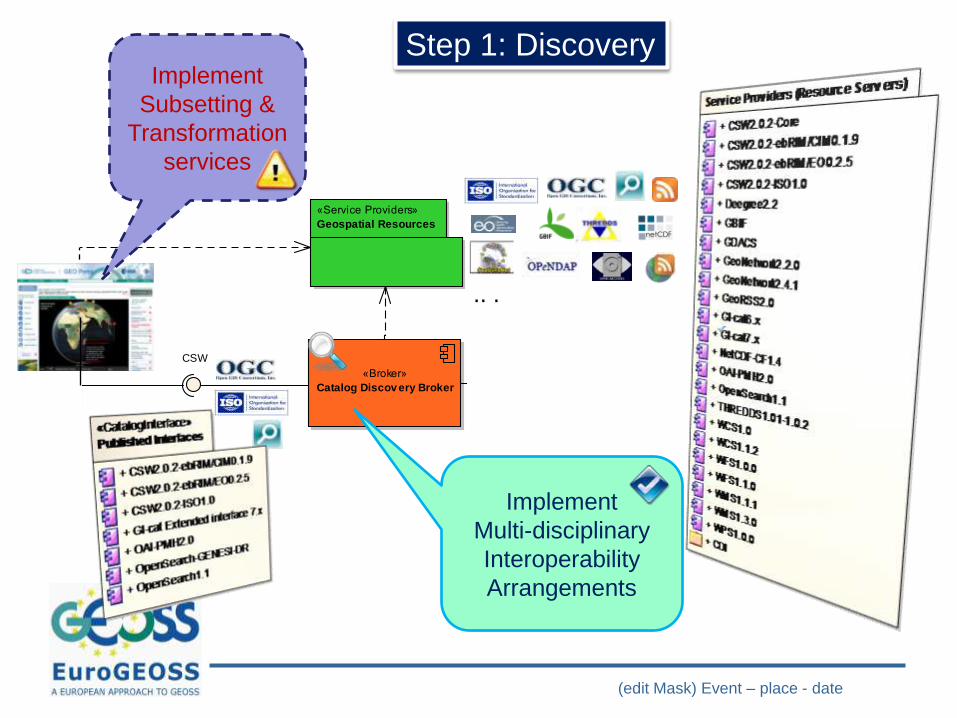
Step 1: Discovery
(edit Mask) Event – place - date
cmp General Picture
«Broker»
Catalog Discov ery Broker«Advanced Module»
Semantic Discov ery Broker
«Advanced Module»
Semantic engine
«Broker»
Geospatial Data Access
Broker
«Service Providers»
Geospatial Resources
«Advanced Module»
Adapters
«Service Providers»
Web 2.0 resources
«Semantic Resources»
Thesauri
«Service Providers»
Gazzetters
SPARQL
CSW OpenSearch
WFS
.. .
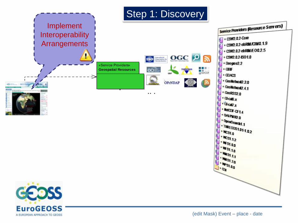
Step 1: DiscoveryImplement
Interoperability
Arrangements
(edit Mask) Event – place - date
cmp General Picture
«Broker»
Catalog Discov ery Broker«Advanced Module»
Semantic Discov ery Broker
«Advanced Module»
Semantic engine
«Broker»
Geospatial Data Access
Broker
«Service Providers»
Geospatial Resources
«Advanced Module»
Adapters
«Service Providers»
Web 2.0 resources
«Semantic Resources»
Thesauri
«Service Providers»
Gazzetters
SPARQL
CSW OpenSearch
WFS
.. .
Step 1: Discovery
cmp General Picture
«Broker»
Catalog Discov ery Broker«Advanced Module»
Semantic Discov ery Broker
«Advanced Module»
Semantic engine
«Broker»
Geospatial Data Access
Broker
«Service Providers»
Geospatial Resources
«Advanced Module»
Adapters
«Service Providers»
Web 2.0 resources
«Semantic Resources»
Thesauri
«Service Providers»
Gazzetters
SPARQL
CSW OpenSearch
WFS
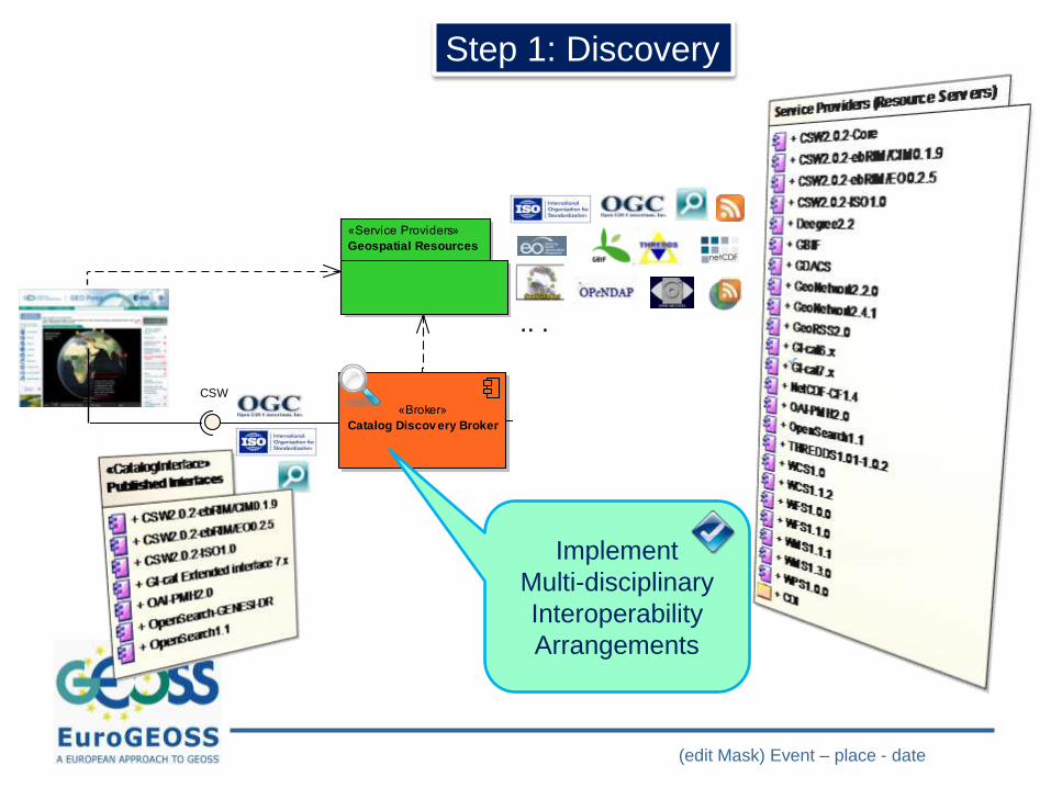
Implement
Multi-disciplinary
Interoperability
Arrangements
(edit Mask) Event – place - date
cmp General Picture
«Broker»
Catalog Discov ery Broker«Advanced Module»
Semantic Discov ery Broker
«Advanced Module»
Semantic engine
«Broker»
Geospatial Data Access
Broker
«Service Providers»
Geospatial Resources
«Advanced Module»
Adapters
«Service Providers»
Web 2.0 resources
«Semantic Resources»
Thesauri
«Service Providers»
Gazzetters
SPARQL
CSW OpenSearch
WFS
.. .
Implement
Subsetting &
Transformation
services
Step 1: Discovery
cmp General Picture
«Broker»
Catalog Discov ery Broker«Advanced Module»
Semantic Discov ery Broker
«Advanced Module»
Semantic engine
«Broker»
Geospatial Data Access
Broker
«Service Providers»
Geospatial Resources
«Advanced Module»
Adapters
«Service Providers»
Web 2.0 resources
«Semantic Resources»
Thesauri
«Service Providers»
Gazzetters
SPARQL
CSW OpenSearch
WFS
Implement
Multi-disciplinary
Interoperability
Arrangements
(edit Mask) Event – place - date
.. .
cmp General Picture
«Broker»
Catalog Discov ery Broker«Advanced Module»
Semantic Discov ery Broker
«Advanced Module»
Semantic engine
«Broker»
Geospatial Data Access
Broker
«Service Providers»
Geospatial Resources
«Advanced Module»
Adapters
«Service Providers»
Web 2.0 resources
«Semantic Resources»
Thesauri
«Service Providers»
Gazzetters
SPARQL
CSW OpenSearch
WFS
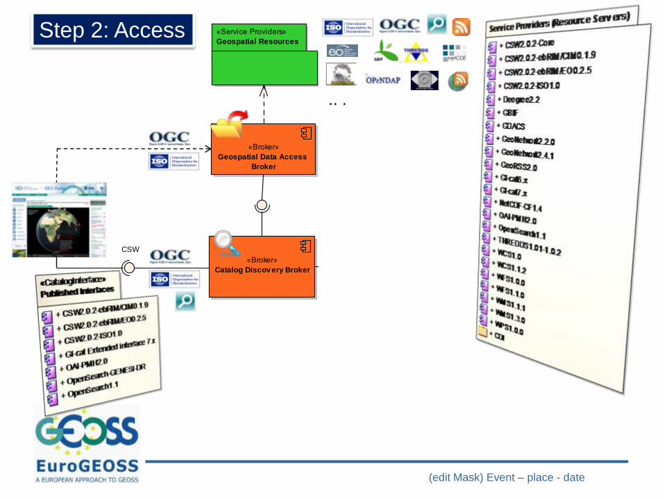
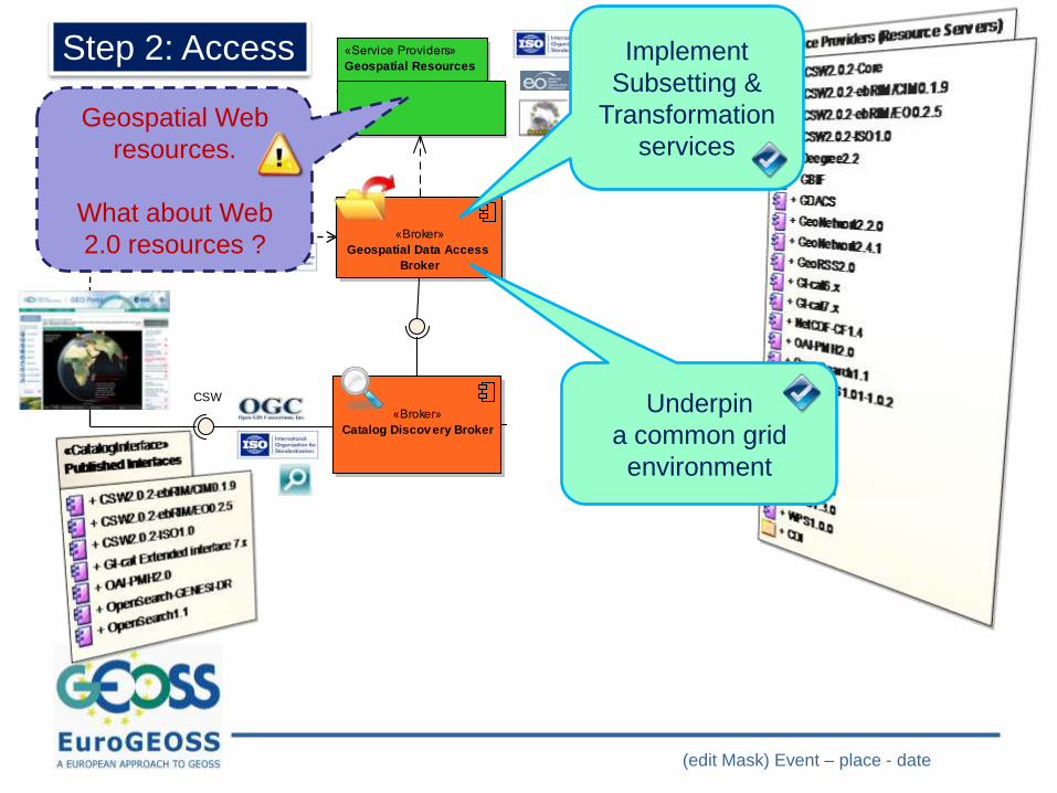
Step 2: Access
(edit Mask) Event – place - date
.. .
cmp General Picture
«Broker»
Catalog Discov ery Broker«Advanced Module»
Semantic Discov ery Broker
«Advanced Module»
Semantic engine
«Broker»
Geospatial Data Access
Broker
«Service Providers»
Geospatial Resources
«Advanced Module»
Adapters
«Service Providers»
Web 2.0 resources
«Semantic Resources»
Thesauri
«Service Providers»
Gazzetters
SPARQL
CSW OpenSearch
WFS
Implement
Subsetting &
Transformation
services
Step 2: Access
(edit Mask) Event – place - date
.. .
cmp General Picture
«Broker»
Catalog Discov ery Broker«Advanced Module»
Semantic Discov ery Broker
«Advanced Module»
Semantic engine
«Broker»
Geospatial Data Access
Broker
«Service Providers»
Geospatial Resources
«Advanced Module»
Adapters
«Service Providers»
Web 2.0 resources
«Semantic Resources»
Thesauri
«Service Providers»
Gazzetters
SPARQL
CSW OpenSearch
WFS
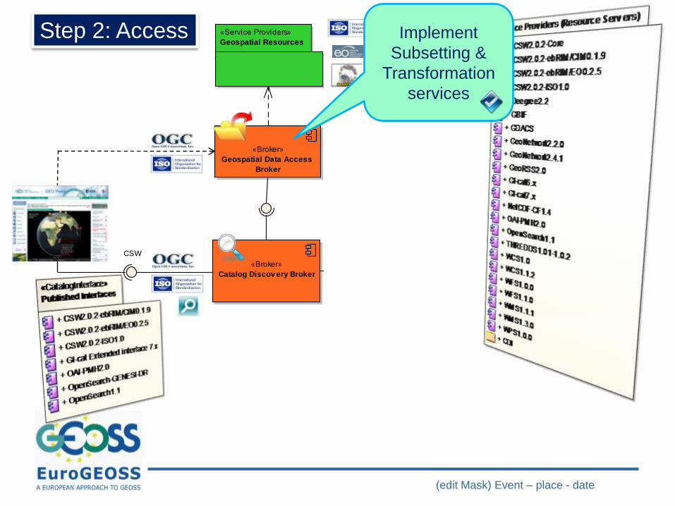
Implement
Subsetting &
Transformation
services
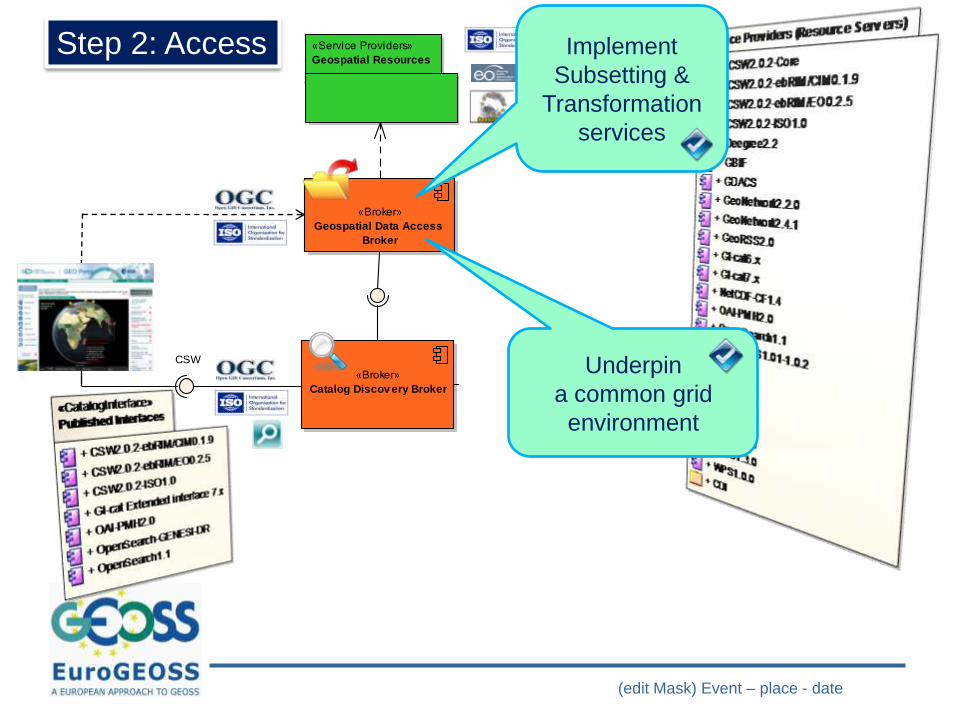
Underpin
a common grid
environment
Step 2: Access
(edit Mask) Event – place - date
.. .
cmp General Picture
«Broker»
Catalog Discov ery Broker«Advanced Module»
Semantic Discov ery Broker
«Advanced Module»
Semantic engine
«Broker»
Geospatial Data Access
Broker
«Service Providers»
Geospatial Resources
«Advanced Module»
Adapters
«Service Providers»
Web 2.0 resources
«Semantic Resources»
Thesauri
«Service Providers»
Gazzetters
SPARQL
CSW OpenSearch
WFS
Implement
Subsetting &
Transformation
services
Underpin
a common grid
environment
Step 2: Access
Geospatial Web
resources.
What about Web
2.0 resources ?
(edit Mask) Event – place - date
cmp General Picture
«Broker»
Catalog Discov ery Broker«Advanced Module»
Semantic Discov ery Broker
«Advanced Module»
Semantic engine
«Broker»
Geospatial Data Access
Broker
«Service Providers»
Geospatial Resources
«Advanced Module»
Adapters
«Service Providers»
Web 2.0 resources
«Semantic Resources»
Thesauri
«Service Providers»
Gazzetters
SPARQL
CSW OpenSearch
WFS
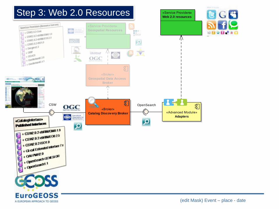
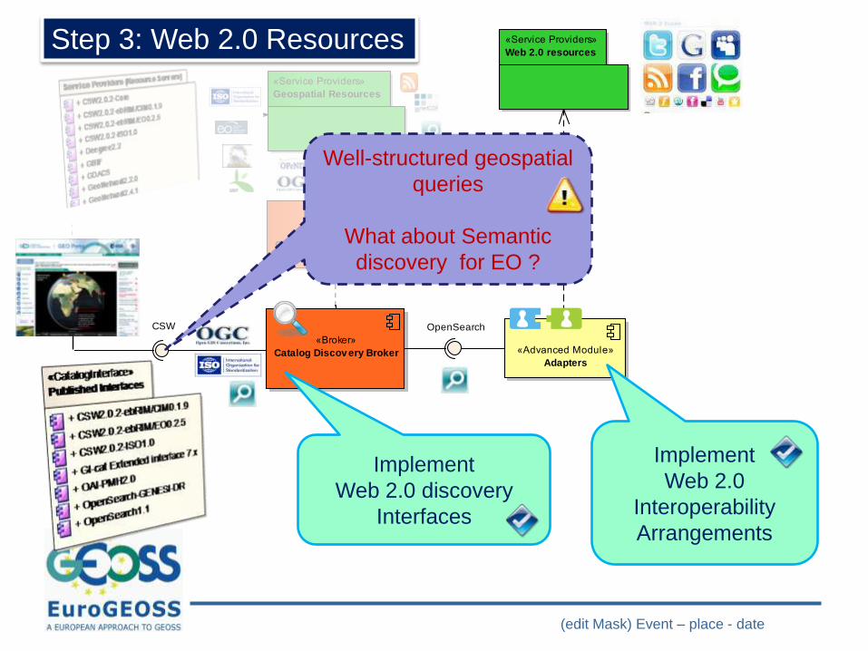
Step 3: Web 2.0 Resources
(edit Mask) Event – place - date
cmp General Picture
«Broker»
Catalog Discov ery Broker«Advanced Module»
Semantic Discov ery Broker
«Advanced Module»
Semantic engine
«Broker»
Geospatial Data Access
Broker
«Service Providers»
Geospatial Resources
«Advanced Module»
Adapters
«Service Providers»
Web 2.0 resources
«Semantic Resources»
Thesauri
«Service Providers»
Gazzetters
SPARQL
CSW OpenSearch
WFS
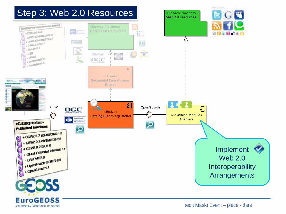
Implement
Web 2.0
Interoperability
Arrangements
cmp General Picture
«Broker»
Catalog Discov ery Broker«Advanced Module»
Semantic Discov ery Broker
«Advanced Module»
Semantic engine
«Broker»
Geospatial Data Access
Broker
«Service Providers»
Geospatial Resources
«Advanced Module»
Adapters
«Service Providers»
Web 2.0 resources
«Semantic Resources»
Thesauri
«Service Providers»
Gazzetters
SPARQL
CSW OpenSearch
WFS
Step 3: Web 2.0 Resources
(edit Mask) Event – place - date
cmp General Picture
«Broker»
Catalog Discov ery Broker«Advanced Module»
Semantic Discov ery Broker
«Advanced Module»
Semantic engine
«Broker»
Geospatial Data Access
Broker
«Service Providers»
Geospatial Resources
«Advanced Module»
Adapters
«Service Providers»
Web 2.0 resources
«Semantic Resources»
Thesauri
«Service Providers»
Gazzetters
SPARQL
CSW OpenSearch
WFS
Implement
Web 2.0
Interoperability
Arrangements
Implement
Web 2.0 discovery
Interfaces
cmp General Picture
«Broker»
Catalog Discov ery Broker«Advanced Module»
Semantic Discov ery Broker
«Advanced Module»
Semantic engine
«Broker»
Geospatial Data Access
Broker
«Service Providers»
Geospatial Resources
«Advanced Module»
Adapters
«Service Providers»
Web 2.0 resources
«Semantic Resources»
Thesauri
«Service Providers»
Gazzetters
SPARQL
CSW OpenSearch
WFS
Step 3: Web 2.0 Resources
Well-structured geospatial
queries
What about Semantic
discovery for EO ?
(edit Mask) Event – place - date
cmp General Picture
«Broker»
Catalog Discov ery Broker«Advanced Module»
Semantic Discov ery Broker
«Advanced Module»
Semantic engine
«Broker»
Geospatial Data Access
Broker
«Service Providers»
Geospatial Resources
«Advanced Module»
Adapters
«Service Providers»
Web 2.0 resources
«Semantic Resources»
Thesauri
«Service Providers»
Gazzetters
SPARQL
CSW OpenSearch
WFS
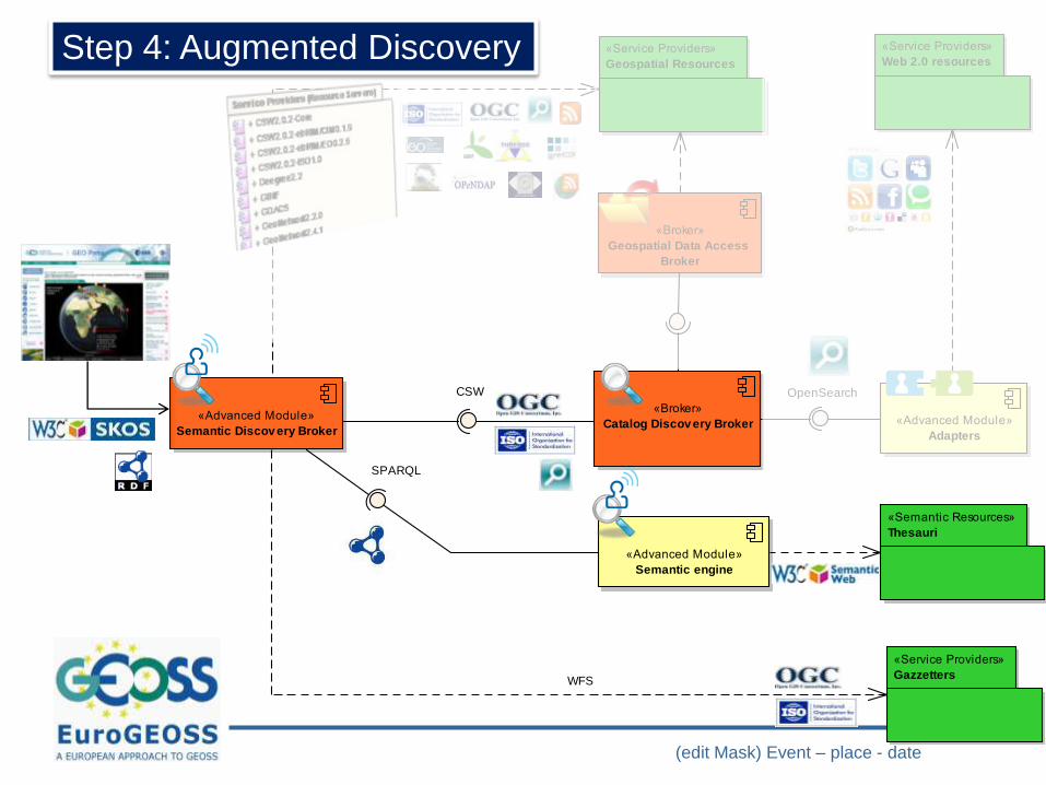
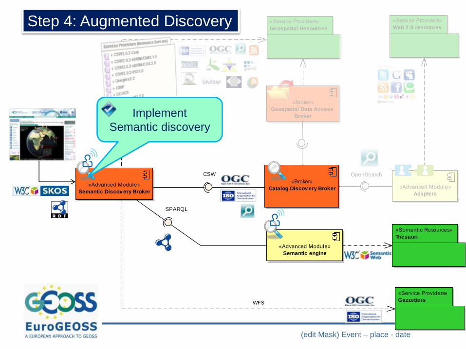
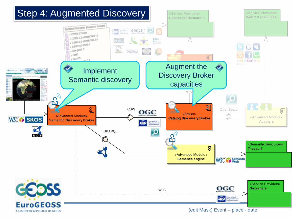
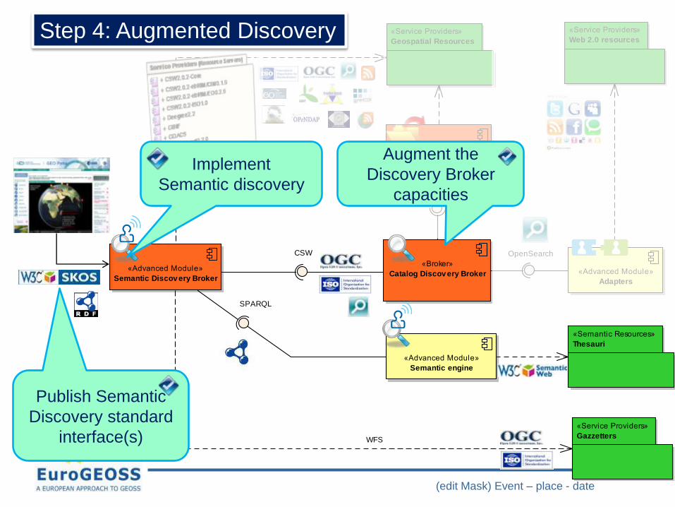
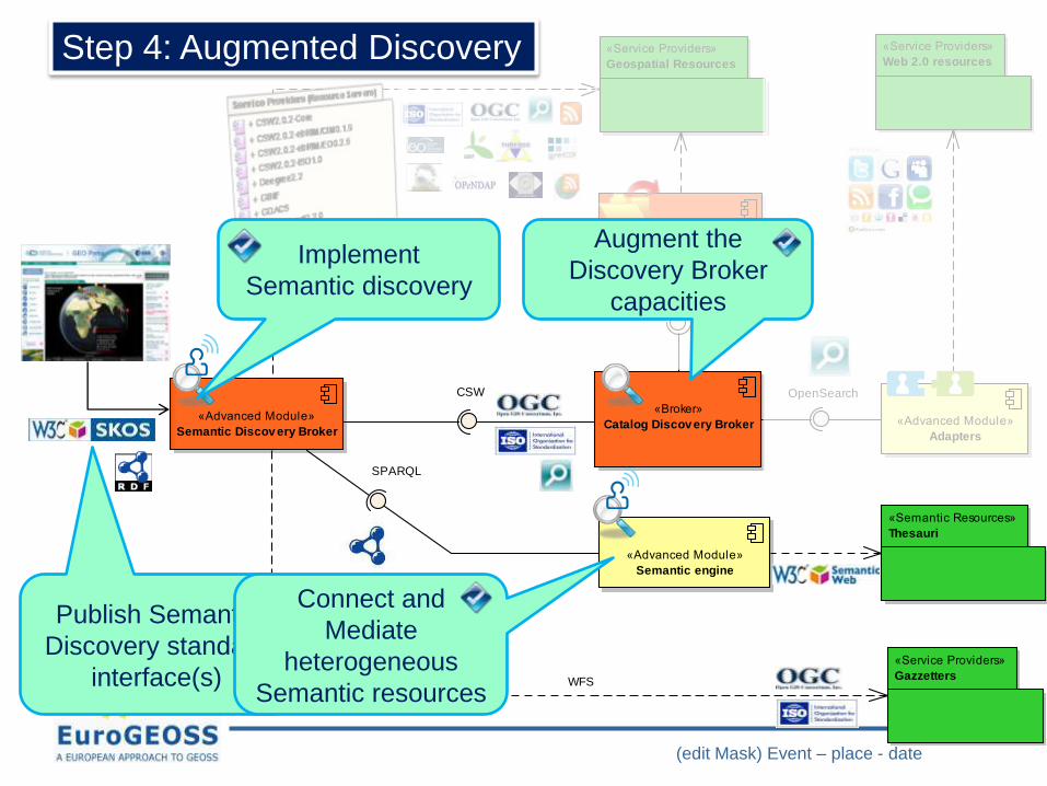
Step 4: Augmented Discovery
(edit Mask) Event – place - date
cmp General Picture
«Broker»
Catalog Discov ery Broker«Advanced Module»
Semantic Discov ery Broker
«Advanced Module»
Semantic engine
«Broker»
Geospatial Data Access
Broker
«Service Providers»
Geospatial Resources
«Advanced Module»
Adapters
«Service Providers»
Web 2.0 resources
«Semantic Resources»
Thesauri
«Service Providers»
Gazzetters
SPARQL
CSW OpenSearch
WFS
Step 4: Augmented Discovery
Implement
Semantic discovery
Augment the
Discovery Broker
capacities
Publish Semantic
Discovery standard
interface(s)
Connect and
Mediate
heterogeneous
Semantic resources
(edit Mask) Event – place - date
cmp General Picture
«Broker»
Catalog Discov ery Broker«Advanced Module»
Semantic Discov ery Broker
«Advanced Module»
Semantic engine
«Broker»
Geospatial Data Access
Broker
«Service Providers»
Geospatial Resources
«Advanced Module»
Adapters
«Service Providers»
Web 2.0 resources
«Semantic Resources»
Thesauri
«Service Providers»
Gazzetters
SPARQL
CSW OpenSearch
WFS
EuroGEOSS Meeting – JRC Ispra – 4-6 oct 2010
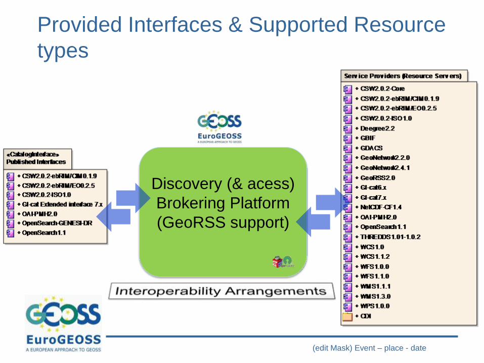
DISCOVERY (& ACCESS)
BROKER
Empowered by
(edit Mask) Event – place - date
Discovery (& acess)
Brokering Platform
(GeoRSS support)
Provided Interfaces & Supported Resource
types
EuroGEOSS Meeting – JRC Ispra – 4-6 oct 2010
OWS Accessors
CS-W APAccessors
GBIF Accessor
THREDDS/OPeNDAPAccessor
CS-W(T)/
ISO APOpenSearch
Accessor
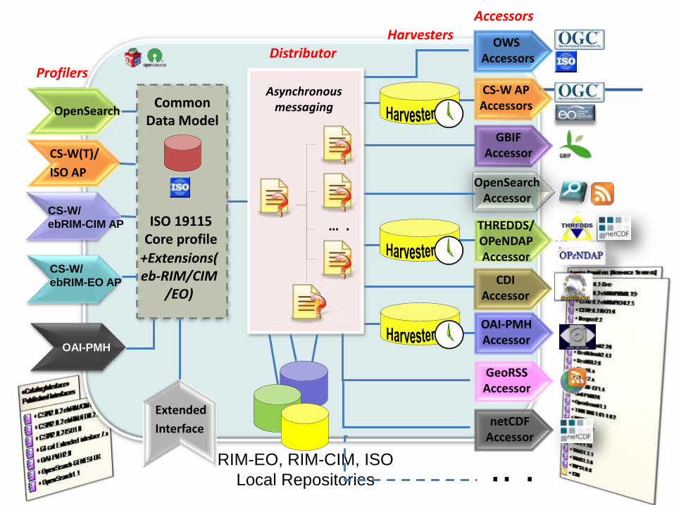
CommonData Model
ISO 19115Core profile
Asynchronousmessaging
CDIAccessor
… .CS-W/
ebRIM-CIM AP
+Extensions(eb-RIM/CIM
/EO)
Accessors
CS-W/
ebRIM-EO AP
Profilers
Extended
Interface
OAI-PMHAccessor
OpenSearch
OAI-PMH
Harvesters
RIM-EO, RIM-CIM, ISO
Local Repositories
GeoRSSAccessor
netCDFAccessor
Distributor
.. .
EuroGEOSS Meeting – JRC Ispra – 4-6 oct 2010
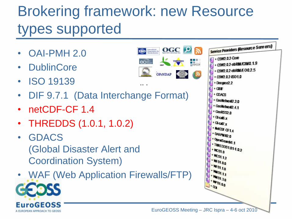
Brokering framework: new Resource
types supported
• OAI-PMH 2.0
• DublinCore
• ISO 19139
• DIF 9.7.1 (Data Interchange Format)
• netCDF-CF 1.4
• THREDDS (1.0.1, 1.0.2)
• GDACS
(Global Disaster Alert and
Coordination System)
• WAF (Web Application Firewalls/FTP)
.. .
EuroGEOSS Meeting – JRC Ispra – 4-6 oct 2010
AUGMENTED (SEMANTIC)
DISCOVERY
In collaboration with GENESIS

EuroGEOSS Meeting – JRC Ispra – 4-6 oct 2010
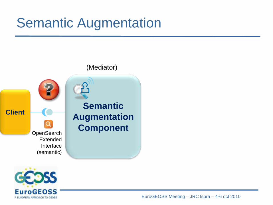
Semantic Augmentation
Semantic
Augmentation
ComponentOpenSearch
Extended
Interface
(semantic)
(Mediator)
Client
EuroGEOSS Meeting – JRC Ispra – 4-6 oct 2010
Semantic Augmentation
Semantic
Augmentation
ComponentOpenSearch
Extended
Interface
(semantic)
(Mediator)
Client
EuroGEOSS Meeting – JRC Ispra – 4-6 oct 2010
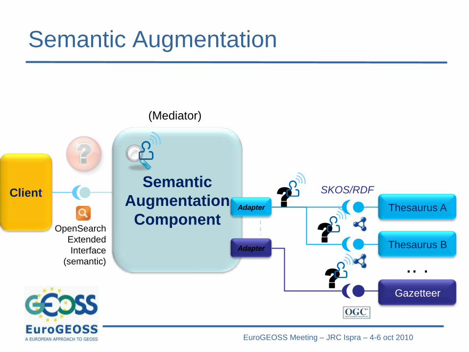
SKOS/RDF
Semantic Augmentation
Semantic
Augmentation
ComponentOpenSearch
Extended
Interface
(semantic)
Thesaurus A
Gazetteer
Adapter
Adapter
(Mediator)
Thesaurus B
.. .
?
?
?
Client
EuroGEOSS Meeting – JRC Ispra – 4-6 oct 2010
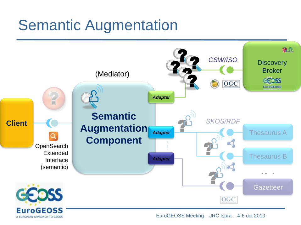
SKOS/RDF
Semantic Augmentation
Semantic
Augmentation
ComponentOpenSearch
Extended
Interface
(semantic)
Thesaurus A
Gazetteer
Adapter
Adapter
(Mediator)
Adapter
Discovery
Broker
CSW/ISO
Thesaurus B
.. .
?
??
??
?
?
?
Client
EuroGEOSS Meeting – JRC Ispra – 4-6 oct 2010
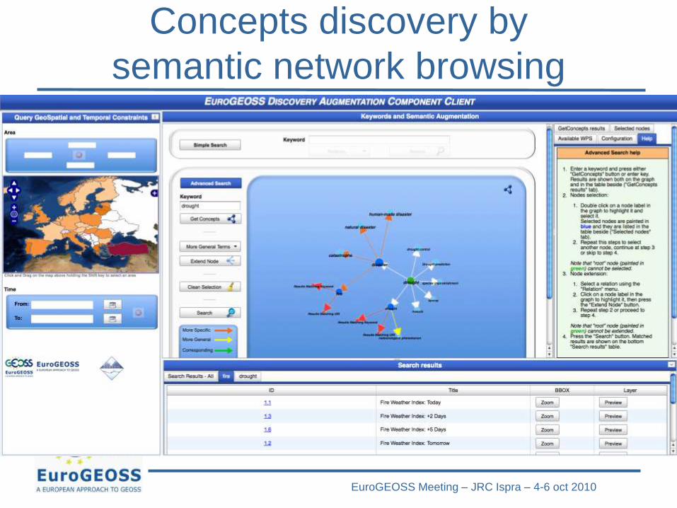
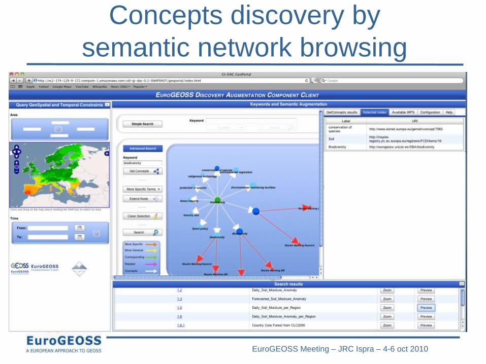
Concepts discovery by
semantic network browsing
EuroGEOSS Meeting – JRC Ispra – 4-6 oct 2010
Concepts discovery by
semantic network browsing
EuroGEOSS Meeting – JRC Ispra – 4-6 oct 2010
COMMON GRID DATA
ACCESS
EuroGEOSS Meeting – JRC Ispra – 4-6 oct 2010
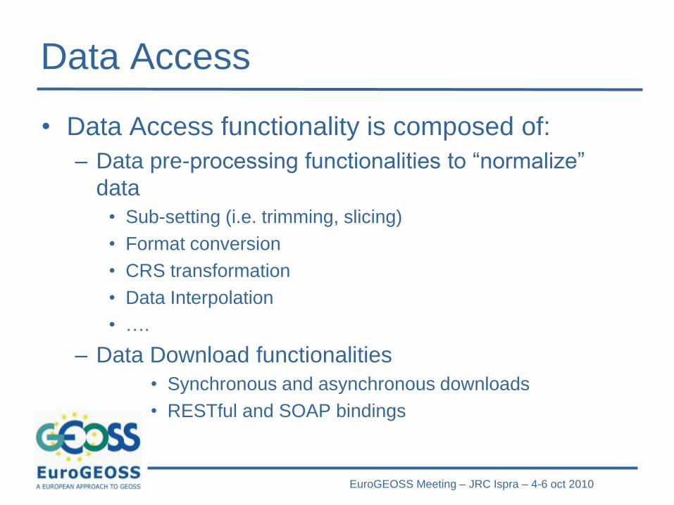
Data Access
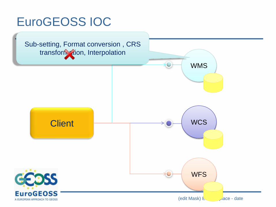
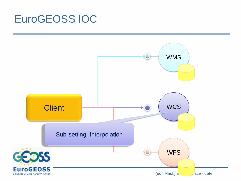
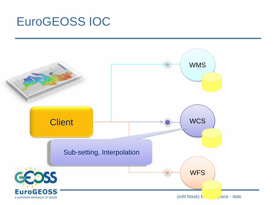
• Data Access functionality is composed of:
– Data pre-processing functionalities to “normalize”
data
• Sub-setting (i.e. trimming, slicing)
• Format conversion
• CRS transformation
• Data Interpolation
• ….
– Data Download functionalities
• Synchronous and asynchronous downloads
• RESTful and SOAP bindings

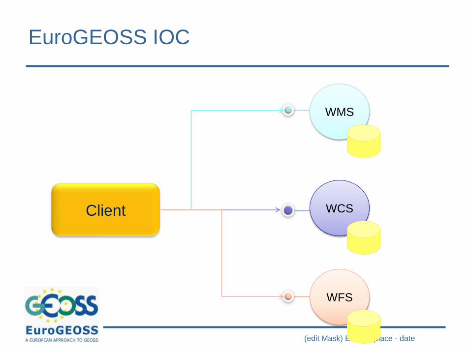
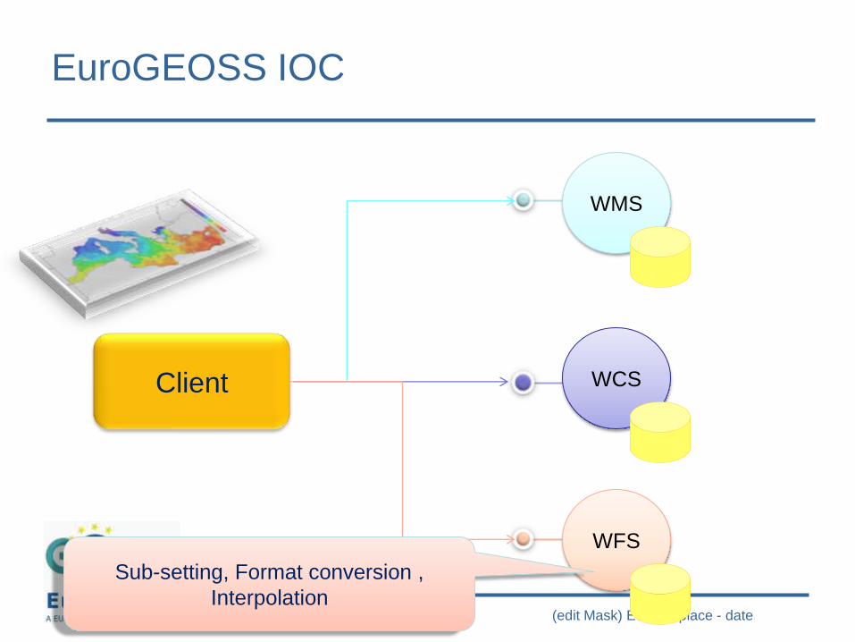
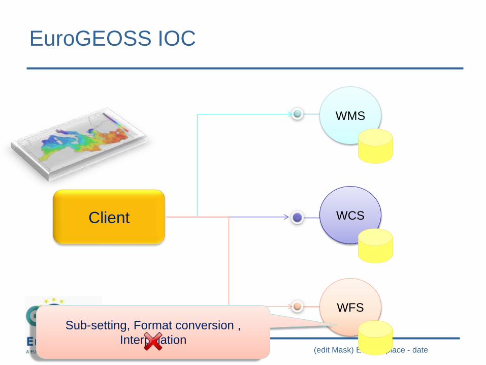
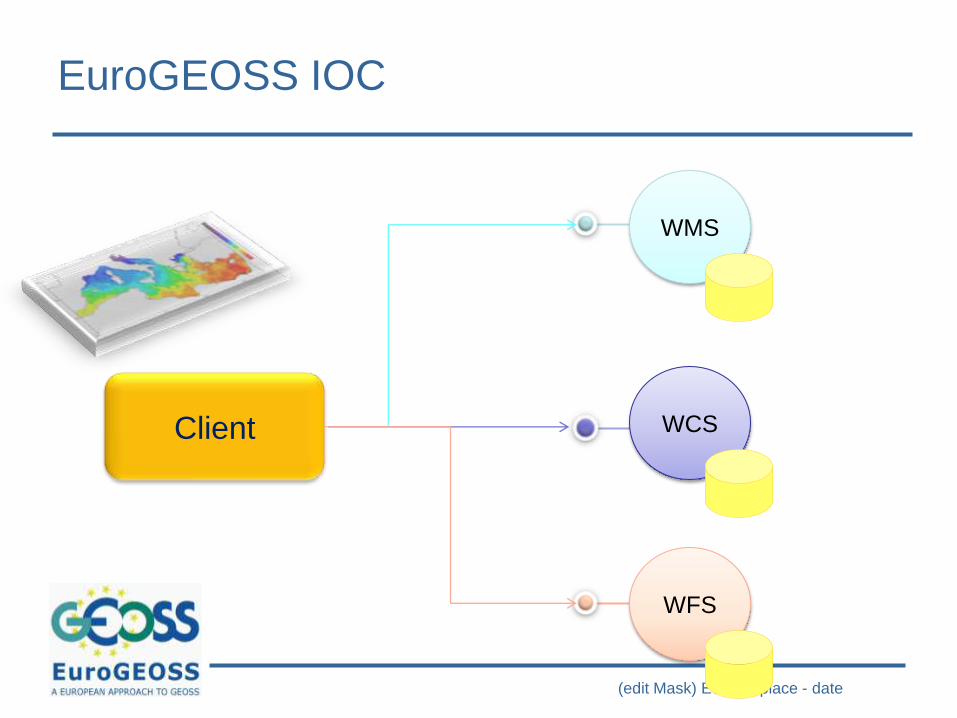
(edit Mask) Event – place - date
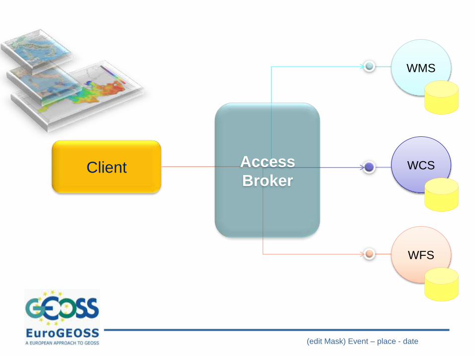
Client
WMS
WCS
WFS
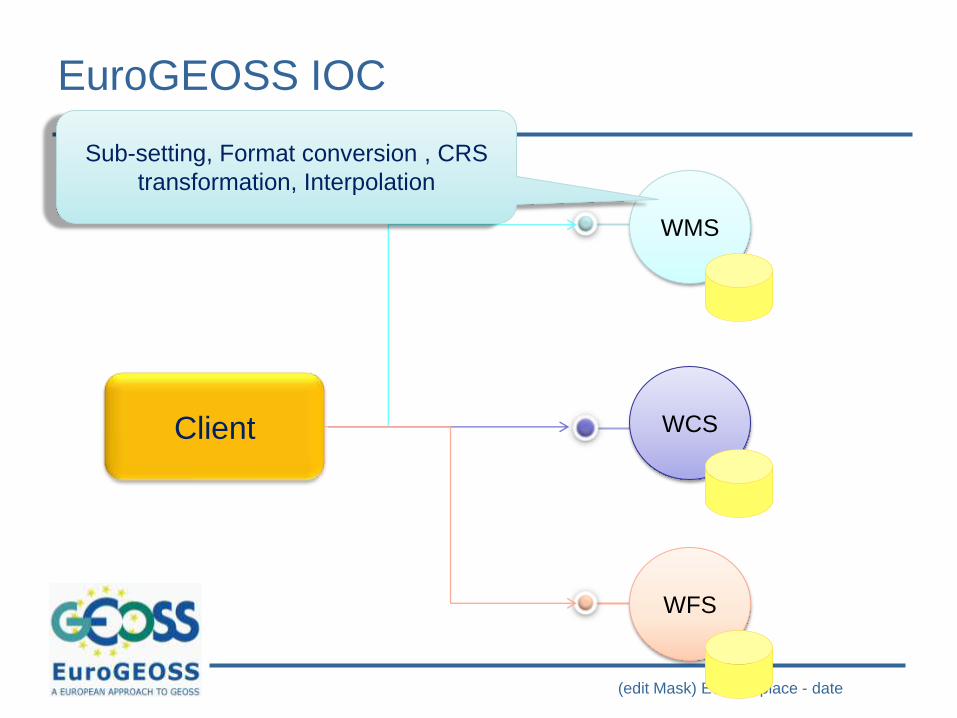
EuroGEOSS IOC
(edit Mask) Event – place - date
Client
WMS
WCS
WFS
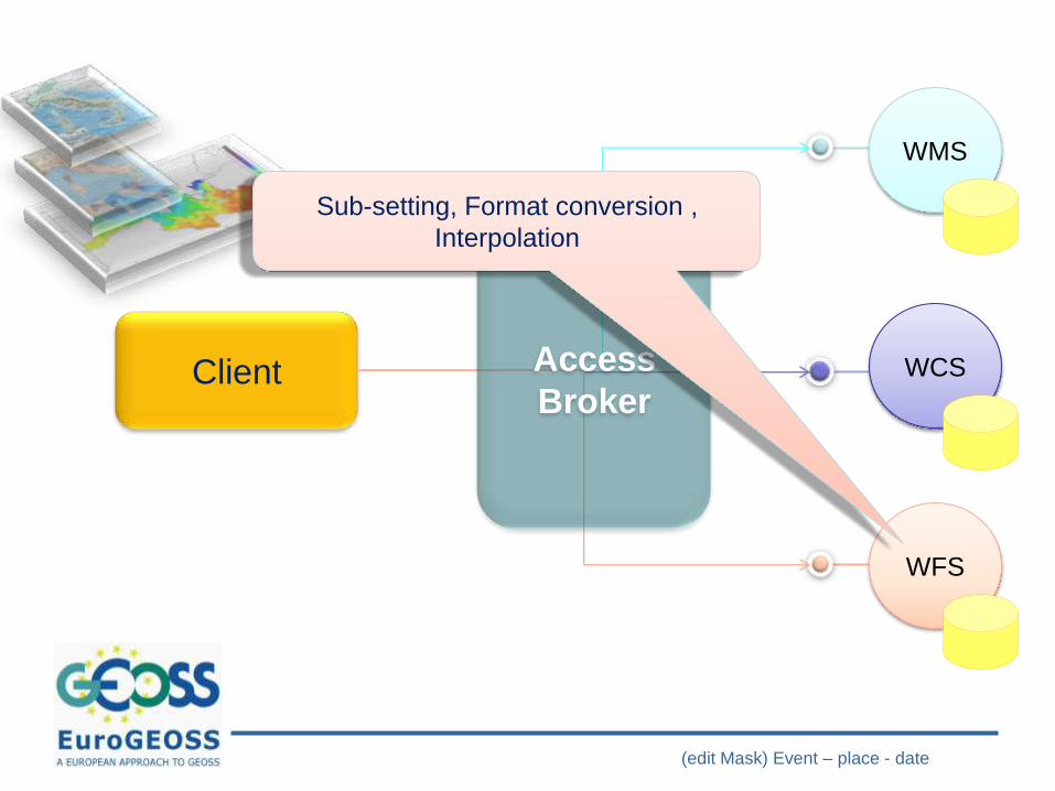
Sub-setting, Format conversion , CRS
transformation, Interpolation
EuroGEOSS IOC
(edit Mask) Event – place - date
Client
WMS
WCS
WFS
Sub-setting, Format conversion , CRS
transformation, Interpolation
EuroGEOSS IOC
(edit Mask) Event – place - date
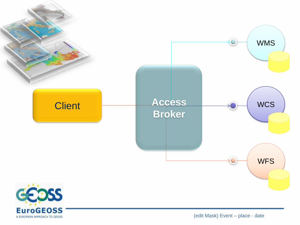
Client
WMS
WCS
WFS
EuroGEOSS IOC
(edit Mask) Event – place - date
Client
WMS
WCS
WFS
Sub-setting, Interpolation
EuroGEOSS IOC
(edit Mask) Event – place - date
Client
WMS
WCS
WFS
Sub-setting, Interpolation
EuroGEOSS IOC

(edit Mask) Event – place - date
Client
WMS
WCS
WFS
EuroGEOSS IOC
(edit Mask) Event – place - date
Client
WMS
WCS
WFS
Sub-setting, Format conversion ,
Interpolation
EuroGEOSS IOC
(edit Mask) Event – place - date
Client
WMS
WCS
WFS
Sub-setting, Format conversion ,
Interpolation
EuroGEOSS IOC
(edit Mask) Event – place - date
Client
WMS
WCS
WFS
EuroGEOSS IOC
EuroGEOSS Meeting – JRC Ispra – 4-6 oct 2010
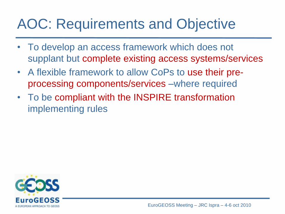
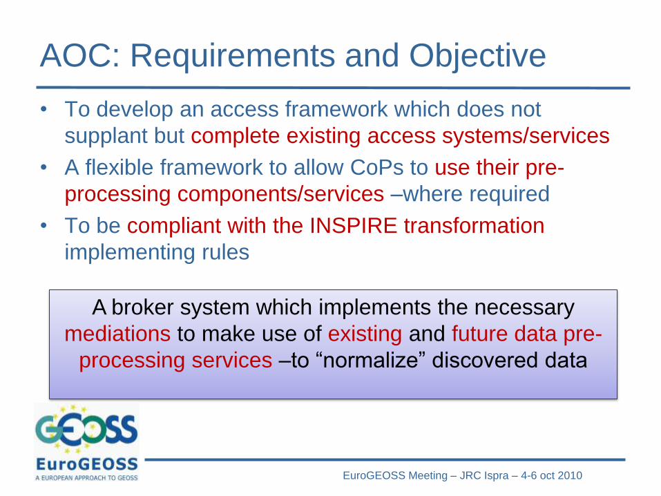
AOC: Requirements and Objective
• To develop an access framework which does not
supplant but complete existing access systems/services
• A flexible framework to allow CoPs to use their pre-
processing components/services –where required
• To be compliant with the INSPIRE transformation
implementing rules
EuroGEOSS Meeting – JRC Ispra – 4-6 oct 2010
AOC: Requirements and Objective
• To develop an access framework which does not
supplant but complete existing access systems/services
• A flexible framework to allow CoPs to use their pre-
processing components/services –where required
• To be compliant with the INSPIRE transformation
implementing rules
A broker system which implements the necessary
mediations to make use of existing and future data pre-
processing services –to “normalize” discovered data
(edit Mask) Event – place - date
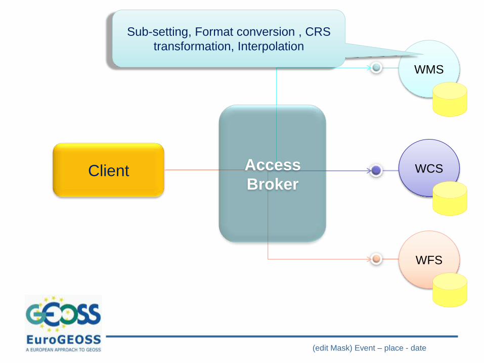
Client
WMS
WCS
WFS
Access
Broker
Sub-setting, Format conversion , CRS
transformation, Interpolation
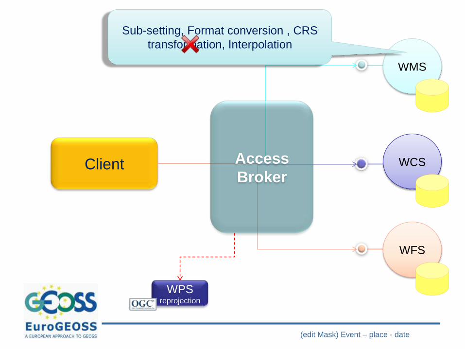
(edit Mask) Event – place - date
Client
WMS
WCS
WFS
Access
Broker
Sub-setting, Format conversion , CRS
transformation, Interpolation
WPSreprojection
(edit Mask) Event – place - date
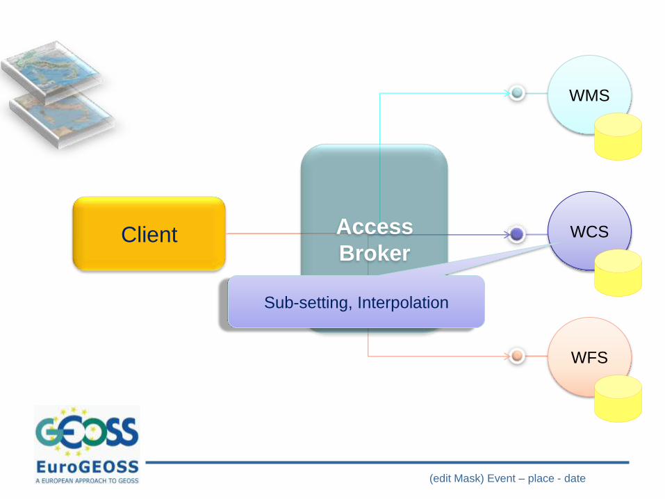
Client
WMS
WCS
WFS
Access
Broker
Sub-setting, Interpolation
(edit Mask) Event – place - date
Client
WMS
WCS
WFS
Access
Broker
(edit Mask) Event – place - date
Client
WMS
WCS
WFS
Access
Broker
Sub-setting, Format conversion ,
Interpolation
(edit Mask) Event – place - date
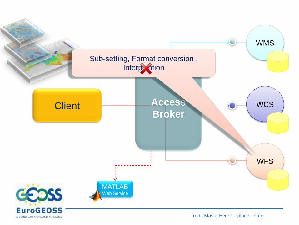
Client
WMS
WCS
WFS
Access
Broker
Sub-setting, Format conversion ,
Interpolation
MATLAB Web Service
(edit Mask) Event – place - date
Client
WMS
WCS
WFS
Access
Broker
(edit Mask) Event – place - date
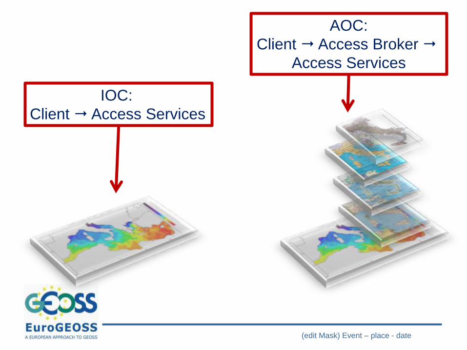
IOC:
Client Access Services
AOC:
Client Access Broker
Access Services
EuroGEOSS Meeting – JRC Ispra – 4-6 oct 2010
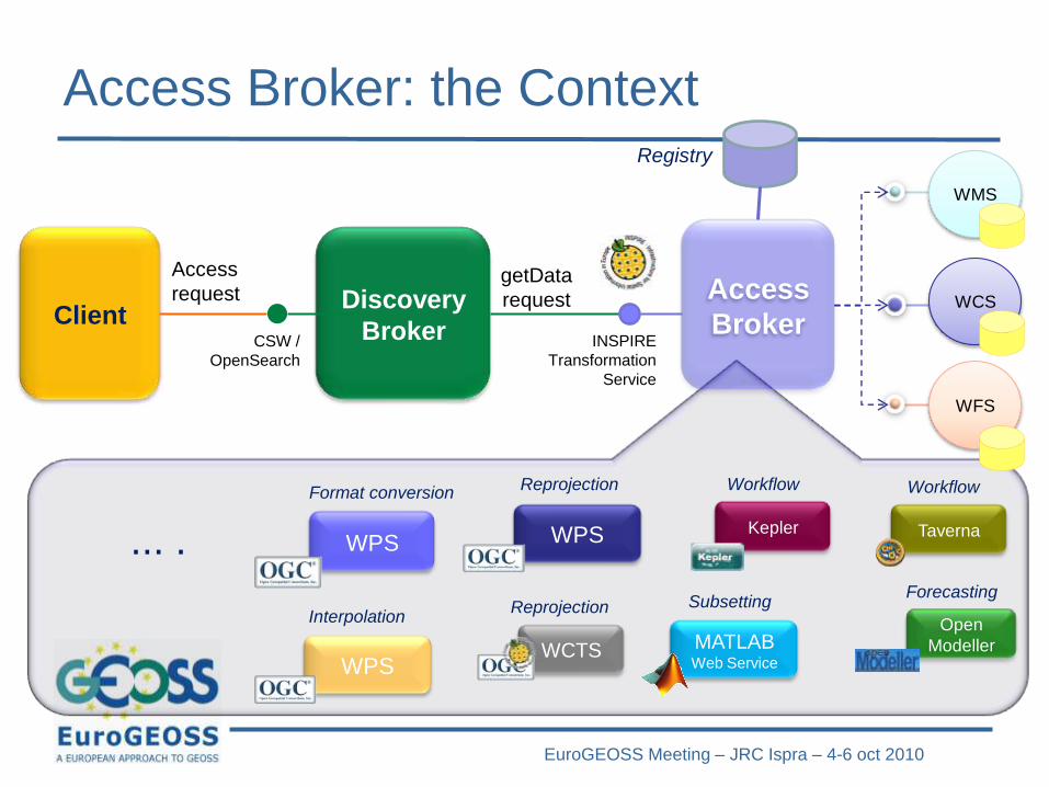
Access Broker: the Context
Discovery
Broker
getData
requestClient
Access
request Access
BrokerINSPIRE
Transformation
Service
Registry
CSW /
OpenSearch
Taverna
Workflow
Kepler
Workflow
Open
Modeller
Forecasting
WPS
Interpolation
WPS
Reprojection
WCTS
Reprojection
WPS
Format conversion
... .
MATLAB Web Service
Subsetting
WMS
WCS
WFS
EuroGEOSS Meeting – JRC Ispra – 4-6 oct 2010
Access Broker: the Context
Discovery
Broker
getData
requestClient
Access
request Access
BrokerINSPIRE
Transformation
Service
Registry
CSW /
OpenSearch
Taverna
Workflow
Kepler
Workflow
Open
Modeller
Forecasting
WPS
Interpolation
WPS
Reprojection
WCTS
Reprojection
WPS
Format conversion
... .
MATLAB Web Service
Subsetting
WMS
WCS
WFS
MATLAB
Web
Service
Specific CoP
Reseampling
EuroGEOSS Meeting – JRC Ispra – 4-6 oct 2010
WEB 2.0 RESOURCES
DISCOVERY
EuroGEOSS Meeting – JRC Ispra – 4-6 oct 2010
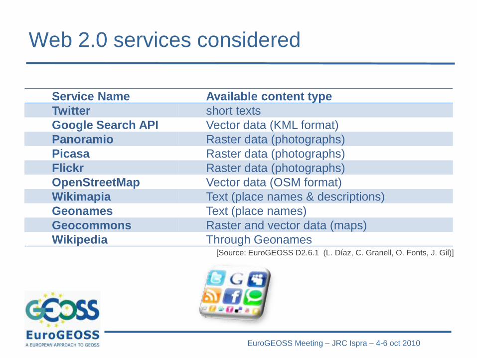
Web 2.0 services considered
Service Name Available content type
Twitter short texts
Google Search API Vector data (KML format)
Panoramio Raster data (photographs)
Picasa Raster data (photographs)
Flickr Raster data (photographs)
OpenStreetMap Vector data (OSM format)
Wikimapia Text (place names & descriptions)
Geonames Text (place names)
Geocommons Raster and vector data (maps)
Wikipedia Through Geonames[Source: EuroGEOSS D2.6.1 (L. Díaz, C. Granell, O. Fonts, J. Gil)]
EuroGEOSS Meeting – JRC Ispra – 4-6 oct 2010
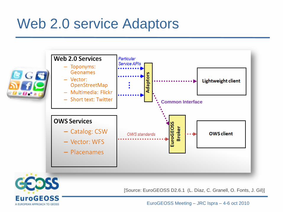
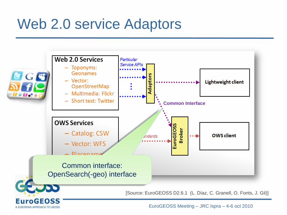
Web 2.0 service Adaptors
[Source: EuroGEOSS D2.6.1 (L. Díaz, C. Granell, O. Fonts, J. Gil)]
Common Interface
EuroGEOSS Meeting – JRC Ispra – 4-6 oct 2010
Web 2.0 service Adaptors
[Source: EuroGEOSS D2.6.1 (L. Díaz, C. Granell, O. Fonts, J. Gil)]
Common interface:
OpenSearch(-geo) interface
Common Interface
EuroGEOSS Meeting – JRC Ispra – 4-6 oct 2010
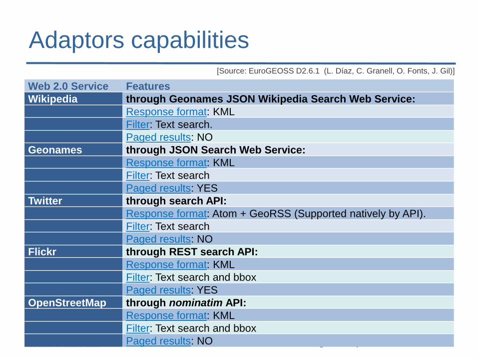
Adaptors capabilities
Web 2.0 Service Features
Wikipedia through Geonames JSON Wikipedia Search Web Service:
Response format: KML
Filter: Text search.
Paged results: NO
Geonames through JSON Search Web Service:
Response format: KML
Filter: Text search
Paged results: YES
Twitter through search API:
Response format: Atom + GeoRSS (Supported natively by API).
Filter: Text search
Paged results: NO
Flickr through REST search API:
Response format: KML
Filter: Text search and bbox
Paged results: YES
OpenStreetMap through nominatim API:
Response format: KML
Filter: Text search and bbox
Paged results: NO
[Source: EuroGEOSS D2.6.1 (L. Díaz, C. Granell, O. Fonts, J. Gil)]
EuroGEOSS Meeting – JRC Ispra – 4-6 oct 2010
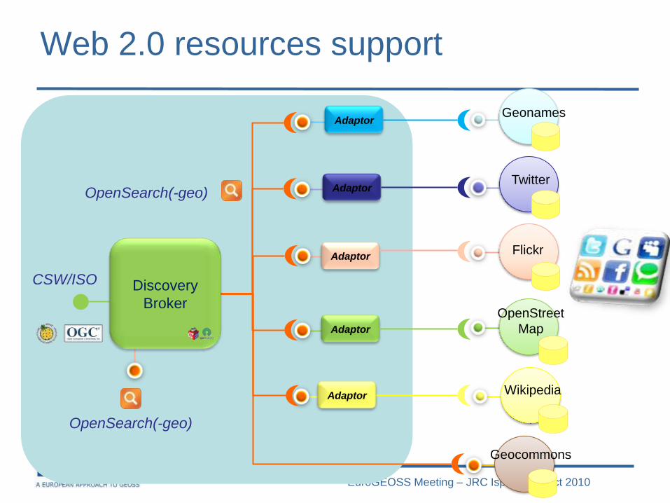
Web 2.0 resources support
CSW/ISO
Adaptor
Geonames
Flickr
OpenStreet
Map
Wikipedia
Adaptor
Adaptor
Adaptor
Adaptor
OpenSearch(-geo)
Geocommons
OpenSearch(-geo)
Discovery
Broker
EuroGEOSS Meeting – JRC Ispra – 4-6 oct 2010
ADVANCED PREVIEW
EuroGEOSS Meeting – JRC Ispra – 4-6 oct 2010
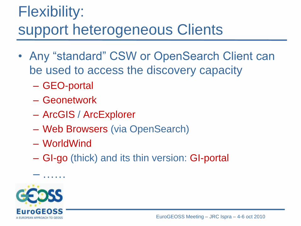
Flexibility:
support heterogeneous Clients
• Any “standard” CSW or OpenSearch Client can
be used to access the discovery capacity
– GEO-portal
– Geonetwork
– ArcGIS / ArcExplorer
– Web Browsers (via OpenSearch)
– WorldWind
– GI-go (thick) and its thin version: GI-portal
– ……
EuroGEOSS Meeting – JRC Ispra – 4-6 oct 2010
USE SCENARIOS (AIP-3)
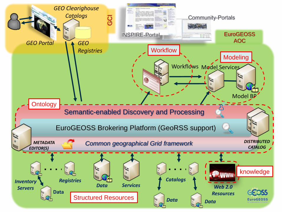
(edit Mask) Event – place - date
ServicesDataCatalogsRegistries
Data Data
Data
InventoryServers
EuroGEOSS
AOCGEO Portal
GEO Clearighouse Catalogs
GEO Registries
GC
I
Workflows
Model BP
Model Services
ModelingWorkflow
Web 2.0 Resources
Semantic-enabled Discovery and ProcessingOntology
EuroGEOSS Brokering Platform (GeoRSS support)
DISTRIBUTEDCATALOG
METADATA EDITOR(S)
Common geographical Grid framework
knowledge
Structured Resources
EuroGEOSS Meeting – JRC Ispra – 4-6 oct 2010
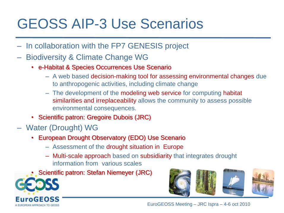
GEOSS AIP-3 Use Scenarios
– In collaboration with the FP7 GENESIS project
– Biodiversity & Climate Change WG
• e-Habitat & Species Occurrences Use Scenario
– A web based decision-making tool for assessing environmental changes due
to anthropogenic activities, including climate change
– The development of the modeling web service for computing habitat
similarities and irreplaceability allows the community to assess possible
environmental consequences.
• Scientific patron: Gregoire Dubois (JRC)
– Water (Drought) WG
• European Drought Observatory (EDO) Use Scenario
– Assessment of the drought situation in Europe
– Multi-scale approach based on subsidiarity that integrates drought
information from various scales
• Scientific patron: Stefan Niemeyer (JRC)
Related Challanges:
From ncML to ncML-G+
ESSI Lab [email protected]
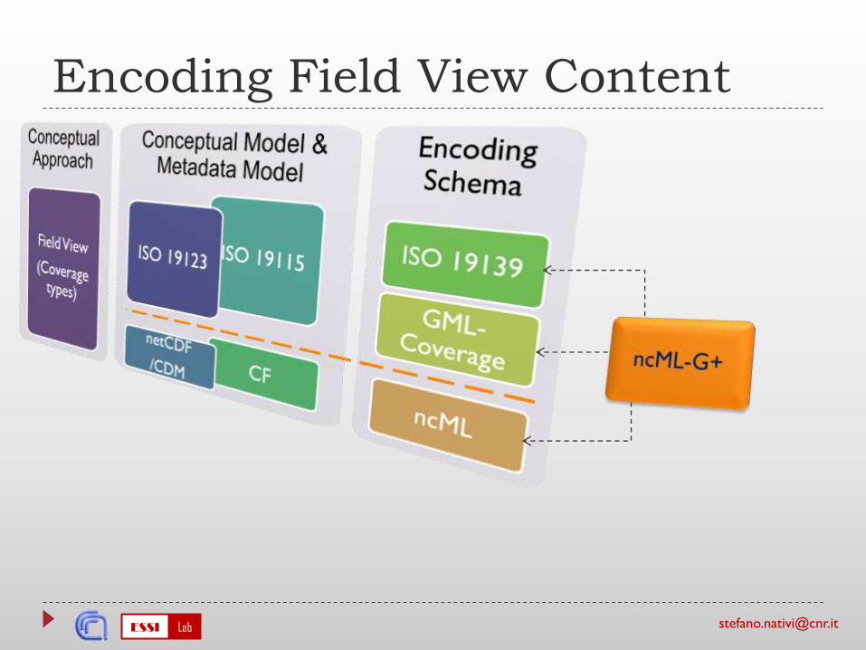
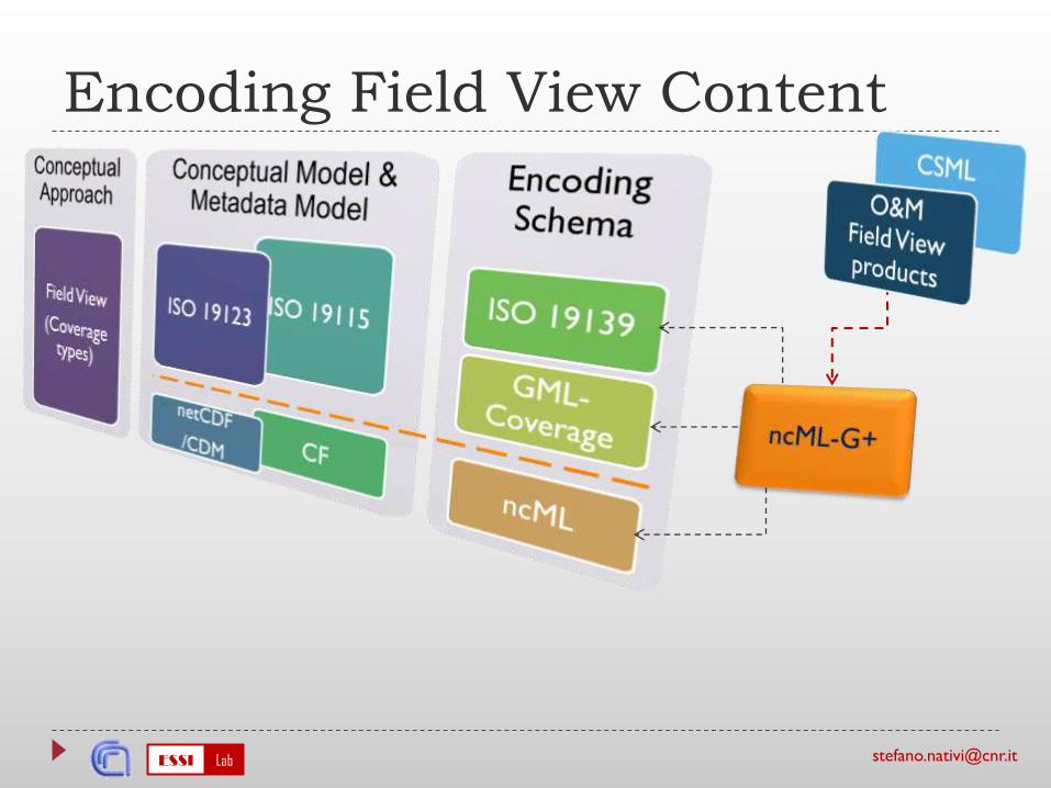
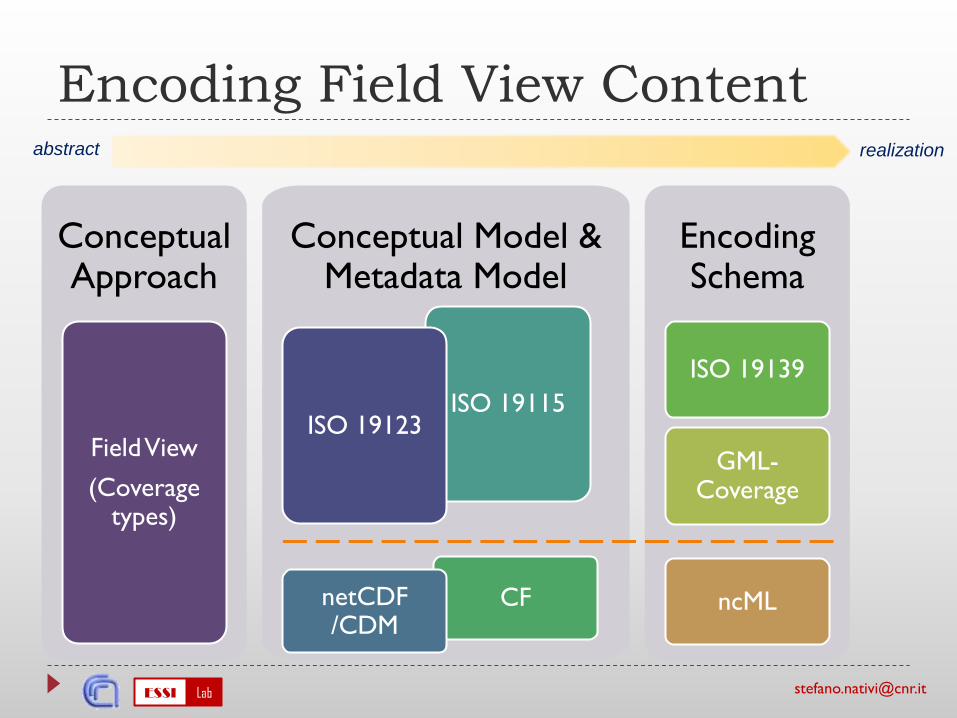
Conceptual Model & Metadata Model
ISO 19115
CF
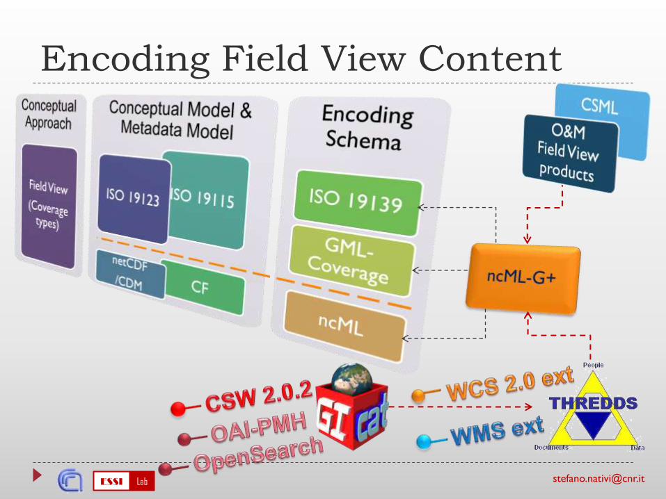
Encoding Field View Content
ConceptualApproach
FieldView
(Coveragetypes)
ISO 19123
netCDF/CDM
EncodingSchema
ISO 19139
GML-Coverage
ncML
abstract realization
ESSI Lab [email protected]
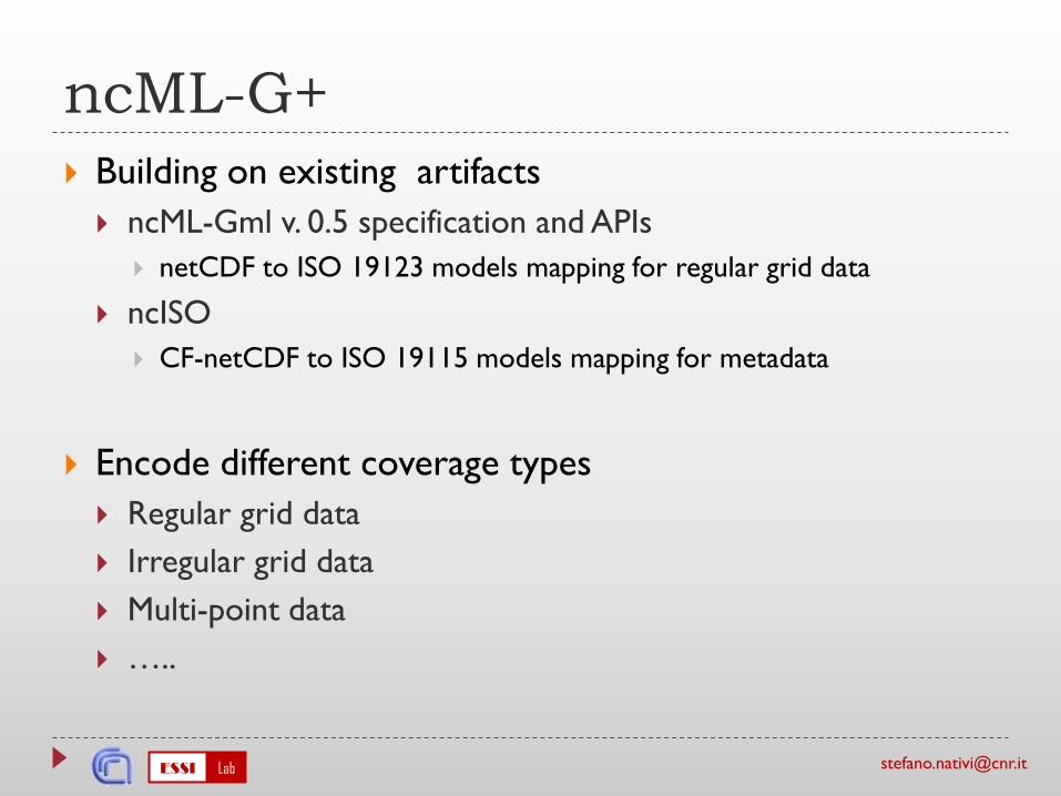
ncML-G+
Building on existing artifacts
ncML-Gml v. 0.5 specification and APIs
netCDF to ISO 19123 models mapping for regular grid data
ncISO
CF-netCDF to ISO 19115 models mapping for metadata
Encode different coverage types
Regular grid data
Irregular grid data
Multi-point data
…..
Uncertain Types and Services
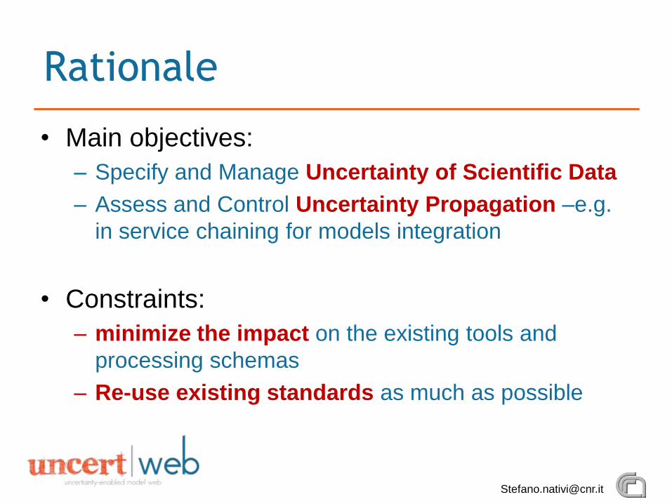
• Main objectives:
– Specify and Manage Uncertainty of Scientific Data
– Assess and Control Uncertainty Propagation –e.g.
in service chaining for models integration
• Constraints:
– minimize the impact on the existing tools and
processing schemas
– Re-use existing standards as much as possible
Rationale
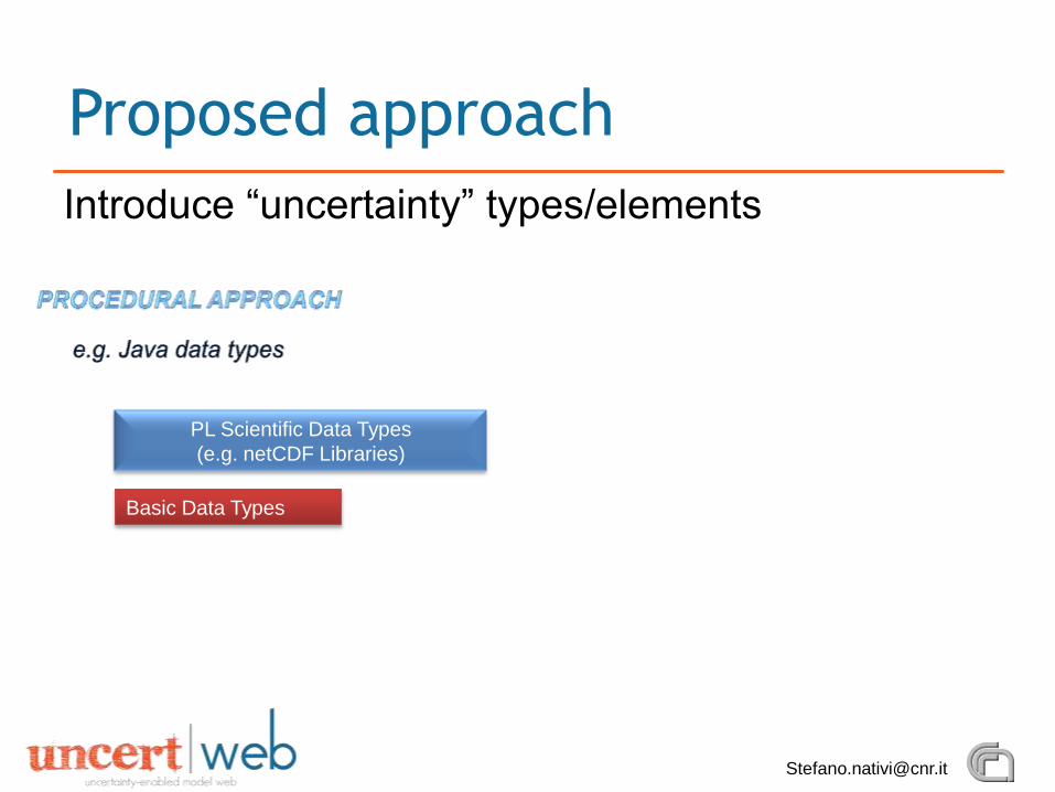
Introduce “uncertainty” types/elements
Proposed approach
Basic Data Types
PL Scientific Data Types
(e.g. netCDF Libraries)
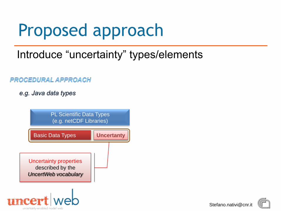
Introduce “uncertainty” types/elements
Proposed approach
Basic Data Types
PL Scientific Data Types
(e.g. netCDF Libraries)
Uncertanty
Uncertainty properties
described by the
UncertWeb vocabulary
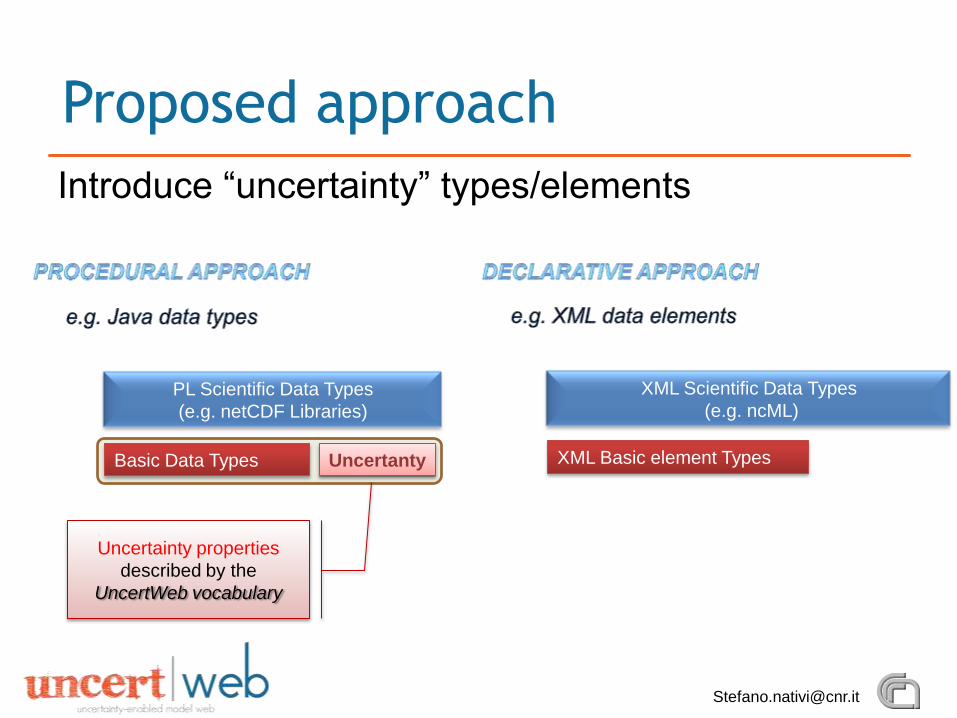
Introduce “uncertainty” types/elements
Proposed approach
XML Basic element Types
XML Scientific Data Types
(e.g. ncML)
Basic Data Types
PL Scientific Data Types
(e.g. netCDF Libraries)
Uncertanty
Uncertainty properties
described by the
UncertWeb vocabulary
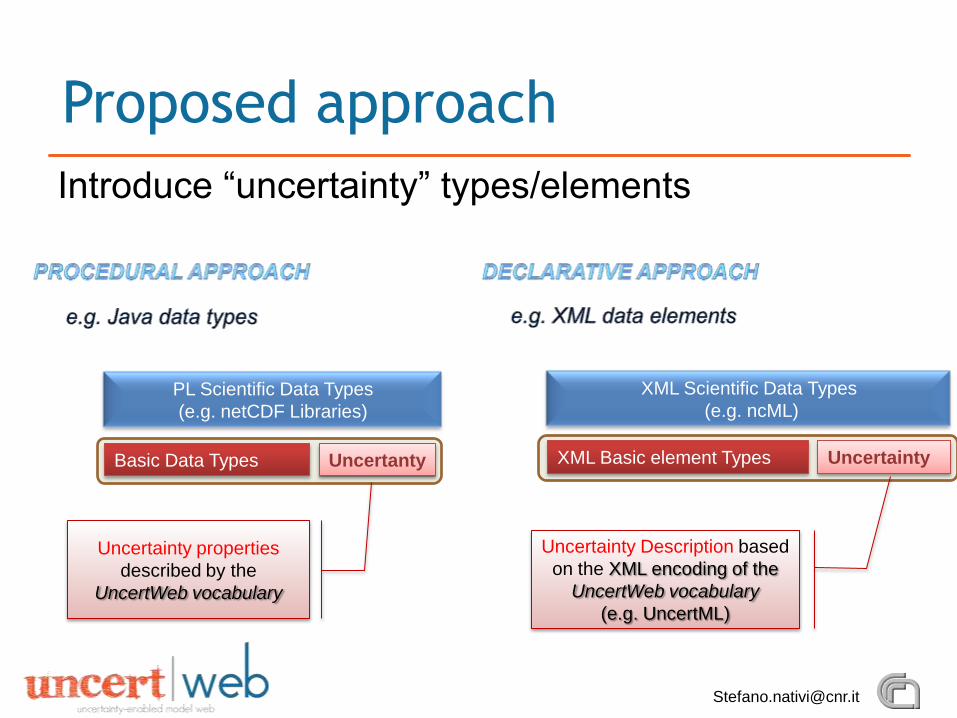
Introduce “uncertainty” types/elements
Proposed approach
XML Basic element Types
XML Scientific Data Types
(e.g. ncML)
Uncertainty
Uncertainty Description based
on the XML encoding of the
UncertWeb vocabulary
(e.g. UncertML)
Basic Data Types
PL Scientific Data Types
(e.g. netCDF Libraries)
Uncertanty
Uncertainty properties
described by the
UncertWeb vocabulary
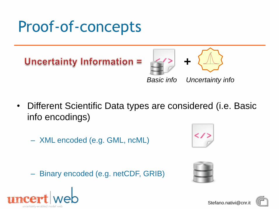
• Different Scientific Data types are considered (i.e. Basic
info encodings)
– XML encoded (e.g. GML, ncML)
– Binary encoded (e.g. netCDF, GRIB)
Proof-of-concepts
+
Basic info Uncertainty info
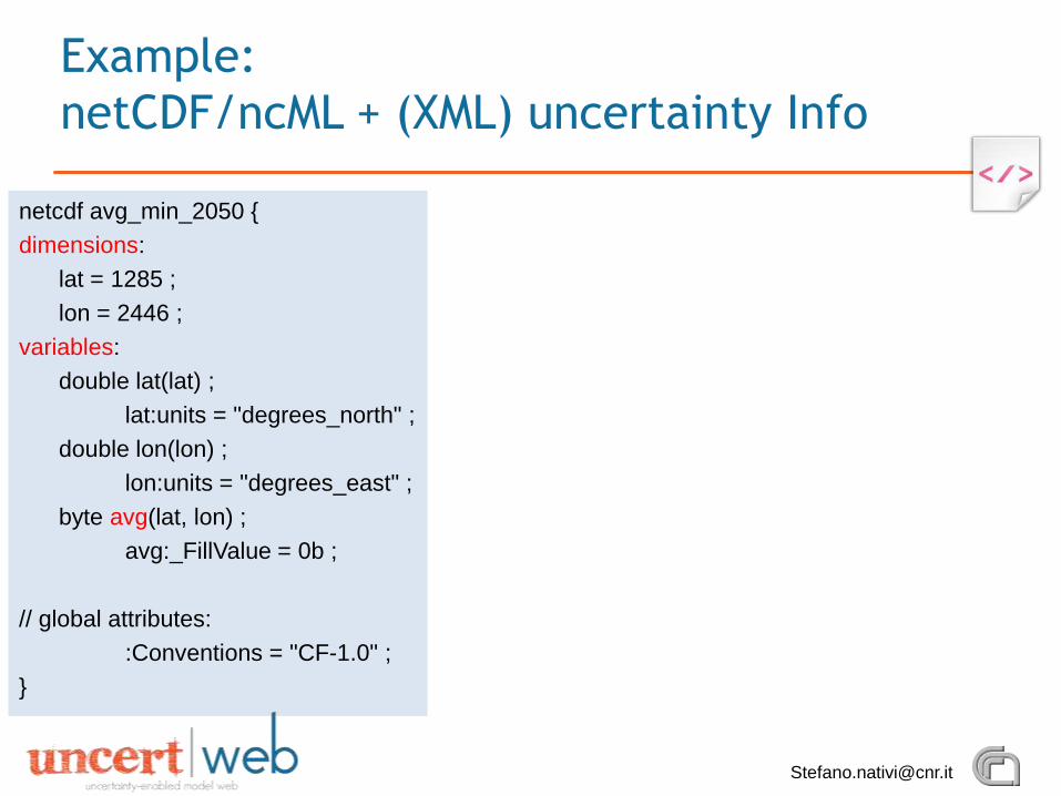
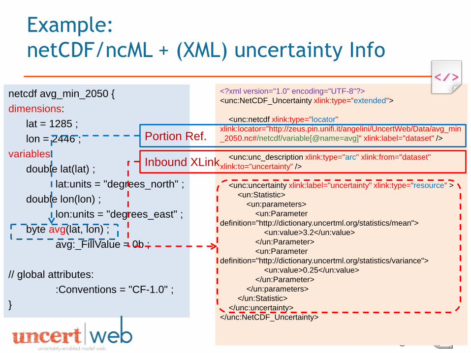
netcdf avg_min_2050 {
dimensions:
lat = 1285 ;
lon = 2446 ;
variables:
double lat(lat) ;
lat:units = "degrees_north" ;
double lon(lon) ;
lon:units = "degrees_east" ;
byte avg(lat, lon) ;
avg:_FillValue = 0b ;
// global attributes:
:Conventions = "CF-1.0" ;
}
Example:
netCDF/ncML + (XML) uncertainty Info
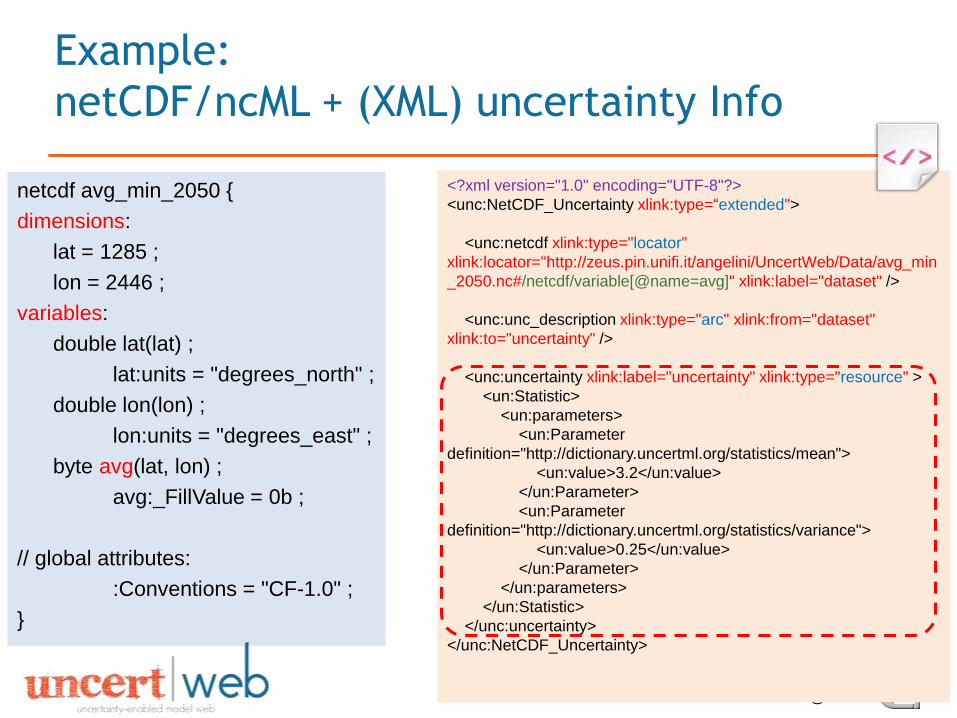
<?xml version="1.0" encoding="UTF-8"?>
<unc:NetCDF_Uncertainty xlink:type=“extended">
<unc:netcdf xlink:type="locator"
xlink:locator="http://zeus.pin.unifi.it/angelini/UncertWeb/Data/avg_min
_2050.nc#/netcdf/variable[@name=avg]" xlink:label="dataset" />
<unc:unc_description xlink:type="arc" xlink:from="dataset"
xlink:to="uncertainty" />
<unc:uncertainty xlink:label="uncertainty" xlink:type="resource" >
<un:Statistic>
<un:parameters>
<un:Parameter
definition="http://dictionary.uncertml.org/statistics/mean">
<un:value>3.2</un:value>
</un:Parameter>
<un:Parameter
definition="http://dictionary.uncertml.org/statistics/variance">
<un:value>0.25</un:value>
</un:Parameter>
</un:parameters>
</un:Statistic>
</unc:uncertainty>
</unc:NetCDF_Uncertainty>
netcdf avg_min_2050 {
dimensions:
lat = 1285 ;
lon = 2446 ;
variables:
double lat(lat) ;
lat:units = "degrees_north" ;
double lon(lon) ;
lon:units = "degrees_east" ;
byte avg(lat, lon) ;
avg:_FillValue = 0b ;
// global attributes:
:Conventions = "CF-1.0" ;
}
Example:
netCDF/ncML + (XML) uncertainty Info
Portion Ref.
<?xml version="1.0" encoding="UTF-8"?>
<unc:NetCDF_Uncertainty xlink:type=“extended">
<unc:netcdf xlink:type="locator"
xlink:locator="http://zeus.pin.unifi.it/angelini/UncertWeb/Data/avg_min
_2050.nc#/netcdf/variable[@name=avg]" xlink:label="dataset" />
<unc:unc_description xlink:type="arc" xlink:from="dataset"
xlink:to="uncertainty" />
<unc:uncertainty xlink:label="uncertainty" xlink:type="resource" >
<un:Statistic>
<un:parameters>
<un:Parameter
definition="http://dictionary.uncertml.org/statistics/mean">
<un:value>3.2</un:value>
</un:Parameter>
<un:Parameter
definition="http://dictionary.uncertml.org/statistics/variance">
<un:value>0.25</un:value>
</un:Parameter>
</un:parameters>
</un:Statistic>
</unc:uncertainty>
</unc:NetCDF_Uncertainty>
netcdf avg_min_2050 {
dimensions:
lat = 1285 ;
lon = 2446 ;
variables:
double lat(lat) ;
lat:units = "degrees_north" ;
double lon(lon) ;
lon:units = "degrees_east" ;
byte avg(lat, lon) ;
avg:_FillValue = 0b ;
// global attributes:
:Conventions = "CF-1.0" ;
}
Example:
netCDF/ncML + (XML) uncertainty Info
Inbound XLink
Portion Ref.
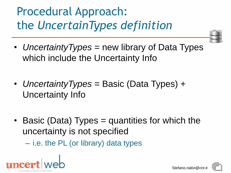
• UncertaintyTypes = new library of Data Types
which include the Uncertainty Info
• UncertaintyTypes = Basic (Data Types) +
Uncertainty Info
• Basic (Data) Types = quantities for which the
uncertainty is not specified
– i.e. the PL (or library) data types
Procedural Approach:
the UncertainTypes definition
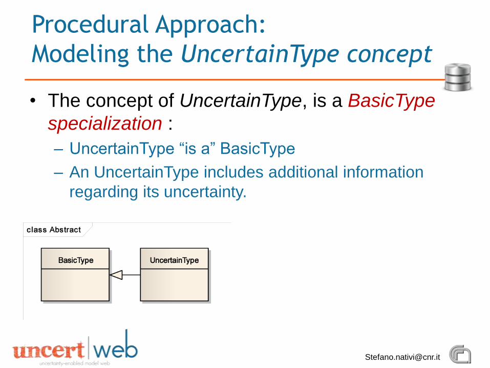
• The concept of UncertainType, is a BasicType
specialization :
– UncertainType “is a” BasicType
– An UncertainType includes additional information
regarding its uncertainty.
Procedural Approach:
Modeling the UncertainType concept
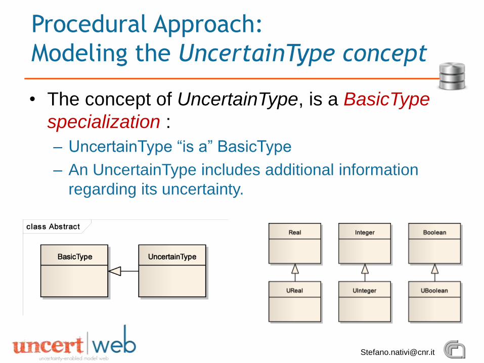
• The concept of UncertainType, is a BasicType
specialization :
– UncertainType “is a” BasicType
– An UncertainType includes additional information
regarding its uncertainty.
Procedural Approach:
Modeling the UncertainType concept
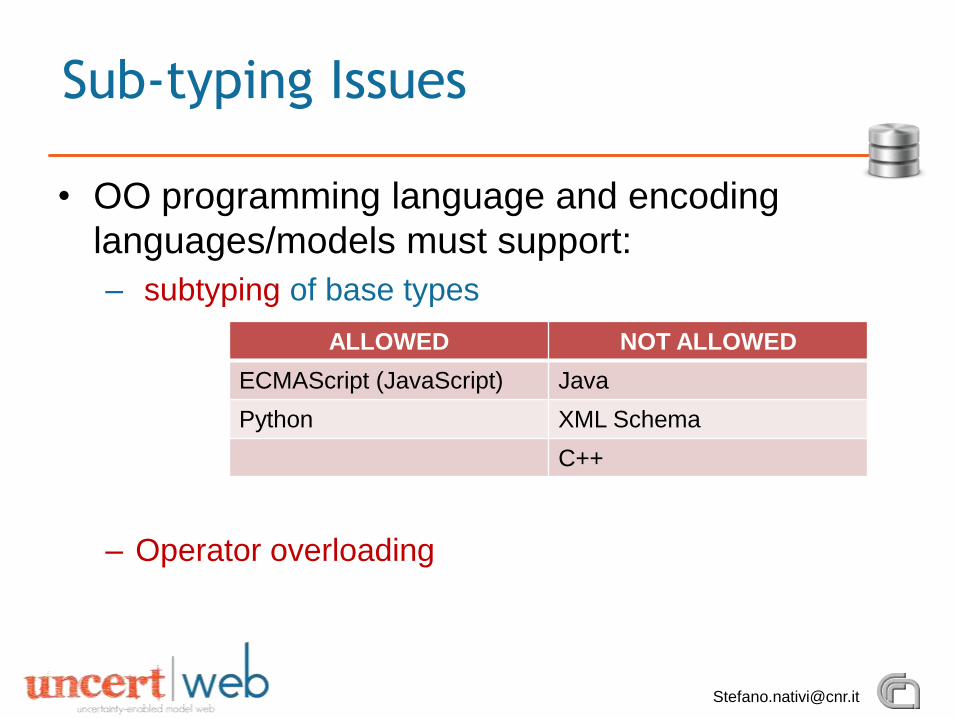
• OO programming language and encoding
languages/models must support:
– subtyping of base types
– Operator overloading
Sub-typing Issues
ALLOWED NOT ALLOWED
ECMAScript (JavaScript) Java
Python XML Schema
C++
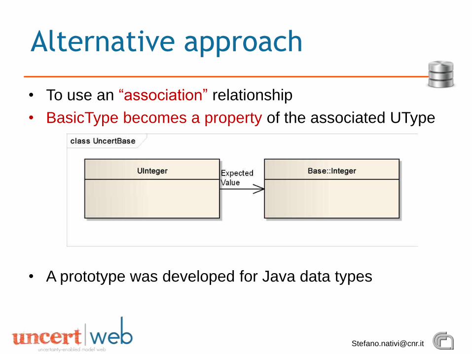
• To use an “association” relationship
• BasicType becomes a property of the associated UType
• A prototype was developed for Java data types
Alternative approach
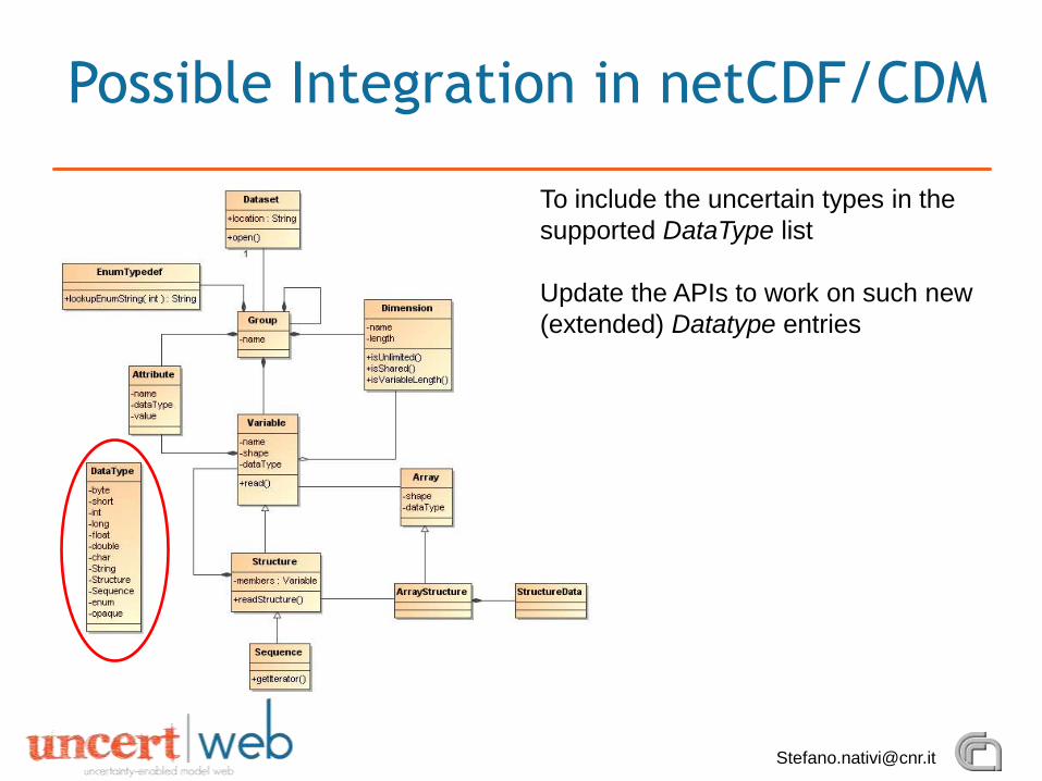
Possible Integration in netCDF/CDM
To include the uncertain types in the
supported DataType list
Update the APIs to work on such new
(extended) Datatype entries
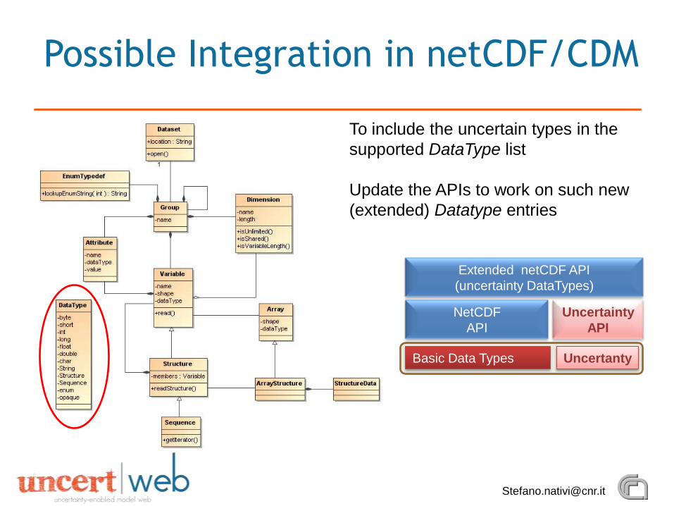
Possible Integration in netCDF/CDM
To include the uncertain types in the
supported DataType list
Update the APIs to work on such new
(extended) Datatype entries
NetCDF
API
Uncertainty
API
Basic Data Types
Extended netCDF API
(uncertainty DataTypes)
Uncertanty
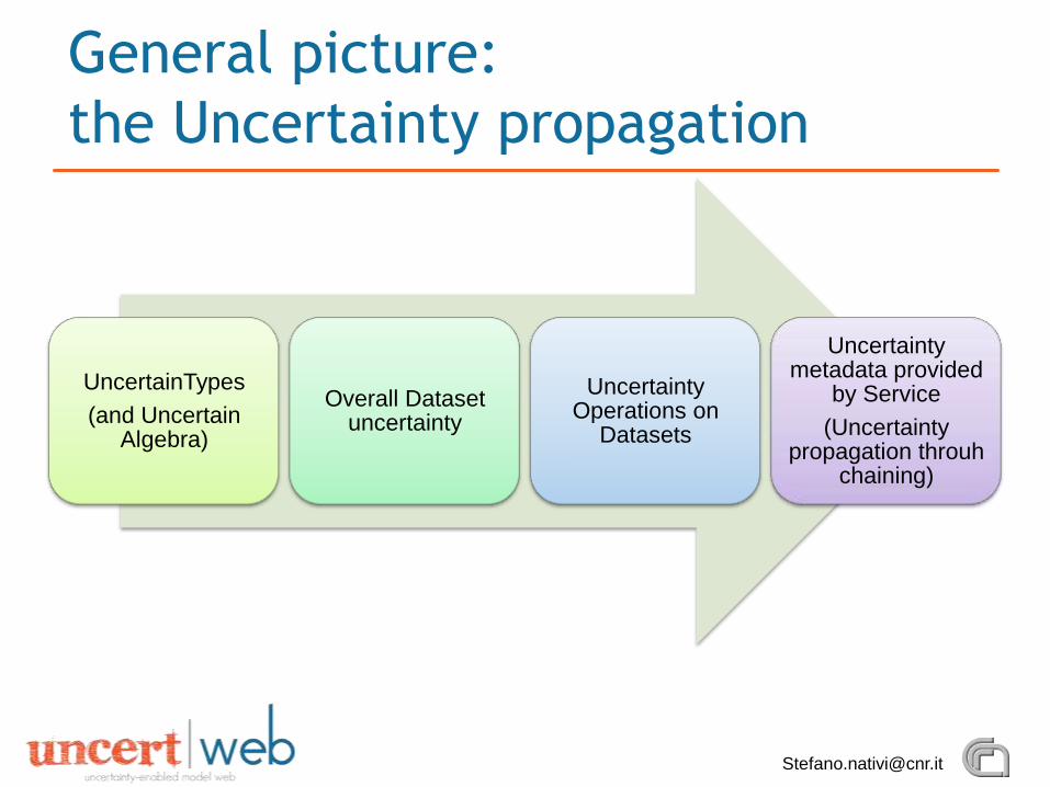
General picture:
the Uncertainty propagation
UncertainTypes
(and UncertainAlgebra)
Overall Datasetuncertainty
UncertaintyOperations on
Datasets
Uncertaintymetadata provided
by Service
(Uncertaintypropagation throuh
chaining)
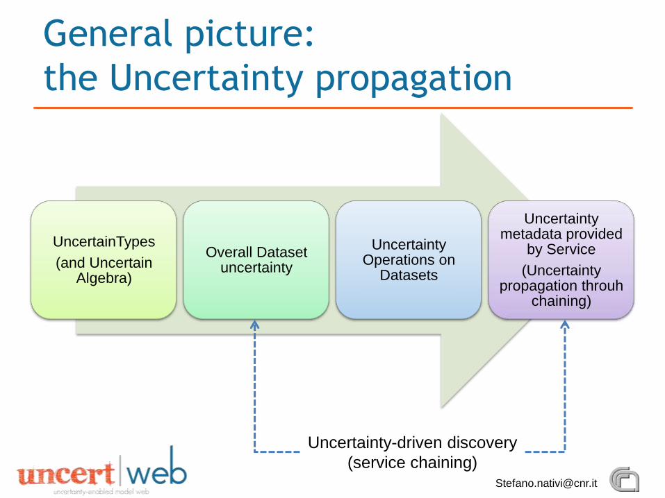
General picture:
the Uncertainty propagation
UncertainTypes
(and UncertainAlgebra)
Overall Datasetuncertainty
UncertaintyOperations on
Datasets
Uncertaintymetadata provided
by Service
(Uncertaintypropagation throuh
chaining)
Uncertainty-driven discovery
(service chaining)
Recommended