Mixed Industry and Business Area North Sector Two Sector Plan No. 026– 2000
North Lakes Development Page 1 of 36 Sector Plan No. 026 - 2000 – Mixed Industry and Business Area North Sector Two December 2016
MANGO HILL INFRASTRUCTURE DEVELOPMENT CONTROL PLAN
Sector Plan No. 026 - 2000
for
Mixed Industry and Business Area North Sector Two
Mixed Industry and Business Area North Precinct– Industry and Service Trade
North Lakes Development
December 2016
Mixed Industry and Business Area North Sector Two Sector Plan No. 026– 2000
North Lakes Development Page 2 of 36 Sector Plan No. 026 - 2000 – Mixed Industry and Business Area North Sector Two December 2016
Contents
1.0 Introduction and Statutory Context ............................................................................. 3
2.0 Land Use Rights .............................................................................................................. 3
3.0 Development Requirements and Guidelines ................................................................ 3 3.1 Introduction 3 3.2 Development Concept 4 3.3 Development Requirements 5 3.4 Design and Siting Measures 6 3.5 Infrastructure and Services 15
4.0 Environmental Management ....................................................................................... 17 4.1 Environmental Management Plan 17 4.2 Stormwater Management 18 4.3 Pollutants and Waste 18
5.0 Subdivision Requirements ........................................................................................... 18
6.0 Infrastructure ................................................................................................................ 18 6.1 Infrastructure to be Provided 19 6.2 Infrastructure Affected or Required by Precinct Development of the Sector 20 6.3 How the Required Infrastructure Relates to the Infrastructure Agreements 20
7.0 Detailed Infrastructure Program ................................................................................ 20 7.1 Estimated Date for Provision of Infrastructure 20 7.2 Intended provider 21 7.3 Other Works Dependant on Infrastructure Provision 21 7.4 Other Relevant Information 21
Figure Reference Date 1. Planning Context MB4sectorfig1 5 March 2010 2. Cadastral Boundaries MB4sectorfig2 5 March 2010 3. Precinct Plan Map MB4sectorfig3 5 March 2010 4. Sector Plan Map MB4sectorfig4 August 2013 5. Sector Landscape Plan MB4sectorfig5 August 2013 6. Indicative Plan of Subdivision MB4sectorfig6 October 2016 7. Road Layout MB4sectorfig7 5 March 2010 8. Water Supply Headworks MB4sectorfig8 5 March 2010 9. Sewerage Headworks MB4sectorfig9 5 March 2010
APPENDICES
A. Final Specification of Land Use for the Sector B. Plant List C. Car and Bicycle Parking Requirements D. Signage Guidelines E. Proposed Metes and Bounds Description F. Bruce Highway Landscaping Concept
Mixed Industry and Business Area North Sector Two Sector Plan No. 026– 2000
North Lakes Development Page 3 of 36 Sector Plan No. 026 - 2000 – Mixed Industry and Business Area North Sector Two December 2016
1.0 Introduction and Statutory Context The Mango Hill Infrastructure Development Control Plan (“DCP”) provides the mechanism for Sector Plans to be prepared in accordance with the relevant provisions of the DCP to give effect to the overall planning for a particular part of a Precinct Plan area.
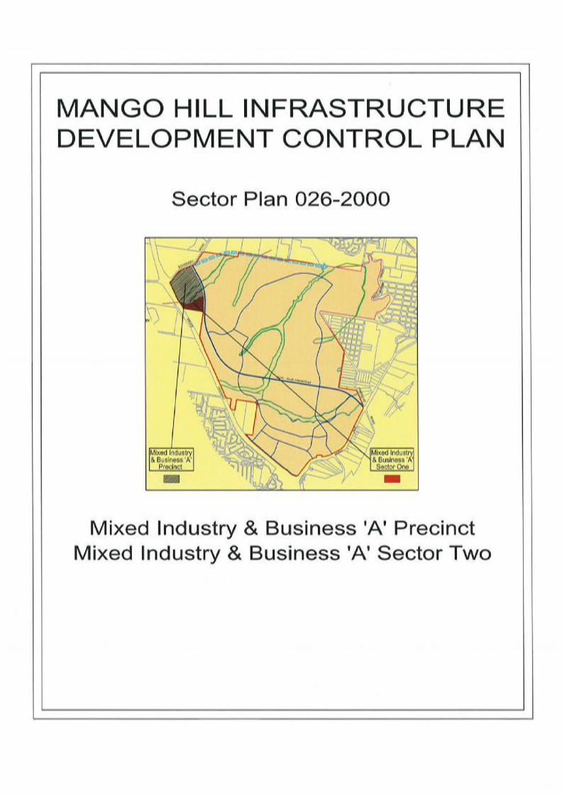
This document constitutes the Sector Plan for the Mixed Industry and Business Area South Sector Three (“Sector Plan”). It relates to part of Precinct Plan No. 026 Mixed Business and Industry Area North – Industry and Business Park (“Precinct Plan”).
The location of the Sector within the DCP area is shown on Figure 1 – Planning Context. As illustrated on Figure 2 – Cadastral Boundaries, the Sector is bounded by:
(i) MIBA North Sector 026 -1000 to the north; (ii) the North-South Arterial Road to the east; (iii) the Bruce Highway to the west; and (iv) “Invocare” land outside the DCP to the south.
The location of the Sector within the Precinct Plan area is shown on Figure 3 – Precinct Plan Map.
The area of this Sector Plan is 7.303 hectares.
This Sector Plan is the code of development for the land in the Sector. In the event that this Sector Plan does not provide development requirements, then the Planning Scheme provisions relevant to the particular form of development apply.
2.0 Land Use Rights The final specification of land use rights for land in this Sector is contained in Appendix A – Final Specification of Land Use for the Sector.
3.0 Development Requirements and Guidelines
3.1 INTRODUCTION
Clause 2.4.2 of the DCP states that a Sector Plan is to specify the requirements for development and car parking and the guidelines for design and siting, landscaping and signage for land in the Sector. The following sections detail the design concepts and guidelines applicable to development within the Sector.
The Sector Plan identifies the code for development of the land and forms the basis for assessment of development applications. The Sector Plan identifies development standards, development requirements, and specific planning and development controls based on performance criteria that are considered to satisfy the Desired Environmental Outcomes (DEOs) and key planning objectives identified in the Precinct Plan. The Sector Plan identifies acceptable solutions, which satisfied by development, are one way of achieving the requirements of the Precinct Plan in regard to the particular matter. Alternative acceptable solutions may be considered by the Council where the development can be demonstrated to
Mixed Industry and Business Area North Sector Two Sector Plan No. 026– 2000
North Lakes Development Page 4 of 36 Sector Plan No. 026 - 2000 – Mixed Industry and Business Area North Sector Two December 2016
comply with the DEOs and key planning objectives if the Precinct Plan and the intent of the DCP based on the same performance criteria.
3.2 DEVELOPMENT CONCEPT
The development concept for this Sector is for a range of low impact industry and service trade uses, accommodated within low to medium rise buildings in a landscaped setting. The Sector is intended to include services that provide a direct convenience service and support role to industries and employees in the Precinct. The Sector will provide for the needs of residents within North Lakes and the surrounding urban areas, while not compromising the livelihood of uses within the Town Centre Core and Frame. The Sector is designed to accommodate industry and service trade uses of a larger scale to those located to the south and is designed to provide a link between the trade services uses to the south and business park areas to the north.
It is recognized that development of a child care centre (Lot 102 and 103 only) within the Sector may be appropriate. Due to the nature and function of this specific use it may not achieve the general character of other forms of commercial development as required within the Mixed Industry and Business Area. It is intended that flexibility will be applied in the application of general design and siting requirements. In particular where fencing requirements vary from transparent style (I.e. pool style) front fencing the fence should generally be set back behind a minimum of 2.0 m of landscaping to effectively screen the fence and maintain the landscaped frontage theme within the streetscape. A fence comprising both transparent and solid fence panels within a landscape setting is the most likely outcome. The circumstances of the sites, the merits of the proposal, compatibility with adjoining development, and the extent to which a proposal otherwise complies with development requirements of the Sector Plan will be considered by the Council in determining appropriate criteria for a child care centre. The development concept for major open space in the Sector is to provide a comprehensive integrated system of open space fulfilling aesthetic, recreation, conservation, transportation and environmental management functions. The Sector is located in a highly visible position next to the Bruce Highway and the North South Arterial Road. To ensure development provides high quality, landscaped development frontage to the Bruce Highway, buildings, landscaping, screen fences and signage are to be designed and located to achieve comprehensive landscaping of development sites with integration of built form, signage and landscaping to provide attractive frontages visible from the Bruce Highway. Development in accordance with the Development Code specified by the Sector Plan constitutes code assessable development (i.e. permitted development subject to conditions). Alternative acceptable solutions may be considered by the Council based on merit and the circumstances of each case and where development can be demonstrated to comply with the DEOs and key planning objectives of the Precinct Plan and the intent of the DCP, based on the same performance criteria.
It is recognised that the development of Retail Showrooms (Lot 94, Lot 95 and Lot 101 only) within the Sector, as identified in Section 7.3.2.7, may be appropriate. The nature and scale of
Mixed Industry and Business Area North Sector Two Sector Plan No. 026– 2000
North Lakes Development Page 5 of 36 Sector Plan No. 026 - 2000 – Mixed Industry and Business Area North Sector Two December 2016
such activities is to be demonstrated to be low impact. Similarly, such activities are to be demonstrated not to compromise the planning intent and development form identified in Sections 7.2 and 7.3 or the design and siting measures identified in Section 7.4 of the DCP.
Development of department store based shopping, discount department shopping and supermarkets is not permitted in this Sector. Retail development within the MIBA should instead allow for other forms of retailing such as retail showrooms offering for sale goods manufactured or assembled onsite, building supplies, home furnishings, floor coverings, sporting goods, leisure goods, electronic goods and the like.
Other forms of development will be assessed on a case by case basis, having regard for the relevant Desired Environmental Outcomes of the DCP and the health of such uses within the Town Centre Core and Frame. This can include the co-location of some complementary development typical of different character areas where providing a relevant service and function to visitors of the business park and surrounding locality. Where two or more activities comprising high volume traffic generation are proposed to collocate on a site (i.e. shop, service station, restaurant, and the like) the suitability and size of those activities is to be considered in the context of adequate provision of car parking, vehicular access and maneuvering on site as determined by the assessment of a Traffic Assessment Report prepared by a suitably qualified engineer. It is intended to restrict the range and extent of activities considered to be high volume traffic generating activities, on a site by compliance with a Traffic Assessment Report (TIA) prepared by a suitably qualified engineer, as well as compliance with the car parking and on-site manoeuvring provisions of the planning scheme and the Council’s Design Manual.
Development in the Sector is to:
(i) Incorporate landscaped entry statement along the proposed entrances to the Sector from the North South Arterial;
(ii) Provide all infrastructure necessary to the proper functioning of the Precinct; (iii) be integrated with the transport system and maintain and improve the safe and efficient
operation of the system; (iv) be designed and sited having regard to the amenity of surrounding residential areas
within North Lakes, including appropriate design of buildings, provision of planted buffer areas and provision of appropriate landscaping;
(v) include sustainable development initiatives for the management of any potential environmental risks including protection re-establishment of the Tributary A; consistent with the approved Environmental Management Plan for Tributary “A”, and
(vi) be carried out without detriment or danger to other development in the locality.
3.3 DEVELOPMENT REQUIREMENTS
In respect of every development in this Sector which involves the erection of a building, the person who undertakes that development or uses the site must as part of that development or use, unless already provided:
(i) construct a full width pedestrian pavement to Council’s specification for the full length of those road frontages required by Council to the development site;
(ii) construct concrete kerb and channeling to the Council’s specification for the full length of each road frontage to the development site;
Mixed Industry and Business Area North Sector Two Sector Plan No. 026– 2000
North Lakes Development Page 6 of 36 Sector Plan No. 026 - 2000 – Mixed Industry and Business Area North Sector Two December 2016
(iii) construct reinforced concrete industrial crossings to the Council’s specification from the kerb and channeling to the property alignment of the development site at approved locations where vehicular access to the development site is required;
(iv) provide drainage work specified by the Council as necessary in connection with the works set out above including debris traps where drainage discharges directly or indirectly to the lake and/or waterway system;
(v) provide reticulated sewerage and water supply adequate for the purpose of the development by connection to the Council’s services in accordance with the requirements of the Council; and
(vi) bear the cost of any alteration necessary to public utility mains, services or installations involved in the construction of the works referred to in this clause.
In respect of every development in this Sector the person who undertakes that development or uses the site must:
(i) have all buildings designed by a registered architect and all landscaping designed by a qualified landscape architect;
(ii) not impose a load on any public utility including the disposal of wastes, greater than that which is contemplated by the provisions of this Sector Plan; and
(iii) not cause interference with the amenity of the area by the operation of machinery or electrical equipment, or from light, noise, vibration, smell, fumes, smoke, vapour, steam, soot, ash, grit, oil, dust, waste water, waste products, electrical interference or otherwise.
In respect of staged development in this Sector the person who undertakes the staged development or uses must undertake the following:
(i) On completion of work in any stage, the remainder of the lot must be cleared of all rubble, debris and construction material and equipment and landscaped to the satisfaction of Council so as to be capable of being maintained; and
(ii) Each stage must form a coherent development and any future development sites must be provided with temporary landscaping, so the presentation of the lot to the street does not give a temporary or partially completed appearance.
In respect of the development of a child care centre (Lot 102 and 103 only) in this Sector the person who undertakes that development or use of the site must: (i) demonstrate the use will not have an adverse impact on any adjoining Permitted
Development; (ii) provide traffic assessment report demonstrating suitability of the site for the land use
having regard for the traffic impacts on the surrounding area at the time of a MCU Development Application; and
(iv) demonstrate compliance with the all other development requirements of the Sector Plan.
3.4 DESIGN AND SITING MEASURES
3.4.1 Site Configuration and Layout
Outcome:
Lots have appropriate area and dimensions to accommodate:- (i) siting and construction of industrial buildings;

Mixed Industry and Business Area North Sector Two Sector Plan No. 026– 2000
North Lakes Development Page 7 of 36 Sector Plan No. 026 - 2000 – Mixed Industry and Business Area North Sector Two December 2016
(ii) outdoor storage areas; (iii) convenient and safe access; (iv) on-site car parking; (v) service vehicle access and manoeuvring; and (vi) landscaping and buffer areas.
Development Code:
The minimum area and dimensions of lots within the Sector are to be as follows:
1. Minimum lot size is 1,000 m2. 2. Minimum road frontage width is 30 metres. 3. Areas of the site not occupied by buildings, structures and/or access and manoeuvring
areas shall be landscaped or turfed to prevent the generation of dust. Some areas may be paved subject to the overall area of the site dedicated to landscaping.
3.4.2 Building Design
Outcome:
Building design and orientation positively contribute to the visual amenity of the surrounding landscape and achieve a high standard of industrial urban design.
Development Code:
Buildings within the Sector are to be as follows:
1. Building height above ground level shall generally not exceeed 15 metres unless otherwise agreed by Council in consideration of the merits of the application;
2. Site coverage (i.e. that portion of a site covered by a building, fixed structure, or outdoor storage area, but not including unroofed parking areas) shall not exceed 75%.
3. The minimum front setback for a building to a road alignment is not less than 6 metres. 4. The minimum side or rear setback for a building is zero where facades are appropriately
treated to present an attractive built form and orderly appearance from the public domain. 5. For allotments that directly adjoin the Bruce Highway, no building shall be constructed
within 20 metres of the Bruce Highway road alignment. 6. For allotments that abut the North South Arterial, all buildings shall be set back a
minimum of 10 m. A landscaping strip (minimum 2 metre in width) is to be provided along the entire length of any common boundary between a lot and the North South Arterial and all storage yards/hardstand areas are to be screened from view from the North South Arterial.
7. Sources of illumination shall be setback or covered to avoid any light spillage across site boundaries.
8. Exterior elements of the building shall be rendered/ bagged or painted in a range of compatible colours. Unfinished materials may be considered as part of an overall colour scheme but are not to be the major finish visible from the street or public areas.
9. Main facades visible from the Bruce Highway and North South Arterial shall be: (i) designed to incorporate:
(i) building elements such as windows and awnings where appropriate; (ii) fenestration and horizontal/ vertical articulation of walls at least at 15 metre
intervals to add visual interest;

Mixed Industry and Business Area North Sector Two Sector Plan No. 026– 2000
North Lakes Development Page 8 of 36 Sector Plan No. 026 - 2000 – Mixed Industry and Business Area North Sector Two December 2016
(iii) relatively unobtrusive, earth toned colours, such as subdued greens, blues, browns and greys, dark blues, dark greens, dark greys, ochres, olives, and natural or stained timbers (bright colours and/or materials which cause glare are avoided); and
(iv) other features which contribute to an interesting and attractive appearance. 10. Building floor levels shall be at least 300mm above the 100 year ARI flood level. 11. In areas affected by overland flow paths, building floor levels shall be at least 50mm
above the depth of the flow during a 100 year ARI storm event. 12. Outdoor storage areas are located above the 100 year ARI flood level. 13. Entries to buildings shall be as follows:
(i) Large vehicle entries are not to provide the main customer entry to the building from the site frontage;
(ii) Large vehicle entries to buildings visible from the street are to include elements of built form such as setbacks, materials or articulation; or projections such as parapets, awnings, sunshades, screens; or other architectural elements to ensure a high standard or finish and presentation of the building façade to the street;
(iii) Entries are to be clearly identifiable from the street and be distinguished from the balance of the building façade;
(iv) Entries are to be well lit, appropriately signposted, and free from areas providing concealment.
14. Building design shall adhere to the Design for Climate and Energy Efficiency Guidelines where appropriate. (i) Include the use of external shade structures, ventilated spaces, overhangs and screens
to allow enjoyment of the outdoors while also providing relief from the sun, wind and rain;
(ii) Maximise ventilation by taking advantage of prevailing breezes and the use of adequate and effective insulation materials in roof cavities and wall spaces of buildings in order to minimise demands for energy required for air-conditioning;
(iii) Articulate and shade external walls, and particularly the longer external walls, with eaves, over-hangs, sills or other treatments to reduce the exposure to direct sunlight, heat and glare, while windows in external walls should be recessed or shaded wherever possible to achieve energy savings;
(iv) Restrict the use of highly reflective materials on external walls or windows as a means of minimising energy requirements and excessive sunlight, glare and heat into adjoining developments;
(v) Incorporate the use of gas or solar hot water heaters and solar energy devices; (vi) Implement energy efficient management systems for the building; (vii) Where possible, use building materials which impose energy efficiency; (viii) Where possible, orientate buildings to respond to westerly sun exposure,
northerly exposure and solar access in the winter, potential impacts of cold westerly winds in winter and limited cooling breezes from the south in summer; and
(ix) Design and landscape car parking areas to reduce the impacts of reflected heat and glare into adjacent buildings, and to reduce the effects of heat storage during summer months.
Mixed Industry and Business Area North Sector Two Sector Plan No. 026– 2000
North Lakes Development Page 9 of 36 Sector Plan No. 026 - 2000 – Mixed Industry and Business Area North Sector Two December 2016
3.4.3 Inclusive Design
Outcome:
Uses cater for, or can readily be adapted to cater for, persons with disabilities.
Development Code:
Uses within the Sector must be designed so that:
1. Where entrances to sites are provided from roads and footpaths they shall incorporate suitably graded ramps, handrails, tactile paving and other design features to enable unassisted entrance for persons with disabilities.
3.4.4 Buffer Strips, Screening and Fencing
Outcome:
Development protects the amenity of adjoining non-industrial development, reduces the impact of the built form on the landscape and ensures an attractive view of the development from adjoining major roads. An indicative plant schedule is contained in Appendix B – Indicative Plant Schedule.
Development Code:
Development within the Sector must incorporate:
1. A vegetated buffer clear of all buildings, structures and hardcover having a minimum dimension of 5 metres shall be provided adjacent to the Bruce Highway road reserve and shall be designed to reduce the visual built form impact and reduce the bulky appearance of buildings. The vegetated buffer shall contain a variety of plants of suitable species and density of planting and maturity to form a dense visual screen with suitable management measures to ensure early establishment and ongoing survival of the plants. An indicative concept for the buffer to the Bruce Highway is contained in Appendix F – Bruce Highway Landscaping Concept.
2. Where the finished site level of a lot is established above natural ground level subsequent development for the purpose of a material change of use shall include the planting of a minimum of 3 canopy trees adjacent to the northern boundary in the rear building setback area, clear of the 5 metre vegetated buffer. Such trees are to be of advanced tub stock (i.e. Minimum of 200 litre tubs) and be Canopy Trees contained in Annexure B – Plant List.
3. A landscaped open space strip clear of all buildings, structures and hardcover and excluding those areas required from site access purposes, having a minimum width of 2 metres shall be provided adjacent to all road frontages.
4. Fencing abutting public areas shall have a height of no greater than 1.2 metres where it is less than 50% transparent.
5. At least 50% of any parts of fencing higher than 1.2 metres are transparent. 6. Where walls or fencing are less than 50% transparent, at least 50% of the street frontage
shall be landscaped in front of the fence to a depth of 3 metres, with no length of wall or fence exceeding 15 metres in length without being indented.
Mixed Industry and Business Area North Sector Two Sector Plan No. 026– 2000
North Lakes Development Page 10 of 36 Sector Plan No. 026 - 2000 – Mixed Industry and Business Area North Sector Two December 2016
7. Screening fences at least 1.8 metres in height shall be provided where vehicle headlights would face into existing or future residential areas.
8. A man proof fence is to be provided to all boundaries that abut the Bruce Highway, this fence should be designed, constructed and maintained to prevent pedestrians entering the Bruce Highway road reserve.
Mixed Industry and Business Area North Sector Two Sector Plan No. 026– 2000
North Lakes Development Page 11 of 36 Sector Plan No. 026 - 2000 – Mixed Industry and Business Area North Sector Two December 2016
3.4.5 Traffic, Access and Parking
Outcome:
Traffic, access and parking arrangements accommodate the following primary functions:
(i) functional and safe access to lots; (ii) on- site car parking; (iii) loading facilities; and (iv) heavy vehicle parking and manoeuvring areas.
Development Code:
Traffic, access and parking matters must consider the following:
1. Driveway shall be constructed in accordance with Council’s Design Manual. 2. Access to the site satisfies the following:
(a) a single driveway (entrance/exit) for lots with frontages less than 50 metres. A secondary access point may be considered by Council only where it can be demonstrated that safe access can be provided and where soft landscaping is provided to achieve a viable landscape buffer. In such instances, such driveways shall not be closer than 10 metres from each other or adjoining property access point unless shared access is provided.
(b) not closer than 10 metres to an intersecting street where the driveway is on the same side of the street;
(c) provides safe entering sight distance in accordance with Council’s Design Manual; and
(d) allows vehicles to always enter the street at right angles. 3. The driveway access shall provide access to and from the street in a forward direction.
Any loading/unloading and service bays shall be located at the rear of the site, or shall be conceled from view from a road/public space/highway.
4. Provision is made for vehicular access to and from the development site by the service vehicles required for each of the land uses in the Planning Scheme, the DCP and the Council’s Design Manual.
5. Where an on-site waste collection area is provided, access and manoeuvring areas shall provide for a HRV of 12.5 metres in length.
6. Car Parking in the Sector must: (a) be in accordance with the Planning Scheme, the DCP and the Council’s Design
Manual (b) be controlled to minimise its impact on the surrounding road network, any internal
circulation and other development adjacent to the Sector; (c) provide safe pedestrian routes which focus on the connectivity between the individual
site, balance of the MIBA and the Bruce Highway; (d) as part of the total car parking requirements, provide not less than one (1) car park per
fifty (50) spaces (or part thereof) for people with disabilities, located as close as possible to the main building entrance.
Mixed Industry and Business Area North Sector Two Sector Plan No. 026– 2000
North Lakes Development Page 12 of 36 Sector Plan No. 026 - 2000 – Mixed Industry and Business Area North Sector Two December 2016
7. Pavements for car parking bays and access ways within the site, (i.e. other than the verge and cross overs within the road reserve), shall be constructed in one of the following ways: (a) Reinforced concrete minimum thickness to be 100mm for parking areas and 150mm
for access ways; (b) Gravel with a minimum thickness of 25mm of asphalt surfacing; or (c) Gravel surfaced with approved concrete pavers.
8. Circulation and queuing areas shall be kept free of parking. 9. Car parks and aisles shall be constructed in accordance with Council’s Design Manual. 10. Within car parking areas, sealed pedestrian footpaths shall be provided in accordance with
AS1428.1. 11. Bicycle parking spaces shall be provided in accordance with AUSTROADS Part 14 and
AS2890.3 Parking Facilities, Part 3: Bicycle Parking Facilities (Bicycle parking requirements are contained in Appendix C – Car and Bicycle Parking Requirements)
12. End of trip facilities for bicycles shall be provided at a rate of 1 locker per 2 bicycle parking spaces and 1 staff shower, with ancillary change rooms, per 10 bicycle spaces for both men and women.
13. Pedestrian paths shall be covered with non-slip materials. 14. Graded access ramps shall be provided between the public and private domain where
slopes restrict wheelchair access. 15. Development shall provide sufficient access to enable evacuation during a range of floods
up to and including the 100 year ARI flood level. 16. Traffic, access and parking arrangements accommodate the following primary functions:
(i) for high volume traffic generating activities, compliance with a Traffic Assessment Report (TIA) prepared by a suitably qualified engineer, as well as compliance with the car parking provisions and the on-site manoeuvring provisions of the planning scheme and the Council’s Design Manual;
(ii) functional and safe access to lots; (iii) adequate on-site car parking; (iv) adequate loading facilities; and (v) adequate heavy vehicle parking and manoeuvring areas.
17. On site car parking associated with a child care centre (Lots 102 and 103 only) is to be screened from view external to the site with landscape / vegetation screening provided on the effected road frontages with a minimum width of 2.0 metres.
Alternative Development Code:
18. On-site driveway access shall be located so as to provide a clear view of passing pedestrians and vehicles.
19. Landscaping shall not block sightlines for vehicle access to the site. 20. The driveway access to any car park shall be clearly visible from the street. 21. Any service bays located wholly or partly within a building shall not provide direct
vehicle access to other floor space. 22. Any vehicles being loaded or unloaded shall be able to stand completely on site. 23. Loading and unloading areas shall be separated from public and visitor car parking and
access points. 24. On-site parking areas shall incorporate the following:
(a) employee parking situated near staff entrances/ access points;

Mixed Industry and Business Area North Sector Two Sector Plan No. 026– 2000
North Lakes Development Page 13 of 36 Sector Plan No. 026 - 2000 – Mixed Industry and Business Area North Sector Two December 2016
(b) disabled parking spaces close to the main building entrance that are clearly sign posted; and
(c) visitor car parking located towards the front of the site and screened by landscape and aesthetically treated.
25. A pathway for pedestrians and cyclists shall be provided from the street frontage into the development.
26. Pedestrian access from the street shall be separated from car parking and vehicle access areas.
27. Parking and loading areas shall be: (a) well lit; (b) located to maximise sightlines; and (c) capable of being locked after hours.
3.4.6 Landscaping
Outcome:
Development creates a pleasant streetscape environment and landscaped open space enhances the attractiveness of the development (Figure 5 – Sector Landscape Plan). Development creates a pleasant streetscape environment and landscaped open space and Tributary “A” environs enhance the attractiveness of the development (Figure 5 – Sector Landscape Plan). The landscaped treatment of Tributary “A” environs is to be in accordance with the approved Environmental Management Plan for Tributary “A”. The landscaped treatment to the Bruce Highway frontage must acknowledge the scale of buildings and their highway setting and shall be provided for the full Bruce Highway frontage of the Sector Plan as part of Operation Works approval. The vegetated buffer shall contain a variety of plants of suitable species and density of planting and maturity to form a dense visual screen with suitable management measures to ensure the early establishment and ongoing survival of the plants. An indicative plant schedule is contained in Appendix B – Indicative Plant Schedule. An indicative concept for the buffer to the Bruce Highway is contained in Appendix F – Bruce Highway Landscaping Concept
Development Code:
Development within the Sector must satisfy the following criteria:
1. At least 8% of the site area of each lot is landscaped with soft landscaping in accordance with a landscaping plan approved by Council.
2. A vegetated buffer clear of all buildings, structures and hardcover having a minimum dimension of 5 metres shall be provided adjacent to the Bruce Highway road reserve and shall be designed to reduce the visual built form impact and reduce the bulky appearance of buildings. Maintenance of vegetation buffer shall be incorporated into a management agreement to ensure ongoing survival and maintenance of buffer. Note this landscape buffer is not part of the 8% landscape requirement.
3. A landscaped open space strip clear of all buildings, structures and hardcover and excluding those areas required from site access purposes, having a minimum width of 2 metres shall be provided adjacent to all road alignments.
4. Shade trees shall be planted in car parks at a rate of one (1) tree per six (6) car parking spaces.
Mixed Industry and Business Area North Sector Two Sector Plan No. 026– 2000
North Lakes Development Page 14 of 36 Sector Plan No. 026 - 2000 – Mixed Industry and Business Area North Sector Two December 2016
5. Landscaping shall not block sightlines for vehicle access to the site. 6. The landscape treatment of development and must give consideration to any adjoining
public open space. 7. Provision shall be made at the front property boundary for inclusion of street numbers for
easy identification by emergency service crews.
3.4.7 Environmental Impacts
Outcome:
Development does not cause environmental harm or nuisance through unacceptable emissions of odour, dust, noise, light, vibration, air pollutants or other potential environmental contaminants.
Development Code:
Development within the Sector must satisfy the following criteria:
1. Development shall not exceed a continuous noise level at the nearest sensitive receptor (e.g. residential development) of the background noise level + the day/night time level of 5/3dB(A) where background noise levels are 50dB(A), or background noise level where background noise levels are >50dB(A).
2. Development shall not discharge more than 50mg/l of suspended solids, 0.75mg/l of nitrogen or 0.1 mg/l of phosphorus in any stormwater discharge, up to a Q2 ARI flood event.
3. Development shall not exceed any of the air emissions criteria listed below:
Air Emissions Criteria
Pollutant Emission Criteria
(g/s)
Indicative Source Air Concentrations
(mg/m3) Particulate matter as PM10 0.061 0.610 Volatile Organic Compounds (including tetrachloroethylene) 0.135
1.350
Nitrogen Dioxide 0.052 0.520 Carbon monoxide 0.75 7.500 Sulphur Dioxide 0.0025 0.025
3.4.8 Advertising Devices
Outcome:
Advertising devises, business identification signs and estate signage does not dominate the built environment.
Development Code:
Advertising devices within the Sector are to be as follows:
1. Signage in the Sector must:
Mixed Industry and Business Area North Sector Two Sector Plan No. 026– 2000
North Lakes Development Page 15 of 36 Sector Plan No. 026 - 2000 – Mixed Industry and Business Area North Sector Two December 2016
(a) with respect to signage that identifies the Sector and associated development, be generally integrated with any frontage walls, entry statements or entry structures, if provided.
(b) provide only one Pylon/Column Sign for estate signage along the frontage of the Bruce Highway.
(c) where appropriate, include directional signage for visitors which may include logos/names of the business;
(d) consist of high quality materials, form, scale and proportions and be coordinated to the built form throughout the Sector, while providing sufficient flexibility for corporate identification and marketing purposes;
(e) ensure that lighting of any signage will not cause a nuisance to drivers or pedestrians; (f) be visible, legible and not result in a cluttered or discordant streetscape and not result
in a cluttered or discordant streetscape, or highway frontage; (g) provide limited use of highly reflective finishes; (h) incorporate professional and coordinated graphics; (i) not permit permanent bunting, streamers and other low-quality, temporary, or
opportunistic signs; (j) ensure that any support structure or cabling to illuminate signs will not be visible; and (k) with respect to signage visible from the Bruce Highway (as a State Controlled Road),
written approval from the Department of Main Roads is to be obtained.
Note: Signage guidelines are included in Appendix D –Signage Guidelines. The Signage Guidelines are to be taken into consideration, along with other relevant issues, when considering matters regarding signs and architectural graphics of all kinds. They are not to be interpreted as giving rights to any number or types of signs. All third party advertising (with the exception of estate signage) will be Impact Assessable. A Coordinated Signage Plan is to be submitted with any development application for Material Change of Use within this Sector. The Coordinated Signage Plan must distinguish between artworks/murals, onsite business advertising, animated signage, and “third party” advertising in terms of sign dimension, location, illumination, and animation on the face of the sign. All signage adjacent to the Bruce Highwat requires approval by the Department of Main Roads.
3.5 INFRASTRUCTURE AND SERVICES
3.5.1 Infrastructure Services
Outcome:
Adequate services are provided to meet the particular requirements of industrial development.
Development Code:
Infrastructure provision within the Sector must meet the following requirements:
Sewerage

Mixed Industry and Business Area North Sector Two Sector Plan No. 026– 2000
North Lakes Development Page 16 of 36 Sector Plan No. 026 - 2000 – Mixed Industry and Business Area North Sector Two December 2016
1. Development shall be connected to a reticulated sewerage system. 2. Trade waste shall be pre-treated on-site prior to its discharge into Council’s reticulated
sewerage network or undertaken in line with an agreement with Council.
Water Supply
3. Development shall be connected to Council's reticulated water supply system. 4. Sites shall be provided with water supply sufficient for fire fighting purposes. 5. Developments shall meet legislative requirements for water efficiency and stormwater
reuse, seeking best practice with respect to water efficiency. This is be achieved through the implementation of such measures as: (a) Capture and treatment and storage of rainwater (b) Reticulation of captured water for non-potable uses (e.g Irrigation, Toilet flushing etc) (c) Leak detection systems (d) Fire testing water capture (e) Water use monitoring
Electricity
6. Development shall be connected to an underground energy supply system approved by the relevant energy regulatory authority.
Telecommunications
7. Development shall be connected to a telecommunications system approved by the relevant telecommunications provider.
Lighting
8. Direct spillage or reflection of light shall be controlled by one or more of the following: (a) Correct angling of light fixtures to face the subject of illumination; (b) Shields, louvres or directional baffles to or in close proximity to the light; (c) Permanent barriers, walls or similar structures that intercept the direct path of the light
before it leaves the property; and (d) Dense, spreading vegetation that permanently screens the light.
9. Sensors or daylight controls shall be installed to switch outdoor lights off during daylight hours.
10. Lighting shall be provided in all areas, including paths, accessible to the public, and be finished with black powder coated paint or similar high quality finish;
Stormwater
11. Development within the sector must comply with the provisions of the Mango Hill Infrastructure Agreement (MHIA), Council’s Design Manual, the Stormwater Management Plans for Tributary A as approved by Council, and the Environmental Protection Policy (Water). Relevant stormwater management works for the sector are to be provided, including the construction of all drainage and landscape works associated with the Tributary A catchment within the DCP area.
12. The development of the sector is to be consistent with the concepts contained in the approved Environmnetal Management Plan for Tributary “A”, Open Space and Landscaping in accordance with the Precinct Plan and the DEO’s of the Mango Hill Infrastructure Development Control Plan.
Mixed Industry and Business Area North Sector Two Sector Plan No. 026– 2000
North Lakes Development Page 17 of 36 Sector Plan No. 026 - 2000 – Mixed Industry and Business Area North Sector Two December 2016
3.5.2 On-Site Waste Storage, Recycling and Disposal Facilities
Outcome:
Waste storage, recycling, disposal and bin washout facilities are provided in locations which:
(i) are appropriately screened from internal thoroughfares, public areas of the site and adjacent land;
(ii) do not have a significant adverse effect on the amenity of the users of the site or the occupants of adjacent land; and
(iii) are readily accessible by waste collection vehicles.
Development Code:
Works associated with on-site waste storage, recycling and disposal in the Sector must be consistent with the following:
1. A bin washout facility of a size adequate to accommodate the largest portable waste storage container used on the site is provided on the land.
2. The waste storage container is: (a) stored external to a building; or (b) stored on a surface which is crossed by stormwater overland flow; or (c) in a form that is not readily transported from its storage location to an on-site bin
washout facility by an unassisted person; (d) stored within a facility which incorporates the same features as those required for an
on-site bin washout facility. 3. The waste storage and bin washout facilities provided on the site are located:
(a) clear of the buffers and road frontage setback areas; and (b) within part of an on-site service area which is directly accessible by an industrial
refuse collection vehicle. 4. Every waste storage and bin washout facility which is not fully enclosed within a building
is screened from public areas of the site and adjoining land by a screen fence having a ratio of obscure area to open area of not less than 10 to 1.
4.0 Environmental Management
4.1 ENVIRONMENTAL MANAGEMENT PLAN
The Tributary “A” Environmental Management Plan applies to this land contained within this sector. Works are to be undertaken in accordance with this approved plan.
Management systems of land within the Sector must be implemented to ensure that the Objectives and Performance Indicators referred in the following sections of the Precinct Plan continue to be met throughout the life of the development and the use of the Sector:
(i) Section 2.2 – Desired Environmental Outcomes of the Precinct Plan (ii) Section 5.1 – Environmental Management Objectives; (iii) Section 5.2 – Stormwater Management Objectives; and
Mixed Industry and Business Area North Sector Two Sector Plan No. 026– 2000
North Lakes Development Page 18 of 36 Sector Plan No. 026 - 2000 – Mixed Industry and Business Area North Sector Two December 2016
(iv) Section 5.3 – Earthworks Management Objectives
4.2 STORMWATER MANAGEMENT
Stormwater management requirements are identified below:
(i) Development within the sector must comply with the provisions of the Mango Hill Infrastructure Agreement (MHIA), Council’s Design Manual, the Stormwater Management Plans for Tributary “A” as approved by Council, and the Environmental Protection Policy (Water).
(ii) Relevant stormwater management works for the sector are to be provided, including the construction of all drainage and landscape works associated with the Tributary “A” catchment within the DCP area.
(iii) The existing waterway is to be retained in most part and be modified/rehabilitated in other parts to provide a natural parkland environment and to ensure flows the substantial upstream catchment pass through the Tributary “A” site without engaging the WSUD elements. The importatnt riparian elemnts are to be retained and weeds and vegetation of lesser quality removed.
4.3 POLLUTANTS AND WASTE
Pollutants and waste requirements are identified below:
(i) all potential emissions shall be treated prior to expulsion to the atmosphere. No pollutants may emit past the property boundaries;
(ii) waste disposal means shall be appropriate for the use on the site, and will comply with all relevant EPA legislation and policy; and
(iv) no liquid or solid waste is to be discharged into a water body of any kind.
5.0 Subdivision Requirements As shown in Appendix E – Proposed Metes and Bounds Description the total area of the Sector is approximately 7.303 hectares. Indicative areas and frontage widths of allotments within the Sector are shown on Figure 6 - Indicative Plan of Subdivision. Access to each lot is only to be from the proposed internal road system. Direct access from the North South Arterial Road to development within the Sector is not permitted. The plan of subdivision is indicative only. Subdivision of lots other than as shown on the Indicative Plan of Subdivision will be considered by the Council based on merit and the circumstances of the case. Where no significant adverse impact could be expected to result on lots in the immediate locality, in the opinion of the Council, the changed subdivision layout could be assessed by the Council as a Reconfiguring a Lot application for code assessment. Other subdivision layouts would require impact assessment. (For clarification, amalgamation of lots, minor boundary amendments, or reduction of lot numbers, would be considered as having no significant adverse impact).
The minimum area and frontage of any future proposed allotment within the Sector is to be as follows:
(ii) Minimum Lot Area – 2,000m². (iii) Minimum Frontage Width – 20 metres.
6.0 Infrastructure
Mixed Industry and Business Area North Sector Two Sector Plan No. 026– 2000
North Lakes Development Page 19 of 36 Sector Plan No. 026 - 2000 – Mixed Industry and Business Area North Sector Two December 2016
6.1 INFRASTRUCTURE TO BE PROVIDED
The infrastructure required to be provided by the Principal Developer to serve the Sector includes internal and external infrastructure provisions in accordance with the Rezoning Conditions, the Mango Hill Infrastructure Agreement 1999 (MHIA) and agreements made with the State Government in accordance with the DCP. These obligations are summarised as follows:
6.1.1 Roads
Construct the following roads including carriageways, stormwater drainage, verges setdowns, footpaths, bikeways, landscaping, traffic control devices and streetlighting. Any reference to initial construction in this section is a reference to construction approved by Council in accordance with the rezoning conditions and MHIA (refer to Figure 5 – Road Layout). 1. All internal industrial collector and industrial access roads; 2. This Sector Plan requires access from the North South Arterial Road therefore the
provisions and timing of the construction of this road from Aurora Boulevard to Boundary Road (and connecting with the internal MIBA road network), will be completed prior to or in conjunction with the development of this stage, or otherwise in accordance with any alternative finding from ongoing traffic reviews provided in accordance with Section 4.2.2 of the MHIA.
3. Bikeways and pathways, including commuter and recreational bikeways generally as shown on Figure 4, in accordance with the MHIA.
The construction of the abovementioned infrastructure to the final standard is to be undertaken in accordance with the staging and timing outlined in the MHIA. The initial standard of construction referred to above will be undertaken to suit the rate of development of the precinct. Where initial construction is not stated, the road is to be constructed to the standard described above to suit the rate of development of the precinct.
6.1.2 Water Supply
All new development is to be connected to reticulated water. Where required by the relevant local Council, appropriate infrastructure contributions shall be paid, where applicable, towards the provision of water connections.
6.1.3 Sewerage
All new development is to be connected to reticulated sewer. Where required by the relevant local Council, appropriate infrastructure contributions shall be paid, where applicable, towards the provision of sewer connections.
6.1.4 Park
1. Provide park as shown on Figure 3 – Precinct Plan Map; 2. Provide Park Enhancement Works in all parks in accordance with MHIA. 3. Provide works consistent with the approved Environmental Management Plan for
“Tributary “A”.

Mixed Industry and Business Area North Sector Two Sector Plan No. 026– 2000
North Lakes Development Page 20 of 36 Sector Plan No. 026 - 2000 – Mixed Industry and Business Area North Sector Two December 2016
6.1.5 Stormwater
1. Construct stormwater management works progressively in accordance with the Stormwater Management Plans for Tributaries A as approved by Council;
2. Construct stormwater drainage systems to roads, parks and lots as required by the MHIA and Council’s Design Manual;
3. Provide works consistent with the approved Environmental Management Plan for Tributary “A”; and
4. In addition, the Principal Developer is to construct stormwater drainage systems and stormwater management systems as required by the MHIA and Environmental Protection (water) policy.
6.1.6 Electricity Supply and Communications
All new development is to be provided with and connected to appropriate telecommunications and electricity infrastructure prior to the commencement of the use.
6.2 INFRASTRUCTURE AFFECTED OR REQUIRED BY PRECINCT DEVELOPMENT OF THE SECTOR
The development of the Sector may place demands on the following infrastructure: (i) Roads external to the DCP area and the Sector; (ii) Water supply infrastructure; (iii) Sewerage infrastructure; (iv) Stormwater infrastructure; (v) Parks; (vi) Community facilities; (vii) Electricity and gas supply; (viii) Communications systems; and (ix) State Government Infrastructure.
The infrastructure described in clause 6.1 above, together with the obligations of the Principal Developer under infrastructure agreements will mitigate the adverse affects on the above infrastructure.
6.3 HOW THE REQUIRED INFRASTRUCTURE RELATES TO THE INFRASTRUCTURE AGREEMENTS
The infrastructure agreements describe the infrastructure that must be provided by the Principal Developer as part of its obligations to provide infrastructure, as envisaged by Chapter 12 of the DCP. The works described in clause 6.1 of this document are the Principal Developer’s obligations under the rezoning conditions and the infrastructure agreements.
7.0 Detailed Infrastructure Program
7.1 ESTIMATED DATE FOR PROVISION OF INFRASTRUCTURE
Mixed Industry and Business Area North Sector Two Sector Plan No. 026– 2000
North Lakes Development Page 21 of 36 Sector Plan No. 026 - 2000 – Mixed Industry and Business Area North Sector Two December 2016
The Principal Developer is to provide the infrastructure referred to in clause 6.1 of this document at times to satisfy the requirements of the MHIA. Initial infrastructure works are estimated to be constructed by December 2010.
7.2 INTENDED PROVIDER
The Principal Developer is to provide the infrastructure referred to in Section 6.1 at times to satisfy the requirements of the Rezoning Conditions and the MHIA which provides for the infrastructure to be constructed to meet the rate of development in the Sector. There are no items of State Government infrastructure to be provided by the Principal Development in conjunction with the development of the Sector.
7.3 OTHER WORKS DEPENDANT ON INFRASTRUCTURE PROVISION
No other works depend on the provision of the infrastructure specified in Section 6.1. Council is to use it best endeavours, including its powers of resumption if lawful, to obtain all necessary rights to permit the construction of water and sewerage infrastructure if such infrastructure is constructed on land external to the DCP area over which Council does not have such rights.
7.4 OTHER RELEVANT INFORMATION
7.4.1 Estimated Water and Sewerage Demands
As required by the MHIA, the Principal Developer states as follows: (i) For the purpose of assessing water supply capacity, the estimated number of Equivalent
Tenements for this Sector is: for Lots 94-101 combined: 48.92ETs; for Lot 104: 23.35ETs; and for Lots 102-103 combined: 18.90ETs;
(ii) For the purpose of assessing sewerage capacity, the estimated number of Equivalent Persons for this Sector is: for Lots 94-101 combined: 100.07EPs; for Lot 104: 118.49 EPs; and for Lots 102-103 combined: 56.71EPs;
(iii) If a future use of the Sector imposes a greater demand on minimum water supply and sewerage infrastructure than assigned in an approved development site within the Sector, Council is to approve the use provided the developer demonstrates that: (a) To do so will not adversely impact on water supply and sewerage infrastructure
standards within the DCP area and elsewhere if considered appropriate by Council’s engineer having taken into consideration development approved in the DCP area at the time of an application and future development in the DCP area as provided for by the DCP;
(b) The principle developer has confirmed, in writing, that the increased demand will not prevent servicing the total number of ETs and EPs provided in the MHIA; and
(c) In the event the developer satisfies Council of the requirements in (a) and (b) above, the Council will require payment of headworks changes for ETs and EPs not already paid in respect of the proposed development.
Mixed Industry and Business Area North Sector Two Sector Plan No. 026– 2000
North Lakes Development Page 22 of 36 Sector Plan No. 026 - 2000 – Mixed Industry and Business Area North Sector Two December 2016
Annex A
Final Specification of Land Use for the Sector
Mixed Industry and Business Area North Sector Two Sector Plan No. 026– 2000
North Lakes Development Page 23 of 36 Sector Plan No. 026 - 2000 – Mixed Industry and Business Area North Sector Two December 2016
Table of Development – Mixed Industry and Business Area North Sector Two
Purposes for which premises maybe erected without the consent of Council (Permitted Development) COLUMN A
Purposes for which premises may be erected or used without the consent of Council subject to conditions (Permitted Development subject to conditions) COLUMN B
Purposes for which premises may be erected or used only with the consent of Council (Permissible Development) COLUMN C
Purposes for which premises may not be erected or used (Prohibited Development) COLUMN D
Caretaker’s residence Park Local utilities
Bulk garden supplies Car park Car wash Catering premises Child care centre (Lot 102 and 103 only) Commercial services Communication station Contractor's depot Convention Centre Electronic simulated
conflict Estate sales office Hardware centre Heavy Vehicle sales Hotel Indoor recreation Office Outdoor recreation Outdoor sales Passenger terminal Public utilities Restaurant (Lot 104) Retail nursery Retail showroom (Lot 94, 95 &101 only) Shop <300m² Special use Technology industry Vehicle hire depot Vehicle sales yard Veterinary clinic Veterinary hospital Warehouse
Any purpose not listed in Column A, B or D
Adult Product Shop Agriculture Air strip Animal husbandry Aquaculture Associated unit Camping grounds Caravan park Casino Cattery Cemetery Community dwelling Concrete batching plant Correctional institution Crematorium Dairy Detached house Display home Domestic storage and
recreation structures Duplex dwelling Extractive industry Family day care centre Fuel depot Hazardous industry Heavy Vehicle parking Host farm Kennels Lot feeding Motor sport and shooting Piggery Poultry farm Retirement village Rural industry Shopping centre >1,500m²
GLA Showground Stables Stock sales yard Townhouse units Transportable home village Turf farming
Mixed Industry and Business Area North Sector Two Sector Plan No. 026– 2000
North Lakes Development Page 24 of 36 Sector Plan No. 026 - 2000 – Mixed Industry and Business Area North Sector Two December 2016
Annex B
Plant List

Mixed Industry and Business Area North Sector Two Sector Plan No. 026– 2000
North Lakes Development Page 25 of 36 Sector Plan No. 026 - 2000 – Mixed Industry and Business Area North Sector Two December 2016
Indicative Plant Schedule – Mixed Industry and Business Area North Sector Two
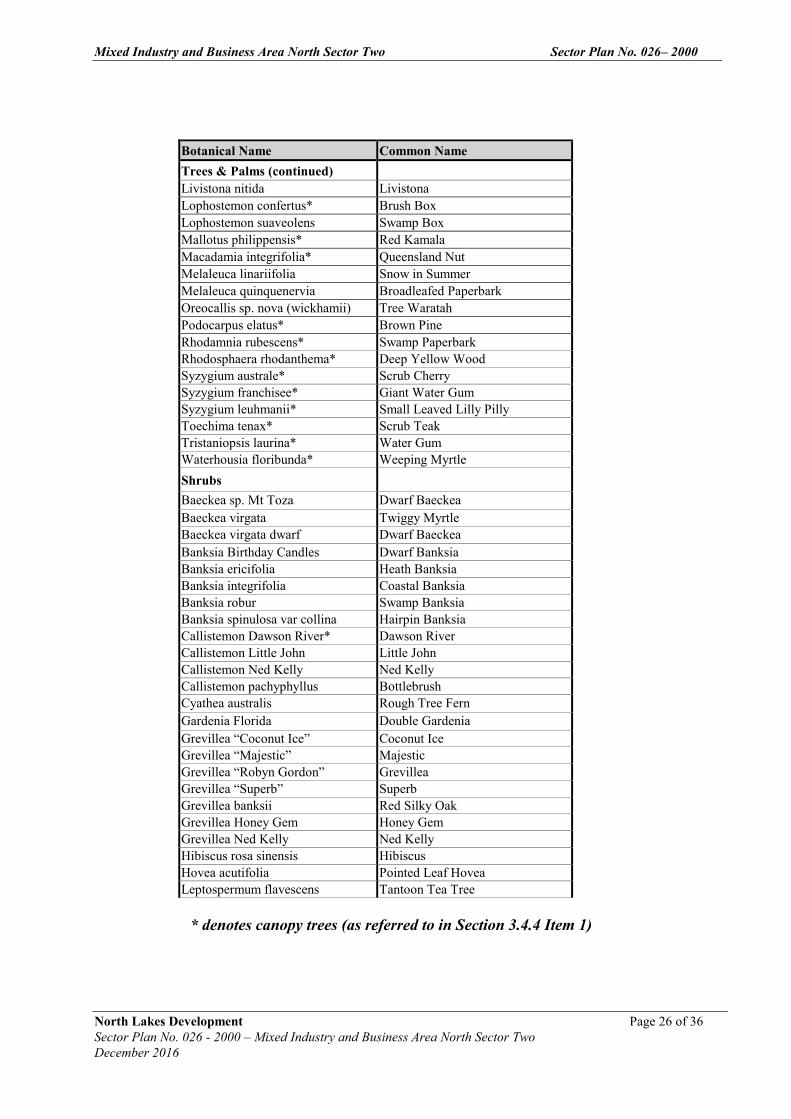
Botanical Name Common Name Trees & Palms Acmena smithii Lilly Pilly Agathis robusta Kauri Pine Allocasuarina littoralis Black She Oak Allocasuarina torulosa Forest She Oak Alphananthe philippensis* Native Elm Alphitonia excelsa* Red Ash Araucaria cunninghamia Hoop Pine Archontophoenix cunninghamia Pickabean Palm Backhousia citriodora* Lemon Scented Myrtle Backhousia myrtifolia* Carrol Banksia integrifolia Coast Banksia Barklya syringifolia* Crown of Gold Tree Brachychiton acerifoliun Flame Tree Brachychiton rupestre Bottle Tree Buckinghamia celsissima Ivory Curl Flower Callistemon salignus* Pink Tips Callistemon viminalis* Weeping Bottlebrush Callitris columellaris Bribie Island Pine Castanospermum australe* Black Bean Casuarina cunninghiana River She Oak Casuarina glauca Swamp She Oak Corymbia intermedia* Pink Bloodwood Cupaniopsis anacardioides* Tuckeroo Elaeocarpus eumundii* Eucalyptus citriodora Lemon Scented Gum Eucalyptus microcorys* Tallowwood Eucalyptus ptychocarpa Swamp Bloodwood Eucalyptus curtisii Plunkett Mallee Ficus coronata* Creek Sandpaper Fig Ficus macrophylla Moreton Bay Fig Ficus rubignosa Port Jackson Fig Flindersia australis* Crows Ash Flindersia pimenteliana* Flindersia Flindersia schottiana* Bumpy Ash Glochidion ferinandi* Buttonwood Grevillea robusta Silky Oak Harpullia pendula* Tulipwood Hymenosporum flavum Native Frangipanii Jagera pseudorhus* Foambark Livistona australis Livistona Livistona decipiens Weeping Cabbage Palm
* denotes canopy trees (as referred to in Section 3.4.4 Item 1)
Mixed Industry and Business Area North Sector Two Sector Plan No. 026– 2000
North Lakes Development Page 26 of 36 Sector Plan No. 026 - 2000 – Mixed Industry and Business Area North Sector Two December 2016
Botanical Name Common Name Trees & Palms (continued) Livistona nitida Livistona Lophostemon confertus* Brush Box Lophostemon suaveolens Swamp Box Mallotus philippensis* Red Kamala Macadamia integrifolia* Queensland Nut Melaleuca linariifolia Snow in Summer Melaleuca quinquenervia Broadleafed Paperbark Oreocallis sp. nova (wickhamii) Tree Waratah Podocarpus elatus* Brown Pine Rhodamnia rubescens* Swamp Paperbark Rhodosphaera rhodanthema* Deep Yellow Wood Syzygium australe* Scrub Cherry Syzygium franchisee* Giant Water Gum Syzygium leuhmanii* Small Leaved Lilly Pilly Toechima tenax* Scrub Teak Tristaniopsis laurina* Water Gum Waterhousia floribunda* Weeping Myrtle Shrubs
Baeckea sp. Mt Toza Dwarf Baeckea Baeckea virgata Twiggy Myrtle Baeckea virgata dwarf Dwarf Baeckea Banksia Birthday Candles Dwarf Banksia Banksia ericifolia Heath Banksia Banksia integrifolia Coastal Banksia Banksia robur Swamp Banksia Banksia spinulosa var collina Hairpin Banksia Callistemon Dawson River* Dawson River Callistemon Little John Little John Callistemon Ned Kelly Ned Kelly Callistemon pachyphyllus Bottlebrush Cyathea australis Rough Tree Fern Gardenia Florida Double Gardenia Grevillea “Coconut Ice” Coconut Ice Grevillea “Majestic” Majestic Grevillea “Robyn Gordon” Grevillea Grevillea “Superb” Superb Grevillea banksii Red Silky Oak Grevillea Honey Gem Honey Gem Grevillea Ned Kelly Ned Kelly Hibiscus rosa sinensis Hibiscus Hovea acutifolia Pointed Leaf Hovea Leptospermum flavescens Tantoon Tea Tree
* denotes canopy trees (as referred to in Section 3.4.4 Item 1)

Mixed Industry and Business Area North Sector Two Sector Plan No. 026– 2000
North Lakes Development Page 27 of 36 Sector Plan No. 026 - 2000 – Mixed Industry and Business Area North Sector Two December 2016
Botanical Name Common Name Trees & Palms (continued) Leptospermum petersonii Lemon Scented Tea Tree Leptospermum Pink Cascade Pink Cascade Melaleuca linariifolia Snowflake Dwarf Tea Tree Murraya paniculata Orange Jessamine Pittosporum revolutum Brisbane Laurel Pittosporum undulatum* Mock Orange Syzygium Blaze Dwarf Lilly Pilly Syzygium Elite Compact Lilly Pilly Syzygium Tiny Trev Dwarf Lilly Pilly Tibouchina jules Tibouchina Westringea fruticosa Wynyabbie Gem
* denotes canopy trees (as referred to in Section 3.4.4 Item 1)

Mixed Industry and Business Area North Sector Two Sector Plan No. 026– 2000
North Lakes Development Page 28 of 36 Sector Plan No. 026 - 2000 – Mixed Industry and Business Area North Sector Two December 2016
Botanical Name Common Name Groundcovers Agapanthus africanus Lily of the Nile Agapanthus orientalis Lily of the Nile Agapanthus Peter Pan Dwarf Agapanthus Anigozanthos hybrids Kangaroo Paws Blechnum cartilagineum Fern Cissus rhombifolium Grape Ivy Cissus Ellen Danica Grape Ivy Crinum pendunculatum River Lily Dianella revoluta Flax Lily Dietes bicolor Japanese Iris Dietes grandiflora Japanese Iris Evolvulus pilosus Blue Sapphire Gardenia radicans Dwarf Gardenia Grevillea Bronze Rambler Bronze Rambler Grevillea Royal Mantle Prostrate Grevillea Hardenbergia violacea Purple Coral Pea Hardenbergia violacea Bushy Blue Bushy Blue Helichrysum ramosissimum Yellow Buttons Hemerocallis species Day Lily Hibbertia dentata Toothed Guinea Flower Hibbertia scandens Snake Vine Liriope “Evergreen Giant” Liriope Lomandra hystrix Creek Mat rush Lomandra longifolia Mat Rush Lomandra multiflora Long Leaved Mat Rush Myoporum ellipticum Creeping Boobialla Myoporum parvifolium Myoporum Pittosporum Miss Muffet Dwarf Pittosporum Pittosporum tobira Miss Muffet Viola hederacae Native Violet Zierra Carpet Star Carpet Star Grasses
Cynodon dactylon Green Couch Danthonia induta Wallaby Grass Digitaria didactyla Blue Couch Greenlees Park Hybrid Couch Poa australis Native Poa Vines
Jasminum polyanthum Jasmine Pandorea pandorana Wonga Wonga Vine Pandorea jasminoides Bower of Beauty Trachelospermum jasminoides Variegated Star Jasmine Trachelospermum jasminoides Star Jasmine
Mixed Industry and Business Area North Sector Two Sector Plan No. 026– 2000
North Lakes Development Page 29 of 36 Sector Plan No. 026 - 2000 – Mixed Industry and Business Area North Sector Two December 2016
Annex C
Car and Bicycle Parking Requirements
Mixed Industry and Business Area North Sector Two Sector Plan No. 026– 2000
North Lakes Development Page 30 of 36 Sector Plan No. 026 - 2000 – Mixed Industry and Business Area North Sector Two December 2016
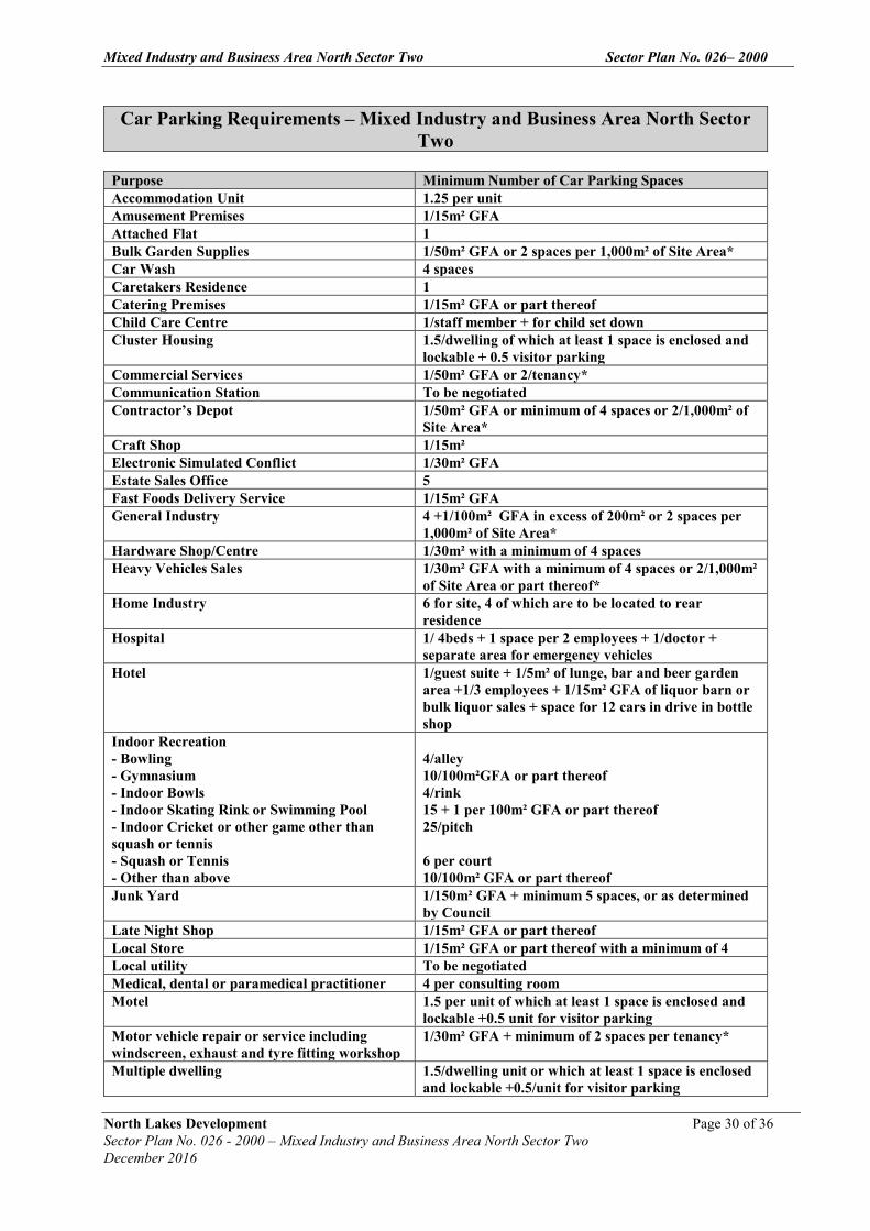
Car Parking Requirements – Mixed Industry and Business Area North Sector Two
Purpose Minimum Number of Car Parking Spaces Accommodation Unit 1.25 per unit Amusement Premises 1/15m² GFA Attached Flat 1 Bulk Garden Supplies 1/50m² GFA or 2 spaces per 1,000m² of Site Area* Car Wash 4 spaces Caretakers Residence 1 Catering Premises 1/15m² GFA or part thereof Child Care Centre 1/staff member + for child set down Cluster Housing 1.5/dwelling of which at least 1 space is enclosed and
lockable + 0.5 visitor parking Commercial Services 1/50m² GFA or 2/tenancy* Communication Station To be negotiated Contractor’s Depot 1/50m² GFA or minimum of 4 spaces or 2/1,000m² of
Site Area* Craft Shop 1/15m² Electronic Simulated Conflict 1/30m² GFA Estate Sales Office 5 Fast Foods Delivery Service 1/15m² GFA General Industry 4 +1/100m² GFA in excess of 200m² or 2 spaces per
1,000m² of Site Area* Hardware Shop/Centre 1/30m² with a minimum of 4 spaces Heavy Vehicles Sales 1/30m² GFA with a minimum of 4 spaces or 2/1,000m²
of Site Area or part thereof* Home Industry 6 for site, 4 of which are to be located to rear
residence Hospital 1/ 4beds + 1 space per 2 employees + 1/doctor +
separate area for emergency vehicles Hotel 1/guest suite + 1/5m² of lunge, bar and beer garden
area +1/3 employees + 1/15m² GFA of liquor barn or bulk liquor sales + space for 12 cars in drive in bottle shop
Indoor Recreation - Bowling - Gymnasium - Indoor Bowls - Indoor Skating Rink or Swimming Pool - Indoor Cricket or other game other than squash or tennis - Squash or Tennis - Other than above
4/alley 10/100m²GFA or part thereof 4/rink 15 + 1 per 100m² GFA or part thereof 25/pitch 6 per court 10/100m² GFA or part thereof
Junk Yard 1/150m² GFA + minimum 5 spaces, or as determined by Council
Late Night Shop 1/15m² GFA or part thereof Local Store 1/15m² GFA or part thereof with a minimum of 4 Local utility To be negotiated Medical, dental or paramedical practitioner 4 per consulting room Motel 1.5 per unit of which at least 1 space is enclosed and
lockable +0.5 unit for visitor parking Motor vehicle repair or service including windscreen, exhaust and tyre fitting workshop
1/30m² GFA + minimum of 2 spaces per tenancy*
Multiple dwelling 1.5/dwelling unit or which at least 1 space is enclosed and lockable +0.5/unit for visitor parking

Mixed Industry and Business Area North Sector Two Sector Plan No. 026– 2000
North Lakes Development Page 31 of 36 Sector Plan No. 026 - 2000 – Mixed Industry and Business Area North Sector Two December 2016
Office (other then medical) Includes offices associated with or ancillary to when more then 20% of GFA
1/30m² GFA or part thereof
Outdoor Recreation (assessable development) 6 spaces per court or negotiated with Council Outdoor sales (assessable development) One space per 150m² of site area, or part thereof Park Nil Place of Assembly 1/15m² GFA Place of Entertainment 1/10m² GFA or part thereof Place of Worship 1/10m² GFA or part therof Public Utilities Nil Retail Nursery (assessable development) 10 spaces, plus one space per 100m² of site area, or
part thereof, in excess of 500m² Restaurant 1/15m²GFA or part thereof Service Industry 1/50m² GFA or part thereof with min. of 2/tenancy Service Station 4 per service bay with a minimum of 4 spaces +
1/15m² GFA or part thereof for any restuqrant or take away food area plus 1/30m² GFA of any other area
Shop 1/15m² GFA or part thereof Showroom 1/30m² GFA Special Use To be negotiated Take-away Foods Store 1/15m² GFA + separate queing for at least 10 vehicles
for drive through servery Technology Industry (Service Industry) 1/50m² GFA or part thereof with min. of 2/tencncy* Transportable Home Park 2 spaces per transportable home site of which at least
1 space is enclosed and lockable + 0.5 spaces per unit for visitor parking
Vehicle Sales Yard/Vehicle Hire Yard 1/30m² GFA or part thereof with minimum of 4 spaces or 2/1,000m² of Site Area*
Veterinary Clinic or Veterinary Hospital 1/30m² GFA or 4 spaces per consulting room* Warehouse 4 + 1/100m² GFA or part thereof in excess of 200m² * Whichever is greater

Mixed Industry and Business Area North Sector Two Sector Plan No. 026– 2000
North Lakes Development Page 32 of 36 Sector Plan No. 026 - 2000 – Mixed Industry and Business Area North Sector Two December 2016
Bicycle Parking Requirements – Mixed Industry and Business Area North Sector Two
Land Use Employee Bicycle Parking Spaces
Class Visitor/Shopper Bicycle Parking Spaces
Class
Park - 1 or 2 1 per hectare with a minimum of 5 spaces
3
Accommodation units
1 per habitable rooms
1 1 space per 16 habitable rooms
3
Bulk garden supplies
1 per 750m2 sales floor
1 1 space per 1,000m2 sales floor
3
Car park 1 space per 750m2 GFA
1 1 space per 50 car parking spaces
3
Car wash 1 space per 750m2 GFA
2 N/A
Catering premises 1 space per 100m2 GFA public area
2 2 spaces 3
Commercial services
1 space per 200m2 GFA
2 1 space per 750m2 GFA over 1,000m2 GFA
3
Contractors depot 1 space per 750m2 GFA
2 1 space per 200m2
GFA 3
Convention centre 1 space per 4 employees
1 or 2 1 per 200m2 GFA 3
Entertainment library
1 space per 300m2 GFA
2 1 space per 200m2 GFA
3
Funeral parlour 1 space per 800m2 GFA
1 - 3
Hardware centre 1 per 750m2 sales floor
1 1 space per 1,000m2 sales floor
3
Heavy vehicle sales 1 space per 800m2 GFA
1 - 3
Hospital 1 per 15 beds 1 1 space per 30 beds 3 Hotel 1 per 25m2 bar
floor area and 2 per 100m2 lounge, beer garden
1 1 space per 25m2 bar floor areas and 2 per 100m2 lounge, beer garden
3
Indoor recreation 1 space per 4 employees
1 or 2 1 space per 200m2 GFA
3
Institution 1 per 400m2 GFA 1 or 2 1 per 200m2 GFA 3 Motel 1 per 40 rooms 1 - 3 Office 1 per 200m2 GFA 1 or 2 1 space per 750m2
over 1,000m2 GFA 3
Outdoor recreation - 1 or 2 1 per hectare with a minimum of 5 spaces
3
Outdoor sales 1 space per 800m2 GFA
1 - 3
Passenger terminal 1 space per 4 employees
1 or 2 1 space per 200m2 GFA with a minimum of 5 spaces
3
Recycling depot 1 per 800m2 GFA 1 - 3 Restaurant 1 per 100m2 public 1 or 2 2 spaces 3
Mixed Industry and Business Area North Sector Two Sector Plan No. 026– 2000
North Lakes Development Page 33 of 36 Sector Plan No. 026 - 2000 – Mixed Industry and Business Area North Sector Two December 2016
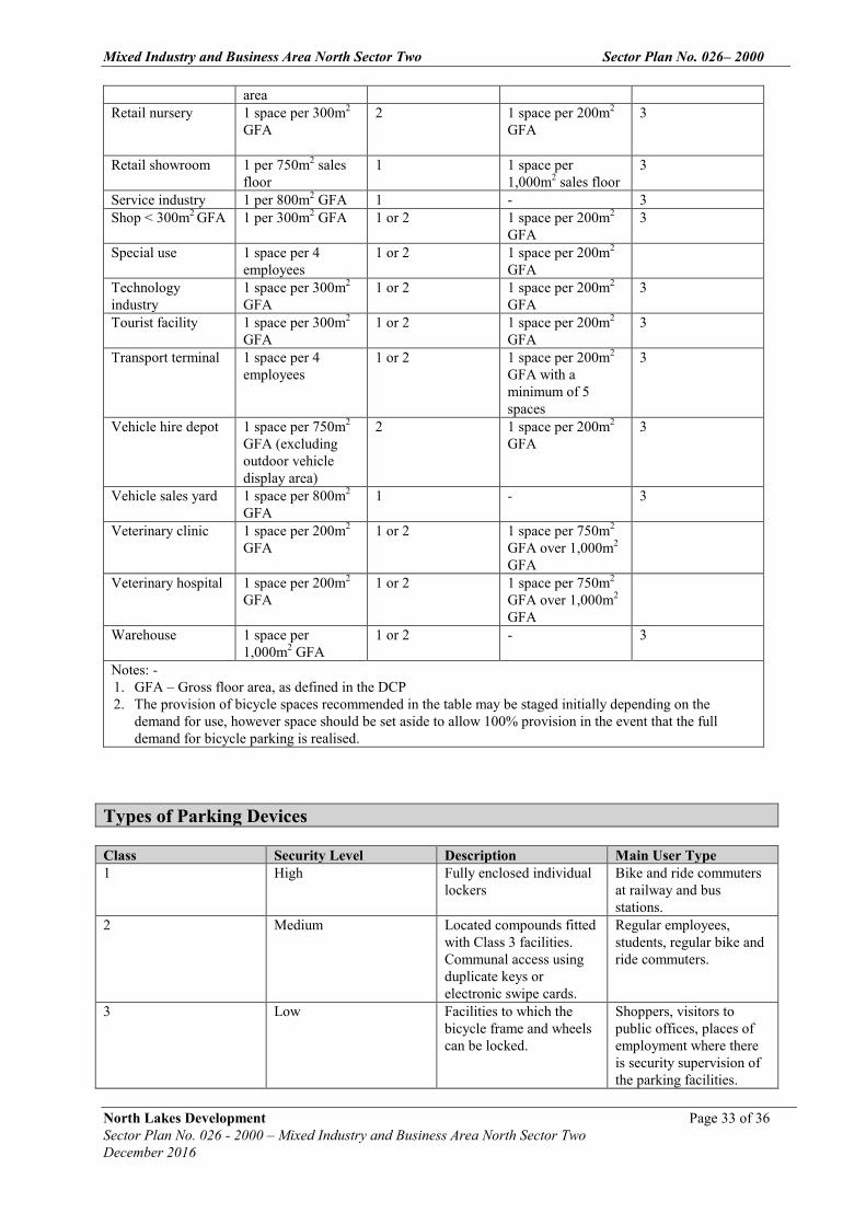
area Retail nursery 1 space per 300m2
GFA
2 1 space per 200m2 GFA
3
Retail showroom 1 per 750m2 sales floor
1 1 space per 1,000m2 sales floor
3
Service industry 1 per 800m2 GFA 1 - 3 Shop < 300m2 GFA 1 per 300m2 GFA 1 or 2 1 space per 200m2
GFA 3
Special use 1 space per 4 employees
1 or 2 1 space per 200m2 GFA
Technology industry
1 space per 300m2 GFA
1 or 2 1 space per 200m2 GFA
3
Tourist facility 1 space per 300m2 GFA
1 or 2 1 space per 200m2 GFA
3
Transport terminal 1 space per 4 employees
1 or 2 1 space per 200m2 GFA with a minimum of 5 spaces
3
Vehicle hire depot 1 space per 750m2 GFA (excluding outdoor vehicle display area)
2 1 space per 200m2 GFA
3
Vehicle sales yard 1 space per 800m2 GFA
1 - 3
Veterinary clinic 1 space per 200m2 GFA
1 or 2 1 space per 750m2 GFA over 1,000m2 GFA
Veterinary hospital 1 space per 200m2 GFA
1 or 2 1 space per 750m2 GFA over 1,000m2 GFA
Warehouse 1 space per 1,000m2 GFA
1 or 2 - 3
Notes: - 1. GFA – Gross floor area, as defined in the DCP 2. The provision of bicycle spaces recommended in the table may be staged initially depending on the
demand for use, however space should be set aside to allow 100% provision in the event that the full demand for bicycle parking is realised.
Types of Parking Devices
Class Security Level Description Main User Type 1 High Fully enclosed individual
lockers Bike and ride commuters at railway and bus stations.
2 Medium Located compounds fitted with Class 3 facilities. Communal access using duplicate keys or electronic swipe cards.
Regular employees, students, regular bike and ride commuters.
3 Low Facilities to which the bicycle frame and wheels can be locked.
Shoppers, visitors to public offices, places of employment where there is security supervision of the parking facilities.
Mixed Industry and Business Area North Sector Two Sector Plan No. 026– 2000
North Lakes Development Page 34 of 36 Sector Plan No. 026 - 2000 – Mixed Industry and Business Area North Sector Two December 2016
Annex D
Signage Guidelines
Mixed Industry and Business Area South Sector Two SIGNAGE GUIDELINES
NORTH LAKES DEVELOPMENT PAGE 1 OF 13
SECTOR PLAN NO TWO – MIXED INDUSTRY AND BUSINESS AREA SOUTH - SECTOR TWO
August 2016
Mixed Industry and Business Area South Sector Two SIGNAGE GUIDELINES
1.0 OBJECTIVES
The objectives of the signage standards for North Lakes are:
(i) To implement design standards consistent with the existing and future character ofNorth Lakes
(ii) To ensure that signs and advertisements complement the attractiveness, safety,legibility and amenity of the North Lakes environment, both day and night
(iii) To support the role of signs and advertising as an important factor in the marketingof North Lakes and in identifying the commercial character in areas of thedevelopment.
2.0 DEFINITIONS
Animated Signage: An animated sign is an advertisement with a changing
display, such as flashing or chasing bulbs, or any other
non-static illuminated displays.
Third Party Advertising: A “third party” advertising sign is an advertisement for a
business not conducted on the land on which the sign is
located, or a commodity not available on that land, and
includes an advertisement for a particular brand of
product sold or distributed from the premises. However,
an advertising sign which incorporates the North Lakes
logo as an integral element of the signage, or a sign which
includes only a generic reference to the type of product
available on the land is not a “third party” advertising
sign in terms of the inclusion of the North Lakes logo or
the generic product reference.
On- Site Business Advertising: An on-site business advertising sign is an advertising sign
which is limited in its content to the name of a business
premises and the name and services offered by the
occupants of the business premises. An on-site business
advertising sign may also incorporate the North Lakes
logo as an integral element of the signage.
Mixed Industry and Business Area South Sector Two SIGNAGE GUIDELINES
NORTH LAKES DEVELOPMENT PAGE 2 OF 13
SECTOR PLAN NO TWO – MIXED INDUSTRY AND BUSINESS AREA SOUTH - SECTOR TWO
August 2016
Artworks/Murals: Artwork and murals are architectural graphics and other
artworks which do not contain any implied or direct
reference to a business undertaking or service or
commodity available from a business undertaking.
However, artworks and murals may incorporate the
North Lakes logo as a supporting or an ancillary element.
3.0 SIGNAGE GUIDELINES
Except in the case of road signs, the following guidelines will be applied to all advertising
signage erected within the Mixed Industry and Business Area South Sector One. These
guidelines are intended to apply for individual signs, but where they form part of a
coordinated signage plan, they can be varied.
3.1. Scale and Location of Signs on Buildings
The scale of the sign shall be compatible with the building and building elements on which it
is affixed and to which it is in proximity, as well as nearby buildings, streets and other
existing signs. Consideration shall be given to the sign’s relationship to the overall
appearance of the development as well as surrounding development.
The number and area of signs, if specified, are intended to be maximum standards.
3.2. Principal Developer Signs
Within road reservations and on land in ownership of the Council or the principal developer,
signage content is limited to the message requirements of the principal developer and traffic
control. Generally content of signs within these areas will be restricted to directional
information for identifying locations, buildings, services and events. Commercial business
names or logos will generally not be permitted except for sponsorships on temporary event
signs.
3.3. Traffic Safety
A sign must not obstruct pedestrians’ views of traffic or vehicle drivers’ views of
pedestrians, other traffic or the road ahead. A sign must not create possible confusion for
drivers at critical locations such as intersections, traffic signals, or merging and weaving
situations eg. red and green lit signage near traffic intersections.
Signs visible from State roads shall comply to the requirements of the Queensland
Department of Main Roads as detailed in the Guide to the Management of Roadside
Advertising, Edition 1.0.
Mixed Industry and Business Area South Sector Two SIGNAGE GUIDELINES
NORTH LAKES DEVELOPMENT PAGE 3 OF 13
SECTOR PLAN NO TWO – MIXED INDUSTRY AND BUSINESS AREA SOUTH - SECTOR TWO
August 2016
3.4. Installation Fixings
No support, fixing, suspension or other systems required for the installation of a sign shall be
exposed, unless designed as an integral feature of the sign. Conduits, wiring, switches etc
shall be discreetly placed out of general view.
3.5. Animated Signs
Animated signs, where parts or all of the sign components move, may be acceptable where
no significant adverse impacts are likely to adjacent or nearby sensitive land uses. No
animated signs are allowable along the Bruce Highway or along the North South Arterial
Road.
3.6. Clutter
The visual amenity of the local area and the effectiveness of the message on the sign will be
enhanced by reducing signage clutter. Proposed signs shall be assessed in the context of the
number, type, size and location of existing signs on the site and surrounds.
3.7. Illumination
The luminance of an externally illuminated advertisement in the Mixed Industry and
Business Area North Sector One (measured in candelas per square metre) is not to exceed
500 cd/m².
The luminance level of an advertisement may exceed this level where it can be shown that
the increase in luminance level is unlikely to contribute to a traffic hazard or cause an
inappropriate loss of amenity.
The external illumination of signs is to be carried out in such a way as to minimise the spill
effects beyond the target sign. An illuminated sign must be designed to make the best
possible use of the energy efficient equipment and light sources available.
At street level sign illumination is to be consistent with the general level of lighting so as to
eliminate shadows and promote the safety of adjoining public areas.
The intensity of lighting and hours of illumination must not unreasonably impact on any
residential properties or traffic operations.
3.8. Environmental Controls
A sign must not be nailed or similarly fixed to any tree, or fixed to any poles used for traffic
control signs or street lighting. Every sign shall be maintained and kept in good repair.
3.9. Performance Controls
Unless otherwise approved under the coordinated signage plan, a proposed sign must meet
the performance criteria outlined in the following section. The acceptable standards

Mixed Industry and Business Area South Sector Two SIGNAGE GUIDELINES
NORTH LAKES DEVELOPMENT PAGE 4 OF 13
SECTOR PLAN NO TWO – MIXED INDUSTRY AND BUSINESS AREA SOUTH - SECTOR TWO
August 2016
associated with each type of sign are provided as examples and should not be seen as
precluding other solutions. However, where alternative solutions are proposed, the onus
will be on the proponent to demonstrate that the relevant performance criteria are met.
4.0 TYPES OF SIGNS
The following schedule sets out maximum criteria for various types of signs. Such signs may
be permitted subject to meeting the requirements of the signage guidelines and overall
performance standards.
(i) Above Awning Sign(ii) Awning / Fascia Sign(iii) Blade Sign(iv) Billboard Sign(v) Business Plate(vi) Created Awning Sign(vii) Flag Pole Sign(viii) Ground Sign(ix) Hamper Sign(x) Pole Sign(xi) Vertical Banner Freestanding Sign(xii) Projecting Flag Sign(xiii) Projecting Sign(xiv) Under Awning Sign(xv) Vertical Banner Building Sign(xvi) Wall Sign(xvii) Window Sign(xviii) Pylon/Column Sign
SIGNS PERFORMANCE CRITERIA
Signs shall:
(i) not create a hazard to traffic or pedestrians(ii) be of character and design standard consistent with the objectives
and controls for this sector plan(iii) complement the streetscape and amenity of the locality by virtue of
their size, location, illumination, utilisation of complementaryshapes, forms, colours, durable quality materials and designconcepts
(iv) if affixed to a building, complement the architectural style of thebuilding by virtue of their size, location, illumination, utilisation ofcomplementary shapes, forms, colours, durable quality materialsand design concepts; and
(v) not unnecessarily repeat or duplicate similar signs.
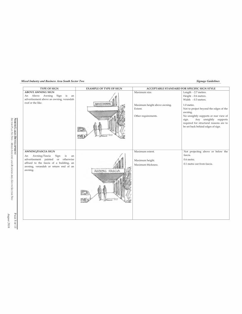
Mixed Industry and Business Area South Sector Two Signage Guidelines
NO
RT
H L
AK
ES
DE
VE
LO
PM
EN
T
PA
GE
5 O
F 1
3S
EC
TO
R P
LA
NN
OT
WO
–M
IXE
D IN
DU
ST
RY
AN
D B
US
INE
SS
AR
EA
SO
UT
H S
EC
TO
R T
WO
August 2016
TYPE OF SIGN EXAMPLE OF TYPE OF SIGN ACCEPTABLE STANDARD FOR SPECIFIC SIGN STYLE
Maximum size. Length - 2.7 metres.
Height - 0.6 metres.
Width - 0.3 metres.
Maximum height above awning. 1.0 metre.
Extent. Not to project beyond the edges of the
awning.
ABOVE AWNING SIGN
An Above Awning Sign is an
advertisement above an awning, verandah
roof or the like.
Other requirements. No unsightly supports or rear view of
sign. Any unsightly supports
required for structural reasons are to
be set back behind edges of sign.
AWNING/FASCIA SIGN
An Awning/Fascia Sign is an
advertisement painted or otherwise
affixed to the fascia of a building, an
awning, verandah or return end of an
awning.
Maximum extent.
Maximum height.
Maximum thickness.
Not projecting above or below the
fascia.
0.6 metre.
0.1 metre out from fascia.
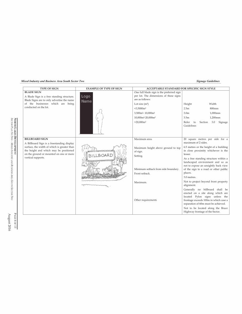
Mixed Industry and Business Area South Sector Two Signage Guidelines
NO
RT
H L
AK
ES
DE
VE
LO
PM
EN
T
PA
GE
6 O
F 1
3S
EC
TO
R P
LA
NN
OT
WO
–M
IXE
D IN
DU
ST
RY
AN
D B
US
INE
SS
AR
EA
SO
UT
H S
EC
TO
R T
WO
August 2016
TYPE OF SIGN EXAMPLE OF TYPE OF SIGN ACCEPTABLE STANDARD FOR SPECIFIC SIGN STYLE
One full blade sign is the preferred sign
per lot. The dimensions of these signs
are as follows:
Lot size (m²) Height Width
<3,5000m² 2.5m 800mm
3,500m²- 10,000m² 3.0m 1,000mm
10,000m²-20,000m² 3.5m 1,200mm
BLADE SIGN
A Blade Sign is a free standing structure.
Blade Signs are to only advertise the name
of the businesses which are being
conducted on the lot.
>20,000m² Refer to Section 3.0 Signage
Guidelines
BILLBOARD SIGN
A Billboard Sign is a freestanding display
surface, the width of which is greater than
the height and which may be positioned
on the ground or mounted on one or more
vertical supports.
Maximum area.
Maximum height above ground to top
of sign.
Setting.
Minimum setback from side boundary.
Front setback.
Maximum.
Other requirements
20 square metres per side for a
maximum of 2 sides.
6.5 metres or the height of a building
in close proximity whichever is the
lesser.
As a free standing structure within a
landscaped environment and so as
not to expose an unsightly back view
of the sign to a road or other public
places.
3.0 metres.
Not to project beyond front property
alignment.
Generally no billboard shall be
erected on a site along which are
located Pylon signs unless the
frontage exceeds 100m in which case a
separation of 60m must be achieved.
Not to be located along the Bruce
Highway frontage of the Sector.
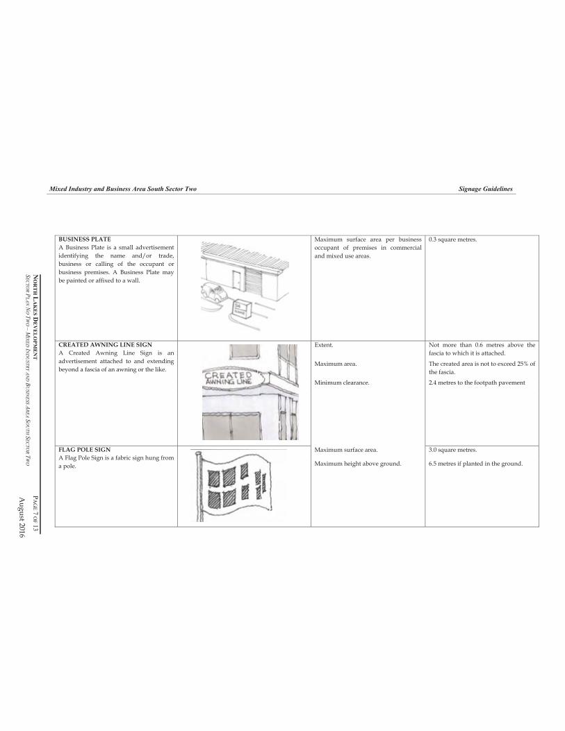
Mixed Industry and Business Area South Sector Two Signage Guidelines
NO
RT
H L
AK
ES
DE
VE
LO
PM
EN
T
PA
GE
7 O
F 1
3S
EC
TO
R P
LA
NN
OT
WO
–M
IXE
D IN
DU
ST
RY
AN
D B
US
INE
SS
AR
EA
SO
UT
H S
EC
TO
R T
WO
August 2016
BUSINESS PLATE
A Business Plate is a small advertisement
identifying the name and/or trade,
business or calling of the occupant or
business premises. A Business Plate may
be painted or affixed to a wall.
Maximum surface area per business
occupant of premises in commercial
and mixed use areas.
0.3 square metres.
Extent. Not more than 0.6 metres above the
fascia to which it is attached.
Maximum area. The created area is not to exceed 25% of
the fascia.
Minimum clearance. 2.4 metres to the footpath pavement
CREATED AWNING LINE SIGN
A Created Awning Line Sign is an
advertisement attached to and extending
beyond a fascia of an awning or the like.
Maximum surface area. 3.0 square metres. FLAG POLE SIGN
A Flag Pole Sign is a fabric sign hung from
a pole. Maximum height above ground. 6.5 metres if planted in the ground.

Mixed Industry and Business Area South Sector Two Signage Guidelines
NO
RT
H L
AK
ES
DE
VE
LO
PM
EN
T
PA
GE
8 O
F 1
3S
EC
TO
R P
LA
NN
OT
WO
–M
IXE
D IN
DU
ST
RY
AN
D B
US
INE
SS
AR
EA
SO
UT
H S
EC
TO
R T
WO
August 2016
TYPE OF SIGN EXAMPLE OF TYPE OF SIGN ACCEPTABLE STANDARD FOR SPECIFIC SIGN STYLE
GROUND SIGN
A Ground Sign is a monolithic sign which,
in effect, sits on or rises out of the ground,
typically used for Entry Gateways.
Setting.
Maximum height.
Maximum surface area.
Maximum setback from side boundary.
Maximum number.
Erected within a landscaped
environment.
Not erected to expose an unsightly back
view of the sign.
1.8 metres.
10 square metres.
3 metres.
One per frontage for frontages up to
100 metres.
For frontages over 100 metres, spacing
of signs to be no less than 60 metres.
HAMPER SIGN
A Hamper Sign is an advertisement,
painted or otherwise affixed, between a
door head and an awning, or their
equivalent levels.
Maximum thickness.
Maximum Extent.
Maximum number.
Other requirements.
0.3 metre from the face of the wall.
The size and form are to be compatible
with the building on which they are
located.
One per building frontage.
A High Rise Building Sign is not to
contain third party advertising.
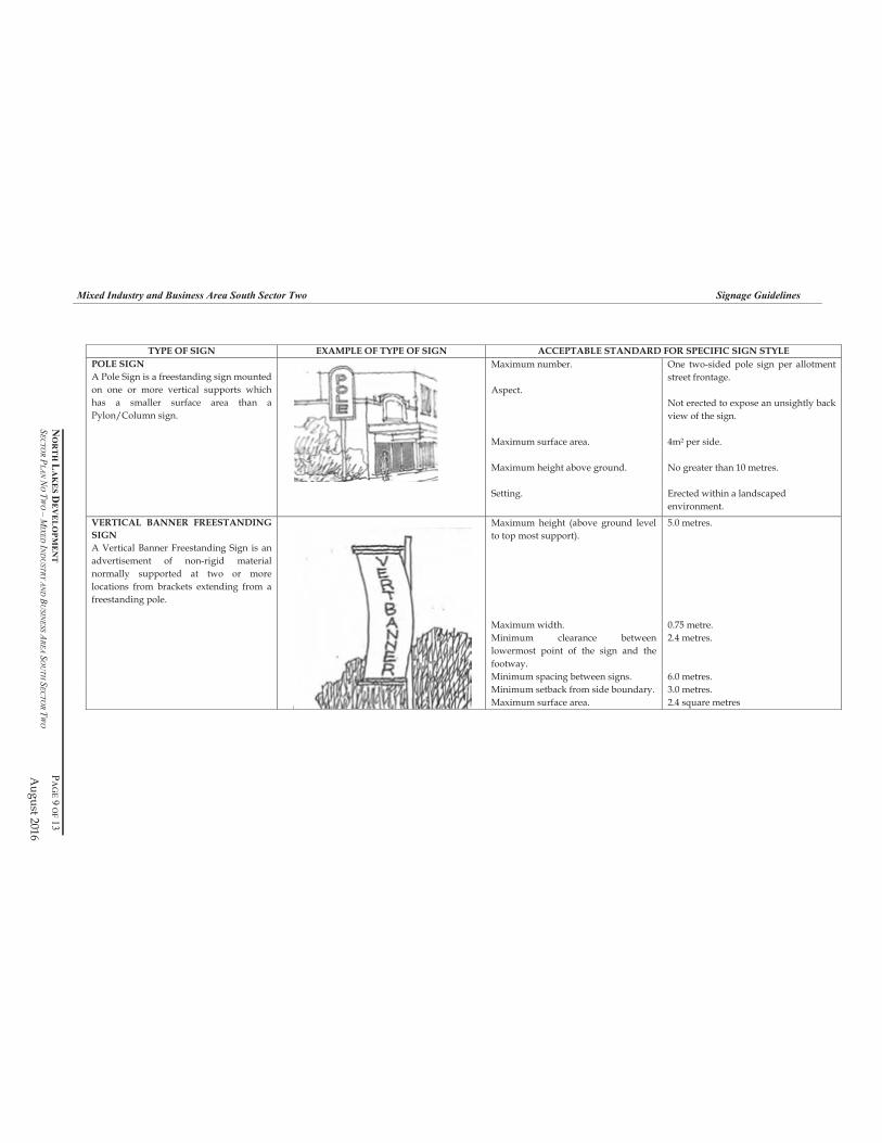
Mixed Industry and Business Area South Sector Two Signage Guidelines
NO
RT
H L
AK
ES
DE
VE
LO
PM
EN
T
PA
GE
9 O
F 1
3S
EC
TO
R P
LA
NN
OT
WO
–M
IXE
D IN
DU
ST
RY
AN
D B
US
INE
SS
AR
EA
SO
UT
H S
EC
TO
R T
WO
August 2016
TYPE OF SIGN EXAMPLE OF TYPE OF SIGN ACCEPTABLE STANDARD FOR SPECIFIC SIGN STYLE
POLE SIGN
A Pole Sign is a freestanding sign mounted
on one or more vertical supports which
has a smaller surface area than a
Pylon/Column sign.
Maximum number.
Aspect.
Maximum surface area.
Maximum height above ground.
Setting.
One two-sided pole sign per allotment
street frontage.
Not erected to expose an unsightly back
view of the sign.
4m² per side.
No greater than 10 metres.
Erected within a landscaped
environment.
VERTICAL BANNER FREESTANDING
SIGN
A Vertical Banner Freestanding Sign is an
advertisement of non-rigid material
normally supported at two or more
locations from brackets extending from a
freestanding pole.
Maximum height (above ground level
to top most support).
5.0 metres.
Maximum width. 0.75 metre.
Minimum clearance between
lowermost point of the sign and the
footway.
2.4 metres.
Minimum spacing between signs. 6.0 metres.
Minimum setback from side boundary. 3.0 metres.
Maximum surface area. 2.4 square metres

Mixed Industry and Business Area South Sector Two Signage Guidelines
NO
RT
H L
AK
ES
DE
VE
LO
PM
EN
T
PA
GE
10
OF
13
SE
CT
OR
PL
AN
NO
TW
O –
MIX
ED
IND
US
TR
Y A
ND
BU
SIN
ES
S A
RE
AS
OU
TH
SE
CT
OR
TW
O
August 2016
TYPE OF SIGN EXAMPLE OF TYPE OF SIGN ACCEPTABLE STANDARD FOR SPECIFIC SIGN STYLE
Maximum size. 0.3 square metre per face.
Maximum number. 4 per site.
Minimum spacing. 2 metres.
PROJECTING FLAG SIGN
A Projecting Flag Sign is a non-
illuminated, wall-mounted corporate flag.
Minimum clearance. 2.4 metres to the footpath pavement.
Minimum clearance between the
lowermost point of the sign and the
footway.
4 metres.
Maximum number. One per building frontage.
Orientation. Vertical.
Extent. Not projected above the height of the
wall to which it is attached.
Maximum size. Height - 3.0 metres.
Width - 0.75 metre.
PROJECTING SIGN
A Projecting Sign is a double-faced sign
projecting at right angles to a wall and
fixed to the wall. A Projecting Sign is not
an Under Awning Sign.

Mixed Industry and Business Area South Sector Two Signage Guidelines
NO
RT
H L
AK
ES
DE
VE
LO
PM
EN
T
PA
GE
11
OF
13
SE
CT
OR
PL
AN
NO
TW
O –
MIX
ED
IND
US
TR
Y A
ND
BU
SIN
ES
S A
RE
AS
OU
TH
SE
CT
OR
TW
O
August 2016
TYPE OF SIGN EXAMPLE OF TYPE OF SIGN ACCEPTABLE STANDARD FOR SPECIFIC SIGN STYLE
Orientation. At right angles to the building frontage.
Minimum clearance between the
lowermost point of the sign and
footway.
2.4 metres.
Extent. Not to project beyond the awning or
verandah.
Location. Central to each shop or tenancy or
shopping arcade entrance.
Minimum distance between under
awning signs.
3.0 metres.
Maximum dimensions. Length – 2.7 metres or not greater than
75% of the width of the awning or
verandah which ever is lesser.
Height - 0.6 metres.
Width – 0.3 metres.
UNDER AWNING SIGN
An Under Awning Sign is an
advertisement suspended under an
awning or verandah.
Minimum setback from side boundary. 1.5 metres.
Maximum height. Not to project above the height of the
adjacent part of the building to which it
is fixed and not to exceed 5 metres
above ground level.
Maximum width. 0.75 metre.
Minimum clearance between
lowermost point of the sign and the
footway.
2.4 metres.
Maximum area. 2.4 square metres.
Minimum spacing between signs. 6.0 metres.
VERTICAL BANNER BUILDING SIGN
A Vertical Banner Building Sign is an
advertisement of non-rigid material
normally fixed at the top and bottom to
brackets projecting from a building.
Minimum setback from side or rear
boundary.
3.0 metres.
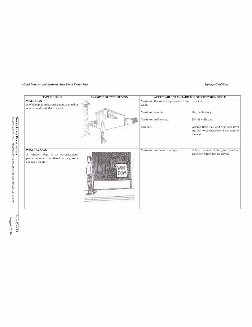
Mixed Industry and Business Area South Sector Two Signage Guidelines
NO
RT
H L
AK
ES
DE
VE
LO
PM
EN
T
PA
GE
12
OF
13
SE
CT
OR
PL
AN
NO
TW
O –
MIX
ED
IND
US
TR
Y A
ND
BU
SIN
ES
S A
RE
AS
OU
TH
SE
CT
OR
TW
O
August 2016
TYPE OF SIGN EXAMPLE OF TYPE OF SIGN ACCEPTABLE STANDARD FOR SPECIFIC SIGN STYLE
WALL SIGN
A Wall Sign is an advertisement, painted or
otherwise affixed, flat to a wall.
Maximum thickness (or projection from
wall).
Maximum number.
Maximum surface area.
Location.
0.3 metre.
One per tenancy.
20% of wall space ,
Ground floor level and first floor level
and not to project beyond the edge of
the wall.
WINDOW SIGN
A Window Sign is an advertisement,
painted or otherwise affixed, to the glass of
a display window.
Maximum surface area of sign. 25% of the area of the glass panel or
panels on which it is displayed.
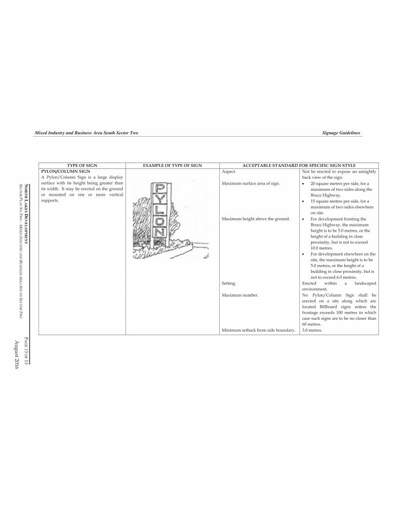
Mixed Industry and Business Area South Sector Two Signage Guidelines
NO
RT
H L
AK
ES
DE
VE
LO
PM
EN
T
PA
GE
13
OF
13
SE
CT
OR
PL
AN
NO
TW
O –
MIX
ED
IND
US
TR
Y A
ND
BU
SIN
ES
S A
RE
AS
OU
TH
SE
CT
OR
TW
O
August 2016
TYPE OF SIGN EXAMPLE OF TYPE OF SIGN ACCEPTABLE STANDARD FOR SPECIFIC SIGN STYLE
Aspect. Not be erected to expose an unsightly
back view of the sign.
Maximum surface area of sign. 20 square metres per side, for a
maximum of two sides along the
Bruce Highway.
15 square metres per side, for a
maximum of two sides elsewhere
on site.
Maximum height above the ground. For development fronting the
Bruce Highway, the maximum
height is to be 5.0 metres, or the
height of a building in close
proximity, but is not to exceed
10.0 metres.
For development elsewhere on the
site, the maximum height is to be
5.0 metres, or the height of a
building in close proximity, but is
not to exceed 6.0 metres.
Setting. Erected within a landscaped
environment.
Maximum number. No Pylon/Column Sign shall be
erected on a site along which are
located Billboard signs unless the
frontage exceeds 100 metres in which
case such signs are to be no closer than
60 metres.
PYLON/COLUMN SIGN
A Pylon/Column Sign is a large display
surface with its height being greater than
its width. It may be erected on the ground
or mounted on one or more vertical
supports.
Minimum setback from side boundary. 3.0 metres.
Mixed Industry and Business Area North Sector Two Sector Plan No. 026– 2000
North Lakes Development Page 35 of 36 Sector Plan No. 026 - 2000 – Mixed Industry and Business Area North Sector Two December 2016
Annex E
Proposed Metes and Bounds Description
Mixed Industry and Business Area North Sector Two Sector Plan No. 026– 2000
North Lakes Development Page 36 of 36 Sector Plan No. 026 - 2000 – Mixed Industry and Business Area North Sector Two December 2016
Appendix F
Bruce Highway Landscaping Concept
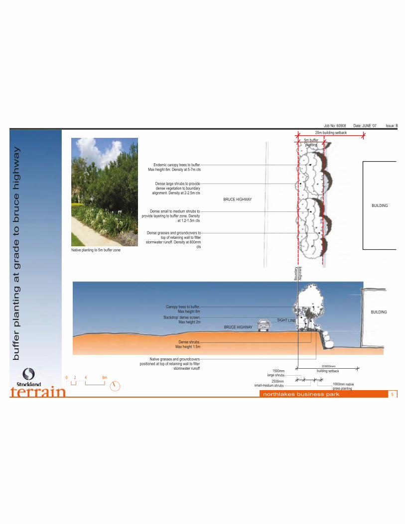
Job No: 60908 Date: JUNE ‘07 Issue: B
buffer p
lanting a
t grade to b
ruce h
ighw
ay
northlakes business park 5
Bou
ndar
ym
nA
lign
et
13000 mmbu lding setbacki
n1000mm ative tgrass plan ing
50 m1 0 mlar hr sge s ub
5 m2 00 ms l e h sma l-m dium s rub
SIGHT LINE
Native grasses and groundcovers positioned at top of retaining wall to filter
stormwater runoff
Canopy trees to buffer.Max height 8m
Dense shrubs. Max height 1.5m
BRUCE HIGHWAY
‘Backdrop’ dense screen. Max height 2m
BUILDING
0 2 4 8m
Endemic canopy trees to buffer. Max height 8m. Density at 5-7m cts
Dense large shrubs to provide dense vegetation to boundary
alignment. Density at 2-2.5m cts
Dense small to medium shrubs to provide layering to buffer zone. Density
at 1.2-1.5m cts
BUILDING
Dense grasses and groundcovers to top of retaining wall to filter
stormwater runoff. Density at 800mmcts
BRUCE HIGHWAY
20m building setback
5m bufferplanting
Native planting to 5m buffer zone
20000mm

Job No: 60908 Date: JUNE ‘07 Issue: B
buffer p
lanting b
elo
w level of bruce h
ighw
ay
northlakes business park 3
013 00mmd n cbuil i g setba k
10 0m na i e 0 m t vg as p a t nr s l n i g
1500mmlarg hrubse s
2500mmsmall- edium m
shrubs
SIGHT L N I E
Native grasses and groundcovers positioned at bottom of batter to filter
stormwater runoff
Canopy trees to batter. Max height 8m
Dense shrubs. Max height 1.5m
BRUCE HIGHWAY
‘Backdrop’ dense screen. Max height 2m
BUILDING
0 2 4 8m
Endemic canopy trees to buffer. Max height 8m. Density at 5-7m cts
Dense large shrubs to provide dense vegetation to boundary
alignment. Density at 2-2.5m cts
Dense small to medium shrubs to provide layering to buffer zone.
Density at 1.2-1.5m cts
Dense grasses and groundcovers to top of retaining wall to filter
stormwater runoff. Density at 800mmcts
5m bufferplanting
BUILDING
20m building setback
Bn
rou
day
inm
enA
lgt
BRUCE HIGHWAY
Native plantings to batter
20000mm
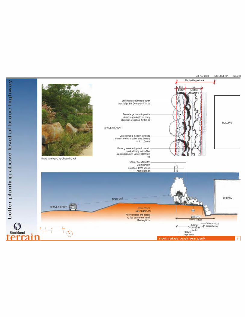
Job No: 60908 Date: JUNE ‘07 Issue: B
buffer p
lanting a
bove level of bruce h
ighw
ay
northlakes business park 2
0 2 4 8m
‘Backdrop’ dense screen. Max height 2m
Native grasses and sedges to filter stormwater runoff.
Max height 1m
0013 0mmd n s cbuil i g etba k
BRUCE HIGHWAY
Canopy trees to buffer. Max height 8m
Dense shrubs. Max height 1.5m
20 0m na i e 0 m t vas a t ngr s pl n i g
40 0m0 mlar hr bsge s u
3500mmi msmall-med u
shrubs
L ESIGHT IN BUILDING
Endemic canopy trees to buffer. Max height 8m. Density at 5-7m cts
Dense large shrubs to provide dense vegetation to boundary
alignment. Density at 2-2.5m cts
Dense small to medium shrubs to provide layering to buffer zone. Density
at 1.2-1.5m cts
Dense grasses and groundcovers to top of retaining wall to filter
stormwater runoff. Density at 800mmcts
20m building setback
5mExisting
Easement
4.5mBuffer
Planting
BUILDING
od
Bun
ary
iAl
gnm
ent
BRUCE HIGHWAY
Native plantings to top of retaining wall
20000mm
Recommended


![12-1-17 - Microsoft · Planned Unit Dev. Amendment, Major Preliminary Plan, Major or Minor Rezoning C] Road Disclaimer SIA, Modification C] Sketch Plan, Major or Minor Sketch Plan,](https://img.pdfslide.us/doc/110x75/5ec7ddd3900359606f38e3e3/12-1-17-microsoft-planned-unit-dev-amendment-major-preliminary-plan-major-or.jpg)